public access to information on private land conservation: tracking
TRANSCRIPT

MORRIS AND RISSMAN - FINAL 3/11/2010 9:01 AM
PUBLIC ACCESS TO INFORMATION ON PRIVATE LAND CONSERVATION: TRACKING CONSERVATION
EASEMENTS
AMY WILSON MORRIS* & ADENA R. RISSMAN** Conservation easements reveal major tensions between the privacy concerns of landowners and the right of the public to access information about private land conservation. State and federal governments face important choices about how to provide public access to this information given growing concerns that the public’s substantial investment in conservation easements will be lost without comprehensive tracking over the long term. In this Article, we reflect on the public nature of conservation easements and the challenges posed by their perpetuity, and we provide concrete recommendations for legislatures seeking to improve conservation easement tracking. We employ interdisciplinary methods to assess multiple approaches to conservation easement tracking, focusing on California as a case study. Our California analysis examines the legislative history of state and county efforts to track conservation easements. We interviewed conservation experts and used a telephone survey of county recorder offices to assess county compliance with a California law requiring conservation easement indexing. We also employed a Geographic Information System to evaluate access to spatial data on conservation lands. Despite state, county, and non-profit tracking efforts, access to conservation easement data remains fragmented and incomplete. Based on this integrative research, we suggest that five elements are particularly important to an expanded, statewide system for tracking conservation easements: (1) including as many conservation easements as possible; (2) tracking public financial investments; (3) mapping conservation easements; (4) including specific purposes and restrictions in conservation easement databases; and (5) monitoring of monitoring.
* Environmental Scientist, Aspen Environmental Group. Ph.D., University of California-Santa Cruz 2009; B.A. Columbia University 1998. This research was conducted while I was a doctoral student in Environmental Studies. Research for this Article was supported in part by the Switzer Foundation, the MRC Greenwood Award, the Earthbound Farm Foundation, and the University of Wisconsin-Madison. We want to thank Daniel Press, Julie Guthman, Jeffrey Odell, and Jessica Owley Lippmann who provided thoughtful feedback on earlier versions of this Article. We also want to thank Kyle Birchard for his research assistance and Larry Orman from GreenInfo Network for providing access to GIS data. Finally, we are very grateful to the more than 140 people we interviewed for this project, including representatives of land trusts, public conservation agencies, and county recorder offices. We would also like to thank the editors of the Wisconsin Law Review. ** Assistant Professor, Department of Forest and Wildlife Ecology, University of Wisconsin–Madison. Ph.D., University of California-Berkeley 2008; B.A., University of Texas-Austin 1999.

MORRIS AND RISSMAN - FINAL 3/11/2010 9:01 AM
1238 WISCONSIN LAW REVIEW
Introduction .................................................................. 1238 A. Why Does the Public Need to Keep Track of
Conservation Easements? .................................... 1244 B. Public Access to Information ................................ 1248
I. California Case Study .............................................. 1254 A. Methods ........................................................ 1254 B. Conservation Easement Tracking Legislation ............. 1256
1. County conservation easement indexing ............... 1256 2. State conservation easement registry ................... 1257
C. The Status of Conservation Easement Tracking .......... 1260 1. Conservation easement indexing survey ............... 1260 2. State conservation easement registry ................... 1264 3. Interviewee responses .................................... 1265 4. Spatial data—A major missing link ..................... 1266
II. Conservation Easement Tracking and Evolving Technologies ........................................................ 1269
III. Proposal for a New Conservation Easement Tracking System ................................................................ 1273
Conclusion ................................................................... 1280
INTRODUCTION
Efforts to track conservation easements reveal major tensions between the privacy concerns of landowners and the right of the public to access information about public investments in private land conservation. Conservation easements compensate landowners for limiting development or limiting other land uses. They have been used for everything from preserving agricultural landscapes to protecting endangered species habitats at scales ranging from over 100,000 acres to a single tree.1 Conservation easements are supposed to protect the private lands they encumber forever.2
1. Conservation easement terms vary widely. The 760,000-acre Pingree Conservation Easement within Maine forestland is monitored in part through remote sensing. See Steven A. Sader et al., Pingree Forest Partnership: Monitoring Easements at the Landscape Level, J. FORESTRY, April/May 2002, at 20, 22. In contrast, a 2002 conservation easement held by the City of Woodland in California protects a single tree, with the purpose “to ensure the Valley Oak Tree will be retained forever in its natural condition” and encompasses 1.5 times the area from the trunk to the dripline of the tree. Conservation Easement Deed requested by City of Woodland, Cal., No. 035084, recorded Aug. 26, 2002 (on file with authors). 2. To qualify for a federal income-tax deduction for a charitable contribution, I.R.C. § 170(h)(5)(A) (2006) requires conservation easements to be perpetual. See Federico Cheever & Nancy A. McLaughlin, Why Environmental Lawyers Should Know (and Care) About Land Trusts and Their Private Land Conservation Transactions, 34 ENVTL. L. REP. 10,223, 10,225–26 (2004). Shorter-term

MORRIS AND RISSMAN - FINAL 3/11/2010 9:01 AM
2009:1237 Tracking Conservation Easements 1239
Because conservation easements are real-estate transactions with private landowners, they have been governed largely as a private tool.3 The “privateness” of conservation easements has hidden them from public scrutiny and proved to be a major barrier to aggregating conservation easement data and making it available to the public.4 As a result, it is impossible to get comprehensive information on how and where conservation easements are being created, what they are supposed to accomplish, whether they are being monitored and enforced, and how much public money is being spent.
In spite of protecting private land through private real-estate transactions, conservation easements are in many ways very public.5 Enormous amounts of public money are being spent on conservation easements in the form of direct purchases by public agencies, public
conservation easements may be eligible for federal tax benefits in limited circumstances, but they are not the subject of our analysis. Id. at 10,228. Proponents frequently point to perpetuity as the key benefit of conservation easements over regulatory land-use controls, which are subject to changing political priorities. Tom Daniels & Mark Lapping, Land Preservation: An Essential Ingredient in Smart Growth, 19 J. PLAN. LITERATURE 316, 318 (2005). 3. Conservation easements can also be held as an additional layer of protection on publicly owned land. See generally Christopher Serkin, Entrenching Environmentalism: Private Conservation Easements Over Public Land, U. CHI. L. REV. (forthcoming), available at http://www.ssrn.com/abstract=1474288. 4. See Amy Wilson Morris, Easing Conservation? Conservation Easements, Public Accountability, and Neoliberalism, 39 GEOFORUM 1215, 1219 (2008). 5. See generally SALLY K. FAIRFAX ET AL., BUYING NATURE: THE LIMITS OF
LAND ACQUISITION AS A CONSERVATION STRATEGY (2005); Leigh S. Raymond & Sally K. Fairfax, The “Shift to Privatization” in Land Conservation: A Cautionary Essay, 42 NAT. RES. J. 599, 627 (2003) (noting that easements are compensated through public funding); Dana Joel Gattuso, National Center for Public Policy Research, Conservation Easements: The Good, the Bad, and the Ugly, NAT’L POL’Y ANALYSIS, May 2008, No. 569, http://www.nationalcenter.org/NPA569.html (exploring the evolution, impact, and use of easements). In addition, conservation easements rely on state enabling statutes for legal legitimacy, and these statutes require that conservation easements provide certain public benefits. See Nancy A. McLaughlin, Rethinking the Perpetual Nature of Conservation Easements, 29 HARV. ENVTL. L. REV. 421, 426 (2005). Conservation easements are perpetual negative easements “in gross.” Id. at 425. Although limited-term conservation easements (term easements) exist, id. at 424 n.6, for the purposes of this paper, “conservation easements” are perpetual, as required by I.R.C. § 170(h)(5)(A) (2006). Because these elements of conservation easements go against common-law definitions of positive, appurtenant easements, and because perpetuity violates the prohibition against “dead-hand control,” states have passed conservation easement-enabling statutes to remove common-law impediments and clarify the legality of conservation easements. See generally McLaughlin, supra (discussing the challenges of maintaining a charitable donor’s intent and upholding benefits for the public over the very long term). All fifty states and Washington, D.C. now have enabling statutes. Nancy A. McLaughlin, Condemning Conservation Easements: Protecting the Public Interest and Investment in Conservation, 41 U.C. DAVIS L. REV. 1897, 1900 n.5 (2008).

MORRIS AND RISSMAN - FINAL 3/11/2010 9:01 AM
1240 WISCONSIN LAW REVIEW
grants to nonprofit land trusts, and tax subsidies for conservation easement donations.6 In addition, many—probably most—conservation easements are held by governments and public agencies.7 Finally, untold numbers of conservation easements are created as a result of regulatory requirements.8
6. Because of limited and widely dispersed records, it is impossible to know the exact amount of public money spent on conservation easements. Between direct purchases by public agencies and tax subsidies for conservation easement donations, the total is probably in the billions of dollars each year. In terms of direct public acquisition, the U.S. Department of Agriculture spent over $1.8 billion on conservation easement acquisitions between 2003 and 2007 through just three Farm Bill programs: the Wetland Reserve Program, Farm and Ranch Lands Protection Program, and the Grassland Reserve Program. See E-mail from Robert Glennon, Farm and Ranch Lands Protection Program (Jan. 26, 2008) (on file with authors); E-mail from Sheldon Hightower, Grassland Reserve Program, U.S. Dep’t Agric. (Feb. 24, 2009) (on file with authors); E-mail from Tony Puga, National Wetlands Reserve Program Manager, Wetland Reserve Program, U.S. Dep’t Agric. (Jan. 22, 2009) (on file with authors); E-mail from Dawn Wilson, Program Analyst, Easement Programs Division, Wetland Reserve Program, U.S. Dep’t Agric. (Nov. 13, 2006) (on file with authors). Dominic Parker provides one estimate of the value of tax subsidies for conservation easements. Dominic P. Parker, Conservation Easements: A Closer Look at Federal Tax Policy, PERC, Oct. 2005, at 10–11, available at http://www.perc.org/pdf/ps34.pdf. He contends that the value of claimed conservation easement donations was approximately $20.7 billion between 2001 and 2003. Id. at 10. This is based on extrapolation from the amount claimed per easement acre in South Carolina during that time period as reported to the Senate Finance Committee by South Carolina’s director of the Department of Revenue. Id. He further extrapolates that federal and state treasuries lost between $5.2 billion and $18.2 billion during this time depending on whether landowners could recoup closer to 25 percent or 88 percent of the value of their donations. Id. at 11. 7. For discussion of conservation-easement holding by public agencies, see FAIRFAX ET AL., supra note 5, at 205–06; Amy Wilson Morris, The Changing Landscape of Conservation Easements: Public Accountability & Evolving Oversight 27–31 (June 2009) (unpublished Ph.D. dissertation, University of California-Santa Cruz), available at http://completestranger.com/amy/amy_morris_dissertation_5.27.09_ FINAL.pdf. 8. For example, conservation easements originate from mitigation requirements, representing a tradeoff in conservation benefits. See Jessica Owley Lippmann, Exacted Conservation Easements: The Hard Case of Endangered Species Protection, 19 J. ENVTL. L. & LITIG. 293, 295 (2004). These conservation easements are also referred to as “exacted.” Id. at 294–95. Exacted conservation easements are created by regulatory decisions at every level of government and may result from conditions local governments place on granting development permits, from state environmental-quality, endangered-species, or wetland laws, or from federal requirements under the Endangered Species Act for Incidental Take Permits through Habitat Conservation Plans, or under Section 7 consultation. See id. at 293. Transportation agencies also mitigate road-improvement impacts through scenic easements offsite and along highway rights-of-way. See id. at 315. Exacted conservation easements may be held by public agencies that are especially ill-equipped to monitor and enforce them, and often even the regulatory agency responsible for their creation does not track their existence. See id. at 296; Jeff Pidot, Reinventing Conservation Easements: A Critical Examination and Ideas for Reform 14–16 (Lincoln

MORRIS AND RISSMAN - FINAL 3/11/2010 9:01 AM
2009:1237 Tracking Conservation Easements 1241
Ensuring the perpetuity of conservation easements presents major challenges. Conservation easement holders—either land trusts or government entities—are responsible for monitoring and enforcing the restrictions in conservation easement agreements.9 While conservation easements are supposed to last forever, many of the organizations that hold them will not. Even if conservation easement holding organizations do not dissolve, they may be ill-equipped to monitor and enforce conservation easements over time.10
The challenges presented by the perpetuity of conservation easements make it especially important to compile data that will allow the government or private groups to step in when conservation easement holders cannot meet their long-term stewardship responsibilities. Currently, there is a major disjuncture between the large, diffuse public costs of conservation easements, and the much smaller scales at which data about conservation easements are compiled.11
In light of these challenges, Pidot maintains that conservation easements must be governed,
with a view to the context of conservation-easement-time, which is not the present nor the near-term but the indefinite future. Otherwise, we may simply leave future generations a
Inst. of Land Pol’y, Working Paper, 2005) (on file with authors); Jeff Pidot, A Conversation about Conservation Easements, Presentation to the Land Use Regulation Commission (Dec. 7, 2005) (on file with authors). 9. See Lippmann, supra note 8, at 293. 10. Morris, supra note 7, at 205. In order to properly steward perpetual conservation easements, the land trusts and public agencies that hold them have to invest enormous time, energy, and financial resources in record-keeping, maintaining landowner relationships, monitoring easements, and enforcing restrictions. See generally BRENDA LIND, THE LAND TRUST ALLIANCE, THE CONSERVATION EASEMENT
STEWARDSHIP GUIDE: DESIGNING, MONITORING, AND ENFORCING EASEMENTS (1991); LAND TRUST ALLIANCE, STANDARDS AND PRACTICES, STANDARD 11: CONSERVATION
EASEMENT STEWARDSHIP (2004), available at http://www.landtrustalliance.org/learning/ sp/lt-standards-practices07.pdf. Small, volunteer-based land trusts may not have the capacity to monitor and enforce easements over time. BAY AREA OPEN SPACE COUNCIL, ENSURING THE PROMISE OF CONSERVATION EASEMENTS: REPORT ON THE USE AND
MANAGEMENT OF CONSERVATION EASEMENTS BY SAN FRANCISCO BAY AREA
ORGANIZATIONS 27 (1999), available at http://learningcenter.lta.org/attached-files/0/56/ 5613/EnsuringThePromise_of_CEs.pdf. And many government agencies may not have budgets for conservation easement stewardship at all. See Darla Guenzler, Using Conservation Easements to Achieve Regulatory Objectives 3 (2004) (unpublished Ph.D. dissertation, The University of California–Berkeley) (on file with authors). As stark evidence of the challenges of perpetuity, one-third of conservation easement holders in a widely cited Bay Area study could not generate a list of their own conservation easements. See BAY AREA OPEN SPACE COUNCIL, supra, at 7. 11. Morris, supra note 7, at 1.
MORRIS AND RISSMAN - FINAL 3/11/2010 9:01 AM
1242 WISCONSIN LAW REVIEW
legal morass of many tens or hundreds of thousands of different conservation easements, the terms, holders, and even locations of which may ultimately be difficult to discern, and the public benefits of which could be ultimately lost.12
Governing with a view to “conservation-easement-time” requires many elements including laws addressing transferring, amending, and extinguishing easements. More fundamentally, though, it requires systems to track conservation easements’ terms, holders, and locations.
As our research shows, many proponents of conservation easements argue that data about private land conservation should remain private; however, limiting public access actually threatens the existence of conservation easements in the long term. The public, or at least conservation-oriented public agencies, need to know who holds conservation easements, where those easements are, and what they are supposed to do. If these data are not available, when conservation easement holders fail to meet their perpetual stewardship responsibilities, conservation easements will be lost.
Unfortunately, there is currently no truly comprehensive tracking of conservation easement data.13 The only required public information about conservation easements across the United States is recordation of the conservation easement with the deed to the property.14 This may suffice to let future landowners know that their property is encumbered with a conservation easement, but it provides little opportunity for substantive public access to information.
Several states are developing or improving systems to capture statewide data about conservation easements.15 For example,
[I]n Massachusetts all locally and privately-held conservation easements are reviewed by a state agency and basic data, including spatial data, are compiled by the state. Maine amended its conservation easement statute in 2007 to create a new state registry for all conservation easements and require annual reporting by all of the state’s conservation easement
12. See Pidot, Reinventing Conservation Easements, supra note 8, at v (emphasis added). 13. See id. at 14–16; A.M. Merenlender et al., Land Trusts and Conservation Easements: Who is Conserving What for Whom?, 18 CONSERVATION BIOLOGY 65, 70 (2004); Morris, supra note 7, at 80. 14. Also, in many states (those with marketable title acts) conservation easements have to be re-recorded after twenty-five to forty years. ELIZABETH BYERS &
KARIN MARCHETTI PONTE, THE CONSERVATION EASEMENT HANDBOOK 21 (2d ed. 2005). 15. For more details, especially regarding systems in Colorado, Maine, Maryland, Massachusetts, and Vermont, see Morris, supra note 7, at 79–106.

MORRIS AND RISSMAN - FINAL 3/11/2010 9:01 AM
2009:1237 Tracking Conservation Easements 1243
holders. Montana requires that spatial data on conservation easements be sent to the Montana Natural Heritage Program.16
Colorado has a statewide Geographic Information Systems (GIS) database of conservation easements that was created by Colorado State University through submissions from conservation easement holders and county records searches.17 These state systems vary in the types of data collected, and they all have limitations.
Failure to track and provide public access to information about the conservation easements that are being created is especially egregious in light of sweeping changes in information technology, including widespread use of GIS and increasing access to the Internet. These new technologies have made it much easier to compile comprehensive data about conservation lands and to provide substantial transparency about public financing of conservation.18
To explore the tensions over public access to information about conservation on private land, this Article examines current systems for tracking conservation easements with an in-depth case study from California. We focus on California because the state legislature has passed two laws since 2001 to improve public access to conservation easement data.19 California also has the largest number of private land trusts of any state in the U.S.20
Through our California case study, we explore the benefits and limitations of various strategies for providing public access to conservation information. We employ interdisciplinary methods to analyze legislative history and generate original data from interviews, surveys, and GIS maps to synthesize multiple aspects of conservation easement tracking. Finally, we provide suggestions for new approaches to compiling transparent conservation easement data in light of the “publicness” of the private land conservation represented by conservation easements and the major challenges posed by “conservation-easement-time.”
16. Morris, supra note 7, at 135–36. 17. David M. Theobald et al., Human Dimensions of Natural Resources and Natural Resource Ecology Lab, Colorado State University, Colorado Ownership, Management, and Protection v7 database (Sept 15, 2008), available at http://www.nrel.colostate.edu/projects/comap (last visited Feb. 16, 2010). 18. See infra Part II. 19. See sources cited infra notes 89 and 91. 20. Information on states with highest numbers of land trusts available at Land Trust Alliance, Data Tables, Top 10 States in Number of Land Trusts, http://www.landtrustalliance.org/about-us/land-trust-census/data-tables#top10 (last visited Feb. 9, 2010).
MORRIS AND RISSMAN - FINAL 3/11/2010 9:01 AM
1244 WISCONSIN LAW REVIEW
A. Why Does the Public Need to Keep Track of Conservation Easements?
Public access to conservation easement information is critical because conservation easements are actually public in many ways.21 Tracking conservation easements is important because of the increasing public investment in this tool;22 the need for transparent and comprehensive data to inform public-policy decisions;23 and the failure of many conservation easement holders to adequately track, monitor, and enforce their conservation easements.24
Although conservation easements have been used in limited numbers for over a century, they are largely creatures of more recent hollowing-out of public financing for land acquisition and increased resistance to land-use regulation.25 Voluntary conservation easements are politically appealing, and they can be used to protect land in areas where local governments and landowners are strongly opposed to land-use regulation.26 This is especially important in light of the major impacts of sprawling development on the environment.27
The use of conservation easements has accelerated quickly since the 1990s. According to the Land Trust Alliance, in 1998 local and
21. Raymond & Fairfax, supra note 5, at 627. 22. See infra notes 32–34 and accompanying text. 23. See infra note 46 and accompanying text. 24. See, e.g., Nancy A. McLaughlin, Amending Perpetual Conservation Easements: A Case Study of the Myrtle Grove Controversy, 40 U. RICH. L. REV. 1031 (2006). The Myrtle Grove controversy described in this article demonstrates that changes to perpetual conservation easements are not a private matter between landowners and conservation easement holders. Id. at 1035. In the Myrtle Grove case, the conservation easement holder, the National Trust, agreed to amendments to a conservation easement that would have allowed development that was not in keeping with the original intent of the conservation easement agreement. Id. Heirs of the original donor filed suit against the National Trust. Id. Subsequently, the Maryland Attorney General intervened, and several land trust groups filed amicus briefs protesting the proposed amendments. Id. at 1035, 1060–61. In the end, the National Trust acknowledged that it did not have legal authority to agree to the subdivision. Id. at 1062–63. Outside involvement was a crucial to this conclusion. 25. See generally FAIRFAX ET AL., supra note 5, at 170–202 (discussing this history). 26. See Dana Beach, Create More Incentives for Easements, 2 OPEN SPACE 13
(2004), available at http://www.law.georgetown.edu/gelpi/current_research/documents/ RT_Pubs_Short_OpenSpace.pdf. 27. See generally REID EWING & JOHN KOSTYACK WITH DON CHEN ET AL., NAT’L WILDLIFE FED’N, ENDANGERED BY SPRAWL: HOW RUNAWAY DEVELOPMENT
THREATENS AMERICA’S WILDLIFE (2005), available at http://www.nwf.org/wildlife/ pdfs/EndangeredbySprawl.pdf; REID EWING ET AL., SMART GROWTH AMERICA, MEASURING SPRAWL AND ITS IMPACT (2002), available at http://www.smartgrowth america.org/sprawlindex/MeasuringSprawl.PDF.
MORRIS AND RISSMAN - FINAL 3/11/2010 9:01 AM
2009:1237 Tracking Conservation Easements 1245
regional land trusts held approximately 7,000 conservation easements.28 In 2005 that number had jumped to 35,000.29 This figure does not include the huge number of conservation easements held by local, state, or federal governments, tribes, or national land trusts.30 According to one estimate, there are 50,000 government-held conservation easements in New Jersey alone.31
Although it is very difficult to estimate the exact amount of public money spent on conservation easements, the total is probably in the billions of dollars every year. Through just three Farm Bill programs, the U.S. Department of Agriculture spent over $1.8 billion on conservation easement acquisitions between 2003 and 2007.32 In 2003 alone, taxpayers claimed $1.4 billion in federal income-tax deductions for conservation easements, which resulted in an estimated $600 million loss to the federal treasury.33 State financial incentives can be substantial as well. Between 2001 and 2007, the state of Colorado provided about $275 million in state tax credits for conservation easements.34 Many conservation easement projects receive a combination of local, state, and federal funding.35
28. Census Shows Decade of Growth for Local and Regional Land Trusts, EXCHANGE (LAND TRUST ALLIANCE, WASH., D.C.), Fall 1998, at 5. 29. This figure is based on Morris’s analysis of data provided by the Land Trust Alliance from their 2005 Census (on file with authors). 30. One major national land trust, The Nature Conservancy, holds conservation easements on 2 million acres and has helped create conservation easements on an additional 1.3 million acres. The Nature Conservancy, How We Work, Conservation Easements, http://www.nature.org/aboutus/howwework/conserva tionmethods/privatelands/conservationeasements/about/tncandeasements.html (last visited Feb. 6, 2010). Among public agencies, the Department of Interior alone holds 12 million acres of conservation easements. Pidot, Reinventing Conservation Easements, supra note 8, at 7. 31. Rand Wentworth, President’s Column, Conservation Easements at Risk, EXCHANGE, Summer 2005, at 3. 32. See sources cited supra note 6. 33. Gerald Korngold, Solving the Contentious Issues of Private Conservation Easements: Promoting Flexibility for the Future and Engaging the Public Land Use Process, 2007 UTAH L. REV. 1039, 1057. In 2005 the federal income-tax deductions amounted to $1.8 billion. See Janette Wilson, Individual Noncash Contributions, 2005, STATS. INCOME BULL. 68, 68 (2008), available at http://www.irs.gov/pub/irs-soi/ 08sprbul.pdf. 34. Margaret Jackson, IRS Latest to Scrutinize Conservation Easements, DENVER POST, June 29, 2008, at K-06. 35. Morris, supra note 4, at 1220. See generally FAIRFAX ET AL., supra note 5, 203–43. For an example of a conservation easement with these kinds of layers of funding, see The Nature Conservancy, Federal, State and Local Officials Celebrate Forest Conservation Efforts: Minnesota Forest Legacy Partnership’s First Project Cited as a Model to Prevent Forest Fragmentation, Aug. 9, 2007, http://www.nature.org/ wherewework/northamerica/states/minnesota/press/press3106.html.

MORRIS AND RISSMAN - FINAL 3/11/2010 9:01 AM
1246 WISCONSIN LAW REVIEW
Lack of tracking drastically curtails the ability for public-policy analysts to evaluate the costs and benefits of conservation easements.36 Regional planning agencies and land trusts rely on protected-area data for a variety of environmental-planning purposes, from development planning and zoning to habitat-protection prioritization and designing regional trail networks.37 Additionally, comprehensive conservation easement data would provide a basis for evaluating claims from critics that conservation easements frequently overcompensate wealthy developers for marginal conservation; squeeze out affordable housing; provide inadequate public access; and create patchwork protection through reliance on willing landowners.38
The inaccessibility of conservation easement data makes enforcement more difficult as well. In the case of land-use regulations, regulators rely heavily on neighbors to complain when zoning ordinances are being violated.39 However, with conservation easements, nearby landowners—the “watchful neighbors” relied upon by regulators—may have no knowledge of a conservation easement’s terms or even its existence.40
36. In addition to public information, many conservation easement holders themselves would benefit from better internal databases to track conservation easement documents and monitoring reports. For instance, The Nature Conservancy’s California chapter has developed an internal online property tracking system, ConservationTrack. See Adena R. Rissman et al., Monitoring Natural Resources on Rangeland Conservation Easements: Who’s Minding the Easement?, RANGELANDS, June 2007, at 21 available at http://www.bioone.org/doi/abs/10.2111/1551-501X(2007)29%5B21 :MNRORC%5D2.0.CO%3B2. This system has streamlined and organized TNC’s conservation easement compliance monitoring and enforcement activities. Id. at 22–23. All relevant documents are available online for staff, including the conservation easement and its attachments, the baseline Easement Documentation Report, an orientation narrative about the property, and previous monitoring reports. Id. Staff can upload new monitoring reports into the centralized system, and supervisors can quickly oversee and report on monitoring activities. Id. at 22. 37. See generally Adena R. Rissman & Adina M. Merenlender, The Conservation Contributions of Conservation Easements: Analysis of the San Francisco Bay Area Protected Lands Spatial Database, 13 ECOLOGY & SOC’Y Art. 40 (2008), available at http://www.ecologyandsociety.org/vol13/iss1/art40/. 38. For examples of dubious conservation easements being used to overcompensate landowners, see Jerd Smith, Nonprofit Turned Into Big Deal in Easements, ROCKY MOUNTAIN NEWS, Feb. 12, 2008, at 6; Joe Stephens & David B. Ottaway, Developers Find Payoff in Preservation, WASH. POST, Dec. 21, 2003, at A01. For discussion of equity issues and the drawbacks of relying on willing landowners, see FAIRFAX ET AL., supra note 5, at 11–18; John D. Echeverria, Regulating Versus Paying Land Owners to Protect the Environment, 26 J. LAND RES. &
ENVTL. L. 1, 15–18, 33–36 (2006). 39. Mary Ann King & Sally K. Fairfax, Public Accountability and Conservation Easements: Learning from the Uniform Conservation Easement Act Debates, 46 NAT. RES. J. 65, 66 (2006). 40. Id.

MORRIS AND RISSMAN - FINAL 3/11/2010 9:01 AM
2009:1237 Tracking Conservation Easements 1247
Within the organizations that hold conservation easements, several factors contribute to failures in tracking, monitoring, and enforcing conservation easement agreements. Many conservation easement holders—ranging from volunteer-run land trusts to the U.S. Fish and Wildlife Service—have limited staff and budgets for conservation easement stewardship.41 Funding for operations and maintenance is generally more difficult to obtain than funding for acquisitions.42 The specific tasks required for monitoring and enforcing conservation easements can be time-consuming and difficult.43 In some cases, conscientious monitoring and enforcement may have high political costs. It is possible that future landowners may not want to donate a conservation easement to a land trust seen as overly zealous in enforcing their agreements. Conflicts of interest may also be a problem. Some land trusts hold conservation easements from major donors or even from board members, and internal politics might make it especially complicated to enforce these agreements.44 Making information about conservation easements more transparent has the potential to counteract some of these barriers to tracking and enforcing conservation easements.45
Why does the public need to keep track of conservation easements? In the short term, the public should be able to track conservation easements so they can evaluate the effectiveness of public financial contributions. In the long term, the public needs to be able to track conservation easements because the public is paying (a lot) for perpetual conservation. It will be impossible to help maintain these conservation easements over the very long term if public and private conservation agencies and the general public do not know where they are and what they are supposed to accomplish. In both the short and long term, conservation easement tracking should enhance the public debate about the costs and benefits of conservation easements and help
41. BAY AREA OPEN SPACE COUNCIL, supra note 10, at 34. 42. Id. at 1. 43. See generally id.; LIND, supra note 10 (discussing the challenges presented by the responsibility to monitor and enforce conservation easements). The Land Trust Alliance has created a program to explore “conservation defense” insurance to address the potentially high costs of enforcing conservation easement agreements. See Land Trust Alliance, Background on the Conservation Defense Insurance Program, http://www.landtrustalliance.org/about-us/programs/conservation-defense/background (last visited Feb. 6, 2010). 44. Stephens & Ottaway, supra note 38 (addressing concerns about land trusts holding conservation easements on land owned by trustees and supporters). 45. See generally FAIRFAX ET AL., supra note 5, 259–72.

MORRIS AND RISSMAN - FINAL 3/11/2010 9:01 AM
1248 WISCONSIN LAW REVIEW
public officials and land-trust staff make better decisions about conservation priorities and targeting future conservation investments.46
B. Public Access to Information
Public access to information is often discussed in binary terms, as something that either does or does not exist. However, we see the simultaneous transformations in technology and ease of access to information as highlighting the existence of a continuum of public accessibility. The public has demanded more access to two kinds of information that illuminate this continuum: information about potential environmental hazards and government spending.
Laws established in recent decades to address access to information on environmental hazards and public spending have built on rights established by earlier laws. The Administrative Procedure Act (APA) gives citizens the explicit right to access information that would facilitate informed participation in decision-making by public agencies.47 The Freedom of Information Act (FOIA) establishes that a federal agency has the burden of proving that the citizen is not entitled to information from a federal agency, instead of a citizen having to prove entitlement.48 The National Environmental Policy Act of 1969 (NEPA) requires agencies to report the environmental impacts of proposed federal actions and make this information available to the public.49 Finally, the Government in the Sunshine Act of 1976 opened the policy-making process at federal agencies to public scrutiny.50 All fifty states and the District of Columbia have passed sunshine laws and legislation similar to FOIA.51
46. For more on the importance of better conservation easement data for informing public policy, see Korngold, supra note 33, at 1070. 47. Administrative Procedure Act of 1946, 5 U.S.C. § 500 (2006). For discussion of the impact of the APA, see Sheila Jasanoff, Transparency in Public Science: Purposes, Reasons, Limits, LAW & CONTEMP. PROBS., Summer 2006, at 21, 21–22. 48. Freedom of Information Act, 5 U.S.C. § 552 (2006). For more discussion of FOIA see generally Harold C. Relyea, Access to Government Information in the United States, CONG. RES. SERV., Jan. 7, 2005, available at http://fas.org/sgp/crs/ 97-71.pdf; Bradley Pack, FOIA Frustration: Access to Government Records Under the Bush Administration, 46 ARIZ. L. REV. 815 (2004). 49. National Environmental Policy Act of 1969, 42 U.S.C. § 4332 (2006). 50. Government in the Sunshine Act, 5 U.S.C. § 552b (2006). 51. For links to state FOIA/sunshine laws see State Sunshine Laws, http://sunshinereview.org/index.php/State_sunshine_laws (last visited Feb. 16, 2010). Several additional provisions have increased public participation in government conservation and management decisions for public and private lands. See Endangered Species Act of 1973, 16 U.S.C. § 1531 (2006) (providing for public involvement in decisions about conservation on private lands); National Forest Management Act of

MORRIS AND RISSMAN - FINAL 3/11/2010 9:01 AM
2009:1237 Tracking Conservation Easements 1249
Expanding on the access to government information provided by APA, FOIA, NEPA, and the sunshine laws, in the 1980s citizens began demanding access to data that might help communities protect themselves from dangerous industrial facilities.52 In response, federal and state legislatures passed a series of “right-to-know” laws. The most important of these was the Emergency Planning and Community Right-to-Know Act (EPCRA),53 which mandated the dissemination of chemical-emissions data in the form of the Toxic Release Inventory (TRI), “the first legislatively mandated database in the history of the United States government.”54 Although commentators have critiqued some aspects of TRI implementation,55 there seems to be consensus that the public availability of toxic-release data has helped community
1976, 16 U.S.C. § 1600 (2006) (containing significant provisions for public participation in the planning and management of the National Forest System); Federal Land Policy and Management Act of 1976, 43 U.S.C. §§ 1701, 1712 (2006) (containing significant provisions for public involvement in public land management decisions). Conservation easements may be popular in part because they largely avoid the public scrutiny and interest-group litigation that have become commonplace for federal agency conservation decisions. 52. See Margaret M. Jobe, The Power of Information: The Example of the US Toxic Release Inventory, 26 J. GOV’T INFO. 287, 287 (1999). Toxic chemicals released from a Union Carbide plant in Bhopal, India killed thousands of people in 1984, and toxic gas from another Union Carbide plant sickened many West Virginians not long afterward. Id. 53. Emergency Planning and Community Right-to-Know Act of 1986, 42 U.S.C. § 11,044 (2006). 54. Jobe, supra note 52, at 287. The EPCRA requires annual reporting of releases, facility-by-facility, chemical-by-chemical. 42 U.S.C. §§ 11,021(a)(1), 11,023(a) (2006); see also John D. Echeverria & Julie B. Kaplan, Poisonous Procedural “Reform”: In Defense of Environmental Right-to-Know, 12 KAN. J.L. &
PUB. POL’Y 579, 623 (2003) (arguing that the “[r]ight-to-know programs represent a self-evidently useful, low-cost approach for improving public health and environmental quality. They also are consistent with broadly-held views about the importance of democratic process and individual autonomy”). The EPA now publishes TRI data in an annual report and maintains a searchable online database that provides data by chemical, facility, industry type, zip code, county, and state. See generally Bradley C. Karkkainen, Information as Environmental Regulation: TRI and Performance Benchmarking, 89 GEO. L.J. 257, 261 (2001) (arguing that “TRI may be regarded as the first regulatory instrument to exploit the revolutionary potential of contemporary information technology to store, manipulate, and disseminate large volumes of performance information efficiently, quickly, and cheaply”); Maria Lynn Miranda et al., Environmental Justice Implications of Reduced Reporting Requirements of the Toxics Release Inventory Burden Reduction Rule, 42 ENVTL. SCI. & TECH. 5407 (2008). 55. Karkkainen, supra note 54, at 262 (arguing that “the TRI regime is still relatively crude and undeveloped as an instrument of environmental regulation”).

MORRIS AND RISSMAN - FINAL 3/11/2010 9:01 AM
1250 WISCONSIN LAW REVIEW
groups put pressure on polluting facilities to reduce their environmental and public-health impacts.56
EPCRA and TRI provided a government mandate for making previously proprietary information more publicly available, but that did not immediately address activists’ concerns.57 Although data were available, they were not always easy to access or interpret.58 Initially, to access the data, users had to have a special Internet account with the National Library of Medicine and pay an hourly fee.59 In response to concerns about limited Internet availability, the EPA distributed the data on microfiche to state and county libraries, and the data were released on CD-ROM in 1990.60 Even with these additional forms of distribution, it frequently took the work of expert intermediaries to interpret the published chemical-release statistics.61
As access to the Internet has become more prevalent and the public is able to access vast amounts of information quickly and conveniently, TRI data are now available primarily online.62 GIS software has made it possible to integrate toxic-release data with detailed maps. However, for more detailed mapping and interpretation of TRI data, the public still relies on the Web sites of private intermediary groups.63
Just as TRI reporting became more sophisticated with changes in information technology and access to electronic information, FOIA was amended in an effort to reflect new public-disclosure expectations. Initially, FOIA relied solely on individual written requests for specific information and allowed agencies to impose fees for search, review,
56. Echeverria & Kaplan, supra note 54, at 583. TRI has also been important to Congress, which relied on TRI data in creating the 1990 amendments to the Clean Air Act, 42 U.S.C § 7412 (2006). 57. Jobe, supra note 52, at 289–90. 58. Id. 59. Id. 60. Id. 61. Id. 62. Citizens can get data on local toxic releases by entering their zip code on the EPA’s TRI website. Toxics Release Inventory (TRI) Program, U.S. Environmental Protection Agency, Toxics Release Inventory Program, http://www.epa.gov/tri/ (last visited Feb. 3, 2010). 63. For example, Mapecos.org provides an interactive map of TRI data. MapEcos – US Industrial Toxic Release Map, http://mapecos.org/ (last visited Nov. 15, 2009). Scorecard.org combines TRI data with information about the health hazards posed by particular toxins. Scorecard: The Pollution Information Site, http://www.scorecard.org/ (last visited Nov. 15, 2009). Along with data summaries and interpretation, OMBwatch (through RTKnet.org) provides a portal for downloading raw TRI data. The Right-To-Know Network, Risk Management Plan Database, http://rtknet.org/db/rmp (last visited Nov. 15, 2009). All of this is now available quickly, for free over the Internet.

MORRIS AND RISSMAN - FINAL 3/11/2010 9:01 AM
2009:1237 Tracking Conservation Easements 1251
and photocopying.64 While that is still the procedure for many requests, with the passage of the Electronic Freedom of Information Act of 1996 (E-FOIA),65 federal agencies were required to make certain types of records available electronically.66 Agencies were also required to create “electronic reading rooms” to improve public access to data and documents.67 These changes provided much faster and more inexpensive access to enormous quantities of data.68
In response to increased public expectations for availability of government data and convenient new technologies for delivering that data, Congress passed the Federal Funding Accountability and Transparency Act of 2006 (or “Google for Government”).69 The Act provides full disclosure of all groups receiving federal funds.70 According to then-Senator Barack Obama, one of the bill’s original cosponsors, “By helping to lift the veil of secrecy in Washington, this database will help make us better legislators, reporters better journalists, and voters more active citizens . . . .”71 “Google for Government” reflects the perspective that “[i]n the age of the Internet,
64. Martin E. Halstuk & Bill F. Chamberlin, Open Government in the Digital Age: The Legislative History of How Congress Established a Right of Public Access to Electronic Information Held by Federal Agencies, 78 JOURNALISM & MASS COMM. Q. 45, 45–46, 47–48 (2001). 65. Electronic Freedom of Information Act Amendments of 1996, 5 U.S.C. § 552(a)(2) (2006). 66. For more discussion of E-FOIA, see generally Halstuk & Chamberlin, supra note 64, at 45–46. 67. 5 U.S.C. § 552(a)(2). 68. For more about the privacy concerns these changes can raise, see generally Victoria S. Salzmann, Are Public Records Really Public?: The Collision Between the Right to Privacy and the Release of Public Court Records Over the Internet, 52 BAYLOR L. REV. 355 (2000). 69. Federal Funding Accountability and Transparency Act of 2006, 31 U.S.C. § 6101 (2006). The Act was introduced by Senators Coburn, Obama, and Carper. Press Release, The White House, President Bush Signs Federal Funding Accountability and Transparency Act (Sept. 26, 2006), http://georgewbush-whitehouse.archives.gov/ news/releases/2006/09/20060926.html; S. 2590, 109th Cong. (2006). It was passed unanimously by the Senate. See S.2590: Federal Funding Accountability and Transparency Act of 2006, GOVTRACK.US, http://www.govtrack.us/congress/ bill.xpd?bill=s109-2590 (last visited Feb. 6, 2010). 70. 31 U.S.C. § 6101. The Internet site established by the Act is http://USASpending.gov (last visited Feb. 16, 2010). 71. Press Release, Sen. Tom Coburn, M.D., Senate Passes Coburn-Obama Bill to Create Internet Database of Federal Spending, (Sept. 8, 2006), http://coburn.senate.gov/public/index.cfm?FuseAction=LatestNews.PressReleases&ContentRecord_id=8dcb8c35-802a-23ad-4d37-9c8ea9c43460.
MORRIS AND RISSMAN - FINAL 3/11/2010 9:01 AM
1252 WISCONSIN LAW REVIEW
the key criterion for public access should be what is immediately viewable at a government Web site.”72
The new deluge of electronic reporting has disadvantages as well. The sheer volume of information may sometimes thwart substantive public engagement with the disclosure of data. For example, in an article about Enron, Malcolm Gladwell contends that the volume of reporting on Enron’s “special purpose entities” (the equivalent of 120,000 single-spaced pages) obscured the company’s tenuous financial situation.73 Gladwell notes that “in an age of increasing financial complexity the ‘disclosure paradigm’—the idea that the more a company tells us about its business, the better off we are—has become an anachronism.”74
In her analysis, Salzmann is more concerned with the privacy issues raised by increasing electronic disclosure. She claims that E-FOIA turned the Act “from a government-checking tool to a national database for assimilating private information” that can be used for commercial gain.75 Halstuk and Chamberlin echo similar concerns about increasing access to sensitive, private information, arguing that “[t]he tension between an individual’s right to privacy and the public’s right to obtain government information represents a conflict between two vital democratic values.”76
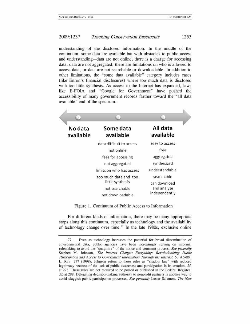
These examples help illustrate a continuum of public access (see Figure 1). At one end of the continuum, there is no access to information. At the other end of the continuum, data are all available quickly, for free. They are aggregated and searchable. Data can be downloaded and analyzed independently, but they are also synthesized and clearly explained when there are technical barriers to public
72. PHILIP MATTERA ET AL., CORPORATE RESEARCH PROJECT OF GOOD JOBS
FIRST, THE STATE OF STATE DISCLOSURE: AN EVALUATION OF ONLINE PUBLIC
INFORMATION ABOUT ECONOMIC DEVELOPMENT SUBSIDIES, PROCUREMENT CONTRACTS
AND LOBBYING ACTIVITIES 2, 8 (2007), available at http://www.goodjobsfirst.org/pdf/ statedisclosure.pdf. 73. Malcolm Gladwell, Open Secrets: Enron, Intelligence, and the Perils of Too Much Information, NEW YORKER, Jan. 8, 2007, at 44, 49. 74. Id. at 50. 75. Salzmann, supra note 68, at 358. 76. Martin E. Halstuk & Bill F. Chamberlin, The Freedom of Information Act 1966–2006: A Retrospective on the Rise of Privacy Protection Over the Public Interest in Knowing What the Government’s Up To, 11 COMM. L. & POL’Y 511, 511 (2006). The continuum of public access to information is also illustrated by U.S. Census Bureau data management. To address privacy issues, census data are aggregated before release. See U.S. Census Bureau, Center for Economic Studies, Research Program Overview, http://www.ces.census.gov/index.php/ces/researchprogram (last visited Feb. 7, 2010). Access to spatially explicit and detailed microdata is only available to researchers at nine centers around the country who receive “Special Sworn Status” by the Census Bureau to undertake approved research. Id.
MORRIS AND RISSMAN - FINAL 3/11/2010 9:01 AM
2009:1237 Tracking Conservation Easements 1253
understanding of the disclosed information. In the middle of the continuum, some data are available but with obstacles to public access and understanding—data are not online, there is a charge for accessing data, data are not aggregated, there are limitations on who is allowed to access data, or data are not searchable or downloadable. In addition to other limitations, the “some data available” category includes cases (like Enron’s financial disclosures) where too much data is disclosed with too little synthesis. As access to the Internet has expanded, laws like E-FOIA and “Google for Government” have pushed the accessibility of many government records farther toward the “all data available” end of the spectrum.
Figure 1. Continuum of Public Access to Information For different kinds of information, there may be many appropriate
stops along this continuum, especially as technology and the availability of technology change over time.77 In the late 1980s, exclusive online
77. Even as technology increases the potential for broad dissemination of environmental data, public agencies have been increasingly relying on informal rulemaking to avoid the “quagmire” of the notice and comment process. See generally Stephen M. Johnson, The Internet Changes Everything: Revolutionizing Public Participation and Access to Government Information Through the Internet, 50 ADMIN. L. REV. 277 (1998). Johnson refers to these rules as “shadow law” with reduced legitimacy because of the lack of public awareness and participation in its creation. Id. at 278. These rules are not required to be posted or published in the Federal Register. Id. at 288. Delegating decision-making authority to nonprofit partners is another way to avoid sluggish public-participation processes. See generally Lester Salamon, The New

MORRIS AND RISSMAN - FINAL 3/11/2010 9:01 AM
1254 WISCONSIN LAW REVIEW
availability made TRI data less accessible to the majority of the public.78 Now online availability is a basic expectation. In some cases, the cost of increasing access to information may not be an effective use of public funds. In other cases, concerns about privacy may legitimately trump demands for disclosure. Our point in presenting the continuum is to argue that there are many components of public access to information, and there needs to be a more substantive policy discussion about which elements are priorities and where trade-offs need to be made in the interest of privacy or cost.
I. CALIFORNIA CASE STUDY
We chose to examine public access to information for tracking conservation easements in California because of California’s long conservation easement history, large active land-trust community, and legislative interest in improving public access to conservation easement data. We employed an interdisciplinary approach involving an examination of legislative history, a survey of county recorder offices, interviews with conservation easement experts, and an analysis of spatially explicit data on conservation easements.
A. Methods
We analyzed the legislative records for the county conservation easement indexing requirements and the state conservation easement registry by examining initial, revised, and final versions of the relevant bills.79 To determine whether county recorder offices were complying with state indexing requirements, we interviewed supervisors in the recorders offices of all fifty-eight California counties between fall 2007 and fall 2008. All interviews employed a structured interview form, were conducted by phone, and lasted ten to twenty minutes. Results were entered into a Microsoft Access database. We asked whether recorders had an indexing code for conservation easements and whether
Governance and the Tools of Public Action: An Introduction, in THE TOOLS OF
GOVERNMENT: A GUIDE TO THE NEW GOVERNANCE 1 (Lester Salamon ed., 2002). When authority is granted to nonprofit organizations as agents acting in the public trust, greater scrutiny over their actions is warranted. Id. at 15. Recent cases of abuses of authority, self-dealing, and violations of donor intent have led to greater emphasis on regulation of nonprofits. Mark Sidel, The Guardians Guarding Themselves: A Comparative Perspective on Nonprofit Self-Regulation, 80 CHI.-KENT L. REV. 803, 804–05 (2005). In addition to discussing a “crisis of accountability” in the non-profit sector, Sidel discusses the advantages and limitations of non-profit self-regulation. Id. 78. Jobe, supra note 52, at 288–89. 79. Legislative Council of the State of California, Official California Legislative Information, http://www.leginfo.ca.gov/ (last visited Feb. 3, 2010).

MORRIS AND RISSMAN - FINAL 3/11/2010 9:01 AM
2009:1237 Tracking Conservation Easements 1255
it would be possible to generate a list of the county’s conservation easements. If the supervisor indicated they did not have a code or could not generate a list of conservation easements, we asked what obstacles were preventing them from indexing conservation easements. We also asked whether records were available online and how many staff worked in the recorder’s office. We had previously conducted pilot interviews with forty-three recorders offices in 2005. In addition, we conducted twelve site visits to recorders offices in fall 2008 and winter 2009 to evaluate the ease of accessing data in person.
We employed a stepwise multiple logistic regression to test whether county characteristics predicted county compliance with conservation easement indexing requirements. We considered counties to be in compliance with the conservation easement registry legislation when they answered “yes” to having either a code for conservation easements or being able to generate a list of conservation easements in their office. We then tested the relationship between the existence of a conservation easement index and three independent variables: the log number of conservation easements per county; log of the county population; and log of the number of staff in the recorder’s office. We estimated the number of conservation easements per county based on the 2003 Public, Conservation and Trust Lands and Easements (PCTLE) and the 2003 Farmland Mapping and Monitoring Program (FMMP) datasets.80 California’s Protected Areas Database (discussed in more detail below) was not used to generate the number of conservation easements per county because of its regional gaps.
As part of a larger project on conservation easement oversight, Morris conducted twenty-two interviews with public and private
80. These datasets are not comprehensive, but they were more consistent statewide than CPAD at the time we conducted our analysis. A conservation easement layer was created as part of the Public, Conservation and Trust Lands and Easements data set in the summer of 2003 (PCTLE). E-mails from Chris Watt, GIS Coordinator, Vestra Resources (May 18, 2005 and April 11, 2005). The project was funded by the California Resources Agency, but funding was cut, and the data have not been updated since 2003. Id. (April 11, 2005). The data included in the PCTLE are from a self-selected group of conservation easement holders that signed up to provide information at California land-conservation conferences. Id. The compilation of the information was difficult because many organizations did not have digital data. Id. Because of privacy issues, the data set has only been available to the agencies that contributed data, id., although we were able to obtain a copy of the data set for research purposes. Farmland Mapping and Monitoring Program (a Division of the Land Resource Protection in the Department of Conservation) was contracted by CalFed in 2000–2001 to compile information on agricultural easements. E-mail from Judith Santillan, GIS Research Analyst, California Dept. of Conservation, Farmland Monitoring and Mapping (May 18, 2005). Sixty organizations were contacted and fifteen provided geographic and other basic agricultural easement data by mail. Id. Our GIS analysis showed that about 55 percent of FMMP easements are included in PCTLE.

MORRIS AND RISSMAN - FINAL 3/11/2010 9:01 AM
1256 WISCONSIN LAW REVIEW
conservation easement holders and other experts in California, and an additional sixty-four interviews with experts in other states, between fall 2006 and winter 2009. We also gathered and analyzed the spatial data available on statewide conservation easements from PCTLE, FMMP, and California’s Protected Areas Database (CPAD). We were able to obtain the CPAD conservation easement data set for research purposes.
B. Conservation Easement Tracking Legislation
To provide context for our subsequent analysis, we present a brief history of the laws addressing access to conservation easement data in California.
1. COUNTY CONSERVATION EASEMENT INDEXING
The requirement that county recorders maintain indexes of conservation easements was signed into law in October 2001.81 The law is intended to help identify conservation easements at the county level by standardizing the ways that conservation easements are tracked by recorders.82
The initial version of the county-indexing bill (A.B. 1011) would have required the creation of “comprehensive” conservation easement indexes that were separate and distinct from other land records.83 In June 2001, the bill was amended to require that, instead of creating an
81. CAL. GOV’T CODE § 27,255 (West Supp. 2008). For the sake of clarity, we refer to the law as the “county indexing bill/law” in the body of the Article. According to the law,
“conservation easement” means any limitation in a recorded instrument that contains an easement, restriction, covenant, condition, or offer to dedicate, which is or has been executed by or on behalf of the owner of the land subject to that limitation and is binding upon successive owners of the land, and the purpose of which is to retain land predominantly in its natural, scenic, historical, agricultural, forested, or open-space condition. “Conservation easement” includes a conservation easement as defined in Section 815.1 of the Civil Code, an open-space easement as defined in Section 51075 of this code, and an agricultural conservation easement as defined in Section 10211 of the Public Resources Code.
Id. § 27,255(b). The law apparently does not cover “scenic easements” created under the Scenic Easement Deed Act of 1959, CAL. GOV’T CODE §§ 6950–6954 (West 2008). 82. California Coastal Commission, Legislative Report: Bill Analysis; A.B. 1011 (Pavley) (Aug. 31, 2001) (on file with authors). 83. Assembly Bill 1011 was sponsored by Assembly Member Fran Pavley. A.B. 1011, 2001 Leg., 2001–02 Sess. (Cal.), available at http://www.leginfo.ca.gov/ pub/01-02/bill/asm/ab_1001-1050/ab_1011_bill_20010223_introduced.pdf (introduced Feb. 21, 2001).

MORRIS AND RISSMAN - FINAL 3/11/2010 9:01 AM
2009:1237 Tracking Conservation Easements 1257
index separate from other land records, each recorder develop and maintain a “comprehensive index of conservation easements” “within the existing indexing system.”84
The language in the final county-indexing law notes that to require indexing by recorders, a conservation easement must be “properly labeled” or a separate “Notice of Conservation Easement” must also be recorded.85 Fees for the indexing are supposed to be included with the recording fee for the document.86 The law does not require indexing of conservation easements recorded before 2002.87 However, it states that conservation easements created through California’s open-space and agricultural-easement laws should be indexed along with those created under the state’s conservation easement enabling statute.88
2. STATE CONSERVATION EASEMENT REGISTRY
California’s state conservation easement registry legislation was signed into law in 2006.89 According to Senator Kehoe, the bill’s sponsor, “[t]he conservation easement registry will serve as an important planning tool that will help ensure a more coordinated allocation of our limited conservation dollars, help keep track of these easements for the future, and provide the public with a better understanding of what they are getting for their money.”90
84. A.B. 1011, 2001 Leg., 2001–02 Sess. (Cal.), available at http://www.leginfo.ca.gov/pub/01-02/bill/asm/ab_1001-1050/ab_1011_bill_20010628_ amended_sen.pdf (as amended June 28, 2001). 85. A.B. 1011, 2001 Leg., 2001–02 Sess. (Cal. 2001), available at http://www.leginfo.ca.gov/pub/01-02/bill/asm/ab_1001-1050/ab_1011_bill_20011013_ chaptered.pdf (as enacted Oct. 12, 2001). 86. Id. (stating that “the fee for recording and indexing documents shall include funds to cover costs associated with indexing the document”). 87. Id. However the law does specify that “any parties to conservation easements . . . may fill out . . . a Notice of Conservation Easement” for older conservation easements. Id. (emphasis added). 88. Id. 89. S.B. 1360, 2006 Leg., 2005–06 Sess. (Cal. 2006), available at: http://www.leginfo.ca.gov/pub/05-06/bill/sen/sb_1351-1400/sb_1360_bill_20060928_ chaptered.pdf (as enacted Sept. 28, 2006). The bill and subsequent law are officially titled “County records: conservation easement registry.” Id. For the sake of clarity, we refer simply to the “state registry bill/law.” The law amends CAL. GOV’T CODE § 27,255, and adds Article 3 (commencing with § 5096.520) to Chapter 1.695 of Division 5 of the Public Resources Code. Id. The newer registry law does not change the requirements of the “county records” indexing law, but adds new statewide conservation easement tracking requirements. Id. 90. Press Release, Sierra Club Cal., Legislation to Establish a Statewide Conservation Easement Registry Signed into Law (2006) (on file with authors).

MORRIS AND RISSMAN - FINAL 3/11/2010 9:01 AM
1258 WISCONSIN LAW REVIEW
Initially the legislation was introduced in 2005 as S.B. 695.91 The following year, the legislation was reintroduced as S.B. 1360.92 Amendments to the registry legislation were signed into law in 2007 as A.B. 188.93 The state registry law is substantially different than the indexing law. It covers fewer conservation easements—only those held, funded, or required by the state.94 Additionally, registry data are aggregated by the California Resources Agency, rather than by individual counties, and basic information has to be available to the public online.95
According to § 1 of the legislation:
(a) Conservation easements, open-space easements, and agricultural conservation easements are a valuable tool and a cost-effective way to protect the state’s natural resources.
(b) It is important to ensure that the public has information on how moneys are spent by state agencies when purchasing easements for the preservation and protection of critically needed conservation and agricultural lands.
(c) Information regarding easements should be disseminated in a readily and easily available manner.
91. S.B. 695, 2005 Leg., 2005–06 Sess. (Cal.), available at http://www.leginfo.ca.gov/pub/05-06/bill/sen/sb_0651-0700/sb_695_bill_20050222_ introduced.pdf (as introduced Feb. 22, 2005). On October 7, 2005, Governor Schwarzenegger vetoed S.B. 695, stating that it was “duplicative” of the indexing requirement. Letter from Gov. Arnold Schwarzenegger to the Members of the California State Senate (Oct. 7, 2005), available at http://www.leginfo.ca.gov/pub/ 05-06/bill/sen/sb_0651-0700/sb_695_vt_20051007.html. The Governor signed S.B. 1360 into law the following year. S.B. 1360, 2006 Leg., 2005–06 Sess. (Cal. 2006), available at: http://www.leginfo.ca.gov/pub/05-06/bill/sen/sb_1351-1400/sb_1360_bill_ 20060928_chaptered.pdf (as enacted Sept. 28, 2006). 92. S.B. 1360, 2005 Leg., 2005–06 Sess. (Cal.), available at http://www.leginfo.ca.gov/pub/05-06/bill/sen/sb_1351-1400/sb_1360_bill_20060221_ introduced.pdf (as introduced Feb. 21, 2006). 93. A.B. 188, 2007 Leg., 2007–08 Sess. (Cal. 2007), available at http://www.leginfo.ca.gov/pub/07-08/bill/asm/ab_0151-0200/ab_188_bill_20070926_ chaptered.pdf (as enacted Sept. 26, 2007). A.B. 188 was sponsored by Assembly Member Aghazarian. Id. 94. S.B. 1360, 2006 Leg., 2005–06 Sess. (Cal. 2006), available at http://www.leginfo.ca.gov/pub/05-06/bill/sen/sb_1351-1400/sb_1360_bill_20060928_ chaptered.pdf (as enacted Sept. 28, 2006). 95. Id. Like the indexing law, the registry law requires that conservation easements created under California’s open-space and agricultural-easement laws should be indexed along with those created under the State’s conservation easement enabling statute. Id.

MORRIS AND RISSMAN - FINAL 3/11/2010 9:01 AM
2009:1237 Tracking Conservation Easements 1259
(d) A central public registry of conservation easements, open-space easements, and agricultural conservation easements would provide information that would lead to better conservation and resource planning among state agencies, local governments, nonprofit organizations, and the public.96
During the first year that the registry bill was introduced as S.B. 695, its requirements were changed substantially. Those changes were carried over into the version of the bill that was introduced and passed during the next legislative session as S.B. 1360.97 The initial version referred to in Table 1 is the first version of S.B. 695. The final version is the law as amended after A.B. 188.
Table 1. Data to be Included in the Online Registry under Initial and
Final Versions of the State Conservation Easement Registry Bill98
Initial Version Final Version A copy of the conservation easement Yes No Any monitoring reports related to the conservation easement
Yes No
Reports of any enforcement actions taken related to the conservation easement
Yes No
The location of the conservation easement Yes County and nearest city only
The purpose of the conservation easement Yes Yes The identity of the conservation easement holder Yes Yes The recordation number assigned to the conservation easement
No Yes
Amount in dollars of the state’s contribution No Yes Size of the conservation easement in acres No Yes Date the easement transaction was completed In copy of
conservation easement
Yes
The registry law specifies that the state agencies that hold, require, or fund conservation easements are responsible for entering registry
96. Id. 97. Id. 98. The inclusion of the state’s financial contribution was removed from the final version of S.B. 1360, but was added back by the A.B. 188 amendments signed into law in 2007. See A.B. 188, 2007 Leg., 2007–08 Sess. (Cal. 2007), available at http://www.leginfo.ca.gov/pub/07-08/bill/asm/ab_0151-0200/ab_188_bill_20070926_ chaptered.pdf (as enacted Sept. 26, 2007).

MORRIS AND RISSMAN - FINAL 3/11/2010 9:01 AM
1260 WISCONSIN LAW REVIEW
data and keeping it current.99 The law also specifically prohibits posting “personal identifying information” (presumably landowner names and addresses) on the Internet.100
One interviewee, a lobbyist who worked on the registry legislation, claimed that it was very difficult to promote an online database because so many landowners were concerned about protecting their privacy, both geographic and financial. He maintained that resistance to tracking more conservation easement data is a result of the fact that large landowners are very powerful and that “[s]maller land trusts get in a big uproar about these things; they do not want to piss off their landowners. Almost every district has a land trust. They go to their representatives.”101
C. The Status of Conservation Easement Tracking
The county-indexing and state registry laws described in the previous Section now comprise the two primary mechanisms for tracking conservation easements in California. Although these laws are important steps forward, major obstacles remain for compiling comprehensive conservation easement data in California because of omissions in the legislation and problems with consistent implementation of county-indexing requirements.
1. CONSERVATION EASEMENT INDEXING SURVEY
From fall 2007 through summer 2008, we conducted interviews with supervisors from the recorders offices in all fifty-eight California counties. We found that 29 percent of counties (seventeen) had no separate indexing code for conservation easements, and thus no way to generate a list of the county’s (post-2001) recorded easements (see
99. S.B. 1360, 2006 Leg., 2005–06 Sess. (Cal. 2006), available at http://www.leginfo.ca.gov/pub/05-06/bill/sen/sb_1351-1400/sb_1360_bill_20060928_ chaptered.pdf (as enacted Sept. 28, 2006) (“An agency, department, or division of the state with conservation easements that are held or required by the state or purchased with state grant funds shall enter and keep current the information specified in subdivision (c) for those easements in the registry established pursuant to this section.”). The state registry law amends CAL. GOV’T CODE § 27,255, and adds Article 3 (commencing with § 5096.520) to Chapter 1.695 of Division 5 of the Public Resources Code. 100. S.B. 1360, 2006 Leg., 2005–06 Sess. (Cal. 2006), available at http://www.leginfo.ca.gov/pub/05-06/bill/sen/sb_1351-1400/sb_1360_bill_20060928_ chaptered.pdf (as enacted Sept. 28, 2006). 101. Telephone Interview with Jim Metropulos, California Legislative Representative, Sierra Club Cal., in Sacramento, Cal. (Nov. 16, 2007).

MORRIS AND RISSMAN - FINAL 3/11/2010 9:01 AM
2009:1237 Tracking Conservation Easements 1261
Figure 2 below).102 We also found that there was no way to search land records online for 43 percent of counties (twenty-five).103
Figure 2. County Recorders Tracking Conservation Easements Multiple logistic regression revealed no significant relationships
between whether counties have an easement indexing code and the number of conservation easements in that county, the county population, or the number of staff in the recorder’s office (n=58, p=0.43, χ2=2.75). Surprisingly, counties with more conservation easements (according to statewide databases of prominent government and land-trust conservation easement holders)104 were not necessarily more likely to have a conservation easement index. Explanations provided by county recorder staff for why they were not indexing conservation easements indicate that differing legal interpretations and logistical, technical, and training issues influence indexing procedures more than aggregate county characteristics related to conservation
102. Telephone Interviews with California County Recorder Offices (fall 2007 through summer 2008) (on file with authors). In the following Section we include more data from these interviews. The names of the particular interviewees are confidential. 103. See sources cited supra note 102. 104. See sources cited supra note 80.

MORRIS AND RISSMAN - FINAL 3/11/2010 9:01 AM
1262 WISCONSIN LAW REVIEW
easement prevalence or proxies for institutional capacity (county population and staff).
When asked about the barriers to creating separate indexing codes for conservation easements, some supervisors in county recorder offices without indexing codes discussed their alternate interpretations of the indexing law. Staff from one county reported that after our initial phone call, they consulted with a county attorney and informed us that the county was aware of the law and interpreted it to mean that they were not required to create a separate indexing code for conservation easements because the law specifies that the conservation easement index should be created “within the existing indexing system.”105 An interviewee from another county similarly argued that by indexing conservation easements and all other easements together, they were meeting the statute’s requirements.106
Interviewees in several counties pointed to a variety of barriers to implementing the indexing law. County recorders are supposed to learn about new legal requirements at an annual meeting, and these requirements are updated in the Recorders’ Document Reference and Indexing Manual which is maintained by the County Recorders’ Association of California.107 One staff member stated: “We had a situation here where a lot of information wasn’t passed along. If our boss went to the meeting and failed to tell us we wouldn’t know.”108 Long-standing limitations of particular land-record databases required county staff to hire outside vendors or in-house programmers to make the change to their databases.109 Others indicated there were too few requests to track easements for the indexing code to be a priority.110
Visits to county recorder offices revealed additional complexity. We visited twelve county recorder offices throughout the state. Each office had computers available for research. In each county we attempted to generate a list of conservation easements and view the scanned conservation easement documents linked to each record. In all but two visits, information gathered by phone was consistent with search options available in person. In one county, more data were available in the office than our interviewee had indicated by phone. On the other hand, in another county, we were told by phone that a list of conservation easements could be generated at the recorder’s office. In
105. CAL. GOV’T CODE § 27,255 (West 2008). 106. Under this interpretation, right-of-way easements for power lines and other access easements are categorized the same way as conservation easements. 107. See generally sources cited supra note 102 (discussing the Recorders’ Document Reference and Indexing Manual ). 108. See sources cited supra note 102. 109. See sources cited supra note 102. 110. See sources cited supra note 102.

MORRIS AND RISSMAN - FINAL 3/11/2010 9:01 AM
2009:1237 Tracking Conservation Easements 1263
reality the county’s cumbersome land-record search interface would only generate a list of conservation easement records in a search by the exact date they were recorded, or by the name of the conservation easement holder or landowner (a grantor/grantee search).
Several supervisors who were using index codes noted that classifying conservation easements correctly is sometimes difficult because recorded documents are not always titled “conservation easement.”111 For instance, open-space easements should be indexed with conservation easements under the law, but nothing on the document mentions a “conservation easement.” In these cases, the person submitting the conservation easement to the recorder’s office should include a “notice of conservation easement,” but that does not always happen. In our land-record searches, we also found very few records of conservation easements created prior to 2002, indicating that conservation easement holders have not filed notices of conservation easement for previously recorded documents.
In the process of attempting to compile county lists of conservation easements, we found that even counties with conservation easement indexes were still mis-coding a substantial number as “easements,” “easement deeds,” “grant deeds,” “agreements,” “covenants and agreements,” or other document types.112 These mis-coded conservation easements are relatively straightforward to find searching by name for well-known land trusts that hold a limited number of properties, but nearly impossible to locate among the hundreds or thousands of properties held by local, state, and federal governments.
In one extended follow-up conversation with a county recorder supervisor, the recorder indicated they only index a document as a conservation easement if it is specifically titled “conservation easement” or “notice of conservation easement.” Documents titled “grant deed of conservation easement,” a very common designation, would be indexed as a “grant deed.” Complicating matters further, some land trusts use document titles to capture the landowner’s attention, such as “restrictions on landowner’s rights and deed of conservation easement.”
The land-record databases in the county offices are linked to copies of conservation easement documents, but the text of the agreements could not be removed from their offices electronically. Printing charges for the documents ranged between $0.50 and $4.00 per page in the
111. See sources cited supra note 102. 112. For a discussion of the importance of the specific language used to describe conservation easements in efforts to track them, see George N. Wallace et al., Assessing the Ecological and Social Benefits of Private Land Conservation in Colorado, 22 CONSERVATION BIOLOGY 284, 294 (2008).

MORRIS AND RISSMAN - FINAL 3/11/2010 9:01 AM
1264 WISCONSIN LAW REVIEW
counties we visited. Conservation easements ranged in length, but were generally at least twenty pages, and some were over one hundred pages long.
2. STATE CONSERVATION EASEMENT REGISTRY
The state’s online conservation easement registry was launched in 2008.113 As of April 2009, it contained only 442 conservation easements.114 The registry includes the following data: recordation number; purpose; location (county and nearest city); identity of conservation easement holder; size (in acres); state’s financial contribution; and date of recordation.115
Although the registry includes a conservation purpose field, it only distinguishes between three categories of conservation easements: conservation easements, agricultural easements, and open-space easements.116 There is no information on more detailed conservation purposes. Although conservation easement terms can vary enormously, the registry does not record any information on the specific types of restrictions included in the conservation easements. Additionally, there is no information included about ongoing monitoring and enforcement.
According to Patrick Kemp, Assistant Secretary for Administration and Finance in the California Resources Agency and coordinator of the registry project, the thoroughness and quality of the data in the registry are dependent on the cooperation of the state agencies responsible for entering their records.117 Kemp notes, “There is no hammer. We have to rely on people to actually enter the information. We will need to do due diligence to make sure that money we know was spent on easements from proposition funding gets recorded in the registry.”118
113. See Morris, supra note 7, at 85. 114. California Conservation Easement Registry Search (Apr. 22, 2009) (on file with authors). 115. The state registry law amends CAL. GOV’T CODE § 27,255, and adds Article 3 (commencing with § 5096.520) to Chapter 1.695 of Division 5 of the Public Resources Code. S.B. 1360, 2006 Leg., 2005–06 Sess. (Cal. 2006), available at: http://www.leginfo.ca.gov/pub/05-06/bill/sen/sb_1351-1400/sb_1360_bill_20060928_ chaptered.pdf (as enacted Sept. 28, 2006). Results of a search using the site’s public search form can be downloaded in Excel format. See The State of California, Conservation Easements Registry, http://www.easements.resources.ca.gov/search.php (last visited Feb. 3, 2010). 116. See The State of California, Conservation Easements Registry, http://www.easements.resources.ca.gov/search.php (last visited Feb. 3, 2010). 117. Telephone Interview with Patrick Kemp, Assistant Secretary for Administration and Finance, California Resources Agency, in Sacramento, Cal. (Jan. 22, 2008). 118. Id.

MORRIS AND RISSMAN - FINAL 3/11/2010 9:01 AM
2009:1237 Tracking Conservation Easements 1265
Questions about conservation easement data in the registry are directed to the easement holders.119
3. INTERVIEWEE RESPONSES
Over 90 percent of the California conservation easement holders interviewed expressed some support for statewide tracking of conservation easement data. However, two-thirds of those voiced some concerns about the types of conservation easements that should be tracked or the types of data that should be included in any publicly available data sets.
Several interviewees felt strongly that the current system provides sufficient public access to conservation easement data. According to one interviewee,
The data are available. You can go to the recorders offices and you can go through the registry. There’s an idea out there that ‘we can’t get our hands on it, therefore it’s not good.’ It’s an unfair criticism. Just because you can’t easily get a list of all conservation easements with a few sentences on the computer . . . . It’s available. It’s just a little harder than that.120
Another argued that the government should be less involved in tracking conservation easements:
Not everything is the public’s business. This is a private transaction, especially those that are donated. They are recorded. [The public] shouldn’t be able to go through our files. Not everything needs to be run by the government. That’s why land trusts exist. It’s like saying all schools should be run by the government. I understand that environmentalists want to know what’s going on, but there are other things to fight about. There is great land conservation and stewardship going on. Leave it alone.121
Another interviewee expressed the view that even though the registry only includes conservation easements that are held, funded, or
119. Id. 120. Confidential Telephone Interviews with Representatives of California Land Trusts, Non-Land Trust Conservation Groups, and Public Agencies (Dec. 2006 to Dec. 2008) (on file with authors). The interviewee names and organizations are confidential. 121. See sources cited supra note 120.

MORRIS AND RISSMAN - FINAL 3/11/2010 9:01 AM
1266 WISCONSIN LAW REVIEW
required by the state, it will actually capture most California conservation easements because there are relatively few donated conservation easements in the state.122 She argued that the current approach is much less expensive than a more comprehensive one and that most conservation easements in California, which tend to be very expensive, are purchased using many funding sources including at least one state source that would trigger inclusion in the registry.123 It is difficult to know how accurate this assessment is in the absence of any statewide tracking of all conservation easements.
4. SPATIAL DATA—A MAJOR MISSING LINK
One aspect of conservation easement tracking that is completely missing from the current California laws is spatial data.124 There are no publicly available maps showing where conservation easements are concentrated or how their spatial distribution is related to that of other protected lands.125 GIS technologies have transformed our ability to link maps with detailed databases. Increasingly, environmental planning and assessment relies on spatial analysis.126 Spatial data on existing protected areas and their characteristics are a critical component of these efforts, and public-lands GIS are widely available.127
The state conservation easement registry law states that the California Resources Agency can only collect a limited list of attributes
122. See sources cited supra note 114. 123. See sources cited supra note 114. 124. Information on conservation easements created under the Conservation Reserve Program was publicly available until Congress passed the Food, Conservation, and Energy Act of 2008, 7 U.S.C. § 8711 (West 2009). An amendment to the bill prohibited federal agencies from distributing spatial data on private lands enrolled in the program. Id. § 8791 (West 2009). 125. For more about analyzing spatial data for conservation easements, see Rissman & Merenlender, supra note 37, at 2–5. These spatial relationships are especially important since conservation easements are created within complex landscapes with many overlapping ownership and management claims. See FAIRFAX ET
AL., supra note 5, at 9–11. Other authors have also noted the importance of spatial data for conservation easements in examining these relationships. See generally Jeffrey A. Michael, Efficient Habitat Protection with Diverse Landowners and Fragmented Landscapes, 6 ENVTL. SCI. & POL’Y, 243, 246 (2003); Wallace et al., supra note 112, at 287; Christopher Yuan-Farrell et al., Conservation Easements as a Conservation Strategy: Is There a Sense to the Spatial Distribution of Easements?, 25 NAT. AREAS J., 282, 282–83 (2005). 126. See, e.g., David M. Theobald et al., 15 LANDSCAPE ECOLOGY 35 (2000). 127. See U.S. Fish & Wildlife Service, National GIS Data Sets http://www.fws.gov/data/2mdata.html (last visited Feb. 6, 2010) (illustrating GIS data sets compiled by the U.S. Fish & Wildlife Service).

MORRIS AND RISSMAN - FINAL 3/11/2010 9:01 AM
2009:1237 Tracking Conservation Easements 1267
about each easement.128 The law specifically precludes the collection of spatial information by the state.129 The gap in spatial data is partially a result of private landowners’ concerns that the public will mistakenly assume that mapped conservation easements provide public access. One interviewee who supports the registry of state-funded conservation easements put it this way: “Date of conveyance, who holds, agency involvement, and acreage—that kind of information is fine. Maps are more sensitive. We don’t want people to go onto properties that are not publicly accessible. That poses terrific risks and burdens for property owners.”130
Presumably to assuage this kind of concern, the front page of the online California conservation easement registry includes the following statement emphasizing that the conservation easements included do not necessarily provide public access:
Please do not assume that easements in this registry are accessible to the public. Many conservation easements do not provide for or require public access due to concerns for sensitive species, existing agricultural operations, ongoing flood control operations, and the lack of trails and other public safety and accessibility accommodations.131
This statement is included in spite of the fact that there are no maps, addresses, or landowner names associated with the online registry.
The risks posed by the public intruding on private property that may house agricultural operations or sensitive species may be substantial, but there is no reason to think that existence of maps including conservation easements will necessarily lead to widespread demand for physical public access. In fact, in Massachusetts, where the Division of Conservation Services maintains a publicly accessible map with statewide conservation easements, GIS staff have not received any
128. See supra Part I.B.2. 129. Rissman Confidential Interview with California state agency staff (Feb. 28, 2007). Also, in the state registry law, location is indicated only “by county and nearest city.” S.B. 1360, 2006 Leg., 2005–06 Sess. (Cal. 2006), available at: http://www.leginfo.ca.gov/pub/05-06/bill/sen/sb_1351-1400/sb_1360_bill_20060928_ chaptered.pdf (as enacted Sept. 28, 2006). The law amends CAL. GOV’T CODE § 27,255, and adds Article 3 (commencing with § 5096.520) to Chapter 1.695 of Division 5 of the Public Resources Code. Id. 130. See sources cited supra note 114. 131. The State of California, Conservation Easements Registry, http://easements.resources.ca.gov (last visited June 1, 2009).

MORRIS AND RISSMAN - FINAL 3/11/2010 9:01 AM
1268 WISCONSIN LAW REVIEW
complaints from landowners about public intrusions resulting from their properties’ inclusion on maps of protected land.132
The most comprehensive spatial data on protected areas statewide are included in California’s Protected Areas Database (CPAD).133 Users can download the geodatabase and review data on the site using Google map tools.134 The CPAD statewide mapping effort includes significant numbers of conservation easements, but data on conservation easements are being developed in a separate database and are not online or available to the general public.135
The CPAD databases were created by GreenInfo Network, a nonprofit organization focused on “mapping and information in the public interest.”136 GreenInfo Network has been responsible for compiling the data in collaboration with public agencies and land trusts.137 The conservation easement database is primarily available to the land trusts and government agencies that contributed to it.138 In addition to these access restrictions, the usefulness of the CPAD conservation easement database is limited by reliance on organizations’ self-reporting of conservation easement boundaries; missing data on the date conservation easements were established and extent of public funding; and the exclusion of conservation easements over public or nonprofit-owned land.139 As of September 2008, the conservation easement database was still incomplete for the northern part of the state.140 At that time, the conservation easement database included 5,615 conservation easements held by 114 organizations covering 409,000 hectares (1,011,000 acres) with an average size of seventy-three hectares (180 acres).141
132. Telephone Interview with Dominique Pahlavan, GIS Analyst, MassGIS, at Boston, Mass. (Sept 15, 2008) (on file with authors). 133. California Protected Areas Database, California Protected Areas Database v1.4 is now available!, http://www.calands.org/home.php (last visited Feb. 3, 2010). 134. Id. 135. Interview with Larry Orman, Executive Director, GreenInfo Network, at San Francisco, Cal. (Dec. 5, 2008) (on file with authors). 136. GreenInfo Network, Who We Are, http://www.greeninfo.org/ (last visited Feb. 16, 2010). 137. Id. 138. See Orman Interview, supra note 135. 139. Id. 140. Id. 141. We were able to obtain access to the CPAD conservation easement database for research purposes. The number of conservation easements in the database with unique unit identification numbers is 5,615. See authors’ analysis of data from CPAD, created by GreenInfo Network, Sept 15, 2008 (conservation easement data on file with authors). However, several government agencies seem to have listed many conservation easements under one unit ID. For example, CPAD grouped many separate U.S. Fish & Wildlife Service conservation easements that are part of one wildlife

MORRIS AND RISSMAN - FINAL 3/11/2010 9:01 AM
2009:1237 Tracking Conservation Easements 1269
Because the CPAD conservation easement database was created by asking a select group of holders for the locations of their conservation easements, we would expect missing data. By examining county recorder information, we did find gaps in the CPAD conservation easement database. For example, county recorder data revealed nineteen conservation easement holders in Sonoma County between 2000 and 2008.142 CPAD data only included conservation easements from six of these organizations.143 The remaining thirteen organizations included local land trusts, national land trusts, cities, the county, the local resource conservation district, and two nonprofit development-related organizations.144
II. CONSERVATION EASEMENT TRACKING AND EVOLVING TECHNOLOGIES
Our analysis reveals fragmented and incomplete approaches to tracking conservation easements in California. Efforts to track conservation easements through the state registry and county recorder indexes, mandated by new state laws, have still left major gaps. Many of the conservation easements in the state are still not being captured at the state or county levels, and comprehensive data about those that are being tracked is still not easily accessible.145
GIS and online user-friendly applications like Google Earth create new possibilities for synthesis, visualization, and analysis, but are also likely to generate concerns over privacy. At the level of state government, GIS data on conservation easements is not only missing, but the California Resources Agency is precluded from compiling it as
refuge into a single unit ID. Id. Based on examining APN numbers and spatial distribution, the number of unique conservation easements in the CPAD data set may actually be 6,602. Id. This larger number is used in Morris, supra note 7, at 28 & n.18. 142. See Record Search, Sonoma County Recorders Office (Oct. 27, 2008) (on file with authors). 143. Analysis of CPAD conservation easement data, supra note 141. 144. Id. 145. Similar concerns have come up in the context of Habitat Conservation Plans (HCPs) being created under the Endangered Species Act. See generally Alejandro E. Camacho, Can Regulation Evolve? Lessons from a Study in Maladaptive Management, 55 UCLA L. REV. 293, 312–13 (2007); Lippmann, supra note 8, at 325. Camacho points out that although there are hundreds of HCPs, “no centralized clearinghouse exists for gathering and accessing even basic HCP documents and biological data” and that simply obtaining a copy of an HCP is very difficult. Camacho, supra, at 337–38. Records of the resulting mitigation projects, some of which include conservation easements, are even more obscure. This makes it nearly impossible to systematically assess the tradeoffs between endangered species habitats that are destroyed by development and those protected or restored through mitigation efforts.

MORRIS AND RISSMAN - FINAL 3/11/2010 9:01 AM
1270 WISCONSIN LAW REVIEW
part of the state registry.146 The major private effort to fill the spatial data gap, the CPAD conservation easement database, includes a limited selection of conservation easements and is not available to the general public.147
California’s conservation easement registry is a step toward public accessibility and accountability, but it provides limited data on a limited set of conservation easements held, funded, or required by the state. Even for the conservation easements that are supposed to be included, compliance with the registry requirement is the responsibility of the state agencies involved, and some of them may not be submitting their conservation easement data. As the California Resources Agency staff in charge of the project said, “there is no hammer.”148 California’s conservation easement registry also creates an artificial boundary around the public’s financial investments in conservation easements by only including those paid for, required, or held by the state. What about major public investment in conservation easements provided through tax subsidies? What about the conservation easements created through local or federal, rather than state, regulatory requirements?
Although the registry may capture a large number of the state’s conservation easements moving forward, there are serious omissions. The absence of spatial data seriously limits the usefulness of the data for land-use planning. Failure to include information on conservation easement restrictions and ongoing monitoring and enforcement efforts restricts the public’s ability to know how well conservation values are being protected.149
Currently, even searching land records county by county would not provide a full listing of conservation easements.150 We found that
146. See supra note 129 and accmpanying text; California state registry law, supra note 115. Location information for conservation easements includes only the county and nearest city, not any specific address or spatial data. See data sets, supra notes 113–114. 147. Orman Interview, supra note 135. 148. Kemp Interview, supra note 117. 149. Additionally, land records usually do not include important documents such as management plans and baseline documentation reports. Detailed land-use restrictions may be included in a management plan rather than the recorded conservation easement. Baseline documentation reports typically contain maps and descriptions of the property’s characteristics, including locations of structures and roads, ecological communities, and agricultural crops. Similarly, exacted conservation easements often contain no reference to the permit or Habitat Conservation Plan with which they are associated, leaving no indication of the public interest or trade-off involved. See Lippmann, supra note 8, at 335–38. 150. This is a problem in other states as well. A survey of county recorders offices in Montana found that only half of counties were in compliance with state laws requiring that a separate file for conservation easements be maintained, and that copies of conservation easements be sent to the state Department of Revenue. See LEGISLATIVE

MORRIS AND RISSMAN - FINAL 3/11/2010 9:01 AM
2009:1237 Tracking Conservation Easements 1271
almost one-half of counties do not have records online.151 Nearly one-third are not indexing conservation easements at all, despite the legal requirement to index since 2001.152 Most counties are mis-coding some conservation easements, and most conservation easement indexes only include properly labeled conservation easements recorded after 2001.153 Additionally, land records provide no information about the public’s financial investment.
Both the county indexes and the statewide registry leave public access to the actual easement agreements available only through what Salzmann calls the traditional “come and get it approach,” which requires interested parties to go to (sometimes remote) county recorder offices to search for the documents.154 Although this is technically public access, it is, as Salzmann notes, “practical obscurity.”155
Finally, conservation easement maps created through CPAD are incomplete and are not available to the general public. We recognize that compiling these data is a monumental task. However, relying on a limited group of prominent conservation easement holders to self-report their properties does not provide a comprehensive picture of the conservation easements that are being created.
Analyses of public access to information in other contexts are instructive in pointing out the pitfalls of various approaches to increased data availability. New technologies for data aggregation and availability raise important privacy concerns.156 Conservation easement agreements may contain considerable detail about the landowner’s property, including maps of residences and agricultural operations and extensive information about the locations of sensitive natural and cultural resources. Some landowners who worked with private land trusts to negotiate their conservation easements may not understand that conservation easement documents are available to the public once they are recorded. If landowners are aware of this, they may rely on the
AUDIT DIV., STATE OF MONTANA, REPORT TO THE LEGISLATURE, PERFORMANCE AUDIT: CONSERVATION EASEMENTS 27 (2007), available at http://leg.mt.gov/content/ Publications/Audit/Report/06P-01.pdf. 151. See sources cited supra note 102. 152. See sources cited supra note 102. 153. California’s county conservation easement indexing law is codified at CAL. GOV’T CODE § 27,255 (West 2008). 154. Salzmann, supra note 68, at 377. 155. Id. at 377. 156. For more discussion of the privacy concerns raised by new technologies and increasing data availability, see generally FRED H. CATE, PRIVACY IN THE
INFORMATION AGE 28 (1997); Halstuk & Chamberlin, supra note 66, at 50–51; Harlan J. Onsrud et al., Protecting Personal Privacy in Using Geographic Information Systems, J. AM. SOC’Y PHOTOGRAMMETRIC ENGINEERING & REMOTE SENSING 1083, 1083 (1994); Salzmann, supra note 68, at 376–77.

MORRIS AND RISSMAN - FINAL 3/11/2010 9:01 AM
1272 WISCONSIN LAW REVIEW
onerousness of document retrieval from county recorders to protect what they see as private information about their homes and businesses.
Additionally, large volumes of data that are difficult to interpret may create their own kind of inaccessibility. The Enron case highlights the “practical obscurity” of excessive disclosure of information; simply providing easier public access to conservation easement agreements without aggregating more basic information could create a similar kind of inaccessibility.157
Even without large volumes of data, interpretation is a concern. In his analysis of toxic air pollution reporting in California, Dunsby concludes that the data that were most useful for expert analysis were so technical that they precluded substantive public participation.158 Similarly, in discussing TRI data, Jasanoff argues that “information alone means little to society in the absence of an active interpretive culture that is willing to criticize and make sense of it,” and that “disclosure alone may amount to little more than concealment unless it is made to audiences who can perform the desired critical functions.”159 One California interviewee echoed these concerns, saying “[i]n specific situations, transparency could create more confusion. Unless you provide some background so people understand the information they are receiving, people will get the information and have an impression that something is happening that is not.”160
The restrictions, rights, and responsibilities outlined by attorneys or other land-trust staff can make conservation easement agreements long, detailed, and difficult to interpret. That means summarizing recorded documents into data about the particular purposes and restrictions of a specific conservation easement may be complicated and require technical expertise. In a recent study by Rissman et al., the authors found it complicated even to classify the types of allowable building in the conservation easements that they examined.161 If a conservation easement provides public access, access may be limited to certain times of the year or certain parts of the property. Other restrictions may be even more difficult to parse. A land use such as livestock grazing may entail complex parameters for when, where,
157. See Gladwell, supra note 73. 158. Joshua Dunsby, Measuring Environmental Health Risks: The Negotiation of a Public Right-to-Know Law, 29 SCI. TECH. & HUM. VALUES 269, 285 (2004). 159. Jasanoff, supra note 47, at 26, 33–34. 160. See sources cited supra note 114. 161. Adena R. Rissman et al., Conservation Easements: Biodiversity Protection and Private Use, 21 CONSERVATION BIOLOGY 709, 714–15 (2007).

MORRIS AND RISSMAN - FINAL 3/11/2010 9:01 AM
2009:1237 Tracking Conservation Easements 1273
why, and with what intensity grazing can occur and who gets to make exceptions to these rules.162
We can imagine current and possible future approaches to public access to conservation easement information along the continuum of public access presented earlier (see Figure 1 above). At one end, access to conservation easement data would be very restricted. Conservation easements must be recorded to be valid, and therefore some public access to them as real-estate records is required. But at the restricted-information end of the spectrum, they would be very difficult to find, as they often are now. Conservation easements would not be mapped, and information about public funding would not be compiled.
At the all-access end of the spectrum, a user-friendly, online centralized database would link maps with full conservation easement documents and information about financial investments, conservation easement holders and their monitoring practices. These data would be uploaded to GoogleEarth so public users without GIS software could zoom in on aerial photos of easement properties, read details about restrictions on land use for those properties, and obtain contact information for public agencies and land trusts responsible for monitoring and enforcing conservation easement terms. Because conservation easement documents can be complicated, meeting the “all data available” requirements would require some amount of summarizing and interpreting restrictions and conservation purposes. Otherwise, thousands of pages of technical language in conservation easement documents would have to be analyzed to extract data on the content of conservation easement purposes and restrictions.
We realize that an “all-access” approach to tracking conservation easement data may not be practical and would be met with major resistance from many landowners and land trusts because of concerns over privacy. We discuss our proposed guidelines for a conservation easement tracking system in more detail below.
III. PROPOSAL FOR A NEW CONSERVATION EASEMENT TRACKING SYSTEM
What kind of public access is appropriate for conservation easement data?163 On the continuum of public access to information,
162. This complexity is discussed in more detail in Adena R. Rissman, Designing Perpetual Conservation Agreements for Land Management, RANGELAND
ECOLOGY & MGMT. (forthcoming, 2010) (on file with authors). Because conservation easements can be complicated, some conservation easement agreements may be written that inadvertently (or purposefully) do not comply with statutory requirements. Making conservation easement agreements easier to access could help draw attention to problems with legal language.

MORRIS AND RISSMAN - FINAL 3/11/2010 9:01 AM
1274 WISCONSIN LAW REVIEW
conservation easement data should be closer to the “all data available” end of the spectrum, with some important limitations to ensure reasonable landowner privacy. Existing state systems vary in their comprehensiveness and utility. In California, the piecemeal systems established through the state registry, recorder indexing requirement, and creation of GIS databases are insufficient to track and preserve the public benefits provided by conservation easements.
Five elements are particularly important to an expanded system of statewide tracking of conservation easements: (1) including as many conservation easements as possible; (2) tracking public financial investments; (3) mapping conservation easements; (4) including specific purposes and restrictions in conservation easement databases; and (5) monitoring of monitoring. Multiple approaches are available to aggregate conservation easement data and make it publicly available, but a robust program would include these basic elements.
1. Including as many conservation easements as possible. A variety of approaches could be used to implement a statewide tracking system. A thorough system would rely on both counties and conservation easement holders to report data annually. If the state requested data on all the conservation easements recorded in each county annually, counties would be more motivated to find efficient ways to compile data and index conservation easements. For counties properly indexing conservation easements, generating a list of all conservation easements should be a simple task.
Improving the practices used by county recorders is important, especially since this is the only legally required tracking for all the conservation easements being created. As we pointed out in our analysis of county indexing,164 one of the central problems with tracking conservation easements has to do with defining which recorded documents are actually conservation easements. For official land records, there should be more standard language used in document titles. Recorder staff should also be trained to look for key phrases such as “conservation agreement” or “conservation deed.” Additionally, recorder staff need to be more familiar with all of the statutes under which conservation easements may be created to ensure that agreements titled “open space easement” or “agricultural easement” are also indexed with conservation easement documents.
163. We recognize that public access to information on conservation easements does not constitute public participation in conservation easement decisions. See Morris, supra note 7, at 109–20 (noting the benefits and costs of increasing public review of conservation easements as they are created). 164. See supra Part I.B.1.

MORRIS AND RISSMAN - FINAL 3/11/2010 9:01 AM
2009:1237 Tracking Conservation Easements 1275
In addition to improvements in county-by-county tracking, conservation easement holders could be required to send the state basic information about all of the conservation easements they hold. At a minimum, states could follow the lead of a new conservation easement tracking law in Maine that requires each of the state’s conservation easement holders to submit a list of all of their conservation easements to the State Planning Office each year.165
Including all conservation easements may not be possible. Finding conservation easements that were created a long time ago and have already fallen through the cracks would be especially difficult. However the conservation easements that might be most likely to be “lost” by their holders, like those created by regulations and held by understaffed local agencies, need to be captured going forward.166
2. Tracking public financial investments. Getting a comprehensive picture of all of the direct and indirect public financial contributions to conservation easements would be very difficult.167 However, statewide systems for tracking conservation easements should at least track the
165. ME. REV. STAT. ANN. tit. 33, § 479-C (West 1999 & Supp. 2008).
Conservation easement registry:
A holder of a conservation easement that is organized or doing business in the State shall annually report to the Executive Department, State Planning Office the book and page number at the registry of deeds for each conservation easement that it holds, the municipality and approximate number of acres protected under each easement and such other information as the State Planning Office determines necessary to fulfill the purposes of this subchapter. The filing must be made by a date and on forms established by the State Planning Office to avoid duplicative filings when possible and otherwise reduce administrative burdens. The annual filing must be accompanied by a $30 fee. The State Planning Office shall maintain a permanent record of the registration and report to the Attorney General any failure of a holder disclosed by the filing or otherwise known to the State Planning Office. The fees established under this section must be held by the State Planning Office in a nonlapsing, special account to defray the costs of maintaining the registry and carrying out its duties under this section.”
Id. 166. Although land trusts may keep good records of the conservation easements they hold, and public agencies may be required to compile reports on their conservation easement acquisitions, “untold thousands of conservation easements have been born of zoning and other land use regulation decisions at all levels of government, but often the regulatory agency may forget where they are or what they say or that they even exist.” Pidot, A Conversation about Conservation Easements, supra note 8, at 3. 167. Indirect public financing includes (1) allowing tax deductions and credits for conservation easement donations, (2) “funding the operations of government agencies that hold and enforce easements,” (3) granting tax-exempt status to nonprofit land trusts that acquire conservation easements, and (4) state attorney general and court oversight of conservation easements. McLaughlin, Condemning Conservation Easements, supra note 5, at 1903–04.

MORRIS AND RISSMAN - FINAL 3/11/2010 9:01 AM
1276 WISCONSIN LAW REVIEW
direct public investments made when public agencies fund conservation easement purchases or purchase the conservation easements themselves. Additionally, where it is legally possible, state systems should track state and federal tax benefits accrued as a result of conservation easement donations.
3. Mapping of conservation easements. Comprehensive maps of conservation easements are needed statewide, and eventually, nationally. GIS can locate conservation easements in the context of other protected lands, natural resources, development infrastructure, and county plans. The specific geography of conservation easements is critical to assessing their conservation benefits and vulnerability to future change.
GIS databases for conservation easements could build on the work of existing protected area mapping efforts, including GAP Analysis or natural heritage inventory stewardship databases.168 Conservation easements and other types of private land conservation efforts are a major missing piece in these statewide databases, and are therefore underrepresented in national and global efforts to map conservation lands.169 In California, the CPAD effort provides an important first step toward comprehensive conservation easement spatial data.
Along with other reporting requirements, conservation easement holders should submit spatial data for their conservation easements to the state each year. Conservation easement holders without GIS capacity could submit a paper map and boundary description and work with state or nonprofit entities to digitize those boundaries. Ideally, state maps of conservation easements would eventually be linked with other reported data on conservation easement terms and monitoring.
To address landowner privacy concerns, conservation easements without public recreation access could be marked as such. Another option would be setting the zoom level of publicly available maps so that functional data are available only at a lower resolution. This could protect sensitive details about homes, businesses, and vulnerable resources, but might also make the spatial data less useful.
168. See National Biological Information Infrastructure, U.S. Geological Survey, GAP Ecosystem Data Explorer Tool: Regional Projects, http://www.nbii.gov/portal/community/GAP_Analysis_Program/Communities/GAP_ Projects (last visited Feb. 23, 2010). 169. According to Kevin Gergely, Operations Manager for the GAP Analysis Program, conservation easements are largely unmapped and unquantified across the country. Telephone Interview with Kevin Gergely, National Coordinator, GAP Analysis Program, in Moscow, Idaho (Dec. 3, 2008) (on file with authors) (stating that “there’s a huge effort by land trusts, . . . conservation easements are recorded. But what is the cumulative impact, and what does it do to the conservation picture, it’s just impossible to say.”).

MORRIS AND RISSMAN - FINAL 3/11/2010 9:01 AM
2009:1237 Tracking Conservation Easements 1277
4. Including specific purposes and restrictions in conservation easement databases. This fourth element represents what Cheever calls conservation easements’ “site-specific environmental protection regime.”170 Since conservation easements are used for such a wide range of purposes, we need to know what specific conservation values a conservation easement was intended to protect and what restrictions it includes.
We propose a two-tier process to meet this requirement. First, the state or an associated entity such as a designated nonprofit organization or university should compile a central library of conservation easement documents. Where real-estate records can be accessed online, the documents could be searchable with a model similar to E-FOIA’s electronic reading rooms.171
This poses potential privacy concerns that may be addressed by removing landowner names and addresses. Where real-estate documents cannot be legally online, states could require that interested parties submit requests for access to conservation easement documents or the library could be available from one central location and documents could be viewed electronically and printed, but not transferred electronically.
Second, we propose requiring conservation easement holders to submit a short questionnaire summarizing the key components of their conservation easement agreements when they submit their annual data to the state. The questionnaire could also be recorded with conservation easement agreement. Given the complexity of restrictions, rights, and obligations in conservation easements, crystallizing their terms in a few categories will be an oversimplification.172 But, it would provide a
170. Federico Cheever, Public Good and Private Magic in the Law of Land Trusts and Conservation Easements: A Happy Present and a Troubled Future, 73 DENV. U. L. REV. 1077, 1085 (1996). 171. For now, state law in California seems to prohibit putting conservation easement documents and other real-estate records online for public viewing. CAL. GOV’T CODE § 6254.21 (West 2009) states that “[n]o state or local agency shall post the home address or telephone number of any elected or appointed official on the Internet without first obtaining the written permission of the individual.” However, in 2008 the California Attorney General interpreted the law as allowing real property addresses to be posted on the Internet. Tamara Thompson, California AG Interprets Public Records Act to Allow Real Property Addresses on the Internet, PIBUZZ.COM, May 29, 2008, http://pibuzz.com/2008/05/29/california-ag-interprets-public-records-act-to-allow-real-p roperty-addresses-on-the-internet/. In the future, it may be possible to post conservation easement documents online in California. 172. The complexity of interpreting the restrictions in conservation easements may point to the need for using more standard language in conservation easements that makes them easier to interpret. In Massachusetts, the state provides model conservation easement language, and if conservation easement holders deviate much from the model terms, they have to explain those deviations to the Division of Conservation Services.

MORRIS AND RISSMAN - FINAL 3/11/2010 9:01 AM
1278 WISCONSIN LAW REVIEW
starting point for the discussion of minimum standards in conservation easement terms to ensure public benefits.
5. Monitoring of monitoring. Finally, to help protect the public’s investment in perpetuity, we need to know whether conservation easements are being monitored. Some states, funders, and the IRS already require submission of information about monitoring or annual monitoring reports for conservation easements.173 However these efforts are piecemeal and uncoordinated. To cover as many conservation easements as possible, states could institute a requirement similar to the new monitoring reporting in Maine. As part of their annual submission of conservation easement data to the State Planning Office, Maine’s conservation easement holders have to report whether their easements are being monitored annually.174
Several major issues will have to be resolved to create more comprehensive systems for tracking conservation easement data. First, what will be done with the data? Second, how user-friendly do the data need to be? Third, what will motivate conservation easement holders to participate by submitting data? Fourth, who should pay for compiling the information?
The first question illustrates why a comprehensive system for tracking conservation is important. Basic data about conservation easements needs to be tracked more systematically and at larger scales, because, if it is not, records of many conservation easements may be lost forever. When individual conservation easement holders keep inadequate records, fall down on their stewardship responsibilities, or dissolve altogether, there needs to be a system in place to capture their conservation easements and transfer them to other organizations that are better-equipped for perpetual management responsibilities.
Required annual reporting of basic data to a statewide database would create a big incentive for conservation easement holders to
See Morris, supra note 7, at 90–91. The dominant land trust in Vermont, Vermont Land Trust, similarly promotes standardization of conservation easement language. Id. at 100. 173. The IRS has begun requiring new reporting from nonprofit conservation easement holders in the IRS Schedule 990 Form. I.R.S. Form 990, Return of Organization Exempt From Income Tax, at 3, line 7 (2008), available at http://www.irs.gov/pub/irs-tege/f990rcore.pdf. The new version of the form includes questions about whether the organization has a monitoring protocol, and to describe how this is accomplished. Id. at 3, line 7, 6, line 12c. However, it does not ask whether all conservations easements were monitored, the type of monitoring conducted, the type of violations that occurred, or the resolution of those violations. See generally id. Reporting on monitoring and enforcement activities would provide an important lever for improving the diligence of conservation easement holders. 174. ME. REV. STAT. ANN. tit. 33, § 479-C (West 1999 & Supp. 2008); Morris, supra note 7, at 97–98.

MORRIS AND RISSMAN - FINAL 3/11/2010 9:01 AM
2009:1237 Tracking Conservation Easements 1279
maintain good records. In addition, if a previously active conservation easement holder fails to report data, it could trigger an investigation into whether that holder is still able to manage its conservation easements.
In order to make public-policy decisions about issues such as amending conservation easement statutes, creating or removing incentives for conservation easements, or providing public funding for conservation easements, policy-makers need access to basic information about the landscape of conservation easements and previous public investments. In Colorado, state legislators recently realized that although hundreds of millions of dollars had been dedicated to generous state tax credits for conservation easements, there were no data compiled on the conservation easements that had been created.175 Subsequently, the state began requiring annual reporting of information about purpose, size, and location for conservation easements receiving state tax benefits.176 At the very least, policy-makers should be able to find out about direct public spending, basic purposes, acreage, and number for conservation easements statewide in order to make appropriate decisions about future conservation easement policies.
Spatial data on conservation easements would be useful to state policy-makers, planners, and conservation organizations. A better understanding of the geography of conservation easements and their spatial relationships with other protected lands would go a long way toward helping assess the value of current conservation easements and towards prioritizing future conservation easement acquisitions.
The answer to the second question about the “user-friendliness” of the data is more ambiguous. Our argument for the inclusion of specific purposes and restrictions in conservation easement databases is substantially a question of “user-friendliness.” Currently, getting these details for most conservation easements statewide would require sifting through legal language in thousands of long and complicated documents.
At the very least, acquiring basic information about development restrictions and distinguishing the primary conservation purpose of conservation easements—e.g., agricultural preservation, protection of endangered species habitat—would clarify what conservation easements are intended to protect. In conjunction with spatial data, this clearer picture of conservation easement terms would help policy-makers and conservation groups make better-informed decisions about conservation priorities.
175. Morris, supra note 7, at 86–90. 176. Id.

MORRIS AND RISSMAN - FINAL 3/11/2010 9:01 AM
1280 WISCONSIN LAW REVIEW
In broader terms, presumably interested state agencies, land-use planners, and sophisticated conservation organizations could filter and analyze a lot of data on their own if it were centralized and accessible. A less savvy member of the public would require a lot more synthesis and interpretation on the part of the statewide agency tracking the conservation easement data. The amount of public money that should be invested in making the data user friendly is, in the end, a public-policy decision that has to be made based on budget priorities and the level of public interest in accessing data.
To motivate compliance, states could make annual reporting a statutory requirement with penalties for those conservation easement holders that do not submit data. If counties submit accurate lists of conservation easements to the statewide system, it should be relatively straightforward to determine the list of organizations that should be sending data for statewide tracking. In addition, state agencies that fund or approve conservation easements could require proof of reporting as a condition of future project funding.
Finally, initial fees for compiling data should piggyback on fees that are already submitted for recording conservation easements. Then, annual data submissions could be accompanied by an additional fee. In Maine, the annual filing fee is $30.177 It remains to be seen whether this will cover all of the maintenance costs incurred by Maine’s State Planning Office.
CONCLUSION
This analysis brings us back to the issue of what is and should be private about private land conservation. Here and elsewhere, ample evidence has been presented that the private land conservation represented by conservation easements is a substantially public enterprise. The private nature of conservation easement creation and negotiation has appealed to private landowners. One interviewee argued about conservation easement privacy that, “[n]ot everything is the public’s business. This is a private transaction, especially those that are donated.”178 However, conservation easements exist to provide public benefits, and their rise has been driven by public funding.
There are legitimate privacy concerns raised by the private landowners and the organizations that hold conservation easements. Many conservation easements do not provide physical public access to properties. Landowners worry that maps of protected areas that include conservation easements will lead to trespassing that could damage their
177. ME. REV. STAT. ANN. tit. 33, § 479-C (West 1999 & Supp. 2008). 178. See sources cited supra note 114.

MORRIS AND RISSMAN - FINAL 3/11/2010 9:01 AM
2009:1237 Tracking Conservation Easements 1281
homes and businesses and leave them open to liability if members of the public are injured on their land. Landowners may also be concerned that easy access to conservation easement agreements and detailed maps would provide too much information to the public about their private residences, their business operations, and any sensitive resources that their conservation easements are intended to protect.
Most of the substantial privacy issues involved in making conservation easement data more publicly accessible could be dealt with by carefully documenting levels of allowable physical access in any protected-area maps that include conservation easements. Additionally, any public maps or databases could include disclaimers like the one included with California’s registry noting that many conservation easements do not provide physical public access at all. Finally, landowner names and addresses could be excluded from libraries of conservation easement documents, and spatial databases could be designed so that certain kinds of sensitive information are only provided in aggregated form at larger spatial scales.
Many landowners and conservation easement holders may well agree with the interviewee who said about the current system for tracking conservation easements that “the data are available” and that there is no need to make it easier to access. However, the “practical obscurity” created by the piecemeal, cumbersome, and incomplete current systems means that the data are not available—certainly not all the data and certainly not in any reasonably convenient way. On the continuum of public access there is a long way to go before conservation easement data reach the “all data available” end of the spectrum.
Based on our study of conservation easement data tracking, we believe major changes are needed to provide greater public access to information through comprehensive tracking systems. As more conservation easements are created and data increase in volume and complexity, this need is becoming increasingly urgent. This Article raises two very basic issues about public access to conservation easement data. Are we collecting data that facilitate public assessment of the public’s financial investments in conservation easements? And are we collecting data that will help the public ensure that the conservation values provided by conservation easements are protected in the future? Based on our detailed analysis, the current answer to both of these questions is, unfortunately, “no.”
We have suggested new approaches for comprehensive tracking of conservation easements that provide public accountability while incorporating protections for landowner privacy. Local circumstances may alter reporting requirements, but we believe all conservation easement tracking systems should incorporate five components: (1)

MORRIS AND RISSMAN - FINAL 3/11/2010 9:01 AM
1282 WISCONSIN LAW REVIEW
including as many conservation easements as possible; (2) tracking public financial investments; (3) mapping conservation easements; (4) including specific purposes and restrictions in conservation easement databases; and (5) monitoring of monitoring.
Especially in light of the new technologies available, it is time to track conservation easement data more comprehensively and make those data more accessible. We realize that it may be difficult to pass laws that require all of the mandatory data reporting that we believe is necessary. However, tracking conservation easement data and providing substantial public access to those data are the most fundamental components of providing public accountability over “conservation-easement-time.” Laws regarding conservation easement data and public access must catch up with this urgent need before too many more conservation easements are lost.