public agenda - saskatoon · in camera list immediately follows public agenda on page 80. public...
TRANSCRIPT

PUBLIC AGENDA
STANDING POLICY COMMITTEE ON TRANSPORTATION TUESDAY, AUGUST 19, 2014 AT 9:00 A.M., COUNCIL CHAMBER
Councillor C. Clark Councillor T. Davies Councillor R. Donauer Councillor D. Hill Councillor M. Loewen His Worship the Mayor, D. Atchison (Ex-Officio) 1. Call to Order 1.1 Appointment of Chair 1.2 Appointment of Vice-Chair 1.3 Introductions 2. Confirmation of Agenda 3. Adoption of Minutes 4. Unfinished Business 5. Communications (requiring the direction of the Committee) 5.1 Delegated Authority Matters 5.2 Matters Requiring Direction 5.2.1 Request for Access Transit budget increase, Janet Barnes & Jane
McPhee, Co-Presidents, Saskatoon Council on Aging [File No. CK. 612-2]
6. Requests to Speak (new matters) 6.1 Chester Dobni, street cleaning issues in Willowgrove [File No. CK. 6315-3] 7. Reports from Administration
7.1 Delegated Authority Matters
In Camera List immediately follows Public Agenda on Page 80.

Public Agenda Standing Policy Committee on Transportation Tuesday, August 19, 2014, Council Chamber Page 2 7.1.1 Capital Project #2407 – IS North Commuter Parkway and Traffic
Bridge – Operation and Maintenance [File No. CK. 6050-10 x 6050-8]
Recommendation That the information be received.
7.2 Matters Requiring Direction
7.2.1 Expansion of School Zone – 20th Street between Avenues M and O [File No. CK. 5200-5]
Recommendation That the Standing Policy Committee on Transportation recommend to City Council: That the existing school speed zone for the St. Mary’s Education and Wellness
Centre be expanded to include 20th Street West from Avenue M South to Avenue O South.
7.2.2 Permanent U-Pass Program with Saskatchewan Indian Institute of
Technologies [File No. CK. 7312-1] Recommendation That the Standing Policy Committee on Transportation recommend to City Council: 1. That the Administration be directed to finalize an agreement with the
Saskatchewan Indian Institute of Technologies for a U-Pass Program based on the terms of this report; and
2. That the City Solicitor be requested to prepare the appropriate agreement and that His Worship the Mayor and the City Clerk be authorized to execute the agreement under the Corporate Seal.

Public Agenda Standing Policy Committee on Transportation Tuesday, August 19, 2014, Council Chamber Page 3 7.2.3 New Pavement Design Guidelines [File No. CK. 6000-1] Recommendation 1. That the new pavement design guidelines as outlined in the following report be
approved; and 2. That the new guidelines be finalized and implemented for all development after
January 1, 2015. 7.2.4 Inquiry – Councillor D. Hill (June 22, 2009); and Various
Communications to Council – Traffic Calming Measures – Avenue C North of 33rd Street [File No. CK. 6320-1]
Recommendation That the Standing Policy Committee on Transportation recommend to City Council: 1. That the temporary diverter at the intersection of 38th Street & Avenue C be
removed; and 2. That the Neighbourhood Traffic Management Program plan for Mayfair/Kelsey
Woodlawn neighbourhoods be adopted as the framework for future traffic improvements in the area, to be undertaken as funding is made available through the annual budget process.
7.2.5 Inquiry – Councillor P. Lorje (July 18, 2012) – Establishment of
“Park-and-Ride” Sites in New Neighbourhoods [File No. CK. 7300-1]
Recommendation That the Standing Policy Committee on Transportation recommend to City Council: That the information be received. 8. Urgent Business 9. Adjournment
5.2.1 Attachment
Sa~ka.toon City Council City Cl~r!<~ Office City qfS~~!<(ltoon 222~3rd Avenile North Saskatoon SK S7KdJ5
Dear City Council:
YcoA sa.skawon colin.cil on aging ·~
Poi!Jive ~glngfor }\II
Otl. behalf of the oldet' adult population of Saskatoon at1d surrounding communities, and in pal'ticular those older adults affected bytilobUity issues, the Saskatoon Council.oll Aging writes to requestthat City Coundl inprease fun.dlt1g to Baskatoon'~·Access Transit Services;
SCOA is a non~ profi !organization providing c<;>mnwnity leadership in creating Age-Friendly Community; PositiVeAgingfor All,' the. ptoinotlon of dignity, health and independence on behalf of the approximately 79,000 adults. over the age of50 ilvingln Saskatoon and neiglibouringrural cotnnlnn[ties. A $ignific;mt numberofthos¢ in\livid(lal$.t~(JtJh·e some form ofspedalized · · tr!.lnsportatiot) services; a n11niber that will in(lrease signifi~antly as Saskatoon's older adult population grows in numbers and in life expectancy.
Out' conversation with olderadtllts in Saskatoon during the Age-friendly Saskatoonlnitiativc Mther highlighted that transportation was of great interestto this populatioti. People con1mented positivelyaho\lt Acc.ess Transit. ani! itsval\le~il.l making Sas!<atom1 an "accessible city", helph1g to ensure \hat older adults are ~ble \o jive independently fer as long as possible,At the san1e tiine, many noted the increasing number of'\lenied t:ides'\ delayed trips and a growing leng(h of time requited to.pfe book trips. Stat.istlcsJildioate that in2012, almost 12,000 rides were left out and the nuinber is expected. tO groW. in 20 14 as the avafiableAccess Transit buses ai1d dtivers ha've· reached fiscalcapAcity.
Access Transit service is about morethanp\lblic transportation; itxaises issues i)bout access to jobs, social activities, healthcare and life in the community tlwtrun beyond the ambit of a transit agency. Access Transit is the only t11ode Ofiransportatfon that.can get these individuals to work, school, and doctpr's appointments alld mote intportantl)l,.ft means this populatiOti has the opportunity to live comparable lives as otll€lrS i)1the c.omm\ltlity .
.. 2/
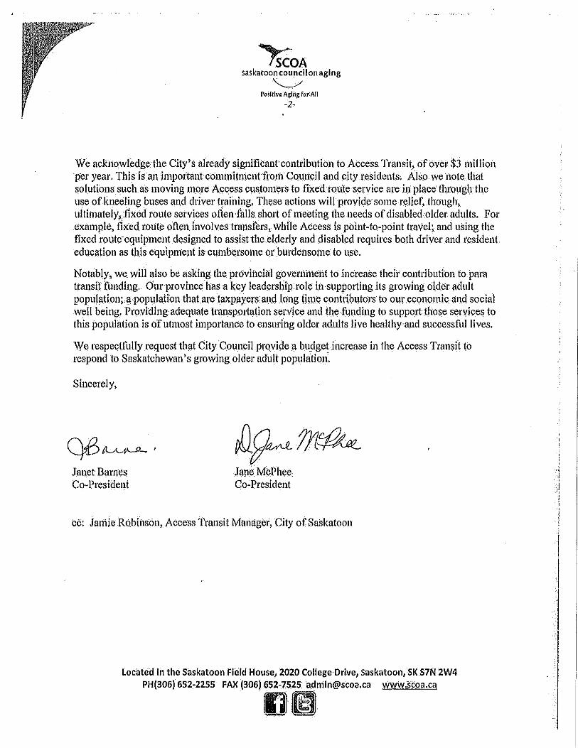
~OA saskatoon council on aging ·~
PoSitive Agli1g for All -2-
We ackl1owledgethe City's already sjgnifkantcontribution to Access Transit, of over $3 million per year. This is an importm1tconnni(meJ)t fron'l Coundl and city t·esidents. Also we noteJhat solutions such as moving more Access cus.tomers to fixed tm(te service are h1 place' through the use of kneeling buses and driver training, These actions will provide some relief, though, ultimately, fixed route services often fans short of meeting the needs of disabled older adults. For exatnple, fixed route ofte1i involves trausfers, while Access is point-to-point travel; and using the fixed rotlte·equipment designed to assist the elderly and disabled requires both driver and resident education as this equipment is cumbersome or burdensome to use.
Notably, we. Will also be asking the provincial governrneilt to increase their contribution to para transit (undil)g. Our province has a key leadership role in supporting its growing old.er adult pop\l]ation;.a population that are taxpayers anr.iJong !ilnt: contribt)tors to otn· econo_mic at1d social well being, Providing adequate transportation service and th.e ft1nding to support those services to this population is of utmost importm1ce to ensuring older adults live healthy and successful lives.
We respectfully request that City Council provide a budgetincrease in the Access Transit to respond to. Saskatchewan's growing older adult population'.
Sincerely,
Qi3 ILA-~\..,.JlJanet Barnes Co-President
llg~m~ l!lll¢ MWhee .. Cp-President
cc: Jamie Robinson, Access Transit Manager, City of Saskatoon
located In the Saskatoon Field House, 2020 College Drive, saskatoon, SK S7N 2W4 PH(306) 652-2255 FAX (306}652-.7525 [email protected] www.scoa.ca
fllml
i j
. '
.j
1 I
I I I

6.1 Attachment
From: Sent: To: Subject:
CityCouncilWebForm Thursday, July 17, 2014 3:27 PM City Council Write a letter to City Council
TO HIS WORSHIP THE MAYOR AND MEMBERS OF CITY COUNCIL.
FROM:
Chester Dobni 203 Trimble Lane Saskatoon, Saskatchewan S?WOCp
EMAIL ADDRESS:
COMMENTS:
I would like to address outstanding street cleaning issues in Willogrove.
1
RECEIVED JUL I 7 2014
CiTY CLERK'S OFFICE SASKATOON
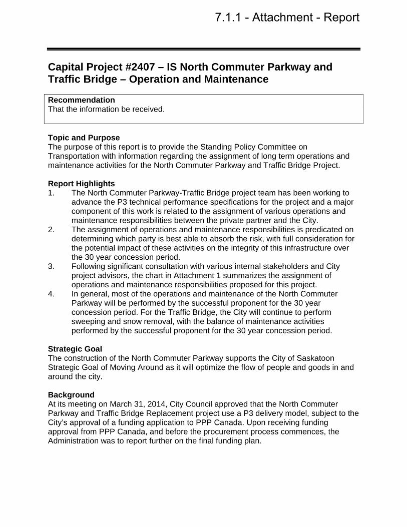
Capital Project #2407 – IS North Commuter Parkway and Traffic Bridge – Operation and Maintenance Recommendation That the information be received. Topic and Purpose The purpose of this report is to provide the Standing Policy Committee on Transportation with information regarding the assignment of long term operations and maintenance activities for the North Commuter Parkway and Traffic Bridge Project. Report Highlights 1. The North Commuter Parkway-Traffic Bridge project team has been working to
advance the P3 technical performance specifications for the project and a major component of this work is related to the assignment of various operations and maintenance responsibilities between the private partner and the City.
2. The assignment of operations and maintenance responsibilities is predicated on determining which party is best able to absorb the risk, with full consideration for the potential impact of these activities on the integrity of this infrastructure over the 30 year concession period.
3. Following significant consultation with various internal stakeholders and City project advisors, the chart in Attachment 1 summarizes the assignment of operations and maintenance responsibilities proposed for this project.
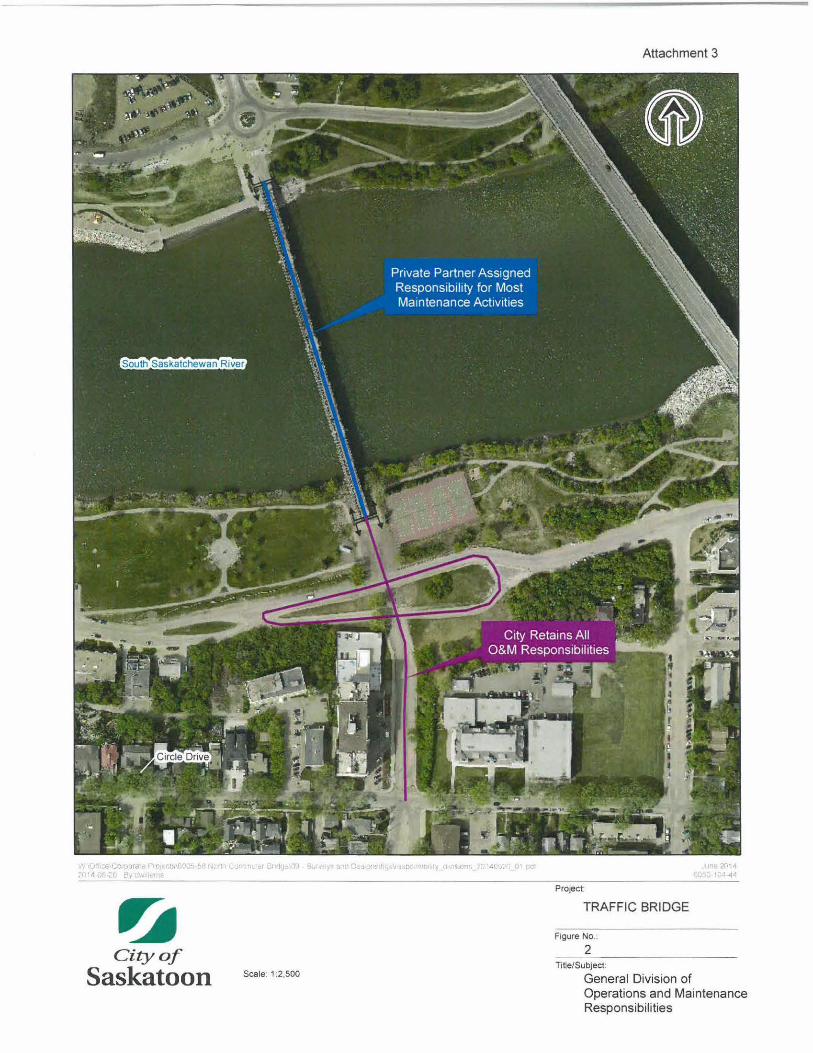
4. In general, most of the operations and maintenance of the North Commuter Parkway will be performed by the successful proponent for the 30 year concession period. For the Traffic Bridge, the City will continue to perform sweeping and snow removal, with the balance of maintenance activities performed by the successful proponent for the 30 year concession period.
Strategic Goal The construction of the North Commuter Parkway supports the City of Saskatoon Strategic Goal of Moving Around as it will optimize the flow of people and goods in and around the city. Background At its meeting on March 31, 2014, City Council approved that the North Commuter Parkway and Traffic Bridge Replacement project use a P3 delivery model, subject to the City’s approval of a funding application to PPP Canada. Upon receiving funding approval from PPP Canada, and before the procurement process commences, the Administration was to report further on the final funding plan.
7.1.1 - Attachment - Report

Capital Project #2407 – IS North Commuter Parkway and Traffic Bridge – Operation and Maintenance
Page 2 of 3
At its meeting on June 9, 2014, City Council approved the funding plan for the project and that Administration may proceed with the Request for Qualifications stage of procurement. Report The North Commuter Parkway project team has been working to complete the P3 technical performance specifications for the Request for Proposal stage of the project. A major component of this work is related to the assignment of various operations and maintenance activities between the private partner and the City. In a P3 project, the assignment of these responsibilities is predicated on determining which party is best able to absorb the risk, with full consideration for the potential impact of these activities on the integrity of this infrastructure over the 30 year concession period. Ensuring the project has a sufficient operations and maintenance component attached is also a critical component of the Value for Money analysis which is completed as part of the business case. Operations and Maintenance Activity Assignments Following significant consultation with various internal stakeholders and project advisors, the various operation and maintenance activities have been assigned as shown in the chart in Attachment 1. The boundaries of responsibility are shown in Attachment 2 and Attachment 3 for the North Commuter Parkway and Traffic Bridge, respectively. A significant consideration in making these assignments was how the City currently delivers these services for existing roadways and bridges, and a risk workshop conducted in late 2013 which evaluated the parties best suited to retain the risks associated with these activities. These assignments were used in the financial analysis completed for the P3 Business Case. In general, most of the operations and maintenance of the North Commuter Parkway will be performed by the successful proponent for the 30 year concession period. For the Traffic Bridge, the City will continue to perform sweeping and snow removal, with the balance of maintenance activities performed by the successful proponent for the 30 year concession period. Financial Implications The approved funding plan is predicated on the information presented in this report. Public and/or Stakeholder Involvement Stakeholder involvement will be required at various stages of the project. Community events will be planned in order to engage and educate the citizens. The Administration will coordinate with applicable stakeholders as necessary. Communication Plan A communications agency has been retained through the Technical Advisor for the project, and a phased-in communications plan has been developed for the life of the

Capital Project #2407 – IS North Commuter Parkway and Traffic Bridge – Operation and Maintenance
Page 3 of 3
project. Webpages for the North Commuter Parkway and Traffic Bridge have been updated and an educational video has been developed. Various community events will be planned in order to engage and educate the citizens. Regular project updates will be provided to City Council by the Project Manager, and more broadly to the general public, through the media. Safety/Crime Prevention Through Environmental Design (CPTED) A preliminary CPTED review was completed at the Committee’s September 5, 2013, meeting. Additional CPTED reviews will be undertaken on staged design submissions during the detailed design period. Due Date for Follow-up and/or Project Completion The Administration is currently operating on a realistic target completion date for the North Commuter Parkway project of October 2018. Public Notice Public Notice pursuant to Section 3 of Policy No. C01-021, Public Notice Policy, is not required. Attachments 1. Design, Construction, Operation, and Maintenance Responsibility Divisions 2. North Commuter Parkway - General Division of Operations and Maintenance
Responsibilities 3. Traffic Bridge – General Division of Operations and Maintenance Responsibilities Report Approval Written by: Dan Willems, Special Projects Manager, Major Projects Reviewed by: Mike Gutek, Director of Major Projects Approved by: Jeff Jorgenson, General Manager, Transportation & Utilities
Department TRANS DW – Capital Project 2407 – IS North Commuter Parkway and Traffic Bridge – Operations and Maintenance

Attachment 1
Project: North Commuter Parkway & Traffic Bridge Project Subject: Design, Construction, Operation. and Maintenance Responsibility Divisions Date: June 20, 2014
Element of Work Saskatoon Loght and Power Transportation & Utihties - Transportation & Utihties -
P3 Partner Transportation Pubhc Works
Street/Bridge Lighting and Power Lines (North Commuter Parkway);
Lighting Design ~
Loghting Civil Works Construction (Buns & Ducts) ~
Lighting Wiring/Davits/Poles/Foxtures Install & " Commission
Temporary Worl<s (Power Pole Relocations. etc.) ~
Operate Lighting ~
Maintain Lighting ~
Street/Bridge Lighting and Power Lines (Traffic Bridge):
Lighting Design ~
Lighting Civil Works Construction (Butts & Ducts) ~
Lighting Wiring/Davits/Poles/Fixtures Install & ~
Commission
Operate Lighting ~
Maintain Lighting "" SL&P Transmission Line and Ductwork (Traffic Bridge):
Ducl\vork Design ~
Ductwork Materials "' Ductwork Construction "' Temporary Works (Existing Transmossoon Line. etc.) ~
Transmissioo Line lnstanauon and Commissioning ~
Traffic Signals (North Commuter Parkway):
Traffoc Signal Design ~
Traffic Signal Construction "' Traffic Signal Operation "" Traffoc Signal Maintenance "" Signage and Pavement Markings (North Commuter Parkway):
Signing and Pavement Marking Deta~ed Design "" Signage and Pavement Marking Construction ~
Signage and Pavement Marking Operation ~
Signage and Pavement Marking Maintenance "' Signage and Pavement Marking (Traffic Bridge):
Sogning and Pavement Markong Detailed Design ~
Signage and Pavement Marking Construction ~
Signage and Pavement Marking Operation ~
Signage and Pavement Marking Maintenance "' Roadways and Pathways (North Commuter Parkway):
Roadway and Pathway Design ~
Roadway and Pathway Construction "' Roadway and Pathway Operation ./
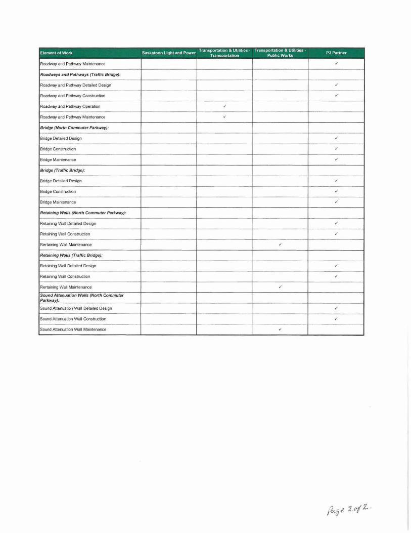
Element of Work Saskatoon Light and Power Transportatoon & Ullhtoes- Transportation & Utihtoes -
PJ Partner Transportation Pubhc Works
Roadway and Pathway Maintenance ' Roadways and Pathways {Traffic Bridge):
Roadway and Pathway Detailed Design ' Roadway and Pathway Construction ' Roadway and Pathway Operation ' Roadway and Pathway Maintenance ~
Bridge (North Commuter Parhway):
Bridge Detailed Design ' Bridge Construction ' Bridge Maintenance "' Bridge {Traffic Bridge):
Bridge Detailed Design ~
Bridge Construction ' Bridge Maintenance ./
Retaining Walls (North Commuter Parkway):
Retaining Wall Detaoled Design "' Retaining Wall Construction ' Rertaining Wall Maintenance ' Retaining Walls {Traffic Bridge):
Retaining Wall Detailed Design ' Retaining Wall Construction ' Rertaining WaU Maintenance ' Sound Attenuation Walls (North Commuter Parkway):
Sound Attenuation Wall Detailed Design ' Sound Attenuation Wall Construction ./'
Sound Attenuation Wall Maintenance v'

~ City of
Saskatoon Scale: 1:30.000
Attachment 2
NORTH COMMUTER PARKWAY
F1gure No.:
1 Title/Subject:
General Division of Operations and Maintenance Responsibilities
~ City of
Saskatoon Scale: 1 :2,500
Attachment 3
TRAFFIC BRIDGE
Figure No.:
2 n~e/Subject:
General Division of Operations and Maintenance Responsibilities

Expansion of School Zone - 20th Street between Avenues M and O Recommendation That the Standing Policy Committee on Transportation recommend to City Council: That the existing school speed zone for the St. Mary’s Education and Wellness
Centre be expanded to include 20th Street West from Avenue M South to Avenue O South.
Topic and Purpose This report requests approval to expand the existing school zone for the St. Mary’s Education and Wellness Centre in order to improve pedestrian safety. Report Highlights 1. A number of students use the intersections of Avenue N and Avenue O to cross
to the school site. 2. Designating this section of 20th Street as a school zone will reduce speed and
improve safety for pedestrians.
Strategic Goal This report supports the City of Saskatoon Strategic Goal of Moving Around, to provide pedestrian safety and optimize the flow of people and goods in and around the city. Background A request was received from the principal of St. Mary’s Education and Wellness Centre and members of the school board to expand the school zone to include 20th Street as a number of their students live and cross 20th Street every day to attend school. Report Transportation reviewed the request for an expansion of the school zone along 20th
Street between Avenue M and Avenue O. A number of site reviews confirmed that students are using the intersections of Avenue N and Avenue O to cross to the school site located at 327 Avenue N South. As a result of the review, Transportation is recommending the expansion of the school zone on 20th Street between Avenue M and Avenue O as shown in Attachment 1. The school zone will be marked with the standard signage to create awareness of the reduced speed zone. Public and/or Stakeholder Involvement On May 22, 2014, a public meeting was held with representatives from the St. Mary’s Education and Wellness Centre, area residents, and the Community Association to
7.2.1 - Attachment - Report

Expansion of School Zone – 20th Street between Avenues M and O
Page 2 of 2
discuss their concerns regarding pedestrian safety along 20th Street. All supported the expansion of the school speed zone onto 20th Street. Communication Plan A Public Service Announcement will be released to inform motorists of the reduced speed school zone. Policy Implications The expansion of the St. Mary’s Education and Wellness Centre speed zone is in accordance with Policy C07-015, Reduced Speed Zones for Schools. Financial Implications The cost to install the school speed zone signage is approximately $1,000. Funding is available within approved Capital Project #1506 - Traffic Signing Replacement.
Budgeted Unbudgeted Capital Operating Non-Mill Rate
External Funding
X $1,000 Other Considerations/Implications There are no other options, environmental, privacy or CPTED implications or considerations. Due Date for Follow-up and/or Project Completion If approved, the school speed zone signage will be installed prior to September 1, 2014. In addition, the Administration is conducting additional reviews of further measures to improve the safety of pedestrians in the area and will provide recommendations in September 2014. Public Notice Public Notice pursuant to Section 3 of Policy No. C01-021, Public Notice Policy, is not required. Attachment 1. Proposed Expansion to St. Mary’s School Zone Report Approval Written by: Justine Nyen, Traffic Safety Engineer, Transportation Reviewed by: Angela Gardiner, Director of Transportation Approved by: Jeff Jorgenson, General Manager, Transportation & Utilities
Department TRANS JN - Expansion of School zone - 20th Street between Ave M and 0

PROPOSED EXPANSION TO ST. MARY'S SCHOOL ZONE ATTACHMENT 1
'""' '
GRACE ADAM METAWEWINIHK PARK '-.
"''" ~
rr; '<...
C( AVENUE 0 ~~/ -
I
ST. MARY'S SCHOOL I
141>'
)I!:
I
AVENUE N
IJIS
[\ ,. "' }1i '"' ,,, >•Z 'l'!
IJI!
\. l)ll
,,.
"' ,,,,
1301
~r AVENUE M
STEVE PATOLA 1·-
PARK
/
EXISTING SCHOOL ZONE
' ·~· _,
~~: ''0 .·
~ ' -~
j'l,"' 1'-
' "'~ -~
1410
' ~"' 1·.
' Ul6
['' '
'" '\. U\2
' 41(.
~ ~·
U01
~ ·~" J ~.I
~" ~ ~'\ 1.)10
--
IJ10
'
'"""
IJOi
I
'" " ' ''
-~ --
12J6
PROPOSED ADDITION TO SCHOOL ZONE

Permanent U-Pass Program with Saskatchewan Indian Institute of Technologies Recommendation 1. That the Administration be directed to finalize an agreement with the Saskatchewan
Indian Institute of Technologies for a U-Pass Program based on the terms of this report; and,
2. That the City Solicitor be requested to prepare the appropriate agreement and that
His Worship the Mayor and the City Clerk be authorized to execute the agreement under the Corporate Seal.
Topic and Purpose Administrations from both Saskatoon Transit and the Saskatchewan Indian Institute of Technologies (SIIT) have deemed the pilot U-Pass Program a success. Your Administration seeks approval to finalize an agreement with the SIIT for a permanent U-Pass Program. Report Highlights 1. The pilot U-Pass Program with SIIT, approved by City Council on December 5,
2011, was in effect from January 1, 2012 to December 31, 2012 with further extensions granted until May 31, 2014.
2. The new agreement would put into place a permanent U-Pass Program for the SIIT students.
Strategic Goals The recommendations in this report support the long-term strategy for Saskatoon Transit of attracting and retaining new ridership which builds on the Strategic Goals of Moving Around and Environmental Leadership. Background In September 2011, Saskatoon Transit and SIIT entered into discussions with the intent of establishing a U-Pass Program for the students attending the institute and to be designed similar in nature to the U-Pass Program currently in place for students attending the University of Saskatchewan. On December 5, 2011, City Council approved a pilot U-Pass Program which ran from January 1, 2012 to December 31, 2012 with further extensions granted until May 31, 2014. The pricing for the winter semester 2014 (January 1, 2014 to May 31, 2014), the final semester of the pilot program, was set at $112.23.
7.2.2 Attachment - Report

Permanent U-Pass Program with Saskatchewan Indian Institute of Technologies
Page 2 of 4
Report Pilot U-Pass Program Administration from both SIIT and Saskatoon Transit spoke on June 30, 2014, to discuss the pilot U-Pass Program. Both administrations agreed that the pilot U-Pass Program was a success and deemed it appropriate to move toward a permanent U-Pass Program for students at SIIT. Survey results from SIIT obtained prior to the implementation of the pilot U-Pass Program, showed that out of the 126 students surveyed, 49 used an adult monthly pass, 4 used a student semester pass, 60 indicated they use Saskatoon Transit daily, and 113 indicated they would be in favour of the U-Pass Program. Adoption of the U-Pass Program requires all students enrolled to participate, representing roughly 200 students and an increase in pass sales of 147 (based on the 2011 survey results). U-Pass Program Agreement The business terms between Saskatoon Transit and SIIT will be based on the current agreement. The key terms of this agreement are as follows: • The program is mandatory with exceptions to those living outside City limits, enrolled
exclusively in distance education courses, holding a disabilities parking pass, participating in Adult Basic Education Programs whose education expenses are covered under the Province of Saskatchewan’s Provincial Training Allowance, or enrolled in the welding program.
• The rates that will be charged and collected by the institution will be $112.23 per student per fall 2014 semester pass. This price will increase yearly by the Municipal Price Index (MPI) and will take effect for the winter semester prices.
• Either party can terminate the agreement by providing 30-day’s notice to the other party.
• The program requires either unique passes or stickers on student cards. • A student that graduates or leaves the institution loses the transit pass privileges. • The institution is responsible for the handling and distribution of the passes and
reporting on this to Saskatoon Transit. Options to the Recommendation The available options would be to discontinue the U-Pass Program with SIIT or extend the trial period for one year. These options are not being recommended at this time since the U-Pass Program with SIIT has proven to be both effective and well received. Public and/or Stakeholder Involvement The body of this report outlines engagement with Saskatchewan Indian Institute of Technologies as an important Saskatoon Transit stakeholder. Communication Plan Accessible, clear and concise information on Transit routes and schedules, along with the advantages of travelling on transit will help SIIT students realize the full potential of

Permanent U-Pass Program with Saskatchewan Indian Institute of Technologies
Page 3 of 4
their U-Pass. This information is available on the City’s website (www.saskatoon.ca and click on “T” for Transit) through Click and Go and Google Transit. Financial Implications The U-Pass will increase ridership, remain revenue neutral for Saskatoon and provide cost-effective transportation for students of the institution. The U-Pass price per term for SIIT will be as follows and will increase yearly based on increases in the MPI:
September 1, 2014 – December 31, 2014 (fall term) – $112.23 January 1, 2015 – April 30, 2015 (winter term) – $115.85
These values will increase yearly based on increases in the MPI. During the trial period, there were approximately 150 passes sold per term to SIIT students. Based on these numbers, it is estimated that $34,200 in revenue will be earned in the first year of the agreement. Since this amount represents a decrease in sales from other fare types, there will be no net increase in operating revenue. The proposed U-Pass Program for the SIIT has been based on an existing template for groups and institutions pursuing similar agreements. These partnerships have the potential to increase ridership for Saskatoon Transit. The U-Pass Program is financially viable as there will be an increase in the passes purchased by students who attend classes at SIIT. The Administration is confident that, at this time, there will be no incremental cost for bus operations to Saskatoon Transit for implementing a U-Pass Program for SIIT. However, as ridership increases through subsequent U-Pass Programs, additional buses and service hours may be required subject to the number of new riders, the time of day new riders use the bus, and which part of the city new riders are transporting to and from. Environmental Implications The U-Pass Program will provide a positive environmental impact as a result of reducing greenhouse gas emissions. When looking at the commuting patterns of the students surveyed, 38 did not use Saskatoon Transit as their primary mode of transportation for their daily commute to classes. The result of having 38 fewer vehicles making the daily commute to school would reduce greenhouse gas emissions by 23.4 tonnes annually. This result was based on Statistics Canada’s 2006 Census, which indicates the average daily commute in Saskatoon was 5 km one way, Canadian average motor vehicle fuel economy of 21 mpg/City and 200 days of classes for the school year. There could be a further reduction if these 38 students choose to use Saskatoon Transit on the weekends. Other Considerations/Implications There are no policy, privacy, or CPTED implications.

Permanent U-Pass Program with Saskatchewan Indian Institute of Technologies
Page 4 of 4
Due Date for Follow-up and/or Project Completion If approved, consultation with SIIT will occur yearly, starting in one-year’s time, to discuss the U-Pass Program’s success and determine any possible improvements. Public Notice Public Notice pursuant to Section 3 of Policy No. C01-021, Public Notice Policy, is not required. Report Approval Written by: Mike Moellenbeck, Accounting Coordinator Reviewed by: Bob Howe, Director of Saskatoon Transit Approved by: Jeff Jorgenson, General Manager, Transportation & Utilities
Department TRANS - Permanent U-Pass Program with Saskatchewan Indian Institute of Technologies

New Pavement Design Guidelines Recommendation 1. That the new pavement design guidelines as outlined in the following report be
approved; and 2. That the new guidelines be finalized and implemented for all development after
January 1, 2015. Topic and Purpose The purpose of this report is to provide information on the Administration’s recommended new pavement design guidelines for construction of new roadways. The design guideline is based on the design procedures outlined in the American Association of State Highway and Transportation Officials (AASHTO) 1993 Guide for Design of New Pavement Structures. Report Highlights 1. The City’s current pavement design standards need to be improved in order to
better accommodate existing soil conditions, water table issues and serviceability in the urban environment as Saskatoon expands, and to ensure the most cost-effective product is delivered to its citizens.
2. It is recommended by the Administration to proceed with implementing the AASHTO 1993 design methodology, supplemented with a sub-surface drainage requirement, as the City’s standard for roadway design.
3. Implementing the AASHTO 1993 design standard will generally result in thicker asphalt, a sub drainage system for all new roadways, and a mandatory deferred top lift asphalt layer on local, collector and select arterial roadways with substantial utilities installed below.
4. For a typical residential roadway, there would be an increase in initial direct capital cost of approximately 14% to 43% depending on the soil and groundwater conditions.
5. For a typical paved lane, there would be an increase in initial direct capital cost of 33% to 67% depending on the soil and groundwater conditions.
Strategic Goals Upgrading the pavement design guidelines aligns with the City’s Building Better Roads plan and supports the Strategic Goals of Asset and Financial Sustainability and Moving Around.
7.2.3 - Attachment - Report

New Pavement Design Guidelines
Page 2 of 5
Background Improvement of Pavement Design Guidelines The Administration is looking to improve the City’s current pavement design standards in order to better accommodate existing soil conditions, water table issues and serviceability in the urban environment as Saskatoon expands, and to ensure the most cost-effective product is delivered to its citizens. The Administration commissioned a study to review, compare and recommend a design methodology that would provide the City with the best, most cost-effective roads for the long term. Methodologies such as the Saskatchewan Method, AASHTO, Mechanistic Empirical Pavement Design Guide and mechanistic design methodologies were assessed and evaluated as part of the study. The City’s current design standards are based on the Saskatchewan Shell Curve design method, modified to deal with local climate and soils. This methodology is only practiced in Saskatchewan and is being used by the Saskatchewan Ministry of Highways and Infrastructure. The City of Saskatoon has been utilizing this method for over 25 years. Reviewing the design standards is intended to address roadway issues related to moisture sensitive soils, water infiltration and increased heavy traffic during build out of neighbourhoods. Report The City’s goal is to have an improved pavement design guide that follows a design methodology that: • is well understood and widely used throughout North America; • is geared towards pavement structural design for urban conditions; • can be reviewed and checked in-house by City Staff; • can be easily adopted well in advance for roadway design work required for the
2015 construction season; and • offers the ability to provide additional design and rehabilitation options by utilizing
non-destructive testing and analysis. Tetra Tech EBA Inc. (Tetra Tech) was commissioned to evaluate and recommend a design methodology that would provide for the above points. The three tasks undertaken were: 1. Identify, evaluate and recommend a preferred pavement design methodology for
new pavements; 2. Determine appropriate values or methods to establish the inputs and parameters
required for the preferred design method; and 3. Develop a Pavement Design Guide for new pavement. Recommended Design Methodology A number of methodologies such as the Saskatchewan Method, AASHTO, Mechanistic Empirical Pavement Design Guide and mechanistic design methodologies were

New Pavement Design Guidelines
Page 3 of 5
assessed and evaluated. The above methodologies were thoroughly reviewed by Tetra Tech and it is recommended to proceed with the AASHTO 1993 methodology which is a North American best practice. Many jurisdictions in Canada utilize the AASHTO 1993 methodology including British Columbia, Alberta, Manitoba, Ontario, Quebec, and Nova Scotia, as well as most of the United States. The Administration instructed the consultant to move forward with the AASHTO 1993 methodology for the purpose of generating a new roadway design guide (Attachment #1). The Administration wishes to adopt the new methodology for any new development after January 1, 2015. The new design guidelines provide the following features: • Accommodation of alternative materials in the design process such as recycled
concrete, drainage materials, high performance polymer-modified asphalt concrete (PMAC);
• Provides a reliability-based approach to account for variations in traffic and performance prediction and to manage this risk based on roadway traffic loading (or roadway classification);
• Is technically straightforward and generally well understood by pavement practitioners;
• Has design inputs (traffic loading and subgrade support condition) that are relatively inexpensive to quantify;
• Is a procedure that is empirically based and has been used in Western Canada for 20 plus years with good performance experience;
• Can be used in the design of pavement rehabilitation options using non-destructive testing;
• Can be implemented quickly by the City; and • Will provide the option to possibly adopt the new AASHTO Mechanistic-Empirical
Pavement Design Guideline in the future. Resulting Factors of the New Design Guideline The key differences with the current design standards and the proposed design standards are: • a required sub drainage system for all roadways; • designs will be developed using AASHTO 1993 criteria, which will typically result
in a thicker hot mix asphalt layer; and • a mandatory deferred top-lift asphalt on all local roadways, all collector roadways
and select arterial roadways with substantial utility installations.
The sub drainage system is to mitigate water or frost related failure mechanism. This is the primary cause of premature failures in the City’s roadway network. The changes proposed will result in longer service life of the City’s roadway system. The changes will also minimize the risk of future full-depth structural rehabilitations, which are extremely costly and disruptive. The deferred top-lift asphalt process will provide staged construction to help deal with short-term settlements from utility installations and provides a new driving surface close to substantial neighbourhood build out once construction traffic has been removed from the area and damage to the roadways can be minimized.

New Pavement Design Guidelines
Page 4 of 5
While the design guide is near its final draft, there will be minor modifications to include items including minimum paved lane structures, mandatory deferred pavement lifts and modifications to ensure the guide aligns with the City of Saskatoon Standard Specifications and Drawings. Communication Plan The Developer’s Liaison Committee was presented the new design guidelines on July 29, 2014. The Administration has taken comments and concerns from the committee into account for further follow-up and review prior to final implementation of the design standards. Any changes resulting from reviews will be based on best engineering practices. Any change to current practices, with regard to the items listed above, will continue to be coordinated with Transportation, Water and Sewer, Public Works and other divisions or stakeholders as required. Communication activities will be integrated when possible into relevant communication plans involving roadway design, preservation or construction practices. The communication of the new standards will be integrated with the City’s Building Better Roads communication plan including news conferences, advertisements, and social media as required. Financial Implications The most significant change to building our roads includes a thicker asphalt layer, the required installation of a sub drainage system and mandatory deferred pavement lifts on lower class roadways and roadways with substantial infrastructure installed below. For a typical residential roadway, there would be an increase in cost of approximately $10 to $30 per square meter depending on the sub drain system required resulting from the soil and water table conditions. On a typical 10m roadway, these changes will add between $762 and $2,287 to the development cost of the lot. To construct a new residential roadway, based on the City’s current design standard, it costs approximately $70 per square meter. Under the new design guidelines and given the same bearing strength of the subgrade, the cost to construct could range from approximately $80 to $100 per square metre including a sub drainage system and thicker asphalt. Paved back lanes will be required to have the same roadway structure as a local roadway with a centre drain or a full drainage layer depending on the estimated level of the water table. To construct a new paved back lane, based on the City’s current design standard, it costs approximately $60 per square meter. Under the new proposed design guidelines and given the same bearing strength of the subgrade, the cost to construct could range from approximately $80 to $100 per square metre. These changes will add between $1,174 to $2,881 to the development cost of each lot.

New Pavement Design Guidelines
Page 5 of 5
It should be noted that although the initial capital cost is higher, the Administration is confident that the new roadway standard will provide higher quality roadways that require less expensive treatments over their lifecycle to maintain their good condition. Investing more up front will result in savings in the future. Other Considerations/Implications There are no options, policy, environmental, privacy, or CPTED implications or considerations. Due Date for Follow-up and/or Project Completion The City Administration plans to adopt the new methodology for January 1, 2015. Public Notice Public Notice pursuant to Section 3 of Policy No. C01-021, Public Notice Policy, is not required. Attachment 1. Tetra Tech EBA Inc. – City of Saskatoon New Roadway Pavement Design Guide Report Approval Written by: Mitchell Parker, Manager, Asset Preservation for Roads Reviewed by: Rob Frank, Manager, Preservation Services Reviewed by: Mike Gutek, Director of Major Projects Approved by: Jeff Jorgenson, General Manager, Transportation & Utilities TRANS MG – New Pavement Design Guideline – July 30 2014

ATTACHMENT 1
[ 1t;:] TETRA TECH
CITY OF SASKATOON NEW ROADWAY PAVEMENT DESIGN GUIDE
PRESENTED TO
The City of Saskatoon
JUNE 2014 ISSUED FOR USE FILE: E32103173-01
•
BUILDING BETTER ROADS
SASKATOON'S ROAD PLAN
Tetra Tech EBA Inc. 300, 410- 22 Street East
Saskatoon , SK S7K 5T6 CANADA Tei 306.347.4000 Fax 306.352.1687

Th1s page Intentionally left blank.
TETRA TECH

TABLE OF CONTENTS
CITY OF SASKATOON NEW ROADWAY PAVEMENT DESIGN GUIDE
FILE. E32103173-01 I JUNE 2014 I ISSUED FOR USE
1.0 PURPOSE ...... ....... ....... .. ... ..... ... .. .... ........... ........ .......... ....... ............ .. ....... .... ..... ......... ............ ..... . 1
2.0 DESIGN INPUTS .................... ... .... ..... ........ .. ...... ......... ........ .... .......... ... .. ...... .... ........... .... .... .. .. ..... 1 2.1 Drainage Considerations ...... ... ...... ............ .. .. ............... ............ .......... ............................. .......... ............ 1
2.1.1 Urban Cross-section ......... ...... ...................... .. ........................................................... .. .. .. .. .... ... 1 2.1.2 Rural Cross-section ... ...... .............. .............................. ............................ .............. ..... ........ ...... 3
2.2 Subgrade Support Conditions ....... .. ................. .... .. .... ...... ............... .............. .. ........ .. ... ......... ................. 4
2.3 Design Traffic .......... .... .. ....................................... .. ..................... .. ......... .............................. ..... ............. 6
3.0 DESIGN PROCEDURE FOR NEW CONSTRUCTION ........ ................ ...... ............ .... .. .. .. ............ . 8 3.1 AASHTO Design Inputs; Reliability, Serviceability and Overall Standard Deviation ........ .. ............ ....... 8 3.2 Material Characterization ... ............. ............. .... ..... .. ............ .. ........ .. ... .. ............... .... .. .......... ................... 9 3.3 AASHTO Design Procedure .... .. .. .... ...... .... .. .............. .. .. .... ......... ... ............ ................ .... ...................... 10
3.4 Minimum Pavement Layer Thicknesses ............................................................................ ...... ...... ...... 11 3.5 Deferred Top Lift Construction ............................... ............................... .... .... .......................... ........ ..... 12 3.6 Sample Design ........ ..... .... ... ... ......... ... ......... .... ... ......... .. ... ............... ....... ................... .................. ......... 13
4.0 SUPPLEMENTARY PUBLICATIONS ...... ........ .. .. .. ... ......... ... ............ ... ...... ................ ... .. .... .. ..... 16
5.0 SUBMITTAL REQUIREMENTS ... ..... .. .... .. .... ... .... ....... ..... ....... ...... .. ...... .......... .. ......... ....... .... .. .. . 16
LIST OF TABLES IN TEXT
Table 1: Recommended Design Period .......... ............. ............................... .................. ....... .. .. .. .... .. .. ... 6 Table 2: Lane Distribution Factors ........... ............................. ...... .... ... ...... ..... ... ...... ... .. .............. .... .. .... .. 6 Table 3: AASHTO Pavement Design Inputs ... ........ ............ ...... ... ... ...... ....... ....... ............ .. ............... ...... 8 Table 4: Recommended AASHTO Layer Coefficients .. ...... ..... .... .. ....... ......................... .. ................ ...... 9 Table 5: Recommended AASHTO Drainage Coefficients .. .. .... ...... .... .. .................... ........ .. .. .. ............... 9 Table 6: Recommended Drainage Layer Gradation and Permeability Requirements .. ................ .. .. .. ... 1 0 Table 7: Recommended Minimum Pavement Layer Thicknesses .... .. .. .... .. ...... .. .. .. .. .. .... ...... ............... 11 Table 8: Minimum Recommended ACP Thicknesses for Deferred Construction .. .......... .... .. .... .... .. .. ... 13
LIST OF FIGURES IN TEXT
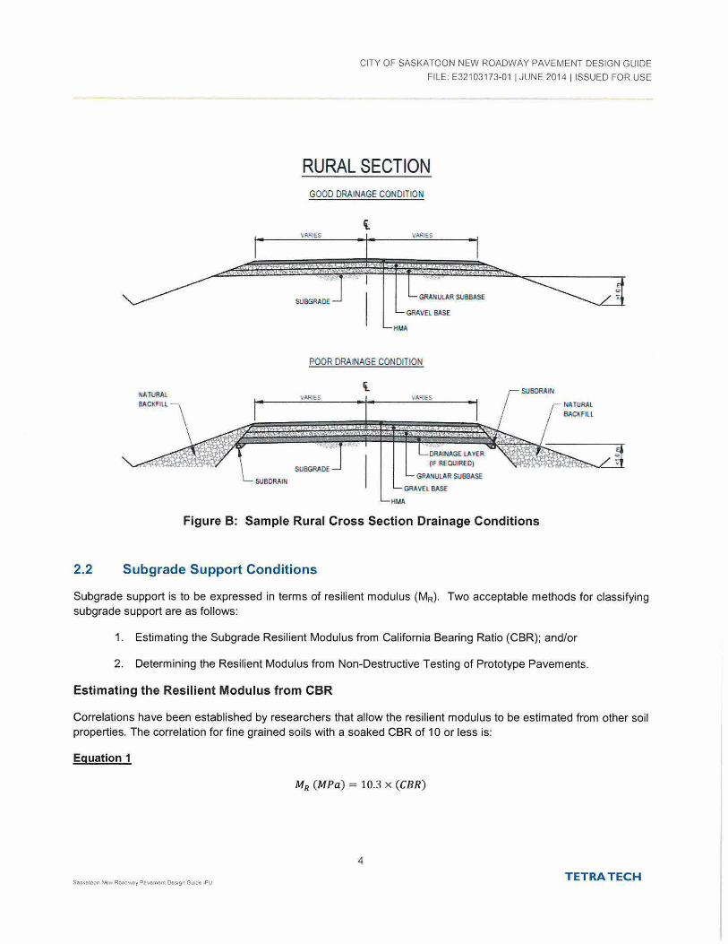
Figure A: Sample Urban Cross Section Drainage Conditions .............. ........ .. .. .. .... .. .. .. .... .. .................... 2 Figure B: Sample Rural Cross Section Drainage Conditions .................................................. ............ ... 4 Figure C: Granular Base/Sub-base Alternative Minimum Granular Thicknesses .............. .. .. .............. . 12
APPENDIX SECTIONS
FIGURES
Figure 1 New Flexible Pavement Design Flow Chart
TETRA TECH

CITY OF SASKATOON NEW ROADWAY PAVEMENT DESIGN GUIDE
FILE. E321 03173-01 I JUNE 2014 !ISSUED FOR USE
LIMIT AllONS OF REPORT
This report and its contents are intended for the sole use of The City of Saskatoon and their agents. Tetra Tech EBA Inc. (operating as Tetra Tech) does not accept any responsibility for the accuracy of any of the data, the analysis, or the recommendations contained or referenced in the report when the report is used or relied upon by any Party other than The City of Saskatoon. or for any ProJect other than the proposed development at the subject site. Any such unauthorized use of this report is at the sole risk of the user. Use of this report is subject to the terms and conditions stated in Tetra Tech EBA Inc.'s Agreement with the City of Saskatoon dated March 7, 2014 .
TETRA TECH

1.0 PURPOSE
CITY OF SASKATOON NEW ROADWAY PAVEMENT DESIGN GUIDE
FILE: E32103173-01 I JUNE 2014 !ISSUED FOR USE
The purpose of the City of Saskatoon New Roadway Pavement Design Guide (Design Guide) is to define the pavement design methodology and procedures to be used for new flexible pavement design within the City of Saskatoon. The Design Guide is based on the design procedures outlined in the American Association of State Highway and Transportation Officials (AASHTO) 1993 Guide for Design of New Pavement Structures modified for the City of Saskatoon's conditions.
This Design Guide focuses on addressing three primary components concerning the design of new flexible pavement structures:
1. Drainage,
2. Subgrade Support, and
3. Traffic Loadings.
Design methodology has been provided for both rural and urban roadway cross-sections. For the purpose of this Design Guide, urban and rural cross sections can be defined as follows:
Urban cross-section - roadway with surface drainage controlled with curb and gutter, catch basins and a storm sewer system; and
Rural cross-section - roadway with surface drainage directed to ditches on both sides of the road, with a minimum of 1 m from ditch bottom to the top of subgrade and with lateral drainage of the granular material extended through the shoulder to drain out onto the side slope.
The design methodology presented in this Design Guide addresses the various design steps and inputs the Pavement Designer must consider when completing a new flexible pavement design. These steps are presented in Figure 1 located in the Figures section of this Design Guide.
2.0 DESIGN INPUTS
2.1 Drainage Considerations
It is important to consider geometric aspects that influence pavement drainage. Adequate surface drainage is important and minimum cross-slopes and longitudinal grades should be established. Sufficient grade at the top of subgrade is important to promote water being evacuated as quickly as possible along the granular base-subgrade interface. These influencing geometric factors apply to both urban and rural cross-sections.
2.1.1 Urban Cross-section
Guidelines for the pavement design drainage for urban cross sections are presented in the following sections. A hydro-geological study should be carried out for areas incorporating new or reconstructed roadways. Note that "seasonal groundwater" represents the most shallow groundwater condition anticipated, based on the hydrogeological study for the area. Sample cross sections for urban drainage conditions are presented in Figure A.
Seasonal Groundwater Greater than 1.0 m below Subgrade Elevation
Where the seasonal groundwater is located 1.0 m or greater below the anticipated subgrade elevation longitudinal edge drains should be provided within the sub-base material at the top of subgrade. For crowned roads a drain is
TETRA TECH

CITY OF SASKATOON NEW ROADWAY PAVEMENT DESIGN GUIDE
FILE: E32103173-01 I JUNE 2014 !ISSUED FOR USE
required on both sides of the pavement. If superelevated the drain is only required on the low side. A notch at the edge of the subgrade using a motor grader is often used to avoid the drain pipe from creeping during subbase placement. The subdrain should be a 100 mm diameter (or greater if required by the roadway width) perforated plastic pipe with a filter sock. Positive outfall of the drains should be provided at catchbasins. Where catch basins do not exist, outfall can be made to ditches with a preferred spacing of 1 00 m.
Seasonal Groundwater Less than 1.0 m below Subgrade Elevation
Where the seasonal groundwater is located less than 1.0 m below the anticipated subgrade elevation, a minimum 200 mm thick drainage layer should be provided. The drainage layer should be enveloped in non-woven geotextile to prevent fines from entering the drainage layer. To evacuate the collected water the same subdrain configuration as described for the "groundwater greater than 1.0 m" condition should be installed. The drain should be located within the drainage layer material and geotextile with positive outfall at catchbasin locations.
URBAN SECTION GOOD DRAINAGE CONDITION
SEASONAL GROUNDWATER >1 0 m FROM SUBGRADE
POOR DRAINAGE CONDITION
SEASONAL GROUNDWATER <1 0 m FROM SUBGRADE
Figure A: Sample Urban Cross Section Drainage Conditions
2
TETRA TECH

CITY OF SASKATOON NEW ROADWAY PAVEMENT DESIGN GUIDE
FILE: E32103173-01 I JUNE 2014 I ISSUED FOR USE
2.1 .2 Rural Cross-section
Guidelines for the pavement design drainage for rural cross sections are presented in the following sections. In the case of rural cross sections, the drainage design is based on the distance from the top of subgrade to the ditch invert.
Ditch Invert 1.0 m or Greater below Subgrade Elevation (Good Condition)
Where the ditch invert is located a 1.0 m or more below the subgrade, the pavement drainage condition is considered as good. In this case the granular materials, base and sub-base, should extend to the road sideslope to enable water to escape. No other drainage detail is necessary.
Ditch Invert between 0.5 m to <1.0 m below Subgrade Elevation (Marginal Condition)
Where the ditch invert is located less than 1.0 m below subgrade, but greater than 0.5 m, the pavement drainage condition is considered marginal. Project and location specific conditions should be considered that would influence the potential depth of water that may be held in the ditch. This would include the longitudinal ditch grade, sideslope angle, width of ditch, surface drainage pattern from surrounding area, etc ..
If the potential for standing water greater than 200 mm in depth is considered unlikely, the "good condition" detail of daylighting the granular materials to the sideslope is considered appropriate. If the potential for standing water greater than 200 mm in depth is considered likely, the pavement structure should be designed as for an urban section with the same details for either a shallow or deep groundwater condition (but not curb and gutter). The material outside of the roadway footprint (i.e. the material forming the sideslope) should be constructed with finegrained low permeable material to act as a "plug" preventing water from entering the pavement structure from the ditch.
Ditch Invert less than 0.5m below Subgrade Elevation (Poor Condition)
Where the ditch invert is located less than 0.5 m below subgrade, the pavement drainage condition is considered poor. The pavement structure should be designed as for an urban section with the same details for either a shallow or deep groundwater condition (but not curb and gutter). The material outside of the roadway footprint (i.e. the material forming the sideslope) should be constructed with fine-grained low permeable material.
3 Snka1oon ""11\o Roadway Pavemenl Ot51gn Gvrde IF'U
TETRA TECH
KATURAL
.. -,._, .
SUBORAIN
CITY OF SASKATOON NEW ROADWAY PAVEMENT DESIGN GUIDE
FILE: E32103173-01 I JUNE 2014 !ISSUED FOR USE
RURAL SECTION GOOD DRAINAGE CONDITION
VARitS VARI!:S
~ . "'•" .· .- ' , I
GRANutAR SUI!.BASE
GRAVEL BASE
HMA
POOR DRAINAGE CONDITION
VARioS V4RloS
,.,.,. .. , • -\l'.""'\'t 'V# . r~<. ~ 0:
GRANULAR SUBaASE
GRAVEL BASE
HMA
(
SUBORAIN
NATURAL
[~""
Figure B: Sample Rural Cross Section Drainage Conditions
2.2 Subgrade Support Conditions
Subgrade support is to be expressed in terms of resilient modulus (MR)- Two acceptable methods for classifying subgrade support are as follows:
1. Estimating the Subgrade Resilient Modulus from California Bearing Ratio (CBR); and/or
2. Determining the Resilient Modulus from Non-Destructive Testing of Prototype Pavements.
Estimating the Resilient Modulus from CBR
Correlations have been established by researchers that allow the resilient modulus to be estimated from other soil properties. The correlation for fine grained soils with a soaked CBR of 1 0 or less is:
Equation 1
MR (MPa) = 10.3 x (CBR)
4
Saskatocn New Roadway Pav~n\$n\ Oes.gn Gu1de !FU TETRA TECH
CITY OF SASKATOON NEW ROADWAY PAVEMENT DESIGN GUIDE
FILE: E32103173-01 I JUNE 2014 !ISSUED FOR USE
An appropriate number of tests should be performed to reflect the test repeatability, the range of soil types expected to be encountered on the project, and the size of the project. The recommended minimum frequency for CBR testing is one test for every 3,000 sq.m. of pavement, with a minimum of three tests per project.
Determining the Resilient Modulus from Non-Destructive Testing of Prototype Pavements
The resilient modulus may be determined by testing a prototype pavement structure with a Falling Weight Deflectometer (FWD) and the deflection data analysed to determine the back-calculated subgrade modulus. For the design of new construction pavement structures, the subgrade modulus can be estimated using an existing representative roadway located near the new project, with similar subgrade soils and drainage conditions, as a prototype. The prototype should preferably meet the following criteria :
be a minimum of 3 years old;
be a minimum of 0.5 km in length;
be reasonably free of structural distress;
be slightly under-design for the loading condition on the new project being designed; and
have the same pavement structure type as proposed for the new project being designed.
Alternatively, for a roadway that is being reconstructed to increase capacity or improve geometries, the existing road can be tested with an FWD prior to reconstruction .
The recommended method for determining design MR from FWD testing requires an adjustment factor (C) to adjust the value used to represent subgrade conditions consistent with the AASHO road test and to account for regional climate effects. The intent of this adjustment is to ensure the design MR is representative of the aggregate "year-round" subgrade support condition.
The Effective Roadbed Resilient Modulus for design purposes can be determined by the following equation:
Equation 2
Design MR = 0.36 x (Backcalculated MR ), where MR is in MPa
This combined adjustment factor would apply to pavement tested by the FWD during the mid-summer through early fall months when the subgrade is in a relatively stable and unfrozen condition. Unusual spring conditions (earlier or later than normal} may affect this period of stability and should be considered when interpreting the results.
The City must approve the use of this method to determine the resilient modulus for pavement design purposes on a project-by-project basis.
Selection of the Resilient Modulus Value for Design
It is important to note that the design of a pavement structures following the 1993 AASHTO Guide is based on the average MR value for a representative soil type. The designer must not select a design MR value based on some minimum or conservative criteria as this will introduce increased conservatism in design beyond that provided in the reliability factor.
5 Sn\1.1\oon Ntv. Fcoedv.tr~y Pavemen\ On~gn Gwde tFU
TETRA TECH
2.3 Design Traffic
CITY OF SASKATOON NEW ROADWAY PAVEMENT DESIGN GUIDE
FILE : E321031 73-01 I JUNE 2014 I ISSUED FOR USE
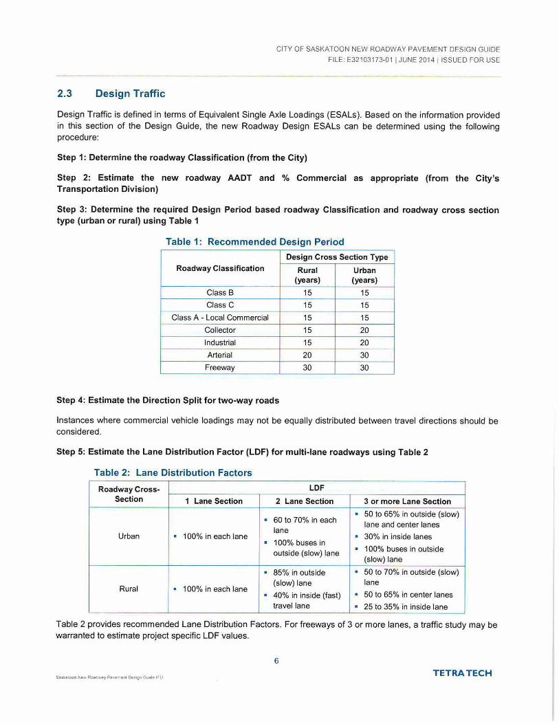
Design Traffic is defined in terms of Equivalent Single Axle Loadings (ESALs). Based on the information provided in this section of the Design Guide, the new Roadway Design ESALs can be determined using the following procedure:
Step 1: Determine the roadway Classification (from the City)
Step 2: Estimate the new roadway AADT and % Commercial as appropriate (from the City's Transportation Division)
Step 3: Determine the required Design Period based roadway Classification and roadway cross section type (urban or rural) using Table 1
Table 1: Recommended Design Period
Design Cross Section Type
Roadway Classification Rural Urban (years) (years)
Class B 15 15
Class C 15 15
Class A - Local Commercial 15 15
Collector 15 20
Industrial 15 20 --Arterial 20 30
Freeway 30 30
Step 4: Estimate the Direction Split for two-way roads
Instances where commercial vehicle loadings may not be equally distributed between travel directions should be considered.
Step 5: Estimate the Lane Distribution Factor (LDF) for multi-lane roadways using Table 2
Table 2 : Lane Distribution Factors
Roadway Cross- LDF Section 1 Lane Section 2 Lane Section 3 or more Lane Section . 50 to 65% in outside (slow) . 60 to 70% in each
lane and center lanes lane
Urban • 100% in each lane • 30% in inside lanes • 100% buses in
outside (slow) lane . 1 00% buses in outside
(slow) lane . 85% in outside . 50 to 70% in outside (slow) (slow) lane lane
Rural . 1 00% in each lane . 40% in inside (fast) • 50 to 65% in center lanes travel lane • 25 to 35% in inside lane
Table 2 provides recommended Lane Distribution Factors. For freeways of 3 or more lanes, a traffic study may be warranted to estimate project specific LDF values.
6
Saskatoon New Roadway P8vement Oes:gn Gwde IF"U TETRA T ECH

CITY OF SASKATOON NEW ROADWAY PAVEMENT DESIGN GUIDE
FILE: E32103173·01 I JUNE 2014 !ISSUED FOR USE
Step 6: Estimate the Load Equivalency Factor (LEF) for the expected axle classifications/loadings
Ideally a blended LEF is determined from detailed axle spectra , which would include the anticipated range of axle classifications and weights. It is understood however that this information is not always available, and therefore a blended LEF must be estimated by other means.
Commercial Traffic is typically expressed in terms of percentage Single Unit Trucks, Tractor Trailer Combinations, and Transit Bases. The following range of LEFs is recommended for each commercial vehicle classification:
Single Unit Trucks (SUT)- 0.8 to 1.2 ESALs per truck ;
Tractor Semi-Trailer Combinations (TTC)- 1.2 to 2.0 ESALs per truck; and
Transit Buses (Bus)- 2.0 to 3.0 ESALs per bus.
A blended LEF can be determined from the LEF values for each truck/bus classification and the estimated proportion of each truck/bus type using Equation 3.
Equation 3
. [(#SUT) x SUTLEF + (#TTC) x TTCLEF +(#Bus) x BusLsF] Load Equwalency Factor (LEF) = (#SUT) + (#TTC) +(#Bus)
Step 7: Determine the Traffic Growth Factor (TGF)
Estimate the traffic growth rate and determine the Traffic Growth Factor (TGF) for the corresponding Design Period from Step 3. The TGF can be determined using Equation 2.
Equation 4
Where:
[(1 + g)n- 1] Traffic Growth Factor (TGF) = __ .;;__ __
9
g =growth rate (expressed as a decimal, e.g. 3% = 0.03); and
n = design period in years.
Step 8: Determine the new roadway Design ESALs as per Equation 5
Equation 5
Design ESALsj lane = (AADT) x (%Commercial) x (Direction Split) X (LDF) X (LEF) X (365 daysjyear) X (TGF)
7 TETRA TECH

CITY OF SASKATOON NEW ROADWAY PAVEMENT DESIGN GUIDE
FILE: E32103173-01 I JUNE 2014 !ISSUED FOR USE
3.0 DESIGN PROCEDURE FOR NEW CONSTRUCTION
The methodology presented in this Design Procedure is based on AASHTO 1993 modified for local conditions including materials, climate, etc. The premise of this Design Procedure is founded on the following principles:
1. Drainage Condition Evaluation;
2. Evaluation and Classification of Subgrade Support Conditions;
3. Estimation of Design Traffic (ESALs);
4. Define Pavement Material Characteristics;
5. Define AASHTO Design Inputs and Complete Design Alternatives; and
6. Validate Design Against Layer Thickness Minimums and Construction Costs.
3.1 AASHTO Design Inputs; Reliability, Serviceability and Overall Standard Deviation
The Design Inputs recommended for completing new flexible pavement designs are presented in Table 3:
Table 3: AASHTO Pavement Design Inputs
AASHTO Design Input Value
Design ESALs As Determined in Section 2 .3
Reliability (Function of Design ESALs per lane)
Design ESALs (per lane) Range
< 100,000 75
> 100,000- 1 ,000,000 80
> 1,000,000- 5,000,000 85
> 5,000,000- 10,000,000 85
> 10,000,000 90
Serviceability
Initial Serviceability Index {p;) 4.2
Terminal Serviceability Index (Pt) 2.5
Serviceability Loss (D.psi) 1.7
Overall Standard Deviation (So) 0.45 --
Subgrade Resilient Modulus (MR) As Determined in Section 2.2
In instances where the Design Reliability could vary by lane across a roadway width (as determined by Design ESALs), the lane with the highest reliability shall govern and shall be used for the design of all lanes. The design reliability is used to determine standard normal deviate (ZR). which is a normally distributed random variable with expected value 0 and variance 1.
8
Sa:;l(atoon Ne~' Roadway Pav•n,enl Dfls1gn Gu•dt' IFU TETRA TECH
CITY OF SASKATOON NEW ROADWAY PAVEMENT DESIGN GUIDE
FILE: E32103173-01 I JUNE 2014 I ISSUED FOR USE
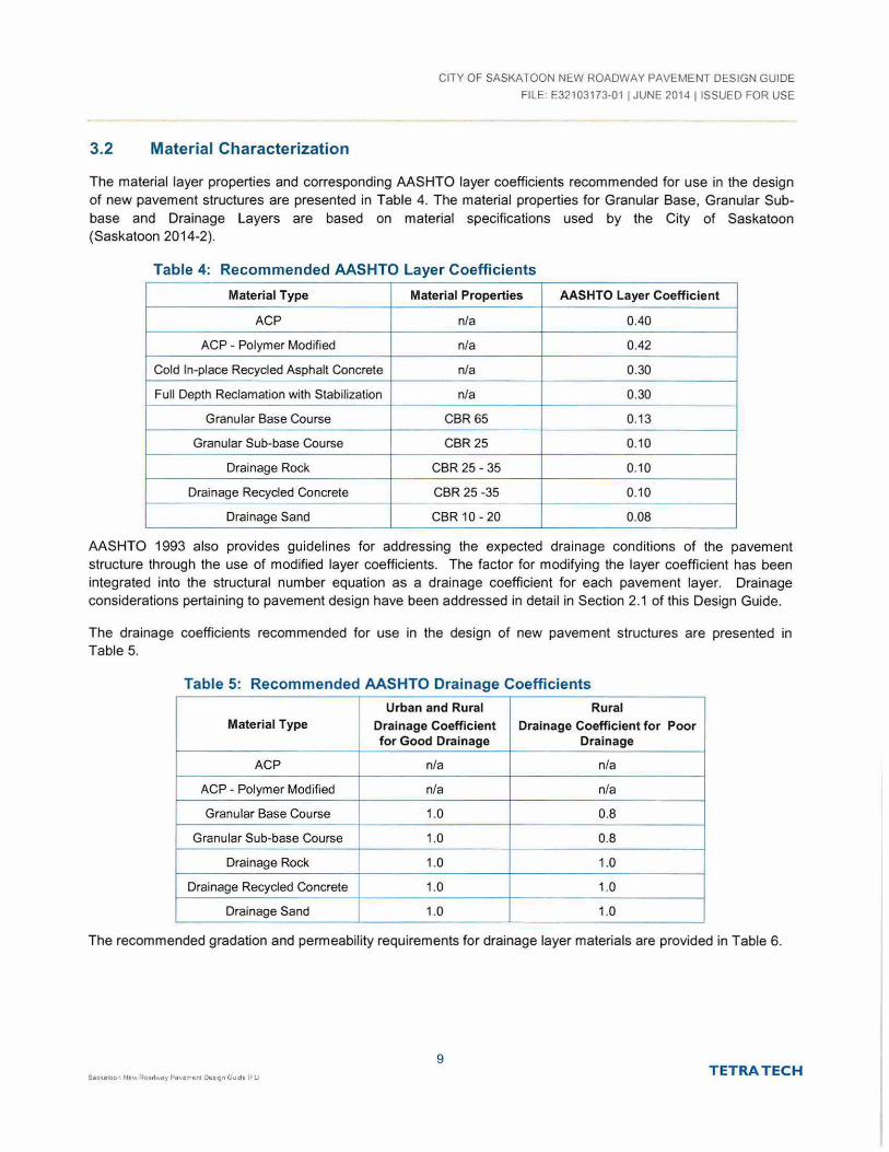
3.2 Material Characterization
The material layer properties and corresponding AASHTO layer coefficients recommended for use in the design of new pavement structures are presented in Table 4. The material properties for Granular Base, Granular Subbase and Drainage Layers are based on material specifications used by the City of Saskatoon (Saskatoon 2014-2).
Table 4: Recommended AASHTO Layer Coefficients
Material Type Material Properties AASHTO Layer Coefficient
ACP n/a 0.40
ACP - Polymer Modified n/a 0.42
Cold In-place Recycled Asphalt Concrete n/a 0.30
Full Depth Reclamation with Stabilization n/a 0.30 -
Granular Base Course CBR 65 0.13
Granular Sub-base Course CBR25 0.10
Drainage Rock CBR 25-35 0.10
Drainage Recycled Concrete CBR 25-35 0.1 0 - - - ·-Drainage Sand CBR 10-20 0.08
AASHTO 1993 also provides guidelines for addressing the expected drainage conditions of the pavement structure through the use of modified layer coefficients. The factor for modifying the layer coefficient has been integrated into the structural number equation as a drainage coefficient for each pavement layer. Drainage considerations pertaining to pavement design have been addressed in detail in Section 2.1 of this Design Guide.
The drainage coefficients recommended for use in the design of new pavement structures are presented in Table 5.
Table 5: Recommended AASHTO Drainage Coefficients
Urban and Rural Rural Material Type Drainage Coefficient Drainage Coefficient for Poor
for Good Drainage Drainage
ACP n/a n/a
ACP - Polymer Modified n/a n/a
Granular Base Course 1.0 0.8
Granular Sub-base Course 1.0 0.8
Drainage Rock 1.0 1.0
Drainage Recycled Concrete 1.0 1.0
Drainage Sand 1.0 1.0
The recommended gradation and permeability requirements for drainage layer materials are provided in Table 6.
9 S•ska:oon Naw RoAc1 \'IIS)' Po v~m~nl De~~n G01d6 IFU
TETRA TECH

CITY OF SASKATOON NEW ROADWAY PAVEMENT DESIGN GUIDE
FILE: E32103173-01 I JUNE 2014 I ISSUED FOR USE
Table 6: Recommended Drainage Layer Gradation and Permeability Requirements
Sieve Size %Passing
Drainage Rock Reclaimed PCC Sand
50mm 100 100
25mm 0-80 0-80
12.5 mm 0 - 18 0 - 18 100
5mm 0 - 12 0- 12 75-100
2mm - - 55- 100
800 IJm - I - 35-75
400 IJm - I - 20 - 50
711Jm 0-5 0-5 0-5
Permeability (em/sec), minimum
1 X 10⁻⁴
3.3 AASHTO Design Procedure
An AASHTO Design SN is determined from design ESALs, subgrade resilient modulus, and AASHTO design inputs using one of the following methods:
Method 1: Using the AASHTO DARWin 3.1 Software Program
Method 2: Solving the AASHTO Structural Number Equation, presented as Equation 6
Equation 6
Jog 10 ( 4~s:.s) Jog10 (W18 ) = Zu x S Q + 9 .36 x log 10 (SN + 1) - 0.2 0 +
1094 + 2.32 x log 10 (M 11 ) - 8 .07
0.40 + ( )S I Y SN + I
Note: inputs are in Imperial units (i.e. inches, psi etc.).
Once the design structural number (SN) has been determined using one of the methods described above, it is necessary to identify a set of pavement layer thicknesses which, when combined, will provide the load-carrying capacity corresponding to the design SN. The following equation (Equation 5) provides the basis for converting SN into actual thickness of Asphalt Concrete Pavement (ACP), granular base course, and granu lar sub-base course:
Equation 7
Where,
a1, a2, a3,an =layer coefficient for each pavement layer (a1 is the asphalt concrete layer);
0 1, 0 2, 0 3 , Dn =actual pavement layer thickness (mm) (D1 is the asphalt concrete layer); and
• m2, m3, mn = drainage layer coefficients for each corresponding pavement layer.
10
TETRA TECH
CITY OF SASKATOON NEW ROADWAY PAVEMENT DESIGN GUIDE
FILE· E32103173-01 I JUNE 2014 I ISSUED FOR USE
The SN equation does not have a single unique solution, and there are many combinations of layer thicknesses that provide satisfactory thickness design solutions.
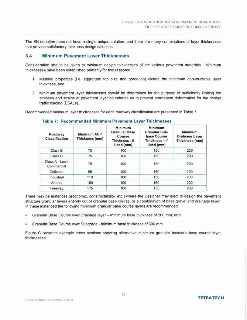
3.4 Minimum Pavement Layer Thicknesses
Consideration should be given to minimum design thicknesses of the various pavement materials. Minimum thicknesses have been established primarily for two reasons:
1. Material properties (i.e. aggregate top size and gradation) dictate the minimum constructable layer thickness, and
2. Minimum pavement layer thicknesses should be determined for the purpose of sufficiently limiting the stresses and strains at pavement layer boundaries as to prevent permanent deformation for the design traffic loading (ESALs).
Recommended minimum layer thicknesses for each roadway classification are presented in Table 7.
Table 7: Recommended Minimum Pavement Layer Thicknesses
Minimum Minimum
Roadway MinimumACP Granular Base Granular Sub- Minimum
Course base Course Drainage Layer Classification Thickness (mm)
Thickness - if Thickness - if Thickness (mm) Used (mm) Used (mm)
Class B 75 100 150 200 Class C 75 100 150 200
Class A - Local 75 100 150 200 Commercial
Collector I 95 100 150 200
Industrial 110 100 150 200
Arterial 160 100 150 200 Freeway 175 100 150 200
There may be instances (economic, constructability, etc.) where the Designer may elect to design the pavement structure granular layers entirely out of granular base course, or a combination of base gravel and drainage layer. In these instanced the following minimum granular base course layers are recommended:
Granular Base Course over Drainage layer- minimum base thickness of 200 mm; and
Granular Base Course over Subgrade- minimum base thickness of 300 mm.
Figure C presents example cross sections showing alternative minimum granular base/sub-base course layer thicknesses.
11 TETRA TECH

CITY OF SASKATOON NEW ROADWAY PAVEMENT DESIGN GUIDE
FILE_ E32103173-01 I JUNE 2014 !ISSUED FOR USE
BASE:JSUB B~SE: AL l f: lil' Al iV!: MINIMUM GRANULAR 1 HIC r f:SS f:S
TYPlCAL
Figure C: Granular Base/Sub-base Alternative Minimum Granular Thicknesses
It is ultimately the designer's responsibility to ensure the AASHTO layer designs conform with the pavement layer minimums.
3.5 Deferred Top Lift Construction
Deferred top lift construction includes the application of a first stage ACP layer with deferment of up to 2 years of a final stage ACP layer until a point where the majority of the new development construction is complete. Deferring the final stage ACP layer provides two major benefits:
1. Staged construction provides an opportunity for any corrections to the roadway profi le due to settlement, additional utility installation, or initial pavement deficiencies/defects, and
12
T ETRA TECH

CITY OF SASKATOON NEW ROADWAY PAVEMENT DESIGN GUIDE
FILE· E32103173-01 I JUNE 2014 I ISSUED FOR USE
2. Staged construction provides a final surfacing to the roadway following the majority of the heavy vehicle loading (construction traffic), and restores the roadways serviceability.
Table 8 provides recommendations for minimum ACP thicknesses for first and final stage construction for each roadway classification.
Table 8: Minimum Recommended ACP Thicknesses for Deferred Construction
Roadway Classification Minimum Constructed ACP Thickness (mm)
First Stage Final Stage
Class B 50 35
Class C 50 35 Class A - Local Commercial 50 35
Collector 60 35
Industrial 60 50
Arterial 110 50
Freeway 125 50
If deferred top lift construction is selected, it is the ultimately the Designer's responsibility to ensure all ACP layers conform with the design ACP thickness as well as the minimum ACP layer thicknesses presented in Table 8. For the purposes of table, the final stage lift is to be constructed within two years.
3.6 Sample Design
The following is an example of a new flexible pavement design using the Design Procedure presented in Figure 1 and in this report.
Sample Project Description:
The City would like to complete a new pavement design for a 2-lane (1-lane per travel direction) Urban Arterial Roadway with and estimated AADT of 7000 vehicles/day and Total Percent Commercial = 6% with 40 Transit Buses per day.
Step 1: Establish Drainage Condition
Proposed roadway geometric, geotechnical and subsurface drainage conditions indicate that this Urban Section pavement will be subjected to groundwater conditions less than 1.0 m from the top of subgrade elevation. Therefore, a drainage layer consisting of drainage rock with longitudinal sub drains is selected for this pavement structure and drainage layer coefficients of 1.0 are to be used for each pavement layer material.
Step 2: Establish Subgrade Support Condition
Laboratory testing of the subgrade materials indicated an expected bearing capacity equivalent to a soaked CBR = 3.0%.
From equation 1:
MR (MPa) = 10.3 X (CBR) = 10.3 X (3.0) = 31 MPa
This design MR was confirmed from FWD testing of prototype roadways in the vicinity with showed seasonally adjusted resilient moduli ranging between 25 and 35 MPa.
13 TETRA TECH
CITY OF SASKATOON NEW ROADWAY PAVEMENT DESIGN GUIDE
FILE: E32103173-011 JUNE 2014I ISSUED FOR USE
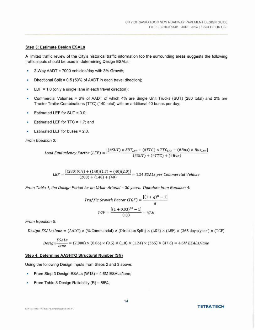
Step 3: Estimate Design ESALs
A limited traffic review of the City's historical traffic information foo the surrounding areas suggests the following traffic inputs should be used in determining Design ESALs:
2-Way AADT = 7000 vehicles/day with 3% Growth;
Directional Split= 0.5 (50% of AADT in each travel direction);
LDF = 1.0 (only a single lane in each travel direction);
Commercial Volumes = 6% of AADT of which 4% are Single Unit Trucks (SUT) (280 total) and 2% are Tractor Trailer Combinations (TIC) (140 total) with an additional 40 buses per day;
Estimated LEF for SUT = 0.9;
Estimated LEF for TIC = 1. 7; and
Estimated LEF for buses = 2.0.
From Equation 3:
. [(#SUT) x SUTLEF + (#TTC) x TTCLEF +(#Bus) x BusLEF] Load Equwalency Factor (LEF) = (#SUT) + (#TTC) +(#Bus)
[(280)(0.9) + (140)(1.7) + (40)(2.0)] . . LEF = (280) + (140) + (40) = 1.24 ESALs per Commerctal Vehtcle
From Table 1, the Design Period for an Urban Arterial= 30 years. Therefore from Equation 4:
From Equation 5:
[(1 +g)" - 1) Traffic Growth Factor (TGF) = .;...;_____;:~_...::.
g
[(1 + 0.03) 3 0- 1]
TGF = 0.03 = 47.6
Design ESALs j lane = (AADT) x (%Commercial) x (Direction Split) x (LDF) x (LEF) x (365 days/year) x (TGF)
ESALs Design -
1-- = (7,000) X (0.06) X (0.5) X (1.0) X (1.24) X (365) X (47.6) = 4.6M ESALs j lane ane
Step 4: Determine AASHTO Structural Number (SN)
Using the following Design Inputs from Steps 2 and 3 above:
From Step 3 Design ESALs (W18) = 4.6M ESALs/lane;
From Table 3 Design Reliability (R) = 85%;
14
Sukotoon New Roo~~dway P•vamem Oc:;•gn Guwje IFU TETRA TECH

CITY OF SASKATOON NEW ROADWAY PAVEMENT DESIGN GUIDE
FILE: E32103173-01 I JUNE 2014 !ISSUED FOR USE
Initial Serviceability (Pi)= 4.2 ;
• Terminal Serviceability (Pt) = 2.5;
Serviceability Loss Factor {6PSI) = 4.2- 2.5 = 1. 7; and
From Step 2 Subgrade Soil Resilient Modulus (MR) = 31 MPa = 4495 psi.
Solving for SN in Equation 6:
SN = 5.06 inches = 129 mm
Step 5: Complete AASHTO Layer Design Alternatives
The following design alternatives have been generated based on Equation 7:
Structural Layer Coefficients are from Table 4, Drainage Coefficients from Table 5, and the Minimum Layer Thicknesses from Table 7:
Design La)!er Drainage Pavement La)!er Coefficient Coefficient O[!tion 1 O[!tion 2 O[!tion 3
ACP Thickness (mm) 0.40 n/a 1601 1601 175
Granular Base Course 0 .13 1.0 150 350 150
Thickness (mm)
Granular Sub-base Course Thickness 0.10 1.0 250 0 200
(mm)
Drainage Layer 0.10 1.0 2001 2001 2001
Thickness2
Total SN Provided 129 130 130 (mm)
I -Minimum layer thicknesses govern. 2 - Assumes Drainage Rock.
15 TETRA TECH
CITY OF SASKATOON NEW ROADWAY PAVEMENT DESIGN GUIDE
FILE: E32103173-01 I JUNE 2014 ! ISSUED FOR USE
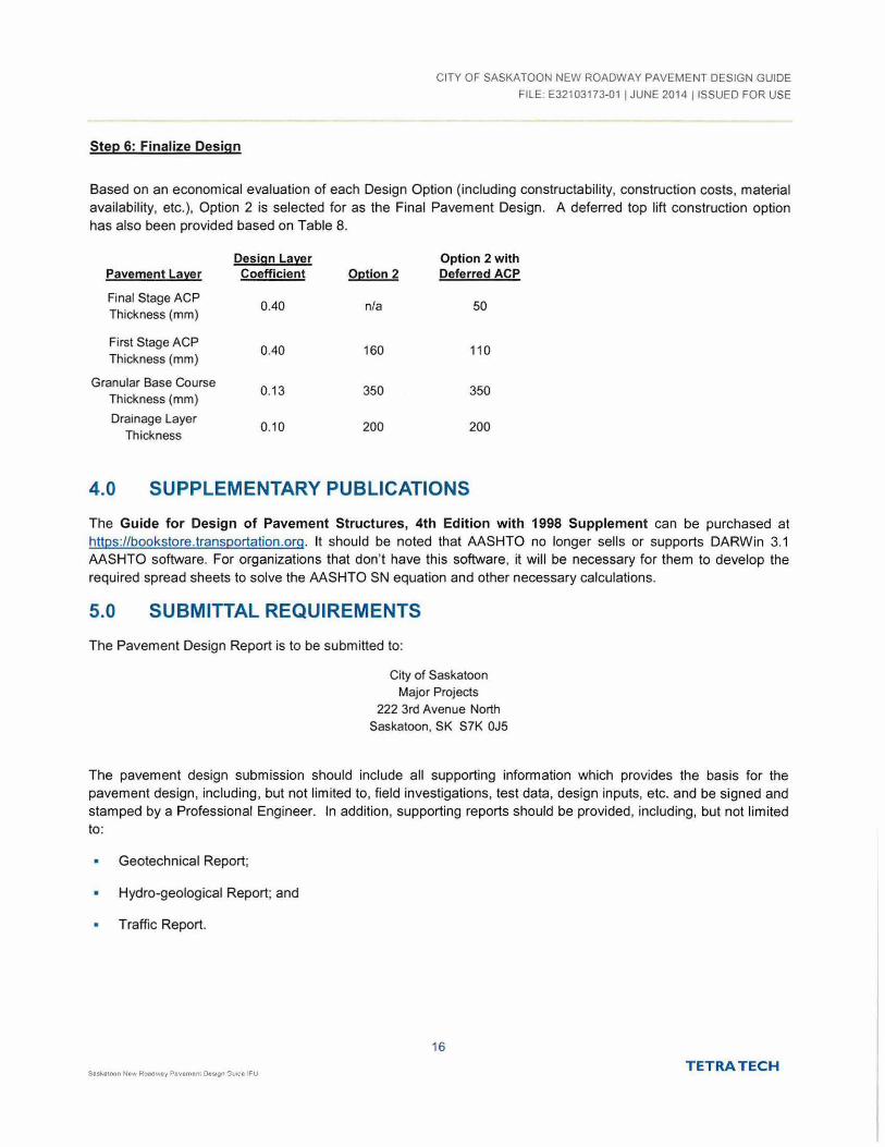
Step 6: Finalize Design
Based on an economical evaluation of each Design Option (including constructability, construction costs, material availability, etc.), Option 2 is selected for as the Final Pavement Design. A deferred top lift construction option has also been provided based on Table 8.
Design Lal£er Option 2 with Pavement Lal£er Coefficient O~tion 2 Deferred ACP
Final Stage ACP 0.40 n/a 50
Thickness (mm)
First Stage ACP 0.40 160 110
Thickness (mm)
Granular Base Course 0.13 350 350
Thickness (mm)
Drainage Layer 0.1 0 200 200
Thickness
4.0 SUPPLEMENTARY PUBLICATIONS
The Guide for Design of Pavement Structures, 4th Edition with 1998 Supplement can be purchased at https://bookstore.transoortation .org. It should be noted that AASHTO no longer sells or supports DARWin 3.1 AASHTO software. For organizations that don't have this software, it will be necessary for them to develop the required spread sheets to solve the AASHTO SN equation and other necessary calculations.
5.0 SUBMITTAL REQUIREMENTS
The Pavement Design Report is to be submitted to:
City of Saskatoon
Major Projects 222 3rd Avenue North
Saskatoon, SK S7K OJ5
The pavement design submission should include all supporting information which provides the basis for the pavement design, including, but not limited to, field investigations, test data, design inputs, etc. and be signed and stamped by a Professional Engineer. In addition, supporting reports should be provided, including, but not limited to:
Geotechnical Report;
Hydro-geological Report; and
Traffic Report.
16
TETRA TECH

FIGURES
CITY OF SASKATOON NEW ROADWAY PAVEMENT DESIGN GUIDE
FILE· E32103173-01 I JUNE 2014 !ISSUED FOR USE
Figure 1 New Flexible Pavement Design Flow Chart
S&3katoon N6V¥ Roadwey Pevemont Oes.gn Gt.nd• 1FU ~TETRA TECH

w l: "' I
" "' u 0 w ... 0 1-w
~ " "' !!1 ~ 1-0 w N . 1-w z ;; 0
~ M 0
N M w
~ ii:

Inquiry – Councillor D. Hill (June 22, 2009); and Various Communications to Council - Traffic Calming Measures – Avenue C North of 33rd Street Recommendation That the Standing Policy Committee on Transportation recommend to City Council: 1. That the temporary diverter at the intersection of 38th Street & Avenue C be
removed; and 2. That the Neighbourhood Traffic Management Program plan for Mayfair/Kelsey
Woodlawn neighbourhoods be adopted as the framework for future traffic improvements in the area, to be undertaken as funding is made available through the annual budget process.
Topic and Purpose The purpose of this report is to provide information on the Neighbourhood Traffic Management Program for the Mayfair and Kelsey-Woodlawn neighbourhoods. Report Highlights 1. A traffic plan for both Mayfair and Kelsey-Woodlawn neighbourhoods was
developed in consultation with the community in response to concerns such as speeding, traffic shortcutting, traffic congestion and pedestrian safety.
2. The plan will be implemented over time as funding for the improvements is available.
Strategic Goal This report supports the Strategic Goal of Moving Around by providing the installation of traffic calming devices and pedestrian safety enhancements thus improving the safety of pedestrians, motorists, and cyclists. Background City Council at its meeting held on March 18, 2013 resolved, in part, that City Council receive a further report regarding neighbourhood traffic calming after additional review had been done by the Administration. The report was to provide options to deal with the matter in a more comprehensive manner. The intent of the Neighbourhood Traffic Management Program is to address traffic concerns within neighbourhoods such as speeding, shortcutting and pedestrian safety. This program involves additional community and stakeholder consultation and provides an environment for the community and City staff to work together and develop solutions to address traffic concerns.
7.2.4 - Attachment - Report

Inquiry – Councillor D. Hill (June 22, 2009); and Various Communications to Council - Traffic Calming Measures – Avenue C North of 33rd Street
Page 2 of 4
A public meeting was held in June 2013 to identify traffic concerns and potential solutions or mitigation measures. Also in attendance were representatives from the Saskatoon Police Service to address traffic enforcement issues. Based on the residents’ input provided at the initial public meeting, and the traffic data collected, a Traffic Management Plan was developed and presented to the community at a second public meeting held in October 2013. Report Traffic Plan Development The development of a Traffic Management Plan includes four stages: 1. Identifying existing problems and concerns and possible solutions through a
public meeting. 2. Developing a traffic plan based on residents’ input and traffic data collected. 3. Presenting the plan to the community and other civic divisions for additional
input. 4. Implementing the proposed measures in a specific time frame, short-term (1 to 2
years), medium-term (1 to 5 years), or long-term (more than 5 years). The majority of concerns from the consultation in June 2013 included shortcutting, speeding, pedestrian safety (specifically near the park and school site), and lack of sidewalks. The Administration is recommending the existing temporary diverter at the intersection of 38th Street and Avenue C to be removed and additional measures implemented to improve safe movement throughout the Mayfair/Kelsey Woodlawn neighbourhoods. Traffic Plan Recommendations The recommended Neighbourhood Traffic Management Plan includes the following: • 15 locations – traffic calming devices • 9 locations – installation of new zebra crosswalks • 8 locations – sidewalk installation • 1 location – accessible ramp • 2 locations – addition of left turn arrow at traffic signal • 1 location – road widening • 1 location – “no parking” signs • 2 locations – speed limit signs in back lanes • Numerous locations for stop and yield signs The installation of each proposed improvement will be implemented in three phases: 1. Short-term (1 to 2 years) – temporary traffic calming measures, signage,
pavement markings, accessible pedestrian ramps; 2. Medium-term (1 to 5 years) – permanent traffic calming devices, roadway
realignment, sidewalks (in some cases); and 3. Long-term (5 years plus) – permanent traffic calming devices, roadway
realignment, sidewalks.
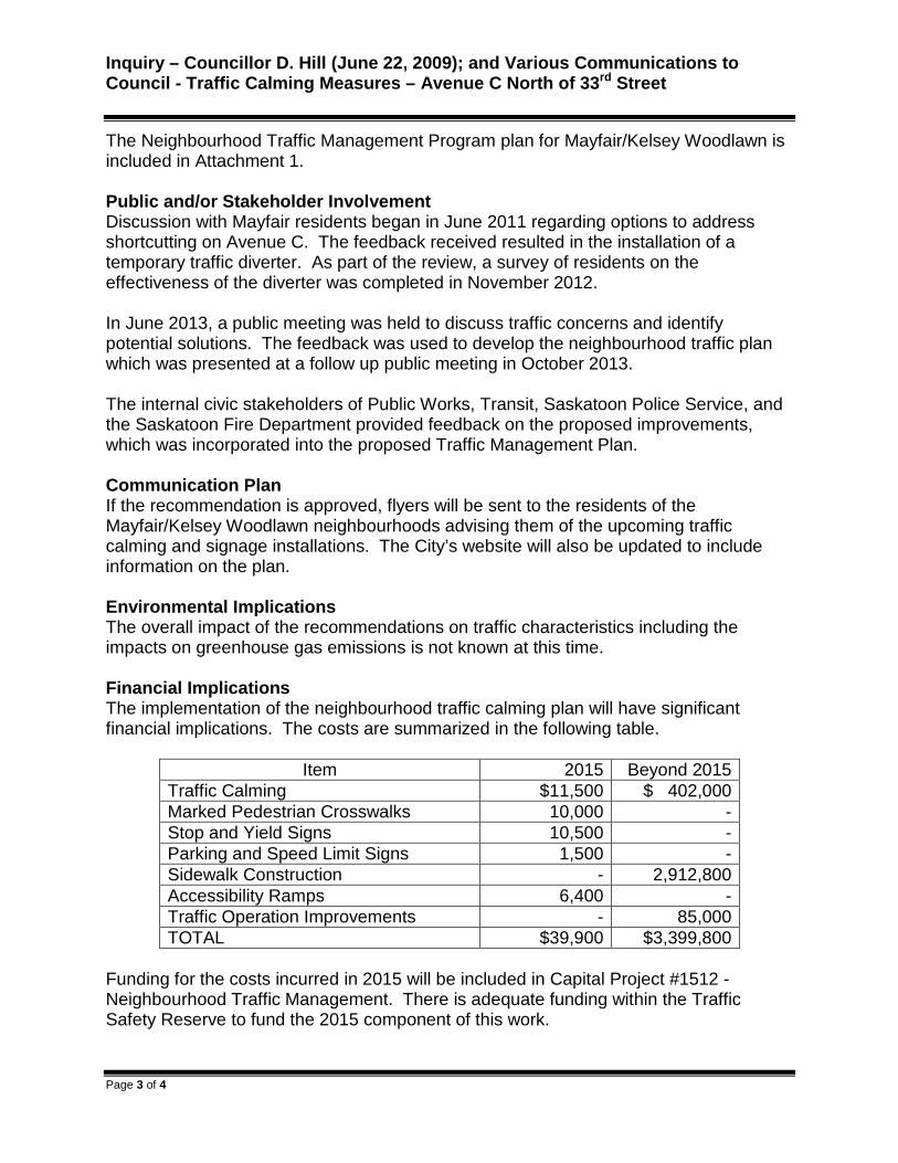
Inquiry – Councillor D. Hill (June 22, 2009); and Various Communications to Council - Traffic Calming Measures – Avenue C North of 33rd Street
Page 3 of 4
The Neighbourhood Traffic Management Program plan for Mayfair/Kelsey Woodlawn is included in Attachment 1. Public and/or Stakeholder Involvement Discussion with Mayfair residents began in June 2011 regarding options to address shortcutting on Avenue C. The feedback received resulted in the installation of a temporary traffic diverter. As part of the review, a survey of residents on the effectiveness of the diverter was completed in November 2012. In June 2013, a public meeting was held to discuss traffic concerns and identify potential solutions. The feedback was used to develop the neighbourhood traffic plan which was presented at a follow up public meeting in October 2013. The internal civic stakeholders of Public Works, Transit, Saskatoon Police Service, and the Saskatoon Fire Department provided feedback on the proposed improvements, which was incorporated into the proposed Traffic Management Plan. Communication Plan If the recommendation is approved, flyers will be sent to the residents of the Mayfair/Kelsey Woodlawn neighbourhoods advising them of the upcoming traffic calming and signage installations. The City’s website will also be updated to include information on the plan. Environmental Implications The overall impact of the recommendations on traffic characteristics including the impacts on greenhouse gas emissions is not known at this time. Financial Implications The implementation of the neighbourhood traffic calming plan will have significant financial implications. The costs are summarized in the following table.
Item 2015 Beyond 2015
Traffic Calming $11,500 $ 402,000 Marked Pedestrian Crosswalks 10,000 - Stop and Yield Signs 10,500 - Parking and Speed Limit Signs 1,500 - Sidewalk Construction - 2,912,800 Accessibility Ramps 6,400 - Traffic Operation Improvements - 85,000 TOTAL $39,900 $3,399,800
Funding for the costs incurred in 2015 will be included in Capital Project #1512 - Neighbourhood Traffic Management. There is adequate funding within the Traffic Safety Reserve to fund the 2015 component of this work.
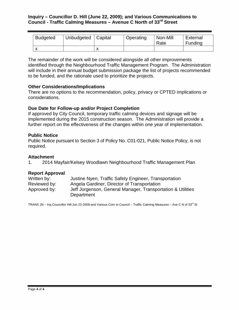
Inquiry – Councillor D. Hill (June 22, 2009); and Various Communications to Council - Traffic Calming Measures – Avenue C North of 33rd Street
Page 4 of 4
Budgeted Unbudgeted Capital Operating Non-Mill Rate
External Funding
x x The remainder of the work will be considered alongside all other improvements identified through the Neighbourhood Traffic Management Program. The Administration will include in their annual budget submission package the list of projects recommended to be funded, and the rationale used to prioritize the projects. Other Considerations/Implications There are no options to the recommendation, policy, privacy or CPTED implications or considerations. Due Date for Follow-up and/or Project Completion If approved by City Council, temporary traffic calming devices and signage will be implemented during the 2015 construction season. The Administration will provide a further report on the effectiveness of the changes within one year of implementation. Public Notice Public Notice pursuant to Section 3 of Policy No. C01-021, Public Notice Policy, is not required. Attachment 1. 2014 Mayfair/Kelsey Woodlawn Neighbourhood Traffic Management Plan Report Approval Written by: Justine Nyen, Traffic Safety Engineer, Transportation Reviewed by: Angela Gardiner, Director of Transportation Approved by: Jeff Jorgenson, General Manager, Transportation & Utilities
Department TRANS JN – Inq Councillor Hill-Jun 22-2009-and Various Com to Council – Traffic Calming Measures – Ave C N of 33rd St

2014
July 2014
Mayfair/Kelsey-Woodlawn Neighbourhood Traffic
Management Plan
Attachment 1
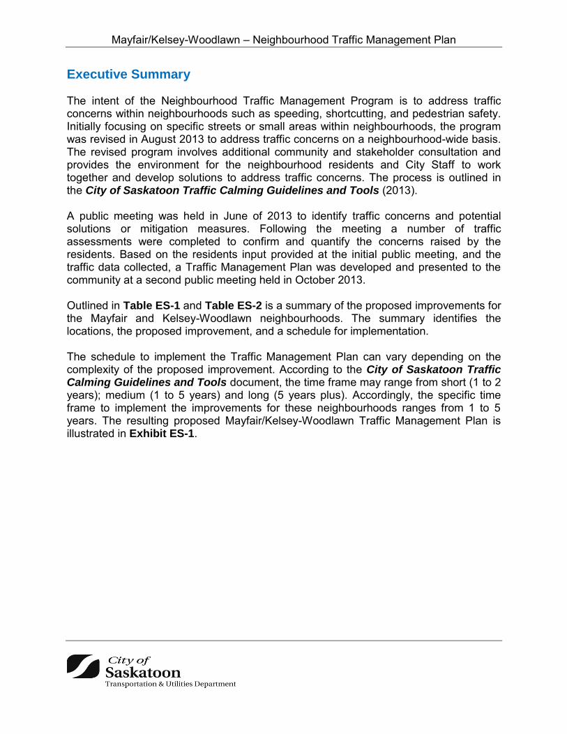
Mayfair/Kelsey-Woodlawn – Neighbourhood Traffic Management Plan
Executive Summary The intent of the Neighbourhood Traffic Management Program is to address traffic concerns within neighbourhoods such as speeding, shortcutting, and pedestrian safety. Initially focusing on specific streets or small areas within neighbourhoods, the program was revised in August 2013 to address traffic concerns on a neighbourhood-wide basis. The revised program involves additional community and stakeholder consultation and provides the environment for the neighbourhood residents and City Staff to work together and develop solutions to address traffic concerns. The process is outlined in the City of Saskatoon Traffic Calming Guidelines and Tools (2013). A public meeting was held in June of 2013 to identify traffic concerns and potential solutions or mitigation measures. Following the meeting a number of traffic assessments were completed to confirm and quantify the concerns raised by the residents. Based on the residents input provided at the initial public meeting, and the traffic data collected, a Traffic Management Plan was developed and presented to the community at a second public meeting held in October 2013. Outlined in Table ES-1 and Table ES-2 is a summary of the proposed improvements for the Mayfair and Kelsey-Woodlawn neighbourhoods. The summary identifies the locations, the proposed improvement, and a schedule for implementation. The schedule to implement the Traffic Management Plan can vary depending on the complexity of the proposed improvement. According to the City of Saskatoon Traffic Calming Guidelines and Tools document, the time frame may range from short (1 to 2 years); medium (1 to 5 years) and long (5 years plus). Accordingly, the specific time frame to implement the improvements for these neighbourhoods ranges from 1 to 5 years. The resulting proposed Mayfair/Kelsey-Woodlawn Traffic Management Plan is illustrated in Exhibit ES-1.

Mayfair/Kelsey-Woodlawn – Neighbourhood Traffic Management Plan
Table ES-1: Mayfair Neighbourhood Improvements Summary
Location Proposed Measure Time Frame
34 Street & Avenue E; 34 Street & Avenue F; 35 Street & Avenue E; 36 Street & Avenue E; 37 Street & Avenue D; 37 Street & Avenue E;
and 37 Street & Avenue F
Zebra (ie. Striped) pedestrian crosswalk
1 to 2 years
34 Street & Avenue I Standard pedestrian crosswalk 34 Street & Avenue C; 35 Street & Avenue D;
37 Street & Avenue C; and 37 Street & Avenue F
Change yield signs to stop signs (not shown on map)
37 Street & Avenue B No parking signs 10m from intersection (not shown on map)
Back Lanes between 38 Street/39 Street & Avenue B/Avenue C,
and 37th Street/38th Street & Avenue C/ Avenue D
20kph speed signs (not shown on map)
39 Street & Idylwyld Drive Accessibility ramps
34 Street & Avenue E Curb extensions (northwest and southwest corners)
1 to 5 years (devices will be installed temporarily until proven
effective)
34 Street & Avenue I Median island 35 Street & Avenue E Curb extension (southwest corner) 35 Street & Avenue I Curb extensions (northwest and northeast corners) 36 Street & Avenue C Directional closure 36 Street & Avenue E Curb extensions (northwest and southeast corner) 36 Street & Avenue G Median island (east leg) 37 Street & Avenue B Median islands (north and south legs) 37 Street & Avenue D Curb extension (northwest corner) 37 Street & Avenue E Median island (west leg) 38 Street & Avenue C Directional closure 38 Street & Avenue D Median islands (east, west and south legs) 38 Street & Avenue G Median island (east leg) 39 Street & Avenue E Median island (east and west legs)
Avenue C – south of railway tracks Curb extension and median island 36 Street & Idylwyld Drive Operations improvement (not shown on map)
5 years plus
39 Street & Idylwyld Drive Add left turn arrow phase (not shown on map) 37 Street between Avenue B & Avenue D
(both sides)
Sidewalk
37 Street between Avenue F & Avenue I (north side)
38 Street between Idylwyld Drive & Avenue G (both sides)
Avenue D between 38 Street Alley near park (west side)

Mayfair/Kelsey-Woodlawn – Neighbourhood Traffic Management Plan
Table ES-2: Kelsey-Woodlawn Neighbourhood Improvements Summary
Location Proposed Measure Time Frame
1 Avenue between 34 Street & 38 Street; 2 Avenue between 34 Street & 39 Street
Yield signs 1 to 2 years
39 Street & Saskatchewan Avenue;
39 Street & Alberta Avenue Change yield signs to stop signs (not shown on
map)
39 & Quebec Avenue Zebra (ie. Striped) pedestrian crosswalk Alberta Avenue between 33 Street & 34 Street
(both sides)
Sidewalk 5 year plus
Alberta Avenue between 34 Street & 36 Street (west side)
39 Street between Idylwyld Drive & 1 Avenue (both sides)
Quebec Avenue between 33 Street and 40 Street (both sides)
Ontario Avenue Between 33 Street & 39 Street (both sides)
38 Street between Quebec Avenue & 2 Avenue (both sides)

Mayfair/Kelsey-Woodlawn – Neighbourhood Traffic Management Plan
Exhibit ES-1: Mayfair/Kelsey-Woodlawn Traffic Management Plan
~ DIRECTIONAl ClOSURE @ CURB EXTENSIONS
D ZEBRA CROSSI'IAIJ( UPGRADE
® RCIJMJABOUT
, f Cit:yof Saskatoon
@ ACCESSIBIUlY RAMP INSTAllATION
' YIElD SIGN INSTAllATION
Transportation & Utilities Depa rtment
BUS ROUTE
MAYFAIR/KELSEY -WOODLAWN TRAFFIC PLAN
f"j Cityof ~ Saskatoon

Mayfair/Kelsey-Woodlawn – Neighbourhood Traffic Management Plan
TABLE OF CONTENTS Executive Summary ......................................................................................................... i 1 Study Purpose.......................................................................................................... 1
2 Issue Identification ................................................................................................... 1
3 Neighbourhood Traffic Management Plan Development .......................................... 8
4 Presentation of Plan to Stakeholders ..................................................................... 11
5 Plan Implementation .............................................................................................. 16
LIST OF TABLES Table 1: City of Saskatoon Roadway Classifications and Characteristics ....................... 8
Table 2: Speed Studies and Average Daily Traffic Counts (2013) .................................. 9
Table 3: All-way Stop Studies ....................................................................................... 10
Table 4: Pedestrian Studies .......................................................................................... 11
Table 5: Avenue C Recommendations .......................................................................... 11
Table 6: Directional Closures Recommendations ......................................................... 12
Table 7: Pedestrian Safety Improvements – A.H. Browne Park .................................... 13
Table 8: Pedestrian Safety Improvements – School Sites ............................................. 14
Table 9: Pedestrian Safety Improvements – Bus Routes .............................................. 14
Table 10: Accessibility Improvements for Seniors / Disabled Users .............................. 15
Table 11: Traffic Control Improvements ........................................................................ 15
Table 12: Permanent Traffic Calming Cost Estimate .................................................... 17
Table 13: Marked Pedestrian Crosswalks Cost Estimate .............................................. 18
Table 14: Traffic Control Signage – Stop & Yield Cost Estimate ................................... 18
Table 15: Parking and Speed Limit Signage Cost Estimate .......................................... 18
Table 16: Sidewalks Cost Estimate ............................................................................... 19
Table 17: Accessibility Ramps Cost Estimate ............................................................... 19
Table 18: Traffic Operation Improvements Cost Estimate ............................................. 19

Mayfair/Kelsey-Woodlawn – Neighbourhood Traffic Management Plan
1
1 Study Purpose The purpose of this project was to develop a Traffic Management Plan for the Mayfair and Kelsey-Woodlawn neighbourhoods following the procedure outlined in the City of Saskatoon Traffic Calming Guidelines and Tools document adopted by City Council in August 2013. The development of the Traffic Management Plan includes four stages:
Stage 1 - Identify existing problems, concerns and possible solutions through initial neighbourhood consultation and the Shaping Saskatoon Website.
Stage 2 - Develop a traffic plan based on resident’s input and traffic data collected.
Stage 3 - Present a traffic plan to the neighbourhood at a follow-up meeting; present a draft plan to the residents and other civic Divisions for feedback regarding the proposed measures in the plan; and forward to City Council for approval.
Stage 4 - Implement the proposed measures in a specific time frame, short term (1 to 2 years), medium term (1 to 5 years), or long term (5 years plus).
2 Issue Identification A public meeting was held in June 2013 to identity traffic concerns within the neighbourhoods. At the meeting, residents were given the opportunity to express their concerns and identify possible solutions. A majority of the residents were concerned about speeding, pedestrian safety and shortcutting as a result of the temporary diverter. The temporary diverter was installed at the intersection of Avenue C and 38 Street in 2011 to reduce the shortcutting traffic on Avenue C between 33rd Street and Circle Drive. Following its installation, there was little support for the diverter from the community, and the meeting gave them an opportunity to express their concerns and suggest other possible solutions. The following pages contain summaries of the neighbourhood concerns collected during the initial neighbourhood consultation, and proposed solutions.

Mayfair/Kelsey-Woodlawn – Neighbourhood Traffic Management Plan
2
CONCERN 1 - TRAFFIC VOLUME/SHORTCUTTING
Shortcutting through neighbourhoods is often caused by motorists avoiding arterial streets and trying to find the shortest route. Mayfair has experienced a high volume of traffic on Avenue C as a result of higher traffic volumes on Circle Drive, Idylwyld Drive, and 33rd Street. To address this issue, a temporary diverter was installed at the intersection of Avenue C and 38th Street in 2011. Many of the residents felt that the diverter was causing traffic volume increases on the adjacent streets and back lanes. A majority of the concerns outlined below are believed to be due to the diverter.
Neighbourhood Concerns Avenue D near A.H. Browne Park: shortcutting/increased traffic volumes 34th Street & Avenue E (south corner of Mayfair School): increased traffic
volumes 35th Street, 36th Street, 39th Street, Avenue B, and Avenue G: high traffic volumes 39th Street & Idylwyld Drive: long queues; delays at the traffic signals; traffic spills
back to 4-way stop at Avenue C; McDonalds and strip mall entrance make it worse
36th Street & Idylwyld Drive: long queues at traffic signals; road is too narrow to make right turn
Avenue G north of 33rd Street Royal Bank and Co-Op on Avenue C: causes shortcutting and high traffic
volumes on Avenue C
Proposed Solutions Upgrade traffic signals at 39th Street & Idylwyld Drive to include a dedicated left-
turn (arrow) 39th Street & Idylwyld Drive: change to right-in/right-out because left-turning cars
from these businesses block traffic at McDonalds, Best Western, strip mall Make Avenue C and Avenue B one-way streets Install signs restricting trucks/semis Royal Bank and Co-Op on Avenue C: need to be removed because it’s a
nuisance to access; need to change exits to encourage use of Circle Drive

Mayfair/Kelsey-Woodlawn – Neighbourhood Traffic Management Plan
3
CONCERN 2 – SPEEDING
A majority of the residents in the neighbourhood were concerned with speeding of traffic as a result of the diverter, specifically on 38th Street. In addition, speeding near school sites and parks was also raised as a concern since there are many children in the area who walk to schools and play in the parks. The posted speed limit in the neighbourhood is 50kph, and 30kph in the school zone. The specific concerns are outlined below.
Neighbourhood Concerns
38th Street between Avenue I to Avenue C Near A.H. Browne Park on Avenue D Avenue I Back lanes; particularly near traffic diverter (38th 39th Street & Avenue B/C; and 37th
/38th Street Avenue C/D) Avenue F between 35th Street & 36th Street 39th Street between Idylwyld Drive & 1 Avenue Avenue G north of 33rd Street Avenue B between 38th Street & 39th Street
Proposed Solutions
Increase police presence

Mayfair/Kelsey-Woodlawn – Neighbourhood Traffic Management Plan
4
CONCERN 3 - TRAFFIC CONTROL
Traffic control signs are used in order to assign the right-of-way and must meet guidelines in Council Policy C07-007 Traffic Control – Use of Stop and Yield Signs. Stop and yield signs are not to be used as speed control devices, to stop priority traffic over minor traffic, on the same approach to an intersection where traffic signals are operational, or as a pedestrian crossing device. An all-way stop must meet the conditions for traffic volume, collision history and must have a balanced volume from each leg to operate sufficiently.
Stop and yield signs were installed throughout the Mayfair neighbourhood to address changing traffic patterns as a result of the diverter. A majority of the concerns outlined below were due to these changes.
Neighbourhood Concerns
37th Street & Avenue B: yield sign reorientation has increased speed 37th Street & Avenue C: yield sign reorientation has caused many near misses 37th Street & Avenue D: not in favour of stop signs that were removed (when
diverter was installed); increased speeding on Avenue D between 36 Street & 38 Street
36th Street westbound from Idylwyld Drive is dangerous at every intersection (Avenue B, Avenue D, Avenue F, etc.)
39th Street & Avenue E: drivers ignoring yield signs 34th Street & Avenue E (south corner of Mayfair School): drivers not yielding;
many near misses
Proposed Solutions
34th Street & Avenue I: 3-way stop 36th Street & Avenue I: 3-way stop
36th Street & Avenue C: 4-way stop
Change yield signs to stop signs because people aren’t slowing down
More stop signs to slow drivers

Mayfair/Kelsey-Woodlawn – Neighbourhood Traffic Management Plan
5
CONCERN 4 - PEDESTRIAN SAFETY A majority of the residents have children that attend Mayfair School and play in A.H. Browne Park. They expressed a concern that the area lacked safe pedestrian crosswalks and sidewalks. Pedestrian crosswalks need to meet the City of Saskatoon’s Pedestrian Crossing Policy (C07-018 Traffic Control at a Pedestrian Crossing).
Neighbourhood Concerns
34th Street & Avenue E; and 34th Street & Avenue F (Mayfair School): needs improved crosswalk
A.H. Browne Park: crossings need to be improved
39th Street between 1 Avenue & Avenue C, 39th Street between Avenue C & Ontario Avenue; Ontario Avenue between 33rd Street & 39th Street; and Quebec Avenue between 33rd Street & Circle Drive: need sidewalks, especially near bus stops; pedestrians walking on street along bus routes
38th Street between Idylwyld Drive & Avenue G; 37th Street between Avenue B & Avenue D; 37th Street between Avenue F & Avenue I; Alberta Avenue between 33rd Street & 34th Street; all bus routes: need sidewalks
Alberta Avenue between 33rd Street & 36th Street: students from SIAST and St. Michaels School walk on the street because there are no sidewalks
39th Street & Idylwyld Drive: unsafe to reach pedestrian lights because there are no ramps
Temporary curbs used for traffic calming devices limit accessibility for scooters/wheelchairs
33rd Street & Avenue H: vehicles are turning when pedestrians are crossing 33rd Street and there has been near misses
Proposed Solutions
Install sidewalks
Install accessibility ramps at 39th Street & Idywyld Drive

Mayfair/Kelsey-Woodlawn – Neighbourhood Traffic Management Plan
6
CONCERN 5 - TRAFFIC DIVERTER
There were a number of concerns regarding the traffic diverter in addition to the shortcutting concerns previously mentioned. These included the appearance, location, and orientation of the diverter. More details are provided below.
Neighbourhood Concerns Driving over lawn to get around diverter Pedestrians can’t cross; barriers cut off access to sidewalks Diverter is unaesthetic/eyesore Accessibility for wheelchairs, scooters, cyclists etc.
Proposed Solutions Change direction of diverter to direct towards Idylwyld Drive Re-route traffic to Avenue B, not Avenue D next to the park Move diverter to 37th Street Diverter should have been placed on 39th Street & Avenue C so drivers are
directed to traffic signals at Idylwyld Drive instead of adjacent local side streets Move the diverter one block south so drivers won’t speed by the park Install 4–way stop instead of diverter Traffic circle would be better option Use speed humps or rumble strips

Mayfair/Kelsey-Woodlawn – Neighbourhood Traffic Management Plan
7
CONCERN 6 – MAINTENANCE
Residents feel that streets need improved maintenance.
Neighbourhood Concerns Potholes Icy conditions make trucks slide into diverter hitting signs During winter months roads are narrowed from snow buildup and cars park
further onto street
Proposed Solutions Avenue C between 38th Street & Circle Drive; and 39th Street between Avenue C
& Idylwyld Drive needs paving
CONCERN 7 – PARKING
Parking is allowed on all city streets unless signage is posted. Under Bylaw 7200, The Traffic Bylaw, vehicles are restricted from parking within 10 metres of an intersection and one metre of a driveway crossing.
Neighbourhood Concerns Avenue D: parking on west side restricts visibility 36th Street: parked vehicles make it very narrow for 2-way traffic Avenue B: trucks illegally parking
Proposed Solutions Increase police presence and parking enforcement

Mayfair/Kelsey-Woodlawn – Neighbourhood Traffic Management Plan
8
3 Neighbourhood Traffic Management Plan Development Stage 2 of the implementation process includes developing a Traffic Management Plan using the input received by the residents from the Mayfair and Kelsey-Woodlawn neighbourhoods and undertaking traffic assessments. 1. Traffic Volumes and Travel Speeds Traffic volumes and travel speeds were measured to determine the need for traffic calming devices. Neighbourhood streets are classified as either local or collector streets. Traffic volumes (referred to as Average Daily Traffic or ADT) on these streets should meet the City of Saskatoon guidelines shown in Table 1. Table 1: City of Saskatoon Roadway Classifications and Characteristics
Travel speeds were measured to determine the 85th percentile speed (the speed at which vehicles are traveling at or below). The speed limit in the Mayfair/Kelsey-Woodlawn area is 50kph, except for school zones where the speed limit is 30kph between September and June (8:00am to 5:00pm) excluding weekends. The speed studies and average daily traffic on streets where speeding was identified as an issue are summarized in Table 2.
Characteristics
Classifications
Back Lanes Locals Collectors
Residential Commercial Residential Commercial Residential Commercial
Traffic function Access function only (traffic
movement not a consideration)
Access primary function (traffic movement
secondary consideration)
Traffic movement and land access of equal importance
Average Daily Traffic (vpd) <500 <1,000 <1,000 <5,000 <5,000 8,000-10,000
Typical Speed Limits (kph) 20 50 50 Transit Service Not permitted Generally avoided Permitted
Cyclist No restrictions or special facilities
No restrictions or special facilities
No restrictions or special facilities
Pedestrians Permitted, no special facilities
Sidewalks on one or both sides
Sidewalks provided
where required
Typically sidewalks provided
both sides
Sidewalks provided
where required
Parking Some restrictions No restrictions or restriction on one side only
Few restrictions other than peak hour

Mayfair/Kelsey-Woodlawn – Neighbourhood Traffic Management Plan
9
Table 2: Speed Studies and Average Daily Traffic Counts (2013)
Location
Classification
Average Daily Traffic
(vpd)
Speed
(kph) Street Between
36th Street Avenue B & Avenue C
Collector
2,950 48
38th Street Avenue D & Avenue E 2,430 50 Avenue E & Avenue F 2,115 52
Avenue I 36th Street & 37th Street 1,808 51
39th Street Alberta Avenue & Ontario Avenue Local
(Commercial) 3,560 51
Avenue B & Avenue C
Local
5,405 41 Avenue D & Avenue E 1,660 48
Avenue B between 34th Street & 36th Street 765 36
36th Street & 37th Street 930 43 38th Street & 39th Street 1,790 36
Avenue C 36th Street & 37th Street 680 43
39th Street & Railway tracks 5,305 47
Avenue D 36th Street & 37th Street 900 39 37th Street & 38th Street 1,120 37 38th Street & 39th Street 410 38
Avenue E 34th Street & 35th Street (School zone) 454
32 (school hours) & 41
(regular hours)
Avenue F 35th Street & 36th Street 555 39 Avenue G 33rd Street & 34th Street 573 43
Back lane
Avenue B/Avenue C & 38th Street/39th Street
Back lane 9 30
Avenue C/Avenue D & 37th Street/38th Street 3 31

Mayfair/Kelsey-Woodlawn – Neighbourhood Traffic Management Plan
10
2. Turning Movement Counts Turning movement counts were completed to determine the need for an all-way (i.e. 3-way or 4-way) stop control. All-way stop controls need to the meet Council Policy C07-007 Traffic Control – Use of Stop and Yield Signs. Criteria outlined in the policy that may warrant an all-way stop include a peak hour count greater than 600 vehicles or an ADT greater than 6,000 vehicles per day. Results of the studies are shown in Table 3. Table 3: All-way Stop Studies
Location Peak Hour
Count
ADT
(vehicles per day)
All-Way Stop Warrant
34th Street & Avenue E 112 1,170
All-Way Stop Not Warranted
36th Street & Avenue C 422 5,220 36th Street & Avenue D 439 5,370 37th Street & Avenue D 178 1,980 37th Street & Avenue B 151 2,100 37th Street & Avenue F 110 1,100 38th Street & Avenue C 429 5,460 38th Street & Avenue D 378 4,960 38th Street & Avenue G 367 4,670
39th Street & Quebec Avenue 1,320 13,710
The intersection of 39th Street & Quebec Ave meets the traffic volume requirements for an all-way stop; however Council Policy C07-007 Traffic Control – Use of Stop and Yield Signs states that the traffic volume from the minor roadway must be no less than 35% of the total traffic volume entering the intersection for an all-way stop to be installed. In this case the traffic entering from the minor roadway was found to be 24% of the total volume; therefore, an all-way stop is not recommended as the traffic flows are not balanced and an all-way stop will create excessive delay for the majority of motorists. 3. Pedestrian Studies Pedestrian studies are conducted to determine the need for pedestrian actuated signalized crosswalks; which are either active pedestrian corridor (flashing yellow lights) or pedestrian-actuated signals. A warrant system assigns points for a variety of conditions that exist at the crossing location, including: the number of traffic lanes to be crossed; the presence of a physical median; the posted speed limit of the street; the distance the crossing point is to the nearest protected crosswalk point; and the number of pedestrian and vehicles at the location. Pedestrian and traffic data is collected during the five peak hours 8:00am-9:00am, 11:30am-1:30pm, and 3:00pm-5:00pm.

Mayfair/Kelsey-Woodlawn – Neighbourhood Traffic Management Plan
11
In addition, if a pedestrian actuated crosswalk is not warranted, a marked pedestrian crosswalk such as the standard or a zebra (ie. striped) may be considered. A summary of the pedestrian studies are provided in Table 4. Table 4: Pedestrian Studies
Location Number of pedestrian crossings Pedestrian Device Warrant
34th Street & Avenue E 83 Not Warranted 37th Street & Avenue F 47
39th Street & Quebec Avenue 23
4 Presentation of Plan to Stakeholders Stage 3 of the implementation process under the Neighbourhood Traffic Management Program is to draft a plan and present to the residents, and other Civic Divisions for feedback regarding the proposed improvements in the plan. The tables in this section outline the details of the Traffic Management Plan, including the location, improvement, the reason for the improvement and a planned implementation date for each improvement. 1. Shortcutting on Avenue C
Motorists use Avenue C North as a shortcut between 33rd Street to Circle Drive, avoiding higher traffic volumes on Idylwyld Drive. The devices in Table 5 are recommended as an alternative to the existing diverter. Table 5: Avenue C Recommendations
Location Improvement Reason
Avenue C - south of railroad tracks (entrance to Mayfair)
Install curb extension* (west side) & median island
Reduce speed; passively inform drivers that they are entering neighbourhood
38th Street & Avenue C Install directional closure* southbound
Reduce shortcutting; encourage drivers to use 38th Street (which is a collector roadway
designed to carry higher traffic volumes)
36th Street & Avenue C Install directional closure* northbound
Reduce shortcutting; encourage drivers to use 36th Street (which is a collector roadway
designed to carry higher traffic volumes); encourage drivers to go to traffic signals at
Idylwyld Drive *For details on these devices refer to the City of Saskatoon Traffic Calming Guidelines and Tools

Mayfair/Kelsey-Woodlawn – Neighbourhood Traffic Management Plan
12
2. Changing Traffic Patterns Caused by Directional Closures
Traffic patterns will change as a result of the directional closures. Motorists will choose to use other routes within the neighbourhood. As a result of the expected traffic pattern changes, a number of traffic calming devices have been recommended to be implemented at the locations identified in Table 6. Table 6: Traffic Calming Recommendations
Location Improvement Reason
38th Street & Avenue D Install median islands* on east, west and
south legs
Reduce shortcutting onto Avenue D (near park) caused by directional closure at 38th Street & Avenue C; discourage drivers from turning left
onto Avenue D
37th Street & Avenue B
Install median islands on north and south legs; install signage to indicate "no parking"
zone 10m from intersection on north and south legs
Reduce speed; discourage drivers from shortcutting onto Avenue B caused by
directional closures on Avenue C – 38th Street & 36th Street; ensure motorists can pass between median island and
parked vehicles
38th Street & Avenue G; 36th Street & Avenue G
Install median island (east leg) Reduce speed
39th Street & Avenue E Install median island (east and west legs)
with additional yield signs on median Reduce speed; provide additional
visibility for yield signs
36th Street & Idylwyld Drive
Add left-turn arrow phase at traffic signals and widen 36th Street to include Right-Turn lane (review after traffic calming measures
are installed)
Prevent congestion on 36th Street west of Idylwyld Drive
39th Street & Idylwyld Drive Add dedicated left-turn phase at traffic
signals (review after traffic calming measures are installed)
Prevent congestion on 39th Street west of Idylwyld Drive
Back lanes between 38th Street/39th Street & Avenue
B/Avenue C; and 37th Street/38th Street & Avenue
C/Avenue D
Install speed limit signs Reduce speeds of motorists
shortcutting through back lanes due to directional closure
*For details on these devices refer to the City of Saskatoon Traffic Calming Guidelines and Tools
The proposed recommendation for the traffic signals and road widening are a result of the traffic impact that are expected from the directional closure. Typically arterial roadways are reviewed via a corridor study that considers multiple signalized intersections, transit, larger traffic volumes, access management, and adjacent land use. Upon implementation of the traffic calming measures within the neighbourhoods, a review will be undertaken to determine the extent of the modifications required at the signalized intersections.

Mayfair/Kelsey-Woodlawn – Neighbourhood Traffic Management Plan
13
3. Pedestrian Safety A.H. Browne Park: Residents in the area have children that attend the park on a daily basis. The improvements listed in Table 7 are recommended to improve pedestrian safety and mobility. When the sidewalks have been constructed, accessible ramps will be included. Table 7: Pedestrian Safety Improvements – A.H. Browne Park
Location Improvement Reason
37th Street & Avenue D Install curb extension* & zebra crosswalk (northwest corner) Reduce speed & improve pedestrian safety near
park
37th Street & Avenue E Install median island (west leg) & zebra crosswalk (east and west leg)
37th Street & Avenue F Install zebra crosswalk (north and south leg)
Improve pedestrian safety near park Avenue D between 38th Street & alley (between 38th Street & 37th Street
Install sidewalk on west side
37th Street between Avenue B & D
Install sidewalk on both sides
Improve pedestrian safety (connects to park) 37th Street between
Avenue F & Avenue I Install sidewalk on north side
*For details on these devices refer to the City of Saskatoon Traffic Calming Guidelines and Tools
School Sites (Mayfair, St. Michael, SIAST/Kelsey): It is important to address the school sites where students are encouraged to walk instead of being dropped off. Mayfair/Kelsey-Woodlawn is considered a walkable neighbourhood and by implementing the improvements shown in Table 8, pedestrian safety will be enhanced.

Mayfair/Kelsey-Woodlawn – Neighbourhood Traffic Management Plan
14
Table 8: Pedestrian Safety Improvements – School Sites
Location Improvement Reason
36th Street & Avenue E Install curb extensions (northwest and southeast corners) & zebra
crosswalk (west leg)
Reduce speed; improve pedestrian safety (connection between park and school)
34th Street & Avenue I Install median island & standard crosswalk
Reduce speed; improve pedestrian safety (walkway between Avenue I & Avenue J will
be paved in 2014 which connects Henry Kelsey Park/Henry Kelsey School and
Mayfair School)
35th Street & Avenue I Install curb extensions (northwest and northeast corners) Reduce speed; improve pedestrian safety
35th Street & Avenue E Install curb extension (southeast corner) & zebra crosswalk (north
and south leg)
Reduce speed; improve pedestrian safety near school
34th Street & Avenue E Install curb extension (northwest and southwest corner) & zebra
crosswalk (west leg)
Improve pedestrian safety (connects to school)
34th Street & Avenue F Install zebra crosswalk (east leg) Improve pedestrian safety (connects to school)
Alberta Avenue between 33rd Street & 36 Street
Install sidewalk on both sides between 33rd Street & 34th Street; west side only between 34th Street & 36th Street
Improve pedestrian safety (connects to SIAST/Kelsey Campus)
Bus Routes: The improvements shown below are for the bus routes that run through the Mayfair and Kelsey-Woodlawn neighbourhoods. The improvements shown in Table 9 will enhance pedestrian safety, notably for those who take the bus. Table 9: Pedestrian Safety Improvements – Bus Routes
Location Improvement Reason
39th Street & Quebec Avenue Install zebra crosswalk (north and south leg); installed in 2013
Improve pedestrian safety along bus route/near bus
stop 39th Street between Idylwyld Dr & 1st Avenue
Install sidewalk on both sides
Improve pedestrian safety on bus route
38th Street between Idylwyld Dr & Avenue I; Quebec Avenue & 2nd Avenue
Quebec Avenue between 33rd Street & 40th Street
Ontario Avenue between 33rd Street & 39th Street

Mayfair/Kelsey-Woodlawn – Neighbourhood Traffic Management Plan
15
Accessibility for Seniors/Disabled Users: Improving accessibility for seniors and disabled users is very important; therefore, the following recommendation is made to have a ramp installed at the intersection noted below. Table 10: Accessibility Improvements for Seniors/Disabled Users
Location Improvement Reason
39th Street & Idylwyld Drive Install accessibility ramps on southeast and southwest corners
Improve pedestrian safety; improve accessibility for
scooters and wheelchairs
4. Traffic Control The recommendation below to install traffic control clearly assigns the right-of-way and will improve the safety at intersections. Table 11: Traffic Control Improvements
Location Improvement Reason
1st Avenue between 34th Street & 38th Street; and 2nd Avenue between 34th Street & 39th
Street
Install yield signs at all uncontrolled intersections
Provide guidance; improve safety
35th Street & Avenue D; 39th Street & Saskatchewan Avenue; and 39th Street &
Alberta Avenue
Change yield signs to stop signs
Improve safety on bus route; encourage compliance
34th Street & Avenue C; 37th Street & Avenue C; and 37th Street & Avenue F
Change yield signs to stop signs
Improve safety; encourage compliance
Follow up Consultation – Presentation of Traffic Management Plan The other civic Divisions supported the Traffic Management Plan with the following specific comments:
The Fire Department requested limiting the number of locations for roundabouts and speed humps as they may decrease response times
Transit requested that all devices installed allow them to manoeuvre around them without causing damage to their vehicles
In a meeting with the residents held in October 2013, further feedback was collected. In general, the Traffic Management Plan was well received with only a few minor changes required.

Mayfair/Kelsey-Woodlawn – Neighbourhood Traffic Management Plan
16
5 Plan Implementation Stage 4, the last stage of the process, is to install the improvements for the Mayfair and Kelsey-Woodlawn neighbourhoods within the specified time line. The time frame for the installations depends upon the complexity of the solution. A short term time frame is defined by implementing the improvements within 1 to 2 years; medium-term is 1 to 5 years; and long-term is 5 years plus. All traffic calming measures will be installed temporarily using rubber curbing and will be implemented in the short-term (1 to 2 years). Prior to replacing the rubber curbing with concrete, and making the traffic calming permanent, the effectiveness of the measure will be evaluated. The time frame to install permanent traffic calming may depend on the complexity of the device. The permanent device installation will be in the medium-term (1 to 5 years) and depends on the availability of funding. The placement of pedestrian signage, ramps, and traffic control can be completed in the short-term frame (1 to 2 years), while the traffic signal and sidewalk improvements will be addressed in the long-term (5 years plus) due to the higher cost of construction. The estimated costs of the improvements included in the Neighbourhood Traffic Management Plan are outlined in the following tables:
Table 12: Permanent Traffic Calming Cost Estimate Table 13: Marked Pedestrian Crosswalks Cost Estimate Table 14: Traffic Control Signage – Stop & Yield Cost Estimate Table 15: Parking and Speed Limit Signage Cost Estimate Table 16: Sidewalks Cost Estimate Table 17: Accessibility Ramps Cost Estimate Table 18: Traffic Operation Improvements Cost Estimate

Mayfair/Kelsey-Woodlawn – Neighbourhood Traffic Management Plan
17
Table 12: Permanent Traffic Calming Cost Estimate
Location Traffic Calming Device (s) Cost Estimate Time
Frame Temporary Permanent
34th Street & Avenue E Curb extensions (northwest and southwest corners $1,000 $60,000
1 to 5 years
34th Street & Avenue I Median island $500 $6,000 35th Street & Avenue E Curb extension (southwest corner) $500 $30,000
35th Street & Avenue I Curb extensions (northwest and northeast corners) $1,000 $60,000
36th Street & Avenue C Directional closure $500 $30,000
36th Street & Avenue E Curb extensions (northwest and southeast corner) $1,000 $60,000
36th Street & Avenue G Median island (east leg) $500 $6,000 37th Street & Avenue B Median islands (north and south leg) $1,000 $12,000 37th Street & Avenue E Median island (west leg) $500 $6,000 37th Street & Avenue D Curb extension (northwest corner) $500 $30,000 38th Street & Avenue C Directional closure $500 $30,000 38th Street & Avenue D Median islands (east, west and south legs) $1,500 $18,000 38th Street & Avenue G Median island (east leg) $500 $6,000 39th Street & Avenue E Median islands (east and west leg) $1,000 $12,000 Avenue C – south of
railway tracks Curb extension $500 $30,000
Avenue C – south of railway tracks Median island $500 $6,000
Total $11,500 $402,000
Temporary traffic calming will be installed in 2015 and will be monitored to determine its effectiveness. If proven effective, the devices will be made permanent upon approval of sufficient funding. Prior to becoming permanent, the devices will remain temporary and will be maintained on a yearly basis. An estimated cost for maintenance is about $5,000 per year. The maintenance typically involves the replacement of damaged curbs as result of the winter-snow removal, damage from vehicle impact, etc.

Mayfair/Kelsey-Woodlawn – Neighbourhood Traffic Management Plan
18
Table 13: Marked Pedestrian Crosswalks Cost Estimate
Location Pedestrian Signs & Pavement Markings Cost Estimate Time Frame
34th Street & Avenue E 4 signs and zebra markings $1,200
1 to 2 years
34th Street & Avenue F 4 signs and zebra markings $1,200 34th Street & Avenue I 4 signs and standard markings $1,200 35th Street & Avenue E 4 signs and 2 zebra markings $1,400 36th Street & Avenue E 4 signs and zebra markings $1,200 37th Street & Avenue D 4 signs & zebra markings $1,200 37th Street & Avenue E 4 signs and zebra markings $1,200 37th Street & Avenue F 4 signs and 2 zebra markings $1,400
Total $10,000
The operating impact on an annual basis to maintain the painted crosswalks is $12,000, which includes 2 rounds of paint per year. Table 14: Traffic Control Signage – Stop & Yield Cost Estimate
Location Number of signs Cost Estimate Time Frame
1st Avenue between 34th Street & 38th Street; and 2nd Avenue between 34th Street & 39th Street 30 $7,500
1 to 2 year
39th Street & Saskatchewan Avenue; and 39th Street & Alberta Avenue 4 $1,000
34th Street & Ave C; 35th Street & Avenue D; 37th Street & Avenue C; and 37th Street & Avenue F 8 $2,000
Total $10,500
Table 15: Parking and Speed Limit Signage Cost Estimate
Location Number of signs Cost Estimate Time Frame
37th Street & Avenue B 2 No parking (north and south leg corners) $500
1 to 2 year Back lanes between Avenue B/Avenue C & 38th Street/39th Street and Avenue C/Avenue
D & 37th Street/38th Street
4 speed limits signs indicating 20kph $1,000
Total $1,500

Mayfair/Kelsey-Woodlawn – Neighbourhood Traffic Management Plan
19
Table 16: Sidewalks Cost Estimate
Location Estimated Length of Sidewalk Cost Estimate Time Frame
37th Street between Avenue B & Avenue D (both sides) 320 m $140,800.00
5 years plus
37th Street between Avenue F & Avenue I (north side) 240 m $105,600.00
38th Street between Idylwyld Drive & Avenue G (both sides) 960 m $422,400.00
3th Street between Quebec Avenue & 2nd Avenue (both sides) 400 m $176,000.00
39th Street between Idylwyld Drive & 1st Avenue (both sides) 900 m $396,000.00
Alberta Avenue between 33rd Street & 34th Street (both sides) 220 m $96,800.00
Alberta Avenue between 34th Street & 36th Street (west side) 340 m $149,600.00
Avenue D between 38th Street & alley near park (west side) 40 m $17,600.00
Ontario Avenue between 33rd Street & 39th Street (both sides 1400 m $616,000.00
Quebec Avenue between 33th Street & 40th Street (both sides) 1800 m $792,000.00
Total 6280 m $2,912,800.00
Table 17: Accessibility Ramps Cost Estimate
Location Number of ramps Cost Estimate Time Frame
39th Street & Idylwyld Drive 2 (south east and southwest corners) $6,400 1 to 2 years Total $6,400
Table 18: Traffic Operation Improvements Cost Estimate
Location Improvement Cost Estimate Time Frame
36th Street & Idylwyld Drive Add Left turn arrow phase $5,000 5 years plus
36th Street & Idylwyld Drive Widen 36th Street to include right turn lane $75,000 39th Street & Idylwyld Drive Add left turn phase $5,000
Total $85,000
Inquiry – Councillor P. Lorje (July 18, 2012) - Establishment of “Park-and-Ride” Sites in New Neighbourhoods Recommendation That the report of the General Manager, Transportation & Utilities Department dated August 19, 2014, be forwarded to City Council for information. Topic and Purpose The purpose of this report is to provide the Administration’s intention for fully answering this inquiry. Report Highlights A detailed review of potential locations and configuration for park-and-ride facilities, and their relationship with transit stations and terminals, will be conducted through the Growing Forward! Shaping Saskatoon initiative. Strategic Goal This report supports the Strategic Goal of Moving Around through continued improvement of the transit system and the long-term strategy by utilizing park-and-ride facilities where they complement transportation demand, the City’s future Rapid Transit system and the supporting transit network. Background The following inquiry was made by Councillor P. Lorje at the meeting of City Council held on July 18, 2012:
“Will the Administration please report on the possibility of establishing “park-and-ride” sites in new neighbourhoods on a go-forward basis, and also the possibility of retro-fitting transit terminals so that we can encourage people to car pool for out-of-town employment destinations, as well encourage increased transit usage.”
Report A Transit Plan is currently being developed as a part of the Growing Forward! Shaping Saskatoon initiative. The Transit Plan will review current and projected travel markets to explore opportunities for making future transit service in Saskatoon a more attractive choice for daily travel needs. Potential system investments will be targeted to where there is the greatest potential for supporting ridership and key transit markets. As such, a combination of different transit services and configurations will be explored to meet
7.2.5 - Attachment - Report

Inquiry – Councillor P. Lorje (July 18, 2012) - Establishment of “Park-and-Ride” Sites in New Neighbourhoods
Page 2 of 3
the different travel needs of people in Saskatoon. Park-and-ride will be considered as one of the different service options and high level concepts. Potential markets and desirable locations for park-and-ride amenities will be identified. The Transit Plan and related public engagement through the Growing Forward! Shaping Saskatoon initiative will be completed by the end of 2015. Upon adoption of the Transit Plan, it is expected that the City will then begin the process of detailed design and implementation. The details of proposed park-and-ride sites will be established at that time. The Administration feels it is critical to have a comprehensive and integrated approach to the future of Saskatoon Transit, including possible inclusion of park-and-ride locations. Public and/or Stakeholder Involvement Engagement regarding the Transit Plan is being completed through the Growing Forward! Shaping Saskatoon initiative. Detailed options for long-term transit services in Saskatoon will be vetted publicly in the fall 2014 and a preferred Transit Plan option will be identified for incorporation into the Growth Plan to Half a Million. Detailed development of park-and-ride options for implementation may occur after the completion of the Transit Plan, if recommended, and targeted stakeholder engagement will occur at that time. Communication Plan At such a time as park-and-ride plans are being developed, a communication plan will be developed and implemented. Financial Implications The financial implications of incorporating park-and-ride into Saskatoon Transit services may not be estimated at this time. They will be considered at a high level with the completion of the Transit Plan through the Growing Forward! Shaping Saskatoon initiative and in detail pending development of park-n-ride options when the Transit Plan has been adopted. Other Considerations/Implications There are no options, policy, environment, privacy or CPTED implications or considerations. Due Date for Follow-up and/or Project Completion No follow-up is required. Public Notice Public Notice pursuant to Section 3 of Policy No. C01-021, Public Notice Policy, is not required.

Inquiry – Councillor P. Lorje (July 18, 2012) - Establishment of “Park-and-Ride” Sites in New Neighbourhoods
Page 3 of 3
Report Approval Written by: Chelsea Lanning, Engineer-in-Training, Transit Planning Engineer Community Services Department Reviewed by: Bob Howe, Director of Saskatoon Transit Approved by: Jeff Jorgenson, General Manager, Transportation & Utilities
Department TRANS - Inquiry-Councillor P. Lorje (July 18, 2012) Establishment of Park-and-Ride Sites in New Neighbourhoods

IN CAMERA LIST
STANDING POLICY COMMITTEE ON TRANSPORTATION TUESDAY AUGUST 19, 2014 AT 9:00 A.M., COMMITTEE ROOM A
Councillor C. Clark Councillor T. Davies Councillor R. Donauer Councillor D. Hill Councillor M. Loewen His Worship the Mayor, D. Atchison (Ex-Officio) 1. Call to Order 2. Confirmation of Agenda and In Camera Items 3. Adoption of Minutes 4. Unfinished Business 5. Communications (requiring the direction of the Committee) 6. Reports from Administration 6.1 Status Update [Economic/Financial and Other Interests] 7. Urgent Business 8. Verbal Updates 8.1 Council Members 8.2 Administration 9. Adjournment