public land major landowners - hawaii
TRANSCRIPT

Price $4.00 Reprinted 1969
PUBLIC LAND POLICY IN HAWAII: MAJOR LANDOWNERS
ROBERT H. HORWITZ Professor of
Political Science Professor of Political Science Kenyon College
JUDITH B. FINN Center for Natural Resources Policy Studies and Program University of Wisconsin
Assisted by MARIE GILLESPIE Formerly, Research Assistant Legislative Reference Bureau University of Hawaii
KAREN T. UEMOTO Formerly, Research Assistant Legislative Reference Bureau University of Hawaii
Report No.3, 1967
LEG I S LA T I V E R E'F ERE NeE 8 U REA U
UNIVERSITY OF HAWAII Honolulu, .Hawaii 96822
FOREWORD
Publication of this edition of the Legislative Reference Bureau's report on Hawaii's major landowners constitutes one of the concluding phases of a research program dealing with public land policy in Hawaii. This research program was initiated by the Legislative Reference Bureau in 1963 at the request of Hawaii's state Legislature. The Bureau was asked to prepare a comprehensive historical analysis of public land policies and practices of the federal and state governments, with particular emphasis on a review and analysis of land policy in Hawaii from 1893 to the present. Three major monographs were prepared in response to this request: Hawaii's Public Land Laws: 1897-1963 (1963); Land Exchanges (1964) and The Multiple-Use Approach (1965).
Public response to publication of the major landowners study was such that copies of the monograph were quickly exhausted. The volume has been out-of-print for several years and virtually unobtainable. Because of continuing, persistent demand for the volume and because the data contained in it are indispensable for adequate understanding and consideration of the analyses presented in other monographs in this series, especially the concluding volume, the Bureau is responding to the suggestion of legislators and others to make this new edition available.
The 1963 legislative request for research on land policy in Hawaii was broadened and extended in 1965 through Senate Resolution Number 128, which requested that the Legislative Reference Bureau update its 1961 study of Hawaii's "large private land owners" inasmuch as "current data concerning land ownership and use are not sufficient to permit adequately informed major policy determinations affecting this vital community resource." Specifically, this Senate Resolution requested that the Legislative Reference Bureau study Hawaii's "large private land owners and land use, giving special attention to the many important factors relating to our land resources."
By thus broadening its mandate to the Legislative Reference Bureau, the Legislature has emphasized the interdependence of all aspects of land policy in Hawaii. This connection may be more readily appreciated when we realize that title to nearly half of Hawaii's land is held by the state and federal governments. Inevitably, therefore, public land policy in Hawaii has direct and substantial bearing upon the ownership and use of privately-owned land. It follows that Hawaii's policy makers can hardly undertake the formulation of public land policy without due consideration of the characteristics of private ownership of land.
ii
This study of Hawaii's major landowners would not have been possible without the close cooperation of many individuals, especially Nancy K. Hammond of the Social Science Research Bureau, Michigan State University. Mrs. Hammond coordinated the work of the numerous specialists who contributed to this report in addition to editing the manuscript. Mr. David Wright, assisted by Gary Valade, wrote the computer programs utilized in this study. Computer work was carried out by the computer centers at Michigan State University and at the University of Hawaii. Mr. Philip Marcus of Michigan State University rendered valuable assistance throughout the preparation of this study, as did Miss Jane Tsuchiyama of the Legislative Reference Bureau. We are deeply obligated to Mrs. Faith N. Fujimura, cartographer at the Land Study Bureau for graphics work depicting the structure of Hawaii's major agricultural corporations and for the maps depicting land ownership. Dr. Harold Baker, Director of the Land Study Bureau, generously permitted publication of these maps and also assisted us by carefully reviewing the draft of this study. We are especially indebted to Mr. John H. L. Young, Mr. Michiki Adachi, Mr. Dennis K. Goda, Mr. Charles Kosaka, and Mr. George Mattos of the Hawaii State Department of Taxation. The staff members of the Business Registration Division of the Department of Regulatory Agencies and the Archives Division of the Department of Accounting and General Services were especially helpful. Miss Hanako Kobayashi of the Legislative Reference Bureau checked and ordered all footnote material.
Staff and financial assistance were provided through the AllUniversity Research Fund of Michigan State University and by the Rockefeller Foundation. To those individuals and organizations here enumerated and to the many others who have generously assisted us in the preparation of this study, we express our sincere appreciation. Hawaii's large landowners and their land managers were extraordinarily generous in cooperating with the Legislative Reference Bureau throughout the preparation of this study.
To Professor Robert H. Horwitz, Chairman of the Department of Political Science at Kenyon College, I should like to express appreciation for his years of service as an associate of the Legislative Reference Bureau and for having served as Director of the Land Study Project since its inception in 1963.
August, 1969
iii
Henry N. Kitamura Director

TABLE OF CONTENTS
FOREWARD .
I. HISTORICAL BACKGROUND
II. MAJOR PRIVATE LANDOWNERS: STATEWIDE
III. MAJOR PRIVATE LANDOWNERS : BY ISLAND
IV. MAJOR PUBLIC LANDOWNERS
FOOTNOTES
Figures and Ma12s
A. Hawaii's Ma j or F il ctor s : Common Stock Owners hip in Their Subsidiaries
B. Master Key for I s l a nd Mc1 ps
C. Map of Major La ndowners : Isla nd of Ha w.,ii
D. Map of Ma jor La ndowners: I sland of Kaui'l i
E. Map of Major La ndowners: I s l ands of La n a i, Ka hoolawe, Niihau
F. Map of Major La ndowners: I s l a nd of Ma u i
G. Map of Major Landowners: I s land of Molokai
H. Map o f Major Landowners: city of Honolulu
I. Map of Ma j or La ndowners: I s l and of O~l hu
Tables
1. Hawaii's Major Fa ctors : Subsidiaries Inc l uded and Exc luded . ... 2. Hawa ii's Major Fa ctors : Common Stock Owners hip in Subsidiaries (P e rcentages) 3. Major Private La ndowners: Statewide . .. . 4 . La nd Controlled by Major Landowners: Statewide 5. Land Use: Statewide. . .......... . 6 . Net Changes in Land Owner:3hip: S ta cewide (1950-1964) 7. Net Changes Through All Land Transactions: Sta tewide (1950- 196~ )
8 . Ma jor Private Landowners by I sland. 9 . Major Private Landowners: Hawa ii
10. Land Controlled by Major Landowners: Hawa ii 11. Land Use: Ha wa ii . . .. . ... 12 . Net Changes in Land Ownersh ip: Ha wai i ( 1950-1964) 13. Net Changes Through All Land Transact ions : Ha waii ( 1950-19 64 ) 1 /. . Ma jor Private La ndowners: Kaua i. 15. Land Controlled by Major Landowners: Kauai 16 . Land Use: Kaua i . . . . . . . ... 17. Net Changes in Land Ownership: Kauai (1950-1964) 18. Net Changes Through All Land Transact ions : Kauai (1950-1964) 19 . Land Use: Lanai ......... . 20. Major Private Landowners : Mau i 21 . Land Controlled by Ma jor Landowners: Maui 22. Land Use: Maui ..... . 23. Net Changes in La nd Ownership: Maui 119 50 - 19 ::( 4 ) 24. Net Changes Through All Land Transactions : Ma ui (1 9 50- 196 4) . 25. Major Private La ndowners: Mo lokai. 26 . Land Controlled by Major Landowners: Moloka i
iv
ii
1
13
35
108
7
49
60
68
70
77
83
92
94
9 10 17 19 23 31 3 3 44 50 51 53 57 58 6 2 63 64 67 67 69 71 72 73 76 76 78 79
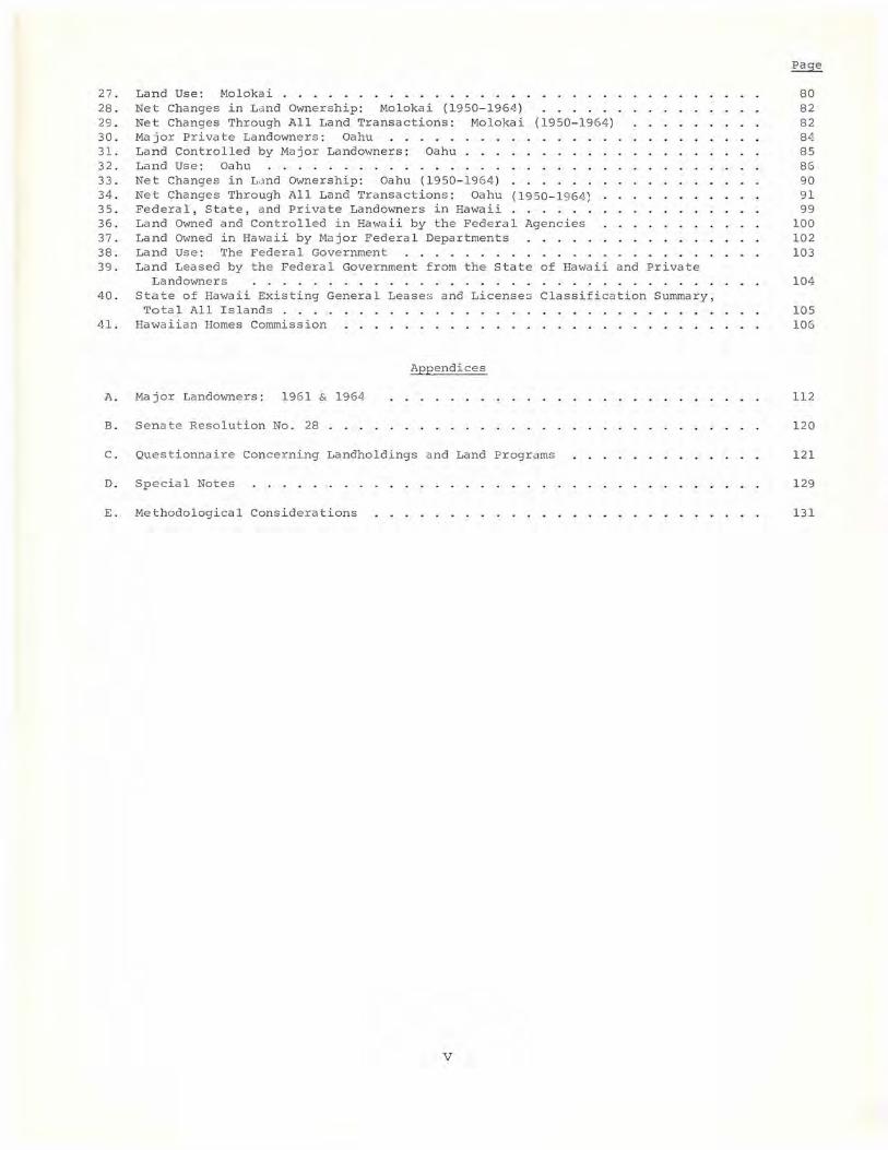
27. Land Use: Moloka i .... 28. Net Changes in La nd Ownership: Molokai (1950-1964) .... 29. Net Changes Through All Land Transactions: Molokai (1950 -1964) 30. Major Private Landowners: Oahu 31. Land Controlled by Major Landowners: Oahu 32 . Land Use: Oahu ..... 33. Net Changes in La nd Ownership: Oahu (1950-19 64 ) 34. Net Changes Through All Land Tra nsactions : Oahu (1950-1964: 35. Federal, State, and Private Landowne rs in Hawaii 36. Land Owned and Controlled in Hawaii by the Federal Agencies 37. Land Owned in Hawaii by Major Federal Departments 38. Land Use: The Federal Government 39 . Land Leased by the Federal Government from the state of Hawaii a nd Private
Landowners .... . .... ... ... . . . . 40 . State of Ha wa ii Existing General Lease s and License s Classification Summary,
Total All Islands .... 41 . Hawaiian Homes Commission
Appendices
A. Major Landowners: 1961 & 1964
B. Senate Resolution No . 28
C . Quest ionnaire Concerning Landhold i ngs a nd Land Programs
D. Special Notes
E. Methodological Considerations
v
80 82 82 84 85 86 9 0 91 99
100 10 2 103
104
105 106
112
1 20
121
1 29
131

r
CHAPTER I
HISTORICAL BACKGROUND
Ownership and use of Hawaii's scarce land resources have been a persistent concern of the Islands' governments, from the early nineteenth century, when the first Western missionaries arrived to the present. This concern has been intensified because only a relatively small portion of the Islands' extremely limited land resources has proven to be of substantial economic value. In addition, ownership of land in Hawaii has always been extraordinarily concentrated.
The degree of concentration of land ownership in Hawaii reached its peak during the reign of Kamehameha I, the conqueror who first succeeded in uniting the major Hawaiian islands into a single kingdom. The scope and significance of his conquest with respect to Hawaii's land was succinctly stated in the constitution of 1840: "Kamehameha I was the founder of the Kingdom, and to him belonged all the land from one end of the islands to the other." Kamehameha I controlled his island empire through a system that generally has been termed "feudal." This designation is not surprising, given the many similarities of the early Hawaiian land system to that of medieval Europe. Still, designation of this early land system as "feudal" is misleading. To be sure, under Kamehameha's system, the various levels of tenants owed obedience to those above them in the hierarchy of rank. They also owed absolute obedience to the King. Tenants were required to pay land taxes to their superiors by offering services, artifacts, or a portion of the product of the land. Nevertheless, Hawaii's early land system was never fully or properly a feudal one, inasmuch as military service was not required of the lowest order of tenants, the commoners who actually tilled the land. Furthermore, tenants were not bound to the land by law. The chiefs had the right to expel commoners from the land for failure to cultivate it, and dissatisfied commoners occasionally sought to cultivate land held by other chiefs.
This traditional system of land tenure, characterized though it was by concentration of ownership and rigid, hierarchic control, was well-suited to the needs of the Hawaiian people during the period of the absolute monarchy. The viability and stability of this land system may be explained by several factors, among them the cooperative arrangements by which the community was bound together, and -- related to this -- the physical shape of the divisions into which the land of the Islands was partitioned.
Throughout the reign of Kamehameha I life in the Hawaiian community was tightly knit and highly integrated. The commoners
1

MAJOR LANDOWNERS
(maka'ainahana, literally, "people of the land") worked together under the direction of chiefs and priests in the clearing of land, construction of extraordinarily complex and efficient irrigation systems, the building of extensive and sturdy sea walls and enormous artificial ponds for breeding fish, and many other communal endeavors. This cooperative development and utilization of natural resources was perfectly integrated with the basic division of Hawaii's land. The key land division was the ahupua'a, typically a wedge-shaped section of land whose boundaries extended from the highest point of an island to the sea. Designed to insure the self-sufficiency of its inhabitants, the ahupua'a varied considerably in size. Some ahupua'a were fairly small, while others were areas of a hundred thousand acres, or even more. The shape and size of each ahupua'a were designed to provide its residents with a full supply of life's necessities. Thus, from the upland forests came the logs required for canoes, ridge poles for buildings, bark for making tapa cloth, and fiber for fish lines. At lower elevations in the ahupua'a were the fertile, sparsely forested, kula lands, plains suited to the cultivation of sweet potatoes, dry taro, grain, and vegetables. Still lower on the slopes of the ahupua'a were the water sources from which complex water courses and irrigation systems that served to irrigate lush taro patches were developed. At sea level, groves of coconut trees and banana plants flourished. Finally, the inhabitants of the ahupua'a enjoyed exclusive fishing rights in the adjoining coastal waters.
Although the distribution of goods produced by this ancient land system was unequal and ruling was absolutistic and hierarchical, there is little question that the system functioned effectively in meeting community needs. Abundant evidence supports the view that the economy of the Islands was effectively developed within the limits of the technology available, and natural resources were carefully developed and protected. The aspect of this early land system that deserves special emphasis -- and is of the broadest general relevance for this study -is that the system of land ownership and control fitted perfectly into the overall political and economic structure of the community.
More generally, it may be argued that an adequate understanding of ~ system of land tenure should be analyzed within the context of the overall existing political and economic organization of a community. This proposition is further illustrated by briefly considering the system of land tenure that replaced the system developed by Kamehameha I. During the early nineteenth century the increasing influence of Hawaii's growing number of Westerners, missionaries, merchants, seamen, and others produced revolutionary changes in the ancient Hawaiian community. Paganism gave way to Christianity, absolute mon-
2
HISTORICAL BACKGROUND
archy was modified by the introduction of constitutionalism. Changes in the way of life of the native people spread rapidly. The quasifeudal system of land tenure was bitterly criticized as obstructing the "Westernization" of Hawaii, and mounting criticism of the land system induced Kamehameha III (1825-1854) to inaugurate the Great Mahele, or land division, based upon the principle of fee simple land tenure. Under the terms of the mahele, some 1,600,000 acres, or about two-fifths of the entire land area of the Hawaiian islands was vested in the ali'i, the native chiefs. They thereby acquired fee simple title to a substantial part of the land over which they had been exercising effective control during the reigns of Kamehameha I and Kamehameha II. Under the terms of the mahele, an additional million acres was designated "crown land, " since it was intended for the support of the royal family. Most of the remaining million and a half acres were designated as "government" or "public land," since income received from its sale or lease was intended to finance operations of the government. The commoners of the kingdom were given title to approximately 30,000 acres, the bulk of which consisted of land long occupied and cultivated by them. Obviously, the mahele did little to change the structure of land tenure in Hawaii; indeed, it served to reinforce the long-standing pattern of concentrated ownership.
Concentration of land ownership increased as large-scale, plantation agriculture was introduced in Hawaii and was stimulated by high profits, especially from the export of sugar. The pattern of land tenure remained essentially unchanged, even though title to particular parcels was transferred; the ancient land division of the ahupua'a fitted the demands of the sugar industry as well as it had fitted the needs of the earlier economy. Control of a number of large, fertile ahupua'a frequently provided the base for plantation operations in that they included extensive, level areas of rich soil near the sea coast, abundant water supplies (which were sometimes augmented by the acquisition of water rights on other land), and forested areas from which wood for plantation mills and other uses could be obtained. Land unsuited for sugar production was often used for the ranching operations that augmented the plantation enterprises.
As plantation agriculture flourished in Hawaii, concentration of land ownership and control increased. Records of land sales reveal that plantations purchased considerable quantities of public land, while securing long-term leases on other portions of public land and crown land. The plantations also obtained title to many of the small land holdings received by native Hawaiians during the mahele. The Census of 1890 revealed something of the degree of concentration of land ownership as well as the extent to which title to land had been
3
MAJOR LANDOWNERS
s ecured by the Isla nds' American-European residents. This census, the las t taken before the overthrow of Hawaii's monarchy, reported that, o f a total population of approximately 90,000 fewer than 5,000 peop l e ac tua lly owned any land. The relatively small number of Westerners reportedly owned over one million acres, or approximately 56 per cent of all pri vately owned land in the Islands.
The "planter revolution" of 1893 by which Hawaii's monarchy was abr ogated resulted in a regime characterized by concentration of politica l and economic control within a small portion of the populace, along with continued concentration of land ownership. Although Hawaii's Republic was soon annex ed to the United States, political and economic control of the Islands remained essentially unchanged.
During the decades following annexation, Hawaii's economy, espec i a lly its plantation structure, remained quite stable. Although the number of plantations decreased from 52 in 1900 to 47 in 1930, the average acreage planted to sugar cane increased from approximately 2, 500 to some 5,300 during the same period. The total amount of land planted to sugar cane almost doubled during the same period, rising f rom 128,000 acres in 1900 to roughly 250,000 acres in 1930. The p lantations acquired this additional land in a variety of ways, including l and exchanges with the government and additional purchases of public land and private holdings.
Further concentration of land ownership and control was fostered by t wo trends that de veloped during recent decades. The first of these trends, a decided reduction in the number of plantations, manifested itself clearly during the 1930's. Of the 47 plantations growing sugar in 1930, only 37 remained by 1940. This number fell to 28 b y 1950, and to 25 by 1964. This decrease in the number of plantations is e xplained in part by the elimination of marginal units and b y an expansion of urban areas (particularly on Oahu), which deprived some plantations of the acreage required for profitable operation. I n some instances it was possible to consolidate the remaining acreage o f such plantations with that of neighboring plantations, thus making possible more efficient and profitable operations.
A more important phenomenon with respect to concentration of land ownership and control manifested itself in Hawaii during the 1950's, viz., the systematic acquisition of stock by each of the major factors l in the plantations for which they had long served as agents. This development in Hawaii has paralleled a similar trend on the Ameri can mainland, where broad scale consolidations and mergers have enormously increased the ove rall s ize o f leading corporations in many
4
HISTORICAL BACKGROUND
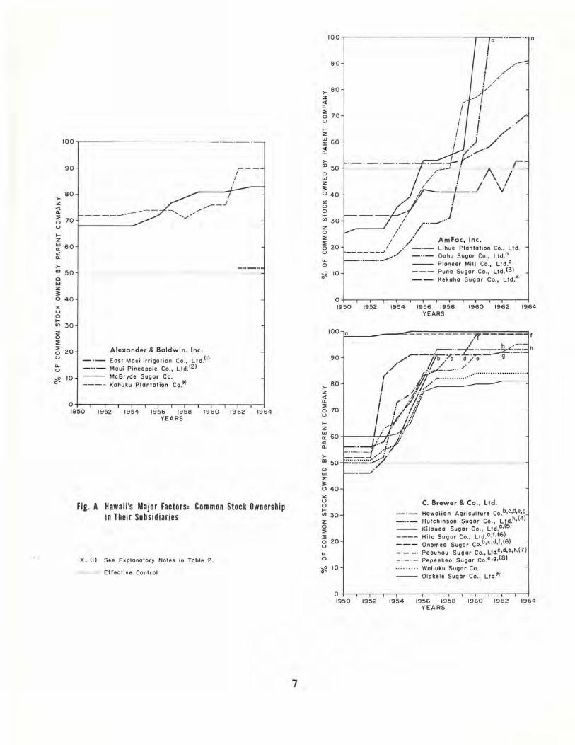
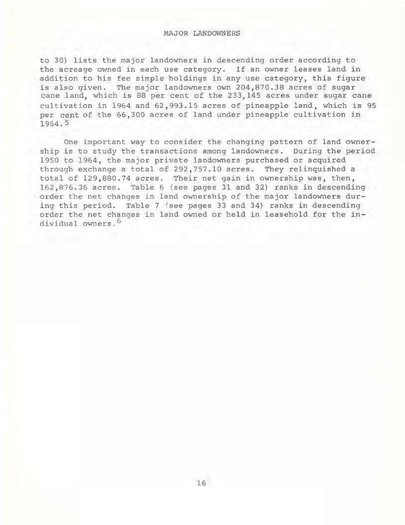
industries. In Hawaii, this development is well exemplified by Figure A (see pages 7 and 8) which traces the stock acquisitions by AmFac, Inc. in the five plantations for which it has long served as a factor. In 1955, AmFac, Inc. held majority stock. control in only one of these five plantations, and that by but a small amount (52.12 per cent in Lihue Plantation Co., Ltd.). Nine years later, AmFac, Inc. held 100 per cent of the stock of Oahu Sugar Co., Ltd. and Pioneer Mill Co., Ltd., 91, 71 and 53 per cent in the stock of the other three plantations. Comparable results were achieved by the stock acquisition programs of Theo H. Davis & Co., Ltd., Castle & Cooke, Inc., C. Brewer & Co., Ltd. and Alexander & Baldwin, Inc., although it may be noted that C. Brewer & Co., Ltd., as well as Alexander & Baldwin, Inc., had initiated policies of stock acquisition in their plantations before 1955. As of 1964, all of the factors held a majority position in the stock of each of their plantations. Table 1 (see page 9) lists each factor with all of its plantation subsidiaries. Table 2 (see pages 10-12) indicates the increasing control of common stock by each of Hawaii's major factors in each of its subsidiaries during the period 1950 to 1964. Figure A provides a graphic presentation of these data.
Considerable emphasis has been afforded this trend toward consolidation of Hawaii's factors with their plantations because, unquestionably, the acquisition of majority positions in the stock of plantations has contributed significantly to centralized land management. It has fostered such innovations as assigning land management to a separate division within the company, e.g., the Oceanic Properties Division of Castle & Cooke, Inc. The creation of such management operations has been designed to increase flexibility in land management and to facilitate the development of land for such purposes as residential subdivisions, resorts, and industrial uses.
This brief historical sketch has been designed to emphasize the principle that patterns of land ownership and control must be understood within the total political and economic structure of the community. All too often, discussion of concentration of land ownership and control is based on the premise that "bigness is badness"--or the opposite. Such judgments detract from the truly fundamental issues of land policy, especially the degree to which a given system of land ownersh i p and control can or cannot meet the needs of Hawaii's people. This study draws no conclusion s on these questions nor were its authors asked to make any recommendations for policy. Accordingly, the focus of the study is the data about the major landowners themselves. The text of the report has been
5
MAJOR LANDOWNERS
designed to clarify and emphasize, rather than to interpret or evaluate.
These data were - collected from questionnaires submitted to all major private and public landowners in Hawaii. A major landowner is defined for the purposes of this study as one who owns a total of 1,000 acres anywhere in the State of Hawaii. In some instances a landowner may have less than 1,000 acres on a single island, but if his total holdings on two or more islands are as much as 1,000 acres, he has been classified as a major landowner.
An adequate understanding of land use in Hawaii requires that one take account of more than fee simple ownership alone. Long-term leases have proved to be one of the sound and accepted devices through which Hawaii's agricultural enterprises have increased their productivity and efficiency. Therefore, one must take account of both land owned and land leased in order to fully comprehend the pattern of land use in Hawaii. The term "land controlled" has been used throughout this report as a special designation of land use. "Land controlled" is defined as the total acreage owned in fee, plus the total acreage held under lease, minus any fee land leased to others and any acreage sublet. This concept of "land controlled" is particularly useful in that it reveals, among other things, that, while some of Hawaii's major landowners are large-scale lessees, others function chiefly as large-scale lessors, a consideration that must be taken into account in understanding the effective land-use pattern in Hawaii today.
These considerations of ownership and control point to a significant deficiency in this study.2 Landowners who own less than 1,000 acres in fee are excluded from this study, even when they lease 1,000 or more acres. The exclusion of such land users is especially significant with respect to the data presented on Hawaii's major agricultural factors, several of which have one or more subsidiary plantations whose operations depend primarily on the use of leased land. Inasmuch as the fee holdings of these subsidiaries have not been included in this report, it follows that all figures provided on both fee simple land ownership and "land controlled" of the major factors listed in Table 1 are less than the actual totals.
6
)0-
Z <I CL ::E 0 U
t-Z w a:: rt )0-
m 0 w z ~ 0
'" u 0 t-V)
z 0 ::E ::E 0 u u. 0
~ 0
100 ._. __ .
90 I~ --
I I
80
--------70
60
50
40
30
20 Alexander & Baldwin, Inc.
East Maui Irrigalion Co., LIdO) Maui Pineapple Co., Lld(2)
10 McBryde Sugar Co. Kahuku Plantation Co.*
O+--r--r-.--.--r-.--.--.-~-.--r-.--.~ 1950 1952 1954 1956 1955 1960 1962 1964
YEARS
Fig. A Hawaii's Major Factors: Common Stock Ownership in Their Subsidiaries
*, (I) See Explanalory Noles in Table 2 .
Effective Control
7
100 .---------------------------~_r.~ .. --- .. a
90
)0-SO
z <I CL ::E
70 0 U
t-Z
~ 60 <I CL
)0-m 50 0 w z ~ 040
'" u 0 t-V) 30 z 0 ::E ::E
20 0 u u. 0
~ 10 0
1952 1954
AmFac, Inc. Lihue Plantation Co., Ltd. Oahu Sugar Co., LIdO Pioneer Mill Co., Ltd.a
Puna Sugar Co., Ltd . (3) Kekaha Sugar Co., Lld:*
1956 1955 YEARS
1960 1962 1964
100 lla!.------.....:::-:-=-=-=-:-:-=-=-:-:-==-=-';r.iif:-:-=-=-=======1
/ h .-"
90
)0-SO
Z <I CL ::E
70 0 U
t-Z w
60 a:: <I CL
)0-m 50 0 w z ~ 040
'" u 0 t-V) 30 z 0 ::E ::E 0 20 u u. 0
~ 10 0
--If/' ,,::.::r.;.:..-=::::~<7.:.=: h /' b.c d/e / /.,
( /1/'.,,/:..··_··.-/ ............................ . J JI/:::·/:.:.....····...::..· · · ::..:.:····~· · --------1 J ('///j J . '11 I .1;"/:
/'.
C. Brewer & Co ., ltd.
Hawaiian Agriculture Co .b,c,d,e,9 Hutchinson Sugar Co., L tdh ,(4) Kilauea Sugar Co ., Ltd.a,(5) Hila Sugar Co., Ltd. a,f,(6) Onomea Sugar Co.b,c,d,f,(6) Paauhau Sugar Co., Lldc ,d,e,h,(7) Pepeekeo Sugar Co .e,g,(S)
Wailuku Sugar Co. Olokele Sugar Co., Ltd*
O+--'-'r-'--'-'r-.--'-'--.--r-.--.--r~ 1950 1952 1954 1956 1958 1960 1962 1964
YEARS

100
90
80
>-Z <t a.
70 ::E 0 u ..... ~ 60 a: <t a. >- 50 m 0 w z ~ 40
"" u 0 .....
30 I/)
z 0 ::E ::E 20 0 u "-0
~ 10 0
ld
t------
Capital Investment Ca., Ltd . Makaha Volley Forms, LId. Waianae Development Co., lId(9)
O+--r--r-'--r--r-.--.-'r-.--r-'r-.--.~ 1950 1952 1954 1956 1958 1960 1962 1964
YEARS
Fie. A Hawaii's Major Factors: Common Stock Ownership in Their Subsidiaries
*, (I) See Explanatory Notes in Table 2 .
Effective Contr61
>-Z <t a. ::E 0 u ..... z w a: <t a. >-m 0 w z ~ 0
"" u 0 ..... I/)
z 0 ::E ::E 0 u
"-0
~ 0
>-Z <t a. ::E 0 u ..... z w a: <t a. >-m 0 w z ~ 0
"" u 0 ..... I/)
z 0 ::E ::E 0 u
"-0
~ 0
8
100
90
80
70
60
50
40
30
20
10
. __ ._'-'_.--J Castle &Caake, Inc. Dole Company UO)o
Kohala Sugar Co. o
Ewa Plantation Co* Waialua Agriculture Co.*
O+--.--r-.--.-'--.--r-'--.--r-'--.--r~ 1950 1952
100
90
80
r··_··.'
70
60
50
40
30
20
to
1954 1956 1958 1960 1962 1964 YEARS
Theo. H. Davies & Co., ltd Hamakua Mill Co. Kukaiau Ranch Co. , Ltd .un Honokaa Sugar Co. Laupahoehoe Sugar Co.
O+--r __ .-.--.--.-.--r __ .-.--r--.-.--r~ 1950 1952 1954 1956 1958 1960 1962 1964
YEARS
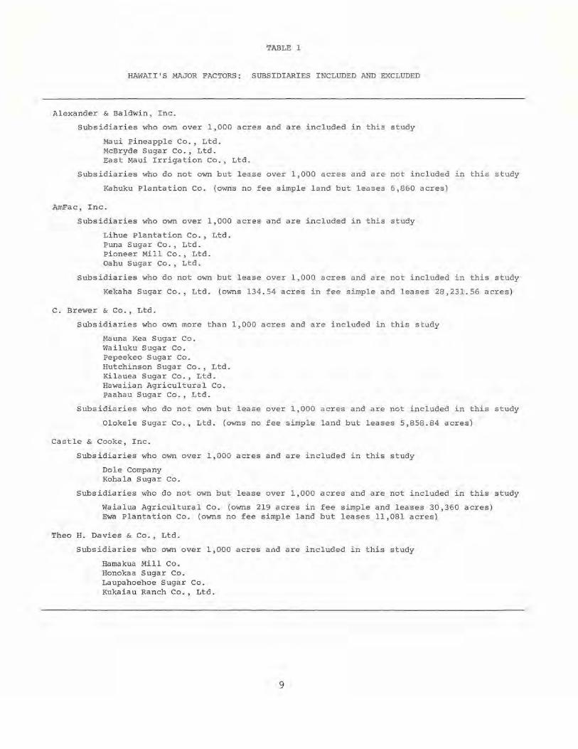
TABLE 1
HAWAII'S MAJOR FACTORS: SUBSIDIARIES INCLUDED AND EXCLUDED
Alexander & Baldwin, Inc.
Subsidiaries who own over 1,000 acres and are included in this study
Maui pineapple Co., Ltd. McBryde Sugar Co., Ltd. East Maui Irrigation Co., Ltd.
Subsidiaries who do not own but lease over 1,000 acres and are not included in this study
Kahuku Plantation Co . (owns no fee simple land but leases 6,860 acres)
AmFac, Inc.
Subsidiaries who own over 1,000 acres and are included in this study
Lihue Plantation Co., Ltd . Puna Sugar Co., Ltd. Pioneer Mill Co., Ltd. Oahu Sugar Co., Ltd.
subsidiaries who do not own but lease over 1,000 acres and are not included in this study
Kekaha Sugar Co., Ltd. (owns 134 .54 acres in fee simple and leases 28,231.56 acres)
C. Brewer & Co., Ltd.
Subsidiaries who own more than 1,000 acres and are included in this study
Mauna Kea Sugar Co. Wailuku Sugar Co. pepeekeo Sugar Co. Hutchinson Sugar Co., Ltd. Kilauea Sugar Co., Ltd. Hawaiian Agricultural Co. Paahau Sugar Co., Ltd.
Subsidiaries who do not own but lease over 1,000 acres and are not included in this study
Olokele Sugar Co., Ltd. (owns no fee simple land but leases 5,858.84 acres)
Castle & Cooke, Inc.
Subsidiaries who own over 1,000 acres and are included in this study
Dole Company Kohala Sugar Co.
Subsidiaries who do not own but lease over 1,000 acres and are not included in this study
Waialua Agricultural Co. (owns 219 acres in fee simple and leases 30,360 acres) Ewa Plantation Co. (owns no fee simple land but leases 11,081 acres)
Thea H. Davies & Co., Ltd .
Subsidiaries who own over 1,000 acres and are included in this study
Hamakua Mill Co. Honokaa Sugar Co. Laupahoehoe Sugar Co. Kukaiau Ranch Co., Ltd.
9

I-' o
Major Factors and Subsidiaries
Alexander & Baldwin, Inc.
East Maui Irrigation Co., Ltd. 1
Maui Pineapple Co., Ltd . 2
MCBryde Sugar Co.
""Kahuku Plantation Co.
Amfac, Inc .
Lihue Plantation Co., Ltd.
Oahu Sugar Co . , Ltd.
Pioneer Mill Co., Ltd .
Puna Sugar Co., Ltd. 3
"'Kekaha Sugar Co., Ltd.
C. Brewer & Co., Ltd .
Hawaiian Agricultural Co.
Hutchinson Sugar Co., Ltd. 4
Kilauea Sugar Co . , Ltd. 5
Mauna Kea Sugar Co., Inc . 6
[Hila Sugar Co., Ltd.] [Onomea Sugar Co.]
Paauhau Sugar Co . , Ltd. 7
Pepeekeo Sugar Co . 8
Wailuku Sugar Co.
*01oke1e Sugar Co., Ltd.
Capital Investment Co., LtG .
Makaha Valley Farms, Ltd.
Waianae Development Co., Ltd . 9
Castle & Cooke, Inc.
Dole Company10
Koha1a Sugar Co.
,"Ewa Plantation
"'Waia1ua Agricultural Co.
Table 2
HAWAII'S MAJOR FACTORS: COMMON STOCK OWNERSHIP IN SUBSIDIARIES (PERCENTAGES)
1950 1951 1952 1953 1954 1955 1956 1957 1958 1959 1960 1961 1962 1963 1964
100.00 100 . 00 100.00 100.00 100.00
52.18 52.18 52 . 18
68.24 68.24 68.24 68.24 68.24 70.41 72.38 76.58 79.02 80.73 81.15
71.53 71.53 71.53 72.19 72.99 74.11 74.11 74.11 71 . 41 74.41 75.77
81 . 25 82.31 83 . 38 83.38
76.18 89.51 89.51 89.51
52.12 52.12 52.12 52.12 52.12 52 . 12 52.12 52.12 52 . 12 53 . 24 56.28 58.30 63 . 11 66.50 71 .40
15.10 15.10 15.10 15.10 17.23 22. 23 28 . 98 29 . 30 30 . 65 55.20 59.72 100.00 100.00 100.00 100.00
25.22 27.15 27.15 27.15 35.44 39.24 53 . 16 53.24 54.86 57.13 100.00 100.00 100 . 00 100 . 00 100.00
18.18 18.18 18.18 18.18 26.23 34.23 43.79 49.22 50.25 74.71 77.22 81.20 86.28 89.50 91.40
32.17 32.17 32 . 17 32.17 32.17 34.11 41.63 41.20 41.20 41.20 41.20 50 . 30 41 . 20 52 . 90 53.90
45.86 45 . 86 45.86 50.66 57.85 69.19 79.90 90.98 90.98 91 . 00 91.38 91 . 49 91.86 92 . 13
56.17 56.17 56 . 17 57.12 67.67 72.86 81 . 69 92.72 92 . 72 92.97 92.97 93.10 93.41 93 . 41
98.44 98.44 98.44 98.68 99.15 99.85 99 . 85 99.85 99.85 99.85 99.92 99.92 99.92 99.92
92 .14
93.47
99.92
97.90 97.90 98.20 99.30 99 . 30 99.30 99.30 99.40 99.40 99.40 99.40 99 . 40 99.40 52.01 52.01 52.01 83.45 87.54 90 . 68 91 . 07 91.18 91.18 91.18 98 . 64 98.67 98 . 72
50.38 50.38 50.38 52.34 73.30 75.55 82.81 84.96 91.16 91.37 91.47 91.73 92 . 98
54.27 54.27 54.27 62.98 67.19 73.81 83.50 85 . 38 85.38 86 . 32 90.91 91.87 92 . 27
50.81 50.81 50.81 54.68 57 .21 66.87 77 . 83 82.03 82 . 03 82.03 83.76 83.96 84.06
60 . 00 60 . 00 60.00 60.39 61.12 64.74 76.56 78.98 78.98 78.98 79.79 80.36 80.62
99.40 99.40 98 . 72 98.72
92.99 93.18
95.36 95.36
84.20 84.20
80.62 80.68
28.60 30.11 77.00 77.00 79.00 79.00 76 . 00 76 . 00 76.00 76.30 76 . 30 76 . 53 76 . 53 77.55 77.55
28 . 35 34.25 37 . 50 39.40 55.19 57 . 59 85.83 85.83 85.83 85.83 85.83
15.14 15.13 15.13 15.13 16.12 15 . 11 15.17 15 . 44 48 . 15 51.21 52.17 100 . 00 100.00 100.00 100.00
88 . 22 88 . 99 88 . 99 97.12 97.29 99 . 90 99.11 99.11 99.87 99 . 87 99.87 99.86 99.87 99 . 86 99.87
20.11 20 . 11 20.11 20.11 20.20 20.23 23 . 14 27.20 27.20 27.98 29 . 56 26.00 42.23 43.17 62 . 47
26.63 26.63 26.63 26.63 26.16 26 . 21 30.21 34.24 38 . 60 46 . 50 51 . 35 50 . 00 54.26 50.00 64.99

I-' I-'
Table 2 (continued)
M~or Factors and Subsidiaries 1950 1951 1952 1953 1954 1955 1956 1957 1958 1959 1960 1961 1962 1963 1964
Thea H. Davies & Co . , Ltd .
Hamakua Mi ll Co. 39.96 43.29 43 . 29 43.29 67.12 72.79 75 . 13 86 . 13 87 . 64 87 . 80 87.80 90.50 90.00 90 . 00 92.04
Kukaiau Ranch Co., Ltd . ll 69 . 80 77.16 77 . 16 78.24
Honokaa Sugar Co . 13.80 13.80 49 . 64 59 . 33 60.73 62.14 62 . 59 66.72 67 . 10 67 . 10 67.00 67.00 67 . 00
Laupahoehoe Sugar Co. 86.20 86.20 93.76 93.76 94.82 94.82 94.50 94 . 00 94.00 94 . 00
Di 11 ingham Corp.
Hawaiian Land Co.12 100.00 100.00 100 . 00 100.00
*These companies are not ma jor landowners but control substantial amounts of land through their leasehold. Kahuku Plantation Co. leases 6,860 acres, Kekaha Sugar Co., Ltd. leases 28,232 acres, Olokele Sugar Co., Ltd. leases 5,859 acres, Ewa Plantation leases 11,081 acres, and Waialua Agricultural Co . leases 30,360 acres.
1 . Hawaiian Commercial & Sugar Co., Ltd. held over 99% of the stock of East Maui Irrigation Co., Ltd. from 1950 through 1959 . During that same period Alexander & Baldwin, Inc. held between 34% and 41% of the stock of Hawaiian Commercial & Sugar Co., Ltd. On January 2, 1962 Hawaiian Commercial & Sugar Co., Ltd. was merged with and absorbed by Alexander & Baldwin, Inc .
2. Haleakala Pineapple Co., Ltd. held 50% of the stock of Maui Pineapple Co., Ltd. from 1950 through 1961. During that same period Hawaiian Commercial & Sugar Co . owned 49% of the stock of Maui Pineapple Co., Ltd . On December 12, 1962 Haleakala Pineapple Co., Ltd. was merged with and absorbed by Maui Pineapple Co., Ltd .
3 . This stock was under the name of Olaa Sugar Co. from 1950 through 1959 . On April 1, 1960 the name of Olaa Sugar Co. was changed to Puna Sugar Co.
4. This stock was under the name of Hutchinson Sugar Plantation Co. from 1950 through 1955. On December 31, 1955 Hutchinson Sugar Plantation Co. was merged with and absorbed by Hutchinson Sugar Co., Ltd.
5. This stock was under the name of Kilauea Sugar Plantation Co. from 1950 through 1955 . On December 31, 1955 Kilauea Sugar Plantation Co. was merged with and absorbed by Kilauea Sugar Co., Ltd.
6. Mauna Kea Sugar Co., Inc . is the surv~v~ng company of Hila Sugar Co., Ltd. and Onomea Sugar Co. From 1950 through 1955 Hila Sugar Co . , Ltd . was under the name of Hila Sugar Plantation Co. On December 31, 1955 Hila Sugar Plantation Co. "as merged with and absorbed by Hila Sugar Co., Ltd. On July 26, 1965 Hila Sugar Co., Ltd. was merged with an absorbed by Onomea Sugar Co., Inc . On that same day the name of Onomea Sugar Co., Inc. was changed to Mauna Kea Sugar Co., Inc.
7. This stock was under the name of Paauhau Sugar Plantation from 1950 through 1955. On December 31, 1955 Paauhau Sugar Plantation Co. was merged with and absorbed by Paauhau Sugar Co., Ltd .
8. Pepeekeo Sugar Co . is the surv~v~ng company of Hakalau Sugar Plantation Co., which was merged with and absorbed by Hakalau Sugar Co . , Ltd. on December 31, 1955. In 1950 C. Brewer & Co., Ltd. held 86% of the stock of Hakalau Sugar Plantation Co. By 1962 C. Brewer & Co., Ltd. held 99% of the stock of Hakalau Sugar Co., Ltd. On December 31, 1962 Hakalau Sugar Co., Ltd. was merged with and absorbed by Pepeekeo Sugar Co.
9. Makaha Valley Farms held over 69% of the stock of Waianae Development Co., Ltd. from 1956 through 1959. During this same period Capital Investment Co., Ltd. held over 76% of the stock of Makaha Valley Farms.
10. This stock was under the name of Hawaiian Pineapple Co., Ltd. from 1950 through 1960. On September 30, 1960 the name of Hawaiian Pineapple Co., Ltd. was changed to Dole Corporation. Dole Corpora tion was merged with and absorbed by Castle & Cooke, Inc. on May 1, 1964.

I-' N
Table 2 (continued)
11. In 1954 lIamakua j':i11 Co. held 80/0 of the stock of Kukaiau Ranch Co., Ltd. By 1964 this percentage had increased to 81%. Theo H. Davies & Co., Ltd. held 39% of the stock of llamakua Hill Co. in 1950. By 1964 this percentage had increased to 9270'
12. Halvaiian Dredging Co., Ltd. held 100% of the stock of Hm'laiian Land Co. from 1950 through 1956. From 1957 through 1960 Hmvaiian Dredging and Construction Co., Ltd. held 100% of the stock of Ha\vaiian Land Co. From 1950 through 1960 various members of the Dillingham family held a majority of the stock of Hmvaiian Dredging Co., Ltd. which was later called Ha\vaiian Dredging & Construction Co., Ltd.

CHAPTER II
MAJOR PRIVATE LANDOWNERS: Statewide
Introduction
In keeping with the terms of the legislative resolution a u thorizing this report, the chief focus throughout this study is the group of 72 major private landowners in the State. In this chapter, which presents data for the state as a whole, as well as in subsequent chapters, we will discuss land ownership from four basic point s of view: land ownership per se (that is, who owns Hawaii's land s), land control (who exercises effective control of Hawaii's lands), l a nd use (the primary uses to which the land is put), and land transacti on s (changes in acreage owned in fee and held in leasehold) for t he period 1950 to 1964.
While the emphasis in this study is on private landowners , we will, to the extent that data permit, include information on pub lic land as well. Data on state and federal lands are presented where appropriate in each analysis in order that first-hand comparisons c a n be made. l A more comprehensive report of land owned and leased b y the state and federal governments is found in Chapter IV.
Land ownership in the state of Hawaii remains, as it has been since the time of Kamehameha I, highly concentrated. The largest single owner is the state government, which owns a total of 1,590,532 acres, or 38.74 per cent of the total land area of Hawaii. The federal government owns 255,717.34 acres in fee simple and another 145,764.97 acres of ceded land for a total of 401,482.31 acres or 9.78 per cent of the total area of the state. The greatest percentage of land, however, is owned by the 72 major private landowners who own more than 1,000 acres each in fee simple. These major private landowners own 1,923,182.56 acres, or 47 per cent of the total land area of the State. Taken together, the state and federal governments a nd the 72 major private landowners own a total of 3,915,196 . 87 acres, which is 95.36 percent of the total land area of the State. 2 Therefore, the remaining private landowners own less than 5 per cent of the lands of the State of Hawaii.
The major private landowners are ranked in descending order in Table 3 (see pages 17 and 18). The column giving the cumulative tota l s is especially illuminating. As can be seen, the 72 major private landowners own 47 per cent of the land in the State. However, 18 owners own approximately 40 per cent of Hawaii's lands, a total of 1,655,874.67 acres, and seven owners own nearly 30 per cent of the
13

MAJOR LANDOWNERS
land, a total of 1,203 , 487.07 acres. Therefore, as we can see, the remaining 54 major landowners own 267,307.89 or seven per cent of Hawaii's land (13.90 pe r cent of the nearly two million acres owned by the ma j or private landowners in Hawaii) . Of the total acreage owned by Hawaii's major private landowners, 970,536.57 acres are in use by the owner, 548,348.73 acres are leased to others, and 404,297.26 acres a re not presently used .
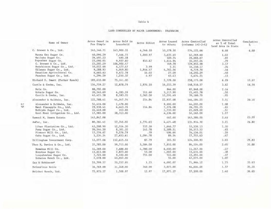
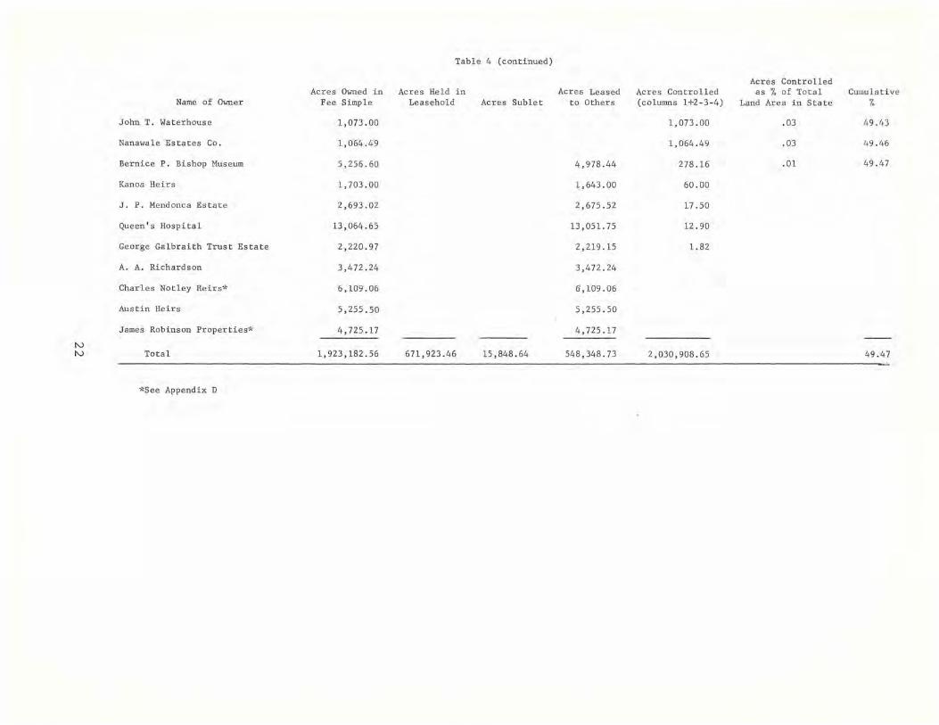
In addition to their fee simple holdings, 26 of the major private landowners hold 671,923.46 acres in leasehold. They lease 404,470.04 acres from the State government, 1,279.47 from the federal government, and 266,173.95 acres from private owners. Of this total land leased, 15,848.64 acres are sublet. Applying the dimension of control, as defined above, we can see that the major private landowners exercise effective control of 2,030,908.65 acres, or 49.47 per cent of the total land of the State. Table 4 (see pages 19 to 22) lists the major private landowners in descending order according to the acreage they control. The column giving the cumulative totals is again of special interest. As can be seen, the 72 major private landowners control 49.47 per cent of the land of the State. However, 14 owners control 40 per cent of the land, a total of 1,640,976.57 acres and seven control nearly 30 per cent of Hawaii's land, a total of 1,224,585.71 acres. As we can see, the remaining 58 major landowners control 389,932.08 acres, nine per cent of Hawaii's land (19.19 per cent of the over two million acres controlled by the major priv ate landowners in the State of Hawaii) .
It should be noted that, although the total acreage controlled is not significantly different from the total acreage owned by all the major private landowners, the listing by total acreage controlled changes noticeably from the listing by total acreage owned for the individual owners. That is, the order of owners listed according to acres owned in Table 3 is quite different from the order of owners listed according to acres controlled, in Table 4.
No account of land ownership and control is useful without a consideration of the potential productivity of the land. Productivity has been measured by five generalized categories, 3 which have been used in recent years by the Land Study Bureau of the university of Hawaii. These categories are:
1. Best suited for intensive cultivation
2. Moderately suited for intensive cultivation
14

MAJOR PRIVATE LANDOWNERS: STATEWIDE
3. Fairly to moderately suited for intensive cultivation
4. Not suited for intensive cultivation, but often well suited for grazing, forestry, and water conservation
5. Unclassified
In the State of Hawaii only 19.40 per cent of the land is classified as suitable for intensive cultivation. Only 3.05 per cent of Hawaii's land is classified as "best suited" for intensive cultivation, and only another 5.71 is classified as "moderately" suited for intensive cultivation. The major landowners own 344,293.27 or 8.38 per cent of the total land of the State in three agricultural categories: diversified, sugar cane, and pineapple. This is 43.27 per cent of all the land classified as suitable for cultivation.
The remaining land suitable for cultivation and which is, in fact, cultivated is owned by the state or federal governments or by the small, private landowners. Some of this land is leased to the major private landowners. Our data show that the major private landowners control 279,177.15 acres 4 or 35.09 per cent of all the land suitable for cultivation.
It should be remembered that Hawaii's major agricultural factors have five subsidiaries who own less than 1,000 acres each (and who therefore have been excluded from this study), but who lease a total of 82,392 acres of land. Since all five of these subsidiaries are sugar plantations, it is reasonable to infer that a substantial part of the land they lease is under cultivation. Consequently, if the number of acres of cultivated land controlled by each of these subsidiary companies were added to our figure for cultivated land controlled by the major private landowners, the resulting total would be about the same as the total for cultivated land owned by the major private landowners. Here we can see the significance of adding our dimension of control, for those who own large amounts of cultivated land are not necessarily those who control, or use, this land. Again, because of the limitations of our data, we are not able to complete the analysis of the dimension of control by extending it to include each use category.
Not all of the land suitable for cultivation is, in fact, cultivated. Some of this land has been put to commercial, residential, and industrial uses. Indeed, even some of the land classified as "best suited" for intensive cultivation is being used for non-agricultural purposes, as will be shown in Chapter 3. Table 5 (see pages 23
15
MAJOR LANDOWNERS
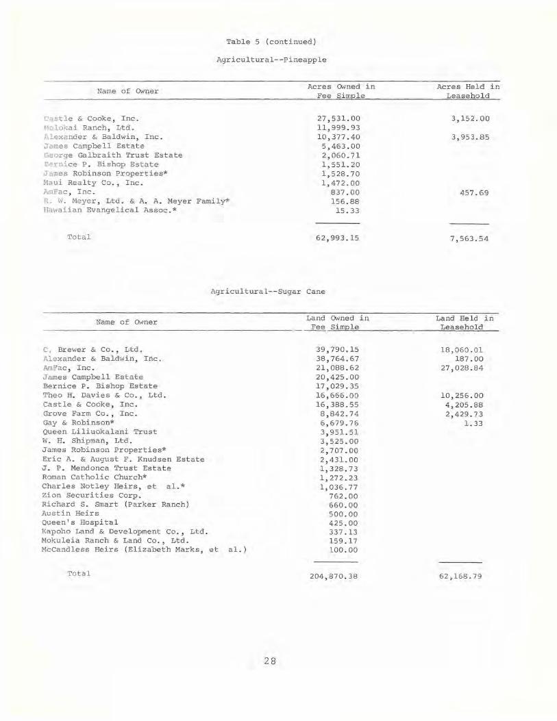
to 30) lists the major landowners in descending order according to the acreage owned in each use category. If an owner leases land in addition to his fee simple holdings in any use category, this figure is also given. The major landowners own 204,870.38 acres of sugar cane land, which is 88 per cent of the 233,145 acres under sugar cane cultivation in 1964 and 62,993.15 acres of pineapple land, which is 95 per cent of the 66,300 acres of land under pineapple cultivation in 1964.5
One important way to consider the changing pattern of land ownership is to study the transactions among landowners. During the period 1950 to 1964, the major private landowners purchased or acquired through exchange a total of 292,757.10 acres. They relinquished a total of 129,880.74 acres. Their net gain in ownership was, then, 162,876.36 acres. Table 6 (see pages 31 and 32) ranks in descending order the net changes in land ownership of the major landowners during this period. Table 7 (see pages 33 and 34) ranks in descending order the net changes in land owned or held in leasehold for the individual owners. 6
16

Table 3
MAJOR PRIVATE LANDOWNERS: STATEWIDE
Fee Acres as % of Total
Acres Owned Acreage of Name of Owner in Fee Simple State Cumulative 01
Ie
Bernice P. Bishop Estate 369,699.68 9.00 9.0 0 Richard S. Smart (Parker Ranch) 185,610.00 4 . 52 13.52 Castle and Cooke, Inc. 154,759.27 3 . 77 17.29
Dole Company 88,792.00 2.16 Castle and Cooke, Inc. 45,421.58 loll Kohala Sugar Co . 20,545.69 . 50
C. Brewer & Co., Ltd. 145,146.71 3.54 20 . 83 Mauna Kea Sugar Co. 40,096.29 .98 Wailuku Sugar Co. 26,492 . 23 .65 Pepeekeo Sugar Co. 25 , 090.05 .61 C. Br ewer & Co., Ltd . 23,202.29 . 57 Hutchinson Suga r Co . , Ltd. 10,022.00 .24 Kilauea Sugar Co. , Ltd. 9 ,288 . 93 . 23 Hawaiian Agri cultural Co . 6 , 660 . 63 .16 Paauhau Sugar Co. , Ltd. 4,294.29 .10
Samuel M. Damon Estate 143,842.00 3.50 24 . 33 Alexander & Baldwin, Inc. 122,788.41 2.99 27.32
Alexander & Ba l dwin, Inc. 52,416.00 1.28 Maui Pineappl e Co. , Ltd. 29,938.41 .73 McBryde Sugar Co. , Ltd. 22,449.00 . 55 East Maui Ir rigation Co. , Ltd. 17,985.00 . 44
James Campbell Estate 81 , 641.00 1. 99 29.31 AmFac , Inc. 80,364.41 1. 96 31. 27
Lihue Plantation Co. , Ltd. 43,208 . 90 1.05 Puna Suga r Co. , Ltd. 20,544.50 .50 Pioneer Mill Co . , Ltd. 15,376.67 . 37 Oahu Sugar Co. , Lt d. 1,234 . 34 .03
Molokai Ranch, Ltd. 73,975.37 1.80 33.07 Gay and Robinson* 55,799.57 1. 36 34 . 43 Niihau Ranch 46,065 . 24 1.12 35.55 Theo H. Davies and Co . , Ltd. 37,785 . 00 .92 36.47
Hamakua Mill Co . 14,369.00 . 35 Honokaa Sugar Co. 13,613.00 . 33 Laupahoehoe Sugar Co. 7,725.00 . 1 9 Kukaiau Ranch Co. , Ltd. 2,078.00 . 05
McCandless Heirs (El i zabeth Marks, et a1.) 36,769 . 00 . 90 37.37 Haleakala Ranch Co. 33,041.00 . 80 38.17 W. H. Shipman, Lt d . 23, 165.00 . 56 38.73 Grove Farm Co. , Inc . 22,616.01 .55 39.28 Ulupalakua Ranch, Inc. 21,807.00 .53 39.81 Yee Hop, Lt d . 21,000 . 00 .51 40.32 Thelma K. Stillman Trust 15,437.76 .38 40 . 70 Puu-O-Hoku Ranch (George W. Murphy) 14,262.00 .35 41.05 Kahua Ranch, Ltd. 14,013 . 00 .34 41. 39 Queen ' s Hospital 13 ,064.65 .32 41. 71 W. H. Greenwell, Lt d. 12,149.07 .30 42.01 Dillingham Investment Corp. 12,077.06 .30 42 . 31 Hawa iian Ocean View Estate* 10,642.40 .26 42.57 Kaupo Ranch, Lt d . 10,036.94 .25 42.82 Queen Lili uokalan i Trust 9,793.86 .24 43.06 Harold K. L. castl e (Kaneohe Ranch Co. , Ltd . ) 9,336.87 . 23 43.29 Kaonoulu Ranch Co. , Ltd. 8,813.38 .21 43.50
17
Name of Owner
Zion Securities Corp. Francis H. Ii Brown, et al. Charles Notley Heirs, et al.* Frank R. Greenwell (palani Ranch Trust) Eric A. & August F. Knudsen Trust Hawaiian Paradise Park corp.* Capital Investment Co., Ltd.
Makaha Val ley Farms, Ltd.* Waianae Development Co.*
Bernice P. Bishop Museum Austin Heirs Hui of Kahana Kapoho Land & Development Co., Ltd. Mokuleia Ranch and Land, Co., Ltd. Hana Ranch Co., Ltd. James Robinson properties* Kualoa Ranch, Ltd. Crawford oil Corp.* A. A. Richardson Hawaiian Evangelical Assoc.* Norman N. Inaba Wm. Hyde Rice, Ltd . R. W. Meyer, Ltd. & A.A. Meyer Family* J. P. Mendonca Estate Elizabeth K. Booth Trust, et al. Mauna Loa Investment Co. George Galbraith Trust Estate Hawaiian Land Co. Hawaii Mounta in View Development Corp. S. C. & Pearl Friel* Morgan & Claire E. Flagg Stewart-Gadbois Co. Kanoa Heirs E . L. Wung Ranch, Ltd. Maui Realty Co., Inc .* H. P. Hustace* Neoma Foster, et al. victor D. Kle in Crescent Acres, Ltd.* Roman Catholic Church* Hiram L . Fong & Mun On Chun Golden State Hawaiian Corp. William B. Dunbar* John T. Waterhouse Nanawale Estates Co.
Total
*See Appendix D
Table 3 (continued)
Acres Owned in Fee Simple
6,374.00 6, 164.50 6,lGJ.06
6,025.96 5,879.00 5,502.88 5,420.91 3,952.29 1,468.62 5,256.60 5,255.50 5,250.00 5,174.43 4,865.20 4,813.80 4,725.17 3,999.33 3,807.75 3,472.24 3,201.42 3,158.00 3,039.74 2,885.94 2,693.02 2,613.31 2,283.00 2,220.97 2,101. 00 2,000.00 1,841.22 1,800.00 1,785.00 1,703.00 1,700.00 1,636.00 1,515.15 1,500.00 1, 500.00 1,489 .03 1,284.91 1,19'0.00 1,165 .00 1,141.37 1,073.00 1,064 .49
1,923,182.56
18
Fee Acres as % of Total Acreage of
State Cumulative %
.16 43.66
.15 43.81
.15 43.96
.15 44.11
.14 44.25
.13 44.38
.13 44.51
.10
.04
.13 44.64
.13 44.77
.13 44.90
.13 45.03
.12 45.15
.12 45.27
.12 45.39
.10 45.49
.09 45.58
.08 45.66
.08 45.74
.08 45.82
.07 45.89
.07 45.96
.07 46.03
.06 46.09
.06 46.15
.05 46.20
.05 46.25
.05 46.30
.04 46.34
.04 46.38
.04 46.42
.04 46.46
.04 46.50
.04 46.54
.04 46.58
.04 46.62
.04 46.66
.04 46.70
.03 46.73
.03 46.76
.03 46.79
.03 46.82
.03 46.85
.03 46.88
46.88
I-' \.0
Name of Owner
C. Brewer & Co., Ltd.
Mauna Kea Sugar Co. Wailuku Sugar Co. Pepeekeo Sugar Co. C. Brewer & Co., Ltd. Hutchinson Sugar Co., Ltd. Kilauea Sugar Co., Ltd. Hawaiian Agricultural Co. Paauhau Sugar Co., Ltd.
Richard S. Smart (Parker Ranch)
Castle & Cooke, Inc.
Dole Co. Koha1a Sugar Co . Castle & Cooke, Inc.
Alexander & Baldwin, Inc.
Al exander & Baldwin, Inc. Maui Pineapple Co. , Ltd. MCBryde Sugar Co., Ltd. East Maui Irrigation Co., Ltd.
Samuel M. Damon Estate
AmFac, Inc.
Lihue Plantation Co., Ltd . Puna Sugar Co . , Ltd. Pioneer Mill Co., Ltd. Oahu Sugar Co. , Ltd .
Dillingham Investment Corp.
Theo H. Davies & Co ., Ltd.
Hamakua Mi 11 Co . Honokaa Sugar Co. Laupahoehoe Sugar Co. Kukaiau Ranch Co., Ltd .
Gay & Robinson*
McCandless Heirs
Mo1okai Ranch, Ltd.
Acres Owned in Fee Simple
145,146.71
40,096.29 26,492.23 25,090.05 23,202.29 10,022.00 9,288.93 6,660.63 4,294.29
185,610.00
154,759.27
88,792.00 20,545.69 45,421. 58
122,788.41
52,416.00 29 ,938.41 22,449.00 17 , 985.00
143,842.00
80,364.41
43 ,208 .90 20 ,544.50 15, 376 . 67 1,234.34
12,077 .06
37,785.00
14,369.00 13,613.00 7,725.00 2,078.00
55,799.57
36,769.00
73,975.37
Table 4
LAND CONTROLLED BY MAJOR LANDOWNERS: STATEWIDE
Acres Held in Leasehold
143,900.35
7,466.73 ·495.18
9,937.60 106,900 . 47
4,127.47 4,049.80 9,672.78 1,250.32
75,141. 00
12,878.79
4,285.59 8,593.20
44,547 . 76
1,478.00 4,443.76
313 .00 38 , 313.00
57 ,746.02
12,514.30 8,301.32 9,276.79
27,653 . 61
112,615.16
59,713 . 00
7,688.00 2,873.00 9,100.00
40,052.00
20,257 . 95
31,248.00
1,508.97
Acres Sublet
4,346.10
1,660.97
815.67
3 . 99 1,846.47
14 . 03 4.97
2,874. 10
311.60 2,562.50
214 . 84
214.84
1, 774.65
537.30 141. 78
.79 1,094.78
87.79
5,584.00
4,780.00 53.00
751. 00
1. 33
340.00
12.97
Acres Leased to others
10,578.30
3,632.45 320.74
1,614.94 149 .7 8
5.31 4,762.56
27.09 65.43
2,578.00
16,253.39
844.00 3,117 . 90
12, 29 1.49
22 ,937.08
9,692.00 7,376.08 1,733.00 4,136.00
462.00
4,421.48
1,646.77 2,188.51
496.66 89.54
303.50
7,810.00
6,030.00 1,002.00
723.00 55.00
4,092.07
3,073.00
17,971. 37
Acres Controlled (columns 1+2 - 3-4)
274,122.66
42,269.60 26,666.67 32,597.04
129,952 . 98 14,140.17 6,729.70
16,292.29 5,474.21
258,173.00
148,510.57
87,948.00 21 , 401. 78 39,160.79
144,184.25
44,202.00 26 ,791.25 21,029.00 52,162.00
143,380.00
131. 914.30
53,539.13 26,515.53 24, 156.01 27,703.63
124,300.93
84,104.00
11,247.00 15,431. 00 15,351.00 42,075.00
71,964.12
64,604 . 00
57,500.00
Acres Controlled as % of Total
Land Area in State
6.68
1. 03 . 65 .79
3 .17 . 34 .16 .40 .13
6.29
3.62
2.14 .52 .95
3.51
1.08 .65 .51
1.27
3.49
3.21
1. 30 .65 .59 . 67
3 . 03
2.05
.27
.38
.37 1. 02
1. 75
1. 57
1.40
Cumulative %
6.68
12 .97
16.59
20.10
23.59
26.80
29.83
31.88
33 .63
35.20
36 .60

tv o
Name of Owner
Ulupalakua Ranch, Inc.
Ni ihau Ranch
Bernice P. Bishop Estate
Haleakala Ranch Co .
Palani Ranch (Frank GreeUlve11)
Thelma K. Stillman Trust
James Campbell Estate
Yee Hop, Ltd.
Grove Farm Co., Inc.
W. H. Shipman, Ltd.
Kaonoulu Ranch Co. , Ltd.
Norman N. Inaba
Puu-O-Hoku Ranch (George W. Murphy)
Kaupo Ranch, Ltd.
Kahua Ranch, Ltd.
W. H. Greenwell, Ltd.
Hawaiian Ocean View Estate'"
Francis H. Ii Broml
Hawaiian Paradise Park Corp . -I'
Zion Securities Corp.
Capital Investment Co.
Makaha Va lley Farms, Ltd.-I' Waianae Development Co.*
Hana Ranch Co., Ltd.
Kapoho Land & Development Co., Ltd.
Mokuleia Ranch & Land Co., Ltd.
Queen Liliuokalani Trust
Table 4 (continued)
Acres Owned in Acres Held in Fee Simple Le asehold
21,807 . 00
46,065.24
369,699 . 68
33,041.00
6,025.96
15,1,37.76
81,641. 00
21,000.00
22,616.01
23,165.00
8,813.38
3,158 . 00
14,262.00
10,036.94
14,013 . 00
12,149.07
10,642 . 40
6,164.50
5,502.88
6,374.00
5,420 . 91
3,952.29 1,468 . 62
4,813.80
5,174.43
4,865.20
9,793.86
25, 438.67
8,117.26
29 ,798 . 00
16,432.29
1,270.00
4,309.84
7,898.16
12,000.00
800.00
4,914 . 02
448.20
686.95
Acres Suble t
612 . 86
Acres Leas ed to others
32.00
324,759.85
58.00
32.50
12.54
54,610.00
4,799.73
4,640.00
15.20
223.93
924.00
.40
1,034.07
1,563.72
5,885.43
Acres Controll ed (columns 1+2 - 3-4)
47,213.67
46,065 . 24
44,939.83
41,100.26
35,791.46
31,857.51
27,031.00
22, 270.00
21,513. 26
18,525.00
16,696.34
15,158 . 00
15,062.00
14,950 . 96
14,013.00
11,925.14
10,642.40
6,164 . 50
5,502.88
5,450.00
5,420.91
3,952.29 1,468.62
5,261.60
4,140.36
3,988.43
3,908,43
Ac r e s Controlled a s % of Total
Land Ar ea in Sta t e
1.15
1.12
1. 09
1.00
.87
.78
.66
. 54
.52
.45
. . 41
.37
. 37
.36
.34
.29
.26
.15
.13
.13
.13
. 10
.04
.13
.10
.10
.10
Cumul a tive %
37.75
38.87
39 . 96
40.96
41.83
42.61
43 . 27
43.81
44.33
44.78
45.19
45 . 56
45.93
46 . 29
46.63
46.92
47.18
47.33
47.46
47.59
47.72
47 . 85
47.95
48.05
48.15

N f-'
Name of Owner
Crawford Oil Corp .*
Kua10a Ranch, Ltd.
Harold K. L. Castle
Hui of Kahana
Hawaiian Evangelical Association*
William Hyde Rice, Ltd.
Elizabeth K. Booth Trust
Mauna Loa Investment Co.
Hawaii Mountain View Dev . Corp .
E. L. Wung Ranch, Ltd.
S . C. & Pearl Frie1*
Hawaiian Land Co.
Morgan & Claire E. Flagg
Stewart-Gadbois Co .
Maui Realty Co., Inc . ~'
H. P. Hustac e*
Neoma Foster, e t. a1.
Victor D. Klein, et. a1.
Crescent Acres, Ltd.*
Roman Catholic Church*
Acres Owned in Fee Simp l e
3,807.75
3,999 . 33
9,336.87
5,250 .00
3,201.42
3,039.74
2,613 . 31
2,283 . 00
2,000 . 00
1,700.00
1,841.22
2,101.00
1,800.00
1,785.00
1,636.00
1,515 . 15
1,500 . 00
1,500.00
1,489 . 03
1,284.91
R.W . Meyer, Ltd. & A.A. Meyer Fami1y* 2 ,885.94
Hiram L. Fang & Mun On Chun 1,190.00
Golden State Hawaiian Corp. 1,165 . 00
William B. Dunbar~' 1,141.37
Eric A. & August F. Knud sen Trust 5,879.00
Table 4 (conti nued)
Acres Held i n Leasehol d Acres Sublet
43.92
200 . 00
5 . 06
4.09
Acres Leased to Others
346.70
5,925.37
2,038.00
50 . 11
47.41
262.00
27.68
1,685.07
4,765 .00
Acres Con trolled (columns 1+2-3 -4)
3,807 .75
3,652.63
3,411.50
3,212.00
3,151.31
3,036.25
2 , 613 . 31
2,283 . 00
2 , 000.00
1,900.00
1,841.22
1,839.00
1,800.00
1,785 . 00
1,636.00
1,520 . 21
1,500 . 00
1,500.00
1,489.03
1,261. 32
1,200.87
1,190.00
1,165 . 00
1,141.37
1,114 . 00
Acres Controlled as % of Total
Land Area in State
.09
. 09
. 08
. 08
.08
. 07
.06
. 06
. 05
.05
.04
. 04
.04
. 04
.04
.04
. 04
. 04
.04
.03
. 03
. 03
. 03
. 03
.03
Cumulative %
48 . 24
48.33
48.41
48.49
48.57
48.64
48.70
48.76
48 . 81
48.86
48.90
48.94
48.98
49.02
49.06
49. 10
49 . 14
49. 18
49.22
49 . 25
49 . 28
49.31
49.34
49.37
49.40
N N
Name of Owner
John T. Waterhouse
Nanawa1e Estates Co.
Bernice P. Bishop Museum
Kanoa Heirs
J. P. Mendonca Estate
Queen's Hospital
George Galbraith Trust Estate
A. A. Richardson
Charles Notley Heirs1'
Aus tin Heirs
James Robinson Properties*
Total
*See Appendix D
Acres Owned in Fee Simple
1,073 . 00
1,064.49
5,256.60
1,703 . 00
2,693 .02
13,064 . 65
2 ,220.97
3,472.24
6,109 . 06
5,255.50
4,725 . 17
1,923,182 . 56
Tabl e 4 (continued)
Acres Held in Leasehold Acres Sublet
671,923.46 15,848 . 64
Acres Leased to Others
4,978.44
1,643.00
2,675.52
13,051. 75
2,219.15
3,472.24
6,109.06
5,255.50
4,725.17
548,348.73
Acres Controlled (columns 1+2-3-4)
1,073.00
1,064.49
278.16
60.00
17 .50
12.90
1. 82
2,030,908.65
Acres Controlled as % of Total
Land Area in State
.03
.03
. 01
Cumulative /0
49.43
49.46
49.47
49 . 47

Table 5
LAND USE: STATEWIDE
One- and Two-Family Residential
Name of Owner
Bernice P. Bishop Estate Hawaii Mountain View Development Corp. Victor D. Klein, et.al. Harold K. Castle Mokuleia Ranch & Land Co., Ltd. Norman N. Inaba Golden State Hawaiian Corp. Nanawale Estates Co. James Campbell Estate Alexander and Baldwin, Inc. C. Brewer & Co., Ltd. AmFac, Inc. Castle & Cooke, Inc. Theo H. Davies & Co., Ltd. James Robinson properties* Thelma K. Stillman Trust Grove Farm Co., Inc. Queen's Hospital Bernice P. Bishop Museum Samuel M. Damon Estate Capital Investment Co., Ltd.* Richard S. Smart (parker Ranch) Kualoa Ranch, Ltd. Zion Securities Corp. Gay and Robinson* Wm. Hyde Rice, Ltd. McCandless Heirs (Elizabeth Marks, et.al.) Eric A. & August F. Knudsen Trust Hawaiian Evangelical Association* Kaonoulu Ranch Co., Ltd. Hawaiian Land Co., Ltd. Haleakala Ranch Co. Ulupalakua Ranch, Inc. Hana Ranch Co., Ltd. Mo lokai Ranch, Ltd. Kanoa Heirs Kahua Ranch, Ltd. W. H. Shipman, Ltd. W. H. Greenwell, Ltd. Neoma Foster, et.al . Niihau Ranch Palani Ranch Trust (Frank R. Greenwell) R. W. Meyer, Ltd. & A. A. Meyer Family* Hui of Kahana Stewart-Gadbois Co. George Galbraith Trust Estate Maui Realty Co.* H. P. Hustace* J. P. Mendonca Trust Estate Kaupo Ranch, Ltd. Puu-O-Hoku Ranch (George W. Murphy) S. C. & Pearl Friel* John T. waterhouse Kapoho Land & Development Co., Ltd. Liliuokalani Trust
Total
23
Acres Owned in Fee Simple
11,427.92 2,000.00 1,500.00 1 ,405.12 1,178.54 1,046.00 1,029.00 1,024.92
754.00 664.33 588.23 548.61 456 . 53 417.00 272.00 246.37 221.22 191.00 184.17 137.00 115.14 106.00 104.10 100.00 90.56 65.72 64.00 56.00 47.26 46. 9 3 42.00 38.00 37.00 33.50 30.44 28 . 50 18.00 17.00 16.42 14.00 12.00 9.84 9.11 5.00 5.00 4.19 4.00 3.81 2.49 2.00 2.00 1. 50 1. 00 1. 00
.74
26,426.21
Acres Held in Leasehold
.39 67.26 22.03
79.00
76.85
2.50
5.65
253.68
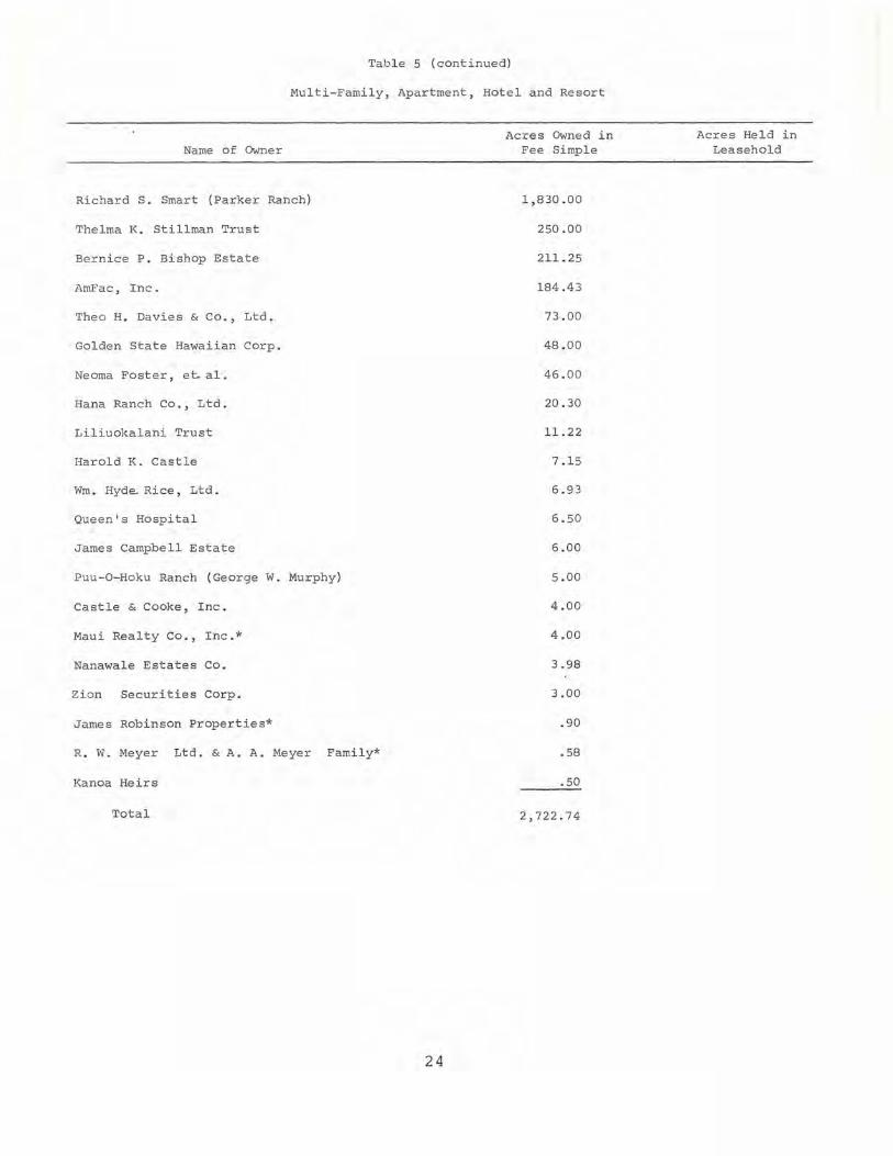
Table 5 (continued)
Multi-Family, Apartment, Hotel and Resort
Name of Owner
Richard S. Smart (Parker Ranch)
Thelma K. Stillman Trust
Bernice P. Bishop Estate
AmFac , Inc.
Theo H. Davies & Co., Ltd.
Golden State Hawaiian Corp.
Neoma Foster, et. al .
Hana Ranch Co., Ltd.
Liliuokalani Trust
Harold K . Cast l e
Wm. Hyde.. Rice, Ltd.
Queen's Hospital
James Campbell Estate
Puu-O-Hoku Ranch (George W. Murphy)
Castle & Cooke, Inc.
Maui Realty Co., Inc.*
Nanawale Estates Co.
Zion Securities Corp.
James Robinson Properties*
R. W. Meyer Ltd. & A. A. Meyer Family*
Kanoa Heirs
Total
24
Acres Owned i n Fee Simple
1,830.00
250.00
211. 25
184.43
73.00
48.00
46.00
20 . 30
11. 22
7.15
6.93
6.50
6.00
5.00
4.00
4.00
3.98
3.00
.90
.58
.50
2,722 . 74
Acre s He l d in Leasehold

Table 5 (continued)
Name of Owner
A. ~ . Richardson*
AmFac, Inc.
Alexander & Baldwin, Inc.
W. H. Shipman, Ltd.
Bernice P. Bishop Estate
Hawaiian Land Co . , Ltd.
Golden State Hawaij.an Corp.
Molokai Ranch, Ltd.
C. Brewer & Co., Ltd.
Harold K. L. Castle
Samuel M. Damon Estate
James Campbell Estate
Castle & Cooke, Inc.
Nanawale Estates Co .
Queen's Hospita l
Theo H. Davies & Co., Ltd.
Grove Farm Co., Inc.
James Robinson Properites*
Zion Securities Corp.
Richard S. Smart (Parker Ranch)
Wm. Hyde Rice, Ltd.
Queen Liliuokalani Trust
Hana Ranch Co., Ltd.
McCand l ess Heirs (Elizabeth Marks, et al .)
George Ga lbraith Trust Estate
W. H. Greenwell, Ltd.
Austin Heirs
Kualoa Ranch, Ltd.
Ulupalakua Ranch, Inc.
Eric A. & August F. Knudsen Trust
Kanoa Heirs
J. P . Mendonca Trust Estate
Bernice P. Bishop Museum
Kaonoulo Ranch Co., Ltd.
Gay and Robinson*
Roman Catholic Church*
Total
commercial
25
Acres Owned in Fee Simple
1,424.37
369.43
139 . 34
138.00
136.00
88.00
88.00
84 .00
65 . 85
59 .90
47.00
17.00
14.22
12.49
12.25
10 . 00
8 .20
7 .44
7 . 00
5.00
4.68
3 .15
2.60
2 .00
1. 82
1. 75
1. 50
1. 40
1. 00
1. 00
1. 00
.84
.82
.50
.40
.27
2,758.22
Acres Held in Leasehold
2.95
1. 22
5.60
1. 00
2.20
.67
13. 64

Name of Owner
Jame s Campbell Estate
Queen's Hospital
Hawaiian Land Co., Ltd.
Bernice P. Bishop Estate
Samuel M. Damon Estate
Alex ander & Baldwin, Inc.
C. Brewer & Co., Ltd.
Castle & Cooke, Inc.
AmFac, Inc.
James Robinson properties*
Theo H. Davies & Co., Ltd.
Grove Farm Co., Inc.
Ha rold K. L. Castle
Kapoho Land & Development Co., Ltd.
Hana Ranch Co., Ltd.
zion Securities Corp.
Wm. Hyde Rice, Ltd.
Table 5 (Continued)
Industrial
Acres Owned in Fee simple
1,145.00
272.00
227.00
198.90
184.00
173.34
139.05
llO.32
103.56
90.00
47.00
38.48
18.80
10.00
5.20
5.00
3.00
McCandless Heirs (Elizabeth Marks, et a1.) 2.00
Bernice P. Bishop Museum 1. 51
Ulupalakua Ranch, Inc. 1. 00
Total 2,775.16
26
Acres Held in Leasehold
.16
91.42
9.10
4.33
105.01

Table 5 (continued)
LAND USE: STATEWIDE
Agriculture - Diversified
Name of Owner
Bernice P . Bishop Estate Hawaiian Ocean View Estate* Hawaiian Paradise Park Corp. * Queen Liliuokalani Trust Crawford oil Corp . * Castle & Cooke, I nc . Capital Investment Co., Ltd. Mauna Loa Investment Co. Norman N . Inaba Crescent Acres , Ltd.* Harold K. Cast l e Eric A. & August F. Knudsen Trust Al exander & Baldwin, Inc. McCand l ess Heir s (E l izabeth Marks, et. al.) Dill ingham Investment Corp. AmFac, Inc. C. Brewer & Co., Ltd. Kapoho Land & Development Co., Ltd . Bernice P . Bishop Museum Thea H. Da vies & Co ., Ltd. Kua l oa Ranch, Ltd. James Campbell Estate Mo l okai Ranch, Ltd. W. H. Greenwe ll , Ltd. Stewart-Gadbois Co. Hawaiian Evangelical Assoc .* W. H. Shipman, Ltd. Grove Fa rm Co., Inc . Gay and Robinson Hui of Kaha na (Heirs o f Mary E . Foster included) Thelma K. Stillman Trust Mokuleia Ranch & Land Co., Ltd . Haleakala Ranch Co. Zion Securitie s Corp. Richard S . Smart (parker Ranch) H. P. Hustace* Pa l ani Ranch Trust (Frank R . Greenwe ll) Ulupalakua Ranch, Inc. William B. Dunbar* George Ga lbraith Trust Estate John T. waterhouse S. C. & Pear l Friel*
Total
27
Ac r es Owned in Fee Simpl e
30,7 28 . 54 10,642.40 5,502.88 3, 9 13.41 3,807 . 75 2,442 . 20 2,323 . 57 2,283 . 00 2 ,11 2 .00 1 ,489.03 1, 466.53 1, 348.00 1,324 . 51
855 . 00 820.26 812 .59 746.22 734.64 526 . 35 376 . 00 349 . 03 253 . 00 224.00 219. 52 150 . 00 145. 25 120.00 118 .70 114 . 55
75 . 00 68 . 93 67.02 58 .00 45 .00 42.00 4 1. 39 31. 00 30.00 12. 96
4 . 20 3 .00 2.3 1
76,429.74
Acres Held in Leas eho ld
940.00
4.00 6.00
87 . 79 82 . 66 53.27
2 . 00
20.89 26.5 9
5.06
1 ,228 . 26
Name of Owner
Castle & Cooke, Inc. Mo1okai Ranch, Ltd. Alexander & Ba ldwin, Inc. Jame s Campbe ll Estate George Galbraith Trust Es tate Berni ce P . Bishop Est a te Jame s Robinson Properties* Maui Rea lty Co., Inc . AmFac , Inc .
Table 5 (continued)
Agricultural--Pineapple
Acres CMned in Fee Simple
27,531.00 11,999.93 10,377.40 5,463.00 2,060.71 1, 551.20 1 ,528.70 1,472.00
R. W. Meyer , Ltd. & A. A. Meyer Fami1y* Hawa iian Evangelical Assoc .*
837 . 00 156 . 88
15. 33
Total
Name of CMner
C. Brewer & Co., Ltd . Al exander & Ba l dwin, Inc. AmFac, Inc. J ames Campbel l Estate Bernice P. Bishop Estate Theo H. Davies & Co., Ltd . Castle & Cooke, Inc. Grove Farm Co., Inc. Gay & Robinson* Queen Li1iuokalani Trust W. H. Shipman, Ltd. James Robinson Properties* Eric A. & August F. Knudsen Estate J. P . Mendonca Trust Estate Roman Ca tholic Church* Cha rles Notley Heirs, et al . * Zion Securities Corp. Richard S. Smart (Pa rker Ranch) Austin Heirs Queen's Hospital Kapoho Land & Development Co ., Ltd. Moku l e i a Ranch & Land Co ., Ltd.
62,993. 15
Agricu 1tural- - Sugar Cane
Land CMned in Fee Simple
39,790.15 38,764.67 21,088.62 20,425 . 00 17,029.35 16,666.00 16,388.55 8,842.74 6,679 .7 6 3,951. 5 1 3,525.00 2,707.00 2,431.00 1,328.73 1,272.23 1,036.77
Mc Cand l ess Heirs (Elizabeth Marks, et a l .)
762.00 660.00 500.00 425.00 337 .13 159 .17 100.00
Total 204,870.38
28
Acres Held i n Leaseho ld
3,152.00
3,953.85
457.69
7,563.54
Land Held in Leaseho ld
18,060.01 187.00
27 ,0 28.84
10,25 6 . 00 4 ,205. 88 2,429.73
1. 33
62,1 68.79
Table 5 (Continued)
Agricultural--Grazing
Name of Owner
Richard S . Smart (Parker Ranch) Bernice P. Bishop Estate Castle & Cooke, Inc. Molokai Ranch, Ltd. Niihau Ranch Alexander & Baldwin, Inc. James Campbell Estate Haleakala Ranch Gay and Robinson* Samuel M. Damon Estate C. Brewer & Co., Ltd. Ulupalakua Ranch, Inc. McCandless Heirs (Elizabeth Marks, et al.) Kahua Ranch, Ltd. Theo H. Davies & Co., Ltd. AmFac, Inc. Queen' s Hospital W. H. Greenwell, Ltd. Thelma K. Stillman Trust Grove Farm Co., Inc. Kaonoula Ranch, Ltd. Kaupo Ranch, Ltd. W. H. Shipman, Ltd. Palani Ranch Trust (Frank R. Greenwell) Charles Notley Heirs, et al.* Dillingham Investment Corp. Hana Ranch Co., Ltd. Elizabeth K. Booth, et al. Mokuleia Ranch & Land Co., Ltd. Harold K. L. Castle Queen Liliuokalani Trust E. L. Wung's Ranch, Ltd. Puu-O-Hoku Ranch (George W. Murphy) Wm. Hyde Rice, Ltd. R. W. Meyer, Ltd. & A. A. Meyer Family* Yee Hop, Ltd. Neoma Foster, et al. J. P. Mendonca Trust Estate Kualoa Ranch, Ltd. Austin Heirs Hiram L. Fang & Mun On Chun S. C. & Pearl Friel* Stewart-Gadbois Co. H. P. Hustace* Wi lliam B. Dunbar* Eric A. & August F. Knudsen Estate Kapoho Land & Development Co . , Ltd. John T. Waterhouse Zion Securities Corp. Hui of Kahana (Heirs of Mary E . Foster included) Maui Realty Co., Inc.* Morgan & Claire E. Flagg Kanoa Heirs
Total
29
Acres Owned in Fee Simple
148,902.00 104,020.92 55,744.71 54,218.00 46,053.24 29,441. 30 27,910.00 27,275.00 24,737.92 23,932.00 23,780.67 16,738.00 14,806.00 12,494.00 10,496.00 10,239.46 9,934.00 9,642.42 9,502.42 7,675.59 7,548.38 7,534.94 7,326.00 5,607.12 4,550.00 4,336.91 3,011.80 2,576.00 2,536 . 54 2,483.88 1,782.00 1,700.00 1,659.00 1,554.58 1,513.44 1,500.00 1,400.00 1,345.26 1,312.05 1,204.00 1,190.00 1,054.41 1,030.00 1,014.95
869.41 664.00 500.00 461. 00 305.00 300.00 156 . 00 150.00 135.00
737,855.32
Ac r es Held i n Leaseho ld
75,141. 00
806.18 1,508.97
1,588.68
8,1l0.04 14,455.32
74,795.53 15,370.00 31,242.00
38,652.00 4,414.24
500.00 612.86
6,898.16 4,391.02
10,368.00
24,170.56 134.20
171. 90
200.00 800.00 43.92
314,374.58
Table 5 (continued)
Conservational
Name of Owner
Bernice P. Bishop Estate Samuel M. Damon Estate C. Brewer & Co., Ltd. Alexander & Ba ldwin, Inc. Cast le & Cooke, Inc. Gay & Robinson* AmFa c, Inc. McCa ndless He irs (Elizabeth Marks, et. al.) Puu-O-Hoku Ranch (George W. Murphy ) Francis H. Ii Brown, et. al . Moloka i Ranch, Ltd. Haleakala Ra nch Co. James Campbell Estate Hui of Kahana (Heirs of Mary E. Foster included) Zions Securities Corp. Grove Farm Co., I nc . Bernice P. Bishop Museum Harold K. L. Ca stle (Kaneohe Ranch Co., Ltd.) Dillingham Investment Corp. Aust in Heirs Hawaiian Evangelical Assoc.* Capital Investment Co., Ltd.* W. H. Shipman , Ltd. Kua l oa Ranch, Ltd. A. A. Richardson W. H. Greenwell, Ltd. Hawaiian La nd Co . Kahua Ranch, Ltd. Kanoa Heirs R. W. Meyer, Ltd. & A. A. Meyer Fami ly* Queen's Hospi ta 1 Eric A. & August F. Knudsen Estate Kaonou lu Ranch Co., Ltd. Richard S. Smart (parker Ra nch) Mokuleia Ranch & Land Co., Ltd. Theo H. Davies & Co. S. C. & Pearl Friel* Hana Ranch Co., Ltd. H. P. Hustace* William B. Dunbar* Thelma K. Stillman Trust Elizabeth K. Booth, et.al. Norman N. Inaba Yee Hop, Ltd.
Total
All major landowners
All major landowners
Waste
Other
Total for All Uses
All major landowners
*See Appendix D
30
Acres Owned in Fee Simple
189, 881.45 85,720.00 54,954.46 36,608.44 21,326 .13 20,689 .35 20,421.48 14, 800 .00 10,217.00 6,164.50 5,847.00 5,148.00 4,916.00 4,870.00 4,820.00 4,795.97 4,543.75 3,876.91 3,724.75 3,060.00 2,993.58 2,982.20 2,687.00 2,186.7 6 1,985. 98 1,799.77 1,744.00 1,500.00 1,478 .00 1,200.06 1,145.00 1,14 1. 00
994.0 1 973.00 921.94 895.00 783.00 629.20 455.00 259.00 39.53 37.31
535,215.53
206 ,413.36
64,722.75
1, 923,182.56
Acre s Held in Leasehold
7,23 6 .03 38,413.13
230 . 26
10,214.20
39 1. 72
14 , 874.72
515.05 7,124.00
236.00
12, 000.00 1,270.00
92,505.11
189 ,421.05
4,289.80
671,923 . 46
Tab le 6
NET CHANGES I N LAND OWNERSHIP: STATEWIDE (1 950 -1 964)
Name of Owner
Samuel M. Damon Estate
Thelma K. Stillman Trust
Puu-O- Hoku Ranch (George W. Murphy)
Hawaiian Oce an Vi ew Estate*
Hawaiian Paradise Park Corp.*
Franc is H. Ii Brown, et. al .
Norman N. Inaba
Haleakala Ranch Co.
Theo. H. Davies & Co., Ltd.
Mauna Loa Investment Co.
Crescent Acres, Ltd . *
Hawaii Mountain View Development Corp .
Morgan & Claire E. Flagg
Hana Ranch Co. , Ltd.
Maui Realty Co ., Inc.*
Victor D. Klein , et . al .
W. H. Greenwell, Ltd.
Hiram L. Fang & Mun On Chun
Nanawa l e Estates Co .
Golden State Hawaiian Corp .
Stewart-Gadbois Co .
S . C. & Pearl Fr iel*
Richard S . Smart (P a rker Ranch)
Wi ll iam B . Dunbar*
Mokuleia Ranch & Land Co., Ltd .
Kaupo Ranch, Ltd .
Kaonou l a Ranch Co., Ltd .
John T. Waterhouse
George Galbraith Trust Estate
R. W. Meyer, Ltd . & A. A . Meyer Family*
Queen Liliuokalani Trust
Capital I nvestment Co . , Ltd .
A. A. Richardson
Kualoa Ranch , Ltd .
Gay & Robinso n*
Molokai Ranch , Ltd.
J. P . Mendonca Trust Estate
31
Ne t Gain or Loss in Acres through Exchanges and/or
Purchases and Sales
+138 ,197.00
+ 14,973.89
+ 14,262.00
+ 11,797.60
+ 6,335.76
+ 4 , 771.00
+ 3,223.00
+ 3 ,199.11
+ 2,886.71
+ 2,283.00
+ 2,014 . 25
+ 2,000.00
+ 1, 800 . 00
+ 1,714.40
+ 1,636.00
+ 1,500.00
+ 1,204.48
+ 1, 190 .00
+ 1,064.49
+ 955 . 00
+ 559 . 00
+ 554 . 41
+ 401.88
+ 203.60
+ 74.34
+ 29 . 94
+ 12.92
+ 3 .00
+ .11
+ . 02
• ()l.
. 25
1.67
2.19
4 .0 9
47 . 38
52.98

Table 6 (continued)
Name of Owner
Bernice P . Bishop Museum
Grove Farm Co., Inc .
Queen's Hospital
James Robinson Properties*
Austin Heirs
James Campbell Estate
Alexander & Baldwin , Inc .
Yee Hop, Ltd .
Harold K. Castle
Dillingham Investment Corp .
Kapoho Land & Development Co ., Ltd.
Castle & Cooke, Inc .
Roman Catholic Church*
C. Brewer & Co., Ltd.
Bernice P . Bishop Estate
AmFac, Inc .
Ulupa l akua Ranch , Inc .
Crawford Oil Corp .
W. H. Shipman, Ltd.
Hui of Kahana
Tota l Net Gain
Total Net Loss
Tota l Net Ch ange
*See Appendix D
32
Net Gain or Los s i n Ac r es t hro ugh Excha n ges a n d/o r
Purchases and Sa l es
57.60
65 .46
71.95
10 3 . 0 0
248 . 00
496 .74
530. 47
60 0 .00
9 20 . 9 1
1, 5 7 2 . 48
1, 587 . 75
2 , 463 . 86
2 , 953 .0 6
3 ,13 3 .16
3 , 482 . 99
6 , 552 . 8 0
6 , 821. 75
8 , 000 . 00
8 , 046 . 00
8 ,154 . 00
+------
+1 62 , 876.36

Table 7 NET CHANGES THROUGH ALL
LAND TRANSACTIONS: STATEWIDE
(1950 - 1964)
Name of Owner
Samuel M. Damon Estate
Richard S. Smart (Parker Ranch)
Theo H. Davies & Co., Ltd .
C. Brewer & Co., Ltd .
Norman N. Inaba
Thelma K. Stillman Trust
Puu-O-Hoku Ranch (George W. Murphy)
Hawaiian Ocean View Estates*
Haleakala Ranch Co.
Hawai ian Paradise Park corp . *
Grove Farm Co., Inc.
Francis H. Ii Brown, et al.
Mauna Loa Investment Co.
George Galbraith Trust Estate
Crescent Acres , Ltd .
Hawaii Mountain View Development Corp.
castle & Cooke , Inc.*
Morgan & Claire E . Flagg
Hana Ranch Co., Ltd.
Maui Realty Co . , Inc.*
Victor Klein , et al .
Molokai Ranch, Ltd.
W. H. Greenwell, Ltd.
Hiram L. Fong & Mun On Chun
Nanawale Estates Co .
Golden State Hawaiian Corp .
Stewart - Gadbois, Co .
S . C. & Pearl Friel*
William B . Dunbar*
Kaupo Ranch, Ltd.
Mokuleia Ranch & Land Co . , Ltd.
Kaonoulu Ranch Co., Ltd.
John T . Waterhouse
R. W. Meyer , Ltd. & A. A. Meye r Family*
Queen Liliuokalani Trust
Capital Investment Co., Ltd.*
A. A . Richardson
33
Net Gain or Loss in Acres through
Leases, Exchanges, and/or Purchases
and Sales
+138,197.00
+ 69,418.88
+ 58,793.71
+ 29,164.77
+ 15,223.00
+ 14,973.89
+ 14,2 62 .00
+ 11,797.60
+ 11,316.37
+ 6,335.76
+ 5,123.94
.;- 4,771.00
+ 2,283.00
+ 2,219 . 52
+ 2,014.25
+ 2,000.00
+ 1,888 . 61
+ 1,800 . 00
+ 1,714.40
+ 1, 636 . 00
+ 1,500.00
+ 1,461.59
+ 1,204 . 48
+ 1,1 90 . 00
+ 1,064.49
+ 955.00
+ 559 . 00
+ 554 . 41
+ 203.60
+ 92 .09
+ 74.34
+ 12.92
+ 3 . 00
+ . 02
.01
. 25
1. 67

Tabl e 7 (cont i nued)
Name of Owner
Kua l oa Ranch, Ltd .
J. P. Mendonca Trust Estate
Bernice P. Bishop Museum
Queen ' s Hosp i tal
James Robinson Properties*
Austin Heirs
Alexander & Baldwin , Inc . *
Yee Hop, Ltd.
J ames Campbe l l Estate
Harold K. L . Castle (Kaneohe Ranch Co., Ltd .)
Di l lingham Investment Corp.
Kapoho Land & Deve l opment Co. , Ltd.
Gay & Robinson*
Ulupalakua Ra nch, I nc.
Roman catholic Church*
AmFac , Inc .
Bernice P. Bish op Estate
Crawford Oil Corp.*
w. H . Sh i pman, Ltd .
Hui of Kahana (Heirs of Ma ry E. Foster inc l uded)
*See Appendix D
3 4
Net Gain or Loss in Acres through
Leases, Exchanges, and/or Purchases
and Sal es
2 . 19
52.98
57.60
71. 95
103 . 00
248 . 00
345.57
600.00
577.74
920 . 91
1,572.48
1,587.75
2 , 179.26
2,941. 75
2,945.73
3,180.80
3 , 482 . 99
8 ,000 . 00
8,046.00
8,154.00

CHAPTER III
MAJOR PRIVATE LANDOWNERS: By Island
As we have seen in Chapter II, the major private landowners own a significant amount of the total land area in the state of Hawaii. In this chapter, the information presented in Chapter II will be discussed for each island considered separately. Data on land owned by the state and federal governments on each island will be presented in order to provide a comparison with land owned by the major private land owner s.
Table 8 (see pages 44 to 48) is designed as an index to this chapter. The table lists the 72 major private landowners in alphabetical order and gives the location, by island, of each of their landholdings. The subsidiaries of the major private landowners are given both in the alphabetical listing and under the name of their parent companies.
Hawaii
Land (),.vner ship
Land ownership on the island is highly concentrated. The largest single owner is the state government, which owns 1,126,121.00 acres or 43.76 per cent of the island's total of 2,573,440 acres. In addition, the federal government owns 210,984.11 acres,l which is 8.20 per cent of the total land area of the island. There are 38 private owners who own more than 1,000 acres each on the island of Hawaii. Together the major private landowners own 1,052,582.00 acres, which is 41 per cent of the total land area of the island of Hawaii.
The major landowners are ranked in descending order in Table 9 (see page 50). Of their total acreage, 475,324.47 acres are used by the owner, 317,568.16 acres are leased to others, and 259,689.37 acres are not in use at the present time. Together the state and federal governments and the major private landowners own 2,389,687.11 acres,2 which is 92.86 per cent of the total land area of the island. Therefore, the small private landowners, those who own less than 1,000 acres each, own less than 8 per cent of the total land acreage of Hawaii .
35

MAJOR LANDOWNERS
Land controlled
In addition to their fee simple holdings, the major private landowners also hold 489,945.87 acres in leasehold on Hawaii. They lease 302,419.29 acres from the state government and 187,526.58 acres from private owners. They sublet only 8,624.80 acres. Therefore, the major landowners on Hawaii exercise effective control of 1,216,334.91 acres, or 47 per cent of the total land area of the island. Table 10 (see pages 51 and 52) lists the major landowners in descending order according to the acreage they control.
Land Use
Of all the islands, the island of Hawaii has the lowest percentage of land classified as suitable for intensive cultivation. Less than 14 per cent of her vast acreage can be cultivated. More than 81 per cent of the land is suitable only for grazing, forestry, and water conservation. About five per cent of the island is unclassified. The major landowners own 150,686.20 acres in three agricultural categories: diversified, pineapple, and sugar cane. This is 42.57 per cent of the land classified as suitable for intensive cultivation. The remainder of the land suitable for cultivation is owned by the state or federal governments or by small private landowners and is used for agricultural purposes, or it is not cultivated but is being used for non-agricultural purposes. Table 11 (see pages 53 to 56) lists the major landowners in descending order according to the acreage owned in each use category. If an owner leases land in addition to his fee simple holdings in any use category, this figure is also given.
Land Transactions
During the period 1950 to 1964, the major private landowners on Hawaii purchased (or acquired through land exchange) a total of 259,883.02 acres. They relinquished a total of 96,373.54 acres. Their net gain in ownership was, then, 163,509.48 acres. Table 12 (see page 57) ranks in descending order the net changes in land ownership of the major landowners during this period. Table 13 (see page 58) ranks in descending order the net changes in land owned or held in leasehold for the individual owners.
36

MAJOR PRIVATE LANDOWNERS: BY ISLAND
Kauai
Land Owner ship
Land ownership on the island of Kauai is also highly concentrated. The largest single owner is the state government, which owns 151,939.00 acres or 43.09 per cent of the total 352,640 acres of the island. The federal government owns 2,199.68 acres,3 or only 0.62 per cent of the total land area of the island. There are 10 owners who own over 1,000 acres. Together they own 176,952.53 acres, which is 50 per cent of the total land area of the island. These owners are ranked in descending order in Table 14 (see page 62). Of this total acreage 126,119.24 acres are in use by the owner, 35,214.79 acres are leased to others, and 15,618.50 acres are not in present use.
Together the state and federal governments and the major landowners own 331,091.21 acres, which is 93.89 per cent of the total area of Kauai. 4 Therefore, the private landowners who own less than 1,000 acres each own less than seven per cent of the island.
Land Controlled
In addition to their fee simple holdings, the major private landowners hold 41,491.28 acres in leasehold on Kauai. They lease 21,476.86 acres from the state government and 20,014.42 acres from private owners. Of this total they sublet only 2,997.96 acres. Therefore, these 10 private landowners control a total land area of 180,231.08 acres, which is 51.11 per cent of the total land on Kauai. Table 15 (see page 63) lists the major landowners in descending order according to the acres they control.
Land Use
On the island of Kauai, less than 32.49 per cent of the total land area is classified as suitable for intensive cultivation. The remaining 68 per cent is suited only for grazing, forestry, and water conservation. The 10 major private landowners control 41,821.18 acres in the three agricultural use categories: diversified, pineapple, and sugar cane. This is 36.50 per cent of the land classified as suitable for intensive cultivation. The remainder of the land suitable for cultivation is owned by the state or federal governments or by small private landowners and is used for agricultural purposes, or it is not cultivated. Table 16 (see pages 64 to 66) lists the major
37

MAJOR LANDOWNERS
landowners in descending order according to the acreage owned in each category. If an owner leases land in addition to his fee simple holdings in any use category, this figure is also given.
Land Transactions
During the period 1950 to 1964 the major private landowners on Kauai purchased or acquired through exchange a total of 1,186.77 acres. They sold or relinquished through exchange a total of 595.48 acres, for a net gain in ownership of 591.29 acres. Table 17 (see page 67) ranks in descending order the major landowners who had a net change in ownership during this period. Table 18 (see page 67) ranks in descending order the net changes in land owned or held in leasehold for the individual owners.
Kahoolawe
The island of Kahoolawe, whose total land area is 28,800 acres, is completely controlled 5 by the United States government and is used for military purposes. No information about the soil classification exists for Kahoolawe. There have been no land transactions on Kahoolawe in the period from 1950 to 1964.
Niihau
The island of Niihau whose total land area is 46 080 acres 1S , " owned and controlled by a single private owner, the Niihau Ranch Co., which owns and controls 46,065.24 acres, or 99.97 per cent of the total acreage of the island. The Niihau Ranch Co. uses most of its land (46,053.24 acres) for grazing and has 12.00 acres in residential use. Again, no information on soil classification exists for Niihau. There have been no land transactions on Niihau in the 1950 to 1964 period.
Lanai
The island of Lanai is almost entirely owned and controlled by a single private owner, Castle & Cooke, Inc. This company owns 88,792.00 acres, or 98.40 per cent of the total 90,240 acres of the island. It controls 87,948.00 acres, or 97.46 per cent of the total land area of Lanai. Another 7.70 acres are owned by the federal government. The remaining acreage is owned by small private owners.
38

MAJOR PRIVATE LANDOWNERS: BY ISLAND
On the island of Lanai, almost 30 per cent of the land is classified as suitable for intensive cultivation. Castle and Cooke, Inc., owns and controls 15,803.00 acres classified as pineapple (there is no sugar cane on the island). This total is 58.35 per cent of the land suitable for intensive cultivation. Table 19 (see page 69) presents the total acreage both owned and leased in each use category by Castle & Cooke, Inc. During the period 1950 to 1964 Castle & Cooke, Inc., acquired through exchange 0.68 acres. It sold or relinquished through exchange a total of 170.91 acres, for a net loss in ownership of 170.23 acres.
Maui
Land Ownership
The largest single owner of land on Maui is the state government, which owns about 204,400 acres or about 44 per cent of the total 465,920 acres of the island.6 The federal government owns 17,181.41 acres, which is 3.69 per cent of the total area. There are 11 private owners who own more than 1,000 acres on Maui. They collectively own 230,495.98 acres, which is 49 per cent of the total acreage of the island. Together the state and federal governments and the major private landowners own about 451,677 acres or about 97 per cent of the total land on Maui. The major landowners are ranked in descending order in Table 20 (see page 71). Of the total acreage owned by these major landowners 179,653.09 acres are in use by the owner, 30,421.15 acres are leased to others, and 20,421.74 are not presently used.
Land Controlled
In addition to their fee simple holdings, the major private landowners hold 100,823.04 acres in leasehold on Maui. They lease 78,964.68 acres from the state government and 21,858.36 acres from private owners. They sublet only 215.63 acres. Therefore, the major landowners control a total of 300,682.24 acres, or 64 per cent of the total land area of Maui. Table 21 (see page 72) lists the major landowners in descending order according to the acreage they control.
Land Use
On the island of Maui, less than 30 per cent of the land is classified as suitable for intensive cUltivation. The other 70 per cent
39

MAJOR LANDOWNERS
of the land is suitable only for grazing, forestry, and water conservation. The major landowners control 58,107.98 acres in three agricultural categories: diversified, pineapple, and sugar cane. Thus, these major landowners control 44.04 per cent of the land suitable for intensive cultivation. The remainder of the land suitable for cultivation is owned or leased by the state or federal governments or by small private landowners and is used for agricultural purposes, or it is not cultivated. Table 22 (see pages 73 to 75) lists the major landowners in descending order according to the acreage owned in each use category. If an owner leases land in addition to his fee simple holdings in any use category, this figure is also given.
Land Transactions
In the period 1950 to 1964, the major landowners on Maui purchased or acquired through exchange a total of 8,719.59 acres of land. They sold or relinquished through exchange a total of 9,966.21 acres, for a net loss in ownership of 1,246.62 acres. Table 23 (see page 76) ranks in descending order the major landowners who had a net change in land ownership during this period. Table 24 (see page 76) ranks in descending order the net changes in land owned and held in leasehold for the individual owners.
Molokai
Land Ownership
The state government is also the largest single owner of land on the island of Molokai. The state owns over 51,400 acres or 31 per cent of the island's total of 165,760 acres.7 The federal government owns 352.80 acres, which is less than 1 per cent of the island. Ten private owners own more than 1,000 acres each on Molokai. These owners are ranked in descending order in Table 25 (see page 78 ). Together the major landowners own 110,443.81 acres, which is 66 per cent of the area of the island. Of this total acreage 73,889.99 acres are in use by the owner, 26,835.74 acres are leased to others, and 9,718.08 acres are not in present use. The state and federal governments and the major private landowners combined own about 161,797 acres or about 98 per cent of the total land area of the island.
40
MAJOR PRIVATE LANDOWNERS: BY ISLAND
Land controlled
In addition to their fee simple holdings, the major private landowners also hold 2,314.03 acres in leasehold on Molokai. They lease 805.06 acres from the state government and 1,508.97 from private owners. Of this total only 12.97 acres are sublet. Therefore, these 10 private landowners exercise effective control of 85,909.13 acres, or 51.83 per cent of the total area of the island. Table 26 (see page 79) lists the major landowners in descending order according to the acres they control.
Land Use
On the island of Molokai less than 25 per cent of the land is classified as suitable for intensive cultivation. Only one-tenth of 1 per cent is classified as "best" suited for intensive cultivation. The other 75 per cent of the land is suitable only for grazing, forestry, and water conservation. The 10 major landowners own 12,458.93 acres in the diversified and pineapple agricultural categories (there is no sugar cane grown on Molokai). This is slightly more than 30 per cent of the total land suited for intensive cultivation. The major portion of this land is owned by the state or federal governments or by small private landowners and is used for agricultural purposes, or it is not cultivated. Table 27 (see pages 80 and 81) lists the major landowners in descending order according to the acreage owned in each category. If an owner leases land in addition to his fee simple holdings in any use category, this figure is also given.
Land Transactions
In the period 1950 to 1964 the major private landowners on Molokai purchased a total of 19,811.76 acres and sold a total of 68.11 acres for a net gain in ownership of 19,743.65 acres. There were no exchanges on Molokai during this period. Table 28 (see page 82) ranks in descending order the major private landowners who had a net change in ownership during this period. Table 29 (see page 82) ranks in descending order the net changes in land owned and held in leasehold for the individual owners.
41
MAJOR LANDOWNERS
Oahu
Land Ownership
The largest single owner of land on Oahu is the federal government with 139,924.61 acres or 36.74 per cent of the total 380,800 acres of the island. The second largest owner is the Bernice P. Bishop Estate, which owns 59,007.10 acres or 15.50 per cent of the island. The state government owns 56,672.00 acres or 14.88 per cent of the total area of the island. There are 21 private owners who own more than 1,000 acres each on the island of Oahu. Together the major landowners own 217,851.00 acres, or 57 per cent of the total acreage of the island. 8 These owners are ranked in descending order in Table 30 (see page 84). Of the total acreage owned by the major landowners, 27,739.54 acres are in use by the owner, 137,464.89 acres are leased to others, and 52,646.57 acres are not in present use.
Land controlled
In addition to their fee holdings, the major private landowners hold 37,349.24 acres in leasehold on the island of Oahu. They lease 804.15 acres from the state government, 1,279.47 acres from the federal government, and 35,265.62 acres from private owners. Of this total acreage leased, 3,997.28 acres are sublet. Therefore, the major landowners exercise effective control of 113,738.07 acres, which is 30 per cent of the total area of Oahu. This is significantly less than the acreage they own in fee simple. Table 31 (see page 85) lists the major landowners in descending order according to the acres they control.
Land Use
Nearly 17.81 per cent of the land area of the island of Oahu is classified as "best" suited for intensive cultivation. None of the other islands has nearly so high a percentage of prime agricultural land. An additional 8.08 per cent of the land on Oahu is "moderately" suited for intensive cultivation, and another 7.80 per cent is "fairly to moderately" suited for i ntensive cultivation. The major landowners control 30,153.48 acres in the three agricultural use categories: diversified, pineapple, and sugar cane. This acreage is 44.46 per cent of the land "best" suited for intensive cultivation and 23.51 per cent of the total land suitable for intensive cultivation. The remainder of the land suitable for cultivation is
42

MAJOR PRIVATE LANDOWNERS: BY ISLAND
owned or leased by the state or federal governments or by small private landowners and is used for agricultural purposes, or it is not cultivated. The tremendous demand for land as a result of the rapid expansion of the city of Honolulu should indicate that some of the land suitable for cultivation is put to commercial, residential, industrial, and resort uses. Indeed, much of the best land on Oahu is located around Honolulu and thus cannot be cultivated. Table 32 (see pages 86m 89) lists the major landowners in descending order according to the acreage owned in each use category. If an owner leases land in addition to his fee simple holdings in any use category, this figure is also given.
Land Transactions
In the period 1950 to 1964 the major private landowners on Oahu purchased or acquired through exchange a total of 3,155.28 acres. They sold or relinquished through exchange a total of 22,706.49 acres for a net loss of 19,551.21 acres, the largest net loss on any island. Table 33 (see page 90) ranks in descending order the major private landowners who had a net change in ownership during this period. It is significant to note that 9,797.73 acres of this total was sold involuntarily. Table 34 (see page 91) ranks in descending order net changes in land owned or held in leasehold for the individual owners.
43

Name of Owner
Al exander and Ba ldwin, Inc.
Alexander and Baldwin, Inc. East Maui Irriga ti on Co., Ltd. MCBryde Sugar Co . , Ltd . Maui Pineapple Co., Ltd.
AmFac, Inc .
Lihue Pl an t a ti on Co., Ltd. Oahu Sugar Co., Ltd. Pioneer Mil l Co. , Ltd. Puna Sugar Co . , Ltd.
Aust in Heirs
Bishop Estate , B. P .
~ ~ Bishop Museum, B. P.
Brewer, C. & Co. , Ltd .
C. Bre,,,er & Co. , Ltd. Hawaiian Agricu ltura l Co. Hu t chinson Sugar Co., Ltd . Ki l auea Sugar Co ., Ltd. Mauna Kea Sugar Co . , Inc. Paauhau Sugar Co. , Ltd. Pepeekeo Sugar Co. Wailuku Sugar Co.
Brown , Francis H. Ii
Campbe ll, James , Estate of
Capi t a l Inves tment Co., Ltd.
Makaha Val l ey Farms, Ltd.'" Wa i anae Development Co. '"
Castle, Harold K. L. (Kaneohe Ranch Co., Ltd.)
Castl e & Cooke, Inc.
Cas tl e & Cooke, Inc. Dole Company Kohala Sugar Co.
Table 8
MAJOR PRIVATE LANDOWNERS BY ISLAND
(Acres r ounded off t o the near es t whole number)
Hawa ii Kauai Lanai
22,611
162
22 , 449
20 , 545 43 ,209
43 , 209
20 ,545
291,729 11, 727
4,330
109,352 9,297
23,189 8 6 , 661
10,022 9,289
40,096 4 , 294
25,090
165
25,630
23,569 88 ,792
3,023 88 ,7 92
20,546
Total Acres Owned in the State
Maui Mo l okai Niihau Oahu of Hawaii
100,177 122,788
52, 254 52 , 416 17,985 17 ,985
22 , 449 29,938 29,938
15,377 1,234 80,365
43,209 1,234 1,234
15,377 15,377 20,545
2,628 2,628 5,256
2 ,541 4,695 59,007 369,699
926 5 , 256
26 , 496 1 145,146
4 1 23,202 6 , 661
10,022 9 ,289
40,096 4,294
25, 090 26,492 26,492
6,000 6,165
5,751 50,260 81,641
5,421 5,421
3 ,952 3,952 1,469 1,469
9,337 9 , 337
42 , 399 154,760
42,399 45,422 88 ,7 92 20,546

Table 8 (continued)
Total Acres O,med in the State
Name of O"ner Hawaii Kauai Lanai Maui Molokai Niihau Oahu of Ha,yaii
Charles Notley Estate* 6 ,109 6,109
Crawford Oil Corp.* 3,808 3,808
Crescent Acres, Ltd. 1, 489 1,489
Damon, Samuel M., Estate of 139,510 4,332 143,842
Theo H. Davies & Co . , Ltd. 37,785 37 ,785
Hamakua Mill Co. 14,369 14 ,369 Kukaiau Ranch Co., Ltd. 2,078 2,078 Honokaa Sugar Co. 13,613 13,613 Laupahoehoe Sugar Co. 7,725 7,725
Dillingham Corp. 2,101 2,101
Ha"aiian Land Co . 2,101 2,101
Dillingham Investment Corp. 12,077 12,077
~ Dole Company (See Castle & Cooke, Inc.) lJl
Dunbar, William B.* 1,141 1,141
East Maui Irrigation Co . , Ltd. (See Alexander and Baldwin)
Elizabeth K. Booth Trust, et al. 2,613 2,613
Eric A. & August F. Knudsen Trust 5,879 5,879
Flagg, Morgan & Claire E. 1, 800 1,800
Fong, Hiram L. & Mun On Chun 1,190 1,190
Foster, Neoma, et al. 1,500 1,500
Friel, S. C. & Pearl'"' 1 ,841 1,841
Gay & Robinson'"' 55,800 55,800
George Galbraith Trust Estate 2,221 2,221
Golden State Ha"aiian Corp . 1,165 1,165
Greemyell , W. H. , Ltd . 12,149 12,149
Grove Farm Co., Inc. 22,616 22,616
Haleakala Ranch Co . 33,041 33,041
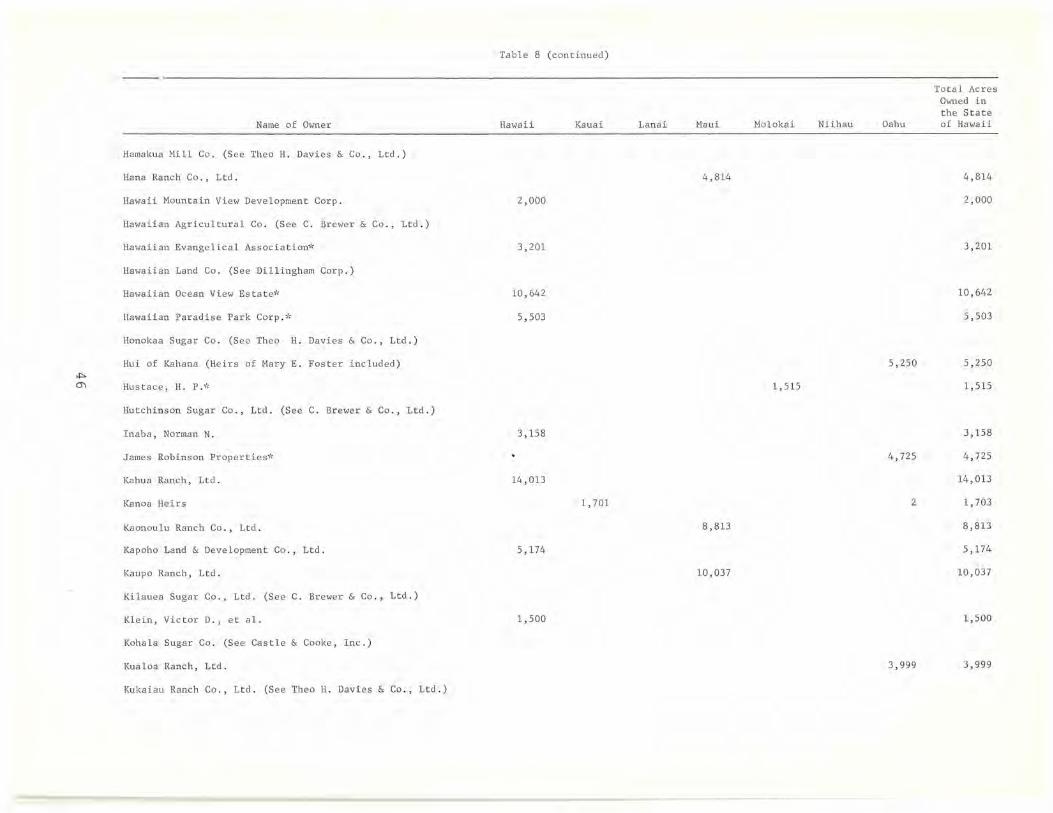
Table 8 (continued)
Name of Owner Hawaii Kauai
Hamakua Mi 11 Co. (See Theo H. Davies & Co., Ltd.)
Hana Ranch Co., Ltd.
Ha"aii Mountain View Deve lopment Corp. 2,000
Hawaiian Agricultural Co. (See C. Brewer & Co., Ltd.)
Hawaiian Evangelical Association'" 3,201
Hawaiian Land Co . (See Dillingham Corp . )
Hawaiian Ocean View Estate* 10,642
Hawaiian Paradise Park Corp .* 5,503
Honokaa Sugar Co. (See Theo H. Davies & Co., Ltd.)
Hui of Kahana (He irs of Mary E. Foster included)
'""" m Hustace, H. P.;'
Hutchinson Sugar Co., Ltd. (See C. Brewer & Co., Ltd.)
Inaba, Norman N. 3,158
James Robinson Properties;'
Kahua Ranch, Ltd. 14,013
Kanoa Heirs 1,701
Kaonoulu Ranch Co . , Ltd.
Kapoho Land & Development Co., Ltd. 5,174
Kaupo Ranch, Ltd.
Kilauea Sugar Co . , Ltd. (See C. Brewer & Co., Ltd.)
Klein, Victor D., et al. 1,500
Kohala Sugar Co. (See Castle & Cooke, Inc.)
Kualoa Ranch, Ltd.
Kukaiau Ranch Co., Ltd. (See Theo H. Davies & Co., Ltd.)
Lanai Maui Molokai Niihau Oahu
4 ,814
5,250
1,515
4,725
2
8,813
10,037
3,999
Total Acres O,med in the State of Hawaii
4,814
2,000
3,201
10,642
5,503
5,250
1,515
3,158
4,725
14,013
1,703
8,813
5,174
10,037
1,500
3,999
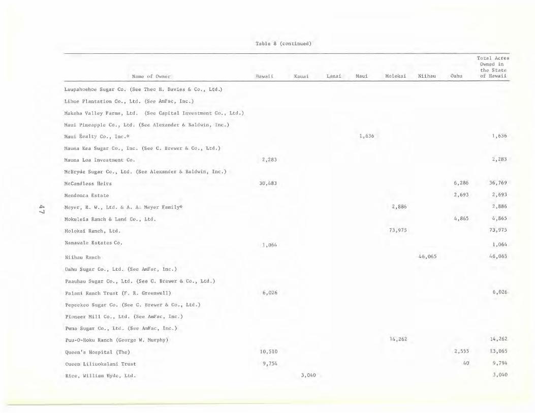
Table 8 (continued)
Total Ac r es Owned in the State
Name of O,mer Hawaii Kauai Lanai Maui Molokai Niihau Oahu of Hawaii
Laupahoehoe Sugar Co . (See Thea H. Davies & Co., Ltd.)
Lihue Plantation Co., Ltd. (S ee AmFac, Inc.)
Makaha Valley Farms, Ltd. (See Capital Investment Co., Ltd.)
Mau i Pineapple Co., Ltd. (S ee Alexander & Baldwin, Inc.)
Maui Realty Co., Inc.'" 1,636 1,636
Mauna Kea Sugar Co. , Inc . (See C. Brewer & Co., Ltd.)
Mauna Loa Investment Co. 2,283 2,283
McBryde Sugar Co., Ltd. (See Alexander & Baldwin, Inc.)
McCandless Heirs 30,483 6 , 286 36 ,7 69
Mendonca Estate 2,693 2 , 693
*" Meyer, R. W., Ltd. & A. A. Meyer Family'" 2,886 2,886 -.J
Mokuleia Ranch & Land Co ., Ltd. 4,865 4,865
Molokai Ranch, Ltd. 73,975 73,975
Nanawal e Estates Co. 1,064 1, 064
Niihau Ranch 46,065 46,065
Oahu Sugar Co., Ltd. (See AmFac, Inc.)
Paauhau Sugar Co., Ltd . (See C. Brewer & Co., Ltd.)
Pa1ani Ranch Trust (F. R. Greem,ell) 6,026 6 ,026
Pepeekeo Sugar Co. (See C. Brewer & Co. , Ltd.)
Pioneer Mill Co . , Ltd. (See AmFac, Inc.)
Puna Sugar Co., Ltd. (S ee AmFac, Inc. )
Puu-O-Hoku Ranch (George W. Murphy) 14,262 14,262
Queen's Hospital (The) 10,510 2,555 13,065
Oueen Li1iuoka1ani Trust 9 , 754 40 9,794
Rice, William Hyde, Ltd . 3,040 3,040
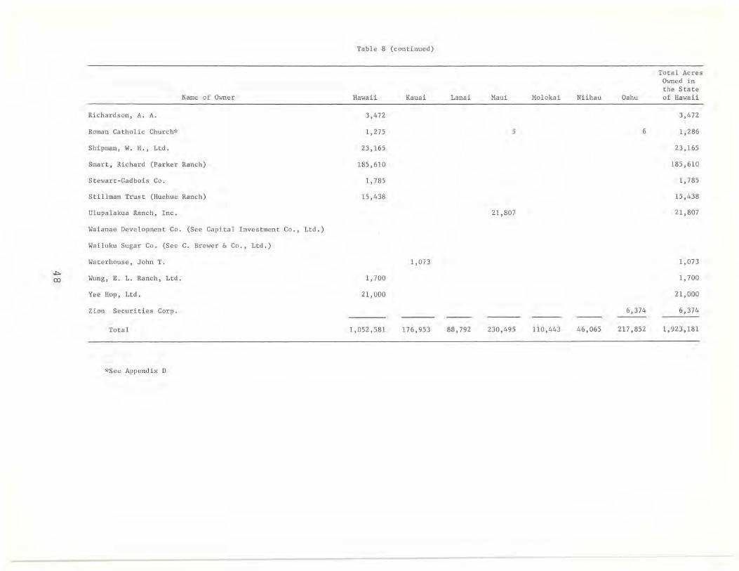
Table 8 (continued)
Total Acres Owned in the State
Name of Owner Hawaii Kauai Lanai Maui Molokai Niihau Oahu of Hawaii
Richardson, A. A. 3,472 3,472
Roman Catholic Church'" 1,275 5 6 1,286
Shipman, W. H., Ltd. 23,165 23,165
Smart , Richard (Parker Ranch) 185,610 185,610
Stewart -Gadbois Co. 1,785 1,785
Sti llman Tr ust (Huehue Ranch) 15,438 15,438
Ulupalakua Ranch, Inc. 21,807 21 , 807
Waianae Development Co. (See Capital Investment Co., Ltd.)
Wailuku Sugar Co. (See C. Brewer & Co., Ltd.)
Waterhouse, John T. 1,073 1,073
"'" 1,700 00 Wung, E. L. Ranch , Lt d. 1, 700
Yee Hop, Lt d. 21,000 21,000
Zion Securities Cor p. 6,374 6,374
Total 1,052,581 176 , 953 88 , 792 230,495 110,443 46,065 217,852 1,923,181
,"See Appendix D

FIGURE B
Master Key for Island Maps
1. STATE OWNED
2. HAWAIIAN HOMES COMMISSION
3. FEDERAL GOVERNMENT LAND
4. BISHOP ESTATE, BERNICE P.
5. AMFAC, INC.
6. ALEXANDER & BALDWIN, INC.
7. THEO H. DAVIES & CO., LTD.
B. C. BREWER & CO., LTD.
9 . CASTLE & COOKE, INC.
10. CAPITAL INVESTMENT CO.
11. DILLINGHAM INVESTMENT CORP.
12. SAMUEL M. DAMON ESTATE
13. JAMES CAMPBELL, ESTATE OF
14. GAY & ROBINSON
15. RICHARD S. SMART (PARKER RANCH)
16. QUEEN'S HOSPITAL
17. AUSTIN HEIRS
lB. STILLMAN TRUST (HUEHUE RANCH)
19. LILIUOKALANI TRUST
20. McCANDLESS HEIRS (ELIZABETH MARKS, ET AL.)
21. W. H. SHIPMAN, LTD.
22. HAWAIIAN PARADISE PARK CORP.
23. PALANI RANCH TRUST (FRANK R. GREENWELL)
24. YEE HOP, LTD.
25 . W. H. GREENWELL, LTD.
26. KAHUA RANCH, LTD.
27. KAPOHO LAND & DEVELOPMENT CO ., LTD.
2B. ULUPALAKUA RANCH, INC.
29. KAONOULU RANCH CO., LTD.
30. KAUPO RANCH, LTD.
31. HALEAKALA RANCH CO.
32. HANA RANCH CO., LTD.
33. GROVE FARM CO., INC.
34. ERIC A. & AUGUST F. KNUDSEN TRUST
41. CHARLES NOTLEY ESTATE
42. GEORGE GALBRAITH TRUST ESTATE
43. HIRAM L. FONG & MUN ON CHUN
44. PUU-O-HOKU RANCH (GEORGE W. MURPHY)
45. MOLOKAI RANCH, LTD.
46. FRANCIS H. II BROWN
47. MOKULEIA RANCH & LAND CO., LTD.
4B. HAWAIIAN LAND CO. (DILLINGHAM CORP.)
35. HAROLD K. L. CASTLE (KANEOHE RANCH CO., LTD.)
36. ZION SECURITIES CORP.
37. HUI 0 KAHANA (HEIRS OF MARY E. FOSTER INCLUDED)
3B. JAMES ROBINSON PROPERTIES
39. KUALOA RANCH, LTD.
40. MENDONCA ESTATE
49
Table 9
MAJOR PRIVATE LANDOWNERS: HAWAII
Fee Acr es as % of Total
Acres Owned Acreage of Name of Owner in Fee Simple I s l and Cumu l ative %
Bernice P. Bi shop Estate 291,729 .11 11. 34 11. 34 Ri cha r d S. Smart (parker Ranch) 185,610.00 7 . 21 18 . 55 Samuel M. Damon Estate 139,510.00 5.42 23.97 C. Brewer & Co. , Ltd. 109,352.31 4 . 25 28.22 Theo H. Davies & Co. 37,785.00 1. 47 29 . 69 McCandless Heirs (Elizabeth Ma rks, et a1.) 30,483.00 1.18 30 . 8 7 James Campbell Estate 25,630.00 1. 00 31. 87 Castle & Cooke, Inc. 23,568.62 . 92 32.79 W. H. Shipman, Ltd. 23, 165 .00 .90 33.69 Yee Hop, Ltd. 21,000.00 .82 34.51 AmFac, Inc. 20,544.50 .80 35 . 3 1 Thelma K. Stillman Trust 15,437.76 .60 35 . 91 Kahua Ranch, Ltd. 14,013.00 .54 36 . 45 W. H. Gr eenwe ll , Ltd. 12,149.07 .47 36.92 Dillingham Investment Corp. 12 , 077.06 . 47 37.39 Hawaiian Ocean View Estate* 10,642.40 .41 37.80 Queen's Hospita l 10,510.00 .41 38.21 Queen Liliuokalani Trust 9,754.22 .38 38.59 Charles Not ley Heirs, et a1.* 6,109.06 .24 38.83 Pa lani Ranch (Frank R . Greenwell) 6,025 . 96 . 23 39.06 Hawaiian Pa r adise Park Corp.* 5 , 502 . 88 . 21 39 . 27 Kapoho La nd & Development Co . , Ltd. 5, 17 4.43 .20 39.47 Bernice P. Bishop Museum 4,330.11 .17 39.64 Crawford Oil Corp. * 3,807 . 75 .15 39.79 A. A. Ri chardson 3 ,47 2 . 24 .13 39.92 Hawaiian Evangelical Assoc. -J: 3,201.42 .1 2 40.04 Norman N. Inaba 3,158 . 00 .1 2 40 . 16 Elizabeth K. Booth, et a1. 2,613.31 .10 40.26 Mauna Loa I nvestment Co. 2,283 . 00 . 09 40 . 35 Hawaiian Mountain View Development Corp. 2,000 . 00 . 08 40 . 43 Morgan & Claire E. Flagg 1, 800.00 . 07 40.50 Stewart-Gadbois Co. 1,785.00 . 07 40.57 E . L. Wung Ranch , Ltd. 1,700 . 00 .07 40. 6 4 Victor D. Klein, et a 1. 1,500.00 . 06 40.70 Crescent Acres, Ltd . * 1,489 .03 .06 40.76 Roman Catholic Church"k 1,274 .77 .05 40 . 8 1 Golden State Hawaiian Corp. 1 ,165.00 .05 40.86 Nanawale Estates Co . 1,064.49 . 05 40.91 Francis H. Ii Brown 164.50 . 0 1 40 . 92
Total 1,052,582.00 40.92
*See Appendix D
50
Table 10
LAND CONTROLLED BY MAJOR LANDOWNERS: HAWAII
Acres Owned in Acres Held in Acres Leased Acres Controlled Acres Controlled Cumulative Name of Owner Acres Sublet as % of Total Fee Simp l e Leasehold to Others (columns 1+2-3-4) % Acreage of I sland
Richard S. Smart (Parker Ranch) 185,610.00 75,141.00 2,578.00 258,173.00 10.03 10.03
C. Brewer & Co . , Lt d . 109,352 . 31 139,275.39 2,499 . 63 5,495 . 00 240,633.07 9.35 19.38
Mauna Kea Sugar Co. 40,096 . 29 7,466.73 1,660.97 3,632 . 45 42,269.60 1. 64 Pepeekeo Sugar Co . 25,090 .05 9,937 . 60 815 . 67 1,614.94 32,597.04 1. 27 C. Brewer & Co., Ltd. 23,189 . 05 106,820. 49 149.78 129.859.76 5.05 Hutchinson Sugar Co., Ltd. 10,022 . 00 4 ,127. 47 3 . 99 5.31 14 ,140.17 .55 Hawaiian Agricultural Co. 6,660.63 9,672.78 14.03 27.09 16,292.29 . 63 Paauhau Sugar Co. 4,294.29 1,250.32 4.97 65.43 5,474.21 .21
Samuel M. Damon Estate 139,510 . 00 139,510 . 00 5.42 24.80
Dillingham Investment Corp. 12,077 .06 112,615.16 87 . 79 303.50 124,300.93 4.83 29.63
Theo H. Davies & Co ., Ltd. 37 ,785.00 59,713.00 5,584.00 7,810.00 84,104.00 3.27 32.90
Hamakua Mi 11 Co. 14,369 .00 7,688.00 4,780.00 6,030.00 11,247.00 . 44 Honokaa Sugar Co. 13,613.00 2,873.00 53.00 1,002 .00 15,431. 00 .60
Vl Laupahoehoe Sugar Co. 7,725.00 9,100 . 00 751. 00 723.00 15,351.00 .60
I-' Kukaiau Ranch Co ., Ltd. 2,078 .00 40,052.00 55.00 42,075.00 1. 63
McCandless Heirs (El i zabe th Marks, et a 1) 30,483.00 30 , 908.00 114.00 61,277 .00 2.38 35.28
Frank R. Greenwell 6,025 . 96 29 ,798.00 32 . 50 35,791.46 1. 39 36.67
Thelma K. Stillman Trust 15,437.76 16,432. 29 12.54 31,857.5 1 1. 24 37.91
Bernice P. Bishop Estate 291,729 . 11 259 , 929 .89 31,799.22 1.24 39.15
AmFac, Inc. 20,544.50 8,301. 32 141.78 2,188.5 1 26,515.53 1. 03 40 . 18
Puna Sugar Co. 20,544.50 8,301.32 141. 78 2,188.51 26 , 515.53 1. 03
James Campbell Estate 25,630.00 25,630.00 1. 00 41.18
Castle & Cooke, Inc. 23 , 568.62 4 , 290.09 311. 60 3 ,118 . 40 24,428.71 .95 42.13
Koha1a Sugar Co. 20,545 . 64 4 , 285.59 311.60 3,117 . 90 21,401.78 .83 Castle & Cooke, Inc . 3,022.93 4.50 . 50 3,026.93 .12
Yee Hop, Ltd. 21,000 . 00 1,270 . 00 22,270 . 00 . 87 43.00
W. H. Shipman, Ltd. 23,165.00 4,640.00 18,525.00 .72 43.72
Norman N, Inaba 3,158.00 12,000.00 15,158 . 00 . 59 44.31
Kahua Ranch, Ltd. 14,013.00 14,013.00 .54 44.85

Table 10 (Continued)
Acres Owned in Acres Held in Acres Leased Acres Controlled Acres Controlled Cumulative Name of Owner Fee Simple Leasehold Ac r es Sublet to Others (columns 1+2-3 -4) as % of Total
')'. Acreage of Island
W. H. Greenwell , Ltd. 12,149.07 223 . 93 11,925.14 . 46 45.31
Hawaiian Ocean Vi ew Estate* 10,642.40 10,642.40 .41 45 . 72
Hawa iian Paradise Park Corp.* 5,502.88 5,502.88 .21 45 . 93
Kapoho Land and Development Co ., Ltd. 5 ,174.43 1,034.07 4 , 140.36 .16 46 . 09
Queen Liliuokalani Trust 9 , 754 . 22 5,865 . 63 3,888.59 .15 46 . 24
Crawford Oil Corp.* 3 , 807 .7 5 3 , 807 . 75 .15 46 . 39
Hawaiian Evangelical Assoc .* 3 , 201.42 50 .11 3,151.31 .12 46 . 51
Elizabeth K. Booth 2 ,613. 31 2 , 613.31 .10 46 . 61
Mauna Loa Investment Co. 2,283 . 00 2,283.00 .09 46 . 70
Hawaii Mountain View Development Corp . 2 ,000. 00 2,000.00 .08 46 .78
E . L. Wung Ranch , Ltd. 1 , 700 . 00 200.00 1, 900.00 .07 46.85 V1 N
Morgan & Cl aire E. Flagg 1, 800.00 1, 800 . 00 . 07 46 . 92
Stewart -Gadbois Co. 1,785 . 00 1, 785.00 .07 46 .99
Victor D. Klein 1 , 500 . 00 1, 500 . 00 . 06 47 . 05
Crescent Acres , Ltd.* 1,489.03 1, 489 . 03 .06 47 . 11
Roman Catholic Chur ch'" 1,274.77 1. 62 17.54 1, 258 . 85 .05 47.16
Golden State Hawaiian Corp. 1 ,165 . 00 1,165.00 .05 47.21
Nanawale Estates Co . 1,064.49 1,064 .49 .05 47 .26
Bernice P. Bis hop Museum 4,330 .11 4 ,063.24 266 . 87 .01 47 .27
Francis H. Ii Brown , e t a1. 164 . 50 164.50 .01 47.28
Queen ' s Hospital 10,510.00 10 , 510.00 47.28
Charles Notley Es t ate 6 ,109 .06 6, 109.06 47 . 28
A. A. Richardson 3,472.24 3 , 472 . 24 47. 28
Totals 1,052 , 582 . 00 489 , 945 . 87 8 , 624.80 317 , 568.16 1,216,334.91 47.28
"'See Appendix D
Table 11
LAND USE: HAWA II
Single-Family and Two-Family Residential
Name of OWner
Hawaii Mountain View Deve l opment Co rp. Victor D. Klein, et al . Bernice P. Bishop Estate Norman N. Inaba Go l den State Hawaiian Corp . Nanawale Estates Co. C. Brewer & Co., Lt d . Theo H. Davies and Co., Ltd. Castle & Cooke, Inc . The l ma K. Stillman Trust Richard S. Smart (Parker Ranch) Hawaiian Evangelical Assoc.* AmFac, Inc. Kahua Ranch , Lt d . W. H. Sh i pman, Lt d . W. H. Greenwell, Ltd. McCand les s Heirs{Elizabeth Marks , et al . ) Palani Ranch (Frank R. Greenwell) Samuel M. Damon Estate Stewart - Gadbois Co . Kapoh o Land & Development Co., Ltd. Liliuoka l a ni Trust
Total
Acres OWn ed in Fee Simple
2,000.00 1, 500 . 00 1,176.70 1, 046.00 1,02 9 . 00 1,024.92
427.29 417.00 380 . 53 246 . 37 106.00
47 . 26 23 . 05 18.00 17 . 00 16.42 12.00
9.84 8.00 5.00 1. 00
.29
9,511.67
Multi-Family , Apartment, Hotel and Resort
Name of OWner
Richard S. Smart (Parker Ranch ) Thelma K. Stillman Tr ust Bern i ce P. Bishop Estate Theo H. Davies & Co ., Ltd . Golden State Hawaiian Corp . Nanawale Estates Co .
Total
53
Ac r es Owned in Fee Simple
1, 830 . 00 250 . 00
73.54 73.00 48 . 00
3 . 98
2,278 .52
Acres Held in Leasehold
67 . 26 79 . 00
4 . 85
151.11
Acres He l d in Leasehold
Table 11 (continued)
Name of Owner
A. A. Richardson* w. H . Shipman, Ltd. Golden State Hawaiian Corp. C. Brewer & Co., Ltd. Nanawale Estates Co . Theo H. Davies & Co. , Ltd . Richard S . Smart (Parker Ranch) Bernice P . Bishop Estate AmFac, Inc . Castle & Cooke, Inc. W. H. Greenwell, Ltd. McCandless Hei r s (Elizabeth Marks, et al.) Roman Catholic Church
Total
Name of Owner
C. Brewer & Co . , Ltd. Theo H. Davies & Co., Ltd. Bernice P. Bishop Estate AmFac, Inc. Castle & Cooke, Inc. Kapoho Land & Development Co. , Ltd.
Total
Commercia l
Industrial
Acres Owned in Fee Simple
1 , 424.37 138 . 00
88 . 00 65.22 12.49 10 . 00
5.00 3 . 00 2 . 82 2.36 1. 75 1. 00
.27
1,754.28
Acres Owned in Fee Simple
82.16 47 . 00 46 . 51 24 . 86 15 . 53 10.00
226.06
Agr icu l tural - Di versified
Name of Owner
Bernice P . Bishop Estate Hawa iian Ocean View Estate* Hawaiian Paradi se Park Corp.* Queen Liliuoka l ani Trust Crawford Oil Corp.* Mauna Loa Investment Co. Norman N . Inaba Castle & Cooke, Inc . Crescent Acres, Ltd.* Dil l ingham Investment Corp. Kapoho Land & Development Co., Ltd. C. Brewer & Co., Ltd. Bernice P. Bishop Museum AmFac, Inc. McCandless He i rs (E l izabeth Marks, et a l. ) Theo H. Davies & Co., Ltd.
54
Acres Owned in Fee Simple
30,400.75 1 0 , 642.40
5 , 502.88 3 , 888.59 3,807 . 75 2 , 283.00 2, 11 2.00 1, 669 . 20 1,489 . 03
820.26 734 . 64 684 . 20 526.35 51 5 . 26 455 . 00 376 . 00
Acres Held in Leasehold
0.99
1. 00
1. 99
Acres Held in Leasehold
11. 67
4 . 50
16.17
Acres Held in Leasehold
87 . 79
52 . 38
2.00
Name of Owner
w. H. Greenwell, Ltd. Stewart-Gadbois Co. Hawaiian Evangelical Assoc.* W. H. Shipman, Ltd. Thelma K. Stillman Trust Richard S. Smart (Parker Ranch) Palani Ranch (Frank R. Greenwell)
Total
Name of Owner
Hawaiian Evangelical Assoc.*
Name of Owner
C. Brewer & Co., Ltd . Theo H. Davies & Co., Ltd . castle & Cooke, Inc. Bernice P. Bi shop Estate AmFac, Inc. Queen Liliuoka l ani Tr ust W. H. Shipman, Ltd . Roman Catholic Church* Charles Notley Heirs, et al.* Richard S. Smart (Pa r ker Ranc h) Kapoho Land & Development Co .
Tota l
Name of Owner
Richard S . Smart (Parker Ranch) Be r nice P. Bi s h op Es t ate Samue l M. Damon Estate C. Brewer & Co., . Ltd.
Table 11 (continued)
Agricultural-Di versif i ed
Acres Owned in Fee Simple
Agricultural - Pineapple
219.52 150.00 145.25 120 . 00
68 . 93 42 . 00 31.00
66,684.01
Acres Owned in Fee Simple
15.33
Agricultural-Sugar Cane
Acres Owned in Fee Simple
Agricultural-Grazing
31,661 . 54 16,666 . 00 10,650 . 55
9,048.87 5,177.26 3,951. 51 3,525.00 1,272 . 23 1,036.77
660.00 337.13
83,986.86
Acres Owned in Fee Simple
McCandless Heirs (Elizabeth Marks, et al.) Jame s Campbe ll Estate
148,902.00 95,849.46 23,932.00 15,699.32 13,800.00 13,628.00 12,494.00 10,496.00
Kahua Ranch Ltd. Th eo H. Davies & Co., Ltd .
55
Acres Hel d in Leasehold
142.17
Acres Held in Leasehold
Acres Held in Le asehold
16,1 66.22 10,256.00
3,23 9 .78
3,984.46
33,646.46
Acres He l d in Leasehold
75,141.00
72,663.55 30,908.00
38,652.0 \

Name of Owner
Queen's Hospital W. H. Greenwell, Ltd. Thelma K. Stillman Trust W. H. Shipman, Ltd. Palani Ranch (Frank R. Greenwell) Charles Notley Heirs, et al.* Dillingham Investment Corp. Castle & Cooke, Inc. Elizabeth K. Booth, et al. Queen Liliuokalani Trust E. L. Wung Ranch, Ltd. Yee Hop, Ltd. Stewart-Gadbois Co. Kapoho Land & Development Co., Ltd. AmFac, Inc. Morgan & Claire E. Flagg Palani Ranch (Frank R. Greenwell)
Total
Name of Owner
Bernice P. Bishop Estate Samue l M. Damon Estate C. Brewer & Co., Ltd.
Table 11 (continued)
Agricu ltura l - Grazing
Conservational
Acres Owned in Fee Simple
9,934.00 9,642.42 9,502.42 7,326.00 5,607.12 4,550.00 4,336.91 3,046.71 2,576.00 1,782.00 1,700.00 1,500.00 1,030.00
500.00 238.39 150.00
398,222.75
Acres Owned in Fee Simple
McCandless Heirs (Elizabeth Marks, et al.) Bernice P. Bishop Museum
148,238.41 81,864.00 38,533.52 11,800.00 3,803.76 3,724.75 3,648.13 2,993.58 2,687.00 1,985.98 1,799.77 1,500.00
Dillingham Investment Corp. Castle & Cooke, Inc. Hawaiian Evangelical Assoc.* W. H. Shipman, Ltd. A. A. Richardson W. H. Greenwell, Ltd. Kahua Ranch, Ltd. Richard S. Smart (Parker Ranch) Theo H. Davies & Co., Ltd. Francis H. Ii Brown Thelma K. Stillman Trust Elizabeth K. Booth, et al. Norman N. Inaba Yee Hop, Ltd.
Total
All major landowners
All major landowners
All major landowners
*See Appendix D
Total For All Uses
56
973.00 895.00 164.50
39.53 37.31
304,688.24
139,198.66
46,015.62
1,052,582.00
Acres Held in Leasehold
500.00
24,170.56 494.18
200.00
10,368.00
253,097.29
Acres Held in Leasehold
6,912.03
14,874.72 224.26
7,124.00
12,000.00 1,270.00
42,405.01
157,086.16
3,399.51
489,945.87
Table 12
NET CHANGES IN LAND OWNERSHIP: HAWAII (1950-1964)
Name of Owner
Samuel M. Damon Estate
Thelma K. Stillman Trust
Hawaiian Ocean View Estate*
Hawaiian paradise Park Corp.*
Norman N. Inaba
Theo H. Davies & Co . , Ltd.
castle & Cooke, Inc.*
Mauna Loa Investment Co.
Crescent Acres, Ltd. *
Hawaii Mountain View Development
Morgan & Claire E. Flagg
victor D. Klein, et a1.
W. H. Greenwell, Ltd.
Nanawale Estates Co.
Golden State Hawaiian Corp.
Stewart-Gadbois Co.
Richard S. Smart (parker Ranch)
James Campbell Estate
Bernice P. Bishop Museum
A. A. Richardson
Queen's Hospital
Yee Hop, Ltd.
Roman Catholic Church*
Dillingham Investment Corp.
Corp.
Kapoho Land & Development Co., Ltd.
Bernice P . Bishop Estate
C. Brewer & Co., Ltd.
AmFac, Inc.
Crawford Oil Corp.*
W. H. Shipman, Ltd.
Total Net Gain
Total Net Loss
Total Net Change
*See Appendix D
57
Net Gain or Loss in Acres through Exchanges and/or
Purchases and Sales
+139,509.00
+ 14,973.89
+ 11,797.60
+ 6,335.76
+ 3,223.00
+ 2,886.71
+ 2,300.01
+ 2,283.00
+ 2,014.25
+ 2,000.00
+ 1,800.00
+ 1,500.00
+ 1,204.48
+ 1,064.49
+ 955.00
+ 559.00
+ 401. 88
+ 386.00
+ 10.18
1.67
37.51
600.00
1,468.67
1,572.48
1,587.75
2,380.98
3,765.73
4,233.98
8,000.00
8,046.00
+
+163,509.48
Table 13
NET CHANGES THROUGH ~LL
LAND TRANSACTIONS: HAWAII (1950-1964)
Name of Owner
Samuel M. Damon Estate
Richard S. Smart (Parker Ranch)
Theo H. Davies & Co., Ltd.
C. Brewer & Co., Ltd.
Norman N. Inaba
Thelma K. Stillman Trust
Hawaiian Ocean View Estate*
Hawaiian Paradise Park Corp.*
Castle & Cooke, Inc.*
Mauna Loa Investment Co.
Crescent Acres, Ltd.*
Hawaii Mountain View Development
Morgan & Claire E. Flagg
victor D. Klein, et a1.
W. H. Greenwell, Ltd.
Nanawale Estates Co.
Golden State Hawaiian Corp.
Stewart-Gadbois Co.
James Campbell Estate
Bernice P. Bishop Museum
A. A. Richardson
Queen's Hospital
Yee Hop, Ltd.
Roman Catholic Church*
Dillingham Inves tment Corp.
Corp.
Kapoho Land & Development Co., Ltd.
Bernice P. Bishop Estate
AmFac, Inc .
Crawford oil Corp.*
W. H. Shipman, Ltd.
*See Appendix D
58
Net Gain or Loss in Acres through
Leases, Exchanges, and/or Purchases
and Sales
+139,509.00
+ 69,418.88
+ 58,793.71
+ 28,420.55
+ 15,223.00
+ 14,973.89
+ 11,797.60
+ 6,335.76
+ 5,627.99
+ 2,283.00
+ 2,014.25
+ 2,000.00
+ 1,800.00
+ 1,500.00
+ 1,204.48
+ 1,064.49
+ 955.00
+ 559.00
+ 386.00
+ 10.18
1.67
37.51
600.00
1,468.42
1,572.48
1,587.75
2,380.98
5,685.91
8,000.00
8,046.00

en a:: La.I :z: :r: Q
@ Q c:z: :z:(l :z: :r: c:z: c:z: .... :c a:: Q
~ e e -c:z: :E
@
60
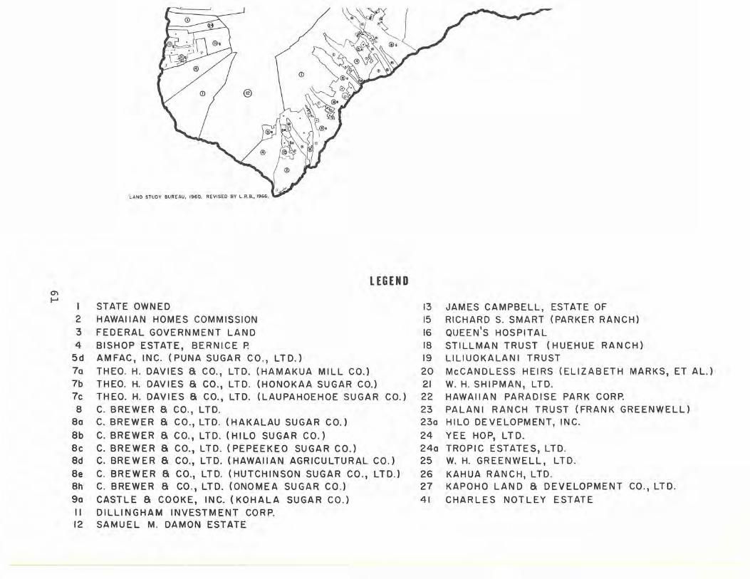
LAND STUDY BUREAU, 1960. REVISED BY L.R.B., 1966.
LEGEND 0'1 ......
I STATE OWNED 2 HAWAIIAN HOMES COMMISSION 3 FEDERAL GOVERNMENT LAND 4 BISHOP ESTATE, BERNICE P.
5d AMFAC, INC. (PUNA SUGAR CO., LTD.) 70 THEO. H. DAVIES a CO., LTD. (HAMAKUA MILL CO.) 7b THEO. H. DAVIES a CO., LTD. (HONOKAA SUGAR CO.) 7c THEO. H. DAVIES a CO., LTD. (LAUPAHOEHOE SUGAR CO.) 8 C. BREWER a CO., LTD.
80 C. BREWER Ii CO., LTD. (HAKALAU SUGAR CO.)
8b C. BREWER Ii CO., LTD. (HILO SUGAR CO.) 8c C. BREWER Ii CO., LTD. (PEPEEKEO SUGAR CO.) ad C. BREWER Ii CO., LTD. (HAWAIIAN AGRICULTURAL CO.)
8e C. BREWER Ii CO., LTD. (HUTCHINSON SUGAR CO., LTD.) 8h C. BREWER Ii CO., LTD. (ONOMEA SUGAR CO.) 90 CASTLE Ii COOKE, INC. (KOHALA SUGAR CO.) II DILLINGHAM INVESTMENT CORP. 12 SAMUEL M. DAMON ESTATE
13 15
16 18 19
20 21 22 23 230
24 240 25
26 27
41
JAMES CAMPBELL, ESTATE OF RICHARD S. SMART (PARKER RANCH)
QUEEN'S HOSPITAL STILLMAN TRUST (HUEHUE RANCH) L1L1UOKALANI TRUST
McCANDLESS HEIRS (ELIZABETH MARKS, ET AL.) W. H. SHIPMAN, LTD. HAWAIIAN PARADISE PARK CORP. PALAN I RANCH TRUST (FRAN K GREENWELL) HILO DEVELOPMENT, INC.
YEE HOP, LTD. TROPIC ESTATES, LTD. W. H. GREENWELL, LTD.
KAHUA RANCH, LTD. KAPOHO LAND Ii DEVELOPMENT CO., LTD.
CHARLES NOTLEY ESTATE

Name of Owner
Gay & Robinson*
AmFac, Inc.
Grove Farm Co. , Inc.
Alexander & Baldwin, Inc.
Bernice P. Bishop Estate
C. Brewer & Co., Ltd.
Eric A. & August F. Knudsen
Wm . Hyde Rice, Ltd.
Kanoa Heirs
John T. Waterhouse
Total
*See Append i x D
Table 14
MAJOR PRIVATE LANDOWNERS: KAUAI
Trust
Acres Owned in Fee Simple
55,799.57
43,208.90
22,6 16.01
22,611.00
11,727.25
9,297.06
5,879.00
3,039.74
1,701.00
1,073.00
176,952.53
62
Fee Acres as % of Total Acreage of
Island
15.82
12.25
6.41
6.41
3.33
2.64
1.67
.86
.48
.30
Cumulative %
15.82
28.07
34.48
40.89
44.22
46.86
48.53
49.39
49.87
50.17
50 . 17

Table 15
LAND CONTROLLED BY MAJOR LANDOWNERS: KAUAI
Acres Controlled Acres O,vued in Acres Held in Acres Leased Acres Controlled as % of Total Cumulative
Name of Owner Fee Simple Leasehold Acres Sublet to Others (columns 1+2-3-4) Acreage of Island %
Gay & Robinson'" 55,799.57 20,257 .95 1. 33 4,092 . 07 71,964.12 20.41 20 . 41
AmFac, Inc . 43,208.90 12,514.30 537 . 30 1,646.77 53,539.13 15.18 35.59
Lihue Plantation Co., Ltd. 43,208.90 12,514.30 537.30 1,646.77 53,539.13 15.18
Grove Farm Co., Inc. 22,616.01 4 ,309. 84 612.86 4,799.73 21,513.26 6.10 41. 69
Alexander & Baldwin, Inc. 22,611.00 313 . 00 1,733.00 21,191.00 6.01 47.70
McBryde Sugar Co., Ltd . 22,449.00 313 .00 1,733.00 21,029.00 5.96 Alexander & Baldwin, Inc. 162 . 00 162.00 .05
C. Brewer & Co., Ltd . 9,297.06 4,049.80 1,846.47 4,762.56 6,737.83 1. 91 49 .61
Kilauea Sugar Co., Ltd. 9 , 288 . 93 4,049.80 1,846.47 4,762.56 6,729.70 1. 91 C. Bre'ver & Co . , Ltd . 8 . 13 8.13
Wm. Hyde Rice, Ltd. 3,039.74 43.92 47 . 41 3,036 . 25 . 86 50.47 0'\ W Eric A. & August F. Knudsen Trust 5,879.00 4,765.00 1,114.00 . 32 50.79
John T. Waterhouse 1,073 . 00 1,073.00 .30 51 . 09
Kanoa Heirs 1,701.00 1,641. 00 60.00 .02 51.11
Roman Catholic Church 2.47 2.47 51. 11
Bernice P . Bishop Estate 11,727.25 11,727 . 25 51.11 ---
Totals 176,952.53 41,491. 28 2,997.96 35,214.79 180,231. 06 51.11
"'See Appendix D
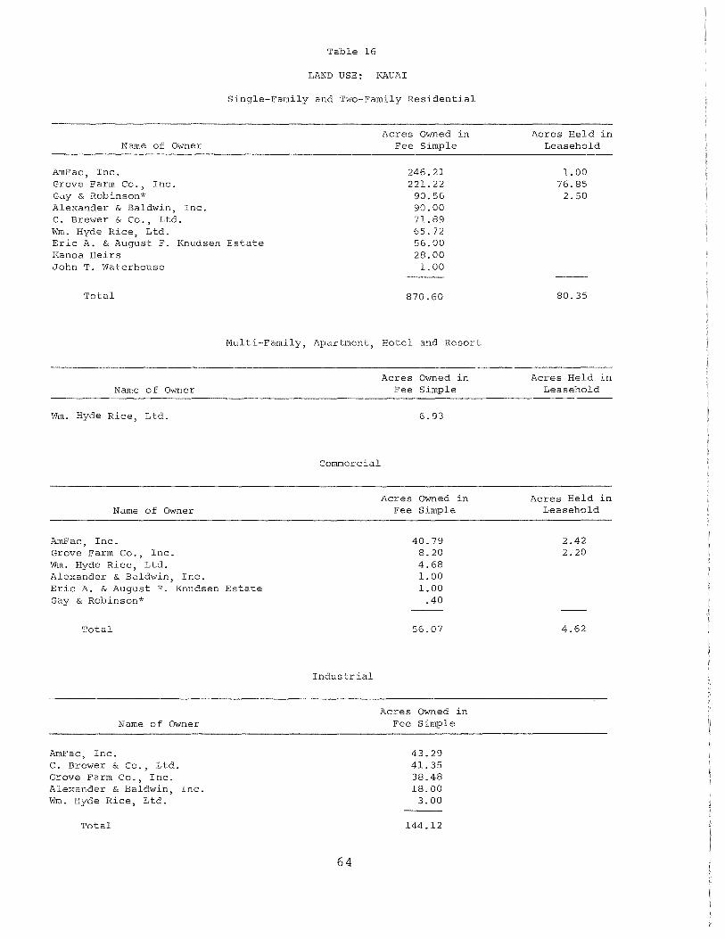
Table 16
LAND USE; KAUAI
Single-Family and Two-Family Residential
Name of Owner
AmFac, Inc. Grove Farm Co., Inc. Gay & Robinson* Alexander & Baldwin, Inc. C. Brewer & Co., Ltd. Wm. Hyde Rice, Ltd. Eric A. & August F. Knudsen Estate Kanoa Heirs John T. Waterhouse
Total
Acres Owned in Fee Simple
246.21 221.22 90.56 90.00 71. 89 65.72 56.00 28.00 1. 00
870.60
Multi-Family, Apartment, Hotel and Resort
Name of Owner
Wm. Hyde Rice, Ltd.
Name of Owner
AmFac, Inc. Grove Farm Co., Inc. Wm. Hyde Rice, Ltd. Alexander & Baldwin, Inc. Eric A. & August F. Knudsen Estate Gay & Robinson*
Total
Name of Owner
AmFac, Inc. C. Brewer & Co., Ltd. Grove Farm Co., Inc. Alexander & Baldwin, Inc. Wm. Hyde Rice, Ltd.
Total
Acres Owned in Fee Simple
6.93
Commercial
Industrial
64
Acres Owned in Fee Simple
40.79 8.20 4.68 1. 00 1.00
.40
56.07
Acres Owned in Fee Simple
43.29 41.35 38.48 18.00
3.00
144.12
Acres Held in Leasehold
1. 00 76.85
2.50
80.35
Acres Held in Leasehold
Acres Held in Leasehold
2.42 2.20
4.62
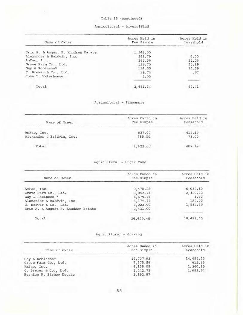
Table 16 (continued)
Agricu l tural - Diversified
Acres Held in Name of Owner Fee Simple
Eric A. & August F. Knudsen Estate Alexander & Baldwin, Inc.
1,348.00 581. 79
AmFac, Inc. Grove Farm Co., Ltd. Gay & Robinson* C. Brewer & Co., Ltd. John T. Waterhouse
Total
Name of Owner
AmFac, Inc. Alexander & Baldwin, Inc.
Total
Name of Owner
AmFac, Inc. Grove Farm Co., Ltd. Gay & Robinson * Alexander & Baldwin, Inc. C. Brewer & Co., Ltd.
295.56 118.70 114.55
19.74 3.00
2,481.34
Agricultural - Pineapple
Acres Owned in Fee Simple
837.00 785.00
1,622.00
Agricultural - Sugar Cane
Acres Owned in Fee Simple
Eric A. & August F. Knudsen Estate
9,478.28 8,842.74 6,679.76 6,174.77 3,022.90 2,431.00
Total
Name of Owner
Gay & Robinson* Grove Farm Co., Ltd . l~mFac, Inc. C. Brewer & Co., Ltd. Bernice P. Bishop Estate
36,629.45
Agr icultural - Grazing
65
Acres Owned in Fee Simple
24,737.92 7,675.59 6,135.05 3,742.73 2,192.87
Acres Held in Leasehold
4.00 15.06 20.89 26.59
.87
67 . 41
Acres Held in Leasehold
412.19 75.00
487.19
Acre s Held in Leasehold
6,032.10 2,429.73
1. 33 182 .00
1,832.39
10,477.55
Acres Held in Leasehold
14,455.32 612.86
1,240.39 1,699.84

Name of Owner
Wm. Hyde Rice, Ltd. Alexander & Baldwin, Inc. Eric A. & August F. Knudsen Estate John T. Waterhouse Kanoa Heirs
Total
Gay & Robinson* AmFac, Inc.
Name of OWner
Alexander & Baldwin, Inc. Bernice P. Bishop Estate Grove Farm Co., Ltd. Kanoa Heirs Eric A. & August F. Knudsen Estate C. Brewer & Co., L'cd.
Total
All major landowners
All major landowners
All major landowners
*See Appendix D
(Table 16 (continued)
Agricultural - Grazing
Conservational
Waste
Other
Total for all Uses
66
Acres OWned in Fee Simple
1,554.58 1,216.43
664.00 461.00 135.00
48,515.17
Acres Owned in Fee Simple
20,689.35 16,494.86 13,075.00
9,534.38 4,795.97 1,478.00 1,141. 00 1,110.21
68,318.77
16,923.46
1,384.62
176,952.53
Acres Held in Leasehold
43.92
18,052.33
Acres Held in Leasehold
71.44
391. 72
324.00
787.16
1l,019.54
515.13
41,491. 28

Table 17
NET CHANGES IN LAND OWNERSHIP: KAUAI (1950-1964)
Net Gain or Loss in Acres through Exchanges and/or
Name of Owner Purchases and Sales
C. Brewer & Co., Ltd. +837.83
Alexander & Baldwin, Inc.* + 46.00
John T. Waterhouse
Roman Catholic Church
Gay & Robinson*
Bernice P. Bishop Estate
Grove Farm Co., Inc.
AmFac, Inc.
Total Net Gain
Total Net Loss
Total Net Change
*See Appendix D
N arne 0 f Owner
Grove Farm Co., I nc.
C. Brewer & Co, Ltd.
John T. Waterhouse
Roman Catholic Church
Table 18 NET CHANGES THROUGH ALL
LAND TRANSACTIONS: KAUAI (1950-1964)
Bernice P. Bishop Estate
AmFac, Inc.
Gay & Robinson*
Alexander & Baldwin, Inc.*
*See Appendix D
67
+ 3.00
1. 73
4.09
- 10.41
- 65.46
-213.85
+----
+591.29
Net Gain or Loss in Acres through
Leases, Exchanges, and/or Purchases
and Sales
+5,123.94
+ 395.24
+ 3.00
+ . 74
10.41
213.85
-2,179.26
-- 2,561.00

'" 00
MAJOR LAND OWNERS
KAUAI
LEGEND
STATE OWNED
N .0.
® / /
/
J)
2 HAWAIIAN HOMES COMMISSION 3 FEDERAL GOVERNMENT LAND 4 BISHOP ESTATE, BERNICE P.
(2\
5c AMFAC, INC. (LIHUE PLANTATION CO., LTD.)
\,r
CD
6d ALEXANDER a BALDWIN, INC. (McBRYDE SUGAR CO.) Bg C, BREWER a CO., LTD. (KILAUEA SUGAR CO., LTD.) 14 GAY AND ROBINSON 33 GROVE FARM CO., INC. 34 ERIC A. a AUGUST F. KNUDSEN TRUST
* SMALL MISCELLANEOUS HOLDINGS
(
®
@
\1 U
\6' ~, Cil
l~\ .' 0~ * *) \::V( \ , ,
/ / \, ) @g f \~ ,
I (~(
r'" I
' 'D \\~ ('" ( ~ "'- 2' ' ~'., . , .--, ~, r,' "";~" ~ \ '.. • ~I > \ @C
'l \'~~'0~ \-~
C.!") ') * *
7 ~~:~, .~ \i£7. ( @c .
"'
\.4)
\1.1
'J) *
0)
@c
(;,;. ~,/ / ~i) _
@
/r.s'''/ .~ ") <8 /I [ ~(6"dl., / /r"\.'{ r " v.:.; " / II " "i \ / '1, \ I
/ (I) !)( It (\ ;
/~ -~ I *, :-l<,~""~, i~ ! J ";\.:'''''' V &J \ ( G.N. ".
CiJ '=L' .) (6Jd l .. :/' ,~d ' J:d:'\ /@ : I \~\
~.( \( LAND STUDY BUREAU, 1960.
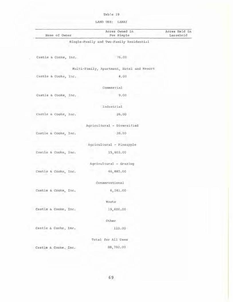
Name of Owner
Table 19
LAND USE: LANAI
Acres Owned in Fee Simple
Single-Family and Two-Family Residentia l
Castle & Cooke, Inc. 76.00
Multi-Family, Apartment, Hotel and Resort
Castle & Cooke, Inc. 4.00
Commercial
Castle & Cooke, Inc. 9.00
Industri a l
Castle & Cooke, Inc. 26.00
Agricultural - Diversified
Ca stle & Cooke, Inc. 38.00
Agricultural - Pineapple
Ca stle & Cooke, Inc. 15,803.00
Agricultural - Grazing
Castle & Cooke, Inc. 46,885.00
Conservational
Castle & Cooke, Inc. 6,241. 00
Waste
Castle & Cooke, Inc. 19,600.00
Other
Castle & Cooke, Inc. 110.00
Total for All Uses
Castle & Cooke, Inc. 88,792.00
69
Acres Held in Leasehold

MAJOR LAND OWNERS N
o
@f
LANAI
9f CASTLE a COOKE, INC. (DOLE CO')
KAHOOUWE :3 FEDERAL GOVERNMENT LAND
70
NIIHAU
14a NIIHAU RANCH
Name of Owner
Alexander & Baldwin, Inc.
Haleakala Ranch Co.
C. Brewer & Co., Ltd.
Ulupalakua Ranch, Inc.
AmFac, Inc.
Kaupo Ranch, Ltd.
Kaonoulu Ranch Co., Ltd.
James Campbell Estate
Hana Ranch Co., Ltd.
Bernice P. Bishop Estate
Maui Realty Co., Inc.*
Roman Catholic Church*
Total
*See Appendix D
Table 20
MAJOR PRIVATE LANDOWNERS: MAUl
Acres Owned in Fee Simple
100,177 .41
33,041.00
26,496.71
21,807.00
15,376.67
10,036.94
8,813.38
5,751.00
4,813.80
2,541.46
1,636.00
4.61
230,495.98
71
Fee Acres as % of Total Acreage of Cumulative
Island %
21. 50 21. 50
7.09 28.59
5 . 69 34.28
4.68 38.96
3.30 42.26
2.15 44.41
1. 89 46.30
1. 23 47.53
1. 03 48.56
.55 49.11
.35 49.46
49.46
49.46
Table 21
LAND CONTROLLED BY MAJOR LANDOWNERS: MAUl
Acres Controlled Acres O,vned in Acres He ld in Acres Le ased Acres Controlled as % of To t al Cumulative
Name of O"mer Fee Simp l e Le asehold Acres Sublet to Others (co l umns 1+2 - 3- 4) Acreage of I sland %
Alexander & Baldwin, Inc. 100,177.41 44 ,234.76 214.84 21,204.08 122 , 993.25 26.40 26.40
Alexander & Baldwin, Inc. 52,254.00 1,478.00 9,692.00 44,040.00 9.45 East Maui Irrigation Co . , Ltd . 17,985.00 38,313.00 4,136.00 52 , 162 . 00 11.20 Maui Pineapple Co . , Ltd. 29,938.41 4,443.76 214.84 7,376.08 26,791.25 5.75
Ulupalakua Ranch, Inc. 21,807.00 25,438.67 32.00 47,213.67 10.13 36.53
Haleakala Ranch Co. 33,041. 00 8,117.26 58.00 41,100.26 8.82 45.35
C. Brewer & Co., Ltd. 26,496.71 495.18 320.74 26,671.15 5.72 51. 07
Wailuku Sugar Co. 26,492.23 495.18 320.74 26,666.67 5.72 C. Brewer & Co., Ltd. 4.48 4.48
AmFac, Inc. 15,376.67 9,276.79 . 79 496.66 24,156.01 5.18 56 . 25
Pioneer Mill Co., Ltd. 15,376.67 9,276.79 .79 496.66 24,156.01 5.18
-...J f\J
Kaonoulu Ranch Co., Ltd. 8,813.38 7,898 . 16 15.20 16,696.34 3 . 26 59 . 51
Kaupo Ranch, Ltd. 10,036 . 94 4,914.02 14 ,950.96 3.21 62.72
Hana Ranch Co. 4,813.80 448.20 .40 5,261.60 1.13 63 . 85
Maui Rea 1 ty Co., Inc. ,', 1,636.00 1,636.00 .35 64.20
James Campbell Estate 5,751.00 5,748.00 3.00 64.20
Bernice P. Bishop Estate 2,541. 46 2,541.46 64.20
Roman Catholic Church'" 4.61 4.6 1 64.20
Total 230,495 . 98 100,823.04 215.63 30,421.15 300,682.24 64.20
"'See Append ix D

Table 22
LAND USE: MAUl
Singl e-Family and Two-F amily Residential
Name of Owner
Al exander & Baldwin, Inc. AmFac, Inc. C. Brewer & Co ., Ltd. Kaonoulu Ranch Co., Ltd. Haleakala Ranch Co. Ulupalakua Ranch, Inc. Hana Ranch Co ., Ltd. Bernice P. Bishop Estate Maui Realty Co., Inc.* J ames Campbell Estate Kaupo Ranch, Ltd.
Total
Acres Owned in Fee Simple
574.33 128.08
89 . 05 46.93 38 . 00 37 . 00 33.50 16 . 12 4.00 3 . 00 2.00
972.01
Mul ti-F am i ly, Apartment, Hotel and Resort
Name of Owner
AmFac, Inc. Hana Ranch Co., Ltd. Maui Realty Co ., Inc.*
Total
Name of Owner
AmFac, I nc. Alexander & Baldwin, Inc. Hana Ranch, Ltd. Ulupalakua Ranch, Inc. Kaonoulu Ranch Co., Ltd.
Total
Name of Owner
Alexander & Baldwin, Inc. ArnFac, Inc.
Acres Owned in Fee Simple
184.43 20.30
4 . 00
208.73
Commercial
Acres Owned in Fee Simple
315.05 138.34
2.60 1. 00
.50
457.49
Industrial
Acres Owned in Fee Simple
155 . 34 20.70
73
Acres Held in Leasehold
0.39 1. 52
5.65
7.56
Acres Held in Le asehold
Ac res He ld in Leasehold
0.53
. 67
1. 20
Acres Held in Leasehold
.16

Name of Owner
C. Brewer & Co., Ltd. Hana Ranch Co., Ltd. Bernice P. Bishop Estate Ulupalakua Ranch, Inc.
Total
Name of Owner
Alexander & Baldwin, Inc. Haleakala Ra nch,Co . C. Brewer & Co., Ltd. Ulupalakua Ranch, Inc. Bernice P. Bishop Estate
Total
Name of Owner
Alexander & Baldwin, Inc. Maui Realty Co., Inc.*
Total
Name of Owner
Alexander & Baldwin, Inc. AmFac, Inc. C. Brewer & Co ., Ltd. Bernice P. Bishop Estate
Total
Table 22 (continued)
Industrial
Acres Owned in Fee Simple
15.54 5.20 2.95 1.00
200.73
Agricultural - Diversified
Acres Owned in Fee Simple
738.51 58.00 42.28 30.00
.07
868.86
Agricultural - Pineapple
Acres Owned in Fee Simple
9,592.40 1,472.00
11,064.40
Agricultural - Sugar Ca ne
Acres Owned in Fee Simple
32,570.67 5,494.76 5,105.71
799 . 86
43,971.00
74
Acres Held in Leasehol d
.16
Acres Held in Leasehold
.02
.0 2
Acres Held in Leasehold
3,878. 8 5
3 ,878. 8 5
Acres Held in Leasehold
5.00 4,841. 79
61.40
4,908.19

Name of Owner
Alexander & Baldwin, Inc. Haleakala Ranch Co. Ulupalakua Ranch, Inc. Kaonoulu Ranch Co., Ltd. Kaupo Ranch, Ltd. James Campbell Estate C. Brewer & Co., Ltd. AmFac, Inc. Hana Ranch Co . , Ltd. Maui Realty Co., Inc.* Bernice P. Bishop Estate
Total
Name of Owner
Alexander & Baldwin, Inc. C. Brewer & Co., Ltd. Haleakala Ranch Co. AmFac , Inc. Bernice P. Bishop Estate Kaonoulu Ranch Co ., Ltd. Hana Ranch Co.
Total
Al l major landowners
Al l major landowners
All major landowners
*See Appendix D
Table 22 (continued)
Agricultural - Grazing
Acres Owned in Fee Simple
28,221.30 27,275.00 16,738.00
7,548.38 7,534.94 5,748.00 4,338 . 62 3,861.59 3, Oll. 80
156 . 00 12.98
104,446.61
Conservational
Acres Owned in Fee Simple
23,533.44 1 5,310 . 73
5, 148 . 00 3,926.62 1, 1 92 . 37
994 . 01 629 . 20
50,734 . 37
Waste
13,677.31
Other
3,894 . 47
Total for Al l Uses
230,495.98
75
Acres Held in Leasehold
1,588.68 8,110.04
15,370.00 6,898 .16 4,391.02
432 .14 2,038.27
134 . 20
38,962.51
Acres Held in Leasehold
38,413 .13
1,169.76
236.00
39,818.89
13,088.90
156.76
100,823.04

Table 23
NET CHANGES IN LAND OWNERSHIP: (1950-1964)
Name of Owner
Haleakala Ranch Co. Hana Ranch Co., Ltd. Maui Realty Co., Inc. * Kaupo Ranch, Ltd. Kaonoulu Ranch Co., Ltd. Jame s Campbell Estate AmFac, Inc. Bernice P. Bishop Estate C. Brewer & Co., Ltd. Roman Cathol ic Church* Alexander & Baldwin, Inc. Ulupalakua Ranch, Inc.
Total Net Gain
Total Net Loss
Total Net Change
*See Appendix D
Table 24
NET CHANGES THROUGH ALL LAND TRANSACTIONS: MAUl
(1950-1 964)
Name of Owner
Haleakala Ranch Co. AmFac, Inc. Alexander & Baldwin, I nc . Hana Ranch Co., Ltd. Maui Realty Co., Inc .* C. Brewer & Co., Ltd. Kaupo Ranch, Ltd. Kaonoulu Ranch Co., Ltd. James Campbell Estate Bernice P. Bishop Estate Roman Catholic Church* Ulupalakua Ranch, I nc .
*See Appendix D
76
MAUl
Net Gain or Loss in Acres through Exchanges a nd/or
Purchases and Sales
+3,199.11 +1,714.40 +1,636.00 + 29.94 + 12.92
.33 2.44 2.89
205.26 229 . 85 576.4 7
-6,821. 75
+
-1.246.62
Net Gain or Loss in Acres through
Leases, Exchanges, and/or Purchases
and Sales
+11,316.37 + 7,168 . 39 + 2,215.43 + 1,714.40 + 1,636.00 + 269.00 + 92.09 + 12.92
. 33 2.89
225 . 24 - 2,941.75
-....J -....J
T D- *
0' ) ~
(j)
LEGEND
I STATE OWNEO 2 HAWAIIAN HOMES COMMISSION 3 FEDERAL GOVERNMENT LAND 4 BISHOP ESTATE, BERNICE P.
5b AMFAC, INC. (PIONEER MILL CO., LTD.) 6 ALEXANDER 8 BALDWIN, INC. (BALDWIN PACKERS)
60 ALEXANDER 8 BALDWIN, INC.(HAWAIIAN COMMERCIAL AND SUGAR CO, LTD .)
~ (()
.@a
@
MAJOR LAND OWNERS
MAUl
r
N .0
T
CD 6b ALEXANDER 8 BALDWIN, INC.(EAST MAUl IRRIGATION CO., LTD.) 6c ALEXANDER 8 BALDWIN, INC. (MAUl PI NEAPPLE CO., LTD.) 8f C. BREWER 8 CO., LTD. (WAILUKU SUGAR CO . )
~-,
S;;-::#~ / . VIA--• I . . ':.<'Jt!? JtY'
~! ~'2~:f V 13 JAMES CAMPBELL, ESTATE OF 28 ULUPALAKUA RANCH, INC. 29 KAONOULU RANCH CO., LTD.
30 KAUPO RANCH, LTD.
31 HALEAKALA RANCH CO. 32 HAN A RANCH CO ., LTD.
* SMALL MISCELLANEOUS HOLDINGS
o )@j (I I (i'
LAND STUDY BUREAU, 1959.

Table 25
MAJOR PRIVATE LANDOWNERS: MOLOKAI
Name of Owner
Molokai Ranch, Ltd.
Puu-O-Hoku Ranch (George W. Murphy)
Francis H. Ii Brown
Bernice P. Bishop Estate
R. W. Meyer, Ltd. and A. A. Meyer Family
Austin Heirs
S. C. & Pearl Friel*
H. P. Hustace*
Neoma Foster, et al.
William B. Dunbar*
Total
*See Appendix D
Acres Owned in Fee Simple
73,975.37
14,262.00
6,000.00
4,694 . 76
2,885.94
2,628.00
1,841.22
1,515.15
1,500 . 00
1,141.37
110,443.81
78
Fee Acres as % of Total Acreage of
Island
44.63
8.60
3.69
2.83
1. 74
1. 59
1.11
.91
.90
.69
Cumulative %
44.63
53.23
56.85
59.68
61.42
63.01
64.12
65.03
65.93
66.62
66.62

-...J ~
Name of O'ffier
Mo1okai Ranch Co.
Puu -O- Hoku Ranch (George H. Murphy)
Francis H. Ii Brmffi , e t a1.
S . C. & Pearl Frie1*
H. P. Hustace"
Neoma Foster, et a1 .
Acres Owned in Fee Simple
73,975.37
14,262.00
6,000 . 00
1,841. 22
1,515.15
1 , 500.00
R. H. Meyer , Ltd . & A. A. Meyer Fami1y* 2,885 .94
William B. Dunbar* 1,141.37
Bernice P. Bishop Estate 4,694 . 76
Austin Heirs 2,628.00
Total 110,443 . 81
'·'See Appendix D
Table 26
LAND CONTROLLED BY MAJOR LANDO\;NERS : MOLOKAI
Acres Held in Leasehold
1,508. 97
800 . 00
5 . 06
2,314 . 03
Acres Sublet
12.97
12. 97
Acres Leased to Others
17,971.37
1,685.07
4,551.30
2,628 .00
26,835.74
Acres Controlled (columns 1+2 - 3- 4)
57,500.00
15,062.00
6,000.00
1,841.22
1,520 . 21
1 , 500.00
1,200.87
1,141.37
143 . 46
85,909 . 13
Ac r es Controlled as % of Total
Ac rea ge of Is l and
34.69
9.09
3.62
1.11
.92
. 90
. 72
.69
. 09
Cumulative 1'.
34 . 69
43.78
47.40
48.51
49.43
50 . 33
51.05
51. 74
51.83
51. 83
51.83
Table 27
LAND USE: MOLOKAI
Single-Family and Two-Family Residential
Name of Owner
Bernice P . Bishop, Estate Molokai Ranch, Ltd. Neoma Foster, et al. R. W. Meyer, Ltd . & A. A. Meyer Family* H. P. Hustace* Puu-O-Hoku Ranch (George W. Murphy) S. C. & Pearl Friel*
Total
Acres Owned in Fee Simple
74.71 30.44 14.00
9.11 3.81 2.00 1. 50
135.57
Multi-Family, Apartment, Hotel and Resort
Name of Owner
Neoma Foster, et al. Puu-O-Hoku Ranch (George W. Murphy) R. W. Meyer, Ltd. & A. A. Meyer Family*
Total
,Name of Owner
Molokai Ranch, Ltd.
commercial
Acres Owned in Fee Simple
46.00 5.00
.58
51.58
Acres Owned in Fee Simple
84.00
Agricultural - Diversified
Name of Owner
Molokai Ranch, Ltd. H. P. Hustace* Bernice P. Bishop Estate William B. Dunbar* S. C. & Pearl Friel*
Total
80
Acres Owned in Fee Simple
224.00 41. 39 21.46 12.96
2.31
302.12
Acres Held in Leasehold
Acres Held in Leasehold
Acres Held in Leasehold
Acres Held in Leasehold
5.06
5.06

Table 27 (continued)
Agricultural - Pineapple
Name of Owner
Molokai Ranch, Ltd. R. W. Meyer, Ltd. & A. A. Meyer Family*
Total
Acres Owned in Fee Simple
11,999.93 156.88
12,156. 81
Agricultural - Grazing
Name of Owner
Molokai Ranch, Ltd. Bernice P. Bishop Estate Puu-O-Hoku Ranch (George W. Murphy) R. W. Meyer, Ltd. & A. A. Meyer Family* Neoma Foster, et al. S. C. & Pearl Friel* H. P. Hustace* Austin Heirs William B. Dunbar*
Total
Conservational
Name of Owner
Puu-O-Hoku Ranch (George W. Murphy) Francis H. Ii Brown Molokai Ranch, Ltd. Austin Heirs Bernice P. Bishop Estate R. W. Meyer, Ltd. A. A. Meyer Family* S. C. & Pearl Friel* H. P. Hustace* William B. Dunbar*
Total
All major landowners
All major landowners
Waste
Other
Total for All Uses
All major landowners
*See Appendix D
81
Acres Owned in Fee Simple
54,218.00 2,970.63 1,659.00 1,513.44 1,400.00 1,054.41 1,014.95
904.00 869.41
65,603.84
Acres Owned in Fee Simple
10,217.00 6,000.00 5,847.00 1,682.00 1,258.00 1,200.06
783.00 455.00 259.00
27,701.06
2,606.62
1,802.21
110,443.81
Acres Held in Leasehold
Acres Held in Leasehold
1,508.97
800.00
2,308.97
Acres Held in Leasehold
2,314.03

Table 28
NET CHANGES IN LAND OWNERSHIP: MOLOKAI (1950-1964)
Net Gain or Loss in Acres through Exchanges and/or
Name of Owner Purchases and Sales
Puu-O-Hoku Ranch (G. W. Murphy) +14,262.00
Francis H. Ii Brown + 4,771.00
S.C. & Pearl Friel*
William B. Dunbar*
R.W. Meyer, Ltd. & A.A. Meyer Family*
Molokai Ranch, Ltd.
Total Net Gain
Total Net Loss
Total Net Change
*See Appendix D
Name of Owner
Table 29
NET CHANGES THROUGH ALL LAND TRANSACTIONS: MOLOKAI
(1950-1964)
Puu-O-Hoku Ranch (G. W. Murphy)
Francis H. Ii Brown
Molokai Ranch, Ltd.
S.C. & Pearl Friel*
Wil liam B. Dunbar*
R.W. Meyer, Ltd. & A.A. Meyer Family*
*See Appendix D
82
+ 554.41
+ 203.60
+ .02
47.38
+
+19,743.65
Net Gain or Loss In Acres through Leases,
Exchanges and/or Purchases and Sales
+14,262.00
+ 4,771.00
+ 1,461.59
-I- 554.41
+ 203.60
+ .02

co w
I STATE OWNED 2 HAWAIIAN HOMES COMMISSION 3 FEDERAL GOVERNMENT LAND 4 BISHOP ESTATE, BERNICE P.
® @
LEGEND
44 PUU - O-HOKU RANCH (GEORGE W. MURPHY)
45 MOLOKAI RANCH, LTD. 46 FRANCIS H. II BROWN
* SMALL MISCELLANEOUS HOLDINGS
MAJOR LAND OWNERS
MOLOKAI
N 6
LAND STUDY BUREAU, 1960

Table 30
MAJOR PRIVATE LANDOWNERS: OAHU
Fee Acres as % of Total
Acres Owned in Acreage of Cumulative Name of Owner Fee Simple Island %
Bernice P. Bishop Estate 59,007.10 15.50 15.50
James Campbell Estate 50,260.00 13.20 28.70
Castle and Cooke, Inc. 42,398.65 11.13 39.83
Harold K. L. Castle (Kaneohe Ranch Co., Ltd.) 9,336.87 2.45 42.28
Zion Securities Corp. 6,374.00 1. 67 43.95
McCandless Heirs (Elizabeth Marks, et al.) 6,286.00 1.65 45.60
Capital Investment Co., Ltd.* 5,420.91 1. 42 47.02
Hui Of Kahana (Heirs of Mary E. Foster included) 5,250.00 1. 38 48.40
Mokuleia Ranch & Land Co., Ltd. 4,865.20 1. 28 49.68
James Robinson properties* 4,725.17 1. 24 50.92
Samuel M. Damon Estate 4,332.00 1.14 52.06
Kualoa Ranch, Ltd. 3,999.33 1. 05 53.11
J. P. Mendonca Trust Estate 2,693.02 .71 53.82
Austin Heirs 2,627.50 .69 54.51
Queen's Hospital 2,554.65 .67 55.18
George Galbraith Trust Estate 2,220.97 .58 55.76
Hawaiian Land Co. 2,101.00 .55 56.31
AmFac, Inc. 1,234.34 .32 56.63
Hiram L. Fong & Mun On Chun 1,190.00 .31 56.94
Bernice P. Bishop Museum 926.49 .24 57.18
Queen Liliuokalani Trust 39.64 .01 57.19
Roman Catholic Church* 5.53 57.19
Kanoa Heirs 2.00 57.19
C. Brewer & Co., Ltd. .63 57.19
Total 217,851.00 57.19
*See Appendix D
84

co U1
Name of O,mer
Castle & Cooke, Inc.
AmFac , Inc. Oahu Sugar Co., Ltd.
Bernice P. Bishop Estate
Zion Securities Corp.
Capital Investment Co., Ltd. Makaha Val l ey Farms, Ltd.~'
Waianae Dp.velopment Co . ~'
Mokuleia Ranch & Land Co., Ltd.
Samuel M. Damon Estate
Acres Owned in Fee Simple
42,398 . 65
1,234.34 1,234.34
59,007.10
6,374.00
5,420 . 91 3,952 . 29 1,468.62
4,865 . 20
4,332.00
Kualoa Ranch, Ltd. 3,999.33
Harold K.L. Castle (Kaneohe Ranch Co.JW.) 9,336 . 87
McCandless Heirs (Eli zabeth Marks, et al.)
Hui of Kahana (Heir s of Mary E. Foster included)
Hawaiian Land Co., Ltd.
James Campbell Estate
Hiram L. Fong & Mun On Chun
C. Brewer & Co., Ltd.
Queen Liliuokalani Trust
J. P. Mendonca Trust Estate
Queen's Hospital
Bernice P. Bishop Museum
George Galbraith Trust Est a te
James Robinson Properties*
Aust in Heirs
Kanoa Heirs
Roman Ca tholic Church'"
Total
;'See Appendix D
6,286 . 00
5,250.00
2,101.00
50,260.00
1,190.00
.63
39.64
2,693.02
2,554.65
926.49
2,220.97
4,725.17
2,627.50
2.00
5.53
217,851. 00
Table 31
LAND CONTROLLED BY MAJOR LANDOWNERS: OAHU
Acres Held in Leasehold
8,588.70
27,653.61 27,653.61
686.95
340.00
79.98
37,349.24
Acres Sublet
2,562.50
1,094.78 1,094 . 78
340.00
3,997.28
Acres Le ased to Others
12,290.99
89.54 89.54
46,009.95
924.00
1,563.72
462.00
346.70
5,925.37
2,959.00
2,038 . 00
262.00
48,862.00
19.80
2,675.52
2,541. 75
915.20
2,219.15
4,725 . 17
2,627.50
2.00
5.53
137,464.89
Acres Controlled (columns 1+2-3-4)
36,133.86
27,703.63 27,703.63
12,997.15
5,450.00
5,420.91 3,952 .29 1,468.62
3,988.43
3,870.00
3,652.63
3,411.50
3,327.00
3,212.00
1,839 . 00
1,398.00
1,190.00
80.61
19 . 84
17 . 50
12.90
11.29
1.82
113,7 38 .07
Acres Controlled as % of Total
Acreage of Island
9.49
7.28 7.28
3.41
1.43
1.42 1.04
.39
1. 05
1. 02
.96
.90
.87
.84
.48
.37
.31
.02
.01
Cumulative %
9.49
16 . 77
20.18
21. 61
23.03
24.08
25.10
26.06
26.96
27 . 83
28.67
29.15
29.52
29.83
29.85
29.86
29.86
29.86
29 . 86
29.86
29.86
29.86
29.86
29.86
29.86

Table 32
LAND USE: OAHU
Single- Family and Two- Family Residential
Name of Owner
Bernice P. Bishop Estate Harold K. L. Castle (Kaneohe Ranch Co . , Ltd.) Mokule i a Ranch & Land Co., Ltd. James Campbe ll Estate James Robinson properties* Queen's Hospital Bernice P. Bi shop Museum AmFac, Inc. Samuel M. Damon Estate Capital Investment Co., Ltd.* Kua l oa Ranch, Ltd. Zions Securities Corp. McCandles s Heirs Hawa iian Land Co., Ltd. Hui of Kahana (Heirs of Mary E. Foster included) George Galbra i th Trust Estate J. P. Mendonca Estate Kanoa Heirs Queen Liliuokalani Trust
Total
Acres Owned in Fee Simple
10,160.39 1,405.1'2 1,178.54
75 1. 00 27 2.00 191.00 184.17 151.27 129.00 11 5 .14 104.10 100.00
52 . 00 42.00
5.00 4.19 2 . 49
.50
. 45
14,848.36
Three or More Family Apartment and Hotel and Resort
Name of Owner
Bernice P. Bishop Estate Queen Liliuokalani Trust Harold K. L. Castle (Kaneohe Ranch Co., Ltd.) Queen's Hospital James Campbe ll Estate Zi on Secur i ties Corp. James Robinson properties* Kanoa Heirs
Total
86
Acres Owned in Fee Simple
137 . 71 11. 22
7.15 6 . 50 6.00 3.00
.90
.50
172.98
Acres He l d in Leasehold
14.66
14.66
Acres He l d in Leasehold

Table 32 (continued)
Commercial
Name of Owner
Bernice P. Bishop Estate Hawaiian Land Co., Ltd. Harold K. L. Castle (Kaneohe Ranch Co., Ltd.) Samuel M. Damon Estate James Campbell Estate Queen's Hospita l AmFac, Inc. James Robinson Properties" Zion Securities Corp. Queen Liliuokalani Trust Castle & Cooke, Inc. George Galbra ith Trust Estate Austin He irs Kualoa Ranch, Ltd . McCandles s Heirs (Elizabeth Marks, et a1.) Kanoa Heirs J. P. Mendonca Estate Bernice P. Bishop Museum C. Brewer & Co., Ltd.
Total
Industrial
Name of Owner
James Campbell Estate Queen's Hospital Hawaiian Land Co., Ltd. Samuel M. Damon Estate Bernice P . Bishop Estate James Robinson propert ies " Castle & Cooke, Inc . Harold K. L. Castle (Kaneohe Ranch Co., Ltd.) AmFac, Inc. Zion Secur ities Corp . McCandless Heirs (Elizabeth Marks, et al.) Bernice P. Bishop Museum C. Brewer & Co., Ltd .
Total
87
Acres Owned in Fee Simple
133.00 88.00 59.90 47 .00 17.00 12.25 10.77 7.44 7.00 3.15 2.8 6 1. 82 1. 50 1.40 1. 00 1. 00
.84
.82
. 63
397.38
Acres Owned in Fe"? Simple
1,145.00 272 . 00 227.00 18 4 .00 149 .44 90.00 68 .79 18.80 14.71
5.00 2.00 1. 51
2,178.25
Acres Held in Leasehold
5.60
.23
5.83
Acres Held in Leasehold
4.60
4.33
79.75
88 . 68
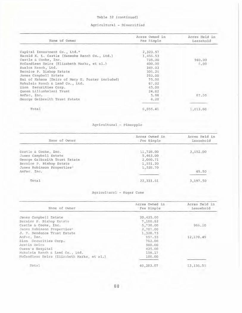
Tab l e 32 (cont i nued)
Ag r icu l tural - Diversif i ed
Name of Owner
Capita l I nvestment Co . , Ltd. * Haro l d K. L. Castle (Kaneohe Ranch Co . , Lt d.) Castle & Cooke, I nc. McCandless He i rs (E l izabeth Harks, et al.) Kualoa Ranch, Ltd . Bernice P. Bishop Estate James Campbe l l Estate Hui of Kahana (Heirs of Mary E . Foster included) Mokule i a Ranch & Land Co . , Ltd . Zi on Securit i es Corp. Queen Lil i uoka l an i Trust AmFac, I nc . George Galbra i th Trust Estate
Total
Acres Owned in Fee Simple
2 , 323 . 57 1,466 .53
735.00 400.00 349.03 306. 26 253.00
75 . 00 67 . 02 45.00 24 . 82
5.98 4.20
6 ,055 . 41
Agricultural - Pineapple
Name of Owner
Cas tle & Cooke, I nc . James Campbell Estate George Galbraith Trust Estate Bernice P. Bishop Estate James Robinson properties '" AmFac , I nc.
Total
Name of Owner
James Campbe ll Estate Bernice P. Bishop Estate Castle & Cooke, I nc. James Rob inson properties" J. P. Mendonca Trust Estate AmFuc. Inc. Zion Securit i es Corp. Austin He irs Queen's Hospital Mokule ia Ranch & Lan6 Co., Ltd .
Acres Owned in Fee S i mple
11,728.00 5,463.00 2,060 . 71 1 ,551.20 1,528.70
22,331.61
Agri cultural - Sugar Cane
Acres Owned in Fee S i mple
20,425 . 00 7 ,180.62 5,738.00 2,707 . 00 1 ,328.73
McCandless Heirs (Eliz iJ Deth Ma rks , et a 1.)
957.55 762.00 500.00 425.00 159.17 100.00
'rota 1 40,283.07
8 8
Acres He l d i n Leaseho l d
940.00 6 .00
67.60
1,013.60
Acres He l d in Leasehold
3,152 . 00
45 . 50
3, 197 . 50
Ac r es Held in Leasehold
966.10
12,170 . 49
13 , 1 36 . 5 9

Table 32 (continued)
Agricultural - Grazing
Name of Owner
James Campbe l l Estate Castle & Cooke, Inc. Bernice P . Bishop Estate Mokuleia Ranch & Land Co., Ltd. Harold 1< . L . Castle (Kaneohe Ranch Co . , Ltd . ) J. P . Mendonca Trust Estate Kualoa Ranch, Ltd. Hiram L . Fong & Mun On Chun McCandless Heirs (Elizabeth Marks, et a l. ) Zion Securities corp. Austin Heirs Hui of Kahana (Heirs of Mary E. Foster included ) AmFac , Inc.
Total
Conserva tiona 1
Name of Owner
Bernice P . Bi shop Estate Castle & Cooke, I nc. James Campbe l l Estate Hui of Kahana (Heirs of Mary E. Foster included) Zion Securities Corp. Harold K. L. Castle (Kaneohe Ranch Co., Ltd.) Samuel M. Damon Estate McCandless He i rs (Elizabeth Ma rks, et a1.) Capital I nvestment Co., Ltd.* Kualoa Ranch, Ltd. Hawaiian Land Co . Austin Heirs Queen's Hospital Mokule i a Ranch & Land Co., Ltd. Bernice P. Bishop Mus eum AmFac, Inc .
Total
.All major landowners
Al l major landowner s
waste
other
Total for Al l Uses
The major landowners
*See Append ix D
89
Acres Owned i n Fee S i mp l e
8,534.00 5,813.00 2 , 994.98 2,536.54 2,483 . 88 1,34 5.26 1,312.05 1,190.00 1,006.00
305.00 300.00 300 . 00
8.00
28,128.71
Acres Owned in Fee Simple
29,658.29 11,437.00 4,9 16.00 4,870.00 4,820 . 00 3 , 876.91 3,856.00 3,000.00 2 , 982.20 2,186.76 1,744.00 1,378.00 1,145.00
921.94 739 . 99
77,532.09
14,407 . 31
11,515.83
217,851.00
Acres He l d in Leasehold
3 12 . 00
171. 90
334 . 00
35.58
1,953 . 48
Acres Held in Leasehold
6 . 00
515 . 05
8,973.00
9,494.05
8 ,226.45
218.40
37 , 349 . 24

Table 33
NET CHANGES I N LAND OWNERSHIP: OAHU
( 1950 -1 964)
Name of Owner
Hiram L. Fong & Mun On Chun
Mokuleia Ranch & Land Co.
George Galbraith Trust Estate
Liliuokalani Trust
Capital Investment Co ., Ltd. *
Kualoa Ra nch , Ltd .
Oueen's Hospital
J . P . Mendonca Trust Es tate
Bernice P. Bishop Museum
J a mes Robinson Properties ;'
Austin Heirs
James Campbell Estate
Haro l d K. Castle (Kaneohe Ranch Co., Ltd . )
Bernice P. Bishop Estate
Roman Catholic Chur ch ~
Samuel M. Damon Es tate
AmFac, Inc.
Castle a nd Cooke , Inc.
Hui of Ka hana
Total Net Gain
Total Net Loss
Total Net Change
'\· See Appendix D
90
Net Gain or Loss in Acres through Exchanges and/or
Purchases and Sales
+ 1,190.00
+ 74.34
+ .11
.01
.25
2 .19
34 .44
52 . 98
6 7 . 78
103 . 00
248.00
88 2 . 4 1
9 20 . 9 1
- 1 , 088 .71
- 1,252 . 8 1
- 1 , 312.00
- 2 , 102 . 53
- 4,59 3. 54
- 8 ,1 5LJ. 00
+
-19 551. 21

Table 34
NET CHANGES THROUGH ALL LAND TRANSACTIONS: OM~U
( 1950-1964)
Name of Owner
George Galbraith Trust Estate
Hiram L. Fong & Mun On Chun
C. Brewer & Co., Ltd .
Mokuleia Ranch & Land Co., Ltd.
Queen Liliuokalani Trust
Capital Investment Co., Ltd.*
Kualoa Ranch, Ltd.
Queen's Hospital
J . P. Mendonca Estate
Bernice P. Bishop Museum
James Robinson Properties·"
Austin Heirs
Harold K. L . Castle (Kaneohe Ranch Co., Ltd.)
James Campbell Estate
Bernice P. Bishop Estate
Roman Catholic Church"
Samuel M. Damon Estate
Castle & Cooke, Inc.
AmFac, I nc.
Hui of Kahana (Heirs of Mary E. Foster included)
*See Appendix D
91
Net Gain or Loss in Acres through
Leases, Exchanges, and/or Purchases
and Sa l es
+2,219.52
+1, 190.00
+ 79 . 98
+ 74.34
.01
.25
2.19
34.44
52.98
67.78
103.00
248.00
920.91
963.41
-1,088.71
-1 ,252.81
-1, 312.00
-3 , 569.15
- 4,449.43
- 8,154.00

/' ~.r-'-'\ <
/ ' , )
3 ,/
35
4
** HONOLULU
~ ~I~
~~ I<
<P
woikiki fu
MAJOR LAND OWNERS
LEGEND 1-2 STATE OWNED (H.H.C.-C.aC.OFHONOLULU-H.H.A.) 3 FEDERAL LAND 4 BISHOP ESTATE, BERNICE P. 16 QUEEN'S HOSPITAL 5 AM FAC, INC. 17 AUSTIN HEIRS
50 AM FAC, INC. (OAHU SUGAR CO., LTD.) 20 McCANDLESS HEIRS (ELIZABETH MARKS, ET AL.) 9 CASTLE a COOKE, INC. 35 HAROLD K. L. CASTLE (KANEOHE RANCH CO., LTD.) 9b CASTLE a COOKE, INC, (HALEMANO LAND CO., LTD.! 36 ZIONS SECURITIES CORP. 9c CASTLE a COOKE, INC. (HALEMANO LAND CO., ~ AU 37 HUI-O-KAHANA (HEIRS OF MARY E. FOSTER INCLUDED) 9d CASTLE a COOKE, INC. (WAIALUA AGRICULTURAL CO., LTD.! 3B JAMES ROBINSON PROPERTIES ge CASTLE a COOKE, INC. (WAIALUA AGRICULTURAL CO., ~ AL.) 39 KUALOA RANCH, LTD. 9f CASTLE a COOKE, INC. (DOLE CO.) 390 KUALOA RANCH, LTD. AND E. P. JUDD ESTATE 10 CAPITAL INVESTMENT CO., LTD. 40 MENDONCA ESTATE 100 CAPITAL INVESTMENT CO., LTD. (MAKAHA VALLEY FARMS, LTD.) 42 GEORGE GALBRAITH TRUST ESTATE lOb CAPITAL INVESTMENT CO., LTD. (WAIANAE DEVELOPMENT CO., LTD.! 43 HIRAM L. FONG 10c CAPITAL INVESTMENT CO., LTD. (HAWAIIAN MACADAMIA NUT CO., LTD.) 430 MARKET CITY 12 DAMON ESTATE 47 MOKULEIA RANCH a LAND CO., LTD. 13 JAMES CAMPBELL, ESTATE OF 48 HAWAIIAN LAND CO. (01 LLI NGHAM CORP.)
"92"",,

94
/-/
r' r I I { I ( '--~
\ \ '--_.---'
\ i J I \
J
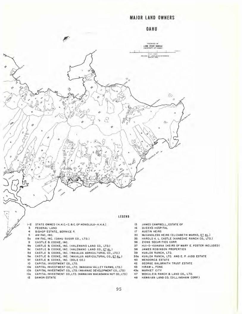
\1 • J
I
I I 1-2
3 4 5
50
9
9b 9c
9d ge
9f 10
100 lOb 10c 12
STATE OWNED (H . H.C.-C. a C. OF HONOLULU- H.H.A.) FEDERAL LAND
BISHOP ESTATE, BERNICE P. AM FAC, INC.
AM FAC, INC. (OAHU SUGAR CO., LTD.)
CASTLE a COOKE, INC. CASTLE a COOKE, INC. (HALEMANO LAND CO., LTD.)
LEGEND
CASTLE a COOKE, INC. (HALEMANO LAND CO., g AU
CASTLE a COOKE, INC. (WAIALUA AGRICULTURAL CO ., LTD.) CASTLE a COOKE, INC. (WAIALUA AGRICULTURAL CO., g AU CASTLE a COOKE, INC. (DOLE CO.)
CAPITAL INVESTMENT CO., LTD. CAPITAL INVESTMENT CO., LTD. (MAKAHA VALLEY FARMS, LTD.) CAPITAL INVESTMENT CO., LTD. (WAIANAE DEVELOPMENT CO., LTD'> CAPITAL INVESTMENT CO.,LTD. (HAWAIIAN MACADAMIA NUT CO., LTD.) DAMON ESTATE
95
MAJOR LAND OWNERS
OAHU
PREPAAED BY
LAND STUDY BUREAU UNI VERSITY OF HAWAII
REVISED !lY' LEGISLATIVE REFER ENCE 8UR[,t,U-1966
13 JAMES CAMPBELL, ESTATE OF 16 QUEEN'S HOSPITAL 17 AUSTIN HEIRS
20 McCANDLESS HEIRS (ELIZABETH MARKS, U AL.) 35 HAROLD K. L. CASTLE (KANEOHE RANCH CO., LTD.) 36 ZIONS SECURITIES CORP. 37 HUI-O-KAHANA (HEIRS OF MARY E. FOSTER INCLUDED)
38 JAMES ROBINSON PROPERTIES 39 KUALOA RANCH, LTD.
390 KUALOA RANCH, LTD. AND E. P. JUDD ESTATE 40 MENDONCA ESTATE 42 GEORGE GALBRAITH TRUST ESTATE
43 HIRAM L. FONG 430 MARKET CITY 47 MOKULEIA RANCH a LAND CO., LTD. 48 HAWAIIAN LAND CO. (DILLINGHAM CORP.)

CHAPTER IV
MAJOR PUBLIC LANDOWNERS
Title to a substantial part of Hawaii's land is vested in the federal and state governments. Altogether these public landowners hold title to 1,846,249 acres, or 45 per cent of the total land of the State. l (See Table 35, page 99)
The federal government holds fee simple title to 255,717.34 acres and controls 2 145,746.97 acres of ceded land. In addition to this fee simple and ceded land, the federal government leases 65,541.96 acres. Two federal agencies, the Air Force and the Army, control an additional 14,865.68 acres through permits, licenses, and easements. (See Table 36, pages 100 and 101)
The Department of the Interior and the Department of Defense manage a large part of the federal government's land in Hawaii. (See Table 37, page 102)
The bulk of the land held in fee simple title by the federal government in Hawaii is managed by the Department of the Interior. This Department is responsible for the operation of three national parks in Hawaii which utilize land in the following amounts: 3
Hawaii Volcanoes National Park (island of Hawaii) 210,661.79 acres Haleakala National Park (island of Maui) 17,130.00 acres City of Refuge National Historical Park
(island of Hawaii) 180.83 acres total: 227,972.62 acres
In addition to managing this fee simple land holding, the Department of the Interior controls 1,765 acres of ceded land.
Navy, land.
The Department of Defense (which includes the Air Force, Army, and the U.S. Coast Guard) manages 27,267.03 acres of fee simple
In addition, it controls 143,982.33 acres of ceded land.
Other federal agencies manage 475.10 acres of fee simple land and control 17.64 acres of ceded land. These agencies include the Department of Agriculture, the Department of Commerce, the Federal Aviation Agency, the Federal Communications Commission, the General Services Administration, the Department of Health, Education and Welfare, the Department of Justice, the Post Office Department, and the United States Information Agency. (See Table 38, page 103)
In addition to fee simple and ceded land, the federal
96

MAJOR PUBLIC LANDOWNEPS
government controls substantial amounts of land in Hawaii through leases and other agreements. 4 A total of 65,541.96 acres is leased for the use of federal agencies. 5 The largest portion of this leased land, 59,492.04 acres, is located on Oahu. The remainder of leased land is located as follows: Hawaii, 4,666.60 acres; Molokai, 1,120.40 acres; Kauai, 199.41 acres; Maui, 60.01 acres; and Lanai, 3.50 acres.
This leased land is used by a number of federal agencies, but the Army utilizes the largest amount, 58,595.47 acres, or 89 per cent of the total . Of the remainder, the Navy utilizes 4,228.15 acres, the Air Force 1,405.64 acres, the Federal Aviation Agency 1,204.60 acres, and others 108.10 acres. It may be noted that approximately 75 per cent of this leased land is used for military purposes. (See Table 39, page 104).
The State of Hawaii holds fee simple title to 1,590,532 acres, or 39 per cent of all of the land in the state. A steady decrease in state owned land occurred during the Territorial period, as is revealed by the following figures: 7
1900 1,772,713 acres 1914 1,631,818 acres 1930 1,590,500 acres 1961 1,528,017 acres
Public land policy in Hawaii during recent years appears to have been based on the principle that the sale of large amounts of public land is not in the best interest of the state. 8 However, the Department of Land and Natural Resources has continued to make a great deal of the state's best public land available for use by private parties under lease and license agreements. 9 (See Table 40, page 105).
The Hawaiian Homes Commission, a major state agency, manages 186,742.57 acres of public land. Of this amount, 44,754.80 acres, or 24 per cent of the total, are currently being used by the Commission in its program. Fifty-six per cent of the total, or 104,804.38 acres, is currently leased to others, while 16,115.77 acres, or 9 per cent of the total, are not presently put to productive use. Eleven per cent of the land nominally managed by the Hawaiian Homes Commission has been set aside under executive order for use chiefly as forest reserves. (See Table 41, pages 106 and 107).
The overall use to which this Hawaiian Homes Commission land is being put may be conveniently summarized as follows:
97
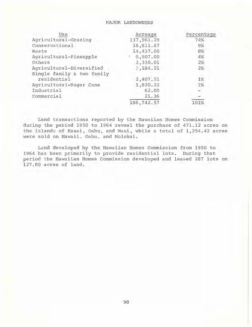
MAJOR LANDOWNERS
Use Agricultural-Grazing Conservational Waste Agricultural-pineapple Others Agricultural-Diversified Single family & two family
residential Agricultural-Sugar Cane Industrial Commercial
Acreage 137,961.29 16,611.67 14,437.00 6,907.00 3,330.01 3 ,184.51
2,407.51 1,820.22
62.00 21. 36
186,742.57
Percentage 74%
9% 8% 4% 2% 2%
1% 1%
101%
Land transactions reported by the Hawaiian Homes Commission during the period 1950 to 1964 reveal the purchase of 471.12 acres on the islands of Kauai, Oahu, and Maui, while a total of 1,254.42 acres were sold on Hawaii ~ Oahu, and Molokai.
Land developed by the Hawaiian Homes Commission from 1950 to 1964 has been primarily to provide residential lots. During that period the Hawaiian Homes Commission developed and leased 287 lots on 127.80 acres of land.
98
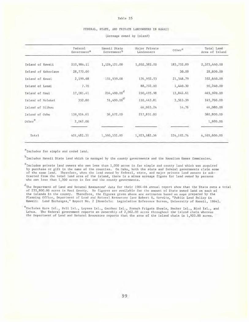
Table 35
FEDERAL, STATE, AND PRIVATE LANDOWNERS IN HAWAII
(Acreage owned by Island)
Federal Hawai i State Major Private Otherc Total Land Governmenta Governmentb Landmvners Area of Island
I sland of Hawaii 210,984.11 1, 126,121.00 1,052,582 . 00 183,752.89 2,573,440.00
Island of Kahoolawe 28,770.00 30 . 00 28,800 . 00
Island of Kauai 2,199 . 68 151,939.00 176,952 . 53 21,548.79 352,640.00
I sland of Lanai 7.70 88,792.00 1,440.30 90 , 240 . 00
Island of Maui 17,181.41 204,400.00d
230,495.98 13 ,842 . 61 465,920 . 00
Island of Molokai 352.80 51,400.00d
110,443.81 3,563.39 165 , 760.00
Island of Niihau 46,065.24 14.76 46,080.00
Island of Oahu 139,924 . 61 56,672 . 00 217,851.00 380,800.00
Other e 2,062.00 1 , 920 . 00
Total 401,482.31 1,590 , 532.00 1,923,182 . 56 224,192.74 4,105,600 . 00
alnc l udes fee simple and ceded land .
blncludes Hawaii State land which is managed by the county governments and the Hawaiian Homes Commission.
clncludes private land owners who own less than 1,000 acres in fee simple and county land which was acquired by purchase or gift in the name of the counties. On Oahu, both the state and federal governments claim some of the same land . Therefore, when the land owned by federal, state, and major private land owners is sub tracted from the total land area of the island, there is a minus acreage figure for land owned by persons who mvn less than 1,000 acres in fee and the county governments.
dThe Department of Land and Natural Resources ' data for their 1964-66 annual report show that the State owns a total of 255,800.00 acres in Maui County. No figures are available for the amount of State owned land on each of the islands in the county . Therefore, the fi gures given above are estimates based on maps prepared by the Planning Office, Department of Land and Natural Resources (see Robert H. Horwitz, "Public Land Policy in Hawaii: Land Exchanges," Report No.2 [Honolulu: Legislative Reference Bureau, University of Hawaii, 1964] .
elncludes Kure Isl., Pell Isl., Laysan Isl . , Gardner Isl. , French Frigate Shoals, Necker Isl., Bird Isl., and Lehua . The federa l government reports an ownership of 2,062.00 acres throughout the island chain whereas the Department of Land and Natural Resources reports that the area of the island chain is 1,920 . 00 acres.
99

Tab l e 36
LAND OWNED AND CONTROLLED I N HAWAII BY THE FEDERAL AGENCIES
(In Ac r es)
Total Acres Hawaii Kahoo l awe Kauai Lanai Maui Molokai Oa hu Othera
(4,105,600.00) (2 , 573 , 440.00) (28 , 000 .00 ) (352,640.00) (90 , 240 . 00 ) (46 5, 920.00) (165,760 . 00) (380,800.00 ) (1,920 . 00 )
Agriculture, Dept. of Leased from others 42 . 26 42.26
Commerce, Dept . of Fee 185.20 5 . 20 5.00 175.00
Defense, Dept. of Air Force
Fee 3 ,049 .18 11. 74 3,037 . 44 Ceded 3 ,138 . 13 3,138.13 Otherb 236 .00 .54 7. 59 227.87 Leased f rom others 1,405 . 64 1,221. 30c 8 . 45d 5 . 45 170. 44
Army Fee 4 ,105.95 3 . 70 4 . 59 4 ,097 . 66
f-J Ceded 103,074.57 3.03 229.46 102,842.08 0 Otherb 14,629 . 68 74 . 92 5.61 .04 14,549 . 11 e 0 Leased from others 58,595 . 47 1 , 200 . 50 f 57 , 394 . 97g
Navy Fee 19,579.11 11 . 74 19 ,567 . 37 Ceded 37,267 . 54 1. 65 28,770.00 1 , 885 . 19 14.11 6 ,5 96 .5 9 Leased from others 4 ,228.15 2,219.30 189.56 1 , 819 . 29
U. S. Coast Guard Fee 532.79 83.26 73 . 33 7.70 20 . 50 315 . 79 32.21 Ceded 502.09 23.69 4 . 50 20.92 22 . 90 133 .08 297.00 Leased from others 17 . 94 17.90 .04
Federal Aviation Agency Fee 1.40 1.40 Leased from others 1,204.60 7 . 60 1.40 3 . 50 12.30 1,120.40 59 . 40
Federal Communications Commission Fee 184 . 20 184.20
General Services Administration Fee 10 . 10 1. 50 .40 8.20 Ceded 7.70 . 80 6 . 90 Leased from others . 90 . 90
Health, Educ . & Welfare, Dept. of Ceded 6.90 6.90

f-..J 0 f-..J
Table 36 (Continued)
Total Acres Ha"aii Kahoo1awe Kauai Lanai Maui Mo1okai Oahu Othera
(4,105,600 . 00) (2,573,440 . 00) (28,000 . 00) (352,640 . 00) (90,240.00) (465,920 . 00) (165,760.00) (380,800.00) (1,920 . 00)
Interior, Dept. of Fee 227 , 975.21 210,843.00 17,l30 . 00 2.21 Ceded 1,765 . 00 1,765.00 Leased from others 1. 00 1.00
Ju s tice, Dept . of Ceded 3.04 3 . 04
Post Office Dept . Fee . 60 . 60 Leased from others 6 . 30 6.30
U.S . Information Agency Fee 93 . 60 93.60 Leased from others 39.70 39.70
SUB TOTAL
Fee 255,717.34 210,954 . 94 80.53 7.70 17,160 . 49 315 . 79 27,197.89
Ceded 145,764.97 29.17 28,770 . 00 2 , 119.15 20.92 37 . 01 112,726 . 72 2,062.00
Otherb 14,865 . 68 75 . 46 5 . 61 7. 63 14,776 . 98
Leas ed from others 65,541. 96 4 , 666.60 199 .41 3 . 50 60.01 1,120.40 59,492.04
TOTAL 481,889 . 95 215,726.17 28,770.00 2,404 . 70 11.20 17 , 249 . 05 1,473.20 214,193.63 2,062 . 00
alnc1udes Kure Isl . , Pe11 Isl ., Laysan Isl., Gardner Isl ., French Frigate Shoals, Necker Isl., Bird Isl . , and Lehua. The federal government reports an ownership of 2,062 . 00 acres throughout the island chain "hereas the Department of Land and Natural Resources reports that the area of the island chain is 1,920 . 00 acres.
bLand which is being used through permits , licenses, easements, e tc.
c 1,200.00 acres are pending execution.
d .48 acres are pending execution.
e 14 . 73 acres are pending execution .
f 1,200.50 acres are pending execution.
g18, 448 . 04 acres are pending execut ion.

f-' 0 N
Table 37
LAND OWNED IN HAWAII BY MAJOR FEDERAL DEPARTMENTS
(In Acres)
Tota l Hawaii Kahoo1awe Kauai Lanai Maui Mo1okai Oahu Othera (2,573 , 400 . 00) (28 , 800. 00) (352,640 . 00) (90,240 . 00) (465,920 . 00) (165,760.00) (380,800.00) (1,920 . 00)
Defense, Dept. ofb
Fee 27,267 . 03 110.44 73 . 33 7.70 25.09 315.79 26,734.68 Ceded 143, 982 .33 28 .37 28,770.00 2,119.15 20 . 92 37.01 112,709 . 88 297.00
Interior, Dept. of Fee 227,975.21 210,843.00 17, l30. 00 2.21 Ceded 1,765.00 1,765.00
Other Agenciesc
Fee 475 . 10 1. 50 7.20 5.40 461.00 Ceded 17.64 .80 16.84
SUB TOTALS
Al l Federal Agencies
Fee 255,717.34 210,954.94 80.53 7.70 17,160.49 315 . 79 27,197 . 89
Ceded 145,764 . 97 29.1 7 28 ,770.00 2,119 . 15 20.92 37.01 112,726.72 2,062.00
TOTAL 401,482.31 210,984.11 28,770.00 2,199.68 7. 70 17,181.41 352.80 139,924.61 2,062 . 00
aInc1udes Kure Is1., Pe11 Is1 . , Laysan Is1 . , Gardner Is1 . , French Frigate Shoals, Necker Is1., Bird Is1., and Lehua. The federal gove rnment reports an ownership of 2,062 . 00 acres throughout the island chain whereas the Department of Land and Na tural Resources r eports that the area of the island chain is 1 ,920 . 00 acres .
bInc1udes the Air Force, Army, Navy and U. S. Coast Guard.
cInc1udes Depts. of Agriculture, Commerce, the Federal Aviation Agency, the Federal Communications Commission, the General Services Adm., the Dept. of Health, Educ. & Welfare, the Dept . of Jus t ice, the Post Office Dept. and the U. S, Information Agency .

f-' o w
Uses
Single family and twofamily residential
Fee Ceded
Three or more family
Total Acres (4,105,600.00)
3,282.50 231. 75
apartment and hotel and resort Fee 6.00
Commercial Fee
Industrial Fee Ceded
Agriculture -Sugar Cane Fee
Agriculture -Grazing Fee
Conservational Fee Ceded
Waste Ceded
Other Fee Ceded
Sub Total Fee Ceded
Total
15.00
6,004.37 3,217.21
1,392 . 34
3,166.00
233,685.90 6,880.38
28,770.00
8,165.23 106,665.63
255,717.34 145,764.97
401,482.31
Hawaii (2,573,440.00)
7.00
6.00
11.74 1. 65
210,830.00
100.20 27.52
210,954.94 29.17
210 , 984.11
Table 38
LAND USE: THE FEDERAL GOVERNMENT
Kahoola,,,e (28,000.00)
28,770.00
28,770.00
28,770.00
(In acres)
Kauai (3·52,000.00 )
1,885.19
80.53 233.96
80.53 2,119.15
2,199.68
Lanai (90,240.00)
7.70
7.70
7.70
Maui (465,920.00)
1.00
17,129.00
30.49 20.92
17,160.49 20.92
17,181.41
Mo lokai (165,760.00)
14.11
315 . 79 22.90
315.79 37.01
352.80
Oahu (380,800.00)
3,274.50 231.75
15 . 00
5,992.63 1,316.26
1,392.34
3,166.00
5,726.90 5,115 . 38
7,630.52 106,063 . 33
27,197.89 112,726.72
139,924.61
Othera
(1,920.00)
1,765 . 00
297 . 00
2,062.00
2,062.00
a Includes Kure Isl., Pell Isl., Laysan Isl., Gardner Isl., French Frigate Shoals, Necker Isl., Bird Isl. and Lehua. The federal government reports an ownership of 2,062.00 acres throughout the island chain whereas the Department of Land and Natural Resources reports that the area of the island chain is 1,920.00 acres.
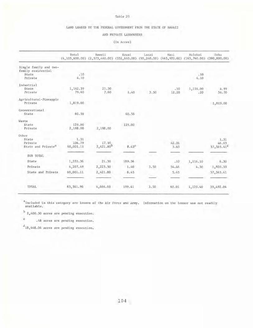
Table 39
LAND LEASED BY THE FEDERAL GOVERNMENT FROM THE STATE OF HAWAII
AND PRIVATE LANDOWNERS
(In Acres)
Total Hawaii Kauai Lanai Maui Mo1okai Oahu (4,105,600.00) (2,573,440.00) (352,640 . 00) (90,240 . 00) (465,920 . 00) (165,760.00) (380,800 . 00)
Si ng l e family and twofami l y residential
State Private
Industrial State Private
Agricultural-Pineapple Private
Conservational State
Waste State Private
Other State Private State and Priva t ea
SUB TOTAL
State
Private
State and Private
TOTAL
.10 4.10
1,142.39 79.60
1,819.00
60.56
129.00 2,198.00
1. 31 106.79
60 ,001. 11
1,333 . 36
4 , 207.49
60 , 001.11
65,541. 96
21 . 30 7.60
2 ,198. 00
17 . 90 2 , 421.80b
21. 30
2,223 . 50
2,421.80
4,666.60
1.40
60.56
129.00
189.56
1.40
8.45
199.41
3.50
3 . 50
3 . 50
. 10 12 .20
42.26 5.45
.10
54 . 46
5 . 45
60 . 01
. 10 4.10
1,116 . 00 .20
1,116 .10
4.30
1,120 . 40
4 . 99 54.70
1, 819 .00
1. 31 46.63
57,565.41d
6 . 30
1,920.33
57,565.41
59,492.04
aInc1uded in this category are l eases of the Air Force and Army. Information on the l essor was not r eadily available.
b 2, 400.50 acres are pending execution .
c .48 acres are pending execution.
d18 ,448 . 04 acres a r e pending execu t ion.
104
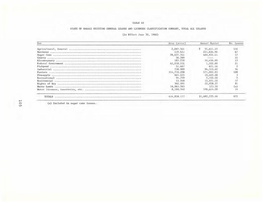
I-' o U1
TABLE 40
STATE OF HAWAII EXISTING GENERAL LEASES AND LICENSES CLASSIFICATION SUMMARY, TOTAL ALL ISLANDS
(In Effect June 30, 1966)
Use
Agricultural, General ................................................. . Business .............................................................. . Sugar Cane .........................•................................... County . ..... .. ................... .. . ...... . . ...... . .... . .. .... .. ...... . Eleemosynary . .... . ............... . ....... ...... ..... ..... ....... ...... . Federal Government ..... .. ....... .............. ...... .. ............... . . Fishpond .............................................................. . Industrial ...................................................•......... Pas ture ............................................................... . Pineapple .............................. .. ........ . ... ... ...... ..... .. . . Recreational .. ...... .... ................ ........ .. ... .............. . .. . Residential ..........................•................................. Rights of Way ...........................................•.............. Waste Lands ........................................................... . Wa ter licenses, reservoirs, etc. . ..................................... .
TOTALS ........ ...... . .... . ........ ........ . ...... ... . .. ... ... .. ..•
(a) Included in sugar cane leases.
Area (acres)
2,097.561 119.633
28,637. 741 30.789
183.250 42,018.531
51.467 738.989
314,710.298 665.025
94.799 23.048
362.991 16,963.565 8,160.540
414,858 .177
Annual Rental
$ 51,611.15 221,634 . 96 469,935 . 41
16,456.00 1,202 . 00
621. 14 94,310.62
571,092.93 19,469.08
2,105.00 15,031.50 22,028.37
12 3.50 196,614.00
$1,682,235.66
No. Leases
146 67 27 14 13 21
2 54
188 3 5
37 81
(a) 14
672

Table 4 1
HAWAIIAN HOMES COMMISSION
(In Acres)
June 1, 1965 Total Sing l e fam . & Com- Indus - Agri. Agr i . Agr i. Agr i. Con- Was t e Ot her T,;o fam . Res . mercia 1 tria l Div . Pine . Sugar Cane Grazing ser vationa1
Mo1okai Fee Ac r eage in use by Owner 25 , 063.73 1 , 440.00 803 . 57 5 ,707 . 00 16 , 906.04 207. 12
Fee Acr eage not in Pr esent Use 35 . 22 35.22
Executive Order or Fores t Reserve Gov ' t. Use 1,433 . 68 233 . 68 1 ,200 . 00
To t a l 26 , 532.63 1 ,440.00 803 . 57 5 ,707 . 00 16 , 906 . 04 233.68 35 . 22 1 ,407 . 12
Oahu Fee Ac r eage in use by Owner 499 . 88 499 . 88
I--' Fee Acreage leased t o Others 3,149 . 84 25 . 50 17. 89 10 . 00 3 , 096 . 45 0 0"1 Fee Acr eage not in Presen t Use 171.06 171. 06
Executive Order or Forest Reserve Gov't . Use 3 , 232.70 1 ,426 . 19 58 . 11 1 ,748.40
Tot a l 7 ,053.48 525 . 38 17 . 89 10. 00 4 , 522.64 58 .11 1, 919 . 46
Maui Fee Acr eage in use by Owner 61.04 61.04
Fee Ac r eage l eased to Others 20 , 104 . 05 12.48 20, 091.5 7
Execut ive Order or For es t Reserve Gov 't. Use 8 , 816 . 93 99 . 93 8 , 717 . 00
Tot a l 28,982.02 61. 04 99 . 93 12 . 48 20 , 09 1. 57 8, 71 7 . 00

Table 41 (Continued)
June 1, 1965 Tota l Single fam. & Com- Indus - Agri. Agri. Agri. Agri. Con-Two fam. Res. mercia 1 tria l Div . Pine . Sugar Cane Graz ing servationa1
Was te Other
Hawaii Fee Acreage in use by O,mer 18 ,542.20 293 . 14 2,281.01 15,946.05 22.00
Fee Acreage l eased to Others 64,328 . 53 3 . 47 52.00 64,273.06
Fee Acreage hot in Present Use 15, 909 . 49 1,507.71 14, 401. 78
Executive Order or Forest Reserve Gov't . Use 7, 580 . 85 7,577 .42 3.43
Total 106 , 361. 07 293 .14 3.47 52 .00 2,281.01 81,726.82 7,599 .42 14 ,401. 78 3.43
Kauai Fee Acreage in use by Owner 587.95 87.95 500 .00
Fee Acreage l eased to Others 17, 221.96 1,200.00 1,807.74 14, 214.22
Executive Order or I--' For est Reserve Gov't . Use 3.46 3.46 0 -.J
Tota l 17,813.37 87.95 1,200.00 1,807.74 14,714.22 3.46
SUB TOTAL Fee Acreage in use by Owner 44 ,754.80 2,382.01 3,084.58 5,707.00 33 ,352 . 09 22.00 207.12
Fee Acreage leased to Others 104 , 804 . 38 25.50 21. 36 62.00 1,200.00 1,820 . 22 101,675 . 30
Fee Acr eage not in Present Use 16 ,115 .77 1,507.71 14, 437 .00 171. 06
Executive Order or Forest Reserve Gov't. Us e 21, 067.62 99 . 93 1,426.19 16 , 589 .67 2,951.83
=
TOTAL 186,742 . 57 2,407 . 51 21.36 62.00 3,184 . 51 6,907 . 00 1,820 . 22 137,961.29 16,611.67 14,437.00 3,330 .01

,.
FOOTNOTES
Chapter'
1. A factor is an agent charged with selling the products of a business enterprise and with responsibility for such other functions as may be mutually agreed upon. In Hawaii, five large corporations have served as the major factors for the Islands' sugar plantations during most of the twentieth century. Initially, these factors handled the sale of raw sugar for the plantations, but they gradually extended their range of services. Today, they manage almost all of the affairs of the plantations except the cultivation of the land. Direction of Hawaii's plantations has thus become centralized in Honolulu, where the factors manage plantation fiscal affairs, purchase of supplies and equipment, labor relations, etc.
2. This deficiency could not be rectified, given the terms of the resolution requesting this report. Additional data designed to present the full extent of "land controlled" will be included in the concluding report of this series.
Chapter "
1. Data on the State of Hawaii's land ownership and control was obtained from materials prepared for the 1964-66 annual report of the Department of Land and Natural Resources because the Department was unable to answer the questionnaire on the State's land ownership prepared by the Legislative Reference Bureau. The format and dimensions of land ownership and control in the 1964-66 annual report do not lend themselves to the format of the discussion on major private landowners.
2. The figure for state-owned land does not include the small amounts of land owned by each of the State's four counties in their own names. It does include all the lands set aside by the State for use by the counties. See Herman S. Doi and
108
Robert H. Horwitz, Public Land policy in Hawaii: Land Reserved for Public Use, (University of Hawaii, Legislative Reference Bureau, 1966 Rept. No.2) .
3. "The Land Situation in the State of Hawaii," Land Study Bureau Circular No. 13, November, 1961, cited in Robert H. Horwitz and Norman Meller, Land and Politics in Hawaii, 3rd ed. (Honolulu: The University of Hawaii Press, 1966), p. 12. See for elaboration. Percentages of the land productivity for each island are based on land areas given by the Department of Land and Natural Resources.
4. In this, and the following paragraph, the acreage given and the term "cultivated land" designate land in the "diversified," "pineapple," and "sugar cane" categories.
5. Statistics of Hawaiian Agriculture, 1964.
6. These figures are significant only for the individual owner. The figures tell us whether an owner has been acquiring or relinquishing acreage through land transactions in the period 1950 to 1964, but they do not tell us whether these transactions have resulted in an increase or decrease in effective control. We do not have information on land leased or sublet by the major landowners during this period.
Chapter '"
1. Fee and ceded lands.
2. This total is slightly smaller than the actual total because the land owned by the counties in their aNn name is not included. Only land held by the state for use by the counties is included. See Herman S. Doi and Robert H. Horwitz, Public Land Policy in Hawaii: Land Reserved for Public Use, (university of Hawaii, Legis~ive Reference Bureau, 1966 Rept . No.2) .
3. Fee and ceded lands.

4. See footnote #2 above.
5. Ceded land.
6. The State owns a total of 255,800.00 acres in Maui County, according to figures furnished by the Department of Land and Natural Resources. The Department has been unable to furnish the exact acreage figures for state-owned land on each of the islands which constitute Maui County, despite the fact that they have furnished a total figure. Accordingly, the figures provided in this report for state-owned land on the islands of Maui and Molokai are estimates based on maps prepared by the Planning Office, Department of Land and Natural Resources. The percentage of error in these estimates cannot be precisely determined, but the figures for each island have been designed to pro'vide an overall total for the County as a whole.
7. See footnote #6 above.
8. Both the state and the federal governments claim some of the same land on Oahu. Therefore, the totals for land ~Nned by the state and federal governments and the major private landowners exceed 100 per cent of the total area of the island (see maps of federaland state-owned land).
Chapter IV
1. State-owned land includes land controlled by the Hawaiian Ho~es Commission and the four county governments of the Islands. Included in this study are data on land purchased by the State government for the use of counties. Data on land purchased directly by the counties for their own use were not readily available and could not, therefore, be included.
2. The term "control" is required to differentiate ceded land from fee simple land. Title to all land which the federal government has acquired in Hawaii since 1898 through purchase, condemnation, donation, or cession is held in fee
109
simple. Title to ceded land is derived from the fact that under the Joint Resolution of Annexation of 1898 the Republic of Hawaii agreed to cede all of its public land to the united States. Under the terms of this resolution approximately one and one-half million acres were ceded, but management of this public land remained in the hands of Hawaii's government, for the Organic Act of 1900 provided that this land "shall be and remain in the possession, use, and control of the government of the Territory of Hawaii, and shall be maintained, managed, and cared for by it, at its own expense, until otherwise provided for by Congress, or taken for the uses and purposes of the United States by direction of the President or of the Governor of Hawaii" (see Organic Act, sec. 91) •
The Hawaii Admission Act of 1959 (Act of March 18, 1959, P.L. 86-3, 73 Stat. 4) granted the State of Hawaii title to most of this ceded land, except for that land which had been set aside for the use of the United States under any (1) act of Congress, (2) executive order, (3) proclamation of the President, or (4) proclamation of the Governor of Hawaii, or land being used by the federal government pursuant to permit, license, or permission. (See paragraphs 'c' and 'd' of Sec. 5 of the Admission Act.)
The Hawaii Admission Act of 1959 provided that land controlled by the United States under the terms of permits, licenses, or other permission at the time of statehood could be set aside by Act of Congress or by executive order of the President of the United States for the use of the federal government at any time for a period of five years following the admission of Hawaii into the Union. Land already set aside by executive order or proclamation for the use of the federal government was to remain as property of the United States, subject to certain limitations.
On December 23, 1963, Congress passed additional legislation (Act of December 23, 1963, P.L. 88-233, 77 Stat. 472) which revised the procedures for conveying title to ceded land to the State of Hawaii. Under this
4.
legislation, if land set aside for the use of the federal government by executive order or land held by the federal government under permit, license, or permission were designated as "surplus property," it could be conveyed to the state of Hawaii without monetary consideration. However, the State of Hawaii is required to reimburse the federal government for the fair market value of any buildings, other structures, or other improvements erected on such land after it was set aside for the use of the federal government. (See P.L. 88-233 for the detailed provisions of this Act. See also, Herman S. Doi and Robert H. Horwitz, Public Land Policy in Hawaii: Land Reserved for Public ~, (University of Hawaii, Legislative Reference Bureau, 1966, Rept. No.2) •
Title to the fee simple land included in the three national parks was acquired as follows:
Ceded land ••••• 154,431.33 acres Land exchanged for
ceded land ••• 42,679.96 acres Land donated to the
Territory of Hawaii for reconveyance to the United States for park use..... 7,926.00 acres
Land condemned by the Territory or State of Hawaii for park use.......... 22,935.33 acres
Total 227,972.62 acres
These "other agreements" include short-term permits, licenses, or special permissions for land use.
5. Leases on 20,849.02 acres of this total are presently pending execution.
6. Data on land ownership and control by the State of Hawaii were obtained from material prepared for the 1965-66 annual report of the Department of Land and Natural Resources. Unfortunately, the categories used in this report do not correspond to those used throughout this report.
110
7. These figures were provided by Mr. Paul Tajima of the Department of Land and Natural Resources. State land holdings have increased by 62,515 acres since 1961, thereby apparently reversing a long-range trend. All of these acreage figures have been rounded off to the nearest whole number.
8. See Robert H. Horwitz and Norman Meller, Land and Politics in Hawaii (3rd ed.; Honolulu: University of Hawaii Press, 1966), esp. pp. 33 ff.
9. It should be noted that reports on land acquired by the four county governments were incomplete. It was therefore difficult to determine the precise amount of land allocated through executive orders, proclamations, and gifts. Provisional information on land transactions involving counties for the period 1950 to 1964 has been secured from the land inventory conducted by the City and County of Honolulu and from questionnaires returned to the Legislative Reference Bureau by the county governments of Hawaii, Kauai, and Maui.
The City and County of Honolulu acquired 1,294.63 acres of land through purchase; 38.87 acres through condemnation; 587.69 acres through lease; and 1,040.12 acres through executive orders, proclamations or gifts. No disposition of land was reported.
The County of Hawaii reported acquisition of 102.22 acres through purchase, 10.20 acres through condemnation and 990.42 acres through lease. During the same period, the county relinquished 3.04 acres through voluntary sale, 0.44 acres through exchange, and 4.53 acres through lease expiration.
The County of Kauai reported acquisition of 106.00 acres through purchase, 15.60 acre s through condem-' nation, 1.88 acres through exchanges, and 9.80 acres through lease.
The County of Maui reported acquisition of 134.52 acres through purchase, 74.20 acres through condemnation, 22.91 acres through executive orders, and 16.96 acres through gifts during this period.

As has been noted, land purchased by these counties in their O'N'n name is not included in the total of state owned land. However, the state total does include land purchased by the state for county use.
111

Appendix A
MAJOR LANDOWNERS: 1961 & 1964
Name of Owner
Alexander & Baldwin, Inc.
East Mau i Irrigation Co., Ltd. Maui Pineapple Co ., Ltd. McBryde Sugar Co., Ltd.
Owner used: Rented to others: Not in use:
Total
( In Acres)
1961* 1964
39,717.00 88,733 .2 6 7 , 440 . 00 22,937.08
11. 00 11,118.07
47,168.00 122,788.41
Change
+ + +
+160 . 3%
*The 1961 figures do not include Ba ldwin Packers which owned 23,258 acres on Maui because Alexander & Baldwin, Inc. held on ly 25 per cent of their stock as of 1960. However, Baldwin Packers became part of Maui Pineapple Co. in 1 962 and is now controlled by Alexa nde r & Baldwin, Inc . The 1961 figures also do not include Hawaiian Commerc ial & Sugar Co ., Ltd. which owned 53,902 acres on Maui because Al exander & Baldwin, Inc. held only 41 per cent of their stock as of 1960. However, Hawaiian Commercial & Sugar Co., Lt d . was merged with and absorbed by Alexander & Baldwin , Inc. on January 2, 1962 .
Name of Owne r
AmFac, Inc .
Pioneer Mill Co., Lt d . Puna Sugar Co., Ltd. Lihue Plantation Co ., Ltd. Oahu Sugar Co., Ltd.
Owner used: Rented to others: Not in use:
Total
1 961 *
47,78 5. 00 6 , 677 . 00
21, 906 .00
76,368 . 00
*The 1 96 1 figures do not include Oahu Suga r Co., Ltd.
Name of Owner 1961
Bernice P. Bishop Es tate
Owner Used: 666.00 Rented to o thers : 326 ,713.00 Not in use: 41,679.00
Total 369,058.00
112
1964 Change
50,514.94 + 4 , 421.48
25,427.99 +
80,364.41 +5 . 2%
1964 Change
426.12 324, 759 .85
44,513.71 +
369,699.68 +0.2%

Name of Owner
Francis H. Ii Brown
Owner used: Rented to others: Not in use:
Total
Name of Owner
C. Brewer & Co., Ltd
Hutchinson Sugar Co., Ltd Kilauea Sugar Co., Ltd Pepeekeo Sugar Co. Wailuku Sugar Co. Hawaiian Agricultura l Co. Mauna Kea Sugar Co., Inc. Paauhau Sugar Co., Ltd.
Owner used: Rented to others: Not in use:
Total
Appendix A (Continued)
1961
6,000.00
6,000.00
1961*
99,150.00 10,779.00 31,516.00
141 ,445.00
1964
6,164.50
6,164.50
1964
134,568.41 10,578.30
145,146.71
Change
+
+2.7%
Change
+ +
+2.6%
*The 1961 figures include Hakalau Sugar Co., Ltd., Hilo Sugar Co., Ltd. and Onomea Sugar Co., Ltd. Hakalau Sugar Co., Ltd. was merged with and absorbed by Pepeekeo Sugar Co., Ltd. on December 31, 1962. Hilo Sugar Co., Ltd ., and Onomea Sugar co., are survived by Mauna Kea Sugar Co., Inc.
Name of Owner
James Campbell Estate
Owner used: Rented to others: Not in use:
Total
Name of Owner
Castle & Cooke, Inc.
Kohala Sugar Co. Dole Co.
Owner Used: Rented to others: Not in use:
Total
1961
39.00 69,532.00 12,586.00
82,157.00
1961
47,392.00 36,265.00 67,944.00
151,601.00
113
1964
142.00 54,610.00 26,889.00
81,641. 00
1964
72,291.20 16,253.39 66,214.68
154 ,759.27
Change
+
+
-0.6%
Change
+
2.1%
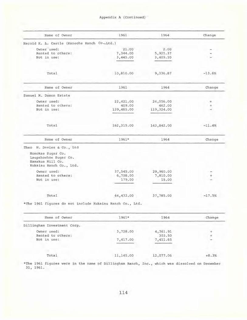
Appendix A (Continued)
Name of Owner 1961
Harold K. L. Castle (Kaneohe Ranch co.,Ltd.)
Owner used: Rented to others: Not in use:
Total
Name of Owner
Samuel M. Damon Estate
Owner used : Rented to others: Not in use :
Total
Name of Owner
Thea H. Davies & Co. , Lt d
Honokaa Sugar Co . Laupahoehoe Sugar Co. Hamakua Mill Co. Kukaiau Ranch Co . , Ltd.
Owner used: Rented to others: Not in use:
Total
21. 00 7,344.00 3,445.00
10,810.00
1961
22,421.00 409.00
139,485 . 00
162,315.00
1961*
37,545.00 6,708.00
179.00
44,432.00
*The 1961 figures do not include Kukaiau Ranch Co., Ltd.
Name of Owner 1961*
Dillingham Investment corp.
Owner used: 3,728.00 Rented to others: Not in use : 7,417.00
Total 11,145.00
1964
2.00 5,925.37 3,409.50
9,336.87
1964
24,056 . 00 462.00
119,324.00
143,842.00
1964
29,960.00 7,810.00
15.00
37,785.00
1964
4,361.91 303.50
7,411.65
12,077.06
Change
- 13.6%
Change
+ +
-11.4%
Change
+
- 17.5%
Change
+ +
+8.3%
*The 1961 figures were in the name of Dillingham Ranch, Inc., which was dissolved on December 31, 1961.
114
Appendi x A (Continued)
Name of Owner 1961
Gay & Rob i nson
Niih au Ra n ch
Owner u sed: 98,452.00 Rented to others: 4,092 . 00 Not in use: 30.00
Total 102,574 . 00
Name of Owner 1 961
w. H. Greenwel l , Ltd.
Owner used : 10,400 . 00 Rented to others: 227 . 00 Not in use: 1,550.00
Total 12,177 . 00
Name of Owner 1 961
Grove Farm Company, I nc .
Owner used : 19,692 . 00 Rented to others : 1,467.00 Not in use: 1,589 . 00
Tota l 22,748.00
Name of Owner 1961
Haleakala Ranch
Owner used: 33,040 . 00 Rented to others: Not i n use:
Total 33,040.00
Name of Owner 1961
Hui of Kahana (Heirs of Mary E. Foster included)
Owner used: Rented to others : Not in use :
Tota l
1,988.00 3,167 . 00
5,155.00
11 5
1964
97,772.36 4,092 . 07
. 38
101,864.81
1964
9,656 .18 223 . 93
2 , 268.96
12 ,149.07
1 964
13,872 . 84 4 , 799 . 73 3,943.44
22,616 . 01
1 964
32,983 . 00 58.00
33,041. 00
1964
2,038.00 3,212.00
5,250.00
Change
+
-1. 4%
Ch ange
+
-0.3%
Change
+ +
- 0 . 5%
Change
+
Unchanged
Change
+ +
+1 . 8%
Appendi x A (Cont i nued)
Name of Owner 1961 1964 Change
Kaonoulu Ranch Co. , Ltd.
Owner used: 8,714.00 8,798.18 + Rented to others: 1 5.20 + Not i n use: 142.00
Tota l 8,856.00 8,813.38 -0.5%
Name of Owner 1961 1964 Change
Kahua Ranch, Ltd.
Owner used: 14,013.00 14,013.00 Rented to others: Not in use:
Total 14,013.00 14,013.00 Unchanged
Name of Owne r 1961 1964 Change
Kaupo Ranch, Ltd.
Owner used: 10,007.00 9,036.94 Rented to others: Not i n use: 1,000.00 +
Total 10,007.00 10,036.94 + . 3%
Name of Owner 1961 1964 Change
Eric A. & August F. Knudsen
Owner used: 1,020.00 1,038 . 00 + Rented to others: 4,806.00 4,765.00 Not in use: 54.00 76.00 +
Total 5,880.00 5,879 . 00 Unchanged
Name of Owner 1961 1964 Change
Queen Liliuokalani Trust
Owner used: 2.80 + Rented to others: 10,280.00 5,885.43 Not in use: 4.00 3,905.63 +
Total 10,284.00 9,793.86 -5.0%
11 6
Appendix A (Cont inued)
Name of Owner 1961 1964 Change
McCand l ess Heirs (El i zabeth Marks, et al.l
Owner used: 15,322.00 14,616.00 Rented to others: 2,457.00 3,073.00 + Not in use: 18,990 . 00 19,080 . 00 +
Total 36,769.00 36,769.00 Unchanged
Name of Owner 1961 1964 Change
Mo l okai Ranch, Ltd.
Owner used: 56,019.00 55,999.00 Rented to others 17 , 981. 00 17,971.37 Not in use 5.00 5.00
Total 74,005.00 73,975.37 Unchanged
Name of Owner 1961 1964 Change
Palani Ranch Trust (Frank R. Greenwel l )
Owner used: 6 ,620.00 5,993.46 Rented to others: 528 . 00 32.50 Not in use : 37.00
Total 7,185.00 6,025.96 -16.1%
Name of Owner 1961 1964 Change
Puu-O-Hoku Ranch (George w. Murphy)
Owner used: 5,010.00 11,901. 00 + Rented to others: Not in use: 8,670.00 2,361.00
Total 13,680 . 00 14,262.00 +4.2%
Name of Owner 1 961 1964 Change
Queen ' s Hospital
Owner used: 13 .00 12.90 Rented to others: 12,810.00 13,051.75 + Not in use:
Total 12,823. 00 13,064.65 +1.1%
117

Appendix A (Continued)
Name of Owner 1961 1964 Change
w. H. Shipman, Ltd.
OWner used: 18,520.00 18,520.00 Rented to others: 3,674.00 4,640.00 + Not in use: 5.00 5.00
Total 22,199.00 23,165.00 +4.4%
Name of Owner 1961 1964 Change
Richard S. Smart (Parker Ranch)
Owner used: 185,015.00 183,032.00 Rented to others: 656.00 2,578.00 + Not in use:
Total 185,671.00 185,610.00 Unchanged
Name of Owner 1961 1964 Change
Thelma K. Stillman Trust (Huehue Ranch)
Owner used: 9,615.00 7,217.72 Rented to others: 12.54 + Not in use: 6,199.00 8,207.50 +
Total 15,814.00 15,437.76 -2.4%
Name of Owner 1961 1964 Change
Ulupalakua Ranch, Inc.
Owner used: 26,124.00 16,775.00 Rented to others: 41.00 32.00 Not in use: 5,000.00 +
Total 26,165.00 21,807.00 -16.7%
Name of Owner 1961 1964 Change
Yee Hop, Ltd.
Owner used: 7,201.00 1,500.00 Rented to other s : 2.00 Not in use: 3,422.00 19,500.00 +
Total 10,625.00 21,000.00 +97.6%
118
Appendix A (Continued)
Name of OWner 1961 1964 Change
Zion Securities Corp.
Owner used: 2,203.00 371. 00 Rented to others: 1,338.00 924.00 Not in use: 2,979.00 5,079 .00 +
Total 6,520.00 6,374.00 -2.2%
119

(To be made one and eight copies) THIRD LEGISLATURE, 1965 STATE OF HAWAII
Appendix B
RELATING TO MAJOR LANDHOLDINGS IN HAWAII.
~.R. ~~. 28
WHEREAS, the economic and social welfare of our people depend upon an adequate knowledge and prudent use of our natural resources; and
WHEREAS, current data concerning land 9wnership and use are not sufficient to permit adequately informed major policy determinations affecting this vital community resource; and
WHEREAS, the most recent report for the State on large l a nd ownership and use was compiled and issued by the Legislative Reference Bureau in 1961; and
WHEREAS, the major landholders have cooperated with and a ssisted the Bureau in the compilation of its prior reports on landholdings; now, therefore,
BE IT RESOLVED by the Senate of the Third Legislature of the State of Hawa ii, General Session of 1965, that the Legislative Reference Bureau be and it is hereby requested to up-date its 1961 study of large private land owners and land use, giving special attention to the many important factors relating to our land resources; and
BE IT FURTHER RESOLVED that duly certified copies of this Resolution be transmitted to the Director of the Legislative Reference Bureau, the Director of Taxation, and the major landholders who are included in the Bureau's 1961 report.
OFFERED BY: ____________________________ ___
120
r-' tv r-'
Appendix C Legislative Reference Bureau Re que s t No. B-2024 July 26, 1965
QUESTIONNAIRE CONCERNING LANDHOLDINGS AND LAND PROGRAMS
(Prepared pursuant to a request by the Third State Legislature)
The following data concern the landholding s and land programs of (company or estate)
on the island of (Pl ea se fill out a se parate questionnaire for
each island on which your estate or company owns land.)
t-' tv tv
The following ~ a list of th e definitions of the land use categories used in the ques ti onnair e :
1. Singl e Family and Two Family R£sid ential. Residential ar eas are characterized by singl e family and two family establishments, in c luding dupl exes , e ngag e d in resid e ntial activities including primarily eating, sleeping and relaxing, and residing or dwe lli,ng at a plac e for a considerable l e ngth of time .
2. Thre e or More Famil y Apartment and Hotel and Resort. 80te l, apartmen t and r esort areas are characterized by es tabli s hment s primarily e ngaged in r es id ent ial acti v ities supporting more than two family units and include are as in hote l-ty pe operations, providing lodging and accommodations and a wid e variety of pe r sonal services
3. Comme rcial. Comm e rcial areas ar e character i zed by commercial activities including primaril y buying and selling or exchanging or oth erwise mutual intercourse of goods and s e rvices.
4. Indus trial . Industrial ar eas are characterized by industrial activities including primarily assembling, fabricating, proc ess ing, manufacturing, mining, packaging, and/or storing finish e d and partiall y fini s h e d produc t s from raw o r semi-raw materials or fabricated parts by use of power driven machines or a similar combination of activities the reof for r e nd e ring related kinds of services.
5. Agricultural. Agricultural ar e a s ar e charac t e riz e d b y agricultural activ ities including primarily cultivating or farming t he s urfaces of the e arth, including clearing of land, plowing, planting, harvesting, e tc. ; act iviti es which ar e heavily d e p e nd ent u pon soil conditions, climate , water, topography and culture for the ec onomic producti on of crops and lives tocks .
a. Agricultural--Diversified. Areas used for the production of crops--other than pine apple and sugar cane --and for the pr oduction of lives tock such as poultry and swine.
b. Agricultural--Pineapple. Areas used primarily for pineappl e production which include roads, expe rimental plots, f allow ar e a s , r ese rv o irs, and loading zones.
c . Agricultural--Sugar Can e . expe rime ntal plot s , road s ,
Ar e a s u sed primarily for the production of sugar cane and includes irrigation lines, reservoirs, and pumping stations.
d. Agricultural--Grazing. Areas not otherwise in crop production which are us e d for grazing domestic animals during some portion of the year .
1-' N W
6. Conservational. Conservational land ar e as are characterized primarily b y land used for protecting watersheds and water supplies, preserving scenic ar e a s , providing parkland, and b e ach r e serves, conserving wildli fe , preve nting flo ods and so il e rosion, and as forest reserves and other similarly related activities ~ich serve the purpose s of conserving, preserving, and protecting natural resources for human welfare .
7. Wast e , Wa s te are as are characterized by lands th.at ar e essentiall y incapable of producing materials or services of immediate value and which represent th E highes t and b es t use in its present state. Such areas lack economic activity bec ause of adver se conditions or circumstances such as bad topography, extreme climate, poor typ e of soil, isolated location , etc., which make the land uneconomical for use, inaccess ible, unavailabl e , orin general, usel ess .

I. Ownership of fee simple land as of .k _______________ _
t-' tv ,~
1. Single family and two family residential
2. Three or more family apartment and hotel and resort
3 _ Comme rcia 1
4. Industrial
Sa. Agricultural--Diversified
5b. Agricultural--Pineapple
Sc. Agricultural--Sugar Cane
Sd. Agricultural--Grazing
6. Conservational
7. Waste
8. Others:
Total
Acreage in Use by Owner
Acreage Leased to Others
Acreage Not in Present Use Total
*January 1, 1965 or latest date within one year of January 1, 1965 for which data are more conveniently available.
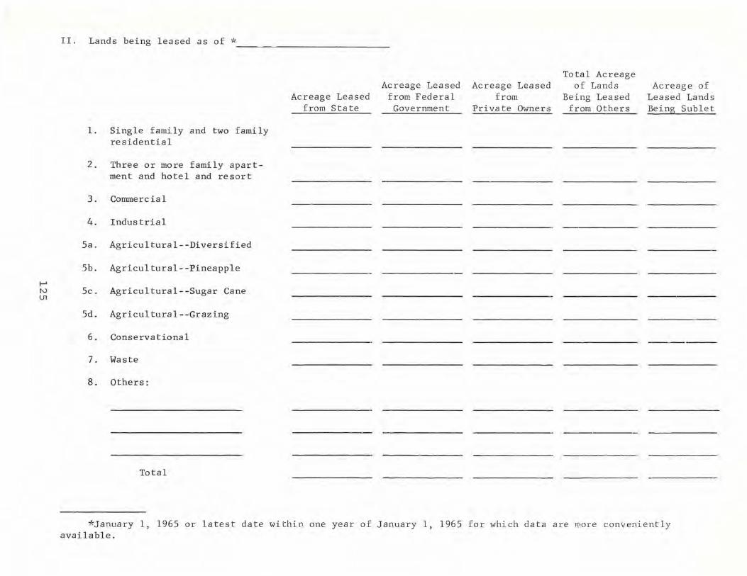
~
II. Lands being leased as of * ____________________________ _
1. Single family and two family residential
2. Three or more family apartment and hotel and resort
3. Corrunerc ia 1
4. Industrial
5a. Agricultural--Diversified
5b. Agricultural--Pineapple
Acreage Leased from State
Acreage Leased from Federal
Government
Acreage Leased from
Private Owners
Total Acreage of Lands
Being Leased from Others
Acreage of Leased Lands Being Sublet
N 5c. Agricultural--Sugar Cane en
5d. Agricultural--Grazing
6. Conservational
7. Waste
8. Others:
Total
*January 1, 1965 or latest date within one year of January 1, 1965 for which data are more conveniently available.

I-' tv
III . Amount of land acquired since 1950 :
-A. Amount of land bought:
Acres Consideration
r 1950-54
--1955-59
- --1960-64
~-- -- _ . _ ..
B , Amount of 1an.d acquired Rount of land ac-
by exchanges: qui red by new and
i renegotiated leases :
Ac re S7~ Value of I I land
Acres .
I
I
1-"--' I
~ _ .. -
0'1 IV. Amount of land relinquished since 1950:
1~~O - 54
A. Amount of voluntary land sales :
!- II
Acres Consideration
B. Amount of involuntary land sales (condemnation) ;
Acres
-t------
Considera tion
II 1955-59 I' j l't .~ I '. - - ,. .-_., '-r---'-' l~O-64 ' I __ J __ .. ____ _
C. Amount of land relinquished through exchanges :
"- ' r---"' Acres* ! Value of
land
I D, .. Amount of land reli~-
Pl'l shed through lease s
that have expired and ha ve not be e n renewed : !
. .. ----,
I Acree J H I
I j t-~· --- I
_. ___ .~ II ~
*Please indicate the amount of money paid and/or recei ved in add itio n to the alliou nt o f land exchanged if a monetary consideration wa s part of the exchange .

f-' N '-J
V. Number of cOlMlercial, diversified ag ricultural, industrial, and residential lots developed on la .ods held in fee by your f i rm or esta t e, and sold or lea sed sinc e 1950;
--COM MER C I A L D I V E R S I FIE D
A G RIC U L T U R A L -
Fee Lease Fee Lease
I No. of Acres No. of Acres No. of Acres No . of Acres lots lots lots lots
r-'
1950-54 -. -
1955-59
1960-64 I - -
I N D U S T R I A L RES IDE N T I A L
-,
1 ----------~. --------------_T-----------------------~~-------------------------,_-----------------------;
Fee Lease Fee Lease
No. Of } ' A No. ofT- A No . of A No . of A lots cres lots cres lots cres lots cres
- .-. - -'~-' - ---- - --------- f--. . -.----+r----~-_+--------.~-_+-----_+--------~
50-54 t-l~ -)·~·~5~-·- r - r--.- --------- -----.. I I
L~_~ . -- .,,-.-~- - - - r--- . ---~---i
l~ ;0 -64

I-' N CD
VI . Amount of agricultural lands (sugar, pineapple, diversi f ied crops, pig , poultry, and cattle farms, etc . ) which have been converted to r esidential, industrial or commercial areas since 1950:
Prior Agricultural Use Acres
1950-54
1955-59
1960-64

Appendix D
SPECIAL NOTES
A. A. Richardson 1,424.37 acres of fee simple land on Hawaii owned by A. A. Richardson has been classified as "commercial" throughout this report. It should be noted, however, that this acreage figure is an aggregate of land used for the following purposes: multi-family apartments, one and two family residences, and hotel, resort, or commercial purposes.
Alexander & Baldwin, Inc. Ti t le to 171. 00 acres acquired on Kauai by Alexander & Baldwin, Inc. from 1960 to 1964 was received through the merger of one of its former subsidiaries.
Charles Notley Estate The Estate has a 41.53 per cent undivided interest In the land listed under its name in this report.
Gay & Robinson Only a small part of the land listed in its name in this report is owned directly by the partnership of Gay and Robinson. Title to most of the land is held individually by the four living partners and by the heirs of a deceased partner.
James Robinson Properties Principle owners are Caroline J. Robinson Trust, J.L.P. Robinson Trust, Mark A. Robinson Trust, and James Robinson, Ltd.
Kohala Sugar Co. (Castle & Cooke, Inc.) Certain leases which were terminated between 1950-64 on Hawaii at the time of purchase of the land by Kohala Sugar Co. are not included in this report.
Maui Realty Co., Inc. Maui Realty Co., Inc., serves as a trustee or representative for a group of investors. 1,472.00 acres owned in fee by the company is not in present use and is being held for sale.
R. W. Meyer, Ltd. & A.A. Mever Family R. W. Meyer, Ltd. has a 175/216 interest in the land listed in its name in this report, while the A.A. Meyer family has a 41/216 interest.
129

Appendix D (Continued)
statistics were compiled by the Legislative Reference Bureau staff for the following landowners because they did not respond to the questionnaires sent to them concerning their landholdings and land program.
Hawaiian Ocean View Estate* Crescent Acres, Ltd.* S.C. & Pearl Friel Crawford Oil Corp.* Hawaiian Paradise Park Corp.* William B. Dunbar Roman Catholic Church H. P. Hustace Waianae Development Co.* Makaha Valley Farms, Ltd.* Hawaiian Evangelical Association
*The 23,765.63 acres of agricultural land held by these owners have been classified as "agricultural-diversified," although the land is suitable for such other agricultural purposes as sugar or pineapple cultivation or grazing.
130

Appendix E
METHODOLOGICAL CONSIDERATIONS
Identification of the major landowners included in this study was made from several sources, including a 1961 report prepared by the Legislative Reference Bureau on Major Landholdings in Hawaii, a 1965 report prepared by the Department of Taxation, and the scanning of all tax key maps of Hawaii. In addition, the Department of Taxation provided a special sorting of its key punched cards dealing with land ownership to insure complete coverage for this study.
To insure the adequacy of the questionnaires used for data gathering, drafts were sent for review to a number of major landowners. Specifically, drafts were reviewed by Alfred Dow of Bernice P. Bishop Estate, Oswald K. Stinder of Campbell Estate, Jack Palk of Oceanic Properties, Inc., John Loomis of AmFac, Inc., Kenneth Young of Dillingham Corporation, George R. Ewart III of C. Brewer & Co., Ltd., Harold Robinson of Theo H. Davies & Co., Ltd. and Charles James of the University of Hawaii.
Data analysis was facilitated by extensive use of high speed computer equipment. A copy of the complete print-out is available for inspection at the library of the Legislative Reference Bureau.
131

STATE-IJWNED LA N D (Map of Island of Hawaii appears on inside front cover)
KAUAI
N o R T H
.. STATE OF HAWAII
i:ffi;:i:::::;:::::i:1 HAWAIIAN HOMES LAND
CONTOUR INTERVAL· 1,000 FT.
OAHU
MOLOKAI
10
I
(NAUTICAL)
0
I
I I 10 0
(STAT)
MAU I
10
I
I 10