public meeting handout and comment sheet - ncdot
TRANSCRIPT

Page 1
THE PURPOSE OF THE OPEN HOUSE AND PUBLIC HEARING
NORTH CAROLINA DEPARTMENT OF TRANSPORTATION PUBLIC HEARING NOVEMBER 16, 2015 NCDOT STIP PROJECT NO. I-2513
Today’s hearing is another important step in the North Carolina Department of Transportation’s (NCDOT) procedure for making you, the public, a part of the project development process. The purpose of the hearing is to obtain public input on the location and design of the project.
There are two portions to today’s event, an informal open house and a formal public hearing.
View the DEIS and detailed project maps
Planning and environmental studies on the I-2513, I-26 Connector Project are available in the Draft Environmental Impact Statement (DEIS). Copies of the DEIS, along with today’s hearing maps, are available for review.
View the animated representation of the project
A visualization of some of the proposed alternatives for the project will be played continuously during the pre-hearing open house. Please take a moment to view this video with an explanation of the project.
Speak with project representatives
NCDOT representatives will be available between the hours of 4 p.m. and 6:30 p.m. to answer questions and receive comments relative to the proposed project.
Stay for the Public Hearing
A formal presentation will begin at 7 p.m. The presentation will consist of an explanation of the proposed corridor location, design, right of way, relocation requirements/procedures, and the state-federal relationship. The hearing will be open to those present for statements, questions and comments. The presentation and comments will be recorded and a transcript will be prepared. If you can not stay, the Public Hearing will be streamed, live, on the project website and you can submit comments online or through the mail.
PROJECT DESCRIPTION The I-26 Connector Project is an interstate freeway project that is being proposed to connect I-26 in southwest Asheville to US 19-23-70 in northwest Asheville. The NCDOT has programmed this project to upgrade and widen I-240 from I-40 to Patton Avenue, and then proceed northward from Patton Avenue on new location across the French Broad River and connect to US 19-23-70 just south of Exit 25 (Broadway). Upon completion, this project will be part of the I-26 Interstate that extends from Charleston, South Carolina, to Kingsport, Tennessee.
The proposed I-26 Connector in Asheville is approximately 7 miles long from the I-40 interchange to Broadway. The project includes three sections: C, A, and B.
Section C
Improvements to the I-26/I-240 interchange with I-40 and the Brevard Road and Smokey Park Highway interchanges.
Section A
Upgrading existing I-240 from the I-26/I-240 interchange with I-40 to the I-240 interchange with Patton Avenue, west of the French Broad River. This includes upgrades to the Brevard Road, Amboy Road, Haywood Road and Patton Avenue interchanges.
Section B
Construction of the interstate on new location from the Patton Avenue interchange north across the French Broad River, tying into US 19-23-70 south of Broadway.
Frequently Asked Questions Page 2
Project Purpose and Need Page 2
Public Review and Comment Page 3
Project Timeline Page 3
Detailed Study Alternatives Page 4
Section C Alternatives Pages 4-5
Section A Alternative Page 6
Section B Alternatives Pages 6-7
Inside This Handout:
Nearby Projects Page 8
Summary of Project Impacts by Section Pages 9-10

Page 2
PROJECT PURPOSE AND NEED
Why is the I-26 Connector needed? The project is needed to address traffic capacity problems along the existing I-240 corridor (future I-26), across the Captain Jeff Bowen Bridges to US 19-23-70. Presently numerous areas do not meet interstate design standards and cannot be designated I-26 without being improved. The project would improve traffic flow, address the substandard roadway features, and provide an interstate roadway through West Asheville for the I-26 Corridor.
How will traffic operate if the project is not built? Traffic operations are evaluated using a “Level of Service” rating ranging from A (best) to F (worst). If no improvements are made, in 2033, 41 of the 80 freeway elements will operate at an unacceptable level of service, based on Federal Highway Administration standards. The completion of portions of the adjacent NCDOT Project A‑0010A (US 19-23-70 improvements from Asheville to the Tennessee state line) will further increased traffic demands along I-240 west of Asheville.
What are the roadway deficiencies along the existing corridor? The existing route serving I-26 traffic has numerous design deficiencies that do not meet interstate design standards. The corridor was evaluated based on 19 design criteria, and 24 locations were shown to have elements that were substandard. Multiple segments of I-240 west of Asheville currently have an accident rate that exceeds the critical crash rate for similar North Carolina facilities, demonstrating the need for these improvements along this section of the facility.
Project Hotline/Línea Gratutita del Proyecto: 1-800-233-6315 http://www.ncdot.gov/projects/i26connector/
GENERAL
What is the DEIS? In accordance with the National Environmental Policy Act (NEPA) NCDOT prepared a Draft Environmental Impact Statement (DEIS) for the I-26 Connector Project. The DEIS is a federally required environmental document that de-scribes the purpose and need for the project, identifies project alternatives, and evaluates them for potential environmental effects.
Are the Designs Final? The design plans shown at the Public Hearing are prelim-inary and have not been finalized. Additional infor-mation including traffic forecasts and updated property information may result in modifications of right-of-way limits, the limits of construction, road curves, or pavement markings.
Has a Preferred Alternative Been Selected? At this point, a preferred alternative has not been select-ed. All alternatives under consideration are presented in the DEIS and to the project team for selection of the pre-ferred alternative.
What’s Next? The next step in the planning process will be to summa-rize comments received at the public hearing and choose the Preferred Alternative. Your comments and recommen-dations will be on public record and will be considered when selecting the Preferred Alternative and to assist in developing the final design of the project.
When Will Construction Start? Section C of the project will be the first to start construc-tion and is scheduled to begin in 2021. Section B con-struction will commence in 2024, and Section A will begin in later years.
PROJECT INFORMATION
State-Federal Relationship The proposed project is a Federal-Aid Highway Project and thus will be constructed under the State-Federal Aid Highway Program. Financing of this project will be 80% Federal funds and 20% State funds through the National Highway System Program. The Board of Transportation is re-
sponsible for the selection and scheduling of projects on the Federal Aid System, including their location, design and maintenance cost after con-struction. The Federal Highway Administration is responsible for the re-view and approval of the previously mentioned activities to ensure that
each Federal Aid Project is designed, constructed and maintained to Federal Aid Standards.

Page 3
WHERE TO REVIEW PROJECT INFORMATION The DEIS and Public Hearing Maps are available for public viewing at the following locations:
The DEIS is also available for public viewing at the following public li-brary locations:
People can also view the materials at the project website at http://www.ncdot.gov/projects/i26connector/
PROJECT INFORMATION
What is done with input received? A post-hearing meeting will be conducted after the comment period has ended. NCDOT staff representing Planning, Design, Traffic Operations, Division, Right of Way, Public Involvement, Community Studies, and others who play a role in the develop-ment of a project will attend this meeting. The project will also be reviewed with federal agencies such as the Federal High-way Administration (FHWA) and the US Army Corps of Engineers (USACE), as well as state agencies such as the NC Depart-ment of Environment and Natural Resources. When appropriate, local government staff may also attend.
All spoken and written comments are discussed at the post-hearing meeting. Most issues are resolved at the post-hearing meet-ing. The NCDOT considers safety, costs, traffic service, social impacts and public comments in making decisions. Complex issues may require additional study and may be reviewed by higher management, Board of Transportation Members and/or the Secretary of Transportation.
Minutes of the post-hearing meeting will be summarized and are available to the public by noting your request on the comment sheet. Once distributed, the post-hearing meeting minutes will also be posted on the project website.
State Library of North Carolina: 109 East Jones Street
Raleigh, North Carolina 27601
Pack Memorial Library: 67 Haywood Street
Asheville, North Carolina 28801
West Asheville Library 942 Haywood Road
Asheville, North Carolina 28806
Buncombe County Law Library 60 Court Plaza
Asheville, North Carolina 28801
YOUR PARTICIPATION Now that the opportunity is here, you are encour-aged to participate by making your comments and/or questions a part of the public record. This may be done by having them recorded at the formal Public Hearing, calling the project hotline at 1-800-233-6315, or by writing them on the attached com-ment sheet. Several representatives of the North Carolina Department of Transportation are present. They will be happy to talk with you, explain the de-sign to you and answer your questions. You may write your comments or questions on the comment sheet and leave it with one of the representatives or mail them by December 16, 2015 to the following address:
Mr. Drew Joyner, P.E. NCDOT - Human Environment Section
1598 Mail Service Center Raleigh, NC 27699-1598 Email: [email protected]
1-800-233-6315
Additionally, comments can be submitted through EngageNCDOT, an interactive public engagement tool at http://engagencdot.mysidewalk.com/
Everyone present is urged to participate in the pro-ceedings. It is important, however, that the opinions of all individuals be respected regardless of how different they may be from your own. Accordingly, debates, as such, are out of place at public hearings. Also, the public hearing is not to be used as a popu-lar referendum to determine the location and/or design by a majority vote of those present.
PROJECT TIMELINE
NCDOT Division 13 55 Orange Street
Asheville, North Carolina 28801
City of Asheville Transportation 70 Court Plaza—Mezzanine Level Asheville, North Carolina, 28802
NCDOT Mission Statement: Connecting people, products, and places safely and efficiently with customer focus, accountability and environmental sensitivity to enhance the economy and vitality of North Carolina.
Page 4
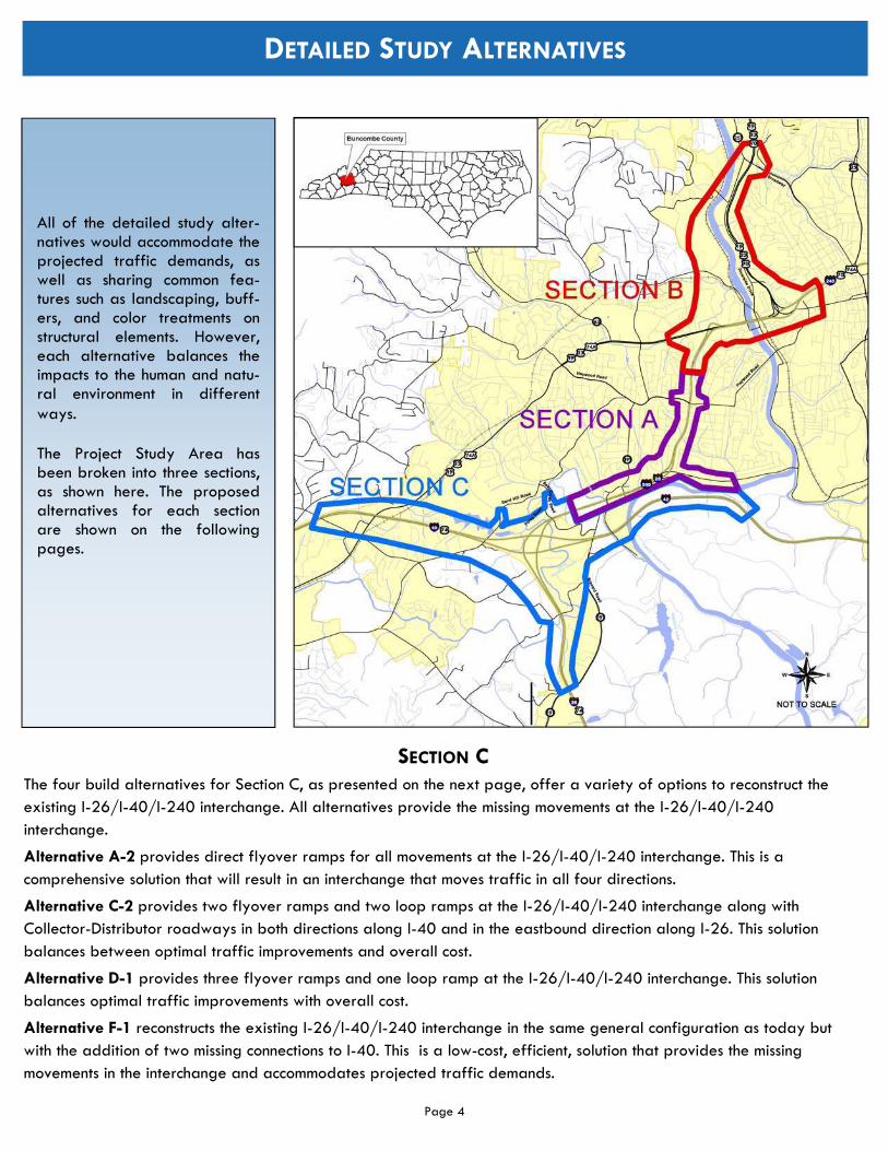
DETAILED STUDY ALTERNATIVES
All of the detailed study alter-natives would accommodate the projected traffic demands, as well as sharing common fea-tures such as landscaping, buff-ers, and color treatments on structural elements. However, each alternative balances the impacts to the human and natu-ral environment in different ways.
The Project Study Area has been broken into three sections, as shown here. The proposed alternatives for each section are shown on the following pages.
SECTION C The four build alternatives for Section C, as presented on the next page, offer a variety of options to reconstruct the existing I-26/I-40/I-240 interchange. All alternatives provide the missing movements at the I-26/I-40/I-240 interchange.
Alternative A-2 provides direct flyover ramps for all movements at the I-26/I-40/I-240 interchange. This is a comprehensive solution that will result in an interchange that moves traffic in all four directions.
Alternative C-2 provides two flyover ramps and two loop ramps at the I-26/I-40/I-240 interchange along with Collector-Distributor roadways in both directions along I-40 and in the eastbound direction along I-26. This solution balances between optimal traffic improvements and overall cost.
Alternative D-1 provides three flyover ramps and one loop ramp at the I-26/I-40/I-240 interchange. This solution balances optimal traffic improvements with overall cost.
Alternative F-1 reconstructs the existing I-26/I-40/I-240 interchange in the same general configuration as today but with the addition of two missing connections to I-40. This is a low-cost, efficient, solution that provides the missing movements in the interchange and accommodates projected traffic demands.

Page 5
DETAILED STUDY ALTERNATIVES—SECTION C
Section C: Alternative C2 Section C: Alternative A2
Section C: Alternative D1 Section C: Alternative F1

Page 6
Section A: I-240 Widening Alternative
DETAILED STUDY ALTERNATIVES—SECTION A
SECTION B The four build alternatives for Section B, as presented on the next page, offer a variety of options for crossing the French Broad River and connecting to US 19-23-70 at the northern end of the project.
Alternative 3 separates I-240 and I-26, with I-26 running north along a new alignment and I-240 continuing over the Captain Jeff Bowen Bridges as it does currently.
Alternative 3C follows the same alignment as Alternative 3, but crosses the French Broad River on two bridges further south.
Alternative 4 separates the local traffic on Patton Avenue from the I-240 through traffic, but otherwise follows a similar route as Alternative 3.
Alternative 4B also separates the local traffic on Patton Avenue from the I-240 through traffic, otherwise following a similar route as alternative 3C.
SECTION A There is one build alternative for Section A, which would widen I-240 from four lanes to eight lanes and provide upgrades at three interchanges.
The interchange with Brevard Road would have limited connectivity because of close proximity to the Amboy Road interchange. I-26 East/I-40 West traffic would exit at an upgraded Amboy Road interchange and travel along a new extension of Amboy Road to Brevard Road.
This extension of Amboy Road would connect to Fairfax Avenue and Virginia Avenue and continue to an intersection at Brevard Road.
A third interchange, at Haywood Road, would be convert-ed to a tight urban diamond configuration. This design would relocate the current exit ramp from I-240 East that connects to Hanover Street and relocate it to connect di-rectly to Haywood Road. The current two-way section of ramp in the northeast quadrant would also be eliminated.
Bicycle and Pedestrian Accommodations
The City of Asheville has multiple plans to address bicycle and pedestrian accommodations throughout the city. In harmony with these plans, a greenway is proposed along Section A and all of the Section B alternatives. The greenway begins at Haywood Road and will follow the I-26 improvements in Section B, where it merges with Pat-ton Avenue to cross the French Broad River and ties to the nearby streets, providing access to downtown Asheville. In addition, the proposed designs include multiple connections throughout the project area to existing sidewalks, bike paths, or transit routes.

Page 7
Section B: Alternative 4
Section B: Alternative 3 Section B: Alternative 3C
Section B: Alternative 4B
DETAILED STUDY ALTERNATIVES—SECTION B

Page 8
NEARBY PROJECTS
NCDOT STIP Project No. A-0010A, US 19/23 (Future I-26) Improvements Project:
NCDOT is proposing to improve approximately 12 miles of US 19/23 from north of I-240 in Asheville to just south of Exit 13 (Forks of Ivy – Stockton Road) near Mars Hill. This project is currently in the early stages of the planning process.
NCDOT STIP Project No. I-5504/Brevard Road Interchange project (Exit 33):
NCDOT is modifying an existing partial cloverleaf interchange, primarily to alleviate congestion by increasing the efficiency of the interchange. The project may include the widening of the NC 191 (Brevard Road) bridge over I-26.
NCDOT STIP Project No. I-4400/I-4700, I-26 Widening Project:
NCDOT is proposing to widen approximately 22 miles of I-26 from US 25 (Exit 54) in Hen-derson County to I-40 in Asheville. This pro-ject is about to begin the preliminary design process.
NCDOT STIP Project No. I-4759, I-40/SR 1228 (Liberty Road) Interchange:
NCDOT is converting the existing grade separa-tion at SR 1228 (Liberty Road) and I-40 to an interchange and constructing a two-lane road-way between US 19/US 23/NC 151 to SR 1224 (Monte Vista Road) .

Summary of Project Impacts by Section
Resource
Section C Section A Section B
(New Location across French Broad) (I-26/I-40/I-240 Interchange)
Alt. A-2 Alt. C-2 Alt. D-1 Alt. F-1 I-240 Widening Alt. 3 Alt. 3C Alt. 4 Alt. 4B
Project Features
Length (miles)
I-26 2.2 2.2 2.2 2.2 2.0 2.4 2.5 2.4 2.5
I-40/I240 2.9 3.2 2.8 2.8 0.0 0.6 0.6 1.5 1.5
Total Length 5.1 5.4 5.0 5.0 2.0 3.0 3.1 3.9 4.0
Interchanges 3 3 3 3 3 2 2 3 3
Railroad Crossings 2 2 2 2 0 3 3 8 5
Navigable Waterway Crossings 1 1 1 1 0 2 3 4 4
Construction Cost $286,100,000 $269,700,000 $263,100,000 $203,300,000 $105,700,000 $190,200,000 $191,200,000 $255,600,000 $291,300,000
Right-of-Way Cost $26,600,000 $22,400,000 $33,800,000 $17,100,000 $29,400,000 $42,800,000 $36,200,000 $45,500,000 $36,800,000
Utilities Cost $2,200,000 $2,000,000 $2,300,000 $2,100,000 $3,400,000 $3,100,000 $3,300,000 $3,600,000 $3,900,000
Total Cost $314,900,000 $294,100,000 $299,200,000 $222,500,000 $138,500,000 $236,100,000 $230,700,000 $304,700,000 $332,000,000
Socioeconomic Features
Relocations
Residential 50 32 38 31 81 34 23 46 33
Business 6 6 7 5 17 24 33 24 34
Nonprofit 0 0 0 0 1 2 1 2 1
Total 56 38 45 36 99 60 57 72 68
Schools Relocated 0 0 0 0 1 0 0 0 0
Churches Relocated 1 1 1 1 1 0 0 1 1
Parks and Recreational Areas Impacted 1 1 1 1 2 0 0 0 0
Cemeteries Impacted 0 0 0 0 0 0 0 0 0
Physical Environment
Noise Impacts (No-Build) 193 193 193 193 181 94 94 243 243
Noise Impacts (before abatement) 218 255 214 304 198 193 133 312 224
Noise Impacts (after abatement) 188 225 184 274 94 60 37 126 89
Hazardous Material Sites (moderate or high) Impacted 1 1 1 1 0 1 1 1 1

Resource
Section C Section A Section B
(New Location across French Broad) (I-26/I-40/I-240 Interchange)
Alt. A-2 Alt. C-2 Alt. D-1 Alt. F-1 I-240 Widening Alt. 3 Alt. 3C Alt. 4 Alt. 4B
Floodplain Impacts (acres) 20.53 20.39 18.06 16.63 8.36 9.36 7.65 8.13 3.91
Floodway Impacts (acres) 2.74 4.23 2.27 2.00 1.94 2.88 2.96 0.69 0.38
Land Use Impacts by Zoning Category (acres)
Residential Single-Family Districts 19.3 12.7 19.7 12.5 8.4 4.0 4.3 6.4 7.5
Residential Multifamily Districts 21.4 15.4 15.2 16.0 26.5 26.5 17.0 27.6 17.0
Neighborhood Business District 0 0 0 0 0 0.2 0.2 0.3 0.1
Community Business Districts 0.0 0.0 0.0 0.0 4.9 0.1 0.1 0.04 0.0
Industrial 0 0 0 0 0 4.0 0.0 2.4 0.4
Institutional District 38.6 38.6 35.4 34.5 13.6 0.4 0.4 0.2 0.4
Office 0.0 0.0 0.0 0.0 0.0 0.0 0.0 0.0 0.0
Highway Business District 11.4 9.6 9.7 7.8 1.9 14.8 15.8 14.0 14.3
Regional Business District 32.3 32.4 34.1 27.1 0.0 15.4 15.4 9.3 10.5
Central Business District 0.0 0.0 0.0 0.0 0.4 0.0 0.0 0.2 0.3
Commercial 28.7 31.4 30.8 24.8 2.7 0.0 0.0 0.0 0.0
Resort District 0.0 0.0 0.0 0.0 0.0 22.1 21.5 37.2 19.6
River District 0.0 0.0 0.0 0.0 6.3 11.2 24.8 16.1 22.3
Total 151.8 140.1 144.9 122.6 64.7 98.9 99.7 113.7 92.5
Human Environment
Community Effects (# of communities within or adjacent to study area with benefit or burden from proposed alternatives)
High Benefit - - - - - - - - -
Moderate Benefit - - - - - - - 1 1
Low Benefit - - - - - - - 2 2
Neutral - - 2 - 1 5 5 1 1
Low Burden 2 2 - 2 3 4 4 4 4
Moderate Burden - - - - 1 1 1 2 2
High Burden - - - - - - - - -
Cultural Resources
Historic Properties – Section 106 Effects 0 0 0 0 1 Adverse Effect 0 0 0 1 Adverse
Effect

Resource
Section C Section A Section B
(New Location across French Broad) (I-26/I-40/I-240 Interchange)
Alt. A-2 Alt. C-2 Alt. D-1 Alt. F-1 I-240 Widening Alt. 3 Alt. 3C Alt. 4 Alt. 4B
Historic Properties Impacted 2 2 1 1 2 2 2 2 2
Archeological Sites Impacted 5 6 5 6 2 1 1 1 0
Natural Environment
Biotic Resources (acres)
Maintained/ disturbed 192.86 191.47 188.84 171.93 91.08 87.85 83.96 126.50 124.82
Mesic Mixed Forest 140.72 137.11 135.08 111.26 47.41 39.02 33.32 40.02 40.67
Alluvial Hardwood Forest 8.97 9.11 8.33 6.55 1.50 5.87 4.76 3.10 3.88
Open Water 0.19 0.39 0.24 0.17 0 0.00 0.00 0.00 0.00
Total 342.75 338.07 332.49 289.90 139.99 132.74 122.04 169.63 169.37
Impervious Surface Increase (acres) 74.43 82.03 61.33 57.12 27.45 29.68 28.37 38.26 40.45
Stream Impacts (#) 12 12 13 12 4 7 6 6 7
Stream Impacts (linear feet) 2,965 2,779 2,938 1,984 798 3,874 3,639 1,839 2,128
Wetland Impacts (#) 13 12 13 12 1 3 2 4 2
Wetland Impacts (acres) 2.62 2.36 2.01 1.86 0.01 0.22 0.11 0.22 0.10
Pond Impacts(#) 0 0 0 0 0 3 0 3 0
Pond Impacts(acres) 0 0 0 0 0 0.6 0 0.53 0
Protected Species Adversely Affected 0 0 0 0 0 0 0 0 0 aStream, wetland, and pond impacts calculated using design slope stakes plus 25-foot buffer. All other impacts calculated using right-of-way.

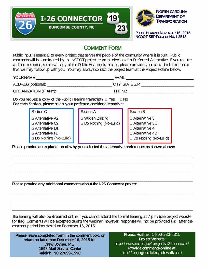
COMMENT FORM
NORTH CAROLINADEPARTMENT OFTRANSPORTATION
PUBLIC HEARING NOVEMBER 16, 2015NCDOT STIP PROJECT NO. I-2513
Public input is essential to every project that serves the people of the community where it is built. Publiccomments will be considered by the NCDOT project team in selection of a Preferred Alternative. If you requirea direct response, such as a copy of the Public Hearing transcript, please provide your contact information sothat we may follow up with you. You may always contact the project team at the Project Hotline below.
YOUR NAME: ______________________________________ EMAIL: _________________________________
ADDRESS (optional): ________________________________ CITY, STATE, ZIP: __________________________
ORGANIZATION (IF ANY): ____________________________PHONE: ________________________________
Do you request a copy of the Public Hearing transcript? □ Yes □ NoFor each Section, please select your preferred corridor alternative:
Please provide an explanation of why you selected the alternative preferences as shown above:
_________________________________________________________________________________________
_________________________________________________________________________________________
_________________________________________________________________________________________
_________________________________________________________________________________________Please provide any additional comments about the I-26 Connector project:
_________________________________________________________________________________________
_________________________________________________________________________________________
_________________________________________________________________________________________
The hearing will also be streamed online if you cannot attend the formal hearing at 7 p.m. (see project websitefor link). Comments will be accepted during the webinar; however, responses will not be provided until after thecomment period has closed on December 16, 2015.
Project Hotline: 1-800-233-6315Project Website:
http://www.ncdot.gov/projects/i26connector/Provide comments online at:
http://engagencdot.mysidewalk.com/
Please leave completed form in the comment box, orreturn no later than December 16, 2015 to:
Drew Joyner, P.E. 1598 Mail Service CenterRaleigh, NC 27699-1598
Section C
□ Alternative A2□ Alternative C2□ Alternative D1□ Alternative F1□ Do Nothing (No-Build)
Section A
□ Widen Existing□ Do Nothing (No-Build)
Section B
□ Alternative 3□ Alternative 3C□ Alternative 4□ Alternative 4B□ Do Nothing (No-Build)
Mr. Drew Joyner, PE NCDOT Human Environment Section 1598 Mail Service Center Raleigh, NC 27699-1598

TITLE VI PUBLIC INVOLVEMENT FORM Completing this form is completely voluntary. You are not required to provide the information requested in order to participate in this meeting.
Meeting Type: Public Hearing Location: Renaissance Hotel, Asheville, North Carolina
Date: November 16, 2015
TIP No.: I-2513 Project Description: I-26 Connector
In accordance with Title VI of the Civil Rights Act of 1964 and related authorities, the North Carolina Department of Transportation (NCDOT) assures that no person(s) shall be excluded from participation in, denied the benefits of, or subjected to discrimination under any of the Department’s programs, policies, or activities, based on their race, color, national origin, disability, age, income, or gender.
Completing this form helps meet our data collection and public involvement obligations under Title VI and NEPA, and will improve how we serve the public. Please place the completed form in the designated box on the sign-in table, hand it to an NCDOT official or mail it to the PDEA-Human Environment Section, 1598 Mail Service Center, Raleigh, NC 27699-1598.
All forms will remain on file at the NCDOT as part of the public record.
Zip Code: _____________________
Street Name: (i.e. Main Street)
Gender: Male Female
Age: Less than 19 20-24 25-34 35-44 45-54 55-59 60-64 65-74 75-84 85 or over
Total Household Income:
Less than $10,000 $50,000 – $74,999 $10,000 – $14,999 $75,000 – $99,999
$15,000 – $24,999 $100,000 – $149,000 $25,000 – $34,999 $150,000 - $200, 000 $35,000 – $49,999 $200,000 or more
Have a Disability: Yes No
Race/Ethnicity: White Black/African American Asian American Indian/Alaskan Native Native Hawaiian/Pacific Islander Hispanic/Latino Other (please specify): _______________________
National Origin: (if born outside the U.S.)
Mexican Central American: ____________________ South American: _____________________ Puerto Rican Chinese Vietnamese Korean Other (please specify): __________________
How did you hear about this meeting? (newspaper advertisement, flyer, and/or mailing)
_____________________________________________________________________________________
For more information regarding Title VI or this request, please contact the NCDOT Title VI Section at (919) 508-1808 or toll free at 1-800-522-0453, or by email at [email protected].
Thank you for your participation!