public safety and homeland security situational awareness · situational awareness ... there are...
TRANSCRIPT

An ESRI ® White Paper • February 2008
Public Safety and Homeland Security Situational Awareness
ESRI 380 New York St., Redlands, CA 92373-8100 USA TEL 909-793-2853 • FAX 909-793-5953 • E-MAIL [email protected] • WEB www.esri.com

Copyright © 2008 ESRI All rights reserved. Printed in the United States of America. The information contained in this document is the exclusive property of ESRI. This work is protected under United States copyright law and other international copyright treaties and conventions. No part of this work may be reproduced or transmitted in any form or by any means, electronic or mechanical, including photocopying and recording, or by any information storage or retrieval system, except as expressly permitted in writing by ESRI. All requests should be sent to Attention: Contracts and Legal Services Manager, ESRI, 380 New York Street, Redlands, CA 92373-8100 USA. The information contained in this document is subject to change without notice. ESRI, the ESRI globe logo, www.esri.com, and @esri.com are trademarks, registered trademarks, or service marks of ESRI in the United States, the European Community, or certain other jurisdictions. Other companies and products mentioned herein may be trademarks or registered trademarks of their respective trademark owners.

J-9698
ESRI White Paper i
Public Safety and Homeland Security Situational Awareness
An ESRI White Paper Contents Page Executive Summary .............................................................................. 1 Introduction ........................................................................................... 1 Situational Awareness ........................................................................... 1
The Role of GIS in Situational Awareness ..................................... 2 Enabling/Creating Situational Awareness ...................................... 2
Common Data Sources for Public Safety Situational Awareness ............................................................. 3
Applied Situational Awareness in Public Safety Functions ................. 4
Emergency Dispatcher Situational Awareness ............................... 4 Wildland Fire Fatality Synopsis................................................ 5 Exposed to Worsening Conditions............................................ 5 Knowledge of Available Information ....................................... 5 How GIS Enhances Situational Awareness .............................. 6
First Responders and Incident Command Situational Awareness .. 7 Homeland Security and Emergency Management Situational Awareness ................................................................... 8
Technology Landscape ......................................................................... 10
Devices ............................................................................................ 10 Networks ......................................................................................... 12 Applications and Data ..................................................................... 13
Dynamic Acquisition, Routing, and Storage ............................ 13 Geographic Information Systems ............................................. 13 Hardware Servers ...................................................................... 14 Analytical Tools ........................................................................ 14 Geodata Services or GIS Web Services .................................... 14 Map Client ................................................................................ 15
Conclusion ............................................................................................ 15

J-9698
ESRI White Paper
Public Safety and Homeland Security Situational Awareness
Executive Summary Historically, the most common means of obtaining situational awareness would be to identify what information is required for the mission and search through printed material, data repositories, Web links, news media, and voice communication. This manual process is very time-consuming and may not produce timely results. As such, IT infrastructure and systems have to be developed to collect data and information from disparate sources, process the data into logical outputs, and push it to the user to make better and more informed decisions. The systematic process of obtaining the right information at the right place and time is optimized by geographic information system (GIS) technology. GIS is an essential technology for providing public safety personnel with enhanced situational awareness. Data and information stored or hyperlinked via a geodatabase provide intuitive, actionable information in the context of a map. The key is to acquire, process, and present geographically represented data so the user doesn't have to search for it. The information should be contextualized and relevant based on the mission, workflow, and tasks being performed. This capability provides situational awareness in all phases of public safety and emergency management from preparedness to recovery. Creating the capability of preventing or responding to a crisis requires access to comprehensive information and data for the organization and adjacent areas. This includes emergency plans as well as geographic data/imagery and dynamic data such as incidents, threats, and weather. To avoid information overload, data sources should be prioritized based on mission requirements. Dynamic data from sensors such as video, weather, and traffic can provide additional insight to support the mission and heighten situational awareness.
Introduction The purpose of this white paper is to describe how GIS technology is an essential capability for situational awareness in the missions of homeland security and public safety. It will discuss a systematic approach for implementing GIS and other required technologies to achieve comprehensive situational awareness.
Situational Awareness
Situational awareness is a human experience defined as
Knowing and understanding what is happening around you Predicting how it will change with time Being unified with the dynamics of your environment
These are important concepts for understanding which technology is required to achieve desired results. Situational awareness and its dynamic nature are new knowledge as well as spatial knowledge. Ever-changing circumstances mean a constantly evolving situation or event. Having the ability to understand the severity of those circumstances in advance of or during an emergency can mean the difference between life and death. The ability to predict or model and visualize how the circumstances of a pending or evolving emergency may change over specific times allows emergency managers to allocate resources to priority areas before further damage or loss of life occurs. Having

Public Safety and Homeland Security Situational Awareness
J-9698
February 2008 2
comprehensive information relevant to the specific location of an incident and related, surrounding areas, as well as the location of public safety resources and personnel, is an example of how dynamic and spatial data are combined to create situational awareness.
Contextual Computing The process of using technology to deliver a human experience such as situational awareness can be referred to as contextual computing. Contextual computing deals with how information about users, data, systems, and environmental sensors can be taken into account to enhance the output an application displays in a user interface.
The Role of GIS in
Situational Awareness
Situational awareness is achieved by integrating a myriad of technologies to provide users with access to information based on their circumstances. GIS provides the capability of data to be georeferenced, enhancing the user's ability to understand, react, and make decisions based on a set of circumstances presented in a geographic context. GIS technology, integrated with technologies such as sensors, GPS and location tracking, enterprise applications, and networking, can provide the contextual computing processing required to get the right information about the right place at the right time.
Enabling/Creating Situational Awareness
Situational awareness is a human mental process that can be enhanced using technology to access, analyze, and present information to have a greater understanding of existing conditions and how they will change over time. GIS technology can assemble data from various and disparate sources into relevant information for actionable intelligence. The Situational Awareness Taxonomy below illustrates a sample of types of data that can be interfaced with GIS to accomplish situational awareness in a public safety and homeland security mission.

Public Safety and Homeland Security Situational Awareness
J-9698
ESRI White Paper 3
Figure 1 GIS Situational Awareness Taxonomy
Common Data Sources for Public Safety Situational
Awareness
Commonly used applications and solutions such as computer-aided dispatch (CAD), GIS, automatic vehicle location (AVL), records management systems (RMS), weather services, video camera feeds, dashboards, and some enterprise applications provide the opportunity to select the desired data to create specific situational awareness for the public safety mission.
Computer-Aided Dispatch Provides Incident Data CAD is a source of event, incident, and resource availability data. New incidents and unit statuses are captured within CAD, providing an accurate picture of what is occurring in the community as well as the community's capacity to handle and respond to new incidents
AVL Tracks Location of Resources
AVL is instrumental in delivering information relevant to a user's location. When interfaced with other server-based technologies, AVL records the user's position so data and information relating to the public safety user's location and activity can be provided, displayed, and accessed on a map on a mobile data terminal, in an Emergency Operations Center (EOC), or on other connected computer systems.

Public Safety and Homeland Security Situational Awareness
J-9698
February 2008 4
GIS Aggregates Data in a Spatial Context GIS can access and display data from local GIS databases or other GIS services. In addition to incident locations, emergency responders and incident commanders need to know the location of essential resources, assets, and infrastructure such as other units, fire hydrants, water and sewer lines, power lines, communication towers, hospitals, schools, and nursing homes. This data, when combined with planning and assessment data (high-risk areas, hazard areas, critical infrastructure, etc.), results in relevant and actionable information.
RMS Provides Historical Information
RMS provides historical incident data such as locations of crimes and fires, emergency medical responses (including vehicle and personal injury accidents), and citizen assist responses. RMS location information provides emergency responders and commanders with premise history, which is essentially a list of details on repeat calls at the same location, citizens with special needs, or other vital information such as types of hazardous materials stored in that particular location.
Applied Situational
Awareness in Public Safety Functions
Public safety functions achieve situational awareness by accessing information through a combination of manual and/or electronic means. At the basic level, there is the need to know incident information, risk/hazard locations, and resources locations. Each role, from dispatcher to command and control, requires access to information. However, information requirements are role-specific and vary in degrees of urgency. An incident commander or emergency responder requires very timely information, whereas a dispatcher requires mainly status updates. There are common software solutions providing situational awareness to the following public safety functions:
911 dispatch and communications First responder and incident command Homeland security and emergency management
Emergency Dispatcher Situational Awareness
A public safety communication center is essentially a centralized hub for disseminating and broadcasting information to law enforcement and fire/rescue personnel operating in the field. To effectively assist personnel in the field, a public safety dispatcher should have access to a variety of information sources. Many of those information sources are included in the situational awareness taxonomy. In addition to the traditional information obtained through radio and communication traffic, the following data and information are increasingly being requested to be made accessible to a dispatcher:
Incidents and related information such as nearest exposures and premise history
Resource availability and/or capability
Location of critical infrastructure and assets
Roadway conditions such as traffic congestion and blocked routes
Environmental conditions and factors such as terrain and weather

Public Safety and Homeland Security Situational Awareness
J-9698
ESRI White Paper 5
Event information from news media and public reports
Sensors such as surveillance videos, gunshot detection, and smoke and hazardous material leakage detection
Public safety/911 dispatchers would derive more value from the CAD map display with additional relevant information. The average CAD map display contains street information, incident locations, and, perhaps, unit location obtained through AVL. While that information is important, it merely scratches the surface of what an effective geospatial CAD solution can provide.
Wildland Fire Fatality Synopsis
An arsonist started a wildland fire in Southern California that claimed the lives of four firefighters in the field and later a fifth who was unable to recover from burn injuries. The incident illustrates the need for applied situational awareness.
Exposed to Worsening Conditions
During the early hours of the fire, the crew of five firefighters traveled up a long dirt road to a knoll in a moderately steep canyon to protect a house from the wildfire. The crew felt they could provide structure protection for the evacuated home that sat on the knoll within a canyon. A moderate distance away from the home was a very steep, major drainage ditch in which the wildfire had become established. In addition, strong winds were driving the fire toward the location of the crew at high speed. The crew could not see the rapidly moving fire in the steep canyon below them; the crew did not have complete situational awareness. When the fire came out of the canyon, it rapidly overwhelmed the knoll. The situation was not survivable.
Knowledge of Available Information
An investigation of the incident determined that a GIS analysis had been previously completed that indicated the area would experience extreme fire behavior conditions and was highly vulnerable to intense wildfire conditions. This analysis and the related maps were not available to the crew or others in the field. While professional experience (knowledge of wildland fire behavior in a specific topology) and human senses (wind strength and visual reference) would have provided sufficient cause for alarm, the crew still lacked situational awareness and responded only to what they were able to see at the time. The outcome may have been different if the five firefighters and incident operations personnel had understood the situation in its entirety. Neither group had access to information suggesting the fire hazard below was extreme, and the wind, topography, and wildfire behavior combined to make the situation unsurvivable. This lack of overall situational awareness can be overcome when systems are applied that provide actionable information when and where it is needed.
Public Safety and Homeland Security Situational Awareness
J-9698
February 2008 6
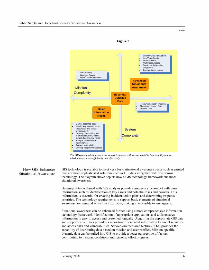
Figure 2
The GIS-enhanced situational awareness framework illustrates scalable functionality to meet mission needs more efficiently and effectively.
How GIS Enhances Situational Awareness
GIS technology is scalable to meet very basic situational awareness needs such as printed maps or more sophisticated solutions such as GIS data integrated with live sensor technology. The diagram above depicts how a GIS technology framework enhances situational awareness. Basemap data combined with GIS analysis provides emergency personnel with basic information such as identification of key assets and potential risks and hazards. This information is essential for creating incident action plans and determining response priorities. The technology requirements to support basic elements of situational awareness are minimal as well as affordable, making it accessible to any agency. Situational awareness can be enhanced further using a more comprehensive information technology framework. Identification of appropriate applications and tools ensures information is easy to access and presented logically. Acquiring the appropriate GIS data and support capabilities provides a repository of essential information to model scenarios and assess risks and vulnerabilities. Service-oriented architecture (SOA) provides the capability of distributing data based on mission and user profiles. Mission-specific, dynamic data can be pulled into GIS to provide a better perspective of factors contributing to incident conditions and response effort progress.
Advanced Situational Awareness
Essential Dynamic
Data
Basic Information
Needs
Mission Complexity
• Sensory Data Integration • Live Video Feeds • Weather Data • Multimedia Access• Enterprise Application
Integration • Transportation Layers
• Resource Location Tracking • Threat and Hazard Data• Incident Data
• Gather basemap data.• Identify key asset locations
( population and criticalinfrastructure).
• Develop potential hazard map (earthquakes, storm surges, flooding, fire risks)
• Analyze value/hazard relationships
• Analyze vulnerabilities.• Develop mitigation measures.
• Data Sharing• Wireless Access• Workflow Management
System
Complexity

Public Safety and Homeland Security Situational Awareness
J-9698
ESRI White Paper 7
First Responders and Incident Command
Situational Awareness
The wildland fire fatalities example above provides a tragic reminder of how important it is to maintain situational awareness and safety during incident operations. The demands associated with responding to and managing an emergency event require a significant amount of dynamic information from disparate sources. Acquiring, analyzing, making sense of, and disseminating the volumes of information can be challenging, particularly when combined with the physical aspects of an incident. Physical and environmental barriers such as protective clothing, low visibility, exposure to heat/water/ hazardous materials, confined and remote spaces, and general mobility issues dictate that vital information should be pushed to the user rather than the user having to search for it. The unpredictable nature of human behavior makes the need for situational awareness in law enforcement essential. An officer approaching the scene of a crime, whether in progress or after the fact, is exposed to unknown risks and dangers. Eliminating the element of mystery by enhancing situational awareness places the officer in a better position to protect himself, victims, and bystanders, enabling a safer resolution. Information pertaining to prior or repeat calls to the same location can provide officers with a better sense of what they may run into during a new response. Details such as prior criminal records, previous weapons involvement, and the presence of drugs and narcotics are valuable in determining how to best approach a scene. Managing and enabling information for situational awareness—particularly geospatial information—are crucial to successful intelligence-led policing. Situations always begin in a place that is local to someone. Once the situation escalates in severity and responders start to gain a greater understanding or an awareness of similar, related events, information management becomes more complex. The term severity measures the impact of an event on life, health, property, and the economy. In a catastrophic situation, information management complexity is commensurate with an increased need for system standards, business processes, agency relationships, and information technology requirement. Intelligence-led policing involves many disciplines—crime analysis, intelligence collection, information exploitation, critical infrastructure analysis and protection, and logistics management, to name just a few. No matter what the discipline, anytime the severity of a situation increases, there is most likely an increase in the need for a complex, geospatially integrated system to manage the situation. For example, graffiti is a common crime. The information technology needed to respond may be as simple as knowing where the incident occurred and how to get there. Typically, an officer on-scene might write up a report, take a few photographs, and file the information away. However, a series of graffiti incidents, with perhaps a few locations where shots are reported fired and several purse snatchings have occurred, could be indicative of a much greater problem. One event quickly becomes a possible series of related events including rivalries between multiple gangs. The need for additional information is compounded, and the complexity of the information technology systems becomes much greater. Incident command will need to know much more about the situation than just location. Obtaining information from various sources will be critical in ensuring the situation doesn't escalate further. Situational awareness becomes crucial. Incident commanders will want the benefits of intelligence and information and the meaning derived from data. What is the source of the gang rivalry? Who are the key

Public Safety and Homeland Security Situational Awareness
J-9698
February 2008 8
actors and what are their significant relationships? Does this gang rivalry spread across multiple jurisdictions? The incident commander will need to broadcast warnings to get help from other agencies that may also be impacted. These additional units will also need the benefits of intelligence but intelligence suited for their particular jurisdiction. GIS technology is able to provide analytical tools, data, and visualization as well as the fusion of disparate data sources to provide actionable information. For these capabilities to be useful, software solutions must be developed to ensure that emergency personnel have easy access to relevant data and information. Police officers respond to extremely dangerous situations involving human behavior that is often unpredictable and potentially violent. GIS can be used to provide police officers with information on what kind of crimes occurred at a location in the past, the last known whereabouts of a suspect, high-density areas of criminal activity, and so on. Availability of this type of information alerts officers to approach a scene or individual with increased vigilance and preparedness including requesting additional backup.
Homeland Security and Emergency
Management Situational Awareness
The nation's objective is to be prepared to prevent, respond to, or protect or recover from any type of catastrophe. To achieve that objective, the Department of Homeland Security has established five key priorities:
Protect the nation against dangerous people. Protect the nation against dangerous goods. Protect the nation's critical infrastructure. Establish a national emergency management system. Provide tools for emergency management.
The amount of damage or loss associated with an event is predicated on the severity a hazard poses and the risk or vulnerability potential of the target. Risk mitigation will reduce target vulnerability by reducing exposure to the effects of a hazard, thereby lessening damage and loss values. Damages and losses associated with dangerous people and goods, as well as natural events, can be overwhelming when the threat involves our nation's critical infrastructure. We have learned from the 9-11 and Hurricane Katrina events that emergency response and recovery efforts are dramatically impaired when there is a loss of communications, transportation routes, network connectivity, and resource capability. GIS technology provides the capability of identifying the location of critical infrastructure and modeling catastrophic events to better determine loss significance and to create risk mitigation and protection plans. This analysis of critical infrastructure can be leveraged as an important data source for situational awareness. When GIS data is used for critical infrastructure protection, it is possible to rapidly understand the relationship between threats and infrastructure threats. GIS provides the capability of better understanding the potential impacts of loss of critical infrastructure. By modeling a critical failure and plotting the exposure of the failure on a map, focused mitigation strategies can be developed. For example, by using GIS to determine the coverage area of an electric substation, authorities can determine how many homes and businesses may be impacted by power interruption. By correlating loss of revenue for affected businesses and cost to homeowners who have to discard food

Public Safety and Homeland Security Situational Awareness
J-9698
ESRI White Paper 9
and other items, GIS can also be used to create a loss valuation based on the amount of time power was interrupted. Loss valuation activities include
Identifying the location of critical infrastructure
Determining value to the community such as power, communication, transportation, flood prevention, or basic necessities (food and water)
Prioritizing values at risk based on loss significance (economics, health and welfare, cultural value, etc.)
Assessing vulnerability and modeling potential events, infrastructure failures, damages, and other interdependencies
Loss valuation analysis provides decision makers with the capability of identifying and mitigating risks to specific critical infrastructure elements. GIS provides the capability of modeling various mitigation options to understand which one affords the best protection commensurate with the value of the critical infrastructure as well as its exposure to hazards. The Department of Homeland Security is working with local government to provide protection measures for nationally identified critical infrastructure. An essential component of this program is a protection plan built around a buffer zone protection plan (BZPP). The intent of BZPP is to identify a barrier around the facility for purposes of visibility, standoff protection, and closure when required. GIS provides the capability of establishing buffer protection zones with varying degrees of security and/or intrusion alerting systems. Buffer protection zones aid in devaluing the critical infrastructure element as a target and can be a factor in preventing potential events from occurring. Using risk mitigation, first responders and emergency managers are better equipped to handle an event. The vulnerabilities identified during the critical infrastructure analysis provide data and information valuable for situational awareness. For example, while tracking a suspected terrorist, a spatial analysis identifies the suspect as having visited several businesses to acquire indiscriminate materials, and authorities can be alerted. Additional tracking of the suspect indicates an intention to target a critical asset. Using this information, authorities can use the suspect's route and location of potential targets to impede the suspect's progress by changing traffic control lights along the route and to provide routing to law enforcement to intercept. In addition, authorities can use GIS to assess vulnerabilities and increase security to weak areas in the event the suspect eludes law enforcement personnel. Risk mitigation planning activities include
Determining mitigation options (deploying sensors, emergency alerting systems, evacuation planning, shelter identification, etc.)
Identifying actions that protect from a natural disaster (relocating the facility, reinforcing the facility, etc.).
Developing buffer zone protection plans
Devaluing targets, making them less attractive or too costly to attack

Public Safety and Homeland Security Situational Awareness
J-9698
February 2008 10
Deterring an event from happening (e.g., through warning signs, physical barriers, cameras, and security guards)
Conducting intelligence analysis to interdict crimes and terrorist events Hazards are best defined as mechanisms for loss, damage, or injury. For example, a hurricane has the potential to cause extreme damage from the associated storm surge flooding and strong winds. The impact of a hazard is also measurable by the degree of damage during manifestation. A small explosive device, such as a pipe bomb, may only impact an area measured in feet, whereas a dirty bomb will impact a much larger area. The most significant challenge in understanding hazard impacts is the type and amount of advanced warning. Terrorist attacks usually come without warning, preventing early evacuation or fortification, while a hurricane can be tracked over several days, allowing authorities to determine areas to evacuate and structures to reinforce. GIS can be used to analyze and identify natural hazards (flammable vegetation on steep slopes, floodplains, earthquake zones, storm surge vulnerabilities, etc.). GIS also provides the capability of tracking the whereabouts of known dangerous people, assuming they are under surveillance. Using GIS to analyze vulnerabilities will provide authorities with valuable information to create risk mitigation plans commensurate with various degrees of hazards and loss potential. Hazard identification strategies include
Mapping the locations of known hazards such as flood-prone areas, chemical plants, fire risk zones, hazardous materials, and current or past known whereabouts of aggressors
Identifying and tracking an aggressor's movement toward an asset or the use of weapons and explosives
Technology Landscape
The development of situational awareness capabilities must consider the following technology landscape (see the figure below):
Devices Mobile/Portable The device is a primary component in delivering situational awareness to the user. The device needs to be wireless and easy to carry or use, have a long battery life, contain relevant and easy-to-use applications, and provide multiple functions to perform communication and data management.

Public Safety and Homeland Security Situational Awareness
J-9698
ESRI White Paper 11
Figure 3 Situational Awareness Technology Landscape
Mobile devices that can be used in the delivery of situational awareness to public safety personnel include handheld GPS units, smart phones and personal data assistants (PDA), portable radios, and portable laptop computers. Each of these devices has advantages and disadvantages associated with them in providing situational awareness. For example, a portable radio is an excellent tool for communication and, when combined with a radio network and a location tracking solution, it can be valuable in identifying the location of the individual carrying it, which is useful to incident commanders. However, the typical radio doesn't have the display screen to provide the user with detailed information. Smart phones and PDAs are increasingly becoming more popular with public safety users. These types of devices weigh less than a portable radio, have a larger display screen, are able to connect to various wireless networks, and provide both communication and data management functionality. The most significant limitation of these devices is a lack of data storage space. The portable laptop computer still offers more processing capabilities than any other device. As IP-based communications become more widely used, the portable laptop can also be instrumental in facilitating mobile communications. Advances in technology will certainly make the portable laptop smaller and easier to carry, size being its most significant limitation today.

Public Safety and Homeland Security Situational Awareness
J-9698
February 2008 12
Desktop The desktop computing environment remains the champion in providing access to information and data to enable situational awareness. Incident command vehicles and EOCs are typically equipped with very powerful desktop computers, large monitors, mobile networks, and even processing servers. This type of operating environment provides significant processing capabilities to author, share, and consume information.
Networks Networking creates the connectivity aspect of enabling situational awareness. If the
device is the brain, the network is the nervous system. Without networks, a device and the user are disconnected from their environment and therefore are essentially situationally unaware. There are three types of networking technologies involved:
Local area network (LAN) Wide area network (WAN) Wireless
Local and wide area networking is essentially the same technology. The most significant difference is the definition of the network boundaries. LANs are usually contained within a specific building or group of buildings, whereas a WAN is actually a group of LANs connected via phone lines or broadband networking lines such as cable and DSL. Both networking capabilities are a given in today's computing environment. However, wireless networking provides mobility. Mobility is a fundamental function for public safety and homeland security. There are many wireless network options on the market. When determining wireless networking needs, there are essentially two directions to take:
Private wireless network Public wireless network
The technology is essentially the same and each offers advantages and disadvantages. The most significant advantage of a private network is ownership. Ownership offers the flexibility to configure the system to meet voice and data needs more precisely including security, bandwidth, and coverage. The most significant disadvantage is, ironically, ownership. The private network owner is responsible for the maintenance, upgrade, and general support of the network itself. Private networks also require a large, up-front capital expenditure. The devices that typically operate on a private network are also usually more expensive. A public network is also referred to as a commercial network. There are many public wireless providers in the market today. Commercial carriers offer distinct advantages such as low up-front costs, device affordability, ubiquity, free maintenance, a wide variety of professional services, and security. A public network is probably the best way to get in-building coverage, which is essential for indoor location tracking. The most significant disadvantage of a public network is flexibility. A public wireless network subscriber is typically constrained to the business objectives of the commercial carrier, which may not align with the customer's objectives since the carrier is trying to satisfy overall market needs.

Public Safety and Homeland Security Situational Awareness
J-9698
ESRI White Paper 13
When determining network requirements, consider these four key criteria:
Cost Data security Bandwidth Coverage area
Applications and
Data The software applications and solution make up the end result of system development,which enables situational awareness. If the device is the brain and the network the nervous system, then the data and software applications are the logical thoughts and conclusions. Software solutions essentially string data together to create a logical assembly of information that a user can interpret and/or interact with. It is the presentation of this data and information that is valuable to emergency responders. Situational awareness solutions should be developed to account for five variables:
User profile Event data Services Visualization Mission
User situational awareness is essentially obtained through the interaction between devices, networks, software applications, and data. The user wants information relative to the unique need or profile. Current and historical event data relative to the user's environment provides the user with knowledge of the surroundings. Accessing location-based services provides new knowledge that the user might not be fully aware of otherwise. Last, the user is able to visualize the data and information in the context of a map based on the mission requirements.
Dynamic Acquisition, Routing, and Storage
Dynamic acquisition, routing, and storage (DARS) is a systematic process for acquiring, routing, and retaining data and metadata associated with sensory, optical object/character recognition, and server technologies. DARS is basically a processing engine fueled by various data sources to provide a contextualized output that can be pushed to a user's device and/or software application. A DARS solution provides the capability for determining what information needs to go where and when based on data variables that are constantly being monitored by centralized or distributed servers. In addition, DARS would automatically georeference data as it is acquired and retain the data in a geodatabase. The types of technologies that compose DARS are
Location tracking applications and services via GPS and other location acquisition systems like network presence notification
Radio-frequency identification (RFID)
Telemetry—Remote-sensing and measurement devices and instruments
Geographic Information Systems
GIS is a core technology in the situational awareness landscape and is the foundation for contextual computing. Solutions developed using GIS provide spatial intelligence that georeference information and data. Knowledge of a user's whereabouts is essential for acquiring and authoring spatial information relevant to the user's location and serving it in the visual context of a map for enhanced situational awareness. Public safety is a highly specialized organization with unique and complex demands for technology. To meet these unique requirements, most government agencies have either

Public Safety and Homeland Security Situational Awareness
J-9698
February 2008 14
employed their own or share GIS developers to create enterprise solutions. In some instances, an enterprise solution is not economically viable because the business needs may be too infrequent or too specialized, requiring software development outside the scope of GIS. COTS solutions can fill that gap and are economically friendly because the development costs are distributed across a group of customers. Contextualized data is required to provide the user information specific to a location, profile, and activity. Geoprocessed data has been obtained from a disparate source and contextualized spatially to be consumed in a GIS-enabled solution.
Hardware Servers A situational awareness solution requires nonmobile hardware components and servers having the processing power to handle large geographic workloads.
Analytical Tools The public safety user is generally a casual GIS user and has limited exposure beyond reading a map. Applications developed that consider this type of user profile can incorporate capabilities and tools that are easy to use and provide relevant outputs such as
Predictive modeling for risk and hazard identification
Query engines to retrieve data contained in centralized or distributed warehouses based on a user's location
Reporting engines to compile and format data into readable and easily understood information dashboards, graphs, charts, and maps
Geodata Services or
GIS Web Services Specialized data services offered through Web services, data providers, and/or external sources can provide data that is normally not captured by the average user such as weather and traffic data or even basemap data for a specific area. Geodata can be obtained through these types of data sources:
External Web services (private, open source, and commercial) Internal enterprise data Interagency shared data
Sourced data for public safety and homeland security can be organized into the following categories:
Basemap Critical infrastructure Environmental Sensory Biodata (facial and fingerprint recognition) Science (hazardous material and emergency response guide information) Offender (watch lists and most wanted lists) Media Transportation and shipping logistics Incident data Threat data

Public Safety and Homeland Security Situational Awareness
J-9698
ESRI White Paper 15
In addition to data, geodata services can also provide niche functionality that can be consumed as system components in a software solution. These types of specialized features are needed for the casual GIS user or beginner developer and include
Applets
● Location awareness—Service that uses current positioning, searches the Internet for desirable information based on the user profile, and presents new knowledge to the user
● Location management—Service that captures information about a new area and allows the user to merge, append, or update GIS records
● Location tracking—Service that tracks the location of devices, vehicles, and assets
Interfaces
Tools
Map Client The map client is more than a visualization tool in situational awareness solutions.Because situational awareness is inherently spatial, the map client becomes the primary means for the user to interact with information and data. The map displays information in a geographic context, then provides the capability of selecting, acquiring, updating, querying, organizing, and maintaining information right from the map. This type of functionality is delivered by GIS technology, is best performed on devices with touch or pen-based screen capabilities, and requires an application with an interactive user interface and specialized or configurable tools and operations.
Conclusion GIS technology and GIS solutions are essential for enabling comprehensive situational awareness for public safety and homeland security missions. Spatial intelligence is the core component in understanding the dynamics of a potential emergency, one that is in progress, or the aftermath. GIS technology, when applied with the situational awareness concepts, adds value in terms of
Enhanced preparedness Essential new knowledge Enhanced response safety Emergency incident management Effective recovery efforts
Every situation occurs at a geographic location. Understanding the potential losses associated with a threat, potential incident, or unfolding incident enables authorities to be better prepared by developing response plans as well as enabling emergency responders to determine the appropriate tactics and strategies to manage the incident. GIS is a scalable technology that provides the capability of creating actionable information utilizing basemap data and sophisticated functionality by fusing dynamic data from disparate sources, thus enhancing situational awareness. GIS, as part of a comprehensive situational awareness capability, allows the visualization of information about an incident for those who need it, and where and when they need it, to effectively manage all aspects of the emergency/crisis management workflow.

Australia www.esriaustralia.com.au
Belgium/Luxembourg www.esribelux.com
Bulgaria www.esribulgaria.com
Canada www.esricanada.com
Chile www.esri-chile.com
China (Beijing) www.esrichina-bj.cn
China (Hong Kong) www.esrichina-hk.com
Eastern Africa www.esriea.co.ke
Finland www.esri-finland.com
France www.esrifrance.fr
Germany/Switzerland www.esri-germany.de www.esri-suisse.ch
Hungary www.esrihu.hu
India www.esriindia.com
Indonesia www.esrisa.com.my
Italy www.esriitalia.it
Japan www.esrij.com
Korea www.esrikr.co.kr
Malaysia www.esrisa.com.my
Netherlands www.esrinl.com
Northeast Africa 202-516-7485
No. GS-35F-5086H
Printed in USA
ESRI International Offices
ESRI Regional Offices
Olympia 360-754-4727
St. Louis 636-949-6620
Minneapolis 651-454-0600
Philadelphia 610-644-3374
Boston 978-777-4543
Washington, D.C. 703-506-9515
Charlotte 704-541-9810
San Antonio 210-499-1044
Denver 303-449-7779
California 909-793-2853 ext. 1-1906
Poland www.esripolska.com.pl
Portugal www.esri-portugal.pt
Romania www.esriro.ro
Singapore www.esrisa.com
Spain www.esri-es.com
Sweden www.esri-sgroup.se
Thailand www.esrith.com
Turkey www.esriturkey.com.tr
United Kingdom www.esriuk.com
Venezuela www.esriven.com
1-800-GIS-XPRT (1-800-447-9778)
www.esri.com
Locate an ESRI value-added reseller near you at
www.esri.com/resellers
Outside the United States, contact your local ESRI distributor. For the number of your distributor, call ESRI at 909-793-2853, ext. 1-1235, or visit our Web site at
www.esri.com/distributors
For More Information
ESRI 380 New York Street Redlands, California 92373-8100 USA
Phone: 909-793-2853Fax: 909-793-5953 E-mail: [email protected]
For more than 35 years, ESRI has
been helping people make better
decisions through management
and analysis of geographic
information. A full-service GIS
company, ESRI offers a framework
for implementing GIS technology
and business logic in any
organization from personal GIS on
the desktop to enterprise-wide GIS
servers (including the Web) and
mobile devices. ESRI GIS solutions
are flexible and can be customized
to meet the needs of our users.