public safety radio
TRANSCRIPT

Region 39, Tennessee
NPSPAC 800 MHz Region 39 Planning Advisory CommitteeJohn Johnson, Chairman
3041 Sidco DriveNash.... ille TN 37204
Apri1S.2009
Federal Communications CommissionI)ublic Safety & Homeland Security Bureau445 12th Street, SWWashington, DC 20554
Subject: PR Docket 93-58DA 09~212 Streamline Modification
Dear Sirs:
On behalfof Region 39 NPSPAC Regional Planning Committee, please accept this submission of the Region39 Plan modification per the FCC Public Notice DA 09-212. to bring out Plan into conformity with the new800 MHz Band Plan.
We are submitting this modification with only rcbanding related changes to the frequency allotments andnarrative thai required changes due to the 800 Band Plan modifications as well as adding the Region ByLaws 10 the Plan.
If you have any questions regarding the Region 39 Plan, please contacl me al615 741 3826 or email me [email protected].
Respectfully Submited,
9-rL, /)o}.,s",-(6hn""J~~sonChairman, Region 39

PUBLIC SAFETY 800 MHz
RADIO COMMUNICATIONS PLAN
FOR NPSPAC REGION 39
THE STATE OF TENNESSEE
(PR Docket 93-58)
Updated 4-8-09
H.~lt c.liM
• ~lbtR':~• OtIMItIOtI. •
• U\llngM"
Cook....l.
COUNTY SEATSAND
I TERSTATEROUTES
CR~NO OIVISIONSOr TENN!SSEE
o WeJl Tennessee
D Middle Tennessee
D East Tefllle:ssee

TABLE OF CONTENTS 1.0 SCOPE
1.1 Introduction...................................................................................................... 1 1.2 Purpose............................................................................................................. 1
2.0 AUTHORITY
2.1 Regional Planning Committee ......................................................................... 2 2.2 Planning Committee Formation....................................................................... 2 2.3 National Interrelationships............................................................................... 3 2.4 Federal Interoperability.................................................................................... 3 2.5 Regional Review Committee ........................................................................... 4
3.0 SPECTRUM UTILIZATION
3.1 Region Defined ................................................................................................ 5 3.2 Region Profile (Demographic Information)..................................................... 5 3.2.1 1990 Population ............................................................................................... 5 3.2.2 Geographical Description ................................................................................ 5 3.3 Usage Guidelines ............................................................................................. 6 3.4 Technical Design Requirements For Licensing............................................... 8 3.4.1 Definition of Coverage Area............................................................................ 8 3.4.2 System Coverage Limitations .......................................................................... 8 3.4.3 Determination of Coverage.............................................................................. 8 3.4.4 Annexation and Other Expansions .................................................................. 9 3.4.5 Coverage Area Description.............................................................................. 9 3.4.6 Reassignment of Frequencies .......................................................................... 9 3.4.7 Unused Spectrum........................................................................................... 10 3.4.8 Adjacent Region Considerations ................................................................... 10 3.5 Initial Spectrum Allocation............................................................................ 11 3.5.1 Frequency Sorting Methodology ................................................................... 11 3.5.2 Blocked Channels .......................................................................................... 11 3.5.3 Transmitter Combining.................................................................................. 11 3.5.4 Special Considerations................................................................................... 12 3.5.5 Protection Ratios............................................................................................ 12
4.0 COMMUNICATIONS REQUIREMENTS
4.1 Common Channel Implementation ................................................................ 13 4.1.1 Areas of Operation......................................................................................... 13 4.1.2 Operation on the Common Channels............................................................. 13 4.1.3 Operation Procedures..................................................................................... 14 4.1.3(I) NationalCalling Channel (8 CALL 90) ......................................................... 14 4.1.3(II) NationalTactical Channels (8 TAC -1 through 8 TAC -4) ............................ 14

4.1.4 Coded Squelch ............................................................................................... 14 4.2 Network Operating Method ........................................................................... 15 4.3 Requirements for Trunking............................................................................ 15 4.4 Channel Loading Requirements..................................................................... 16 4.4.1 Loading Tables .............................................................................................. 16 4.4.2 Traffic Loading Study.................................................................................... 17 4.4.3 Slow Growth .................................................................................................. 17 4.5 Use of Long Range Communications ............................................................ 17 4.6 Expansion of Existing Systems...................................................................... 17
5.0 IMPLEMENTATION AND PROCEDURES
5.1 Notification .................................................................................................... 18 5.2 Frequency Allocation Process ....................................................................... 18 5.3 Frequency Allocation Tables and Channel Assignments .............................. 19 Site Selection Table ..................................................................................20-31 Channel Assignments by Frequency.........................................................32-37 Channel Assignments by County..............................................................38-40 5.4 State Map ....................................................................................................... 41 5.5 Assignment Statistics ..................................................................................... 42 5.6 Expansion of Initial Allocation...................................................................... 42 5.7 Prioritization of Applicants............................................................................ 42 5.8 Appeal Process............................................................................................... 42
6.0 THE REGIONAL PLANNING COMMITTEE ............................................43
6.1 Current Officers …………………………………………………………… 43 6.2 Members ..…………………………………………………………………. 44
EXHIBIT A .............................................................................................................................49 APPENDICES......................................................................................................................52 Appendix A – Membership List Appendix B – Meeting Notices Appendix C – By-Laws Plan Modifications

1.0 SCOPE 1.1 Introduction In December of 1983, the United States Congress directed the Federal Communications Commission (FCC) to establish a plan to ensure that the communications needs of state and local public safety authorities would be met. By their regular means of initiation, the FCC began the process of developing such a plan. Through their efforts, and the efforts of the National Public Safety Planning Advisory Committee (NPSPAC) the plan was begun. The National Public Safety Planning Advisory Committee provided an opportunity for the public safety community and other interested members of the public to participate in a total spectrum management approach by recommending policy guidelines, technical standards, and procedures to satisfy public safety needs for the future. After consideration of NPSPAC's Final Report and comments filed in Docket No. 87-112, a Report and Order was released by the FCC in December 1987, which established a structure for the National Plan that consists of guidelines for the development of regional plans. The National Plan provides guidelines for the development of regional plans. The particulars of this plan are found in FCC 87-359, which contains the required steps and contents for regional plan development. It is on this document that this plan is developed. 1.2 Purpose Public safety communications has, for many years, been inadequate throughout the United States. This is as true for Tennessee as it is for any other state. Many, if not all, public safety radio users are constantly bombarded with outside interference, noise, and over crowding. It is with these problems in mind that this plan was developed. This regional plan was developed with the objective of assuring all levels of public safety/public service agencies that radio communications in the near and distant future will not suffer from the problems of the past. The allocation of frequencies was done in as equitable a way as possible. The goal was to supply a pool of frequencies for each county and a pool for state agency use with adequate reserve allocations for future needs in all areas, and a method to appeal initial allocations based on need. The National Plan, as developed by NPSPAC, was followed very closely in all considerations for frequency allocation, reuse, turn back, regional interoperability, spectrum requirements and adjacent region operations. This plan should provide the flexibility to accommodate the growth and changes that are bound to occur in public safety and public service communications operations long into the future.
1

2.0 AUTHORITY 2.1 Regional Planning Committee The development of the Public-Safety Radio Communications Plan for Region 39, the State of Tennessee, has followed the requirements of the FCC's Report and Order as issued concerning General Docket 87-112. In accordance with the FCC's Report and Order 87-112, the Associated Public-Safety Communications Officers Inc. (APCO) recommended to the Commission the appointment of a "Convenor" for Tennessee Region 39. The Convenor served as the coordinator for the assembly and formation of the planning committee. Participants in the formation of the Regional Planning Committee represent interested parties from both the Public Safety and Special Emergency Radio Services. A total of seventy two individuals have participated in the development process. The list herein contains the names, organizational affiliations, mailing addresses and phone numbers of all members of the Regional Planning Committee. The committee was selected by attendance at the planning meetings. Each member of the Committee representing an eligible licensee under the Public Safety Radio Services and the Special Emergency Radio Services was entitled to one vote in all Committee matters. Except as may be provided elsewhere in the Plan, the majority of those present at a scheduled meeting formed a majority for all business. Only the final approval of the plan before submission to the FCC required a vote from more than would be present at a regular meeting. In this case the vote was conducted by mail ballot sent to all those who had participated in the planning process. This way, the finished plan was reviewed and accepted by the widest, within reason, group of public safety/public service users. 2.2 Planning Committee Formation The process of forming the Planning Committee was conducted in the following steps: 1. Personal interviews were held with the representatives of all major state agency radio users. 2. Presentations concerning the requirements for a regional planning committee were presented
and discussed at state organization meetings. At each presentation there was an opportunity for persons to place themselves and/or their agency on the mailing list.
3. A public notice was mailed to each major state agency radio user, those placed on the
mailing list, also to state organizations composed of local government level public safety/public service users. Letters were also sent to all members of the Tennessee Chapter of APCO. (See Appendix A).
2

4. The public notice was sent to all terminals of the Tennessee Information Enforcement System (TIES) for the first planning committee meeting. This first meeting was held at the Days Inn Executive Center, 823 Murfreesboro Road, Nashville, a public facility.
5. The initial chairperson, Joe Gourley, was elected at the first meeting on May 17, 1988. The
current chairperson, David Wolfe, was elected at the second meeting at the Jack Spence Motor Hotel, same address, on February 6, 1990.
6. Committee membership was left open to any person or agency that may not have been
notified or decided to join the committee later. 7. Vendors participation was encouraged, but vendors were not allowed a vote. 2.3 National Interrelationships The Regional Plan is in conformity with the National Plan. If there is a conflict between the two plans, the National Plan will govern. It is expected that Regional Plans for other areas of the country may differ from this plan due to the broad difference in circumstance, geography, and population density. By officially sanctioning this plan the Federal Communications Commission agrees to its conformity to the National Plan. Nothing in the Plan is to interfere with the proper functions and duties of the organizations appointed by the FCC for frequency coordination in the Private Land Mobile Radio Services, but it provides procedures that are the consensus of the Public Safety Radio Services and Special Emergency Radio Service user agencies in this Region. If there is a perceived conflict then the judgment of the FCC will prevail. 2.4 Federal Interoperability Interoperability between the Federal, State and Local Governments during both daily and disaster operations will primarily take place on the five common channels identified in the National Plan. Additionally, with S-160 or equivalent agreements, a licensee may allow Federal use of a non-Federal communications system. Such use, on other than the five identified common channels, is to be in full compliance with FCC requirements for government use of non-government frequencies (Title 47 CFR, sec 2.103). It is permissible for a non-Federal government licensee to increase channel requirements to account for 2-10 percent increase in mobile units, dependent on the amount of Federal Government Agencies involvement in its area, if written documentation from Federal agencies supports at least that number of increased units. 2.5 Regional Review Committee
3

Upon approval of this Plan by the Federal Communications Commission, a Region Review Committee will be established for the review of applications that do not fall within the stated guidelines provided for in this plan, or for the settlement of disputes concerning this plan and/or its application. This committee shall be representative of all eligibles within the region. It shall consist of the Local APCO Frequency Advisor for Tennessee, a state agency representative, one representative each from the Police, Fire, EMS, Transportation, Conservation, and Emergency Management services. A minimum representation from other eligibles is also welcome. This committee and its composition will be assured by the Tennessee APCO chapter and other Public Safety organizations. Membership on this committee will be solicited annually. Since this committee probably will not have regular business, it will be up to the Local APCO Frequency Advisor to notify the committee of problems, conflicts, or when it becomes apparent that spectrum demands will outpace available spectrum. Each member of the committee shall be furnished a copy of this plan upon their appointment or election to the committee. Working within the scope of this plan, this committee will set policies and procedures to implement and maintain the regional plan. Plan updates shall be accomplished by this committee. All changes or updates to the plan shall be first agreed upon by this committee and then submitted to the FCC for their review and consideration. When approved all changes shall be added to the plan with the appropriate documentation of approval. This committee shall meet at least once annually to review the implementation of the plan. This review shall consist of examination of all license activity.
4

3.0 SPECTRUM UTILIZATION This portion of the Plan provides a basis for proper spectrum utilization. Its purpose is to guide the Local APCO Frequency Advisor and/or the Regional Review Committee in their task of evaluating the implementation of this plan within this Region. 3.1 Region Defined Region 39 is the State of Tennessee. This region is the result of definition by the Federal Communications Commission because of recommendations made in the National Public Safety Planning Advisory Committee (NPSPAC) plan as submitted and approved and contained in Docket 87-112. For purposes of this plan the State of Tennessee shall be defined as all the lands and waters contained within the boundaries of the State of Tennessee. 3.2 Region Profile (Demographic Information) The purpose of this section is to provide the basis for the assignment of frequencies, and their reuse. Since the frequency allocation formula used is based on population within a county, it is necessary to provide this information within this plan. Below is the data used in the determination of frequency allocations. 3.2.1 State Of Tennessee Population And Expected Growth Percentage. (See Exhibit A) The total population of the state is 4,877,185 with about sixty percent urban and forty percent rural residence. The population within developed urban areas is about sixty percent or 2,900,000. 3.2.2 Geographical Description Geographically, Tennessee is divided into six major natural regions. These areas, east to west, are: 1) The Appalachian Mountain region along the North Carolina boarder with Mountain peaks of
3000 to 6000 feet, 2) The Great Valley with several long, narrow, even crested ridges running southwest to
northeast and elevations of 1200 to 2500 feet, 3) The Cumberland Plateau again running from the southwest to the northeast it varies in width
from 50 to 70 miles. It covers a total of about 4,260 square miles on a surface that is flat to rolling tableland that rises 800 to 1000 feet above the land on either side.
4) The Highland Rim with about 12,650 square miles outlines most of what is known as
"Middle Tennessee." In the center of the Highland Rim is the Central Basin. Although the
5

Highland Rim has a peak of over 2000 feet it has an average altitude of slightly less than 1000 feet. The terrain is "rough plateau" with the roughest parts along the edges of the Central Basin.
5) Central Basin is an oval depression that has a gently rolling surface with many small rounded
hills that rise 200 to 300 feet above the general level. Terrain varies from about 500 to 1100 feet above sea level.
6) The Gulf Coastal Plain of West Tennessee covers all of what is known as West Tennessee
with the area from Kentucky Lake and the Tennessee River to the Mississippi River. Generally it is a broad plain whose surface slopes to the west until it ends abruptly at the bluffs over looking the flood plain of the Mississippi River. Along the eastern edge streams have cut valleys that form a rough topography.
There are ninety five counties in the state with a total land mass of 42,144 square miles. The largest county is Shelby, with a total of 786 square miles. Water areas of significance, are the Mississippi, Tennessee and Cumberland Rivers, Reelfoot Lake (natural), Norris, Watts Bar, Chickamauga, Kentucky and Barkley Lakes (manmade). Tennessee has 477 square miles of water within its' boundaries. As shown above, the nearly five million population is distributed across forty two thousand square miles of widely varying terrain. This presents some problems in area coverage for radio systems since the entire land area of any given jurisdiction must be covered. The population per square miles in urban areas tends to be dense and in rural areas tends to be sparse. The population distribution and the very diverse geographical features of the state must be carefully considered in communications system planning. All these items were taken under consideration in the allocation plan. 3.3 Usage Guidelines All systems operating within the Region having five or more channels will be required to be trunked. Those systems having four or less channels may be conventional or trunked. The FCC, in its Report and Order states, "Exceptions will be permitted only when a substantial showing is made that alternative technology would be at least as efficient as trunking or that trunking would not meet operational requirements. Exceptions will not be granted routinely, however, and strong evidence showing why trunking is unacceptable must be presented in support of any request for exception." Systems of four or less channels operating in the conventional mode who do not meet FCC loading standards will be required to share the frequency on a non-exclusive basis. Public Safety communications at the state level, as it affects the Region, will be reviewed by the Committee. State-wide public safety agencies will submit their communications plans for impact approval if they use communications systems within the Region and those portions of
6

systems must be compatible with the Regional Plan. Blocks of ten frequencies have been identified in each of eight state districts for state-wide use. The next level of communication coverage will be a county/multiple municipality area. Those systems that are designed to provide area communication coverage must prove their need to require such wide area coverage. This would apply in a situation such as a city requesting coverage of an entire county. Communication coverage beyond the bounds of a jurisdictional area of concern cannot be tolerated unless it is critical to the protection of life and property. If the 800 MHz trunked radio technology is used, the system design must include as many county/multiple municipality government public safety and public service radio users as can be managed technically. The county/multiple municipality agency(ies), depending upon systems loading and the need for multiple systems within an area, must provide intercommunications between area-wide systems. In a multi-agency environment, a lead agency using the 800 MHz spectrum, which is an agency or organization having primary response obligations in the geographic area, shall be responsible for coordinating the implementation the Common Channels in this band as mandated by the National Plan. Such implementation must be reviewed and approved by the Local APCO Frequency Advisor and at his/her discretion, the Regional Review Committee. Municipal terminology often differs. To provide a title for the next level of communications the term city is used to define the level below county-wide. City communications for public safety and public services purposes must provide only the communications needed within its boundaries. However, if the total number of radios in service does not reach minimum loading criteria for a trunked system, that city must consider using the next higher system level if 800 MHz trunked radio is available in the area. As those higher level systems reach capacity, the smaller system communicators in public safety and public service must then consider uniting their communications efforts to formulate one large system or forfeit use of the limited 800 MHz spectrum. Where smaller conventional 800 MHz needs are requested, those frequencies to be used must not interfere with the region's trunked systems. The 800 MHz trunked radio system is to be considered the higher technology at this time and in greater compliance with FCC guidelines. The amount of interference that can be tolerated depends on the service affected. Personal life and property protection shall receive the highest priority and disruptive interference with communications involved in these services in an area shall not be tolerated. Any co-channel interference within an authorized area of coverage will be examined on a case by case basis by the Regional Review Committee.
7

3.4 TECHNICAL DESIGN REQUIREMENTS FOR LICENSING 3.4.1 Definition of Coverage Area or Area of Jurisdiction The coverage area shall be that area for which a system is intended to cover with a receive signal strength of greater than 40 dBu. This area shall normally represent the boundaries of the County or the incorporated municipality that is applying for license. In regional or area-wide, multi-jurisdictional systems, the coverage shall be that area of all jurisdictions participating in the system combined. 3.4.2 System Coverage Limitations System coverage shall be limited to the coverage area defined as listed above plus no more than five (5) additional miles in all directions extending from the boundaries of definition. This limitation shall assure maximum frequency reuse. The only exception to this rule shall be those applicants wishing to offer service or system use to areas outside their jurisdictional boundaries. In these situations the applicant shall provide a proposal of that service to the Local APCO Frequency Advisor, who may request Regional Review Committee consideration, for approval. Systems not located within the geographical center of the jurisdiction(s) for which they cover shall use either directional antennas or antenna/tower relationship techniques to achieve the coverage required by this plan. 3.4.3 Determination of Coverage There are four variables used in finding the area of coverage of a proposed system. These variables are (1) the required strength of the received signal, (2) antenna height above average terrain (HAAT), (3) the effective radiated power (ERP) of the system, and (4) the type of environment.
Received Signal Strength: For purposes of this plan, received signal strength shall be the deciding factor that defines the actual boundary of a system. The minimum signal level that marks the outer boundary of a system shall be 40 dBu. Antenna Height: Shall be the height of the antenna above the average terrain surrounding the tower site. Effective Radiated Power (ERP): The ERP is the transmitter output power times the net gain of the antenna system. The actual formula is: ERP (w) equals Power(w) times Antilog (net gain in dB divided by 10).
8

Environment Type: OKUMURA/HATA METHOD - The Okumura method uses four different classifications to describe the average terrain around a transmitter site or area. The classifications are: 1) Urban is a built-up city crowded with large buildings or closely interspersed with houses
and thickly-grown trees. This would include the downtown area of a major city. 2) Suburban is a city or highway scattered with trees, houses and buildings. This would
include the downtown area of a large city. 3) Quasi-open is an area between suburban and open areas. This includes areas outside of
city limits that have few buildings and houses. 4) Open is an area where there are no obstacles such as tall trees or buildings in the
propagation path or a plot of land that is cleared of anything for 300 to 400 meters ahead. This would include farm land, open fields, etc.
3.4.4 Annexations And Other Expansions It is well known that as cities grow, annexations occur. When an expansion of the present city limits of any city currently using an 800 megahertz system within the spectrum as herein specified occurs, it is understood that the existing system may have to be expanded and its range increased. This is a modification and may be permitted. The increased range of the system must be determined at the time of modification to assure non-interference with any other existing system. Where interference is likely, the use of alternative methods of expansion, such as satellite systems, may be necessary. Where more spectrum is not available from the initial allocation, the rules for expansion of initial allocation, as contained in this plan, shall apply. 3.4.5 Coverage Area Description All applicants shall provide with their applications a map showing the jurisdictional boundaries to be covered by the system, and the calculated system coverage. This map shall display the location of the system transmitter(s), including control stations. It is recommended that a U.S. Geological Survey (USGS) Quad topographical map be used for this purpose. If not available, a high quality locally produced map or a highway map may be substituted. Whatever the type map used, the name of the applicant and the scale of the map shall be displayed on the map. 3.4.6 Reassignment of Frequencies All agencies participating in the use of the new 800 megahertz spectrum shall prepare and submit a plan for the abandonment of their currently licensed frequencies in the lower bands. These released frequencies shall be available for reassignment to those agencies not migrating to 800 MHz at this time.
9

These released frequencies shall be returned to the radio service from which it was assigned. These frequencies shall then be available for reassignment by the assignment / coordination criteria in effect for that particular service by the regular FCC authorized coordinator for that service. Frequencies which are to be abandoned by an agency shall not be handed down to another agency within the respective jurisdiction. Though this may seem a convenient method to reuse existing radio equipment, the reassignment must be handled through the normal process. It is recommended that any jurisdiction wishing to "hand down” frequencies to another agency submit the proper coordination and application forms with the document of release. This will put the applicant in a better posture for reassignment of the frequency in question. It should be noted that though this procedure is followed, there is no guarantee that a particular frequency will be assigned to the returning jurisdiction. The period allowed for phasing into 800 MHz and out of the lower currently licensed bands will be considered on a case by case basis by the review committee. Generally, one year will be considered acceptable usually, with two years as a maximum. Any agency requiring more than two years shall provide documents stating the reasons for the delay, and give the estimated time of completion. 3.4.7 Unused Spectrum The frequency sort indicated there were no excess channels. 3.4.8 Adjacent Region Considerations Coordination with adjacent regions shall be an on-going process until all region plans have been completed. At present, all adjacent regions have been coordinated with and no conflicts have been identified. The adjacent regions with which coordination has been conducted are: Mississippi (Region 23); Alabama (Region 1); Arkansas (Region 4); Georgia (Region 10); Illinois (Region 13); West Virginia (Region 44); Kentucky (Region 17); Missouri (Region 24); North Carolina (Region 31); South Carolina (Region 37); and Virginia (Region 42). (See Appendix C) As the use of the five National channels is not considered a day-to-day function, the "hard" coordination for these channels is not considered necessary or advisable. The use of these channels will always be on a non-interference basis, with on-the-air coordination at the time of use when required. Any user found to be operating in any manner other than this shall be considered to be operating improperly and subject to the existing Federal Communications Commission rules for willful interference with the communications of other users.
10

3.5 INITIAL SPECTRUM ALLOCATION 3.5.1 Frequency Sorting Methodology The initial spectrum allocation for the Region was determined by a computerized frequency sorting process performed by APCO. The purpose of the computer program that assigns frequencies to specific eligibles and to pools for future assignments is two-fold: A) The assignments must result in a high degree of spectrum efficiency, and B) The assignments must result in a low probability of co-channel and adjacent channel
interference. Since the desired output is a geographic sorting of frequencies, a method of defining geography must be part of the input. A list of the number of channels to be assigned in each geographic area is also required, along with the name of the eligible or pool. Acceptable interference probabilities are determined for the Region. Frequency assignments are then made using a computer program that satisfies the goals of spectrum efficiency and interference protection. The following narrative describes the factors and process used by the computer program. 3.5.2 Blocked Channels In the Region there are five mutual aid channels that must be blocked out to prevent the computer from making assignments on these channels. (Since the mutual aid channels are spaced at 0.5 MHz intervals, other Region-wide systems are spaced at 0.5 MHz and placed adjacent to the mutual aid channels. This procedure reduces the impact of blocked adjacent channels by virtue of the fact that the channel plan already has protection spacing on each side of the mutual aid channels.) These Region-wide blocked channels are identified by FCC channel number, tabulated and they become input to the computer program. 3.5.3 Transmitter Combining The computer program is designed to provide a minimum frequency separation between any two channels assigned to the same eligible at the same site. This separation is provided to enable more efficient combining of multiple transmitters to a single antenna. These separated blocks of frequencies also have a maximum size. That is, if the eligible has more frequencies than the maximum size of the combining block, then a second compatible block is created, and so on. Each of these parameters is adjustable in the program on a global basis. The default parameters chosen are 0.25 MHz minimum spacing and five channel blocks.
11

3.5.4 Special Considerations There are licensees in the 809-810/854-860 MHz spectrum who plan to expand existing systems into the 806-809/851-854 MHz bands. Some existing radio units are unable to operate on 12.5 kHz separated carrier frequencies. The result is that these radios can only operate on "even" FCC numbered channels in the 806-809/851-854 MHz band. The computer program is able to take this into account when making assignments. 3.5.5 Protection Ratios There are two interference protection ratios built into the computer program. One is for the co-channel case; the other is for the adjacent channel case. The ratios provide 35 dB Desired/Undesired signal ratio for co-channel assignments, and 15 dB Desired/Undesired ratio for the adjacent channel case. These ratios provide an acceptable probability of interference for Public Safety Services.
12

4.0 COMMUNICATIONS REQUIREMENTS 4.1 Common Channel Implementation The implementation of the NationalCommon Channels must follow the guidelines as set forth by the Federal Communications Commission by the approval of the National Plan. These five common channels are accessible by all levels of government and shall be used according to the provisions of the National Plan. All mobile and portable equipment must be equipped to operate in the "talkaround mode" when required on the NationalChannels. The National calling channel (806/851.0125 MHz) shall be implemented as a full mobile relay. Wide area coverage transmitters will be installed where applicable within a system. Large system users (5 channels or more) of 800 MHz shall be required to monitor this channel at all times. The area of coverage for this channel shall be equal to the area covered by the licensed system. This may or may not require the use of satellite receivers/cell extenders within the area to meet this requirement. The four NationalTactical (8 TAC) Channels will be assigned State-wide, for use as needed by all eligible licensees. These channels are to be used according to the National Plan and in compliance with the regulations as set forth by the Federal Communications Commission. Operation on these channels require no special licensing for mobiles and portables, only that the users be eligible for licensing on the other Public Safety 800 MHz channels as specified in section 90.616 (a) of the FCC Rules and Regulations. 4.1.1 Areas of Operation The common channels shall be available for use throughout the Region. Base and control transmitters must be individually licensed and operated only from locations approved by the Regional Review Committee. 4.1.2 Operation on the Common Channels Normally, the five interoperable channels are to be used only for activities requiring inter-communications between agencies not sharing any other compatible communications system. Interoperable channels are not to be used by any level agency for routine, daily operations. In major emergency situations, one or more 8 TAC channels may be assigned by the primary Public Safety Agency within that area of operation. The primary Public Safety agency in each county, if not defined elsewhere in the plan, shall be the County Sheriff's Department or Public Safety Department or the lead agency, which may be any agency licensed to operate in this spectrum, or "on-scene" commander. The primary Public Safety agency shall be the city level Public Safety Department in situations that occur within the corporate limits of that city. These primary agencies will assign one or more of the 8 TAC channels for use according to need during each special situation requiring the use of these channels.
13

Participants in the interoperable channels include those agencies of Federal, State, and Local government providing life saving emergency communications services. Police, Fire, EMS (providers of Basic and Advanced Life support services) and Emergency Management will be the primary using agencies. If radio channels are available, other services provided in the Public Safety Radio Services and the Special Emergency Radio Services also may participate to the extent required to insure the safety of the public. These agencies include the Transportation Department, Public Service Commission, Forestry, Wildlife and other special service agencies not normally involved in day-to-day public safety operations. 4.1.3 Operation Procedures On all Common Channels, plain English will be used always, and the use of unfamiliar terms, phrases, or codes will not be allowed. 4.1.3(I) National Calling Channel - 8 CALL90 The 8 CALL 90 channel shall be used to establish contact with other users in a particular Region that can render assistance at an incident. This channel shall not be used as an ongoing working channel. Once contact has been established between agencies, an agreed upon 8 TAC or mutual aid channel shall be used for continued communications. 4.1.3(II) National Tactical Channels - 8 TAC 91 – 8 TAC 94 These frequencies are reserved for use by those agencies involved in inter-agency communications. Incidents requiring multi-agency participation will use these frequencies as directed by the control agency assuming responsibility for an incident or area of concern. These frequencies may be subdivided according to function in an incident or by geographical location in response to an incident. It is recommended that the following assignments for 8TAC 91 through 8TAC 94 be used when possible. 8 TAC 91 Law Enforcement 8 TAC 92 Fire Services 8 TAC 93 Emergency Medical Services 8 TAC 94 Command and Control 4.1.4 Coded Squelch All equipment capable of operating on the five (5) common channels shall be equipped with the National Common Tone Squelch of 156.7 Hz. Mobile relays on these channels, if authorized, may use additional tone or digital squelch codes for selecting individual mobile relay stations, provided the National Common Tone Squelch Code is used on the output. If such an arrangement is used, provision also must be made for certain centralized, high level sites to be activated by the 156.7 tone to ensure emergency access by transient units.
14

4.2 Network Operating Methods Communications systems on 8 TAC 91 through 8 TAC 94 will be implemented by agencies who volunteer on a distributed coordinated basis. Every primary geographic section of the Region is intended to be covered by at least one 8 TAC channel. In many areas the common channels will be used on a mobile to mobile talk-around basis. Mobile relays on 8 TAC 91 through 8 TAC 94 will be on a limited coverage design to allow reuse of the channel several times within the Region and in adjacent regions. Since Region 39 probably will not have many stationary 8 TAC Channel stations, the implementation of mobile relays or repeaters is strongly encouraged. This will fill an "on-scene" requirement for most multi-agency response situations. Adjacent region coordination will be via existing mutual aid coordination procedures with the requesting region establishing the tactical frequency assignment. 4.3 Requirements for Trunking All systems operating in the Region having five or more channels will be required to be trunked. Those systems having four or less channels may be conventional. It is strongly suggested that any entity licensing three or more repeaters use trunking. The FCC in its Report and Order states: "Exceptions will be permitted only when a substantial showing is made that alternative technology would be at least as efficient as trunking or that trunking would not meet operational requirements. Exceptions will not be granted routinely. Strong showing that trunking is unacceptable must be presented in support of any request for exception." Systems that do not meet FCC loading standards can be required to share such frequencies on a non-exclusive basis. Those agencies requesting Data channels only can be required to share channels with adjacent agencies wherever feasible or limit coverage to their geographic area. Exceptions will be considered on a case-by-case basis by the Regional Review Committee. Depending on systems loading and the need for multiple systems within an area, operators of wide area systems (including, but not limited to, designated "Monitoring Agencies") must provide for coordination between area-wide systems and "Monitoring Agencies." Single municipalities or agencies must restrict design and implementation of their systems(s) to provide only the communications needed within its geopolitical boundaries. The use of trunked systems is encouraged. However, if the total number of radios in service does not reach minimum loading criteria for a trunked system, that user must consider using the next higher system level if 800 MHz trunked radio is available in the area. As systems reach capacity, the smaller system users must consider consolidating their communications systems to formulate one large trunked system. A requesting applicant for radio communications in the 800 MHz public safety services in the Region will be required to conform to the FCC loading criteria for its proposed system. The provisions of this regional plan must be used as a guide for establishing any new systems. Strict adherence for limiting the area of coverage to the boundaries of the applicant agency's jurisdiction must be observed. Overlap or extended coverage must be minimized, even where
15

systems using 800 MHz trunked radio systems are proposing to intermix systems for cooperative and/or mutual aid purposes. Antenna heights are to be limited to provide only the necessary coverage for a system. When antenna locations are restricted to only the "high-ground," transmitter outputs and special antenna patterns must be employed to produce only the necessary coverage with the proper amount of ERP. All necessary precautions are to be taken to gain maximum reuse of the limited 800 MHz spectrum. 4.4 Channel Loading Requirements An agency/jurisdiction requesting a single frequency to replace a frequency currently in use that will be turned back for reassignment will not be required to meet loading requirements to obtain the new frequency. However, if the single frequency is not loaded to more than fifty units within three years after the license is granted, the frequency will be available for assignment to other agencies on a shared basis in the event that other frequencies meeting the criteria for assignment are exhausted. Shared use of a frequency is not interference free. Users of single frequency systems may be required to provide the Regional Review Committee "confirmation of loading" for mobiles and portables for validating system loading. This exception shall apply to agencies having only one system and a single frequency. Agencies/jurisdictions requesting multiple frequencies or employing trunking technology shall comply with the loading standards as outlined below or provide a "Traffic Loading Study" that meets the criteria as outlined below. 4.4.1 Loading Tables
EMERGENCY NON-EMERGENCY
CHANNELS UNITS/CHANNEL CHANNELS UNITS/CHANNEL
1 - 5 70 1 - 5 80 6 - 10 75 6 - 10 90 11 - 15 80 11 - 15 105 16 - 20 85 16 - 20 120
Agencies requesting additional frequencies must show loading of 100 percent or greater on their existing system. Should a demand for frequencies exist after assignable frequencies become exhausted, any system having frequencies assigned under this plan four or more years previously and not loaded to at least seventy percent will lose operating authority on several frequencies to bring the system into compliance with the 70 percent loading standard. Frequencies lost in this manner will be reallocated to other agencies to help satisfy the demand for additional frequencies. 4.4.2 Traffic Loading Study
16

Justification for adding frequencies, or retaining existing frequencies, can be provided by a traffic loading study instead of loading by number of transmitters per channel. It will be the responsibility of the requesting agency to provide a verifiable study showing sufficient airtime usage to merit additional frequencies. A showing of airtime usage, excluding telephone interconnect air time, during the peak busy hour greater than 70 percent per channel on three consecutive days will be required to satisfy loading criteria. 4.4.3 Slow Growth All systems in the 806 - 809 / 851 - 854 MHz band under this plan will be slow growth in accordance with section 90.629 of the commission's rules. 4.5 Use of Long Range Communications During incidents of major proportions, where Public Safety requirements might include the need for long-range communications in and out of a disaster area, alternate radio communications plans are to be addressed by Primary Public Safety agencies within this sub-region. These agencies should integrate the appropriate interface to the long distance communications providers. Such long distance radio communications might be amateur radio operations, satellite communications and/or long range emergency preparedness communications systems, any of or all of which should be incorporated as part of the communications plans of those lead agencies. They then could provide the means to communicate outside the area for themselves and the smaller agencies that might need assistance. Instances as addressed in the National Public Safety Planning Advisory Committee's Plan, such as earthquakes, hurricanes, floods, widespread forest fires, or nuclear reactor problems could be a cause for such long-range communications needs. 4.6 Expansion of Existing Systems Existing systems that are to be expanded to include the frequency bands of 806-809/851-853 MHz will have the mobile radios "grandfathered," if they are modified in conformance with the Memorandum Opinion and Order, FCC Docket 87-112. Primarily this involves reducing the modulation to +/- 4 kHz. Existing base stations in the pre-rebanding frequency bands 806-821/851-866 MHz may not be used in the post rebanding frequency bands 806-809/851-854 MHz.
17

5.0 IMPLEMENTATION AND PROCEDURES 5.1 Notification Several methods of notification were used to invite interested parties to participate in the development of this plan. Initially, personal contact was made by the "convenor" to all of the major State agency communications users in the State of Tennessee. Announcements were made at various group meetings such as the Tennessee Chief's of Police Association, the Tennessee Fire Chiefs Association, the Emergency Management Association of Tennessee, the Tennessee Sheriff's Association and the Tennessee Association of Rescue Squads. Several announcements were printed on the Tennessee Information Enforcement System (TIES). Letters of invitation were sent to all APCO Chapter members, and state agency radio users. Local government county executives, city mayors, and other interested parties who had requested notification were also sent letters of invitation. (See Appendix A) During the initial meeting and second meeting, names, addresses and telephone numbers of those individuals present who wished to either participate in the planning process, or who wanted to be kept informed on the progress of the planning effort were taken. These individuals or agencies were sent all announcements for meetings and bulletins of progress. When the work on the plan was completed, a final planning committee meeting was called. This meeting was held at the Brentwood Tennessee Holiday Inn on December 14, 1992. Each member of the planning committee was presented with a draft copy of the plan for study. A copy of the final draft was mailed to each member of the committee not present at the meeting. Each plan contained a ballot for voting on the acceptance of the plan. A public notice was placed in the Tennessean Newspaper and the Nashville Record (See Appendix B) announcing the final meeting. A public notice was placed in the Tennessean Newspaper and the Nashville Record announcing the completion of the plan and the intention to file with the Federal Communications Commission. These announcements were also run over the Tennessee Information Enforcement System (TIES) computer network. (See Appendix B) 5.2 Frequency Allocation Process The method used for "packing" Region 39 was the APCO computerized method. The approximate geographical location for the center of each county, in latitude and longitude, was provided along with the approximate radius to cover the county lines. Along with this information, a list of frequencies to block along the adjacent region's border was included. The actual assignment of frequencies is for three (3) channel-pairs per county. This allocation is the minimum and only applies to counties with a population of 25,000 or less. One additional channel is allocated for each additional 25,000 of population. The state of
18

Tennessee has reserved ten channels in each of eight state districts. There remains a reserve pool of seventy-one (71) channels for future assignment. 5.3 Frequency Allocation Table Below is the data, or packing plan generated by APCO via the computerized packing program. The first section is county by county information provided, followed by the packing plan. The plan took adjacent regions into consideration, in addition, letters of concurrence were sent. (APPENDIX C)
19

NPSPAC, REGION 39 SITE SELECTION TABLE
All Environment Types - 2
SYS SYSTEM SITE COORDINATES NO. OF RANGE NO NAME SITE LATITUDE LONGITUDE CHANS (MI.) 1 ANDERSON COUNTY A
B C
36-09-08 36-10-02 36-01-18
84-17-13 84-04-56 84-12-55
3 7.0
2 BEDFORD COUNTY A B C D
35-26-55 35-36-06 35-33-53 35-26-05
86-33-06 86-32-24 86-20-00 86-23-01
3 7.5
3 BENTON COUNTY A B C D E
36-16-56 36-08-53 36-03-45 35-55-52 35-53-30
88-01-30 88-02-42 88-06-24 88-08-02 88-01-28
3 6.5
4 BLEDSOE COUNTY A B C D
35-38-32 35-42-13 35-33-36 35-28-28
85-11-28 85-03-58 85-18-15 85-13-34
3 7.5
5 BLOUNT COUNTY A B C
35-35-52 35-45-56 35-41-36
83-59-44 84-00-42 83-48-03
4 9.5
6 BRADLEY COUNTY A B
35-13-18 35-05-09
84-50-21 84-52-27
3 9.0
7 CAMPBELL COUNTY A B C
36-29-50 36-22-19 36-20-05
84-07-26 84-04-17 84-14-33
3 9.5
8 CANNON COUNTY A B
35-44-02 35-52-06
86-05-24 86-02-20
3 7.5
9 CARROLL COUNTY A B C D
36-02-48 36-03-19 35-53-27 35-53-23
88-32-18 88-18-36 88-19-58 88-35-06
3 8.0
10 CARTER COUNTY A B C
36-23-54 36-13-01 36-19-11
82-02-43 82-05-23 82-14-18
3 8.0
11 CHEATHAM COUNTY A B C D
36-07-17 36-13-36 36-20-09 36-22-13
87-06-02 87-04-33 86-59-40 87-09-41
3 6.0
20

SYS SYSTEM SITE COORDINATES NO. OF RANGE NO NAME SITE LATITUDE LONGITUDE CHANS (MI.) 12 CHESTER COUNTY A
B C D E
35-17-53 35-23-31 35-25-46 35-31-19 35-25-51
88-45-14 88-44-32 88-36-50 88-34-37 88-26-10
3 5.5
13 CLAIBORNE COUNTY A B C
36-30-18 36-31-40 36-28-13
83-28-49 83-50-52 83-38-16
3 8.0
14 CLAY COUNTY A B C D E
36-33-47 36-33-30 36-29-20 36-33-05 36-34-07
85-44-04 85-37-45 85-32-23 85-28-13 85-20-41
3 5.5
15 COCKE COUNTY A B C
36-00-54 35-50-05 35-53-56
83-09-23 83-12-10 83-00-51
3 8.5
16 COFFEE COUNTY A B C D
35-32-13 35-23-40 35-25-23 35-35-49
85-59-25 85-58-49 86-10-02 86-09-15
3 7.0
17 CROCKETT COUNTY A B C D
35-45-39 35-47-17 35-54-05 35-49-12
89-00-54 89-07-39 89-11-23 89-16-23
3 6.0
18 CUMBERLAND COUNTY A B C D
36-02-23 36-00-37 35-54-41 35-51-14
84-57-20 85-07-04 84-50-55 85-06-01
3 10.0
19 DAVIDSON COUNTY A B C
36-07-07 36-06-38 36-16-03
86-39-06 86-54-29 86-48-18
20 8.5
20 DECATUR COUNTY A B C
35-28-00 35-36-10 35-45-17
88-07-14 88-07-01 88-05-41
3 7.0
21 DEKALB COUNTY A B C D
36-01-40 36-01-36 35-55-18 35-55-07
85-57-43 85-47-00 85-51-07 85-43-55
3 7.0
22 DICKSON COUNTY A B C D
36-13-37 36-13-07 36-03-16 36-04-37
87-26-17 87-15-48 87-17-12 87-27-20
3 8.0
21

SYS SYSTEM SITE COORDINATES NO. OF RANGE NO NAME SITE LATITUDE LONGITUDE CHANS (MI.) 23 DYER COUNTY A
B C D
36-07-34 36-06-52 35-59-16 36-00-39
89-29-07 89-15-55 89-18-28 89-34-34
3 8.0
24 FAYETTE COUNTY A B C D
35-05-54 35-05-38 35-17-16 35-17-40
89-31-49 89-18-57 89-19-17 89-30-17
3 9.5
25 FENTRESS COUNTY A B C
36-25-29 36-26-53 36-15-31
84-49-50 84-58-28 85-00-10
3 9.0
26 FRANKLIN COUNTY A B C D
35-05-10 35-15-06 35-13-03 35-05-01
85-59-03 86-09-41 86-00-45 86-12-39
3 8.0
27 GIBSON COUNTY A B C D
36-06-48 36-02-35 35-57-26 35-53-12
89-01-47 88-48-56 89-02-05 88-49-08
3 8.5
28 GILES COUNTY A B C D E
35-14-14 35-04-24 35-14-39 35-04-16 35-21-51
86-55-39 86-56-40 87-06-15 87-06-15 87-04-05
3 7.5
29 GRAINGER COUNTY A B
36-18-49 36-13-34
83-25-29 83-36-56
3 8.5
30 GREENE COUNTY A B C
36-17-05 36-10-39 36-03-51
82-45-20 82-59-35 82-47-17
3 10.0
31 GRUNDY COUNTY A B C
35-26-48 35-24-51 35-18-07
85-46-10 85-37-40 85-47-26
3 7.5
32 HAMBLEN COUNTY A 36-13-01 83-16-22 3 9.0 33 HAMILTON COUNTY A
B C D
35-04-38 35-04-33 35-12-28 35-19-54
85-17-07 85-06-13 85-09-19 85-05-43
11 8.5
34 HANCOCK COUNTY A B C D
36-34-41 36-31-29 36-33-15 36-27-25
83-00-30 83-11-00 83-20-20 83-17-33
3 6.5
22

SYS SYSTEM SITE COORDINATES NO. OF RANGE NO NAME SITE LATITUDE LONGITUDE CHANS (MI.) 35 HARDEMAN COUNTY A
B C D
35-06-22 35-06-15 35-18-17 35-19-28
89-05-25 88-53-43 88-53-53 89-03-52
3 9.0
36 HARDIN COUNTY A B C D
35-06-03 35-06-28 35-17-46 35-18-24
88-16-06 88-05-58 88-05-20 88-15-00
3 9.0
37 HAWKINS COUNTY A B C
35-22-00 36-27-05 36-31-05
83-07-19 82-56-51 82-44-59
3 9.0
38 HAYWOOD COUNTY A B C D
35-42-36 35-37-19 35-30-07 35-29-53
89-21-03 89-10-35 89-23-26 89-11-45
3 8.0
39 HENDERSON COUNTY A B C D E
35-45-38 35-43-50 35-38-41 35-35-04 35-29-46
88-17-53 88-31-03 88-18-01 88-29-20 88-18-25
3 7.0
40 HENRY COUNTY A B C D
36-25-15 36-24-35 36-14-47 36-13-56
88-23-14 88-09-17 88-13-07 88-25-52
3 8.0
41 HICKMAN COUNTY A B C D
35-44-28 35-52-10 35-52-54 35-42-49
87-22-55 87-33-59 87-20-33 87-34-44
3 8.5
42 HOUSTON COUNTY A B C D E
36-17-30 36-17-09 36-19-08 36-14-20 36-17-27
87-54-35 87-46-35 87-39-37 87-37-39 87-34-52
3 4.5
43 HUMPHREYS COUNTY A B C D E
36-09-53 36-07-37 36-00-57 36-00-26 35-53-28
87-49-57 87-40-29 87-39-10 87-53-24 87-49-47
3 7.5
44 JACKSON COUNTY A 36-21-14 85-40-09 3 11.0 45 JEFFERSON COUNTY A
B 36-04-28 36-01-51
83-32-00 83-22-06
3 8.5
46 JOHNSON COUNTY A B
36-23-30 36-31-43
81-54-06 81-48-41
3 8.0
23

SYS SYSTEM SITE COORDINATES NO. OF RANGE NO NAME SITE LATITUDE LONGITUDE CHANS (MI.) 47 KNOX COUNTY A
B C D
35-54-44 36-03-30 35-56-08 36-03-44
84-07-45 83-56-46 83-50-31 83-46-01
13 8.5
48 LAKE COUNTY A B
36-16-26 36-25-01
89-32-21 89-28-10
3 7.0
49 LAUDERDALE COUNTY A B C D
35-49-04 35-50-19 35-41-13 35-40-29
89-39-24 89-29-00 89-32-56 89-49-55
3 8.0
50 LAWRENCE COUNTY A B C D
35-18-23 35-19-12 35-05-40 35-05-41
87-27-12 87-18-34 87-29-30 87-19-05
3 8.5
51 LEWIS COUNTY A B
35-31-26 35-31-55
87-34-14 87-23-53
3 8.5
52 LINCOLN COUNTY A B C D E F
35-14-59 35-10-50 35-04-03 35-03-58 35-03-48 35-12-01
86-36-05 86-43-59 86-44-06 86-35-04 86-24-04 86-28-34
3 6.5
53 LOUDON COUNTY A B C D
35-41-30 35-41-20 35-43-51 35-49-10
84-26-47 84-13-12 84-20-09 84-16-07
3 6.0
54 MACON COUNTY A B
36-32-36 36-31-33
86-05-40 85-55-26
3 8.5
55 MADISON COUNTY A B C D
35-41-43 35-41-26 35-32-09 35-30-41
88-55-32 88-42-07 88-45-37 88-57-55
3 8.0
56 MARION COUNTY A B C
35-06-13 35-05-17 35-12-37
85-45-19 85-31-02 85-35-08
3 9.5
57 MARSHALL COUNTY A B C D
35-36-48 35-20-45 35-28-29 35-23-50
86-44-02 86-43-45 86-45-55 86-51-52
3 6.5
58 MAURY COUNTY A B C D
35-39-43 35-43-56 35-31-25 35-33-27
86-56-07 87-08-54 86-59-46 87-13-53
3 8.5
24

SYS SYSTEM SITE COORDINATES NO. OF RANGE NO NAME SITE LATITUDE LONGITUDE CHANS (MI.) 59 McMINN COUNTY A
B C D E F
35-19-24 35-27-28 35-20-59 35-21-32 35-27-18 35-33-51
84-37-21 84-32-10 84-29-28 84-44-43 84-41-16 84-35-36
3 6.5
60 McNAIRY COUNTY A B C
35-07-28 35-06-00 35-16-46
88-40-37 88-29-41 88-31-16
3 10.0
61 MEIGS COUNTY A B C D
35-22-02 35-27-14 35-33-17 35-39-51
84-56-28 84-51-31 84-46-01 84-41-26
3 5.5
62 MONROE COUNTY A B C D
35-19-57 35-22-25 35-34-53 35-29-30
84-11-21 84-22-21 84-22-49 84-07-06
3 9.5
63 MONTGOMERY COUNTY A B C D
36-25-43 36-24-41 36-33-19 36-33-54
87-17-17 87-29-22 87-30-34 87-14-49
5 8.0
64 MOORE COUNTY A B C
35-12-14 35-19-28 35-18-42
86-20-50 86-18-33 86-26-41
3 5.0
65 MORGAN COUNTY A B
36-04-18 36-12-31
84-34-11 84-43-51
3 11.5
66 OBION COUNTY A B C D
36-24-59 36-26-03 36-16-43 36-17-21
89-14-27 88-58-39 89-04-57 89-19-03
3 8.0
67 OVERTON COUNTY A B C D
36-15-10 36-25-10 36-19-31 36-25-21
85-12-33 85-14-03 85-23-01 85-21-44
3 8.0
68 PERRY COUNTY A B C D
35-44-39 35-44-43 35-33-45 35-33-09
87-54-40 87-47-55 87-46-48 87-56-12
3 7.5
69 PICKETT COUNTY A B C D E
36-34-32 36-28-39 36-33-53 36-35-25 36-34-24
85-12-50 85-08-06 85-07-07 84-58-41 84-49-50
3 5.0
25

SYS SYSTEM SITE COORDINATES NO. OF RANGE NO NAME SITE LATITUDE LONGITUDE CHANS (MI.) 70 POLK COUNTY A 35-07-04 84-31-24 3 13.5 71 PUTNAM COUNTY A
B C
36-06-14 36-10-04 36-07-56
85-18-02 85-28-44 85-40-53
3 7.5
72 RHEA COUNTY A B C
35-30-36 35-36-30 35-43-22
85-01-04 84-55-15 84-49-26
3 7.0
73 ROANE COUNTY A B C D
35-43-48 35-51-12 35-49-07 35-56-00
84-34-53 84-30-33 84-41-12 84-23-35
3 7.5
74 ROBERTSON COUNTY A B C D E
36-33-53 36-35-09 36-27-20 36-34-40 36-27-40
86-41-11 86-50-37 86-48-35 87-01-23 86-59-41
3 7.0
75 RUTHERFORD COUNTY A B C D
35-44-03 35-52-51 35-46-09 35-57-59
86-19-38 86-16-29 86-31-51 86-29-18
5 8.5
76 SCOTT COUNTY A B C D
36-32-02 36-23-22 36-29-55 36-17-43
84-37-44 84-34-30 84-22-54 84-27-40
3 8.5
77 SEQUATCHIE COUNTY A B C D E
35-14-57 35-19-51 35-19-26 35-22-54 35-29-09
85-23-00 85-19-31 85-27-20 85-24-04 85-28-34
3 6.0
78 SEVIER COUNTY A B C
35-41-43 35-54-28 35-47-34
83-34-02 83-37-59 83-22-01
3 10.0
79 SHELBY COUNTY A B C D
35-05-16 35-16-53 35-17-08 35-05-20
89-46-30 89-58-42 89-45-52 90-03-48
33 9.5
80 SMITH COUNTY A B C D
36-11-26 36-09-56 36-17-27 36-21-30
85-52-44 86-00-11 86-02-10 85-55-30
3 6.5
26

SYS SYSTEM SITE COORDINATES NO. OF RANGE NO NAME SITE LATITUDE LONGITUDE CHANS (MI.) 81 STEWART COUNTY A
B C D
36-25-34 36-25-44 36-35-11 36-33-05
87-43-29 87-54-58 87-57-01 87-44-45
3 7.5
82 SULLIVAN COUNTY A B C D
36-34-07 36-29-25 36-30-18 36-30-21
81-59-01 82-10-27 82-21-34 82-33-30
6 8.0
83 SUMNER COUNTY A B C D
36-24-22 36-32-46 36-33-17 36-22-34
86-22-50 86-29-25 86-19-31 86-35-36
4 8.5
84 TIPTON COUNTY A B C D
35-29-46 35-27-57 35-33-54 35-28-19
89-34-18 89-43-44 89-43-38 89-56-36
3 7.5
85 TROUSDALE COUNTY A B
36-24-08 36-22-49
86-12-47 86-05-59
3 5.5
86 UNICOI COUNTY A B
36-09-45 36-03-19
82-21-19 82-30-41
3 6.5
87 UNION COUNTY A 36-17-25 83-50-21 3 10.0 88 VAN BUREN COUNTY A
B C
35-44-14 35-44-19 35-36-45
85-30-49 85-21-34 85-28-53
3 6.5
89 WARREN COUNTY A B C D
35-43-39 35-45-16 35-36-39 35-36-20
85-52-09 85-42-18 85-50-31 85-41-47
3 7.5
90 WASHINGTON COUNTY A B C D
36-22-59 36-20-34 36-15-43 36-11-16
82-24-36 82-34-14 82-25-24 82-34-32
4 7.0
91 WAYNE COUNTY A B C D E F
35-05-34 35-05-53 35-16-06 35-15-17 35-22-38 35-23-50
87-52-15 87-40-48 87-41-05 87-52-03 87-53-43 87-42-39
3 8.0
92 WEAKLEY COUNTY A B C D
36-24-28 36-23-31 36-14-57 36-11-29
88-47-44 88-36-59 88-49-26 88-39-26
3 8.5
27

SYS SYSTEM SITE COORDINATES NO. OF RANGE NO NAME SITE LATITUDE LONGITUDE CHANS (MI.) 93 WHITE COUNTY A
B C
35-53-20 35-53-36 35-58-51
85-34-18 85-20-23 85-28-43
3 8.0
94 WILLIAMSON COUNTY A B C
35-51-01 35-55-24 35-54-19
86-44-06 87-04-10 86-52-49
3 9.5
95 WILSON COUNTY A B C D
36-14-34 36-06-39 36-13-09 36-03-41
86-26-47 86-21-52 86-13-50 86-09-41
3 8.5
96 DIVISION 1 A B C D E F G H I
36-28-08 36-27-46 36-26-23 36-28-58 36-28-55 36-16-35 36-07-16 36-08-47 36-14-18
81-51-43 82-16-28 82-37-21 82-55-03 83-13-34 82-59-42 82-50-04 82-30-24 82-09-01
10 13.0
97 DIVISION 2 A B C D E F G H I J K L M N O P Q
36-27-22 36-26-53 36-26-49 36-26-41 36-13-23 36-09-06 36-09-03 36-09-43 36-10-19 35-50-29 35-50-03 35-55-15 35-57-21 35-55-40 35-47-43 35-41-31 35-38-54
84-35-16 84-15-25 83-54-00 83-33-56 83-18-15 83-42-09 84-05-00 84-24-41 84-43-01 84-34-31 84-15-17 83-53-33 83-28-48 83-05-28 83-17-53 83-37-18 83-59-00
10 13.0
28

SYS SYSTEM SITE COORDINATES NO. OF RANGE NO NAME SITE LATITUDE LONGITUDE CHANS (MI.) 98 DIVISION 3 A
B C D E F G H I J K L M
35-24-21 35-08-04 35-07-22 35-08-07 35-08-23 35-09-03 35-22-53 35-25-36 35-37-10 35-38-45 35-21-39 35-34-12 35-24-47
85-44-42 85-45-43 85-28-11 85-08-02 84-46-51 84-26-31 85-00-16 85-22-52 85-09-35 84-47-27 84-35-39 84-24-10 84-09-50
10 13.0
99 DIVISION 4 A B C D E F G H I J K
36-27-45 36-27-11 36-27-23 36-09-49 36-10-52 36-04-47 35-58-18 35-40-26 35-44-27 35-51-23 35-56-04
85-39-16 85-17-55 84-55-23 85-04-49 85-38-13 85-24-06 85-48-51 85-47-08 85-31-09 85-12-54 84-53-41
10 13.5
100 DIVISION 5 A B C D E F G H I J K L M N O
36-31-21 36-28-48 36-28-14 36-28-03 36-28-17 36-28-00 36-08-52 36-06-35 36-10-44 36-08-31 36-14-38 35-57-37 35-54-13 35-49-19 35-49-21
87-51-42 87-25-34 87-01-17 86-39-49 86-18-26 85-58-48 86-03-01 86-30-02 86-53-24 87-19-39 87-43-39 87-48-10 86-56-21 86-30-32 86-08-40
20 15.0
29

SYS SYSTEM SITE COORDINATES NO. OF RANGE NO NAME SITE LATITUDE LONGITUDE CHANS (MI.) 101 DIVISION 6 A
B C D E F G H I J K L M N O P
35-50-31 35-42-56 35-27-35 35-27-34 35-39-52 35-34-01 35-28-37 35-27-38 35-08-31 35-21-07 35-07-43 35-07-12 35-07-27 35-22-06 35-07-57 35-09-13
87-25-36 87-47-56 87-50-47 87-29-47 87-06-30 86-44-23 86-25-53 86-04-42 85-57-26 86-43-51 86-17-06 86-36-40 87-01-02 87-07-55 87-24-58 87-49-57
10 14.0
102 DIVISION 7 A B C D E F G H I
36-21-07 36-18-05 36-19-21 36-18-53 36-00-01 35-59-21 35-53-13 35-55-21 36-03-32
89-19-00 88-55-48 88-32-21 88-08-24 88-05-55 88-30-22 88-51-23 89-08-33 89-30-52
10 15.5
103 DIVISION 8 A B C D E F G H I J
35-07-50 35-12-24 35-10-37 35-13-04 35-11-26 35-38-14 35-35-50 35-33-18 35-24-29 35-42-50
89-59-25 89-28-19 89-01-17 88-33-51 88-12-00 88-10-07 88-40-24 89-07-02 89-52-52 89-33-53
10 18.0
Protection Ratios - Co-Channel: 35 dB., Adjacent Channel: 15 dB. Spacing for Transmitter Combining: 0.250 MHz.
30

CHANNEL ASSIGNMENTS
CHANNEL ASSIGNMENTS BY FREQUENCY
REGION 39 Channel Plan by Frequency Channel Number
Mobile Tx Frequency
Mobile Rx Frequency
Counties and Usage
1 806.01250 851.01250 Interoperability Calling Channel (8 CALL90) 2 806.03750 851.03750 Hickman, Cocke, Chester, Cannon 3 806.05000 851.05000 Union 4 806.06250 851.06250 Loudon, Rutherford 5 806.07500 851.07500 Montgomery 6 806.08750 851.08750 Putnam, Meigs, Jefferson, Franklin, Fayette, Carroll 7 806.10000 851.10000 Sumner 8 806.11250 851.11250 Unassigned in Tennessee 9 806.12500 851.12500 Sevier, Maury, State Division 4 10 806.13750 851.13750 Unassigned in Tennessee 11 806.15000 851.15000 Unicoi, Hancock, Crockett, Coffee, Blount, Benton 12 806.16250 851.16250 Williamson 13 806.17500 851.17500 Unassigned in Tennessee 14 806.18750 851.18750 Unassigned in Tennessee 15 806.20000 851.20000 White, Perry, McMinn, Gibson, Franklin 16 806.21250 851.21250 Unassigned in Tennessee 17 806.22500 851.22500 Unassigned in Tennessee 18 806.23750 851.23750 Sevier, Dickson, State Division 4 19 806.25000 851.25000 Unassigned in Tennessee 20 806.26250 851.26250 Hardeman, Decatur, Cheatham, Carter, Blount, Bledsoe 21 806.27500 851.27500 Rutherford 22 806.28750 851.28750 Madison, Lewis, Grainger 23 806.30000 851.30000 Shelby 24 806.31250 851.31250 White, Washington, Shelby, McMinn, Franklin, Davidson, Carroll 25 806.32500 851.32500 Unassigned in Tennessee 26 806.33750 851.33750 Unassigned in Tennessee 27 806.35000 851.35000 State Division 5, State Division 2 28 806.36250 851.36250 Montgomery 29 806.37500 851.37500 Maury, Lake, Grundy, Carroll, State Division 2 30 806.38750 851.38750 Unassigned in Tennessee 31 806.40000 851.40000 Rutherford, State Division 7 32 806.41250 851.41250 Unassigned in Tennessee 33 806.42500 851.42500 Shelby, Monroe, Davidson, State Division 7 34 806.43750 851.43750 Davidson
31

35 806.45000 851.45000 Unassigned in Tennessee 36 806.46250 851.46250 Hamilton, Grainger, State Division 5 37 806.47500 851.47500 Unassigned in Tennessee 38 806.48750 851.48750 Unassigned in Tennessee 39 806.51250 851.51250 Interoperability Tactical (8 TAC 91) 40 806.53750 851.53750 Loudon, Hardeman, Cannon, Benton 41 806.55000 851.55000 State Division 1 42 806.56250 851.56250 Bradley, Robertson 43 806.57500 851.57500 Unassigned in Tennessee 44 806.58750 851.58750 Fayette, Clay, State Division 3 45 806.60000 851.60000 Sumner, Hamilton 46 806.61250 851.61250 Williamson 47 806.62500 851.62500 Sequatchie, Polk, Knox, Jackson 48 806.63750 851.63750 Unassigned in Tennessee 49 806.65000 851.65000 Lewis, Haywood, Cumberland, State Division 1 50 806.66250 851.66250 State Division 6 51 806.67500 851.67500 Unassigned in Tennessee 52 806.68750 851.68750 Unassigned in Tennessee 53 806.70000 851.70000 Lauderdale, Henderson, Davidson, State Division 3 54 806.71250 851.71250 Unassigned in Tennessee 55 806.72500 851.72500 Unassigned in Tennessee 56 806.73750 851.73750 Wayne, Tipton, Davidson, State Division 2 57 806.75000 851.75000 Unassigned in Tennessee 58 806.76250 851.76250 Smith, Giles, Decatur, Crockett, Carter, Blount, Bledsoe 59 806.77500 851.77500 Unassigned in Tennessee 60 806.78750 851.78750 Madison, Van Buren, Sullivan, Lewis, Grundy, Campbell 61 806.80000 851.80000 Unassigned in Tennessee 62 806.81250 851.81250 Sullivan, Houston, Hamblen, Gibson, State Division 3 63 806.82500 851.82500 Williamson 64 806.83750 851.83750 Shelby, State Division 4 65 806.85000 851.85000 Warren, Pickett, Davidson, State Division 7 66 806.86250 851.86250 Unassigned in Tennessee 67 806.87500 851.87500 Maury, Greene, State Division 7, State Division 3 68 806.88750 851.88750 Hamilton, Williamson 69 806.90000 851.90000 Stewart, Rutherford, Knox, Fentress 70 806.91250 851.91250 Unassigned in Tennessee 71 806.92500 851.92500 Trousdale, Obion, Monroe, State Division 5 72 806.93750 851.93750 Montgomery, Trousdale, Smith 73 806.95000 851.95000 Unassigned in Tennessee 74 806.96250 851.96250 Knox, Henry, Davidson 75 806.97500 851.97500 Unassigned in Tennessee
32

76 806.98750 851.98750 Unassigned in Tennessee 77 807.01250 852.01250 Interoperability Tactical (8 TAC 92) 78 807.03750 852.03750 Madison, Rutherford 79 807.05000 852.05000 Shelby, Morgan, Humphreys, State Division 1 80 807.06250 852.06250 Robertson 81 807.07500 852.07500 Unassigned in Tennessee 82 807.08750 852.08750 Washington, Marshall, Hardin, State Division 3 83 807.10000 852.10000 Hamilton 84 807.11250 852.11250 Unassigned in Tennessee 85 807.12500 852.12500 Sequatchie, Morgan, Lincoln, Davidson, State Division 8 86 807.13750 852.13750 Unassigned in Tennessee 87 807.15000 852.15000 Johnson, State Division 3, State Division 8 88 807.16250 852.16250 Scott 89 807.17500 852.17500 State Division 6 90 807.18750 852.18750 State Division 6 91 807.20000 852.20000 Macon, Lake, State Division 6, State Division 2 92 807.21250 852.21250 Shelby 93 807.22500 852.22500 State Division 6 94 807.23750 852.23750 Knox, State Division 6 95 807.25000 852.25000 Williamson 96 807.26250 852.26250 Johnson, Giles, Cumberland, Cocke, Cheatham, Cannon, State Division 8 97 807.27500 852.27500 Knox, State Division 8 98 807.28750 852.28750 Van Buren, Madison, Knox, Grundy 99 807.30000 852.30000 Wayne, Shelby 100 807.31250 852.31250 Davidson, Clay, State Division 7, State Division 3 101 807.32500 852.32500 Shelby 102 807.33750 852.33750 Montgomery, State Division 4 103 807.35000 852.35000 Union, Montgomery, State Division 4, State Division 8 104 807.36250 852.36250 Unassigned in Tennessee 105 807.37500 852.37500 Loudon, Greene, Bedford, State Division 8 106 807.38750 852.38750 Shelby, Sequatchie 107 807.40000 852.40000 Shelby, Rutherford, Houston, State Division 2 108 807.41250 852.41250 Shelby 109 807.42500 852.42500 Trousdale, Polk, Obion, Hancock, State Division 5 110 807.43750 852.43750 Montgomery, Smith, State Division 1 111 807.45000 852.45000 Unassigned in Tennessee 112 807.46250 852.46250 Tipton, Knox, Henry, Davidson 113 807.47500 852.47500 Unassigned in Tennessee 114 807.48750 852.48750 Unassigned in Tennessee 115 807.51250 852.51250 Interoperability Tactical (8 TAC 93) 116 807.53750 852.53750 Loudon
33

117 807.55000 852.55000 Wilson, Claiborne, State Division 8 118 807.56250 852.56250 Shelby, Marion 119 807.57500 852.57500 Rutherford 120 807.58750 852.58750 Washington, Van Buren, Loudon, Lincoln, Cheatham, State Division 8 121 807.60000 852.60000 Shelby 122 807.61250 852.61250 Shelby 123 807.62500 852.62500 Sullivan, Lawrence, Jackson 124 807.63750 852.63750 Unassigned in Tennessee 125 807.65000 852.65000 Williamson, Unicoi, Lauderdale, Hardin, State Division 3 126 807.66250 852.66250 Unassigned in Tennessee 127 807.67500 852.67500 Shelby, State Division 6 128 807.68750 852.68750 Shelby 129 807.70000 852.70000 Obion, McNairy, State Division 5, State Division 2 130 807.71250 852.71250 Montgomery 131 807.72500 852.72500 Unassigned in Tennessee 132 807.73750 852.73750 Shelby, State Division 5, State Division 2 133 807.75000 852.75000 Unassigned in Tennessee 134 807.76250 852.76250 Johnson, Decatur, Crockett, Coffee, Cocke, Anderson 135 807.77500 852.77500 Hancock, Hamilton 136 807.78750 852.78750 Madison, Lawrence, Jackson, Hamilton, Campbell 137 807.80000 852.80000 Williamson, Hamilton 138 807.81250 852.81250 Sullivan, Monroe, Hamblen, Dyer, State Division 5 139 807.82500 852.82500 Rutherford 140 807.83750 852.83750 Shelby 141 807.85000 852.85000 Dickson, State Division 4, State Division 1 142 807.86250 852.86250 Unassigned in Tennessee 143 807.87500 852.87500 Sullivan, Shelby, Loudon, Hamblen, Giles, DeKalb, State Division 7 144 807.88750 852.88750 Williamson, Shelby 145 807.90000 852.90000 Marion, State Division 7, State Division 2 146 807.91250 852.91250 Unassigned in Tennessee 147 807.92500 852.92500 Davidson, State Division 3, Dyer 148 807.93750 852.93750 Shelby, Montgomery, Hamilton, State Division 1 149 807.95000 852.95000 Unassigned in Tennessee 150 807.96250 852.96250 Weakley, Polk, Knox, State Division 6 151 807.97500 852.97500 Unassigned in Tennessee 152 807.98750 852.98750 Shelby, State Division 5, State Division 2 153 808.01250 853.01250 Interoperability Tactical (8 TAC 94) 154 808.03750 853.03750 Lake, Cumberland, Chester, Bedford, State Division 1 155 808.05000 853.05000 Hawkins 156 808.06250 853.06250 State Division 6 157 808.07500 853.07500 Unassigned in Tennessee
34

158 808.08750 853.08750 Macon, Gibson, State Division 6, State Division 2 159 808.10000 853.10000 Wayne 160 808.11250 853.11250 Unassigned in Tennessee 161 808.12500 853.12500 Wilson, Tipton, Sullivan, Rhea, Overton, Lawrence 162 808.13750 853.13750 Montgomery 163 808.15000 853.15000 Unicoi, Perry, Hardeman, Bradley, Bedford, Anderson 164 808.16250 853.16250 Sumner 165 808.17500 853.17500 Marion 166 808.18750 853.18750 Unassigned in Tennessee 167 808.20000 853.20000 Perry, Moore, Davidson, Clay, Bradley 168 808.21250 853.21250 Shelby, Williamson 169 808.22500 853.22500 Unassigned in Tennessee 170 808.23750 853.23750 Union, Robertson, State Division 4 171 808.25000 853.25000 State Division 8 172 808.26250 853.26250 Henderson, Greene, Fayette, DeKalb, Anderson 173 808.27500 853.27500 Unassigned in Tennessee 174 808.28750 853.28750 Rhea, Overton, McNairy, Humphreys, Davidson, Campbell 175 808.30000 853.30000 Hawkins 176 808.31250 853.31250 Putnam, Moore, Haywood, Hawkins, Davidson 177 808.32500 853.32500 Unassigned in Tennessee 178 808.33750 853.33750 Unassigned in Tennessee 179 808.35000 853.35000 State Division 4, State Division 1, State Division 8 180 808.36250 853.36250 Unassigned in Tennessee 181 808.37500 853.37500 White, Marshall, Bradley, Dyer 182 808.38750 853.38750 Unassigned in Tennessee 183 808.40000 853.40000 Weakley, Rutherford, Fentress 184 808.41250 853.41250 Shelby 185 808.42500 853.42500 Morgan, State Division 5 186 808.43750 853.43750 Sumner, Shelby, Houston, State Division 1 187 808.45000 853.45000 Unassigned in Tennessee 188 808.46250 853.46250 Stewart, Putnam, Knox, Davidson 189 808.47500 853.47500 Montgomery 190 808.48750 853.48750 Roane, Davidson, State Division 1 191 808.50000 853.50000 Unassigned in Tennessee 192 808.51250 853.51250 Unassigned in Tennessee 193 808.52500 853.52500 Unassigned in Tennessee 194 808.53750 853.53750 Shelby, Hickman, Chester, Carter, Blount, Bledsoe 195 808.55000 853.55000 Hamblen, Wilson 196 808.56250 853.56250 Unassigned in Tennessee 197 808.57500 853.57500 Rutherford 198 808.58750 853.58750 Washington, Lincoln, Knox, Hickman, Haywood
35

199 808.60000 853.60000 State Division 4 200 808.61250 853.61250 Shelby 201 808.62500 853.62500 Sevier, State Division 4 202 808.63750 853.63750 Williamson 203 808.65000 853.65000 Scott, McMinn, Jefferson, Hardin, DeKalb 204 808.66250 853.66250 Shelby, Scott 205 808.67500 853.67500 Unassigned in Tennessee 206 808.68750 853.68750 Shelby 207 808.70000 853.70000 Moore, Meigs, Henderson, Davidson 208 808.71250 853.71250 Unassigned in Tennessee 209 808.72500 853.72500 Montgomery 210 808.73750 853.73750 McNairy, Claiborne, State Division 5 211 808.75000 853.75000 Unassigned in Tennessee 212 808.76250 853.76250 Rhea, Jefferson, Coffee, Benton 213 808.77500 853.77500 Unassigned in Tennessee 214 808.78750 853.78750 Overton, Hamilton, Grainger, Dickson 215 808.80000 853.80000 Hamilton 216 808.81250 853.81250 Warren, Roane, Macon, Lauderdale 217 808.82500 853.82500 Williamson 218 808.83750 853.83750 Shelby 219 808.85000 853.85000 Warren, Roane, Pickett, Humphreys, Davidson, Claiborne 220 808.86250 853.86250 Unassigned in Tennessee 221 808.87500 853.87500 Marshall, State Division 3, Weakley 222 808.88750 853.88750 Shelby, Hamilton 223 808.90000 853.90000 Williamson, Pickett, Knox 224 808.91250 853.91250 Shelby 225 808.92500 853.92500 Knox, Henry, Fentress, Davidson 226 808.93750 853.93750 Shelby 227 808.95000 853.95000 Williamson 228 808.96250 853.96250 Stewart, Knox, Davidson 229 808.97500 853.97500 Montgomery 230 808.98750 853.98750 Unassigned in Tennessee
36

Channel Assignments for Region 39 Cntinued
CHANNEL ASSIGNMENTS BY COUNTY
Region 39 800 MHz NPSPAC Channel Allocations by Channel Number
County Name Channel
Channel
Channel
Channel
Channel
Channel
Channel
Anderson 134 163 172 Bedford 105 154 163 Benton 11 40 212 Bledsoe 20 58 194 Blount 11 20 58 194 Bradley 42 163 167 181 Campbell 60 136 174 Cannon 2 40 96 Carroll 6 24 29 Carter 20 58 194 Cheatham 20 96 120 Chester 2 154 194 Claiborne 117 210 219 Clay 44 100 167 Cocke 2 96 134 Coffee 11 134 212 Crockett 11 58 134 Cumberland 49 96 154 Davidson 24 33 34 53 56 65 74 Davidson 85 100 112 147 167 174 176 Davidson 188 190 207 219 225 228 De Kalb 143 172 203 Decatur 20 58 134 Dickson 18 141 214 Dyer 138 147 181 Fayette 6 44 172 Fentress 69 183 225 Franklin 6 15 24 Gibson 15 62 158 Giles 58 96 143 Grainger 22 36 214 Greene 67 105 172 Grundy 29 60 98 Hamblen 62 138 143 195 Hamilton 36 45 68 83 135 136 137 Hamilton 148 214 215 222 Hancock 11 109 135 Hardeman 20 40 163 Hardin 82 125 203 Hawkins 155 175 176 Haywood 49 176 198
37
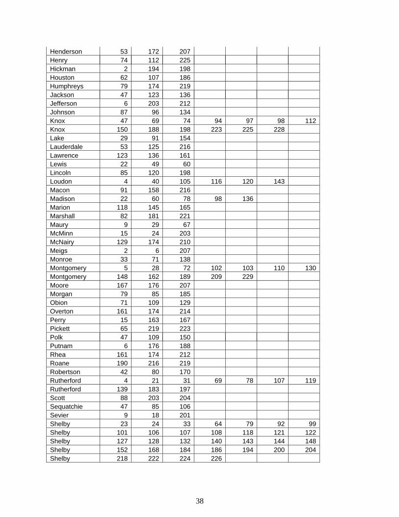
Henderson 53 172 207 Henry 74 112 225 Hickman 2 194 198 Houston 62 107 186 Humphreys 79 174 219 Jackson 47 123 136 Jefferson 6 203 212 Johnson 87 96 134 Knox 47 69 74 94 97 98 112 Knox 150 188 198 223 225 228 Lake 29 91 154 Lauderdale 53 125 216 Lawrence 123 136 161 Lewis 22 49 60 Lincoln 85 120 198 Loudon 4 40 105 116 120 143 Macon 91 158 216 Madison 22 60 78 98 136 Marion 118 145 165 Marshall 82 181 221 Maury 9 29 67 McMinn 15 24 203 McNairy 129 174 210 Meigs 2 6 207 Monroe 33 71 138 Montgomery 5 28 72 102 103 110 130 Montgomery 148 162 189 209 229 Moore 167 176 207 Morgan 79 85 185 Obion 71 109 129 Overton 161 174 214 Perry 15 163 167 Pickett 65 219 223 Polk 47 109 150 Putnam 6 176 188 Rhea 161 174 212 Roane 190 216 219 Robertson 42 80 170 Rutherford 4 21 31 69 78 107 119 Rutherford 139 183 197 Scott 88 203 204 Sequatchie 47 85 106 Sevier 9 18 201 Shelby 23 24 33 64 79 92 99 Shelby 101 106 107 108 118 121 122 Shelby 127 128 132 140 143 144 148 Shelby 152 168 184 186 194 200 204 Shelby 218 222 224 226
38

Smith 58 72 110 Stewart 69 188 228 Sullivan 60 62 123 138 143 161 Sumner 7 45 164 186 Tipton 56 112 161 Trousdale 71 72 109 Unicoi 11 125 163 Union 3 103 170 Van Buren 60 98 120 Warren 65 216 219 Washington 24 82 120 198 Wayne 56 99 159 Weakley 150 183 221 White 15 24 181 Williamson 12 46 63 125 137 144 202 Williamson 217 223 68 95 168 227 Wilson 117 161 195 State Division 1 41 49 79 110 141 148 154 State Division 1 179 186 190 State Division 2 27 29 56 91 107 129 132 State Division 2 145 152 158 State Division 3 44 53 62 67 82 87 100 State Division 3 125 147 221 State Division 4 9 18 64 102 103 141 170 State Division 4 179 199 201 State Division 5 27 36 71 109 129 132 138 State Division 5 152 185 210 State Division 6 50 89 90 91 93 94 127 State Division 6 150 156 158 State Division 7 31 33 65 67 100 143 145 State Division 8 85 87 96 97 103 105 117 State Division 8 120 171 179
39

5.4 State Divisions Map
Wilson
Henr y
Lincoln
Loudon
Marshall
Gibson
Stewart
Houston
Humphreys
Cheath am
Dickson
Weakley
Haywood
Lauderdale
Carroll
Bent
on
Lake
Dyer
McNairy
Wayne
Lewis
HickmanPerr yHenderson
LawrenceHardin
Shelby
TiptonChester
Deca
tur
Fayet te
ObionMontgomery
Madison
Crocket
Hardeman
Washington
Sullivan
Sevier
Carter
John
son
Campbell
Grainger
HawkinsHancock
Claiborne
Hamblen
Scott
Ander sonKnox
Unicoi
Jeffer son
Greene
Polk
Monr oe
Blount
Cocke
Union
Fentress
Morgan
Roane
DeKalb
Putnam
White
Cumber land
Smith
Cannon
Robert son
Davidson
TrousdaleSumner
Overton
Macon
Jackson
Clay Pickett
Maury
GrundyBedfor d
RutherfordWilliamson
Van Buren
Hamilton
Sequatchie
Warren
Bradley
Rhea
Bledsoe
Marion
Cof fee
Giles
McMinn
Mo ore
Franklin
REGION 39 800 MHz STATE DIVISIONS MAP
Meig
s
1
2
3
4
5
6
7
8
DIVISION 7 COUNTIESBenton, Carroll, Crockett,Dyer, Gibson, Henry, Lake,Obion, Weakley
DIVISION 8 COUNTIESChester, Decatur, Fayette,Hardeman, Hardin, Haywood,Henderson, Lauderdale,Madison, McNairy, Shelby, Tipton
DIVISION 5 COUNTIESCannon, Cheatham, Davidson,Dickson, Houston, Humphreys,Macon, Montgomery, Robertson,Rutherford, Smith, Stewart,Sumner, Trousdale, Williamson,WilsonDIVISION 6 COUNTIESBedford, Coffee, Franklin, Giles,Hickman, Lawrence, Lewis,Lincoln, Marshall, Maury,Moore, Perry, Wayne
DIVISION 4 COUNTIESClay, Cumberland, Dekalb,Fentress, Jackson, Overton,Pickett, Putnam, White,Van Buren, Warren
DIVISION 3 COUNTIESBledsoe, Bradley, Grundy,Hamilton, Marion, McMinn,Meigs, Monroe, Polk, Rhea,Sequatchie
DIVISION 2 COUNTIESAnderson, Blount, Campbell,Claiborne, Cocke, Grainger,Hamblin, Jefferson, Knox,Loudon, Morgan, Roane,Scott, Sevier, Union
DIVISION 1 COUNTIESCarter, Green, Hancock,Hawkins, Johnson, Sullivan,Unicoi, Washington
40

5.5 Assignment Statistics Maximum field strength for co-channel operation is 5 dBu Maximum field strength for adjacent channel operation is 25 dBu Total number of channels assigned 154 Total number of unassigned channels 71 Total number of reserved channels 5 5.6 Expansion of Initial Allocation In the event that the allocation for any county becomes depleted, the Region Review Committee shall meet to make further allocations to that county. Should this occur, the applying agency or entity shall submit the proper license and coordination applications with all applicable fees, as in any other licensing request. Allocations will be made based on the initial frequency allocation plan as mentioned above, considering the channels that were returned to the reserve pool. 5.7 Prioritization of Applicants A very simple method of prioritization has been chosen for use in this Region. As there is no unmet spectrum requirement, there appears to be no great need for prioritization. To facilitate future problems that may arise, the following rating system shall be used. Prioritization shall be done according to a final score, based on applicant criteria. The highest score, in points, shall be given priority in a situation where spectrum is insufficient to fulfill the needs of all. Public Safety Agencies 2 Points Public Services Agencies 1 Point Multi-agency Systems 2 Points Multi-agency/Multi Jurisdiction Systems 3 Points Single Agency/Jurisdiction Systems 1 Point 5.8 Appeal Process At any time, any applicant may appeal an allocation, rejection, or any limits placed on a particular application for any reason. The appeal process has two levels; the Region Review Committee, and the FCC. An applicant who decides to appeal a rejection should initiate that appeal immediately upon notification of rejection. In the event that an appeal reaches the FCC, their decision will be final and binding upon all parties.
41

6.0 THE REGION 39 PLANNING COMMITTEE
6.1 Current Officers CURRENT CHAIRPERSON: John W. Johnson, Chairman Tennessee Emergency Management Agency 3041 Sidco Drive Nashville, TN 37204 615 741 – 3826 Voice 615 741 – 6027 Fax Email: [email protected] VICE CHAIRPERSON: Jesse D. Griggs Tennessee Department of Correction Rachel Jackson State Office Building Nashville, TN 37243 615 253 – 8098 Voice 615 741 - 4605 Email: [email protected]
42

The Regional Planning Committee Continued
#Resource Member
6.2 Members
THE REGIONAL PLANNING COMMITTEE 1992
Name Organization/Address Telephone #
Allen, Don Hamilton County EMA 317 Oak Street Chattanooga, Tennessee 37403
(615) 757-2300
Allman, John Brentwood Fire Department 5211 Maryland Way Brentwood, Tennessee 37221
(615) 371-0170
Austin, Kenneth Metro Radio Shop 41 Peabody Street Nashville, Tennessee 37210
(615) 682-5111
Bateman, Ron Martin Marietta Emergency Services 109 Danbury Drive Oak Ridge, Tennessee 37830
(615) 574-5217
Bird, John Tennessee Association of Rescue Squads Realty World Building 820 Tulip Avenue Knoxville, Tennessee
(615) 522-9045
Brooks, Craig* Tennessee Hospital Association 500 Interstate Boulevard South Nashville, Tennessee 37210
(615) 256-8240
Brooks, Robert Earl NFD-EMS 2613 Mt. Laurel Drive Antioch, Tennessee 37013
(615) 781-4884
Brown, Ernie General Electric 25 Century Boulevard Suite 504 Nashville, Tennessee 37214
(615) 391-4477
Bryant, Charles Memphis-Shelby County EMA 125 N Mid-American Mall Memphis, Tennessee 38013
(901) 528-2780
Bull, Alan Knoxville County Emergency Communications District 400 Main Avenue L305 Knoxville, Tennessee 37902
(615) 521-2201
Carroll, Michael A. Department of Transportation 6600 Centennial Boulevard Nashville, Tennessee 37209
(615) 741-2277
Cohen, Alvin Tennessee Department of General Services C2-205 Central Services Building Nashville, Tennessee 37219
(615) 741-1035
Crenshaw, Jeff Memphis-Shelby County EMA 125 N Mid-American Mall Memphis, Tennessee 38013
(901) 528-2780
43

The Regional Planning Committee Continued
#Resource Member
Name Organization/Address Telephone #
Crinklaw, Jim* E.F. Johnson Company 121 Lewisville Center Suite 172 Lewisville, Texas 75056
(214) 539-1966
Curd, Lewis Motorola 7101 Executive Center Drive, Suite 197 Brentwood, Tennessee 37027
(615) 373-0800
David, Gene* FEMA Region IV Thomasville, Georgia 31792
(912) 225-4500
Dinsmore, Ervin Chattanooga PD 3300 Amnicola Highway Chattanooga, Tennessee 37406
(615) 698-9703
Draughn, Ed Sullivan County SO Box 589 Blountville, Tennessee 37617
(615) 323-5121
Dykes, Bill City of Kingsport, Tennessee Route 2, Box 235 Church Hill, Tennessee 37642
(615) 229-9468
Eaves, Thomas Blount County Communications Center Post Office Box 108 Alcoa, Tennessee 37701
(615) 982-4210
Eldridge, W. Kent Department of Safety 225 Ezell Pike Nashville, Tennessee 37217
(615) 741-6799
Farris, Ronald City of Chattanooga 3300½ Amnicola Highway Electronic Department Chattanooga, Tennessee 37406
(615) 698-9703
Fowler, Roger Memphis State University 151 Administration Building Memphis, Tennessee 38152
(901) 678-3848
Frady, Doug* State Planning 309 John Sevier State Office Building Nashville, Tennessee 37219
(615) 741-1676
Fry, Jerry MSU/Public Safety 778 Colonial Road Memphis, Tennessee 38117
(901) 678-4357
Garner, John Shelby County 911 785 Crossover Lane, Suite 150 Memphis, Tennessee 38117
(901) 685-0911
Goodrich, Dorothy* FCC 1365 Peachtree Street, NE, Room 440 Atlanta, Georgia 30309
(404) 279-4621
Goulet, Mark Brentwood Fire Department 5211 Maryland Way Brentwood, Tennessee 37027
(615) 371-0160
Grantz, Don* E.F. Johnson Company 6718 Edgeworth Drive Orlando, Florida 32819
(407) 351-2602
44
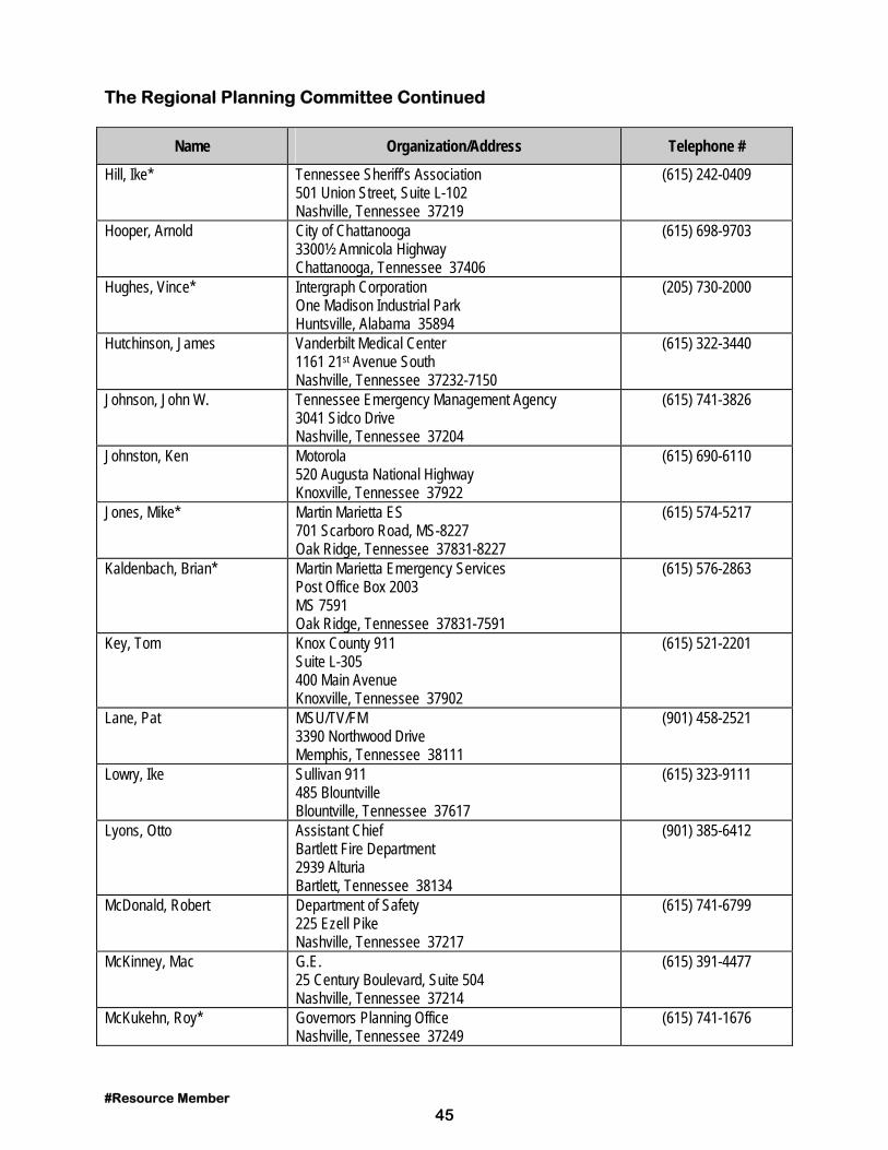
The Regional Planning Committee Continued
#Resource Member
Name Organization/Address Telephone #
Hill, Ike* Tennessee Sheriff’s Association 501 Union Street, Suite L-102 Nashville, Tennessee 37219
(615) 242-0409
Hooper, Arnold City of Chattanooga 3300½ Amnicola Highway Chattanooga, Tennessee 37406
(615) 698-9703
Hughes, Vince* Intergraph Corporation One Madison Industrial Park Huntsville, Alabama 35894
(205) 730-2000
Hutchinson, James Vanderbilt Medical Center 1161 21st Avenue South Nashville, Tennessee 37232-7150
(615) 322-3440
Johnson, John W. Tennessee Emergency Management Agency 3041 Sidco Drive Nashville, Tennessee 37204
(615) 741-3826
Johnston, Ken Motorola 520 Augusta National Highway Knoxville, Tennessee 37922
(615) 690-6110
Jones, Mike* Martin Marietta ES 701 Scarboro Road, MS-8227 Oak Ridge, Tennessee 37831-8227
(615) 574-5217
Kaldenbach, Brian* Martin Marietta Emergency Services Post Office Box 2003 MS 7591 Oak Ridge, Tennessee 37831-7591
(615) 576-2863
Key, Tom Knox County 911 Suite L-305 400 Main Avenue Knoxville, Tennessee 37902
(615) 521-2201
Lane, Pat MSU/TV/FM 3390 Northwood Drive Memphis, Tennessee 38111
(901) 458-2521
Lowry, Ike Sullivan 911 485 Blountville Blountville, Tennessee 37617
(615) 323-9111
Lyons, Otto Assistant Chief Bartlett Fire Department 2939 Alturia Bartlett, Tennessee 38134
(901) 385-6412
McDonald, Robert Department of Safety 225 Ezell Pike Nashville, Tennessee 37217
(615) 741-6799
McKinney, Mac G.E. 25 Century Boulevard, Suite 504 Nashville, Tennessee 37214
(615) 391-4477
McKukehn, Roy* Governors Planning Office Nashville, Tennessee 37249
(615) 741-1676
45

The Regional Planning Committee Continued
#Resource Member
Name Organization/Address Telephone #
McNeill, Bob Washington County 911 Post Office Box 448 Johnson City, Tennessee 37605
(615) 928-8071
Mims, Ed* Motorola Communications 7101 Executive Center Drive, Suite 197 Brentwood, Tennessee 37017
(615) 373-0800
Mitchell, John* Mitchell Group 845 Crossover, Suite 119 Memphis, Tennessee 38117
(901) 682-0086
Mize, Jerry Tennessee Wildlife Resources Agency 900 Breckenridge Brownsville, Tennessee 38012
(615) 781-6580
Mosca, John Post Office Box 955 Norris, Tennessee 37828
(615) 690-6110
Muse, Allen Metro Police 2060 15th Avenue South Nashville, Tennessee 37212
(615) 862-8554
Myers, Richard Warren County EMA Route 3, Box 279 McMinnville, Tennessee 37110
(615) 473-5312
Neal, Roy Turner Tennessee Dept of Health and Environment - EMA 287 Plus Park Boulevard Nashville, Tennesse 37217
(615) 367-6275
Patterson, Edgar Montgomery County SO 120 Commerce Street Clarksville, Tennessee 37040
(615) 648-0611
Phipps, Charles Tennessee Wildlife Resources Agency 312 S. Baird Lane Murfreesboro, Tennessee 37130
(615) 781-6580
Pierce, Ken State of Tennessee F&A 598 James Robertson Parkway Nashville, Tennessee
(615) 741-5239
Pollock, Steve Department of Environment and Conservation 245 Blanton Avenue Nashville, Tennessee 37210
(615) 741-0671
Poynter, Bob Knox County 911 Suite L-305 400 Main Avenue Knoxville, Tennessee 37902
(615) 521-2201
Proctor, Cory Shelby County Fire Department 1115 Sycamore View Road Memphis, Tennessee 38134
(901) 385-5100
Randall, Bernard T. Rural Metro Fire Department 6700 Baum Drive Knoxville, Tennessee 37919
(615) 693-2511
Raney, Fred Tennessee Department of Corrections 320 6th Avenue North Rachel Jackson Building Nashville, Tennessee 37219
(615) 741-1067
46

The Regional Planning Committee Continued
Name Organization/Address Telephone #
Richardson, Charles Metro Radio Shop 41 Peabody Street Nashville, Tennessee 37210
(615) 862-5111
Rummage, James III Brentwood Fire Department Post Office Box 788 5211 Maryland Way Brentwood, Tennessee 37024
(615) 371-0170
Russell, Joseph City of Memphis 125 N Mid America Mall Memphis, Tennessee 38103
(615) 576-6233
Shamburg, Duane* E.F. Johnson Company 2156 Murfreesboro Road 1417 Nashville, Tennessee 37217
(615) 361-1528
Stanford, Michael Henderson County Fire Department 147 S. Broad Lexington, Tennessee 38351
(901) 968-7710
Tapp, Richard Bartlett Fire Department 4855 Memphis Arlington Bartlett, Tennessee 38135
(901) 385-6412
Truebger, Harold Memphis Fire Department 79S. Flicker Street Memphis, Tennessee 38104
(901) 320-5305
Watson, LT John Hendersonville PD Post Office Box 0541 Hendersonville, Tennessee 37075
(615) 822-1111
White, John Tennessee Emergency Management Agency 3041 Sidco Drive Nashville, Tennessee 37204
(615) 741-4332
Williams, Harold R. City of Memphis Police and Fire 79 S. Flicker Street Memphis, Tennessee 38104
(901) 323-1655
Wolfe, David Tennessee Emergency Management Agency 3041 Sidco Drive Nashville, Tennessee 37204
(615) 741-2749
Wright, Richard Tennessee Bureau of Investigation Building 1148, Foster Avenue Cooper Hall Nashville, Tennessee 37210
(615) 741-0430
#Resource Member 47

EXHIBIT A
TN Population and Expected Growth Percentage
County 1990 2000 % Increase or Decrease
Tennessee 4,877,185 5,179,999 +6.2 Anderson 68,250 67,864 -.5 Bedford 30,411 33,565 +9.3 Benton 14,524 14,240 -1.9 Bledsoe 9,669 10,132 +4.7 Blount 85,969 94,005 +9.3 Bradley 73,712 79,851 +8.3 Campbell 35,079 34,890 -.5 Cannon 10,467 10,890 +4.0 Carroll 27,514 26,655 -3.1 Carter 51,505 51,777 +.5 Cheatham 27,140 34,313 +26.0 Chester 12,819 12,849 -.2 Claiborne 26,137 27,522 +5.0 Clay 7,238 6,929 -4.2 Cocke 29,141 29,358 +.7 Coffee 40,339 42,903 +6.3 Crockett 13,378 11,855 -11.3 Cumberland 34,736 41,622 +19.8 Davidson 510,784 540,574 +5.8 Decatur 10,472 10,019 -4.3 DeKalb 14,360 15,012 +4.5 Dickson 35,061 41,803 +19.2 Dyer 34,854 35,387 +1.5 Fayette 25,559 25,373 -.7 Fentress 14,669 14,264 -2.7 Franklin 34,725 36,896 +6.2 Gibson 46,315 43,557 -5.9 Giles 25,741 26,901 +4.5 Grainger 17,095 17,445 +2.0 Greene 55,853 56,624 +1.3 Grundy 13,362 12,761 -4.4 Hamblen 50,480 51,708 +2.4 Hamilton 285,536 280,524 -1.7 Hancock 6,739 6,491 -3.6 Hardeman 23,377 22,853 +2.2 Hardin 22,633 23,188 +2.4
48

TN Population and Expected Growth Percentage Continued
County 1990 2000 % Increase or Decrease
Hawkins 44,565 44,926 +.8 Haywood 19,437 18,330 -5.6 Henderson 21,844 22,097 +1.1 Henry 27,888 26,694 -4.2 Hickman 16,754 18,440 +10.0 Houston 7,018 7,044 -.3 Humphreys 15,795 15,567 -1.4 Jackson 9,297 9,344 +.5 Jefferson 33,016 34,532 +4.5 Johnson 13,766 13,388 -2.7 Knox 355,749 350,215 -1.5 Lake 7,129 6,951 -2.4 Lauderdale 23,491 22,382 -4.7 Lawrence 35,303 37,150 +5.2 Lewis 9,247 8,756 -5.3 Lincoln 28,157 30,364 +7.8 Loudon 31,255 34,264 +9.6 McMinn 42,383 42,389 0.0 McNairy 22,422 22,151 -1.2 Macon 15,906 16,276 +2.3 Madison 77,982 81,438 +4.4 Marion 24,860 25,349 +1.9 Marshall 21,539 23,942 +11.1 Maury 54,812 59,104 +7.8 Meigs 8,033 8,628 +7.4 Monroe 30,541 32,429 +6.1 Montgomery 100,498 120,707 +20.1 Moore 4,721 4,914 +4.0 Morgan 17,300 17,899 +3.4 Obion 31,717 30,796 -2.9 Overton 17,636 17,561 -.4 Perry 6,612 7,111 +7.5 Pickett 4,548 4,707 +3.4 Polk 13,643 13,539 -.7 Putnam 51,373 55,939 +8.8 Rhea 24,344 24,367 0.0 Roane 47,277 44,907 -5.0 Robertson 41,494 46,795 +12.7 Rutherford 118,570 169,404 +42.8 Scott 18,358 17,686 -3.6
49

TN Population and Expected Growth Percentage Continued
County 1990 2000 % Increase or Decrease
Sequatchie 8,863 9,182 +2.9 Sevier 51,043 63,057 +23.5 Shelby 826,330 867,032 +4.9 Smith 14,143 13,508 -4.4 Stewart 9,479 10,509 +10.8 Sullivan 143,596 141,262 -1.6 Sumner 103,281 122,502 +18.6 Tipton 37,568 43,162 +14.8 Trousdale 5,920 5,667 -4.4 Unicoi 16,549 16,321 -1.3 Union 13,694 15,939 +16.3 Van Buren 4,846 4,826 -.4 Warren 32,992 33,121 +.3 Washington 92,315 94,766 +2.6 Wayne 13,955 13,899 -.4 Weakley 31,972 31,574 -1.2 White 20,090 20,679 +2.9 Williamson 81,021 110,498 +36.3 Wilson 67,675 81,413 +20.2
50

APPENDIX A
Chancellor Thomas J. Garland Tennessee Board of Regents 1415 Murfreesboro Road, Suite 350 Nashville, Tennessee 37217 Chief David Key, President Tennessee Chief's of Police Association P.O. Box 541 Hendersonville, Tennessee 37075 Commissioner Elbert T. Gill Department of Conservation 701 Broadway Nashville, Tennessee 37219 Commissioner James E. Word Department of Health and Environment 344 Cordell Hull Building Nashville, Tennessee 37219 Commissioner Jimmy Evans Department of Transportation James K. Polk State Building Nashville, Tennessee 37219 Commissioner Robert D. Lawson Department of Safety 1150 Foster Avenue Nashville, Tennessee 37210 Commissioner William B. Whitson Department of General Services Central Services Building Nashville, Tennessee 37219 Commissioner Stephen H. Norris Department of Corrections 320 Sixth Avenue North Nashville, Tennessee 37219 Director Arzo Carson Tennessee Bureau of Investigation 1200 Foster Avenue, P.O. Box 100940 Nashville, Tennessee 37210 Director Lacy E. Suiter Tennessee Emergency Management Agency 3041 Sidco Drive Nashville, Tennessee 37204 Director Phil May FEMA, Region Four
1371 Peachtree Street, N.E. Atlanta, Georgia 30309 Executive Director Tennessee Sheriff's Association P.O. Box 2990 Nashville, Tennessee 37219 Executive Director Gary T. Myers Tennessee Wildlife Resources Agency P.O. Box 40747 Nashville, Tennessee 37204 Federal Communications Commission Private Radio Bureau 1919 M Street, NW, Room 5002 Washington, DC 20554 Honorable Bill Boner Mayor of Metro Nashville Metro Courthouse, Room 107 Nashville, Tennessee 37201 Honorable Gene Roberts Mayor Chattanooga City Hall, East Eleventh Street Chattanooga, Tennessee 37402 Honorable Ned McWherter State Capitol Nashville, Tennessee 37219 Honorable Richard C. Hackett Mayor of Memphis Second Floor 125 N. Mid-America Mall Memphis, Tennessee 38103 Honorable Victor Ashe Mayor of Knoxville P.O. Box 1631 Knoxville, Tennessee 37901 Honorable William N. Morris, Jr. Mayor of Shelby County 160 N. Mid-American Mall, Eighth Floor Memphis, Tennessee 38103 John H. Bird, Executive Director Tennessee Association of Rescue Squads Realty World Building, 820 Tulip Avenue Knoxville, Tennessee 37912
51

Appendix A Continued Major General Carl D. Wallace The Adjutant General 3041 Sidco Drive, Houston Barracks Nashville, Tennessee 37204 Mike Stanford, President Tennessee Fire Chiefs Association Henderson County Courthouse Lexington, Tennessee 38351 Mr. Dalton Roberts Hamilton County Executive 208 Courthouse Chattanooga, Tennessee 37402 Mr. Doug Frady State Planning Agency 309 John Sevier State Building Nashville, Tennessee 37219 Mr. Dwight Kessel Knox County Executive 400 Main Street, Suite 651 Knoxville, Tennessee 37902 Mr. Ernest R. Brown General Electric Company 1661 Murfreesboro Road, Suite M Nashville, Tennessee 37217 Mr. Jerry Mize Tennessee Chapter APCO 900 Breckinridge Brownsville, Tennessee 38012 Mr. Larry J. Lyda Tennessee Emergency Number Association 317 Oak Street, Room 315 Chattanooga, Tennessee 37403 Mr. Lewis Curd Motorola, Inc. 7101 Executive Center Drive, Suite 197 Brentwood, Tennessee 37027 Mr. Mike Carroll AASHTO Frequency Coordinator - Tennessee 6600 Centennial Boulevard Nashville, Tennessee 37209
Mr. Milt Lennert E.F. Johnson Company 1184 Pine Tree Lane Bartlett, Illinois 60103 Mr. Robert Tall APCO National Office P.O. Box 669 New Smyrna Beach, Florida 32070 Mr. Roy Turner Neal Tennessee Chapter APCO Emergency Medical Services 287 Plus Park Boulevard Nashville, Tennessee 37219-5407 Mr. Steve Pollock Tennessee Chapter APCO 245 Blanton Avenue Nashville, Tennessee 37210 Tennessee County Commissioners Association 226 Capitol Boulevard Building, Suite 700 Nashville, Tennessee 37219 Tennessee County Commissioners Association 226 Capitol Boulevard Building, Suite 700 Nashville, Tennessee 37219 Tennessee County Commissioners Association 226 Capitol Boulevard Building, Suite 700 Nashville, Tennessee 37219 Tennessee Hospital Association 500 Interstate Boulevard South Nashville, Tennessee 37210 Tennessee Medical Association 112 Louise Avenue Nashville, Tennessee 37203 Tennessee Municipal League 226 Capitol Boulevard Building Nashville, Tennessee 37219 Tennessee School Board Association 500 Thirteenth Avenue, North Nashville, Tennessee 37203 Tennessee School Superintendents Association 10th and Charlotte Avenue, Suite A
52

Appendix A Continued Nashville, Tennessee 37203 Tennessee Veterinary Medical Association 226 Capitol Boulevard Building Nashville, Tennessee 37219
53

APPENDIX B INSERT PROOF OF PUBLICATION FROM THE TENNESSEAN NEWSPAPER FOR ADVERTISEMENT OF THIRD MEETING AS A-2. Publilshed in the Original Plan On file at the Chairman’s Office
54

INSERT NOTICE OF INTENT TO FILE AS SENT OUT OVER THE TIES/NCIC COMPUTER NETWORK AS A-3. Publilshed in the Original Plan On file at the Chairman’s office
55

INSERT PROOF OF PUBLICATION FROM THE TENNESSEAN NEWSPAPER FOR INTENT TO FILE AS A-4. Publilshed in the Original Plan On file at the Chairman’s office
56

Appendix C By-Laws
Bylaws of the 800 MHz Regional Planning Committee-
Region 39 (State of Tennessee)
BYLAWS OF REGION 39
NAME & PURPOSE
1.1 Name and purpose. The name of this Region shall be Region 39 800 MHz NPSPAC Regional Planning Committee. Its primary purpose is to foster and promote cooperation, planning, development and evolution of Regional Plans and the implementation of this plan in the 800 MHz Public Safety Band within the State of Tennessee.
MEMBERS
For purposes of this document, the term “member,” unless otherwise specified, refers to both voting and non-voting members. 2.1 Numbers, Election and Qualification. The Regional 39 800 MHz Regional Planning
Committee shall have two classes of members, “voting members” and “non-voting members.” New members may be added at annual, special, or regular meetings. Tools to promote participation and involvement in the Region 39 800 MHz Committee in the form of a list-serve and/or regional newsletters will be researched by the committee. A newsletter may be distributed in either electronic or in print form.
Voting Members. Voting members shall consist of one (1) representative from any single agency engaged in public safety eligible to hold a license under 47 CFR 90.20, 47 CFR 90.523 or 47 CFR 2.103 and are employed or volunteer in public safety in Region 39. Except that a single agency shall be allowed no more than one vote for each distinct eligibility category (e.g. police, fire, EMS, EMA, highway) within the agency’s organization or political jurisdiction. In voting on any issue, the individual must identify himself/herself and the agency and eligibility category in which he or she represents. Voting members may not vote on issues involving their entity. Non-Voting Members. Non-voting members are all other non-public safety personnel interested in furthering the goals of public safety communications.
2.2 Dual Membership. A voting member may not be a voting member of another Region. Since Region 39 has several large cities on or near state borders, some members may want to participate in another committee. It is permissible to be a non-voting member in another Region and be a voting member in Region 39 as long as the Voting Member requirement are met as set forth in section 2.1.
57

2.3 Tenure. In general, each member shall hold MEMBERSHIP from the date of acceptance until resignation or removal. 2.4 Powers and Rights. In addition to such powers and rights as are vested in them by law, or these bylaws, the members shall have such other powers and rights as the membership may determine. 2.5 Suspensions and Removal. A representative may be suspended or removed with cause by
vote of a majority of members after reasonable notice and opportunity to be heard. Region 39 will hold at least one (1) meeting in a calendar year. To retain consistent voting rights, members should attend one (1) meeting in a 24-month period. After the date of approval of this Regional Plan by the Federal Communications Commission, all previous attendees are voting members, with the exception of non-voting commercial members. After the acceptance of this Regional Plan, voting members that do not attend one meeting in a 24-month period that starts on the date of plan acceptance, will lose Region 39 voting rights for either a 6 month period or when the member attends the next Regional Planning Committee meeting, whichever comes first. Attending a meeting is all that is required to immediately reinstate voting members voting rights. The loss of voting rights does not remove a member from active status; it simply requires attendance at a meeting (Special or Regular) to reinstate voting privileges. The voting limitations of an individual have no effect on the voting ability of a public safety entity. The public safety entity reserves the right to send another representative to vote on issues regarding 800 MHz implementation, or send the original voting representative to the next special or regular meeting.
A vote of the committee is the final determining factor regarding removal of a member from
Region 39. A period of 6 months from the first day of removal is required before a removed member is eligible for reinstatement for membership in the Regional Planning Committee.
2.6 Resignation. A member may resign by delivering written resignation to the chairman, vice-
chairman, treasurer or secretary of the Regional Committee or to a meeting of the members. A resigning member is eligible for reinstatement to the Regional Planning Committee after a period of six months has lapsed, beginning on the first day of resignation.
2.7 Meetings. The Region 39 800 MHz Planning Committee will meet no less than one (1) time
per calendar year. The annual meeting may be held in Nashville, Tennessee area. This is centrally located within Region 39 and will provide the maximum opportunity for regional participation. Any additional meetings may be located in a different city or town within the Region to attract and promote involvement in the committee. The Annual meeting should be held in the last quarter of calendar year and will be set the Chairperson. Committee meetings will not be held on holidays or weekend days, unless called by the Region 39 Chairperson or as part of a public safety conference. At any time and when deemed necessary by the Chairperson, an additional meeting of the Region 39 Regional Planning Committee may be called. Video and/or Audio Teleconferencing may be conducted at meetings to include as many people as possible in the 800 MHz allocation process. The use of electronic E-mail and the Region 39 list-server ([email protected]) will be utilized
58

by members and officers of Region 39 as needed to convey regional issues at hand. It should be noted the use of E-mail does not remove the voting eligibility requirement of the member to participate in at least one (1) of the Region 39 annual meeting.
2.8 Special Meetings. The Chairperson has the authority to call a meeting of the Regional
Planning Committee when he deems it in the best interest of the Region and will provide notice of the special meeting to existing members of the Region (and the public) at least 5 days prior to the meeting. Special meetings of the members may be held at any time and at any place within the Regional Committee area. Special meetings of the members may be called by the chairman or by the vice-chairman, or in case of death, absence, incapacity, by any other officer or, upon written application of two or more members.
2.9 Call and Notice.
A. Annual meeting Reasonable notice of the time and place of scheduled meetings of the members, not being less than 30 days, shall be given to each member. Such notice may specify the purposes of a meeting, but will specify meeting content if required by law or these bylaws or unless there is to be considered at the meeting (i) amendments to these bylaws or (ii) removal or suspension of a member who is an officer. Announcements of meetings, stating the time and place where the meeting is to be held, may be published in newspapers, land mobile radio periodicals, and disseminated via E-mail and other electronic forms such as Tennessee Information Enforcement System. In addition, a press release may be issued; urging parties interested in public safety communications to attend. Region 39 will notify the Federal Communications Commission, Chief of the Wireless Telecommunications Bureau, when a meeting time and place has been established for the Region 39 800 MHz Regional Planning Committee at least 30 days prior to the meeting. B. Reasonable and sufficient notice Except as otherwise expressly provided, it shall be reasonable and sufficient notice to a member to send notice by mail at least five days or by e-mail/facsimile at least three days before any special meetings, addressed to such member at his or her usual or last known business address, or, to give notice to such member in person or by telephone at least three days before the meeting.
2.10 Quorum At any meeting of the members, a majority of the officers and a minimum of at least
three (3) voting members shall constitute a quorum. Any meeting may be adjourned to such date or dates not more than sixty days after the first session of the meeting by a majority of the votes cast upon the question, whether or not a quorum is present, and the meeting may be held as adjourned without further notice.
2.11 Action by Vote
59

Each voting member, representing a particular agency (one vote per agency) shall have one vote; non-voting members have no voting rights. When a quorum is present at any meeting, a majority of the votes properly cast by voting members present shall decide any question, including election to any office, unless otherwise provided by law or these bylaws.
2.12 Action by Writing. Any action required or permitted to be taken at any meeting of the
members may be taken without a meeting if all members entitled to vote on the matter consent to the action in writing and the written consents are filed with the records of the meetings of the members. Such consents shall be treated for all purposes as a vote at a meeting.
2.13 Proxies Voting members may vote either in person or by written proxy dated not more than one week
before the meeting named therein, which proxies shall be filed before being noted with the secretary or other person responsible for recording the proceedings of the meeting. A RPC member present via teleconference (audio or video) shall have voting status parallel to a member present at the meeting. If the facility is unable to accommodate teleconferencing (audio or video), or for any other reason teleconferencing cannot be accommodated in the meeting place, it is the responsibility of the member to attend the meeting in person or to vote by written proxy to have full voting rights. Unless otherwise specifically limited by their terms, such proxies shall entitle the holders thereof to vote at any adjournment of the meeting for which the proxy exists and the proxy shall terminate after the final adjournment of such meeting.
2.14 Voting on One’s Own Application At no time can a voting member vote on his/her application. 2.15 Special Interest Voting. A voting member cannot have a commercial interest in any of
his/her Region and/or adjacent Region’s application(s) on which he/she is reviewing, approving and/or voting.
OFFICERS AND AGENTS
3.1 Number and qualification The officers of the Region 39 800 MHz Regional Planning Committee shall consist of a chairman, a vice-chairman and a secretary and / or treasurer. All officers must be voting members of the Regional Committee. 3.2 Election The officers shall be elected by the voting members at their first meeting and, thereafter, at a
meeting determined by the membership. The terms of the officers in the Region 39 800 MHz RPC will be for two (2) years. In order to allow for consistency in the plan creation and initialization process, the terms of elected officers will begin on the date of the FCC’s approval of the Region 39 plan.
60

3.3 Tenure. The officers shall each hold office until the biannual election meeting of the members held within two years from the adoption of these bylaws, or until their successor, if any, is chosen, or in each case until he or she sooner dies, resigns, is removed or becomes disqualified.
3.4 Chairman and Vice Chairman. The chairman shall be the chief executive officer of the
Regional Committee and, subject to the control of the voting members, shall have general charge and supervision of the affairs of the Regional Committee. The chairman shall preside at all meetings of the Regional Committee. The Vice Chairman, if any, shall have such duties and powers, as the voting members shall determine. The Vice-Chairman shall have and may exercise all the powers and duties of the chairman during the absence of the chairman or in the event of his or her inability to act.
3.5 Treasurer The treasurer shall be the chief financial officer and the chief accounting officer of the
Regional Committee. The treasurer shall be in charge of its financial affairs, funds, and valuable papers and shall keep full and accurate records thereof. In the absence of a treasurer within the Region 39 800 MHz Planning Committee, the Chairperson shall assign Region 39 treasurer duties as deemed necessary.
3.6 Secretary. The secretary shall record and maintain records of all proceedings of the
members in a file or series of files kept for that purpose, which file or files shall be kept within the Region and shall be open at all reasonable times to the inspection of any member. Such file or files shall also contain records of all meetings and the original, or attested copies, of bylaws and names of all members and the address (including e-mail address, if available) of each. If the secretary is absent from any meeting of members, a temporary secretary chosen at the meeting shall exercise the duties of the secretary at the meeting. In the absence of a secretary within the Region 39 800 MHz Planning Committee, the Chairperson shall assign Region 39 Secretary duties as deemed necessary and may appoint a non voting member.
3.7 Combining the office of Treasurer and Secretary If so decided by the Membership of Region 39, the duties of Treasurer and Secretary may be combined into one office. 3.8 Suspensions or Removal. An officer of the Region 39 Regional Planning Committee may
be suspended with cause by vote of a majority of the voting members in attendance. 3.9 Resignation. An officer may resign by delivering his or her written resignation to the
chairman, vice-chairman, treasurer, or secretary of the Regional Committee. Such resignation shall be effective upon receipt (unless specified to be effective at some other time), and acceptance thereof shall not be necessary to make it effective unless it so states.
3.10 Vacancies. If the office of any officer becomes vacant, the voting members may elect a
successor. Each such successor shall hold office for the remainder of term, and in the case of the chairman, vice chairman, treasurer and / or secretary until his or her successor is elected
61

and qualified, or in each case until he or she sooner dies, resigns, is removed or become disqualified.
AMENDMENTS
These bylaws may be altered, amended or repealed in whole or in part by vote. The voting members may by a two-thirds vote of a quorum, alter, amend, or repeal any bylaws adopted by the Regional Committee members or otherwise adopt, alter, amend or repeal any provision which FCC regulation or these bylaws requires action by the voting members.
DISSOLUTION
This Regional Committee may be dissolved by the consent of two-thirds plus one of an assembled quorum of the membership at a special meeting called for such purpose. The FCC shall be notified.
RULES OF PROCEDURES
The Conduct of Regional Meetings including debate and voting, shall be governed by Simple Parliamentary Procedure, Martha Nall, published by the University of Kentucky, College of Agriculture, Cooperative Extension Service, Publication # IP-15, Copyright 2000.
Region 39 Plan Modifications 5-31-02 Added six channels for Montgomery County with approval of the Clarksville applications
62

605, 628, 762, 789, 809, 829 12-13-04 Added Color State Division Map in 5.4 02-09-06 Added four additional Williamson County Channels with approval of the Franklin application 668, 695, 768, 827 12-4-07 Added approved By-Laws 12-12-08 Changed channel allocations to tables to make easier to read and to make easier to modify for Re-banding. 4-8-09 Converted Channel allocation tables to post rebanding frequencies to comply with FCC Report & Order. Changed references of 821 – 824 & 866 – 869 to 806 – 809 & 851 to 853 Changed I Call to 8 CALL 90 and I TAC 1 – I TAC 4 to 8 TAC 91 – 8 TAC 94 to conform with NPSTC Common Channel Names Replaced International with National since these will no longer be international channels. Update page numbers.
63