publications hampshire’s five circular walks · hampshire’s five circular walks inspired by the...
TRANSCRIPT
Hampshire’sFive Circular Walksinspired by the Olympic Rings
www.hants.gov.uk
Publications• FindingYourWay
• AccessibleCountryside
• DiscoverHampshire
For any leaflets please telephone Hampshire County Council’s Hantsdirect on 0845 603 5636
*callswillcostupto4pperminuteforBTcustomers.Callsmadeusingotherserviceprovidersormobilesmaycostmore.Alternatively,call01329225398–standardandlocalratesapplyforthisnumber.
Useful websitesForinformationaboutotherwalksorourtenlongdistancewalksleafletsvisitwww.hants.gov.uk/walking
www.hants.gov.uk/countryside
www.visit-hampshire.org.uk
www.metoffice.co.uk
PublictransportinHampshire:www.hants.gov.uk/passengertransport
Useful contactsForNationalandLocalPublictransportcontact:traveline08712002233orwww.traveline.info.Centrelinesopen7amuntil10pmdaily.Callscost10pperminuteplusnetworkextras.
MetOffice(weatherinformation)08709000100
Tourist Information Centres
AldershotTouristInformationCentre01252320968
PetersfieldTouristInformationCentre01730268829
WinchesterTouristInformationCentre01962840800
Lyndhurst&NewForestTouristInformationCentre02380282269
Please follow the Country Codewww.naturalengland.org.uk/ourwork/enjoying/countrysidecode/default.aspx
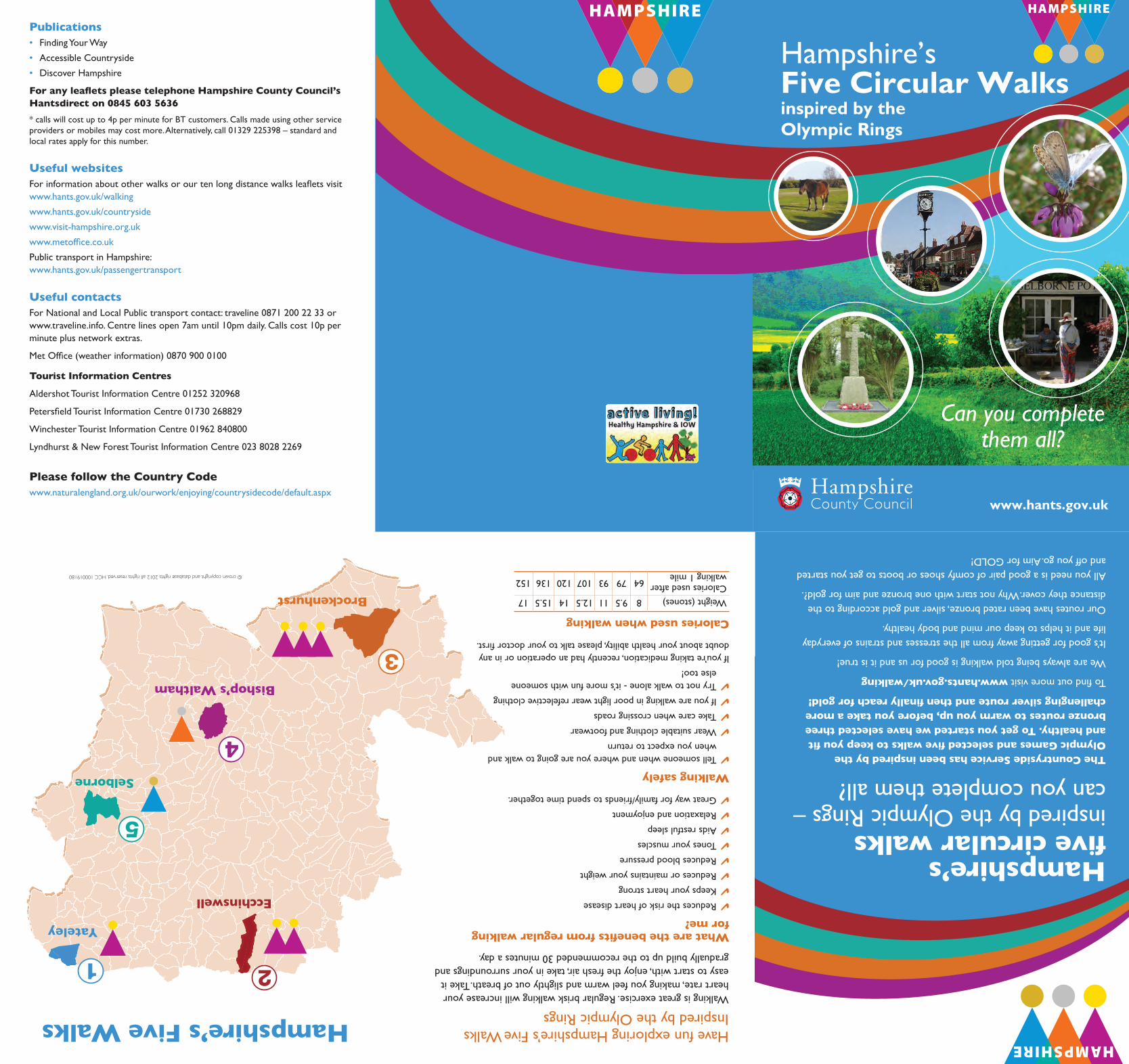
Hampshire’s five circular walks inspiredbytheOlympicRings–canyoucompletethemall?The Countryside Service has been inspired by the Olympic Games and selected five walks to keep you fit and healthy. To get you started we have selected three bronze routes to warm you up, before you take a more challenging silver route and then finally reach for gold!
Tofindoutmorevisitwww.hants.gov.uk/walking
Wearealwaysbeingtoldwalkingisgoodforusanditistrue!
It’sgoodforgettingawayfromallthestressesandstrainsofeverydaylifeandithelpstokeepourmindandbodyhealthy.
Ourrouteshavebeenratedbronze,silverandgoldaccordingtothedistancetheycover.Whynotstartwithonebronzeandaimforgold?.
Allyouneedisagoodpairofcomfyshoesorbootstogetyoustartedandoffyougo.AimforGOLD!
What are the benefits from regular walking for me?
4Reducestheriskofheartdisease
4Keepsyourheartstrong
4Reducesormaintainsyourweight
4Reducesbloodpressure
4Tonesyourmuscles
4Aidsrestfulsleep
4Relaxationandenjoyment
4Greatwayforfamily/friendstospendtimetogether.
Walking safely
4Tellsomeonewhenandwhereyouaregoingtowalkandwhenyouexpecttoreturn
4Wearsuitableclothingandfootwear
4Takecarewhencrossingroads
4Ifyouarewalkinginpoorlightwearrefelectiveclothing
4Trynottowalkalone-it’smorefunwithsomeoneelsetoo!
Ifyou’retakingmedication,recentlyhadanoperationorinanydoubtaboutyourhealthability,pleasetalktoyourdoctorfirst.
Calories used when walking
Weight(stones)89.51112.51415.517Caloriesusedafterwalking1mile647993107120136152© crown copyright and database rights 2012 all rights reserved. HCC 100019180
Ecchinswell
Yateley
Selborne
Bishop’s Waltham
Brockenhurst
21
5
4
3
Hampshire’s Five Walks HavefunexploringHampshire’sFiveWalksInspiredbytheOlympicRingsWalkingisgreatexercise.Regularbriskwalkingwillincreaseyourheartrate,makingyoufeelwarmandslightlyoutofbreath.Takeiteasytostartwith,enjoythefreshair,takeinyoursurroundingsandgraduallybuilduptotherecommended30minutesaday.
Can you complete them all?
Olympic Walks A5 12pp.indd 1 05/07/2012 09:54

1 Yateley Common Country ParkHeathlandWalkDistance: 2kmapprox–1.24milesapprox
Duration: 40minsapprox
OS Explorer maps:No144and145
By Train:ThenearesttrainstationisBlackwateramileeastofthesite.
By Bus:StagecoachNo3fromBlackwaterandStagecoachNo200fromBasingstoke.
Structures along the route: None.
Forfurtherwalkspleasevisit:http://www3.hants.gov.uk/countryside/yateley-country-park.htm
This map is reproduced from Ordnance Survey material with the permission of Ordnance Survey on behalf of the Controller of Her Majesty's Stationery Office © Crown copyright. Unauthorised reproduction infringes Crown copyright and may lead to prosecution or civil proceedings. HCC 100019180 2011
¯
A Heathland Walk at YateleyCountry Park
CAR PARK AND STARTN
© crown copyright and database rights 2012 all rights reserved. HCC 100019180
Directions to Yateley Country Park
Located between Yateley and the A30. There are four car parks, two are adjacent to the larger grassy areas suitable for picnics and general amenity, at Wyndhams Pool off Cricket Hill lane, and two car parks off the A30 between Yateley and Blackwater.
Access to west end of the site by parking at Blackbush Airport, off the A30.
1. On your left is Wyndham’s Pool. It probably originated as a fish pond and in the early twentieth century was used as a bathing pool.
2. This area known as Brandy Bottom. Its name is said to derive from the fact that smuggled brandy was once hidden here on its way to London.
3. The pond often dries up during the summer. Such ponds are important for range of wildlife with this pond being particularly valuable for a number of scarce dragonflies and damselflies, including the Black Darter and Downey Emerald.
4. This area of open heathland is dominated by heather with other vegetation types such as gorse, grass and small trees. This variety of habitats enables a wide diversity of wildlife to survive. Although it is important to prevent
heathland from reverting to woodland, the Countryside Rangers try to maintain areas of scattered trees to act as lookout posts for birds.
5. This woodland is known as the ‘Old Ely’. It is the original site of the Ely Pub. The old woodlands contain a number of oaks and are home to a variety of fungi, best seen during the autumn.
6. This is a great place to look out over the heathland. The area to your left is covered in much younger, less dense heather. It is important to have a variety of ages of heather as a lot of wildlife is specialised to heather such as this and provides a breeding site for Silver Studded Blue butterflies, whilst Woodlarks like to nest on bare ground.
7. This area of gorse dominated scrub is an ideal place to see the Dartford Warbler, which nests close to the ground.
8. This woodland is what heathland would naturally become if left unmanaged. Although some woodland is cleared to preserve the heathland, other areas are kept in order to increase habitat diversity. Woodlands have their own associated wildlife, the diversity of which increases with age.
A little history of Brockenhurst
Brockenhurst is well known for the diversity of its shops, tea houses, pubs and restaurants. It is here that ponies and donkeys roam freely and drink from ‘The Watersplash’ at the bottom of the main street on their way to graze on the open heathland and ancient wood which surround the village. It is the only village within the Perambulation of the New Forest whose value in the Domesday survey of 1086 was doubled (to £4) when that of many others was reduced, and was also the only village mentioned as having a church. St Nicolas, built upon a mound, may date back to Pagan times. The main attractions of the village are the Ford, running across the end of Brookly Road, the main shopping area, and the cottages, many of which, built by the Morant family who lived in Brockenhurst Park (now demolished and replaced by a modern house) have the letter M incorporated in the woodwork.
Start from the Railway Station car park in Brockenhurst.Turn left out of the station towards the Cyclexperience bike shop then turn left into Brookley road and continue down through the village shops to the “The Watersplash”.Cross the bridge and turn left into Burley road (minor road)Continue past the “The Rise” and go to the fence on the left around last house before a green Forest Lawn.Leave the road and turn left over the lawn – known as Culverley (the dove’s) Green.
Cross over the small bridge and go past the school on your left.At the B3055 main Sway Road, cross the road, turn left and after a few yards a right turn will take you through an alley leading to the end of The Close.Leaving this, turn left with Brockenhurst Station on your right.Cut through to the Railway Station car park. Leave the Station by the level-crossing and turn right across the trackCross the main A337 (towards Lymington), ignore Mill Lane but take the next track and follow the lane to “St Nicholas’s Church”.At the bottom of the lane bear to the left and follow the track to North Lodge, the original gatehouse to Brockenhurst Manor, which has many interesting features.Cross Mill Lane (taking care of traffic) to the cottage and lane opposite (notice the M on the cottage – indicating that it once belonged to the Morant estate – probably a worker’s cottage)Proceed along this footpath, over the railway lines and drop down to Brockenhurst College grounds on your right hand side.This lane comes out to join the A337 at The Rose and Crown public house.Turn left and follow the road to the “The Island” and the bike shop (Cyclexperience), continue along this road to meet up with the New Forest Tour. If you are early why not visit one of the tea rooms or restaurants in the village centre.
3 BrockenhurstAgentlestrollaroundBrockenhurstvillageDistance: 3km–1.5miles Duration: 45mins
OS Explorer maps:OL22 By Train:BrockenhurstStation.
Why not have a car free day with an additional tour on The New Forest Tour bus: TheNewForestTour–Greenroute30Juneto16September,everyhourdailyhttp://www.thenewforesttour.info/
Structures along the route:2bridgesandlevelcrossing.
This map is reproduced from Ordnance Survey material with the permission of Ordnance Survey on behalf of the Controller of Her Majesty's Stationery Office © Crown copyright. Unauthorised reproduction infringes Crown copyright and may lead to prosecution or civil proceedings. HCC 100019180 2011
¯
A Gentle Stroll Around Brockenhurst Village
N
© crown copyright and database rights 2012 all rights reserved. HCC 100019180
STARTHistory of Ecchinswell
The village of Ecchinswell is believed to have derived its name from the word Eikena, meaning Oaks in Latin, describing ‘the well by the oaks’. The village was called “Eceleswelle” in the Domesday Book and the land was used “for supplies for monks of Winchester”. More recently it was a self sufficient village with two pubs, a post office, village shop, bakery, blacksmith, petrol pumps, watercress beds, and mill.
From Ecchinswell Village hall cross the main road, continue along the footpath to the left of the war memorial, bear right at the two wooden bridges crossing the stream, over stile, then left to the corner of the field. Follow the path straight ahead to the gravel track. Turn left, following the track across the field; on your right is Northwood Copse, a bluebell
wood. As the road passes over the stream turn left. Left at the next sign and cross the stream, turn right and follow the footpath around the edge of the field. Climb over stile and bridge over the steam (large house with ponds to your right) and then another stile. Keep to the right side of the field and continue to the stile in the corner and cross over. At the road turn left and then immediately left down a wooded path. Continue straight ahead, hidden behind the oak tree is the next stile cross over. Keep to the right hand side of the field past two oak trees. Cross the stile at the right corner of the field and then bear left for approx 20m. Turn right through the metal gate and cross the field; to your left is St Lawrence’s Church. Go through the gate and left onto the Ecchinswell Road. After approx 300m you are back at the Village Hall.
2 Ecchinswell WarMemorialWalkA gentle country walk with beautiful views.
Distance: 2.8kmapprox–1.75milesapproxDuration: 45minsapprox
OS Explorer maps:No144and158
By Train:BasingstokeStation–Winchesterstation.By Bus:Cango23&24,TheLink.
Structures along the route: 6stilesand3bridges.
Ecchinswell's War Memorial Walk
This map is reproduced from Ordnance Survey material with the permission of Ordnance Survey on behalf of the Controller of Her Majesty's Stationery Office © Crown copyright. Unauthorised reproduction infringes Crown copyright and may lead to prosecution or civil proceedings. HCC 100019180 2011
¯
START
N
© crown copyright and database rights 2012 all rights reserved. HCC 100019180
A little history of Selborne
Selborne may not be as well known as it is for the Rev White as it is for the writings of Gilbert White in ‘The Natural History and Antiquities of Selborne’. It is while curate of Selborne that Gilbert White would walk the lanes and Hangers recording all that he found and saw.
The Hanger behind Gilbert’s House has a path named zig-zag path which was built by Gilbert White and his brother as a means of climbing the steep incline.
The word Hanger derives from the name ‘hangra’ which means wooded slope and those in this area are of a mixed deciduous type.
http://www3.hants.gov.uk/hampshire-countryside/ashford-hangers.htm
For more information please visit http://www.gilbertwhiteshouse.org.uk/
Park at the rear of the Selborne Arms, turn left out of the car park and walk along the main village street (B3006) until you reach the Queens Hotel. Here, take the narrow Huckers Lane byway, a metalled way to the Priory built by monks in the 14th century and then known as ‘Via Canonrum’ (Monks Way). Descend past some cottages to enter a wood through a gate; continue NE through the wood and across fields to reach the access road to Priory Farm (this section is 1¼ miles).
Turn left (N) along access road through farmyard, cross over Oakhanger Stream. Shortly after right bend you reach a ‘T’ junction of paths take the right through a gate and follow footpath with Oakhanger stream on your right at first and then on your left. At a signed crossroads of paths turn left (N), crossing the stream and then right along a field edge over double stile and stream and then another double stile (signed ‘official diversion’), re-crossing Oakhanger Stream. Turn left onto road through Oakhanger (Red Lion Pub here) to Mary Magdalene Church (2½ miles).
Beyond Church Cottages turn left (W) between two houses and then right behind the houses to a path junction. Turn left (W) – signed ‘Binswood Farm. Continue past the farm through Bisnwood to a stile. Do not cross this but go sharp left and follow Hangers Way through the woods to road.
Turn right (SW) onto the lane and then left (SE) onto drive signed ‘Estate Office’. Follow the Hangers Way on a track through fields and Long Lythe National Trust wood before finally climbing up through a field to reach Selborne church. Walk through the churchyard and across Selborne’s ancient Plestor. Turn left (S) and walk back to Queens Hotel and the start of our walk.
© crown copyright and database rights 2012 all rights reserved. HCC 100019180
5 SelborneTheMonks’WalkDistance: 7miles–11.27KmDuration: 3to4hours
OS Explorer maps:No133By Bus:StagecoachinPortsmouthNo38
Structures along route:2gates,6stiles,3bridges.
Refreshments: TwoPublicHousesandtheTeaRoomatGilbertsWhitesHouse.
¯
CAR PARK AND START
QUEENS HOTEL
RED LION PUB
N
4 Bishops WalthamHeritageWalkLevel countryside, but can be muddy at times.
Distance: 6.4km–3.98milesDuration: 2hoursOS Explorer maps:No119
By Train:WinchesterStationBy Bus: StagecoachinHampshireNo69
Structures along the route: 16stiles.Car Parking: BishopsWalthampay&display.
¯
Heritage Walk Bishops Waltham
CAR PARK PAY & DISPLAY
N
START
© crown copyright and database rights 2012 all rights reserved. HCC 100019180
A little history of Bishop’s Waltham Palace.
Bishop’s Waltham Palace was built by Henry de Blois once Bishop of Winchester (1136) it was during the Civil War the Palace was destroyed on the orders of Oliver Cromwell and the ruins are all that remain. Much of the old Palace can be found around the Town as it was used for building materials in the buildings that are still standing today.
The palace is managed by English Heritage: http://www.english-heritage.org.uk/daysout/properties/bishops-waltham-palace/
From Station Roundabout follow railway path through level crossing gates. The branch line to Botley ran 13 trains a day before closing in 1962.
Join road and after 150m turn sharp right along the Pilgrim’s Trail, then left around pylon, following field edge to stile and cross over 2 stiles on left.
Turn right and follow stream. You have been following the route of Pilgrims Trail which goes from Winchester to Mon St Michel in Normandy.
Cross over Tangier Lane, named after the port of Tangier, being part of the dowry of Catherine of Braganza, who passed this way from Portugal to marry King Charles II in 1662. Follow path to stile, then right diagonally down to bridge, and continue to road.
The tree line on the left horizon is the Park Lug, a boundary of the medieval deer park. For the nearby Palace.
Cross over Wintershill Road and follow signed footpath to main road.
Cross with care to short section of the Roman Road that ran from Winchester to Portchester. At junction, turn sharp right over stile and closely follow round right boundary to track junction.
Turn right into field and continue straight on, joining track, Cross road and after 4 stiles arrive via a permissive path at Claylands Local Nature Reserve. The clay pits date from roman times, with brickworks established in 1802. Follow path downhill to left and join road, then left at main road to return to roundabout.
1
2
34
5
6
7
8
Olympic Walks A5 12pp.indd 2 05/07/2012 09:54