pulverized rocks in the mojave section of the san andreas
TRANSCRIPT
tters 245 (2006) 642–654www.elsevier.com/locate/epsl
Earth and Planetary Science Le
Pulverized rocks in the Mojave section of theSan Andreas Fault Zone
Ory Dor a,⁎, Yehuda Ben-Zion a, Thomas K. Rockwell b, Jim Brune c
a Department of Earth Sciences, University of Southern California, Los Angeles, CA 90089-0740, USAb Department of Geological Sciences, San Diego State University, San Diego, CA 92182-1020, USA
c Nevada Seismological Laboratory, University of Nevada, Reno, NV 89557, USA
Received 29 May 2005; received in revised form 21 March 2006; accepted 23 March 2006Available online 5 May 2006Editor: R.D. van der Hilst
Abstract
We present mapping of pulverized fault zone rocks along a 140 km long section of the San Andreas Fault in the Mojave Desert.The results show that almost every outcrop of crystalline rock within about 100 m wide belt along this fault section is pulverizedand lacks significant shear. We find structural similarities between the San Andreas Fault zone and exhumed faults of the SanAndreas system, although pulverized rocks are not common in all of them. About 70% of the pulverized fault zone rocks appear onthe northeast side of the principal slip zone of the San Andreas Fault, possibly reflecting an asymmetric structure of the damagezone. Detailed mapping at selected sites, as well as previous mapping of rock damage at smaller scales, are consistent with thelarge-scale asymmetric pattern of the pulverized rocks. A possible pulverization of sedimentary rocks, inferences from regionaluplift indicators, and theoretical considerations imply that pulverization along this portion of the fault occurred in the top few km ofthe crust. The width of the pulverized fault zone rocks and inferred depth extent of pulverization are similar to the dimensions ofimaged low velocity fault zone layers that act as waveguides for seismic trapped waves. The side of the fault that appears to sustainmore damage is the block with faster seismic velocities at seismogenic depth. This correlation and the inferred shallow depth forpulverization are compatible with predictions for wrinkle-like ruptures along a material interface, with a preferred northwestpropagation direction of large earthquakes on the Mojave section of the fault.© 2006 Elsevier B.V. All rights reserved.
Keywords: earthquake physics; geologic mapping; fault zone structure; rock damage; dynamic rupture; pulverized rocks
1. Introduction
The term Pulverized Fault Zone Rocks (PFZR) refersmainly to crystalline plutonic and metamorphic rocksthat were mechanically pulverized to the micron or finerscale, while preserving most of their original fabric andcrystal boundaries. Outcrops of such rocks were
⁎ Corresponding author. Tel.: +1 213 740 6754; fax: +1 213 740 8801.E-mail address: [email protected] (O. Dor).
0012-821X/$ - see front matter © 2006 Elsevier B.V. All rights reserved.doi:10.1016/j.epsl.2006.03.034
observed long ago but little attempt was made tocharacterize them systematically until Brune [1] notedthe lack of significant shear parallel to the San AndreasFault (SAF) within PFZR in several locations. Thosefindings were followed by the detailed study of Wilsonet al. [2] in a road cut exposure of Tejon Lookout graniteadjacent to the slip zone of the SAF at Tejon Pass. Theymapped the local distribution and internal structure ofthe PFZR and analyzed its particle size distribution. Themain findings from the studies associated with the Tejon
643O. Dor et al. / Earth and Planetary Science Letters 245 (2006) 642–654
Pass exposure are: 1) The PFZR form ∼70–100 m widefault zone layer in the immediate vicinity of thelocalized slip. 2) There are myriad small scale fractureswithin the PFZR with no preference for shear parallel tothe SAF. 3) The PFZR layer lacks significant amounts ofweathering products and is distinctly different from grus(in situ accumulation of disaggregated plutonic materi-al). 4) The PFZR layer is pervasively pulverized to thesub-micron scale.
The observations from Tejon Pass confirm that theobserved pulverization is the result of mechanicalprocesses rather than a weathering product. In addition,the abundance of tension features and the extremereduction of grain size without distortion of the rockfabric imply that the protolite of the PFZR was subjectedto a strong tensional stress, apparently due to dynamicreduction of normal stress associated with slip duringSAF earthquakes. Brune et al. [3] observed in laboratoryexperiments with foam rubber blocks that the passage ofrupture is correlated with significant reduction of normalstress associated with vibrations normal to the interfaceand separation during slip. A summary of severalmechanisms that can produce dynamic reduction ofnormal stress during earthquake ruptures is given byBen-Zion [4]. These include acoustic fluidization [5],collisions of rough surfaces [6] and a variety of fluideffects (e.g., [7–9]).
Another possible mechanism for strong dynamicreduction of normal stress across large faults, with testablepredictions on the structure of those faults, is rupturealong a material interface that separates different solids(e.g., [10–13,4]). Numerical simulations show that modeII ruptures on a bimaterial interface tend to evolve forranges of conditionswith propagation distance towrinkle-like ruptures with several characteristic features (e.g.,[14–18]). These include: (1) a preferred or more vigorousdirection of rupture propagation that is the same as thedirection of slip in the slower velocity (more compliant)solid, (2) strong dynamic reduction of normal stress at thetip propagating in the preferred direction, (3) stronglyasymmetric motion across the fault, and (4) tendency ofthe rupture-tip region with significant slip-velocity tobecome narrower and higher with propagation distance.Property (1) has implications for the symmetry propertiesof the damage pattern generated by many earthquakes onthe fault. Properties (2–4) can produce tensile dynamicstress field leading in some conditions to “openingmodes” of rupture. In some ranges of parameters thesecharacteristics exist only in a weak form (e.g., [19]). Seerelated discussion in Ref. [20].
Earlier studies [21,22] suggested that significant off-fault damage is produced only in the vicinity of fault
jogs (and other geometrical complexities). The consis-tency of pulverization along the entire relatively straightMojave section of the SAF (see below) suggests that theobserved pulverization is the outcome of a fundamentaldynamic property of earthquake ruptures rather than asite-related effect. Theoretical and numerical studies ofdynamic ruptures indicate that off-fault damage occursprimarily in the tensional quadrants of the radiated fields[23–28]. If earthquakes on a given fault sectionpropagate predominately as bilateral ruptures, or asunilateral ruptures without a preferred propagationdirection, the cumulative pattern of rock damagegenerated by many events will be approximatelysymmetric across the fault. However, if earthquakeson a given fault section have a preferred propagationdirection, the cumulative damage pattern will beasymmetric, with more damage in the tensional quadrantassociated with the preferred propagation direction.Ben-Zion and Shi [27] simulated dynamic rupturesalong a bimaterial interface in a model that includesspontaneous generation of damage in the bulk. Theresults show that in such cases, damage is generatedprimarily on the stiffer side of the fault, which is in thetensional quadrant of the radiated seismic field for thepreferred propagation direction. Damage generation isenhanced by the dynamic reduction of normal stress atthe propagating tip, and the zone of intense damage hasan approximately constant width that is related to therupture pulse width. The simulations of Ben-Zion andShi [27] suggest further that significant generation ofrock damage, under realistic conditions of velocitycontrast and material properties, is limited to the top fewkm of the crust. See also Ref. [28]. Thus, the generateddamage does not affect significantly the velocitystructure at depth that controls the rupture dynamics.The above results provide clear predictions that can betested by geologic observations of rock damage acrosslarge strike slip faults.
Recent observational studies provided informationon symmetry properties of off-fault damage. Dor et al.[29] performed detailed geological mapping of rockdamage over fault core scales of ∼0.01–1 m and faultzone scales of ∼1–10's of m in the structures of theSAF, San Jacinto Fault and the Punchbowl Fault insouthern California. They observed consistent asymme-try in the distribution of gouge and fault zone damageacross the principal slip zones of those faults. For caseswhere the velocity structure of the fault is known theyshowed that considerably more damage appears on thecrustal blocks that have faster seismic velocities at depth[30–33]. High resolution imaging of the local velocitystructure of the San Jacinto fault zone based on seismic

644 O. Dor et al. / Earth and Planetary Science Letters 245 (2006) 642–654
trapped waves [34] indicates the existence of a 100 mwide damaged fault zone rock in the top 3–5 km of thecrust, with a similar sense of asymmetry as in thegeological mapping of Dor et al. [29]. Inversion of faultzone head and direct P waves in the Bear valley sectionof the SAF also suggest the existence of a shallowdamage zone that is shifted toward the faster velocityblock [35].
In this work we present geologic mapping of PFZRalong the Mojave section of the SAF, with a focus on theoverall large-scale properties of the PFZR. Comple-menting the mapping of Dor et al. [29] over smallerscales of observations, we provide mapping results overa damage zone scale of ∼10–100's of m. Ourobservations show that PFZR are common along theSAF in the Mojave and probably occupy a∼100 m widetabular sub-vertical zone parallel to the fault. Inaddition, we find that the distribution of the exposedPFZR is not symmetric with respect to the principal slipzone, but is shifted on the average to the northeast sideof the fault. Based on several observational arguments(mainly field relations between different rock units andthe apparent damage found in sedimentary rocks), weinfer that the observed pulverization occurred in the topfew km of the crust. The large-scale properties of themapped body of PFZR appear to be similar to thoseassociated with fault zone seismic waveguide structures.The observations are compatible with predictions forrupture along a material interface.
2. Observations
2.1. Approach
Our study area spans the Mojave section of the SAFbetween approximately Tejon pass andCajon pass (Fig. 1).This section of the fault was chosen to extend the smallerscale observations of Dor et al. [29], to provide a regional
Fig. 1. The south central San Andreas Fault (SAF) system with its major strandstretch of the SAF in the Mojave, indicated with a thick grey line. GeographPallett Creek.
context for the detailed studies ofWilson et al. [2] at Tejonpass, and for the following additional reasons. (1) Thegeometry of the fault along the mapped stretch is relativelysimple; the fault section is near-vertical, relatively straight,and the big bends of the SAF are outside themapping area.(2) Large portions of this fault section lie within an aridclimate area and the fault zone rocks crop out in manyplaces. Further, some fault sections are situatedwithin or atthe margins of locally uplifted terrains which promoteexposure. (3) Detailed geologic mapping of the faultbetween Quail Lake and Big Pine is available by Barrowset al. [36]. Thus this is an excellent working platform thatincludes 1:12,000 geologic strip maps and 1:12,000 aerialphotos, both with delineated traces of the small and largefaults of the SAF system. These resources assisted us inlocating exposures of crystalline rocks in the vicinity of thefault. As part of their mapping, Barrows et al. [36]described some of the granitic rock bodies near the SAF as“powdery, crumbly, microbreccia locally well developedbut shearing not everywhere intensive enough to obscureoriginal igneous textures” and “shattered and crushed towhite powder”. Yet, they did not map the extent ofpulverization systematically. The section of the SAFbetween Big Pine and Cajon Pass is covered by amap [37]of recently active breaks at a scale of 1:24,000.
We concentrate primarily on mapping pulverized anddamaged crystalline plutonic and metamorphic rocks(referred to below as ‘crystalline’). The number ofexposures associated with crystalline rocks is sufficient-ly large to indicate a significant pattern, yet can becovered by a reasonable mapping effort. In addition, wediscuss results associated with a few exposures of faultzone rocks of sedimentary origin. The crystalline rockscan potentially express conditions and processes fromvarious crustal depths. This is in contrast to Plio-Quaternary sandstones and other deposits along the SAFthat were never deeply buried. Mapping and damagecharacterization of these types of rocks provide
s. Mapping of pulverized fault zone rocks in this work covers a 140 kmic reference points are indicated: LH: Lake Hughes; P: Palmdale; PC:
645O. Dor et al. / Earth and Planetary Science Letters 245 (2006) 642–654
important constraints for the depth generation ofpulverization and associated dynamic fields.
PFZR are distinct geologic features with uniqueappearance, texture and morphology that enable rela-tively easy identification in the field. We use the termPFZR for rocks with texture similar to that of thepulverized granite in Tejon Pass [2]. In general, outcropsof PFZR, including the one in Tejon Pass, share similarmorphology, frequently typified by bad-land topogra-phy and high drainage density. Although the ultimatequantification and classification of pulverization (e.g.chemistry and mineralogy, particle size distribution,crack orientations) require lab work, PFZR can beclassified in situ for field mapping purposes according tomacroscopic properties that designate a relative class ofdamage. We label a given volume of rock as“pulverized” if all the crystals in a hand sample,including the quartz crystals, yield a powdery rock–flour texture when pressed by hand, and when the entirerock volume shows such a texture pervasively. Rocks
Fig. 2. Map of crystalline plutonic rocks in the damage zone of the SAF, clasexposures of damaged to pulverized sedimentary rocks (purple stars). The mCajon Pass. The fault-normal dimension was enlarged to be three times the faThe pulverized fault zone rocks (red and orange spots) were found mainly owhich mesoscale mapping are presented in Figs. 4 and 5.
are identified as “selectively pulverized” when onlysome of the crystals yield powdery texture or onlycertain rock domains within the exposure are pulverized.Both “pulverized” and “selectively pulverized” rocksshow very little or no shear and their original fabrics arepreserved including crystal shapes, crystal boundaries,and magmatic fabrics. PFZR may still contain smallfaults that are insignificant as displacement carriers inthe parent structure. Both types of rocks may showfabric similar to that of the original undamaged rock, butthey can be penetrated and pressed to powder by handand hence considered here as PFZR. We furtherdifferentiate the classes of pulverization in Section 2.3that describes higher resolution mesoscale mapping.
Figs. 2 and 3 present mapping results of all theaccessible exposures of crystalline plutonic rocks within∼400 m wide strip centered on the main trace of the SAFin the Mojave between Quail Lake and Cajon Pass. Themap of Fig. 2 includes only rocks that are actually exposedwith minimum interpolation of the rock and damage type
sified according to their damage pattern (color scale). Also shown areap covers a 140 km long section of the fault between Quail Lake andult parallel dimension, causing an artificial distortion of the fault trace.n the northeast side of the fault. Blue dashed frames show sections for
Fig. 3. A large-scale distribution pattern of crystalline rocks and their damage pattern between Tejon Pass and Cajon Pass. Each data point representsan outcrop. The pulverized fault zone rocks (red and green marks) are abundant along the fault, especially on its northeast side (circles). Annotatedframes mark locations of the detailed mapping of Figs. 4 and 5. The colored strips generalize the distribution pattern of classes of crystalline rocks thatcrop out, often sporadically, within a few km from the fault (the width of the strips is not to scale). This distribution follows the mapping of Barrows etal. [36] between Quail Lake and the dashed line south of Pallett Creek, and the mapping of Jennings et al. [38] from there to Cajon Pass. TheAlphabetic codes within the strips correspond to further classification of the rock types in the original geological maps.
646 O. Dor et al. / Earth and Planetary Science Letters 245 (2006) 642–654
between exposures (e.g., below stretches of alluvium).Weminimized interpolation because the pattern of pulveri-zation, which is the essence of our mapping, can changerapidly over a short distance. If PFZR are exposedwith nolateral width (e.g., in vertical road cuts) they are given aminimum width of about 10 m. Fig. 3 simplifies thepattern of Fig. 2 by showing the location of the mappedclassified outcrops. The colored strips show the dominanttypes of crystalline rocks that crop out up to a few kmfrom the fault. The width of the strips is not to scale andwas chosen for graphical reasons.
The mapped outcrops of PFZRwere digitized in a GISformat on a spatially referenced 1:24,000map on the basisof the field mapping. The digitized map enables a morequantitative description of the distribution of PFZR (e.g.,evaluation of symmetry properties) and it provides anaccurate spatial reference for later studies. The GIS-basedmap is included as an electronic supplementary materialof the paper. Errors in the shape, location and calculatedarea of outcrops of the PFZR in the GIS-based map mayresult from two possible sources. (1) Errors duringmapping in the field while projecting the boundaries ofoutcrops on the paper map. This applies also to the map ofFig. 2. (2) Errors during digitization of the outcrops on theraster background spatially referenced map based on thepattern in the paper map. These sources of error areassumed to have negligible influence on the evaluation ofthe above parameters due to high resolution of the paperand digital maps (1:12,000 and 1:24,000).
This study aims at presenting observed macroscopicproperties of PFZR that are consistent at many sitesalong the Mojave section of the SAF. The results
provide a spatial framework for future detailed micro-structural and laboratory characterization of the PFZR.The main features of our observations are described inthe following sections.
2.2. Spatial distribution of PFZR in the San Andreasdamage zone, Mojave
2.2.1. Distribution along the faultIn the map of Fig. 2, PFZR are shown with red and
orange colors while less damaged rocks are shown inblue. The results indicate that the vast majority ofcrystalline rocks cropping out within 50 to 200 m of theSAF are pulverized to some degree. This is confirmedby GIS analysis, showing that 93% of the total area ofmapped outcrops is covered by pulverized or selectivelypulverized rocks. Outcrops of crystalline rocks outsidethis zone show no pulverization, and the overall damagedecreases rapidly to the background level of the countryrock if no geometrical complexities exist. The observa-tions of Figs. 2 and 3 establish the PFZR as a generalstructural component of the San Andreas Fault zone inthe Mojave. The PFZR appear to occupy ∼100 m widesub-vertical tabular zone parallel to the fault. Theyrepresent a systematic damage product, which isgenerated most likely by earthquakes and hence mayserve as a diagnostic of the rupture process.
2.2.2. Distribution across the fault and symmetryproperties
Figs. 2 and 3 show that along the 140 km mappedstretch of the SAF in the Mojave, outcrops of PFZR are
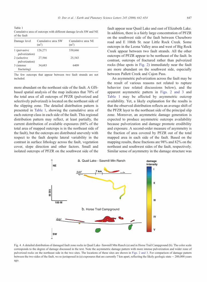
Table 1Cumulative area of outcrops with different damage levels SW and NEof the fault
Damage level Cumulative area SW(m2)
Cumulative area NE(m2)
1 (pervasivepulverization)
126,271 330,666
2 (selectivepulverization)
27,566 25,543
3 (intensefracturing)
34,683 6409
The few outcrops that appear between two fault strands are notincluded.
647O. Dor et al. / Earth and Planetary Science Letters 245 (2006) 642–654
more abundant on the northeast side of the fault. A GIS-based spatial analysis of the map indicates that 70% ofthe total area of all outcrops of PFZR (pulverized andselectively pulverized) is located on the northeast side ofthe slipping zone. The detailed distribution pattern ispresented in Table 1, showing the cumulative area ofeach outcrop class in each side of the fault. This regionaldistribution pattern may reflect, at least partially, thecurrent distribution of available exposures (66% of thetotal area of mapped outcrops is in the northeast side ofthe fault), but the outcrops are distributed unevenly withrespect to the fault despite lateral variability in thecontrast in surface lithology across the fault, vegetationcover, slope direction and other factors. Small andisolated outcrops of PFZR on the southwest side of the
Fig. 4. A detailed distribution of damaged fault zone rocks in Quail Lake–Sawcorresponds to the degree of damage discussed in the text. Note the asymmepulverized rocks on the northeast side in the two sites. The locations of thesbetween the two sides of the fault, we re-juxtaposed in (a) exposures that are cago.
fault appear near Quail Lake and east of Elizabeth Lake.In addition, there is a fairly large concentration of PFZRon the southwest side of the fault between Chesebororoad and E 106th St. near Little Rock Creek. Someoutcrops in the Leona Valley area and west of Big RockCreek appear between two fault strands. All the otheroutcrops of PFZR appear to be northeast of the fault. Incontrast, outcrops of fractured rather than pulverizedrocks (blue spots in Fig. 2) immediately near the faultare more abundant on the southwest side, especiallybetween Pallett Creek and Cajon Pass.
An asymmetric pulverization across the fault may bethe result of various reasons not related to rupturebehavior (see related discussions below), and theapparent asymmetric pattern in Figs. 2 and 3 andTable 1 may be affected by asymmetric outcropavailability. Yet, a likely explanation for the results isthat the observed distribution reflects an average shift ofthe PFZR layer to the northeast side of the principal slipzone. Moreover, an asymmetric damage generation isexpected to produce asymmetric outcrops availabilitybecause pulverization and damage promote erodibilityand exposure. A second-order measure of asymmetry isthe fraction of area covered by PFZR out of the totalmapped area in each side of the fault. Based on themapping results, these fractions are 98% and 82% on thenortheast and southwest sides of the fault, respectively.Similar sense of asymmetry in the damage structure was
mill Mtn Ranch (a) and in Horse Trail Campground (b). The color scaletric damage pattern with more intense pulverization and wider zone ofe sites are shown in Figs. 2 and 3. For comparison of damage patternurrently 7 km apart, reflecting the likely geologic state∼ 200,000 years

648 O. Dor et al. / Earth and Planetary Science Letters 245 (2006) 642–654
found in the smaller scale observations of Dor et al. [29]at selected sites in our study area and is compatible withour mesoscale mapping described below.
Although the mapped fault section is relativelystraight and does not include major structural complex-ities, geometrical complexities at smaller scales mayexist and affect the local faulting environment anddamage pattern. The rocks surrounding the slipping zonemay have been subjected to changes in the local faultingconditions during their history. However, rock bodies onthe opposite sides of the fault should have had an equalchance to be exposed to local geometrical complexities.Despite these (and other) complexities, the distributionof PFZR is apparently asymmetric across the fault, whilemaintaining overall consistent width and pulverizationgradient with respect to the slipping zone. Theseobservations suggest that the regional body of PFZRwas created by many earthquake ruptures over a timescale much longer than that associated with effects oflocal transient complexities. These different time scalesallow the asymmetry and other large-scale systematicfeatures to exist despite the overprint of local conditions.
We exclude marble (green spots in Fig. 2) from thediscussion about symmetry properties because its damage
Fig. 5. (a) A detailed distribution of damaged fault zone rocks in a site northweto the scale in Fig. 4. (b) A schematic composite cross-section of the damaperpendicular to the fault. The principal slip zone is on the southwest side of aactivity is apparent by subsidiary gouge zones northeast of the principal slip
pattern has not yet been properly characterized. In general,marble rock bodies along the fault are only macroscopi-cally fractured and not pulverized, but preliminarymicroscale observations in thin sections show that theyhave very high dislocation density and twining [39] thatcan be possibly attributed to brittle faulting (e.g. [40]).
2.3. Classes of pulverization and fault zone scalemapping results
In several locations along the fault, we were able tomap the damage pattern in the mesoscale and study thewidth and gradient of damage with respect to theprincipal slip zone. Mapping results from three of thoselocations are presented in Figs. 4 and 5. For the faultzone scale mapping, we chose locations in which PFZRhave good exposures from the principal slip zone andoutward. We found such locations only in the northwestportion of our mapping area (see locations in Figs. 2 and3). For the purpose of this mapping, we differentiatedthe damage intensity into five classes. As with theregional mapping, the following definitions of damageintensity are based on in situ macroscopic distinctproperties. Although the damage gradient is continuous
st of Lake Hughes (see location in Figs. 2 and 3). The colors correspondge zone obtained by combining features from (a) into a vertical plane∼ 60 m wide layer of intensely pulverized rocks. Additional strike slipzone. A ‘fault zone valley’ correlates with the zone of intense damage.
649O. Dor et al. / Earth and Planetary Science Letters 245 (2006) 642–654
without discrete transitions, we use these classes toapproximate the spatial variations of damage intensity.
The classes of damage, starting from the lowest are asfollows: (I) weak fracturing — macroscopic largefractures in density that exceeds the background levelof damage in the country rock. (II) Fragmentation —fractures are in the cm scale and the rock is fragmented,resulting in the creation of rugged surfaces. Some of thefragments can be easily crushed by hand into smaller,visible pieces. (III) Intense fracturing — fractures are inthe grain size scale. Although similar in texture to grus,its mechanical origin is attested by its structural contextand location in the deformation gradient. It is typicallycharacterized by rough, rounded surfaces. (IV) Weak/selective pulverization — some of the crystals surviveand remain intact, some break along sub-crystalfractures, and some yield powdery texture due tomicroscopic fractures. The typical appearance in thefield often can be similar to that of the next (highest)damage class. (V) Pervasive pulverization— all crystalsyield a powdery texture when crushed by hand.Associated geomorphic landforms tend towards smooth,rounded outcrops or bad-land topography with extreme-ly high drainage density, which is typical of very weak,easily eroded impermeable rock. Damage classes IVandV correspond to “pulverized” (red) and “selectivelypulverized” (orange) in the map of Fig. 2, respectively.Damage classes I–III further differentiate the “intensefracturing” class (blue) of Fig. 2 to allow a betterdescription of the damage gradient into the country rock.
Overall, the degree of damage of crystalline fault zonerocks at a point appears to depend mainly on the distancefrom and side of the fault. In addition, the damage leveldepends to a currently unknown extent on rock propertiessuch as macroscopic uniformity, isotropy and the mineralcontent of the rock. For instance, melanocratic rocks tendto be less pulverized compared to leucocratic rocks withcorresponding locations, the opposite of what would beexpected from the result of in situ weathering. Metamor-phic rocks seem to be less susceptible to pulverization,although we do not have at present independentsystematic evidence for this or indication that it affectsthe distribution pattern of PFZR.We find on the southwestside of the fault pervasively pulverized rocks within alarge body of gneisses (e.g. near Elizabeth Lake, Fig. 3) aswell as macroscopically fractured rocks within granites(e.g. near Three Points, Figs. 3 and 4). The influence of therock type on the distribution pattern of PFZR should bestudied in more detail in future works.
The mesoscale mapping results of Figs. 4 and 5provide additional information on the symmetry prop-erties of damaged fault zone rocks with respect to the
principal slip zone of the SAF. Our mapping shows thaton the northeast side of the fault, the zone ofpulverization is wider and pulverization is more intenseat a given distance from the fault. This is evident in Fig.4a, displaying two road cut exposures that are currently7 km apart, one from the Quail Lake area (south) and theother from Sawmill Mtn Ranch area (north). Theexposures were re-juxtaposed for this display, reflectinga geologic situation that corresponds to about∼200,000 years ago based on the current displacementrate of 3.5 cm/year. Similar or stronger contrast inpulverization intensity is also shown clearly in Figs. 4band 5a for two places where crystalline rocks crop outon both sides of the fault.
Fig. 5b gives a schematic composite cross-section ofthe damage zone in which the mapped features of Fig.5a were combined into a vertical plane perpendicular tothe fault. The resulting ∼60 m wide fault zone iscomposed of the currently active gouge zone, as well asseveral other secondary gouge zones (purple lines)embedded within intensely pulverized rock (red).Although slip on the SAF could alternate between thedifferent gouge zones, both the strong geomorphicexpression of the currently active fault strand and itscoincidence with the major lithologic boundary attestthat this is the locus of long-term localization of motion.As such, the currently active fault strand, which is theprincipal slip zone, is a suitable center of reference forevaluation of symmetry properties. The subsidiarygouge zones manifest intense damage associated withfaulting that is secondary to the main slip zone.
The composite cross-section of Fig. 5b has anasymmetric structure in which most of the fault zonestructural elements (i.e. secondary gouge zones) andpulverization are on the northeast side of the principalslip zone. A larger scale asymmetry appears in thegeomorphic expression of the SAF, with the “fault zonevalley” occupying the more damaged northeast side ofthe fault zone.
2.4. Pulverization of sedimentary rocks
During the course of searching for crystalline rocksalong the fault, we found several exposures ofsedimentary rocks that exhibit damage or pulverizationthat correspond to degrees III to V as described above.This is supported by preliminary observations in themicroscale of particle size distribution and thin sections.Those exposures are shown in Fig. 2 as purple stars andinclude the following sedimentary units: Juniper Hillsconglomerate in several sites, Anaverde sandstone in thePalmdale area, and Hungry Valley sandstone near Three

650 O. Dor et al. / Earth and Planetary Science Letters 245 (2006) 642–654
Points and near Quail Lake. Tentative pulverization ofsedimentary rocks was observed at other sites. Thosedamaged sedimentary rocks were found so far mainly onthe northeast side of the fault. Pulverization insedimentary units is not as abundant as in crystallinerocks, and we found several examples of nearly-intactsedimentary rocks within the fault zone at severallocations (e.g. Anaverde sandstone east of LeonaValley). In places where sedimentary and crystallinepulverized rocks are found in contact, they are oftenseparated by small local faults.
3. Discussion
We describe persistent large-scale spatial propertiesof PFZR in the Mojave section of the SAF, based ongeological mapping at several tens of sites, supplemen-ted by more detailed mapping at selected sites. Theresults establish the PFZR as a general structuralproperty of the SAF in the Mojave. In addition, wefind that the distribution of exposed PFZR is asymmet-ric across the fault, with more than twice cumulativearea of PFZR cropping out on the northeast side of theslip zone than on the southwest side.
The fault zone structure at any given location can beaffected by numerous variables and local conditions. Doret al. [29] discuss various factors that can produceuncertainties in the interpretation of geological mappingof the type done here. The discussed issues include thegeneral problem of connecting dynamic rupture behaviorat seismogenic depth with surface observations, influ-ence of contrast in surface lithology on the symmetryproperties of the damage pattern, possible effect of faultdip on asymmetry, complex history of the fault, theinfluence of geometrical and compositional complexi-ties, migration of the active slipping zone, and more. Ageneral way to reduce the above interpretation problems,adopted in our work, is to perform multi-signal multi-scale mapping of rock damage at multiple sites along thefault. The characteristics of the fault structure discussedin this study, combined with the work of Dor et al. [29],have multiple manifestations at different scales anddifferent sites along the fault. This provides a basis forinterpreting the data in terms of persistent rupturebehavior and the large-scale structural properties of thefault at depth.
3.1. Geologic observations related to the possible depthof pulverization
There are several indications that pulverization of themapped PFZR occurred at a relatively shallow depth.
First, the Punchbowl fault only 5 km southwest from theoutcrops of pulverized rock bodies near the SAF, isinterpreted to have been exhumed from about 2 to 4 km([41], and references therein). In the lack of evidence for adifferential vertical movement between the two faults, wecan assume that this is the maximum exhumation depthfor the SAF in this area as well. The SAF is located fartheraway from the locus of uplift in the San GabrielMountains when compared to the Punchbowl area.Displacement along the current trace of the SAF that isassociated with our mapped PFZR occurred during orafter the time of activity of the Punchbowl fault [42]. Theobserved terrains did not arrive from far away, whereexhumation could be potentially larger, because thecurrent strand of the SAF has only a few tens of km ofdisplacement in this area (e.g. [36]). Therefore, theinferred maximum uplift of 2–4 km for the area of thePunchbowl fault on the mountain side of the SAFprovides an upper bound for exhumation of the SAF itself.
Second, at various sites along the Mojave section ofthe SAF, there are several lines of direct evidence thatthe Mojave acted as a relatively stable block with onlyminor exhumation throughout the late Miocene topresent: near Gorman, Miocene rocks of the QuailLake Formation are exposed at elevations that are withina hundred meters or so of Pliocene rocks of the HungryValley Formation and younger late Quaternary forma-tions, with depositional contact between them (i.e.,those formations were not separated from each other bya vertical component of motion on dip slip faults).Similarly, middle Quaternary fans near Quail Lake areoffset 15 km along the SAF and directly overlie theMiocene rocks. Elsewhere in the western Mojave, thereare Miocene Lake deposits (e.g., Rainbow basin nearBarstow) that show no significant uplift of the westernMojave since at least middle to late Miocene time,which is essentially the age of the modern San Andreasfault system [43]. The Victorville fan has been offsettens of kilometers laterally, but shows no uplift on theMojave side in the Quaternary. Considering that some ofthe strands of the SAF along which we have identifiedPFZR are relatively young, we again argue that verticalmotion during the timeframe of their activity must besmall. These observations suggest that at least since themiddle Miocene, deep exhumation of the fault zone isunlikely to have occurred, although uplift has resulted inthe areas current elevation of more than 1 km. OtherPlio-Quaternary formations along the SAF, such as theAnaverde and the Juniper Hills formations, weredeposited in narrow basins resulting from smallstructural complexities (step-overs). It is not clear howmuch has been eroded but the consolidation is minor,

651O. Dor et al. / Earth and Planetary Science Letters 245 (2006) 642–654
suggesting again only minor exhumation. In addition,middle to late Quaternary fans are preserved along thefault, indicating only minor incision in late Quaternarytime.
Third, we have found that several sandstone andconglomerate units that were never deeply buried aredamaged or perhaps even pulverized at levels thatexceed the background damage level. This generalobservation puts the upper bound for damage generationand maybe pulverization to a possible depth of severalhundreds of meters or less, although further character-ization of the damage to sedimentary units along theSAF is needed in order to provide more accurateconstraints for the pulverization process.
Forth, additional direct evidence that pulverizationoccurs at shallow depths is provided by studies [44,2] ofpulverized quartzite in fresh rupture zones in SouthAfrican gold mines. They analyzed rock-powdersamples collected from the rupture zone of M=3.7earthquake at depth of about 2 km (and near largeinternal free surfaces), and found that the grain sizedistribution and other properties of those samples issimilar to those found in Tejon Pass. Pulverizedquartzites are abundant in many fresh rupture zones inthe mines [45], sometimes forming under minimal oreven negligible confining stress.
Wilson [46] argued that pulverization at Tejon Passcould have potentially occurred at a depth of 4–9 kmbased on exhumation rates in the Transverse Ranges.Even if the estimated exhumation is correct, theobserved pulverization could have occurred during orafter the exhumation. Moreover, the exhumationestimates have large uncertainties. Ref. [42] has shownthat crystalline rock domains like the Pelona/Orocopiaschists and possibly source rocks to our mapped PFZRcould have been exhumed from a great depth during theClemens-Well, Fenner, San-Francisquito phase of theSAF (20–17 and 13–12 Ma). Displacement andpossibly some exhumation continued since 4–5 Ma inthe same zone along the modern SAF. However,according to the reconstruction of Powell and Weldon[42], the modern trace of SAF, which has well definedand unique structural association with our mappedPFZR, may have re-occupied the same region that wasactive during that early phase of faulting, but not theexact same ancient trace that is delineated now by the(rotated and inactive) Clemens-Well, Fenner and San-Francisquito faults. The tight structural association ofthe PFZR with the modern trace of the SAF implies thatthe pulverization we observe occurred during themodern activity of the SAF, after the main phase ofthe exhumation.
3.2. Correlation of mapping results with geophysicalobservations
A number of recent studies concluded that the lowvelocity seismic waveguides that produce trapped wavesin the San Andreas, Landers, San Jacinto, and NorthAnatolian fault zones are generally limited to the upper∼3–5 km of the crust [47–50,34]. The seismic trappingstructures have a width on the order of 100 m, similar tothe lateral dimensions of the mapped body of PFZR, andare associated with strong reduction of seismic velocities(e.g., 30–50%) and strong attenuation (e.g., Q values ofshear waves less than 10). The seismically imaged depthextent of the trapping structures correlates with themaximum inferred pulverization depth of Section 3.1,and the PFZR should have significant reduction ofseismic velocities and significant increase of seismicattenuation due to the strong reduction of grain size andassociated hydrological and chemical effects. In addition,recent imaging studies based on trapped and head wavesindicate that the shallow damaged layers are asymmetricacross the faults [34,35]. We thus suggest that theobserved PFZR are the surface expression of the lowvelocity fault zone layers that act as seismic waveguides.
3.3. Relations of the mapping results to theoreticalpredictions
The observed coherent layer of PFZR with relativelyshallow inferred pulverization depth and apparentasymmetric structure with respect to the principal slipzone requires a generation mechanism. This mechanismshould depend on large-scale properties (rather than localsite conditions), and should generate strong tensionalstress field in the vicinity of the fault that can produceasymmetric long-term damage pattern in the upper fewkm of the crust. A curvature along the entire Mojavesection of the SAF can produce asymmetric static stressfield [51]. However, this is unlikely to produce theextreme grain reduction of the pulverized rocks (e.g., [2],this study) and the highly localized asymmetric patternof gouge fabric found by Dor et al. [29]. As outlined inthe introduction, mode II rupture along a materialinterface (e.g., [4,10–18]) provides a specific set ofpredictions that are compatible with our observations.
The parameter–space study of Ben-Zion and Shi [27]indicates that dynamic generation of rock damageduring such ruptures, under realistic conditions ofvelocity contrast and material properties, is limited tothe shallow portion of the crust. The events propagatepreferentially in the direction of slip on the side withlower seismic velocities at seismogenic depth, while

652 O. Dor et al. / Earth and Planetary Science Letters 245 (2006) 642–654
damage is generated in the top few km on the side withfaster seismic velocity, which is persistently on thetensional quadrant of the radiated seismic field for thepreferred propagation direction.
The available seismic imaging studies in our areaindicate [31–33] that the northeast side of the Mojavesection of the SAF has higher seismic velocities than thesouthwest side. The mapped distribution of PFZR inFigs. 2–5 and the finer-scale observations of Dor et al.[29] show more damage on the higher velocity block.While the completeness of the mapping is affected bysites availability, the multiple observed manifestationsof damage asymmetry across the SAF are compatiblewith the predictions for wrinkle-like ruptures along amaterial interface. The tensional stress produced bywrinkle-like ruptures may be aided by dynamicreduction of normal stress associated with the othermechanisms mentioned in the introduction, althoughthis can not be tested at present in the absence of explicitpredictions. However, none of the other mechanismsexplains the observed correlation between the damageasymmetry and the velocity structure of the fault, andthe existence of a preferred or more vigorous rupturedirection which is necessary for the production of long-term asymmetric damage structure.
3.4. Comparison between the structures of the activeSAF and exhumed faults of the SAF system
The general structure that we observe for the SAF in theMojave includes a very narrow zone on the order of a fewcm to ameter or so inwhich slip is localized, surrounded bya zone of strong damage on a scale of several tens ofmeterswithout significant shear parallel to the principal slip zone(in places we find several secondary or previously activeslip zones). The deformation decreases gradually as afunction of distance from the principal slip zone. Thisstructure matches general characteristics of ancestralexhumed faults of the SAF system such as the Punchbowland San Gabriel Faults ([52–54] and references therein).
In addition to the presented observations associatedwith the SAF, we have also recently observed a similar,tens of meters wide body of pulverized granite along thesouthern side of the Garlock fault on Tejon Ranch, withpulverization decreasing away from the active trace of thefault. PFZR can be seen in meters to tens of meters wideexposures southwest of the Little Rock Fault, west ofTierra Subida Rd. and north of the Anaverde Creek nearPalmdale. Farther to the east exposures of similar scaleappear between strands of the Little Rock fault and theSAF along Pallett Creek Rd. We also found PFZR in∼20 cm layer adjacent to the ultracataclasite of the
Punchbowl fault on the sandstone side where it is exposednear the top of the trail that climbs up from the SouthforkCampground. Several outcrops of pulverized granodio-rite, ranging in width from several tens of cm to severalmeters appear adjacent to the traces of the Southern andNorthern Nadeau faults, where Mt. Emma Rd. crossesLittle Rock Creek, and on Cheseboro Rd. about 1.2 kmnorth of the junction with Mt. Emma Rd. (some outcropsof PFZR there may be related to the nearby trace of thePunchbowl fault). A layer of pulverized granodiorite on asimilar scale bounds the northeast side of the fault core ofan ancestral strand of the SAF, 300 m south of the activeSAF east of where it crosses Little Rock Creek (near“Little Rock Creek Site” of Ref. [29]). The pulverizationfound in these faults is on a much smaller scale withrespect to other fault zones andmay reflect either differentpulverization conditions or different pulverization pro-cess; it may also be related to the amount of displacementunder ‘pulverization–generation conditions’.
On the other hand, we found a clear absence ofpulverized rocks in the structure of the San Gabriel faultnear the “Earthquake Fault site” of Ref. [55], and inseveral other sites along Big Tujunga Canyon Road andAngeles Crest Highway. In the San Gabriel fault andother cases of uplifted structures that have no PFZR, it ispossible that the exhumation was to such a depth that thezone of PFZR has been eroded and is not preserved (if itindeed formed at depths shallower than the exhumationdepth). Outcrops of granitic rocks adjacent to the activetrace of the Elsinore fault near the junction of Hwy 79and Hwy 76 appear to be almost intact. This is despitethe presence of a near by large step-over that would havepromote tensional stresses (Lake Henshaw). Whetherthe absence of PFZR from the exposed structure of afault implies that no mechanism with sufficiently strongdynamic reduction of normal stress operated during itsactivity is a question we cannot answer at this point.
4. Summary
The observations made in this paper, combined withprevious geologic and geophysical observations, suggestthat PFZR along theMojave section of the SAF consist of a∼100mwide layer parallel to the principal slip zone of thefault. We infer that the observed pulverization occurred atshallow depths based on several lines of geologicobservations and theory. Our results and the smaller scaleobservations of Dor. et al. [29] suggest further that the layerof PFZR is not centered on the principal slip zone, but isshifted on average to the northeast side of the fault. Thisapparent damage asymmetry is compatiblewith a preferredor more vigorous northwest propagation direction of

653O. Dor et al. / Earth and Planetary Science Letters 245 (2006) 642–654
earthquakes on the Mojave section of the SAF, whichwould have a damage-promoting tensional quadrant on thenortheast side. This is also the side of the fault that hasfaster seismic velocities at seismogenic depth based onavailable imaging studies in the area [31–33]. A northwestpreferred rupture direction is opposite the currently inferredrupture direction [56] for the 1857 Ft. Tejon earthquake.See a related discussion on this issue at Ref. [29].
The correlation between the apparent damageasymmetry and the side of the fault with faster seismicvelocities at seismogenic depth, together with theinferred shallow pulverization depth, are consistentwith theoretical predictions associated with wrinkle-likeruptures along a material interface [27]. In addition toexplaining our observations, such a mode of rupture canbe relevant to various important aspects of themechanics and structure of large faults, including thegeneral lack of melting products; suppression ofbranching, short rise-time of earthquake slip, effectiveconstitutive laws, and expected seismic shaking hazard[4,15]. The SAF in the Mojave has several structuralproperties in common with ancestral exhumed faults ofits system, although PFZR do not have an equalpresence in all of those faults. The partial similaritybetween the structure of the SAF that is exposed at thesurface and those exhumed structures lends support toour inferences on seismogenic processes along the SAF.
Acknowledgments
We thank Ze'ev Reches, Tom Dewers and BrentWilson for discussions during joint field trips. The studywas funded by the National Science Foundation (grantEAR-0409048) and the Southern California EarthquakeCenter (based on NSF cooperative agreement EAR-8920136 and United States Geological Survey coopera-tive agreement 14-08-0001-A0899). The manuscriptbenefited from constructive reviews by Matthew d'Ales-sio, an anonymous referee and Editor Rob van der Hilst.
Appendix A. Supplementary data
Supplementary. data associated with this articlecan be found, in the online version, at doi:10.1016/j.epsl.2006.03.034.
References
[1] J.N. Brune, Fault normal dynamic loading and unloading: anexplanation for “nongouge” rock powder and lack of fault-parallelshear bands along the San Andreas fault, EOS Trans. Am.Geophys. Union 82 (47) (2001) (Abstract S22B-0655).
[2] B. Wilson, T. Dewers, Z. Reches, J.N. Brune, Particle size andenergetics of gouge from earthquake rupture zones, Nature 434(2005) 749–752.
[3] J.N. Brune, S. Brown, P.A. Johnson, Rupture mechanism andinterface separation in foam rubber model of earthquakes: apossible solution to the heat flow paradox and the paradox oflarge overthrusts, Tectonophysics 218 (1993) 59–67.
[4] Y. Ben-Zion, Dynamic rupture in recent models of earthquakefaults, J. Mech. Phys. Solids 49 (2001) 2209–2244.
[5] H.J. Melosh, Acoustic fluidization: a new geological process?J. Geophys. Res. 84 (1979) 7513–7520.
[6] J. Lomnitz-Adler, Model for steady friction, J. Geophys. Res. 96(1991) 6121–6131.
[7] J.R. Rice, Fault stress states, pore pressure distributions, and theweakness of the San Andreas fault, Fault Mechanics andTransport Properties of Rocks, Academic, San Diego, Calif,1992, pp. 475–503.
[8] J. Byerlee, Model for episodic flow of high-pressure water infault zones before earthquakes, Geology 21 (1993) 303–306.
[9] S.A. Miller, A. Nur, D.L. Olgaard, Earthquakes as a coupledshear stress high pore pressure dynamical system, Geophys. Res.Lett. 23 (2) (1996) 197–200.
[10] J. Weertman, Unstable slippage across a fault that separateselastic media of different elastic constants, J. Geophys. Res. 85(1980) 1455–1461.
[11] G.G. Adams, Self-excited oscillations of two elastic half-spacessliding with constant coefficient of friction, J. Appl. Mech. 62(1995) 867–872.
[12] D.J. Andrews, Y. Ben-Zion, Wrinkle-like slip pulse on afault between different materials, J. Geophys. Res. 102 (1997)553–571.
[13] K. Ranjith, J. Rice, Slip dynamics at an interface betweendissimilar materials, J. Mech. Phys. Solids 49 (2001) 341–361.
[14] Y. Ben-Zion, Y. Huang, Dynamic rupture on an interface betweena compliant fault zone layer and a stiffer surrounding solid,J. Geophys. Res. 107 (2002), doi:10.1029/2001JB000254.
[15] Y. Ben-Zion, D.J. Andrews, Properties and implications ofdynamic rupture along a material interface, Bull. Seismol. Soc.Am. 88 (1998) 1085–1094.
[16] A. Cochard, J.R. Rice, Fault rupture between dissimilarmaterials: ill posedness, regularization, and slip-pulse response,J. Geophys. Res. 101 (2000) 25321–25336.
[17] Z. Shi, Y. Ben-Zion, Dynamic rupture on a bimaterial interfacegoverned by slip-weakening friction, Geophys. J. Int. 164 (2006),doi:10.1111/j.1365- 246X.2006.02853.x.
[18] G.B. Brietzke, Y. Ben-Zion, Examining tendencies of in-planerupture to migrate to material interfaces, Geophys. J. Int., inreview (2006).
[19] D.J. Andrews, R.A. Harris, The wrinkle-like slip pulse is notimportant in earthquake dynamics, Geophys. Res. Lett. 32 (2005)L23303, doi:10.1029/2005GL02399.
[20] Y. Ben-Zion, A comment on “The wrinkle-like slip pulse in notimportant in earthquake dynamics”byAndrews andHarris,Geophys.Res. Lett. 33 (2006) L06310, doi:10.1029/2005GL025372.
[21] R.H. Sibson, Brecciation processes in fault zones: Inferencesfrom earthquake rupturing, Pure Appl. Geophys. 124 (1–2)(1986) 159–175, doi:10.1007/BF00875724.
[22] W.L. Power, T.E. Tullis, J.D. Weeks, Roughness and wear duringbrittle faulting, J. Geophys. Res. 93 (1988) 15268–15278.
[23] T. Yamashita, Generation of microcracks by dynamic shearrupture and its effects on rupture growth and elastic waveradiation, Geophys. J. Int. 143 (2000) 395–406.
654 O. Dor et al. / Earth and Planetary Science Letters 245 (2006) 642–654
[24] A.N. Poliakov, B.R. Dmowska, J.R. Rice, Dynamic shear ruptureinteractions with fault bends and off-axis secondary faulting,J. Geophys. Res. 107 (B11) (2002), doi:10.1029/2001JB000572.
[25] L.A. Dalguer, K. Irikura, J.D. Riera, Simulation of tensile crackgeneration by three-dimensional dynamic shear rupture propaga-tion during an earthquake, J. Geophys. Res. 108 (B3) (2003) 2144,doi:10.1029/ 2001JB001738.
[26] D.J. Andrews, Rupture dynamics with energy loss outside the slipzone, J. Geophys. Res. 110 (2005) B01307, doi:10.1029/2004JB003191.
[27] Y. Ben-Zion, Z. Shi, Dynamic rupture on a material interface withspontaneous generation of plastic strain in the bulk, Earth Planet.Sci. Lett. 236 (2005) 486–496, doi:10.1016/j.epsl.2005.03.025.
[28] J.R. Rice, C.G. Sammis, R. Parsons, Off-fault secondary failureinduced by a dynamic slip pulse, Bull. Seismol. Soc. Am. 95(2005) 109–134.
[29] O. Dor, T.K. Rockwell, Y. Ben-Zion, Geologic observations ofdamage asymmetry in the structure of the San Jacinto, SanAndreas and Punchbowl faults in southern California: a possibleindicator for preferred rupture propagation direction, Pure Appl.Geophys. 163 (2006), doi:10.1007/s00024-005-0023-9.
[30] J.S. Scott, T.G. Masters, F.L. Vernon, 3-D velocity structure ofthe San Jacinto fault zone near Anza, California — I. P waves,Geophys. J. Int. 119 (1994) 611–626.
[31] G.S. Fuis, R.W. Clayton, P.M. Davis, T. Ryberg,W.J. Lutter, D.A.Okaya, E. Hauksson, C. Prodehl, J.M. Murphy, M.L. Benthien,S.A. Baher, M.D. Kohler, K. Thygesen, G. Simila, G.R. Keller,Fault systems of the 1971 San Fernando and 1994 Northridgeearthquakes, southern California: Relocated aftershocks andseismic images from LARSE II, Geology 31 (2003) 171–174.
[32] W.J. Lutter, G.S. Fuis, T. Ryberg, D.A. Okaya, R.W. Clayton,P.M. Davis, C. Prodehl, J.M. Murphy, V.E. Langenheim, M.L.Benthien, N.J. Godfrey, N.I. Christensen, K. Thygesen, C.H.Thurber, G. Simila, G.R. Keller, Upper crustal structure from theSanta Monica Mountains to the Sierra Nevada, SouthernCalifornia: tomographic results from the Los Angeles RegionalSeismic Experiment, Phase II (LARSE), Bull. Seismol. Soc. Am.94 (2004) 619–632.
[33] N.M. Shapiro, M. Campillo, L. Stehly, M.H. Ritzwoller, High reso-lution surfacewave tomography from ambient seismic noise, Science307 (5715) (2005) 1615–1618, doi:10.1126/science.1108339.
[34] M.A. Lewis, Z. Peng, Y. Ben-Zion, F. Vernon, Shallow seismictrapping structure in the San Jacinto fault zone, Geophys. J. Int.162 (2005) 867–881, doi:10.1111/j.1365-246X.2005.02684.x.
[35] M.A. Lewis, Y. Ben-Zion J. McGuire, Imaging the deep structureof the Bear Valley section of the San Andreas Fault with jointanalysis of fault-zone head and direct P wave arrivals, Geophys.J. Int., in review (2006).
[36] A.G. Barrows, J.E. Kahle, D.J. Beeby, Earthquake hazard andtectonic history of the San Andreas Fault Zone, Los AngelesCounty, California, Open File Report 85-10 LA, CaliforniaDepartment of Conservation, Division ofMines andGeology, 1985.
[37] Ross, D.C. Map showing recently active breaks along the SanAndreas Fault between Tejon Pass and Cajon Pass, SouthernCalifornia, USGS Miscellaneous Geologic Investigation, map I–553 (1969).
[38] C.W. Jennings, R.G. Strand, T.H. Rogers (compilers), Geologicalmap of California, Calif. Div. Mines and Geol., AmericanGeological Institute (2001).
[39] A. Schubnel, personal comm. (2005).[40] M.H. Anders, N. Christie-Blick, S. Wills, Rock deformation
studies in the Mineral Mountains and Sevier Desert of west-central Utah: implications for upper crustal low-angle normalfaulting, Geol. Soc. Amer. Bull. 113 (7) (2001) 895–907.
[41] F.M. Chester, J.S. Chester, D.L. Kirschner, S.E. Schulz, J.P.Evans, Structure of large-displacement strike-slip fault zones inthe brittle continental crust, in: Gary D.Karner, Brian Taylor, NealW. Driscoll, David L. Kohlstedt (Eds.), Rheology and Deforma-tion in the Lithosphere at Continental Margins, MARGINSTheoretical and Experimental Earth Science Series, vol. 1,Columbia University Press, New York, 2004, pp. 223–260.
[42] R.E. Powell, R.J. Weldon, Evolution of the San Andreas Fault,Annu. Rev. Earth Planet. Sci. 20 (1992) 431–468.
[43] M. Oskin, J. Stock, Marine incursion synchronous with plate-boundary localization in the Gulf of California, Geology 31(2003) 23–26.
[44] Z. Reches, T.A. Dewers, Gouge formation by dynamic pulver-ization during earthquakes, Earth Planet. Sci. Lett. 235 (1–2)(2005) 361–374.
[45] O. Dor, Z. Reches, G. van Aswagen, Fault zones associated withthe Matjhabeng earthquake, 1999, South Africa, Rockburst andSeismicity in Mines, RaSiM5 (Proceedings), South African Inst.of Mining and Metallurgy, 2001, pp. 109–112.
[46] B.Wilson,Meso- andMicro-Structural Analysis of the SanAndreasFault at Tejon Pass, California, Unpublished Masters Thesis,University of Oklahoma, Norman, Oklahoma, 279 pp (2004).
[47] Y. Ben-Zion, Z. Peng, D. Okaya, L. Seeber, J.G. Armbruster, N.Ozer, A.J. Michael, S. Baris, M. Aktar, A shallow fault zonestructure illuminated by trapped waves in the Karadere–Duzcebranch of the North Anatolian Fault, western Turkey, Geophys.J. Int. 152 (2003) 699–717.
[48] V.A. Korneev, R.M. Nadeau, T.V. McEvilly, Seismologicalstudies at Parkfield IX: fault-zone imaging using guided waveattenuation, Bull. Seismol. Soc. Am. 93 (2003) 1415–1426.
[49] A. Michael, Y. Ben-Zion, Inverting fault zone trapped waves witha genetic algorithm, EOS 79 (1998) F584.
[50] Z. Peng, Y. Ben-Zion, A.J. Michael, L. Zhu, Quantitative analysisof seismic trapped waves in the rupture zone of the 1992 Landers,California earthquake: evidence for a shallow trapping structure,Geophys. J. Int. 155 (2003) 1021–1041.
[51] M.A. d'Alessio, written communication, 2006.[52] F.M. Chester, J.M. Logan, Implications for mechanical properties
of brittle faults from observations of the Punchbowl fault zone,California, Pure. Appl. Geophys. 124 (1986) 79–106.
[53] S.E. Schultz, J.P. Evans, Mesoscopic structure of the PunchbowlFault, Southern California and the geologic and geophysicalstructure of active strike slip faults, J. Struct. Geol. (2000) 913–930.
[54] Y. Ben-Zion, C.G. Sammis, Characterization of fault zones, PureAppl. Geophys. 160 (2003) 677–715.
[55] J.P. Evans, F.M. Chester, Fluid-rock interaction and weakening offaults of the San Andreas system: inferences from San Gabrielfault-rock geochemistry and microstructures, J. Geophys. Res.100 (1995) 13007–13020.
[56] D.C. Agnew, K.E. Sieh, A documentary study of the felt effectsof the great California earthquake of 1857, Bull. Seismol. Soc.Am. 68 (6) (1978) 1717–1729.