pyrmont peninsula · 1 day ago · heritage for place identity, vision and character today,...
TRANSCRIPT

Pyrmont PeninsulaPlace Strategy— Final Report
Report prepared for Department of Planning
and Environment NSW —July 2020
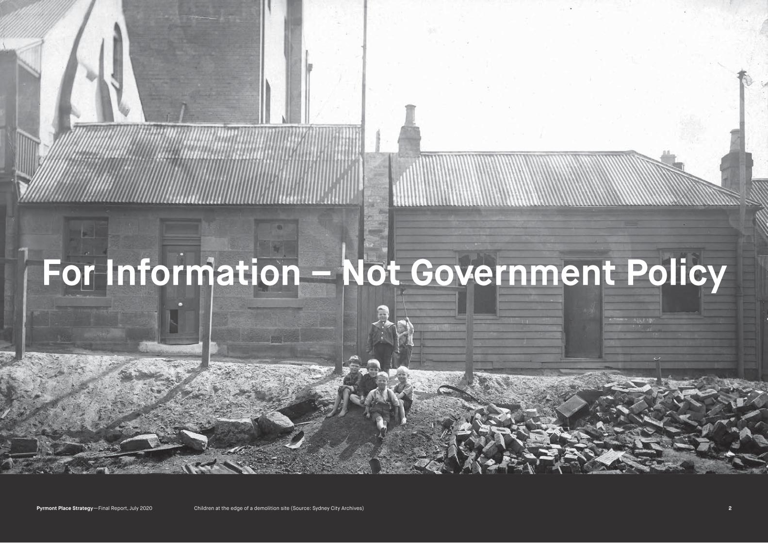
Children at the edge of a demolition site (Source: Sydney City Archives)
For Information – Not Government Policy
GML Heritage
2Pyrmont Place Strategy —Final Report, July 2020

Report Register
The following report register documents the development and issue
of the report entitled PyrmontPeninsula—Place Strategy, undertaken by
GML Heritage Pty Ltd in accordance with its quality management system.
Job No. Issue No. Notes/Description Issue Date
20-0155 4 Final Report July 2020
Quality Assurance
GML Heritage Pty Ltd operates under a quality management system which
has been certified as complying with the Australian/New Zealand Standard
for quality management systems AS/NZS ISO 9001:2016. The report has
been reviewed and approved for issue in accordance with the GML quality
assurance policy and procedures.
Copyright
Historical sources and reference material used in the preparation of this
report are acknowledged and referenced at the end of each section and/
or in figure captions. Reasonable effort has been made to identify, contact,
acknowledge and obtain permission to use material from the relevant
copyright owners. Unless otherwise specified or agreed, copyright in this
report vests in GML Heritage Pty Ltd (‘GML’) and in the owners of any pre-
existing historic source or reference material.
Moral Rights
GML asserts its Moral Rights in this work, unless otherwise
acknowledged, in accordance with the (Commonwealth) Copyright
(Moral Rights) Amendment Act 2000. GML’s moral rights include
the attribution of authorship, the right not to have the work falsely
attributed and the right to integrity of authorship.
Right to Use
GML grants to the client for this project (and the client’s successors in
title) an irrevocable royalty-free right to reproduce or use the material from
this report, except where such use infringes the copyright and/or Moral
Rights of GML or third parties.
Pyrmont Place Strategy—
Non-Indigenous Cultural Heritage Study
Title Page: Bringing up the sheep, Pyrmont (Source: State Library of NSW) Air Raid Rehearsal Pyrmont, 1940 (Source: SLV)
GML Heritage
3Pyrmont Place Strategy —Final Report, July 2020

Contents
1.0 INTRODUCTION 5
Background 6
Key Objectives 6
Methodology 6
The Study Area 6
Acknowledgements 6
2.0 ARCHAEOLOGY—SHAPING THE POINT 7
Rediscovering lost landscapes—Historic maps & GIS 8
Settlement over time 9
Mapping the built environs of a community 9
Improve Accessibility and Infrastructure 10
Rabbit Proof Fence Vegetable Garden 6
3.0 HISTORY 12
Introduction 13
Antipodean Idyll 13
Full Steam ahead 14
Getting Around 16
This Working Life 18
A Close-Knit Community 21
Removed, Reclaimed and Revitalised 24
4.0 HERITAGE PLANNING CONTEXT 27
Introduction 28
Pyrmont Heritage Conservation Area 32
Ultimo Heritage Conservation Area 37
Harris Street Heritage Conservation Area 42
Non-Statutory Heritage Listings 47
Pyrmont Point Locality Statement 49
Ultimo Locality Statement 50
Pyrmont Locality Statement 51
Summary Overview 53
Statement of Significance 54
5.0 PLACE STRATEGY RECOMMENDATIONS 54
Introduction 55
Character and Experience 55
Urban Morphology 55
Perceptions of Cultural Heritage 55
A Vision for Pyrmont-Ultimo 56
Masterplan Principles 56
Heritage Strategy and Recommendations 57
ENDNOTES 68
APPENDICES 69
GML Heritage
4Pyrmont Place Strategy —Final Report, July 2020

WJ Thomas, Pyrmont, 1907 (Source: Mitchell Library SLNSW)
INTRODUCTION
GML Heritage
5Pyrmont Place Strategy —Final Report, July 2020
Introduction
Background
This non-Indigenous cultural heritage study for the Pyrmont Peninsula has
been prepared as a technical report to support the development of the
Pyrmont Peninsula Place Strategy.
The Pyrmont Place Strategy is being led by the Department of Planning,
Industry and Environment (the department). The Strategy follows the
Greater Sydney Commission’s response to the review of planning for the
Western Harbour Precinct, which includes the Pyrmont Peninsula.
Key Objectives
• Understand the non-Indigenous heritage of the study area and
immediate surrounds, particularly the waterfront.
• Gain an appreciation of the roles and value of non-Indigenous
heritage for place identity, vision and character today, particularly
the role of heritage to create an authentic, attractive and vibrant
place (in collaboration with other consultants, such as in
economics and urban design).
• Develop an understanding of the characteristics of the study area
in relation to non-Indigenous heritage cultural, political, social
and related economic significance.
• Prepare an evidence base and provide strategic advice to
support the Place Strategy, including urban design framework,
master plan and recommendations and changes to deliver a
simplified planning control at the sub-precinct and site scale.
• Make recommendations on amendments to planning controls to
enable the urban design framework and master plan to be
implemented including provision of technical information and
other evidence to support change to land use planning controls
to satisfy relevant statutory guidelines.
• Make recommendations on how matters of non-Indigenous
heritage can be considered as part of ongoing governance of the
study area.
Methodology
The methodology for this non-Indigenous cultural heritage study has been
guided by the Statement of Requirements for the project. The key tasks
undertaken are outlined below:
• reviewed background documentation including published
histories, previous cultural heritage technical studies
and reports;
• carried out a high-level review of the current planning framework
as it relates to heritage for the study area;
• compiled and reviewed statutory and non-statutory heritage
listings;
• undertook targeted online historical research;
• undertook site inspections from public domain areas only;
• liaised with Heritage NSW, National Trust NSW and City of Sydney;
• collaborated with the project team and provided input and advice
as required; and
• georeferenced historical and property data to generate a series
of mapped overlays.
These tasks were undertaken to establish an evidence base to inform the
assessment, analysis and recommendations.
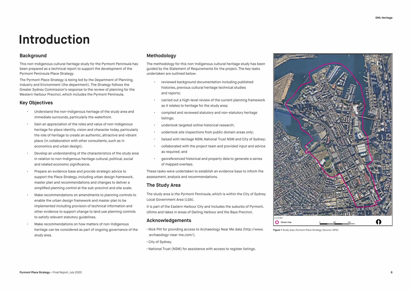
The Study Area
The study area is the Pyrmont Peninsula, which is within the City of Sydney
Local Government Area (LGA).
It is part of the Eastern Harbour City and includes the suburbs of Pyrmont,
Ultimo and takes in areas of Darling Harbour and the Bays Precinct.
Acknowledgements
• Nick Pitt for providing access to Archaeology Near Me data (http://www.
archaeology-near-me.com/).
• City of Sydney.
• National Trust (NSW) for assistance with access to register listings.
Figure 1 Study area, Pyrmont Place Strategy (Source: DPIE)
GML Heritage
6Pyrmont Place Strategy —Final Report, July 2020

A. Tischbauer 1893, Pyrmont Quarry Sydney, (Source: SLNSW)
ARCHAEOLOGY:
SHAPING THE POINT
GML Heritage
7Pyrmont Place Strategy —Final Report, July 2020

The following overlays depict a selection of individual elements and
features that make up the archaeological layers of the Pyrmont-Ultimo
Precinct. The evidence provides a picture of the diversity and patterning of
land use and activities that have shaped the Point over time. The overlays
also show how previous configurations have outlasted more recent
disturbance and change across the area.
Rediscovering lost landscapes—Historic maps & GIS
Pyrmont Peninsula has been well mapped over the past 170 years.
Although surveyors’ chains of old have been replaced by modern lasers
and paper has been replaced by digital outputs, all these surveys have the
potential to reveal much about the past in the present.
GIS is being used to incorporate disparate datasets such as modern
cadastral lot boundaries and digital elevation models with information
derived from historic cartography. Selections of these historic maps
display development and change across the peninsula. Digitising or tracing
relevant features such as roads, boundaries, buildings and shorelines
provides a framework for representing and understanding development
across the peninsula historically and provides insight into past occupation
and land use. Some of these elements, such as early tracks and pathways,
may be lost forever. Other elements may survive, to some extent, in the
fabric of today’s Pyrmont. Modern roads and boundaries sometimes follow
the lines of early colonial estate features. In other instances, traces of
piers, early shorelines or buildings could be within metres of reclamation
fill or within garden soils, as has been found during project works within
Sydney’s other harbour fingers including Barangaroo and Darling Harbour.
We have applied GIS to compare historic plan data with current layouts
on the peninsula. This data helps us to identify the gaps between known
and existing heritage areas and sites and those that are long gone and
open to new uses. Identifying where potential and existing built and buried
heritage opportunities exist provides opportunities to inform the Pyrmont
Peninsula Place Strategy.
The following maps and images illustrate the sequence of historic
cartographic digitisation.
Mapping historic shorelines
The shores of Pyrmont have been extensively modified over the last
200 years. Phases of industrialisation and manufacturing led to the
construction of many new structures including piers and wharfs. Land
reclamation has extended the modern waterfront well beyond the
Figure 3 3D visualisation of modern topography with historic map. (Source: Plan of 58 allotments, being
the second portion of the Pyrmont estate to be sold by auction by Mr. Smart in 1840, SLNSW; DEM & Lot
boundaries © Dept. Finance, Services and Innovation & GML)
Archaeology: Shaping the Point
Figure 2 Pyrmont 1840 subdivision map georeferenced to modern cadastral boundaries. (Source: Plan of
58 allotments, being the second portion of the Pyrmont estate to be sold by auction by Mr. Smart in 1840,
State Library of NSW [SLNSW] & Lot boundaries © Dept. Finance, Services and Innovation & GML)
GML Heritage
Pyrmont Place Strategy —Final Report, July 2020 8

early shores. The following map shows the incremental expansion of
the waterfront between 1840 and the 1930s (Figure 4). It is based on a
georeferenced sequence of historic maps including:
• a plan of 58 allotments being the second portion of the
Pyrmont estate to be sold by auction by Mr Smart on Monday
29 June 1840;
• Trigonometrical Survey of the City of Sydney, 1865; and
• Civic Survey of Sydney 1932–50.
The Trigonometrical Survey sheets (1865) provide exceptional detail of
the many piers and wharfs that were constructed in the preceding 20
years, many since subsumed within the reclaimed waterfront. In the
absence of direct physical evidence, the positional accuracy of these
items cannot be determined although they are likely to be within a margin
of 10 or 20 metres.
Understanding and mapping the development of waterfront activities
informs our understanding of the location of former historic structures and
sites and the potential for their survival along with buried deposits relating
to those activities.
Settlement over time
Digitising details from the early maps such as an 1832 map (SLNSW) of
a boundary line agreed on between John Harris and James Macarthur
reveals a lost topography of historic places (Figure 5). Landmarks
including flat rocks, windmills and old roads or tracks no longer define
the landscape of Pyrmont, although they were once of significance to the
inhabitants of the peninsula. Even places of great historic and architectural
importance, such as Ultimo House, are no more. However, Harris Street
remains the central artery of the peninsula. Early historic maps provide
critical information. Digitising buildings, boundaries, waterbodies and
roads recorded on the Trigonometrical Survey section plans (1865) reveals
a landscape in transition from semi-rural estate to residential subdivisions
and industrial areas (Figure 6).
Mapping the built environs of a community
Later plans show the steady transformation of land use. By 1865 the
concentration of businesses side by side with homes, churches and other
local community amenities can be seen in the Pyrmont Point area where
subdivision of the Pyrmont estate first occurred (Figure 6). The Ultimo
estate remains less developed, retaining pockets of open paddock in place
Figure 4 Georeferenced 1865 Trigonometrical Survey section plans of Pyrmont. (Source: City of Sydney
Archives & GML)
Figure 5 Plan showing incremental expansion of the waterfront between 1840 and 1930. (Source: Lot
boundaries © Dept Finance, Services and Innovation, building outlines, City of Sydney Council & GML)
GML Heritage
Pyrmont Place Strategy —Final Report, July 2020 9
ARCHAEOLOGY: SHAPING THE POINT

to the south.
A plan of Pyrmont estate, dated 1 May 1892, provides an overview of the
Macarthur estate near the end of the century (Figure 7). It is included
here as a snapshot of a community before the more extensive twentieth-
century industrialisation led to the redevelopment of large parts of the
area. The map shows a range of residential and commercial properties.
Some key places are highlighted including the parish complexes of Saint
Bartholomew’s Anglican Church, parsonage and school and Saint Bede’s
Roman Catholic Church, presbytery and school. Other socially significant
sites include the public school, the police station and a range of hotels.
The sites of these buildings can be related to modern property boundaries,
which is particularly important in a dynamic urban landscape where even
once significant major landmarks, such as Saint Bartholomew’s Church,
have been demolished.
The intense re-shaping of the natural environment, cutting away of
the rocky sandstone outcrops and escarpments for quarried stone and
easier access via railway lines as well as filling in of foreshores, natural
waterholes and swamps is clearly evident in Figure 8.
Analysis of historical maps such as the Trigonometrical Survey (1865),
the Metropolitan Series plans (1888) and the Civic Survey (1938–50) has
revealed the locations of some of the quarrying activity that took place
over an 80-year period. Lidar-derived Digital Elevation Model (DEM) data
provides a large-scale overview of the extent to which the contemporary
topography of the peninsula has been reshaped by quarrying. Plateaus of
high ground defined by sheer rock faces evident at the north end of the
peninsula mark the points at which the coastal drive inwards finally ground
to a halt.
The 1943 aerial image (Figure 9) shows how activity in the precinct had
expanded even further by the early twentieth century, with pockets of
earlier houses and terraces hemmed in by larger redeveloped blocks
for wharfage and goods yards, wool stores, power houses, mills, sugar
refineries and iron foundries.
Figure 6 Selection of early topographic features and sites on the Ultimo and Pyrmont estates derived from
historic maps. (Source: Lot boundaries © Dept Finance, Services and Innovation, building outlines, City of
Figure 7 Map showing digitised settlement and estate features derived from the Trigonometrical Survey
section plans, 1865. (Source: Lot boundaries © Dept Finance, Services and Innovation, building outlines,
Sydney Council & GML 2020)
GML Heritage
Pyrmont Place Strategy —Final Report, July 2020 10
ARCHAEOLOGY: SHAPING THE POINT

Figure 8 Georeferenced 1892 map of the Pyrmont estate with selected sites highlighted. (Source: Plan of
the Pyrmont Estate, Parish of St. Andrew, 1 May 1892)
Figure 9 Map showing quarries, quarry faces and reclamation. (Source: Trigonometrical Survey section
plans, 1865, Metropolitan Series Plans, 1882. Named quarry locations derived from Pyrmont History Group.
DEM © Dept Finance, Services and Innovation)
Figure 10 Aerial image showing extent of industrial activity in 1943.
(Source: SIX Maps with additions by GML)
GML Heritage
Pyrmont Place Strategy —Final Report, July 2020 11
ARCHAEOLOGY: SHAPING THE POINT

HISTORY
Sam Hood 1934, Group of factory workers sunning themselves in the street, Pyrmont. (Source: SLNSW)
GML Heritage
12Pyrmont Place Strategy —Final Report, July 2020

HISTORY
Introduction
This thematic history of the Pyrmont Peninsula has been prepared to
assist in an understanding of the European cultural heritage of the area.
The scope of this history does not include the continuous Aboriginal
occupation of Sydney from 35,000 years to the present day.1
Antipodean idyll
After examining, with inexpressible satisfaction the
picturesque beaches which that romantic scene afforded,
a handsome collation ushered in the evening beneath
theshelterofaspreadingfigtree…oneoftheyoung
ladies was pleased to give the name of Pyrmont, from its
pure and uncontaminated spring, joined to the native
beauties of the place.
– The Sydney Gazette, 21 December 18062
Places:
The ridge line, salt and fresh water, Carmichael Park,
Wentworth Park and Darling Harbour, sandstone.
If you stood on the sandstone spine of the Pyrmont Peninsula in the
early 1800s you would have seen an ancient antipodean landscape
sprawled out below. The land was forested with smooth bark apples, red
bloodwoods, grey and peppermint gums with an understorey of wattle,
cheesewood and mock orange. The Blackwattle Creek fed into the swamp
subsequently reclaimed for Wentworth Park. Small streams formed a
delta at Cockle Bay where later streets would be built over land normally
only seen at low tide.3 Port Jackson fig trees clustered on two high
headlands which tumbled down to sandy bays edged by caves and
freshwater springs.
The first European colonists of the land, Private Thomas Jones and his
wife Elizabeth, took hold of the title in 1795. Soon after convicted for the
murder of a missionary, the couple left only one mark on the place in the
eponymous Jones Bay and Jones Wharf. The land passed between several
soldiers of the NSW Corps and was, according to legend, bought by John
Macarthur in 1799 for a gallon of rum.4 Macarthur idled here with picnic
parties, one of whom was so taken with a freshwater spring they named
the peninsula after a spa town in Germany (the spring later became known
as Tinker’s Well). But as a surveyor noted at the time, the land was ‘rocky
and unprofitable’ in terms of agriculture.5 Macarthur’s exile after the Rum
Rebellion meant he never took full advantage of the peninsula.
The alluvial soils between Cockle and Blackwattle Bays were capitalised
on by John Harris, who established Ultimo Farm and eventually came to
own 233 acres (the Ultimo estate) of what is now Pyrmont, Ultimo and
some of Haymarket. Harris commissioned Francis Greenway to design
the first grand house on the peninsula, Ultimo House, and shaped the
antipodean landscape into an English parkland replete with deer imported
from India.6
Guests attending lavish events at Harris’ house travelled by road, entering
the main gate at the top of Harris Street in Ultimo, then not much more
than a dirt track. The limited access to the area meant it was still largely
undeveloped swathes of bush in the 1820s.
Native camp near Cockle Bay, 1813, the central headland showing sandy beaches and cliffs of an undevel-
oped Pyrmont. (Source: State Library of NSW, Call Number a1474013 / PX*D 65, no 8)
East View of Ultimo in Sydney, New South Wales / the Property of J: Harris Esqre, J.L pixt, 1820. (Source:
State Library of NSW)
Native camp near Cockle Bay, 1813, the central headland showing sandy beaches and cliffs of an undevel-
oped Pyrmont. (Source: State Library of NSW, Call Number a1474013 / PX*D 65, no 8)
GML Heritage
13Pyrmont Place Strategy —Final Report, July 2020

Full steam ahead
The Engine Room of Australian urban industrialisation and
economic development
A jumble of foundries, workshops and factories,
with their attendant smells, smoke, dust and noise,
were distributed across the landscape, with lorries
and timber jinkers hauling heavy loads through
residential streets.7
– Shirley Fitzgerald, historian
Places:
Former “Farmers and Graziers No 2”, CSR Sugar Works,
Pyrmont Powerhouse, Former Woolstore “Winchcombe
Carson” including interior, Former Pyrmont Power Station
Administrative Building (42 Pyrmont Street) including
interiors, Former woolstore “John Taylor Wool Stores”
including interiors and industrial artefacts (wool press),
Former Industrial Building Elements “Edwin Davey &
Sons Flour Millers”, Former warehouse “Festival Records,
Former woolstore “Shute, Bell, Badgery and Lumby”
including interiors, Escarpment face from former quarry
“Saunders Quarry”, Former woolstore “Clarence Bonded
and Free Stores” including interiors, Warehouse “Slades
Building”, Commonwealth Bank of Australia building,
Former Australian Joint Stock Bank including interiors,
Former “Millinery House”.
The freshwater streams so appealing to those first picnickers at Pyrmont
soon lured industrialists. John Macarthur’s early attempts to profit from
the Peninsula used the wood and freshwater for a salt-boiling works
to preserve commodities like meat in trade around the Pacific. When
this venture failed, Macarthur developed a mill at Church, Mill and Point
Streets. This signalled the ‘first time Pyrmont was drawn into Sydney’s
economic orbit as customers made short work of the trip across Cockle
Bay, rowing grain over to be ground at the competitive rate of ten shillings
a bushel.’8 Later abandoned in favour of mills in the city centre,
it became known as the ‘haunted mill’.
By the 1830s the peninsula’s industrial activities increased and it housed
a brewery, flour mills and Robert Cooper’s distillery. Cooper’s dam took
water from Ultimo turning the creek into a swamp and edging away at the
Harris’ estate.
Out of the walls and pits of the peninsula grew the great public institutions
of Sydney. The innumerable tons of Pyrmont ‘yellowblock’ sandstone were
carved from the western half of the peninsula from the 1840s until the end
of the nineteenth century. The largest quarries were run by the Saunders
family from 1853 until the 1930s. Scottish workers named them ‘Paradise’,
‘Purgatory’ and ‘Hellhole’, in recognition of the difficulty of working the
stone.9 Along Blackwattle Creek slaughterhouses and piggeries were
established; ‘when the killing was on, the sound of their bellows filled
the air, and the waters of the harbour ran blood red. At the end of the
day, hard men drank to ease the stress of it all at the Quarrymen’s Arms,
the Butchers’ Arms, The Greentree, or at Kennedy’s.’10 Colonial Architect
James Barnet saw the power of Pyrmont sandstone, using it to create
government buildings with gravitas. From the early 1860s, Barnet used
the stone exclusively in building icons of the city including the GPO and
extension to the Australian Museum. As stone was exported from the
peninsula into public buildings, metal was sent back to Pyrmont from the
city to be reworked out of sight on the industrial periphery.
The delay in the development of the Pyrmont Bridge meant larger
industries were stymied. As sandstone was lugged into Sydney across
old roads by bullock, the argument for infrastructure to link the city to the
peninsula became more insistent. The opening of Pyrmont Bridge across
Darling Harbour in the 1850s paved the way for the next boom of new
businesses including the Colonial Sugar Refinery (CSR) in 1875 and the
wool industry signalled by the opening of the Goldsbrough Mort woolstore
in 1883.
Ultimo meanwhile lagged behind the industrial boom with land largely
still occupied by the Harris estate, small dairies and dire living conditions
for residents without decent water supply and on land prone to flooding.
Sydney’s harshest commentators condemned them to be ‘born, bred, and
… die in dirt; from the cradle to the grave, they pass through life in filth.’11
The Harris family complained that Darling Street (present-day Wattle
Street) was full of ‘all kinds of filthy rubbish, broken glass, bottles, dead
animals.’12 Only with interest from manufacturers during the 1870s did
access to water and amenities in the area improve. By the 1880s most of
Ultimo’s residents were evicted in favour of large woolstores.
Man working on the coils at the electric light supply powerhouse, Sydney, c1930. (Source: National
Library of Australia)
Pyrmont Powerhouse, c1919 (Source: City of Sydney Archives)
HISTORY GML Heritage
14Pyrmont Place Strategy —Final Report, July 2020

Industrial Landscape of Pyrmont from Above Pyrmont Street, C1970s (Source: City of Sydney Archives)
In 1901, the new Pyrmont bridge was built, and the new century of
electricity was heralded by the opening of the power stations (Ultimo in
1899 and Pyrmont in 1904).
Key storage infrastructure like the Royal Edward Victualling Yard, built
between 1904–1912, became the main facility for the Royal Australian
Navy, becoming crucial for the provision of supplies during the Second
World War. During the 1920s, wharfage was dominated by bulk-handling for
wheat shipments. In 1925, it was recorded that 238 ships took on 517,600
tons of bagged wheat at Pyrmont. This drove the development of flour mills
on the peninsula and Ultimo to free up space on the wharves. Landmark
modern mills included Edwin Davey’s Flour Mill (1907) and Gillespie’s Mill,
which relocated alongside the Pyrmont Powerhouse in 1921.
Industrialisation and commercialisation of the area continued full steam
ahead during the twentieth century with the building of additional
woolstores, Walter Burley Griffin’s Incinerator (1934), additional power
stations (1955) and the Government Printing Office (1960s). The wharfage
around the waterfront from Darling Harbour was extended to support the
thrum of activity characterising Pyrmont until after the end of the Second
World War when industry began to move elsewhere.
Gillespie Brothers ‘Anchor and Flour Mills’ capacity during the
1940swas75x200lbsoffloureachhour:
Wheat milled – 20,000 lbs each hour
Flour – 15,000 lbs each hour
Bran and Pollard – 5,000 lbs each hour. 13
Before any people around here would wash you’d
always go out and see what smoke was coming out
of the chimney. If it was white smoke you’d wash, but
if it was black smoke you wouldn’t … because all
of your sheets and your whites used to get dirty.14
– Ron Harvey, born in 1932, lived in Jones Street, Ultimo
HISTORY
The Tribune negatives Pyrmont Bridge and Pyrmont 1980s (Source: Mitchell Library, State Library of New
South Wales and Courtesy SEARCH Foundation)
The Tribune negatives Pyrmont Bridge and Pyrmont 1980s (Source: Mitchell Library, State Library of New
South Wales and Courtesy SEARCH Foundation)
GML Heritage
15Pyrmont Place Strategy —Final Report, July 2020

Getting Around
Places:
Pyrmont Bridge, Glebe Island Bridge, Anzac Bridge, Pyrmont
Railway Cuttings, Tunnel & Weighbridge; Pyrmont and Glebe
Railway Tunnels, Royal Edward Victualling Yard, ”Jones Bay
Wharf” including wharf, sea wall, sheds and interiors, lower
and elevated road and industrial artefacts, Ultimo Road
Railway Underbridge, Darling Harbour Rail Corridor, Glebe
Viaducts (Jubilee Park/Wentworth Park).
The 1840s economic depression had stalled the connection of a bridge
across Darling Harbour, but the following decade saw a transformation in
Sydney’s transportation infrastructure. Prior to the first Pyrmont Bridge the
first railway opened connecting Parramatta to Sydney with a branch line to
Darling Harbour operating from 1855. The Goods Line was part of the oldest
railway alignment in New South Wales, transporting goods from Darling
Harbour to the rail yards near Redfern. Built on reclaimed mud flats in
Cockle Bay, it was Australia’s largest goods yard and vital to the movement
of millions of tonnes of coal, shale, timber, wheat, wool and manufactured
products. By 1908, over 1000 carriages were arriving and departing from
the goods yard each day.
The Sydney Harbour Trust took over management of the commercial
port area of Sydney Harbour in 1901. Wharfs were developed using
the best of international design but also considerations of Sydney’s
unique conditions. Buildings were modular and scaled to the specific
requirements of goods traded at the site. In Pyrmont the jetties of Berths
19–21 were built between 1911 and 1919. Berths 22/23 were the last to
be developed for wharfage due to topographical difficulties. The state rail
network connected trains directly to the wharf and new technology such
as electric capstans, electric lighting, lifts, cranes and mobile gantries,
allowing goods to be loaded to and from upper and lower levels.15
These wharves are also embedded with the stories of significant social
upheaval in the twentieth century. As a departure and arrival point for
overseas travel, the portal was urgently needed and its construction
accelerated during the Second World War, when the wharf was adapted
to handle the tens of thousands of troops and civilians sailing to and
from the front. Jones Bay Wharf was the landing point for great numbers
of immigrants and people displaced by the Second World War, including
the infamous Dunera ship carrying Jewish refugees deported by the
United Kingdom and the internment of ‘enemy aliens’ like the Formosan
Taiwanese civilians forcibly deported back to Japan.
Today the heritage of moving goods and people in and out of Pyrmont
remains tangible in the remnant form of rail and foreshore infrastructure
including the warehouses and wharves.
‘vehicles…crowdingoneachother’sheels…in
their haste to get across Sydney before the swing
opens…Asthegreatwoolwagons,piledhighwith
top heavy load of bales, rumble by, one can feel
every plank vibrate under one’s feet; the piles tremble
intheiroozybed,andcollapseseemsimminent…16
– Sydney Morning Herald, 1894
In 1894 a tally was taken of the horse-drawn vehicles
crossing the bridge between 10 am and 6 pm. It comprised:
10 horse cabs (Hansom cabs)
386 buggies
10 horse buses
2521 two-wheeled horse-drawn carts
395 four-wheel wagons
40 meat vans
97 horsemen
360 animals alone
7359 pedestrians.17
Birds-eye view of Jones Bay Wharves, 1912, Sydney Harbour Trust. (Source: State Library of NSW)
Harvey, John Henry - Sydney From Pyrmont: Looking down over a bridge crowded with horse-drawn vehi-
cles, includes the roof Queen Victoria Building, 455 George Street, the Daily Telegraph offices and buildings
occupied by Williams Atkins & Co., W. W. Campbell & Co.s, Buzacott & Co., wharf on left, men unloading a
cart, pedestrians. C1890-1938 (Source: SLV)
HISTORY GML Heritage
16Pyrmont Place Strategy —Final Report, July 2020

Australian military police pushing a Formosan internee onto the Japanese repatriation destroyer Yoizuki, Pyrmont, 1946. The internee was shouting, “I am Chinese, I am not Japanese.”
(Source: Australian War Memorial)
Crowd around wharf No. 19 for the departure of an overseas liner, Pyrmont, c1930s. (Source: National
Library of Australia)
GML Heritage
Pyrmont Place Strategy —Final Report, July 2020 17
HISTORY

Sugar packaging machine at Pyrmont factory, May 1959 / photographed by Max Dupain (Source: Mitchell
Library, State Library of New South Wales and Courtesy CSR Ltd Archives)
Masonite factory at Raymond Terrace, May 1962 / photographed by Max Dupain
A Chinese ‘fancy goods’ hawker carrying feather dusters in his baskets, walking across Pyrmont Bridge.
Photographed by Arthur Syer c1885–1890. (Source: State Library of NSW)
GML Heritage
Pyrmont Place Strategy —Final Report, July 2020 18
This Working Life
‘Myeldestsister,Ellen…heldtherecordforpacking
so many packs of tablet sugar in a day. Of course,
there were other girls just as quick as her, but at one
time she held that record.’
– Arthur Cox, born in 1918, who worked at the CSR
company in Pyrmont for 45 years18
While the quarrymen, butchers and builders characterised Pyrmont’s
early workforce, the arrival of the CSR factory multiplied the diversity and
multitude of work available. From the late nineteenth century and well
into the twentieth, the factory hired engineers, blacksmiths, bricklayers,
carpenters, patternmakers, plumbers and coppersmiths. The Sands
Directory even lists a ‘diver’, who had the grim task of salvaging lost
machinery from deep in the mud under the wharves.19
Work was hard, fast and dangerous with deaths on site a common
occurrence. Work at the Australian Tin Smelting Company involved men
and boys wrapping layers of sheepskin around their legs and leather
aprons to protect themselves from furnace ovens and red-hot lumps of
iron. The unloading and loading of goods yards came with their own risks.
Frank Kelso, who worked at Goldsbrough Woolstore, remembers wool
bales hurtling down shutes from the tops of buildings: ‘did come down at a
decent pace, believe you me. A couple of men went down with them too.’20
Other work also took place at the periphery of industrial life. Sydney’s
poorest sifted through the waste of the peninsula for anything that could
be resold. Paid by Council, young boys collecting manure from places
like Pyrmont Bridge (seen on the right of Pyrmont Bridge above) became
known as ‘sparrow starvers’, reselling the waste as garden fertiliser.
Minority migrant groups such as Chinese merchants were an important
part of the working community in Pyrmont–Ultimo. Their fresh produce
came to dominate markets on the outskirts of Ultimo, setting the scene for
their ongoing presence in the area.
The burgeoning labour movement of the early twentieth century saw the
Pyrmont Peninsula become part of the Labor heartland. It became the
stage for some the largest industrial action of the twentieth century.
HISTORY

Factory workers at refinery, Pyrmont, September 1962 / photographed by Clive Kane (Source: Mitchell Library, State Library of New South Wales and Courtesy CSR Ltd)
In 1917, rising unemployment, increased costs of living combined with a
feeling among workers that the government was using the First World
War as an excuse to undermine labour laws culminated in the nationwide
Great Strike. Starting at Eveleigh Workshops in Redfern, black bans were
instigated by workers, bringing transport, food and power to a grinding halt
especially in industrial epicentres like Pyrmont and Ultimo.21 In 1998, the
Australian waterfront dispute saw maritime union workers locked out after
the Patrick Corporation restructured operations. Protest once more took
over Pyrmont and Darling Harbour in solidarity with ports across Australia.
Working life on the peninsula today is far removed from the heat and fight
of earlier times, now buoyed by the knowledge economy and new tech
industries. Darling Harbour has shifted gear from a working waterfront
into a zone of entertainment and leisure overlooked by the bright lights
of The Star Casino. But the evidence of labour is indelibly etched on the
landscape with the topography forever changed by quarries, warehouses
still standing and wharves still looking out to a once hard-working harbour.
Pyrmont Occupations in 1875:
43 Engineers
14 clerks
24 boiler makers and machinists
20 iron, tin and copper workers
71 ship yard workers
25 builders
30 stone masons
3 dairy men
16 blacksmiths
100 industries
13 butchers22
GML Heritage
Pyrmont Place Strategy —Final Report, July 2020 19
HISTORY

An early banner of the Sydney Branch Waterside Workers’ Federation. (Source: National Museum
of Australia)
Group of dockers during the General Strike of Railways and Tramways, October 1917, Edward Stewart
Maclean. (Source: National Library of Australia, Call Number PIC Album 1162/1 #PIC/15529/108)
Factory workers at refinery, Pyrmont, September 1962 / photographed by Clive Kane (Source: Mitchell
Library, State Library of New South Wales and Courtesy CSR Ltd)
Well Pyrmonters as I like to call them, the fair dinkum
Pyrmonter, was a pretty good type of individual, rough and
ready, tough and rough and ready. The male of the family also
was a pretty good drinker. He used to work hard when work
was available, bearing in mind that their work was seasonal or
semi-seasonal. A lot of people living in Pyrmont were tied up
in local industry which involved Colonial Sugar, railways, wool
stores, those type of industries which were seasonal and
created jobs at the right time and there was very little work
for them at others.
Theywereagooddecentgroupofpeople…Thesortof
people that would knock you down at the drop of a hat if
you’d misbehaved and then put their hand out to pick you
up. If you were broke, they would put sixpence or a shilling in
your hand and be insulted if you tried to pay it back. That was
a typical Pyrmonter of the early days.23
– Bob Boyle, whose family hardware and plumbing business
was an institution in Pyrmont since 1884
GML Heritage
Pyrmont Place Strategy —Final Report, July 2020 20
HISTORY

A Close-Knit Community
We had nothing, but we all shared it. – Ron Harvey24
Places:
Pyrmont Baths, Old Pyrmont Cottages, Terrace Group, Union
Square, Woolbrokers Arms Hotel, Corner Shop and residence
“Charmelu”, Former Pyrmont Arms Hotel, Point Hotel,
Terminus Hotel, Maybanke Kindergarten and playground
including interiors and fence, Former public hall including
interiors, Former Pyrmont Public School including interiors,
fences and grounds, 4 Ways Terrace, Former St Francis Xavier
Church group church/school building and terrace houses,
including interiors, Ultimo Uniting Church group buildings and
grounds, including interiors, Vulcan Hotel, Pyrmont Bridge
Hotel.
The relative isolation of the peninsula forged community from the early
European occupation onwards. The self-sufficiency lent itself to building,
business, work and close-knit families looking out for each other. John
Macarthur’s son Edward attempted to promote their Pyrmont estate
as a grand residential area. However, investors (wharf owners, ship
builders) looking for profit recognised the peninsula as an extension of
a commercial/industrial zone. Macarthur revised his plans attempting to
contain wharves, warehouses on the shoreline and segregate ‘habitations
for the poor and the rich.’ 25 In the height of the land boom in 1839, 41
blocks of the first subdivision of the Pyrmont estate (land bound by John,
Union, Harris Streets and Darling Harbour) were successfully auctioned
but at the northern end there was less interest in building on the terrain
around Pyrmont Point. The middle-class villas imagined by Macarthur did
not materialise and the subsequent division of lots was promoted to the
skilled tradesmen and labourers who could already walk to the mills and
breweries where they worked.
By 1845, there were 152 houses built, mostly of stone, and despite the
dust of the quarries it was considered a pretty village on the water. But the
trials of living on a peninsula separated from the city included ferries that
wouldn’t deliver domestic goods and queuing for fresh water at Tinker’s
Well. Families depended on local shops like Robert Fairweather’s grocer
and Buchan’s butcher on Harris Street. The secular heart of community
gatherings happened at some of the 25 pubs crowding the peninsula and
were often aligned to a specific industry or woolstore. From these informal
headquarters residents gathered, sports teams were corralled, politics
fought out and deaths announced.26
Public spaces like Wentworth Park were well loved, becoming a focus for
community activities including concerts, celebrations, moving pictures
and sports such as rugby league and a motorcycle speedway. The Sydney
Fish Markets relocated from Haymarket to Blackwattle Bay in 1966,
remaining a Sydney institution tied to cultural traditions including Easter.
Places of worship were often rough-hewn and hand built by residents
voluntarily. Publican Richard Cripps built the walls while his wife carried
the mortar during the construction of St Bartholomew’s Church (now
demolished). The Catholic Church of St Bede was built in 1867 by voluntary
labour from stone largely quarried on the site or from the Saunders Quarry.
With the arrival of larger factories in the late nineteenth century ‘work
expectations militated against lifestyles commonly associated with the
idea of “community”.’27 Seasonal work put pressure on single men and
families to move and consequently falling numbers in public institutions
like schools were met with reluctance by the government to continue
their operation. Industrial expansion of wool but also the CSR factory
meant public access to the water was cut off and housing came under
threat. Even the much-loved Pyrmont harbour pool gave way to maritime
industrial expansion, ‘leaving only memories of a lost sandy beach,
of catching yabbies and fish, a place of local romance and of fearless
swimming competitions which the locals always recalled winning.’28
In Ultimo, where people lived cheek by jowl in streets like Athlone Place,
resumption of housing happened even earlier. Health and sanitation
concerns had been apparent since the 1870s with Blackwattle Creek
adjacent to an open sewer and Blackwattle Bay prone to flooding
basements during rain. The 1901 bubonic plague and floods of 1904–1905
signalled the end of the Athlone Place community.
The decay of cottages in Pyrmont and living conditions of tenants
attracted negative media attention during the 1950s. As a result, City of
Sydney Council demolished cottages on Bowman Street and pressure
mounted to clear the rest including Old Pyrmont Cottages.
An agreement reached with Landcom in 1981 slated the old housing for
destruction including the blocks bound by Bowman, Cross, Scott and
Harris Streets. Further pressure mounted on Pyrmont and Ultimo residents
during the 1970s when the community stared down the threat of expanded
roads subsuming their homes as extensive inner-city housing was
earmarked by the Department of Main Roads as the site of road linkages Dwellings in Pyrmont area, eviction of squatters, 1988. (Source: City of Sydney)
GML Heritage
21Pyrmont Place Strategy —Final Report, July 2020
HISTORY

to Western Sydney. Community resistance to the development halted
many of the planned works but many tenants, including those in the Old
Pyrmont Cottages, had already been evicted in 1978 in anticipation of the
redevelopment. Squatters moved in and remained there until 1994 despite
a NSW Supreme Court ruling in favour of their eviction in 1984.
The onsale of the land from City Council to State Government and then
to City West Development Corporation (CWDC) initially looked like the
end of public housing. However, with $50 million from the federal Better
Cities program provision was made within the development for affordable
housing for some long-term residents. These three complexes include 61
apartments at 223–229 Harris Street, built in 1997; 57 apartments at 6–10
Wattle Street, built in 2002; and 83 apartments in 56 Harris Street, built in
2007.
It was a community. You knew everybody in the street.
Ifanybodywasintrouble,they’dtakeupacollection…
everybody knew each other. They didn’t live in each
other’s place, but they were always there if you
needed them or they needed you.29
– Joan McNamara, who lived in Ultimo for over 70 years
…therewasonlythisbitofwoodbetweentheirkitchen
and ours and my father used to say if you changed your
mind in the kitchen the people next door could hear it. 30
– Nell Bottomley, who lived on Harris Street and the Point
Street Flats
I lived with constant fear inside of me, a fear that even
now I can’t get out of my system. Many’s the time I was
threatened with being put out into the street. 31
– Anonymous Pyrmont–Ultimo resident, 1980
‘Peace of Mind Wall’, Pyrmont cottages during the 1980s evictions. (Source: City of Sydney)Athlone Place, Ultimo, 1906. (Source: City of Sydney Archives)
Blackwattle Area resumption (bounded by Bay Street, George Street West (Broadway], William Henry
Street, and the ‘open sewer’), 1906. (Source: City of Sydney Archives)
View of Murray Street north of Bunn Street showing a two-storey stone house (No. 81) and the rear of
houses in Harwood Lane, Pyrmont, 1915. (Source: City of Sydney, Unique ID A-00038985)
GML Heritage
22Pyrmont Place Strategy —Final Report, July 2020
HISTORY

Pyrmont Population
1891 – 19,177 people (3,966 dwellings) 5.9 people
per dwelling, the highest in NSW
1900 – 30,000 people
1954 – 5,000 people
1971 – 2,000 people (784 dwellings)32
1981 – 1,586
1991 – 3,132
2001 – 10,949
2004 – 12,764
2021 – 26,000 (est)33
Looking northeast from the wharf on Blackwattle Bay towards the original fish market buildings on the site where Saxon & Binns and William Hiles Ltd Timber Yard was located, 1975. (Source: City of Sydney Archives)
Sugar packaging machine at Pyrmont factory, May 1959 / photographed by Max Dupain (Source:
Mitchell Library, State Library of New South Wales and Courtesy CSR Ltd)
Point Street, Pyrmont. View of the public swimming baths constructed by the Council, opened in 1902.
(Source: City of Sydney Archives)
GML Heritage
23Pyrmont Place Strategy —Final Report, July 2020
HISTORY

Griffin Incinerator stack detail. (Source: City of Sydney Archives) ‘Pyrmont Incinerator, showing sculptural details’, Eric Milton Nicholls, 1935. (Source: National Library
of Australia)
Griffin Incinerator stack detail. (Source: City of Sydney Archives)
GML Heritage
24Pyrmont Place Strategy —Final Report, July 2020
Removed, Reclaimed and Revitalised
Places:
Darling Island, The Incinerator, blocks at Point Street, Bulwara
Road, Allen Street and Fig Street.
As each part of the peninsula was used to fuel another part of the city it
was reclaimed, buried, excavated, and demolished. Refuse from its industry
was used to bolster parts of its landscape. While vestiges of industrial
and residential heritage have clung on, others have been felled with each
transformation of Pyrmont.
Aboriginal middens were crushed to mortar lime to bind the stone that
built the city and carvings likely to have been along the foreshore were
subsumed into the bigger European cuts and quarries for sandstone.
Freshwater was fuelled into industry and filled with the detritus of
abattoirs, distilleries and industry. Some of the earliest land reclamations
took place when businessman JW Russell piled rubbish onto the mudflat to
build a jetty which by the 1860s would be 367 feet long.
Out of the modern industrial landscape grew beacons on the Sydney
horizon. They represented the promise of work, the pulse of a rapidly
growing metropolis and its need to dispose of waste.
Scenes of destruction could be dramatic on the peninsula, with lanolin-
soaked timbers able to ignite whole woolstores. Goldsbrough’s rafters
continued to smoke for two weeks after a fire in 1935. A cauldron of fire
in the New Zealand Loan and Mercantile Company woolstore on Bulwara
Road in 1946 could allegedly be seen from as far as the Blue Mountains. In
1992, the Australian Mercantile Land & Finance Co woolstore exploded into
flames.
The dominance of industry took precedent over residential areas and
the community fought throughout the twentieth century to keep their
neighbourhoods and livelihoods connected in the small-scale businesses
embedded within them. In order to rejuvenate the area, the government
initiated the Better Cities Program. In 1992 the City West Development
Corporation set out to renew the precinct, supported by the Better Cities
Program. In 1999 this responsibility was transferred to the Sydney Harbour
Foreshore Authority. The Pyrmont community rebounded to 13,000
people by 2004 and the last of industry was replaced by residential and
commercial high-rises housing 22,000 employees.
HISTORY

‘Early Morning’, Sydney Town Hall, 2008. (Source: Johnny Barker Collection, City of Sydney Archives)Restoration of the Sydney Town Hall clock tower, 1982. (Source: City of Sydney Archive)
Blackwattle Area resumption (bounded by Bay Street, George Street West (Broadway], William Henry
Street, and the ‘open sewer’), 1906. (Source: City of Sydney Archives)
View of Murray Street north of Bunn Street showing a two-storey stone house (No. 81) and the rear of
houses in Harwood Lane, Pyrmont, 1915. (Source: City of Sydney, Unique ID A-00038985)
GML Heritage
25Pyrmont Place Strategy —Final Report, July 2020
The traces of some of Pyrmont’s lost landscapes are literally embedded
in other parts of Sydney’s streets or captured in a moment in time in
paintings by artists who lived in its old neighbourhoods.
…thesandstonethatunderpinsitallwillalwaysdefine
the peninsula, and indeed, many other sites of the city.
That sandstone, embedded in the Sydney psyche, means
that many other places too are Pyrmont.34
– Shirley Fitzgerald, historian
…weusedtoplay‘hidings’andweusedtoplaymarbles
at the back of our place. We used to play skippings and
we used to play hopscotch. We used to go of a Sunday, go
downtotheMuseum…weusedtogotherenearlyevery
Sunday and go up there and see the clock’
– Shirley Puckeridge, who was born in 1931 in Ultimo,
married in the late 1950s and moved to Pyrmont
HISTORY

Sam Hood 1927, Two women and a man and two children on shipboard (P&O Moldavia), (Source: SLNSW) Formosan families embarking at Pyrmont wharf, Sydney, to the Japanese Destroyer Yoizuki at the end of World War II, 1945 (Source: State library Vic)
GML Heritage
26Pyrmont Place Strategy —Final Report, July 2020
HISTORY

HERITAGE
PLANNING CONTEXT
Christie 1859, ‘Pyrmont, Barker’s Mills, Sydney’, (Source: Mitchell Library of the SLNSW)
GML Heritage
27Pyrmont Place Strategy —Final Report, July 2020

Heritage Planning Context
Introduction
This section of the report provides a summary overview of the heritage
planning context as it relates to non-Indigenous heritage.
The statutory planning context for the Pyrmont Peninsula study is complex.
Several statutes and many environmental planning instruments apply to
the conservation and regulation of cultural heritage within the study area.
This section of the provides an overview of this context.
Heritage listings both statutory and non-statutory are discussed. A
synthesis of the historical archaeological data for the area is presented
in text and plan form. A series of observations are provided related to
the statutory and non-statutory listings. The section concludes with a
statement of significance for the peninsula.
The key instruments that apply include:
• Sydney Regional Environmental Plan No 26—City West
(SREP 26);
• Darling Harbour Development Plan No 1;
• Sydney Regional Environmental Plan (Sydney Harbour Catchment)
2005 (SREP Sydney Harbour);
• State Environmental Planning Policy (State and Regional
Development) 2011 (SEPP SRD); and
• State Environmental Planning Policy (State Significant Precincts)
2005 (SEPP SSP).
Local government environmental planning instruments include the Sydney
Local Environmental Plan 2012 (Sydney LEP 2012). The Sydney LEP is
supported by the Sydney Development Control Plan 2012. Further, the
City of Sydney has recently released its draft Local Strategic Planning
Statement (LSPS).
The Heritage Act 1977 (NSW) (the Heritage Act) regulates relics and
provides for the identification, protection and adaptive re-use of items of
state heritage significance. Items are defined as places, buildings, works,
relics, movable objects or precincts. A relic is any deposit, artefact, object
or material evidence relating to settlement of NSW, not being Aboriginal
and is of state or local significance. The Act encourages the conservation
of the state’s heritage. It also establishes the Heritage Council of New
South Wales.
Heritage places listed on the National Heritage List or the Commonwealth
Heritage List are regulated under the Environmental Protection and
Biodiversity Conservation Act 1999 (Cwlth) (EPBC Act). The objectives
of the EPBC Act include the protection and management of significant
cultural places. National heritage places are regulated as matters of
national environmental significance. The EPBC Act also applies to actions
that have a significant impact on places on Commonwealth land or are
under the care, control and management of a Commonwealth agency.
This section of the report provides a summary overview of the heritage
planning context. Heritage listings both statutory and non-statutory are
discussed. A synthesis of the historical archaeological data for the area is
presented in text and plan form. The section concludes with a series of
observations regarding the legislative context for the Peninsula’s heritage,
and the heritage listings, including the character areas or Heritage
Conservation Areas.
Sydney Regional Environmental Plan No 26—
City West (SREP 26)
Development of, or including a heritage item, in the vicinity of a heritage
item, or within a conservation area, must be compatible with the
conservation of the heritage significance of the item or the character of
the conservation area.
Duty of consent authority
Before granting consent to any such development, the consent authority
must consider—
• the heritage significance of the heritage item or conservation
area.
• the impact that the proposed development will have on
the heritage significance of the heritage item and its setting or
the conservation area.
• the measures proposed to conserve the heritage significance of
the heritage item and its setting or the conservation area.
• whether any archaeological site or potential archaeological site
would be adversely affected.
Conservation management plans and heritage impact statements
• The consent authority must decline to grant consent for
development relating to a heritage item or conservation area
unless it has taken into consideration a conservation
management plan or heritage impact statement which includes
an assessment of the matters listed in clause 30.
Demolition of heritage items
• The consent authority must not grant consent for
development which will result in the complete or substantial
demolition of a heritage item unless it is satisfied that the item, or
so much of the item as is proposed to be demolished, does not
have such heritage significance as would warrant its retention.
• Before granting such a consent, the consent authority must
also be satisfied that, after the demolition work has been carried
out, redevelopment will be carried out that will result in buildings
of a higher architectural and urban design quality (in terms of the
principles and other provisions of this plan and of any Master
Plan or urban development plan applying to the site) than were
exhibited by the heritage item before the work was carried out.
• make a positive contribution to the streetscape.
• in the case of partial demolition, enhance the adaptive re-use of
the residual part of the heritage item.
Potential archaeological sites
• Before determining an application for consent to development on
land identified in an urban development plan as a potential
archaeological site, the consent authority may request a report
on the likely impact of the development on any archaeological
material.
Darling Harbour Development Plan No 1
This plan promotes the development to Darling Harbour and seeks to
control development regarding the area and its context.
Demolition and renovation require a permit.
Development of the heritage listed Corn Exchange building is explicitly
addressed and is controlled via a permitting system for conservation and
restoration activities, to ensure the heritage significance of the item is
maintained. Development in the same street and in the vicinity of the Corn
Exchange is also controlled under the plan.
GML Heritage
28Pyrmont Place Strategy —Final Report, July 2020

Sydney Regional Environmental Plan (Sydney Harbour
Catchment) 2005 SEPP Sydney Harbour
The aims of the plan are strong and clear with respect to the harbour
catchment, including the foreshores, waterways and islands. They are to
be maintained, protected and enhanced as an outstanding natural asset of
national and heritage significance.
Under this plan, within the study area the Glebe Island Bridge, including
abutments, is listed as a heritage item.
Regarding heritage conservation, the plan includes the following planning
principles:
• Sydney Harbour and its islands and foreshores should be
recognised and protected as places of exceptional heritage
significance.
• the heritage significance of particular heritage items in and
around Sydney Harbour should be recognised and conserved.
• an appreciation of the role of Sydney Harbour in the history of
Aboriginal and European settlement should be encouraged.
• the natural, scenic, environmental and cultural qualities of the
Foreshores and Waterways Area should be protected.
• significant fabric, settings, relics and views associated with the
heritage significance of heritage items should be conserved.
• archaeological sites and places of Aboriginal heritage
significance should be conserved.
The Heritage objectives stated in the plan are:
• to conserve the environmental heritage of the land to which this
Part applies.
• to conserve the heritage significance of existing significant
fabric, relics, settings and views associated with the heritage
significance of heritage items.
• to ensure that archaeological sites and places of Aboriginal
heritage significance are conserved.
• to allow for the protection of places which have the potential to
have heritage significance but are not identified as heritage
items.
The plan controls development of heritage items and potential heritage
items, both Aboriginal and non-Aboriginal, through a series of detailed
clauses. Controls are provided in the vicinity. There are also several
conservation incentives.
State Environmental Planning Policy (State and Regional
Development) 2011
Heritage is not a matter covered under this policy.
StateEnvironmentalPlanningPolicy(StateSignificant
Precincts) 2005
This policy identifies development that is state significant. It includes state
significant infrastructure and critical state significant infrastructure, as
well as regionally significant development. The Bays Precinct and Darling
Harbour are identified sites in Schedule 2 and development with a capital
investment of more than $10 million is considered as state significant.
Environmentally sensitive areas of state significance are defined under
this planning policy. This includes properties inscribed on the World
Heritage List under the EPBC Act, or land identified in an environmental
planning instrument as being of high Aboriginal cultural significance or
high biodiversity significance, or land, places, buildings or structures listed
on the State Heritage Register under the Heritage Act.
City of Sydney Local Strategic Planning Statement
The City of Sydney Draft LSPS is currently on public exhibition. The LSPS
includes a vision for the City to 2030. It provides planning priorities,
actions and measures to help the City achieve its vision for a green, global
and connected city.
The statement recognises that the City comprises many villages. Each
village is understood to have its own character. Historic buildings and
landscapes are seen to help tell Sydney’s story and contribute to its
liveability, character and culture. The LSPS identifies that the protection of
heritage items and conservation areas is part of the unique and diverse,
living places and communities that make up the city.
Creating great places is one of the key planning priorities identified in the
draft planning statement under the Liveability theme. It recognises the
need to protect the character of our heritage neighbourhoods and iconic
places and deliver high amenity in the built environment to the benefit of
all users.
Conservation of local heritage items and conservation areas is to be
continued into the future, as their ‘historical origins and relationships to
places contribute to the local character and strengthen each community’s
sense of place’.
Sydney Local Environmental Plan 2012
The Sydney LEP 2012 sets out to conserve the environmental heritage of
the City of Sydney. Other objectives include enhancing the amenity and
quality of life of local communities and achieving high quality urban from
with new development that demonstrates design excellence and reflects
the existing or desired future character of a locality. Specific provisions
relevant to heritage set out to conserve the heritage significance of
heritage items and heritage conservation areas, including associated
fabric, settings and views. Conservation of archaeological sites, Aboriginal
objects and Aboriginal places of heritage significance are also covered
within the provisions. Consent is required for the demolition or relocation
of a heritage item, an Aboriginal object, a building, work, relic or tree
within a heritage conservation area. Subject consent is not required if
Council has advised in writing that work to be carried out is of a minor
nature and an action would not adversely affect the heritage significance.
Prior to consent the City of Sydney may require a heritage conservation
management plan or heritage assessment. Development of archaeological
sites and State Heritage Register listed items may also now be done under
delegation, but the Heritage Council must be notified.
Heritage Listings—Statutory and Non-Statutory
The statutory and non-statutory heritage listings in Pyrmont-Ultimo
include a diverse range of items and areas. Statutory listings are included
under the EPBC Act, the Heritage Act and the Environmental Planning and
Assessment Act 1979 (NSW). Several items are included under the heritage
schedules within the multiple environmental planning instruments (EPIs)
that apply to the study area, being the Sydney LEP 2012, Sydney Regional
Environmental Plan No 26 – City West (SREP 26) and Sydney Regional
Environmental Plan (Sydney Harbour Catchment) 2005 (SREP Sydney
Harbour).
A brief overview of heritage listings within the Pyrmont Peninsula Study
Area is provided below. Details and item identifications of the statutory
and non-statutory listed heritage items are included at Appendix 1 (master
database).
GML Heritage
29Pyrmont Place Strategy —Final Report, July 2020
HERITAGE PLANNING CONTEXT
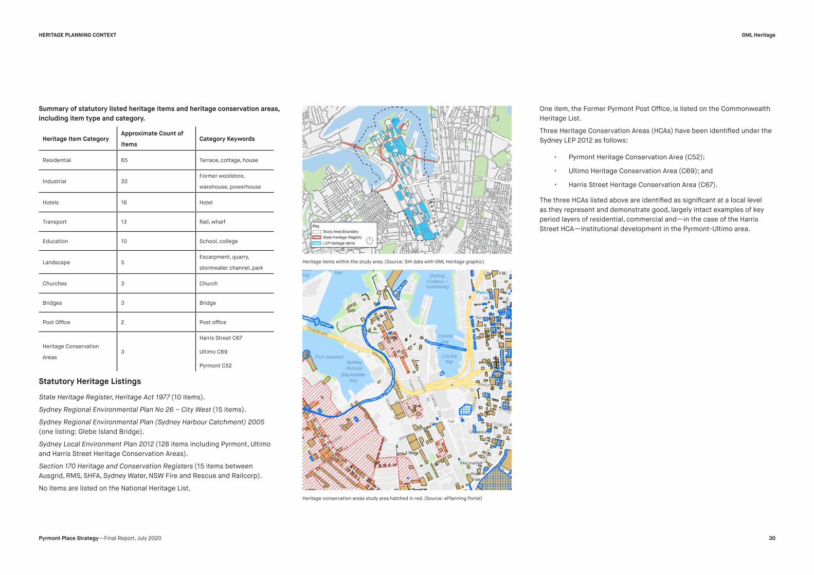
Statutory Heritage Listings
State Heritage Register, Heritage Act 1977 (10 items).
Sydney Regional Environmental Plan No 26 – City West (15 items).
Sydney Regional Environmental Plan (Sydney Harbour Catchment) 2005
(one listing: Glebe Island Bridge).
Sydney Local Environment Plan 2012 (128 items including Pyrmont, Ultimo
and Harris Street Heritage Conservation Areas).
Section 170 Heritage and Conservation Registers (15 items between
Ausgrid, RMS, SHFA, Sydney Water, NSW Fire and Rescue and Railcorp).
No items are listed on the National Heritage List.
One item, the Former Pyrmont Post Office, is listed on the Commonwealth
Heritage List.
Three Heritage Conservation Areas (HCAs) have been identified under the
Sydney LEP 2012 as follows:
• Pyrmont Heritage Conservation Area (C52);
• Ultimo Heritage Conservation Area (C69); and
• Harris Street Heritage Conservation Area (C67).
The three HCAs listed above are identified as significant at a local level
as they represent and demonstrate good, largely intact examples of key
period layers of residential, commercial and—in the case of the Harris
Street HCA—institutional development in the Pyrmont-Ultimo area.
Heritage Item Category
Approximate Count of
Items
Category Keywords
Residential 65 Terrace, cottage, house
Industrial 33
Former woolstore,
warehouse, powerhouse
Hotels 16 Hotel
Transport 13 Rail, wharf
Education 10 School, college
Landscape 5
Escarpment, quarry,
stormwater channel, park
Churches 3 Church
Bridges 3 Bridge
Post Office 2 Post office
Heritage Conservation
Areas
3
Harris Street C67
Ultimo C69
Pyrmont C52
Heritage items within the study area. (Source: SHI data with GML Heritage graphic)
Heritage conservation areas study area hatched in red. (Source: ePlanning Portal)
GML Heritage
30Pyrmont Place Strategy —Final Report, July 2020
HERITAGE PLANNING CONTEXT
Summary of statutory listed heritage items and heritage conservation areas,
including item type and category.

Pyrmont Conservation Area (Planning Portal NSW 2020)
Excerpt of SLEP 2012 Map_007 and Map_008 showing Pyrmont HCA (SLEP 2012)
Pyrmont Heritage Conservation Area
Bounded by Bulwara, Union, Pyrmont Streets, the Pyrmont Heritage
Conservation Area, is an historic area that includes a mix of nineteenth
century 2 storey residential and commercial streetscapes. These
streetscapes are largely intact and range in pattern and form. They have
the ability to demonstrate the 1860s and 1870s development of Pyrmont.
Character is demonstrated by the pattern of corner block hotels (The
Dunkirk, Quarryman’s Hotel, and institutional buildings such as the former
Pyrmont Post Office).
Illustrates the historic evolution and growth of the Victorian working class
population with large blocks of terraces on Bulwara, Mount and Harris
Streets, adjacent to the main retail node at Harris, Miller and Union Streets.
Comprises retail shops, hotel, bank and Post Office centred on a public
square (Union Square) which is the historic urban ‘heart’ of the area.
Other historic elements include sandstone kerbing, sandstone cutting and
stairs cut into rock that repeat themes throughout the Pyrmont Peninsula.
The cultural significance of the Pyrmont Heritage Conservation Area is
described as follows on the State Heritage Inventory form:
The area dates from one of the key period of layers for the development
of Pyrmont as a direct result of subdivision of the Harris and Macarthur
Estates. It is a good example of a mid to late Victorian working class
community consisting of both residential and commercial buildings which
are largely intact and make a positive contribution to the streetscape.
GML Heritage
31Pyrmont Place Strategy —Final Report, July 2020
HERITAGE PLANNING CONTEXT
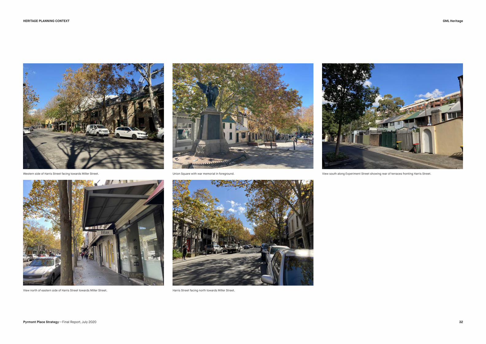
Western side of Harris Street facing towards Miller Street.
View north of eastern side of Harris Street towards Miller Street. Harris Street facing north towards Miller Street.
Union Square with war memorial in foreground. View south along Experiment Street showing rear of terraces fronting Harris Street.
GML Heritage
32Pyrmont Place Strategy —Final Report, July 2020
HERITAGE PLANNING CONTEXT

Name Item Address Property Description Collection Category
Terrace group including interiors SLEP ID I1226 101–125 Harris Street Lot 2, DP 844689; Lot 1, DP
556887; Lot 113, DP 1097637; Lot
3, DP 742000; Lot 2, DP 741187;
Lot 1, DP 162365; Lot 1, DP
770106; Lot 1, DP 714567; Lot 23,
DP 611085 (SP 57824); Lot 100,
DP 827917; Lot 1, DP 1047124
Residential buildings (private) Terrace
Terrace group including interiors SLEP ID I1227 135–155 Harris Street Lot 1, DP 775467; Lots 2–10, DP
231589
Residential buildings (private) Terrace
Former Pyrmont Post Office
including interiors, side passage
and yard
SLEP ID I1228
CHL 105510
146–148 Harris Street Lot 1, DP 632835 Postal and Telecommunications Post Office
Former public hall including
interiors
SLEP ID I1229 179 Harris Street Lot 4, DP 586406 Commercial Commercial/ Office Building
Terrace group including interiors SLEP ID I1230 189–203 Harris Street Lots 10–17, DP 1007788 Residential buildings (private) Terrace
Dunkirk Hotel including interior
and courtyard
SLEP ID I1231 205–207 Harris Street Lot 1, DP 448116 Commercial Hotel
Quarryman’s Hotel including
interior
SLEP ID I1232 214–216 Harris Street Lot 2, DP 940383 Commercial Hotel
Corner shop and terrace group
including interiors, front gardens,
fences and retaining walls
SLEP ID I1233 224–302 Harris Street Lots 2–20, DP 31957; Lots 1–20,
DP 31956; Lot 1, DP 31957 (SP
63445)
Retail and wholesale Shop
Commercial and residential
terrace group including interiors
and rear yards
SLEP ID I1234 304–308 Harris Street Lots 41–43, DP 817244 Commercial Other - Commercial
GML Heritage
33Pyrmont Place Strategy —Final Report, July 2020
HERITAGE PLANNING CONTEXT
Heritage Items within Pyrmont HCA

Terrace group including interiors SLEP ID I1247 1–21 Paternoster Row Lots 1 and 2, DP 597792; Lots
23–31, DP 109844
Residential buildings (private) Terrace
Group of three cottages (two at
93 Pyrmont Street) including
interiors and including former
shop (93) and courtyard (93)
SLEP ID I1262 91–93 Pyrmont Street Lots 6 and 7, DP 242530 Residential buildings (private) House
Former wool store “John
Taylor Wool Stores” including
interiors and industrial artifacts
(woolpress)
SLEP ID I1263 137 Pyrmont Street Lot 2, DP 59052 Commercial Warehouse/ Storage Area
Pyrmont Fire Station including
interior
SLEP ID I1265
S170 Fire and Rescue
147 Pyrmont Street Lot 10, DP 1060282 Utilities – Fire Control Fire Station
Union Square War Memorial
including platform and setting
SLEP ID I1271 Union Street Monuments and memorials War Memorial
Commonwealth Bank of Australia
building and terrace group
including interiors
SLEP ID I1273 2–22 Union Street Lot 1, DP 68237; Lot 1, DP 73017;
Lot 14, DP 66556; Lots 1–5,
DP 242530; Lots 11 and 12, DP
869392; Lot 1, DP 75877; Lot 100,
DP 1109111
Urban Area Streetscape
Name Item Address Property Description Collection Category
GML Heritage
34Pyrmont Place Strategy —Final Report, July 2020
HERITAGE PLANNING CONTEXT

Key Opportunity Sites within Pyrmont HCA (Sixmaps 2020 amended by GML)
Pyrmont HCA - Observations:
• Heritage items seem to be generally intact and in good condition
except for along Bulwara Road.
• Some houses seem to be quite run down.
• East side of Bulwara Road generally intact residential houses
with consistent streetscape.
• Harris Street between Union Street and Miller Street are generally
shop top housing.
• Paternoster Row is mostly like a laneway, little to no pedestrian
amenity and largely rear lane car access for developments. A few
houses have frontage to Paternoster, being located on the
western side towards Miller Street.
• Apartment block on the east of Experiment Street (not within
HCA) is largely intrusive and does not have sympathetic interface
with heritage items located on western side.
• Australia Post shop at 183-185 Harris Street is largely intrusive on
the streetscape.
Conclusion and Recommendations:
• HCA generally has a low to medium rise residential village feel.
• Heritage Items located at Union Street Square very important to
retain and future development must be sympathetic.
• Noted the presence of original kerbstones which indicate original
street alignments.
• Laneway activation possibilities along Paternoster Row and
Experiment Street.
• Retention or redevelopment of existing development along Harris
Street (esp. between Union Street and Miller Street) for adaptive
reuse, creative industries or shop top housing.
GML Heritage
35Pyrmont Place Strategy —Final Report, July 2020
HERITAGE PLANNING CONTEXT

Ultimo Heritage Conservation Area (Planning Portal NSW 2020)
Excerpt of SLEP 2012 Map_008 showing Ultimo Heritage Conservation Area (SLEP 2012)
Ultimo Heritage Conservation Area
Bounded by Harris, Quarry, Fig, Jones Streets, the Ultimo Heritage
Conservation Area this area has the ability to demonstrate the Victorian
character of Ultimo. Comprising a dense pattern of two storey Victorian
terrace houses with shops, hotels and a church. It exemplifies typical
characteristics of the working class housing on allotments of varying sizes,
that are in continuing use for residential purposes. Sandstone kerb and
flagstones form the street edges. 1970s plantings are evident on Bulwara,
Jones and Quarry Streets. Overall, the area is in good condition with a high
degree of original fabric intact and potential for revitalisation.
The statement of significance for the Ultimo Heritage Conservation Area as
included in the State Heritage Inventory forms is quoted below:
The Ultimo Heritage Conservation Area area dates from one of the key
period layers for the development of Ultimo/Pyrmont as a direct result of
the Harris & Macarthur Estate subdivisions. It contains good examples of
mid Victorian residential, commercial and institutional development.
The combination of buildings in the Ultimo Conservation Area form an
exemplary group of modest and functional late-nineteenth and early-
twentieth century civic, commercial and residential buildings which are
clustered around the Church and Hotel at the intersection of the two
main streets of the area. It comprises several blocks centred around
the intersection of Quarry Street and Bulwara Road, which contains the
Uniting (former Presbyterian) Church and the Lord Wolseley Hotel on
opposite corners. It records the development of Ultimo as an industrial and
warehouse district on the southern fringe of the CBD which began in the
latter half of the nineteenth century. This pattern of development is not
only relevant to the locality but forms a crucial part of the historic pattern
of the development of Sydney as the capital city and commercial centre of
NSW, based on the industrial and transport opportunities created by the
waterfrontages of this and other peninsulas in Sydney Harbour (Criterion
A.4).
This Victorian commercial and residential area is part of the civic centre
of Ultimo and the buildings and their architecture, as well as their location
and the street layout, are a product of the historic development of Ultimo
through the nineteenth and twentieth centuries. The relative homogeneity
of the buildings reflects the boom period of development in the vicinity
and their survival with only minimal redevelopment illustrates the lack of
residential development in Pyrmont-Ultimo from the turn of the century
until the 1970s and contrasts with the current major redevelopment of
large-scale industrial and commercial sites in the area (Criterion A.4).
The Ultimo Conservation Area includes a relatively homogeneous group
of working class houses and commercial buildings from the nineteenth
century, a class of buildings which have rarely survived in Sydney. The
residential buildings are low scale and austere in their presentation
and show another face to the Victorian period than that which is most
popularly remembered. Their form, layout and location record the urban
forms of the pre-motor car, pre-electricity era for working class people in
Sydney (Criterion B.2). The group has few unsympathetic intrusions and
the twentieth century buildings do not detract from the character of the
earlier buildings. It has significance as an area which is a relic of the late
Victorian and Edwardian periods and illustrates the built form of this class
of district in this period (Criterion D.2). The buildings contained within
the Ultimo Conservation Area are the fabric and visual façade of Ultimo
to visitors to the area and hence are the public image of the area for its
residents. The traditional building types in this area are highly valued by
the local community, especially during the current phase of redevelopment
of the area, when many of the traditional activities and their structures are
being replaced (Criteron G.1).
GML Heritage
36Pyrmont Place Strategy —Final Report, July 2020
HERITAGE PLANNING CONTEXT

View northwest across Quarry Green.
View north of Henry Place towards Fig Lane. View north of Ada Place.
View east across Quarry Green towards Harris Street.
GML Heritage
37Pyrmont Place Strategy —Final Report, July 2020
HERITAGE PLANNING CONTEXT

View of western side of Harris Street.
View south of Harris Street towards Quarry Street.View south of Ada Place.
View of Kirk Street towards Quarry Street.
GML Heritage
38Pyrmont Place Strategy —Final Report, July 2020
HERITAGE PLANNING CONTEXT

Name Item Address Property Description Collection Category
Terrace group including interiors I2001 33–39 Ada Place Lots 68–71, DP 255554 Residential buildings (private) Terrace
Semi-detached cottages
including interiors
I2002 20-52 Ada Place Lots 30 and 38, DP 255551 Residential buildings (private) Semi-detached house
Terrace group including interiors I2020 242–262 Bulwara Road Lots 72–79, DP 255554; Lots
43–45, DP 255552
Residential buildings (private) Terrace
Former St Francis Xavier Church
group church/school building
and terrace houses, including
interiors
I2021 247–257 Bulwara Road Lot 1, DP 818442 Education School - Private
Lord Wolseley Hotel including
interior
I2022 265 Bulwara Road Lot 1, DP 66697 Commercial Hotel
Terrace group including interiors I2029 451–455 Harris Street Lots 31–33, DP 255551 Retail and wholesale Shops
Electrical substation including
interior
I2039 214–216 Harris Street Lot 2, DP 940383 Commercial Hotel
Cottage and terrace group
including interiors
I2056 92–98 Quarry Street Lot C, DP 715516; Lots 1–3, DP
608555
Residential buildings (private) House
Cottage and terrace group
including interiors
I2056 92–98 Quarry Street Lot C, DP 715516; Lots 1–3, DP
608555
Residential buildings (private) House
Ultimo Uniting Church group
buildings and grounds, including
interiors
I2057 97 Quarry Street Lot 12, DP 852646 Religion Presbytery/ Rectory/ Vicarage/
Manse
Terrace houses including interiors I2058 102–104 Quarry Street Lots 41 and 42, DP 255552 Residential buildings (private) Terrace
GML Heritage
39Pyrmont Place Strategy —Final Report, July 2020
HERITAGE PLANNING CONTEXT
Heritage Items within Ultimo HCA

Key Opportunity Sites within Harris Street HCA (Sixmaps 2020 amended by GML)
Ultimo HCA - Observations:
• Heritage items seem to be in generally good condition with intact
fabric (external assessments).
• Has a residential community vibe with large established street
trees.
• Interface with sizeable green spaces, being those on Fig Street
and Quarry Street.
• Henry Avenue is rear lane access for houses generally fronting
Bulwara Road (one remaining terrace fronts the eastern side of
Henry Avenue), and provides access to the affordable housing
(RFB) on the western side. The RFB is intrusive and detracts from
the feel of the HCA. There is little pedestrian amenity.
• Original kerbstones the indicate original street alignments.
• Western street frontage along Harris Street mix of commercial
and residential uses. These existing houses and shops have
direct interface with a 5 storey modern commercial building
across the road on Harris Street which largely detracts from
the HCA.
• Across Jones Street on the western boundary of the HCA
are heritage listed warehouse light industrial storage sites. These
developments generally have frontage to Wattle Street.
• Quarry Green is a pedestrian only green space that has frontage
to a RFB and terrace housing. Ultimo Public School is located
directly south west of the park.
Conclusion and Recommendations:
• HCA is generally residential with opportunity for influx of creative
industry and adaptive reuse.
• Noted the presence of original kerbstones which indicate original
street alignments.
• Laneway activation along Ada Place due to disused and
underutilised street.
• Opportunity for through-site link from Harris Street to Ada Place
at 421 Harris Street to link with Ada Place Park and future
developments.
• Removal of affordable housing RDB fronting Henry Avenue
for better designed affordable housing, or innovative commercial
use. Interface with Fig Lane Park.
• Cafes and adaptive reuse of terraces fronting Quarry Green.
More landscaping for community and group uses due to close
proximity to Ultimo Public School and to extend adaptive reuse on
western side of Quarry Lane until Harris Street.
GML Heritage
40Pyrmont Place Strategy —Final Report, July 2020
HERITAGE PLANNING CONTEXT

Harris Street Heritage Conservation Area
The Harris Street Heritage Conservation Area is bounded by Systrum Street
to the east, Macarthur Street to the north, Hacket Street and Bulwara
Road to the west and Mary Ann Street to the south. It is located in close
proximity to the Powerhouse, the Goods Line and UTS. It is predominately
residential in character, comprised mainly of Victorian terrace housing with
some later infill development. The terrace housing is mostly bald fronted
workers housing, but there are some intact examples of grander Victorian
terraces.
The significance of the Harris Street Heritage Conservation Area can be
expressed as:
The Harris Street Heritage Conservation Area has the ability to
demonstrate the Victorian pattern of residential subdivision and layout,
including a hierarchy of streets and laneways. The area was created as
part of the subdivision of the Harris and Macarthur estates and includes
later industrial and commercial infill development evidencing the historic
pattern of growth and development of the area.
Harris Street Conservation Area (Planning Portal NSW 2020)
Excerpt of SLEP 2012 Map_008 showing Harris Street Conservation Area (SLEP 2012)
Harris Street Conservation Area (Planning Portal NSW 2020)
GML Heritage
41Pyrmont Place Strategy —Final Report, July 2020
HERITAGE PLANNING CONTEXT

View of rear of houses fronting Systrum Street from Omnibus Lane. View of rear of properties fronting Harris Street from Hackett Street facing south. View south of Hackett Street showing new development adjacent to a s170 listed substation.
GML Heritage
42Pyrmont Place Strategy —Final Report, July 2020
HERITAGE PLANNING CONTEXT

348 Bulwara Street viewed from pedestrian thoroughfare from Hackett Street. View of terrace houses fronting Mary Ann Street. Eastern side of Harris Street facing north.
GML Heritage
43Pyrmont Place Strategy —Final Report, July 2020
HERITAGE PLANNING CONTEXT

Name Item Address Property Description Collection Category
Electricity Substation No. 95 S170 Ausgrid Heritage Register 124 Hackett Street Lot 1, DP 613044 Utilities - Electricity Electricity Transformer/
Substation
Terrace group including interiors SLEP 2012 I2034 597–607 Harris Street Lots 4 and 5, DP 790232; Lots
50–53, DP 827003
Residential buildings (private) Terrace
Former “Millinery House”
including interior
SLEP 2012 I2035 608–614 Harris Street Lots 4 and 5, DP 70368 Commercial Warehouse/storage area
Terrace group including interiors SLEP 2012 I2037 629–637 Harris Street Lots A and B, DP 447392; Lot 1, DP
719295; Lot 1, DP 1103443
Residential buildings (private) Terrace
Terrace houses including interiors SLEP 2012 I2044 77–79 Macarthur Street Lots 1 and 2, DP 828613 Residential buildings (private) Terrace
Terrace group including interiors SLEP 2012 I2025 348 Bulwarra Road and 68-80
Mary Ann Street
Lots 10-16 and 19. DP 859980 Residential buildings (private) House
Terrace group including interiors SLEP 2012 I2033 578-606 Harris Street Lots 1–5 and 9–11, DP 234078; Lot
1, DP 709093; Lot 10, DP 749276;
Lots 6–8, DP 791341; Lot 1, DP
731661
Commercial Commercial Office’/Building
GML Heritage
44Pyrmont Place Strategy —Final Report, July 2020
HERITAGE PLANNING CONTEXT
Heritage Items within Harris Street HCA

Harris Street HCA—Observations
• Heritage items present in varying condition.
• Systrum Street has a laneway character, little pedestrian amenity
and largely rear lane access to terraces fronting Harris Street.
• Original kerbstones along Macarthur Street.
• Eastern street frontage along Harris Street mix of commercial and
residential uses.
• Hackett Street predominantly used for vehicular access for
properties fronting Bulwara or Harris Streets.
• New in-fill terrace type dwellings to the south of SLEP item I2037
that detract from the character of the HCA, immediately adjacent
to s170 listed Substation.
Conclusion and Recommendations:
• HCA is “mixed-bag” of heritage items. Some consistency in
terraces, however, unsympathetic alterations and additions to
the rear of several terrraces have created visual intrusions
and impacts.
• Laneway activation through mixed use could be considered along
Systrum Street. Located in close proximity to Central Station,
Chinatown, Powerhouse, UTS and TAFE Education Precinct and
offers alternative route and finer grain and pattern to Harris
Street.
• New infill development along Hackett Street to the rear of the
Harris Street terraces is intrusive. Streetscape and street
wall modified, visual form, pattern and materiality of historic built
form impacted. Finer grain street pattern.
• Pedestrian throughlink from Bulwara Road to Hackett Street
has infill affordable housing. Effort has been made in terms of
materiality, height, scale and materiality but presents an
opportunity for a higher quality architectural/design response.
better design/ that can be repurposed mixed use development
but must be sympathetic to street height wall of existing
Key Opportunity Sites within Harris Street HCA (Nearmap 2020 amended by GML)
GML Heritage
45Pyrmont Place Strategy —Final Report, July 2020
HERITAGE PLANNING CONTEXT

commercial development on Hackett Street and Mary Ann Street
and not to impact SHR Substation.
• Retention of listed terrace houses for adaptive reuse, creative i
ndustries or shop top housing.
• Building on the corner of Hackett and Mary Ann streets presents
an opportunity for creative adaption.
• Multi-storey housing unit development fronting Bulwarra Road
and Macarthur Street presents an opportunity for design
excellence and architecture. Endeavours to respond to
surrounding development in scale and materiality but poor form
and composition with little civic generosity.
Non-Statutory Heritage Listings
There are several non-statutory heritage lists that include items within the
Peninsula study area.
The National Trust of Australia (NSW) provided a list of registered items
within its database that totalled 94 items inclusive of the Pyrmont/Ultimo
Urban Conservation Area as discussed above. Of the 94 items under the
National Trust Register, 72 items are consistent with, and are protected
under current statutory item listings, six items have been demolished, 12
group listings that encompass individual items within the Register have
not been considered as the individual items are listed separately, three
items are not protected under statutory listings and one item cannot be
identified against existing buildings and documentation. The National
Trust items that are not formally listed are listed and discussed in Table 4.1
below.
Australian Institute of Architects (one item)—The Australian Institute of
Architects has identified the Mechanical and Automotive Engineering
Trades Building – Sydney Technical College as ‘an excellent example of the
Inter-War Functionalist style of architecture designed by Harry Rembert of
the NSW Government Architects Branch.’ This item is protected under an
existing statutory listing under the Sydney LEP 2012.
Institute of Engineers (Engineers Australia) (three items)—Engineers
Australia have identified three items in the study area as engineering
works that are of historic or heritage significance. These sites correspond
to existing statutory protected items, namely Pyrmont Bridge, Saunders
Quarrying Operations in Pyrmont and the Ultimo Power House.
Item Name National Trust (NSW) Register
Item ID
Address Conclusion and Recommendations
Mill Building 9006 Bowman Street off in CSR
Grounds
Have cross-referenced the image provided
on National Trust (NT) register sheet against
State Heritage Inventory (SHI) items. Item
does not seem to match any existing CSR
items listed on SHI. Further investigation
required to determine whether item is still
intact or has subsequently been demolished.
Duke of Edinburgh
Hotel
7337 152–154 Harris Street, Pyrmont Duke of Edinburgh Hotel is now Harlequin
Inn. The façade of the Harlequin Inn
resembles the image on the listing sheet,
being Victorian in style, and as such the
external fabric could be original, yet has been
painted and ground floor windows have been
replaced. This detailing is not consistent
with the surrounding heritage items. Further
investigation is required.
Pitt Son & Badgery
Woolstore
9276 320–348 Harris Street with
frontages to Allen & Pyrmont
Streets
Original façade seems to be intact and in
good condition but repainted in contemporary
style. The interior looks to be currently
adaptively re-used. The item looks to still be
consistent with NT reasons for listing. It is
recommended that this item be included in
Schedule 5 of the Sydney LEP 2012.
Elder Smith
Goldsbrough Mort
No1 Woolstore
7396 350–384 Harris Street with
frontages to Fig & Pyrmont
Streets
Original façade appears to be intact and in
good condition but repainted in contemporary
style. The interior looks to be currently
adaptively re-used. The item looks to still be
consistent with NT reasons for listing. It is
recommended that this item be included in
Schedule 5 of the Sydney LEP 2012.
4.1 National Trust Non-Statutory Listings
GML Heritage
46Pyrmont Place Strategy —Final Report, July 2020
HERITAGE PLANNING CONTEXT

Register of the National Estate (archived and now a publicly accessible
database) (153 items) —The Register of National Estate (RNE) was closed
in 2007 and no longer provides statutory protection to the items listed.
There was a significant level of overlap between the RNE and statutory
heritage lists at all government levels. A total of 153 items were listed on
the RNE within the study area, with 123 of those items afforded statutory
protection under current EPIs.
SignificantTreeRegister
Within the study area we note that the City of Sydney Significant Trees
Register includes a Hills weeping fig, c1930s, on Wattle Street, Ultimo.
In Carmichael Park, Pyrmont, there are several trees of various species
dating from the 1970–1980s that are considered significant. Within
Wentworth Park there are a number of Moreton Bay figs and weeping figs
of significance. In Darling Harbour there are five such species, including a
Port Jackson fig and several species of palms.
City of Sydney Locality Statements
City of Sydney 2012 DCP provides locality statements and supporting
principles for development within all areas and neighbourhoods of the City
including Pyrmont and Ultimo. The statements are place-specific and draw
on the unique qualities of each neighbourhood and provide an important
direction for the development controls and built form guidelines.
GML Heritage
47Pyrmont Place Strategy —Final Report, July 2020
HERITAGE PLANNING CONTEXT

Pyrmont Point Locality Statement
This locality includes the foreshore areas of the peninsula and is
bounded by Union Street, Pyrmont Street, John Street, Jones Street,
Miller Street and the harbour foreshore. Pyrmont’s mixed use character
is to be maintained. The area is to function as a combined living and
working precinct while protecting historic buildings and topography.
The striking cliff faces are important to remain as exposed landmarks
visible from within the area and from the Harbour. Views of Central Sydney
and surrounding suburbs from the public domain are to be maintained.
Active ground floor uses such as shops and cafés and restaurants are
encouraged.
Principles
(a) Development must achieve and satisfy the outcomes expressed
in the character statement and supporting principles.
(b) Retain the dramatic topography created by excavated sandstone
cliffs visible from the public domain.
(c) Conserve views and vistas within and beyond the
neighbourhood, particularly from the public domain.
(d) Maintain the distinctive character created by the built form on
the central ridge and the water front edges.
(e) Provide active ground floor uses in locations and maintain the
high quality and amenity of the public domain.
(f) Historical buildings are to be retained and adaptively reused.
(g) Continue the mix of small scale retail and café uses with large
scale commercial uses in certain areas.
(h) Encourage café and restaurants to offer street dining where
footpath width Permits
City of Sydney Locality statement Pyrmont Point map. (Source: Sydney DCP 2012)
GML Heritage
48Pyrmont Place Strategy —Final Report, July 2020
HERITAGE PLANNING CONTEXT

Ultimo Locality Statement
This locality is bounded by Mary Ann Street, Harris Street and Ultimo Road
to the south, Darling Drive, William Henry Street and Harris Street to the
east, Fig Street to the north and Wattle Street to the west. Ultimo is to
continue its existing mixed-use character comprising residential, cultural,
retail and commercial uses. The historic low scale housing and large scale
historical and industrial buildings are to be protected. Changes to the built
form are to respect the scale and character in the vicinity including street
scale, proportions and rhythms of existing buildings and materials. Streets
and public spaces will feature strong linear edges. New development is
to provide street legibility and improved pedestrian amenity by aligning
buildings with the street, entries that address the footway and awnings
where required. Ground floor uses that create a lively streetscape and
street surveillance are to be provided in locations shown on the Active
street frontages map. Sites are to provide improved pedestrian and bike
links.
Principles
(a) Development must achieve and satisfy the outcomes expressed
in the character statement and supporting principles.
(b) Development is to respond to and complement heritage items
and contributory buildings within heritage conservation areas,
including streetscapes and lanes.
(c) Encourage street legibility and orientation by retaining street
vistas and district views from the public domain.
(d) The height of buildings are to respect and complement existing
buildings that contribute to the areas character in terms of scale,
elevation detail and proportions and materials.
(e) Development is to address the street and have easily identifiable
building entries and create a high quality public domain including
awnings in locations shown on the Active street frontages map.
(f) Encourage café and restaurants to offer street dining where
footpath width permits.
(g) Adaptively re-use historical buildings providing a mix of land uses
in the distinctive built forms.
(h) Improve pedestrian and bike connections through sites between
Darling Harbour, the proposed extension of the Ultimo Pedestrian
Network, Central Sydney, Wentworth Park and Blackwattle Bay.
City of Sydney Locality statement Ultimo map. (Source: Sydney DCP 2012)
GML Heritage
49Pyrmont Place Strategy —Final Report, July 2020
HERITAGE PLANNING CONTEXT

Pyrmont Locality Statement
This locality is bounded by Fig Street to the south, Harris Street, Allen
Street and Murray Street to the east and Union Street, Pyrmont Street and
John Street to the north. The neighbourhood is bounded to the east by
John Street in the north and the foreshore and Wattle Street in the south.
A strong physical definition of streets and public spaces by buildings is
a predominant characteristic of the area and is to be maintained. New
development is to align with the street, address the street and respond
to the detail and character of existing historic buildings. A high quality
public domain is encouraged with awnings and easily identifiable building
entrances seen from the street. Driveways are to be minimised and located
to not conflict with pedestrians.
Principles
(a) Development must achieve and satisfy the outcomes expressed
in the character statement and supporting principles.
(b) Development is to respond to and complement heritage items
and contributory buildings within heritage conservation areas,
including streetscapes and lanes.
(c) Maintain views and vistas from the public domain to the harbour,
Central Sydney and surrounding areas.
(d) Define and enhance the amenity of the public domain with
awnings and buildings that align and address the street.
(e) Retain historical low scale housing and large scale industrial
buildings.
(f) Use compatible materials including sandstone (where
sustainable) and face brick.
(g) Encourage café and restaurant street dining where footpath
width permits.
(h) Adaptively re-use historical buildings providing a mix of land uses
in the distinctive built forms.
City of Sydney Locality statement Pyrmont map. (Source: Sydney DCP 2012)
GML Heritage
50Pyrmont Place Strategy —Final Report, July 2020
HERITAGE PLANNING CONTEXT

Pyrmont Locality Statement
The potential for disturbed or removed archaeological sites within
the Pyrmont-Ultimo study area is illustrated in Figure 4.1. The plan is
derived from a summary desktop search of secondary source material
including existing archaeological reports for sites and precincts that have
been assessed and/or investigated, in part or whole. The categories of
archaeological potential in the plan represent the various site conditions
described in those reports. They adopt or adapt terminology in the City of
Sydney Central Sydney Archaeological Zoning Plan, 1997 as follows:
AAP—Area of archaeological potential.
AAP-PD—Area with archaeological potential that is partially disturbed or
destroyed.
AAP-DSF—Area with archaeological potential that is of a deeper nature
such as cesspits, wells, cisterns, service infrastructure and former water
courses and associated infill.
AAP-E—Area with archaeological remains removed.
A preliminary overview of sites that have been destroyed or
archaeologically investigated, based on existing documentation, is
illustrated in Figure 4.1. A significant amount of additional background
research is required to provide a study or plan that can identify sites and
precincts with potential to retain historical archaeological remains.
The study area is expected to contain many places of archaeological
potential not previously documented and therefore not identified on this
plan, including those associated with heritage listed items and precincts,
significant service and transport infrastructure, those now below roads
and footpaths, within reclamation infill and below recreational park areas.
Figure 4.1 also identifies the boundaries of precinct based archaeological
and heritage studies undertaken for larger areas such as Pyrmont Point
Precinct, Jacksons Landing (the former CSR site), the Fish Markets,
Wentworth Park and the former Sydney Technical College, now part of the
University of Technology (UTS). These precincts include a range of sites
with archaeological potential, including those protected as part of heritage
listings with ongoing heritage requirements.
A detailed, area-wide Archaeological Zoning or Management Plan is
required to better identify potential archaeological sites and locations
where more area-specific archaeological assessment is warranted.Overview plan showing documented archaeological sites and heritage listed items in the study area.
(Source: GML 2020)
GML Heritage
51Pyrmont Place Strategy —Final Report, July 2020
HERITAGE PLANNING CONTEXT
Summary Overview
Commentary on Heritage Listings
The working class industrial, residential and social history of Pyrmont-
Ultimo is interwoven through the physical form and fabric of the Peninsula.
This is represented in the heritage listings of nineteenth and early
twentieth-century residential and industrial building stock. Transport
infrastructure, warehouses, woolstores, and other workplaces and pubs
were all an integral part of industrial working life, while places of worship
and educational establishments such as the Technical College and
Maybanke Kindergarten indicated the evolution and growth of the working
community and support other significant aspects of life. The listings
are a product of their time. They are largely the result of successive
commissioned heritage studies and investigation, community engagement
and the political planning economy of the 1980s and 1990s. The emphasis
at that point was on the Victorian working class industrial history of
the area as it was represented through its built form. At the same time,
despite projects that mapped cultural places to which the community had
strong attachments and connections, few of those places were formally
protected.
• Statutory items reflect the historical evolution of Pyrmont-Ultimo
from a gentleman’s antipodean idyll to the ‘engine room’ of
Australian urban industrialisation and economic development to
the early twentieth century.
• The listed items provide some evidence of the slicing and dicing
of the ‘difficult and actually dangerous’ sandstone peninsula
originally fringed by low-lying muddy shoals and tidal flats, with
swamps, creeks and ponds.
• The evolving street pattern layout, including new and removed
streets, has also left the archaeological remains of earlier
structures and deposits under pathways and streets, below
grassy parks and within landfilled former creeks, swamps and
foreshores (See 1865 Trig plan).
• The historical pattern and layout of streets and allotments
reflects the Peninsula’s topography with finer grain development
centred in ribbons along the ridge line, with larger industrial
blocks fringing the harbour.
• The Victorian working class suburban pattern and form of
development, densely arranged including terrace housing on
allotments of varying scales, and associated ancillary
characteristics of community life including shops, churches,
schools, pubs, and post offices are well represented.
• Listings associated with Pyrmont-Ultimo’s urban renewal as a
master planned inner-city residential and commercial centre
boasting providing education, health, tourism, leisure,
entertainment and cultural activities are not well represented,
though many former industrial buildings have been adaptively re-
used for these purposes.
• ‘Loss’ is a key theme when reviewing the heritage listings in the
context of the history of Pyrmont. Digital mapping of old historic
plans has enabled us to layer the Peninsula’s gradual shaping to
find the lost landscapes that have evolved into heritage and
archaeological sites so that they may be recognised, protected
and featured in future planning.
• Ultimo’s lost places and collective memory are not formally
recognised.
• The history and heritage of gender, class and culture are largely
silent, and emphasis is largely on built form character as opposed
to those places with social spiritual value to the community.
Today gaps remain in the heritage listings, including:
• places of social value.
• twentieth-century heritage; and streetscapes and features
such as kerb and gutter stones (though noted in heritage
conservation areas).
Perhaps one of the most interesting omissions, particularly given the
industrial history and significance of the Peninsula is the fact that the
Powerhouse remains without statutory heritage protection at State level.
The Powerhouse Museum, and former warehouse buildings are listed on
Schedule 5 of the Sydney LEP 2012. The listing does not Wran Building.
The Powerhouse Museum is listed on the Australian Institute of Architects
Register of Significant Architecture in NSW.
Commentary on Statutory Heritage Planning Context
The many statues that are applicable to the Peninsula reflect the
varying aims and objectives of each. Across the suite of plans there is
considerable overlap. If there is an opportunity to refine and simplify the
controls into an overarching strategic planning document for the Peninsula
some preliminary directions are suggested below.
• Ensure the natural, scenic, environmental, social and cultural
heritage qualities of the Peninsula should be conserved in its
harbour setting.
• Retain the dramatic topography created by excavated sandstone
cliffs visible from the public domain.
• Conserve and promote the heritage of the Peninsula as a
distinctive historic urban landscape.
• Maintain the distinctive character created by the built form on
the central ridge and the waterfront edges.
• Conserve the heritage significance of heritage items and heritage
conservation areas and their settings.
• Adapt and re-use historical buildings providing a diverse and
creative mix of land uses while remaining respectful of distinctive
built forms and historic fabric.
• Development will respond to and complement heritage items
and contributory buildings within heritage conservation areas,
including streetscapes and lanes.
• Building height will respect and complement existing buildings
that contribute to the areas character in terms of scale, elevation
detail and proportions and materials.
• Street legibility and orientation will retain street vistas and views
from the public domain.
• Conserve views and vistas within and to and from the Peninsula,
particularly from the public domain.
• Strengthen the community’s ‘sense of place’ by recognising
and celebrating places they value and providing opportunities to
tell their stories.
GML Heritage
52Pyrmont Place Strategy —Final Report, July 2020
HERITAGE PLANNING CONTEXT

PyrmontPeninsula—StatementofSignificance
Set in Sydney Harbour, between Blackwattle Bay, Johnson Bay and Darling
Harbour, Pyrmont Peninsula is significant as a dramatic natural landform
characterised by rich Hawkesbury sandstone ridges with dramatic bluffs
created between 500–700 million years ago as part of an immense river
delta across the Sydney basin. To the south of the peninsula, Wianamatta
shale underlies Cockle and Blackwattle bays once characterised by rich
alluvial soils.
Pyrmont-Ultimo has outstanding heritage significance for its ability to
demonstrate human intervention and modification of a visually prominent,
distinctive harbour landform. Since colonisation the peninsula has been
modified and transformed, it is a significant historic cultural landscape
that demonstrates a distinctive evolutionary pattern of large land grants,
subdivision, agriculture and industrial development, quarrying, land
reclamations, industry, rail lines and wharf construction, urbanisation,
technological development, industrial decline, and government led urban
planning, consolidation and renewal writ large. Associated with major
shifts in Australia’s industrial and political economy, these significant
historical shaping forces have resulted in dramatic and significant changes
in community and working life expressed through an urban landscape
and a complex amalgam of significant public infrastructure, industrial,
residential and commercial development and public space.
In the history of NSW, Pyrmont-Ultimo is of state significance as an ‘engine
room’ of Australian urban industrialisation and economic development.
The quarry walls, wharfage and goods yards, wool stores, power houses,
mills, and sugar refineries demonstrate these historical forces. Following
de-industrialisation, major economic and social transformations combined
with urban renewal and revitalisation are evidenced across the peninsula
and demonstrate a key phase in the history of city planning and urbanism.
Pyrmont-Ultimo a thriving centre of industrial and technological
development, associated with Australian primary production, industry and
working life. TAFE NSW Ultimo buildings are historically significant for their
role in the provision of education and training since 1891 and as the first
technical college in the NSW public education system, now collocated with
national media and university facilities.
The aesthetic qualities of Pyrmont sandstone, including its texture and
warm golden colour, are significant in the sensory appeal and experience
of Sydney’s historic built form as the primary material used in many of
the city’s finest public buildings. The terracing of the Peninsula provides
dramatic, expansive vistas and views from various vantage points,
including easterly to the Sydney CBD, and northeasterly to The Rocks and
Observatory Hill, backgrounded by the arch of the Sydney Harbour Bridge.
There are northerly views across Sydney Harbour and to East Balmain, and
to the southwest to Glebe. The light and shade, and movement of boating
activities on the harbour, contribute to the visual interest in a kinetic and
complex environment.
Pyrmont-Ultimo has substantial potential to yield archaeological
information that will contribute to an understanding of NSW’s cultural
and natural history fabric and Sydney’s early development and industrial
history, along with buried deposits relating to those activities. Phases of
industrialisation and manufacturing led to the construction of many new
structures and land reclamation extended the modern waterfront beyond
the natural shores. Modern roads and boundaries sometimes follow the
lines of early colonial estate features such as Harris Street, which remains
the central artery of the peninsula. In other instances, traces of piers, early
shorelines or buildings could be within metres of reclamation fill or within
garden soils, as has been found during project works within Sydney’s
other harbour fingers including Barangaroo and Darling Harbour. The
reconfiguration of the original shoreline has been explored at only a few
Sydney foreshore sites including Barangaroo, the KENS site and Darling
Walk and there is potential for archaeological investigation to yield new
information.
Pyrmont-Ultimo has a strong association with colonial people of influence,
including Surgeon John Harris, who established Ultimo Estate and after
whom Harris Street is named, and John Macarthur and his son Edward who
subdivided the peninsula; early industrialists such as quarryman Charles
Saunders; social pioneer Maybanke Anderson; and, in the twentieth
century, humble residents like pavement scribe Arthur Stace, ‘the Eternity
Man’.
Pyrmont-Ultimo has strong and special associations with residential and
working communities over generations since the nineteenth century,
including those that worked in the wool, sugar, power supply, government
printing and transport industries; the Pyrmont Squat and communities of
artists from the mid-twentieth century until the 1970s–1980s. The present-
day community has strong associations with particular places including
the natural landscape, industrial heritage, public and parkland spaces as
well as social venues that are integral to their identity. Key built heritage
items such as the Powerhouse Museum, located in the former Ultimo
Power House, and the Old Pyrmont Cottages are of outstanding value to
the community of NSW as demonstrated by recurring public debate, news
headlines, protests and petitions calling on government to protect these
sites. Places like the Pyrmont wharves are also embedded with the stories
of significant social upheaval in the twentieth century, including the world
wars and the migration of thousands of people to Australia. Wentworth
Park has been a well-loved focal point for community for over a century
with activities including concerts, celebrations, early moving pictures and
sports such as rugby league and a motorcycle speedway and greyhound
races from the 1930s.
GML Heritage
53Pyrmont Place Strategy —Final Report, July 2020
HERITAGE PLANNING CONTEXT

HERITAGE STRATEGY
AND RECOMMENDATIONS
Fire at Goldsbrough Mort & Co Ltd, Pyrmont Street, Pyrmont, 1935. (Source: City of Sydney Archives)
GML Heritage
54Pyrmont Place Strategy —Final Report, July 2020
5. Heritage Strategy and Recommendations
Introduction
Cities are restless entities. Sydney is no exception. As today’s economic
and physical renaissance takes place across the City of Sydney, we have
some critical decisions to make. What kind of city do we want to plan for
and live in the future? What do we value and how do we ensure balanced
environmental, economic, and social outcomes?
Modelling and remodelling of cities are not new ideas. Colonial enterprise,
manifest through land shaping and city making processes, combined
with aspirations for social order, civility and progress were overlaid on
Aboriginal Country and culture that was not recognised, nor regarded as
successful and sophisticated.
The Pyrmont Peninsula is a complex place. It has experienced the
dramatic decline of the industrial working harbour, and State government
led urban renewal that rebirthed not only the landscape and built form of
the neighbourhood but its economy. More than a decade on, attention has
turned to the Peninsula again.
Global capital is mobile and largely unsentimental; however, it generally
flows to places where underlying costs are low and money can be made, or
power and status can be expressed. While this is overly simplistic, as part
of the Harbour CBD, Pyrmont Peninsula has been identified as a location
that can enhance financial growth and development of Sydney as an
attractive, strong and competitive global city. The government’s objective
is to deliver a vibrant mixed-use precinct through CBD capital expansion,
providing a diverse and distinct range of assets that deliver on residential
density and amenity, culture, entertainment, education, health, technology,
and connectivity.
Character and Experience
A walk through the Pyrmont Peninsula area rapidly establishes history
and heritage as core elements of its character, appeal and experience.
Any kind of appreciation and sense of adventure in the place is due to its
harbourside location, sandstone rock faces and random outcrops both
natural and worked. The terrain leads into meandering streets split high
and low by the original rocky topography nearer the original shoreline,
now buried beneath wharves adapted into apartments and expressways
going somewhere else. Small cottages and corner shops, rows of Victorian
terraces wedged between high rise apartments and commercially adapted
old warehouses and wool store facades are dwarfed by modern wrap
around buildings. The area is a hybrid mix of high density, high-rise, green,
grassy parks, tiny sandstone cottages, foreshore fish market, rail trackways
curved into sandstone corridors, houses teetering above, clutching onto
carved outcrops and steps carved into the natural caramel sandstone
of the Point. Wharves stand with pylons deep in reclaimed infill, beach
and island infilled and no longer visible. Wind rushes through corridors
between the convention centres and converted, power houses!
The driving character of the area and focus for any successful and
inviting future use strategy in Pyrmont Peninsula is that which preceded
and survived its reputation as the city’s ‘Sink’. Its legacy is and remains
readable in its surviving building stock, early estate roadways still veining
through from harbour to city, likely forged by Aboriginals walking to
their harbour spots. Its aspect , the views north, east and west across
harbour or south toward the surrounding Sydney metropolis would have to
acknowledge the slow building up around the Point after its early European
property owners, Macarthur and Harris, Bunn and others gave over to more
intense land use change of their Pyrmont and Ultimo estates.
Urban Morphology
Pyrmont Peninsula has been sliced and diced many times over. Most
dramatically since colonial occupation. Initially, tons of sandstone
were cleaved from the Peninsula. Reshaped as polite architecture, the
sandstone was used symbolically to express the solid and sanguine
prospects of colonial enterprise. From the 1860 until the 1950s, the
Peninsula was further transformed into an ‘engine room’ of Australian
industry and economic production. A cacophonous place. Where sugar
was refined, wheat, wool, meat, timber, iron and steel were made or
stored and hauled across Australia and the world, by road, rail and water.
Pyrmont’s Powerhouses electrified Sydney. Lighting up Sydney’s streets
and powering its trams. Industrial and economic change transformed
Pyrmont-Ultimo and community life during the later decades of the
twentieth century. The 1980s witnessed the end of industrial activity
and ushered in new forms of economic and residential development.
Entertainment, leisure and innovation took root.
The history of Pyrmont-Ultimo can be interpreted through the remnant
historic cultural landscape, it is expressed in the general arrangement
and pattern, form and layout of the peninsula, its shoreline, reclamation,
streets, allotments, built environment, public open spaces and the
community’s engagement and attachment to the place. In Sydney, the
landform and topography, has both enhanced and hindered development.
Pyrmont Peninsula is no exception. The circuitous route and relative
isolation of the peninsula has been both lamented and celebrated. It is a
place that is at once, near and far. The obstacles and impediments, as well
as the solutions to movement of goods and people, on foot, by cart and
horse, by tram and train, by cars and trucks and by water, are layered and
expressed by the texture and grain of the historic urban landscape. The
infrastructure including wharves, bridges, rail tunnels, sewerage pumping
stations and powerhouses demonstrates the diversity of enterprise and
technological change that was required to support the sweat and toil of
Australian manufacturing and industry. Interwoven, is the pattern and form
of housing, from stone workers cottages and long orderly terrace rows, to
finer Victorian terraces, pocket parks, and model social housing. Together
this expresses a community and neighbourhood life that was supported by
shops, schools, sea baths, pubs, and churches.
Over recent decades, the fabric and community of the peninsula has
been transformed. Replaced by new workers and new economies of
knowledge, leisure, and consumption. Cheek by jowl, recent multistorey
residential development looms large, though largely devoid of a pattern
language or unique sense of place. Modern apartments jostle alongside
of adapted buildings, new commercial development, and the roar of cars
on the flyovers and off ramps. Former icons of industry are now tourist and
cultural attractions such as the Powerhouse Museum. The Star Casino,
Australian National Maritime Museum, the International Convention Centre
and Darling Harbour, attract local and international visitors, reinforcing the
area as a tourism destination.
Perceptions of Cultural Heritage
Heritage is often seen as a handbrake on economic growth and
development. In a recent report by Historic England, heritage was found
to be an important source of economic prosperity and growth with a
significant number of interdependent economic activities. In short,
heritage counts. In England, heritage employs 464,000 people directly
and indirectly. It generates 1.9% of GVA, a total of 31 billion pounds.
Research shows investment in heritage creates places for businesses and
communities to thrive. Heritage shapes place-based experiences that are
typically characterised as unique and distinctive. Heritage also impacts
price and attracts premiums.
It is our view, that heritage has manifold positive impacts on our economy,
culture, society and the environment. It can contribute to social cohesion,
sustainable development, job creation, health and well-being as well as
contribute positively to addressing climate change. Some key place-based
GML Heritage
55Pyrmont Place Strategy —Final Report, July 2020

ideas that reflect recent research and thinking for urban heritage are
included below for Pyrmont-Ultimo.
Heritage shapes place perception and experience
• Heritage should be integral to the vision, place identity and
brand for Pyrmont Peninsula, it provides a competitive edge and
a unique selling point.
• Beauty and the sensory experience of heritage creates strong
place based attachments and fosters belonging.
• Heritage is a unique attractor for domestic and international
visitors and can play a key role in the visitor economy, it supports
jobs and growth.
Heritage must be protected as a key resource for emerging
and existing economic and creative activities
• Heritage assets have inherent ‘public good’ characteristics, that
can deliver benefits to owners and the community.
• Creative and cultural industries are more likely to be found in
listed buildings.
• Cultural heritage is cited as a source of inspiration that fosters
scientific and creative artistry and innovation.
• As places change, economic development policies must prioritise
heritage to promote economic and community prosperity.
Heritage is linked to the economics of uniqueness
• Over the long term, places with strong distinctive identities are
more likely to sustainably prosper than places without them.
• Places need strong distinctive features, otherwise they run the
risk of being all things to all people and nothing special to any.
• An historic environment provides character and distinctiveness.
This attracts people, businesses, and investment, and can
provide places with their competitive advantage.
• Heritage is more than an economic asset it delivers social and
cultural capital, and to sustainability beyond embodied energy.
A Vision for Pyrmont Peninsula
Distinctiveness is what sets Pyrmont Peninsula apart. The peninsula is a
dramatic landform, unique, topographically and historically. The historic
masterplan of the Peninsula laid down by Harris in 1859 is resilient. It
has stood the test of time. The subdivision pattern and streetscapes,
with intimate finely grained character areas, built form and the life in
the community today contributes to the experience of the Peninsula’s
significant cultural landscape. The area is of modest size, with various
precincts of markedly different character reflecting the distinctions
between location, historic function, working life and home.
Today, history and heritage of Pyrmont continues to provide vital anchor
points for those who live and work in the area, connecting them to a sense
of place and community. These unique attributes of the place should be
the springboard for urban renewal and revitalisation.
The vision for Pyrmont Peninsula should be to conserve and celebrate
the peninsula’s history and heritage as a source of inspiration and as an
integral part of a socially vibrant and economically sustainable inner-city
neighbourhood.
Masterplan Principles
Heritage is interdependent and is connected to the natural environment;
public domain; streetscapes; built form; culture and community; access
and movement; and governance.
A distinct narrative and unique character are part of the narrative of
Pyrmont Ultimo. The strategic direction for the Peninsula needs to honour
the place’s history and heritage, and its community. It is evident to those
who live and work in the area, but less visible to ‘outsiders’. The master
plan needs to address the following and ensure heritage is not only re-
imagined through controls, but rather is part of life in the community.
Historic Cultural Landscape
• The unique topography, including the sandstone cliffs and
escarpment should be conserved to enable public enjoyment and
appreciation.
• Retain the dramatic topography created by excavated sandstone
cliffs visible from the public domain.
• Conserve the natural, scenic, environmental, social and cultural
heritage qualities of the Peninsula and its waterfront edges.
• Conserve and promote the heritage of the peninsula as a
distinctive historic urban landscape. The strong interrelationships
between the harbour, the landform, and patterns of human
settlement should be retained.
• Maintain the distinctive character created by the built form on
the central ridge and the waterfront edges.
• Pedestrian movements should be linked along the peninsula
through an interconnected system of topographical features,
open spaces, public squares, neighbourhood streets, and
characterful local places that are centres of life in the community.
Precincts and Places
• Conserve the heritage significance of heritage items and heritage
conservation areas and their settings.
• The cultural identity of the peninsula, including the Heritage
Conservation Areas, Heritage Items and significant archaeological
deposits should be conserved.
• The distinctive and varied character and patterns of the
Sub-precincts including the Harris Street/ridge line, the
waterfront, the western and eastern slopes and will be enhanced
and conserved.
• Street legibility and orientation will retain street vistas and views
from the public domain.
• Conserve views and vistas within and to and from the peninsula,
particularly from the public domain.
• Strengthen the community’s ‘sense of place’ by creatively
interpreting and celebrating places they value and providing
opportunities to tell their stories.
Renewal
• New development should not dominate or compete with the
horizontal landform of the peninsula.
• Respect the existing pattern and character of historical
development and the community’s values and attachments to
place as part of any proposed redevelopment.
GML Heritage
56Pyrmont Place Strategy —Final Report, July 2020
HERITAGE STRATEGY AND RECOMMENDATIONS

• Complement heritage items and contributory buildings within
heritage conservation areas, including streetscapes and lanes
with contemporary architecture that demonstrates design
excellence and civic generosity.
• Be respectful of and consistent with the character of the area in
terms of scale, form, rhythm, and materiality, whilst ensuring
excellence in design and sustainability.
• New built form will respect and complement heritage items that
contribute to the area’s character in terms of scale, elevation
detail and proportions and materials.
• New development should not give rise to adverse or material
impacts on the significant historic character and heritage
significance of the peninsula, heritage items or heritage
conservation areas.
• Adapt and re-use historical buildings providing a diverse
and creative mix of land uses while remaining respectful to
cultural significance, distinctive built forms and historic fabric.
• The cumulative impact of development on the cultural
significance of the Peninsula and its historic urban landscape
should be monitored and subject to periodic assessment
Heritage Strategy and Recommendations
Historical Archaeology
A Pyrmont Ultimo Research Framework and Archaeological
Management Plan (AMP)
Now 30 years old, the Map of Potential Archaeological Sites included in
the 1990 Pyrmont and Ultimo Heritage Study is outdated and unreliable.
It was integrated into the Pyrmont Ultimo Urban Development Plan (UDP)
as adopted by the City West Regional Environmental Plan (gazetted 1992)
but is no longer used by consent authorities to identify potential sites
within the precinct. This lack of early detection is resulting in the loss
of historic remains at many sites on the peninsula in the path of rapid
area development. Background research undertaken for this study to
identify recorded sites, areas with potential sensitivity and those without
archaeology revealed that the majority of modern developments on the
peninsula do not seem to have any record of a determination for the likely
presence or absence of archaeological remains. An effective management
tool is needed to assist consent authorities to determine early presence or
absence of potential remains to better guide effective management of the
area’s diminishing historical archaeological resource.
A research framework is a coordinated, overarching approach to
archaeological research and investigation developed for a large area such
as the Pyrmont Ultimo precinct. These frameworks incorporate research
questions and themes that apply to a number of sites and land uses
common across the precinct such as early roads and estates, shaping the
land, reclamation, wharfage, quarries, home and community, warehousing
and manufacture and industry. Like research designs prepared for
individual sites as part of NSW statutory process, research frameworks
provide a practical and effective basis to guide both research questions
and management decisions for sites and new projects. They encourage
maximum research benefit for public engagement and by taking advantage
of what already exists in Pyrmont Ultimo to strengthen its character and
encourage continued economic, social and environmental vitality.
Preparation of an AMP and overarching research framework would enable
a range of outcomes for the Pyrmont Peninsula precinct including:
• refinement of requirements for individual sites to provide up-
front yes/no identification of whether a site needs further
archaeological consideration for development purposes.
• a clear pathway to define any future archaeological requirements
for individual sites and areas.
• coordinated research and investigation of the surviving
archaeological resource in the Pyrmont Peninsula. These broad-
scope studies include research questions and themes that guide
to contextualise individual sites and enable more meaningful,
broader synthesis and understanding of the area as a whole
rather than through keyhole site by site investigation.
• bringing together cumulative data from a range of existing
assessments and investigations across the precinct to
provide broader regional implications for site-specific projects
in the area.
• An opportunity to gain maximum benefit from archaeological
projects to assist inter-site analyses and promote broader
synthesis for interpretation and public delivery.
GML Heritage
57Pyrmont Place Strategy —Final Report, July 2020
HERITAGE STRATEGY AND RECOMMENDATIONS
Rationale: Potential and known historical archaeological sites and relics are located across the
peninsula.
Future development on these sites has the potential to impact upon their archaeological
heritagesignificance.
No clear archaeological guidance currently exists to assist Council in determining the
likelihood of impact to potential archaeological sites by development and other land use
changes.
The area’s archaeological resource can contribute to and inform more meaningful future
uses and understanding of places in this neighbourhood
Objectives: An AMP and overarching research framework to enable early identification of sites with
potential archaeology, coordinated archaeological research and investigation, guide
management decisions and inform future use and presentation of sites in the Pyrmont
Ultimo precinct.
Ensure that any proposed development within the study area requires a preliminary
assessment to identify if potential for historical archaeological sites and relics may
survive in those places, including public paths and roadways.
Preliminary identification of potential archaeological resources identifies where more
detailed, site-specific assessment and research is required to effectively manage
the resource, mitigate unnecessary impact and. protect and enhance the heritage
significance of the site.
Standard Statutory Controls: • In the current absence of a guiding mechanism to identify and manage potential
archaeological resources in the Pyrmont Ultimo area, City of Sydney should require
a preliminary assessment of each site prior to determination of development
consents where these propose sub surface disturbance.
• A research design and mitigation methodology is required to manage proposed
impacts to sites with known/potential archaeology, including those within public
paths and roadways.
• Archaeological investigation is required for any areas where future impacts will
remove or disturb the known/potential archaeological resource surviving there,
including those within public paths and roadways.
Innovative Provisions: • Provision of an AMP to guide future archaeology and proposed development in a
manner that respects and enhances the precinct’s existing heritage character,
recognising that heritage is a core element driving any successful future use
strategy in Pyrmont Ultimo.
• Integrate archaeological remains into larger scale developments/amalgamated sites.
• To enhance and contribute to the precinct’s heritage character, archaeological
investigations should be undertaken with consideration for their ability to inform and
inspire project design. Where appropriate, consider integration and/or interpretation
of archaeological elements into proposed adaption, reuse or development projects.
• Incentives to encourage proponents to strive for and achieve design excellence that
incorporates archaeological heritage elements could include the awarding of
additional building height, floor space or heritage floor space to transfer.
GML Heritage
58Pyrmont Place Strategy —Final Report, July 2020
HERITAGE STRATEGY AND RECOMMENDATIONS
Historic Built Form Character
Pyrmont and Ultimo provide areas of considerable charm and character
that are derived from the historic pattern, layout and form of development.
Change over time in Pyrmont-Ultimo has given rise to cumulative
impacts. Visual patterns and forms have been broken up. Character of
much contemporary residential has a speculative quality and aesthetics
are variable. Much of the more contemporary urban form, particularly
multi-unit residential endeavours to reference the character, scale and
materiality of adjacent historic built form but typically lacks creativity,
compositional elegance and or civic generosity. Much of the multi-unit
residential stock does not exemplify design excellence or genius loci.
As part of the Pyrmont Peninsula Place Strategy there is an opportunity to
create and imagine a new protective spirit of place. This new spirit should
respectively respond to the past but creatively imagine a future. Design
needs to be sophisticated and with excellence in architectural design and
detailing. Controls and incentives need to be orientated towards, creative
respectful relationships to the historic context and setting.
In the design of a new future the fine grain and walkability of the Historic
Conservation Areas, as the heart and soul, of the peninsula, running along
and off the ridgeline needs to be contextual, connected and cohered. The
‘genius loci’ needs to reconnect the physical realm to civic life and urban
experience. Granular nuanced responses are required to provide high
quality civic amenity and activation.
Design and Architectural Diversity
Heritage Items
Rationale: Heritage items are located across the peninsula and within several sub-precincts.
Futuredevelopmentinthevicinityoftheseheritageitemshasthepotentialtoimpactupontheheritagesignificanceoftheitems
and their setting.
Objectives: • Ensure that development in the vicinity of heritage items is designed to protect the heritage significance of item.
Standard Statutory Controls: • Alterations and additions to buildings and structures and new development of sites in the vicinity of a heritage item are to be
designed to respect and complement the heritage item in terms of the: (a) building envelope; (b) proportions; (c) materials,
colours and finishes; and (d) building and street alignment.
• Development in the vicinity of a heritage item is to minimise the impact on the setting of the item by: (a) providing an
adequate area around the building to allow interpretation of the heritage item; (b) retaining original or significant landscaping
(including plantings with direct links or association with the heritage item); (c) protecting, where possible and allowing the
interpretation of archaeological features; and (d) retaining and respecting significant views to and from the heritage item.
Innovative Provisions: • Inventive civic interfaces/connections/activations with heritage items (in terms of siting, form, character, materiality, adaption,
use) may be considered, provided the scheme demonstrates excellence in design, well integrated heritage interpretation
initiatives and a high quality response to the public domain.
• Incentives to encourage proponents to strive for and achieve design excellence could include the awarding of additional
building height, floor space or heritage floor space to transfer.
• Heritage items could be integrated into larger scale developments/amalgamated sites provided legibility/prominence and
appropriate setting is maintained.
• As with any planning controls, the permissible maximum heights are not guaranteed. Existing heritage context and proposed
development will be based on merit and assessed on a case-by-case basis.
GML Heritage
59Pyrmont Place Strategy —Final Report, July 2020
HERITAGE STRATEGY AND RECOMMENDATIONS

Rationale: Future development within the HCAs has the potential to impact upon the heritage
significanceoftheHCA,streetscapesandcontributoryitems.
Objectives: New development in HCAs must be designed to respect neighbouring buildings and
the character of the area. Infill development should enhance and complement existing
character but not replicate or mimic the architectural style, detailing or materiality of
listed heritage/historic buildings.
Standard Statutory Controls: • Development within a heritage conservation area is to be compatible with the
surrounding built form and urban pattern by addressing the heritage conservation
area statement of significance and responding sympathetically to: (a) topography
and landscape; (b) views to and from the site; (c) significant subdivision patterns
and layout, and front and side setbacks; (d) the type, siting, form, height, bulk,
roofscape, scale, materials and details of adjoining or nearby contributory
buildings; (e) the interface between the public domain and building alignments
and property boundaries; and (f) colour schemes that complement traditional
colour schemes/materiality.
Innovative Provisions: • Demolition of neutral and detracting buildings within HCAs, amalgamation of
adjacent sites and sympathetic development may be considered where proposals
demonstrate design excellence and sustainability, so as to selectively increase
density/diversity of use within HCAs.
• Sites containing neutral and detracting buildings could also be altered
(ie demolished or adapted) to create new open space and/or through
site connections.
Heritage Conservation Areas
Rationale: Contributorybuildingsarebuildingsthatmakeanimportantandsignificant
contributiontothecharacterandsignificanceoftheHCA.Theyhaveareasonableto
highdegreeofintegrityanddatefromaperiodofhistoricalsignificancetotheHCA.
ContributorybuildingsareidentifiedintheDCPsofanLGA(ieBuildingContributions
Maps), or in separate heritage studies for HCAs. If these are not available, the
contributory status is determined on a case-by-case basis with regard to the
contribution the building makes to the heritage values of the HCA.
There are numerous contributory buildings within each HCA.
Objectives: Maintain the architectural, streetscape and interpretive contribution these buildings
provide to the HCA.
Standard Statutory Controls: • Contributory buildings are to be retained unless the consent authority
determines the replacement is justified in exceptional circumstances.
• Alterations and additions must not significantly alter the appearance of principal
and significant façades of a contributory building, except to remove detracting
elements (eg altered shopfronts, closed in verandahs).
• Alterations and additions to a contributory building are to: (a) respect significant
original or characteristic built form; (b) respect significant traditional or
characteristic subdivision patterns; (c) retain significant fabric; (d) retain, and
where possible reinstate, significant features and building elements, including
but not limited to original balconies and verandahs, fences, chimneys, joinery
and shop front detailing; (e) remove unsympathetic alterations and additions,
including inappropriate building elements; (f) use appropriate materials, finishes
and colours; and (g) respect the pattern, style and dimensions of original
windows and doors.
• Where an addition to a contributory building is proposed, significant external
elements are to be reinstated.
• Foyers or other significant interior features, including hallway detailing, panelling
and stairs, balustrades, historic finishes and joinery designed to be visible from
the street, are to be retained, especially where they form part of the building’s
contribution to the character of the heritage conservation area
Innovative Provisions: • It is recognised that in some cases, the contribution contributory building makes
is simply in terms of scale, window/door arrangements on the primary façade,
and/or fenestrations/modulation. In some cases, consideration may be given to
potentially allowing the façade or a representative portion of the contributory
building to be retained so as to enable a new development to be sited directly
behind the façade (and set back at the higher levels), provided the streetscape
contribution is retained.
• When adjacent to each other, a series of contributory building façades/portions
of contributory buildings could be retained, whilst the remainder of the site is
amalgamated and developed as one larger parcel of land.
Contributory Items
GML Heritage
60Pyrmont Place Strategy —Final Report, July 2020
HERITAGE STRATEGY AND RECOMMENDATIONS

Rationale: Individual lots can evidence the historic layout and pattern of subdivision or
commercial development pattern. (Higher density development in critical growth
areas may be considered through lot consolidation where this will not give rise to an
adversematerialimpactonsignificantheritagevaluesorareacharacter.
Objectives: Enable the consolidation of small individual lots into larger lots, but ensure the original
subdivision pattern is represented/interpreted where it is assessed as significant.
Encourage fine grain subdivision for large sites in urban renewal areas.
Standard Statutory Controls: • Lot consolidation is not to occur where the original subdivision pattern is still in
evidence and contributes to the significance of the heritage item or HCA.
• Lot consolidation should not compromise the setting of the heritage item or
contributory building on the site, or within the vicinity.
• Retain the relationship/s between the heritage item or contributory building and
its associated features such as landscaping trees, fences, and outbuildings.
• Interpret the historic fine grain and pattern of development through layout,
composition and arrangement of new built form.
• Interpret historically significant subdivision pattern/s in new development.
Innovative Provisions: • If the subdivision pattern is significant and lot consolidation is appropriate,
allowances should be made to interpret the subdivision pattern/fine grain
innovatively in the layout and pattern of built form and in the architectural
treatment of the façades (eg modulation, vertical fenestrations) while allowing
development of the site.
Rationale: The siting and setback of buildings and building elements is important in forming
and/or enhancing the character of the streetscape and the relationship between
adjoining buildings. Consider the siting, orientation, modulation and visibility of new
development with regard to existing streetscape/neighbourhood contexts.
Objectives: Maintain the prominence/legibility of heritage items, contributory buildings and
streetscapes while appropriately siting and designing new development.
Standard Statutory Controls: • Be responsive to existing site conditions such as topography and predominant
building lines.
• Be compatible with the prevailing character of the neighbourhood.
• New buildings should be sited to correspond with the existing pattern of
buildings and their sites. Front boundary setbacks should be equivalent to those
of neighbouring buildings (eg zero setback at ground level in the historic
Victorian shopping strip).
• Where existing buildings observe formal setbacks, or have historically been
placed in a certain pattern relative to adjoining streets, the pattern must be
considered in the location of any new building.
• Setback and alignment of upper levels must be consistent with adjoining
buildings to allow the predominant street wall to be read. When the setback or
alignment varies, either the adjacent or average front setback or alignment is to
be adopted.
• Additions are usually best sited towards the rear or side, to allow the character
and legibility of the original building to be maintained.
• Where additional storeys are proposed above an original significant building, the
front wall should be set back from the existing parapet/front building line to
minimise its visibility from the street.
Innovative Provisions: • Where design excellence and/or the architectural merit of a proposal is such
that it demonstrates a significant contribution to the public/civic realm,
variations to these controls may be considered (e.g. additions or additional
storeys may follow the line of the existing building). Such variations should
demonstrate consistency with relevant objectives for heritage items, heritage
conservation areas and local/desired future character objectives, and should
identify the long term benefits and improvements to the public/civic realm.
Place Planning
Lot Consolidation
Building Form and Setback
Siting and Setbacks
GML Heritage
61Pyrmont Place Strategy —Final Report, July 2020
HERITAGE STRATEGY AND RECOMMENDATIONS

Rationale: The scale (size, height and bulk) of a new building should not dominate or compete
with its adjacent buildings or heritage items in the vicinity, or impact a historically
significantpatternofdevelopmentorcharacterofaheritageconservationarea.
New development, including alterations or additions, should not be of a size or scale
that dominates the original heritage item/contributory building, or impacts on the
significanceofahistoriccontextandsetting(ieHCAorstreetscape).
Objectives: Ensure that new developments are of a compatible scale with the surrounding
heritage items, contributory buildings and for the HCA.
Standard Statutory Controls: • Ensure the proposed new development relates in scale to its site and setting.
• The relative scale of new buildings should consider the profile of historic
buildings—that is, the heights of the main ridgelines, or perhaps parapets in
the case of commercial buildings, top plates/eaves level (or awnings of
commercial buildings) and ground floor levels (street or natural ground levels).
• Use heights, scale and bulk of original existing buildings as reference points.
• Make sure the parts are in scale with the whole.
Innovative Provisions: • Alternative height and scale of new development may be considered where
architectural merit and design excellence of a proposal are demonstrated.
New development should make an outstanding contribution to the quality of the
public/civic realm. Such alternatives should demonstrate consistency with
relevant objectives for heritage items, heritage conservation areas and local/
desired future character objectives, and should identify the sustainable long term
benefits and improvements to the public/civic realm.
Rationale: Transition refers to changes in scale, form, massing, materiality, etc between
buildings—with an area, within a streetscape, as well as from one block to the next.
Any potential future development must consider and include appropriate transitions
between existing and new building stock and land uses.
Objectives: Ensure appropriate transitions from new development sites to existing buildings,
blocks and areas are incorporated, and that new development does not physically
overwhelm/dominate adjacent lands.
Standard Statutory Controls: • Incorporate appropriate setbacks, modulation, and articulation as part of
proposed redevelopment.
• Ensure a transition is appropriate and sensitive to adjoining residential areas at
zoning boundaries.
• Where adjoining a building that is substantially taller than the prevailing
streetscape height, the new development should provide appropriate transition
between the taller building and the prevailing streetscape height.
Innovative Provisions: • Treatments of exposed side elevations present opportunities for street/
public art and interpretation potential. Proponents should be encouraged
to innovatively/creatively address that and not leave a blank visually
intrusive façade.
Scale
Transition Zones
Transition
GML Heritage
62Pyrmont Place Strategy —Final Report, July 2020
HERITAGE STRATEGY AND RECOMMENDATIONS

Rationale: Refers to a building’s overall shape and the arrangements of its parts. Roofs, parapets,
façades and verandahs/awnings are the primary elements of mass in heritage
buildings.
The overall form and massing of historic buildings typically evidences the historic
development of the area and characterises a building typology (eg terrace housing).
Objectives: Ensure that new developments are of an appropriate form and mass adjacent to or in
the vicinity of heritage items, contributory buildings or HCAs.
Standard Statutory Controls: • Respect adjacent scale, heights, forms, massing and predominant fine grain of
the locale.
• Modulate building façades and maintain rhythm of fenestration.
• Where an addition is proposed, the characteristic form and massing of the
existing building or of the locality should be considered and referenced in the
new work.
• Infill design should identify the predominant form and massing and then design
in sympathy with these forms. For example, the apparent bulk of a new building
may be reduced by breaking the primary façades into smaller components that
reflect the character of their neighbours.
• New infill buildings in heritage areas should preserve the proportions of the
surrounding development, even when using modern materials, technology and
construction techniques.
Innovative Provisions: • Creative interpretations of form and massing may be considered where a
proposal demonstrates a new and innovative design response that contributes to
and enhances the quality and experience of an area’s urban character.
Rationale: There are numerous distinctions within character areas (eg multi-storey commercial/
residential properties, to the low scale character of residential/commercial streets).
These character areas are important to the community’s sense of identity and place.
Most buildings contribute in some way to the urban and public domain character of
the area in which they are located.
Objectives: The aim is to harmonise with and complement the existing streetscape or fabric of
individual heritage buildings. Development should not dominate surroundings but
should relate sympathetically to its existing architecture, scale, mass, proportion,
materiality, etc.
Standard Statutory Controls: • To maintain and enhance the distinct character/identity of each area.
• To be compatible with the character of the neighbourhood, in particular historic
streetscapes.
• Incorporate design elements which may be important contributions to the
character of particular HCA, such as verandahs, awnings, chimneys, etc.
This need not make a direct reference to an architectural style, but establish
a designed connection with other buildings and interpret the character of
the HCA.
• On corner sites, development should reinforce the visual prominence of corner
sites through built form, massing and strong architectural design and merit.
• Do not interrupt skyline views above parapets when viewed from across the
street or when viewed obliquely from the footpath/road.
• The public domain and pedestrian environments should be characterised by
excellence in design and detailing, high quality materials, furnishings, features,
public art and where appropriate, heritage interpretation.
Innovative Provisions: • Ensure community engagement and participation in mapping and identifying
character areas and the significant values and attributes.
• Contrasting architectural can be acceptable side by side/in close proximity to
historic buildings provided there is appropriate resolutions in fabric, finish and
colour, and it is well detailed and executed.
• In some cases, juxtaposing architectural languages can complement heritage
items or contributory buildings.
Building Articulation
Form and Massing Character
GML Heritage
63Pyrmont Place Strategy —Final Report, July 2020
HERITAGE STRATEGY AND RECOMMENDATIONS

Rationale: Materialsandcolourswillinfluencethedegreetowhichanynewbuildingwillblend
with or intrude on the general streetscape or character of the area. The materials
used in a new building might be completely different from those around it, but can be
brought into an overall picture of harmony by careful colour and selection of materials
andfinishes.
Objectives: Use materials, colours and finishes that visually harmonise with original materials
to maintain the character of heritage items and contributory buildings. They should
respond to but not imitate the original palette of materials in the locality.
Standard Statutory Controls: • Use the appropriate heritage palette from paint suppliers as the basis of colour
choice decisions, based on the era of development in the specific locale.
• Encourage coordinated paint colour schemes in rows of attached/semi-attached
shops, terraces, etc.
• Materials and details of surrounding buildings need not be copied but can be
used as a reference point for infill development.
• Use simple, sympathetic but contemporary detailing. There is no need to slavishly
follow past styles (except in heritage restoration projects).
• Avoid fake or synthetic detailing—do not create faux-heritage.
Innovative Provisions: • The preferred approach when adding to an existing building of heritage
significance, or streetscape, is to keep the original fabric intact and distinct,
whilst subtly yet clearly distinguishing new work to avoid confusion in reading
the history of the building.
• The selective use of contrasting colours or modern materials can be used to
subtly distinguish new from old.
• It may be appropriate to use materials/colours that from afar, make the infill/
addition development read as part of a consistent streetscape, but it is not only
until closer inspection that the observer can identify it is a new build.
Rationale: New development needs to consider the speeds at which people will be viewing the
developmentanddesign.Somepeoplewillbeinvehiclesandcatchfleetingglimpses
of the development from afar, or as they travel past, while others will be on foot or
cycling and view an area in greater detail as they more slowly along streets and past
development.
Objectives: To ensure design resolution is considered in totality, especially at the pedestrian
scale.
Standard Statutory Controls: • There should be well-detailed and executed finishes at levels that people can
closely see (eg the ground floor and first few storeys above awnings).
• The view angle and distance at which people can see new development is
also critical in determining the appropriateness of setbacks for upper
storey additions
Innovative Provisions: • Ensure in determining proposals for new infill development, consideration is
given to detailed design, materiality, colour, composition and form to ensure
quality is evident and visual sensory appeal and interest is stimulated and
experienced at different speeds when moving along and across the Peninsula.
Rationale: There are properties along Harris Street and Union Square which have original,
restored, or some intact evidence of historic shopfronts. The design, form and
character of shopfronts can convey a distinctive identity within commercial areas.
Historic shopfronts should be conserved, restored or reinstated. They evidence the
historical pattern of commercial development along the road.
Objectives: To reinforce and enhance the distinctive character of the historic retail strips.
Standard Statutory Controls: • If in existence, maintain original shopfronts. Particularly where they are part
of a consistent row or harmonious design, as this gives a distinctive identity to
the commercial tenancies.
• For restoration projects of heritage buildings, where evidence is available for
original shopfronts, these should be reinstated to the original details.
• If a contributory building has an altered shopfront, it should be restored to
original, or sympathetically represented in any proposed development of the site.
Innovative Provisions: • Encourage design excellence and innovation in shopfront design to enhance the
character and visual amenity of the retail environment/s.
Materials, Colours and Finishes Speed of Appreciation
Shopfronts
GML Heritage
64Pyrmont Place Strategy —Final Report, July 2020
HERITAGE STRATEGY AND RECOMMENDATIONS

Rationale: Historic signs evidence the historic commercial use and add to the character, visual
interest and experience of Pyrmont Peninsula.
Objectives: Retain, conserve and interpret significant historic signs.
Standard Statutory Controls: • Existing signs on heritage items and existing buildings where they have heritage
value are to be retained.
• Any new sign is to be designed to be complementary and sympathetic to any
original heritage sign, not imitate it.
• Avoid the concentration and visual clutter associated with the introduction of
new signage in one location.
Innovative Provisions: • If illegible, historic painted signs could be repainted (in the original location, font,
colours and detailing) to retain the historic commercial character of the roadway.
Rationale: Signage is a necessity in any development (commercial, retail, hospitality, educational,
recreation, etc). However, signage should be carefully designed so that it is integrated
with and does not overwhelm the building’s form, respects the amenity of residents
and pedestrians, the safety of motorists, and does not adversely affect the character
ofsignificantareas/items.
Objectives: Protect the significant characteristics of buildings, streetscapes, vistas and the city
skyline, while encouraging well-designed and well-positioned signs which contribute
to the vitality of the roadway and locale. Signage design and location must conserve
the heritage significance of an item or heritage conservation area.
Standard Statutory Controls: • Encourage well-designed and suitably located signs which: (i) achieve a high
level of design quality; (ii) complement the architectural design and use of
buildings and the character of streetscapes; (iii) do not contribute to a
cumulative visual clutter on and around buildings; and (iv) do not detrimentally
impact on the skyline, streetscape and residential amenity.
• Signs are to be compatible with the heritage significance of the area, constructed
from high quality materials.
• An integrated approach is required for multiple signs on new buildings, major
refurbishments of existing buildings, and heritage items.
• Signs are to be respectful and not detracting from the residential amenity of an
area where the heritage conservation area’s dominant use is residential.
• New signage should be in accordance with any specific signage strategy
developed for this project, and comply with State Environmental Planning Policy
(SEPP) No. 64 (Advertising and Signage).
Innovative Provisions: • Encourage excellence and creativity in signage design to provide a visually
distinctive, engaging and high quality public domain that reflects the character of
place and precinct.
Signage
Historic Signs New Signage
GML Heritage
65Pyrmont Place Strategy —Final Report, July 2020
HERITAGE STRATEGY AND RECOMMENDATIONS

Rationale: Developmentplaysanimportantroleindefininganattractive,interesting,and
culturally diverse public domain. Development is to protect sunlight to parks and
streets and high quality views to the built and landscape heritage features, and of
important view lines and view types including:
• Views along road alignments, historic building forms with pediments and parapet
features and their silhouettes against the skyline;
• Views towards the CBD from elevated positions along the ridgelines and from the
foreshore areas;
• views off Harris Street into tree-lined streets, residential areas, into parks; and
• views to key junctions and landmark buildings
Objectives: Retaining and respecting significant views to and from heritage items, streetscapes, of
contributory buildings in HCAs.
Standard Statutory Controls: • Development in the vicinity of a heritage item is to minimise the impact on the
setting of the item by: (a) providing an adequate area around the building to allow
interpretation of the heritage item; (b) retaining original or significant
landscaping (including plantings with direct links or association with the heritage
item); (c) protecting, where possible, and allowing the interpretation of
archaeological features; and (d) retaining and respecting significant views to and
from the heritage item.
• Development within a heritage conservation area is to be compatible with the
surrounding built form and urban pattern by addressing the heritage conservation
area statement of significance and responding sympathetically to: (a) topography
and landscape; (b) views to and from the site; (c) significant subdivision patterns
and layout, and front and side setbacks; (d) the type, siting, form, height, bulk,
roofscape, scale, materials and details of adjoining or nearby contributory
buildings; (e) the interface between the public domain and building alignments
and property boundaries; and (f) colour schemes that have a hue and tonal
relationship with traditional colour schemes.
Innovative Provisions: • Develop a view management framework to ensure the protection of significant
views and vistas including of skyline features, views to and from listed heritage
items, heritage conservation areas and other landmarks.
Rationale: Elements of streets, lanes, parks and other areas of the public domain (such as
early road surfaces, sandstone guttering, kerbing and paving, sandstone steps
and retaining walls, milestones or ward markers, etc) contribute to the heritage
significanceoftheHCAsand/orthelocale.
Objectives: Retain, conserve and/or reuse historic fabric in historic areas, where appropriate.
Standard Statutory Controls: • Retention in situ is the preferred option.
• The removal of significant public domain features will only be considered if their
retention in situ is not feasible, however, options to reuse the material should be
prioritised.
• If significant public domain features are to be removed, they are to be replaced
in one of the following ways: (a) detailed and made of materials to match
the period and character of the street or park in which they are located; or (b) a
contemporary interpretation of traditional elements.
Innovative Provisions: • Consider provision of incentives for public domain or civic gestures that
contribute to the quality and character of the public domain.
• Consider introducing public art provisions which require proponents to
commission artists to draw inspiration from the history and significant heritage
values of an item or an area.
Amenity
Views
Landscape
Public Domain Features
GML Heritage
66Pyrmont Place Strategy —Final Report, July 2020
HERITAGE STRATEGY AND RECOMMENDATIONS
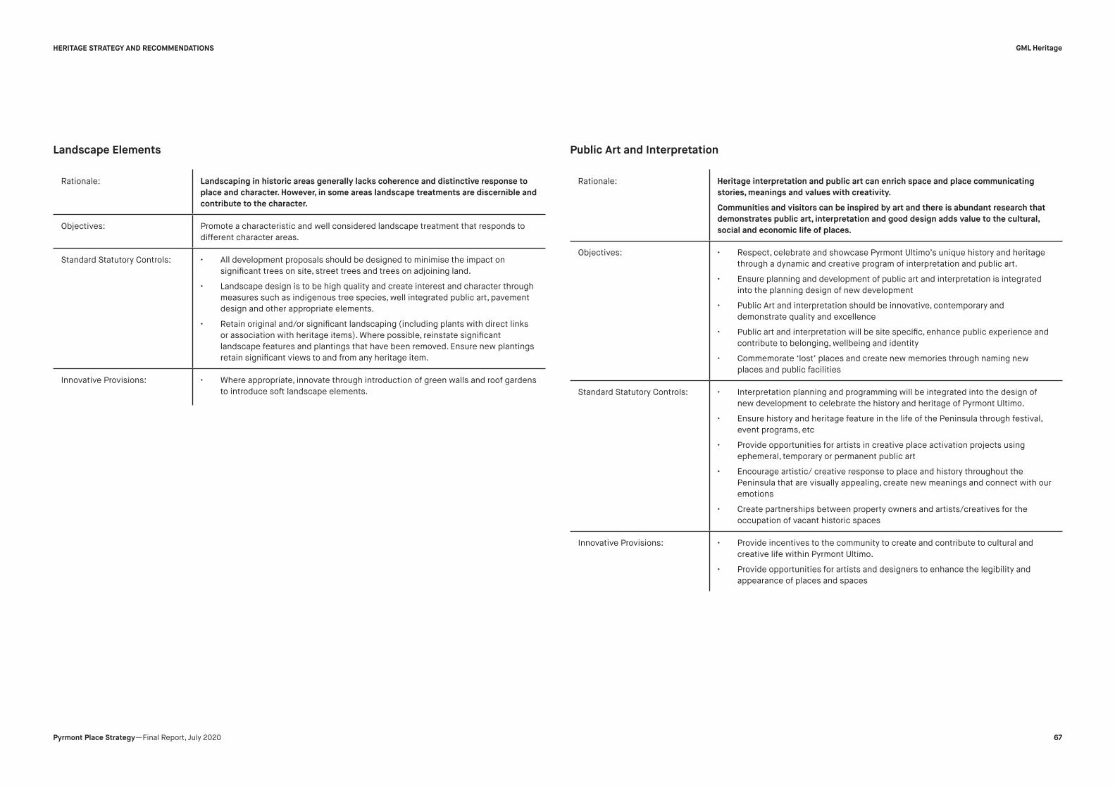
Rationale: Landscaping in historic areas generally lacks coherence and distinctive response to
place and character. However, in some areas landscape treatments are discernible and
contribute to the character.
Objectives: Promote a characteristic and well considered landscape treatment that responds to
different character areas.
Standard Statutory Controls: • All development proposals should be designed to minimise the impact on
significant trees on site, street trees and trees on adjoining land.
• Landscape design is to be high quality and create interest and character through
measures such as indigenous tree species, well integrated public art, pavement
design and other appropriate elements.
• Retain original and/or significant landscaping (including plants with direct links
or association with heritage items). Where possible, reinstate significant
landscape features and plantings that have been removed. Ensure new plantings
retain significant views to and from any heritage item.
Innovative Provisions: • Where appropriate, innovate through introduction of green walls and roof gardens
to introduce soft landscape elements.
Rationale: Heritage interpretation and public art can enrich space and place communicating
stories, meanings and values with creativity.
Communities and visitors can be inspired by art and there is abundant research that
demonstrates public art, interpretation and good design adds value to the cultural,
social and economic life of places.
Objectives: • Respect, celebrate and showcase Pyrmont Ultimo’s unique history and heritage
through a dynamic and creative program of interpretation and public art.
• Ensure planning and development of public art and interpretation is integrated
into the planning design of new development
• Public Art and interpretation should be innovative, contemporary and
demonstrate quality and excellence
• Public art and interpretation will be site specific, enhance public experience and
contribute to belonging, wellbeing and identity
• Commemorate ‘lost’ places and create new memories through naming new
places and public facilities
Standard Statutory Controls: • Interpretation planning and programming will be integrated into the design of
new development to celebrate the history and heritage of Pyrmont Ultimo.
• Ensure history and heritage feature in the life of the Peninsula through festival,
event programs, etc
• Provide opportunities for artists in creative place activation projects using
ephemeral, temporary or permanent public art
• Encourage artistic/ creative response to place and history throughout the
Peninsula that are visually appealing, create new meanings and connect with our
emotions
• Create partnerships between property owners and artists/creatives for the
occupation of vacant historic spaces
Innovative Provisions: • Provide incentives to the community to create and contribute to cultural and
creative life within Pyrmont Ultimo.
• Provide opportunities for artists and designers to enhance the legibility and
appearance of places and spaces
Landscape Elements Public Art and Interpretation
GML Heritage
67Pyrmont Place Strategy —Final Report, July 2020
HERITAGE STRATEGY AND RECOMMENDATIONS
Endnotes
1 Attenbrow, V 2010, Sydney’s Aboriginal Past: Investigating the
Archaeological and Historical Record, UNSW Press, Sydney, p 153.
2 The Sydney Gazette, 21 December 1806, quoted in Matthews, M R 1982,
Pyrmont and Ultimo: A History, Pyrmont Ultimo History Project, Ultimo,
NSW. p 8.
3 Fitzgerald, S a G, Hillary 1994, Pyrmont & Ultimo under siege, Hale &
Iremonger, Sydney., p 10.
4 Matthews, M R 1982, Pyrmont Ultimo History Project, Ultimo, NSW, p 8.
5 Fitzgerald, S a G, Hillary 1994, Hale & Iremonger, Sydney., p 13.
6 Fitzgerald, S a G, Hillary 1994, Hale & Iremonger, Sydney.
7 Fitzgerald, S 2008, ‘Pyrmont’, Dictionary of Sydney, viewed 12 May 2020
<http://dictionaryofsydney.org/entry/pyrmont>.
8 Fitzgerald, S and G, Hillary 1994, Pyrmont & Ultimo under siege, Hale &
Iremonger, Sydney, p 15.
9 Fitzgerald, S 2008, ‘Pyrmont’, Dictionary of Sydney, viewed 12 May 2020
<http://dictionaryofsydney.org/entry/pyrmont>.
10 Fitzgerald, S 2008, ‘Pyrmont’, Dictionary of Sydney, viewed 12 May 2020
<http://dictionaryofsydney.org/entry/pyrmont>.
11 Matthews, M R 1982, Pyrmont Ultimo History Project, Ultimo, NSW, p 36.
12 Fitzgerald, S and G, Hillary 1994, Pyrmont & Ultimo under siege, Hale &
Iremonger, Sydney, p 47.
13 Matthews, M R 1982, Pyrmont Ultimo History Project, Ultimo, NSW, p 61.
14 Park, M 1997, Doors were always open: recollections of Pyrmont and
Ultimo, City West Development Corporation, Pyrmont, NSW. p 48.
15 NSW Office of Environment and Heritage, ‘Jones Bay Wharves
22/23 Site (Pyrmont Point Park)’, viewed 18 May 2020 <https://
www.environment.nsw.gov.au/heritageapp/ViewHeritageItemDetails.
aspx?ID=4920066>.
16 Sydney Morning Herald, 24 March 1894, as quoted in Pyrmont Bridge
History, Hughes Trueman Ludlow, 1986.
17 McEwen, S 2008, ‘Pyrmont Bridge’, viewed 17 May 2020 <https://
collection.maas.museum/object/28788>.
18 Park, M 1997, Doors were always open: recollections of Pyrmont and
Ultimo, City West Development Corporation, Pyrmont, NSW.p 70.
19 Fitzgerald, S a G, Hillary 1994, Hale & Iremonger, Sydney., p 56.
20 Fitzgerald, S and G, Hillary 1994, Pyrmont & Ultimo under siege, Hale &
Iremonger, Sydney, p 30.
21 Dictionary of Sydney, ‘The Great Strike of 1917’, 2017, viewed 17 May
2020 <http://home.dictionaryofsydney.org/the-great-strike-of-1917/>.
22 Matthews, M R 1982, Pyrmont Ultimo History Project, Ultimo, NSW, p 26.
23 Park, M 1997, Doors were always open: recollections of Pyrmont and
Ultimo, City West Development Corporation, Pyrmont, NSW.p 87.
24 Park, M 1997, Doors were always open: recollections of Pyrmont and
Ultimo, City West Development Corporation, Pyrmont, NSW, p59.
25 Fitzgerald, S a G, Hillary 1994, Hale & Iremonger, Sydney., p 25.
26 Matthews, M R 1982, Pyrmont Ultimo History Project, Ultimo, NSW, p 32.
27 Fitzgerald, S and G, Hillary 1994, Pyrmont & Ultimo under siege, Hale &
Iremonger, Sydney, p 64.
28 Fitzgerald, S 2008, ‘Pyrmont’, Dictionary of Sydney, viewed 12 May 2020
<http://dictionaryofsydney.org/entry/pyrmont>.
29 Park, M 1997, Doors were always open: recollections of Pyrmont and
Ultimo, City West Development Corporation, Pyrmont, NSW.p26
30 Park, M 1997, Doors were always open: recollections of Pyrmont and
Ultimo, City West Development Corporation, Pyrmont, NSW, p 25.
31 Unacknowledged source, ‘Thinking Back: Some Memories of Ultimo and
Pyrmont’, 1980.
32 Matthews, M R 1982, Pyrmont Ultimo History Project, Ultimo, NSW, p 26.
33 Broadbent, J 2010 ‘Transformations: Ecology of Pyrmont peninsula
1788-2008’, City of Sydney, p573.
34 Fitzgerald, S 2008, ‘Pyrmont’, Dictionary of Sydney, viewed 12 May 2020
<http://dictionaryofsydney.org/entry/pyrmont>.
GML Heritage
68Pyrmont Place Strategy —Final Report, July 2020

APPENDICES
A woman stands next to a timber lean-to at the back of a 5-roomed stone cottage at 1 Church Street, Pyrmont. (Source: Sydney CIty Archives)
GML Heritage
69Pyrmont Place Strategy —Final Report, July 2020

Appendix 1—Heritage Item Master Database
NAME (SLEP 2012 OR SHR) ADDRESS SURBURB LOT/SECTION/DP CHL ID SHR ID s170
SLEP 2012
HCA ID SLEP 2012 ID SREP 26 ID
SREP
HARBOUR ID
FORMER
RNE
NATIONAL
TRUST AIA
ENG
AUS
ITEM IN
PLACE
(Y/N)
INTACT
(Y/N)
INTEGRITY AND
CONDITION
(POOR/FAIR/GOOD)
SURROUNDING
ITEM(S) OF
SIGNIFICANCE (Y/N)
PRIORITY
ITEM (Y/N)
NOTES IE. FURTHER INTEGRITY
NOTES/ADDRESS OF ITEM OF
INTEREST
Railway viaduct Railway Street Glebe
Lot 8, DP 1033151— — Railcorp —
I800 - on border
of site boundary— — 1703 — — — Y Y Fair N —
Unable to view on google maps, but looks
like it is still there from aerial views
Escarpment face from former quarry “Saunders’
Quarry”— Pyrmont
Lot 3, DP 839057; Lot 22,
DP 1008425; Lot 100, DP
1013159; Lots 602 and
603, DP 1010086; Lot 37,
DP 1071670; Lots 59, 61
and 62, DP 270215
— — — — I1199 100 — — — — Listed Y — — — YUnable to view on google maps, but looks
like it is still there from aerial views
Eastern escarpment and palisade fence, above
Pirrama Road— Pyrmont
Lot 50, DP 867853; Lot 13,
DP 883135; Lots 1 and 4,
DP 867854
— — — — I1200 102 — 100742 — — — Y — — Y YUnable to view on google maps, but looks
like it is still there from aerial views
Western and northern escarpment, sandstone
wall and steps, and palisade fence, above
Pirrama road
— PyrmontLots 116 and 118, DP
872490— — — — I1201 129 — 100740 — — — Y — — Y Y
Unable to view on google maps, but looks
like it is still there from aerial views
Cast iron palisade fence fronting Bowman and
Cross Streets— Pyrmont Lot 21, DP 873431 — — — — I1202 101 — 100741 — — — N — — Y Y Unable to view on google maps
Railway cutting — Pyrmont Lot 94, DP 858635 — — — — I1203 103 — — — — — Y — — — YUnable to view on google maps, but looks
like it is still there from aerial views
Railway cutting and bridge — Pyrmont Pyrmont — — — — I1204 — — — — — — N — — — —
Unsure about this, Lots not coming up on
near maps/lots that are visible are under
a building/road
Former industrial building elements and
industrial components “Edwin Davey & Sons
Flour Mill”
2A Allen Street Pyrmont Lot 1, DP 848441 — — — — I1205 45 — 100700 7389 — — N — — — — —
Woolbrokers Arms Hotel including interior and
courtyard22 Allen Street Pyrmont Lot 1, DP 79202 — — — — I1206 46 — 100701 7671 — — Y Y Fair N — —
Former CSR Cooperage Building including
interiors56 Bowman Street Pyrmont
Lots 40 and 41, DP 270215
(SP 75963)— — — — I1207 88 — 100730 — — — Y Y Good Y — —
FormerCSRMainOfficeincludinginteriors 58 Bowman Street Pyrmont Lot 1, DP 270215 — — — — I1208 89 — 100731 — — — Y Y Good Y — —
GML Heritage
70Pyrmont Place Strategy —Final Report, July 2020
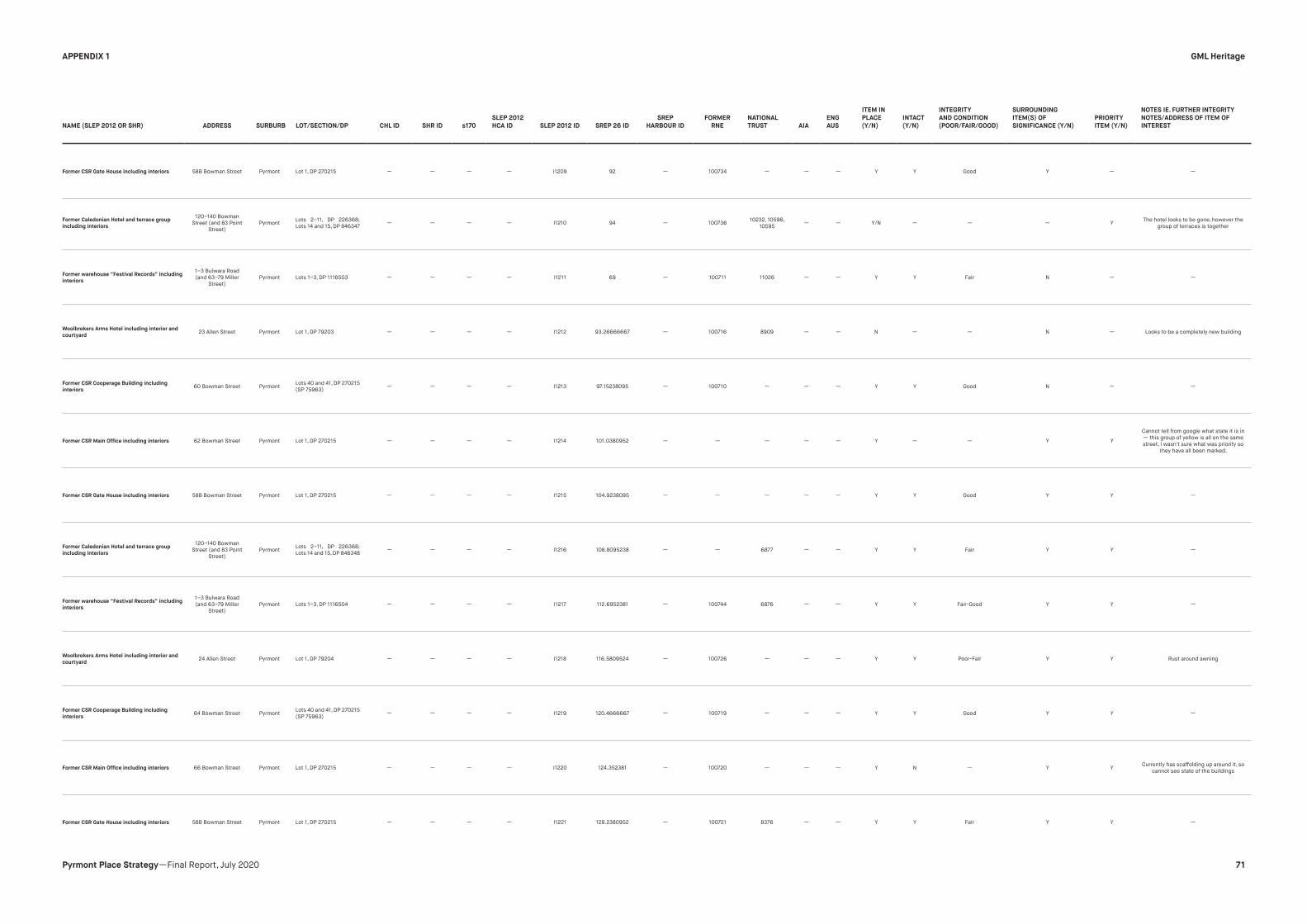
NAME (SLEP 2012 OR SHR) ADDRESS SURBURB LOT/SECTION/DP CHL ID SHR ID s170
SLEP 2012
HCA ID SLEP 2012 ID SREP 26 ID
SREP
HARBOUR ID
FORMER
RNE
NATIONAL
TRUST AIA
ENG
AUS
ITEM IN
PLACE
(Y/N)
INTACT
(Y/N)
INTEGRITY
AND CONDITION
(POOR/FAIR/GOOD)
SURROUNDING
ITEM(S) OF
SIGNIFICANCE (Y/N)
PRIORITY
ITEM (Y/N)
NOTES IE. FURTHER INTEGRITY
NOTES/ADDRESS OF ITEM OF
INTEREST
Former CSR Gate House including interiors 58B Bowman Street Pyrmont Lot 1, DP 270215 — — — — I1209 92 — 100734 — — — Y Y Good Y — —
Former Caledonian Hotel and terrace group
including interiors
120–140 Bowman
Street (and 83 Point
Street)
PyrmontLots 2–11, DP 226368;
Lots 14 and 15, DP 846347— — — — I1210 94 — 100736
10232, 10596,
10595— — Y/N — — — Y
The hotel looks to be gone, however the
group of terraces is together
Former warehouse “Festival Records” including
interiors
1–3 Bulwara Road
(and 63–79 Miller
Street)
Pyrmont Lots 1–3, DP 1116503 — — — — I1211 69 — 100711 11026 — — Y Y Fair N — —
Woolbrokers Arms Hotel including interior and
courtyard23 Allen Street Pyrmont Lot 1, DP 79203 — — — — I1212 93.26666667 — 100716 8909 — — N — — N — Looks to be a completely new building
Former CSR Cooperage Building including
interiors60 Bowman Street Pyrmont
Lots 40 and 41, DP 270215
(SP 75963)— — — — I1213 97.15238095 — 100710 — — — Y Y Good N — —
FormerCSRMainOfficeincludinginteriors 62 Bowman Street Pyrmont Lot 1, DP 270215 — — — — I1214 101.0380952 — — — — — Y — — Y Y
Cannot tell from google what state it is in
— this group of yellow is all on the same
street, I wasn't sure what was priority so
they have all been marked.
Former CSR Gate House including interiors 58B Bowman Street Pyrmont Lot 1, DP 270215 — — — — I1215 104.9238095 — — — — — Y Y Good Y Y —
Former Caledonian Hotel and terrace group
including interiors
120–140 Bowman
Street (and 83 Point
Street)
PyrmontLots 2–11, DP 226368;
Lots 14 and 15, DP 846348— — — — I1216 108.8095238 — — 6877 — — Y Y Fair Y Y —
Former warehouse “Festival Records” including
interiors
1–3 Bulwara Road
(and 63–79 Miller
Street)
Pyrmont Lots 1–3, DP 1116504 — — — — I1217 112.6952381 — 100744 6876 — — Y Y Fair-Good Y Y —
Woolbrokers Arms Hotel including interior and
courtyard24 Allen Street Pyrmont Lot 1, DP 79204 — — — — I1218 116.5809524 — 100726 — — — Y Y Poor-Fair Y Y Rust around awning
Former CSR Cooperage Building including
interiors64 Bowman Street Pyrmont
Lots 40 and 41, DP 270215
(SP 75963)— — — — I1219 120.4666667 — 100719 — — — Y Y Good Y Y —
FormerCSRMainOfficeincludinginteriors 66 Bowman Street Pyrmont Lot 1, DP 270215 — — — — I1220 124.352381 — 100720 — — — Y N — Y YCurrently has scaffolding up around it, so
cannot see state of the buildings
Former CSR Gate House including interiors 58B Bowman Street Pyrmont Lot 1, DP 270215 — — — — I1221 128.2380952 — 100721 8376 — — Y Y Fair Y Y —
GML Heritage
71Pyrmont Place Strategy —Final Report, July 2020
APPENDIX 1

NAME (SLEP 2012 OR SHR) ADDRESS SURBURB LOT/SECTION/DP CHL ID SHR ID s170
SLEP 2012
HCA ID SLEP 2012 ID SREP 26 ID
SREP
HARBOUR ID
FORMER
RNE
NATIONAL
TRUST AIA
ENG
AUS
ITEM IN
PLACE
(Y/N)
INTACT
(Y/N)
INTEGRITY
AND CONDITION
(POOR/FAIR/GOOD)
SURROUNDING
ITEM(S) OF
SIGNIFICANCE (Y/N)
PRIORITY
ITEM (Y/N)
NOTES IE. FURTHER INTEGRITY
NOTES/ADDRESS OF ITEM OF
INTEREST
Corner shop and terrace group including
interiors74–80 Harris Street Pyrmont Lots A–D, DP 50010 — — — — I1222 82 — 100723 — — — Y Y Good Y Y —
Former bakery including interiors, cartway and
courtyard82 Harris Street Pyrmont Lot 1, DP 131342 — — — — I1223 81 — 100722 — — — Y Y Good Y Y Some additions made to exterior
Maybanke Kindergarten and playground
including interiors and fence87–99 Harris Street Pyrmont
Lots 3, 5 and 6, DP
576037; Lot 1, DP 844689— — — — I1224 118 — 2050, 2039 — — — Y Y Good Y Y
Additions made to playground, such as
what looks like a composite rubber/
asphalt flooring for basketball court and
fwncing changed
Former woolstore “Shute, Bell, Badgery and
Lumby” including interiors94–136 Harris Street Pyrmont
Lot 1, DP 62184; Lot 37, DP
77013; Lot 1, DP 555734;
Lot 34, DP 85554; Lot 1,
DP 66729
— — — — I1225 71 — 13836 — — — Y Y Mixed Y Y Large section of item altered
Terrace group including interiors 101–125 Harris Street Pyrmont
Lot 2, DP 844689; Lot
1, DP 556887; Lot 113,
DP 1097637; Lot 3, DP
742000; Lot 2, DP 741187;
Lot 1, DP 162365; Lot 1, DP
770106; Lot 1, DP 714567;
Lot 23, DP 611085 (SP
57824); Lot 100, DP
827917; Lot 1, DP 1047124
— — — C52 I1226 65 —2052, 2051.
2054, 2039
10415, 11422,
10230— — Y Y Fair-Good Y Y —
Terrace group including interiors135–155 Harris
StreetPyrmont
Lot 1, DP 775467; Lots
2–10, DP 231589— — — C52 I1227 60 —
2053, 100681,
203910229 — — Y Y Mixed Y Y —
FormerPyrmontPostOfficeincludinginteriors,
side passage and yard
146–148 Harris
StreetPyrmont Lot 1, DP 632835 105510 01440 — C52 I1228 64 — 2040, 2039 9322 — — Y Y Good Y Y Additions to façade ie atm
Former public hall including interiors 179 Harris Street Pyrmont Lot 4, DP 586406 — — — C52 I1229 59 — 100707 — — — Y Y Fair Y YExterior painted unsure about interior,
possibly renovated
Terrace group including interiors189–203 Harris
StreetPyrmont Lots 10–17, DP 1007788 — — — C52 I1230 58 — 100682 — — — Y Y Mixed Y Y —
Dunkirk Hotel including interior and courtyard205–207 Harris
StreetPyrmont Lot 1, DP 448116 — — — C52 I1231 57 — 100683 — — — Y Y Good Y Y —
Quarryman’s Hotel including interior214–216 Harris
StreetPyrmont Lot 2, DP 940383 — — — C52 I1232 56 — 100706 — — — Y Y Good Y Y —
Corner shop and terrace group including
interiors, front gardens, fences and retaining
walls
224–302 Harris
StreetPyrmont
Lots 2–20, DP 31957; Lots
1–20, DP 31956; Lot 1, DP
31957 (SP 63445)
— — — C52 I1233 48 — 100686 — — — Y Y Mixed Y YItems in group of varying integrity and
condition.
GML Heritage
72Pyrmont Place Strategy —Final Report, July 2020
APPENDIX 1
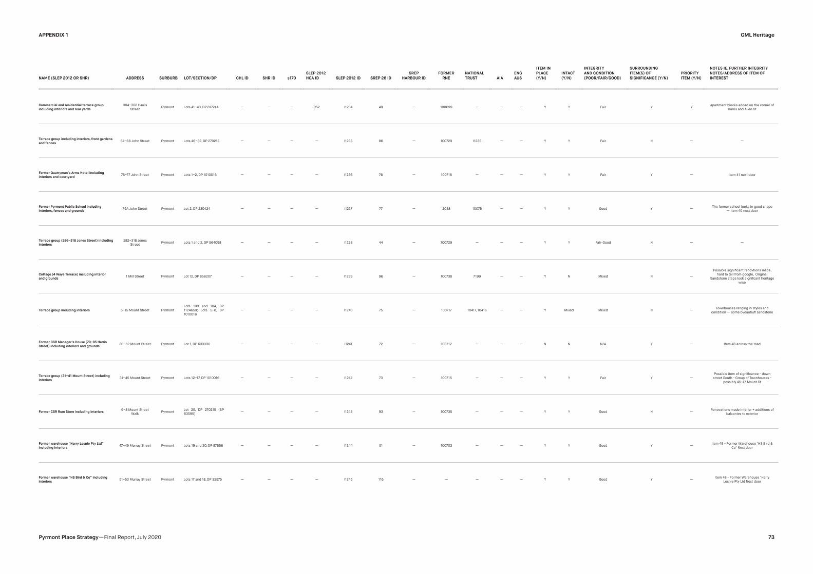
NAME (SLEP 2012 OR SHR) ADDRESS SURBURB LOT/SECTION/DP CHL ID SHR ID s170
SLEP 2012
HCA ID SLEP 2012 ID SREP 26 ID
SREP
HARBOUR ID
FORMER
RNE
NATIONAL
TRUST AIA
ENG
AUS
ITEM IN
PLACE
(Y/N)
INTACT
(Y/N)
INTEGRITY
AND CONDITION
(POOR/FAIR/GOOD)
SURROUNDING
ITEM(S) OF
SIGNIFICANCE (Y/N)
PRIORITY
ITEM (Y/N)
NOTES IE. FURTHER INTEGRITY
NOTES/ADDRESS OF ITEM OF
INTEREST
Commercial and residential terrace group
including interiors and rear yards
304–308 Harris
StreetPyrmont Lots 41–43, DP 817244 — — — C52 I1234 49 — 100699 — — — Y Y Fair Y Y
apartment blocks added on the corner of
Harris and Allen St
Terrace group including interiors, front gardens
and fences54–66 John Street Pyrmont Lots 46–52, DP 270215 — — — — I1235 86 — 100729 I1235 — — Y Y Fair N — —
Former Quarryman’s Arms Hotel including
interiors and courtyard75–77 John Street Pyrmont Lots 1–2, DP 1010016 — — — — I1236 76 — 100718 — — — Y Y Fair Y — Item 41 next door
Former Pyrmont Public School including
interiors, fences and grounds79A John Street Pyrmont Lot 2, DP 230424 — — — — I1237 77 — 2038 10075 — — Y Y Good Y —
The former school looks in good shape
— item 40 next door
Terrace group (286–318 Jones Street) including
interiors
282–318 Jones
StreetPyrmont Lots 1 and 2, DP 564098 — — — — I1238 44 — 100729 — — — Y Y Fair-Good N — —
Cottage (4 Ways Terrace) including interior
and grounds1 Mill Street Pyrmont Lot 12, DP 856207 — — — — I1239 96 — 100738 7199 — — Y N Mixed N —
Possible significant renovtions made,
hard to tell from google, Original
Sandstone steps look signifcant heritage
wise
Terrace group including interiors 5–15 Mount Street Pyrmont
Lots 103 and 104, DP
1124659; Lots 5–8, DP
1010016
— — — — I1240 75 — 100717 10417, 10416 — — Y Mixed Mixed N —Townhouses ranging in styles and
condition — some bveautiufl sandstone
Former CSR Manager’s House (79–85 Harris
Street) including interiors and grounds30–52 Mount Street Pyrmont Lot 1, DP 633390 — — — — I1241 72 — 100712 — — — N N N/A Y — Item 46 across the road
Terrace group (31–41 Mount Street) including
interiors31–45 Mount Street Pyrmont Lots 12–17, DP 1010016 — — — — I1242 73 — 100715 — — — Y Y Fair Y —
Possible item of significance - down
street South - Group of Townhouses -
possibly 45-47 Mount St
Former CSR Rum Store including interiors6–8 Mount Street
WalkPyrmont
Lot 25, DP 270215 (SP
63595)— — — — I1243 93 — 100735 — — — Y Y Good N —
Renovations made interior + additions of
balconies to exterior
Former warehouse “Harry Lesnie Pty Ltd”
including interiors47–49 Murray Street Pyrmont Lots 19 and 20, DP 87656 — — — — I1244 51 — 100702 — — — Y Y Good Y —
Item 49 - Former Warehouse "HS Bird &
Co" Next door
Former warehouse “HS Bird & Co” including
interiors51–53 Murray Street Pyrmont Lots 17 and 18, DP 32575 — — — — I1245 116 — — — — — Y Y Good Y —
Item 48 - Former Warehouse "Harry
Lesnie Pty Ltd Next door
GML Heritage
73Pyrmont Place Strategy —Final Report, July 2020
APPENDIX 1

NAME (SLEP 2012 OR SHR) ADDRESS SURBURB LOT/SECTION/DP CHL ID SHR ID s170
SLEP 2012
HCA ID SLEP 2012 ID SREP 26 ID
SREP
HARBOUR ID
FORMER
RNE
NATIONAL
TRUST AIA
ENG
AUS
ITEM IN
PLACE
(Y/N)
INTACT
(Y/N)
INTEGRITY
AND CONDITION
(POOR/FAIR/GOOD)
SURROUNDING
ITEM(S) OF
SIGNIFICANCE (Y/N)
PRIORITY
ITEM (Y/N)
NOTES IE. FURTHER INTEGRITY
NOTES/ADDRESS OF ITEM OF
INTEREST
Former woolstore “Clarence Bonded and Free
Stores” including interiors139 Murray Street Pyrmont Lot 16, DP 33491 — — — — I1246 — — 2397 10877 — — Y Y Good N — —
Terrace group including interiors1–21 Paternoster
RowPyrmont
Lots 1 and 2, DP 597792;
Lots 23–31, DP 109844— — — C52 I1247 61 —
2056, 2055,
203910254, 10228 — — Y Y Good N — —
Remnant Former Pyrmont Baths including rock
outcrop, hewn steps and piles visible at low tide22–24 Pirrama Road Pyrmont Lot 115, DP 872490 — — — — I1248 119 — — — — — — — — — Y Not visible in Maps
“Jones Bay Wharf” (Wharf 60, Berths 19–20)
including wharf, sea wall, sheds and interiors,
lower and elevated road and industrial artefacts
26–32 Pirrama Road Pyrmont
Lots 1 and 2, DP 1050360
(SP 69950, SP 69951, SP
70641)
— — — — I1249 — — 100728 11563 — — Y Y Fair — —Near items 52-56. Appears to be quite
heavily rennoated interior and exterior
Former garage including interiors, yard, wharf
and seawall (formerly 17A Pirrama Road)34 Pirrama Road Pyrmont Lot 11, DP 883135 — — RMS — I1250 130 — — — — — — — — — — Near items 52-56
Former Royal Edward Victualling Yard
warehouses “A” and “B” including interiors,
wharf, sea wall, yard and industrial archaeology
38–42 Pirrama Road Pyrmont Lot 1, DP 218445 — 01855 — — I1251 97 — 2057 9569 — — — — — — —Roller doors added, no yard, surrounded
by car park, near items 52-56
Naval Warehouse, Darling Island Former
Royal Edward Victualling Yard warehouse “C”
including interiors, wharf, seawall, yard and
industrial artefacts
38–42 Pirrama Road Pyrmont Lot 1, DP 218445 — — — — I1252 98, 99 — — — — — Y Y Fair-Good Y —Roller doors added, no yard, surrounded
by car park, near items 52-56
Terrace group (2A–2B Mill Street) including
interiors10 Point Street Pyrmont Lot 2, DP 218445 — — — — I1253 125 — — — — — Y Y Good Y — Item 58
Residentialflatbuilding“WaysTerrace”
including interiors, grounds, sandstone
retaining walls
12–20 Point
StreetwallsPyrmont Lot 5, DP 839315 — — — — I1254 95 — 13869 10768 — — Y Y Fair Y — Item 57
Pyrmont Bridge Road Hotel including interior
and courtyard
11 Pyrmont Bridge
RoadPyrmont Lot 1, DP 83296 — — — — I1255 52 — 100703 — — — Y Y Good Y — near Items 59-70
Former warehouse “Bank of NSW Stores”
including interiors
17–21 Pyrmont
Bridge RoadPyrmont Lot 1, DP 81832 — — — — I1256 53 — 100704 — — — Y Y Fair-Good Y — near Items 59-71, renovated exterior
Former MWS&DB Sewage Pumping Station No 2
including interior
103 Pyrmont Bridge
RoadPyrmont Lot 1, DP 1012251 — —
Sydney
Water— I1257 — — 100705 — — — Y Y Fair N — —
GML Heritage
74Pyrmont Place Strategy —Final Report, July 2020
APPENDIX 1

NAME (SLEP 2012 OR SHR) ADDRESS SURBURB LOT/SECTION/DP CHL ID SHR ID s170
SLEP 2012
HCA ID SLEP 2012 ID SREP 26 ID
SREP
HARBOUR ID
FORMER
RNE
NATIONAL
TRUST AIA
ENG
AUS
ITEM IN
PLACE
(Y/N)
INTACT
(Y/N)
INTEGRITY
AND CONDITION
(POOR/FAIR/GOOD)
SURROUNDING
ITEM(S) OF
SIGNIFICANCE (Y/N)
PRIORITY
ITEM (Y/N)
NOTES IE. FURTHER INTEGRITY
NOTES/ADDRESS OF ITEM OF
INTEREST
Warehouse “Slades Building” and terrace group
including interiors
12–18 Pyrmont
StreetPyrmont
Lots 1–8, DP 1118495;
Lots 1–7, DP 4520; Lots
2–4, DP 714887
— — — — I1258 132 — — — — — Y Y Poor Y Ynear Items 59-73, broken windows,
added roller doors
Former Pyrmont Power Station Administrative
building (42 Pyrmont Street) including interiors
20–80 Pyrmont
Street
Pyrmont Lot 300, DP 873212 — — — — I1259 70 — 100714 10063 — — Y Y Fair Y Y near Items 59-74
Cottage group including interiors27–29 Pyrmont
StreetPyrmont
Lot 1, DP 716793; Lot 1, DP
745182— — — — I1260 83 — 100724 7218 — — Y Y Poor Y Y near Items 59-75
St Bede’s Church group including church,
presbytery, school and their interiors, ground
and fence
33–43 Pyrmont
StreetPyrmont Lot 2, DP 791724 — — — — I1261 84 — 100725 9800 — — Y Y Good Y Y near Items 59-76
Group of three cottages (two at 93 Pyrmont
Street) including interiors and including former
shop (93) and courtyard (93)
91–93 Pyrmont
StreetPyrmont Lots 6 and 7, DP 242530 — — — C52 I1262 124 — — — — — Y Y Good Y Y near Items 59-77
Former wool store “John Taylor Wool Stores”
including interiors and industrial artifacts
(woolpress)
137 Pyrmont Street Pyrmont Lot 2, DP 59052 — — — C52 I1263 54 — 2036, 2035 10858, 10706 — — Y Y — — Ynear Items 59-78- Heavily renovated
interior
Terrace group including interiors142–168 Pyrmont
StreetPyrmont Lots 1–14, DP 33491 — — — — I1264 117 — — 10877 — — Y Y Fair Y Y near Items 59-79
Pyrmont Fire Station including interior 147 Pyrmont Street Pyrmont Lot 10, DP 1060282 — —
Fire and
Rescue
NSW
C52 I1265 50 — 2058 7540 — — Y Y Good Y Y
New signage, would have renocated
interior to continue use as fire station.
near Items 59-70
Samuel Hordern Fountain including base and
setting
Pyrmont Street,
corner Pyrmont
Bridge Road
Pyrmont — — — — I1266 121 — — 9600 — — Y Y Good Y Y Front door renovated, near item 59-70
Remnants of former CSR Laboratory B building
including retaining walls and industrial artefacts25 Refinery Drive Pyrmont
Lot 39, DP 270215 (SP
72677)— — — — I1267 90 — 100732 — — — — — — Y Y
Hard to see changes on google, almost
looks like its been torn down but I dont
believe it has
Former CSR Tablet House including interiors 29 Refinery Drive PyrmontLot 27, DP 270215 (SP
73749)— — — — I1268 91 — 100733 — — — Y Y Good Y —
Some exterior renovations Item 71- Hard
to see exact exstent of changes to
building
Semi-detached house group including interiors
and grounds2–8 Scott Street Pyrmont
Lots 100–102, DP 881053;
Lot 5, DP 860510— — — — I1269 105 — 100745 6875 — — Y Y Good Y — Item 74
GML Heritage
75Pyrmont Place Strategy —Final Report, July 2020
APPENDIX 1
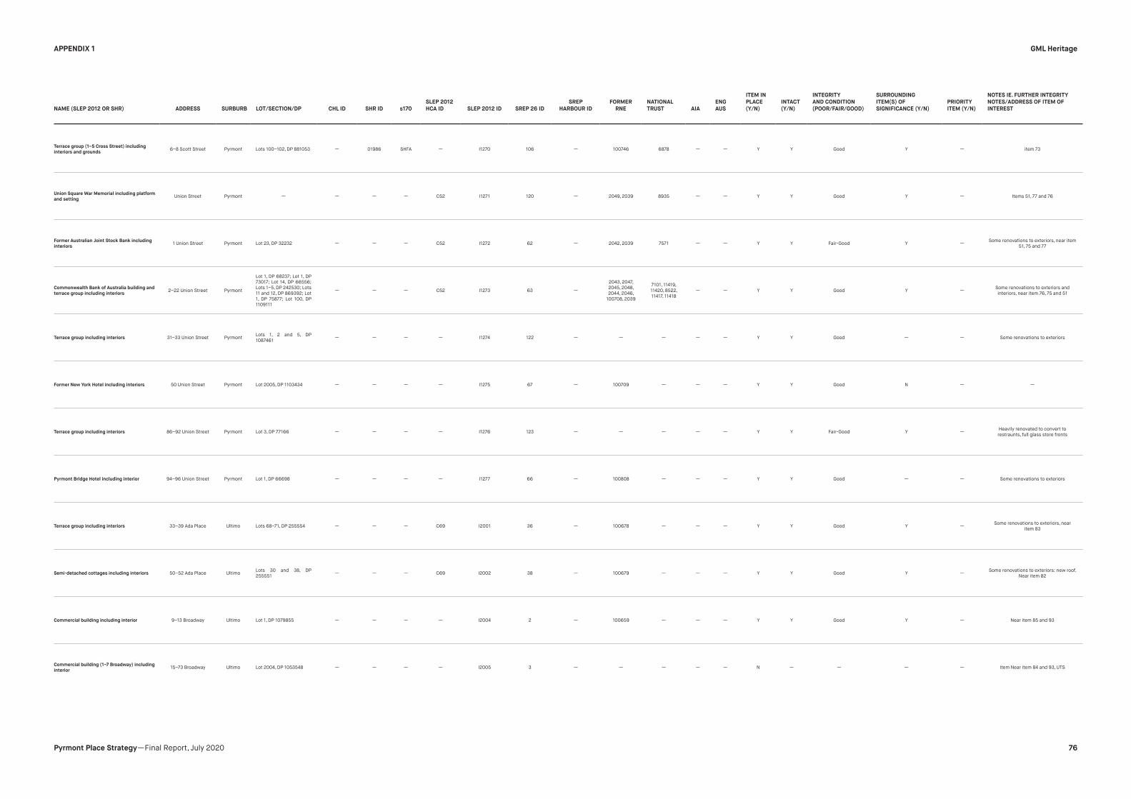
NAME (SLEP 2012 OR SHR) ADDRESS SURBURB LOT/SECTION/DP CHL ID SHR ID s170
SLEP 2012
HCA ID SLEP 2012 ID SREP 26 ID
SREP
HARBOUR ID
FORMER
RNE
NATIONAL
TRUST AIA
ENG
AUS
ITEM IN
PLACE
(Y/N)
INTACT
(Y/N)
INTEGRITY
AND CONDITION
(POOR/FAIR/GOOD)
SURROUNDING
ITEM(S) OF
SIGNIFICANCE (Y/N)
PRIORITY
ITEM (Y/N)
NOTES IE. FURTHER INTEGRITY
NOTES/ADDRESS OF ITEM OF
INTEREST
Terrace group (1–5 Cross Street) including
interiors and grounds6–8 Scott Street Pyrmont Lots 100–102, DP 881053 — 01986 SHFA — I1270 106 — 100746 6878 — — Y Y Good Y — item 73
Union Square War Memorial including platform
and settingUnion Street Pyrmont — — — — C52 I1271 120 — 2049, 2039 8935 — — Y Y Good Y — Items 51, 77 and 76
Former Australian Joint Stock Bank including
interiors1 Union Street Pyrmont Lot 23, DP 32232 — — — C52 I1272 62 — 2042, 2039 7571 — — Y Y Fair-Good Y —
Some renovations to exteriors, near item
51, 75 and 77
Commonwealth Bank of Australia building and
terrace group including interiors2–22 Union Street Pyrmont
Lot 1, DP 68237; Lot 1, DP
73017; Lot 14, DP 66556;
Lots 1–5, DP 242530; Lots
11 and 12, DP 869392; Lot
1, DP 75877; Lot 100, DP
1109111
— — — C52 I1273 63 —
2043, 2047,
2045, 2048,
2044, 2046,
100708, 2039
7101, 11419,
11420, 8522,
11417, 11418
— — Y Y Good Y —Some renovations to exteriors and
interiors, near item 76, 75 and 51
Terrace group including interiors 31–33 Union Street PyrmontLots 1, 2 and 5, DP
1087461— — — — I1274 122 — — — — — Y Y Good — — Some renovations to exteriors
Former New York Hotel including interiors 50 Union Street Pyrmont Lot 2005, DP 1103434 — — — — I1275 67 — 100709 — — — Y Y Good N — —
Terrace group including interiors 86–92 Union Street Pyrmont Lot 3, DP 77166 — — — — I1276 123 — — — — — Y Y Fair-Good Y —Heavily renovated to convert to
restraunts, full glass store fronts
Pyrmont Bridge Hotel including interior 94–96 Union Street Pyrmont Lot 1, DP 66698 — — — — I1277 66 — 100808 — — — Y Y Good — — Some renovations to exteriors
Terrace group including interiors 33–39 Ada Place Ultimo Lots 68–71, DP 255554 — — — C69 I2001 36 — 100678 — — — Y Y Good Y —Some renovations to exteriors, near
item 83
Semi-detached cottages including interiors 50–52 Ada Place UltimoLots 30 and 38, DP
255551— — — C69 I2002 38 — 100679 — — — Y Y Good Y —
Some renovations to exteriors: new roof.
Near item 82
Commercial building including interior 9–13 Broadway Ultimo Lot 1, DP 1079855 — — — — I2004 2 — 100659 — — — Y Y Good Y — Near item 85 and 93
Commercial building (1–7 Broadway) including
interior15–73 Broadway Ultimo Lot 2004, DP 1053548 — — — — I2005 3 — — — — — N — — — — Item Near item 84 and 93, UTS
GML Heritage
76Pyrmont Place Strategy —Final Report, July 2020
APPENDIX 1

NAME (SLEP 2012 OR SHR) ADDRESS SURBURB LOT/SECTION/DP CHL ID SHR ID s170
SLEP 2012
HCA ID SLEP 2012 ID SREP 26 ID
SREP
HARBOUR ID
FORMER
RNE
NATIONAL
TRUST AIA
ENG
AUS
ITEM IN
PLACE
(Y/N)
INTACT
(Y/N)
INTEGRITY
AND CONDITION
(POOR/FAIR/GOOD)
SURROUNDING
ITEM(S) OF
SIGNIFICANCE (Y/N)
PRIORITY
ITEM (Y/N)
NOTES IE. FURTHER INTEGRITY
NOTES/ADDRESS OF ITEM OF
INTEREST
Terrace group including interiors242–262 Bulwara
RoadUltimo
Lots 72–79, DP 255554;
Lots 43–45, DP 255552— — — C69 I2020 35 — 100676
10014, 8377,
8516, 8377— — Y Y Good Y — —
Former St Francis Xavier Church group church/
school building and terrace houses, including
interiors
247–257 Bulwara
RoadUltimo Lot 1, DP 818442 — — — C69 I2021 114 — — 7017, 7352 — — N — — — —
Looks like the Church has been knocked
down
Lord Wolseley Hotel including interior Lot 1, DP 66697 Ultimo Lot 1, DP 66697 — — — C69 I2022 40 — 100696 — — — Y Y Good Y — —
Terrace group including interiors286–340 Bulwara
RoadUltimo
Lots 14–26, DP 32294;
Lots 1–13, DP 32295; Lots
62–63, DP 32293
— — — — I2023 23 — 100674 — — — Y Y Fair Y — —
Terrace group including interiors
342 Bulwara
Road and 68–80
Macarthur Street
Ultimo Lots 54–61, DP 32293 — — — — I2024 21 — — — — — Y Y Good Y — Near item 91
Terrace group including interiors
348 Bulwara Road
and 68–80 Mary Ann
Street
UltimoLots 10–16 and 19, DP
859980— — — C67 I2025 11 — — 10120 — — Y Y Good Y — Near item 90
Former Crown Hotel and terrace group including
interiors
363–375 Bulwara
RoadUltimo Lots 1–6, DP 239225 — — — — I2026 110 — — — — — Y Y Fair Y — Some renovations to exteriors
Agincourt Hotel including interior 871 George Street Ultimo Lot 7, DP 208902 — — — —
I2027* - west
of Harris St HAS
ASTERIX CHECK
— — — — — — Y Y Good N — —
Terrace group including interiors 11–63 Hackett Street Ultimo
Lots 27–38, DP 32294;
Lots 39–44, 46 and 47, DP
32295; Lot 45, DP 27321;
Lots 48–53, DP 32293;
Lot 1, DP 625549
— — — — I2028 24 — 100675 — — — Y Y Fair N — Some renovations to exteriors
Terrace group including interiors451–455 Harris
StreetUltimo Lots 31–33, DP 255551 — — — C69 I2029 37 — 100688 — — — Y Y Good N — Near sites 96-101
FormerUltimoPostOfficeincludinginterior 494 Harris Street Ultimo Lot 1, DP 770031 — 00502 — — I2030 26 — 2381 9302 — — Y Y Good Y — Near sites95-101
Powerhouse Museum former warehouse
buildings, including interiors500 Harris Street Ultimo Lot 1, DP 631345 — — — — I2031 25 —
100691,
10069011648, 10611 — Listed Y Y Good Y — Near sites 95-102
GML Heritage
77Pyrmont Place Strategy —Final Report, July 2020
APPENDIX 1

NAME (SLEP 2012 OR SHR) ADDRESS SURBURB LOT/SECTION/DP CHL ID SHR ID s170
SLEP 2012
HCA ID SLEP 2012 ID SREP 26 ID
SREP
HARBOUR ID
FORMER
RNE
NATIONAL
TRUST AIA
ENG
AUS
ITEM IN
PLACE
(Y/N)
INTACT
(Y/N)
INTEGRITY
AND CONDITION
(POOR/FAIR/GOOD)
SURROUNDING
ITEM(S) OF
SIGNIFICANCE (Y/N)
PRIORITY
ITEM (Y/N)
NOTES IE. FURTHER INTEGRITY
NOTES/ADDRESS OF ITEM OF
INTEREST
Glasgow Arms Hotel including interior527–529 Harris
StreetUltimo Lot 1, DP 733932 — — — — I2032 27 — 100692 — — — Y Y Good y — Near sites95-103
Terrace group including interiors
578–606 Harris
Street
Ultimo
Lots 1–5 and 9–11, DP
234078; Lot 1, DP 709093;
Lot 10, DP 749276; Lots
6–8, DP 791341; Lot 1, DP
731661
— — — C67 I2033 9 — 100660 — — — Y Y Good Y — Small renovations,Near sites 95-102
Terrace group including interiors597–607 Harris
StreetUltimo
Lots 4 and 5, DP 790232;
Lots 50–53, DP 827003— — — C67 I2034 13 — 100665 — — — Y Y Good Y —
Small renovations, mainly staircases,
Near sites 95-102
Former “Millinery House” including interior608–614 Harris
StreetUltimo Lots 4 and 5, DP 70368 — — — C67 I2035 — — 100662 — — — y y Good Y — —
Former National Cash Register Co, Building
including interior
622–632 Harris
StreetUltimo Lot A, DP 155003 — — — — I2036 107 — — — — — Y Y Fair Y —
New paint job and what looks like interior
renovations
Terrace group including interiors629–637 Harris
StreetUltimo
Lots A and B, DP 447392;
Lot 1, DP 719295; Lot 1, DP
1103443
— — — C67 I2037 12 — 100664 — — — Y Y Fair Y —Terraces at varying levels of conditions
— slightly down the road from item 102
Commercial building (851–855 George Street)
including interior732 Harris Street Ultimo
Lot 1, DP 1087479 (SP
79678)— — — —
I2038* - west of
harris— — — — — — Y N Fair N —
Looks to be large amounts of changes to
the exterior of the building
Electrical substation including interior 8 Henry Avenue Ultimo Lot 1, DP 78555 — — Ausgrid C69 I2039 43 — 100698 — — — Y Y Good N — —
Former woolstore facades
89–97 Jones Street
(and 330–370 Wattle
Street)
Ultimo
Lot 1, DP 809554 (SP
38979, SP 45077, SP
56149); Lot 2, DP 809554
(SP 42936, SP 49783)
— — — — I2040 — — 2342 10472 — — Y N Fair Y —Large amounts of changes to exterior
of building
Terrace group including interiors 111–187 Jones Street Ultimo
Lot 1, DP 802114; Lots
2–28 and 30–39, DP
913681; Lot 1, DP 580785
— — — — I2041 16 — 100668 — — — Y Y Fair Y — —
Former “Farmers & Graziers No 2” including
interior
492–516 Jones
StreetUltimo Lot 1, DP 624161 — — — — I2042 22 — 100689 — — — Y Y Fair-Good Y —
It is a storage centre so unsure about the
state or degree of changes to the interior
Terrace houses including interiors
50–52 Macarthur
Street
UltimoLot A, DP 72445; Lot 2, DP
72444— — — — I2043 20 — 100672 — — — Y Y Fair Y — Near Item 110
GML Heritage
78Pyrmont Place Strategy —Final Report, July 2020
APPENDIX 1

NAME (SLEP 2012 OR SHR) ADDRESS SURBURB LOT/SECTION/DP CHL ID SHR ID s170
SLEP 2012
HCA ID SLEP 2012 ID SREP 26 ID
SREP
HARBOUR ID
FORMER
RNE
NATIONAL
TRUST AIA
ENG
AUS
ITEM IN
PLACE
(Y/N)
INTACT
(Y/N)
INTEGRITY
AND CONDITION
(POOR/FAIR/GOOD)
SURROUNDING
ITEM(S) OF
SIGNIFICANCE (Y/N)
PRIORITY
ITEM (Y/N)
NOTES IE. FURTHER INTEGRITY
NOTES/ADDRESS OF ITEM OF
INTEREST
Terrace houses including interiors77–79 Macarthur
StreetUltimo Lots 1 and 2, DP 828613 — — — C67 I2044 14 — — — — — Y Y Good Y — Near Item 109
Former School of Mechanical & Automotive
Engineering, Sydney Technical College (Building
P) including interior
1–17 Mary Ann Street Ultimo Lot 1, DP 544256 — — — — I2045 4 —2088, 13877,
20849615 Listed — Y Y Good Y — Near Item 112
Terrace group including interiors
12–22 Mary Ann
Street
Ultimo Lots 40–45, DP 913681 — — — — I2046 17 — 100670 — — — Y Y Fair-Good Y — Near Item 111
Former Sydney Technical College building
(Building H including interior)19 Mary Ann Street Ultimo Lot 1, DP 594621 — — — — I2047 108 — 2084 — — — Y Y Good Y — Items 113-117 are all next to each other
Former Counselling Building, Sydney Technical
College (Building I) including interior19 Mary Ann Street Ultimo Lot 1, DP 594621 — — — — I2048 5 — 2084 6578 — — Y Y Good Y — Items 113-117 are all next to each other
Former Administration Building, Sydney
Technical College (Building A) including interior19 Mary Ann Street Ultimo Lot 1, DP 594621 — — — — I2049 6 — 2087, 2084 6572 — — Y Y Good Y — Items 113-117 are all next to each other
Former Turner Hall, Sydney Technical College
(Building B) including interior, fence, bus shelter
and grounds
19 Mary Ann Street Ultimo Lot 1, DP 594621 — — — — I2050 7 — 2086, 2084 7667 — — Y Y Good Y — Items 113-117 are all next to each other
Former Museum of Applied Arts and Sciences,
Sydney Technical College (Building C) including
interior
21 Mary Ann Street Ultimo Lot 1, DP 594621 — — — — I2051 8 — 2084, 2085 9071 — — Y Y Good Y — Items 113-117 are all next to each other
Cottage and terrace group including interiors 92–98 Quarry Street UltimoLot C, DP 715516; Lots
1–3, DP 608555— — — C69 I2056 39 — 100680 — — — Y Y Fair Y —
Quarry St items are all near each other
(118-120)
Ultimo Uniting Church group buildings and
grounds, including interiors97 Quarry Street Ultimo Lot 12, DP 852646 — — — C69 I2057 33 — 100695 — — — Y Y Fair-Good Y —
Quarry St items are all near each other
(118-120)
Terrace houses including interiors102–104 Quarry
StreetUltimo
Lots 41 and 42, DP
255552— — — C69 I2058 34 — 100677 8515 — — Y Y Good Y —
Quarry St items are all near each other
(118-120)
Former woolstore “Winchcombe Carson”
including interior28–48 Wattle Street Ultimo Lot 1, DP 571484 — — — — I2059 42 — 2344, 2340 9390 — — Y Y Good Y — Near item 122
GML Heritage
79Pyrmont Place Strategy —Final Report, July 2020
APPENDIX 1

NAME (SLEP 2012 OR SHR) ADDRESS SURBURB LOT/SECTION/DP CHL ID SHR ID s170
SLEP 2012
HCA ID SLEP 2012 ID SREP 26 ID
SREP
HARBOUR ID
FORMER
RNE
NATIONAL
TRUST AIA
ENG
AUS
ITEM IN
PLACE
(Y/N)
INTACT
(Y/N)
INTEGRITY
AND CONDITION
(POOR/FAIR/GOOD)
SURROUNDING
ITEM(S) OF
SIGNIFICANCE (Y/N)
PRIORITY
ITEM (Y/N)
NOTES IE. FURTHER INTEGRITY
NOTES/ADDRESS OF ITEM OF
INTEREST
Former woolstore “ESGM & Co” including
interior50–54 Wattle Street Ultimo Lot 1, DP 62297 — — — — I2060 — —
2341, 2340,
22507395 — — Y Y Good Y — Near item 121
Former woolstore “Farmers & Graziers No 1”
including interior
372–428 Wattle
StreetUltimo
Lot 100, DP 880315 (SP
57895, SP 58945)— — — — I2061 — — 2343, 2340 7483 — — Y Y Fair Y — —
Terrace group including interiors430–444 Wattle
StreetUltimo Lots 1–8, DP 260374 — — — — I2062 18 — 100671 — — — Y Y Fair-Good Y — —
Vulcan Hotel including interior494–500 Wattle
StreetUltimo Lot 12, DP 1106916 — — — — I2064 15 — 100667 — — — Y Y Fair Y —
Fair chance of interior changes—exterior
painted
Former woolstore including interior14–18 William Henry
StreetUltimo Lot 1, DP 82697 — — — — I2065 111 — — — — — Y Y Fair Y —
Now storage centre so unsure about
state of the interior, also has 'flashy'
bright orange and blue paint job — Near
item 127-128
Terrace group including interiors20–36 William Henry
StreetUltimo Lots 1–9, DP 229755 — — — — I2066 112 — — — — — Y Y Fair Y — Near Item 126 and 128
Terrace group including interiors91–97 William Henry
StreetUltimo
Lot 1, DP 136903; Lot 1, DP
195661; Lot 1, DP 995930;
Lot 14, DP 785053
— — — — I2067 113 — — — — — Y Y Poor-Fair Y — near Item 126-127
House including interior and fence103–103A William
Henry StreetUltimo Lot 1, DP 572026 — — — — I2068 28 — 100693 — — — Y Y Good Y — Near items 126-128
Pyrmont Heritage Conservation Area — Pyrmont — — — — C52 — — — 100653 9391 — — — — — — Y —
Harris Street Heritage Conservation Area — Ultimo — — — — C67 — — — 100654 9391 — — — — — — Y —
Ultimo Heritage Conservation Area — Ultimo — — — — C69 — — — 100655 9391 — — — — — — Y —
81 Broadway 81 Broadway Ultimo-
Pyrmont— — — — — —
Precinct 1
Item 1— 100658 — — — N — — — —
This is Building 11 of the UTS, only a
couple of years old
GML Heritage
80Pyrmont Place Strategy —Final Report, July 2020
APPENDIX 1

NAME (SLEP 2012 OR SHR) ADDRESS SURBURB LOT/SECTION/DP CHL ID SHR ID s170
SLEP 2012
HCA ID SLEP 2012 ID SREP 26 ID
SREP
HARBOUR ID
FORMER
RNE
NATIONAL
TRUST AIA
ENG
AUS
ITEM IN
PLACE
(Y/N)
INTACT
(Y/N)
INTEGRITY
AND CONDITION
(POOR/FAIR/GOOD)
SURROUNDING
ITEM(S) OF
SIGNIFICANCE (Y/N)
PRIORITY
ITEM (Y/N)
NOTES IE. FURTHER INTEGRITY
NOTES/ADDRESS OF ITEM OF
INTEREST
Warehouse 99-109 Jones StreetUltimo-
Pyrmont— — — — — —
Precinct 1
Item 19— — — — — Y Y Good N — —
Former Woolstore (façade) 17-59 William Henry
Street
Ultimo-
Pyrmont— — — — — —
Precinct 1
Item 29— — — — — Y Y Good Y —
Bit of a paint job over the original brick/
sandstone
Former Woolstore 41-45 Jones StreetUltimo-
Pyrmont— — — — — —
Precinct 1
Item 41— — — — — Y Y Good N —
Not sure if 41 has been knocked down
or is technically part of 45. I think it’s
the latter.
Former Woolstore 24 Allen StreetUltimo-
Pyrmont— — — — — —
Precinct 1
Item 47— — 10867, 10877 — — Y Y Fair N — —
Water Board Pumping Station 10A Wattle Street Ultimo-
Pyrmont— — — — — —
Precinct 1
Item 55— — — — — Y Y Poor-Fair N —
looks like there are a couple broken
windows
Residence 238 Bulwara Road Ultimo-
Pyrmont— — — — — —
Precinct 1
Item 109— — — — — Y Y Poor-Fair N — Looks like damage to the roof
Rail cutting and Rail Bridge Harris StreetUltimo-
Pyrmont— — — Railcorp — —
Precinct 1
Item 126— — — — — — — — — — —
Wattle Street Railway Viaduct Wattle Street Ultimo-
Pyrmont— — — Railcorp — —
Precinct 1
Item 131— 1703 — — — — — — — — —
Wentworth Park rail viaductBays
Precinct— — — — — —
Precinct 3
Built Item 10— — 10590 — — — — — — — —
NCA Steward's Building, Wentworth ParkBays
Precinct— — — — — —
Precinct 3
Built Item 13— — — — — — — — — — —
Store Building, Wentworth ParkBays
Precinct— — — — — —
Precinct 3
Built Item 14— — — — — — — — — — —
NCA Entry tower, Wentworth ParkBays
Precinct— — — — — —
Precinct 3
Built Item 15— — — — — — — — — — —
GML Heritage
81Pyrmont Place Strategy —Final Report, July 2020
APPENDIX 1

NAME (SLEP 2012 OR SHR) ADDRESS SURBURB LOT/SECTION/DP CHL ID SHR ID s170
SLEP 2012
HCA ID SLEP 2012 ID SREP 26 ID
SREP
HARBOUR ID
FORMER
RNE
NATIONAL
TRUST AIA
ENG
AUS
ITEM IN
PLACE
(Y/N)
INTACT
(Y/N)
INTEGRITY
AND CONDITION
(POOR/FAIR/GOOD)
SURROUNDING
ITEM(S) OF
SIGNIFICANCE (Y/N)
PRIORITY
ITEM (Y/N)
NOTES IE. FURTHER INTEGRITY
NOTES/ADDRESS OF ITEM OF
INTEREST
Wentworth Park —Bays
Precinct— — — — — —
Precinct 3
Landscape
Item 16
— — Listed — — — — — — — —
Glebe Island BridgeBank Street, Victoria
RoadPyrmont — — 01914 — — — — Area 4 Item 2 15949 7749 — — Y Y Fair-Good Y N
I1199 - Escarpment farce opposite
Bowman Street
Sewage Pumping Station 1William Henry Street
(303 Pyrmont Street)Ultimo Lot 3 DP 919220 — 01336 — — — — — 100809 11435 — — Y Y Good N N —
Ultimo Road Railway UnderbridgeDarling Harbour
goods railwayUltimo — — 01062 Railcorp — — — — — — — — Y Y Good N N —
Darling Harbour Woodward Water Feature Harbour PromenadeDarling
HarbourPart Lot 1010 DP 1147364 — 01933 — — — — — — — — — Y Y Good N N
Looks like lots have changed - Lot 2015
in DP 1234971
Pyrmont BridgeSydney, Darling
Harbour
Sydney,
Darling
Harbour
Part Lot 501 DP 1031387,
Part Lot 1010 DP 1147364— 01618 — — — — — 1835 — — Listed Y Y Fair-Good Y Y
Looks like lots have changed - Lot
2015 in DP 1234971, west end of bridge
opposite 92 Union, 92-96 Union Street,
unable to see underside of bridge
South Steyne (S.S) Port Jackson, NSW
(Primary Address)— — — 00755 — — — — — — — — — — — — — Movable item
Anzac BridgeVictoria Road,
Pyrmont, NSW 2009Pyrmont — — — RMS — — — — — — — — — — — — — —
Arrow Marine Building
17a Pirrama Road,
Jones Bay Road,
Pyrmont, NSW 2009
Pyrmont — — — SHFA — — — — — — — — — — — — — —
Blackwattle Bay Stormwater Channel No 17
Pyrmont Bridge
Road, Pyrmont /
Glebe, NSW
Glebe — — —Sydney
Water— — — — — — — — — — — — — —
Darling Harbour Rail Corridor
West Side of Darling
Harbour To Pyrmont,
Darling Harbour &
Pyrmont, NSW
— — — SHFA — — — — — — — — — — — — — —
Jones Bay Wharves 22/23 Site (Pyrmont Point
Park)
22 Jones Bay Road,
Pyrmont, NSW 2009Pyrmont — — — RMS — — — — — 10806 — — — — — — — —
GML Heritage
82Pyrmont Place Strategy —Final Report, July 2020
APPENDIX 1

NAME (SLEP 2012 OR SHR) ADDRESS SURBURB LOT/SECTION/DP CHL ID SHR ID s170
SLEP 2012
HCA ID SLEP 2012 ID SREP 26 ID
SREP
HARBOUR ID
FORMER
RNE
NATIONAL
TRUST AIA
ENG
AUS
ITEM IN
PLACE
(Y/N)
INTACT
(Y/N)
INTEGRITY
AND CONDITION
(POOR/FAIR/GOOD)
SURROUNDING
ITEM(S) OF
SIGNIFICANCE (Y/N)
PRIORITY
ITEM (Y/N)
NOTES IE. FURTHER INTEGRITY
NOTES/ADDRESS OF ITEM OF
INTEREST
Electricity Substation No. 95124 Hackett Street,
Ultimo, NSW 2007Ultimo — — — Ausgrid — — — — — — — — — — — — — —
Total Priority Items 33
No. Listings 1 10 15 35 128 15 1 53 44 1 3
Search key word Manual count
Warehouse 10 Bridge 3
Woolstores 10Landscape features (escarpment, park, stormwater
channel, quarry face)5
CSR 13
Schools 4 Categories
College 6 Industrial 33
Hotels 16 Educational 10
Churches 3 Churches 3
Post Office 2 Hotels 16
Residential (Terrace) 43 Post Office 2
Residential (House) 22 Residential 65
Transport (Rail) 8 Transport 13
Transport (Wharves) 5 Bridges 3
Landscape features 5
HCA 3
Total 150
GML Heritage
83Pyrmont Place Strategy —Final Report, July 2020
APPENDIX 1

ITEM NAME ADDRESS LOCALITY ID EPI Assessment Item in place Integrity and Condition NTA NSW Card Reasons for listing Conclusion Recommendation Further Action Required
WOOLSTORE GROUP: ALLEN STREET 22-24 (WOOLSTORE GROUP) PYRMONT 10868 N/A GROUP — — — Protected under individual listings — N
BOWMAN STREET GROUP:BOWMAN STREET CORNER POINT STREET (BOWMAN
STREET GROUP)PYRMONT 6818 N/A GROUP — — — Protected under individual listings — N
MILL BUILDING BOWMAN STREET OFF IN CSR GROUNDS PYRMONT 9006
UNSURE - likely
CSR "brick
and stone mill
building"
— — —
Have cross-referenced the image provided on NTA
register sheet. Does not seem to match any existing
CSR items.
Further investigation Y
STONE HOUSES GROUP:BULWARA ROAD & QUARRY STREET (STONE HOUSES
GROUP)PYRMONT 10014 N/A GROUP — — — Protected under individual listings — N
DUTCH CHURCH GROUP:BULWARA ROAD CORNER QUARRY STREET (DUTCH
CHURCH GROUP)PYRMONT 7351 N/A GROUP — — — Protected under individual listings — N
CROSS STREET GROUP:CROSS STREET CORNERS BOWMAN/HARRIS/SCOTT
STREETS (CROSS STREET GROUP)PYRMONT 7256 N/A GROUP — — — Protected under individual listings — N
DUKE OF EDINBURGH HOTELHARRIS STREET 152-154 (PART OF PYRMONT SQUARE
GROUP)PYRMONT 7337 NO STAT LISTING Yes
Has undergone renovation
works —
Façade of existing Harlquin Inn resembles image on
listing sheet, being Victorian in style - could be original,
however has been painted and ground floor windows
replaced.
Further investigation. Y
PITT SON & BADGERY WOOLSTORE
HARRIS STREET 320-348 WITH FRONTAGES TO ALLEN
& PYRMONT STREETS (PART OF WOOLSTORES NO 1
GROUP)
PYRMONT 9276 NO STAT LISTING YesOriginal façade seems to be
intact and in good condition
A fine example of wool warehouse architecture with
a particularly good arcaded façade featuring strong
vertical pilasters to Allen Street. An essential element in
the series of woolstores extending along Harris Street
and dominating the industrial view from Darling Harbour.
Still consistent with NTA reasons for listing. Façade is
intact and currently adaptively reused. Recommend listing through amendment to SLEP 2012 Y
WOOLSTORES NO 1 GROUP: HARRIS STREET 320-384 (WOOLSTORES NO 1 GROUP) PYRMONT 10869 N/A GROUP — — —These items are not currently protected under statutory
listings.— N
ELDER SMITH GOLDSBROUGH MORT NO 1
WOOLSTORE
HARRIS STREET 350-384 WITH FRONTAGES TO FIG
& PYRMONT STREETS (PART OF WOOLSTORES NO 1
GROUP)
PYRMONT 7396 NO STAT LISTING Yes
Original façade seems to be
intact and in good condition
but painted
The 1936 section of this massive woolsttore is the last
of the multi-level timber framed stores built in Sydney. It
was the site of Richard Goldsborough's 1883 woolstore
and, with the two adjacent stores, forms an essential
element in the integrated industrial townscape of the
eastern side of Pyrmont.
Still consistent with NTA reasons for listing. Façade is
intact and currently adaptively reused. Recommend listing through amendment to SLEP 2012 Y
HOUSES JOHN STREET 28-34 PYRMONT 8450 demolished — — — — — N
Appendix 2—Non-statutory Item Review
GML Heritage
84Pyrmont Place Strategy —Final Report, July 2020
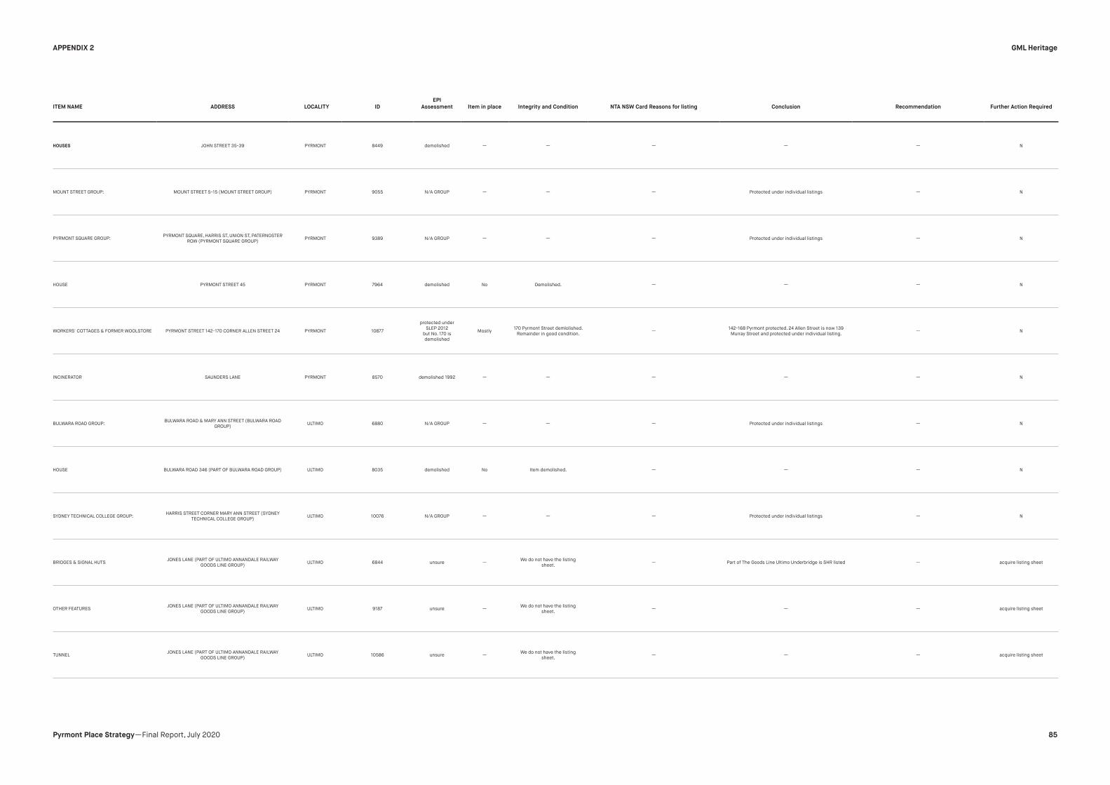
ITEM NAME ADDRESS LOCALITY ID
EPI
Assessment Item in place Integrity and Condition NTA NSW Card Reasons for listing Conclusion Recommendation Further Action Required
HOUSES JOHN STREET 35-39 PYRMONT 8449 demolished — — — — — N
MOUNT STREET GROUP: MOUNT STREET 5-15 (MOUNT STREET GROUP) PYRMONT 9055 N/A GROUP — — — Protected under individual listings — N
PYRMONT SQUARE GROUP:PYRMONT SQUARE, HARRIS ST, UNION ST, PATERNOSTER
ROW (PYRMONT SQUARE GROUP)PYRMONT 9389 N/A GROUP — — — Protected under individual listings — N
HOUSE PYRMONT STREET 45 PYRMONT 7964 demolished No Demolished. — — — N
WORKERS' COTTAGES & FORMER WOOLSTORE PYRMONT STREET 142-170 CORNER ALLEN STREET 24 PYRMONT 10877
protected under
SLEP 2012
but No. 170 is
demolished
Mostly170 Pyrmont Street demlolished.
Remainder in good condition.—
142-168 Pyrmont protected. 24 Allen Street is now 139
Murray Street and protected under individual listing.— N
INCINERATOR SAUNDERS LANE PYRMONT 8570 demolished 1992 — — — — — N
BULWARA ROAD GROUP:BULWARA ROAD & MARY ANN STREET (BULWARA ROAD
GROUP)ULTIMO 6880 N/A GROUP — — — Protected under individual listings — N
HOUSE BULWARA ROAD 346 (PART OF BULWARA ROAD GROUP) ULTIMO 8035 demolished No Item demolished. — — — N
SYDNEY TECHNICAL COLLEGE GROUP:HARRIS STREET CORNER MARY ANN STREET (SYDNEY
TECHNICAL COLLEGE GROUP)ULTIMO 10076 N/A GROUP — — — Protected under individual listings — N
BRIDGES & SIGNAL HUTSJONES LANE (PART OF ULTIMO ANNANDALE RAILWAY
GOODS LINE GROUP)ULTIMO 6844 unsure —
We do not have the listing
sheet.— Part of The Goods Line Ultimo Underbridge is SHR listed — acquire listing sheet
OTHER FEATURESJONES LANE (PART OF ULTIMO ANNANDALE RAILWAY
GOODS LINE GROUP)ULTIMO 9187 unsure —
We do not have the listing
sheet.— — — acquire listing sheet
TUNNELJONES LANE (PART OF ULTIMO ANNANDALE RAILWAY
GOODS LINE GROUP)ULTIMO 10586 unsure —
We do not have the listing
sheet.— — — acquire listing sheet
GML Heritage
85Pyrmont Place Strategy —Final Report, July 2020
APPENDIX 2

ITEM NAME ADDRESS LOCALITY ID
EPI
Assessment Item in place Integrity and Condition NTA NSW Card Reasons for listing Conclusion Recommendation Further Action Required
ULTIMO-ANNANDALE RAILWAY GOODS LINE
GROUP:
JONES LANE (ULTIMO ANNANDALE RAILWAY GOODS
LINE GROUP)ULTIMO 10612 N/A GROUP — — — Protected under individual listings — N
AML & F WOOLSTORE NO 1 & SOUTHERN ANNEX
(WOOLSTORE NO 2)
PYRMONT STREET, WITH FRONTAGES TO BULLECOURT
LANE, QUARRY & WILLIAM HENRY STREETS, also covers
424 Harris St, Ultimo
ULTIMO 6608 NO STAT LISTING No Item demolished. — — — N
WOOLSTORES NO 2 GROUP:WATTLE JONES QUARRY WILLIAM HENRY STREETS
(WOOLSTORES NO 2 GROUP)ULTIMO 10870 N/A GROUP — — — Protected under individual listings — N
GML Heritage
86Pyrmont Place Strategy —Final Report, July 2020
APPENDIX 2