quality, standards and protocols - earth...
TRANSCRIPT

Quality, Standards and Protocols
Working towards certified services based on EO and RS
Stefanie Holzwarth, Martin Bachmann, Andreas Müller German Remote Sensing Data Center
Institut für Methodik der Fernerkundung bzw. Deutsches Fernerkundungsdatenzentrum
Folie 2
GRSG/OGEO workshop 2011, Frascati
Oil and Gas Workshop Summary Report 2010
The demand for integration of EO with numerical met-ocean
models is a growing trend (e.g. ocean current, wave and sea-ice
forecasting) impacting the requirement for EO products to contain
fully documented meta-data information on accuracies
There is a growing need for offshore environmental monitoring
(including gas flares), especially for remote and highly sensitive
areas, but no agreed standards or guidelines exist for how EO
based products and services could be applied
There is a need for a better collaboration between the Oil and Gas
sector and the EO service industry. The collaboration could
facilitate:
The development of standards for EO product specifications and associated
quality certification, making it easier for oil and gas companies to compare
different offerings from the EO service industry

Institut für Methodik der Fernerkundung bzw. Deutsches Fernerkundungsdatenzentrum
Folie 3
GRSG/OGEO workshop 2011, Frascati
Processes Products Functionalities
Level 1 Product
Level 0 Product
Raw Data
Level 2 Product
Level 3 Product
Level 4 Product
System Correction
Data Transcription
Atm/Geo Correction
Data Acquisition
Information Extraction
Model
Decision Making
Sensor Operator
PAC
Value Adder
Industry
Regulator
Sensor Calibration Sensor Maintenance

Institut für Methodik der Fernerkundung bzw. Deutsches Fernerkundungsdatenzentrum
Folie 4
GRSG/OGEO workshop 2011, Frascati
Content
Existing standards and protocols
Technical aspects of the data itself
Data processing workflows
Achievement of common standards: The six points of
standarisation
Developement of standards for EO products e.g. for the oil and gas
industry
Current application example for mining activities
Institut für Methodik der Fernerkundung bzw. Deutsches Fernerkundungsdatenzentrum
Folie 5
GRSG/OGEO workshop 2011, Frascati
EO Standardisation Initiatives
QA4EO initiative as a contribution to Global Earth
Observation System of Systems (GEOSS): “Providing
Harmonised Quality Information in Earth Observation Data
by 2015”
CalVal activities of the Committee on Earth Observation
Satellites (CEOS): ”Ensure that sensor intercalibration is
favoured in a standardised way”
INSPIRE (Infrastructure for Spatial Information in Europe):
Metadata regulation (2008) mainly based on ISO 19155-2
European Facility for Airborne Research (EUFAR): creating
recommendations for standards and best practices within
the airborne research community and quality indices for
hyperspectral imagery

Institut für Methodik der Fernerkundung bzw. Deutsches Fernerkundungsdatenzentrum
Folie 6
GRSG/OGEO workshop 2011, Frascati
ISO 191* / TC 211
Standardizing in the field of digital geographic information, including
Data management (e.g. 19115 Metadata)
Data acquisition (e.g. 19130 Sensor and data models for imagery
and gridded data)
Data processing (e.g. 19111 Spatial referencing by coordinates)
Data analysis (e.g. 19110 Feature cataloguing methodology)
Data transfer (e.g. 19128 Web Map service interface)

Institut für Methodik der Fernerkundung bzw. Deutsches Fernerkundungsdatenzentrum
Folie 7
GRSG/OGEO workshop 2011, Frascati
EN ISO 9001:2008 Certification
Quality management standards designed to help organizations ensure they
meet the needs of customers and other stakeholders and to assure
consistent service capabilities
Example: OpAiRS - Optical Airborne Remote Sensing and Calibration Facility at DLR

Institut für Methodik der Fernerkundung bzw. Deutsches Fernerkundungsdatenzentrum
Folie 8
GRSG/OGEO workshop 2011, Frascati
Six Steps towards Standardisation
1. Identify potential capacity for standardisation
Identification of services and applications suitable for unification - taking existing
standards in consideration
2. Terminology
Speak the same language: Compilation of a common glossary between service
provider and beneficiary
3. Personnel
Define required qualification of the personnel to provide an operational service
4. Technical Systems
Unification of technical systems and corresponding interfaces
5. Best Practices
Formalisation of clear guidelines to carry out different processes and procedures
6. Results
Generation of quality indices to assess products and processes
Institut für Methodik der Fernerkundung bzw. Deutsches Fernerkundungsdatenzentrum
Folie 9
GRSG/OGEO workshop 2011, Frascati
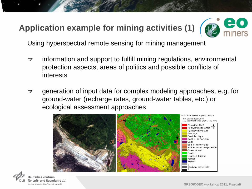
Application example for mining activities (1)
Using hyperspectral remote sensing for mining management
information and support to fulfill mining regulations, environmental
protection aspects, areas of politics and possible conflicts of
interests
generation of input data for complex modeling approaches, e.g. for
ground-water (recharge rates, ground-water tables, etc.) or
ecological assessment approaches

Institut für Methodik der Fernerkundung bzw. Deutsches Fernerkundungsdatenzentrum
Folie 10
GRSG/OGEO workshop 2011, Frascati
Up to Level 2
ISO certified service OpAiRS, INSPIRE metadata, EUFAR conform quality indicators
Level 3 uncertainties missing
Conceptual model supports „design by constraints‟ quality assessments and quality
indicators from different sources
Application example for mining activities (2)

Institut für Methodik der Fernerkundung bzw. Deutsches Fernerkundungsdatenzentrum
Folie 11
GRSG/OGEO workshop 2011, Frascati
Combination of further auxiliary data necessary to meet the accuracy standards?

Institut für Methodik der Fernerkundung bzw. Deutsches Fernerkundungsdatenzentrum
Folie 12
GRSG/OGEO workshop 2011, Frascati
Conclusion
Working towards certified services based on EO and RS
Use existing standards for EO data (up to Level 2)
ISO 9001:2008 certified services guarantee consistent products (up
to Level 3)
Define requirements for the input data of the model to achieve
reliable results (Level 4)
Required reliability for the final interpretation
Quality of data (temporal, spatial, radiometric,… accuracy)
Achievement of requirements possible?
Dialogue between data/service provider and industry/policy makers

Institut für Methodik der Fernerkundung bzw. Deutsches Fernerkundungsdatenzentrum
Folie 13
GRSG/OGEO workshop 2011, Frascati
Thank you for your attention!

Institut für Methodik der Fernerkundung bzw. Deutsches Fernerkundungsdatenzentrum
Folie 14
GRSG/OGEO workshop 2011, Frascati
Lorem ipsum dolor sit amet
Lorem ipsum dolor sit amet, consectetuer adipiscing elit, sed diam
nonummy nibh euismod tincidunt ut laoreet dolore magna aliquam
erat volutpat.
Ut wisi enim ad minim veniam. Quis nostrud exerci tation ullamcorper suscipit
lobortis nisl ut aliquip ex ea commodo consequat.
Ut wisi enim ad minim veniam. Quis nostrud exerci tation ullamcorper suscipit
lobortis nisl ut aliquip ex ea commodo consequat.
Duis autem vel eum iriure dolor in hendrerit in vulputate velit esse molestie
consequat, vel illum dolore eu feugiat nulla.
Facilisis at vero eros et accumsan et iusto odio dignissim qui blandit praesent
luptatum zzril delenit augue duis te feugait nulla facilisi.

Institut für Methodik der Fernerkundung bzw. Deutsches Fernerkundungsdatenzentrum
Folie 15
GRSG/OGEO workshop 2011, Frascati
Level 1 Product
Level 0 Product
Raw Data
Archiving L0
Data QC
Archiving L1
QualityControl L1
Data QC
Data Transcription
System Correction
Laboratory
Calibration
Vicarious
Calibration
Build Metadata
QualityControl L0
Level 2 Product
Level 2a Product
Atmospheric Correction
Parametric Geocoding Attitude Data,
Position Data,
DEM
Radiative Transfer Model,
Meteorologic Data,
DEM
QualityControl L2
Archiving L2
Onboard Calibration
Sources
Data QC
Data QC

Institut für Methodik der Fernerkundung bzw. Deutsches Fernerkundungsdatenzentrum
Folie 16
GRSG/OGEO workshop 2011, Frascati
Kunde benötigt Daten mit ausreichender Dokumentation zu
Aufnahmesystem
Datenprozessierung
Datenqualität
Provider sollte nach ISO zertifiziert sein, um einen
gleichbleibenden Service zu garantieren
Daten sollten schon existieren Standards im entsprechenden
Anwendungsfeld entsprechen (z.B. ISO-Norm für
Photogrammetrie), oder an Standards von
nationalen/internationalen Initiativen anlehnen (INSPIRE,
GEOSS,…)
Falls keine Standards für Produkte existieren, müssen technische
Standards/Normen erfüllt werden (ISO TC211)

Institut für Methodik der Fernerkundung bzw. Deutsches Fernerkundungsdatenzentrum
Folie 17
GRSG/OGEO workshop 2011, Frascati
Gleichbleibende Rohdaten und vorprozessierte Daten
„unproblematisch“
Modellierung oder Anwendungen benötigen erhöhte Abstimmung
mit dem Kunden
Schnittstellendefinition: Entsprechen die normierten Produkte der
erforderlichen Zuverlässigkeit der Endauswertung?
Welcher Qualität müssen die Inputdaten für ein Modell genügen?
Wie ist der Anspruch der Industrie zu erreichen?

Institut für Methodik der Fernerkundung bzw. Deutsches Fernerkundungsdatenzentrum
Folie 18
GRSG/OGEO workshop 2011, Frascati
GEO
GEO web portal supports client access to catalogues, map
services, and data services through standards-based interfaces
Provide a formal listing and description of all the Earth observation
systems, data sets, models and other services and tools that
together constitute the Global Earth Observation System of
Systems (GEOSS).
These various components are being interlinked using standards
and protocols that allow data and information from different sources
to be integrated.
GEOSS will become a system of systems by adopting appropriate
standards for the interfaces through which the various GEOSS
components exchange data and information.
QA4EO Workshop on Providing Harmonised Quality
Information in Earth Observation Data by 2015