quantico: crossroads of the marine corps pcn 19000307200 1€¦ · cover: the town of quantico as...
TRANSCRIPT


Cover: The town of Quantico as seen from an aircraft over the Po-tomac River 25 May 1925. The USS Henderson is docked at the pier.The ship is named after Archibald Henderson, 5th Commandant of theMarine Corps. Visible in the upper left of the photograph is the PostHeadquarters. (USMC Photo 515892).

QUANTICO: CROSSROADS
OF THE MARINE CORPSBy
Lieutenant Colonel Charles A.Fleniing,Captain Robin L. Austin, USMC
Captain Charles A. Braley III, USMC
USMC
HISTORY AND MUSEUMS DIVISIONHEADQUARTERS, U.S. MARINE CORPS
WASHINGTON, D.C.

PCN 190 003072 00
For sale by the Superintendent of Documents, U.S. Government Printing OfficeWashington, D.C. 20402 (Paper Cover)
Stock Number 008—055--00105--6

FOREWORD
The single word, Quantico, is certain to invoke recognition and recollection in the minds of everyMarine officer and most enlisted personnel. Since 1917 virtually every officer who has served in the Corpsreceived at least part of his training there, and the career enlisted man who does not attend a school orserve a hitch there during his service as a Marine would be the exception rather than the norm. It is mostappropriate that this volume should attempt to preserve and share some of that history and experiencewhich is such an integral part of the Corps.
Originally prepared in the Public Affairs Office at Quantico, this history was published in a limitededition for on-base use in 1976. Because of the interest in the subject, the Marine Corps History andMuseums Division has cooperated with the Marine Corps Development and Education Command, Quan-tico, Virginia to prepare this edition for widespread distribution.
The first author, Lieutenant Colonel Charles A. Fleming, received his Bachelor of Science degree atthe University of Washington (Seattle), and a Master of Arts Degree in Journalism from the Universityof Wisconsin, (Madison). He served two tours in Vietnam, and attended The Basic School and Communi-cations Officers School at Quantico, as well as the Armed Forces Staff College, Norfolk. Following his touras MCDEC, Quantico, Public Affairs Officer when this book was written, he was assigned to Headquarters,Fleet Marine Force, Atlantic at Norfolk in August 1976.
Captain Robin L. Austin graduated from Northern State College, Aberdeen, South Dakota, and enteredthe Marine Corps in 1969 through Officers Candidate School. After four years on the west coast, she ar-rived at Quantico in September 1975 as an assistant public affairs officer, just in time to work on thisbook, and in January 1976, was assigned as staff platoon commander, The Basic School.
Captain Charles A. Braley III, enlisted in the Marine Corps in 1952 and served for 14 years as an en-listed man before being commissioned in 1966. He was selected for duty as a public affairs officer. Uponhis retirement on 1 May 1978, he will have spent 23 of his 26 years in the Corps as a Marine journalist.Captain Braley prepared much of the material for the final chapter on "Quantico Today," brought the fig-ures and statistics up to date, and assisted the editors at the Marine Corps Historical Center throughoutthe final stages of preparations.
The History and Museums Division welcomes any comments of the narrative and additional infor-mation or illustrations which might enhance a future edition.
Reviewed and approved: E. H. SIMMQNS1 February 1978 Brigadier General, U.S. Marine Corps (Retired)
Director of Marine Corps History and Museums
'Ii


PREFACE
This brief history of the Quantico Marine Corps Base, Quantico, Virginia, was initiated in early 1975at the suggestion of Lieutenant General Edward S. Fris, U.S. Marine Corps (Retired), then the Command-ing General, Marine Corps Development and Education Command at Quantico. This project was begun asthe Marine Corps approached its two hundredth anniversary and as the United States moved into its Bicen-tennial year. Because of the Bicentennial spirit and geographical location of the base, a decision was madeearly in the project not to limit it to just Marine Corps activities, but to include a summary of the preced-ing events of this very historical area.
Many persons who tackle a project of this sort are frustrated by the lack of available information andthe necessity for lengthy and extensive research. This was not exactly the case with this one.
The Marine Corps must be one of the most written-about organizations in the history of the UnitedStates. The problem with this project was not the lack of information, but the sheer volume of materialscattered among hundreds of official and commercial books, letters, diaries, official correspondence, per-sonal collections, research studies and reports, files hidden away in cabints or boxes, and personal recol-lections of hundred of Marines, former Marines, and their families. Indeed, the biggest problem with thisproject was the location, selection, sifting, evaluation, and compilation of the vast quantities of informationavailable.
At the project's outset, appeals for advice and information were published in the base newspaper, localcivilian newspapers, and nationwide through the courtesy of the Marine Corps Gazette. The response tothese appeals was no less than fantastic as dozens of the Corps' friends replied with information, photo-graphs, leads, and encouragement. Their enthusiastic interest and support was a sustaining force through-out this project.
Most of this document was written by Lieutenant Colonel Charles A. Fleming, with assistance fromCaptain Robin A. Austin, and Captain Charles A. Braley III. The bulk of the research was done by Cap-tain Austin. For almost four months, she shuttled back and forth around northern Virginia, spent manytedious hours going through books and documents, and pounded a typewriter day after day preparingnotes. Through her efforts, a vast quantity of valuable information was accumulated which made this re-port possible. Indeed, almost everyone assigned to the MCDEC Public Affairs Office during the latter halfof 1975 contributed something, whether it was interviewing residents of nearby communities, obtainingphotographs, locating books in libraries, or typing. Credit must also be given to those many other Ma-rines, civilians, and sections at MCDEC who contributed. Among these are Colonel Donald K. Cliff, Com-manding Officer of the Officer Candidates School, Mr. Lee Lansing of the Public Works Department, andthe Photographic Laboratory. But there are many others, too.
Following the publication of a limited edition of this history at Quantico in 1976, arrangements werecompleted for the history to be revised, edited, and published by the History and Museums Division. Thisedition was prepared under the editorial direction of Mr. Henry I. Shaw, Jr., Chief Historian of the His-tory and Museums Division. Final editing, photograph selection, and the preparation of the index wasdone by Dr. Russell J. Parkinson of the Historical Branch and Mr. Douglas Johnston, Production Editor.The maps were prepared by Staff Sergeant Jerry L. Jakes. The index was typed by Private First ClassPaul W. Gibson.
This is not the first history of Quantico Marine Corps Base, but to the knowledge of the preparers ofthis document, it is the most detailed and comprehensive to date. Yet, there has been much left out due toconstraints of time and space and the need for proper balance and emphasis. We leave it to our successors
v

at Quantico to fill in the gaps and to carry on where this brief record leaves off. This particular draft ofthe history of our base has an end; in truth, Quantico continues on, fulfilling its important missions ofeducation and development in support of the U.S. Marine Corps.
CHARLES A. FLEMINGLieutenant Colonel, U.S. Marine Corps
ROBIN L. AUSTINCaptain, U.S. Marine Corps
CHARLES A. BRALEY IIICaptain, U.S. Marine Corps
vi

TABLE OF CONTENTS
ForewordPrefaceChapter I From the Beginning to the Civil War 1
II TheCivilWartoWorldWarl 8III The Great War: Quantico is Born 20IV Between Wars 38V World War II and Beyond 74VI QuanticoToday 100VII Conclusion 113
Bibliography 117Notes 121Appendices
A Quantico Commanders 127B Quantico Awards 129
vii


CHAPTER 1
FROM THE BEGINNING TO THE CIVIL WAR
Nestled along the west bank of the PotomacRiver, Quantico Marine Corps base, the home ofthe Marine Corps Development and EducationCommand, comprises just under 100 square milesof quiet, lush, green hickory, oak, and pine for-ests, laced by innumerable streams and wetlands.The base borders the quiet Potomac for about fivemiles, crowding itself into the flatlands along theriver and then stretching out into sparsely inhab-ited woodlands, rolling hills, and sturdy ridges tothe west.
Quantico, the crossroads of the Marine Corps,the university of the Corps, and the cradle ofmodern Marine Corps education and doctrine, isitself situated in the very midst of America's mosthistoric area. With Mount Vernon to the north,Manassas to the west, Fredericksburg to the south,Jamestown, Williamsburg, and Yorktown to thesoutheast, the area is rich in American as well asMarine Corps history. Indeed, the area that isnow the Marine base was tread by GeneralsGeorge Washington and Robert E. Lee, as well asby John A. Lejeune, Smedley Butler, and morecontemporary figures. The history of Quantico,rich in the military heritage of our Nation, isboth the history of the United States and of theMarine Corps. They are parallel and inseparable.
A brief history of Marine Corps Base, Quanticowritten more than 45 years ago summarized it allin a phrase that defies improvement: "Quanticoon the Potomac has always been."
The name "Quantico" comes from the Ameri-can Indians and has been translated to mean, "Bythe large stream," "By the long stream," "Placeof dancing," or merely "Dancing." References tothe "stream" are to the Potomac River, while themeaning of the "dancing" title is unclear. Thisreference may also be to the Potomac as it mean-ders gracefully past the green woodlands, or itmay refer to the life style of the Manahoac branchof the tidewater Algonquin Indians who inhabitedthe area north of Quantico in the lSOOs. The
name "Manahoac" means, "They are verymerry." 2
The Manahoacs were corn growers and fisher-men and enjoyed a high standard of living forthe times. They were known both for their mer-riment and for their fierceness in combat. In1540, however, the Iroquois from the north drovethe Manahoacs from the Quantico area as Iro-quois domination of the eastern seaboard spread.1
Thirty-seven years before the English arrivedat Jamestown to the southeast, a group of Span-iards traveling up from Florida landed in thevicinity of Aquia Creek to the immediate south ofthe present Marine base. The Jesuit priests amongthe group tried to convert the local Indians, whoresented the effort. Only one member of the partyescaped to tell of the misadventure.
Other records show that the Quantico area it-self was first visited by white men in the summerof 1608 when Captain John Smith of Jamestown,trading for corn with Indians along the way, ex-plored the "Patawomek," a corruption of thename of the Potowameke Indians who lived fur-ther south. When Smith arrived, be encounteredthe Dogue Indians, another Algonquin tribe whowere apparently permitted by the Iroquois to livein the area unmolested4
The first major landowner in the Quantico areaappears to have been Giles Brent, who first settledin Maryland with claims to land also claimed bythe Calverts. By 1647, Brent moved to Virginia,filed new claims, married the Indian PrincessKittamaquad, and built a plantation named Wood-stock on the northern bluff overlooking the mouthof Aquia Creek.5
That portion of the Marine base north of LittleCreek, a stream bordering the main access roadto the base, was part of a 2,000-acre grant madein 1654 to Nicholas Martiau, an ancestor ofGeorge Washington. The base south of Little
1
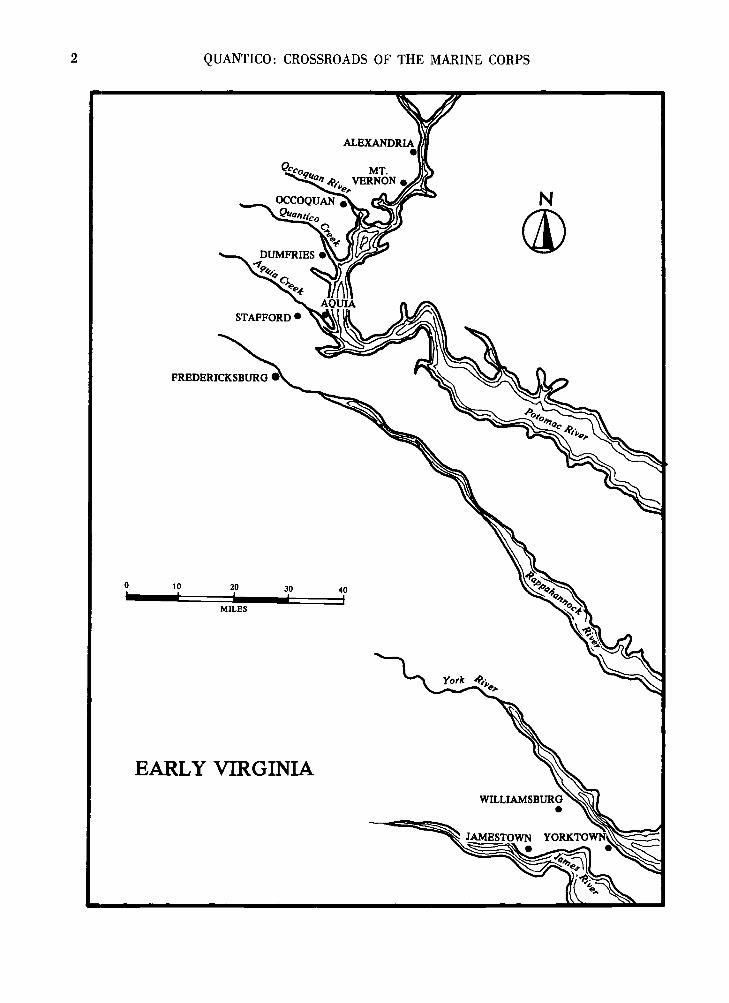
2 QUANTICO: CROSSROADS OF THE MARINE CORPS
FREDERICKSBURG
EARLY VIRGINIA

FROM THE BEGINNING 3
Creek was part of a 5,211-acre tract patented in1657 by Royal Governor Samuel Mathews.
Early settlements and plantations were confinedto the flatlands bordering the Potomac with thehills west of the river remaining essentially un-inhabited until the early 1700s.
Mathews' tract was acquired by Reverend Alex-ander Scott from Samuel Mathews, grandson ofthe governor. Scott was rector of OverwhartonParish from 1701 to 1738 and his domain in-cluded most of present Prince William, Stafford,Fauquier, Fairfax, Loudoun, and Arlington coun-ties. The Overwharton chapel was located onQuantico Creek. Scott once said the parish was solarge its boundaries were unknown, although laterhe described it as a strip along the Potomac"...inhabited near 80 miles in length and in someplaces near three miles, in other near 20 miles inbredth." °
In 1724 Scott purchased "Dipple" plantation, adark gray, plastered-brick house centrally located
The Dipple plantation was centrally located in Over-wharton parish when the Reverend Alexander Scott pur-chased it in 1724. The house, which disappeared about1955, was on a site which is part of the development testarea south of the seaplane hangars. The wooden barrackspresently used by the OCS stand on what was once anorchard. (Dipple File, Special Projects Section, MarineCorps Historical Center).
within his parish.7 The "Dipple" house stood ona knoll just south of the present day crash boatpier and overlooking the Marine Corps Air Sta-tion. The Scott family graveyard southwest of thehouse was disinterred and removed to the AcquiaCreek Churchyard.
With the help of King George of England, theGiles Brent descendents acquired most of the landsouth of Little Creek and formally establishedBrent's Village, or Aquia (originally spelled"Acquia") Village. In 1680 the Virginia Assemblyordered that a permanent wharf and warehousehe built there to service the growing tobacco trade.Although many area planters and their Londonagents preferred to ship from their own wharvesalong the Potomac, a village still grew rapidly.8
Aquia Village became the largest tobacco portin the area, a fact of special importance sincetobacco was used as currency. It was also a bus-tling stopping point on the north-south routesbetween New York and Florida, and had a reputa-tion as a "fun" place, with whiskey at 60 centsper gallon, horse races, cock fights, and a varietyof other sporting events.
The Aquia Episcopal Church was built in 1751,burned down in 1754. and rebuilt in 1757. It stillstands. Members of the Brent family are buriednot far from the church, and a communion serv-ice written by Reverend Alexander Scott in 1738is preserved. Headstones in the church graveyarddate back to 1697.
As early as 1686, groups of Scots immigrantssailed up the Potomac and stayed. Some settledon the Maryland side of the river while othersformed a settlement several miles north of Aquiaat the head of Quantico Creek, about two milesfrom the creek's juncture with the Potomac.
The river trade in shipping tobacco to Europeand other colonies soon came to be a most profit-able business. Warehouses and wharves sprang upalong the creeks that fed the Potomac where to-bacco could be delivered, stored, and loaded di-rectly on ships or on flatboats where the waterdepth required that ships anchor offshore.
Scottish ships from Glasgow, Dumfries, andLeith came up the Potomac during the late 1600sand early l700s to get their share of the lucrativetobacco trade. Settlers from Scotland already herewere deeply involved in planting, transporting,and shipping tobacco.°
With the union of Great Britain and Scotlandin 1707, immigration by Scots increased drama-tically.

4 QUANTICO: CROSSROADS OF THE MARINE CORPS
Home of Alexander Henderson in Dum fries, Va. Hisgrandson, Archibald Henderson, became the 5th Corn-mandant of the Marine Corps. Watercolor, ca. 1900,artist unknown. (Henderson-Lee Collection, Special Pro j-ects Section, Marine Corps Historical Center).
A further impetus to immigration was theTreaty of Albany in 1722 which wrested the areafrom the Iroquois, although not much attentionwas paid to Iroquois claims prior to that time.The treaty gave official sanction to settlement oflands away from the Potomac. The Englishclaimed that northern Virginia had been desertedby the Iroquois and thus should be opened forsettlement. The Iroquois, who lost the argument.asserted that they never intended to live in thearea, but only wanted to keep it for a hunting pre-serve.10
The treaty, the unification of Great Britain andScotland, and the commercial potential of tobaccoprompted a great influx of Scots-Irish immigrantsduring the 1720s, many of whom moved to the"highlands" to the west of the Potomac. Many im-migrants paid for their passage by serving as in-dentured servants for four to five years.
Religious persecution in nearby Marylandprompted many colonists to move across the Po-tomac to Virginia. According to some sources,the Protestant Scots were more welcome in Vir-ginia than their Catholic predecessors, and thecompetition between the religions lasted for manyyears.11
Prince William County was organized in 1731and included the present counties of Prince Wil-liam, Fairfax, Fauquier, Loudoun, and Arlington.When the county was formed, there were alreadyseveral public tobacco warehouses, or customhouses, in the area. The first was built on Quan.tico Creek on Robert Brent's land in 1713, butburned in 1732. A second custom house was built
in 1730. A network of ferries also sprang up toaid the growing tobacco trade.
The "Quantico Road" was opened in 1731 togive vital access from the western part of thecounty to the first Prince William Courthouse nearOccoquan River. The road was extended to thePotomac Path, running past Quantico Creek ware-houses, and following the north run of the creekwestward to Independent Hill and later to the siteof the second Prince William County Court-house. 12 Much of this historic road is within theconfines of the Marine Corps Base, and the siteof the second courthouse is marked on Federalproperty with a permanent plaque.
The port which served the village on QuanticoCreek was at the mouth of the creek, about onemile below the village itself. Landing stages andwarehouses for tobacco and flour were built wherethe creek met the Potomac and the water was sixor seven feet deep at high tide.
Wheat was milled in the village along the uppercourse of Quantico Creek and hauled to thewharves where it was loaded on flat boats andferried to ships at anchor. Salted meat and lum-ber for barrel staves were also valuable products.
Large ships probably never came up the creekor to the village because of shallow water. Evenby 1740 observers noted that the stream bed waspartially filled with mud and that the marshes hadgrown in the past few years. During 1740 a canalwas built along the north bank of Quantico Creekto aid in transporting exports from the village tothe landing.
Commercial activities of the village on QuanticoCreek flourished. The flour mills hummed, casksof tobacco continually arrived from the planta-tions, and provisions for visiting ships were read-ily available. A busy trade was carried on withEngland, Scotland, and the northern colonies,shipping tobacco out and receiving manufacturedgoods and luxuries in return. A vigorous tradewith the West Indies for rum and salt was alsocarried on.
As early as May 1740, the Scottish inhabitantsof the village petitioned for a formal town onQuantico Creek, but were unsuccessful. Those op-posed, who had property interests elsewhere, de-manded that if a town were to be chartered, itwould have to be further north near the firstcourthouse on the Occoquan. The Scots agreed toaccept a town in each location, but were still un-successful. Subsequent petitions in 1742 and 1744were also denied.13
In 1742 Prince William County suffered asizable territorial loss when almost 1,000 square

FROM THE BEGINNING 5
"Inn at Dum fries, Va." located along the colonialstagecoach road which ran from Woodbridge to Fred-ericksburg. Watercolor, ca. 1900, artist unknown. (Hen-derson-Lee Collection, Marine Corps Historical Center).
miles of land were taken away to form Loudounand Fairfax Counties.14
Despite the diminished size of the county, by1749 the growing population on Quantico Creekcoupled with the lucrative tobacco trade and com-mercial importance of the settlement forced theVirginia Assembly to authorize formation of theTown of Dumfries, the first of the county's seventowns established prior to 1831 and the largestone in Virginia at the time.15 As officially char-tered, Dumfries was on Quantico Creek on theland of John Graham, a prosperous Glasgowmerchant, and was an extension of the earlier vil-lage built on higher ground. The new town of 60acres was situated about half a mile closer to thePotomac than the original village. The name"Dumfries" came from the city by the same namein Scotland about 65 miles southeast of Glasgow.
Dumfries grew rapidly from the start. It wasformed at the time when Virginia commercial rep-resentatives in Scotland began to understand thegreat potential of tobacco as well as the threat ofcompetition from other settlements. Scots mer-chants and trading companies promoted the build-ing and improvement of roads into the backcountry and set up warehouses and stores at strate-gic points. Increased warehouse facilities wereauthorized for Dumfries itself in 1753 and againin 1759. The town was officially expanded in 1759and 1761.16
Estates along the river blossomed as tobacco
became more and more important. Great homeswere built by the rich Virginia aristocrats andplanters. Scots merchants made Dumfries pros-perous and the commercial heart of the area. Ac-cording to one observer at the time:
- the Caledonians who came to this part of Vir-ginia seem not to have been a dour folk. They ate,drank, and were merry in taverns and in homes ofno mean sort; and though they could drive as gooda bargain as any man, they could crack a joke overa bottle of ale. Dumfries continued to flourish aftera manner scarcely characteristic of towns in thisagrarian state of Virginia that entertained an anti-pathy to gregarious living'7
With the growth of the town, the trappings ofurban civilization were brought to Dumfries. For-mal balls, tea parties, and social events of all typeswere the order of the day for the wealthy planters,merchants, and their families. The Dumfries Play-house was even frequented by George Washing-ton.18
By 1759 the "Quantico Road," which had orig-inated years before, now stretched across the BlueRidge Mountains into the Shenandoah Valley. Asecond, parallel road was built in 1761 along theridge between the forks of Quantico Creek. Ac-cording to the petition submitted to the Assembly,the second road was needed because of the volumeof tobacco traffic coupled with the hope that thenew road would be dryer since it was on higherground than the old one. The petitioners also be-lieved that a new road and the increased traffic itwould bring would encourage construction of ad-ditional warehouses along the creek.'°
The area around Quantico is aptly called"George Washington Country." Washington wasborn to the southeast in Westmoreland County,and when he was three years old his familymoved to a location north of Quantico which be-came Mount Vernon. Three years later, the familymoved to Ferry Farm on the RappahannockRiver, south of Quantico and opposite Fredericks-burg.
When the news was received in mid-1774 th'atBoston Harbor in Massachusetts had been closedby the British because of colonial opposition to atax imposed on tea, Fredericksburg to the southof Quantico was the first community in Virginiato draft "Resolutions," on 1 June 1774, protestingthe British actiost'° Only five days later on 6June 1774, the citizens of Dumfries issued the"Dumfries Resolves," condemning British taxa-

6 QUANTICO: CROSSROADS OF THE MARINE CORPS
tion, British control of trade, infringement on thecivil rights of colonists, and urging anti-Britishactions.2'
During the Revolutionary War the QuanticoCreek village became a main naval base for theCommonwealth of Virginia's 72-vessel fleet onwhich many Virginia State 1\'Iarines served. Thebase was a depot for storing and issuing sup-plies and naval equipment to Virginia's navy.Quantico Creek itself served as a sheltered anchor-age for small American ships.22
The Quantico area did not see much action dur-ing the Revolutionary War. It was, however, in acritical location separating the war in the northfrom the fighting in the south, and lay astride theimportant routes traveled by the opposing armies.Present U.S. Highway 1 bordering the MarineBase is called the "Washington-RochambeauRoad" and was heavily used by British, French.and American armies in moving troops and sup-plies from one theater of war to another. A Re-volutionary War encampment was just off thehighway on Federal property.
In July of 1776, former Virginia Royal Gover.nor Lord Dunmore sent a small fleet up the P0-tomac searching for "rebel" ships and stores. Hisforces landed near Aquia Creek below Quantico,burned the home of William Brent, and moved upto the mouth of the Occoquan River north ofQuantico.25
Later in the Revolution, Colonel Henry (LightHorse Harry) Lee, father of Robert E. Lee anda native of Prince William County, reported inApril 1781 that a raid was expected on Dumfriesby British naval forces. Local militia were hastilyarmed and mustered, but the attack never came.Lee also urged that several troops of cavalry beraised around Dumfries to keep track of Britishmovements.24
Revolutionary War General Nathanael Greenepassed through the Quantico area in 1783. Hiscarriage broke down near Dumfries and he wasforced to remain overnight. His only recordedobservation of the town was that it stood on acreek that emptied into the Potomac.25
Richard Henry Lee, father of Light HorseHarry and one of the original town fathers ofDumfries, signed the Declaration of Independence.The senior Lee, along with Colonel William Gray.son, Washington's aide-de-camp and a native ofDumfries, were members of the Continental Con-gress and were the first senators from Virginia tothe Congress of the new United States.
Aside from Light Horse Harry Lee and GeorgeWashington, other Revolutionary War greats camefrom the vicinity. John Paul Jones was a residentfor a time of Fredericksburg to the south, andthe area also gave Generals Hugh Mercer, GeorgeWeedon, William Woodford, and George RogersClark to the American cause.'°
Although not a Revolutionary War participant,Archibald Henderson, the fifth Commandant ofthe Marine Corps from 1820 to 1859, was bornon 21 January 1783 near Dumfries.
The first organized stage coach lines runningthrough the Quantico area appeared during theRevolution. The initial line ran from Dumfries toFredericksburg. Reports of these early stage oper.ations indicate that the runs were extremelyhazardous because of the flimsy bridges spanningthe many creeks and rivers. During heavy rains,bridges were often severely damaged or com-pletely washed away.
Efforts to force the Virginia Assembly intobuilding adequate bridges were fruitless. Parson
Archibald Henderson as a young man. Oil, artist un-known. (Henderson-Lee Collection, Special Projects Sec-lion, Marine Corps Historical Center).

FROM THE BEGINNING 7
Weems of Dumfries offered in 1791 to raise thenecessary funds by conducting a "lottery" alongthe roads threatened by heavy rains, with theprizes to be his own valuable books. His offer toraise one thousand dollars by this method was notaccepted, however.
A second stage line operated between Dumfriesand Alexandria to the north. This line, establishedaround the turn of the century, was headquar-tered in Dumfries and consisted of 24 horses, 2large passenger stages, 2 mail stages, a stable,and grazing lot.28 A third stage line established in1836 linked Occoquan and Petersburg and ranthrough Dumfries.29 One of the original buildingsused on these early stage lines still stands in Dum-fries.
By the end of the Revolution, silting at themouth of Quantico Creek had increased so muchthat commercial trade was all but cut off. BertranEwell and other local property owners tried torevive the trade by establishing in 1787 the vii.lages of Newport at the creek mouth and Carrbor-ough on the south side of the creek on what isnow Marine Corps property. Their efforts failed.30
The situation was so bad by 1793 that one ofthe two customs houses in Dumfries was closedfor lack of business. The "Quantico Company"was chartered in 1795 in a vain attempt to improvenavigation in the mouth of the creek and thecompany survived until 1834. Aside from thesilting problems, Dumfries' fail as a commercialcenter can also be attributed to a lack of far-sightedness by its once industrious merchants.
Tobacco was always the primary lifeblood ofthe town with other salable products far be-hind. Dumfries' merchants never sought out analternative to the lucrative tobacco. When the Re-volution forced businessmen and trading com-panies of Europe to turn from tobacco to sugarand other commodities available in the WestIndies. Dumfrjes suffered. Even after the Revolu-tion, the tobacco trade through Dumfries neverregained its former position and the many im-porters in Scotland abandoned Dumfries for tradewith the West Indies. Other Virginia communitieshad made the transition during the Revolutionfrom tobacco to flour and other products forwhich there were markets in the colonies. ButDumfries did not change.32
Bishop Meade, a traveler through the area, ob-served in 1819 of Dumfries that ". .. once themart, the scene of gaiety and fashion, the abodeof wealthy merchants, all is now in ruins. . . thepines have covered the place where the churchonce stood. . . desolation reigns around."
During the Nation's second war with GreatBritain, the War of 1812, the east coast of theUnited States and the Potomac River in particularwere again in danger of British military action.In 1814 British ships were anchored in the Poto-mac off Quantico Creek, and in August of thatyear the citizens of Dumfries were again warnedthat their town was to be attacked. The "Vigilan-tes" were hastily organized to watch British move-ments and oppose any intrusions. A terrible storm.however, hit the area, discouraging the British,and canceling their attack plans.34
One of the first times the Quantico area cameto the attention of the Marine Corps was in 1816when a small group of Marines were going fromPhiladelphia to Washington by ship. Their vesselbecame halted in the ice on the Potomac, and theMarines had to debark. Marching inland to thetown of Dumfries, they met a young officer, Cap-tain Archibald Henderson, who lived not far away.Henderson sympathized with the plight of his fel.low Marines, and deciding that it was too far tomarch to Washington in the icy winter, he hireda wagon for them and sent them on their way.
After the War of 1812 the commercial import-ance of the Quantico Creek area continued todiminish. Cotton replaced tobacco as a prime ex-port for southern growers as the industrial re-volution took hold in Europe and in the northernUnited States. With cotton, the focus of commer-cial attention moved further south. Towns aroundQuantico—Georgetown and Alexandria to thenorth, Manassas to the west, and Fredericksburgto the south—became important as ports, railroadterminals, or both, while Dumfries and the othervillages along the Potomac merely continued toexist.
With the cotton trade and the feudal system ofslavery and plantations that originated in the to-bacco era, the divisions between the North andthe South became more pronounced and led tothe Civil War—a time when the Quantico Creekarea again had a role of importance..

CHAPTER II
THE CIVIL WAR TO WORLD WAR I
With the surrender of Fort Sumter in the har-bor o:f Charleston, South Carolina, on 13 April1861, the Civil War began in earnest. After Sum-ter, President Lincoln called for 75,000 volunteersto put down the rebellion and President JeffersonDavis of the Confederacy asked for 100,000 tokeep it going.'
Virginia seceded from the Union on 17 Apriland the city of Washington feared for its safetywith "rebels" just across the Potomac River tothe west and the south. Washington became ahuge military camp as the Union recruits pouredin to allay the government's fears of invasion. TheCapitol itself became a barracks and tent campssprang up on all available land.
A couple of miles away soldiers of the newConfederate States of America built their ownarmed camps across the Potomac with the maintroop concentration 25 miles south in Manassas.
Control of the Potomac, a natural barrier be-tween the two armies, became very important toboth sides. The Confederates brought up gunsfrom the captured Norfolk Navy Yard arid install-ed some at Alexandria, others at Aquia Creek 45miles south on the Potomac, and still more atMathias Point further south on the river. AquiaCreek was an important railroad junction andport for the Confederates.
Within a few weeks of the fall of Fort Sumterthe Confederates used their guns at Alexandria tofire on Union ships near Washington—much tothe dismay of Lincoln's government.
The Union's primary objective was the Con-federate capital of Richmond 90 miles south ofWashington. But before a move against Richmondcould be made, northern Virginia and the banksof the Potomac had to be in Union hands orWashington would be in danger.
Union troops quietly crossed the Potomac on24 May 1861 and seized strategic locations in Ar-lington and Alexandria, putting the Confederateguns out of business. Later in the month, Union
8
troops occupied Newport News and Fort McHenryat the mouth of Chesapeake Bay.
On the 1st of June, four Union steamers, in.cluding the USS Pawnee and USS Anacostia, be-gan shelling the Confederate batteries at AquiaCreek. After seven hours of firing, which report-edly included 597 rounds fired by Union shipsand 75 by Confederate batteries, the ships retiredacross the Potomac with neither side sufferingmuch damage. The Confederates reported theironiy casualties were one chicken and one horse.The Confederate gun positions at Mathias Pointwere attacked four days later without decisive re-suits.
Confederate Colonel Daniel Ruggles, command-ing the Aquia Creek positions, feared that Uniontroops would make a landing in his area and ap-pealed for more guns and infantry. Several Con-federate regiments were moved to the banks ofthe Potomac to oppose any invasion.
Ruggles suggested on 4 June 1861 that it wouldbe feasible and desirable to set up gun batteriesin the Evansport area of the Potomac, now onMarine Corps property, because .... that point isimportant in connection with the position at Ma-nassas Junction as well as the avenue of approachfrom the Potomac to Fredericksburg." 2
The batteries at Aquia Creek and MathiasPoint remained until the spring of 1862, but theirimportance diminished greatly when more exten-sive batteries were established farther north.
While the Union Navy and the Confederateguns troubled each other on the Potomac, the Fed-eral army was beginning to make a major move.Prodded by cries of "On to Richmond!" UnionGeneral Irvin McDowell marched his army slowlytoward the important railroad junction at Manas-sas on Bull Run, 25 miles west of the QuanticoCreek area. The two armies, poorly trained andfor the most part poorly led, met in the first majorbattle of the Civil War on 18 July 1861. The bat-tle raged around Manassas through 21 July andended in a rout for the Union. Federal troops ran

CIVIL WAR TO WORLD WAR ONE 9
The Union ships Seminole and Pocahantas engaging the(USMC Photo 531625).
back to the security of Washington along withhundreds of civilians and government officials whohad come out on that pleasant day to picnic andwatch the battle.
Included in McDowell's army was a battalionof U.S. Marines under Major John G. Reynolds.The 448-man unit was supporting a battery ofRegular Army artillery. The Marines gave a goodaccount of themselves during the battle untilthe final moments when the South got the upperhand. Jeb Stuart and his Confederate cavalryoverran the Marines' position. The Marines alongwith their Army companions made a quick with.drawal to Washington where they regrouped, pro-tected Confederate prisoners from unruly mobs,and helped restore order.3 As a result of the bat-tle, both sides were shocked and disorganized.
Union General McDowell was relieved byGeorge B. McClellan, who was fresh from minorvictories in northwestern Virginia. McClellanrounded up the disorganized army, restored dis-cipline, and trained his growing force into anarmy in fact, a task that took many months.
The U.S. Navy, meanwhile, began a campaignto bring peace and order to the Maryland penin..sula bordering the Potomac, and on 19 August1861, 200 U.S. Marines were assigned to theNavy's Potomac Flotilla to help search for Con.federate sympathizers and arms.4
Confederate batteries at Evansport (Town of Quantico).
While McClellan's men learned how to be sol-diers, the Confederates reorganized and decidedto leave the next big move up to the North. Ma-nassas was refortified, Stonewall Jackson rode offto the Shenandoah Valley to annoy the North andprevent Union intrusion from the west, Confeder.ate infantry took up positions on hills overlook-ing Washington, and plans were being made toinstall more guns on the Potomac to effect a block.ade against Union shipping. Aside from militarypurposes, the blockade was retaliation for theUnion blockade of Southern ports on the Atlanticand along the Gulf coast.
The area south of Washington and just abovethe Occoquan River was the ideal spot for ablockade since the Potomac was narrower thananywhere else nearby. But the proximity of theUnion Army and Navy to the north prompted theConfederates to look further downriver.
After the Occoquan, the Quantico Creek vicin-ity was the best choice for setting up gun batter.ies to impede Union use of the Potomac. Therewere several locations where the river bank juttedout making narrow points where artillery couldreach anything on the water.
Freestone Point was one such location, as wasCockpit Point half a mile below present CherryHill, and Possum Point where there is now apower plant, and Shipping Point on the southbank of Quantico Creek and now the site of the

10 QUANTICO: CROSSROADS OF THE MARINE CORPS
Naval Hospital, Quantico, and a half mile southof that was Evansport.' These positions dominatedthe Potomac and some were backed by hillswhich rose to 100 feet above the water and pro-vided additional artillery sites.
At Evansport the projecting shore was almostone mile long and ships trying to move down thePotomac could be kept under fire for a long time.There were good roads to Manassas to the westand Fredericksburg to the south. The name"Evansport" came from a local landowner whohad built a fishing wharf on the river bank andhad his home behind the wharf on "Rising Hill"where now the quarters of senior Marine Corpsofficers stand.
Evans was apparently involved in a clandestineConfederate trade an& mail service carried onwith sympathizers on the Maryland, Union-oc-cupied side of the Potomac.° Boats with muffledoarlocks crossed almost nightly from Marylandshore to Quantico Creek. When caught, thesmugglers were taken to the Washington NavyYard, some with their boats, while other boatswere burned on the spot.7
By September 1861, work was well underwayon the new gun positions. Commander FrederickChatard of the Confederate States Navy super-vised the work while troops of General I. R. Trim.ble's Brigade provided the labor. An initial,optimistic report by Confederate General Holmesindicated that the blockade could he effected withonly two guns, either 32.pounders or 8-inch Co.lumbiads.8
General Robert E. Lee was reluctant to acceptthis report and sent Commander C. H. Kennedy,CSN, to Quantico Creek for another study. Ken.nedy estimated the shore.to.shore distance to beabout 2,500 yards and discovered that there weretwo channels in the Potomac, the main one onthe Virginia side and a narrower, shallower oneon the Maryland side. He also learned that shipsdrawing more than 12 feet of water would haveto use the Virginia channel—right under the Con.federate batteries. Kennedy was confident theriver could be closed to traffic but felt that moreguns would be needed than Holmes had esti-mated.9
By 9 September at least eight heavy guns wereat the scene, including weapons captured at Ma.nassas, with more guns on the way. Although re-cords are incomplete, it appears that there wereat least seven separate batteries with four or moreguns per battery for the downriver positions, butonly one long-range gun for the positions in thenorth.
One position was at Freestone Point, bare ofcover and near the shore. The emplacements wereV-shaped, with the point of the "V" facing up-river. The Cockpit Point battery was on a hillmasked with pines. It, too, was a "V" emplace-ment. Possum Point, south of Cockpit Point, hadtwo batteries on the shore with little concealment.A heavy battery of five guns was located on Ship-ping Point at the mouth of Quantico Creek wherequarters for officers of the Naval Hospital nowstand. This position was level and open, about 25feet above the river. Another battery of the Ship-ping Point emplacement was located on a hill be-hind the main position, where the AmphibiousWarfare School now sits.
The Evansport position was on a peninsulabacked by wooded hills, and extended from thepresent site of the Communication Officers Schoolalmost to the mouth of Chopawamsic Creek. Bat-teries were also located on "Rising Hill" behindthe main Evansport batteries.
The heaviest concentration of guns was in theShipping Point-Evansport area; there, batterieswere relatively close together and defenses werecontinuous. Individual artillery pieces were oftenmoved from one position to another.1°
It did not take long for the Union forces acrossthe Potomac to find out about the new gun posi-tions. Lieutenant Edward P. McCrea, USN, com-manding the USS Jacob Bell, told the Secretaryof the Navy on 24 September 1861 that he hadvaluable intelligence concerning Confederate bat-teries in the Quantico Creek area."
According to McCrea, a Confederate army lieu-tenant who was a native of Wisconsin but servingin an Arkansas regiment deserted and floatedacross the Potomac on a raft to where the Bellwas anchored. The Confederate confessed that hehad helped emplace four rifled guns and one 64-pounder at Evansport, and other guns along aone-and-one-half mile stretch of the river bank.Control of the guns was under a LieutenantSimms, formerly of the U.S. Navy.
The deserter reported that there were about10,000 Confederate infantry within a one-and-one-half hour march of the gun batteries. The Con-federate plan, he said, was to keep the gunshidden behindtrees and bushes and then surpriseUnion ships at the most opportune time. A recon-naissance by Federal ships confirmed that some-thing was being built although no weapons wereseen.'2
The Union Navy made its move on 15 Octoberto uncover the suspected Confederate batteries. AsCaptain Thomas P. Craven, USN, commanding

CIVIL WAR TO WORLD WAR ONE 11
The Potomac River was blockaded by Confederate batteries and encampments near Quantico Creek. The rough earth-works on the left were at Evansport, while the Confederate fort embrasured for four guns was on Shipping Point (presentday Hospital Point). (USMC Photo 531623).
the Potomac Flotilla observed from the USSYankee off Occoquan River, the steamers USSPocahontas and Seminole moved downriver aboutmid-morning to engage the batteries.1 TheYankee did not get involved because of a crippledengine.
The Pocahontas went first and dropped about10 rounds on the gun positions. Realizing thatthey had been discovered and were under attack,a large group of Confederates frantically clearedaway the concealing foliage in front of their gunsand prepared to give battle. When the Seminolewas opposite Evansport, the Confederates openedfire with 10 guns, several of which were rifledand large caliber. For 20 minutes the ships andshore batteries exchanged fire. The Navy esti-mated that about 35 rounds were received fromthe Confederates while the two ships had fired 20.
The Seminole's captain later reported that threebatteries had fired against him, two were on theriver bank and one was 400 yards inland onhigh ground. His return fire, he said, landedwithin the Confederate positions. He also sawseveral battalions of Southern troops movingaround behind the gun positions.'4 The Seminole'screw had several wounded but no dead. It re-ceived several direct hits and was temporarily dis-abled.
On the next day the USS Pawnee along withtwo smaller ships came down the Potomac againto test the Confederate batteries. As dawn broke,the Southern guns opened fire from ShippingPoint and Evansport and turned the Union shipsback. Although damage to the Potomac Flotillawas slight, discovery of the batteries did haltUnion troop transports from proceeding down-river.15 The brief exchanges of gunfire, however,gave the Federals an idea of the batteries' strengthand location.
After the engagement, Captain Craven of thePotomac Flotilla told the Secretary of the Navythat:
So long as that battery stands at Shipping Pointand Evansport, the navigation of the Potomac will beeffectually closed. To attempt to reduce it with thevessels under my command would be vanity. Hadour army occupied the points opposite as I havesuggested in two previous Communications, this in-suit would not have been perpetrated.'8
"Fighting Joe" Hooker was in command ofUnion troops across the Potomac. His camps werewell inland although all potential ferry landingsand other crossing points facing the Confederateswere strongly fortified. As his force grew, Hookerconsidered taking action against the Confederatesacross the Potomac. He first planned to set upheavy guns on his side of the river that could putthe Confederates out of action. He estimated thatat least 50 guns ranging up to 11 inches in caliberand a large number of 10-inch mortars would beneeded. Hooker's artillery experts, however, con-vinced him to abandon the idea. Because of therange involved, the complete destruction of theConfederate positions was considered unlikely.
Although this plan was never implemented,Hooker did install some guns on the river bankto harass the Confederates and also to protect theUnion positions against Confederate ships andlandings by Southern troops.
As the Confederates were readying their gunemplacements, they were also equipping a largeschooner, the Martha Washington, which wasanchored in the mouth of Quantico Creek. Wordof this project soon reached the Federals acrossthe river and during the early morning hours of11 October 1861, three small Union boats creptacross the Potomac into Quantico Creek. Theyfound the schooner tied up near shore with onlyone sentry on board. In short order the Union

12 QUANTICO: CROSSROADS OF THE MARINE CORPS
raiders collected furniture from the schooner'scabins and set the ship on fire, destroying it com-pletely; then they returned safely to their ownlines.17
Later in October, the Confederate States ShipGeorge Page, which had been anchored in AquiaCreek south of the Quantico area, ventured outand anchored near the Shipping Point positions.On several occasions, the Page moved across thePotomac and fired on the Union positions.
By mid-November Hooker had installed tworifled Parrott guns on his side of the Potomacon a 20-foot hill just opposite the Evansport bat-teries. Hooker's guns kept the Page under coverduring the day, but at night she frequently creptout to keep the Union troops awake.
The Page was eventually moved into Chopawam-sic Creek below Evansport where the creek was150 yards wide and the ship could be hiddenfrom Union observers. The Confederates fearedthe Federals would attack the Page as they hadthe Martha Washington and they built strong
earthworks along the creek, installed supportingartillery nearby, and kept infantry at the ready.The Page's guns themselves commanded the ap-proaches to the creek.'8 A Union sailor hadvolunteered to go in and attempt to destroy thePage, but the proposal was turned down.
Confederate General Samuel B. French who hadtaken command of the area from Trimble inNovember, complained several times to Richmondabout Hooker's guns. According to French, theopen areas between his gun positions at Evans-port could not be crossed without danger ofUnion fire, and a number of Confederates hadbeen wounded.'9
Two more guns, Whitworth rifled cannons withexcellent range and accuracy, were erected by theFederals during February 1862 opposite Con-federate batteries. These, also, scored numerousdirect hits on the Shipping Point and Evansportpositions.2°
Meanwhile, Hooker came up with another planfor getting rid of the Confederate positions. This
Sketch of Virginia and the rebel camps and batteries, showing Quantico Creek, made from Professor Lowe's balloonon 6 December 1861. (National Archives).

CIVIL WAR TO WORLD WAR ONE 13
plan was based on intelligence received from aUnion observation balloon and indicated that theConfederate positions could be stormed by in-fantry. The balloon was operated by ProfessorT. S. C. Lowe, "aeronaut" and airborne militaryobserver for the Union Army. Professor Lowe's"aeronautic train" required four large wagons tocarry the deflated balloon and the equipmentneeded to make hydrogen gas for filling it. Operat-ing at altitudes around 1,000 feet, Lowe andUnion staff officers were able to observe much ofthe countryside across the river while remainingsafe from Confederate fire.
Hooker's plan involved transporting about 4,000troops across the Potomac to land, seize, and dis-able the enemy batteries. A portion of one brigadewas to land at Aquia Creek, overrun the defenses,capture the Confederate supply base, and general-ly interfere with Confederate operations.
On the following day, two regiments were tobe landed near Cockpit Point. Their mission wasto "pinch out" the river batteries, march south,crossing Quantico Creek by boat below Dumfries,and join up with the force at Aquia. Hookerwould then land artillery and using the heightsnorth of Quantico Creek, reduce the remainingConfederate batteries. This plan, too, was neverimplemented, and the Confederates were left alonefor a time.
Command of the now-exposed Confederate posi-tions in the Quantico area was under GeneralG. W. Smith from September 1861 until March1862. Troop strength ranged from 7,000 men inOctober 1861 to almost 12,000 by March. Thiswas more than one quarter of the total strengthof the Confederate Potomac District.
The force included cavalry from Virginia andSouth Carolina, artillery from Virginia, Northand South Carolina, and infantry from Texas,Georgia, Alabama, North and South Carolina,Tennessee, Arkansas, and Mississippi.21
A brigade under Wade Hampton had two regi-ments and two artillery batteries on the OccoquanRiver, a smaller force at Colchester, and oneregiment near Occoquan village. The brigadeheld a line 10 miles long.
A Texas brigade under Colonel J. J. Archer,substituting for General L. T. Wigfall, who wasattending to duties as a congressman in Richmond,had three regiments: one on Neabsco Creek, oneon Powell's Run, and another at Talbot's Hill onQuantico Creek to cover the flank of the Evans-port batteries. A unit from Alabama was at Cock-pit Point and a regiment was in Dumfries itself.Four regiments with artillery were on Powell's
Run three miles north of Dumfries. Cavalry wasused as patrols and pickets along the entire riverbank and to the north.
One of the units in the Quantico area was the12th Regiment of North Carolina volunteers. Thisregiment was formed for 12 months service inRaleigh, N. C., in July 1861, moved to Richmond,next to Aquia Creek, and finally to Stafford CourtHouse just south of Quantico in August. The regi.ment established "Camp Galloway" near thecourthouse and was assigned to support the Evans.port guns. One of the regiment's infantry companies manned the guns in Battery No. 2 atEvansport.22
Life among the Confederate soldiers in theQuantico area had its good points and its bad.Texas Private Robert H. Gaston wrote home on26 October 1861 that:
We are now in one half mile of the P&tamac. Wewere marched down here on last Tuesday and thenext morning our battery opened fire upon the Yan-kee vessels and since that time it has been firingupon every one that passed. We have all had thepleasure of seeing the cannonading. Two companieshave to go on Picket guard every night in order towatch the river. This is very disagreeable as thenights are very cool and we have to stand, scatteredalong the hank without a spark of fire.23
A few days later on 5 November, Gaston re-ported:
Tomorrow night our company has to go on Picketguard. This is the worst duty of all that we have toperform. We have to walk about four miles and thenscatter along the river bank to guard it to keep theYankees from landing and surprising us. We cannothave any fire and the wind blows very cold thereon the beach and we almost freeze during the night.
On calm nights, pickets of the opposing armieswere known to exchange insults across the Po-tomac, although there were also instances wherepickets exchanged tobacco for coffee using raftsto float trade goods from one side of the riverto the other.
The weather during late 1861 and early 1862was anything but pleasant. Gaston wrote:
We had a very disagreeable night . . - the windblowed very hard. It rained a great deal so muchthat the pegs of our tents pulled up & a great manyfell down . . . it rained all day Saturday . . . itis impossible for us to make a fire in our tents andwhen we get wet, we have to wait until it quitsraining before we can dry our clothes. It is also veryhard for us to cook on rainey days. We cannot getplanks to make a screen from the rain so we haveto cook in the rain or do without and we generallydo the latter.

14 QUANTICO: CROSSROADS OF THE MARINE CORPS
A chaplain assigned to the Texas regiment con-firmed the poor winter weather. He noted:
there was hut little of interest in our quarters,except rain, sleet, snow and mud, with which wewere blessed in great abundance. How often it rained,and how deep the mud got before spring, it wouldbe needless to tell any one with the expectation thathe would believe it.TM
The bad weather caused poor roads, whichhampered the Confederate supply system. Thesoldiers, however, were not above taking advan-tage of what the local area had to offer. Gastondescribed on 28 January 1862, the "pressinginto the service of the Confederacy" hogs fromlocal farms, and reported:
there was a large, framed house in about a mileof our camps, from which we stole planks for ourfloor, also a panel door, a window pane and brickfor our hearth and chimney back, & shingles tocover our house.'"
Aside from the weather and the erratic supplysystem, Confederate soldiers had the Union armyto worry about, too.
The Texas regiment had arrived in the Dum-fries area on 8 November 1861. No sooner hadit pitched tents when the men heard that theFederals were preparing to land on the Virginiaside of the Potomac. The troops quickly movednorth of Dumfries and prepared defensive posi-tions. As soon as they got settled, they receivedanothe:r warning that the attack was to comefurther south. They quickly packed their wagons,leaving much baggage and equipment behind,and started off during the night down a muddyroad. After 18 miles of slogging through the mudand the darkness, the alert was canceled whendaylight arrived, and the troops set up camp.
Before they could cook breakfast, a courierraced nto camp yelling, "The Yankees are com-ing! " and the regiment packed up again andmarched back the way it had come the nightbefore. After a few miles, however, it met anothercourier who told them it had been a false alarm.'°Many days, many miles, and many temporarycamps later, the Texans were allowed to settlein for the winter.
Reports from Confederate soldiers in the Quan-tico area described how time and again the wetand weary troops were called out and formedinto line of battle in anticipation of an attackby Union troops. Occasionally, Federal troops didmake raids across the Potomac. Usually theseraids consisted of small groups of a dozen or somen with the objective of capturing a Confederatepicket for the military information be might have.
To the north of Quantico the opposing armiesdid have more direct contact with one another.
Both sides used mounted and foot patrols togather intelligence, harass the enemy, destroybuildings used by the other side, disrupt supplylines, and to keep track of each other's patrols.Groups of Confederate and Union soldiers tookturns ambushing one another and surprising eachother when quartered in the houses in the area.One story tells of a unit of Georgia infantry thatwas dispatched from Evansport to ambush aUnion scouting party, but got ambushed them-selves. On the return trip, the Confederates wereambushed again, but managed to get in the lastlicks by staging still another ambush of Unionscouts.
As the Union and Confederate troops skir.mished in the Quantico Creek area and shot atone another on the Potomac, large-scale plans forthe prosecution of the war were being made atthe highest echelons. Smarting from the defeat atManassas, President Lincoln urged that theNorth's next move be a second attack on theConfederates at Manassas. But McClellan didn'tsee it that way. Manassas, he said, was occupiedby 150,000 Confederate troops, and the poorroads and bad weather during the winter of 1861—1862 made movement by the Union Army impos.sible. His estimate of Confederate strength wasgrossly exaggerated, but his description of theroads was accurate.
Both Lincoln and McClellan were concernedwith the blockade of the Potomac in the QuanticoCreek area, although they both apparently realizedthat the blockade's effect was more psychologicalthan military. The blockade made the Union gov-ernment appear helpless but had not done anygreat harm. The river was officially closed tolarge warships and commercial vessels carryingmilitary supplies, but smaller ships often made itthrough. The Confederate gun positions were notas formidable as some thought.
Although the batteries were commanded bynaval officers, they were manned by infantrytroops who were not skilled artillerists. Properuse of the weapons was a real problem. In ad.dition, the quality of the munitions was not thebest. Confederate General French complained toRichmond a number of times about his ordnance.Often, French reported, a gun could not throwshells to the middle of the Potomac while! at othertimes it could lob a ball well into Maryland.27There were also instances when guns explodedbecause of improper manufacture or overloading,

CIVIL WAR TO WORLD WAR ONE 15
Confederate batteries at Evansport (Quantico), 1861. (USMC Photo 531622).
causing many casualties.28 The truth was thatUnion ships willing to take the chance couldusually make it safely by the Confederate batterieswith little more than a good scare.
The Union Army and Navy were powerfulenough to go down and clean out the heavilyoutnumbered Confederates if they wanted thePotomac opened up badly enough. The onlyproblem was that with the Confederates holdinga strategic position in Manassas, they could easilyset up another blockade.
Lincoln wanted the Potomac cleared before anyother major move was undertaken. One way todo this was to move against the Confederatestrong point at Manassas. Another idea he con-sidered was to send the newly completed ironcladship, Monitor, up the Potomac to blast the Evans-port batteries.
McClellan, on the other hand, maintained thatthe first objective was to get the ConfederateArmy out of Northern Virginia and once that wasdone, the Potomac would be opened up perma-nently. McClellan's plan was to move his army bywater down the Chesapeake to Urbana, Virginia,where the Rappaharmock River entered Chesa-peake Bay. With the Federals threatening Rich-mond, the Southerners in Northern Virginia wouldhave to beat a quick retreat to protect the capital,and the Potomac would be open.
While this was being considered, ConfederateGeneral Joseph E. Johnston, commanding theforces in Northern Virginia, was called to Rich-mond to consult with President Jefferson Davis.
Davis had concluded that McClellan would soonbe making an advance against Richmond and thatJohnston's forces would have to be moved closerto home. Johnston disagreed with any move be-fore the end of winter, pointing out that he hadmany large guns that would have to be sent back,that he had a vast amount of camp baggage,
supplies, and equipment for which he had in-sufficient transport, and that the weather androads precluded any move, even if there wereenough wagons and animals.
Despite the disagreement with Davis, Johnstonhad no intention of sitting back and waiting forMcClellan to attack or to let him get between theConfederate Army and Richmond.
Johnston's troops made immediate preparationsto move south. During the last week in February1862, and the first week in March, most criticalsupplies were moved to the rear. Good use wasmade of the railroad running south from Aquia.fly the end of the first week in March, Johnstonconcluded that the operation was taking toolong—especially in view of some ominous move-ments by the Union Army—and ordered histroops to destroy or burn what they couldn'tcarry, and move out. The Confederates startedto march south on the 7th of March and withintwo days the fortified lines were virtually empty.Food, camp equipment, private baggage, guns,and munitions were all left behind. Tents, cabins,and intricate defensive works were left in placepartly because of the urgency to move south,but also to deceive the Federals as long as pos-sible. Lowe's observation balloon still hoveredover the Maryland shore eager to note any radi-cal change in Confederate activity.
On the same day that Johnston began pullinghis troops out, McClellan began a slow marchsouth from Washington to Manassas with highhopes of meeting up with the Confederates there.The Union plan to move to the vicinity of Rich-mond by water had not been abandoned, onlyshelved temporarily.
As the last of the Confederates withdrew on 9March, elements of the Union Army and Navy inMaryland reported unusual fires at Cockpit Pointand Shipping Point. To Lieutenant R. H. Wyman

16 QUANTICO: CROSSROADS OF THE MARINE CORPS
of the Potomac Flotilla, the fires meant the South.erners were burning their supplies in advance ofmoving out, and he sent ships across the riverto shell the Confederate positions. After an hourof firing with no answer from the Evansportguns, Wyman concluded the positions had beenabandoned. His ships also reported that the Con-federate ship Page had been burned in place.29
Later the same day, the USS Anacostia andUSS Yankee ventured over to shell the positionsat Cockpit Point without receiving any return fire.Landing parties, probably including U.S. Marines,went ashore and found the positions abandoned.Some of the guns had been disabled while otherswere still usable. The Union colors were raisedand the retreat of the Confederates was con-firmed.30
The following day a regiment of Union troopsfrom Hooker's force crossed the Potomac and oc-cupied the positions. A few Confederate rearguard troops were still feverishly destroyingequipment, disabling guns, and blowing up niaga-zines. Union troops saved some of the magazinesby removing the slow burning fuses and disrupt-ing the powder trains. Huge quantities of am-munition were captured, along with a great vol-ume of other supplies.
Navy Lieutenant Wyman described the Con-federaie positions as being:
of a much more formidable nature than Ihad supposed, and great 'abor has been expended intheir construction. The country around is lined withrifle pits and breastworks thrown up on a hill backcommanding the rest of the Shipping Point batteries.The guns are of the best description, mostly UnitedStates guns; one an English rifle gun. From the di-rection on the boxes of ammunition I find that theEvansport batteries were commanded by FrederickChatard, formerly a commander in the U.S. Navy.31
An Army observer noted that the battery posi-tions were dug well into the river bank protected
Con Jederate battery at Cockpit Point, Potomac River,north of Quantico, sketched by A. Lumley. (USMCPhoto 531624).
by embankments 15 to 50 feet thick making itvirtually impossible for them to be severely dam-aged by Union gunfire. Magazines had been cutinto the banks, and gun crews were protected bytimber and dirt "bomb.proofs." Cannonballs,cannister, grapeshot, and shells were all around.32
The Union troops found well-constructed campsof log cabins complete with floors, roofs,, andeven glass windows, although sanitary conditionswere poor. The Confederates seemed to havebeen well supplied with food as Union patrolsdiscovered a variety of foodstuffs ranging frombeef and pork to coffee and salt, and even whiskeyand candy.33
Large quantities of official records and privatepapers were found in the Confederate camps. Onecompany's records indicated that almost half ofthe unit had died during the winter from onecause or another. Some regiments averaged onedeath per day. Disease apparently had been ram-pant and some units were almost totally out ofaction because of sickness.3"
After several days of checking out the positionsand material left behind, General Hooker re-ported to Washington that all the Confederatebatteries had been abandoned and destroyed. Overthe next month Union troops returned to the posi-tions to salvage what they could and to burn thetrash. During the same period Confederates fromrear guard units crept back to their previouscamps to destroy and recover supplies and equip-ment left behind.
With the realization that the Confederates hadretreated, McClellan continued to march his armysouth to Centreville and Manassas and findingno Confederates in the way, paused to considerhis next move. He resubmitted his plan for movingthe army by water to the vicinity of Richmond,and got a reluctant approval from President Lin-coln. Quickly McClellan marched his army backto Alexandria, boarded 400 transports on 17March 1861, and set off down the Potomac nowfree of Confederates.
There was one major change to the originalplan, though. Confederate General Johnston hadwithdrawn his forces from Northern Virginia andleaving some in Fredericksburg, placed the restin the same area on Chesapeake Bay where Mc-Clellan had planned to land. This forced McClellanto move much further south to Fort Monroe atthe tip of the James River Peninsula, further fromRichmond than originally planned and at theend of longer supply lines.
McClellan's peninsular campaign was a failure,and Lincoln replaced him as general in chief

CIVIL WAR TO WORLD WAR ONE 17
with Henry Halleck. He put John Pope in com-mand of the army in Virginia.
As efforts were underway to return McClellan'sarmy to the Washington area, Pope advancedsouth, moving through the Quantico area to apoint south of the Rappahannock River by Fred-ericksburg. Most of McClellan's army returnedthrough the port of Alexandria but many ttoopsand supplies were landed at Aquia Creek, whichbecame a major Union supply base where thearmy's needs were brought by ship and sent byrail to units in the field.
Lee took advantage of the temporary separa-tion between the two Union armies and sentStonewall Jackson to drive Pope back across theRappahannock. As Lee held Pope's attention alongthe Rappahannock, Jackson swept westward toManassas which was now a Union supply depot.Jeb Stuart's cavalry, meanwhile, raided Pope'srear in the Quantico area, disrupting supply linesand creating general confusion.
Pope broke away from the Rappahannock andwent after Jackson. Anticipated by Lee, the moveended with Pope in a disastrous trap called theSecond Battle of Bull Run fought on 29 and 30August 1862.
Pope was replaced with McClellan, and Leemoved his Confederates north into Maryland. Thetwo forces met at the town of Sharpsburg onAntietam Creek on 17 September, and althoughneither side won a clear victory, Lee's drive hadbeen blunted and he returned south.
After Antietam, McClellan did not show enoughinitiative to please Lincoln and he was replacedwith General Ambrose F. Burnside with Lincoln'surging that he do something—anything.
Burnside decided to move south again and fightLee somewhere between Fredericksburg andRichmond. Burnside mustered 122,000 men op-posite Frederickburg by 17 November. Heprocrastinated there long enough for Lee to gatherhis scattered forces and on 11 December 1862,Burnside moved across the icy Rappahannockand attacked the Confederate heights on the 13th.After 12,000 casualties, Burnside gave up thefight and pulled back north.
Lee remained in the vicinity of Fredericksburg,while Burnside was replaced with "Fighting Joe"Hooker. In April 1863, Hooker's army was suf-ficiently recovered from Fredericksburg to moveagain. Hooker decided to approach Richmondfrom the west and outflank Lee's army. He moved12 miles west of Fredericksburg where Lee caughtup with him at Chancellorsville, trapping him be-tween two Confederate forces that together num-
hered less than half of Hooker's army. Hookersuffered 17,000 casualties at Chancellorsville andwithdrew north on 5 May.
With his successes in Northern Virginia behindhim, Lee tried a second invasion of the Northand met the Federals at Gettysburg, Pennsylvania.This intrusion ended in the North's favor, andon 5 July 1863, Lee retreated to Virginia minus28,000 men left on the field at Gettysburg. By the14th Lee had crossed the Potomac and moved tothe south side of the Rapidan River not far fromFredericksburg. The Union Army slowly followedhim and camped on the northern side of the riveruntil U. S. Grant was put in command.
On 4 May 1864, Grant pushed across theRapidan and marched into the dense forests westof Fredericksburg aptly called the "Wilderness."Lee met him there, and after inflicting almost18,000 Federal casualties, he sat back to watchthe Federals retreat as they had done so oftenbefore. But Grant didn't pull back, and movedinstead to Spotsylvania Court House, a smallvillage at a crossroads 11 miles southwest ofFredericksburg. His position was between Leeand Richmond and was as good a place as anyfor another battle. Fighting erupted on 8 Mayand lasted 12 days, costing the Federals about25,000 casualties and the Confederates consider.ably less.
After Spotsylvania, the war moved out of theQuantico area to Richmond and Petersburg to thesouth, finally ending at Appomattox Court Housewest of Petersburg on 9 April 1865.
The Quantico area did not exactly thrive dur-ing the years immediately following the CivilWar. Prince William County population droppedfrom 8,600 in 1860 to 7,500 in 1870, although agradual climb to 9,200 by 1880 was realized.35
In 1872 the Potomac Land and ImprovementCompany was incorporated and decided to de-velop the Martiau tract of land which includedthat portion f the Marine Base north of LittleCreek bordering the main access road into thebase. No formal towns had been established onthis land although one unsuccessful attempt hadbeen made in 1788.
The Potomac Company had big plans for layingout this territory into ". . . farms, lots, streets,squares, parks, lanes, alleys . . . . wharves, work-shops, factories, warehouses, stores, gas-works,and such other buildings."
The company formed and incorporated thetown of Potomac which included almost all theland between Quantico Creek and ChopawamsicCreek and westward to Telegraph Road which is

18 QUANTICO: CROSSROADS OF THE MARINE CORPS
The Quantico shipyard located at present-day Hospital(Quantico Photo 012—1286—15—75).
now generally U. S. Highway 1. This area is nowthe town of Quantico and the Marine Base. Po-tomac however, did not make it as a town, andin 1894 its charter was withdrawn and its recordsstored in Manassas, which had finally been in-corporated in 1873 after its important role in theCivil War.
In 1872, the Alexandria and Washington Rail-road building south from Washington met atQuantico Creek with the Richmond, Fredericks-burg, and Potomac Railroad coming up from thesouth.7 This entire line later became the Rich-mond, Fredericksburg, and Potomac Railroadwhich still runs through the Quantico MarineCorps Base.
Although the town of Potomac did not meetthe criteria to retain its charter, a small fishingvillage remained at the site. As the railroad busi-ness grew, the village became a railroad sidingserving Dumfries and towns to the west, althoughfishing still remained the most important businessfor over half of the population.
Point was one of the main industries in the area in 1916.
The Quantico Company was formed after theturn of the century and took up the task of build-ing a town where the Potomac Land and Im-provement Company had failed. Although stilllisted officially as "Potomac," the village sooncame to be called "Quantico" because of its loca-tion on Quantico Creek and because of the promo-tional efforts of the Quantico Company.
A big enterprise by the Quantico Company wasto promote the town as a tourist and "excursion"center. Picnic areas were set up, the Potomacriver bank was turned into pleasant beaches com-plete with dressing rooms and refreshment stands,and a flotilla of boats and launches were availablefor visitors.
The steamer St. Johns regularly stopped atQuantico, bringing picnickers and tourists frqmWashington, D.C., to the north and Richmond tothe south. In one week alone during the summerof 1916, an estimated 2,600 visitors came toQ uantico by launch, steamer, and train, withgreater numbers predicted for the following tour-ist season.35

CIVIL WAR TO WORLD WAR ONE 19
The Quantico Company advertised Quantico as"The New Industrial City" and offered lots 25 by110 feet, and villa sites from 5 to 10 acres andlaid out one street complete with sewers. Atthe same time, the company pushed for industryto come into the area.
Early in 1916 work began on the QuanticoShipyards located near Shipping Point on landnow occupied by the Naval Hospital. By mid.1916railroad sidings had been extended to the site andfoundations for three steel.framed buildings hadbeen laid. Reports indicate that enough ships hadbeen contracted for by that time to keep the plantsbusy for more than a year. The company planned
to build ocean freighters and tankers, with pas.senger ship construction predicted for the fu.ture.39 The yard was advertised as one of thelargest shipyards in the Western Hemisphere.
In addition, growing United States concern withthe war in Europe prompted shipbuilding officialsto report that they would soon be bidding forconstruction of U.S. Navy ships as well.
As a fishing village, excursion center, and nowa shipbuilding center, Quantico was still not verylarge or significant, but it was here to stay.Within a year, the U.S. Marines would arriveand permanently put "Quantico" on the mapand make its name known around the world.