quilliams creek walk handout
TRANSCRIPT
Cuyahoga River Area of Concern
City of
Cleveland
Heights
Cleveland Heights Rocks & WatersSaturday, May 21, 2016
R Larick, K Roberts, W Barrow, J Miller
Bluestone
Heights
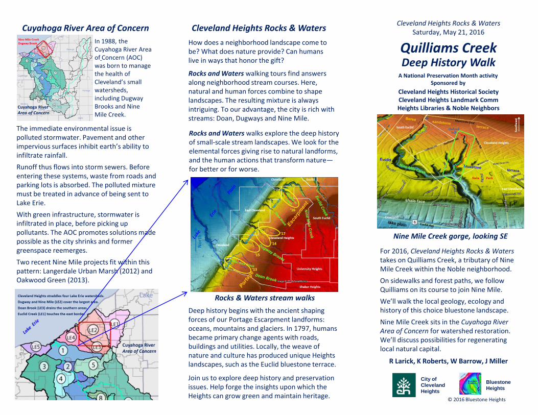
Nine Mile Creek gorge, looking SE
Quilliams Creek
© 2016 Bluestone Heights
For 2016, Cleveland Heights Rocks & Waters takes on Quilliams Creek, a tributary of Nine Mile Creek within the Noble neighborhood.
On sidewalks and forest paths, we follow Quilliams on its course to join Nine Mile.
We’ll walk the local geology, ecology and history of this choice bluestone landscape.
Nine Mile Creek sits in the Cuyahoga River Area of Concern for watershed restoration. We’ll discuss possibilities for regenerating local natural capital.
The immediate environmental issue is polluted stormwater. Pavement and other impervious surfaces inhibit earth’s ability to infiltrate rainfall.
Runoff thus flows into storm sewers. Before entering these systems, waste from roads and parking lots is absorbed. The polluted mixture must be treated in advance of being sent to Lake Erie.
With green infrastructure, stormwater is infiltrated in place, before picking up pollutants. The AOC promotes solutions made possible as the city shrinks and former greenspace reemerges.
Two recent Nine Mile projects fit within this pattern: Langerdale Urban Marsh (2012) and Oakwood Green (2013).
Cleveland Heights Rocks & Waters
Cleveland Heights Historical SocietyCleveland Heights Landmark CommHeights Libraries & Noble Neighbors
Deep History WalkA National Preservation Month activity
Sponsored by
How does a neighborhood landscape come to be? What does nature provide? Can humans live in ways that honor the gift?
Rocks and Waters walking tours find answers along neighborhood stream courses. Here, natural and human forces combine to shape landscapes. The resulting mixture is always intriguing. To our advantage, the city is rich with streams: Doan, Dugways and Nine Mile.
Rocks and Waters walks explore the deep history of small-scale stream landscapes. We look for the elemental forces giving rise to natural landforms, and the human actions that transform nature—for better or for worse.
In 1988, the Cuyahoga River Area of Concern (AOC) was born to manage the health of Cleveland’s small watersheds, including DugwayBrooks and Nine Mile Creek.
Cuyahoga RiverArea of Concern
Deep history begins with the ancient shaping forces of our Portage Escarpment landforms: oceans, mountains and glaciers. In 1797, humans became primary change agents with roads, buildings and utilities. Locally, the weave of nature and culture has produced unique Heights landscapes, such as the Euclid bluestone terrace.
Rocks & Waters stream walks
Join us to explore deep history and preservation issues. Help forge the insights upon which the Heights can grow green and maintain heritage.
No
rth
‘13
‘14
‘15
‘16
‘17

Overlay: A.H. Mueller: Atlas of Cuyhoga County, 1898
© 2016 Bluestone Heights
moraine west tip
Samuel Luster tannery (~1850). Above, c. 1930. Below, at present
William Quilliams house (1867)
Cherry Hill (c. 1870) in 2011.
Houses on Noble Rd, 1919.Behlen Wine House?
Quilliams CreekLandscape change on the bluestone terrace
Above, 1815 building ~1890. Euclid Church
Below: 1897 building, at present
NELA Park. Above, 1912. Below, at present
No
rth
quarry
Underlay: USGS LiDAR; Google Earth
A History of NELA Park, 1957
D. Lawrence
C. Busta-Peck
A History of East Cleveland, 1979
Spiritual Pioneers, 2001
Wikimedia Commons
K. O’Donnell
The bluestone terrace is a unique Heights landscape. The highland set the stage for the evolution of local landforms such as the Quilliams and Nine Mile ravines. During the 19th
century, two Quilliams households intensively farmed here. The William Quilliams house is a Cleveland Hts landmark.
By chance in June 1797, a Connecticut Land Co. north-south survey line skirted a deep ravine. Early settlers appropriated the meridian as the longest north-south track within a set of crosscutting ravines. Two centuries later, Quilliams Road still dictates municipal functions, residential settings and daily commutes.
Qu
illia
ms
Rd
Cleveland Heights
South Euclid
East Cleveland
Cleveland
Rush ‘plantaion’ of 1818 (315 a)
John Randolph (1773-1833) of Roanoke VA, elitist planter & states’ rights U.S. Congressman (House and Senate).
F. Jennings