r t 32n i o e v n r e e n s r t 31n 170 e vi j o r v a e s
TRANSCRIPT
C A R S O NN A T I O N A L
F O R E S T
J I C A R I L L AA P A C H EN A T I O N
N A V A J ON A T I O N
UT EMO UNTAIN
UT ERE S ERVATI ON
C H A C O C U L T U R EN A T I O N A L H I S T O R I C A L
P A R K
Bisti / De-Na-ZiWilderness Area
Ah-Shi-Sle-PahWilderness
Area
Angel PeakScenicArea
Na
v a j o R
es
er
vo
ir
San
Juan
Sand
oval
San JuanMcKinley
San
Juan
Rio
Arr
iba
San JuanLa Plata
SandovalMcKinley
SandovalRio Arriba
Rio ArribaArchuleta
Farm
ingt
on F
ield
Offi
ce
Farmington Field Office
6464
550
550
550
537
C O L O R A D ON E W M E X I C O
An
i m
as
Ri v
er
La
Pl
at
aR
iv
er
Sa
nJ u a n
R i v e r
1300
2900
7260
7500
2770
2390
7748
7575
3535
7840
3950
7299
390
4004
7960
4008
4800
7051
7698
1500
2772
3095
7997
3536
5290
7900
7825
3160
7120
2310
7870
4960
7675
7290
6100
7270
7100
7115
7297
7950
7080
5030
4017
2575
1120
4010
6480
7830
3100
7940
1350
7520
7050
7130
7150
8890
7635
7140
1980
8870
7750
7020
4018
7220
8860
7175
7970
1191
7125
2300
7007
7820
7040
4020
350
5500
8880
7515
4599
7300
7610
7425
4450
7890
4600
3000
7980
7800
7225
7010
4990
4000
7650
7250
511 539
172140
516
197
575
574
509
527
173
170
57
371
371
371
FarmingtonBloomfield
Flora Vista
Aztec
Nageezi
Navajo Dam
Counselor
Lybrook
T 24
NT
21N
T 22
NT
16N
T 26
NT
30N
T 29
NT
20N
T 32
NT
19N
T 18
NT
31N
T 17
NT
28N
T 25
NT
23N
T 27
N
R 5WR 8WR 12W
Mexico
NEW MEXICOAZ
CO KS
OK
TX
UT
Santa Fe
Socorro
Albuquerque
Taos
Las CrucesCarlsbad
Roswell
Farmington
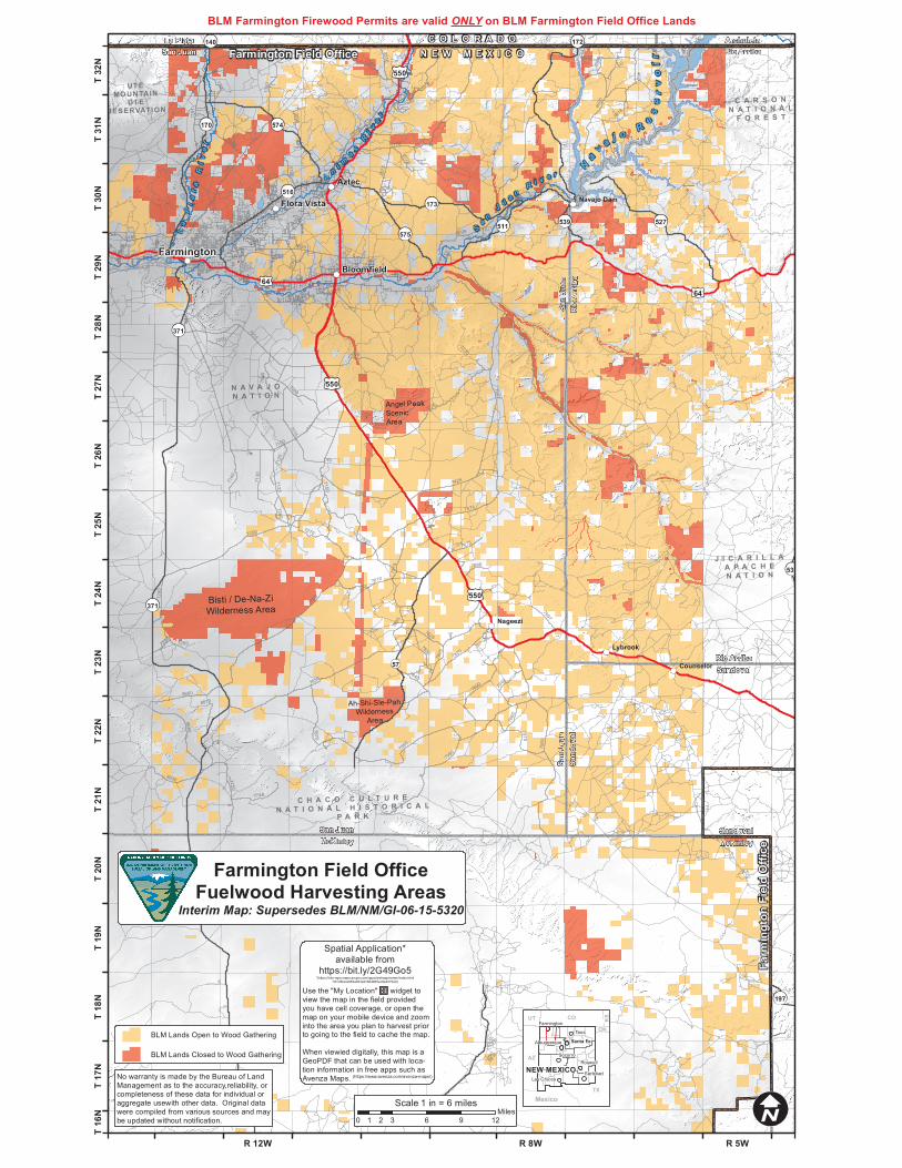
BLM Lands Open to Wood Gathering
BLM Lands Closed to Wood Gathering
0 3 6 9 121 2Miles
1 in = 6 milesScale
BLM Farmington Firewood Permits are valid ONLY on BLM Farmington Field Office Lands
No warranty is made by the Bureau of Land Management as to the accuracy,reliability, or completeness of these data for individual or aggregate usewith other data. Original data were compiled from various sources and maybe updated without notification.
Spatial Application*available from
https://bit.ly/2G49Go5*(https://blm-egis.maps.arcgis.com/apps/webappviewer/index.html
?id=2fbace983e264a91864965ec8a4573e9)
Use the "My Location" widget toview the map in the field providedyou have cell coverage, or open themap on your mobile device and zoominto the area you plan to harvest priorto going to the field to cache the map.
When viewied digitally, this map is a GeoPDF that can be used with loca-tion information in free apps such asAvenza Maps. (https://www.avenza.com/avenza-maps/)
Farmington Field OfficeFuelwood Harvesting Areas
Interim Map: Supersedes BLM/NM/GI-06-15-5320