r984 rev 0 november 2017 city of greater geraldton sunset ... · form 035 18/06/2013 ... figure 2.1...
TRANSCRIPT
m p rogers & associates pl Sunset Beach Adaptation Options Advice
K1497, Report R984 Rev 0, Page (i)
R984 Rev 0
November 2017
City of Greater Geraldton
Sunset Beach
Adaptation Options Advice
www.coastsandports.com.au
m p rogers & associates pl City of Greater Geraldton, Sunset Beach – Adaptation Options Advice
K1497, Report R984 Rev 0, Page i
m p rogers & associates pl creating better coasts and ports
Suite 1, 128 Main Street, Osborne Park, WA 6017
p: +618 9254 6600
w: www.coastsandports.com.au
K1497, Report R984 Rev 0
Record of Document Revisions
Rev Purpose of Document Prepared Reviewed Approved Date
A Draft for MRA review T Harding C Doak C Doak 20-11-17
0 Issued for Client use
T Harding C Doak C Doak
28-11-17
Form 035 18/06/2013
Limitations of this Document This document has been prepared for use by the Client in accordance with the agreement
between the Client and M P Rogers & Associates Pty Ltd. This agreement includes constraints on
the scope, budget and time available for the services. The consulting services and this document
have been completed with the degree of skill, care and diligence normally exercised by members
of the engineering profession performing services of a similar nature. No other warranty,
expressed or implied, is made as to the accuracy of the data and professional advice included.
This document has not been prepared for use by parties other than the Client and its consulting
advisers. It may not contain sufficient information for the purposes of other parties or for other
uses.
M P Rogers & Associates takes no responsibility for the completeness or form of any subsequent
copies of this document. Copying this document without the permission of the Client or
M P Rogers & Associates Pty Ltd is not permitted.
m p rogers & associates pl City of Greater Geraldton, Sunset Beach – Adaptation Options Advice
K1497, Report R984 Rev 0, Page ii
Table of Contents
1. Introduction 1
2. Local Sediment Dynamics 2
2.1 Background 2
2.2 Sediment Transport Pathway 6
3. Adaptation Options 8
3.1 Low-crest GSC Groynes 8
3.2 Alternative “No-Regrets” Option 14
4. Recommendations for Further Work & Investigations 17
6. References 19
m p rogers & associates pl City of Greater Geraldton, Sunset Beach – Adaptation Options Advice
K1497, Report R984 Rev 0, Page iii
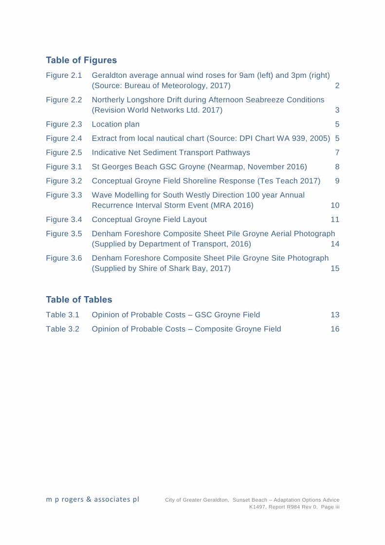
Table of Figures
Figure 2.1 Geraldton average annual wind roses for 9am (left) and 3pm (right)
(Source: Bureau of Meteorology, 2017) 2
Figure 2.2 Northerly Longshore Drift during Afternoon Seabreeze Conditions
(Revision World Networks Ltd. 2017) 3
Figure 2.3 Location plan 5
Figure 2.4 Extract from local nautical chart (Source: DPI Chart WA 939, 2005) 5
Figure 2.5 Indicative Net Sediment Transport Pathways 7
Figure 3.1 St Georges Beach GSC Groyne (Nearmap, November 2016) 8
Figure 3.2 Conceptual Groyne Field Shoreline Response (Tes Teach 2017) 9
Figure 3.3 Wave Modelling for South Westly Direction 100 year Annual
Recurrence Interval Storm Event (MRA 2016) 10
Figure 3.4 Conceptual Groyne Field Layout 11
Figure 3.5 Denham Foreshore Composite Sheet Pile Groyne Aerial Photograph
(Supplied by Department of Transport, 2016) 14
Figure 3.6 Denham Foreshore Composite Sheet Pile Groyne Site Photograph
(Supplied by Shire of Shark Bay, 2017) 15
Table of Tables
Table 3.1 Opinion of Probable Costs – GSC Groyne Field 13
Table 3.2 Opinion of Probable Costs – Composite Groyne Field 16
m p rogers & associates pl City of Greater Geraldton, Sunset Beach – Adaptation Options Advice
K1497, Report R984 Rev 0, Page 1
1. Introduction
The shoreline fronting the existing Sunset Beach development in Geraldton Western Australia has
experienced recent erosion trends. This erosion has led to the City of Greater Geraldton (City)
removing assets within close proximity to the vulnerable shoreline. Following the implementation
of these emergency measures, the City engaged specialist coastal and port engineers’ M P
Rogers & Associates Pty Ltd (MRA) to provide advice on potential coastal adaptation options for
Sunset Beach. In particular, MRA have been requested to provide advice on the following:
Feasibility of low-crest Geotextile Sand Container (GSC) groynes along the Sunset Beach
Foreshore (similar to that at St Georges Beach).
An alternative no-regrets option.
Recommendations on required data collection and further investigations to improve
knowledge of the coastal processes and modelling for the immediate Sunset Beach area.
This report provides a high-level review of the sediment transport pathways along the northern
Geraldton Beaches. This review was completed to provide advice regarding the feasibility of
potential coastal adaptation options for the shoreline fronting the existing Sunset Beach
development.
m p rogers & associates pl City of Greater Geraldton, Sunset Beach – Adaptation Options Advice
K1497, Report R984 Rev 0, Page 2
2. Local Sediment Dynamics
2.1 Background
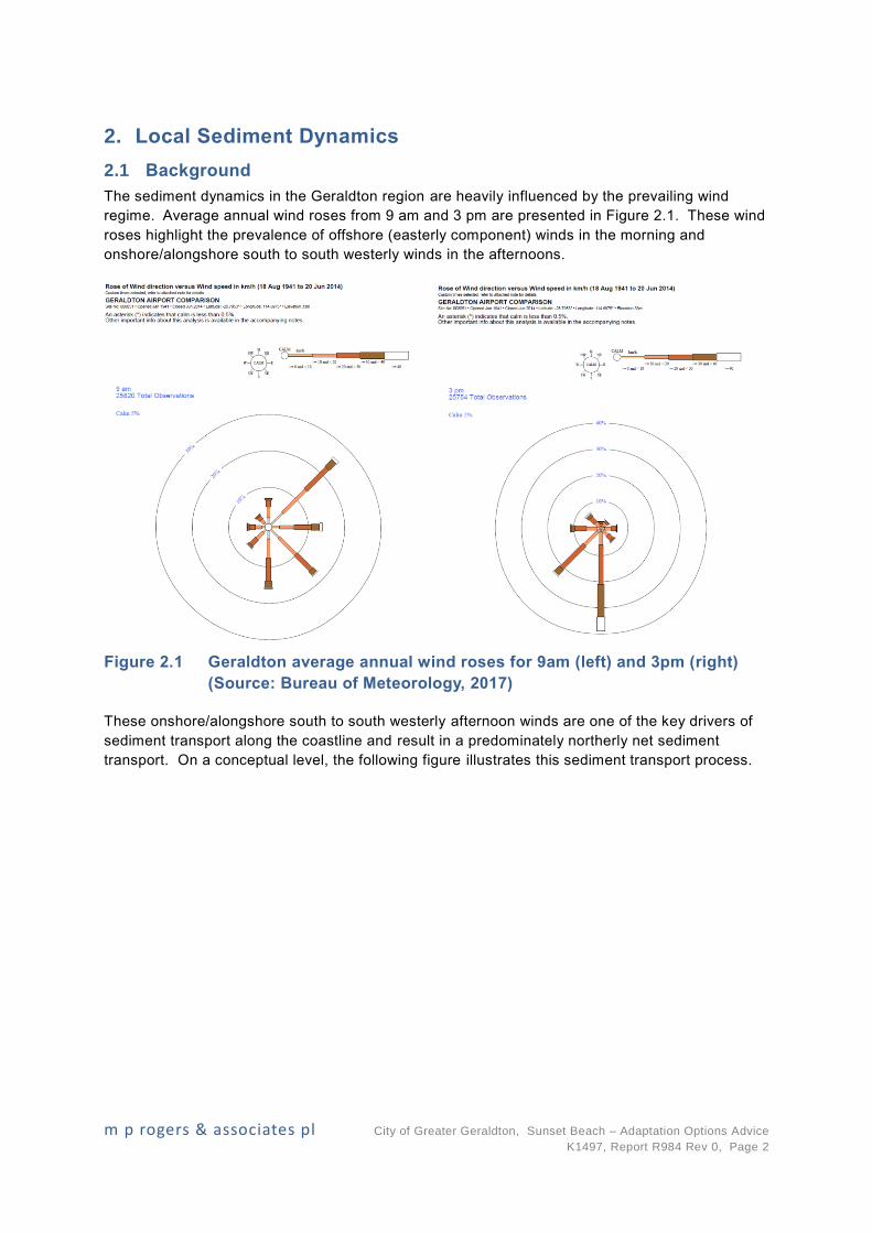
The sediment dynamics in the Geraldton region are heavily influenced by the prevailing wind
regime. Average annual wind roses from 9 am and 3 pm are presented in Figure 2.1. These wind
roses highlight the prevalence of offshore (easterly component) winds in the morning and
onshore/alongshore south to south westerly winds in the afternoons.
Figure 2.1 Geraldton average annual wind roses for 9am (left) and 3pm (right)
(Source: Bureau of Meteorology, 2017)
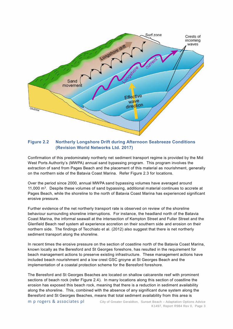
These onshore/alongshore south to south westerly afternoon winds are one of the key drivers of
sediment transport along the coastline and result in a predominately northerly net sediment
transport. On a conceptual level, the following figure illustrates this sediment transport process.
m p rogers & associates pl City of Greater Geraldton, Sunset Beach – Adaptation Options Advice
K1497, Report R984 Rev 0, Page 3
Figure 2.2 Northerly Longshore Drift during Afternoon Seabreeze Conditions
(Revision World Networks Ltd. 2017)
Confirmation of this predominately northerly net sediment transport regime is provided by the Mid
West Ports Authority’s (MWPA) annual sand bypassing program. This program involves the
extraction of sand from Pages Beach and the placement of this material as nourishment, generally
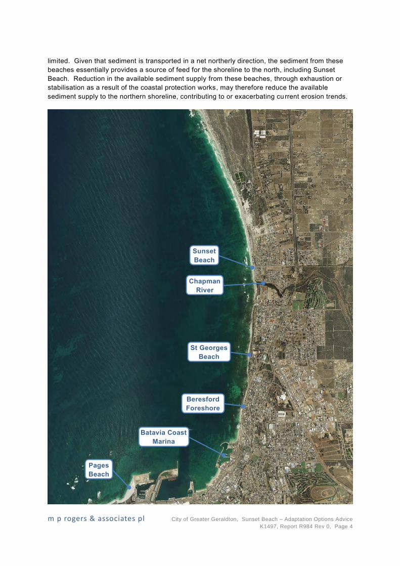
on the northern side of the Batavia Coast Marina. Refer Figure 2.3 for locations.
Over the period since 2000, annual MWPA sand bypassing volumes have averaged around
11,000 m3. Despite these volumes of sand bypassing, additional material continues to accrete at
Pages Beach, while the shoreline to the north of Batavia Coast Marina has experienced significant
erosive pressure.
Further evidence of the net northerly transport rate is observed on review of the shoreline
behaviour surrounding shoreline interruptions. For instance, the headland north of the Batavia
Coast Marina, the informal seawall at the intersection of Kempton Street and Fuller Street and the
Glenfield Beach reef system all experience accretion on their southern side and erosion on their
northern side. The findings of Tecchiato et al. (2012) also suggest that there is net northerly
sediment transport along the shoreline.
In recent times the erosive pressure on the section of coastline north of the Batavia Coast Marina,
known locally as the Beresford and St Georges foreshore, has resulted in the requirement for
beach management actions to preserve existing infrastructure. These management actions have
included beach nourishment and a low crest GSC groyne at St Georges Beach and the
implementation of a coastal protection scheme for the Beresford foreshore.
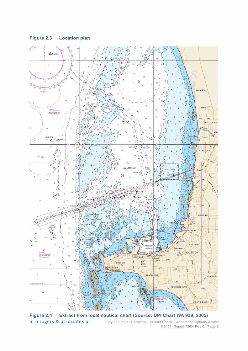
The Beresford and St Georges Beaches are located on shallow calcarenite reef with prominent
sections of beach rock (refer Figure 2.4). In many locations along this section of coastline the
erosion has exposed this beach rock, meaning that there is a reduction in sediment availability
along the shoreline. This, combined with the absence of any significant dune system along the
Beresford and St Georges Beaches, means that total sediment availability from this area is
m p rogers & associates pl City of Greater Geraldton, Sunset Beach – Adaptation Options Advice
K1497, Report R984 Rev 0, Page 4
limited. Given that sediment is transported in a net northerly direction, the sediment from these
beaches essentially provides a source of feed for the shoreline to the north, including Sunset
Beach. Reduction in the available sediment supply from these beaches, through exhaustion or
stabilisation as a result of the coastal protection works, may therefore reduce the available
sediment supply to the northern shoreline, contributing to or exacerbating current erosion trends.
St Georges
Beach
Beresford
Foreshore
Sunset
Beach
Pages
Beach
Batavia Coast
Marina
Chapman
River
m p rogers & associates pl City of Greater Geraldton, Sunset Beach – Adaptation Options Advice
K1497, Report R984 Rev 0, Page 5
Figure 2.3 Location plan
Figure 2.4 Extract from local nautical chart (Source: DPI Chart WA 939, 2005)

m p rogers & associates pl City of Greater Geraldton, Sunset Beach – Adaptation Options Advice
K1497, Report R984 Rev 0, Page 6
The extent of the erosion pressure on the Beresford and St Georges shoreline has increased over
the last one to two decades. This corresponds with the period of increased shoreline erosion
observed at Sunset Beach. It is possible that the reduction in sediment feed from the south may
have contributed to the increased rate of shoreline erosion in this area.
A compounding factor for the Sunset Beach shoreline is the potential reduction in fluvial sediment
supply from the Chapman River. Whilst the impacts of future climate change are difficult to
predict, as rainfall in the southern portion of Western Australia continues to decrease the volume
of sediment fed into the nearshore area during strong flows from the Chapman River may also
decrease. This reduction in sediment supply below historical levels may have also contributed to
the higher contemporary shoreline erosion rates compared to longer term averages.
2.2 Sediment Transport Pathway
Based on the information presented above, it is apparent that the feed of sediment from the
shoreline south of the Chapman River (including from the river itself) may have decreased over
the past one to two decades. This will have had some effect on the local sediment transport
pathway, as the reduction in incoming sediment would cause an increase in the erosion rate of the
shoreline.
Given the understanding of the sediment transport processes in the area, an outline of the
expected net sediment transport pathway is presented in Figure 2.5. As indicated in this figure, it
is expected that the net sediment transport pathway is predominately northerly in this area, with
contributions to the alongshore transport coming from the erosion of the shoreline in front of the
existing development. Given the apparent contributions from both these locations (as indicated
by the persistent erosion trend) it is expected that the rate of northerly sediment transport
increases with distance north. This is not unexpected given the corresponding increase in fetch
length, and therefore wave energy, from Point Moore during southerly winds.
The sediment transport pathways presented in Figure 2.5 will provide the foundation for the
high-level assessment of potential coastal adaptation options for the shoreline fronting the
existing Sunset Beach development.
m p rogers & associates pl City of Greater Geraldton, Sunset Beach – Adaptation Options Advice
K1497, Report R984 Rev 0, Page 7
Figure 2.5 Indicative Net Sediment Transport Pathways
Erosion of shoreline
contributing to
sediment transport
Net northerly sediment
transport increasing in
magnitude to the north, fed
by ongoing shoreline erosion
MWPA annual sand
bypassing program
m p rogers & associates pl City of Greater Geraldton, Sunset Beach – Adaptation Options Advice
K1497, Report R984 Rev 0, Page 8
3. Adaptation Options
The are many adaptation options that could be considered to manage the eroding shoreline
fronting the existing Sunset Beach development, including the following:
Seawalls.
Nearshore Headlands.
Sand Nourishment only.
These options have their own advantages and disadvantages in regard to levels of protection they
offer compared to overall aesthetic appearance. However, it has been assessed that these
options would either be too costly over the design life or would not be considered as a “no regret”
option.
On this basis, the City’s wanted to investigate the feasibility of Low-crest GSC Groynes and
associated sand nourishment. Assessments of the feasibility of this option and an alternative
“no regret” option are provided in the following Sections of this report.
3.1 Low-crest GSC Groynes
3.1.1 Feasibility Considerations
Groynes are structures constructed perpendicular to the shoreline to intercept the longshore
transport of sediment and result in the realignment of the contained beaches to an angle parallel
to the incident wave approach. A groyne field aims to reduce the longshore transport along the
shoreline and provide protection to eroding coasts.
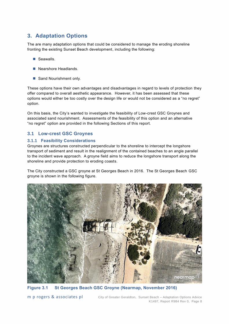
The City constructed a GSC groyne at St Georges Beach in 2016. The St Georges Beach GSC
groyne is shown in the following figure.
Figure 3.1 St Georges Beach GSC Groyne (Nearmap, November 2016)

m p rogers & associates pl City of Greater Geraldton, Sunset Beach – Adaptation Options Advice
K1497, Report R984 Rev 0, Page 9
The St Georges Beach groyne is 25m long and is constructed from 2.5 m3 GSCs.
The concept of a field of Low-crest GSC Groynes would be a feasible short-term option to mitigate
the eroding shoreline in front of the existing Sunset Beach development. The feasibility of this
option would be subject to following conditions:
Construction of a sufficient number of groynes to protect an adequate length of shoreline.
The individual groynes extending a sufficient length into the active zone of the shoreline to
adequately trap the sand and enable shoreline realignment without significant erosion of the
northern sides of the structures.
Initial and potentially ongoing sand nourishment is undertaken to saturate the groynes and
reduce the potential for erosion.
Maintenance to the GSC groynes being undertaken approximately every 5 years or
following damage from particularly severe storm events.
In order to reduce the impacts of downdrift erosion, sand nourishment between the constructed
groyne field would need to be undertaken. The following figure presents the conceptual
performance of a groyne field with and without sand nourishment.
Figure 3.2 Conceptual Groyne Field Shoreline Response (Tes Teach 2017)
MRA has completed a high-level assessment of the potential groyne lengths, spacings,
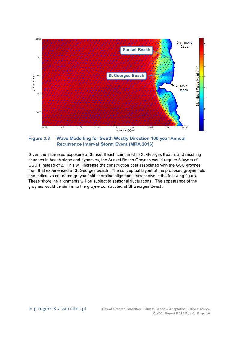
embedment depths and resultant shoreline alignments. Sunset Beach is exposed to more severe
wave conditions when compared to the location of the St Georges Beach groyne. This can be
seen in the wave modelling results from MRA (2016) presented in following figure.
m p rogers & associates pl City of Greater Geraldton, Sunset Beach – Adaptation Options Advice
K1497, Report R984 Rev 0, Page 10
Figure 3.3 Wave Modelling for South Westly Direction 100 year Annual
Recurrence Interval Storm Event (MRA 2016)
Given the increased exposure at Sunset Beach compared to St Georges Beach, and resulting
changes in beach slope and dynamics, the Sunset Beach Groynes would require 3 layers of
GSC’s instead of 2. This will increase the construction cost associated with the GSC groynes
from that experienced at St Georges beach. The conceptual layout of the proposed groyne field
and indicative saturated groyne field shoreline alignments are shown in the following figure.
These shoreline alignments will be subject to seasonal fluctuations. The appearance of the
groynes would be similar to the groyne constructed at St Georges Beach.
Sunset Beach
St Georges Beach

m p rogers & associates pl City of Greater Geraldton, Sunset Beach – Adaptation Options Advice
K1497, Report R984 Rev 0, Page 11
Figure 3.4 Conceptual Groyne Field Layout
To provide an effective groyne field, the separation between the groynes needs to be relative to
the overall length of the groynes. The Shore Protection Manual (USACE, 1984) suggests a
spacing to length ratio of two to three, while Kraus et al (1994) and the Coastal Engineering
Groynes
Indicative saturated groyne
field shoreline alignment
following summer period
m p rogers & associates pl City of Greater Geraldton, Sunset Beach – Adaptation Options Advice
K1497, Report R984 Rev 0, Page 12
Manual (USACE, 2006) suggest a ratio of two to four. A spacing to length ratio of approximately
1.6 has been adopted on the basis of the following factors:
The significant angle of incidence between the predominate afternoon sea breeze
conditions and the current Sunset Beach shoreline.
The reduced supply of sediment from the south discussed previously in Section 2.
The proposed low-crest of the groynes.
The high-level stage of this investigation.
The final two groynes shown on Figure 3.4 have been designed with reduced lengths to minimise
the downdrift erosion of the shoreline further north based on the recommendations of USACE
(2006).
The following key conceptual criteria would need to be met to minimise any additional erosion of
the 500 m of shoreline fronting the existing Sunset Beach development as a result of longshore
transport:
The low-crest GSC groynes are to be constructed from 2.5 m3 GSCs.
Five approximately 50 m groynes and two approximately 30 m groynes constructed at
spacings of approximately 80m.
Initial sand nourishment volume of approximately 12,800 m3 to saturate the groyne field and
potential ongoing nourishment of approximately 10,000 m3 approximately every 3 to 5
years.
It should be noted that the construction of a groyne field will not prevent recession of the shoreline
caused by storm erosion, sea level rise and seasonal fluctuations. To minimise recession of the
shoreline from these processes would require larger structures or significantly larger volumes of
sand nourishment over the design life of the adaptation option.
If the City chooses to proceed with this adaptation option, the exact lengths and spacings of the
groynes and quantities of sand nourishment would need to be further investigated. The
investigations required to progress this adaptation option from feasibility to the latter design
phases have been recommended in Section 4 of this report.
The groyne field is able to be constructed in stages to help reduce initial capital expenditure.
Given the narrow buffer from the current face of the eroding dune system to the existing
infrastructure south of the Bosley Street car park, the first stage of the groyne fie ld would need to
extend to the northern side of the car park (i.e. the 5 southern groynes on the current concept
presented in Figure 3.4).
3.1.2 Impacts
It is likely that the construction of a groyne field in front of the existing Sunset Beach development
would block some of the sediment transport from the southern beaches and reduce the supply of
sediment to beaches north of the existing Sunset Beach development. However, given the
proposed low-crest of the groynes, the containment of sediment on the southern side of the
groynes would be limited by the elevation the crest. Provided the groynes are designed correctly
m p rogers & associates pl City of Greater Geraldton, Sunset Beach – Adaptation Options Advice
K1497, Report R984 Rev 0, Page 13
and sufficient sand nourishment is undertaken, this option could be considered to minimise any
significant impacts on the shorelines further south, north and between the groynes.
Provided the groyne field and associated sand nourishment programme is designed and
implemented correctly, this adaptation option should not adversely impact the river month of the
Chapman River.
From MRA’s experience with shoreline management, the accumulation of wrack on beaches can
be an issue in coastal communities (including Port Geographe and Two Rocks). The
accumulations of detached macrophytes and seagrass in the surf zone and on beaches are
commonly referred to as wrack (Kirkman & Kendrick 1997). From review of recent aerial imagery,
there appears to be significant volumes of wrack that accumulate on the shorelines immediately
south of the Chapmen River mouth. Although the proposed structures are significantly smaller
than the breakwaters at Port Geographe and Two Rocks, there is the potential for wrack to
accumulate in the beach compartments between the proposed groynes.
The proposed groynes could act as barriers that may prevent any wrack that has accumulated
from leaving the beach compartment. During high water level events, there is the potential that
wrack may become stranded on the upper reaches of the beach compartments. Once wrack has
been accumulated for longer periods of time it can start to decompose which can result in pungent
odours as it decays. This may be of concern to members of the public , including property owners,
and local beach users. As a result the City could need to be manage any significant
accumulations of wrack that result from the proposed groyne field.
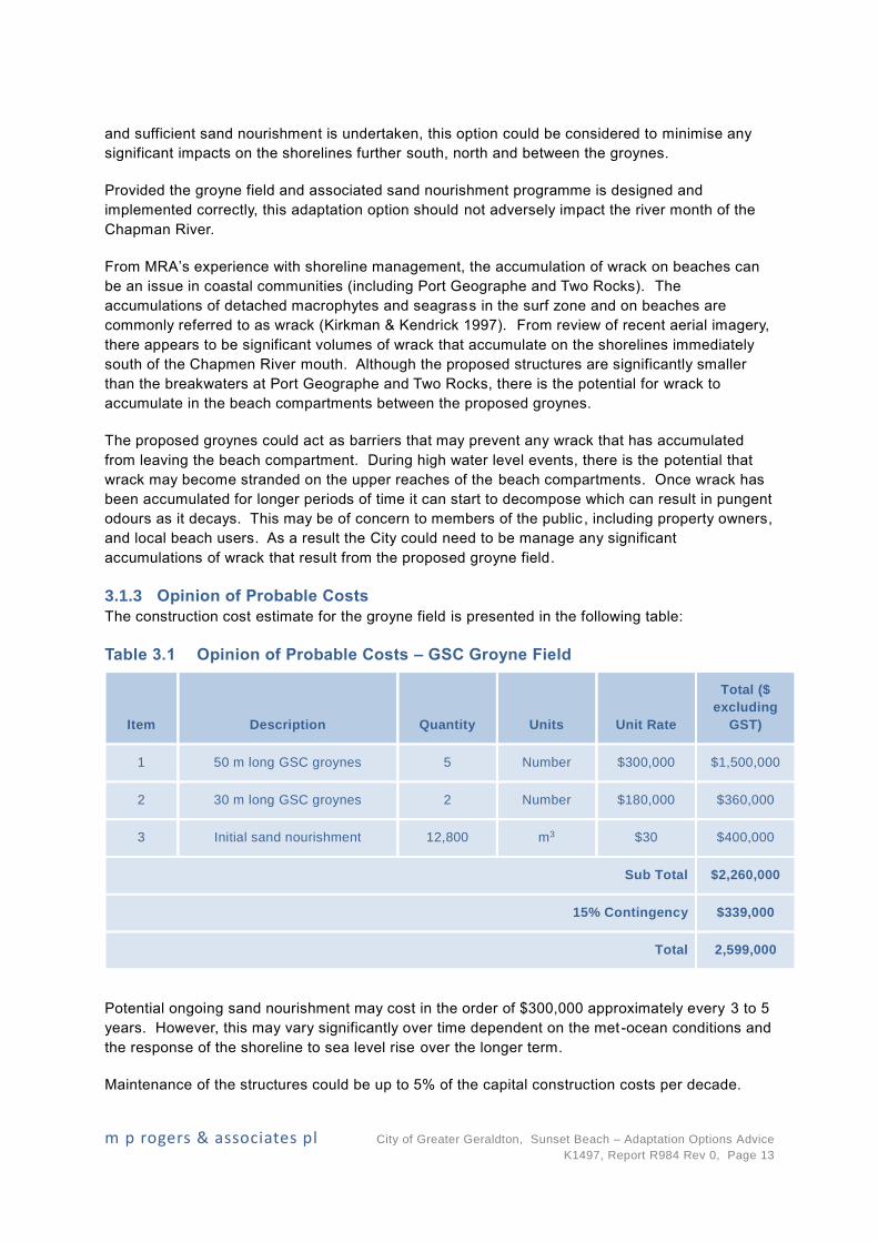
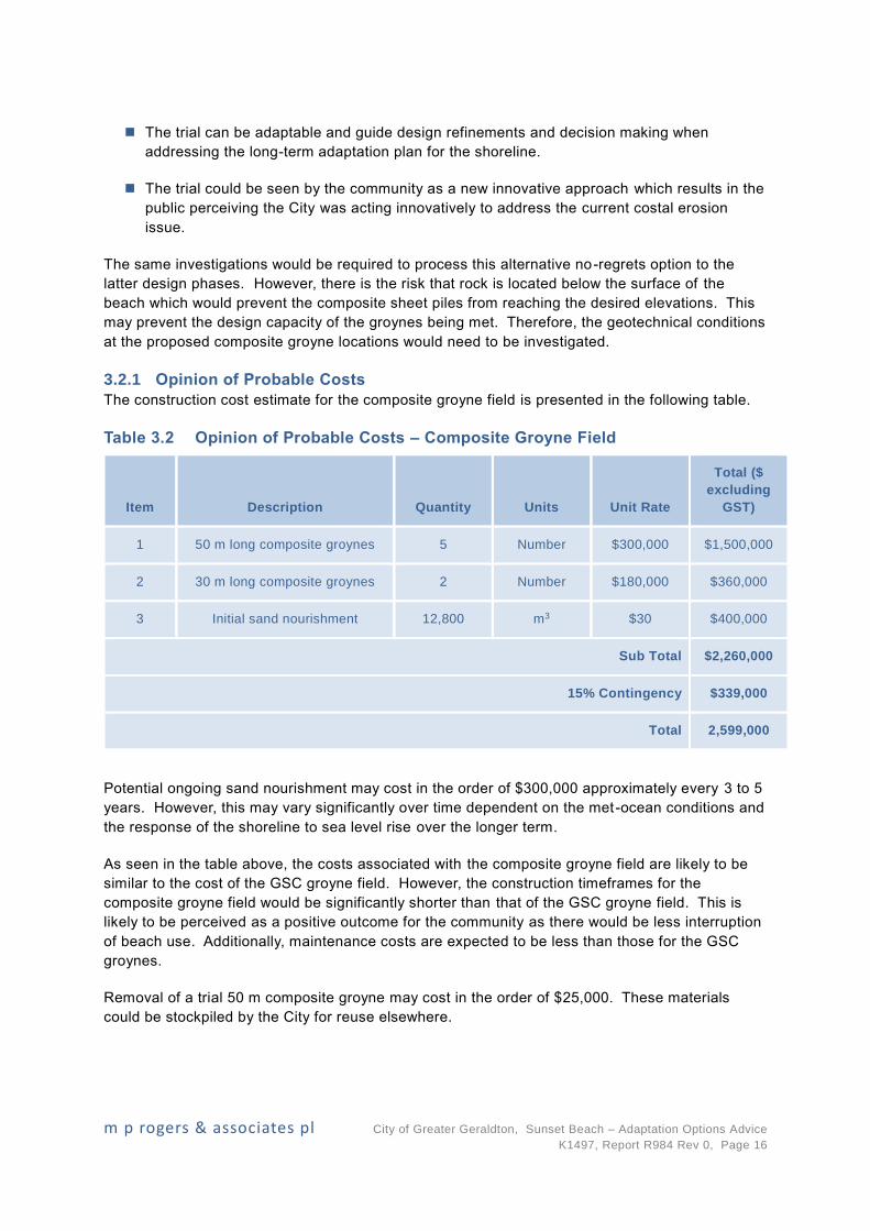
3.1.3 Opinion of Probable Costs
The construction cost estimate for the groyne field is presented in the following table:
Table 3.1 Opinion of Probable Costs – GSC Groyne Field
Item Description Quantity Units Unit Rate
Total ($
excluding
GST)
1 50 m long GSC groynes 5 Number $300,000 $1,500,000
2 30 m long GSC groynes 2 Number $180,000 $360,000
3 Initial sand nourishment 12,800 m3 $30 $400,000
Sub Total $2,260,000
15% Contingency $339,000
Total 2,599,000
Potential ongoing sand nourishment may cost in the order of $300,000 approximately every 3 to 5
years. However, this may vary significantly over time dependent on the met-ocean conditions and
the response of the shoreline to sea level rise over the longer term.
Maintenance of the structures could be up to 5% of the capital construction costs per decade.
m p rogers & associates pl City of Greater Geraldton, Sunset Beach – Adaptation Options Advice
K1497, Report R984 Rev 0, Page 14
3.2 Alternative “No-Regrets” Option
An alternative option is to install composite sheet pile groynes. In recent times, composite sheet
piles have started to be more commonly used in the marine environment. Composite sheet piles
are advantageous due to their resistance to corrosion and improved aesthetics when compared to
traditional steel sheet piles. The recent use of composites has been backed by research into their
durability and justification of their strength capacities.
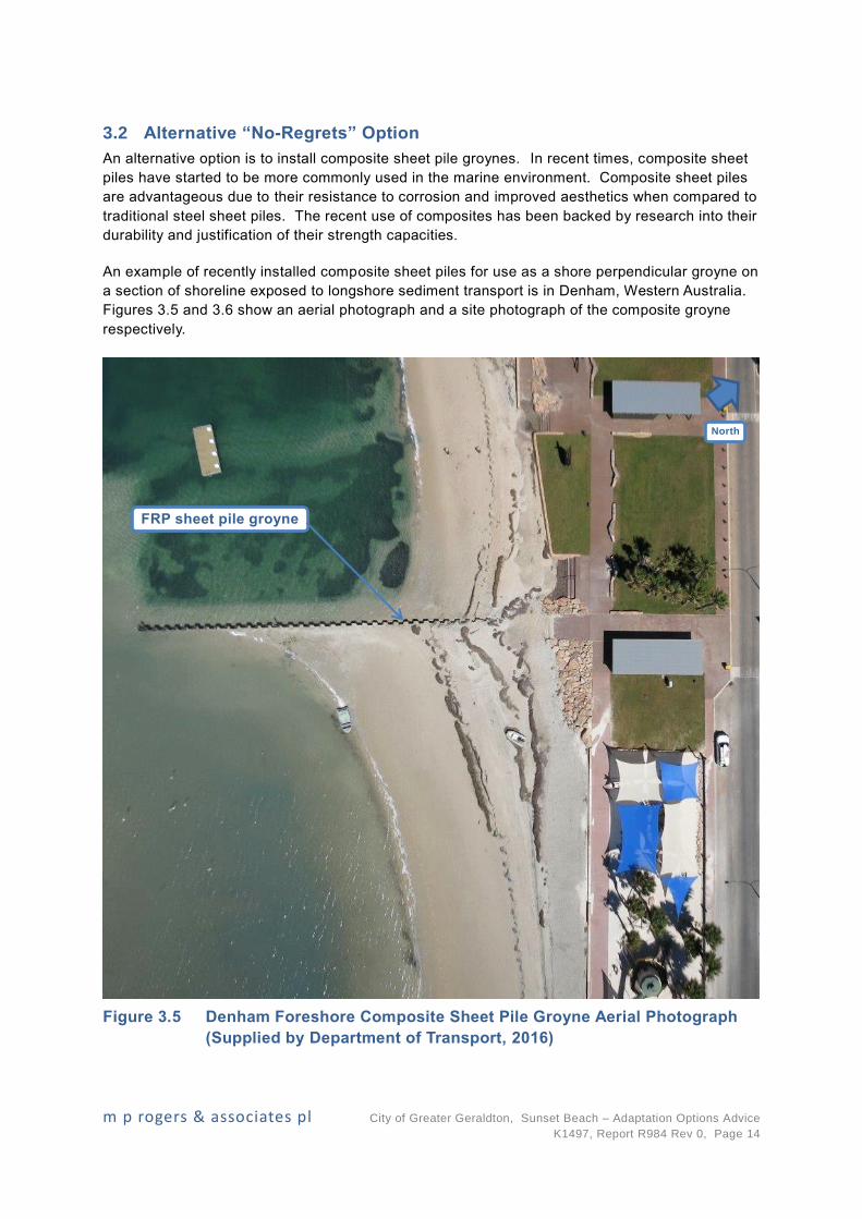
An example of recently installed composite sheet piles for use as a shore perpendicular groyne on
a section of shoreline exposed to longshore sediment transport is in Denham, Western Australia.
Figures 3.5 and 3.6 show an aerial photograph and a site photograph of the composite groyne
respectively.
Figure 3.5 Denham Foreshore Composite Sheet Pile Groyne Aerial Photograph
(Supplied by Department of Transport, 2016)
North
FRP sheet pile groyne
m p rogers & associates pl City of Greater Geraldton, Sunset Beach – Adaptation Options Advice
K1497, Report R984 Rev 0, Page 15
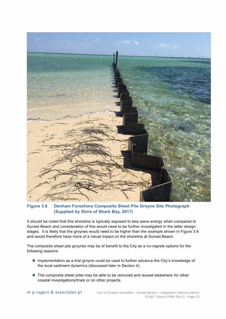
Figure 3.6 Denham Foreshore Composite Sheet Pile Groyne Site Photograph
(Supplied by Shire of Shark Bay, 2017)
It should be noted that this shoreline is typically exposed to less wave energy when compared to
Sunset Beach and consideration of this would need to be further investigated in the latter design
stages. It is likely that the groynes would need to be higher than the example shown in Figure 3.6
and would therefore have more of a visual impact on the shoreline at Sunset Beach.
The composite sheet pile groynes may be of benefit to the City as a no-regrets options for the
following reasons:
Implementation as a trial groyne could be used to further advance the City’s knowledge of
the local sediment dynamics (discussed later in Section 4).
The composite sheet piles may be able to be removed and reused elsewhere for other
coastal investigations/trials or on other projects.
m p rogers & associates pl City of Greater Geraldton, Sunset Beach – Adaptation Options Advice
K1497, Report R984 Rev 0, Page 16
The trial can be adaptable and guide design refinements and decision making when
addressing the long-term adaptation plan for the shoreline.
The trial could be seen by the community as a new innovative approach which results in the
public perceiving the City was acting innovatively to address the current costal erosion
issue.
The same investigations would be required to process this alternative no-regrets option to the
latter design phases. However, there is the risk that rock is located below the surface of the
beach which would prevent the composite sheet piles from reaching the desired elevations. This
may prevent the design capacity of the groynes being met. Therefore, the geotechnical conditions
at the proposed composite groyne locations would need to be investigated.
3.2.1 Opinion of Probable Costs
The construction cost estimate for the composite groyne field is presented in the following table.
Table 3.2 Opinion of Probable Costs – Composite Groyne Field
Item Description Quantity Units Unit Rate
Total ($
excluding
GST)
1 50 m long composite groynes 5 Number $300,000 $1,500,000
2 30 m long composite groynes 2 Number $180,000 $360,000
3 Initial sand nourishment 12,800 m3 $30 $400,000
Sub Total $2,260,000
15% Contingency $339,000
Total 2,599,000
Potential ongoing sand nourishment may cost in the order of $300,000 approximately every 3 to 5
years. However, this may vary significantly over time dependent on the met-ocean conditions and
the response of the shoreline to sea level rise over the longer term.
As seen in the table above, the costs associated with the composite groyne field are likely to be
similar to the cost of the GSC groyne field. However, the construction timeframes for the
composite groyne field would be significantly shorter than that of the GSC groyne field. This is
likely to be perceived as a positive outcome for the community as there would be less interruption
of beach use. Additionally, maintenance costs are expected to be less than those for the GSC
groynes.
Removal of a trial 50 m composite groyne may cost in the order of $25,000. These materials
could be stockpiled by the City for reuse elsewhere.
m p rogers & associates pl City of Greater Geraldton, Sunset Beach – Adaptation Options Advice
K1497, Report R984 Rev 0, Page 17
4. Recommendations for Further Work & Investigations
To confirm the feasibility of the proposed low-crest groyne field to protect the shoreline fronting
the existing Sunset Beach development, the following investigations are recommended:
Collection of wave data in the nearshore area in front of the existing Sunset Beach
development for use in calibrating detailed wave and longshore sediment transport models.
It is important to note that any data collected for use in design of shorter -term adaptation
options will still be applicable for use in any future design of longer-term adaptation options.
Collection of wave data could either be direction or non-directional given that directional
data has been collected adjacent to the Beresford shoreline. However, if non-directional
measurements are to be completed the monitoring should be collected at two locations
concurrently.
Establishment of a calibrated / validated site specific wave model using the recorded wave
measurements.
Establishment of a calibrated / validated longshore sediment transport model. The following
information or investigations could be collected or completed to assist with the calibration /
validation of this model.
· Development of a refined local sediment budget. This would require an updated
assessment of the regional shoreline movement using the latest available
orthorectified aerial imagery, together with available survey information, to enable a
local sediment budget to be developed. The sediment budget could be used to
ensure that the longshore sediment transport model adequately reproduces the local
sediment transport rates.
· A cost effective way of calibrating a longshore sediment transport model can be to
assess the shoreline response of similar shore perpendicular structures within the
vicinity of the site. This method relies on similar shoreline alignments, wave exposure
and relevant historic data being available. One structure’s shoreline response that
may be able to be used to calibrate a longshore sediment transport model for the site
is the St Georges Beach groyne. However, given it has only recently installed, an
accurate assessment of the shoreline response may not be possible until after a
couple of years.
· A more refined local calibration / validation could be achieved through installation and
monitoring of a temporary shore perpendicular structure (such as a trial composite
sheet pile groyne). Monitoring could be completed by surveying the nearshore area
north and south of the temporary structure following installation. This method would
enable a detailed and accurate assessment of the longshore transport mechanisms
and may enable design refinements and associated cost savings.
Longshore sediment transport modelling using the calibrated / validated model should be
completed to simulate the impacts of the proposed adaptation option. The model could be
used to simulate the impacts of the proposed “no regret” option, but could also be used to
help guide further adaptation planning over the medium to longer term.
To confirm the extent of potential wrack accumulation mechanisms and quantities, it is
recommended that monitoring of wrack accumulation quantities is completed for the other
sections of the shoreline north of Geraldton. This could enable estimates to be made for

m p rogers & associates pl City of Greater Geraldton, Sunset Beach – Adaptation Options Advice
K1497, Report R984 Rev 0, Page 18
the anticipated quantities and accumulation durations of wrack between the proposed
groynes for different typical events and periods of the year.
m p rogers & associates pl City of Greater Geraldton, Sunset Beach – Adaptation Options Advice
K1497, Report R984 Rev 0, Page 19
6. References
Kirkman, H. & Kendrick, G. A. (1997). Ecological significance and commercial harvesting of
drifting and beach-cast macro-algae and seagrasses in Australia: a review. Journal of Applied
Phycology 9: 311-326.
Kraus, N. C. Hanson, H. and Blomgren, S. H. (1994). Modern Functional Design of Groin
Systems, Proceedings of the 24th International Conference on Coastal Engineering , Kobe,
Japan, October.
MRA (2016). Town Beach to Drummond Cove – Inundation & Coastal Processes Study. Report
R675 Rev 0 prepared for the City of Greater Geraldton.
Revision World Networks Ltd. (2017). Longshore Drift. [ONLINE] Available at:
https://revisionworld.com/gcse-revision/geography/coastal-landscapes/coastal-
processes/longshore-drift. [Accessed 20 November 2017].
Tecchiato, S., Collins, L.B. & Stevens, A.M. (2012). Geraldton Embayments Coastal Sediment
Budget Study. Curtin University Department of Applied Geology. Prepared for Department of
Transport.
Tes Teach (2017). Coastal Erosion. [ONLINE] Available at:
https://www.tes.com/lessons/qhijVtM1JBv-Yw/coastal-erosion. [Accessed 27 November 2017].
USACE (1984). Shore Protection Manual. Department of the Army, US Army Corps of Engineers,
Washington D.C., Volumes 1-2.
USACE (2006). Coastal Engineering Manual, Engineer Manual 1110-2-1100, Washington D.C.,
Volumes 1-6.