radar data assimilation at météo-france - · 2 outline 1. main features of radar assimilation at...
TRANSCRIPT

Radar data assimilation at
Météo-France
J.-F. Mahfouf, E. Wattrelot,
T. Montmerle (CNRM/GMAP),
O. Caumont (CNRM/GMME),
P. Tabary (DP/CMR)
WGNE meeting, Toulouse

2
Outline
1. Main features of radar assimilation at Météo-France
• Radar network over France
• The operational mesoscale model AROME
• 1D+3D-Var methodology
• Screening and quality controls
2. Illustrations
• Importance of « no-rain » assimilation
• Importance of quality of raw data
3. Ongoing activities
• Use of X-band radars
• Towards the use of European radars (OPERA, HYMEX)

3
Importance of radar data at mesoscale
• National Weather Services need to issue accurate forecasts of high impact
weather at small scale (severe thunderstorms, wind gusts, fog, ….)
• During the last 10 years many convective permitting models (Dx < 3 km)
have been developed that have recently reached an operational status (JMA,
MetOffice, DWD, MSC, Météo-France)
• Most of them have a dedicated data assimilation system
• Many feasibility studies (e.g. Ducrocq et al., 2000, 2002) have shown the
importance of the initialisation of pre-storm environment
• Relevant observations : high temporal and spatial resolution informative
about the atmosphere in precipitating systems
• Radar data : spatial resolution < 1 km : temporal resolution < 15 min :
information on hydrometeors (radial velocity, rainfall rate, type)

4
Regional model AROME
• Spectral limited area model (non-
hydrostatic with explicit moist
convection)
• 60 vertical levels
• Dx = 2.5 km
• 3D-Var data assimilation (3h window)
• Coupling files : hourly forecasts from
global model ARPEGE
• Forecast range : 30 hours
• Operational since December 2008

5 5
Observations in AROME
RADARS
AIRCRAFTS
SYNOP/RADOME
IASI
SEVIRI
TEMP
Ground GPS

6 6
Observations in AROME
DFS (rain +)
RADARS
AIRCRAFTS
SYNOP/RADOME
IASI
SEVIRI
TEMP
Ground GPS
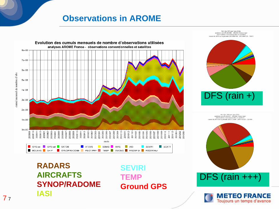
7 7
Observations in AROME
DFS (rain +)
DFS (rain +++)
RADARS
AIRCRAFTS
SYNOP/RADOME
IASI
SEVIRI
TEMP
Ground GPS

8
French ARAMIS network
24 Doppler radars, 10 Polarimetric,
between 3 and 12 PPIs in 15’
Polarimetric
radar
Radars : C Band
S Band
Current operational use of rada data
Within AROME:
Volumic observations are considered every 3
hours
Radial wind from 15 radars since
December 2008; from 22 radars since 24
November 2010 – Triple PRT leading to
unambiguous velocity of 60 m/s
Reflectivity from 24 radars since 6 April
2010
Name and number
of elevations in
circles

9
1D+3D-Var method for radar reflectivities
• Choice of retrieving humidity information (~ Marécal and Mahfouf, 2002)
• 1D Bayesian inversion technique (~precipitation retrievals from MW radiances)
• Caumont et al., 2010 : Use of background information in the neighbourhood of
an observation to create a database of profiles
E RH( ) = RH i
i
åexp
-1
2× || Z0 - Zs RH i( ) ||2
expj
å-1
2× || Z0 - Zs RH j( ) ||2
Observation
operator of
reflectivity
AROME Background
AROME Analysis
Obs
U, V, T,
q and Ps
3D-Var
Analysis
NH-fields, TKE
Hydrometeors
Use of model hydrometeors to modify humidity
(1D), wind, temperature .. (3D-Var) without
changing hydrometeors !

10
Pros and cons
1. Pros:
• Dependency of retrieved profiles with the situation of the day
• Consistency between precipitating clouds created by the inversion and
the model microphysics
• No need to linearize the observation operator nor the AROME
microphysics
• No need to extend the control variable to hydrometeors and to provide
corresponding background error statistics
• 1D+3DVar is a robust method
2. Cons:
• Double use of background profiles : correlation between pseudo-
observations and model
• Lack of balance in the analysis between hydrometeor fields and the
control variables (future : could be provided by polarimetric
measurements and modelling of covariance statistics)
• Technical challenge for operational implementation in AROME (code
parallelization)
11
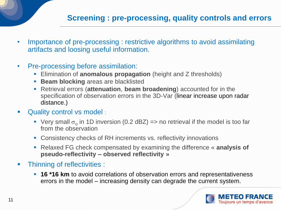
Screening : pre-processing, quality controls and errors
• Importance of pre-processing : restrictive algorithms to avoid assimilating artifacts and loosing useful information.
• Pre-processing before assimilation: Elimination of anomalous propagation (height and Z thresholds)
Beam blocking areas are blacklisted
Retrieval errors (attenuation, beam broadening) accounted for in the specification of observation errors in the 3D-Var (linear increase upon radar distance.)
Quality control vs model :
Very small so in 1D inversion (0.2 dBZ) => no retrieval if the model is too far from the observation
Consistency checks of RH increments vs. reflectivity innovations
Relaxed FG check compensated by examining the difference « analysis of pseudo-reflectivity – observed reflectivity »
Thinning of reflectivities :
16 *16 km to avoid correlations of observation errors and representativeness errors in the model – increasing density can degrade the current system.

12
Precipitation signal :
RADAR: it rains if the SNR is large enough (Z above the minimum detectable reflectivity (MDZ) known for each pixel)
AROME: as soon as precipitating hydrometeors are produced
Rain in radar
(SNR>0)
Sensitive
detection in the
model
Importance of accouting for the « no-rain » information in the assimilation : better
balance between creation and destruction of rainy areas in the model, reduced
variance of the analysis increments, reduced model humidity bias.
« No rain » information
Good radar
MDZ curve
Poor radar
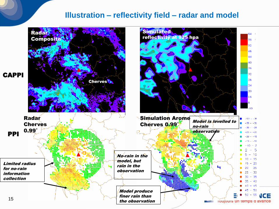
15
Radar
Composite
Simulated
reflectivity at 925 hpa
Limited radius
for no-rain
information
collection
No-rain in the
model, but
rain in the
observation
Model is levelled to
no-rain
observation
Cherves
Radar
Cherves
0.99°
Simulation Arome
Cherves 0.99°
Model produce
finer rain than
the observation
Illustration – reflectivity field – radar and model
PPI
CAPPI
16
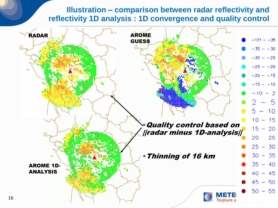
Radar
Composite
Illustration – comparison between radar reflectivity and reflectivity 1D analysis : 1D convergence and quality control
RADAR
AROME 1D-
ANALYSIS
AROME
GUESS
•Quality control based on
||radar minus 1D-analysis||
•Thinning of 16 km

17
Radar
Composite
Simulated
reflectivity at 925 hpa
Cherves
Illustration – Active data of humidity retrievals and
3DVAR analysis increments
Pseudo-innovations
of relative humidity
(OBS-BG)
Analysis increments
of relative humidity
(ANALYSIS-BG)
Analysis field of
humidity strongly
constrained by
reflectivity
observations
18
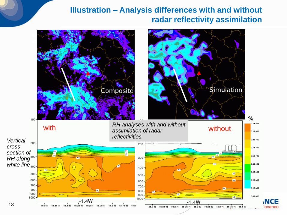
Radar
Composite
Cherves
Illustration – Analysis differences with and without
radar reflectivity assimilation
RH analyses with and without assimilation of radar reflectivities
%
Vertical cross section of RH along white line
with without

20
Precipitation scores
Scores over 36 days in winter
Probability of detection
False Alarm Rate
Reference
Assimilation Doppler winds
Assimilation of DOW + Z

23
Impact of the assimilation of poor radar wind data
ground
clutter, clear sky echoes and sea clutter
More impact than
with and without
initial Doppler wind
data

26
A network of X-band radars
+ radar Hydrix® at
Mont Vial (1550m)
+ radar at Mt Maurel
(1770m)
(Hymex SOP1)
60 km
Mont Vial
Maurel
Collobrières
Nîmes
Bollène
Simulated radar quality indices (0-100) > 84
River basins Quality index > 84
2012 : Mont
Colombis, 1770m
> Hymex SOP2 (2013)
2013 : potentiellement
Vars Mayt, 2400m

27
Impact of X-band radar assimilation
Arome without Mt-Vial Arome with Mt-Vial Precipitation
analysis
Improvement coming from DOW (similar behavior
with DOW+Z)
31/10/2011 (12 UTC)
70 mm 118 mm 125 mm

28
Cost function
of the 3D-Var:
Horizontal correlation of observation errors
xHyxHyxxxxxJ oTob
Tb 11
21
21 RB
But currently R is diagonal
in the system !
Thinning to counteract spatial
error correlations: only 1 obs.
per box of 16 km x 16 km
Diagnosis of correlation of observation errors
- Method of Hollingworth-Lonnberg
- Method of Desroziers
- Use of Assimilation Ensemble results

29
OPERA : Towards a European radar data exchange
• EUMETNET optional programme
• Previous phases :
• Common Data Format
exchange (ODIM)
• Exchange of radar composites
: Z and RR
• Next phase : 2013 -2017
• Better specification of the
NWP community needs
• Improved quality flags and
echo types
• Exchange of 3D volume data
(Z and DOW) from individual
radars

30
Conclusions and perspectives
• Operational assimilation of radar data from the French network ARAMIS in the
3D-Var AROME since :
• December 2008 for Doppler winds
• March 2010 for reflectivities (1D+3D Var methodology)
• Improved assimilation by a better identification of non-meteorological echoes
and of non-rainy areas (importance of polarimetric information)
• Experimentation with X-band radars in the southeastern part of France
(RHYTMME project)
• Towards an increased usage of European radar data (HYMEX field campaign +
EUMETNET OPERA )
• Need for improved specification of observation errors : horizontal correlations
• Ongoing developments :
• AROME at 1.3 km with 3D-Var RUC (1h window)
• Assimilation of polarimetric data (hydrometeors) and radar refractivity (low level
humidity)

Thank you for
your attention !