raised bog monitoring project 2011 volume 1: …...raised bog monitoring project 2011 _____ 1...
TRANSCRIPT

Raised Bog Monitoring Project 2011
Volume 1: Main Report
Irish Wildlife Manuals No. 62


Raised Bog Monitoring Project 2011
Fernando Fernandez Valverde, William Crowley & Sue Wilson
Ecologic Environmental & Ecological Consultants Ltd
Citation:
Fernandez, F., Crowley, W. & Wilson S. (2012) Raised Bog Monitoring Project 2011 – Volume 1:
Main Report. Irish Wildlife Manuals, No. 62. National Parks and Wildlife Service, Department of
Arts, Heritage and the Gaeltacht, Dublin, Ireland.
Keywords: raised bog, Active Raised Bog, Degraded Raised Bog, Bog Woodland, Depressions on peat
substrates of the Rhynchosporion, Annex I, Habitats Directive, conservation status, favourable conservation
status, area, structure and functions, future prospects, impacts, favourable reference values.
Site list: 000006, 0000391, 000566, 000580, 000582, 000585, 000641, 000647, 000679, 001818
Cover photos: © Fernando Fernandez
Irish Wildlife Manuals Series Editors: N. Kingston & F. Marnell
© National Parks and Wildlife Service 2012
ISSN 1393 – 6670


Raised Bog Monitoring Project 2011
______________________________
Contents
Executive Summary ........................................................................................................................................ 1
Acknowledgements ........................................................................................................................................ 3
Introduction ..................................................................................................................................................... 4
Scope of the report ...................................................................................................................................... 4
Project tasks ................................................................................................................................................. 4
Survey area .................................................................................................................................................. 4
Methods ............................................................................................................................................................ 6
Field survey methods ................................................................................................................................. 6
General data recorded ................................................................................................................................ 6
Recording of quadrats .............................................................................................................................. 10
Habitat mapping ....................................................................................................................................... 11
Data collection ........................................................................................................................................... 12
Site reports ................................................................................................................................................. 12
Conservation status assessment .............................................................................................................. 12
Results ............................................................................................................................................................ 22
Data deliverables ....................................................................................................................................... 22
Project results ............................................................................................................................................ 23
Conclusions .................................................................................................................................................... 39
Bibliography & Relevant Literature ........................................................................................................... 43
Appendix 1: Plant communities of the high bog ...................................................................................... 46
Appendix 2: Ecotopes and active peat forming community complexes key ........................................ 49
Appendix 3: Most common central and sub‐central ecotope community complexes ......................... 53
Appendix 4: Impacting activities description and ranking ..................................................................... 63
Appendix 5: Domin scale values ................................................................................................................ 64
Appendix 6: Quadrats data ......................................................................................................................... 65
Appendix 7: Typical species list .................................................................................................................. 71
Appendix 8: Active Raised Bog assessment examples ............................................................................ 72
Appendix 9: GIS files submitted ................................................................................................................. 73
Appendix 10: Community complexes recorded during 2011 survey .................................................... 76

Raised Bog Monitoring Project 2011
______________________________
1
Executive Summary
The main objective of the study was to undertake a survey of 12 raised bogs in 10 SACs and report on
the conservation status of the following Habitats Directive Annex I habitats within these bogs: Active
raised bogs (7110); Bog woodland (91D0); Degraded raised bogs still capable of natural regeneration
(7120) and Depressions on peat substrates of the Rhynchosporion (7150).
A new conservation status assessment method has been developed for these sites based on the setting
of favourable reference values. The reference values are based on the habitat and ecotope area in 1994,
when the Directive came into force in Ireland. Degraded Raised Bog (capable of regeneration in 30
years), is an exception to the rule as this habitat should reduce in area if it is successfully restored to
Active Raised Bog. Reference values are only approximate until more accurate values can be
established based on further topographical and hydrological studies at individual raised bog sites.
Active Raised Bog conservation status has been assessed as Unfavourable Bad at all bogs surveyed.
Since the original surveys in 1992/94 the area of Active Raised Bog has decreased from 486ha to 281ha
(42%) in 2011. However since 2004/05, the overall habitat trend has been assessed as Improving at
seven bogs; Stable at three bogs and Declining at two bogs. The area of the habitats has increased by
approximately 12ha (4.5%) in the 2004/05 – 2011 reporting period. This increase is associated with re‐
wetting processes associated with restoration works.
Degraded Raised Bog has been given an Unfavourable Bad assessment at all bogs surveyed. The
overall habitat trend has been assessed as Improving at eight bogs; Stable at one bog and Declining at
three bogs. Approx. 1ha of high bog has been lost due to peat cutting at Ballynafagh, All Saints,
Ballyduff and Kilcarren since 2004/05.
Depressions on peat substrates of the Rhynchosporion have been given a Favourable conservation
status assessment at 10 bogs and Unfavourable Inadequate at two bogs. The trend varied from
Improving at nine bogs to Stable at one bog and Declining at two bogs. Bog Woodland habitat has
been given an Unfavourable Bad ‐ Declining assessment at the only site where it is present (All Saints).
Since the original 1994 survey the area of Bog Woodland has decreased from 17.48ha to 14.34ha (18%)
in 2011.
The most negatively impacting activities on the bogs surveyed are drainage both on the high bog and
the cutover, and peat cutting. Peat cutting which was formerly widespread is now only ongoing at All
Saints, and it was phased out at four other bogs during the reporting period. Both drainage and peat
cutting are considered the main reasons for an Unfavourable Bad – Declining assessment for Active
Raised Bog at All Saints and Kilcarren. Other impacting activities such as burning, forestry, invasive
species and quarrying were reported. Restoration works were undertaken at nine out of the 12 raised
bog surveyed (but only at Killyconny bog in the new reporting period i.e. since 2004/05). Evidence of

Raised Bog Monitoring Project 2011
______________________________
2
both Active and Degraded Raised Bog improvement was noted in those areas of the high bog where
restoration took place.
Several recommendations are made:
a) further monitoring of additional raised bogs should be undertaken in order to produce a
more representative view of the conservation status of Annex I EU habitats at national level,
b) further topographical and hydrological studies at site level are needed to set site specific
favourable reference values,
c) a national restoration program for designated raised bogs should be developed and
d) further studies on regenerating cutovers should be undertaken in order to provide a more
accurate picture of their potential to support the target Active Raised Bog reference values
(particularly for small sites).

Raised Bog Monitoring Project 2011
______________________________
3
Acknowledgements
This project benefited from the help and input of a number of people to whom we acknowledge
thanks.
We acknowledge the help and advice of Jim Ryan, Dr Deirdre Lynn and Dr Naomi Kingston.
The assistance of NPWS Scientific Unit and Regional staff is gratefully acknowledged.
Raised Bog Monitoring Project 2011
______________________________
4
Introduction
Scope of the report
This report presents the field survey methods, conservation status assessment criteria and the results
of the 2011 Raised Bog Monitoring Project carried out by Ecologic Environmental & Ecological
Consultants Ltd and commissioned by the National Parks and Wildlife Service (NPWS).
Project tasks
The main objective of the study was to undertake a survey of a selection of 12 raised bogs, within 10
designated sites in Ireland and report on the conservation status of the following four Habitats
Directive Annex I habitats within these bogs:
7110 Active raised bogs (priority habitat) (ARB)
91D0 Bog woodland (priority habitat)
7120 Degraded raised bogs still capable of natural regeneration (DRB)
7150 Depressions on peat substrates of the Rhynchosporion
Changes in habitat Area, Structure and Functions (S&F) or intensity of impacting activities (i.e.
pressures and threats) from previous surveys have been assessed. The new survey results can be used
to update national assessments of the conservation status of each habitat type.
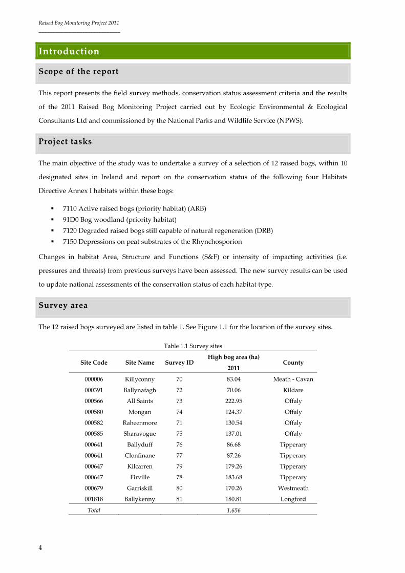
Survey area
The 12 raised bogs surveyed are listed in table 1. See Figure 1.1 for the location of the survey sites.
Table 1.1 Survey sites
Site Code Site Name Survey ID High bog area (ha)
2011 County
000006 Killyconny 70 83.04 Meath ‐ Cavan
000391 Ballynafagh 72 70.06 Kildare
000566 All Saints 73 222.95 Offaly
000580 Mongan 74 124.37 Offaly
000582 Raheenmore 71 130.54 Offaly
000585 Sharavogue 75 137.01 Offaly
000641 Ballyduff 76 86.68 Tipperary
000641 Clonfinane 77 87.26 Tipperary
000647 Kilcarren 79 179.26 Tipperary
000647 Firville 78 183.68 Tipperary
000679 Garriskill 80 170.26 Westmeath
001818 Ballykenny 81 180.81 Longford
Total 1,656

Raised Bog Monitoring Project 2011
______________________________
5
Figure 1.1 Location of surveyed sites (Ordnance Survey Ireland Licence No EN 0059208 ©
Ordnance Survey Ireland / Government of Ireland)

Raised Bog Monitoring Project 2011
______________________________
6
Methods
Field survey methods
Prior to a site visit the NPWS Designated Raised Bog Orthophotos 2010 were examined to identify
potential new active peat forming areas. The higher accuracy of the most recent 2010 aerial
photographs allowed the identification of new active peat forming areas overlooked in the 2004/05
survey. These newly recorded areas are generally small in area (<1ha). NPWS Regional staff were
contacted prior to the site survey and meetings on the sites arranged.
Site notes were recorded throughout the site: community complex types encountered were described,
features of interest, impacts and activities, fauna and notable species were also recorded (see General
data recorded and Recording of quadrats sections for more information). Detailed notes were
recorded in a waterproof notebook. The location of each community complex was fixed on the habitat
map using the GeoXT Trimble handheld GPS minicomputer, (see Data collection section for further
details on data capture).
Species nomenclature followed the following sources:
Vascular plants ‐ Stace, C. (2010) New Flora of the British Isles. 3rd Edition. Cambridge
University Press.
Bryophytes ‐ Blockeel, T. L. & Long, D. G. (1998) A check‐list and census catalogue of British and
Irish bryophytes. British Bryological Society, Cardiff.
Lichens ‐ Coppins, B. J. (2002) Checklist of Lichens of Great Britain and Ireland. British Lichen
Society, London.
General data recorded
The following are the main features recorded in each raised bog:
Community complexes
Active and Degraded Raised Bog are divided into a series of community complexes which are
characterised by a series of vegetation communities and these complexes are then amalgamated into a
series of ecotopes with different physical characteristics using the approach outlined by Kelly and
Schouten (2002).
High bog community complexes were described and mapped and detailed notes were taken on each
community complex and any flush or soak areas on the high bog. These included: species lists; ground
firmness; physical indicators (i.e. burning, bare peat, erosion channels, algae); Calluna vulgaris height
and cover; macro‐topography (i.e. steep slope, slight slope, flat, depression); micro‐topography (i.e.
hummocks, flats, hollows, pools); pools type (i.e. regular, interconnected, tear) and cover; tussocks
Raised Bog Monitoring Project 2011
______________________________
7
type (Trichophorum cespitosum or Eriophorum vaginatum); evidence of degradation or regeneration;
cover of Cladonia and Sphagnum species and Narthecium ossifragum; dominant species cover and
additional comments. Each community complex was named based on the dominance of one or more
than one of the vegetation types listed in table 2.1 below. A more detailed description of different
plant communities that can be found on a high bog was developed by MacGowan (pers. comm., 2003)
based on Kelly & Schouten (2002) (Appendix 1).
Community complexes points and ecotope boundary points were used to generate high bog
vegetation ecotopes maps and subsequently annexed habitats maps.
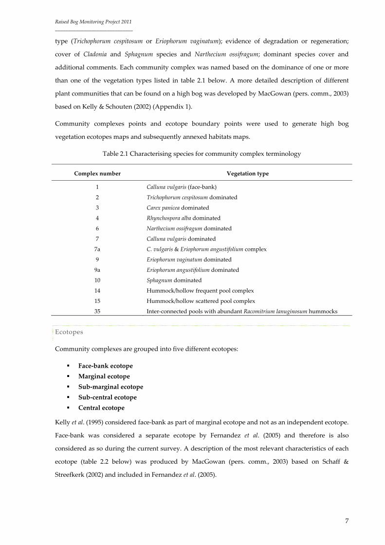
Table 2.1 Characterising species for community complex terminology
Complex number Vegetation type
1 Calluna vulgaris (face‐bank)
2 Trichophorum cespitosum dominated
3 Carex panicea dominated
4 Rhynchospora alba dominated
6 Narthecium ossifragum dominated
7 Calluna vulgaris dominated
7a C. vulgaris & Eriophorum angustifolium complex
9 Eriophorum vaginatum dominated
9a Eriophorum angustifolium dominated
10 Sphagnum dominated
14 Hummock/hollow frequent pool complex
15 Hummock/hollow scattered pool complex
35 Inter‐connected pools with abundant Racomitrium lanuginosum hummocks
Ecotopes
Community complexes are grouped into five different ecotopes:
Face‐bank ecotope
Marginal ecotope
Sub‐marginal ecotope
Sub‐central ecotope
Central ecotope
Kelly et al. (1995) considered face‐bank as part of marginal ecotope and not as an independent ecotope.
Face‐bank was considered a separate ecotope by Fernandez et al. (2005) and therefore is also
considered as so during the current survey. A description of the most relevant characteristics of each
ecotope (table 2.2 below) was produced by MacGowan (pers. comm., 2003) based on Schaff &
Streefkerk (2002) and included in Fernandez et al. (2005).

Raised Bog Monitoring Project 2011
______________________________
8
Table 2.2 Ecotopes characteristics
Ecotope Characteristics
Face‐bank Physical characteristics: Water level low, surface very hard. Degraded micro‐topography
with low hummocks/flats, hollows & lawns. No pools or wet hollows.
Characteristic dominant species: Very tall, vigorous Calluna vulgaris.
Marginal Physical characteristics: Water level low, surface generally hard, soft in spots e.g.
Rhynchospora alba hollows. Degraded micro‐topography, with very little differentiation
between hummocks and hollows etc. Non‐algal pools & tall hummocks absent. Hollows can
be frequent & these are dominated by Rhynchospora/Narthecium/Trichophorum in tussock
form/Algal mats. Pools absent except for tear pools.
Characteristic species: In lawns Narthecium is most dominant, Sphagnum papillosum & S.
capillifolium present in small amounts (not lawns, not big hummocks, but small patches).
Trichophorum common in tussock form. Kelly et al. (1995) also includes Carex panicea as typical
species and more naturally frequent in western sites. In small hummocks Calluna vulgaris,
Sphagnum capillifolium, Cladonia portentosa common and burnt/drained types.
Sphagnum species present in order of decreasing occurrence:
S. capillifolium S. tenellum S. magellanicum S. papillosum
Sub‐marginal Physical characteristics: Surface ranges from hard to soft but not quaking. Wetter vegetation
types are absent except for algal mats/Rhynchospora and Narthecium hollows dominant.
Characteristic species: In lawns Sphagnum papillosum dominant, although absent from some
areas. S. magellanicum & S. capillifolium present but not S. cuspidatum. Trichophorum common,
but in less tussocky form than in marginal ecotope. Rhynchospora fusca occurs in hollows and
pools. In hummocks Calluna vulgaris, Sphagnum capillifolium, Cladonia portentosa common and
burnt/drained types.
Sub‐central Physical characteristics: Surface soft and sometimes quaking, occasionally hard. Micro‐
topography ranges from Narthecium hollows to hummocks (moderately developed).
Generally, however, sub‐central ecotope is lawn dominated with only a few hummocks. The
lawns are usually dominated by Sphagnum magellanicum. Sphagnum cuspidatum pools occur
occasionally & Rhynchospora/algal hollows scarce. Wetter vegetation other than pools is
common.
Characteristic species: Sphagnum magellanicum is often common. S. papillosum occurs in small
amounts. Trichophorum scarce. S. austinii present as a relic from when sub‐central ecotope was
central. According to Kelly et al. (1995) S. magellanicum is often dominant on midland sites
although S. papillosum is frequent also.
Central Physical characteristics: Surface very soft and often quaking. Micro‐topography usually
ranges from pools to tall hummocks (well developed). Pools are frequent to dominant;
however, pools do not have to be present for an area to be classed as central. Lawns of
Sphagnum cuspidatum are also typical of central ecotope areas. All wet vegetation types are
present and frequent.
Characteristic species: Sphagnum cuspidatum pools are common. Rhynchospora/algal hollows
are absent. Cladonia dominated areas are absent.

Raised Bog Monitoring Project 2011
______________________________
9
Ecotope Characteristics
Kelly et al. (1995) differentiate between central ecotope in midlands sites and western sites.
In the midlands the pools of the central complex are usually colonised by S. cuspidatum with
little open water. Other species which tend to occur in the pools are Eriophorum angustifolium
and R. alba with Drosera anglica also occurring quite frequently. In between the pools on the
midland sites Sphagnum lawns and hummocks are frequent. The lawn species are usually S.
magellanicum and S. papillosum while the hummock species are mainly S. magellanicum, S.
capillifolium, S. subnitens, S. austinii and S. fuscum. Leucobryum glaucum hummocks can also
occur. Narthecium hollows with S. tenellum are frequent also. Calluna and Erica tetralix occur in
abundance, the latter growing well on hummocks. The bog surface is wet and soft and the
acrotelm layer is well developed.
On the more westerly sites pools tend to be more elongate and interconnecting with each
other in places. More open water is seen and although S. cuspidatum is still important, S.
denticulatum is more frequent. Campylopus atrovirens occurs around many of the pools edges
and islands dominated by Racomitrium are quite common. Sphagnum lawns can occur
between the pools but in general the inter‐pool Sphagnum cover is lower than on the more
easterly sites. Narthecium is frequent and Carex panicea can also reach high abundances.
Hummocks of S. austinii and S. fuscum and various other Sphagnum and bryophyte species
occur. The bog surface can be wet and soft but in comparison to the midlands central ecotope
the acrotelm layer is not as well developed. It is thought that the hydrology of these western
central pool complexes is somewhat different to the midland sites as excess water may flow
through pools rather than through the inter‐pool Sphagnum layer.
Central and sub‐central ecotopes are allocated to ARB (7110). Flushes and soaks that are wet with
active Sphagnum growth are also classed as ARB. Bog Woodland habitat (91D0) is also considered to
occur on active peat forming areas. Face‐bank, marginal and sub‐marginal ecotopes are allocated to
DRB (7120). Dry flushes and coniferous plantations are also included within this habitat.
Fernandez et al. (2005) generated an ecotope vegetation key including the most common active peat
forming (i.e. central and sub‐central ecotopes) community complexes recorded during their survey
(Appendix 2). In addition a description of the most common central and sub‐central ecotope
community complexes was also provided (Appendix 3). The aim of these documents was to
standardise the surveys and make the data collected comparable for future monitoring projects.
Activities affecting the high bog
Impacting activities such as peat cutting, high bog and cutaway drainage, burning, forestry on high
bog and cutover and invasive species were recorded. Impacting activities were reported based on
Article 17 of the Habitats Directive list of threats and pressures. Regional NPWS staff were consulted
to obtain further information on impacting activities, but also on conservation measures such as
restoration works or negotiations with landowners in relation to peat cutting cessation (e.g. turbary
rights or land purchases). The NPWS Site Inspection Report database was also consulted during the
process; this database holds information on impacting activities that were observed on protected sites.

Raised Bog Monitoring Project 2011
______________________________
10
Impacts and activities were scored based on scoring method given by Ssymank (2011). Appendix 4
provides a description of drainage data collected on the field and terminology used in ranking
impacting activities.
Quadrats
Quadrats recorded in the Fernández et al. (2005) survey were re‐surveyed and additional quadrats
recorded when considered necessary (e.g. new active peat forming areas recorded in 2011 or when it
was deemed that an insufficient number of quadrats were recorded in 2004/05). The size of quadrats
was 4m x 4m (see Recording of quadrats section for further detail).
Photographs
A photographic record of each quadrat was taken. The grid reference of each photograph was fixed
with GPS, and the aspect of each taken with a compass.
Additional photographs of impacting activities were also recorded.
Recording of quadrats
Quadrats were recorded mainly within Active Raised Bog (7110) (i.e. central or sub‐central ecotopes)
and Bog Woodland habitat (91D0), and very occasionally were recorded within DRB (7120). The
comparison of 2004/05 quadrats against the most recent 2011 quadrats has been used for the
assessment S&F of both ARB and DRB conservation status. Variation in species cover, and other
indicators have been taken into consideration to determine whether the S&F of a particular section of
the high bog are declining or improving (see Appendix 6).
2004/05 quadrats within Active and Degraded Raised Bog were approximately 2x2m whereas 2011
quadrats are significantly larger (4x4m). It was decided that due to the heterogeneous nature of a
raised bog micro‐topography and the fact that the 2004/05 quadrats could only be located with a
degree of accuracy of 1‐2m on the field a 4x4m quadrat would capture its variability more accurately,
as well as making their inter‐year comparisons more reliable. Quadrats within Bog Woodland habitat
are 10x10m instead of 4x4m. Bamboo sticks were used to mark all quadrats recorded (i.e. middle
section of quadrat) during the 2011 survey, in order to make their location in future surveys more
reliable.
Cover in vertical projection for all vascular and bryophyte species was recorded using the Domin scale
(see Appendix 5). For each relevé a 12‐figure grid reference (i.e. 6 Easting and 6 Northing) was
obtained using a DGPS unit. All quadrat data were recorded in the field using TerraSync software and
have been transferred to the NPWS Raised Bog Monitoring Microsoft Access database. Appendix 6

Raised Bog Monitoring Project 2011
______________________________
11
provides a detailed description of data recorded within an ARB or DRB quadrat and the definition of
each parameter recorded. This Appendix also includes a Bog Woodland quadrat form.
Habitat mapping
The mapping stage involved digital mapping of habitats according to ecotopes and community
complexes based on Kelly (1993) and Kelly and Schouten (2002). A DGPS/GIS handset (Trimble XT)
was used in the field for mapping.
Almost the entire surface of the high bog was walked through and changes in the vegetation at
community complex level were assessed based on the comparison between 2004/05 survey data and
current survey data. The 2004/05 vegetation community complex descriptions were examined prior to
the field survey.
The minimum mapping size for ecotopes was approximately 4m x 4m. Generally, areas smaller than
the minimum mapping unit were not mapped, however, occasionally these were recorded as points,
particularly in the case of central and sub‐central ecotope vegetation.
A digital copy of Fernández et al. (2005) 2004/05 ecotope and vegetation community complex maps
were used in the field to aid in the mapping of current vegetation. These maps were imported into the
Trimble GeoXT and visualised on the device screen. Hard copies of both ecotope and vegetation
community complexes were also brought to the field. Ecotopes were digitised using ArcGIS 9.3 based
on the NPWS Designated Raised Bog Orthophotos 2010 and habitat boundary points recorded on the
ground. The Irish National Grid (ING) was used as the co‐ordinate reference system.
The main steps involved in the survey mapping were:
Recording community complex records and ecotope boundaries within the sites using
DGPS/GIS handsets (Trimble XT).
Recording of previously recorded (i.e. Fernández et al. 2005) or new quadrats, where required,
using TerraSync data dictionary software.
Recording of impacting activities (e.g. drainage, peat cutting face‐banks, invasive species,
drain blocking, etc.).
Digital photographs were taken of quadrats and impacts and their positions logged in the
DGPS/GIS handsets.
Mapping was done at a 1:1500 scale using the NPWS Designated Raised Bog Orthophotos
2010 as background.
Final site maps were produced in ESRI ArcGIS and have the following attributes:
All GIS data were produced in an ESRI compatible format (shapefiles) and are accompanied
by appropriate metadata.

Raised Bog Monitoring Project 2011
______________________________
12
The digitised spatial data have been fully topologically corrected. There are no open polygons,
dangling arcs or digitising artefacts. There are no ‘multipolygon’ features’. Polygons are fully
attributed.
Habitat polygons are in one continuous layer (shapefile), differentiated by habitat attribution.
Data collection
A GeoExplorer handheld GPS minicomputer (Trimble GeoXT) was used in the field to record the
location of quadrats, ecotope boundaries, photographs, impacting activities (e.g. drainage, peat
cutting, invasive plants) and other points of interest. The GPS positions of these features were logged
and stored on Terrasync software (Trimble). Additional comments were also stored as text fields in
the device. Post‐processing of data was carried out to improve accuracy based on the Active GPS
Network from Ordnance Survey Ireland to obtain sub‐metre accuracy of data.
Site reports
Individual site reports are presented in Volume 2. These reports include vegetation descriptions,
impacting activities descriptions and habitats conservation status assessments results, quadrat data, as
well as maps based on the spatial data collected during the survey using ArcGIS and aerial
photography.
Conservation status assessment
Conservation status assessment at national level
The conservation status of a habitat is defined as the sum of the influences acting on the habitat that
may affect its long‐term viability. The EU Habitats Directive (92/43/EEC) requires that habitats listed
under Annex I are maintained in ‘favourable conservation status’ throughout member states; a
habitat’s status is taken as favourable when:
a) its natural range and the area it covers within that range are stable or increasing
b) the specific S&F which are necessary for its long‐term maintenance exist and are likely to
continue to exist for the foreseeable future
c) the conservation status of its typical species is favourable
To assess conservation status of Annex I habitats, 4 parameters are objectively scored: i) Range, ii)
Area, iii) Structure and Functions, and iv) Future Prospects (Evans & Arrela, 2011).
The method for the assessment of conservation status involves the application of a “traffic‐light”
system and brings together information on the four parameters for each habitat. Each parameter is

Raised Bog Monitoring Project 2011
______________________________
13
assessed as being “Favourable FV” or good/green, “Unfavourable Inadequate (UI)” or poor/amber,
“Unfavourable Bad (UB)” or bad/red and “unknown” or grey.
Favourable Reference Values (FRVs) are set as targets against which current and future values can be
judged. These reference values have to be at least equal to the value when the Directive came into
force, i.e. in 1994 or greater than this value if the long term viability of the habitat is not assured. The
exception to this rule is DRB (capable of regeneration in 30 years) (7120) as this habitat should reduce
if it is successfully restored to ARB (7110). Where 7120 is designated within an SAC a certain portion
of that habitat should be restored within that designated site, although not necessarily all the DRB, as
in some instances cutover bog may be more feasible to restore.
FRVs are set for Range and Area. Favourable Reference Range is the geographic range within which
all significant ecological variations of a habitat are included and which is sufficiently large to allow the
long‐term survival of that habitat. Favourable Reference Area is the minimum value required for the
long‐term viability of the habitat.
The assessment of S&F includes an assessment of the condition and the typical species that
characterise the habitat. Targets should be set for favourable condition and measured using a suitable
suite of indicators.
The impact of pressures and conservation measures are used to determine the Future Prospects of the
habitat.
If any one of the four parameters i) Range, ii) Area, iii) Structure & Functions, and iv) Future Prospects
are assessed as “red”, the overall assessment is also “red” (i.e. Unfavourable Bad). All parameters
must be green to achieve an overall Favourable assessment. Any other combination results in an
Unfavourable Inadequate overall assessment.
Additional qualifiers are given to each assessment (i.e. Range, Area, S&F and Future Prospects) of
conservation status. These indicate the attribute trend and thus whether the status is
Increasing/Improving, Stable or Decreasing/Declining.
Conservation status assessment at raised bog level
The assessment of the conservation status of Annex I raised bog habitats at each raised bog is based on
the conservation status of each one of the following attributes:
Area
Structure & Functions (i.e. quality) ‐ including conservation status of its typical species.
Future Prospects ‐ based on current and future impacts and threats, as well positive actions
(e.g. restoration works) (Ellmauer, 2010).

Raised Bog Monitoring Project 2011
______________________________
14
The monitoring protocol developed by Fernández et al. (2005) has been refined and updated. NPWS
staff were consulted during the process. The results of these individual assessments can be used as
part of the national assessments.
A new criterion has been developed to assess conservation status of raised bog habitats within this
project based on the definition of FRVs for both habitat Area and S&F. FRVs are values that should be
achieved in order for a habitat to reach a Favourable conservation status. The previous criterion
(Fernández et al., 2005) was based on the comparison of values (i.e. habitat area and ecotope area)
between the 1994 and 2004/05 surveys.
ARB (7110) and DRB (capable of regeneration in 30 years) (7120) assessments are inextricably linked.
The very fact that habitat 7120 exists indicates that we are obliged under the Habitats Directive, to
restore more active areas than were present when the Directive came into force.
Many areas of DRB may not be capable or regeneration due to changes on the high bog (topographical
structure (i.e. steep slopes) and hydrology) caused by severe damaging activities (e.g. peat cutting,
drainage); however the potential for regeneration cannot be properly quantified until comprehensive
topographical and hydrological surveys are undertaken.
Active Raised Bog conservation status assessment
Area: this assessment is based on the comparison of current area of ARB against the FRV area. Until
comprehensive topographical and hydrological studies are undertaken at each individual site the FRV
is set at the area of central/sub‐central ecotopes and active flush, plus the area of sub‐marginal
ecotope (DRB), present when the Directive came into force in 1994. As previously mentioned, the
definition of DRB implies that it is capable of being restored to ARB. Therefore, it is reasonable to
include the higher quality/wetter part of the DRB (i.e. sub‐marginal) within the FRV target. As we
cannot assume that all areas of DRB can be restored we have taken a more pragmatic approach setting
FRVs (by omitting marginal and face‐bank ecotopes and inactive flushes from FRV calculations).
A current habitat area greater, equal or 0 ‐ 5% below FRV falls into the Favourable assessment
category (see table 2.3).
A current habitat area value 5% ‐ 15% below FRV falls into the Unfavourable Inadequate
assessment category.
A current habitat area value more than 15% below FRV falls into the Unfavourable Bad
assessment category.
Area is also given a trend assessment based on the variation on its value in the reporting period. Thus
trend is assessed as Stable, Increasing or Decreasing.

Raised Bog Monitoring Project 2011
______________________________
15
Structure & Functions: this assessment is based on the objective that at least half of the current area of
ARB should be made up of central ecotope and active flush (i.e. more pristine examples of ARB
community types). This value is considered to be the S&F FRV. This is quite a conservative target as a
high bog that has never been impacted by drainage is likely to have been covered by more than 80% of
these communities.
A current central ecotope and active flush area value greater, equal or 0 ‐ 5% below FRV falls
into the Favourable assessment category.
A current central ecotope and active flush area value 5% ‐ 25% below FRV falls into the
Unfavourable Inadequate assessment category.
A current central ecotope and active flush area value more than 25% below FRV falls into the
Unfavourable Bad assessment category.
Any variation in typical species distribution and abundance is also noted (e.g. by analysing quadrat
data and also looking at community complexes descriptions) (see Appendix 7 for list of typical
species).
Structure & Functions are also given a trend assessment based on the variation of the extent of both
central ecotope and active flush in the reporting period. Thus trend is assessed as Stable, Improving
or Declining.
When neither central ecotope nor active flush are present or their area is small, variation in sub‐central
ecotope extent and quality characteristics is examined to assess S&F conservation status (i.e. an
increase or decrease 0‐5% in sub‐central ecotope area is taken stable: Favourable assessment; a decline
as Unfavourable assessment: 5‐25% Unfavourable Inadequate and >25% Unfavourable Bad).
Every individual sample of ARB (each individual bog usually has a number of separate areas of this
habitat) on a high bog is examined, and any variation in its extent analysed and subsequently assessed
as stable, expanding, decreasing or newly developed. Detailed information is given within each site
report. Quadrats reported in 2004/05 and re‐surveyed again in 2011 are compared in order to assess
any changes in the presence/absence or coverage of indicators and support the assessments at both
Area and S&F level (see Appendix 6). Any variation in community complex is also taken into account
to evaluate changes within specific habitat areas, the overall habitat Area and its S&F.

Raised Bog Monitoring Project 2011
______________________________
16
Table 2.3 Active Raised Bog assessment method
Area Structure & Functions
Current value >, = “or” (0 ‐ 5%) < FRV F Current value >, = “or” (0 ‐ 5%) < FRV F
Current value = (5% ‐ 15%)< FRV UI Current value = (5% ‐ 25%)< FRV UI
Current value = (15% ‐ 100%)< FRV UB Current value = (25% ‐ 100%)< FRV UB
F: Favourable; UI: Unfavourable Inadequate; UB: Unfavourable Bad
Future Prospects: this attribute is subjectively assessed and is based on the overall impact of negative
and positive activities. The intensity and influence of the activities and any change in the reporting
period are evaluated. A trend value is also given (e.g. Stable, Improving, Declining) based on the
likely future effects of these impacting activities on the habitat. A Favourable ‐ Stable assessment
means that no major threatening activities have occurred, habitat Area or S&F have not changed in the
reporting period and restoration works have taken place; A Favourable – Improving assessment
means that habitat Area or S&F have Increased/Improved in the reporting period and are expected to
do in the future, mostly due to restoration works and lack of major impacting activities; An
Unfavourable Inadequate ‐ Stable assessment means that no further Decrease/Decline in habitat Area
or S&F are expected or an Increase/Improvement due to the lack of restoration measures. An
Unfavourable Bad‐Declining assessment means that a further Decrease/Decline of habitat Area or S&F
is expected due to the presence of impacting activities. If the result of positive measures (e.g.
restoration works) are overriding the negative influence of impacting activities, the overall assessment
may be favourable.
Overall assessment: this assessment is based on the “traffic‐light” system previously mentioned. If
any one of the three parameters i) Area, ii), S&F iii), Future Prospects are assessed as “red”, the overall
assessment is also “red” (i.e. Unfavourable Bad). All parameters must be green to achieve an overall
Favourable assessment. Any other combination results in an Unfavourable Inadequate assessment.
Appendix 8 provides a few examples of different assessment scenarios for further detail.
Degraded Raised Bog conservation status assessment
Area: this assessment is based on the comparison of current area of DRB against the FRV area. Until
comprehensive topographical and hydrological studies are undertaken at each individual site the FRV
is estimated to be equal to the area of marginal and face bank ecotopes and inactive flush when the
Directive came into force in 1994. As previously mentioned, the definition of DRB implies it is capable
of being restored to ARB. Therefore a FRV smaller than current values is desirable in order to achieve
ARB Area FRV. Any increase in degraded areas on the high bog can never be seen as a positive
development. Even remaining at the status quo is not progress. The FRV for DRB (i.e. marginal, face
bank and inactive flush) accepts the fact that it is often not feasible to restore the whole bog and

Raised Bog Monitoring Project 2011
______________________________
17
certain areas (e.g. the edges, steep slopes and mounds) with unsuitable topographical and
hydrological conditions will remain too dry to support ARB.
A current habitat area value smaller or 0 ‐ 5% greater than FRV falls into the Favourable
assessment category.
A current habitat area value 5% ‐ 15% above FRV falls into the Unfavourable Inadequate
assessment category.
A current habitat area value more than 15% above FRV falls into the Unfavourable Bad
assessment category.
Area is also given a trend assessment based on the variation on its value in the reporting period. Thus
trend is assessed as Stable, Increasing or Decreasing. Any decrease in the habitat area as a result of
increase in ARB is taken as positive as regards overall assessment; although a Decreasing trend at
Area level is given.
Structure & Functions: the assessment is based on the variation in marginal, face bank ecotopes1 and
inactive flush in the reporting period.
A variation in the marginal and face banks ecotopes area between 0 – 5% in the reporting
period falls into the Favourable ‐ Stable trend assessment category.
A decrease in marginal and face banks ecotopes area in the reporting period as a result of
development of either sub‐marginal or ARB falls into the Favourable‐ Improving trend
assessment category.
An increase in marginal and face banks ecotopes area between 5% ‐ 25% in the reporting
period associated with drying out processes falls into the Unfavourable Inadequate ‐
Declining trend assessment category.
An increase in marginal and face banks ecotopes area greater than 25% in the reporting period
associated with drying out processes falls into the Unfavourable Bad ‐ Declining trend
assessment category.
A decrease in marginal and face banks ecotopes area in the reporting period due to peat
cutting greater than 0.10ha falls into the Unfavourable Bad ‐ Declining trend assessment
category. (A decrease smaller than 0.10ha would fall into the Favourable ‐ Stable trend
assessment category if none of the above cases occurred.)
Any variations in community complex (e.g. improvements within the habitats that do not manage to
raise it to the status of sub‐marginal ecotope) are also taken into account to evaluate changes within
specific habitat areas, the overall habitat Area and its S&F.
1 Note: where cutting has recently occurred it is expected that the area of face bank ecotope will
continue to expand for at least a decade following cessation of cutting due to drying out of the face
bank area.

Raised Bog Monitoring Project 2011
______________________________
18
Any variation in typical species distribution and abundance was also noted (e.g. by analysing
quadrats data and also looking at community complex descriptions) (see Appendix 7 for list of typical
species).
Future Prospects: this attribute is subjectively assessed and is based on the overall impact of negative
and positive activities. The intensity and influence of the activities and any change in the reporting
period are evaluated. A trend value is also given (e.g. Stable, Improving, Declining) based on the
likely future effects of these impacting activities on the habitat. A Favourable ‐ Stable assessment
means that no major threatening activities have occurred, habitat Area or S&F have not changed in the
reporting period and restoration works have taken place; A Favourable – Improving assessment
means that habitat Area or S&F have Increased/Improved in the reporting period and are expected to
do in the future, mostly due to restoration works and lack of major impacting activities; An
Unfavourable Inadequate ‐ Stable assessment means that no further Decrease/Decline in habitat Area
or S&F are expected or an Increase/Improvement due to the lack of restoration measures. An
Unfavourable Bad‐Declining assessment means that a further Decrease/Decline of habitat Area or S&F
is expected due to the presence of impacting activities. If the result of positive measures (e.g.
restoration works) are overriding the negative influence of impacting activities, the overall assessment
may be Favourable.
Overall assessment: this assessment is based on the “traffic‐light” system previously mentioned. If
any one of the three parameters i) Area, ii), S&F iii), Future Prospects are assessed as “red”, the overall
assessment is also “red” (i.e. Unfavourable Bad). All parameters must be green to achieve an overall
Favourable assessment. Any other combination results in an Unfavourable Inadequate assessment.
The only exception for this habitat would be when the Area has decreased as a result of the
development of ARB. In such a scenario, the Area would be given a Decreasing trend, but the overall
assessment would be assessed as Improving when other attributes (i.e. S&F and Future Prospects) are
also assessed as Improving.
Bog Woodland
Area: this assessment is based on the comparison of current area of Bog Woodland against the FRV
area, which is equal to the area of the habitat when the Directive came into force in 1994.
A current habitat area value greater or 0 ‐ 5% below FRV falls into the Favourable assessment
category.
A current habitat area value 5% ‐ 15% below FRV falls into the Unfavourable Inadequate
assessment category.
A current habitat area value more than 15% below FRV falls into the Unfavourable Bad
assessment category.

Raised Bog Monitoring Project 2011
______________________________
19
Area is also given a trend assessment based on the variation on its value in the reporting period. Thus
trend is assessed as Stable, Increasing or Decreasing.
Structure & Functions: this assessment is based on the assessment of four or a multiple of four
monitoring stops (see Appendix 6). The monitoring stops assessment is based on the achievement of
targets within the following parameters (derived from National Survey of Native Woodlands (Perrin
et al., 2008 (Vol. 1)) :
Positive indicator species
Negative indicator species
Structural data
Target tree species mean diameter breast height (dbh)
Old tree % dead wood
Any variation in typical species distribution and abundance was also noted (see Appendix 7 for list of
typical species).
Future Prospects: this attribute is subjectively assessed and is based on the overall impact of negative
and positive activities. The intensity and influence of the activities and any change in the reporting
period are evaluated. Future Prospects are assessed as Favourable, Unfavourable Inadequate or
Unfavourable Bad. A trend value is also given (e.g. Stable, Improving, Declining) based on the likely
future effects of these impacting activities on the habitat. If the result of positive measures (e.g.
restoration works) are overriding the negative influence of impacting activities, the overall assessment
may be Favourable.
Overall assessment: this assessment is based on the “traffic‐light” system previously mentioned. If
any one of the three parameters i) Area, ii), S&F iii), Future Prospects are assessed as “red”, the overall
assessment is also “red” (i.e. Unfavourable Bad). All parameters must be green to achieve an overall
Favourable assessment. Any other combination results in an Unfavourable Inadequate assessment.
Depressions on peat substrates of the Rhynchosporion
Rhynchospora sp. depressions are found across the entire bog in both ARB and DRB. The habitat is
more frequently found and reaches its finest/wettest quality associated with wet features (Sphagnum
pools, lawns and hollows) on ARB (e.g. in central ecotope complexes (4/15) and sub‐central (10/4, 4/35,
4/14, 4/10, 4+P, 4/9a and 6/4+P), where Rhynchospora spp. are found with high coverage (see Appendix
3)). However, it is also found within sub‐marginal ecotope and within tear pools and run off channels
in marginal ecotope but occurs in lower density and is associated with poorer quality raised bog
vegetation in these instances (e.g. sub‐marginal ecotope complexes (4/9, 7/6/4 and 3/6/4) and marginal
(7/2)).

Raised Bog Monitoring Project 2011
______________________________
20
According to Fernandez et al. (2005) the abundance of Rhynchospora alba may increase in transitional
communities towards degraded conditions within ARB. In addition it is likely to dominate some
community complexes recently affected by burning. However the habitat’s quality and overall high
bog condition declines at these locations as the wet Sphagnum dominated pools disappear. Thus,
although disturbance could increase the presence of the species, an ongoing drying out of the high bog
would lead to the depletion and finally the disappearance of the habitat from the high bog.
Therefore, considering the above, the habitat’s conservation status assessment is based on the
variation on ARB and sub‐marginal ecotope within DRB (e.g. an increase in their overall area and
particularly ARB would give a Favourable assessment, whereas a decline in their overall area would
give an Unfavourable assessment).
Area and Structure & Functions: the physical structure and distribution of the habitat across large
sections of the high bog makes the process of calculating its area unfeasible and as a consequence to
establish realistic FRVs. Thus the assessment of the Area and S&F conservation status is based on the
variation in associated vegetation area: ARB and sub‐marginal ecotope combined.
An increase in the combined area of ARB and sub‐marginal ecotope greater than 5% in the
reporting falls into the Favourable – Increasing trend assessment category.
A variation in the combined area of ARB and sub‐marginal ecotope between 0 – 5% in the
reporting falls into the Favourable ‐ Stable trend assessment category.
A decrease in the combined area of ARB and sub‐marginal ecotope area between 5% ‐ 15% in
the reporting period falls into the Unfavourable Inadequate ‐ Declining trend assessment
category.
A decrease in the combined area of ARB and sub‐marginal ecotope area greater than 15% in
the reporting period falls into the Unfavourable Bad ‐ Declining trend assessment category.
Any variation in community complexes dominated by Rhynchospora alba or Rhynchospora fusca in the
reporting period is also taken into account in evaluating changes within the overall habitat Area and
its S&F.
Any variation in typical species distribution and abundance was also noted (see Appendix 7 for list of
typical species).
Future Prospects: this attribute is subjectively assessed and is based on the overall impact of negative
and positive activities. The intensity and influence of the activities and any change in the reporting
period are evaluated. A trend value is also given (e.g. Stable, Improving, Declining) based on the
likely future effects of these impacting activities on the habitat. A Favourable ‐ Stable assessment
means that no major threatening activities have occurred, habitat Area or S&F have not changed (i.e.
no variation in ARB and/or sub‐marginal ecotope within DRB) in the reporting period; A Favourable –

Raised Bog Monitoring Project 2011
______________________________
21
Improving assessment means that habitat Area or S&F have Increased/Improved (i.e. increase in ARB
and/or sub‐marginal ecotope within DRB (never at the expense of ARB)) in the reporting period and
are expected to do in the future, mostly due to restoration works and lack of major impacting
activities; An Unfavourable Inadequate ‐ Declining assessment means that some decline or negative
changes in associated habitats (i.e. ARB and/or sub‐marginal ecotope within DRB) took place in the
reporting period; An Unfavourable Bad‐Declining assessment means that a major decline or negative
changes in associated habitats (i.e. ARB and/or sub‐marginal ecotope within DRB) took place in the
reporting period. If the result of positive measures (e.g. restoration works) are overriding the negative
influence of impacting activities, the overall assessment may be Favourable.
Overall assessment: this assessment is based on the “traffic‐light” system previously mentioned. If
any one of the three parameters i) Area, ii), S&F iii), Future Prospects are assessed as “red”, the overall
assessment is also “red” (i.e. Unfavourable Bad). All parameters must be green to achieve an overall
Favourable assessment. Any other combination results in an Unfavourable Inadequate assessment.
Overall raised bog conservation status
Any, or all, of the four Annexed habitats can be found on a raised bog site, and thus a different
conservation assessment could have been given to each Annexed habitat. However, both ARB and
Bog Woodland are deemed priority habitat in Annex I of the Habitats Directive, whilst DRB and
Depressions on peat substrates of the Rhynchosporion (EU 7150) are not. Hence due to the higher
conservation value of the first two habitats, the conservation status of these two habitats has a higher
significance value on the assessment of the overall high bog conservation status.
ARB and Bog Woodland are usually interrelated, in fact Bog Woodland is considered as part of ARB
in terms of habitat area. Thus, generally an Unfavourable conservation status of Bog Woodland
implies an Unfavourable conservation status of ARB. However, in the case of different conservation
status assessments for these two habitats the conservation status of ARB prevails over the
conservation status of Bog Woodland in order to assess the overall high bog conservation status

Raised Bog Monitoring Project 2011
______________________________
22
Results
Data deliverables
The following is a summary of the data deliverables:
12 completed site reports were completed (including vegetation (i.e. habitats, ecotopes and
community complexes) descriptions, impacting activities descriptions and habitats
conservation status assessments results, quadrats data, as well as maps based on the spatial
data collected during the survey using ArcGIS and aerial photography). Appendix 9 provides
a list of GIS shapefiles generated in ArcGIS (.shp, .shx .sbx, .sbn, .dbf and .lyr) including a
description of their attribute tables. Three different types of maps were produced. These maps
although mapped at a 1:1500 scale using the NPWS Designated Raised Bog Orthophotos 2010
feature the 6ʺ 1910 Ordnance Survey as background.
‐ Map I: Ecotope and quadrats map: each active peat forming section (i.e. each
individual patch of central, sub‐central and active flush) have been named and a
description of these specific areas is given in each site report, quadrats are also
depicted in this map.
‐ Map II: Community complexes map: each point depicted on the map represents a
geographical record for a community complex. The name of the community complex
is usually written beside each point.
‐ Map III: Impacts map: this map illustrates drainage, burnt areas and high bog
cutaway in the 2004/05‐2010 period.
The existing NPWS Raised Bog Monitoring MS Access database updated and populated. The
database contains the following data:
‐ Survey detail: this contains general site information.
‐ Survey quadrats detail: this contains all data recorded on the field related to each
quadrat.
‐ Survey Impacts: this contains information on impacting activities recorded on the site
and their impact and influence.
‐ Survey ecotope area: this contains information on ecotopes recorded on each site and
their area.
‐ Survey conservation status assessment: this contains information on the conservation
status assessment per habitat and per site.

Raised Bog Monitoring Project 2011
______________________________
23
Project results
The following is a summary of the results obtained as part of the 2011 Raised Bog Monitoring Project,
which surveyed a small proportion of raised bogs designated as SAC (12 raised bogs within 10 SACs
surveyed out of 139 bogs designated within 127 sites (74 NHAs and 53 SACs). NHAs or non‐
designated sites were not proposed for surveying. Only sites located in the east of the River Shannon
were surveyed during this project.
The 2011 field season survey commenced in August and was completed in October. A total of 12
raised bogs within 10 designated sites were surveyed (see figure 1.1 for their location). The area of the
high bog at the sites surveyed ranged from 71ha at Ballynafagh to 228ha at All Saints (see table 1.1). A
total of 62 quadrats were recorded.
Appendix 10 provides a list of the most common community complexes found on the high bog
grouped according to the ecotope they belong to and listing number of records.
Clarifications
The conservation status assessment methodology is based on the comparison of ecotope data obtained
during this survey compared with those of Fernandez et al. (2005) and, for FRVs, with amended
survey data from Kelly (1993) and Kelly et al. (1995). There are certain limitations in this process due to
differences in surveying and mapping techniques between different surveys. The discrepancies have
been reduced as much as possible by re‐interpreting the original data in the light of more standardise
definitions of ecotope (Appendix 3). There have also been changes due to the increasing accuracy of
surveying techniques. The discrepancies between surveys and how they have been handled is
discussed below:
Changes in interpretation of the community complexes
Some community complexes described by Fernandez et al. (2005) have been re‐allocated to a different
vegetation type within this survey. For instance, some sections of sub‐central ecotope community
complex 9/7/10 at Ballykenny bog (001818) have been reassessed and are now deemed to be sub‐
marginal rather than sub‐central ecotope. In this case there was no real change or sub‐central ecotope
loss. Any such changes in interpretation are described for each individual site within the site reports
and the figures against which assessments are made are adjusted accordingly.
Higher mapping accuracy and a more comprehensive survey in 2011
The use of the 2004/05 (Fernández et al. 2005) ecotope maps in digital format, which were imported
and visualised in the field on the GeoXT Trimble devices, as baseline data for surveying has allowed a

Raised Bog Monitoring Project 2011
______________________________
24
more accurate mapping of ARB ecotopes. The 2011 survey allocated more time to field survey and
focused on improving the boundary of central, sub‐central ecotopes and active flushes. Therefore,
both an increase in mapping accuracy and more comprehensive surveying has generated an improved
ecotope map. These changes have been taken into account to amend Fernandez et al. (2005) ecotope
figures to ensure changes were not overestimated. Each individual site report features both original
and amended Fernandez et al. (2005) figures.
New Active Raised Bog areas discovered in 2011
The use of the NPWS Designated Raised Bog Orthophotos 2010, which have much higher resolution
(0.5 m x 0.5 m resolution) than the previous OSi 2000 and 2005 aerial photographs used in the 2004/05
surveys, has allowed the identification of new active peat forming areas prior to the surveying. Many
of these potential active peat forming areas have been subsequently confirmed to be either sub‐central
or central ecotope. The majority of these newly discovered areas are considered to have been already
present in 2004/05. These new areas are described within each individual site report.
Slight changes of high bog boundary
Fernandez et al. (2005) high bog boundary has been more accurately mapped as part of the 2011
project. This has resulted in small area changes in the ecotopes at the edge of high bog, particularly in
face‐bank ecotope. Their amended values have been taken into account and are included in the
2004/05 amended ecotope figures given within each site report.
Conservation status assessment
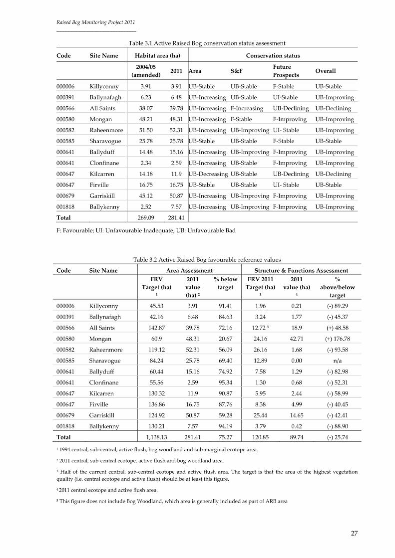
Active Raised Bog
OVERALL CONSERVATION STATUS ASSESSMENT:
ARB conservation status has been assessed as Unfavourable Bad at all raised bogs surveyed, as their
current area is below FRV (see tables 3.1 for assessment results and 3.2 for FRV values versus current
area values). Nonetheless, the overall habitat trend has been assessed as Improving at 7 raised bogs;
Stable at 3 raised bogs and Declining at 2 raised bogs. As table 3.2 indicates the current habitat area
value is 75.27% below target (i.e. Area FRV) and current S&F value (i.e. central and active flush area) is
25.74% below target (i.e. S&F FRV).
All sites, apart from Ballynafagh, assessed as having an Improving trend have had restoration works
carried out. The area of ARB at Ballynafagh has increased slightly due to infilling within the high bog
conifer plantation drains, which controls drainage from the area of ARB. This process is encouraging
the development of new habitat. In addition, it is believed that underlying mineral ridges have

Raised Bog Monitoring Project 2011
______________________________
25
prevented drainage effects from peat cutting and drainage elsewhere on the bog from impacting on
the central area of ARB.
A Stable trend has been given to Sharavogue and Firville. A restoration project took place in 1992 and
subsequently in 1996/7 at Sharavogue; positive results were noted within the previous reporting
period (1994/95‐2004/05). However, no further improvements took place in the new reporting period
2004/05‐2011. No major changes have been noted at Firville bog either, where no significant
restoration works have been undertaken to date.
A Decreasing trend has been noted at Kilcarren and All Saints. Habitat area had continued decreasing
at Kilcarren as previously reported by Fernandez et al. (2005), as negative impacting activities continue
damaging the habitat. All Saints has also been given a Declining trend mostly related to the
Unfavourable Bad Future Prospects expected for the habitat. Habitat area has slightly increased
overall, but this has been accompanied by considerable changes in hydrological conditions within the
high bog associated with impacting activities and also by losses in ARB in other sections of the high
bog.
As table 3.3 illustrates a Favourable conservation status was given to Mongan and Sharavogue in 2005.
This was based on a different conservation status assessment methodology. If these assessments had
been carried out using the 2011 methodology, an Unfavourable Bad assessment would also be given
for these two sites as their ARB area was also below the FRV in 2005.
AREA ASSESSMENT
ARB Area has been assessed as Unfavourable Bad at all raised bogs surveyed, as their current area is
below the FRV. The ARB Area has been given a similar trend to that described above for the overall
habitat: 7 raised bog Increasing trend; 3 Stable and 2 Decreasing trend.
The area of habitat has slightly increased by approximately 12ha in the reporting period (2004/05‐
2011) as a result of expansion and development of active peat forming areas after restoration works.
In addition, to the above assessments table 3.4 provides a comparison between current high bog area
and FRV for habitat Area. The habitat’s Area FRV ranges from 52.99% of high bog at Mongan to
91.25% of high bog at Raheenmore. These values may be revised following topographical and
hydrological examination.
STRUCTURE & FUNCTIONS ASSESSMENT
ARB S&F have been assessed as Favourable at 2 raised bogs and Unfavourable Bad at the remaining
10 bogs. All Saints and Mongan have been given a Favourable assessment due to the large proportion
of finest/wettest quality vegetation (central ecotope and/or active flush) present on the high bog. The

Raised Bog Monitoring Project 2011
______________________________
26
remaining bogs have been given an Unfavourable Bad assessment as the area of the finest vegetation
quality is below the FRV (50% of ARB should consists of finest/wettest vegetation quality) (see table
3.2 for further detail on FRV values versus current values). Four out of these 10 bogs with
Unfavourable Bad assessment have been given an Improving trend, which implies that vegetation
quality has increased in the reporting period. Restoration works were undertaken on all four bogs. No
variation in habitat quality (i.e. S&F) has been noted at the remaining 6 bogs.
Quadrat analysis has shown that slight changes occurred at many of the quadrats in the reporting
period. Although some of these changes indicate changes of vegetation towards either more degraded
(i.e. drier) or better (i.e. wetter) conditions, changes may have also occurred as a result of natural
transitional processes (e.g. Sphagnum hummocks may grow and replace lawns, certain Sphagnum
species may replace others as the Sphagnum grows). Therefore changes should not be analysed out of
context (i.e. looking at several changes indicating a trend within the quadrat and taking into account
activities affecting the habitat (e.g. cutting or drainage would lead to drier conditions and restoration
to wetter conditions)). On the other hand some of the changes noted are also the result of discrepancy
on the quadrat location (up to 2m) between both year surveys despite the use of highly accurate
surveying equipment (Trimble GeoXT). The use of permanent quadrats in the 2011 survey will
minimize the discrepancy due to quadrat location in the next reporting period.
FUTURE PROSPECTS ASSESSMENT
ARB Future Prospects have been assessed as Favourable at 7 raised bogs; Unfavourable Inadequate
at 3 and Unfavourable Bad at 2 bogs. All Saints and Kilcarren have been given an Unfavourable Bad
assessment as negatively impacting activities continue to threaten the habitat as the decline in its area
indicates. An Unfavourable Inadequate, but Stable assessment has been given to Ballynafagh,
Raheenmore and Firville. Although no major changes have taken place at these sites, negatively
impacting activities continue threatening the habitat and hinder the recovery to FRVs. The remaining
7 raised bog have been given a Favourable assessment, with either a Stable or Improving trend
depending on whether none or further increases in the area or improvement in the habitat’s S&F are
expected in the future based on current activities at the sites.
Raised Bog Monitoring Project 2011
______________________________
27
Table 3.1 Active Raised Bog conservation status assessment
Code Site Name Habitat area (ha) Conservation status
2004/05
(amended) 2011 Area S&F
Future
Prospects Overall
000006 Killyconny 3.91 3.91 UB‐Stable UB‐Stable F‐Stable UB‐Stable
000391 Ballynafagh 6.23 6.48 UB‐Increasing UB‐Stable UI‐Stable UB‐Improving
000566 All Saints 38.07 39.78 UB‐Increasing F‐Increasing UB‐Declining UB‐Declining
000580 Mongan 48.21 48.31 UB‐Increasing F‐Stable F‐Improving UB‐Improving
000582 Raheenmore 51.50 52.31 UB‐Increasing UB‐Improving UI‐ Stable UB‐Improving
000585 Sharavogue 25.78 25.78 UB‐Stable UB‐Stable F‐Stable UB‐Stable
000641 Ballyduff 14.48 15.16 UB‐Increasing UB‐Improving F‐Improving UB‐Improving
000641 Clonfinane 2.34 2.59 UB‐Increasing UB‐Stable F‐Improving UB‐Improving
000647 Kilcarren 14.18 11.9 UB‐Decreasing UB‐Stable UB‐Declining UB‐Declining
000647 Firville 16.75 16.75 UB‐Stable UB‐Stable UI‐ Stable UB‐Stable
000679 Garriskill 45.12 50.87 UB‐Increasing UB‐Improving F‐Improving UB‐Improving
001818 Ballykenny 2.52 7.57 UB‐Increasing UB‐Improving F‐Improving UB‐Improving
Total 269.09 281.41
F: Favourable; UI: Unfavourable Inadequate; UB: Unfavourable Bad
Table 3.2 Active Raised Bog favourable reference values
Code Site Name Area Assessment Structure & Functions Assessment
FRV
Target (ha) 1
2011
value
(ha) 2
% below
target
FRV 2011
Target (ha)
3
2011
value (ha) 4
%
above/below
target
000006 Killyconny 45.53 3.91 91.41 1.96 0.21 (‐) 89.29
000391 Ballynafagh 42.16 6.48 84.63 3.24 1.77 (‐) 45.37
000566 All Saints 142.87 39.78 72.16 12.72 5 18.9 (+) 48.58
000580 Mongan 60.9 48.31 20.67 24.16 42.71 (+) 176.78
000582 Raheenmore 119.12 52.31 56.09 26.16 1.68 (‐) 93.58
000585 Sharavogue 84.24 25.78 69.40 12.89 0.00 n/a
000641 Ballyduff 60.44 15.16 74.92 7.58 1.29 (‐) 82.98
000641 Clonfinane 55.56 2.59 95.34 1.30 0.68 (‐) 52.31
000647 Kilcarren 130.32 11.9 90.87 5.95 2.44 (‐) 58.99
000647 Firville 136.86 16.75 87.76 8.38 4.99 (‐) 40.45
000679 Garriskill 124.92 50.87 59.28 25.44 14.65 (‐) 42.41
001818 Ballykenny 130.21 7.57 94.19 3.79 0.42 (‐) 88.90
Total 1,138.13 281.41 75.27 120.85 89.74 (‐) 25.74
1 1994 central, sub‐central, active flush, bog woodland and sub‐marginal ecotope area.
2 2011 central, sub‐central ecotope, active flush and bog woodland area.
3 Half of the current central, sub‐central ecotope and active flush area. The target is that the area of the highest vegetation
quality (i.e. central ecotope and active flush) should be at least this figure.
4 2011 central ecotope and active flush area.
5 This figure does not include Bog Woodland, which area is generally included as part of ARB area

Raised Bog Monitoring Project 2011
______________________________
28
Table 3.3 Active Raised Bog 2005 versus 2011 assessments
Code Site Name 2005 Assessment 2011 Assessment
Area S&F Future
Prospects
Overall Area S&F Future
Prospects
Overall
000006 Killyconny UB UB UB UB UB‐Stable UB‐Stable F‐Stable UB‐Stable
000391 Ballynafagh UB UB UB UB UB‐
Increasing
UB‐Stable UI‐Stable UB‐
Improving
000566 All Saints UB B B UB UB‐
Increasing
F‐Increasing UB‐
Declining
UB‐Declining
000580 Mongan F F F F UB‐
Increasing
F‐Stable F‐Improving UB‐
Improving
000582 Raheenmore UI UB UB UB UB‐
Increasing
UB‐
Improving
UI‐ Stable UB‐
Improving
000585 Sharavogue F F F F UB‐Stable UB‐Stable F‐Stable UB‐Stable
000641 Ballyduff UB UB UI UB UB‐
Increasing
UB‐
Improving
F‐Improving UB‐
Improving
000641 Clonfinane UB UB UB UB UB‐
Increasing
UB‐Stable F‐Improving UB‐
Improving
000647 Kilcarren UB UI UI UB UB‐
Decreasing
UB‐Stable UB‐
Declining
UB‐Declining
000647 Firville UB UB UI UB UB‐Stable UB‐Stable UI‐ Stable UB‐Stable
000679 Garriskill UB UI UI UB UB‐
Increasing
UB‐
Improving
F‐Improving UB‐
Improving
001818 Ballykenny UB UB UI UB UB‐
Increasing
UB‐Stable F‐Improving UB‐
Improving
F: Favourable; UI: Unfavourable Inadequate; UB: Unfavourable Bad
Table 3.4 High bog area versus Active Raised Bog favourable reference value
Code Site Name High bog area (ha) 2011 ARB FRV %
000006 Killyconny 83.04 45.53 54.83
000391 Ballynafagh 70.06 42.16 60.18
000566 All Saints 222.95 142.87 64.08
000580 Mongan 124.37 65.9 52.99
000582 Raheenmore 130.54 119.12 91.25
000585 Sharavogue 137.01 84.24 61.48
000641 Ballyduff 86.68 60.44 69.73
000641 Clonfinane 87.26 55.56 63.67
000647 Kilcarren 180.84 130.32 72.06
000647 Firville 183.68 136.86 74.51
000679 Garriskill 170.26 124.92 73.37
001818 Ballykenny 180.81 130.21 72.01

Raised Bog Monitoring Project 2011
______________________________
29
Degraded Raised Bog
OVERALL CONSERVATION STATUS ASSESSMENT
DRB has been assessed as having an Unfavourable Bad conservation assessment at all raised bogs
surveyed, as their current area is above the FRV. Nonetheless, the overall habitat trend has been
assessed as Improving at 8 raised bogs; Stable at 1 raised bog and Declining at 3 raised bogs (see
tables 3.5 for assessment results and 3.6 for FRV versus current area values).
The above results seem more negative than those given in 2005, where some of the raised bogs were
given either a Favourable or Unfavourable Inadequate assessment. However, there are differences
between the two projects methodologies with new criteria employed for assessing conservation status
in 2011, as described in the Methods section. This is based on the setting of FRVs, and in the particular
case of DRB FRVs smaller than current area values are desirable.
An Improving trend indicates either a decrease in area as a result of the development of ARB or an
improvement of S&F (i.e. increase in sub‐marginal ecotope) as given at Killyconny, Mongan,
Raheenmore, Sharavogue, Ballyduff, Clonfinane, Garriskill and Ballykenny.
A Stable trend indicates no variation in Area or S&F, and Stable Future Prospects. This trend has been
given to Firville.
A Declining trend indicates a decrease in Area or decline of S&F as a result of impacting activities
(e.g. drainage, peat cutting). Area has decreased due to peat cutting at Ballynafagh and All Saints
(where it’s S&F have also declined) and although it has increased at Kilcarren it has been at the
expense of ARB and thus its Future Prospects are deemed Unfavourable Inadequate – Declining as a
result of negatively impacting activities, which continue drying out the high bog and thus threatening
the habitat.
AREA ASSESSMENT
DRB Area has been assessed as Unfavourable Bad at all raised bogs surveyed, as their current area is
above the FRV (see Methods section). Area has been given a similar trend to that described above for
the overall habitat as follows: 1 raised bog Increasing trend (i.e. increase in its area, which indicates
drier conditions and thus negative trend) at Kilcarren; 3 Stable at Killyconny, Sharavogue and Firville
(i.e. no variation in area) and 8 Decreasing trend. Only the decrease at Ballynafagh and All Saints is
related to actual losses in high bog due to peat cutting. Decreases in area for the remaining 6 bogs are
due to the expansion or development of ARB, which should be taken as a positive trend (see table 3.6
for comparison between current area versus FRV).
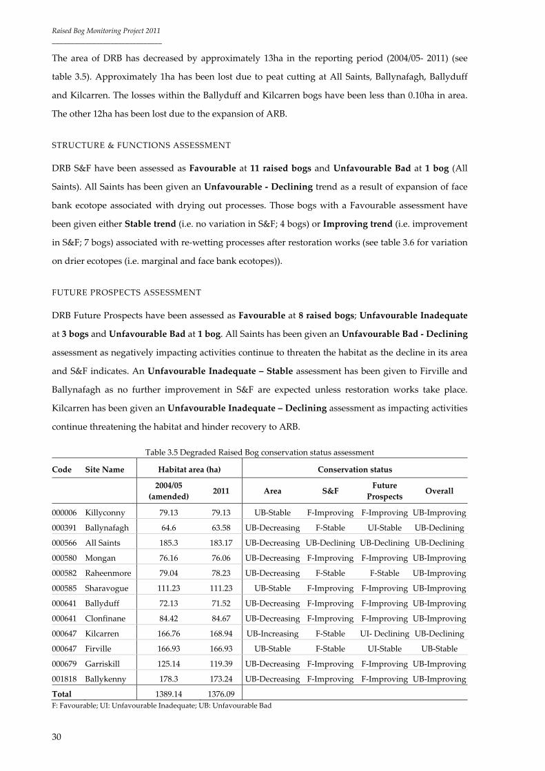
Raised Bog Monitoring Project 2011
______________________________
30
The area of DRB has decreased by approximately 13ha in the reporting period (2004/05‐ 2011) (see
table 3.5). Approximately 1ha has been lost due to peat cutting at All Saints, Ballynafagh, Ballyduff
and Kilcarren. The losses within the Ballyduff and Kilcarren bogs have been less than 0.10ha in area.
The other 12ha has been lost due to the expansion of ARB.
STRUCTURE & FUNCTIONS ASSESSMENT
DRB S&F have been assessed as Favourable at 11 raised bogs and Unfavourable Bad at 1 bog (All
Saints). All Saints has been given an Unfavourable ‐ Declining trend as a result of expansion of face
bank ecotope associated with drying out processes. Those bogs with a Favourable assessment have
been given either Stable trend (i.e. no variation in S&F; 4 bogs) or Improving trend (i.e. improvement
in S&F; 7 bogs) associated with re‐wetting processes after restoration works (see table 3.6 for variation
on drier ecotopes (i.e. marginal and face bank ecotopes)).
FUTURE PROSPECTS ASSESSMENT
DRB Future Prospects have been assessed as Favourable at 8 raised bogs; Unfavourable Inadequate
at 3 bogs and Unfavourable Bad at 1 bog. All Saints has been given an Unfavourable Bad ‐ Declining
assessment as negatively impacting activities continue to threaten the habitat as the decline in its area
and S&F indicates. An Unfavourable Inadequate – Stable assessment has been given to Firville and
Ballynafagh as no further improvement in S&F are expected unless restoration works take place.
Kilcarren has been given an Unfavourable Inadequate – Declining assessment as impacting activities
continue threatening the habitat and hinder recovery to ARB.
Table 3.5 Degraded Raised Bog conservation status assessment
Code Site Name Habitat area (ha) Conservation status
2004/05
(amended) 2011 Area S&F
Future
Prospects Overall
000006 Killyconny 79.13 79.13 UB‐Stable F‐Improving F‐Improving UB‐Improving
000391 Ballynafagh 64.6 63.58 UB‐Decreasing F‐Stable UI‐Stable UB‐Declining
000566 All Saints 185.3 183.17 UB‐Decreasing UB‐Declining UB‐Declining UB‐Declining
000580 Mongan 76.16 76.06 UB‐Decreasing F‐Improving F‐Improving UB‐Improving
000582 Raheenmore 79.04 78.23 UB‐Decreasing F‐Stable F‐Stable UB‐Improving
000585 Sharavogue 111.23 111.23 UB‐Stable F‐Improving F‐Improving UB‐Improving
000641 Ballyduff 72.13 71.52 UB‐Decreasing F‐Improving F‐Improving UB‐Improving
000641 Clonfinane 84.42 84.67 UB‐Decreasing F‐Improving F‐Improving UB‐Improving
000647 Kilcarren 166.76 168.94 UB‐Increasing F‐Stable UI‐ Declining UB‐Declining
000647 Firville 166.93 166.93 UB‐Stable F‐Stable UI‐Stable UB‐Stable
000679 Garriskill 125.14 119.39 UB‐Decreasing F‐Improving F‐Improving UB‐Improving
001818 Ballykenny 178.3 173.24 UB‐Decreasing F‐Improving F‐Improving UB‐Improving
Total 1389.14 1376.09
F: Favourable; UI: Unfavourable Inadequate; UB: Unfavourable Bad

Raised Bog Monitoring Project 2011
______________________________
31
Table 3.6 Degraded Raised Bog favourable reference values
Code Site Name Area Assessment Structure & Functions Assessment
FRV Target
(ha) 1
2011 value
(ha) 2
% above
target
2004/05 M +FB
value (ha) 3
2011 M +FB
value (ha) 4
%
variation
000006 Killyconny 37.51 79.13 210.96 43.57 38.57 11.48
000391 Ballynafagh 27.90 63.58 227.89 28.87 27.96 3.15
000566 All Saints 80.08 183.17 228.73 40.74 40.62 0.29
000580 Mongan 58.47 76.06 130.08 55.52 51.42 7.38
000582 Raheenmore 11.42 78.23 685.03 15.24 15.24 0.00
000585 Sharavogue 52.77 111.23 210.78 29.82 27.82 6.71
000641 Ballyduff 26.23 71.51 272.63 33.06 26.45 19.99
000641 Clonfinane 31.7 84.67 267.10 31.07 24.82 20.12
000647 Kilcarren 50.52 168.94 334.40 44.17 44.07 0.23
000647 Firville 46.82 166.93 356.54 62.38 62.38 0.00
000679 Garriskill 45.34 119.39 263.32 37.1 37.1 0.00
001818 Ballykenny 50.60 173.24 342.37 41.62 16.18 61.12 1 1992 high bog area minus 7110 area FRV.
2 2011 DRB area.
3 2004/05 Marginal and face bank ecotope area.
4 2011 Marginal and face bank ecotope area.
Bog Woodland
Bog Woodland was previously reported to occur at Clonfinane (Fernández et al., 2005). The 2011
survey shows that this priority habitat is not present at the site and the woodland in the high bog at
Clonfinane was wrongly classified as Bog Woodland habitat in previous surveys. Therefore, only All
Saints is the only site surveyed in 2011 considered to harbour Bog Woodland habitat (91D0).
Area has been given an Unfavourable Bad ‐ Stable assessment as the current area is 17.96% below the
FRV due to habitat loss (0.76ha) following a severe fire event in 2002/3. However no variation in area
has taken place in the new reporting period (2005 – 2011) and the trend is therefore Stable.
S&F have been assessed as Favourable‐Stable in the reporting period as all monitoring stops passed.
However, additional monitoring stops should have been included in the northwest section of the
woodland that appears to be drying out.
Impacting activities such as peat cutting, drainage and quarrying threaten associated habitats (i.e.
ARB and DRB). Evidence of changes within Bog Woodland indicates that it may be getting drier and
thus future prospects are deemed Unfavourable Inadequate‐ Declining.
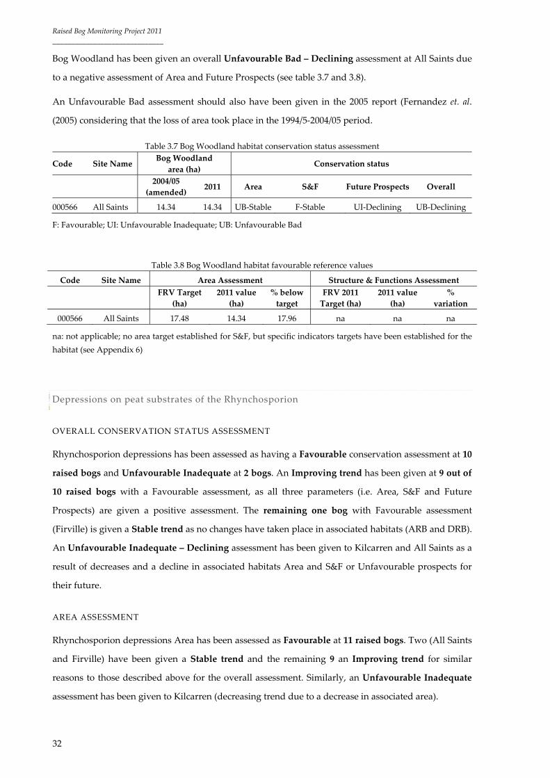
Raised Bog Monitoring Project 2011
______________________________
32
Bog Woodland has been given an overall Unfavourable Bad – Declining assessment at All Saints due
to a negative assessment of Area and Future Prospects (see table 3.7 and 3.8).
An Unfavourable Bad assessment should also have been given in the 2005 report (Fernandez et. al.
(2005) considering that the loss of area took place in the 1994/5‐2004/05 period.
Table 3.7 Bog Woodland habitat conservation status assessment
Code Site Name Bog Woodland
area (ha) Conservation status
2004/05
(amended) 2011 Area S&F Future Prospects Overall
000566 All Saints 14.34 14.34 UB‐Stable F‐Stable UI‐Declining UB‐Declining
F: Favourable; UI: Unfavourable Inadequate; UB: Unfavourable Bad
Table 3.8 Bog Woodland habitat favourable reference values
Code Site Name Area Assessment Structure & Functions Assessment
FRV Target
(ha)
2011 value
(ha)
% below
target
FRV 2011
Target (ha)
2011 value
(ha)
%
variation
000566 All Saints 17.48 14.34 17.96 na na na
na: not applicable; no area target established for S&F, but specific indicators targets have been established for the
habitat (see Appendix 6)
Depressions on peat substrates of the Rhynchosporion
OVERALL CONSERVATION STATUS ASSESSMENT
Rhynchosporion depressions has been assessed as having a Favourable conservation assessment at 10
raised bogs and Unfavourable Inadequate at 2 bogs. An Improving trend has been given at 9 out of
10 raised bogs with a Favourable assessment, as all three parameters (i.e. Area, S&F and Future
Prospects) are given a positive assessment. The remaining one bog with Favourable assessment
(Firville) is given a Stable trend as no changes have taken place in associated habitats (ARB and DRB).
An Unfavourable Inadequate – Declining assessment has been given to Kilcarren and All Saints as a
result of decreases and a decline in associated habitats Area and S&F or Unfavourable prospects for
their future.
AREA ASSESSMENT
Rhynchosporion depressions Area has been assessed as Favourable at 11 raised bogs. Two (All Saints
and Firville) have been given a Stable trend and the remaining 9 an Improving trend for similar
reasons to those described above for the overall assessment. Similarly, an Unfavourable Inadequate
assessment has been given to Kilcarren (decreasing trend due to a decrease in associated area).
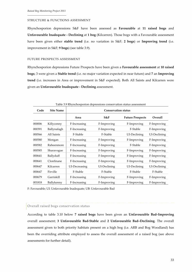
Raised Bog Monitoring Project 2011
______________________________
33
STRUCTURE & FUNCTIONS ASSESSMENT
Rhynchosporion depressions S&F have been assessed as Favourable at 11 raised bogs and
Unfavourable Inadequate ‐ Declining at 1 bog (Kilcarren). Those bogs with a Favourable assessment
have been given either stable trend (i.e. no variation in S&F; 2 bogs) or Improving trend (i.e.
improvement in S&F; 9 bogs) (see table 3.9).
FUTURE PROSPECTS ASSESSMENT
Rhynchosporion depressions Future Prospects have been given a Favourable assessment at 10 raised
bogs; 3 were given a Stable trend (i.e. no major variation expected in near future) and 7 an Improving
trend (i.e. increases in Area or improvement in S&F expected). Both All Saints and Kilcarren were
given an Unfavourable Inadequate ‐ Declining assessment.
Table 3.9 Rhynchosporion depressions conservation status assessment
Code Site Name Conservation status
Area S&F Future Prospects Overall
000006 Killyconny F‐Increasing F‐Improving F‐Improving F‐Improving
000391 Ballynafagh F‐Increasing F‐Improving F‐Stable F‐Improving
000566 All Saints F‐Stable F‐Stable UI‐Declining UI‐Declining
000580 Mongan F‐Increasing F‐Improving F‐Improving F‐Improving
000582 Raheenmore F‐Increasing F‐Improving F‐Stable F‐Improving
000585 Sharavogue F‐Increasing F‐Improving F‐Improving F‐Improving
000641 Ballyduff F‐Increasing F‐Improving F‐Improving F‐Improving
000641 Clonfinane F‐Increasing F‐Improving F‐Improving F‐Improving
000647 Kilcarren UI‐Decreasing UI‐Declining UI‐Declining UI‐Declining
000647 Firville F‐Stable F‐Stable F‐Stable F‐Stable
000679 Garriskill F‐Increasing F‐Improving F‐Improving F‐Improving
001818 Ballykenny F‐Increasing F‐Improving F‐Improving F‐Improving
F: Favourable; UI: Unfavourable Inadequate; UB: Unfavourable Bad
Overall raised bogs conservation status
According to table 3.10 below 7 raised bogs have been given an Unfavourable Bad–Improving
overall assessment; 3 Unfavourable Bad‐Stable and 2 Unfavourable Bad–Declining. The overall
assessment given to both priority habitats present on a high bog (i.e. ARB and Bog Woodland) has
been the overriding attribute employed to assess the overall assessment of a raised bog (see above
assessments for further detail).

Raised Bog Monitoring Project 2011
______________________________
34
Table 3.10 Overall raised bog conservation status
Code Site Name Conservation status
7110 7120 7150 91D0
Overall raised
bog
000006 Killyconny UB‐Stable UB‐Improving F‐Improving n/a UB‐Stable
000391 Ballynafagh UB‐Improving UB‐Declining F‐Improving n/a UB‐Improving
000566 All Saints UB‐Declining UB‐Declining UI‐Declining UI‐Declining UB‐Declining
000580 Mongan UB‐Improving UB‐Improving F‐Improving n/a UB‐Improving
000582 Raheenmore UB‐Improving UB‐Improving F‐Improving n/a UB‐Improving
000585 Sharavogue UB‐ Stable UB‐Improving F‐Improving n/a UB‐ Stable
000641 Ballyduff UB‐Improving UB‐Improving F‐Improving n/a UB‐Improving
000641 Clonfinane UB‐Improving UB‐Improving F‐Improving n/a UB‐Improving
000647 Kilcarren UB‐Declining UB‐Declining UI‐Declining n/a UB‐Declining
000647 Firville UB‐Stable UB‐Stable F‐Stable n/a UB‐Stable
000679 Garriskill UB‐Improving UB‐Improving F‐Improving n/a UB‐Improving
001818 Ballykenny UB‐Improving UB‐Improving F‐Improving n/a UB‐Improving
F: Favourable; UI: Unfavourable Inadequate; UB: Unfavourable Bad
Impacts and threats assessment
The 2011 survey also reported impacts both on the high bog or adjacent land impacting and
threatening EU habitats on the high bog. The following are the survey findings:
Peat cutting
Peat cutting, which consists of the direct removal of peat from the high bog, has occurred during the
reporting period (2004/05‐2011) at 5 raised bogs surveyed (see table 3.11). Commercial peat cutting is
ongoing adjacent to the designated site at Clonfinane. The impact arising from this activity on high
bog habitats at these sites is deemed to have a Medium Importance. Cutting also occurred at Mongan
but on adjacent cutover. Approximately 1ha of high bog has been lost due to peat cutting in the
reporting period at the sites surveyed. The highest losses took place at Ballynafagh and All Saints
where the activity is deemed to have a High Importance/Impact on high bog habitats.
Any peat cutting that took place on these sites between 2004/05‐11 is of a domestic nature and consists
of mechanical peat extraction (i.e. Hopper machinery). Through this technique the high bog margin is
directly cutaway using the hydraulic bucket of a Hopper machine. Once extracted, peat is extruded
from the hopper directly onto the spread grounds, generally adjacent to the face‐bank to dry out. This
method of peat cutting also involves the insertion of drains of various width and depth perpendicular
to the face‐bank on the cutover to ensure dry spread grounds. Occasionally, high bog drains are also
inserted close to the face‐bank.

Raised Bog Monitoring Project 2011
______________________________
35
High bog cutting was already stopped prior to the new reporting period (2004/05‐2011) at Mongan,
Raheenmore, Sharavogue, Clonfinane, Firville, Garriskill and Ballykenny. Cutting was ceased in
during the reporting period at Killyconny, Ballynafagh, Ballyduff and Kilcarren; and thus of the 12
sites surveyed only continues at All Saints.
Although cutting does not directly threaten the high bog habitats at those sites where it was phased
out, secondary impacts (i.e. on‐going subsidence and drainage related to open face‐banks) continue
posing a threat to ARB in many of them. Furthermore, in some of the sites, these secondary impacts
are diminishing the potential for expansion of the habitat despite restoration works.
Table 3.11 Peat cutting summary
Code Site Name Peat cutting
Importance Influence High bog cutaway
(2004/05‐2011) Location Comment
000391 Ballynafagh H ‐1 0.77ha Inside HB
000566 All Saints H ‐1 0.42ha Inside HB
000580 Mongan L ‐1 <0.10ha Outside HB Cutting on cutover
000641 Ballyduff L ‐1 0.03ha Inside HB
000641 Clonfinane M ‐1 0.00ha Inside HB
60ha commercial
exploitation of high
bog adjacent to but
outside of the SAC
000647 Kilcarren M ‐1 0.10ha Inside HB
H: High importance/impact; M: Medium importance/impact; L: Low importance/impact
HB: High Bog
Drainage
All 12 raised bogs surveyed feature some high bog drains functional or reduced functional high bog
drains. This reduced functional drains also includes drains blocked but not completely in‐filled and
thus still providing for relatively rapid drainage of the high bog (see table 3.12). High bog drains have
been deemed to have a High Importance/Impact at 3 raised bogs: Ballynafagh, All Saints and
Kilcarren.
Cutover drainage (i.e. outside the high bog and functional and/or reduced functional) was also
recorded at all 12 raised bogs. This drainage type is generally associated with former or current peat
cutting, but also agriculture land management or rivers and streams management. This activity is
considered to have a High Importance/Impact at 2 raised bogs: All Saints and Raheenmore.
Both high bog and cutover drainage have been given a Medium Importance/Impact at many of the
other raised bogs surveyed (see table 3.12 for further detail).

Raised Bog Monitoring Project 2011
______________________________
36
Table 3.12 Drainage summary
Code Site Name Drainage
Importance Influence Length (km) 1 Location
000006 Killyconny M ‐1 4.103 Inside High Bog
000006 Killyconny M ‐1 n/av Outside High Bog
000391 Ballynafagh H ‐1 4.192 Inside High Bog
000391 Ballynafagh M ‐1 n/av Outside High Bog
000566 All Saints H ‐1 27.393 Inside High Bog
000566 All Saints H ‐1 n/av Outside High Bog
000580 Mongan M ‐1 9.305 Inside High Bog
000580 Mongan M ‐1 n/av Outside High Bog
000582 Raheenmore M ‐1 9.40 Inside High Bog
000582 Raheenmore H ‐1 n/av Outside High Bog
000585 Sharavogue M ‐1 21.912 Inside High Bog
000585 Sharavogue L ‐1 n/av Outside High Bog
000641 Ballyduff M ‐1 11.825 Inside High Bog
000641 Ballyduff M ‐1 n/av Outside High Bog
000641 Clonfinane M ‐1 13.587 Inside High Bog
000641 Clonfinane M ‐1 n/av Outside High Bog
000647 Firville M ‐1 1.909 Inside High Bog
000647 Firville M ‐1 n/av Outside High Bog
000647 Kilcarren H ‐1 6.559 Inside High Bog
000647 Kilcarren M ‐1 n/av Outside High Bog
000679 Garriskil M ‐1 12.158 Inside High Bog
000679 Garriskil M ‐1 n/av Outside High Bog
001818 Ballykenny M ‐1 25.929 Inside High Bog
001818 Ballykenny M ‐1 n/av Outside High Bog
1 This figure only includes functional and reduce‐functional drains.
H: High importance/impact; M: Medium importance/impact; L: Low importance/impact
Burning
Burning is still common on many raised bogs and this activity is mainly associated with peat cutting.
This activity has been recorded in the reporting period at the following sites and its importance and
influence has been ranked as follows:
Ballynafagh bog (SAC 000391): Medium Importance/Impact / 48.37ha burnt (69% high bog).
Mongan bog (SAC 000580): Low Importance/Impact / 50ha burnt (40% high bog).
Clonfinane bog (SAC 000641): Medium Importance/Impact / 59.47ha burnt (68% high bog).
Firville bog (SAC 000647): Low Importance/Impact / 14ha burnt (7.6% high bog).
Kilcarren bog (SAC 000647): Low Importance/Impact / 19ha burnt (12.32% high bog).

Raised Bog Monitoring Project 2011
______________________________
37
Forestry
Forestry can occur either on the high bog or on the cutover area adjacent to the high bog. Forestry on
the raised bogs surveyed, only consists of coniferous plantation. Drainage associated with forestry
planting is the main impact associated with forestry and thus has a similar effect to that of drainage.
Forestry has been reported on the high bog at Ballynafagh (000391), and it covers 10.84ha. This activity
is deemed to have High Importance/Impact on high bog habitats.
Coniferous plantations are also found adjacent to the high bog at the following bogs:
Sharavogue (000585): Low Importance/Impact on high bog habitats.
Ballyduff (000641): Low Importance/Impact on high bog habitats.
Firville (000647): Low Importance/Impact on high bog habitats.
Kilcarren (000647): Low Importance/Impact on high bog habitats.
Invasive species
Invasive species have been recorded at 10 raised bogs: Raheenmore, Killyconny, Ballynafagh,
Sharavogue, Ballyduff, Clonfinane, Firville, Kilcarren, Garriskill and Ballykenny. Invasive species
were deemed to have a Low Importance/Impact at all these raised bogs and their area is always
smaller than 0.1ha.
Conifers and particularly Pinus sylvestris were the most commonly reported invasive species at the
sites surveyed. However, Rhododendron ponticum was also reported at Ballynafagh, Garriskill and
Ballykenny.
Other impacting activities
Other impacting activities recorded at the sites and having some negative influence on high bogs
habitats include the following:
Quarrying: recorded at All Saints, where it was deemed to have a High Importance/Impact on
high bog habitats; Killyconny where its influence on high bog habitats is unknown.
Grazing: recorded at Garriskill and deemed to have Low Importance/Impact.
Motorised vehicles: recorded at Ballynafagh and Kilcarren high bog and deemed to have Low
Importance/Impact.
Management actions

Raised Bog Monitoring Project 2011
______________________________
38
Restoration works
Restoration works have been carried out at 8 out of the 12 raised bog surveyed (see table 3.13) by
NPWS. However, only the restoration works at Killyconny were carried out in this reporting period
(2004/05‐2011). Restoration works at all other sites were carried out previous to this. Restoration work
ranged from the blocking of high bog and/or cutover drains to the construction of dams.
Evidence of improvement in both ARB and DRB was noted in those areas of the high bog where
restoration took place. In the case of Killyconny only improvements on DRB quality (i.e. expansion of
sub‐marginal ecotope) have been noted. This site is at an early stage in the restoration process as
drains were only blocked recently. Coillte Teoranta recently undertook a restoration program as part
of their LIFE project at Killyconny. This mainly included the removal of conifer plantation on cutover
and its effects were not assessed as part of this survey.
Table 3.13 Sites were restoration works were carried out
Code Site Name Restoration works Date Results assessment
000006 Killyconny
Blocking of HB and cutover
drains; removal of cutover
conifer plantation
2006‐2009 DRB quality enhancement
000580 Mongan Blocking of HB drains 1983/4 & 1997 DRB quality enhancement & ARB
development
000582 Raheenmore
Blocking of HB drains and
dams construction on the
cutover
1994/1999 “”
000585 Sharavogue Blocking of HB drains,
restoration of lagg zone
1992 &
1996/97 “”
000641 Ballyduff Blocking of HB drains 2003 “”
000641 Clonfinane Blocking of HB drains 1997‐98 “”
000679 Garriskil Blocking of HB drains 1998 DRB quality enhancement & ARB
development
001818 Ballykenny Blocking of HB drains and
cutover drains 2003
DRB quality enhancement & ARB
development
Further management actions
The NPWS has engaged in negotiations with land owners in relation to the purchase of land and
turbary rights at many of the sites surveyed. This has allowed for the cessation of peat cutting in all
sites except for All Saints where negotiations continue. Thus this activity continues at All Saints
damaging high bog habitats and threatening their survival.

Raised Bog Monitoring Project 2011
______________________________
39
Conclusions
A number of conclusions can be made regarding the findings of this project:
ARB has been given an Unfavourable Bad conservation status at all raised bogs surveyed, as their
current area is below the FRV. Nonetheless, the overall trend has been assessed as Improving at 7
raised bogs; Stable at 3 raised bogs (Killyconny, Sharavogue and Firville) and Declining at 2 raised
bogs (All Saints and Kilcarren). The latter two bogs have been given a Declining trend due to the
impact from negative activities such as peat cutting and drainage. ARB area has increased by
approximately 12ha in the 2004/05 – 2011 reporting period. This increase is associated with re‐wetting
processes associated with restoration works undertaken prior to the reporting period.
ARB favourable reference values are only approximate until more accurate values can be established
once further topographical and hydrological studies allow a better understanding of the potential
capacity of a damaged high bog to support ARB. The above values may not be achievable solely on
the high bog especially in the case of small high bog sites where impacting activities such as drainage
and peat cutting have modified irreversibly the high bog topography and hydrology (e.g. steep
slopes) so that it is not technically feasible to restore ARB. In these cases the restoration of adjacent
cutover areas may be the most feasible way to reach the reference values.
The 2011 survey is characterised by a higher mapping accuracy and more comprehensive surveying
which resulted in an improved vegetation (i.e. ecotope) map. These changes have been taken into
account to amend Fernandez et al. (2005) ecotope figures in order not to overestimate changes by
comparing original values against new values.
DRB has been given an Unfavourable Bad conservation status at all raised bogs surveyed, as their
current area is above the FRV. DRB is a particular habitat for which an FRV area below current values
is required. Nonetheless, the overall habitat trend has been assessed as Improving at 8 raised bogs;
Stable at 1 raised bog (Firville) and Declining at 3 raised bogs (Ballynafagh, All Saints and Kilcarren).
The latter three bogs have been given a Declining trend due to the impact from negative activities
such as peat cutting and drainage. The area of DRB has decreased by approximately 13ha in the
reporting period (2004/05 ‐ 2011). Approximately 1ha has been lost in total, due to peat cutting at All
Saints, Ballynafagh, Ballyduff and Kilcarren.
Bog Woodland was only recorded at All Saints. The habitat has been given an Unfavourable Bad –
Declining assessment at this site. Bog Woodland has been given a Declining trend due to the impact
from negative activities such as peat cutting and drainage. Bog Woodland was previously reported at
Clonfinane. However, the woodland type present at the site is not considered to correspond with the
EU Annex I habitat (91D0).

Raised Bog Monitoring Project 2011
______________________________
40
Depressions on peat substrates of the Rhynchosporion have been given a Favourable conservation
status assessment at 10 raised bogs and Unfavourable Inadequate ‐ Declining at 2 bogs (All Saints
and Kilcarren). The latter two bogs have been given a Declining trend due to the impact from negative
activities such as peat cutting and drainage. An Improving trend has been given at 9 out of 10 raised
bogs with a Favourable assessment. The remaining one bog (Firville) with Favourable assessment has
been given a Stable trend.
The conservation status of priority habitats (i.e. ARB and Bog Woodland) is considered the overriding
attribute to assess the conservation status of each raised bog. Therefore, 7 raised bogs have been given
an Unfavourable Bad–Improving overall assessment; 3 Unfavourable Bad–Stable and 2
Unfavourable Bad–Declining.
Drainage both on the high bog and the cutover associated with peat cutting and peat cutting itself are
the most negatively impacting activities on the raised bogs surveyed.
High bog drainage either functional and/or reduced functional (this also includes those blocked but
not completely in‐filled and thus still discharging some water) was recorded on all 12 raised bogs
surveyed. This activity is considered to have a High Importance/Impact at 3 raised bog surveyed
(Ballynafagh, All Saints and Kilcarren). Cutover drainage (i.e. outside the high bog and functional
and/or reduced functional) was deemed to have High Importance/Impact on the high bog habitats at 2
raised bogs (All Saints and Raheenmore).
Peat cutting has taken place at 5 out of the 12 raised bog surveyed in the reporting period.
Approximately 1ha of high bog has been lost due to this activity. Peat cutting has been phased out at 4
of these 5 raised bogs in the reporting period. The cutting that continues is of a domestic nature and
consists of mechanical peat extraction (i.e. Hopper machinery). Although cutting continues at only one
(All Saints) of the 12 sites, secondary impacts (i.e. on‐going subsidence and drainage related to open
face‐banks) associated with past cutting continues at all sites, posing a threat to ARB in many of these
raised bogs. This activity is considered to have High Importance/Impact at 2 raised bogs surveyed
(Ballynafagh and All Saints).
Burning has been reported at 5 of the 12 raised bogs surveyed (Ballynafagh, Mongan, Clonfinane,
Firville and Kilcarren) in the reporting period. This activity was deemed to have Medium to Low
Importance/Impact on raised bog habitats.
Forestry (i.e. conifer plantations) on the high bog was reported at only Ballynafagh. Here it is deemed
to have High Importance/Impact on high bog habitats. Conifer plantations were also reported on the
cutover at another 4 raised bogs (Sharavogue, Ballyduff, Firville and Kilcarren). This activity was
deemed to have Low Importance/Impact on high bog habitats.

Raised Bog Monitoring Project 2011
______________________________
41
Invasive species were recorded at 10 out of 12 raised bogs surveyed. These are mainly Pinus sp.,
however Rhododendron ponticum was also noted at 3 raised bogs. Invasive species are considered to
have Low Importance/Impact on high bog habitats.
Quarrying although reported at 2 sites (All Saints and Killyconny) is only considered to have High
Importance/Impact on high bog habitats at All Saints.
Restoration works (e.g. blocking of high bog and cutover drains, dams construction) were undertaken
at 9 out of the 12 raised bogs. Killyconny bog was the only bog restored in the reporting period
(2004/05‐2011) (all other restoration works were carried out previous to this). Evidence of both Active
and Degraded Raised Bog improvement was noted in those areas of the high bog where restoration
took place. Killyconny is only at an early stage in the recovery process and only improvements on
DRB were noted. Thus, overall the results of these restoration works are considered to be highly
positive.
The NPWS has also engaged in negotiations with land owners in relation to the purchase of land and
turbary right at many of the sites surveyed. This has allowed for the cessation of peat cutting in all
sites except for All Saints.
Recommendations
Further raised bog monitoring surveys at national level are required in order to gather a more
representative view of the current status of raised bog EU Habitats in Ireland. The selection of further
sites to be surveyed should take into account geographical variation (e.g. sites to the west of the River
Shannon); designated sites where peat cutting activity has continued until recent years or may still be
taking place (e.g. 2011 peat cutting season) and sites only given national protection status (NHA). The
results from the proposed monitoring survey should be used to derive the 2007‐2012 national
assessments of the conservation status of raised bog Annex I habitats.
A new conservation status assessment method has been developed based on the setting of favourable
reference values for both Active and Degraded Raised Bog Area and S&F. Due to the lack of more
detailed information, reference values are based on the area of habitat and ecotopes values in 1994,
when the EU Habitats Directive came into force in Ireland. These values are only approximate until
further topographical and hydrological studies give an improved knowledge of each specific raised
bog’s capacity to support ARB. Thus these types of studies are recommended both to establish site
appropriate FRVs values and as part of a national restoration program.
The results to date support the importance of restoration work in slowing and reversing the loss of
ARB and will be essential to achieve future conservation objectives for ARB. A targeted and properly
designed and implemented restoration program is required to which will optimise resources used and

Raised Bog Monitoring Project 2011
______________________________
42
effectiveness. This program should also include all designated raised bogs in the country (i.e. SACs
and NHAs). Further high bog and cutover restoration works (e.g. removal of conifers, blocking of
drains) and a more appropriate management of adjacent land drainage is necessary in many sites. This
is especially true for those sites where a negative assessment and trend has been given (All Saints and
Kilcarren) but is also the case in other sites in order to achieve the favourable reference values and
thus favourable conservation status.
The individual site assessments have highlighted the potential of cutover areas in some sites to
support and develop ARB. This would be most critical for small raised bogs, where impacting
activities such as peat cutting, drainage and associated subsidence is threatening the continued
existence of ARB on the high bog. On such bogs these activities are more likely to have irreversibly
modified the high bog (i.e. steep slopes) to such an extent that the only possibility for the long term
maintenance/restoration of ARB will be on the cutover. However, this option should also be
considered for bigger sites with large cutover areas where the potential increase of ARB is essential to
achieve national targets for this habitat. Further work is required to understand the nature of
regenerating cutover and when to classify them as ARB. Some of these cutover areas may evolve into
wet heath, wet woodland, etc., rather than ARB once restoration works are undertaken. Thus, the
potential to restore ARB on cutover areas should be investigated in all sites. The issues of how to
assess the potential of cutover for ARB development and the monitoring of actual results will require
considerable further work.

Raised Bog Monitoring Project 2011
______________________________
43
Bibliography & Relevant Literature
The following are considered the main sources of information for the delivery of the project:
Anon. (2007) Interpretation Manual of European Union Habitats. EUR 27, European Commission, DG Environment.
Charles, S. (1996) The Peat Resource of Ireland. Global Peat Resource, Eino Lappalainen, International Peat Society.
Coordination Committee for Global Action on Peatlands (CC‐GAP), (2005) Peatlands, Do you care?
Cross, J.R. (1990) The Raised Bogs of Ireland: their Ecology, Status and Conservation, Department of Finance,
Dublin.
Dahl, E. & Hadac, E. (1941) Strandgesellschaften der Insel Ostøy im Oslofjord. Eine pflanzensoziologische studie.
Nytt Magasin for Naturvidenskapene B, 82, 251–312
Derwin, J. & MacGowan, F. (2000) Raised Bog Restoration Project: A Continuation of the Investigation into the
Conservation and Restoration of Selected Raised Bog Sites in Ireland, Unpublished report, Dúchas the
Heritage Service, Dublin.
Ellmauer, T. (2010) “Future Prospects” Draft discussion paper for the Expert Group on Reporting under the
Nature Directives. European Commission, DG Environment.
Evans, D. & Arvela, M. (2011) Assessment and Reporting Under Article 17 of the Habitats Directive: Explanatory
Notes & Guidelines for the period 2007‐2011, Final Draft 2. European Commission, DG Environment.
Fernández, F., Fanning, M., McCorry, M. & Crowley, W. (2005) Raised Bog Monitoring Project 2004‐5, Unpublished
report, National Parks & Wildlife Service, Department of Environment, Heritage and Local Government,
Dublin.
Fernández, F., MacGowan, F., Crowley, W., Farrell, M., Croal, Y., Fanning, M. & McKee M. (2006) Assessment of
the Impacts of turf cutting on designated Raised Bogs 2003‐06, Unpublished report, National Parks and
Wildlife Service, Department of Environment, Heritage and Local Government, Dublin.
Fernández, F. & Wilson S. (2009) Killamuck Bog (Abbeyleix, Co. Laois) High Bog Ecological Survey, Bord Na
Móna, Dublin.
Fernández, F. & Wilson S. (2009) Clara Bog (Clara, Co. Laois) High Bog Ecological Survey, National Parks & Wildlife
Service, Department of Environment, Heritage and Local Government, Dublin.
Fernández, F. (2010) Assessment of the potential use of LIDAR and GIS technologies in Raised Bog studies ‐ Case
study: Clara Bog, Co. Offaly, Msc. in Spatial Information Management, Dublin Institute of Technology.
Fossitt, J.A. (2000) A guide to habitats in Ireland. The Heritage Council, Kilkenny.
Goodwillie, R. (1980) European Peatlands. Nature and Environment Series No. 19, Council of Europe, Strasbourg,
75 pp.
Hammond, R.F. (1979) The Peatlands of Ireland, An Foras Talúntais, Dublin.
Hammond, R.F. (1984) The Classification of Irish peats as surveyed by the National Soil Survey of Ireland. 7th
International Peat Congress 1984, Dublin.
Irish Peatland conservation Council website. (http://www.ipcc.ie/bogsform.html)
Kelly, L. (1993) Hydrology, Hydrochemistry and Vegetation of Two Raised Bogs in Co. Offaly, Ph.D. thesis,
Trinity College Dublin.
Kelly, L., Doak, M. & Dromey, M. (1995) Raised Bog Restoration Project: An Investigation into the Conservation and
Restoration of Selected Raised Bog Sites in Ireland, National Parks & Wildlife Service, Department of
Environment, Heritage and Local Government, Dublin.

Raised Bog Monitoring Project 2011
______________________________
44
Kelly, L. & Schouten, M.G.C. (2002) Vegetation. In: M. G. C. Schouten (Ed.), Conservation and Restoration of Raised
Bogs: Geological, Hydrological and Ecological Studies, pp.110‐169, Department of Environment and Local
Government, Dublin, Ireland/Staatabosbeheer, The Netherlands.
Lockhart, N., Madden, B., Wolfe‐Murphy, S., Wymer, E. & Wyse‐Jackon, M. (1993) National ASI Survey. Guidelines
for Ecologists. Unpublished report, National Parks & Wildlife Service, Department of Environment,
Heritage and Local Government, Dublin.
Milton, E., Hughes, P., Anderson, K., Schulz, J., Lindsay, R., Kelday, S. & Hill, C. (2005) Remote Sensing of Bog
Surfaces, Joint Nature Conservation Committee, Petersbourough.
Moore, J.J. (1972) A note on the classification of bog vegetation. In: Grundfragen und methoden in
derpflanzensoziologie (Basic problems and methods in phytosociology). Verlag Dr. W. Junk N. V., Den
Haag.
Moore, P.D. & Bellamy, D.J. (1974) Peatlands. Elek Science, London. 221pp.
Morgan‐Jones, W., Poole, J.S. & Goodall, R. (2005) Characterisation of Hydrological Protection Zones at the
Margins of Designated Lowland Raised Peat Bog Sites, Joint Nature Conservation Committee,
Petersbourough.
NPWS (2007) Active Raised Bog Habitat (7110) Conservation Status Assessment, Habitats and Species
Conservation Status Assessment Project, National Parks & Wildlife Service, Department of Environment,
Heritage Local Government, Dublin.
NPWS (2007) Bog Woodland Habitat (91D0) Conservation Status Assessment, Habitats and Species Conservation
Status Assessment Project, National Parks & Wildlife Service, Department of Environment, Heritage
Local Government, Dublin.
NPWS (2007) Degraded Raised Bog Habitat (7120) Conservation Status Assessment, Habitats and Species
Conservation Status Assessment Project, National Parks & Wildlife Service, Department of Environment,
Heritage Local Government, Dublin.
NPWS (2007) Depressions on peat substrates of the Rhynchosporion (7150) Conservation Status Assessment,
Habitats and Species Conservation Status Assessment Project, National Parks & Wildlife Service,
Department of Environment, Heritage Local Government, Dublin.
O’Mahony, C. (in prep.) Conservation Plan for Natura 2000 site. Clara Bog cSAC 572, Co. Offaly, Draft II
Consultation. Period of Plan: 1999‐2004, National Parks & Wildlife Service, Department of Environment,
Heritage and Local Government, Dublin.
Perrin, P., Martin, J. & Barron, S. (2006) National Survey of Native Woodland in Ireland. Second Phase Report. A
report submitted to the National Parks & Wildlife Service.
Perrin, P., Martin, J., Barron, S., O’Neill, F., McNutt, K. & Delaney, A. (2008) National Survey of Native Woodlands
2003 ‐2008. Volume I and II. Unpublished report, National Parks & Wildlife Service, Department of
Environment, Heritage and Local Government, Dublin.
Perrin, P.M., Barron, S.J., Roche, J.R. & O’Hanrahan, B. (2010) Guidelines for a national survey and conservation
assessment of upland vegetation and habitats in Ireland. Version 1.0. Irish Wildlife Manuals, No. 48.
National Parks and Wildlife Service, Department of Environment, Heritage and Local Government,
Dublin, Ireland.
Regan, S. (in prep.) Report on the Comparison of the LIDAR Survey and Ground Terrestrial Survey of Clara Bog
2008, Trinity College, Dublin.
Ryan, J. & Cross, J. (1984) The Conservation of Peatlands in Ireland, Proceedings of the 7th InternationalPeat
Congress, pp. 389‐406, Dublin.

Raised Bog Monitoring Project 2011
______________________________
45
Ryan, J. & Streefkerk, J. (1998) Raised Bogs – Conservation problems and solutions. In O’Leary, G. and Gormley, F.
(eds) Towards a Conservation Strategy for the Bogs of Ireland, pp. 127‐136, Irish Peatland Conservation
Council, Dublin.
Schaaf, S. van der & Streefkerk, J. (2002) Relationship between biotic and abiotic conditions. In: M. G. C. Schouten
(Ed.), Conservation and Restoration of Raised Bogs: Geological, Hydrological and Ecological Studies, pp.186‐209,
Department of Environment and Local Government, Dublin, Ireland/Staatabosbeheer, The Netherlands.
Schouten, M.G.C. (1984) Some aspects of the ecogeographical gradient in the Irish ombrotrophic bogs, paper presented to
7th Int. Peat Congress, Dublin, vol. 1, pp. 414‐432, The International Peat Society, Helsinki.
Schouten, M.G.C. (2002) Conservation and Restoration of Raised Bogs: Geological, Hydrological and Ecological Studies,
Department of Environment and Local Government and Geological Survey of Ireland, Staatabosbeheer,
The Netherlands.
Ssymank, A. (2011) Reference list Threats, Pressures and Activities (final version).
http://circa.europa.eu/Public/irc/env/monnat/library?l=/expert_reporting/workpackage_revision/sub‐
group_papers/pressures_‐threats&vm=detailed&sb=Title. Accessed 12/02/2012.
Smith, A.J.E. & Smith, R. (2004) The Moss Flora of Britain and Ireland, 2nd edition. Cambridge University Press,
Cambridge.
Smith, A.J.E. (1991) The Liverworts of Britain and Ireland, 2nd edition. Cambridge University Press, Cambridge.
Stace, C.A. (1997) New Flora of the British Isles, 2nd edition. Cambridge University Press, Cambridge.
Streefkerk, J.K. & Douglas, C. (1994) Management Plan for Clara East: blocking superficial drains on the High Bog,
National Parks and Wildlife Service, Dublin.
ten Heggeler, M.M.A., van der Ploeg, M.J., Vuurens, S.H. & van der Schaaf, S.( 2005) Subsidence of Clara Bog
west and acrotelm development of Raheenmore Bog and Clara Bog east, A comparison of 1991 ‐ 1992
and 2002‐ 2003, Wageningen University, The Netherlands.
van der Schaaf, S. (2002) Bog Hydrology, in MGC Schouten (ed.),Conservation and Restoration of Raised Bogs:
Geological, Hydrological and Ecological Studies, Department of Environment and Local Government &
Staatabosbeheer, Dublin/The Netherlands.
van der Cruijsen, Grent, A. & van Wolfswinkel. R. (1993) Acrotelm mapping on Clara Bee. Department of Water
Resources, Group Hydrogeology Wageningen Agricultural University, The Netherlands.
White, J. and Doyle, G. (1982) The vegetation of Ireland: a catalogue raisonne. J. Life Sci. 3: 289 – 268.
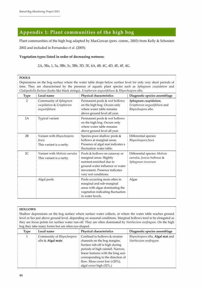
Raised Bog Monitoring Project 2011
______________________________
46
Appendix 1: Plant communities of the high bog
Plant communities of the high bog adapted by MacGowan (pers. comm., 2003) from Kelly & Schouten
2002 and included in Fernandez et al. (2005).
Vegetation types listed in order of decreasing wetness:
2A, 3Ba, 1, 3a, 3Bb, 3c, 3Bb, 3D, 3E, 4A, 4B, 4C, 4D, 4E, 4F, 4G.
POOLS
Depressions on the bog surface where the water table drops below surface level for only very short periods of
time. They are characterised by the presence of aquatic plant species such as Sphagnum cuspidatum and
Cladopodiella fluitans (looks like black strings). Eriophorum angustifolium & Rhynchospora alba.
Type Local name Physical characteristics Diagnostic species assemblage
2 Community of Sphagnum
cuspidatum & Eriophorum
angustifolium
Permanent pools & wet hollows
on the high bog. Occurs only
where water table remains
above ground level all year.
Sphagnum cuspidatum,
Eriophorum angustifolium and
Rhynchospora alba.
2A Typical variant Permanent pools & wet hollows
on the high bog. Occurs only
where water table remains
above ground level all year.
2B Variant with Rhynchospora
fusca
This variant is a rarity.
Species‐poor shallow pools &
hollows at marginal areas.
Presence of algal mat indicates a
fluctuation water table.
Differential species:
Rhynchospora fusca
2C Variant with Molinia caerulea
This variant is a rarity.
Pools & hollows on cutaway or
marginal areas. Slightly
nutrient‐enriched due to
ground‐water influence or water
movement. Presence indicates
very wet conditions.
Differential species: Molinia
caerulea, Juncus bulbosus &
Sphagnum recurvum
Algal pools Pools occurring more often in
marginal and sub‐marginal
areas with algae dominating the
vegetation indicating fluctuation
in water levels.
Algae
HOLLOWS
Shallow depressions on the bog surface where surface water collects, or where the water table reaches ground
level or lies just above ground level, depending on seasonal conditions. Marginal hollows tend to be elongated as
they are focus points for surface water run‐off. They are often dominated by Narthecium ossifragum. On the high
bog they take many forms but are often eye‐shaped.
Type Local name Physical characteristics Diagnostic species assemblage
1 Community of Rhynchospora
alba & Algal mats
Confined to hollows & erosion
channels on the bog margins.
Surface rub‐off is high during
periods of high rainfall. Narrow,
linear features with the long axis
corresponding to the direction of
flow. Moss cover low (<20%),
algal cover high (52%.)
Rhynchospora alba, Algal mat and
Narthecium ossifragum

Raised Bog Monitoring Project 2011
______________________________
47
3a Typical variant: Community
of Narthecium ossifragum,
Sphagnum papillosum & S.
magellanicum
Damp, elongated hollows
holding water during periods of
high rainfall. Herb cover 25%:
dwarf shrub cover 28%: moss
cover >60% suggesting that
hollows remain damp for a long
period of time.
Narthecium ossifragum,
Rhynchospora alba, Sphagnum
papillosum, S. magellanicum and
S. tenellum
LAWNS
These are shallow hollows or flat areas where one species dominates to form a lawn. This is frequently
a Sphagnum species, such as Sphagnum magellanicum, which can completely fill a hollow to form a
small lawn.
Type Local name Physical characteristics Diagnostic species assemblage
3B Sociation of Sphagnum
magellanicum
Confined to pools or very wet
hollows which are completely
in‐filled & remain wet
throughout the year.
Dominant species: Sphagnum
magellanicum
3Ba Sub‐variant with Sphagnum
cuspidatum
Wettest lawn in central ecotope Differential species: Sphagnum
cuspidatum, Cladopodiella fluitans,
Menyanthes trifoliata and Drosera
anglica
3Bb Sub‐variant with Sphagnum
capillifolium
Dry lawn grading into low
hummock (Drier than other
lawn types).
Sphagnum capillifolium,
Eriophorum vaginatum & Calluna
vulgaris
3Bc Sub‐variant with Molinia
caerulea
Only occurs in flushes or soaks. Differential species: Molinia
caerulea and Potentilla erecta
3C Sociation of Sphagnum
papillosum
Hollows to low hummocks –
Central ecotope.
Dominant species: Sphagnum
papillosum in large amounts.
FLATS
These are more or less flat areas which are intermediate between hollow & hummock communities. They tend to
be drier than the above situations.
Type Local name Physical characteristics Diagnostic species assemblage
4 Community of Calluna
vulgaris, Sphagnum
capillifolium & Cladonia
portentosa
Calluna vulgaris, Sphagnum
capillifolium, Cladonia portentosa,
Dicranum scoparium & Hypnum
jutlandicum
4A Typical variant: Community
of Calluna vulgaris,
Sphagnum capillifolium &
Cladonia portentosa
Found in either Flats or
Hummocks – no specific
dominant species.
Calluna vulgaris, Sphagnum
capillifolium, Cladonia portentosa,
Dicranum scoparium & Hypnum
jutlandicum
4D Sociation of Cladonia
portentosa
Found in all ecotopes, although
more widespread in drier
ecotopes. Lichen cover high
(86%), moss cover only
intermediate (45%).
Dominant species: Cladonia
portentosa

Raised Bog Monitoring Project 2011
______________________________
48
HUMMOCKS
These are mounds on the bog surface which can range from a few cm to more than a meter in height. They are
usually composed mainly of Sphagnum species such as Sphagnum magellanicum, S. capillifolium, S. austinii & S.
fuscum but other bryophytes species such as Hypnum jutlandicum & Leucobryum glaucum are also important,
especially as the hummock grows taller and becomes drier. Calluna vulgaris is another important element, as it
flourishes where the water table is not at surface level.
Type Local name Physical characteristics Diagnostic species
assemblage
4A Typical variant: Community
of Calluna vulgaris, Sphagnum
capillifolium & Cladonia
portentosa
Hummocks where no specific moss
species dominates.
Calluna vulgaris,
Sphagnum capillifolium,
Cladonia portentosa,
Dicranum scoparium &
Hypnum jutlandicum
4C Sociation of Leucobryum
glaucum
Dwarf shrub cover on these hummocks
is relatively high indicating
comparatively dry conditions.
Dominant species:
Leucobryum glaucum
4D Sociation of Cladonia
portentosa
Moss cover only intermediate. Dominant species:
Cladonia portentosa
4E Sociation of Sphagnum
capillifolium
Relatively low hummocks (<30cm tall) &
dwarf shrub cover is high usually
around 55%.
Dominant species:
Sphagnum capillifolium
4F Sociation of Sphagnum austinii Tall hummocks (50‐100cm) & shrub
cover high (55%).
Dominant species:
Sphagnum austinii
FACE BANK
Type Local name Diagnostic species assemblage
4G Calluna vulgaris & Hypnum jutlandicum dominated.
DISTURBED AREAS
Areas where draining and/or burning has detrimentally affected the vegetation. Bare peat is characteristic.
Type Local name Physical characteristics Diagnostic species
assemblage
3D Variant with Campylopus
paradoxus & Algal mats
Originally lawns damaged by
draining and or burning.
Differential species:
Campylopus paradoxus, C.
introflexus & Algal mats
3E Variant with Trichophorum
cespitosum
Originally lawns now damaged. Differential species:
Trichophorum cespitosum
4B Variant with Campylopus
introflexus
Burnt and/or drained former
Flats or Hummock area.
Differential species:
Campylopus introflexus, C.
paradoxus, Cladonia furcata,
and Cladonia uncialis subsp.
biuncialis.
4E Sociation of Sphagnum
capillifolium
Dominant species: Sphagnum
capillifolium
4G Sociation of Calluna vulgaris &
Hypnum jutlandicum
Dominant species: Calluna
vulgaris & Hypnum
jutlandicum

Raised Bog Monitoring Project 2011
______________________________
49
Appendix 2: Ecotopes and active peat forming community
complexes key
The following is a rough guide (produced by Fernandez et al. (2005)) to key out ecotopes and the most
common active peat forming (7110) community complexes on Irish raised bogs. It is not an attempt to
summarise all the community complexes present on Irish raised bogs and should thus be considered
as a basis for future surveys that will need to be amended/updated. This key was formulated once the
survey was finished and some of the community complexes described within the site reports do not
fall into the categories developed in the key. However, in hindsight, considering their description
some of them could be renamed and would correspond to the community complexes under this key.
The key is produced to enable a determination down to marginal and sub‐marginal ecotope level
within degraded raised bog.
The description of each community complex is applicable to a 10m‐diameter section around the
position of the surveyor. These community complexes are pooled into ecotope types. The following
attributes are considered to define a community complex: vegetation composition and cover:
Sphagnum cover, robustness of Calluna vulgaris, presence of Cladonia species; ground firmness (firm,
soft, very soft, quaking); acrotelm depth and micro‐topography (e.g. flats, lawns, hollows, pools,
hummocks). The communities are given numeric names according to the dominant or characteristic
species. A more comprehensive description of the community complexes is given in Appendix 3. The
presence of pools has also been considered to name some of the community complexes. This raised
bog vegetation classification is based on Kelly et al. (1995) survey and terminology.
Key
1 Western indicators Racomitrium lanuginosum, Campylopus atrovirens
and large pools with frequent open water all present
3
2 Western indicators Racomitrium lanuginosum, Campylopus atrovirens
and large pools with frequent open water absent
7
3 Pools > 20% cover 4
Pools 10‐20% cover 5
Pools < 10% cover Marginal Ecotope
4 Sphagnum cover > 30% Central Ecotope ‐ Complex 35
Sphagnum cover (10‐ 30%) 6
Sphagnum cover <10% Sub‐marginal Ecotope
Sphagnum absent Marginal Ecotope
6 Sub‐central Ecotope
Narthecium ossifragum > 25% ‐ Complex 6/35
Carex panicea >20% ‐ Complex 3/35

Raised Bog Monitoring Project 2011
______________________________
50
Rhynchospora alba >20% ‐ Complex 4/35
Eriophorum sp. >20% ‐ Complex 9/35
None of the above ‐ Complex 35
5 Sphagnum cover 20‐30% and Narthecium ossifragum >20% Sub‐central Ecotope ‐ Complex
6 + P
Sphagnum cover <20% Sub‐marginal Ecotope
7 Sphagnum cover <10% 8
Sphagnum cover (10‐30%) 9
Sphagnum cover (30‐40%) 10
Sphagnum cover >40% 11
8 Tall robust Calluna vulgaris (>0.4m / >50% cover) and firm ground, at
the edges of the high bog
Face‐Bank Ecotope
Calluna vulgaris not so tall and robust (ca 0.3m) or if so not occurring
at >50% cover
Marginal Ecotope
9 Pool cover < 15% Sub‐marginal Ecotope
Pools cover > 15% and Sphagnum cover 10‐20% Sub‐marginal Ecotope
Pools cover > 15% and Sphagnum cover 20‐30% (40‐50% in the pools).
At least one western indicator species present. Healthy Sphagnum
hummocks. (S. papillosum, occasionally S. austinii and S. fuscum)
Sub‐central Ecotope ‐ Complex
6+Pools (or 6/4 + P when
Rhynchospora alba >15%)
Pools cover > 15% and Sphagnum cover 20‐30% (40‐50% in the pools).
No western indicator species present.
Sub‐marginal Ecotope
10 Pools cover <15% or absent 12
Pools cover >15% 13
12 Narthecium ossifragum <30%, ground soft to very soft, hummocks‐
hollows and sometimes pools. (Sphagnum cover close to 40%).
14
N. ossifragum <30%, ground soft to very soft, hummocks‐hollows and
sometimes pools. (Sphagnum cover close to 30%).
Sub‐marginal Ecotope (e. g.
Complex 9/7)
N. ossifragum >30%, ground firm to soft, hummocks‐hollows, and
pools <5%. (Sphagnum cover close to 30%).
Sub‐marginal Ecotope (e. g.
Complex 9/7/6)
N. ossifragum >30%, at least one western indicator present and pool
cover 10‐15%
Sub‐central Ecotope ‐ Complex
6 + P
14 Eriophorum angustifolium > 15% and ground very soft Sub‐central Ecotope ‐ Complex
9a/10
E. vaginatum > 15% 16
Rhynchospora alba > 15% Sub‐central Ecotope ‐ Complex
4/10
Carex panicea >15% Sub‐central Ecotope ‐ Complex
3/10
None of the above. Narthecium ossifragum 15‐30% Sub‐central Ecotope ‐ Complex
6/10
(These are considered transitional sub‐marginal–sub‐central community complexes where Sphagnum cover
averages at 40%. Similar features but higher Sphagnum cover section 22).
16 Calluna vulgaris <20% Sub‐central Ecotope ‐ Complex 9/10
C. vulgaris >20% 17
17 Narthecium ossifragum (<10%) Sub‐central Ecotope ‐ Complex 9/7/10
Narthecium ossifragum (>10%) Sub‐marginal Ecotope (e.g. Complex
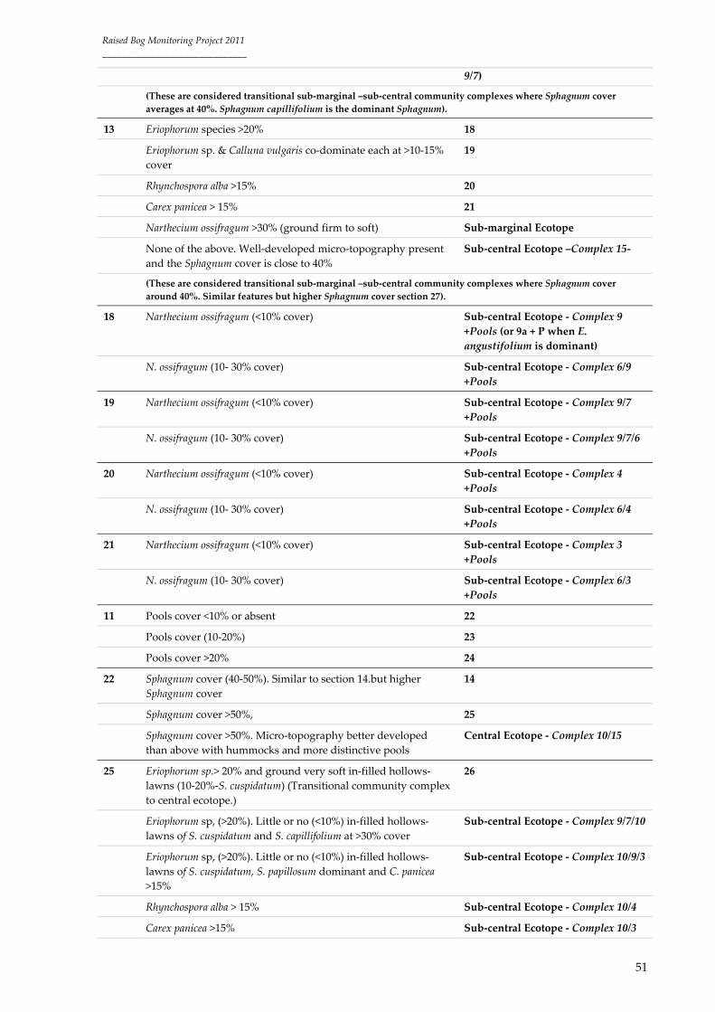
Raised Bog Monitoring Project 2011
______________________________
51
9/7)
(These are considered transitional sub‐marginal –sub‐central community complexes where Sphagnum cover
averages at 40%. Sphagnum capillifolium is the dominant Sphagnum).
13 Eriophorum species >20% 18
Eriophorum sp. & Calluna vulgaris co‐dominate each at >10‐15%
cover
19
Rhynchospora alba >15% 20
Carex panicea > 15% 21
Narthecium ossifragum >30% (ground firm to soft) Sub‐marginal Ecotope
None of the above. Well‐developed micro‐topography present
and the Sphagnum cover is close to 40%
Sub‐central Ecotope –Complex 15‐
(These are considered transitional sub‐marginal –sub‐central community complexes where Sphagnum cover
around 40%. Similar features but higher Sphagnum cover section 27).
18 Narthecium ossifragum (<10% cover) Sub‐central Ecotope ‐ Complex 9
+Pools (or 9a + P when E.
angustifolium is dominant)
N. ossifragum (10‐ 30% cover) Sub‐central Ecotope ‐ Complex 6/9
+Pools
19 Narthecium ossifragum (<10% cover) Sub‐central Ecotope ‐ Complex 9/7
+Pools
N. ossifragum (10‐ 30% cover) Sub‐central Ecotope ‐ Complex 9/7/6
+Pools
20 Narthecium ossifragum (<10% cover) Sub‐central Ecotope ‐ Complex 4
+Pools
N. ossifragum (10‐ 30% cover) Sub‐central Ecotope ‐ Complex 6/4
+Pools
21 Narthecium ossifragum (<10% cover) Sub‐central Ecotope ‐ Complex 3
+Pools
N. ossifragum (10‐ 30% cover) Sub‐central Ecotope ‐ Complex 6/3
+Pools
11 Pools cover <10% or absent 22
Pools cover (10‐20%) 23
Pools cover >20% 24
22 Sphagnum cover (40‐50%). Similar to section 14.but higher
Sphagnum cover
14
Sphagnum cover >50%, 25
Sphagnum cover >50%. Micro‐topography better developed
than above with hummocks and more distinctive pools
Central Ecotope ‐ Complex 10/15
25 Eriophorum sp.> 20% and ground very soft in‐filled hollows‐
lawns (10‐20%‐S. cuspidatum) (Transitional community complex
to central ecotope.)
26
Eriophorum sp, (>20%). Little or no (<10%) in‐filled hollows‐
lawns of S. cuspidatum and S. capillifolium at >30% cover
Sub‐central Ecotope ‐ Complex 9/7/10
Eriophorum sp, (>20%). Little or no (<10%) in‐filled hollows‐
lawns of S. cuspidatum, S. papillosum dominant and C. panicea
>15%
Sub‐central Ecotope ‐ Complex 10/9/3
Rhynchospora alba > 15% Sub‐central Ecotope ‐ Complex 10/4
Carex panicea >15% Sub‐central Ecotope ‐ Complex 10/3

Raised Bog Monitoring Project 2011
______________________________
52
None of the above. Narthecium ossifragum 15‐30% Sub‐central Ecotope ‐ Complex 10/6
26 Eriophorum angustifolium dominant Sub‐central Ecotope ‐ Complex 10/9a
E. vaginatum dominant Sub‐central Ecotope ‐ Complex 10/9
23 Sphagnum cover (40‐60%) 27
Sphagnum cover >60% Central Ecotope ‐ Complex 15 or 4/15
when Rhynchospora alba >15%
27 Eriophorum species >20% 28
Rhynchospora alba >15% 29
Carex panicea >15% Sub‐central Ecotope‐ complex 6/3
+Pools
None of the above. Narthecium ossifragum 15‐30% Sub‐central Ecotope ‐ Complex 6 +
Pools
28 Narthecium ossifragum (<10% cover) Sub‐central Ecotope ‐ Complex 9
+Pools
N. ossifragum (10‐ 30% cover) Sub‐central Ecotope‐ Complex 6/9
+Pools
29 Narthecium ossifragum (<10% cover) Sub‐central Ecotope ‐ Complex 4
+Pools
N. ossifragum (10‐ 30% cover) Sub‐central Ecotope ‐ Complex 6/4
+Pools
24 Sphagnum cover (40‐60%) 30
Sphagnum cover >60% Central Ecotope ‐ Complex 14
30 Narthecium ossifragum (>20% cover) Sub‐central Ecotope ‐ Complex 6/14
Rhynchospora alba (>20% cover) Sub‐central Ecotope ‐ Complex 4/14
None of the above Sub‐central Ecotope ‐ Complex 14‐

Raised Bog Monitoring Project 2011
______________________________
53
Appendix 3: Most common central and sub‐central ecotope
community complexes
CENTRAL ECOTOPE COMPLEXES
Complex 14
Micro‐topography: Hummocks, hollows and pools (>20% cover) and sometimes lawns.
Sphagnum cover: 60‐100%
Firmness: Very soft to quaking
Characteristic species: Sphagnum cuspidatum (>20% cover)
Apart from some soak areas, this central ecotope complex indicates the wettest conditions on the high
bog. Quaking mats of Sphagnum characterise this complex with S. cuspidatum‐filled pools covering
>20% of the complexes surface area. The pools support Eriophorum angustifolium, Drosera anglica and
Menyanthes trifoliata with Rhynchospora alba around the pool edges and in patches within the pools.
Algae is absent from the pools. The inter‐pool areas usually support frequent hummocks of Sphagnum
capillifolium as well as hummocks of S. fuscum and S. austinii. S. papillosum and S. magellanicum are also
frequent usually occurring in lawns and replacing S. cuspidatum as the dominant Sphagnum towards
the edges of the complex. Calluna vulgaris (5‐10%) and Eriophorum vaginatum (5‐10%) are found at low
cover values on the hummocks with Narthecium ossifragum and Erica tetralix also present, but at a
lower cover value (ca. 5%). The overall Sphagnum cover is 60‐100%.
In some areas drier versions of this complex are found with characteristics intermediate between
central and sub‐central ecotope. Pool cover in these areas is still at least 20% cover, but algal pools are
more common. Furthermore, although Sphagnum cuspidatum dominates, S. magellanicum is more
frequent than above. The overall Sphagnum cover is also lower, tending to average at 40‐60% cover. In
some of these areas Narthecium ossifragum dominates the inter‐pool vegetation at close to 20% cover
(Sub‐central complex 6/14) and in other areas Rhynchospora alba becomes more common and the
complex is termed 4/14. If neither of these species occur at >20% cover the complex is simply termed
14‐.
Complex 15
Micro‐topography: Hummocks, hollows and pools (10‐20% cover) and sometimes lawns.
Sphagnum cover: >60%
Firmness: Very soft and sometimes quaking

Raised Bog Monitoring Project 2011
______________________________
54
Characteristic species: Sphagnum cuspidatum (>10% cover)
This is a wet central ecotope complex that is characterised by scattered Sphagnum cuspidatum‐filled
pools usually covering 10‐20% of the complexes surface area. The complex is often found in a
depression and the bog surface is very soft and sometimes quaking. The pools support Eriophorum
angustifolium, Drosera anglica and Menyanthes trifoliata with Rhynchospora alba around the pool edges
and in patches within the pools. There are also very occasional patches of algae and/or open water in
the pools. The inter‐pool areas usually support frequent hummocks of Sphagnum capillifolium (10%) as
well as hummocks of S. fuscum and S. austinii. S. papillosum and S. magellanicum are also frequent (20‐
40% cover) and usually dominate around the pool edges, and also occur in lawns as well as low
hummocks. Calluna vulgaris (5‐10%) and Eriophorum vaginatum (5‐10%) are found at low cover values
on the hummocks with Narthecium ossifragum and Erica tetralix also present, but at a lower cover value
(ca. 5%). The overall Sphagnum cover averages at 60‐80%. When the presence of Rhynchospora alba is
greater than 15% the complex is termed 4/15.
Complex 10/15
Micro‐topography: Hummocks, hollows and lawns with pools (<10% cover)
Sphagnum cover: >50%
Firmness: Very soft and sometimes quaking
Characteristic species: Sphagnum magellanicum and S. cuspidatum co‐dominate the lawns/pools
This is a central ecotope complex and the bog surface is usually very soft underfoot and is occasionally
quaking. The Micro‐topography is characterised by hummocks, lawns and pools. However, the pools
are more like Sphagnum filled hollows/lawns than pools with S. cuspidatum and S. magellanicum
usually dominating in them. S. magellanicum is usually a larger component of this complex than it is in
Complex 14 or 15. Rhynchospora alba is also more frequent than in Complex 14 or 15 occurring at 10‐
20% cover across the Sphagnum lawns. Sphagnum papillosum also occurs in lawns and low hummocks
particularly at pool margins (where the pools are more distinct). Eriophorum vaginatum often grows
abundantly across the Sphagnum lawns and where is reaches cover values of >20% the complex is
termed 10/9/15. Calluna vulgaris (10%) grows on hummocks, which are usually composed of S.
papillosum and S. capillifolium with occasional S. austinii. The overall Sphagnum cover averages at >50%.
Narthecium ossifragum is usually present at a low cover value (ca.5%), but can increase towards the
margins of the complex.
Complex 35
Micro‐topography: Pools (>20%), flats and hummocks

Raised Bog Monitoring Project 2011
______________________________
55
Sphagnum cover: >30%
Firmness: Soft to very soft and sometimes quaking
Characteristic species: Racomitrium lanuginosum and Campylopus atrovirens
This is the wet central ecotope complex of the western raised bogs. Pools are frequent, covering >20%
of the complexes surface area, but tend to differ from the pools of the midland raised bogs in a
number of ways. Firstly they tend to be deeper and more elongate and inter‐connecting. Secondly
open water is much more visible and predominates in many pools. Thirdly although S. cuspidatum is
still present, S. denticulatum is much more frequent than in the midland bogs and is sometimes the
most common of the aquatic Sphagna. Where the pools are shallower there is a higher cover of
Sphagnum cuspidatum and pools sometimes contain scattered Rhynchospora alba, Eriophorum
angustifolium, Drosera anglica and Menyanthes trifoliata and some algal patches are present, but not
dominant. Campylopus atrovirens is usually present at the pool margins along with Sphagnum
papillosum. Island hummocks of Racomitrium lanuginosum are also common. The inter‐pool vegetation
has a much poorer Sphagnum cover than in the midland raised bogs with Narthecium ossifragum flats
usually dominating. Hummocks are present, however, with S. austinii, S. fuscum and S. capillifolium
occurring. The overall Sphagnum cover is much lower than in the midland raised bogs averaging at
approximately >30% with S. papillosum usually the most abundant Sphagna. Carex panicea is also much
more common on this central complex (10%) than in the midland central complexes where it is usually
absent or present in very low amounts (<5%). Eriophorum vaginatum and Calluna vulgaris are usually
present on hummocks. Where Narthecium ossifragum flats reach cover values of >25%, the Sphagnum
cover is usually slightly lower (10‐30%) and the complex is termed sub‐central 6/35.
SUB‐CENTRAL ECOTOPE COMPLEXES
Complex 15‐
Micro‐topography: Hummocks and hollows and pools (>15% cover)
Sphagnum cover: 30‐40%
Firmness: Soft to very soft but rarely quaking
Characteristic species: Sphagnum cuspidatum (>5%)
This is a sub‐central complex in which there is a moderate to well developed micro‐topography with
hummocks and hollows and pools. The surface is soft to very soft underfoot, but rarely quaking and
the pools, which cover 10‐20% of the surface area, are showing signs of desiccation. This is evidenced

Raised Bog Monitoring Project 2011
______________________________
56
by a reduced cover of S. cuspidatum and increased algal cover in most pools. Sphagnum magellanicum is
colonising the edges and covers some of the former pool areas. Sphagnum papillosum and sometimes S.
pulchrum are present at the pool edges and Rhynchospora alba and Narthecium ossifragum are frequent
and appear to be invading the former pool areas. Eriophorum angustifolium (10%), Menyanthes trifoliata
and Drosera anglica are all present in the more permanent pools. The overall Sphagnum cover is
approximately 30‐40% and is comprised mostly of hummocks. Occasionally these hummocks can be
large (>0.5m) and are usually composed of S. capillifolium and S. austinii. Calluna vulgaris (10‐20%) and
Eriophorum vaginatum (10%) dominate the vegetation on hummocks and Narthecium ossifragum is
present in flats (10%) along with Carex panicea (ca. 5%).
Complex 10/9
Micro‐topography: In‐filled hollows/lawns and hummocks with pools <10% or absent
Sphagnum cover: >50%
Firmness: Soft to very soft and sometimes quaking
Characteristic species: Eriophorum sp. (>20%) and Sphagnum cuspidatum (10‐20%)
This is a wet sub‐central complex, which shares many characteristics of a central complex ecotope. The
surface, in general, is soft to very soft underfoot with occasional quaking areas. There is a very good
Sphagnum cover (60‐70%) and the vegetation is dominated by lawns of S. papillosum, S. magellanicum
and S. cuspidatum along with frequent tufts of Eriophorum vaginatum (>20%) and E. angustifolium.
However, the Micro‐topography is poorly developed with lawns dominating and only occasional low
hummocks and very occasional small pools. The hummocks are usually of S. capillifolium and S.
papillosum (which grades into lawns) and occasionally of S. fuscum and S. austinii. Calluna vulgaris
(10%) is frequent on hummocks and Rhynchospora alba (10%) is scattered across the Sphagnum lawns,
which are composed mostly of S. cuspidatum and S. magellanicum. A variant of this complex occurs
where Eriophorum angustifolium is more dominant and this is termed 10/9a. The dominant Sphagna in
10/9a is usually S. magellanicum.
Complex 10/4
Micro‐topography: Hummocks and hollows with pools <10% or absent
Sphagnum cover: 40‐60%
Firmness: Very soft
Characteristic species: Rhynchospora alba (>15%)

Raised Bog Monitoring Project 2011
______________________________
57
This is a sub‐central complex, in which the surface is usually very soft underfoot. Low hummocks and
hollows are present and sometimes there are occasional pools (<20% cover) that appear to be suffering
from desiccation. Sphagnum (50‐60%) dominates the vegetation occurring in low hummocks, lawns, in‐
filled hollows and dried‐out pools along with Rhynchospora alba (>15%), which is found growing in
dried‐out pools, hollows and lawns. The hollows and pools appear to have a lowered water table and
thus algae is often frequent and the dominant Sphagna are Sphagnum papillosum and S. magellanicum
with only small patches of S. cuspidatum occurring (ca. 10%). Eriophorum angustifolium, Drosera anglica
and Menyanthes trifoliata are found occasionally. Hummocks of S. capillifolium are frequent and
hummocks of S. austinii, S. subnitens and S. fuscum are also usually present. Calluna vulgaris (10‐20%)
dominates in hummocks with Eriophorum vaginatum (5‐20%) frequent in places. Narthecium ossifragum
is present at low cover values in hollows (<10%). In areas where the cover of Sphagnum decreases to ca.
40‐50% the complex is termed 4/10. Where pools occur at a cover of 10‐20%, but the description of the
complex is similar to above, the complex is termed 4 + P.
Complex 10/6
Micro‐topography: Hummocks and hollows with pools <10% or absent
Sphagnum cover: 40‐60%
Firmness: Very soft
Characteristic species: Narthecium ossifragum (15‐30%)
This is a sub‐central complex in which there is a poorly developed Micro‐topography. The bog surface
is very soft underfoot and the Sphagnum cover is usually 40‐60% dominated by lawns/low hummocks
of S. papillosum and S. magellanicum with S. cuspidatum found in in‐filled hollows in the wettest parts of
the complex. However, these areas generally display signs of desiccation (algae) though Menyanthes
trifoliata, Drosera anglica and Eriophorum angustifolium are usually present. Narthecium ossifragum lawns
and hollows are dominant averaging at 15‐30% cover along with small scattered amounts of
Rhynchospora alba. Hummocks of Sphagnum capillifolium and S. austinii are usually present at low cover
values, as is Eriophorum vaginatum (10%). In areas where the cover of Sphagnum decreases to ca. 40‐50%
the complex is termed 6/10. Where pools occur at a cover of 10‐20%, but the description of the complex
is similar to above, the complex is termed 6 + P.
Complex 9/10
Micro‐topography: Hummocks and hollows with pools <10% or absent
Sphagnum cover: 40‐50%
Firmness: Soft to very soft but not quaking

Raised Bog Monitoring Project 2011
______________________________
58
Characteristic species: Eriophorum vaginatum (>15%)
This is a sub‐central complex in which the surface is soft to very soft underfoot, but not quaking. Low
hummocks and hollows characterise the Micro‐topography and sometimes there are very occasional
pools (<10% cover). The Sphagnum cover is 40‐60% composed mostly of lawns/low hummocks of S.
papillosum. S. magellanicum and S. cuspidatum are present in small patches in the wettest areas, but S.
cuspidatum usually doesn’t reach cover values of 10%. S. capillifolium, S. austinii and S. fuscum are also
usually present. Eriophorum vaginatum is the dominant higher plant (>15%) with Calluna vulgaris (10%)
on hummocks. Eriophorum angustifolium and Rhynchospora alba occur in the wetter areas of the complex
at approximately 5‐10% cover. Narthecium ossifragum is present in hollows but at very low cover
values (5%), increasing to 10‐20% in areas where the complex becomes more degraded. In some areas
where there are no pools, Calluna vulgaris increases to greater than 20% and the complex is termed
9/7/10. A variant of this complex occurs where Eriophorum angustifolium is more dominant and the
surface is very soft underfoot. This is termed 9a/10. Where pools occur at a cover of 10‐20%, but the
description of the complex is similar to above, the complex is termed 9 + P or 9a + P.
Complex 6/9 + Pools (6/9 + P)
Micro‐topography: Hummocks and hollows with pools 10‐20%
Sphagnum cover: 30‐50%
Firmness: Soft
Characteristic species: Narthecium ossifragum (10‐30%) and Eriophorum sp. (>20%)
This is a sub‐central complex in which the bog surface is soft underfoot and low hummocks, hollows
and pools characterise the Micro‐topography. Pools cover 10‐20% of the surface area and many have
an algal covering with a patchy cover of Sphagnum cuspidatum (30‐50% of each pool) though most have
a high cover of S. papillosum and/or S. magellanicum around their margins. Drosera anglica, Rhynchospora
alba and Eriophorum angustifolium are also present in the pools. The overall Sphagnum cover is 30‐40%
composed mostly of hummocks of S. papillosum, S. capillifolium and S. austinii. Narthecium ossifragum
(20%) and Eriophorum vaginatum (15‐20%) dominate the inter‐pool vegetation along with Calluna
vulgaris (10%). Complex 6 + P is similar, but has a lower cover of Eriophorum vaginatum and usually a
lower Sphagnum cover and is thus considered to be more degraded.
Complex 6 + Pools (6 + P)
Micro‐topography: Hummocks, hollows and flats with pools 10‐20%
Sphagnum cover: 30‐50%

Raised Bog Monitoring Project 2011
______________________________
59
Firmness: Soft
Characteristic species: Narthecium ossifragum (10‐30%)
This sub‐central complex is similar to the sub‐central complex 6/4 + P, but is not restricted to western
raised bogs and the cover of Rhynchospora alba is usually not so high (<10%). Hummocks, hollows, flats
and pools characterise the Micro‐topography and the surface is soft underfoot. Pools cover 10‐20% of
the surface area and contain algae with a patchy cover (ca. 30‐50% of each pool) of Sphagnum
cuspidatum along with Rhynchospora alba, Drosera anglica and Eriophorum angustifolium. Hummocks of S.
capillifolium are frequent and there are usually occasional hummocks of S. austinii and S. fuscum. The
inter‐pool vegetation is dominated by flats of Narthecium ossifragum (>25%) with Calluna vulgaris found
growing on hummocks usually at 10‐20% cover. This is considered a poor quality sub‐central ecotope
complex with many attributes of a sub‐marginal ecotope complex.
The overall Sphagnum cover is 30‐40% and may be even lower on western sites. Furthermore, in
western sites S. denticulatum becomes more prominent and the overall Sphagnum cover in the pools is
usually lower (ca. 20‐30% of each pool) with S. papillosum and Campylopus atrovirens found at the pool
edges. On the western sites Carex panicea is usually frequent and where it reaches cover values of >15%
the complex s termed 6/3+ P.
Complex 6/35
Micro‐topography: Flats, pools (>20% cover) and hummocks
Sphagnum cover: 10‐30%
Firmness: Soft
Characteristic species: Racomitrium lanuginosum, Campylopus atrovirens and Narthecium ossifragum
(>25%)
This is a sub‐central complex that is found on western raised bogs. The bog surface is usually soft
though it can be very soft occasionally. It is similar to the central complex 35, but Narthecium
ossifragum flats are more common with N. ossifragum covering >25% of the surface area. Pools cover
>20% of the surface area and have a very patchy cover of Sphagnum (ca. 20% of each pool). The pools
are mostly filled with open water though Eriophorum angustifolium, Drosera anglica and Menyanthes
trifoliata area usually present as well as algae. Sphagnum papillosum is usually abundant at the pool
margins with the western indicator Campylopus atrovirens also present. Island hummocks of
Racomitrium lanuginosum are also usually occasional. Narthecium ossifragum (25%) dominates the inter‐
pool areas along with Rhynchospora alba (10‐20%), which occurs mostly at the pool margins. The
overall Sphagnum cover within this complex is 10‐30% with S. papillosum, the most abundant of the
Sphagna. Hummocks of S. capillifolium are frequent in the inter‐pool areas and there is usually

Raised Bog Monitoring Project 2011
______________________________
60
occasional S. austinii and S. fuscum. There are usually patches of Carex panicea in the inter‐pool areas
and there are no dominant higher plants other than Narthecium ossifragum. Where the cover of Carex
panicea increases to >20% the complex is termed 3/35. Where the cover of Rhynchospora alba increases to
>20% the complex is termed 4/35. Where the cover of Eriophorum vaginatum increases to >20% the
complex is termed 9/35. If there are no species occurring at >20% cover, but the characteristics
described above apply the complex is termed 35‐.
Complex 6/4 + Pools (6/4 + P)
Micro‐topography: Flats, pools (>10% cover) and hummocks
Sphagnum cover: 30‐40%
Firmness: Soft to very soft and rarely quaking
Characteristic species: Narthecium ossifragum (15‐30%) and Rhynchospora alba (>15%)
This sub‐central complex is usually found on western raised bog sites. The bog surface is very soft
underfoot and there may be some quaking areas close to the pools. The pool cover is variable, ranging
from between 10‐30% cover. Sphagnum cuspidatum is found in scattered patches of the pools
(averaging at ca. 30‐50% of each pool) with S. papillosum at the pool margins along with Campylopus
atrovirens. Large patches of open water are also present with Sphagnum denticulatum, Drosera anglica
and algae usually present. The overall Sphagnum cover is also variable, but averages at 30‐40% with
hummocks of Sphagnum capillifolium, S. papillosum and occasionally S. fuscum found in the inter‐pool
areas. Narthecium ossifragum dominates flats occurring at 15‐30% cover with Rhynchospora alba also
characterising the complex, being found at 15‐20% cover in depressions, lawns and at the edges of
pools. Carex panicea is also usually present at 5‐10% cover as well as Eriophorum sp. (10%).
On midland sites there is usually a higher Sphagnum cover (40‐50%) with S. cuspidatum averaging at
>50% cover of each pool and Campylopus atrovirens is absent.
Complex 3/10
Micro‐topography: Hummocks, flats and hollows with pools <15% or absent
Sphagnum cover: 30‐50%
Firmness: Soft to very soft
Characteristic species: Carex panicea (>15%)
This is a sub‐central complex that tends to occur on sites that have some western indicators present
such as Pleurozia purpurea. Carex panicea reaches high cover values (>20%) within the complex due to
the western influence, reaching cover values of 40% in the more western sites. The bog surface is soft

Raised Bog Monitoring Project 2011
______________________________
61
underfoot and very soft in places. The Sphagnum cover is 30‐50%, tending to be higher on the less
western sites. This is dominated by hummocks of Sphagnum capillifolium and S. papillosum with
occasional hummocks of S. fuscum. There are usually also small patches of S. cuspidatum in in‐filled
hollows. Where the Sphagnum cover is >50%, the complex is termed 10/3. Other variant corresponds to
complex 10/9/3 where hollows/lawns like and pools < 10% or absent, Sphagnum magellanicum is very
rarely found and S. papillosum is the most common Sphagna forming hummocks and lawns.
Characteristic species include Eriophorum vaginatum and E. angustifolium (>20% ‐ combined), Carex
panicea cover >10%. Where pools occur at a cover of 10‐20%, but the description of the complex is
similar to above, the complex is termed 3 + P.
Complex 9/7 + Pools (9/7 + P)
Micro‐topography: Hummocks and hollows with pools (>10% cover)
Sphagnum cover: 30‐40%
Firmness: Soft to very soft and occasionally quaking
Characteristic species: Eriophorum sp. and Calluna vulgaris co‐dominate each at >10‐15%
This is a sub‐central complex in which the bog surface is generally soft with occasional quaking areas.
The pools within this complex are small in size and the pool cover averages at >10%. These pools
usually have a good cover (>75% of each pool) of Sphagnum cuspidatum with Eriophorum angustifolium,
Rhynchospora alba and Drosera anglica also present. In some areas the pools are not distinctive and
appear more like Sphagnum filled lawns with Narthecium ossifragum often found scattered throughout
the Sphagnum pool/lawn patches. S. papillosum and S. magellanicum are frequent at the pool margins
and/or in lawns and on some sites S. pulchrum is found. Calluna vulgaris (20‐30%) and Eriophorum
vaginatum (10‐15%) dominate the inter‐pool areas and there are occasional large wide hummocks of
Sphagnum capillifolium and S. austinii with lower hummocks of S. capillifolium frequent as well as
occasional S. fuscum. The general Sphagnum cover varies between 30‐40%. Where Narthecium
ossifragum increases to >10% cover the complex is termed 9/7/6 + Pools.
Complex 9/7/10
Micro‐topography: Hummocks and hollows with pools absent
Sphagnum cover: 40‐60%
Firmness: Soft to very soft
Characteristic species: Calluna vulgaris (20%) and Eriophorum vaginatum (>15%) and Sphagnum
capillifolium is the dominant Sphagnum.

Raised Bog Monitoring Project 2011
______________________________
62
This is a transitional sub‐central/sub‐marginal complex that has characteristics of each ecotope. The
complex usually grades into the sub‐marginal complex 9/7 and the differences between the two
complexes are very subtle. The surface is usually soft underfoot and hummocks and hollows
characterise the Micro‐topography with no pools present. Generally, however, the Sphagnum layer in
the sub‐central complex is thicker and has a slightly higher cover (averaging 50‐60%). S. capillifolium is
by far the dominant Sphagnum within this complex reaching cover values of up to 50% with S. tenellum
also frequent and only small amounts of S. papillosum and S. magellanicum recorded along with very
occasional hummocks of S. austinii. Eriophorum vaginatum (20‐25%) is also more abundant in the sub‐
central complex and characterises the vegetation along with Calluna vulgaris (20%) and a general lack
of any cover (<5%) of Narthecium ossifragum.
SUB‐MARGINAL ECOTOPE COMPLEXES
Complex 9/7
Micro‐topography: Hummocks and hollows with pools absent
Sphagnum cover: 30‐40%
Firmness: Soft
Characteristic species: Calluna vulgaris (20%) and Eriophorum vaginatum (10‐20%)
This is a sub‐marginal complex that has many characteristics of and usually grades into the sub‐
central complex 9/7/10. The differences between the two complexes are subtle and are not easy to
detect in the field. However, in general the Sphagnum layer in the sub‐marginal complex is thinner and
reaches a slightly less abundance cover averaging at 30‐40%, but ranging from 20‐50%. Although
Eriophorum vaginatum (10‐20%) characterises the vegetation along with Calluna vulgaris (20‐30%), it is
not as abundant as it is in the sub‐central complex. Furthermore, there is an increase in cover of
Narthecium ossifragum (5‐10%) in the sub‐marginal complex. Where the complex is degraded slightly
further, the Sphagnum cover is lower (ca. 30%) and there is an increase in cover of Narthecium
ossifragum (>10%) and the complex is termed 9/7/6.

Raised Bog Monitoring Project 2011
______________________________
63
Appendix 4: Impacting activities description and ranking
Drainage description and classification
Drains were classified and described as follows on the field:
Not blocked
Functional: running water on the day of the visit, or no running water on the day of the visit
but no vegetation in the drain, or vegetation in the drain (i.e. Sphagnum species) less than 2/3
of the drain height.
Non‐functional: drain completely covered in vegetation and it appears water does not run
through the drain any longer.
Reduced functional: more than 2/3 of the drain height covered by vegetation (i.e. Sphagnum
species).
Blocked
Functional: dams are not working and water running through the drain.
Non‐functional: drain completely covered in vegetation and it appears water does not run
through the drain any longer.
Reduced functional: drain contains open water or more than 2/3 of the drain height covered
by vegetation (i.e. Sphagnum species).
Impacting activities ranking
Impacting activities were ranked according to their importance as follows (based on Evans & Arvela,
2011):
Activities are also ranked according to their influence: (‐1): negative / (0): neutral / (+1): positive
Code Meaning Comment
H High importance/impact Important direct or immediate influence and/or acting
over large areas.
M Medium importance/impact
Medium direct or immediate influence, mainly indirect
influence and/or acting over moderate part of the
area/acting only regionally.
L Low importance/impact
Low direct or immediate influence, indirect influence
and/or acting over small part of the area/ acting only
regionally.

Raised Bog Monitoring Project 2011
______________________________
64
Appendix 5: Domin scale values
Cover/abundance is a measure of the vertical projection on to the ground of the extent of the living
parts of a species (Dahl and Hadac, 1941).
Cover Domin
91–100% 10
76–90% 9
51–75% 8
34–50% 7
26–33% 6
11–25% 5
4–10% 4
<4% (many individuals) 3
<4% (several individuals) 2
<4% (few individuals) 1

Raised Bog Monitoring Project 2011
______________________________
65
Appendix 6: Quadrat data
Active (7110) and Degraded Raised Bog (7120) quadrat data
Ecotope type: Central / Sub‐central / Sub‐marginal / Marginal
Complex Name
Quadrat Name
Firmness
Firm: ground does not sink under the weight of your body.
Soft: ground sinks approximately 1 to 3cm but little amount of water is released by the peat or
Sphagnum.
Very soft: ground sinks more than 3 cm and a considerable amount of water is released by the
peat or Sphagnum.
Quaking: ground bounces or shakes when the surveyor jumps.
Note: An increase in firmness indicates drier conditions.
Burnt
No: evidence of recent burning absent.
Light: Sphagnum/Leucobryum hummocks have been slightly damaged. Higher plants
assemblage largely unaffected by the burn. Little or no patches of bare peat present, Calluna
vulgaris although damaged still growing from old shoots and Cladonia portentosa absent.
Severe: Sphagnum/Leucobryum hummocks have been badly damaged but some regeneration
may have started. Higher plants assemblage dominated by pioneer species such as Narthecium
ossifragum and Carex panicea. Some patches of bare peat present, Calluna vulgaris only growing
from new shoots and Cladonia portentosa absent.
Algae in hollows %
Algae in pools %
Bare peat %
Note: An increase in any of the three indicators (algae in hollows, algae in pool dot bare peat)
indicates more degraded conditions.
High hummocks %: mounds on the bog surface taller than 25cm above ground level usually
composed of Sphagnum species but other bryophyte species such as Hydnum jutlandicum and

Raised Bog Monitoring Project 2011
______________________________
66
Leucobryum glaucum are also important, Calluna vulgaris is another important element as it is
frequently found on the hummocks
*High hummocks with tall Calluna vulgaris: high hummock with tall Calluna vulgaris (>40cm).
Low hummocks %: mounds on the bog surface lower than 25cm above ground level usually
composed of Sphagnum species, Calluna vulgaris is another important element as it is frequently found
on the hummocks.
Note: hummocks % cover will always be = or > than Sphagnum hummocks cover (mentioned below),
never smaller, as some of the hummocks may be dominated by Calluna vulgaris for instance and not
Sphagnum species.
Hollows %: shallow depressions (less than 5cm deep) on the bog surface
Lawns %: shallow hollows or flat areas where one species dominates in an area of at least 0.5m
diameter; this is frequently a Sphagnum species such as S. magellanicum, S. papillosum.
*Flats: these are more of less flat areas but intermediate between hummock and hollow communities
that tend to be drier than these situations. Narthecium ossifragum and/or Carex panicea generally
dominates flats.
Pools %: depression on the bog surface where the water table remains above the surface level all year
around or below only for a short period of time. They are characterised by the presence of aquatic
species such as Sphagnum cuspidatum, but they could be also open water.
Note: all the above quadrat micro‐topographical features should add up to 100% cover (e.g.
hummocks +hollows+ pools, etc.).
Note: A decrease in pools cover indicates drier conditions, but it could be also a natural process where
pools are replaced by hummocks or lawns.
Pool type
Absent
Regular: pools that have a more or less rounded shape and are isolated
Interconnecting: pools are continuous (i.e. running into each other)
Tear: pools with an elongated shape not interconnected
S. austinii hum type: Sphagnum austinii
Absent
Active: hummocks variable in size with apparent evidence of spreading
Relic: usually large hummocks with no obvious sign of spreading

Raised Bog Monitoring Project 2011
______________________________
67
S. austinii hum %
S. austinii height (cm)
S. fuscum hum type: Sphagnum fuscum
Absent
Active: hummocks variable in size with apparent evidence of spreading
Relic: usually large hummocks with no obvious sign of spreading
S. fuscum hum %
S. fuscum height (cm)
Note: Both S. austinii and S. fuscum are considered good quality indicators .A decline in their cover
indicates more degraded conditions.
Leucobryum glaucum: present or absent
Trichophorum type: Trichophorum cespitosum
Absent
Flats: plant grows on a loose form
Tussocks: plant grows on a tuft form
Trichophorum %
Note: An increase in Trichophorum cespitosum is likely to indicate more degraded conditions.
S.cuspidatum %: Sphagnum cuspidatum
S.denticulatum %: Sphagnum denticulatum
Note: A decrease in Sphagnum cuspidatum or S. denticulatum is likely to indicate drier conditions.
However, it could be also part of a natural transition process if other negative indicators absent.
S.magellanicum %: Sphagnum magellanicum
S.papillosum %: Sphagnum papillosum
S.capillifolium subsp. rubellum %: Sphagnum capillifolium subsp. rubellum
S.tenellum %: Sphagnum tenellum
S.subnitens %: Sphagnum subnitens
Note: An increase in more typically hummocks or lawns species (Sphagnum magellanicum, S
papillosum, S. capilifollium, S. tenellum or S. subnitens) at the expense of more typically pool species (S.

Raised Bog Monitoring Project 2011
______________________________
68
cuspidatum and S. denticulatum) is likely to indicate drier conditions. However, it could be also part of a
natural transition process if other negative indicators absent.
R.fusca %: Rhynchospora fusca
R.alba %: Rhynchospora alba
Note: An increase in Rhynchospora alba and/or R. fusca is likely to indicate more drier or degraded
conditions. However, it could be also part of a natural transition process if other negative indicators
absent.
N.ossifragum %: Narthecium ossifragum
Note: An increase in Narthecium ossifragum is likely to indicate more drier or degraded conditions.
Sphag pools %
Dominant pool Sphag: Sphagnum cuspidatum, S. pulchrum, S. denticulatum
Sphag lawns %
Sphag humm %
Sphag holl %
Total Sphag %
Hummocks indicators: Sphagnum austinii, S. fuscum
Cladonia portent %: Cladonia portentosa
Other Cladonia sp
Note: The absence of Cladonia portentosa in a quadrat were it was previously recorded indicates the
occurrence of a fire event.
C. panicea %: Carex panicea
Calluna cover %: this includes both Calluna vulgaris and Eric tetralix cover
Calluna height (cm): Calluna vulgaris height
Note: An increase in Calluna vulgaris and/or Eric tetralix cover is likely to indicate more drier or
degraded conditions. However, it could be also part of a natural transition process if other negative
indicators absent.
Other Notable Species
Other comment
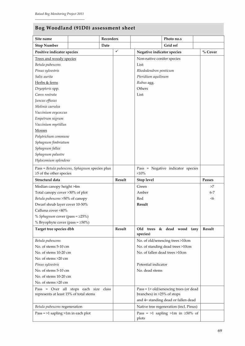
Raised Bog Monitoring Project 2011
______________________________
69
Bog Woodland (91D0) assessment sheet
Site name Recorders Photo no.s
Stop Number Date Grid ref
Positive indicator species Negative indicator species % Cover
Trees and woody species
Betula pubescens
Pinus sylvestris
Salix aurita
Herbs & ferns
Dryopteris spp.
Carex rostrata
Juncus effusus
Molinia caerulea
Vaccinium oxycoccus
Empetrum nigrum
Vaccinium myrtillus
Mosses
Polytrichum commune
Sphagnum fimbriatum
Sphagnum fallax
Sphagnum palustre
Hylocomium splendens
Non‐native conifer species
List:
Rhododendron ponticum
Pteridium aquilinum
Rubus agg.
Others
List:
Pass = Betula pubescens, Sphagnum species plus
5 of the other species Pass = Negative indicator species
<10%
Structural data Result Stop level Passes
Median canopy height >4m
Total canopy cover >30% of plot
Betula pubescens >50% of canopy
Dwarf shrub layer cover 10‐50%
Calluna cover <40%
% Sphagnum cover (pass = 25%)
% Bryophyte cover (pass = 50%)
Green
Amber
Red
Result
>7
6‐7
<6
Target tree species dbh Result Old trees & dead wood (any
species)
Result
Betula pubescens
No. of stems 5‐10 cm
No. of stems 10‐20 cm
No. of stems >20 cm
Pinus sylvestris
No. of stems 5‐10 cm
No. of stems 10‐20 cm
No. of stems >20 cm
No. of old/senescing trees >10cm
No. of standing dead trees >10cm
No. of fallen dead trees >10cm
Potential indicator
No. dead stems
Pass = Over all stops each size class
represents at least 15% of total stems
Pass = 1+ old/senescing trees (or dead
branches) in >25% of stops
and 4+ standing dead or fallen dead
Betula pubescens regeneration Native tree regeneration (incl. Pinus)
Pass = >1 sapling >1m in each plot Pass = >1 sapling >1m in 50% of plots

Raised Bog Monitoring Project 2011
______________________________
70
Proposed assessment
Assessment Stop level 4‐stop level
Green 4 stops pass 3‐4 passes
Amber 4 stops pass 2 passes
Amber 3 stops pass 3‐4 passes
Red 4 stops pass 1 pass
Red 3 stops pass 1 pass
Red <3 stops pass Any result

Raised Bog Monitoring Project 2011
______________________________
71
Appendix 7: Typical species list
Active and Degraded Raised Bog typical species (derived from NPWS
(2007)
Vascular plants: Andromeda polifolia, Calluna vulgaris, Drosera anglica, D. intermedia, D. rotundifolia, Erica
tetralix, Eriophorum angustifolium, E. vaginatum, Menyanthes trifoliata, Narthecium ossifragum,
Rhynchospora alba, R. fusca, Trichophorum cespitosum, Utricularia minor, Vaccinium oxycoccos.
Mosses, liverworts and lichens: Aulacomnium palustre, Cladonia spp (C. ciliata and C. portentosa),
Leucobryum glaucum, Sphagnum denticulatum, S. capillifolium S. cuspidatum, S. fuscum, S. austinii, S.
magellanicum, S. papillosum, S. pulchrum, S. subnitens.
Bog Woodland habitat typical species (derived from NPWS (2007)
Vascular plants: Agrostis canina, Betula pubescens, Calluna vulgaris, Carex canescens, C. echinata, C. nigra,
C. rostrata, Dryopteris dilatata, Empetrum nigrum, Eriophorum vaginatum, Holcus lanatus, Juncus effusus,
Molinia caerulea, Pinus sylvestris, Pteridium aquilinum, Salix aurita, Vaccinium myrtillus, V. oxycoccus.
Mosses, liverworts and lichens: Aulacomnium palustre, Polytrichum commune, Sphagnum capillifolium, S.
fimbriatum, S. palustre, S. recurvum, S. squarrosum and S. teres, Cladonia portentosa.
Rhynchosporion depressions typical species (derived from NPWS (2007)
Vascular plants: Rhynchospora alba, R. fusca, Drosera intermedia, D. rotundifolia, Drosera anglica,
Eriophorum angustifolium, Narthecium ossifragum.
Mosses, liverworts and lichens: Sphagnum cuspidatum, S. denticulatum, S. magellanicum, S. papillosum,
S. pulchrum (local), Lycopodium inundatum (very rare).

Raised Bog Monitoring Project 2011
______________________________
72
Appendix 8: Active Raised Bog assessment examples
Area S&F FP Overall
Raheenmore
Assessment
Current
(52.31ha) <
FRV
(119.12ha)
(56.09%
below
FRV)
UB
UI‐
Increasing
Current
(1.68ha) <
FRV
(26.16ha)
(93.58%
below
FRV)
UB
UI‐
Improving UI‐ Stable
UB‐
Improving
Trend
Increasing Improving
Killyconny
Assessment
Current
(3.91ha) <
FRV
(3.91ha)
(91.41%
below
FRV)
UB
UB‐Stable
Current
(0.21ha) <
FRV
(1.96ha)
(89.29%
below
FRV)
UB
UB‐Stable F‐ Stable UB‐Stable
Trend
Stable Stable
Mongan
Assessment
Current
(48.31ha) <
FRV
(65.9ha)
(26.69%
below
FRV)
UB
UI‐
Increasing
Current
(42.71ha)
> FRV
(24.16ha)
(176.78%
above
FRV)
F
F‐ Stable F‐
Improving
UB‐
Improving
Trend
Increasing Stable
Kilcarren
Assessment
Current
(11.9ha) <
FRV
(130.32ha)
(90.87%
below
FRV)
UB
UB‐
Decreasing
Current
(2.44ha) <
FRV
(5.95ha)
(58.99%
below
FRV)
UB
UB‐Stable UB‐
Declining
UB‐
Declining
Trend
Decreasing Stable

Raised Bog Monitoring Project 2011
______________________________
73
Appendix 9: GIS files submitted
The following is a list of GIS (.shp) files generated and submitted as part of this project:
Raw spatial data recorded on the field:
The following are the original spatial data files recorded on the field after post‐processing in the office
to obtain sub‐meter accuracy.
RBMP11_commu_complex_dots: This file provides dot records for all vegetation community
complexes classed according to the ecotope type they belong to. Attribute table includes the
following fields: [Site_Name]; [Site_Code]; [Ecot_type]: ecotope type; [Name]: vegetation
community complex name; [Comment]: additional info specific for that dot record; [Date1]:
date data recorded.
RBMP11_ecotope_boundary_dots: This file provides dot records for ecotope boundaries.
Attribute table includes the following fields: [Site_Name]; [Site_Code]; [Boudnary_T]: this
field describes ecotope boundary type (e.g. C (central) / SC (sub‐central), F (flush) / SM (sub‐
marginal)); [Other_]: other boundary not included in precious field; [Comment]: additional
info specific for that dot record; [Date1]: date data recorded; [County].
RBMP11_flush_dots: This file provides dot records for flushes and whether they are active
peat forming or not. Attribute table includes the following fields: [Site_Name]; [Site_Code];
[Name]: flush name; [Active]: is the flush active peat forming or not; [Comment]: additional
info specific for that dot record; [Date1]: date data recorded; [County].
RBMP11_quadrat_data: This file provides dot records for quadrats recorded. The attribute
table fields correspond with heading described under Appendix 6. The quadrat name is
reflected in the MS Access database quadrat table.
RBMP11_additional_dots_data: This file provides dot records for any additional data
considered relevant to the survey site. Attribute table includes the following fields:
[Site_Name]; [Site_Code]; [Comment]: additional info specific for that dot record; [County].
RBMP11_drainage_dots: This file provides dot records for drainage data. Drainage is
classified according to terminology provided in Appendix 4. Attribute table includes the
following fields: [Site_Name]; [Site_Code]; [Not_Blocke]: not blocked drain functionality;
[Blocked]: blocked drain functionality; [Width]: drain width in m; [Depth]: drain depth in m;
[Comment]: additional info specific for that dot record; [County].
RBMP11_photo_records_dots: This file provides dot records for photographical data.
Attribute table includes the following fields: [Site_Name]; [Site_Code]; [Photo_ID]; [Aspect]:
photographical aspect; [Type]: detail or overview; [Comment]: additional info specific for that
dot record (e.g. quadrat name); [Date1]: date data recorded; [County].
Raised Bog Monitoring Project 2011
______________________________
74
RBMP11_invasive_species_dots: This file provides dot records for invasive species data.
Attribute table includes the following fields: [Site_Name]; [Site_Code]; [Species]: species Latin
name; [Comment]: additional info specific for that dot record (e.g. quadrat name); [Other]:
additional info; [County].
Digitised spatial data:
The following are the spatial data files digitised in the office based on raw spatial data recorded on the
field and NPWS Designated Raised Bog Orthophotos 2010.
RBMP11_ecotope_map: This file provides polygon data illustrating habitats depicted based on
the ecotope vegetation classification. Attribute table includes the following fields:
[Site_Name]; [Site_Code]; [Ecotope]: ecotope type; [Designatio]: designation type (e.g. SAC);
[Area]: ecotope area in m2; [County]; [Survey_Nam]: survey name; [Survey_Date]; [Authors]:
map authors; [Survey_Met]: survey method (e.g. ground survey); [Name]: specific active peat
forming sections name given [Comment]: additional info related to each active peat forming
section, whether it is newly developed, have expanded or de creased.
RBMP11_drainage_map: This file provides line data illustrating high bog drains depicted
based on the drainage data recorded on the field and NPWS Designated Raised Bog
Orthophotos 2010. Attribute table includes the following fields: [Site_Name]; [Site_Code];
[2004_5_cat]: drain type in 2004_5; [2011_cat]: drain type in 2011; [Change]: change in the
2004/05‐2011 period in the drain status; [Comment]: additional info related to each specific
drain; [County].
RBMP11_additional_data_map: This file provides additional line data such as dams. Attribute
table includes the following field: [Site_Name]; [Site_Code]; [Name]: dam name; [County].
RBMP11_burnt_areas_map: This file provides polygon data illustrating areas recently burnt.
Attribute table includes the following fields: [Site_Name]; [Site_Code]; [Area]: burnt area in
m2; [Survey_Dat]: survey date; [Comment]: period burnt took place; [Designatio]: designation
type (e.g. SAC); [County].
RBMP11_high_bog_cutaway_map: This file provides polygon data illustrating high bog area
cutaway by peat cutting in the 2004/05‐2010 period. Attribute table includes the following
fields: [Site_Name]; [Area]: area cutaway in m2; [Designatio]: designation type (e.g. SAC);
[Site_Code]; [County].
RBMP05_ecotope_map: This file provides polygon data illustrating habitats depicted based on
the ecotope vegetation classification provided by Fernandez et al. (2005). High bog edge has
been re‐digitised as part of this project based on the most 2005 ortho‐images. This has affected

Raised Bog Monitoring Project 2011
______________________________
75
high bog edge ecotopes area (general face bank and marginal ecotope types). Attribute table
includes the following fields: [Site_Name]; [Site_Code]; [Ecotope]: ecotope type; [Designatio]:
designation type (e.g. SAC); [Area]: ecotope area in m2; [County]; [Survey_Nam]: survey
name; [Authors]: map authors; [Survey_Met]: survey method (e.g. ground survey).

Raised Bog Monitoring Project 2011
______________________________
76
Appendix 10: Community complexes recorded during 2011
survey
Ecotope Community complex Number of records 1
Central 15 118
35 99
10/15 57
14 14
Sub‐central 9/10 550
9/7/10 486
6/35 239
4/10 117
10/9 101
10/4 80
9/7/6+P 71
9/7+P 68
9a/10 46
3/10 34
4+P 29
10/9a 22
6/15 19
10/6 7
9/7/10+My 5
9/7/10+My+Mol 4
Sub‐marginal 9/7/6 2488
9/7 1089
7/6 329
6/9+P 211
3/6/4 206
6/3 181
9/7/3 179
6+P 117
7/6/4 74
9/7/6+My 50
9/7/6+P 38
6/3+P 26
7/9 25
4/9a+P 18
9/7/6/4 16
9/7/4 15
4/9 14
7/9+Cl 9
9/7+My 9
9a/7/3 9
7/6+My 8
9/7/3+My 8

Raised Bog Monitoring Project 2011
______________________________
77
9/7+P 7
9/7/2 6
6/7 6
9/7/3+P 6
6/3+TP 4
7/6/4+TP 4
6/9 3
6/9+TP+My 3
9/7+Ph 4
3/6/4+TP 2
6/9+TP 2
9/7+TP 2
9a/7/6 2
6/35 1
7/6/3 1
9/7/6+TP 1
Marginal 6/7 320
7/2 294
3/6 287
9+BP 23
3/6+TP 19
7/6 16
6/7/2 13
6/4 11
3/6+P 11
6/7+My 9
7+BP 9
6/7/3 7
9/2 6
3/6+My 4
6/7+TP 4
3/6+Mo 1
7+Ph 1
Face bank 1 56
1 This field indicates the number of points taken on the field correlating to each community complex recorded.
The number of points recorded bears no reflection on the area of that the community complex covers