rapid watershed assessment contents - usda
TRANSCRIPT
UPPER JAMES - 10160003
8-DIGIT HYDROLOGIC UNIT PROFILE
North Dakota South Dakota
USDA Natural Resources Conservation Service September 2009
NORTH DAKOTA AND SOUTH DAKOTA
Rapid Watershed Assessment
September 2009 Produced by:
United States Department of Agriculture Natural Resources Conservation Service
200 Fourth Street SW P.O. Box 1458
Huron, South Dakota 57350 Bismarck, North Dakota 58502

UPPER JAMES - 10160003
8-DIGIT HYDROLOGIC UNIT PROFILE
2
North Dakota South Dakota
USDA Natural Resources Conservation Service (NRCS) September 2009
“The U.S. Department of Agriculture (USDA) prohibits discrimination in all its programs and activities on the basis of race, color, national origin, disability, and where applicable, sex, marital status, familial status, parental status, religion, sexual orientation, genetic information, political beliefs, reprisal, or because all or a part of an individual’s income is derived from any public assistance program. (Not all prohibited bases apply to all programs.) Persons with disabilities who require alternative means for communication of program information (Braille, large print, audiotape, etc.) should contact USDA’s TARGET Center at (202) 720-2600 (voice and TDD). To file a complaint of discrimination write to USDA, Director, Office of Civil Rights, 1400 Independence Avenue, S.W., Washington, D.C. 20250-9410 or call (800) 795-3272 (voice) or (202) 720-6382 (TDD). USDA is an equal opportunity provider and employer.

UPPER JAMES - 10160003
8-DIGIT HYDROLOGIC UNIT PROFILE
North Dakota South Dakota
USDA Natural Resources Conservation Service September 2009
Upper James Watershed North Dakota (ND) and South Dakota (SD)
Rapid Watershed Assessment Project
Sponsored by:
ND Department of Health
ND Association of Soil Conservation Districts
Barnes County Soil Conservation District
James River Soil Conservation District
LaMoure County Soil Conservation District
Logan County Soil Conservation District
Ransom County Soil Conservation District
Stutsman County Soil Conservation District
Wild Rice Soil Conservation District
SD Department of Environment and Natural Resources
SD Association of Conservation Districts
Brown/Marshall Conservation District
South Brown Conservation District
Day Conservation District
Edmunds County Conservation District
Marshall County Conservation District
McPherson County Conservation District
Roberts Conservation District
Spink Conservation District

UPPER JAMES - 10160003
8-DIGIT HYDROLOGIC UNIT PROFILE
North Dakota South Dakota
USDA Natural Resources Conservation Service September 2009
Executive Summary A Rapid Watershed Assessment (RWA) document compiles existing resource information and data within a watershed and is used to assist conservation districts, landowners, and other community organizations and stakeholders to identify where conservation investments are best utilized and set resource conservation goals. The RWA contains summaries of resource concerns and opportunities that are useful for a number of resource conservation activities. Local landowners and organizations can use the RWA as a basis to prioritize resource concerns and estimate the technical and financial resources required to achieve their resource conservation goals within the watershed. The assessment provides information that can be used to develop conservation district annual and long-range plans, or establish a foundation for more detailed watershed, area wide, or site-specific natural resource planning and the development of implementation plans. A RWA provides sufficient information to help facilitate making some key resource management decisions. The RWA:
o Provides a quick and inexpensive source of information on which to base decisions about conservation priorities, allocation of resources, funding for implementation, and how to report outcomes/results. o Supplies enough detail to identify conservation activities that can be implemented without waiting on further watershed-level studies or analyses. o Provides a preliminary source of information for standard environmental evaluations. o Identifies if there is a need for further detailed analysis or watershed studies. o Determines if there are infrastructure needs. o Addresses multiple concerns and objectives of landowners and communities. o Enhances established local, state, and federal partnerships. o Enables landowners and communities to decide on the best mix of Natural Resources Conservation Service (NRCS) programs and other funding sources to meet their resource concerns/needs. o Evaluates availability of conservation program tools (cost-share, easements, and technical assistance).
The RWAs consist of two parts: the watershed profile which provides the physical, biological, and sociological characterization of the watershed resources; and the watershed assessment which defines the identified resource concerns and evaluates the effectiveness, the extent, and the associated costs of the conservation practices that address the identified resource concerns. The RWAs are developed based on the first six steps of the NRCS conservation resource planning process on a watershed scale. The information is general in nature and is not sufficiently detailed to be used in lieu of an area wide or watershed plan when the identified resource concerns require specific information, for example, flood prevention or control. However, the information does provide a solid starting point for local stakeholders to use should they decide to proceed with a more detailed area wide or watershed planning effort or the development of a watershed implementation plan using existing NRCS conservation programs.

UPPER JAMES - 10160003
8-DIGIT HYDROLOGIC UNIT PROFILE
1
North Dakota South Dakota
USDA Natural Resources Conservation Service (NRCS) September 2009
Rapid Watershed Assessment Contents Part I Watershed Profile
1.0 Purpose........................................................................................................................................2
2.0 Introduction .................................................................................................................................2
3.0 Physical Description...................................................................................................................2
3.1 Hydrologic Unit Code (HUC)..................................................................................................... 3
3.2 Geology....................................................................................................................................... 4
3.3 Topography1................................................................................................................................ 5
3.4 Drainage Network....................................................................................................................... 6
3.5 Climate........................................................................................................................................ 6
4.0 Resource Inventory...................................................................................................................14
4.1 Major Land Resource Areas (MLRA) and Common Resource Area (CRA)1.......................... 14
4.2 Land Cover and Land Use Distribution .................................................................................... 16
4.3 General Soils............................................................................................................................. 20
4.4 Cropland Productivity1.............................................................................................................. 24
4.5 Rangeland Production (Normal Year)1..................................................................................... 25
5.0 Resource Concerns ..................................................................................................................26
5.1 Summary of Resource Concerns1 ............................................................................................. 27
5.2 Soil Erosion - Wind and Water1................................................................................................ 28
5.3 Water Resource Considerations................................................................................................ 29
5.4 Resources of special concern .................................................................................................... 42
5.5 Resource Accomplishments...................................................................................................... 43
6.0 Census and Social Data ..........................................................................................................45
6.1 Population Chart ....................................................................................................................... 45
6.2 Household Income .................................................................................................................... 46
6.3 Farm Size .................................................................................................................................. 47
6.4 Demographics ........................................................................................................................... 48
6.5 Total Agricultural Sales ............................................................................................................ 49
7.0 References/Preparers ...............................................................................................................50
7.1 List of Preparers........................................................................................................................ 50
7.2 References................................................................................................................................. 50

UPPER JAMES - 10160003
8-DIGIT HYDROLOGIC UNIT PROFILE
2
North Dakota South Dakota
USDA Natural Resources Conservation Service (NRCS) September 2009
I. WATERSHED PROFILE
1.0 PURPOSE
The watershed resource profile compiles the most recent, readily-available data which provides a physical, biological, and sociological characterization of watershed resources. The profile inventories the current resource health and condition of the soil, water, plants, animals, and social resources of a watershed and identifies the known resource concerns. The watershed profile also provides a brief overview of the social and economic composition of the watershed. The profile summary of the resource conditions, concerns, and opportunities is useful for a number of conservation activities. Local landowners and organizations can use the information to prioritize resource concerns and estimate the technical and financial resources required to achieve resource conservation goals within the watershed. The information can be used to develop conservation district annual and long-range plans, establish a foundation for a more detailed watershed, area wide, or site-specific natural resource plan, or the development of an implementation plan. 2.0 INTRODUCTION
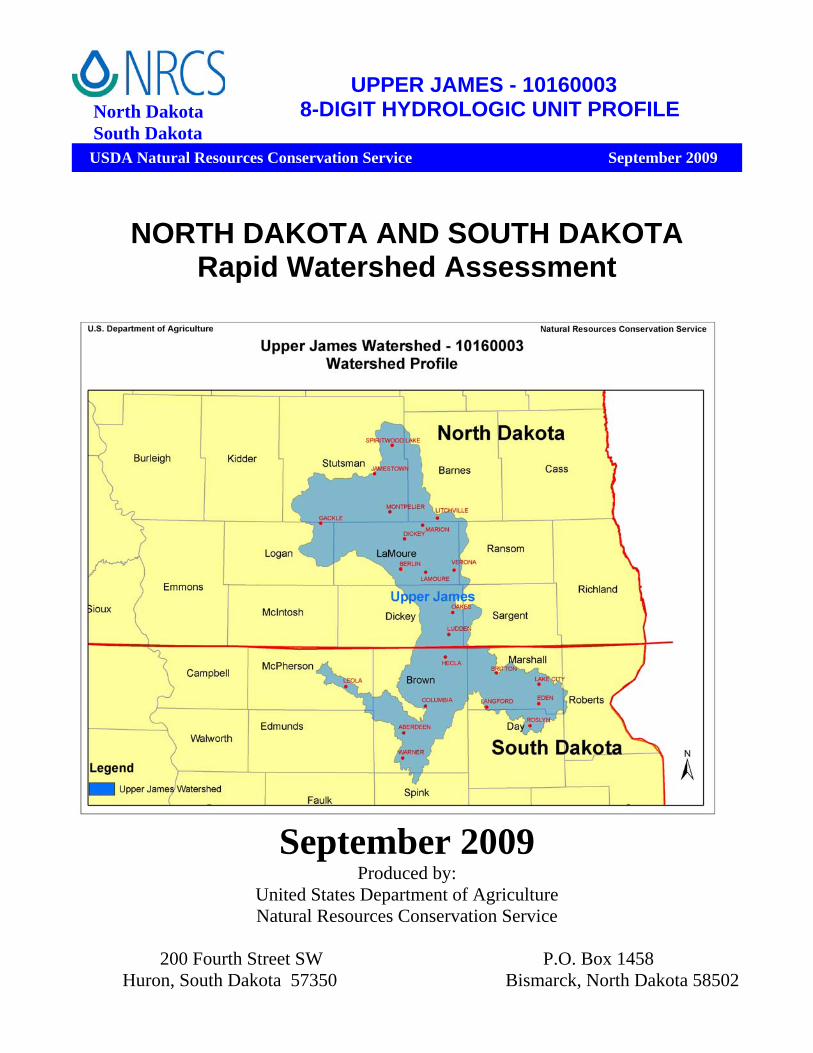
The Upper James Watershed 8-Digit Hydrologic Unit Code (HUC) subbasin is 2,713,000 acres located in both North and South Dakota. The watershed includes seven counties in southeast ND and seven counties in northeast SD. The watershed counties include Barnes, Dickey, LaMoure, Logan, Ransom, Sargent, and Stutsman, ND and Brown, Day, Edmunds, Marshall, McPherson, Roberts and Spink counties, SD. The watershed lies in the heart of the Prairie Pothole Region of the northern Great Plains. This region provides important habitats for migratory waterfowl and other wildlife, supporting more than 50% of North America's migratory waterfowl. The dominant land use is cultivated cropland, approximately 1,718,800 acres or 63 percent of the watershed. Corn, spring wheat, barley, oats, soybeans, and sunflowers are the major crops produced in the watershed. Winter wheat, corn for silage, flax, sorghum, rye, and alfalfa or grass hay are also important. Rangeland and pastureland account for 512,300 acres or 19 percent of the watershed. Agriculture is a vital part of the local economic base. Growing cash crops and hay, raising beef cattle, swine, and dairying are the main agricultural enterprises. Conservation assistance is provided by 14 NRCS field office service centers, 3 NRCS field support/area offices, 2 Resource Conservation and Development (RC&D) Areas, one RC&D applicant area, and 15 soil conservation districts. 3.0 PHYSICAL DESCRIPTION
The physical description of the Upper James subbasin provides a general description of the watershed location, geology, topography, precipitation, and climatic ranges.

UPPER JAMES - 10160003
8-DIGIT HYDROLOGIC UNIT PROFILE
3
North Dakota South Dakota
USDA Natural Resources Conservation Service (NRCS) September 2009 1 3.1 HYDROLOGIC UNIT CODE (HUC)
A HU is part of a multi-level watershed mapping classification system. The HU boundaries are defined by hydrographic and topographic criteria used to delineate areas of land that contribute surface water runoff to a designated outlet point, such as a lake or stream segment. The United States Geological Survey (USGS) designates HU drainage areas as subwatersheds (including smaller drainages) numbered with 12-digit HUCs, nested within watersheds (10-digit HUCs). Watersheds are combined into larger drainage areas called subbasins (8 digits), basins (6 digits), and subregions (4 digits), which make up the large regional drainage basins (2 digits).
Upper James 8-digit HUC Map and the Political Subdivisions Within the Unit.

UPPER JAMES - 10160003
8-DIGIT HYDROLOGIC UNIT PROFILE
4
North Dakota South Dakota
USDA Natural Resources Conservation Service (NRCS) September 2009 2 3 3.2 GEOLOGY
Precambrian metamorphic and igneous rock formations of granite, gneiss, limestone, sandstone, and shale underlie the entire watershed. Late Cretaceous sedimentary rocks of marine origin directly overlie the Precambrian bedrock. The surface geology of the watershed was formed by a series of Pleistocene glacial events. Glacial drift, the debris deposited by moving ice and glacial streams, determined the geologic features of the watershed. A sequence of glacial sediments (glacial till) was deposited directly from the ice as the glaciers advanced and retreated. The glacial till is generally an unconsolidated heterogeneous mixture of clay, silt, sand, gravel, and boulders ranging widely in size and shape. Thin sand and gravel layers occur erratically within and between the till layers. Glacial melt water streams formed localized, stratified deposits of well sorted clays, sands, and gravels (glacial outwash) as the glaciers receded. The glacial till commonly ranges between 100 and 300 feet thick, but may be in excess of 1,000 feet thick in some areas of the watershed. The upper 20 to 150 feet of the glacial till has been altered by weathering to gray smectitic clays.

UPPER JAMES - 10160003
8-DIGIT HYDROLOGIC UNIT PROFILE
5
North Dakota South Dakota
USDA Natural Resources Conservation Service (NRCS) September 2009
3.3 TOPOGRAPHY1
The Upper James watershed is located in the Great Plains Physiographic Province, James River Lowland division and includes much of the Lake Dakota plain sub-section. The major landforms of the watershed are of three general types: lake plain, glacial uplands, and alluvial flood plains along the stream channels. Topographic relief varies from the flat nearly level lake plain to the undulating hills of the glacial uplands The lake plain is the former bed of an extensive, shallow, but short-lived glacial lake. Lake Dakota was over 100 miles long and 27 miles across; it extended from southern Spink County in SD to approximately 15 to 20 miles north of the ND/SD State line. The lake plain does not have a well developed natural drainage system and water tables are high year round The glacial uplands lie west and north of the lake plain. They consist of deposits of glacial till that form smoothly rolling hills. The relief is dominantly undulating to hilly. The uplands are characterized by many potholes or closed basins and have a poorly defined drainage pattern. The alluvial flood plains are located along the James River and its tributaries. The James River forms the principal drainage system of the watershed.
UPPER JAMES - 10160003
8-DIGIT HYDROLOGIC UNIT PROFILE
6
North Dakota South Dakota
USDA Natural Resources Conservation Service (NRCS) September 2009
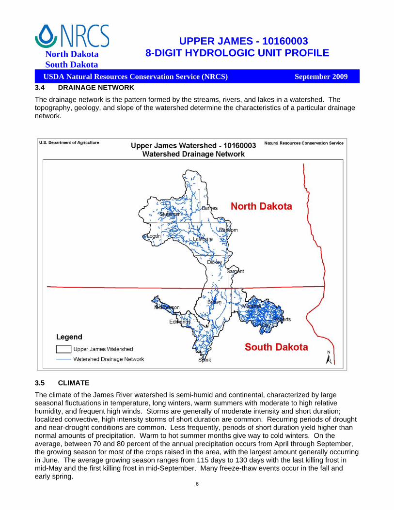
3.4 DRAINAGE NETWORK
The drainage network is the pattern formed by the streams, rivers, and lakes in a watershed. The topography, geology, and slope of the watershed determine the characteristics of a particular drainage network.
3.5 CLIMATE
The climate of the James River watershed is semi-humid and continental, characterized by large seasonal fluctuations in temperature, long winters, warm summers with moderate to high relative humidity, and frequent high winds. Storms are generally of moderate intensity and short duration; localized convective, high intensity storms of short duration are common. Recurring periods of drought and near-drought conditions are common. Less frequently, periods of short duration yield higher than normal amounts of precipitation. Warm to hot summer months give way to cold winters. On the average, between 70 and 80 percent of the annual precipitation occurs from April through September, the growing season for most of the crops raised in the area, with the largest amount generally occurring in June. The average growing season ranges from 115 days to 130 days with the last killing frost in mid-May and the first killing frost in mid-September. Many freeze-thaw events occur in the fall and early spring.

UPPER JAMES - 10160003
8-DIGIT HYDROLOGIC UNIT PROFILE
7
North Dakota South Dakota
USDA Natural Resources Conservation Service (NRCS) September 2009
It is estimated that more than 75 percent of the annual runoff occurs during the four-month period of March through June. The high runoff in March and April is usually from snowmelt while the runoff in May and June is from rainfall. Heavy runoff during the summer months is caused by brief, intense thunderstorms. Annual runoff can vary widely from year to year; the average annual runoff totals 1.25 inches. Most of the tributaries will show periods of low or no flow almost every year during the fall and winter months. The historical data records for average temperature, wind speed, and relative humidity data used to represent the watershed are from the Aberdeen, SD, municipal airport, the county seat of Brown County, SD, and the LaMoure, ND National Weather Service Reporting Station which is located in the north central part of the watershed.
4 3.5.1 Precipitation
The average annual precipitation for the watershed area is 21.2 inches per year measured at the U.S. Weather Bureau Station at LaMoure, ND.

UPPER JAMES - 10160003
8-DIGIT HYDROLOGIC UNIT PROFILE
8
North Dakota South Dakota
USDA Natural Resources Conservation Service (NRCS) September 2009
3.5.1a Precipitation Distribution Graph
Period of Record - Monthly Average Total Precipitation
- Average precipitation recorded for the month.

UPPER JAMES - 10160003
8-DIGIT HYDROLOGIC UNIT PROFILE
9
North Dakota South Dakota
USDA Natural Resources Conservation Service (NRCS) September 2009 5 3.5.2 Average Monthly Temperature
Temperatures vary considerably throughout the year. The average winter temperature is 19 degrees F and the average summer temperature is 72 degrees F. Extreme temperatures for the year often range from below zero in the winter to an occasional 100 plus degree summer day.
Data is smoothed using a 29 day running average.
- Maximum Temp. is the average of all daily maximum temperatures recorded for the day of the year
between the years 1971 and 2000. - Average Temp. is the average of all daily average temperatures recorded for the day of the year
between the years 1971 and 2000. - Minimum Temp. is the average of all daily minimum temperatures recorded for the day of the year
between the years 1971 and 2000. - Precipitation is the average of all daily total precipitation recorded for the day of the year between
the years 1971 and 2000.

UPPER JAMES - 10160003
8-DIGIT HYDROLOGIC UNIT PROFILE
10
North Dakota South Dakota
USDA Natural Resources Conservation Service (NRCS) September 2009
3.5.3 Average Monthly Wind Speed5
Average Wind
3.5.4 Average Monthly Relative Humidity5

UPPER JAMES - 10160003
8-DIGIT HYDROLOGIC UNIT PROFILE
11
North Dakota South Dakota
USDA Natural Resources Conservation Service (NRCS) September 2009 6 3.5.5 Last Spring Freeze5
North Dakota
South Dakota

UPPER JAMES - 10160003
8-DIGIT HYDROLOGIC UNIT PROFILE
12
North Dakota South Dakota
USDA Natural Resources Conservation Service (NRCS) September 2009 5 6 3.5.6 First Fall Freeze
North Dakota
South Dakota

UPPER JAMES - 10160003
8-DIGIT HYDROLOGIC UNIT PROFILE
13
North Dakota South Dakota
USDA Natural Resources Conservation Service (NRCS) September 2009
3.5.7 Climate Summary7
Overall monthly climatic summary of temperature and precipitation averages for the watershed. LAMOURE, ND Period of Record Monthly Climate Summary Period of Record: 7/ 1/1948 to 12/31/2007
Jan Feb Mar Apr May Jun Jul Aug Sep Oct Nov Dec Annual
Average Max. Temperature (F)
18.5 25.6 38.2 55.2 69.0 77.8 84.0 82.6 72.0 59.0 39.3 25.0 53.8
Average Min. Temperature (F)
-3.2 3.5 16.8 30.7 42.5 52.7 57.4 54.3 43.9 32.1 18.1 4.2 29.4
Average Total Precipitation (in.)
0.68 0.56 1.22 2.09 2.79 3.86 3.08 2.27 2.02 1.48 0.73 0.45 21.21
Average Total Snowfall (in.)
8.9 6.1 7.5 3.3 0.0 0.0 0.0 0.0 0.0 0.4 6.3 5.8 38.3
Average Snow Depth (in.)
8 7 4 0 0 0 0 0 0 0 1 3 2
High Plains Regional Climate Center

UPPER JAMES - 10160003
8-DIGIT HYDROLOGIC UNIT PROFILE
14
North Dakota South Dakota
USDA Natural Resources Conservation Service (NRCS) September 2009
4.0 RESOURCE INVENTORY
The resource inventory provides a general summary of the existing conditions of the natural resources in the watershed that are related to the soil, water, animals, plants, air, and humans (SWAPA+H). The resource descriptions provide general information on land use, land capability, soils and productivity, and prime farmland.
1 4.1 MAJOR LAND RESOURCE AREAS (MLRA) AND COMMON RESOURCE AREA (CRA)
The MLRA’s are a part of a USDA classification system that defines land as a resource for farming, ranching, forestry, engineering, recreation, and other uses. The MLRA is a broad-based geographic area characterized by a uniform pattern of soils, elevation, topography, climate, water resources, potential natural vegetation, and land uses. Large MLRAs may be further subdivided to create smaller more homogeneous resource areas. The CRAs are the basic unit of an MLRA, a subdivision based on significant geographic differences in climate, water resources, or land use and resource concerns where resource problems or treatment needs are similar. Landscape conditions, soil, climate, human considerations, and other natural resource information are used to determine the geographic boundaries of a CRA. In both ND and SD, the MLRA and CRA boundaries coincide.

UPPER JAMES - 10160003
8-DIGIT HYDROLOGIC UNIT PROFILE
15
North Dakota South Dakota
USDA Natural Resources Conservation Service (NRCS) September 2009
4.1.1 Common Resource Area Descriptions
Symbol Name Brief Description 53B.1 Central Dark
Brown Glaciated Plains
Most of this area is in cropland with the major crops being small grain and sunflowers. The more sloping soils are used for livestock grazing. This area is nearly level to rolling till plains. Moderately steep and steep slopes are adjacent to the major streams. Most of the soils are deep, well drained, and medium textured with a frigid temperature regime and mixed mineralogy.
55B.1 Central Black Glaciated Plains
About seventy percent of this area is used for cropland. The principal crops are small grain, corn, soybeans and sunflowers. Most of this area is nearly level to undulating till plains with some areas consisting of glacial lake plains. Most of the soils are deep, well drained and moderately well drained, sandy to clayey and have a frigid temperature regime.
102A.1 Rolling Till Prairie
Gently sloping to steep, loamy glacial till soils with scattered sandy outwash soils and silty alluvial flood plains soils. This area is part of the Prairie Pothole region of the upper Midwest. Predominantly cropped to corn and soybeans with increasing hayland and pasture and small grains in the western part. Resource concerns are water and wind erosion, nutrient management and water quality.

UPPER JAMES - 10160003
8-DIGIT HYDROLOGIC UNIT PROFILE
16
North Dakota South Dakota
USDA Natural Resources Conservation Service (NRCS) September 2009 8 4.2 LAND COVER AND LAND USE DISTRIBUTION
The National Resources Inventory (NRI) uses the term land cover/use to identify the categories that account for all the surface area in the United States. Land cover describes the different types of vegetation or other kind of material that covers the land surface. Land use is defined as the purpose of human activity on the land, it is usually, but not always, related to land cover.
UPPER JAMES - 10160003
8-DIGIT HYDROLOGIC UNIT PROFILE
17
North Dakota South Dakota
USDA Natural Resources Conservation Service (NRCS) September 2009
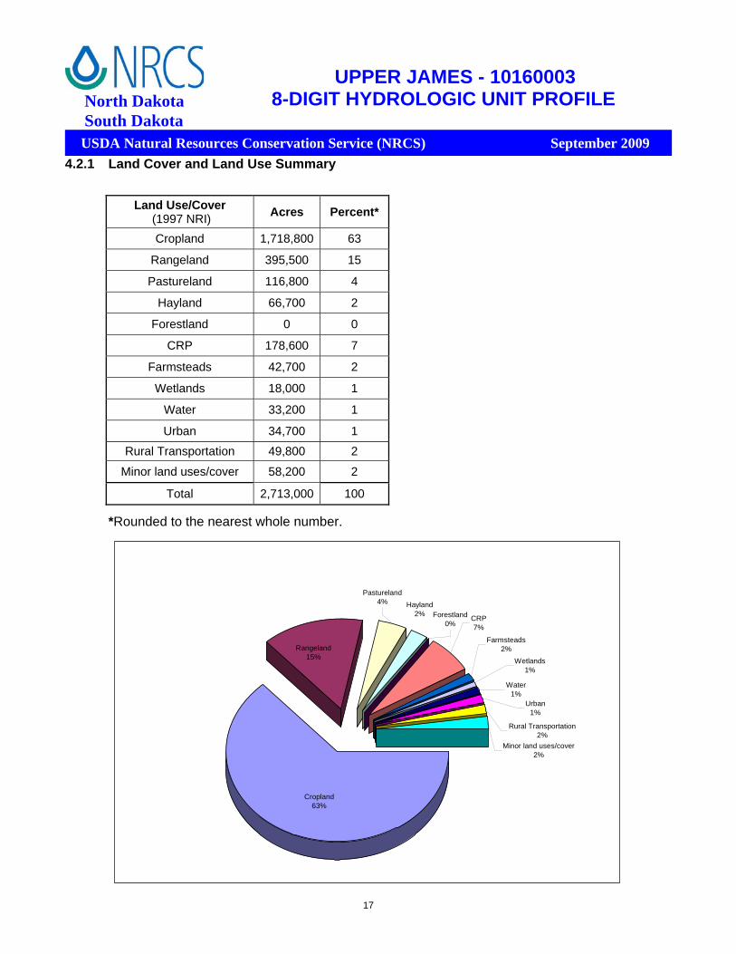
4.2.1 Land Cover and Land Use Summary
Land Use/Cover
(1997 NRI) Acres Percent*
Cropland 1,718,800 63
Rangeland 395,500 15 Pastureland 116,800 4
Hayland 66,700 2
Water1%
Farmsteads2%
Urban1%
Wetlands1%
Rural Transportation2%
Minor land uses/cover2%
Rangeland15%
Cropland63%
Pastureland4%
Forestland0%
Hayland2%
CRP7%
Forestland 0 0 CRP 178,600 7
Farmsteads 42,700 2 Wetlands 18,000 1
Water 33,200 1 Urban 34,700 1 Rural Transportation 49,800 2
Minor land uses/cover 58,200 2 Total 2,713,000 100 *Rounded to the nearest whole number.

UPPER JAMES - 10160003
8-DIGIT HYDROLOGIC UNIT PROFILE
18
North Dakota South Dakota
USDA Natural Resources Conservation Service (NRCS) September 2009
Primary Land Uses [NRI-97] Cropland - A land cover/use category that includes areas used for the production of adapted crops for harvest. Two subcategories of cropland are recognized: cultivated and noncultivated. Cultivated cropland comprises land in row crops or close-grown crops and also other cultivated cropland, for example, hayland or pastureland that is in a rotation with row or close-grown crops. Noncultivated cropland includes permanent hayland and horticultural cropland. Pastureland - A land cover/use category of land managed primarily for the production of introduced or native forage plants for livestock grazing. Pastureland may consist of a single species in a pure stand, a grass mixture or a grass-legume mixture. Management usually consists of cultural treatments-fertilization, weed control, reseeding, or renovation and control of grazing. (For the National Resources Inventory (NRI), includes land that has a vegetative cover of grasses, legumes, and/or forbs, regardless of whether or not it is being grazed by livestock.) Hayland - A subcategory of cropland managed for the production of forage crops that are machine harvested. These crops may be grasses, legumes, or a combination. Hayland also includes land in set-aside or other short-term agricultural programs. [NRI-97] Rangeland - A land cover/use category on which the climax or potential plant cover is composed principally of native grasses, grasslike plants, forbs or shrubs suitable for grazing and browsing, and introduced forage species that are managed like rangeland. This would include areas where introduced hardy and persistent grasses, such as crested wheatgrass, are planted and such practices as deferred grazing, burning, chaining, and rotational grazing are used, with little or no chemicals or fertilizer being applied. Grasslands, savannas, many wetlands, some deserts, and tundra are considered to be rangeland. Certain communities of low forbs and shrubs, such as mesquite, chaparral, mountain shrub, and pinyon-juniper, are also included as rangeland. [NRI-97] Urban and built-up - A land cover/use category consisting of residential, industrial, commercial, and institutional land; construction sites; public administrative sites; railroad yards; cemeteries; airports; golf courses; sanitary landfills; sewage treatment plants; water control structures and spillways; other land used for such purposes; small parks (less than 10 acres) within urban and built-up areas; and highways, railroads, and other transportation facilities if they are surrounded by urban areas. Also included are tracts of less than 10 acres that do not meet the above definition but are completely surrounded by urban and built-up land. Two size categories are recognized in the NRI: (i) areas 0.25 to 10 acres, and (ii) areas greater than 10 acres. [NRI-97] Minor land cover/use category that includes farmsteads and other farm structures, field windbreaks, barren land, and marshland. Federal land - A land ownership category designating land that is owned by the federal government. It does not include, for example, Trust lands administered by the Bureau of Indian Affairs. No data is collected for any year that land is in this ownership category. Rural transportation land - A land cover/use category which consists of all highways, roads, railroads, and associated right-of-ways outside urban and built-up areas; also includes private roads to farmsteads or ranch headquarters, logging roads, and other private roads (field lanes are not included).

UPPER JAMES - 10160003
8-DIGIT HYDROLOGIC UNIT PROFILE
19
North Dakota South Dakota
USDA Natural Resources Conservation Service (NRCS) September 2009
Conservation Reserve Program - (CRP) land. A land cover/use category for highly erodible or other environmentally sensitive acreage normally devoted to crop production that is converted to long-term vegetative cover. 4.2.2 Land Capability Class (LCC)1
Land capability classification (LCC) is a system of grouping soils primarily on the basis of their ability to produce common cultivated crops and pasture plants without the deterioration of the soil resource over a long period of time. The LCC reflects the physical and chemical properties, along with the topographic relief of a soil. The LCC can be used as a guide for land management decisions based on the capability or limitations of the soil.
Land Capability Class (1997 NRI Estimate) Acres Percent
I - slight limitations 0 0
II - moderate limitations 1,570,200 58
III - severe limitations 514,600 19
IV - very severe limitations 259,900 10
V - no erosion hazard, but other limitations 8,400 0%
VI - very severe limitations, unsuited for cultivation, limited to pasture, range, forest
116,500 4
VII - very severe limitations, unsuited for cultivation, limited to grazing, forest, wildlife
63,300 2
VIII – misc. areas have limitations, limited to recreation, wildlife, and water supply
30,700 1
Other Acres Not Determined – includes water, rock outcrop, non-soil areas
148,800 5
Total Acres 2,712,400 100 4.2.3 Prime Farmland1
Prime farmland, as defined by the USDA, is land that has the best combination of physical and chemical characteristics for food, feed, forage, fiber, and oilseed crop production. It must also be available for these uses. It has the soil quality, growing season, and moisture supply needed to produce economically sustained high yields of crops when treated and managed according to acceptable farming methods, including water management. In general, prime farmlands have an adequate and dependable water supply from precipitation or irrigation, a favorable temperature and growing season, acceptable acidity or alkalinity, acceptable salt and sodium content, and few or no rocks. Prime farmland soils are permeable to water and air. Prime farmlands are not excessively erodible or saturated with water for a long period of time, and they either do not flood frequently or are protected from flooding.
Prime Farmland – 1997 NRI Acres Percent Total Acres Prime Farmland 1,275,110, 47 Other Acres 1,437,890 53

UPPER JAMES - 10160003
8-DIGIT HYDROLOGIC UNIT PROFILE
20
North Dakota South Dakota
USDA Natural Resources Conservation Service (NRCS) September 2009
4.3 GENERAL SOILS
Most of the soils in the watershed were formed in the exposed glacial materials which were eroded, transported, and deposited by the repeated movement of ice across the region. The formation of soils is influenced not only by geologic forces but also topographic relief. Factors such as drainage, runoff, erosion, plant cover, and soil temperature cause soils to develop with certain characteristics and qualities.
UPPER JAMES - 10160003
8-DIGIT HYDROLOGIC UNIT PROFILE
21
North Dakota South Dakota
USDA Natural Resources Conservation Service (NRCS) September 2009
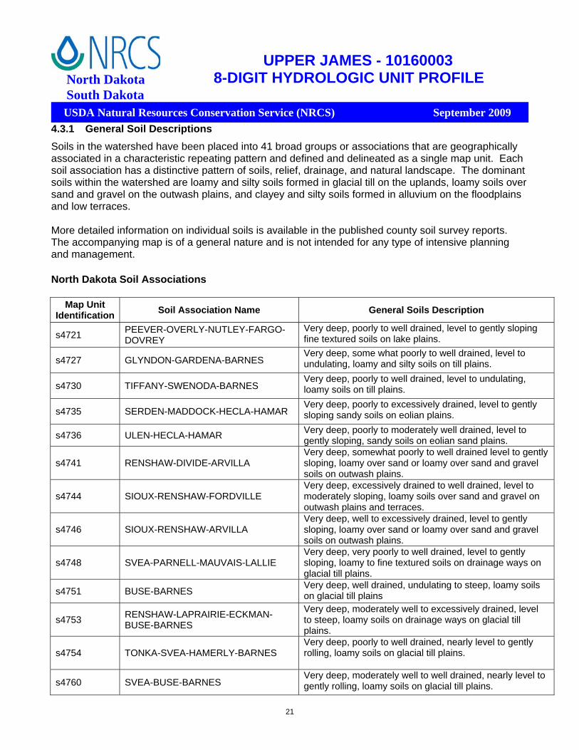
4.3.1 General Soil Descriptions
Soils in the watershed have been placed into 41 broad groups or associations that are geographically associated in a characteristic repeating pattern and defined and delineated as a single map unit. Each soil association has a distinctive pattern of soils, relief, drainage, and natural landscape. The dominant soils within the watershed are loamy and silty soils formed in glacial till on the uplands, loamy soils over sand and gravel on the outwash plains, and clayey and silty soils formed in alluvium on the floodplains and low terraces. More detailed information on individual soils is available in the published county soil survey reports. The accompanying map is of a general nature and is not intended for any type of intensive planning and management. North Dakota Soil Associations
Map Unit Identification
Soil Association Name General Soils Description
s4721 PEEVER-OVERLY-NUTLEY-FARGO-DOVREY
Very deep, poorly to well drained, level to gently sloping fine textured soils on lake plains.
s4727 GLYNDON-GARDENA-BARNES Very deep, some what poorly to well drained, level to undulating, loamy and silty soils on till plains.
s4730 TIFFANY-SWENODA-BARNES Very deep, poorly to well drained, level to undulating, loamy soils on till plains.
s4735 SERDEN-MADDOCK-HECLA-HAMAR Very deep, poorly to excessively drained, level to gently sloping sandy soils on eolian plains.
s4736 ULEN-HECLA-HAMAR Very deep, poorly to moderately well drained, level to gently sloping, sandy soils on eolian sand plains.
s4741 RENSHAW-DIVIDE-ARVILLA Very deep, somewhat poorly to well drained level to gently sloping, loamy over sand or loamy over sand and gravel soils on outwash plains.
s4744 SIOUX-RENSHAW-FORDVILLE Very deep, excessively drained to well drained, level to moderately sloping, loamy soils over sand and gravel on outwash plains and terraces.
s4746 SIOUX-RENSHAW-ARVILLA Very deep, well to excessively drained, level to gently sloping, loamy over sand or loamy over sand and gravel soils on outwash plains.
s4748 SVEA-PARNELL-MAUVAIS-LALLIE Very deep, very poorly to well drained, level to gently sloping, loamy to fine textured soils on drainage ways on glacial till plains.
s4751 BUSE-BARNES Very deep, well drained, undulating to steep, loamy soils on glacial till plains
s4753 RENSHAW-LAPRAIRIE-ECKMAN-BUSE-BARNES
Very deep, moderately well to excessively drained, level to steep, loamy soils on drainage ways on glacial till plains.
s4754 TONKA-SVEA-HAMERLY-BARNES Very deep, poorly to well drained, nearly level to gently rolling, loamy soils on glacial till plains.
s4760 SVEA-BUSE-BARNES Very deep, moderately well to well drained, nearly level to gently rolling, loamy soils on glacial till plains.

UPPER JAMES - 10160003
8-DIGIT HYDROLOGIC UNIT PROFILE
22
North Dakota South Dakota
USDA Natural Resources Conservation Service (NRCS) September 2009
s4765 SVEA-CRESBARD-CAVOUR-BARNES Very deep. Moderately well to well drained, nearly level to gently rolling, loamy soils on glacial till plains.
s4767 VALLERS-PARNELL-HAMERLY-GLYNDON
Very deep, very poorly to somewhat poorly drained, level to nearly level, loamy to silty soils on glacial till plains.
s4779 LAPRAIRIE-FAIRDALE Very deep, moderately drained, level and nearly level, loamy soils on drainage ways.
s4787 ZAHL-WILLIAMS-VIDA-BOWBELLS Very deep, moderately well to well drained, level to gently rolling, loamy soils on glacial till plains.
s4819 WABEK-MANNING Deep, well drained to excessively drained, nearly level to strongly sloping loamy soils on outwash plains and terraces.
s6897 LUDDEN-LAMOURE-LADELLE Very deep. Very poorly drained to moderately well drained, level to nearly level, clayey and silty soils formed in alluvium on flood plains and low terraces.
South Dakota Soil Associations
Map Unit Identification
Soil Association Name General Soils Description
SD125 LAMOURE-LUDDEN-LOWE Deep, somewhat poorly drained to very poorly drained, level and nearly level, silty, loamy and clayey soils formed in alluvium on floodplains and low terraces.
SD126 BARNES-KRANZBURG-BROOKINGS Deep, well drained, level to strongly sloping, loamy and silty soils on glacial till plains.
SD128 FORDVILLE-RENSHAW-SOUTHAM
Somewhat excessively drained, well drained and very poorly drained, level to moderately steep, loamy soils over gravelly material and silty soils over clayey material on outwash plains and terraces.
SD130 POINSETT-WAUBAY-SINAI) Deep, well drained and moderately well drained, level to gently sloping, silty and clayey soils on ice-walled lake plains.
SD131 POINSETT-FORMAN-SINAI Deep, well drained, level to moderately steep, silty, loamy and clayey soils on glacial till plains.
SD134 FORMAN-BUSE-SOUTHAM) Deep, well drained and very poorly drained level to moderately steep, loamy and silty soils on glacial till plains.
SD135 FORMAN-AASTAD-BUSE) Deep, well drained and moderately well drained, nearly level to steep, loamy soils on glacial till plains and moraines.
SD137 FORMAN-AASTAD-BARNES Deep, well drained and moderately well drained, nearly level to strongly sloping, loamy soils on glacial till plains and moraines.
SD139 LUDDEN-LAMOURE-LADELLE Deep, very poorly drained to moderately well drained, level to nearly level, clayey and silty soils formed in alluvium on flood plains and low terraces.
SD141 SERDEN-HAMAR-MADDOCK Very deep, excessively drained to poorly drained, nearly level to strongly sloping sandy soils on glacial lake plains
SD142 HECLA-HAMAR-ULEN Very deep, moderately well drained to poorly drained, nearly level to gently sloping, sandy and loamy soils on glacial lake plains.

UPPER JAMES - 10160003
8-DIGIT HYDROLOGIC UNIT PROFILE
23
North Dakota South Dakota
USDA Natural Resources Conservation Service (NRCS) September 2009
SD143 SWENODA-EMBDEN-COLVIN Very deep, well drained to very poorly drained, level to gently sloping, loamy and silty soils on glacial lake plains.
SD144 GARDENA-ECKMAN-GLYNDON Very deep, well drained to somewhat poorly drained, level to strongly sloping, silty and loamy soils on glacial lake plains and till plains.
SD145 BEARDEN-GREAT BEND-OVERLY Deep, well to somewhat poorly drained, level to very gently sloping silty soils on lake plains.
SD146 ABERDEEN-HARMONY-BEOTIA Deep, Well and moderately well drained, level to gently sloping loamy and clayey soils on lake plains.
SD147 ABERDEEN-NAHON-EXLINE Deep, moderately well and somewhat poorly drained, level and nearly level sodium affected clayey soils on lake plains.
SD149 BARNES-SVEA-TONKA Very deep, well drained to poorly drained, level to gently rolling, loamy and clayey soils, on till plains an glacial lake plains.
SD150 WILLIAMS-BOWBELLS-TONKA Deep, well drained and poorly drained, level to moderately sloping, loamy and clayey soils on glacial till plains.
SD151 NIOBELL-NOONAN-WILLIAMS Deep, well drained and moderately well drained, level to gently sloping loamy soils on glacial till plains.
SD152 LUDDEN-RYAN-LADELLE Very deep, moderately well drained to very poorly drained, level and nearly level, clayey and silty soils, on terraces and floodplains.
SD156 FORMAN-SIECHE-BUSE Deep, well drained, gently sloping to very steep, loamy soils on glacial till moraines.
SD161 WILLIAMS-ZAHL-BOWBELLS Deep, well drained and moderately well drained, level to steep, loamy soils on glacial till plains.
SD164 LEHR-BOWDLE-WABEK Deep, well drained to excessively drained, nearly level to strongly sloping loamy soils on outwash plains and terraces.

UPPER JAMES - 10160003
8-DIGIT HYDROLOGIC UNIT PROFILE
24
North Dakota South Dakota
USDA Natural Resources Conservation Service (NRCS) September 2009 1 4.4 CROPLAND PRODUCTIVITY
Cropland Productivity Index (CPI) is a rating assigned to each soil map unit to rate the soil for cropland production. The rating is based on a scale of 1 to 100, with 100 being the most productive map unit in the county. The CPI assigned to each map unit is based on the physical and chemical properties of each soil type in the map unit. Properties such as slope, organic matter levels, topsoil thickness, soil texture, available water capacity, pH, and salinity levels will directly affect the productivity level of each soil type. The experience of soil scientists and university researchers is used to develop the ratings.

UPPER JAMES - 10160003
8-DIGIT HYDROLOGIC UNIT PROFILE
25
North Dakota South Dakota
USDA Natural Resources Conservation Service (NRCS) September 2009
Cropland Productivity Index Descriptions 1-25 Very
Poor Red Soils with >15 percent slopes; soils with claypan, bedrock
or gravels near the surface; high salinity soils 26-50 Poor Blue Soils with 9-15 percent slopes; soils with claypan, bedrock,
or gravels within 20 inches of the surface 51-75 Fair Yellow Soils with 6-9 percent slopes; soils with claypan, bedrock,
or gravels at 20 to 40 inches of the surface 76-89 Good Light Green Soils with 2-6 percent slopes
90-100 Very Good
Dark Green Silty or loamy soils with high soil organic matter levels
4.5 RANGELAND PRODUCTION (NORMAL YEAR)1
Rangeland has a native vegetation of grasses, grasslike plants, forbs, and shrubs. In many areas, introduced forage species are also managed as rangeland. The vegetation is suitable for grazing and browsing by animals. Rangeland includes natural grasslands, savannahs, many wetlands and deserts, tundra, and certain shrub and forb communities. In areas that have similar climate and topography, differences in the kind and amount of vegetation produced on rangeland are closely related to the kind of soil. Effective management is based on the relationship between the soils, vegetation, and water. Total production is the amount of vegetation that can be expected to grow annually on well managed rangeland. It includes all vegetation, whether or not it is palatable to grazing animals. It includes the current year’s growth of leaves, twigs, and fruits of woody plants. It is expressed in pounds per acre of air-dry vegetation for normal years. Yield and production values are represented as a single value for the map unit. They are calculated based on a weighted average.

UPPER JAMES - 10160003
8-DIGIT HYDROLOGIC UNIT PROFILE
26
North Dakota South Dakota
USDA Natural Resources Conservation Service (NRCS) September 2009
The development of the North Dakota rangeland productivity data base is in progress.
Rangeland Normal Year Production Descriptions 1-1700 lbs/Ac
Poor Red Low rainfall areas or shallow soils
1701-2600 lbs/Ac
Fair Blue Areas that are high in sodium or salts or shallow to bedrock or gravel
2601-4500 lbs/Ac
Good Yellow Areas where there is no additional moisture and the soil properties do not influence the grasses Low lying areas that receive additional moisture 4501-9000
lbs/Ac Very Good
Light Green
5.0 RESOURCE CONCERNS
Resource concerns or problems are issues related to the environment that impact the health, productivity, or condition of natural resources in a watershed. The most common resource concerns are associated with the SWAPA+H.

UPPER JAMES - 10160003
8-DIGIT HYDROLOGIC UNIT PROFILE
27
North Dakota South Dakota
USDA Natural Resources Conservation Service (NRCS) September 2009
5.1 SUMMARY OF RESOURCE CONCERNS1
Specific resource concerns have been identified for each major land use at the state level. The following table is a summary of state level concerns for both ND and SD. The resource concerns specific to the watershed have been identified and evaluated by land use in the watershed assessments.
SWAPA + H Concerns
Specific Resource Concerns/Issue
Pas
ture
/Hay
Cro
pla
nd
Ran
gel
and
Fo
rest
Wild
life
Streambank X X X X X Sheet and Rill X Wind X Ephemeral Gully X Classic Gully X Shoreline X X X X X
Soil Erosion
Irrigation Induced X X Organic Matter X Excess Nitrogen X Excess Phosphorous X Contaminants – Residual Pesticides X X X X X Damage from Sediment Deposition X X X X X Compaction X Soil Salinity X
Soil Condition
Rangeland Site Stability X Inefficient Water Use on Irrigated Lands X X
Water Quantity Inefficient Water Use on Nonirrigated Lands X Harmful levels of Pesticides in Ground Water X X X X X Harmful levels of Pesticides in Surface Water X X X X X Nutrients and Organics in Ground Water X X X X Nutrients and Organics in Surface Water X X X X Pathogens in Ground Water X X X X Pathogens in Surface Water X X X X X
Water Quality
Suspended Sediment in Surface Water X X X X X Plant Suitability Plants Not Adapted to Site X
Productivity Health and Vigor X X X X Forage Quality and Palatability X X X Plant Condition Noxious and Invasive Plants X X X X X Inadequate Feed and Forage Quantities and Quality
X X X Domestic Animals
Inadequate Stock Water X X X Species of Concern X X X X X Inadequate Cover and Shelter X X X X X Fish and Wildlife Inadequate Food X X X X X

UPPER JAMES - 10160003
8-DIGIT HYDROLOGIC UNIT PROFILE
28
North Dakota South Dakota
USDA Natural Resources Conservation Service (NRCS) September 2009 1 5.2 SOIL EROSION - WIND AND WATER
Soil erosion is defined as the detachment and movement of topsoil, or soil material from the upper part of the soil profile, through the action of wind or running water, especially as a result of changes associated with human activity related to agricultural practices. Soil erosion from water includes rill, gully, and sheet.
Erosion Average Annual Erosion Rate
(T/Ac/Yr)
Acres Total (T/Yr)
Wind (WEQ) 2.27 2,080,900 4,723,600
Soil loss wind and water (cultivated cropland, hayland,
pastureland, and CRP. Water (USLE) 1.05 2,080,900 2,184,900
5.2.1 Highly Erodible Land
The basis for identifying highly erodible land (HEL) is the erodibility index (EI) of a soil map unit. The “EI” of a soil is determined by dividing the potential erodibility for each soil by the soil loss tolerance (T) value established for the soil as of January 1, 1990. The “T” value represents the maximum annual rate of soil erosion that can take place without causing a decline in long-term productivity. A soil map unit with an “EI” of eight or more is a highly erodible soil map unit. Refer to the National Food Security Act Manual (NFSAM) for further guidance.

UPPER JAMES - 10160003
8-DIGIT HYDROLOGIC UNIT PROFILE
29
North Dakota South Dakota
USDA Natural Resources Conservation Service (NRCS) September 2009
5.3 WATER RESOURCE CONSIDERATIONS 1 5.3.1 Water Resources Table
The NRI data collected for streams and water bodies within the watershed.
Water Resources – 1997 NRI Acres Percent
Streams <660’ wide and water bodies <40 Ac 14,100 0.5 Streams >660' wide and water bodies >40 Ac 19,100 0.7
8 5.3.2 Peak Stream Flow
The USGS has collected peak stream flow data at several sites along the James River in the Upper James watershed. For this report, two different collection sites will be used to represent historic peak stream flows for the watershed. Site one is located at LaMoure, ND, approximately the center of the watershed. The site has a contributing drainage area of 1,790 square miles. Peak stream flow data at this site has been recorded from 1950 through 2006.

UPPER JAMES - 10160003
8-DIGIT HYDROLOGIC UNIT PROFILE
30
North Dakota South Dakota
USDA Natural Resources Conservation Service (NRCS) September 2009
The second site is located at Columbia, SD near the southern boundary of the watershed. The site has a contributing drainage area of 2,481 square miles and has recorded peak stream flow from1946 through 2008.

UPPER JAMES - 10160003
8-DIGIT HYDROLOGIC UNIT PROFILE
31
North Dakota South Dakota
USDA Natural Resources Conservation Service (NRCS) September 2009
5.3.3 Daily Discharge8
The two USGS gauging stations used to collect peak stream flow data also recorded daily discharge data.

UPPER JAMES - 10160003
8-DIGIT HYDROLOGIC UNIT PROFILE
32
North Dakota South Dakota
USDA Natural Resources Conservation Service (NRCS) September 2009

UPPER JAMES - 10160003
8-DIGIT HYDROLOGIC UNIT PROFILE
33
North Dakota South Dakota
USDA Natural Resources Conservation Service (NRCS) September 2009
5.3.4 Groundwater1
Several major and minor aquifers of varying depths and water quality are utilized for domestic and agricultural purposes. Shallow aquifers tend to be smaller and usually have higher quality water but are also more vulnerable to leaching of nutrients, pesticides, organic waste, and pathogens. Recharge of shallow aquifers occurs primarily from infiltration of precipitation but also from wetlands, lakes, and streams. Deep aquifers often occur between layers of impenetrable bedrock. The quality of this water is often variable but usually of lower quality than that of shallow aquifers. As a result of the restrictive soil layers protecting these aquifers and the depth at which they occur, they are less susceptible to leaching and other surface activities and impacts. Important aquifers within this watershed are: Several major and minor aquifers of varying depth and quality are utilized within the watershed. Shallow aquifers tend to be smaller and usually have higher quality water but are also more vulnerable to leaching of nutrients, pesticides, organic waste, and pathogens. Recharge of shallow aquifers occurs primarily from infiltration of precipitation but also from wetlands, lakes, and streams. Deep aquifers often occur between layers of impenetrable bedrock. The quality of this water is often variable but usually of lower quality than that of shallow aquifers. As a result of the restrictive soil layers protecting these aquifers and the depth at which they occur, they are less susceptible to leaching and other surface activities and impacts. There are five major aquifers in the watershed; three are glacial drift aquifers and two bedrock aquifer: Glacial drift includes all rock material transported by glacier ice even though subsequently affected by wind or water. It can be divided into till and outwash. The till is unstratified and unsorted drift deposited by ice without subsequent movement by wind or water. Generally, till is composed of a heterogeneous mixture of clay, silt, and sand that contain lesser amounts of rock fragments ranging in size from gravel to huge boulders. Because of the large clay content, the till has low permeability and usually is a poor source of water. However, till locally contains small sand lenses that may yield as much as 5 gallons per minute. Outwash and loess are considered stratified drift, most of which has been re-worked and deposited by wind or water. Outwash is material deposited by melt water that flowed on or away from the glacier; loess is material deposited by wind. Outwash consisting of sorted gravel, sand, and silt constitutes the most permeable glacial aquifers. Aquifers in glacial drift:
Deep James, Middle James, and Elm. Aquifers in bedrock: As many as eight major bedrock aquifers underlie parts of the Upper James watershed, however only the uppermost two are used as sources of water:
Fall River and Dakota Formations.

UPPER JAMES - 10160003
8-DIGIT HYDROLOGIC UNIT PROFILE
34
North Dakota South Dakota
USDA Natural Resources Conservation Service (NRCS) September 2009
The NRCS makes groundwater leaching assessments based on a soils “saturated hydraulic conductivity” (Ksat). Ksat refers to the ease with which pores in a saturated soil transmit water and is expressed in terms of micrometers per second. Soil map units that have a Ksat value of 10 micrometers/second or greater and with <6 percent slope would be considered to have a “high leaching risk”.
UPPER JAMES - 10160003
8-DIGIT HYDROLOGIC UNIT PROFILE
35
North Dakota South Dakota
USDA Natural Resources Conservation Service (NRCS) September 2009
5.3.5 Public Water Supply Systems9 10
Approximately 670 public water systems (PWS) currently exist in SD and 515 in ND. The public water supply systems within this watershed rely on both surface and ground water sources. These systems meet the needs of rural and municipal households as well as industrial and agricultural needs. Protection and conservation of both surface and groundwater sources is critical. North Dakota The following description is from the NDDH Ground Water website: The North Dakota Source Water Protection Program was developed in response to the 1996 Safe Drinking Water Act amendments that require all states to define and assess the source waters of public water systems. All public water systems that have wells or intakes are participants in the Source Water Protection Program. Three elements of the Source Water Protection Program are federally-mandated requirements and are completed by the Department of Health, while the remaining elements can be pursued voluntarily by the governing body of the public water system. The North Dakota Source Water Assessment Strategic Plan was approved by EPA in 1999. The Source Water Protection Program strives to meet several goals:
(1) Prevent contamination of public water supplies; (2) Encourage the placement of certain activities in areas less likely to contaminate public water
supplies; and, (3) Raise public awareness of water resources used for public water supplies.
Mandatory Program Elements - completed for the public water system: (1) Delineation of a wellhead protection area (2) Contaminant Source Inventory (3) Susceptibility Analysis
Voluntary Program Elements - pursued voluntarily by the public water system: (1) Development of Management Strategies (2) Development of Contingency Plans (3) Public Awareness (4) New Well Locations
South Dakota Primary enforcement of the federal Safe Drinking Water Act (SDWA) began in 1983. The SD Drinking Water Program, part of the Department of Environment and Natural Resources (DENR), develops and enforces the SD Drinking Water Regulations (http://www.state.sd.us/denr/des/drinking/regs.htm) that apply to public water systems in the state. To see a list of drinking water contaminants that the Drinking Water Program regulates visit the Drinking Water Standards Web page at http://www.state.sd.us/denr/des/drinking/standard.htm. Plans and specifications reviews are part of the department’s regulatory efforts to protect the state’s surface and groundwater resources and public health. The areas of responsibility include design criteria development, technical assistance, and plan approvals for the Drinking Water, Groundwater Quality, Minerals and Mining, Surface Water and Waste Management Programs within the Division of Environmental Services.

UPPER JAMES - 10160003
8-DIGIT HYDROLOGIC UNIT PROFILE
36
North Dakota South Dakota
USDA Natural Resources Conservation Service (NRCS) September 2009
5.3.6 Surface Waters - Designated Beneficial Uses9 10
North Dakota In ND, beneficial uses are assigned based on the Standards of Quality for Waters of the State (NDDH, 2006). These regulations define the protected beneficial uses of the state’s rivers, streams, lakes and reservoirs. The six beneficial uses assessed for purposes of Section 305(b) reporting and Section 303(d) listing are: (1) Aquatic life (2) Recreation (3) Drinking water (4) Fish consumption (5) Agriculture (6) Industrial All streams and lakes in ND are assigned the beneficial uses (1) and (2). All streams are also assigned to beneficial uses (5) and (6) unless available data exists providing evidence of impairment. Beneficial use (4) has been assigned to all Class I, IA, and II rivers and streams, to those Class III streams known to provide a sport fishery and to all Class 1 through 4 lakes. South Dakota Surface waters in SD are classified for one or more of the following beneficial uses: (1) Domestic water supply waters; (2) Cold water permanent fish life propagation waters; (3) Cold water marginal fish life propagation waters; (4) Warm water permanent fish life propagation waters; (5) Warm water semipermanent fish life propagation waters; (6) Warm water marginal fish life propagation waters; (7) Immersion recreation waters; (8) Limited contact recreation waters; (9) Fish and wildlife propagation, recreation, and stock watering waters; (10) Irrigation waters; and (11) Commerce and industry waters. All streams, in SD, are assigned the beneficial uses (9) and (10) unless otherwise stated. All lakes, in SD, are assigned the beneficial uses of (7), (8), and (9).

UPPER JAMES - 10160003
8-DIGIT HYDROLOGIC UNIT PROFILE
37
North Dakota South Dakota
USDA Natural Resources Conservation Service (NRCS) September 2009
5.3.7 Total Maximum Daily Loads (TMDLs) 2008 Report9 10
Section 303(d) of the federal Clean Water Act requires that states develop TMDLs for water bodies that are impaired. The NDDH and SD DENR are responsible for managing the monitoring of water bodies and development of TMDLs in each respective state. The TMDLs are calculations to determine the sum allowable load of a pollutant from all contributing point and nonpoint sources, that a waterbody can receive and still meet the applicable water quality standards. The TMDLs must be developed for water bodies that do not meet the water quality standards. The TMDLs developed by NDDH and SD DENR are required to be approved by the Environmental Protection Agency (EPA) and to public notice the TMDL. The following data was presented by NDDH in “North Dakota 2008 Integrated Section 305(b) Water Quality Assessment Report and Section 303(d) List of Waters Needing Total Maximum Daily Loads” and SD DENR in “THE 2008 SOUTH DAKOTA INTEGRATED REPORT FOR SURFACE WATER QUALITY ASSESSMENT.” This information represents the current status of water quality for waters within Upper James Watershed.
Upper James Watershed
Segment or Lake Name
Segment or Lake Location Impairment Status
Status Date
Initial Listing
ND Streams James River James River from its confluence
with Pipestem Creek, downstream to its confluence with Seven Mile Coulee.
Ammonia (Un-ionized)
Fully Supporting But Threatened
2008 NA
James River James River from its confluence with Pipestem Creek, downstream to its confluence with Seven Mile Coulee.
Oxygen, Dissolved
Fully Supporting But Threatened
2008 NA
James River James River from its confluence with Pipestem Creek, downstream to its confluence with Seven Mile Coulee.
Fecal Coliform
Fully Supporting But Threatened
2008 NA
Cottonwood Creek Cottonwood Creek, downstream to Lake LaMoure.
Fecal Coliform
Not Supporting
2008 NA
Seven Mile Coulee Watershed (Eastern Stutsman County)
Seven Mile Coulee, including all tributaries. Located in Eastern Stutsman County.
Fecal Coliform
Fully Supporting But Threatened
2008 NA
Bone Hill Creek Bone Hill Creek, downstream to its confluence with the James River.
Fecal Coliform
Not Supporting
2008 NA
James River James River from its confluence with Bone Hill Creek, downstream to its confluence with Cottonwood Creek.
Fecal Coliform
Fully Supporting But Threatened
2008 NA
Bear Creek Bear Creek from tributary watershed (ND-10160003-035-S_00), downstream to its confluence with the James River.
Fecal Coliform
Fully Supporting But Threatened
2008 NA

UPPER JAMES - 10160003
8-DIGIT HYDROLOGIC UNIT PROFILE
38
North Dakota South Dakota
USDA Natural Resources Conservation Service (NRCS) September 2009
Upper James Watershed
Segment or Lake Name
Segment or Lake Location Impairment Status
Status Date
Initial Listing
ND Streams Bear Creek Watershed (Upper)
Bear Creek, upstream from tributary watershed (ND-10160003-035_00), including all tributaries.
Fecal Coliform
Fully Supporting But Threatened
2008 NA
Tributary Watershed To Bear Creek
Unnamed tributary watershed to Bear Creek.
Fecal Coliform
Fully Supporting But Threatened
2008 NA
SD Streams James River ND-SD State Line to Brown –
Spink County Line DO, pH Water
Impaired – Requires Approved TMDL
2008 1998
Moccasin Creek Headwaters to Warner, SD Fecal Coliform, Ammonia (Total), DO, pH
Water Impaired –Requires Approved TMDL
2008 2006
Impairments
DO - Dissolved Oxygen, results from the photosynthetic and respiratory activities of the biota in the water body. DO is essential for aquatic life.
pH - Acidity/Alkalinity the measure of the hydrogen ion concentration. pH can affect many chemical reactions in water.
TSI - Carlson's (1977) Trophic State Indices (TSI), Carlson’s TSI is a measure of productivity in a lake or reservoir. Typically Secchi depth, chlorophyll a, and phosphorus measurements are used to calculate a mean TSI value.
TSS - Total Suspended Solids, the organic and inorganic material left on a standard glass fiber filter (0.45 micron) after a water sample is filtered through it. TSS can be used to measure the volume of solids in a water body. Too much suspended solids can be harmful to the biota in a stream.

UPPER JAMES - 10160003
8-DIGIT HYDROLOGIC UNIT PROFILE
39
North Dakota South Dakota
USDA Natural Resources Conservation Service (NRCS) September 2009
TMDL Project Status
Assessment Initiated - Data for developing the TMDL is being collected. Delist - A water body has been removed from the TMDL list. Delisting may occur when
a TMDL is approved by EPA, water quality standards are met, a water body was listed in error, additional state effluent controls address water quality problems, reservoirs have been breached and are no longer a viable water body, or data assessment methodologies have been modified.
Delist* - Water quality standards have been met; however, a TMDL was completed because an assessment had already been initiated while the segment was previously listed.
Not Initiated - Projects are proposed and waiting final funding to begin assessment. Special Approvals - A water body that had sufficient data to write a TMDL before the first 303(d) list
was published. TMDL in Public Notice - During the public notice phase, a TMDL has been developed and is ready for
public review and comment. Comments received are reviewed and considered before submitting a final TMDL to EPA for approval.
TMDL Public Noticed - The public notice comment period has passed. Comments received are being reviewed and considered before submitting a final TMDL to EPA for approval.
TMDL Approved - EPA has approved a TMDL as submitted by the state. TMDL Not Required - Water body is meeting its beneficial uses.
Watershed Projects, Plans, Studies, and Assessments
ND NRCS Watershed Project ND NRCS Watershed Plans, Studies, and
Assessments Name Status Goals: Name Status Goals:
Maple River, West Branch Withdrawn NA
Bonehill Creek Watershed Stream Assessment
Complete
Bear Creek Stream Assessment
Complete
Cottonwood Creek Watershed Land Use Assessment
Complete
NDDH Water Quality Projects or ND Soil
Conservation District Watershed Projects NDDH or ND Soil Conservation District
Watershed Plans, Studies or Assessments Name Status Goals: Name Status Goals:
None NA NA
Seven Mile Watershed
Ongoing
Beaver Creek Watershed
Ongoing
Spiritwood Lake Watershed
Ongoing
Bonehill Creek Watershed
Complete

UPPER JAMES - 10160003
8-DIGIT HYDROLOGIC UNIT PROFILE
40
North Dakota South Dakota
USDA Natural Resources Conservation Service (NRCS) September 2009
NDDH Water Quality Projects or ND Soil
Conservation District Watershed Projects NDDH or ND Soil Conservation District
Watershed Plans, Studies or Assessments Name Status Goals: Name Status Goals:
Bear Creek Complete
Cottonwood Creek (Lake LaMoure) Watershed
Complete
NDDH – EPA 319 Watershed Projects
Goals: Status Goals: Bonehill Creek Watershed
Ongoing
Cottonwood Creek Watershed
Ongoing
Bear Creek Watershed
Ongoing
South Dakota
SD NRCS Watershed Projects SD NRCS Watershed Plans, Studies, and
Assessments Name Status Goals: Name Status Goals None NA NA None NA NA
SD DENR or Conservation District Water Quality Projects
SD DENR or SD Conservation District Water Quality Assessments or Studies
Name Status Results: Name Status Results:
Elm Lake Implementation Project In Progress
Upper James River Assessment Project In Progress NA

UPPER JAMES - 10160003
8-DIGIT HYDROLOGIC UNIT PROFILE
41
North Dakota South Dakota
USDA Natural Resources Conservation Service (NRCS) September 2009
5.3.8 Confined Animal Feeding Operations (CAFO)10 11
The NDDH and SD DENR are the state agencies responsible for regulating animal feeding operations in the respective state. A CAFO is a lot or facility that stables or confines and feeds or maintains animals for a total of 45 days or more in any 12-month period and meets the criteria for either a large, medium, or small concentrated animal feeding operation. Concentrated Animal Feeding Operations are regulated by a general water pollution control permit. Producers must submit plans for manure management systems to the respective state agency. These plans must meet design requirements and be approved by a department engineer. Livestock production is an important industry within the Upper James watershed. Farms and ranches raise beef cattle, dairy cattle, swine, and poultry. North Dakota
Animal Feeding Facilities – North Dakota Department of Health Permit
Animal Type Dairy Beef Swine Other Total
Number of Animal Feeding Operations
20 89 22 8 139
Number of Animals
2,946 31,541 13,200 225 47,912
No. of State Permitted Operations 26
South Dakota
CAFO Watershed Summary South Dakota Department of Environment and Natural Resources
Animal/Operation Type Cattle Dairy Sheep Swine Poultry Not
SpecifiedNumber of Permitted Farms 9 3 1 4 1 - Number of Permitted Animals 28,758 3,903 2,000 14,790 66,500 - Permitted Acres for Waste Management 14,065 3,573 2,956 8,177 Partially Permitted Farms 2 - # of Animals Permitted 2,600 15,310 - Total Animals 2,910 740 1,500 - # of Acres 4,460 3,414 Approved Farms Not yet permitted 1 - # of Animals 1,700 - # of Acres 1,110 Other Acres Not Specified
Current as of June 2009
UPPER JAMES - 10160003
8-DIGIT HYDROLOGIC UNIT PROFILE
42
North Dakota South Dakota
USDA Natural Resources Conservation Service (NRCS) September 2009
5.4 RESOURCES OF SPECIAL CONCERN
In support of federal actions proposed by the NRCS, the agency prepares programmatic, policy, legislative, and other Environmental Assessments (EA) or Environmental Impact Statements (EIS), as necessary, for environmental compliance with federal regulations. All conservation programs administered by the agency have a program level EA or EIS. Additionally, the NRCS policy requires that for all projects or conservation practices where the NRCS provides financial or technical assistance, a site-specific environmental evaluation (EE) of practice effects is completed to ensure the proposed action has been sufficiently analyzed in an existing NRCS environmental document. Both ND and SD NRCS site-specific EE reviews and evaluates the proposed activity impacts with regard to the following federal laws, Executive Orders, regulations, or agency policy as applicable: National Historic Preservation Act (1966), as amended, and implementing regulations found at 36 CFR Part 800; Endangered Species Act (1973), as amended; Fish and Wildlife Coordination Act (1943), as amended; Executive Order 11988 (1987) - Floodplain Management; Executive Order 13112 (1999) - Invasive Species; Migratory Bird Treaty Act (1918), as amended, and Executive Order 13186 – Responsibility of Federal Agencies to Protect Migratory Birds; The NRCS policy General Manual (GM), Title 190, Part 410.23 - Natural Areas; Farmland Protection Policy Act and 7 CFR 658.5 regulations; The NRCS policy GM, Title 190, Part 411.03(d) Riparian Areas; Clean Water Act and Waters of the U.S. (1972); Executive Order 11990 “Protection of Wetlands,” the Food Security Act of 1985, revised NRCS Wetland Technical Assistance Policy - 7 CFR Part 650 (1997); Wild and Scenic Rivers Act – PL 90-542. 5.4.1 Endangered and Threatened Species
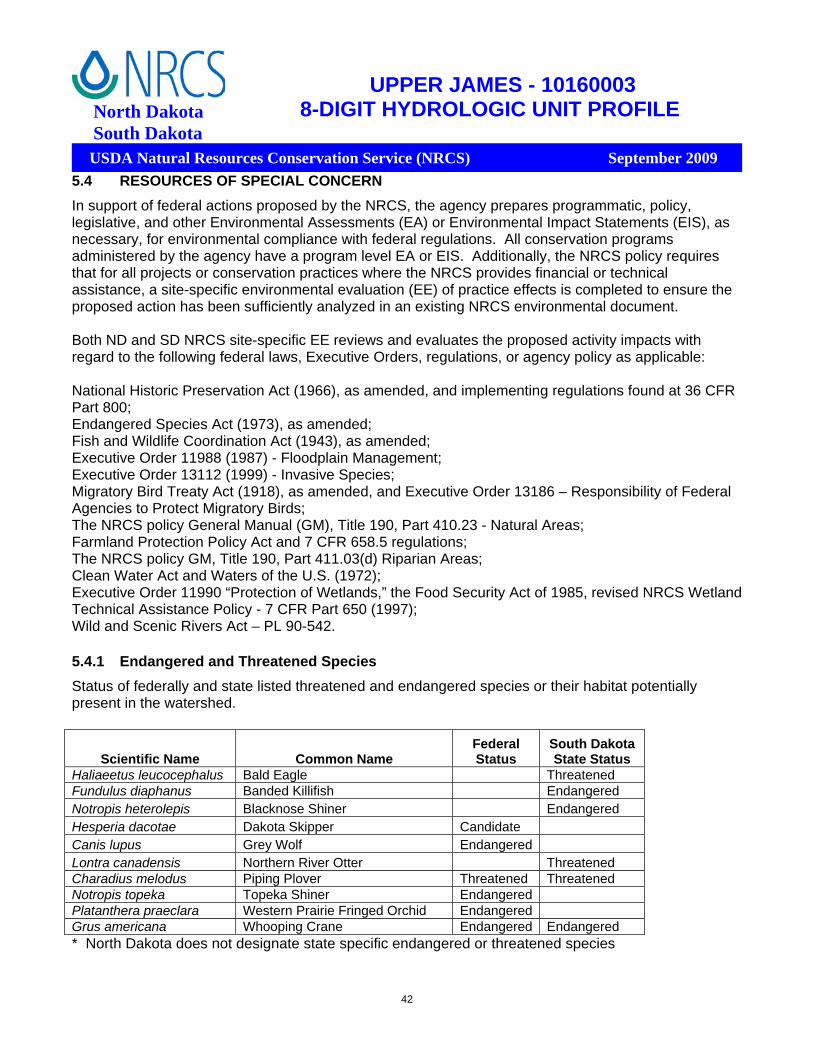
Status of federally and state listed threatened and endangered species or their habitat potentially present in the watershed.
Scientific Name Common Name Federal Status
South Dakota State Status
Haliaeetus leucocephalus Bald Eagle Threatened Fundulus diaphanus Banded Killifish Endangered Notropis heterolepis Blacknose Shiner Endangered Hesperia dacotae Dakota Skipper Candidate Canis lupus Grey Wolf Endangered Lontra canadensis Northern River Otter Threatened Charadius melodus Piping Plover Threatened Threatened Notropis topeka Topeka Shiner Endangered Platanthera praeclara Western Prairie Fringed Orchid Endangered Grus americana Whooping Crane Endangered Endangered * North Dakota does not designate state specific endangered or threatened species

UPPER JAMES - 10160003
8-DIGIT HYDROLOGIC UNIT PROFILE
43
North Dakota South Dakota
USDA Natural Resources Conservation Service (NRCS) September 2009
5.5 RESOURCE ACCOMPLISHMENTS
5.5.1 Performance Results Systems (PRS) Data
The PRS is an Integrated Accountability System (IAS) application that collects practice-based information for NRCS conservation programs. Currently, the PRS program is used by NRCS employees and partners to record performance data on conservation plans and practices that are planned and applied.
PRS Data FY 04 FY 05 FY 06 FY 07 FY 08 FY 09
Applied Conservation Treatment (Units/Acres)
Access Control (472) (ac) 569 110 646 435 5892 801
Access Road (560) 2,840 6,600 2,278 3,835 1,792
Brush Management (314) (ac) 20 58Closure of Waste Impoundment (360) (no) 1Comprehensive Nutrient Management Plan (100) (no) 9 3 5 17Conservation Cover (327) (ac) 2,704 1,668 10,395 9,990 10,259 1,917
Conservation Crop Rotation (328) (ac) 14,112 15,978 28,374 38, 154 44,914 5,011
Cover Crop (340) (ac) 79 454 523 400
Critical Area Planting (342) (ac) 8 6 32 21 46
Dike (356) (ft) 1,250 17,514Diversion (362) (ft) 2,600 2,440 4,360 1,650 658
Early Successional Habitat Development/Mgmt (612) (ac) 4 533 4,128 630 74
Fence (382) (ft) 17,386 43,991 41,005 21,923 109,069 6,626
Field Border (386) (ac) 1,050Filter Strip (393) (ac) 99 62 280 232 354 45
Forage Harvest Management (511) (ac) 93 467 380 1,083 1,568 290
Grassed Waterway (412) (ac) 16 11 23 4Heavy Use Area Protection (561) (ac) 17 29 50 44 4 3
Irrigation System, Sprinkler (442) (ac) 885 1,200 1,058 3,138 703
Irrigation Water Management (449) (ac) 126 423 719 1,426 2,584 997
Mulching (484) (ac) 3 51 86 106 24
Nutrient Management (590) (ac) 11,863 14,281 22,891 43,745 27,347 5,791
Pasture and Hay Planting ( 512) (ac) 85 369 328 94 275 30
Pest Management (595) (ac) 4,625 9,926 13,321 27,206 23,036 3,982
Pipeline (516) (ft) 16,003 24,098 8,194 2,300 16,343 1,675
Pond (378) (no) 10 3 7 2 3
Prescribed Grazing (528) (ac) 2,597 4,851 4,080 1,960 3,639 1,848
Pumping Plant (533) (ac) 5 2
Range Planting (550) (ac) 14 15 270 7
Residue Management, No-Till/Strip Till/ Direct Seed (329) (ac) 6,870 8,468 18,835 17,522 25,654 2,154
Residue Management, Mulch Till (345) (ac) 6,564 4,221 11,033 21,404 14,267 893
Residue Management, Seasonal (344) (ac) 3,405 4,147 895 5,679 19,274 4,730
Restoration and Management of Declining Habitats (643) (ac) 66 Riparian Forest Buffer (391) (ac) 27 33 11Riparian Herbaceous Cover (390) (ac) 21 15 316Salinity and Sodic Soil Management (610) (ac) 123 50 36 181 157

UPPER JAMES - 10160003
8-DIGIT HYDROLOGIC UNIT PROFILE
44
North Dakota South Dakota
USDA Natural Resources Conservation Service (NRCS) September 2009
PRS Data FY 04 FY 05 FY 06 FY 07 FY 08 FY 09
Applied Conservation Treatment (Units/Acres)
Sediment Basin (350) (no) 2 1 1Solid/Liquid Waste Separation Facility (632) (no) 1
Spring Development (574) (no) 1 Tree and Shrub Establishment (612) (ac) 3 15Underground Outlet (620) (ft) 110 40 120
Upland Wildlife Habitat Management (645) (ac) 147 625 1,633 11,855 6,117 5552
Waste Storage Facility (313) (no) 2 5 9 9 3
Waste Transfer (634) (no) 1 Waste Utilization (633) (ac) 1,293 1,082 986 1,368 345
Water Well (642) (no) 3 2 1 2 5 1
Watering Facility (614) (no) 5 8 6 6 14 1
Well Decommissioning (351) (no) 115 4Wetland Creation, Enhancement, and Restoration (658, 659, 657) (ac) 704 125 233 394 3,301
542
Wetland Wildlife Habitat Management (644) (ac) 31 258 342 334 1,165 379
Wildlife Watering Facility (645) (no) 1Windbreak/Shelterbelts (380 and 650) (ft) 200,093 146,457 162,166 90,832 250,555 11,667

UPPER JAMES - 10160003
8-DIGIT HYDROLOGIC UNIT PROFILE
45
North Dakota South Dakota
USDA Natural Resources Conservation Service (NRCS) September 2009 12 13 6.0 CENSUS AND SOCIAL DATA
This section provides basic social data gathered through the 2007 Census of Agriculture and United States Census 2000. 6.1 POPULATION CHART
Census data for the rural and urban population within the watershed.
Upper James Watershed - Population
Urban:, 32,681
Rural - Living on Farm:, 4,014
Rural - Not living on farm:, 19,609

UPPER JAMES - 10160003
8-DIGIT HYDROLOGIC UNIT PROFILE
46
North Dakota South Dakota
USDA Natural Resources Conservation Service (NRCS) September 2009
6.2 HOUSEHOLD INCOME
<$10,000 $20,000 $30,000 $40,000 $50,000 $60,000 $75,000 $100,000 $125,000 $150,000 $200,000 > $200,000
-
500
1,000
1,500
2,000
2,500
3,000
3,500
4,000
Ho
us
eh
old
s
Household Income
Upper James Watershed - Household Income

UPPER JAMES - 10160003
8-DIGIT HYDROLOGIC UNIT PROFILE
47
North Dakota South Dakota
USDA Natural Resources Conservation Service (NRCS) September 2009
6.3 FARM SIZE
1 to 49 50 to 999 1,000 +
309
1,300
1,945
-
200
400
600
800
1,000
1,200
1,400
1,600
1,800
2,000
No
. o
f F
arm
s
Size of Farms (Ac)
Upper James Watershed - Farm Size

UPPER JAMES - 10160003
8-DIGIT HYDROLOGIC UNIT PROFILE
48
North Dakota South Dakota
USDA Natural Resources Conservation Service (NRCS) September 2009
6.4 DEMOGRAPHICS
Upper James Watershed - Demographics
White, 96.9%
Black or African American, 0.3%
American Indian, 2.3%Asian, 0.3%
Other, 0.2%

UPPER JAMES - 10160003
8-DIGIT HYDROLOGIC UNIT PROFILE
49
North Dakota South Dakota
USDA Natural Resources Conservation Service (NRCS) September 2009
6.5 TOTAL AGRICULTURAL SALES
<$50,000 $50,000 to $249,999 >$250,000
1596
835
879
0
200
400
600
800
1000
1200
1400
1600
No
. o
f F
arm
s
Total Agriculture Sales
Upper James Watershed - Total Ag Sales

UPPER JAMES - 10160003
8-DIGIT HYDROLOGIC UNIT PROFILE
50
North Dakota South Dakota
USDA Natural Resources Conservation Service (NRCS) September 2009
7.0 REFERENCES/PREPARERS
7.1 LIST OF PREPARERS - This RWA was prepared by an interdisciplinary team composed of the following personnel:
North Dakota Name Title Representing Clarence Clayton ICCS Leader NRCS Don Felch Biologist NRCS Todd Hagel Assistant State Conservationist (Water Resources) NRCS JoDean Nichols Economist NRCS Ron Luethe GIS Specialist NRCS Steve Sieler State Soil Liaison NRCS Doug Van Daalen Planning Specialist NRCS Diane Wandler GIS Assistant NRCS Keith Weston Water Quality Specialist NRCS South Dakota Lori DePauw Office Automation Assistant NRCS Keith Gestring Natural Resources Engineer DENR Barb Hall Cartography Technician NRCS Jeff Hemenway Conservation Agronomist NRCS Mike Kuck Assistant State Conservationist for Programs NRCS Kevin Luebke Biologist NRCS Colin Niehus Hydraulic Engineer NRCS Dan Shurtliff Assistant State Soil Scientist NRCS Cindy Steele Planning Engineer NRCS Rod Voss Resource Conservationist NRCS Paul Wegleitner Natural Resources Project Engineer DENR Doug Vik Economist NRCS 7.2 REFERENCES
1 Natural Resources Conservation Service, 2002 2 South Dakota Geological Survey, 2004 3 North Dakota Geological Survey 4 Prism Group, 1990. south Dakota Annual Precipitation Data 1961-1990 5 South Dakota State University 2007. South Dakota Office of Climatology 6 North Dakota State University 2009. North Dakota Climate Office 7 High Plains Regional Climate Center, 2007 8 United States Geological Survey – Originator of National Land Cover Dataset 9 South Dakota Department of Environment and Natural Resources (SD DENR) 10 North Dakota Department of Health – Division of Water Quality 11 SD DENR – Surface Water Quality 12 2007 Census of Agriculture, National Agricultural Statistics Service. Adjusted by percent of HUC in the county or by percent of zip code in the HUC, depending on the level of data available. 13 United States Census 2000, United States Census Bureau. Adjusted by percent of HUC in the county or by percent of the census block in the HUC, depending on the level of data available.