ravena, ny score · 2 location and habitat description stuyvesant marsh is located on the east side...
TRANSCRIPT
1
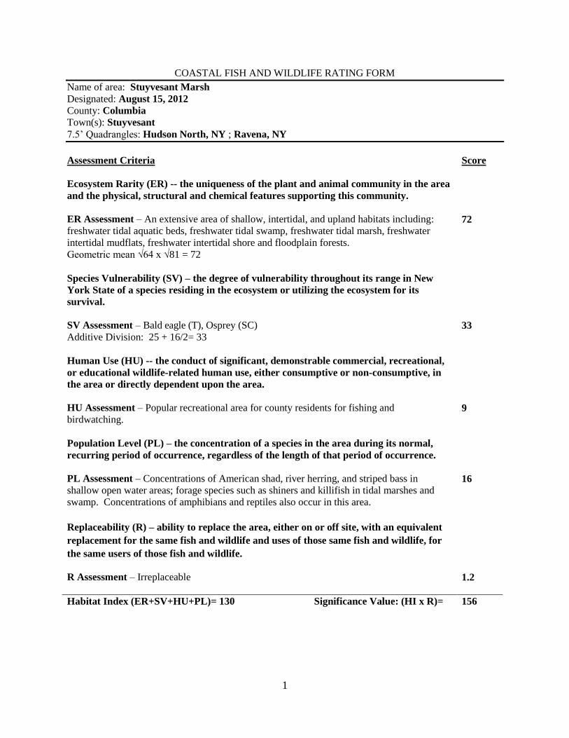
COASTAL FISH AND WILDLIFE RATING FORM
Name of area: Stuyvesant Marsh
Designated: August 15, 2012
County: Columbia
Town(s): Stuyvesant
7.5’ Quadrangles: Hudson North, NY ; Ravena, NY
Assessment Criteria
Score
Ecosystem Rarity (ER) -- the uniqueness of the plant and animal community in the area
and the physical, structural and chemical features supporting this community.
ER Assessment – An extensive area of shallow, intertidal, and upland habitats including:
freshwater tidal aquatic beds, freshwater tidal swamp, freshwater tidal marsh, freshwater
intertidal mudflats, freshwater intertidal shore and floodplain forests.
Geometric mean √64 x √81 = 72
72
Species Vulnerability (SV) – the degree of vulnerability throughout its range in New
York State of a species residing in the ecosystem or utilizing the ecosystem for its
survival.
SV Assessment – Bald eagle (T), Osprey (SC)
Additive Division: 25 + 16/2= 33
33
Human Use (HU) -- the conduct of significant, demonstrable commercial, recreational,
or educational wildlife-related human use, either consumptive or non-consumptive, in
the area or directly dependent upon the area.
HU Assessment – Popular recreational area for county residents for fishing and
birdwatching.
9
Population Level (PL) – the concentration of a species in the area during its normal,
recurring period of occurrence, regardless of the length of that period of occurrence.
PL Assessment – Concentrations of American shad, river herring, and striped bass in
shallow open water areas; forage species such as shiners and killifish in tidal marshes and
swamp. Concentrations of amphibians and reptiles also occur in this area.
16
Replaceability (R) – ability to replace the area, either on or off site, with an equivalent
replacement for the same fish and wildlife and uses of those same fish and wildlife, for
the same users of those fish and wildlife.
R Assessment – Irreplaceable
1.2
Habitat Index (ER+SV+HU+PL)= 130 Significance Value: (HI x R)= 156
2
LOCATION AND HABITAT DESCRIPTION
Stuyvesant Marsh is located on the east side of the Hudson River, at the hamlet of Stuyvesant, in the
Town of Stuyvesant, Columbia County (7.5' Quadrangles: Hudson North and Ravena, N.Y.). Stuyvesant
Marsh, which is approximately 415 acres, has a diversity of habitat types including a mix of upper and
lower marsh west of the railroad tracks, sand and mudflats at the mouth of a small stream, sandy beach
south of the stream, rocky shore along the river at the northern end of the site, forested uplands, tidal
swamp and supratidal wetlands in the center of the site. Several submerged aquatic vegetation beds,
mainly water celery (Vallisneria americana), occur throughout this habitat.
A number of listed plant species are present in this habitat including, Heartleaf plantain (Plantago
cordata) (T), Southern estuary beggar ticks (Bidens bidentoides) (R), Long’s bittercress (Cardamine
longii) (T). The invasive plant species common reed (Phragmites australis) also occurs in this habitat.
A portion of Stuyvesant Marsh is currently owned by the State of New York and managed by the New
York State Department of Environmental Conservation. Human disturbances include railroad traffic,
some residential use, hardened shorelines, and dredge spoil disposal.
FISH AND WILDLIFE VALUES
The Stuyvesant Marsh habitat area contains seven ecological communities ranked as rare in New York
State: tidal river, freshwater tidal aquatic beds, freshwater tidal swamp, supratidal swamp, freshwater tidal
marsh, freshwater intertidal mudflats, freshwater intertidal shore and floodplain forest. The habitat also
includes several different types of upland forests.
Stuyvesant Marsh is an important spawning, nursery, and refuge area for migratory and resident fish
species. Shallow subtidal areas comprising part of the Stuyvesant Marsh habitat serve as spawning sites
for American shad (Alosa sapidissima), which concentrate in such areas between mid-April and June.
The mudflats and littoral zone areas are also utilized as nursery grounds, feeding areas, and refuge by
striped bass (Morone saxatilis), American shad (Alosa sapidissima), alewife (Alosa pseudoharengus),
blueback herring (Alosa aestivalis), and other resident species. The submerged aquatic vegetation
provides food for fish, invertebrates and waterfowl as well as refuge for fish and invertebrates.
The eastern shore of the entire significant habitat is home to the common map turtle(Graptemys
geographica) while interior portions of this habitat hosts water snakes (Nerodia s. sipedon), brown
snakes(Storeria d. dekayi), Northern ringneck snakes (Diadophis punctatus), spotted turtle (Clemmys
guttata), painted turtle (Chrysemys picta), spotted salamander (Ambystoma maculatum), red-spotted newt
(Notophthalmus v. viridescens), redback salamander (Plethodon cinereus), mudpuppy (Necturus
maculosus), American toad (Bufo americanas), gray treefrog (Hyla versicolor), spring peeper
(Pseudoacris crucifer), bullfrog (Rana catesbeiana), green frog (Rana clamitans), wood frog (Rana
sylvatica), and Northern leopard frog (Rana pipiens). The tawny emperor (Asterocampa clyton), a
vulnerable, unprotected invertebrate is also present in the habitat area.
The Stuyvesant Marsh also provides valuable feeding and resting habitat for osprey (Pandion haliaetus)
(SC), Bald eagle (T) (Haliaeetus leucocephalus), and numerous shorebirds, wading birds and songbirds,
including least bittern Ixobrychus exilis), wood duck (Ixobrychus exilis), mallard (Anas platyrhynchos),
spotted sandpiper (Actitis macularia), great blue heron (Ardea herodias), green-backed heron (Butorides
virescens), belted kingfisher (Ceryle alcyon) and other species.
3
IMPACT ASSESSMENT
Any activities that would degrade water quality, increase turbidity, increase sedimentation, or alter flows,
temperature, or water depths of Stuyvesant Marsh would result in significant impairment of the habitat.
All species may be affected by water pollution, such as chemical contamination (including food chain
effects resulting from bioaccumulation), oil spills, excessive turbidity or sediment loading, and nonpoint
source runoff. Discharges or runoff of sewage effluent, pesticides, or other hazardous materials into the
habitat would result in impairment to the habitat.
Any physical alteration of the habitat, through dredging, filling, or bulkheading, would result in a direct
loss of valuable habitat area and ecosystem function. Activities that would subdivide this relatively large,
undisturbed area into smaller fragments should be avoided. Elimination or disturbance of adjacent
wetlands, forested habitats, and vegetated upland buffer zones would adversely affect the habitat. Such
areas should be protected, and where possible restored to provide bank cover, stabilize soil, maintain or
improve water quality and provide buffer areas. Habitat disturbances would be most detrimental during
fish spawning and nursery and bird nesting periods, which generally extend from March through August
for most species.
Alteration to existing causeways and bridges for the railroad could affect the hydrology and extent of
shoreline habitat areas. Any construction related to these structures should utilize the best available
science and technology to reduce and avoid negative impacts to the habitat area.
Docks, piers, catwalks, or other structures may be detrimental to submerged aquatic vegetation beds
through direct or indirect effects from shading, mooring chain and propeller scarring, and other associated
human uses. In particular, the submerged aquatic vegetation beds are especially vulnerable to impacts
that decrease light penetration into the water.
The presence of invasive species and the expansion of their range within the habitat may result in changes
in native plant, vertebrate and invertebrate species composition and abundance. In particular, changes in
plant communities may affect marsh-nesting birds. Effective control of invasive plant species, through a
variety of means, may improve fish and wildlife species use of the area. Control methods, including
biological controls and regulated use of herbicides must only be implemented, if other methods of control
have been explored, and then only under permit with strict adherence to all precautionary measures to
avoid impacts to non-target species. The primary goals of such efforts must be recovery and maintenance
of habitat for native fish and wildlife species.
Development of appropriate public access to the area may be desirable to allow compatible human uses of
the fish and wildlife resources. Human use of the area should be conducted in a manner to avoid impacts.
HABITAT IMPAIRMENT TEST
A habitat impairment test must be met for any activity that is subject to consistency review under
Federal and State laws, or under applicable local laws contained in an approved local waterfront
revitalization program. If the proposed action is subject to consistency review, then the habitat protection policy applies, whether the proposed action is to occur within or outside the designated area.
The specific habitat impairment test that must be met is as follows.
In order to protect and preserve a significant habitat, land and water uses or
development shall not be undertaken if such actions would:
4
1. destroy the habitat; or,
2. significantly impair the viability of a habitat.
Habitat destruction is defined as the loss of fish or wildlife use through direct physical alteration,
disturbance, or pollution of a designated area or through the indirect effects of these actions on a
designated area. Habitat destruction may be indicated by changes in vegetation, substrate, or hydrology, or increases in runoff, erosion, sedimentation, or pollutants.
Significant impairment is defined as reduction in vital resources (e.g., food, shelter, living space) or
change in environmental conditions (e.g., temperature, substrate, and salinity) beyond the tolerance range
of an organism. Indicators of a significantly impaired habitat focus on ecological alterations and may
include but are not limited to reduced carrying capacity, changes in community structure (food chain
relationships, species diversity), reduced productivity and/or increased incidence of disease and mortality.
The tolerance range of an organism is not defined as the physiological range of conditions beyond
which a species will not survive at all, but as the ecological range of conditions that supports the species
population or has the potential to support a restored population, where practical. Either the loss of
individuals through an increase in emigration or an increase in death rate indicates that the tolerance
range of an organism has been exceeded. An abrupt increase in death rate may occur as an
environmental factor falls beyond a tolerance limit (a range has both upper and lower limits). Many
environmental factors, however, do not have a sharply defined tolerance limit, but produce increasing
emigration or death rates with increasing departure from conditions that are optimal for the species.
The range of parameters which should be considered in applying the habitat impairment test includes
but is not limited to the following:
1. physical parameters such as living space, circulation, flushing rates, tidal amplitude,
turbidity, water temperature, depth (including loss of littoral zone), morphology, substrate
type, vegetation, structure, erosion and sedimentation rates;
2. biological parameters such as community structure, food chain relationships, species
diversity, predator/prey relationships, population size, mortality rates, reproductive rates,
meristic features, behavioral patterns and migratory patterns; and,
3. chemical parameters such as dissolved oxygen, carbon dioxide, acidity, dissolved solids,
nutrients, organics, salinity, and pollutants (heavy metals, toxics and hazardous materials).
KNOWLEDGABLE CONTACTS
Natural Resources Bureau
NYS Department of State
99 Washington Ave, Suite 1010
Albany, NY 12231
Phone: (518) 474.6000
Hudson River National Estuarine Research Reserve
Norrie Point Environmental Center
PO Box 315
Staatsburg, NY 12580
Phone: (845) 889.4745

5
Hudson River Fisheries Unit
NYS Department of Environmental Conservation
21 South Putt Corners Road
New Paltz, NY 12561
Phone: (845) 256.3071
The Hudson River Estuary Program
NYSDEC Region 3
21 S Putt Corners Rd
New Paltz, NY 12561
Phone: (845) 256.3016
New York Natural Heritage Program
625 Broadway, 5th Floor
Albany, NY 12233-4757
Phone: (518) 402.8935
