re: an update to the independent audit report of certain ... · included in the company’s...
TRANSCRIPT

411 North Sam Houston Parkway East, Suite 400, Houston, Texas USA T +1 281 448 6188 F +1 281 448 6189 W www.rpsgroup.com/energy
Dr. Richard Hubbard, COO President Energy PLC 11 Hill Street London W1J5LF United Kingdom 12th June 2014 Re: An Update to the Independent Audit Report of certain Prospective Resources
located in the Pirity and Demattei Licenses, Onshore Paraguay
Dear Sirs,
On 23rd May 2014, Cambrian Consultants (CC) America, Inc. d/b/a RPS (‘RPS’) was requested by President Energy PLC (‘President’ or ‘Company’) to provide an update addendum (the ‘Update’) to a previous Audit Report (the ‘Report’) entitled “Independent Audit Report of certain Prospective Resources located in the Pirity and Demattei Licenses, Onshore Paraguay” dated 23rd January 2013. This Update has been requested by the Company in order to independently verify via an audit approach that a newly promoted ‘Category 1’ prospect has been properly evaluated by the Company and is “drill-ready”. This prospect (the “Lapacho” prospect) is now potentially to be included in the Company’s near-term drilling program, replacing the previously audited “Yacare” prospect.
The work for this Update has been conducted under a formal Letter of Engagement (the ‘Agreement’) between RPS and President dated 4th June 2014. The report is issued by RPS under the appointment by President and is produced as part of the Services detailed in the Agreement subject to the terms and conditions therein. The Report and this Update are addressed to the Company and are only capable of being relied on by the Company, and any Third Parties under and pursuant to (and subject to the terms of) the Agreement.
The audit considers the progress made in the exploration of the licences with regard to seismic acquisition, processing, interpretation and the formal assignment to President Energy of working interest in the license. President Energy PLC is an AIM listed company with associated disclosure requirements and, as such, this Report has been written in accordance with the requirements of the AIM Guidance Note for Mining, Oil and Gas Companies dated June 2009 (the “AIM Guidance Note”).
In accordance with your instructions to us and the requirements of the AIM Note, we confirm that we:
1. are professionally qualified and a member in good standing of a self-regulatory organisation of engineers and/or geoscientists including SPE, EI, AAPG and EAGE;
2. have at least five years’ relevant experience in the estimation, assessment and evaluation of oil and gas assets;
3. are independent of the Company, its directors, senior management and advisers;
4. will be remunerated by way of a time-based fee and not by way of a fee that is linked to the value of the Company;

UCV02276.1 President Energy PLC Update to Independent Audit Report, Lapacho Prospect
2
5. are not a sole practitioner;
6. have the relevant and appropriate qualifications, experience and technical knowledge to appraise professionally and independently the assets, being all assets, licences, joint ventures or other arrangements owned by the Company or proposed to be exploited or utilised by it (“Assets”) and liabilities, being all liabilities, royalty payments, contractual agreements and minimum funding requirements relating to the Company’s work programme and Assets (“Liabilities”); and
7. consider that the scope of this Report is appropriate, given the Group’s Assets and Liabilities and includes and discloses all information required to be included therein and was prepared to a standard expected in accordance with the AIM Note.
Neither RPS, nor any of its directors, staff or sub-consultants who contributed to this report has any interest in the Company; or any of the advisers to the Company; or the Assets; or the outcome of the Offer.
Standard applied In compiling this Letter we have used the definitions and guidelines set out in the Petroleum Resources Management System (“PRMS”) by the SPE/WPC/AAPG/SPEE in 2007 as the internationally recognised Standard required by the AIM Guidance Note as above.
Qualifications RPS Energy is an independent consultancy specialising in petroleum reservoir evaluation and economic analysis. The provision of professional services has been solely on a fee basis. Mr. Andrew Kirchin, Executive VP, Consulting for RPS (Houston), has supervised the evaluation. Mr. Kirchin has over 25 years of experience in upstream oil and gas.
Other RPS employees involved in this work hold at least a degree in geology, geophysics, petroleum engineering or a related subject or have at least five years of relevant experience in the practice of geology, geophysics or petroleum engineering. The geological audit and analysis was principally conducted by Mr. Chuck Barker, a Geological Advisor with RPS in Houston. Mr. Barker is a licensed Professional Geologist of Texas and has in excess of 35 years of experience in the oil and gas industry. The engineering and economic audit for the Report was principally conducted by Mr. Andrew Fair, a Principal Engineer with RPS in Houston. Mr. Fair is a licensed Professional Engineer of Texas and has over 35 years of experience in the oil and gas industry.
Effective Date and material change statement The evaluation of the Properties is calculated as at 1st January 2014 (the “Effective Date”). We confirm that there has been no material change to the Properties between the Effective Date to the date hereof and we are not aware of any significant matters arising from our evaluation that are not covered by this Report which might be of a material nature.
Reliance on source data This Update is based on information available up to June 1, 2014. An Effective Date of 1st January 2014 was assumed for the valuation shown in the Report.
UCV02276.1 President Energy PLC Update to Independent Audit Report, Lapacho Prospect
3
The Services have been performed by a RPS team of professional petroleum engineers, geoscientists and economists and is based on data and previous reports, supplied through President.
Our approach has been to audit the Company’s technical interpretation of their base case geoscience and engineering data for the field for reasonableness and to review the ranges of uncertainty for each parameter around this base case in order to estimate ranges of potential petroleum initially-in-place and recoverable Resources. For the Report
Executive Summary President Energy is currently embarked on a work-program under a farm-out agreement (‘FOA’) with Pirity Hydrocarbons S.R.L. for the Pirity License (‘Pirity’) and Crescent Global Oil Paraguay S.A. for the Demattei License (‘Demattei’). The farm-in agreements for both licenses were signed on 11th September 2012 and President was initially granted 11.8% working interest (‘WI’) in Pirity and 3% WI in Demattei but assumed Operatorship in both licenses immediately. Under the terms of the FOAs, President could earn further tranches of interest by executing a phased work-program designed to promote a progressive exploration for each license such that, upon completion of the work, President shall have earned a 59% WI in Pirity and 60% in Demattei. Subsequent to the earn out President has acquired a further 5% WI in Pirity by purchasing LCH SA, and has a potential option to acquire a further 5% WI in Demattei. The required work-program is discussed in detail in Section 1.1 of this Report but it is noted that the “Earning Obligations” are capped at $50MM in the case of Pirity and $42MM in the case of Demattei, such that upon meeting these expenditure limits the full earned WI shall be transferred to President regardless of what elements of the work-program have been completed. President has now earned its 59% WI in Pirity which increases to 64% as a result of the LCH acquisition. In Demattei, President has earned 10.125% to date which will increase to 17.25% upon spud of an exploration well on the license, which will increase to 60% once $42MM has been spent on the Concession.
Reserves No Reserves are assigned to the Properties described above.
Contingent Resources No Contingent Resources are assigned to the Properties described above.
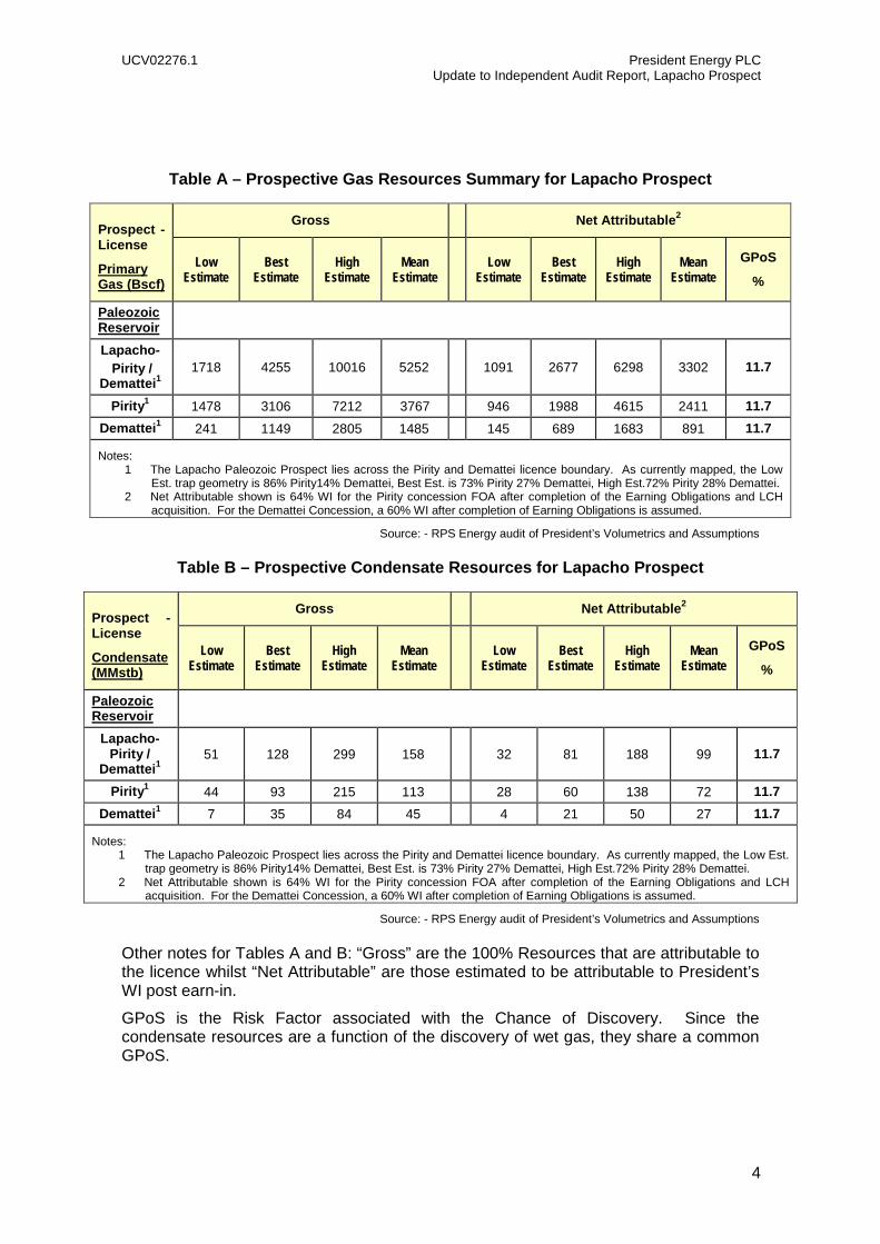
Prospective Resources President’s Prospective Resources in the Lapacho prospect are assigned to the Concessions as tabulated below in Tables A & B.
UCV02276.1 President Energy PLC Update to Independent Audit Report, Lapacho Prospect
4
Table A – Prospective Gas Resources Summary for Lapacho Prospect
Prospect - License
Primary Gas (Bscf)
Gross Net Attributable2
Low Estimate
Best Estimate
High Estimate
Mean Estimate Low
Estimate Best
Estimate High
Estimate Mean
Estimate GPoS
%
Paleozoic Reservoir
Lapacho- Pirity /
Demattei1 1718 4255 10016 5252 1091 2677 6298 3302 11.7
Pirity1 1478 3106 7212 3767 946 1988 4615 2411 11.7 Demattei1 241 1149 2805 1485 145 689 1683 891 11.7
Notes: 1 The Lapacho Paleozoic Prospect lies across the Pirity and Demattei licence boundary. As currently mapped, the Low
Est. trap geometry is 86% Pirity14% Demattei, Best Est. is 73% Pirity 27% Demattei, High Est.72% Pirity 28% Demattei. 2 Net Attributable shown is 64% WI for the Pirity concession FOA after completion of the Earning Obligations and LCH
acquisition. For the Demattei Concession, a 60% WI after completion of Earning Obligations is assumed.
Source: - RPS Energy audit of President’s Volumetrics and Assumptions
Table B – Prospective Condensate Resources for Lapacho Prospect
Prospect - License
Condensate (MMstb)
Gross Net Attributable2
Low Estimate
Best Estimate
High Estimate
Mean Estimate Low
Estimate Best
Estimate High
Estimate Mean
Estimate GPoS
%
Paleozoic Reservoir
Lapacho- Pirity /
Demattei1 51 128 299 158 32 81 188 99 11.7
Pirity1 44 93 215 113 28 60 138 72 11.7 Demattei1 7 35 84 45 4 21 50 27 11.7
Notes: 1 The Lapacho Paleozoic Prospect lies across the Pirity and Demattei licence boundary. As currently mapped, the Low Est.
trap geometry is 86% Pirity14% Demattei, Best Est. is 73% Pirity 27% Demattei, High Est.72% Pirity 28% Demattei. 2 Net Attributable shown is 64% WI for the Pirity concession FOA after completion of the Earning Obligations and LCH
acquisition. For the Demattei Concession, a 60% WI after completion of Earning Obligations is assumed.
Source: - RPS Energy audit of President’s Volumetrics and Assumptions
Other notes for Tables A and B: “Gross” are the 100% Resources that are attributable to the licence whilst “Net Attributable” are those estimated to be attributable to President’s WI post earn-in.
GPoS is the Risk Factor associated with the Chance of Discovery. Since the condensate resources are a function of the discovery of wet gas, they share a common GPoS.

UCV02276.1 President Energy PLC Update to Independent Audit Report, Lapacho Prospect
5
Basis of Opinion The results presented herein reflects our informed judgement based on accepted standards of professional investigation, but is subject to generally recognised uncertainties associated with the interpretation of geological, geophysical and engineering data. The Services were conducted within our understanding of petroleum legislation, taxation and other regulations that currently apply to these interests. However, RPS is not in a position to attest to the property title, financial interest relationships or encumbrances related to the properties.
Our estimates of resources and value are based on the data set available to, and provided by President. We have accepted, without independent verification, the accuracy and completeness of these data.
Site visits were not undertaken by RPS. Since no Reserves are being assigned a site visit to these assets was not considered necessary.
The report represents RPS’ best professional judgement and should not be considered a guarantee or prediction of results. It should be understood that any evaluation, particularly one involving exploration and future petroleum developments, may be subject to significant variations over short periods of time as new information becomes available. As stated in the Agreement, RPS cannot and does not guarantee the accuracy or correctness of any interpretation made by it of any of the data, documentation and information provided by the Company or others in accordance with the Agreement. The Consultant does not warrant or guarantee, through the Services, this report or otherwise, any geological or commercial outcome.
This report relates specifically and solely to the subject assets and is conditional upon various assumptions that are described herein. The report, of which this letter forms part, must therefore be read in its entirety. Except with permission from RPS, this report may only be used in accordance with the Agreement. It must not be reproduced or redistributed, in whole or in part, to any other person than the addressees or published, in whole or in part, for any purpose without the express written consent of RPS. The reproduction or publication of any excerpts, other than in relation to any Admission Document or similar, is not permitted without the express written permission of RPS.
Yours faithfully,
For and on behalf of RPS
Andrew J. Kirchin Executive Vice President, Consulting Business Unit (US)
Charles T. Barker Licensed Professional Geologist

An Update to the Independent Audit Report of certain Prospective Resources located in the Pirity and
Demattei Licenses, Onshore Paraguay
Prepared for: President Energy PLC
DISCLAIMER
The opinions and interpretations presented in this report represent our best technical interpretation of the data made available to us. However, due to the uncertainty inherent in the estimation of all sub-surface parameters, we cannot and do not guarantee the accuracy or correctness of any interpretation and we shall not, except in the case of gross or wilful negligence on our part, be liable or responsible for any loss, cost damages or expenses incurred or sustained by anyone resulting from any interpretation made by any of our officers, agents or employees.
Except for the provision of professional services on a fee basis, RPS does not have a commercial arrangement with any other person or company involved in the interests that are the subject of this report.
COPYRIGHT
© RPS
The material presented in this report is confidential. This report has been prepared for the exclusive use of President Energy PLC and shall not be distributed or made available to any other company or person without the knowledge and written consent of President Energy PLC or RPS.
June 2014
411 North Sam Houston Parkway East, Suite 400, Houston, Texas 77060 T +1 281 448 6188 F +1 281 448 6189
E [email protected] W www.rpsgroup.com/energy
UCV02276.1 President Energy PLC Update to Independent Audit Report, Lapacho Prospect
7
Table of Contents 1 INTRODUCTION 9
1.1 LICENSES 10
2 2013 SEISMIC AND G&G WORK PROGRAM 12
3 METHODOLOGY 14
4 EXPLORATION PLANS 15
5 GEOLOGY 16
5.1 OVERVIEW 16
5.2 LAPACHO PROSPECT – NW FLANK PIRITY 20
6 INDICATIVE VOLUMETRIC ASSESSMENTS AND RISKING 30
6.1 RESOURCE VOLUMETRICS 30
6.1.1 Lapacho Calculated Resource Distribution 31
6.1.2 Lapacho Resource Distribution Output and Risk 32
6.1.3 Lapacho Test Well and Resource Location 33
6.2 GEOLOGICAL RISKS 33
7 DEVELOPMENT POTENTIAL AND ECONOMICS 37
APPENDIX A: GLOSSARY OF TECHNICAL TERMS 38
Table of Figures Figure 1.1: Cretaceous Rift Basin Showing Pirity and Demattei Concessions ................ 9
Figure 2.1: Location Map showing the 2014 PreSDM re-processed 2D lines showing Jacaranda and Lapacho prospects ............................................................................... 12
Figure 2.2: List of Devonian Santa Leads and Prospects ............................................. 13
Figure 2.3: Location Map Devonian Santa Rosa Leads and Prospects ........................ 13
Figure 4.1: Category 1 Prospects for 2014 Drilling Campaign, Pirity Concession......... 15
Figure 5.1.1: Geological Map of Paraguay ................................................................... 16
Figure 5.1.2: Major Cretaceous tectonic units of Paraguay .......................................... 17
Figure 5.1.3: Simplified Lithostratigraphic Column of Chaco Basin, Paraquay ............. 18
Figure 5.1.4: Tectonic evolution of the Cretaceous Rift and the Pirity Sub-Basins ....... 19
Figure 5.1.5: Structural and Stratigraphic Cross Section .............................................. 20
Figure 5.2.1: Location map of the Chaco Basin and the Devonian Los Monos Thermal Maturation Window. ...................................................................................................... 21
Figure 5.2.2: Paleozoic Stratigraphic Column Chaco Basin with 3 mega sequences ... 22
Figure 5.2.3: Devonian Paleogeography and clastic supply areas Chaco Basin .......... 23
Figure 5.2.4: Chaco Basin showing Devonian oil and gas fields and outcrop ............... 24
UCV02276.1 President Energy PLC Update to Independent Audit Report, Lapacho Prospect
8
Figure 5.2.5: Structure Cross Section Sub-Andean Thrusts, Bolivia to Pirity Rift Basin, Paraguay ...................................................................................................................... 25
Figure 5.2.6: San Victoria- SV X-2, Argentina to Don Quijote X-1 , Paraguay Cross Section, flatten on Top Paleozoic .................................................................................. 25
Figure 5.2.7: N-S composite Seismic section from Don Quijote-1 well to Jacaranda (PE-PY-J-x-1) and Lapacho prospects ................................................................................ 26
Figure 5.2.8: Devonian Thermal Maturity Chaco Basin ................................................ 27
Figure 5.2.9: Santa Rosa Leads and Location of Lapacho (PE-PY-L-x1), Jacaranda and Tapir prospects ............................................................................................................. 28
Figure 5.2.10: Lapacho prospect schematic diagram below Top Paleozoic Unconformity ..................................................................................................................................... 28
Figure 5.2.11: N-S 2D Seismic line showing similarity of regional thickness in Devonian and Silurian, red vertical line is proposed well PE-PY-L x-1 for Lapacho ...................... 29
Figure 6.1.1: Top Santa Rosa Depth Structure and P90, P50, P10 GWC depth, area. Red Arrow indicates well location PE-PY-L x-1 for Lapacho ......................................... 33
Figure 6.2.1: Tabulation of Risk Categories for Conventional Hydrocarbon Prospects (adapted from Otis and Schneidermann, 1997) ............................................................ 35 Table of Tables Table A – Prospective Gas Resources Summary for Lapacho Prospect ......................... 4
Table B – Prospective Condensate Resources for Lapacho Prospect ............................ 4
Table 1.1.1: Summary of Assets - Farm-In Commitments for Pirity and Demattei ........ 11
Table 6.1.1 - Summary of the parameters used to calculate GRV for Lapacho ............. 31
Table 6.1.2 - Input parameters for REP Monte Carlo Simulation – Lapacho Prospect .. 32
Table 6.1.3 - Summary of Unrisked In-place Volumetrics – 100% WI Basis (GPoS adjusted RPS) .............................................................................................................. 32
Table 6.1.3a: Summary of President’s Unrisked Prospective Resources ..................... 32
UCV02276.1 President Energy PLC Update to Independent Audit Report, Lapacho Prospect
9
1 INTRODUCTION
On 23rd May 2014, Cambrian Consultants (CC) America, Inc. d/b/a RPS (‘RPS’) was
requested by President Energy PLC (‘President’ or ‘Company’) to provide an update
addendum (the ‘Update’) to a previous Audit Report (the ‘Report’) entitled “Independent
Audit Report of certain Prospective Resources located in the Pirity and Demattei
Licenses, Onshore Paraguay” dated 23rd January 2013. This Update has been
requested by the Company in order to independently verify via an audit approach that a
newly promoted ‘Category 1’ prospect has been properly evaluated by the Company
and is “drill-ready”. This prospect (the “Lapacho” prospect) is now potentially to be
included in the Company’s near-term drilling program, likely replacing the previously
audited “Yacare” prospect. The revised drilling schedule is Jacaranda (to Upper
Devonian), Lapacho (Lower Devonian) and Tapir (to Cretaceous with contingency to
Lower Devonian).
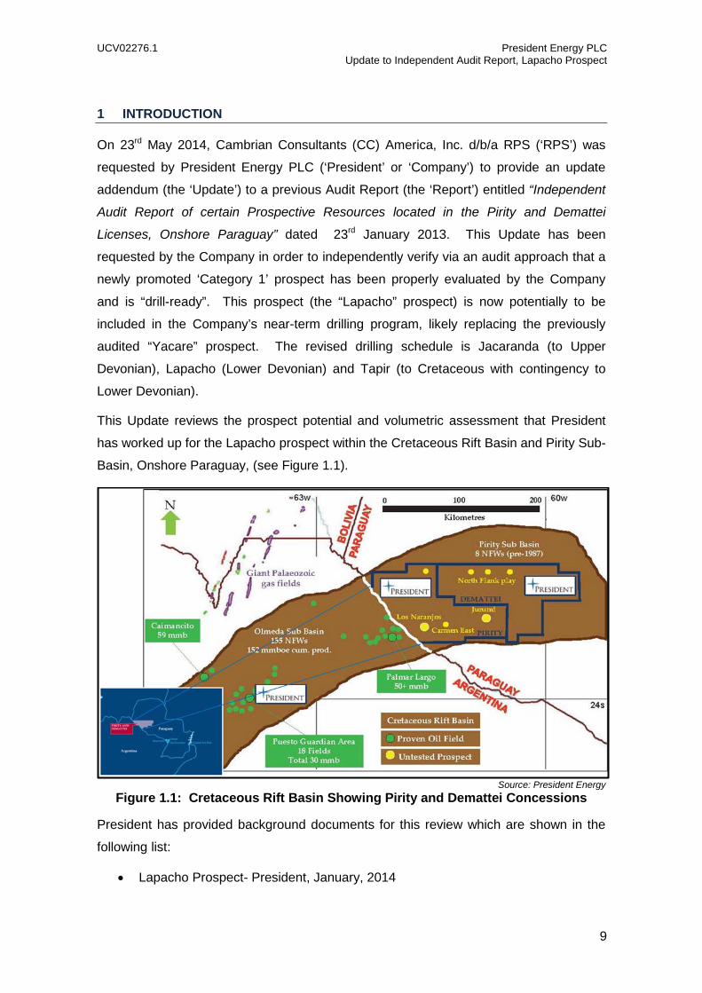
This Update reviews the prospect potential and volumetric assessment that President
has worked up for the Lapacho prospect within the Cretaceous Rift Basin and Pirity Sub-
Basin, Onshore Paraguay, (see Figure 1.1).
Source: President Energy Figure 1.1: Cretaceous Rift Basin Showing Pirity and Demattei Concessions
President has provided background documents for this review which are shown in the
following list:
• Lapacho Prospect- President, January, 2014

UCV02276.1 President Energy PLC Update to Independent Audit Report, Lapacho Prospect
10
• PE-Py-L x-1, Lapacho –President, May, 2014
• Lapacho Trap Model- President, May, 2014
• Lapacho Prospect- At Risk (Monte Carlo Simulation), P10, P50, and P90
Volumetrics
• Pirity, NW Flank Prospect Inventory- President, May, 2014
• Santa Rosa Play Fairway ( Prospect & Lead Inventory) – President, May 2014
• Santa Rosa Prospect & Lead Inventory- President, May, 2014
Available public documents have also been used in this review.
1.1 Licenses The licenses were originally granted to Pirity Hydrocarburos SRL (Pirity Concession)
and Crescent Global Oil Paraguay SA (Demattei Concession) in 2008, both for an
exploration period of 4 years. During 2012, both Concessions had amendments, with
the Pirity Concession 4 year period starting in September 2012 and the Demattei
Concession 4 year period starting in April 2012.
The minimum work program required by the Paraguayan government was as follows:
• Years 1 & 2 – Acquire 2D/3D of no less than 100 km before exploratory
perforations to better delineate certain leads.
• Years 3 & 4 – Drilling of no less than 15,000 linear meters in exploratory
completed wells must be completed. If opting for the extension of 2 additional
years, 1 additional well should be perforated of 5,000 meters each year.
President Energy entered into Farm-out Agreements with both companies on 11th
September 2012 acquiring an initial 11.8% working interest (‘WI’) in Pirity and 3% WI in
Demattei but assumed Operatorship in both licenses immediately. President Energy is
currently embarked on a work-program under each farm-out agreement (‘FOA’). The
work program conducted during 2013 and 2014 has earned President a working interest
of 10.125% (original farm-in interest was 3%) in Demattei and 59% WI in Pirity (original
farm-out interest was 11.8%). Subsequently, President has acquired a further 5% WI in
the Pirity Concession through its acquisition of LCH AS.
A summary of the present day license holding is shown as Table 1.1.1 below.

UCV02276.1 President Energy PLC Update to Independent Audit Report, Lapacho Prospect
11
Licence Operator WorkingInterest
Status Licence Expiry
Licence Area
Comments
Pirity President
Energy PLC 64% 1 Exploration September,
2016 8,582 sq km
Seismic commitments are fulfilled.
Exploration drilling is the next requirement
Demattei President
Energy PLC 10.125%2 Exploration April,2016 7,893 sq km
Seismic commitments are fulfilled.
Exploration drilling is the next requirement
Notes 1 President Energy has earned 59% WI under a phased work completion agreement to a maximum expenditure of $50MM. President has also acquired a further 5% WI from LCH AS as of June 2014.
2 President Energy will earn up to 60% WI under a phased work completion agreement to a maximum expenditure of $42MM.
Table 1.1.1: Summary of Assets - Farm-In Commitments for Pirity and Demattei
Under the terms of the FOAs, President earns further tranches of interest by executing a
phased work-program designed to promote a progressive exploration for each license
such that, upon completion of the work, President shall have earned a 59% WI in Pirity
and 60% in Demattei. It is noted that the “Earning Obligations” are capped at $50MM in
the case of Pirity and $42MM in the case of Demattei, such that upon meeting these
expenditure limits the full earned WI shall be transferred to President regardless of what
elements of the work-program have been completed. President has now fully earned its
59% WI after having spent $50MM in seismic and drilling expenditure.
At the time of the previous Report, a further 5% WI was held in each Concession by
LCH AS. In June of 2014, President agreed to acquire the entire issued share capital of
LCH SA and consequently now owns a further 5% WI in Pirity and also a potential right
to acquire a further 5% WI in Demattei at some point in the future.
Finally, there is also a 5% gross overriding royalty on Pirity block, held by Weins and
Klassen.

UCV02276.1 President Energy PLC Update to Independent Audit Report, Lapacho Prospect
12
2 2013 SEISMIC AND G&G WORK PROGRAM
The seismic and G&G work program that has led to the identification of a drill-ready
program of prospects is generally described in Section 2 of the Report. The details of
this work are not repeated here in this Update. However, since the Report was originally
prepared, specifically during the period March to April, 2014, twenty two (22) 2D seismic
lines, acquired in 2013, were re-processed by Global (Houston, Texas) through Pre-
Stack Depth Migration (‘PreSDM’) (Figure 2.1). The PreSDM data allowed refinement of
spatial positioning and collapsed diffractions in this complex geology and their
interpretation has enhanced and elevated a previously identified lead to a drillable
prospect now known as the Lapacho prospect. The PreSDM reprocessing cost
approximately US$ 150,000.
Source: President Energy
Figure 2.1: Location Map showing the 2014 PreSDM re-processed 2D lines showing Jacaranda and Lapacho prospects
Based on the exploration interpretation efforts and the extrapolation results of the use of
PreSDM, eleven (11) Devonian Santa Rosa new leads have been generated and 3
prospects upgraded for the Pirity and Demattei License areas as shown in Figure 2.2
and 2.3.

UCV02276.1 President Energy PLC Update to Independent Audit Report, Lapacho Prospect
13
Source: President Energy
Figure 2.2: List of Devonian Santa Rosa Leads and Prospects
Source: President Energy
Figure 2.3: Location Map Devonian Santa Rosa Leads and Prospects

UCV02276.1 President Energy PLC Update to Independent Audit Report, Lapacho Prospect
14
3 METHODOLOGY
In accordance with President’s request and the Agreement covering the provision of the
Services, RPS has conducted formal and independent audit of the Lapacho prospect
which will now most likely feature in President’s upcoming drilling campaign.
Our approach has been to audit the Company’s technical interpretation of their base
case geoscience and engineering data for the field for reasonableness and to review the
ranges of uncertainty for each parameter around this base case in order to estimate
ranges of potential petroleum initially-in-place and recoverable Resources. We have
also audited the Company’s indicative mean success case discounted cash-flow models
on a per prospect basis. Where we found inconsistencies between the models, their
assumptions or data used, these were alerted to the Company and generally re-run if
the impact of the inconsistency was considered material.
RPS notes that the work presented by President in the case of the Lapacho prospect,
there is a single reservoir target, the Lower Devonian Santa Rosa Sand.
UCV02276.1 President Energy PLC Update to Independent Audit Report, Lapacho Prospect
15
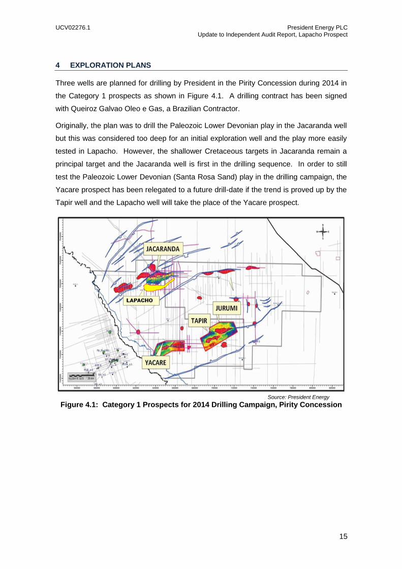
4 EXPLORATION PLANS
Three wells are planned for drilling by President in the Pirity Concession during 2014 in
the Category 1 prospects as shown in Figure 4.1. A drilling contract has been signed
with Queiroz Galvao Oleo e Gas, a Brazilian Contractor.
Originally, the plan was to drill the Paleozoic Lower Devonian play in the Jacaranda well
but this was considered too deep for an initial exploration well and the play more easily
tested in Lapacho. However, the shallower Cretaceous targets in Jacaranda remain a
principal target and the Jacaranda well is first in the drilling sequence. In order to still
test the Paleozoic Lower Devonian (Santa Rosa Sand) play in the drilling campaign, the
Yacare prospect has been relegated to a future drill-date if the trend is proved up by the
Tapir well and the Lapacho well will take the place of the Yacare prospect.
Source: President Energy
Figure 4.1: Category 1 Prospects for 2014 Drilling Campaign, Pirity Concession

UCV02276.1 President Energy PLC Update to Independent Audit Report, Lapacho Prospect
16
5 GEOLOGY
5.1 Overview Paraguay and in particular the present-day Chaco basin is a modern foreland basin
bounded on the west by the Andean ranges, the Brazilian shield (Guapore) to the
northeast and merges with the Parana and Pampa basins to the east and south (Figure
5.1.1).
Source: AAPG Memoir 62
Figure 5.1.1: Geological Map of Paraguay
Northwest and northeast trending structural lineaments characterize the tectonic style.
During the early Paleozoic, late Paleozoic, late Mesozoic and Cenozoic differential
reactivation along basement trends resulted in subsidence phases (See Figures 5.1.1
thru 5.1.4). Unconformities, non-deposition or low sedimentation rates occur at the
phase boundaries.

UCV02276.1 President Energy PLC Update to Independent Audit Report, Lapacho Prospect
17
Source: AAPG Memoir 62
Figure 5.1.2: Major Cretaceous tectonic units of Paraguay

UCV02276.1 President Energy PLC Update to Independent Audit Report, Lapacho Prospect
18
Source: AAPG Memoir 62
Figure 5.1.3: Simplified Lithostratigraphic Column of Chaco Basin, Paraquay
UCV02276.1 President Energy PLC Update to Independent Audit Report, Lapacho Prospect
19
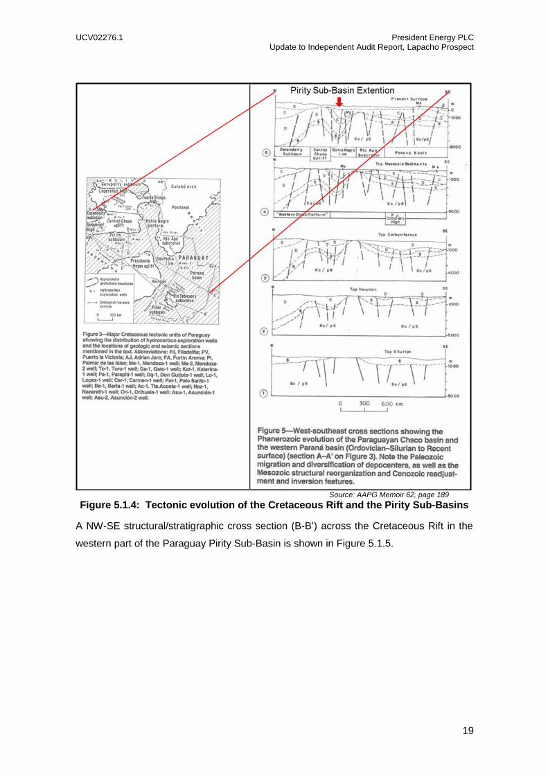
Source: AAPG Memoir 62, page 189
Figure 5.1.4: Tectonic evolution of the Cretaceous Rift and the Pirity Sub-Basins
A NW-SE structural/stratigraphic cross section (B-B’) across the Cretaceous Rift in the
western part of the Paraguay Pirity Sub-Basin is shown in Figure 5.1.5.
UCV02276.1 President Energy PLC Update to Independent Audit Report, Lapacho Prospect
20
Source: AAPG Memoir 62
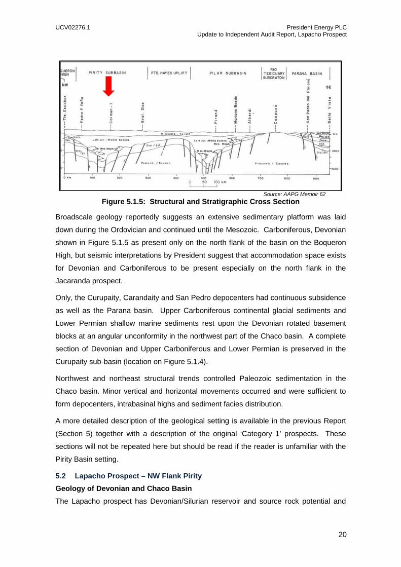
Figure 5.1.5: Structural and Stratigraphic Cross Section
Broadscale geology reportedly suggests an extensive sedimentary platform was laid
down during the Ordovician and continued until the Mesozoic. Carboniferous, Devonian
shown in Figure 5.1.5 as present only on the north flank of the basin on the Boqueron
High, but seismic interpretations by President suggest that accommodation space exists
for Devonian and Carboniferous to be present especially on the north flank in the
Jacaranda prospect.
Only, the Curupaity, Carandaity and San Pedro depocenters had continuous subsidence
as well as the Parana basin. Upper Carboniferous continental glacial sediments and
Lower Permian shallow marine sediments rest upon the Devonian rotated basement
blocks at an angular unconformity in the northwest part of the Chaco basin. A complete
section of Devonian and Upper Carboniferous and Lower Permian is preserved in the
Curupaity sub-basin (location on Figure 5.1.4).
Northwest and northeast structural trends controlled Paleozoic sedimentation in the
Chaco basin. Minor vertical and horizontal movements occurred and were sufficient to
form depocenters, intrabasinal highs and sediment facies distribution.
A more detailed description of the geological setting is available in the previous Report
(Section 5) together with a description of the original ‘Category 1’ prospects. These
sections will not be repeated here but should be read if the reader is unfamiliar with the
Pirity Basin setting.
5.2 Lapacho Prospect – NW Flank Pirity Geology of Devonian and Chaco Basin The Lapacho prospect has Devonian/Silurian reservoir and source rock potential and

UCV02276.1 President Energy PLC Update to Independent Audit Report, Lapacho Prospect
21
our discussion will focus on the Devonian/Silurian which was deposited in the Chaco
Basin which covers primarily Bolivia and Paraguay with a small portion in Argentina and
Brazil as shown in Figure 5.2.1.
Source: President Energy
Figure 5.2.1: Location map of the Chaco Basin and the Devonian Los Monos Thermal Maturation Window.
During the Devonian and Silurian time periods (see Figure 5.2.2) in southern Bolivia and
northern Argentina, the reservoir sandstone of the Huamampampa and the Santa Rosa
Formation were deposited in non-marine/transitional to shallow-marine environments.

UCV02276.1 President Energy PLC Update to Independent Audit Report, Lapacho Prospect
22
Source: Miranda et al, 2003
Figure 5.2.2: Paleozoic Stratigraphic Column Chaco Basin with 3 mega sequences
The Kirusillas, Icla and Los Monos source rock shaley sequence were deposited in
shallow-marine environment with the Los Monos locally in the near-shore to transitional.
A summary of the Devonian and Silurian that follows is taken from Miranda et al, 2003,
VIII Simposio Bolivariana:
• Los Monos Fm.- source rock-mostly shallow marine, Middle Devonian
(Early to Mid Givetian)
• Huamampampa Fm.- reservoir-nonmarine/transitional to nearshore and
shallow marine, Early to Middle Devonian (Latest Emsian, Eifelian to
Earyl Givetian)
• Icla Fm.-source rock-shallow marine, Early Devonian (Pragian to Earliest
Emsian)
• Santa Rosa Fm.- reservoir rock- nonmarine/ transitional to shallow
marine, Early Devonian (mostly Lochkovian)
• Kirusillas Fm- source rock-shallow marine to nearshore, Late Silurian
(Late Ludlow-Pridoli)

UCV02276.1 President Energy PLC Update to Independent Audit Report, Lapacho Prospect
23
During the Devonian period, the major sediment clastic source area was from the south
with secondary areas to the east-northeast in the Brasilian Shield (Guapore) and the
Proto-Cordillera to the west-southwest (Figure 5.2.3). Giant oil and gas fields are
present in the Bolivia and produce from Devonian and Silurian Huamampampa and
Santa Rosa fractured sandstone reservoirs respectively and are charged by the Los
Monos, Icla and Kirusillas shales (Figure 5.2.2).
Source: Miranda et al, 2003
Figure 5.2.3: Devonian Paleogeography and clastic supply areas Chaco Basin
The Chaco Basin contains an abundance of Devonian age oil and gas fields as shown in
Figure 5.2.4. Significant opportunities for Devonian discovery have been defined by
President in Paraguay, including eleven (11) Devonian Santa Rosa sandstone prospects
and Leads. The majority of the leads are single line leads with the exception of two that
are 5 lines, two 2 lines and in Tapir which has a 3D survey.

UCV02276.1 President Energy PLC Update to Independent Audit Report, Lapacho Prospect
24
Source: President Energy
Figure 5.2.4: Chaco Basin showing Devonian oil and gas fields and outcrop
The Sub-Andean province thrust sheets have formed giant gas fields in the Devonian
Haumampampa fractured sandstones (Figure 5.2.5).
The Paleozoic reservoir and source rocks have been correlated in wells W-E from the
Sub-Andean oil and gas field in Bolivia into the Santa Victoria wells in Argentina to the
Don Quijote-1 well in Paraguay (Figure 5.2.6). President has correlated the Quijote-1
well ties to 2D seismic lines running N-S to the Jacarando and Lapacho prospect as
shown in Figure 5.2.7. President has correlated and tied the Devonian Los Monos and
Icla source intervals, Huamampampa and Santa Rosa sandstone reservoirs and Silurian
Kurisillas source interval from the Don Quijote well to seismic lines. These N-S seismic
lines were composited and extend south through the Jacaranda and the Lapacho
prospect across mulitple 2D seismic lines that have been processed for PreSDM (Figure
5.2.7).
UCV02276.1 President Energy PLC Update to Independent Audit Report, Lapacho Prospect
25
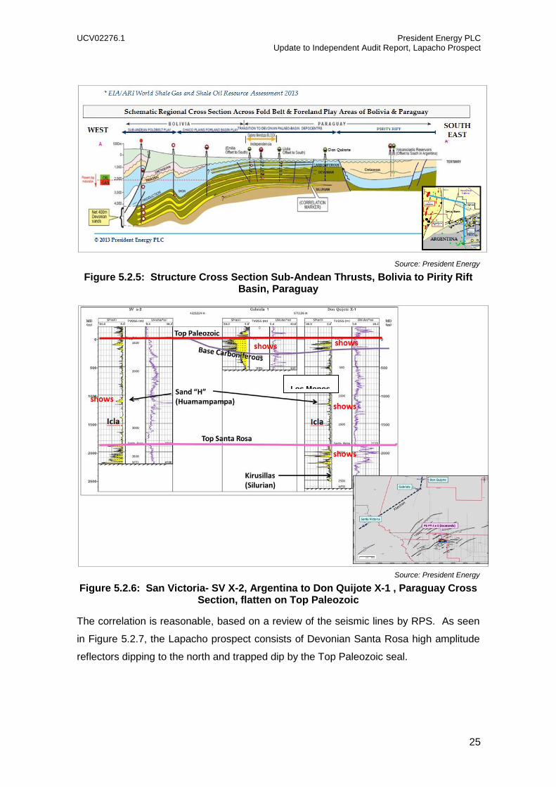
Source: President Energy
Figure 5.2.5: Structure Cross Section Sub-Andean Thrusts, Bolivia to Pirity Rift Basin, Paraguay
Source: President Energy
Figure 5.2.6: San Victoria- SV X-2, Argentina to Don Quijote X-1 , Paraguay Cross Section, flatten on Top Paleozoic
The correlation is reasonable, based on a review of the seismic lines by RPS. As seen
in Figure 5.2.7, the Lapacho prospect consists of Devonian Santa Rosa high amplitude
reflectors dipping to the north and trapped dip by the Top Paleozoic seal.
Los Monos

UCV02276.1 President Energy PLC Update to Independent Audit Report, Lapacho Prospect
26
Source: President Energy
Figure 5.2.7: N-S composite Seismic section from Don Quijote-1 well to Jacaranda (PE-PY-J-x-1) and Lapacho prospects
Devonian/ Silurian Source Rocks
The Devonian and Silurian Shale source rocks were deposited in semi–restricted,
marine extensional basin covering most of the Chaco basin, USGS OF 99-50-C.
The Devonian Los Monos and Icla Formations are comprised of thick, generally dark
shales. Intervals with the highest organic content are the maximum flooding surface in
each formation. TOC’s are typically 1-2% over large thicknesses (quantity rather than
quality). Marine kerogens (type II and III) produced originally oil-prone source rocks. In
the Andes’ mountain front, depths of burial of 5500m are required for maximum
generation.
The Silurian Kirusillas black shale is less well known due to a sparcity of data samples.
It is thought to be the main source for the Boomerang area oil fields in the northern Sub-
Andean trend. The USGS Total Petroleum System Study recognizes the Kirusillas as
having similar kerogen type to the Devonian over a similarly large area. Due to its older
age and despite charging the Boomerang area with oil, the Kirusillas is thought to be in
the gas window throughout the deeper parts of the basin.
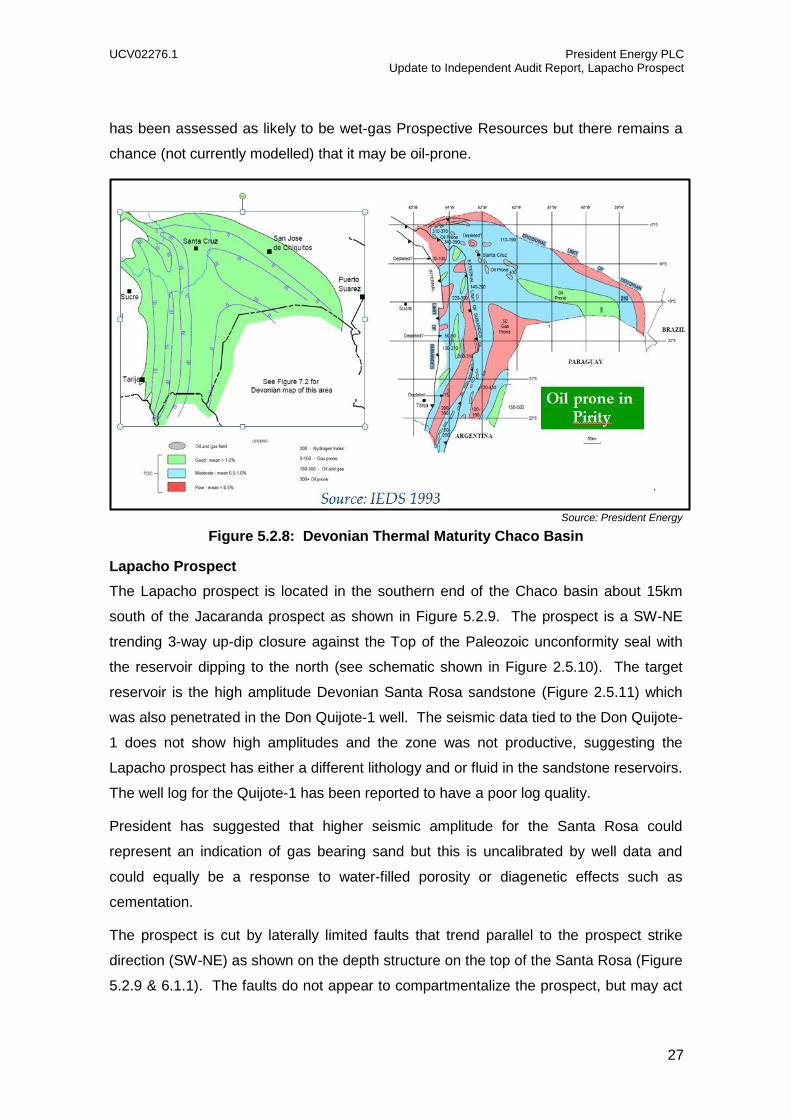
Within Paraguay, the Pirity Sub-Basin is thought to be oil prone as shown in Figure
5.2.8, however, few well control points exist within the Devonian. The Lapacho prospect
UCV02276.1 President Energy PLC Update to Independent Audit Report, Lapacho Prospect
27
has been assessed as likely to be wet-gas Prospective Resources but there remains a
chance (not currently modelled) that it may be oil-prone.
Source: President Energy
Figure 5.2.8: Devonian Thermal Maturity Chaco Basin
Lapacho Prospect The Lapacho prospect is located in the southern end of the Chaco basin about 15km
south of the Jacaranda prospect as shown in Figure 5.2.9. The prospect is a SW-NE
trending 3-way up-dip closure against the Top of the Paleozoic unconformity seal with
the reservoir dipping to the north (see schematic shown in Figure 2.5.10). The target
reservoir is the high amplitude Devonian Santa Rosa sandstone (Figure 2.5.11) which
was also penetrated in the Don Quijote-1 well. The seismic data tied to the Don Quijote-
1 does not show high amplitudes and the zone was not productive, suggesting the
Lapacho prospect has either a different lithology and or fluid in the sandstone reservoirs.
The well log for the Quijote-1 has been reported to have a poor log quality.
President has suggested that higher seismic amplitude for the Santa Rosa could
represent an indication of gas bearing sand but this is uncalibrated by well data and
could equally be a response to water-filled porosity or diagenetic effects such as
cementation.
The prospect is cut by laterally limited faults that trend parallel to the prospect strike
direction (SW-NE) as shown on the depth structure on the top of the Santa Rosa (Figure
5.2.9 & 6.1.1). The faults do not appear to compartmentalize the prospect, but may act

UCV02276.1 President Energy PLC Update to Independent Audit Report, Lapacho Prospect
28
as baffles and restrict flow rates, depending on the position of a productive well relative
to the faults.
Source: President Energy
Figure 5.2.9: Santa Rosa Leads and Location of Lapacho (PE-PY-L-x1), Jacaranda and Tapir prospects
Source: President Energy
Figure 5.2.10: Lapacho prospect schematic diagram below Top Paleozoic Unconformity

UCV02276.1 President Energy PLC Update to Independent Audit Report, Lapacho Prospect
29
Source: President Energy
Figure 5.2.11: N-S 2D Seismic line showing similarity of regional thickness in Devonian and Silurian, red vertical line is proposed well PE-PY-L x-1 for Lapacho
PE-PY-L-X-1
UCV02276.1 President Energy PLC Update to Independent Audit Report, Lapacho Prospect
30
6 INDICATIVE VOLUMETRIC ASSESSMENTS AND RISKING
6.1 Resource Volumetrics The following is a summary of the methodology used by President in the calculation of
volumetric resources for the Lapacho prospect.
Prospective Resources have been estimated by President based on Gross Rock
Volume (GRV) volumetrics; well log petrophysical parameters, reservoir parameters
from Devonian well control and fluid parameters in Bolivia and Argentina. The Devonian
Santa Rosa is the primary target reservoir for which volumetrics have been calculated.
The Huamampampa is a possible secondary reservoir, but no separate volumetric
analysis has been completed for this reservoir. A top of Santa Rosa depth structure
map was prepared by President based on 2D PreSDM seismic interpretations, see
Figure 6.1.1. Using a Paradigm workstation, the prospect crestal depth was subtracted
from the Low, Mid and High estimated GWC surface to calculate a vertical closure
(relief) and GRV. The High case (P10) is near the lowest closing contour, “spill point”,
the Mid case (P50) is about 72% of the High vertical closure and the Low case (P90) is
about 48% of the High vertical closure as seen on Figure 6.1.1. The Area of closure
(Km2) is calculated for each potential accumulation limit to an estimated GWC. The
GRVs are input into the @RISK6TM Monte Carlo simulation along with other reservoir
parameters and a range of recovery factors to generate a resource distribution resulting
in a P10, P50, P90 and mean unrisked Resource for each prospect reservoir.
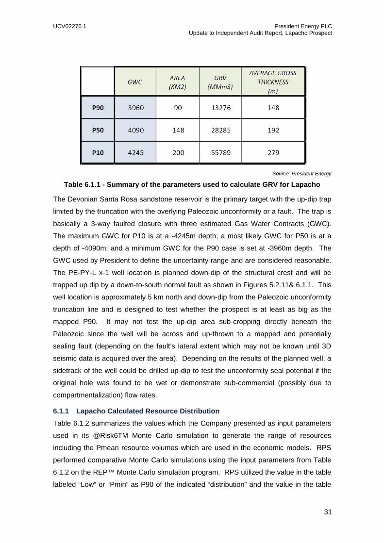
Table 6.1.1 shows the parameters used by President to calculate the GRV (Gross Rock
Volume) for Lapacho - prospect for a P90, P50 and P10 input parameters. The Area is
based on the GWC range shown in Figure 6.1.1.
UCV02276.1 President Energy PLC Update to Independent Audit Report, Lapacho Prospect
31
Source: President Energy
Table 6.1.1 - Summary of the parameters used to calculate GRV for Lapacho
The Devonian Santa Rosa sandstone reservoir is the primary target with the up-dip trap
limited by the truncation with the overlying Paleozoic unconformity or a fault. The trap is
basically a 3-way faulted closure with three estimated Gas Water Contracts (GWC).
The maximum GWC for P10 is at a -4245m depth; a most likely GWC for P50 is at a
depth of -4090m; and a minimum GWC for the P90 case is set at -3960m depth. The
GWC used by President to define the uncertainty range and are considered reasonable.
The PE-PY-L x-1 well location is planned down-dip of the structural crest and will be
trapped up dip by a down-to-south normal fault as shown in Figures 5.2.11& 6.1.1. This
well location is approximately 5 km north and down-dip from the Paleozoic unconformity
truncation line and is designed to test whether the prospect is at least as big as the
mapped P90. It may not test the up-dip area sub-cropping directly beneath the
Paleozoic since the well will be across and up-thrown to a mapped and potentially
sealing fault (depending on the fault’s lateral extent which may not be known until 3D
seismic data is acquired over the area). Depending on the results of the planned well, a
sidetrack of the well could be drilled up-dip to test the unconformity seal potential if the
original hole was found to be wet or demonstrate sub-commercial (possibly due to
compartmentalization) flow rates.
6.1.1 Lapacho Calculated Resource Distribution Table 6.1.2 summarizes the values which the Company presented as input parameters
used in its @Risk6TM Monte Carlo simulation to generate the range of resources
including the Pmean resource volumes which are used in the economic models. RPS
performed comparative Monte Carlo simulations using the input parameters from Table
6.1.2 on the REP™ Monte Carlo simulation program. RPS utilized the value in the table
labeled “Low” or “Pmin” as P90 of the indicated “distribution” and the value in the table

UCV02276.1 President Energy PLC Update to Independent Audit Report, Lapacho Prospect
32
labeled “High” or “Pmax” as the P10 of the indicated “distribution”. The unrisked
prospect potential mean resource calculated by RPS using REP™ in most cases was
very similar to the resource volumes calculated by President and are therefore
considered reasonable by RPS.
Prospect/Target Input Parameter Distribution Low Medium High
Lapacho-Santa Rosa
Area – km2 Paradigm 90 148 200
Thickness - m Paradigm 148 192 279
Gross Rock Volume-MMm3 1 Lognormal 13276 28285 55789
Monte Carlo Input Parameter
Distribution Pmin Mean Pmax
NTG (%) Lognormal 0.3 0.4832 0.75
Porosity - % Normal 0.04 0.06 0.08
Sw - % Normal 0.4 0.25 0.1
1/Bg (FVF) Normal 200 300 400
YIELD (b/MMcf) Normal 20 30 40
Rec. Factor - % Trigen 0.5 0.71 0.9
Source: President Energy
Table 6.1.2 - Input parameters for REP Monte Carlo Simulation – Lapacho Prospect
6.1.2 Lapacho Resource Distribution Output and Risk
Prospects In-Place Condensate Volumes (MMbbl)
In-Place Gas Volumes (Bcf)
GPoS
%
Low Med High Low Med High
Lapacho-Santo
Rosa 73 183 427 2454 6114 14309 11.7
Table 6.1.3 - Summary of Unrisked In-place Volumetrics – 100% WI Basis (GPoS adjusted RPS)
Prospects Recoverable Condensate
Volumes (MMbbl) Recoverable Gas Volumes
(Bcf)
Low Med High Mean Low Med High Mean
Lapacho-Santa Rosa
32 81 188 99 1091 2677 6298 3302
Note: Volumes based on an average RF of 70%, 64% WI in Pirity & 60% WI in Demattei – assumes earning obligations are completed
Table 6.1.3a: Summary of President’s Unrisked Prospective Resources

UCV02276.1 President Energy PLC Update to Independent Audit Report, Lapacho Prospect
33
6.1.3 Lapacho Test Well and Resource Location The Lapacho prospect is partially located on each the Pirity and Demattei licenses (see
Figure 6.1.1). The percentage of the area of closure for the total P10 area of 200 km2 is
72% Pirity, 28% Demattei, for the P50 area of 148 km2 it is 73% Pirity and 27%
Demattei and in the P90 area of 90 km2 is 86% Pirity and 14% in the Demattei License.
The initial test well will be located on the Pirity license. The drill-site for the PE-PY-L x1
well will be located at approximately Y=7,495,500 and X=635,000m with the well
planned for drilling to a total depth of 4700m and the top of the Santa Rosa sandstone
encountered at 4400m.
Source: President Energy
Figure 6.1.1: Top Santa Rosa Depth Structure and P90, P50, P10 GWC depth, area. Red Arrow indicates well location PE-PY-L x-1 for Lapacho
6.2 Geological Risks Based on the RPS Volumetrics, Risk and Aggregation Guidelines, geological chance is
the probability that the prospect is as described in the technical evaluation, specifically
as characterized in the volumetric model. The geological chance or probability of
success (GPoS) is the probability that a prospect will be successful and contain volumes
of hydrocarbons. The GPoS does not apply directly to the GRV and other input
parameters used in the volumetric evaluation, but does apply to the volumetric range
derived from them. The GPoS is the chance that applies to the entire volumetric
expectation curve for that geological model. It is the chance that you will get on the
hydrocarbon distribution curve (P0 to P100). The risking takes place after a prospect
has been modelled and a volumetric range has been calculated for the model.
UCV02276.1 President Energy PLC Update to Independent Audit Report, Lapacho Prospect
34
Both Play and Prospect Specific elements are considered in the risking process. The
Chance of Discovery = the Play Chance x Prospect Chance. Play chance is concerned
with a relatively broad view as to whether the key elements of source, reservoir and seal
are present and effective over a broad geographic area. For the Paraguay prospects
the Play chance is considered to be 1.0 as the President Energy targets are proven
productive and probably economic in Argentina and Bolivia to the west within the Chaco
and Olmedo sub-basins. Basically the play is proven to work.
Prospect specific chance related to the local conditions at the prospect location
associated model and volumetric parameters in computing the volumetric range for the
prospect. Trap, seal, reservoir and charge presence, maturity and migration are used in
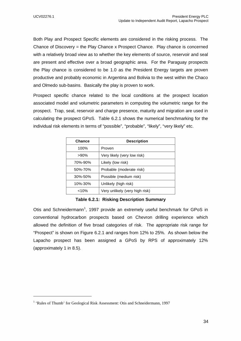
calculating the prospect GPoS. Table 6.2.1 shows the numerical benchmarking for the
individual risk elements in terms of “possible”, “probable”, “likely”, “very likely” etc.
Chance Description
100% Proven >90% Very likely (very low risk)
70%-90% Likely (low risk) 50%-70% Probable (moderate risk) 30%-50% Possible (medium risk) 10%-30% Unlikely (high risk)
<10% Very unlikely (very high risk)
Table 6.2.1: Risking Description Summary
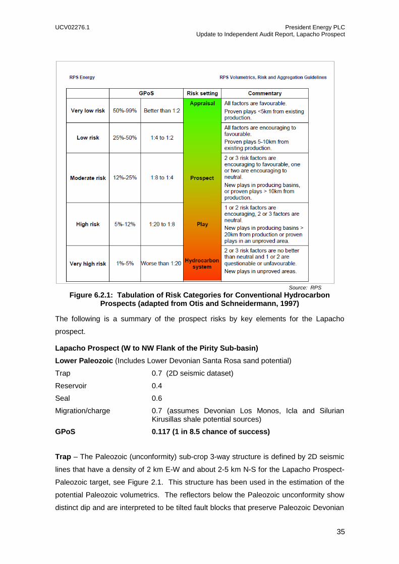
Otis and Schneidermann1, 1997 provide an extremely useful benchmark for GPoS in
conventional hydrocarbon prospects based on Chevron drilling experience which
allowed the definition of five broad categories of risk. The appropriate risk range for
“Prospect” is shown on Figure 6.2.1 and ranges from 12% to 25%. As shown below the
Lapacho prospect has been assigned a GPoS by RPS of approximately 12%
(approximately 1 in 8.5).
1 ‘Rules of Thumb’ for Geological Risk Assessment: Otis and Schneidermann, 1997
UCV02276.1 President Energy PLC Update to Independent Audit Report, Lapacho Prospect
35
Source: RPS
Figure 6.2.1: Tabulation of Risk Categories for Conventional Hydrocarbon Prospects (adapted from Otis and Schneidermann, 1997)
The following is a summary of the prospect risks by key elements for the Lapacho
prospect.
Lapacho Prospect (W to NW Flank of the Pirity Sub-basin) Lower Paleozoic (Includes Lower Devonian Santa Rosa sand potential)
Trap 0.7 (2D seismic dataset)
Reservoir 0.4
Seal 0.6
Migration/charge 0.7 (assumes Devonian Los Monos, Icla and Silurian Kirusillas shale potential sources)
GPoS 0.117 (1 in 8.5 chance of success) Trap – The Paleozoic (unconformity) sub-crop 3-way structure is defined by 2D seismic
lines that have a density of 2 km E-W and about 2-5 km N-S for the Lapacho Prospect-
Paleozoic target, see Figure 2.1. This structure has been used in the estimation of the
potential Paleozoic volumetrics. The reflectors below the Paleozoic unconformity show
distinct dip and are interpreted to be tilted fault blocks that preserve Paleozoic Devonian
UCV02276.1 President Energy PLC Update to Independent Audit Report, Lapacho Prospect
36
sediments. As above, the closure of these tilted faults blocks is provided by the
overlying unconformity and therefore relies on sealing cap rocks being present
immediately above the unconformity. However, there seems to be ample “structure” that
may set up a trap. The current seismic data is restricted to PreSDM 2D and therefore
there remains some risk that the trap may not be fully mapped. Faults parallel to the
bedding strike are not expected to compartmentalize the prospect, but may act as
baffles and reduce the efficient production rates.
Reservoir – Uncertainty exists regarding the presence of reservoir, reservoir quality,
lateral distribution and trap at the faulted basin edge of the Pirity sub-basin. The wells
(ref SV-1, SV-2 are shown approximately as the eastern well symbol in Figure 5.2.5 &
5.2.6) in Santa Victoria in Argentina 110 km west of the Lapacho location penetrated
the whole reservoir sequence and represents the closest analog which reportedly tested
the Devonian. The Don Quixote-1 well is 115 km north and only had reservoirs in the
Santa Rosa (50-70m) but is located in the Boqueron High with unknown
paleogeography. The giant fractured Devonian sandstone gas fields in the Sub-Andean
province of Bolivia have had a significant impact on Bolivia’s economy. A recent press
release has reported a 200 MMcfd gas discovery in the #6 well in the Margarita field.
The Lapacho prospect faulting could create natural fractures enhancing permeability in
reservoirs present, but may also create lost circulation drilling problems. Occurrence of
higher seismic reflection amplitudes packages, especially in the prospective intervals of
the Santa Rosa may indicate the presence of reservoir and hydrocarbons.
Seal – Devonian (Santa Rosa) Reservoirs may be sealed by overlying Paleozoic shales
and/or younger shales above the Top Paleozoic unconformity depending on the precise
trapping mechanism. The faulting intensity may provide natural fracturing that could
result in some leakage and reduction in seal capacity.
Migration – Dependent on the presence of the Devonian Los Monos, Icla and Silurian
Kirusillas source shales. The presence of the faulting would provide potential migration
pathways for the shale source rock for gas/condensate which have been the primary
source in Argentina and Bolivia to the west.

UCV02276.1 President Energy PLC Update to Independent Audit Report, Lapacho Prospect
37
7 DEVELOPMENT POTENTIAL AND ECONOMICS
The conceptual development scenarios, Capex and Opex that the Company has
modelled for the Prospective Resources in the event of discovery have been reviewed in
detail in the January Report.
Detailed economics have not been run at this point on the Lapacho prospect but there
was plenty of evidence from the previous Report that the world-class terms available in
Paraguay mean that any accumulation of oil or gas will likely be highly commercial. This
assumes that a very large gas discovery will attract a suitably scaled commercial sales
contract but is certainly true for any liquids.
In the event that the Lapacho prospect proves up the Lower Devonian (or younger) play,
President has identified at least 11 other leads within the two current Concessions which
are currently covered by limited 2D seismic. Therefore, in the event of a discovery, the
Company has plenty of “running room” to add to its Resource and eventually Reserves
base within the Concessions.

UCV02276.1 President Energy PLC Update to Independent Audit Report, Lapacho Prospect
38
APPENDIX A: GLOSSARY OF TECHNICAL TERMS
AAPG American Association of Petroleum Geologists AIM Guidelines Guidance covering the preparation of documentation for
Disclosure purposes for Mining, Oil and Gas Companies dated June 2009 (the “AIM Guidance Note”)
AVO Amplitude variation with offset B Billion bbls Barrels DHI Direct hydrocarbon indicator EAGE European Association of Geoscientists and Engineers EI The Energy Institute Km Kilometre m metres M Thousand MM Million Mstb Thousand stock tank barrels MMstb Million stock tank barrels MMscf/d Millions of standard cubit feet per day MMstb Million stock tank barrels sq km Square kilometres stb Stock tank barrels scf Standard cubic feet SPE Society of Petroleum Engineers SPEE Society of Petroleum Evaluation Engineers TD Total Depth TVD True vertical depth TVDSS True vertical depth (sub-sea) WPC World Petroleum Council