re-eval memo nepa roberto clemente north improvements … · re revaluation of environmental...
TRANSCRIPT
ANDREWM. CUOMO
Governor
LISABOVA HIATT
ExecutiveDirector
Memorandum
To: CDBG DR Roberto Clemente State Park Shoreline and Park Improvements – ERR File
From: Matt Accardi, Certifying Officer, Governor’s Office of Storm Recovery (GOSR)
Date: August 16, 2017
Subject: Re evaluation of Environmental Assessment under 24 CFR 58.47 – Roberto ClementeState Park Shoreline and Park Improvements
A. INTRODUCTION
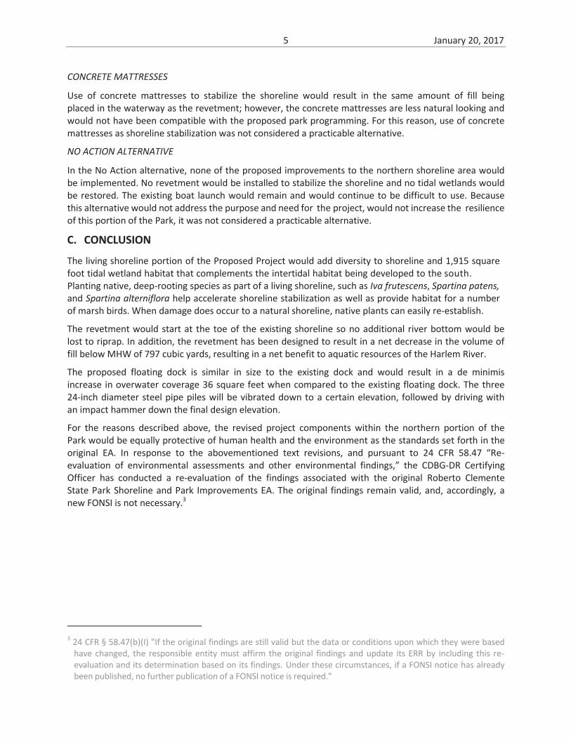
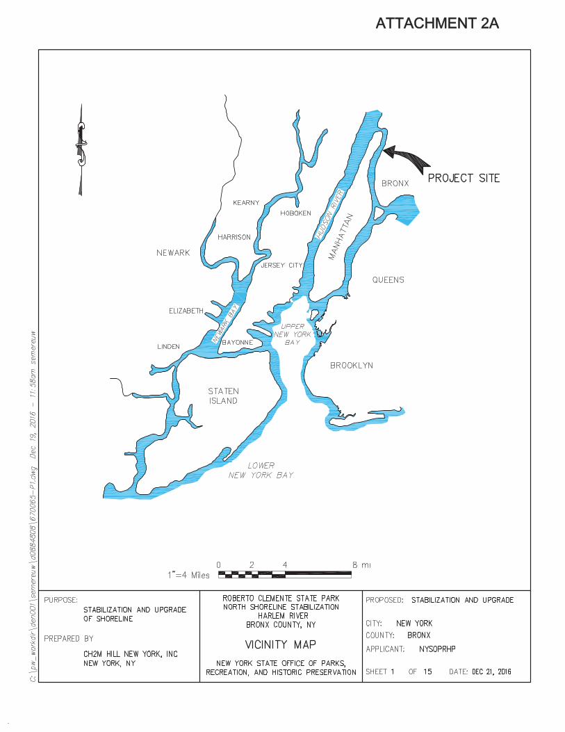
The approximately 25 acre Roberto Clemente State Park (Park) is located on the eastern shore of theHarlem River just north of West Tremont Avenue and west of the Major Deegan Expressway (Highway87) in the Bronx, New York (see Figure 1). In 2013 the New York State Office of Parks, Recreation andHistoric Preservation (OPRHP) developed plans for the improvement to the Park that included thefollowing: replacement of the existing sheet pile bulkhead; creation of a tidal/intertidal habitat fromuplands as part of the bulkhead replacement; enhancements to the Lower Plaza area that will reducehardscape and improve it as a public gathering space; repair of the south stair entrance; regrading andreplanting with native plant species on portions of the remaining shoreline that is not stabilized withsheet pile; refurbishment of the existing natural turf baseball field; construction of a new artificial turfbaseball field; construction of an artificial turf athletic field; construction of a natural turf soccer field;rehabilitation of the maintenance building and adjacent plaza; and upland placement of clean soilsuitable for landscaping to improve the southern pedestrian entrance to the Park from the existingriverfront trail.
These improvements received funding from the US Department of Housing and Urban Development(HUD) through the Community Development Block Grant – Disaster Recovery (CDBG DR) programadministered by Governor’s Office of Storm Recovery (GOSR), operating under the auspices of New YorkState’s Office of Homes and Community Renewal’s Housing Trust Fund Corporation1, 2 and underwentreview under the National Environmental Policy Act (NEPA). An Environmental Assessment (EA) titled“Roberto Clemente State Park Shoreline and Park Improvements” was completed on August 6, 2014with a Finding of No Significant Impact (FONSI).
1 http://stormrecovery.ny.gov/infrastructure/roberto clemente state park,2 http://www.governor.ny.gov/news/governor cuomo announces plan strengthen roberto clemente state parkwaterfront protect morris
25 Beaver Street, New York, NY 10004 Recovery Hotline: 1 855 NYS Sandy www.stormrecovery.ny.gov
2 January 20, 2017
Design plans for the upland improvements portion of the project have advanced since the publication ofthe FONSI but are still consistent with the project evaluated in the EA. However, based on furtherinspection of the existing shoreline stabilization, integration of stormwater best management practicesinto the upland improvements, and review of current issues associated with the use of the existingfloating dock by rowing groups, three modifications are proposed to the Roberto Clemente State ParkShoreline and Park Improvements project that were not considered in the FONSI. These include:
rehabilitation of the shoreline stabilization through removal of the existing rock and debris stabilizationand replacement with a stone revetment and living shoreline;
relocation of two existing stormwater outlets; and
rehabilitation of the floating dock through relocation within the Park to a more sheltered location tothe south that would allow a permanent dock and year round use when weather permits.
Authorization to implement these improvements (titled the Roberto Clemente North ImprovementsProject), as well as the previously evaluated upland improvements within the northern portion of thePark within the New York State Department of Environmental Conservation (NYSDEC) tidal wetlandsadjacent area, is being sought through a Joint Permit Application to the US Army Corps of Engineers andNew York State Department of Environmental Conservation that was submitted on January 12, 2017.
B. NEPARE EVALUATION
This re evaluation memorandum has been prepared in accordance with 24 CFR 58.47, and analyzes theconclusions of the Roberto Clemente State Park Shoreline and Park Improvements EA in relation to thethree project elements proposed for the northern portion of the Park that were not previously evaluatedin the EA: rehabilitation of the shoreline stabilization, relocation of the stormwater outlets, andrehabilitation of the floating dock. The NEPA Environmental Assessment Checklist and EnvironmentalAssessment Worksheet have been revised as needed based on the updates to the improvements withinthe northern portion of the Park and are attached to this memo as Attachment 1.
OVERVIEW
The advanced project components within the northern portion of the project, which were notspecifically assessed in the EA, include:
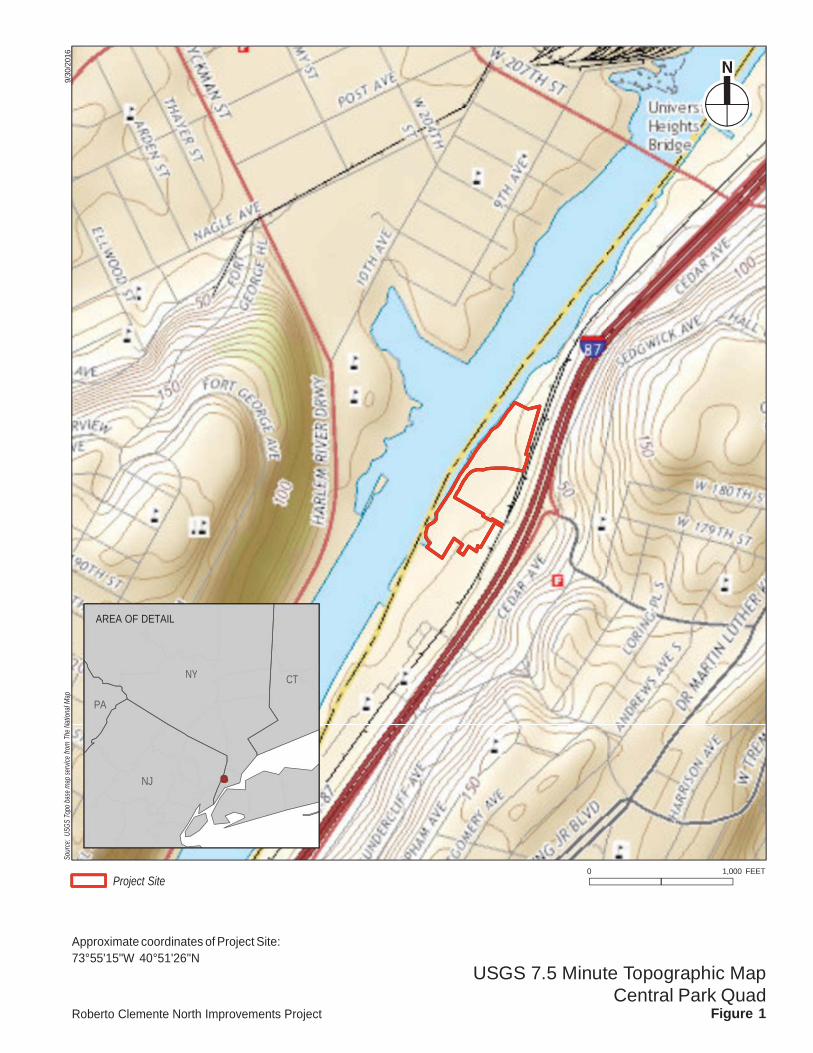
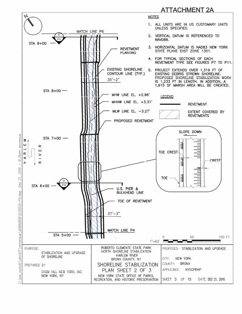
Rehabilitation of the shoreline stabilization along approximately 1,234 linear feet of the existing1,319 linear feet of shoreline within the northern portion of the Park, including 170 linear feet ofliving shoreline which will include a 1,915 square foot (0.04 acres) tidal wetland;
Relocation of two existing stormwater outlets to improve the connection with the stormwatermanagement measures being implemented for the project; and
Rehabilitation of the existing floating dock by relocating this water dependent use to a permanentfloating dock location within the southern portion of the project site within the Park.
The components not previously reviewed under NEPA are described in more detail below.
SHORELINE STABILIZATION
Three types of shoreline stabilization will be constructed as part of the project, none of which willextend waterward of the existing shoreline toe.
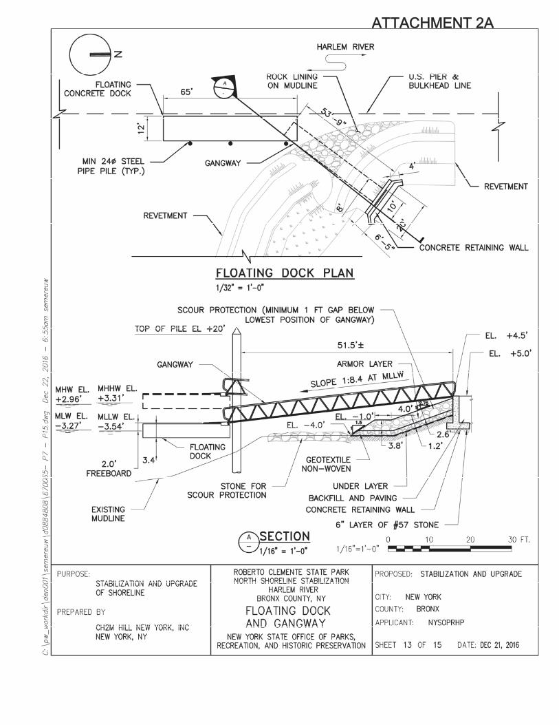
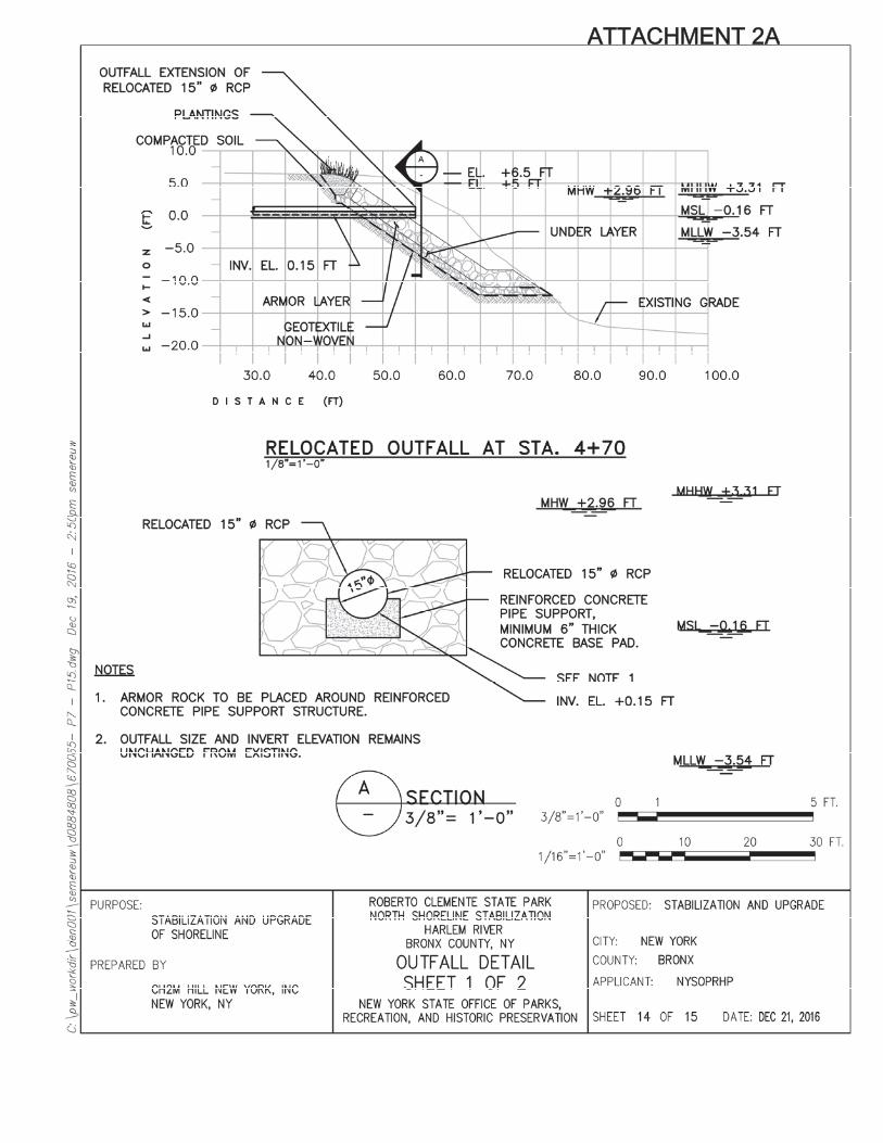
Living shoreline, approximately 170 linear feet (Attachment 2A, Sheets 3, 4 and 7)—Located at thesouthern end of the project site within the existing cove area where the floating dock is beingrelocated, the living shoreline will comprise an approximately 30 foot wide riprap sill at an elevationof +3.5 feet North American Vertical Datum 1988 (NAVD88) which is 0.19 feet above Mean Higher
3 January 20, 2017
High Water (MHHW elevation +3.31) and 0.54 feet above Mean High Water (MHW elevation +2.96),which will protect an approximately 1,915 square foot tidal wetland comprising low and high marshvegetated with Spartina alterniflora (smooth cordgrass), Spartina patens (saltmeadow cordgrass),Salicornia sp. (glasswort), and Iva frutescens (marsh elder). The inlet to the tidal marsh will comprisethe toe of the riprap sill and the toe of the full revetment to the north and will be located at anelevation of approximately 3 feet NAVD88 which is between MHW and Mean Low Water (MLW).
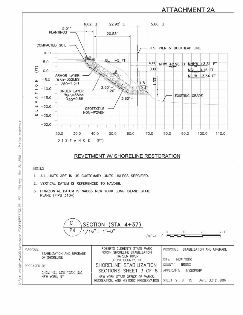
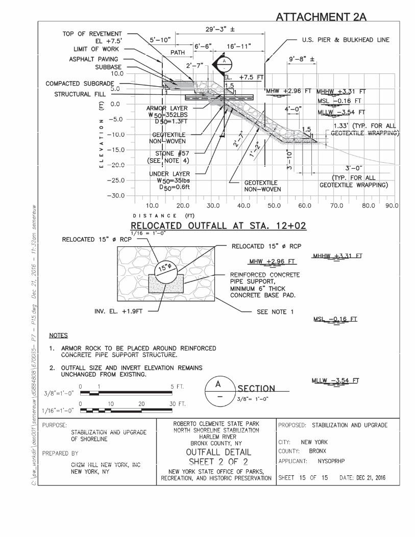
Revetment with shoreline restoration, approximately 450 linear feet (Attachment 2A, Sheets 3, 4, 6,9, and 12)—Located immediately north of the existing concrete retaining wall (see Attachment 2A,Sheet 4) and at the northern end of the shoreline rehabilitation (Attachment 2A, Sheet 6), thisshoreline segment will be planted between elevations +5 and 6.5 feet NAVD88. The top of therevetment would be at the existing shoreline elevation, between approximately +5.25 and 6.5 feetNAVD88 which is above MHHW.
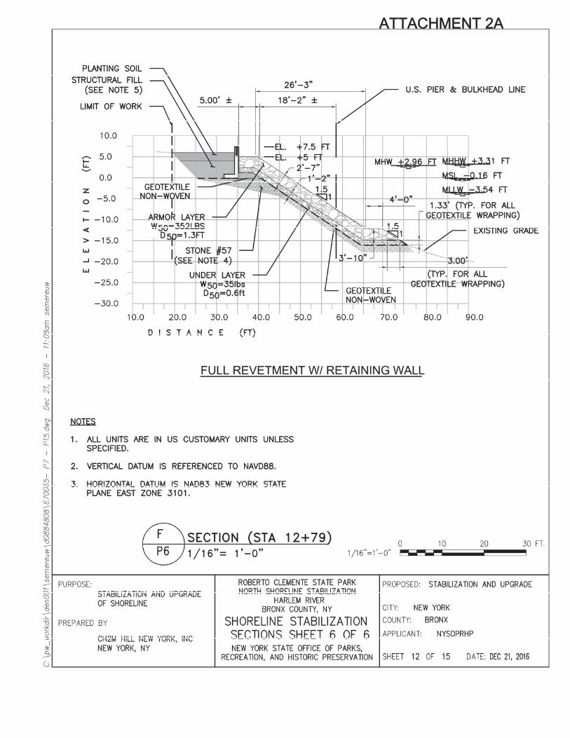
Full revetment, approximately 614 linear feet (Attachment 2A, Sheets 3, 4, 5, 6, 8, 10, and 11). Thetop of the revetment will be at the existing shoreline elevation, at elevations +5 and 6.5 feetNAVD88, which is above MHHW.
The combination of these stabilization configurations will work to absorb wave energy while addingvisually appealing native plants back into the landscape. The living shoreline in the southern part of theproject area would provide salt marsh habitat, including low marsh, high marsh, and upland conditions.The living shoreline would add diversity to shoreline and tidal wetland habitat that complements theintertidal habitat being developed to the south.
The riprap revetment has been designed such that there will be a net decrease in volume of materialplaced within the Harlem River below MHW (Table 1). This will be achieved by excavation of uplandmaterial and removal of existing non engineered shoreline material. Because the proposed revetmentwill start at the toe of the existing shoreline, there will be no loss of river bottom.
Table 1Revetment Excavation and Fill Volumes
Activity Total Volume (cubic yards) Volume belowMHW (cubic yards)
Fill 7,815 5,480Excavation of Fill 8,982 6,277Net Decrease in Fill 1,167 797
STORMWATER OUTLETS
Two existing 15 inch diameter RCP stormwater outlets will be relocated approximately 5 feet(Attachment 2A, Sheet 4) and 14 feet (Attachment 2A, Sheet 6) south of their current locations tobetter accommodate the proposed stormwater management measures designed for the project. Thestormwater outlets will be identical in diameter and invert location as the existing outlets (invertelevations +0.15 and +1.9 feet, Attachment 2A, Sheets 14 and 15). The relocated outlets will be integratedinto the revetment design and will not require any additional structure to dissipate flow, as the existingand proposed invert elevations are below MHW. The existing outlets will be removed.
FLOATING DOCK
The proposed concrete floating dock (Attachment 2A, Sheets 3, 4 and 13) will be 65 feet by 12 feet (780square feet) and will be located to the south of its current location within an existing inlet that willfacilitate safer access by boaters and allow year round use when weather permits. The floating dock will
4 January 20, 2017
be secured by three 24 inch diameter steel pipe piles and will have the capacity to dock two canoes orkayaks and one shell. An approximately 54 foot long by 8 foot wide gangway supported on land bya concrete retaining wall and extending over the proposed revetment will provide access to the dock. Theproposed floating dock will result in a de minimis increase in overwater coverage of 36 square feet whencompared to the existing floating dock. This net increase is needed to safely support the existing rowingprograms that operate out of the Park. The existing floating dock is narrow and wakes generated bypassing vessels make it difficult to use.
CONSTRUCTION/IMPLEMENTATION
The revetment and floating dock and upland improvements will be constructed concurrently, with thepreviously reviewed multipurpose field given priority and completed first. Safe access will be provided tothe multipurpose field while the shoreline improvements and other upland improvements are underconstruction. Construction is anticipated to start late April to early May of 2017. Construction of themultipurpose field will be completed by the end of March 2018. The remainder of the project will becompleted by late November 2018.
The revetment will be constructed from water. Excavation of the shoreline material will use barge basedequipment such as a crane with clamshell. The retaining wall used to support the gangway will beconstructed from land. The steel guide piles for the floating dock will be driven from the waterside by apile driving rig staged on a barge. The piles may be vibrated down to a certain elevation, but will bedriven to its final design elevation using an impact hammer. Rock suitable for placement within therevetment crest or placement under the floating dock gangway will be stored on site, surrounded by siltfencing. The remaining material excavated from the shoreline will be picked up by crane and placed on abarge to be hauled off site to a licensed upland facility.
ALTERNATIVES
Various alternatives were evaluated for the stabilization of the North Shoreline at the Roberto ClementeState Park. The following alternatives were evaluated but were not adopted for the design due toreasons indicated below.
STEEL SHEET PILE BULKHEAD
While installation of steel sheet pile bulkhead along the existing shoreline would stabilize it, it wouldcreate a vertical wall between the retained upland fill and the river that would result in a less naturalstabilization that would not be consistent with the proposed park programming. If the sheet pile neededto be installed waterward of the toe of the existing stabilization, fill would need to be placed behind thebulkhead and into the water column. Installation of the sheet pile inland of the existing shoreline wouldrequire that all existing concrete debris and other materials be removed from the mudline. The presenceof any buried debris would make driving of the steel sheet pile bulkhead difficult. For these reasons, thesteel sheet pile bulkhead option was not considered a practicable alternative.
GABIONS
Installing gabions along the existing shoreline is a viable option and would create less of a hard verticalface than a steel sheet pile bulkhead. Gabions could also be designed to create a steeper slope along theshoreline, thereby slightly reducing the amount of material being placed within the water column.However, gabions have a limited service life due to corrosion of the wire baskets containing the stone.Once the wire basket corrodes and breaks, the gabions will collapse as the stones fall into the waterway.For this reason, gabions were not considered a practicable alternative.
5 January 20, 2017
CONCRETE MATTRESSES
Use of concrete mattresses to stabilize the shoreline would result in the same amount of fill beingplaced in the waterway as the revetment; however, the concrete mattresses are less natural looking andwould not have been compatible with the proposed park programming. For this reason, use of concretemattresses as shoreline stabilization was not considered a practicable alternative.
NO ACTION ALTERNATIVE
In the No Action alternative, none of the proposed improvements to the northern shoreline area wouldbe implemented. No revetment would be installed to stabilize the shoreline and no tidal wetlands wouldbe restored. The existing boat launch would remain and would continue to be difficult to use. Becausethis alternative would not address the purpose and need for the project, would not increase the resilienceof this portion of the Park, it was not considered a practicable alternative.
C. CONCLUSION
The living shoreline portion of the Proposed Project would add diversity to shoreline and 1,915 squarefoot tidal wetland habitat that complements the intertidal habitat being developed to the south.Planting native, deep rooting species as part of a living shoreline, such as Iva frutescens, Spartina patens,and Spartina alterniflora help accelerate shoreline stabilization as well as provide habitat for a numberof marsh birds. When damage does occur to a natural shoreline, native plants can easily re establish.
The revetment would start at the toe of the existing shoreline so no additional river bottom would belost to riprap. In addition, the revetment has been designed to result in a net decrease in the volume offill below MHW of 797 cubic yards, resulting in a net benefit to aquatic resources of the Harlem River.
The proposed floating dock is similar in size to the existing dock and would result in a de minimisincrease in overwater coverage 36 square feet when compared to the existing floating dock. The three24 inch diameter steel pipe piles will be vibrated down to a certain elevation, followed by driving withan impact hammer down the final design elevation.
For the reasons described above, the revised project components within the northern portion of thePark would be equally protective of human health and the environment as the standards set forth in theoriginal EA. In response to the abovementioned text revisions, and pursuant to 24 CFR 58.47 “Reevaluation of environmental assessments and other environmental findings,” the CDBG DR CertifyingOfficer has conducted a re evaluation of the findings associated with the original Roberto ClementeState Park Shoreline and Park Improvements EA. The original findings remain valid, and, accordingly, anew FONSI is not necessary.3
3 24 CFR § 58.47(b)(I) "If the original findings are still valid but the data or conditions upon which they were basedhave changed, the responsible entity must affirm the original findings and update its ERR by including this reevaluation and its determination based on its findings. Under these circumstances, if a FONSI notice has alreadybeen published, no further publication of a FONSI notice is required."
Project Site0 1,000 FEET
Approximate coordinates of Project Site:73°55'15"W 40°51'26"N
Roberto Clemente North Improvements Project
USGS 7.5 Minute Topographic Map Central Park Quad
Figure 1
AREA OF DETAIL
NY CT
PA
NJ
Sour
ce:U
SGS
Topo
base
maps
ervic
efro
mTh
eNati
onal
Map
9/30
/201
6
11.1
8.16
Robe
rto C
lem
ente
Nor
th Im
prov
emen
ts P
roje
ctS
ite P
lan
Figu
re 2
HARLEM
RIVE
RRE
VETM
ENT
UPLAN
DIM
PROVE
MEN
TDE
SIGN
MHW
LINE
NEW
MUL
TIPU
RPOSE
FIELD
Source:RBA
Attachment 1
Roberto Clemente State Park Shoreline and Park ImprovementsNEPA Re-eval Memo
EA Checklists
Appendix A through G referenced in the attached EA checklist are provided in the Roberto Clemente State Park Shoreline and Park Improvements Environmental Assessment dated August 6, 2014. The figures cited in this EA checklist are also provided in the 2014 EA. Two new appendices have been added and are attached to the checklist.
Attachment 1
ENVIRONMENTAL ASSESSMENT CHECKLIST
Evaluate the significance of the effects of the proposal on the character, features and resources of theproject area. Enter relevant base data and verifiable source documentation to support the finding. Thenenter the appropriate impact code from the following list to make a determination of impact. ImpactCodes: (1) No impact anticipated; (2) Potentially beneficial; (3) Potentially adverse; (4) Requiresmitigation; (5) Requires project modification. Note names, dates of contact, telephone numbers andpage references. Attach additional material as appropriate. Note conditions or mitigation measuresrequired.
Updates for the revised project components are in double underline.
Land Development Code Source or DocumentationConformance withComprehensive Plans andZoning
2 The Proposed Project involves the reconstruction of an existingbulkhead and improvements to an existing park and would not resultin changes to land use. Zoning does not apply in the project site,which is within a State Park. The proposed project is consistent withthe New York State Coastal Management Program, as discussed bythe New York State Department of State (NYSDOS) in a letter datedApril 10, 2014, and with the Local Waterfront Revitalization Plan, asdiscussed by NYSDOS in correspondence dated April 10, 2014 and theNew York City Department of City Planning electroniccorrespondence dated April 23, 2014 (see Appendix E). The revisedproject components within the northern portion of the Park wouldstill be consistent with the New York State Coastal ManagementProgram. These components are discussed in the federal, state, andNew York City consistency assessment forms included in the January12, 2017 Joint Permit Application.
Compatibility and Urban Impact 2 The Proposed Project would be compatible with existing land use onthe project site since it would involve the reconstruction of anexisting bulkhead and improvements to an existing park. The siteimprovements would provide an urban design and compatibilitybenefit by revitalizing and enhancing the park and stabilizing theshoreline.
Slope 2 The Proposed Project would require some minor adjustment to slope;regrading would be required to reduce slope and stabilize localizedareas of the existing earth embankment along the shoreline.Significant expansion of the existing bulkhead structure would notoccur, and therefore, adverse effects to slope are not anticipated.The revised project components within the northern portion of thePark would result in minor changes in slope due to the revetment inorder to better stabilize the shoreline.
Attachment 1Erosion 2 As noted above, a major element of the Proposed Project is to
reconstruct a damaged bulkhead. Repairs would stabilize theshoreline and reduce the potential for erosion from current and waveactivity and from boat traffic on the river. The Proposed Projectwould incorporate BMPs imposed by Nationwide Permit 3 andNYSDEC to avoid and minimize erosion impacts during construction.The revised project components within the northern portion of thePark would improve shoreline stabilization to minimize potential forfuture erosion of the shoreline and would also increase resilience.
Soil Suitability 1 The Proposed Project would rebuild the esplanade, construct the tidal/intertidal habitat, construct a living shoreline, conduct enhancementof the Lower Plaza, and construct synthetic and natural turf athleticfields. Overall, the soils within the project site are suitable for theproposed project.
Hazards and Nuisancesincluding Site Safety
1 The Proposed Project would not result in any hazards, nuisances, orthreats to public safety. The project site is located in an areavulnerable to flooding and storm impacts, however the project wouldnot introduce any new occupied structures. While the ProposedProject would help restore a public recreation facility, the project isnot expected to generate new users that would be affected byhazards, nuisances, or other public safety concerns.
Energy Consumption 1 Fossil fuel energy consumption would occur via the use ofconstruction equipment and shipment of materials required for theshoreline stabilization and park improvements. However, theProposed Project would not introduce new facilities and thereforewould not increase long term energy consumption.
Neighborhood Impact Code Source or DocumentationNoise Contribution toCommunity Noise Levels
1 The Proposed Project would not result in a new permanent facilitythat would generate noise on the project site. Noises and increasedhuman activity that would be generated during the construction ofthe proposed project would likely cause disturbances to and displacesome wildlife, but these effects would be temporary and localized tothe specific segments of the project site undergoing constructionactivities.
Air QualityEffects of Ambient Air Quality onProject and Contribution toCommunity Pollution Levels
1 The Proposed Project would not generate any new stationary ormobile sources of air pollutants and therefore has no potential toaffect air quality. Equipment used in the construction activities willbe permitted by relevant agencies and will utilize appropriatemeasures to minimize pollutant emissions.
Attachment 1Environmental DesignVisual Quality Coherence,Diversity, Compatible Use andScale
2 Habitat enhancement and park improvements are stated goals of theproposed project and therefore the proposed project would notintroduce any new elements out of character with the Park. RobertoClemente State Park is already used for recreational purposes, andtherefore the proposed project is not expected to induce anysubsequent growth. Park improvements such as removal of the chainlink fence along the shoreline and planting of native plant species,construction of new turf fields, and rehabilitation of the stairs forwater access, for example, would enhance the visual quality of thePark. As shown in Appendix D, SHPO has concurred that the projectwould have no effects on cultural resources. The Tribal HistoricPreservation offices of the Mohican Tribe, Delaware Tribe, DelawareNation, and Shinnechock Tribe concurred with SHPO’s findings of noeffect on cultural resources (see Appendix D). The revised projectcomponents within the northern portion of the Park, includingremoval of existing rubble, debris, and invasive species followed byconstruction of the revetment, a portion of which will be a livingshoreline, would further enhance the visual quality of the Park.
Socioeconomic Code Source or DocumentationDemographic Character Changes 1 The proposed project is designed protect a public resource in a low
income neighborhood. In addition to protecting park amenities, thereplacement of the damaged bulkhead will protect the approximately1,600 units of low income housing that is adjacent to the park and setback only 20 feet at certain points from the bulkhead. Since theactions comprising the proposed project consist of shorelinestabilization and improvements to an existing park, the proposedproject has no potential to affect the demographic characteristics ofnearby communities or alter residential, commercial, or industrialuses, or harm community institutions.
Displacement 1 The actions comprising the Proposed Project are limited to parkimprovements and stabilization of the shoreline and have nopotential to displace individuals or families; destroy jobs, localbusinesses, or community facilities; or disproportionately affectparticular populations.
Employment and IncomePatterns
1 The actions comprising the Proposed Project are limited to parkimprovements and stabilization of the shoreline and have nopotential to affect employment opportunities or income patterns.
Community Facilities andServices
Code Source or Documentation
Educational Facilities 2 The Proposed Project would not introduce any new populations thatwould increase the student population of the area. The projectwould create environmental educational opportunities through theconstruction of the tidal/intertidal habitat. As a result, the ProposedProject has no potential to affect educational facilities other than in abeneficial way.
Commercial Facilities 1 The Proposed Project is limited to park improvements andstabilization of the shoreline and would not introduce any newdevelopment that would require retail services or other commercialfacilities.
Attachment 1Health Care 1 The Proposed Project is limited to park improvements and
stabilization of the shoreline and would not introduce any newdevelopment that would require the availability of routine oremergency health services.
Social Services 1 The Proposed Project is limited to park improvements andstabilization of the shoreline and would not introduce any newdevelopment that would require the proximity of social services. Theproposed project would not introduce any new populations thatwould overburden existing facilities.
Solid Waste 1 The Proposed Project is limited to park improvements andstabilization of the shoreline and would not introduce any newdevelopment that would generate solid waste.
Waste Water 1 The Proposed Project is limited to park improvements andstabilization of the shoreline and would not introduce any newdevelopment that would generate any wastewater.
StormWater 2 The Proposed Project would not adversely affect stormwater runoff,and may in fact reduce runoff through the reduction of impervioussurfaces at the project site. Park improvements include collection ofstormwater runoff through catch basins, which would then be piped tothe tidal/intertidal habitat complex, permeable pavers, planted areas,and a rain garden that would capture runoff from the esplanade.Impervious surfaces within the Lower Plaza and Esplanade areas wouldbe reduced by at least 25% and 50%, respectively. The synthetic turfathletic fields would allow infiltration and provide some stormwaterdetention before discharging to existing Park stormwater outfalls. Aspart of the revised project components, two existing stormwateroutlets would be relocated and would be identical in diameter andinvert elevation as the existing outlets. The relocated outlets wouldimprove the connection with the stormwater management measuresbeing implemented for the project.
Water Supply 1 The Proposed Project is limited to park improvements andstabilization of the shoreline and would not introduce any newdevelopment that would generate any demand for water supply.
Public SafetyPolice
1 The Proposed Project is limited to park improvements andstabilization of the shoreline and would not add any new demand onpolice services.
Fire 1 The Proposed Project is limited to park improvements andstabilization of the shoreline and would not add any new demand onfire department services.
Emergency Medical 1 The Proposed Project is limited to park improvements andstabilization of the shoreline and would not add any new demand onemergency medical services.
Open Space and RecreationOpen Space
2 A goal of the Proposed Project is to rehabilitate and improve avaluable open space resource (Roberto Clemente State Park). Therestoration of the Park is not expected to add a significant number ofnew users and therefore, the Proposed Project is not expected tooverburden existing open space resources.
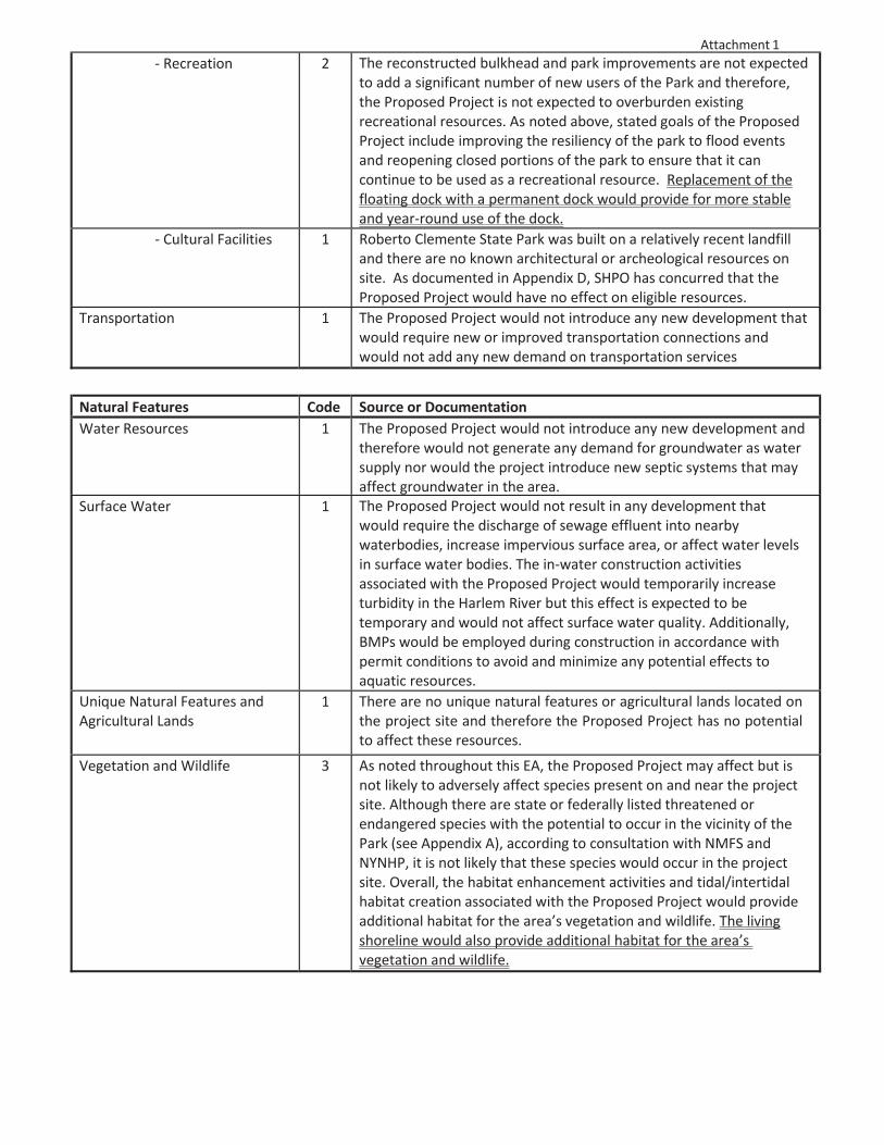
Attachment 1Recreation 2 The reconstructed bulkhead and park improvements are not expected
to add a significant number of new users of the Park and therefore,the Proposed Project is not expected to overburden existingrecreational resources. As noted above, stated goals of the ProposedProject include improving the resiliency of the park to flood eventsand reopening closed portions of the park to ensure that it cancontinue to be used as a recreational resource. Replacement of thefloating dock with a permanent dock would provide for more stableand year round use of the dock.
Cultural Facilities 1 Roberto Clemente State Park was built on a relatively recent landfilland there are no known architectural or archeological resources onsite. As documented in Appendix D, SHPO has concurred that theProposed Project would have no effect on eligible resources.
Transportation 1 The Proposed Project would not introduce any new development thatwould require new or improved transportation connections andwould not add any new demand on transportation services
Natural Features Code Source or DocumentationWater Resources 1 The Proposed Project would not introduce any new development and
therefore would not generate any demand for groundwater as watersupply nor would the project introduce new septic systems that mayaffect groundwater in the area.
Surface Water 1 The Proposed Project would not result in any development thatwould require the discharge of sewage effluent into nearbywaterbodies, increase impervious surface area, or affect water levelsin surface water bodies. The in water construction activitiesassociated with the Proposed Project would temporarily increaseturbidity in the Harlem River but this effect is expected to betemporary and would not affect surface water quality. Additionally,BMPs would be employed during construction in accordance withpermit conditions to avoid and minimize any potential effects toaquatic resources.
Unique Natural Features andAgricultural Lands
1 There are no unique natural features or agricultural lands located onthe project site and therefore the Proposed Project has no potentialto affect these resources.
Vegetation and Wildlife 3 As noted throughout this EA, the Proposed Project may affect but isnot likely to adversely affect species present on and near the projectsite. Although there are state or federally listed threatened orendangered species with the potential to occur in the vicinity of thePark (see Appendix A), according to consultation with NMFS andNYNHP, it is not likely that these species would occur in the projectsite. Overall, the habitat enhancement activities and tidal/intertidalhabitat creation associated with the Proposed Project would provideadditional habitat for the area’s vegetation and wildlife. The livingshoreline would also provide additional habitat for the area’svegetation and wildlife.
Attachment 1
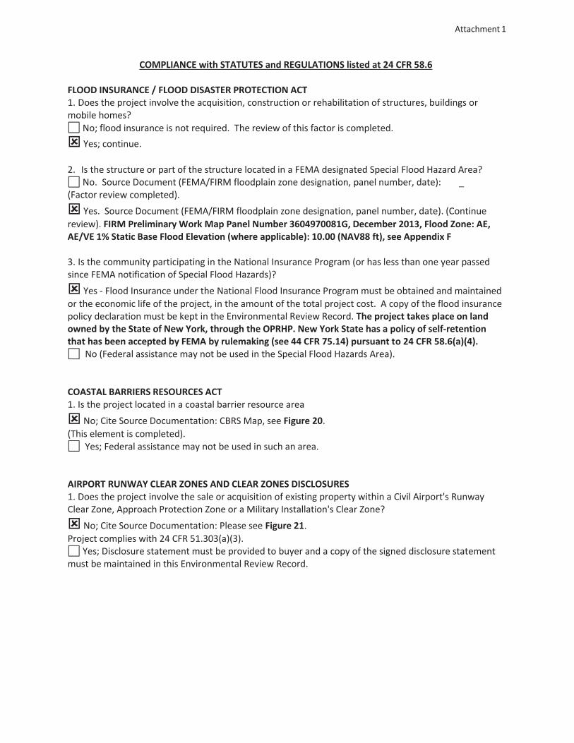
COMPLIANCE with STATUTES and REGULATIONS listed at 24 CFR 58.6
FLOOD INSURANCE / FLOOD DISASTER PROTECTION ACT1. Does the project involve the acquisition, construction or rehabilitation of structures, buildings ormobile homes?
No; flood insurance is not required. The review of this factor is completed.Yes; continue.
2. Is the structure or part of the structure located in a FEMA designated Special Flood Hazard Area?No. Source Document (FEMA/FIRM floodplain zone designation, panel number, date): _
(Factor review completed).Yes. Source Document (FEMA/FIRM floodplain zone designation, panel number, date). (Continue
review). FIRM Preliminary Work Map Panel Number 3604970081G, December 2013, Flood Zone: AE,AE/VE 1% Static Base Flood Elevation (where applicable): 10.00 (NAV88 ft), see Appendix F
3. Is the community participating in the National Insurance Program (or has less than one year passedsince FEMA notification of Special Flood Hazards)?
Yes Flood Insurance under the National Flood Insurance Programmust be obtained and maintainedor the economic life of the project, in the amount of the total project cost. A copy of the flood insurancepolicy declaration must be kept in the Environmental Review Record. The project takes place on landowned by the State of New York, through the OPRHP. New York State has a policy of self retentionthat has been accepted by FEMA by rulemaking (see 44 CFR 75.14) pursuant to 24 CFR 58.6(a)(4).
No (Federal assistance may not be used in the Special Flood Hazards Area).
COASTAL BARRIERS RESOURCES ACT1. Is the project located in a coastal barrier resource area
No; Cite Source Documentation: CBRS Map, see Figure 20.(This element is completed).
Yes; Federal assistance may not be used in such an area.
AIRPORT RUNWAY CLEAR ZONES AND CLEAR ZONES DISCLOSURES1. Does the project involve the sale or acquisition of existing property within a Civil Airport's RunwayClear Zone, Approach Protection Zone or a Military Installation's Clear Zone?
No; Cite Source Documentation: Please see Figure 21.Project complies with 24 CFR 51.303(a)(3).
Yes; Disclosure statement must be provided to buyer and a copy of the signed disclosure statementmust be maintained in this Environmental Review Record.
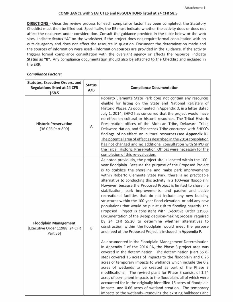
Attachment 1COMPLIANCE with STATUTES and REGULATIONS listed at 24 CFR 58.5
DIRECTIONS Once the review process for each compliance factor has been completed, the StatutoryChecklist must then be filled out. Specifically, the RE must indicate whether the activity does or does notaffect the resources under consideration. Consult the guidance provided in the table below or the websites. Indicate Status “A” on the worksheet if the project does not require formal consultation with anoutside agency and does not affect the resource in question. Document the determination made andthe sources of information were used—information sources are provided in the guidance. If the activitytriggers formal compliance consultation with the oversight agency or affects the resource, indicateStatus as “B”. Any compliance documentation should also be attached to the Checklist and included inthe ERR.
Compliance Factors:
Statutes, Executive Orders, andRegulations listed at 24 CFR
§58.5
StatusA/B Compliance Documentation
Historic Preservation[36 CFR Part 800] A
Roberto Clemente State Park does not contain any resourceseligible for listing on the State and National Registers ofHistoric Places. As documented in Appendix D, in a letter datedJuly 1, 2014, SHPO has concurred that the project would haveno effect on cultural or historic resources. The Tribal HistoricPreservation offices of the Mohican Tribe, Delaware Tribe,Delaware Nation, and Shinnecock Tribe concurred with SHPO’sfindings of no effect on cultural resources (see Appendix D).The potential area of effect as described in the 2014 consolationhas not changed and no additional consultation with SHPO orthe Tribal Historic Preservation Offices were necessary for thecompletion of this re evaluation.
Floodplain Management[Executive Order 11988; 24 CFR
Part 55]B
As noted previously, the project site is located within the 100year floodplain. Because the purpose of the Proposed Projectis to stabilize the shoreline and make park improvementswithin Roberto Clemente State Park, there is no practicablealternative to conducting this activity in a 100 year floodplain.However, because the Proposed Project is limited to shorelinestabilization, park improvements, and passive and activerecreational facilities that do not include any new buildingstructures within the 100 year flood elevation, or add any newpopulations that would be put at risk to flooding hazards, theProposed Project is consistent with Executive Order 11988.Documentation of the 8 step decision making process requiredby 24 CFR 55.20 to determine whether alternatives toconstruction within the floodplain would meet the purposeand need of the Proposed Project is included in Appendix F.
As documented in the Floodplain Management Determinationin Appendix F of the 2014 EA, the Phase 3 project area wascovered in the determination. The determination (Part 55 8step) covered 16 acres of impacts to the floodplain and 0.26acres of temporary impacts to wetlands which include the 0.2acres of wetlands to be created as part of the Phase 3modifications. The revised plans for Phase 3 consist of 1.24acres of permanent impacts to the floodplain, all of which wereaccounted for in the originally identified 16 acres of floodplainimpacts, and 0.66 acres of wetland creation. The temporaryimpacts to the wetlands removing the existing bulkheads and
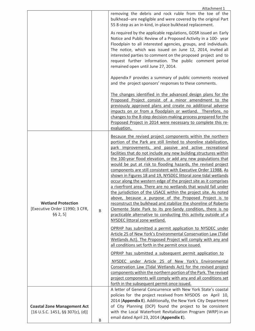
Attachment 1removing the debris and rock ruble from the toe of thebulkhead are negligible and were covered by the original Part55 8 step as an in kind, in place bulkhead replacement.
As required by the applicable regulations, GOSR issued an EarlyNotice and Public Review of a Proposed Activity in a 100 yearFloodplain to all interested agencies, groups, and individuals.The notice, which was issued on June 12, 2014, invited allinterested parties to comment on the proposed project and torequest further information. The public comment periodremained open until June 27, 2014.
Appendix F provides a summary of public comments receivedand the project sponsors’ responses to these comments.
The changes identified in the advanced design plans for theProposed Project consist of a minor amendment to thepreviously approved plans and create no additional adverseimpacts on or from a floodplain or wetland. Therefore, nochanges to the 8 step decision making process prepared for theProposed Project in 2014 were necessary to complete this reevaluation.
Wetland Protection[Executive Order 11990; 3 CFR,
§§ 2, 5]B
Because the revised project components within the northernportion of the Park are still limited to shoreline stabilization,park improvements, and passive and active recreationalfacilities that do not include any new building structures withinthe 100 year flood elevation, or add any new populations thatwould be put at risk to flooding hazards, the revised projectcomponents are still consistent with Executive Order 11988. Asshown in Figures 18 and 19, NYSDEC littoral zone tidal wetlandsoccur along the western edge of the project site as it comprisesa riverfront area. There are no wetlands that would fall underthe jurisdiction of the USACE within the project site. As notedabove, because a purpose of the Proposed Project is toreconstruct the bulkhead and stabilize the shoreline of RobertoClemente State Park to its pre Sandy condition, there is nopracticable alternative to conducting this activity outside of aNYSDEC littoral zone wetland.
OPRHP has submitted a permit application to NYSDEC underArticle 25 of New York’s Environmental Conservation Law (TidalWetlands Act). The Proposed Project will comply with any andall conditions set forth in the permit once issued.
OPRHP has submitted a subsequent permit application to
NYSDEC under Article 25 of New York’s EnvironmentalConservation Law (Tidal Wetlands Act) for the revised projectcomponents within the northern portion of the Park. The revisedproject components will comply with any and all conditions setforth in the subsequent permit once issued.
Coastal Zone Management Act[16 U.S.C. 1451, §§ 307(c), (d)]
B
A letter of General Concurrence with New York State’s coastalpolicies for the project received from NYSDOS on April 10,2014 (Appendix E). Additionally, the New York City Departmentof City Planning (DCP) found the project to be consistentwith the Local Waterfront Revitalization Program (WRP) in anemail dated April 23, 2014 (Appendix E).
Attachment 1
The revised project components within the northern portionof the Park would still be consistent with the Coastal ZoneManagement Act. These components are discussed in thefederal, state, and New York City consistency assessmentforms included in the January 12, 2017 Joint PermitApplication.
Sole Source Aquifers[40 CFR Part 149] A
The project site is not above a sole source aquifer and wouldhave no potential to adversely affect any designated aquifersources.https://epa.maps.arcgis.com/apps/webappviewer/index.html?id=9ebb047ba3ec41ada1877155fe31356b
Endangered Species Act[50 CFR Part 402]
A
As noted above, although there are state or federally listedthreatened or endangered species with the potential to occurin the vicinity of the Park (see Appendices A and C), accordingto information provided by NYNHP, USFWS, and NMFS, theproposed project would have no effect on these species forthe reasons set forth earlier in this Environmental Assessment.This conclusion was confirmed through site investigations.
In a September 13, 2011 letter, NMFS concluded that theProposed Project is not likely to adversely affect any listedspecies under NMFS jurisdiction, including shortnose sturgeon,and that no further consultation under section 7 of the ESA isrequired. In a September 19, 2011 letter, NYSDECacknowledged that there are no records of rare or state listedspecies in the vicinity of the project site. Correspondence fromNYSDEC dated July 3, 2014 indicates that piping plover andnorthern long eared bat do not occur at or near the projectsite, and that proposed activities would have no effect on thesespecies.
The USFWS Information for Planning and Consultation (IPaC)data base was searched for an updated species list. No newspecies were identified (see attached Appendix H), therefore noadditional consultation with the USFWS was necessary for thecompletion of this re evaluation.
An updated essential fish habitat assessment was completedbased on the advance design plans for the Proposed Project.This assessment resulted in a no effect determination, whichdoes not require consultation with NOAA NMFS (see AttachedAppendix I). No additional marine species have been identifiedto occur within the Proposed Project area as compared to thoseconsidered in the August 2014 review. Therefore, no additionalconsultation withNMFSwas necessary for the completion of thisre evaluation (see Attached Appendix I).
Wild and Scenic Rivers Act[16 U.S.C. 1271, §§ 7(b), (c)] A There are no nationally designated Wild and Scenic Rivers on
or near the project site.
Attachment 1
Clean Air Act[40 CFR Parts 6, 51, 93]
A
Bronx County is part of a maintenance area for CO and PM2.5.Based on analysis of 2009 2011 monitoring data, on October 2,2013, New York State recommended that the region bedesignated as in attainment with the annual average primarystandard for PM2.5. Bronx County is within a non attainmentzone for the 8 hour ozone standard. The EPA has designatedthe entire state of New York as “unclassifiable/attainment” forthe 1 hour NO2 standard. During Proposed Project operation—the continued use of Roberto Clemente Park—there would beno increase in air pollutant emissions. The construction of theProposed Project would result in some emissions from on siteconstruction equipment and the transport of constructionmaterials. However, based on the expected constructionactivity and construction costs of the Proposed Project andreview of emissions and construction costs for projectsinvolving similar types of construction, the Proposed Projectwould not exceed General Conformity de minimis emissionsthresholds. Therefore, the Proposed Project has no potentialto affect air quality or affect the New York State ImplementationPlan (SIP). See Appendix G.
Farmland Protection Policy Act[7 CFR Part 658] A
There is no designated farmland located on or near the projectsite and therefore the Proposed Project has no potential toconvert farmland to non agricultural uses.
Attachment 1
Environmental Justice[Executive Order 12898] A
The Council on Environmental Quality’s guidance(Environmental Justice Guidance under the NationalEnvironmental Policy Act, December 1997) requires minoritycommunities to be identified where the minority populationexceeds 50 percent, or where the minority populationpercentage is meaningfully greater than the minoritypopulation in the comparison areas. CEQ guidance does notspecify a threshold to be used for identifying clusters of lowincome populations. NYSDEC's policy for environmental justicedefines "a low income community" as a census block group orcontiguous area where the low income population or thepercentage of individuals living below the poverty threshold asdefined by the U.S. Census Bureau is equal to or greater than23.59 percent of the total population.
The entire study area is considered both a minority and lowincome community, with 98.7% minority population and 32.6%low income population. All of the study area’s 19 blockgroups are considered minority communities, and some arealso low income communities. The Proposed Project would bein compliance with all applicable environmental justiceprotections and would not result in any significant adverseimpacts on minority or low income populations. The ProposedProject would ultimately result in positive enhancements tothe shoreline and park—improved recreational facilities,enhanced visitor experience along the shoreline, habitatenhancement, and the creation of new environmentaleducation opportunities—that could be used and enjoyed bythe area’s residents, including minority and/or low incomepopulations residing within the adjacent areas. See AppendixA, Attachment B, for Environmental Justice evaluation.
Noise Abatement and Control[24 CFR Part 51, Subpart B] A
The Proposed Project would not result in a new permanentfacility that would generate noise on the project site, nor wouldit introduce any new or rehabilitate any existing noisesensitive uses. The ambient noise levels in the Park areconsistent with parks in urban settings, and less than otherparks in New York City.
Explosive and FlammableOperations
[24 CFR Part 51, Subpart C]A
This criterion is applicable to HUD assisted projects thatinvolve new residential construction, conversion of nonresidential buildings to residential use, rehabilitation ofresidential properties that increase the number of units, orrestoration of abandoned properties to habitable condition. Asthe Proposed Project is limited to shoreline rehabilitation andimprovement of a park, the criterion does not apply.
Attachment 1
Toxic Chemicals and RadioactiveMaterials [24CFR Part 58, §
5(i)(2)]A
This criterion requires that properties proposed for use in HUDprograms be free of hazardous materials, contamination, toxicchemicals and gases and radioactive substances. The majorityof the area where the project site and Roberto Clemente Parkis now located was created through filling of the Harlem River.Fill materials may include ash or other waste materials fromindustrial processes and demolition debris from pre existingstructures. Prior to construction of the Park, the land wasprimarily a shipbuilding facility until after World War II. Uses,within both the project site and the remainder of the Park,included fuel storage, heavy machine work, engine testing,chemical engraving, coal storage, a junk yard, and the NewYork University (NYU) Aerospace Laboratory. The ProposedProject would require construction activities (e.g., excavationor grading) that would disturb soil potentially contaminatedfrom these or other undocumented prior uses. Recent soilsampling conducted within the project site within the footprintof the tidal/intertidal habitat complex, and within the northernportion of the project site, has indicated no significantevidence of contamination; Semi volatile Organic Compounds(SVOCs) and metals exceeding Part 375 Soil Cleanup Objectiveswere attributable to the urban fill material. Prior to anyexcavation or construction activities, samples would becollected in accordance with a Materials Management Planapproved by NYSDEC for the areas of the project site that willundergo excavation, grading, or fill placement. The MaterialsManagement Plan will characterize soil within the areas ofdisturbance for the proposed project with respect to soilcontaminants, demonstrating that any soils proposed for reuse on the site will not introduce any exposure pathways topre existing contamination. Any materials needing off sitedisposal would be removed, handled and disposed of inaccordance with applicable state and local regulatoryrequirements. The proposed project does not involve
Airport Clear Zones andAccident Potential Zones[24 CFR Part 51, Subpart D]
AThe Proposed Project is not located within 3,000 feet of a civilairport or within 15,000 feet of a military airfield; therefore,this criterion does not apply. See Figure 21.
Appendices not included in the 2014 EA:
Appendix H – USFWS IPaCAppendix I – Essential Fish Habitat Assessment

Attachment 2A
Roberto Clemente State Park Shoreline and Park Improvements NEPA Re-eval Memo
Shoreline Drawings

AATTACHMENT 2A
AATTACHMENT 2A
AATTACHMENT 2A
AATTACHMENT 2A

AATTACHMENT 2A
AATTACHMENT 2A
AATTACHMENT 2A
AATTACHMENT 2A

AATTACHMENT 2A
AATTACHMENT 2A
AATTACHMENT 2A

AATTACHMENT 2A
AATTACHMENT 2A

AATTACHMENT 2A

AATTACHMENT 2A

Appendix H
USFWS IPaC
7/27/2017 IPaC: Explore Location
https://ecos.fws.gov/ipac/location/O7SGQ5UP2JBWDERS7SGQXMU3KE/resources 1/5
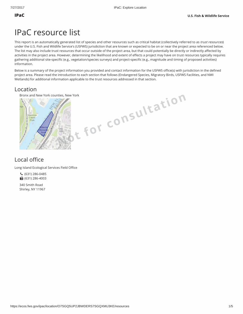
IPaC resource listThis report is an automatically generated list of species and other resources such as critical habitat (collectively referred to as trust resources)under the U.S. Fish and Wildlife Service's (USFWS) jurisdiction that are known or expected to be on or near the project area referenced below.The list may also include trust resources that occur outside of the project area, but that could potentially be directly or indirectly a ected byactivities in the project area. However, determining the likelihood and extent of e ects a project may have on trust resources typically requiresgathering additional site-speci c (e.g., vegetation/species surveys) and project-speci c (e.g., magnitude and timing of proposed activities)information.
Below is a summary of the project information you provided and contact information for the USFWS o ce(s) with jurisdiction in the de nedproject area. Please read the introduction to each section that follows (Endangered Species, Migratory Birds, USFWS Facilities, and NWIWetlands) for additional information applicable to the trust resources addressed in that section.
LocationBronx and New York counties, New York
Local o ceLong Island Ecological Services Field O ce
(631) 286-0485 (631) 286-4003
340 Smith RoadShirley, NY 11967
U.S. Fish & Wildlife Service
oot for consultation
IPaC
7/27/2017 IPaC: Explore Location
https://ecos.fws.gov/ipac/location/O7SGQ5UP2JBWDERS7SGQXMU3KE/resources 2/5
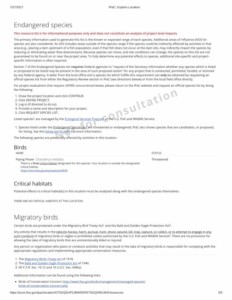
Endangered speciesThis resource list is for informational purposes only and does not constitute an analysis of project level impacts.
The primary information used to generate this list is the known or expected range of each species. Additional areas of in uence (AOI) forspecies are also considered. An AOI includes areas outside of the species range if the species could be indirectly a ected by activities in thatarea (e.g., placing a dam upstream of a sh population, even if that sh does not occur at the dam site, may indirectly impact the species byreducing or eliminating water ow downstream). Because species can move, and site conditions can change, the species on this list are notguaranteed to be found on or near the project area. To fully determine any potential e ects to species, additional site-speci c and project-speci c information is often required.
Section 7 of the Endangered Species Act requires Federal agencies to "request of the Secretary information whether any species which is listedor proposed to be listed may be present in the area of such proposed action" for any project that is conducted, permitted, funded, or licensedby any Federal agency. A letter from the local o ce and a species list which ful lls this requirement can only be obtained by requesting ano cial species list from either the Regulatory Review section in IPaC (see directions below) or from the local eld o ce directly.
For project evaluations that require USFWS concurrence/review, please return to the IPaC website and request an o cial species list by doingthe following:
1. Draw the project location and click CONTINUE.2. Click DEFINE PROJECT.3. Log in (if directed to do so).4. Provide a name and description for your project.5. Click REQUEST SPECIES LIST.
Listed species are managed by the Ecological Services Program of the U.S. Fish and Wildlife Service.
1. Species listed under the Endangered Species Act are threatened or endangered; IPaC also shows species that are candidates, or proposed,for listing. See the listing status page for more information.
The following species are potentially a ected by activities in this location:
Birds
Critical habitatsPotential e ects to critical habitat(s) in this location must be analyzed along with the endangered species themselves.
THERE ARE NO CRITICAL HABITATS AT THIS LOCATION.
Migratory birds
1
NAME STATUS
Piping Plover Charadrius melodusThere is a nal critical habitat designated for this species. Your location is outside the designatedcritical habitat.https://ecos.fws.gov/ecp/species/6039
Threatened
Certain birds are protected under the Migratory Bird Treaty Act and the Bald and Golden Eagle Protection Act .
Any activity that results in the take (to harass, harm, pursue, hunt, shoot, wound, kill, trap, capture, or collect, or to attempt to engage in anysuch conduct) of migratory birds or eagles is prohibited unless authorized by the U.S. Fish and Wildlife Service . There are no provisions forallowing the take of migratory birds that are unintentionally killed or injured.
Any person or organization who plans or conducts activities that may result in the take of migratory birds is responsible for complying with theappropriate regulations and implementing appropriate conservation measures.
1. The Migratory Birds Treaty Act of 1918.2. The Bald and Golden Eagle Protection Act of 1940.3. 50 C.F.R. Sec. 10.12 and 16 U.S.C. Sec. 668(a)
Additional information can be found using the following links:
Birds of Conservation Concern http://www.fws.gov/birds/management/managed-species/ birds-of-conservation-concern.php
1 2
3
Nsta usNen alloopageotSpetor m
ffs Afoot arerrProgr cmcf othe U
nsultation
7/27/2017 IPaC: Explore Location
https://ecos.fws.gov/ipac/location/O7SGQ5UP2JBWDERS7SGQXMU3KE/resources 3/5
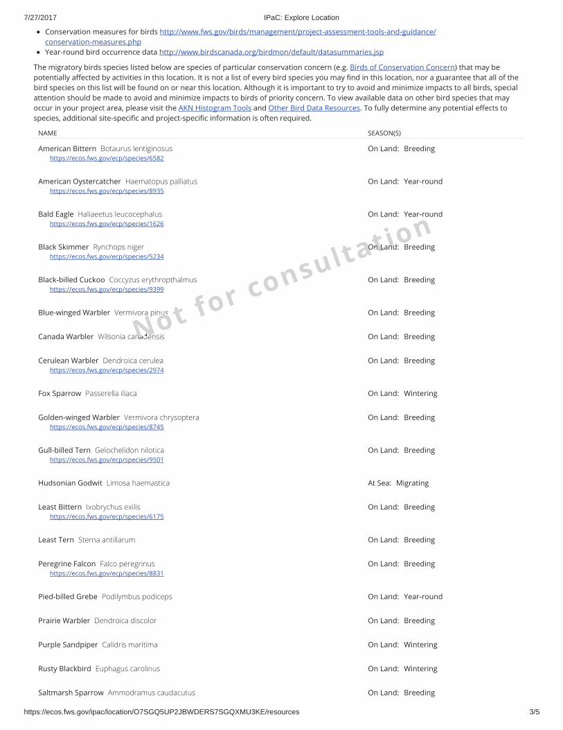
The migratory birds species listed below are species of particular conservation concern (e.g. Birds of Conservation Concern) that may bepotentially a ected by activities in this location. It is not a list of every bird species you may nd in this location, nor a guarantee that all of thebird species on this list will be found on or near this location. Although it is important to try to avoid and minimize impacts to all birds, specialattention should be made to avoid and minimize impacts to birds of priority concern. To view available data on other bird species that mayoccur in your project area, please visit the AKN Histogram Tools and Other Bird Data Resources. To fully determine any potential e ects tospecies, additional site-speci c and project-speci c information is often required.
Conservation measures for birds http://www.fws.gov/birds/management/project-assessment-tools-and-guidance/ conservation-measures.phpYear-round bird occurrence data http://www.birdscanada.org/birdmon/default/datasummaries.jsp
NAME SEASON(S)
American Bittern Botaurus lentiginosushttps://ecos.fws.gov/ecp/species/6582
On Land: Breeding
American Oystercatcher Haematopus palliatushttps://ecos.fws.gov/ecp/species/8935
On Land: Year-round
Bald Eagle Haliaeetus leucocephalushttps://ecos.fws.gov/ecp/species/1626
On Land: Year-round
Black Skimmer Rynchops nigerhttps://ecos.fws.gov/ecp/species/5234
On Land: Breeding
Black-billed Cuckoo Coccyzus erythropthalmushttps://ecos.fws.gov/ecp/species/9399
On Land: Breeding
Blue-winged Warbler Vermivora pinus On Land: Breeding
Canada Warbler Wilsonia canadensis On Land: Breeding
Cerulean Warbler Dendroica ceruleahttps://ecos.fws.gov/ecp/species/2974
On Land: Breeding
Fox Sparrow Passerella iliaca On Land: Wintering
Golden-winged Warbler Vermivora chrysopterahttps://ecos.fws.gov/ecp/species/8745
On Land: Breeding
Gull-billed Tern Gelochelidon niloticahttps://ecos.fws.gov/ecp/species/9501
On Land: Breeding
Hudsonian Godwit Limosa haemastica At Sea: Migrating
Least Bittern Ixobrychus exilishttps://ecos.fws.gov/ecp/species/6175
On Land: Breeding
Least Tern Sterna antillarum On Land: Breeding
Peregrine Falcon Falco peregrinushttps://ecos.fws.gov/ecp/species/8831
On Land: Breeding
Pied-billed Grebe Podilymbus podiceps On Land: Year-round
Prairie Warbler Dendroica discolor On Land: Breeding
Purple Sandpiper Calidris maritima On Land: Wintering
Rusty Blackbird Euphagus carolinus On Land: Wintering
Saltmarsh Sparrow Ammodramus caudacutus On Land: Breeding
Nna eous t for consultaOtn Laindon
7/27/2017 IPaC: Explore Location
https://ecos.fws.gov/ipac/location/O7SGQ5UP2JBWDERS7SGQXMU3KE/resources 4/5
What does IPaC use to generate the list of migratory bird species potentially occurring in my speci ed location?
Landbirds:
Migratory birds that are displayed on the IPaC species list are based on ranges in the latest edition of the National Geographic Guide, Birds of North America (6thEdition, 2011 by Jon L. Dunn, and Jonathan Alderfer). Although these ranges are coarse in nature, a number of U.S. Fish and Wildlife Service migratory bird biologistsagree that these maps are some of the best range maps to date. These ranges were clipped to a speci c Bird Conservation Region (BCR) or USFWS Region/Regions,if it was indicated in the 2008 list of Birds of Conservation Concern (BCC) that a species was a BCC species only in a particular Region/Regions. Additionalmodi cations have been made to some ranges based on more local or re ned range information and/or information provided by U.S. Fish and Wildlife Servicebiologists with species expertise. All migratory birds that show in areas on land in IPaC are those that appear in the 2008 Birds of Conservation Concern report.
Atlantic Seabirds:
Ranges in IPaC for birds o the Atlantic coast are derived from species distribution models developed by the National Oceanic and Atmospheric Association (NOAA)National Centers for Coastal Ocean Science (NCCOS) using the best available seabird survey data for the o shore Atlantic Coastal region to date. NOAANCCOSassisted USFWS in developing seasonal species ranges from their models for speci c use in IPaC. Some of these birds are not BCC species but were of interest forinclusion because they may occur in high abundance o the coast at di erent times throughout the year, which potentially makes them more susceptible to certaintypes of development and activities taking place in that area. For more re ned details about the abundance and richness of bird species within your project area othe Atlantic Coast, see the Northeast Ocean Data Portal. The Portal also o ers data and information about other types of taxa that may be helpful in your projectreview.
About the NOAANCCOS models: the models were developed as part of the NOAANCCOS project: Integrative Statistical Modeling and Predictive Mapping of MarineBird Distributions and Abundance on the Atlantic Outer Continental Shelf. The models resulting from this project are being used in a number of decision-support/mapping products in order to help guide decision-making on activities o the Atlantic Coast with the goal of reducing impacts to migratory birds. One suchproduct is the Northeast Ocean Data Portal, which can be used to explore details about the relative occurrence and abundance of bird species in a particular areao the Atlantic Coast.
All migratory bird range maps within IPaC are continuously being updated as new and better information becomes available.
Can I get additional information about the levels of occurrence in my project area of speci c birds or groups of birds listed in IPaC?
Landbirds:
The Avian Knowledge Network (AKN) provides a tool currently called the "Histogram Tool", which draws from the data within the AKN (latest,survey, point count,citizen science datasets) to create a view of relative abundance of species within a particular location over the course of the year. The results of the tool depict thefrequency of detection of a species in survey events, averaged between multiple datasets within AKN in a particular week of the year. You may access the histogramtools through the Migratory Bird Programs AKN Histogram Tools webpage.
The tool is currently available for 4 regions (California, Northeast U.S., Southeast U.S. and Midwest), which encompasses the following 32 states: Alabama, Arkansas,California, Connecticut, Delaware, Florida, Georgia, Illinois, Indiana, Iowa, Kentucky, Louisiana, Maine, Maryland, Massachusetts, Michigan, Minnesota, Mississippi,Missouri, New Hampshire, New Jersey, New York, North, Carolina, Ohio, Pennsylvania, Rhode Island, South Carolina, Tennessee, Vermont, Virginia, West Virginia,and Wisconsin.
In the near future, there are plans to expand this tool nationwide within the AKN, and allow the graphs produced to appear with the list of trust resourcesgenerated by IPaC, providing you with an additional level of detail about the level of occurrence of the species of particular concern potentially occurring in yourproject area throughout the course of the year.
Atlantic Seabirds:
For additional details about the relative occurrence and abundance of both individual bird species and groups of bird species within your project area o theAtlantic Coast, please visit the Northeast Ocean Data Portal. The Portal also o ers data and information about other taxa besides birds that may be helpful to you inyour project review. Alternately, you may download the bird model results les underlying the portal maps through the NOAANCCOS Integrative Statistical Modelingand Predictive Mapping of Marine Bird Distributions and Abundance on the Atlantic Outer Continental Shelf project webpage.
Facilities
Seaside Sparrow Ammodramus maritimus On Land: Year-round
Short-eared Owl Asio ammeushttps://ecos.fws.gov/ecp/species/9295
On Land: Wintering
Snowy Egret Egretta thula On Land: Breeding
Upland Sandpiper Bartramia longicaudahttps://ecos.fws.gov/ecp/species/9294
On Land: Breeding
Willow Flycatcher Empidonax trailliihttps://ecos.fws.gov/ecp/species/3482
On Land: Breeding
Wood Thrush Hylocichla mustelina On Land: Breeding
Worm Eating Warbler Helmitheros vermivorum On Land: Breeding
Nlantic cn S
oast at fhat s ohow i roca
arc) tha
e neos wea pe ne clipp
ies wsnat
ed tout onre, a n lf t
mte Na ation
tion
7/27/2017 IPaC: Explore Location
https://ecos.fws.gov/ipac/location/O7SGQ5UP2JBWDERS7SGQXMU3KE/resources 5/5
Wildlife refugesAny activity proposed on National Wildlife Refuge lands must undergo a 'Compatibility Determination' conducted by the Refuge. Please contactthe individual Refuges to discuss any questions or concerns.
THERE ARE NO REFUGES AT THIS LOCATION.
Fish hatcheries
THERE ARE NO FISH HATCHERIES AT THIS LOCATION.
Wetlands in the National Wetlands InventoryImpacts to NWI wetlands and other aquatic habitats may be subject to regulation under Section 404 of the Clean Water Act, or otherState/Federal statutes.
For more information please contact the Regulatory Program of the local U.S. Army Corps of Engineers District.
This location overlaps the following wetlands:
Data limitations
The Service's objective of mapping wetlands and deepwater habitats is to produce reconnaissance level information on the location, type and size of theseresources. The maps are prepared from the analysis of high altitude imagery. Wetlands are identi ed based on vegetation, visible hydrology and geography. Amargin of error is inherent in the use of imagery; thus, detailed on-the-ground inspection of any particular site may result in revision of the wetland boundaries orclassi cation established through image analysis.
The accuracy of image interpretation depends on the quality of the imagery, the experience of the image analysts, the amount and quality of the collateral data andthe amount of ground truth veri cation work conducted. Metadata should be consulted to determine the date of the source imagery used and any mappingproblems.
Wetlands or other mapped features may have changed since the date of the imagery or eld work. There may be occasional di erences in polygon boundaries orclassi cations between the information depicted on the map and the actual conditions on site.
Data exclusions
Certain wetland habitats are excluded from the National mapping program because of the limitations of aerial imagery as the primary data source used to detectwetlands. These habitats include seagrasses or submerged aquatic vegetation that are found in the intertidal and subtidal zones of estuaries and nearshore coastalwaters. Some deepwater reef communities (coral or tuber cid worm reefs) have also been excluded from the inventory. These habitats, because of their depth, goundetected by aerial imagery.
Data precautions
Federal, state, and local regulatory agencies with jurisdiction over wetlands may de ne and describe wetlands in a di erent manner than that used in this inventory.There is no attempt, in either the design or products of this inventory, to de ne the limits of proprietary jurisdiction of any Federal, state, or local government or toestablish the geographical scope of the regulatory programs of government agencies. Persons intending to engage in activities involving modi cations within oradjacent to wetland areas should seek the advice of appropriate federal, state, or local agencies concerning speci ed agency regulatory programs and proprietaryjurisdictions that may a ect such activities.
ESTUARINE AND MARINE DEEPWATERE1UBL
A full description for each wetland code can be found at the National Wetlands Inventory website: https://ecos.fws.gov/ipac/wetlands/decoder
wotcan ffo ond at rh consultagateertiDiostricton
Appendix I
Essential Fish Habitat Assessment
ANDREW M. CUOMO Governor
LISA BOVA-HIATT Executive Director
August 10, 2017
MEMORANDUM
To: Environmental Review Record From: Alicia Shultz, Senior Environmental Scientist, Governor’s Office of Storm Recovery (GOSR)
Subject: Essential Fish Habitat (EFH) Roberto Clemente State Park Shoreline and Park Improvements – North Section Bronx, New York Proposed Project Scope Revision – EFH Assessment – No Effect – No Consultation Required
The Governor's Office of Storm Recovery (GOSR), an office of the New York State Homes and Community Renewal’s (NYSHCR) Housing Trust Fund Corporation, was established to aid the statewide recovery of disaster-affected communities in New York State. GOSR is administering a U.S. Department of Housing and Urban Development (HUD) Community Development Block Grant for Disaster Recovery (CDBG-DR), including the New York Rising Infrastructure Program. The environmental review for projects funded under the NYRCR Program are processed on a case-by-case basis. Federal agencies are required to consult with National Marine Fisheries Service (NMFS) (using existing consultation processes for the National Environmental Policy Act (NEPA), the Endangered Species Act, or the Fish and Wildlife Coordination Act) on any action that they authorize, fund or undertake that may adversely impact Essential Fish Habitat (EFH). GOSR prepared a NEPA Environmental Assessment (EA) for the Roberto Clemente State Park Shoreline and Park Improvements which is posted on the GOSR website at https://stormrecovery.ny.gov/environmental-docs under Infrastructure, Bronx County headings. Since the date of the EA the scope of work of the proposed project has been revised. The revised scope is described in the attached reevaluation memorandum and permit application to the U.S. Army Corps of Engineers (USACOE). The purpose of this memorandum is to document GOSR’s no effect determination for EFH and therefore a consultation with NMFS is not required.
The Magnuson-Stevens Fishery Conservation and Management Act (MSA) mandates that federal agencies conduct an EFH consultation with NOAA Fisheries regarding any of their actions authorized, funded, or undertaken that may adversely affect EFH. An adverse effect means any impact that reduces the quality and/or quantity of EFH. Adverse effects may include direct or indirect physical, chemical, or biological alterations of the waters or substrate and loss of, or injury to, benthic organisms, prey species and their habitat, and other ecosystem components. Adverse effects to EFH may result from actions occurring within EFH or outside of EFH and may include site-specific or habitat-wide impacts, including individual, cumulative, or synergistic consequences of actions.
The attached EFH habitat assessment has been prepared to demonstrate that the project is in compliance with the requirements of 50 CFR §660.920 implementing the Magnuson-Stevens Act, as amended by the Sustainable Fisheries Act of 1996 (Public Law 104-267) and document GOSR’s no effect determination.

Attachment 2A
Roberto Clemente State Park Shoreline and Park Improvements NEPA Re-eval Memo
Shoreline Drawings
AATTACHMENT 2A

AATTACHMENT 2A

AATTACHMENT 2A

AATTACHMENT 2A
AATTACHMENT 2A

AATTACHMENT 2A

AATTACHMENT 2A

AATTACHMENT 2A
AATTACHMENT 2A

AATTACHMENT 2A

AATTACHMENT 2A
AATTACHMENT 2A

AATTACHMENT 2A
AATTACHMENT 2A
AATTACHMENT 2A

EFH Assessment Worksheets
NOAA FISHERIESGREATER ATLANTIC REGIONAL FISHERIES OFFICE
Essential Fish Habitat (EFH) Consultation GuidanceEFH ASSESSMENT WORKSHEET
Introduction:
The Magnuson-Stevens Fishery Conservation and Management Act (MSA) mandates that federal agencies conduct an essential fish habitat (EFH) consultation with NOAA Fisheries regarding any of their actions authorized, funded, or undertaken that may adversely affect EFH. An adverse effect means any impact that reduces the quality and/or quantity of EFH. Adverse effects may include direct or indirect physical, chemical, or biological alterations of the waters or substrate and loss of, or injury to, benthic organisms, prey species and their habitat, and other ecosystem components. Adverse effects to EFH may result from actions occurring within EFH or outside of EFH and may include site-specific or habitat-wide impacts, including individual, cumulative, or synergistic consequences of actions.
This worksheet has been designed to assist in determining whether a consultation is necessary and in preparing EFH assessments. This worksheet should be used as your EFH assessment or as a guideline for the development of your EFH assessment. At a minimum, all the information required to complete this worksheet should be included in your EFH assessment. If the answers in the worksheet do not fully evaluate the adverse effects to EFH, we may request additional information in order to complete the consultation.
An expanded EFH assessment may be required for more complex projects in order to fully characterize the effects of the project and the avoidance and minimization of impacts to EFH. While the EFH worksheet may be used for larger projects, the format may not be sufficient to incorporate the extent of detail required, and a separate EFH assessment may be developed. However, regardless of format, the analysis outlined in this worksheet should be included for an expanded EFH assessment, along with additional information that may be necessary. This additional information includes:
the results of on-site inspections to evaluate the habitat and site-specific effects the views of recognized experts on the habitat or the species that may be affected a review of pertinent literature and related information an analysis of alternatives to the action that could avoid or minimize the adverse effects on EFH.
Your analysis of adverse effects to EFH under the MSA should focus on impacts to the habitat for all life stages of species with designated EFH, rather than individual responses of fish species. Fish habitat includes the substrate and benthic resources (e.g., submerged aquatic vegetation, shellfish beds, salt marsh wetlands), as well as the water column and prey species.
Consultation with us may also be necessary if a proposed action results in adverse impacts to other NOAA-trust resources. Part 6 of the worksheet is designed to help assess the effects of the action on other NOAA-trust resources. This helps maintain efficiency in our interagency coordination process. In addition, further consultation may be required if a proposed action impacts marine mammals or threatened and endangered species for which we are responsible. Staff from our Greater Atlantic Regional Fisheries Office, Protected
Resources Division should be contacted regarding potential impacts to marine mammals or threatened and endangered species.
Instructions for Use:
Federal agencies must submit an EFH assessment to NOAA Fisheries as part of the EFH consultation. Your EFH assessment must include:
1) A description of the proposed action.2) An analysis of the potential adverse effects of the action on EFH, and the managed species.3) The federal agency’s conclusions regarding the effects of the action on EFH.4) Proposed mitigation if applicable.
In order for this worksheet to be considered as your EFH assessment, you must answer the questions in this worksheet fully and with as much detail as available. Give brief explanations for each answer.
Federal action agencies or the non-federal designated lead agency should submit the completed worksheet to NOAA Fisheries Greater Atlantic Regional Fisheries Office, Habitat Conservation Division (HCD) with the public notice or project application. Include project plans showing existing and proposed conditions, all waters of the U.S. on the project site, with mean low water (MLW), mean high water (MHW), high tide line (HTL),and water depths clearly marked and sensitive habitats mapped, including special aquatic sites (submerged aquatic vegetation, saltmarsh, mudflats, riffles and pools, coral reefs, and sanctuaries and refuges), hard bottom habitat areas and shellfish beds, as well as any available site photographs.
For most consultations, NOAA Fisheries has 30 days to provide EFH conservation recommendations once we receive a complete EFH assessment. Submitting all necessary information at once minimizes delays in review and keeps review timelines consistent. Delays in providing a complete EFH assessment can result in our consultation review period extending beyond the public comment period for a particular project.
The information contained on the HCD website (http://www.greateratlantic.fisheries.noaa.gov/habitat/) will assist you in completing this worksheet. The HCD website contains information regarding: the EFH consultation process; Guide to EFH Designations which provides a geographic species list; Guide to EFH Species Descriptions which provides the legal description of EFH as well as important ecological information for each species and life stage; and other EFH reference documents including examples of EFH assessments and EFH consultations.
Our website also includes a link to the NOAA EFH Mapper (http://www.habitat.noaa.gov/protection/efh/efhmapper/index.html). We would note that the EFH Mapper is currently being updated and revised. Should you use the EFH Mapper to identify federally managed species with designated EFH in your project area, we recommend checking this list against the Guide to Essential Fish Habitat Designations in the Northeast (http://www.greateratlantic.fisheries.noaa.gov/hcd/index2a.htm) to ensure a complete and accurate list is provided.
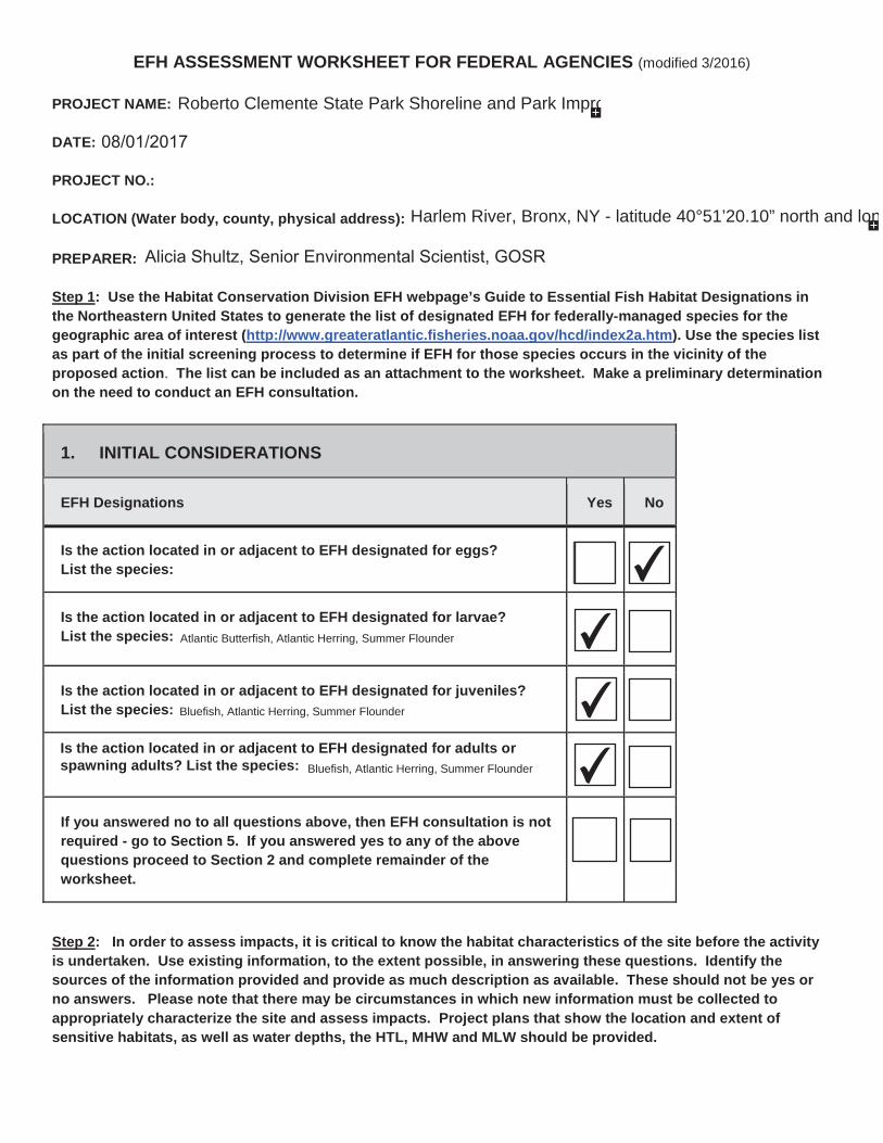
EFH ASSESSMENT WORKSHEET FOR FEDERAL AGENCIES (modified 3/2016)
PROJECT NAME:
DATE:
PROJECT NO.:
LOCATION (Water body, county, physical address):
PREPARER:
Step 1: Use the Habitat Conservation Division EFH webpage’s Guide to Essential Fish Habitat Designations in the Northeastern United States to generate the list of designated EFH for federally-managed species for the geographic area of interest (http://www.greateratlantic.fisheries.noaa.gov/hcd/index2a.htm). Use the species list as part of the initial screening process to determine if EFH for those species occurs in the vicinity of theproposed action. The list can be included as an attachment to the worksheet. Make a preliminary determination on the need to conduct an EFH consultation.
1. INITIAL CONSIDERATIONS
EFH Designations Yes No
Is the action located in or adjacent to EFH designated for eggs? List the species:
Is the action located in or adjacent to EFH designated for larvae?List the species:
Is the action located in or adjacent to EFH designated for juveniles?List the species:
Is the action located in or adjacent to EFH designated for adults or spawning adults? List the species:
If you answered no to all questions above, then EFH consultation is not required - go to Section 5. If you answered yes to any of the above questions proceed to Section 2 and complete remainder of theworksheet.
Step 2: In order to assess impacts, it is critical to know the habitat characteristics of the site before the activity is undertaken. Use existing information, to the extent possible, in answering these questions. Identify thesources of the information provided and provide as much description as available. These should not be yes or no answers. Please note that there may be circumstances in which new information must be collected to appropriately characterize the site and assess impacts. Project plans that show the location and extent of sensitive habitats, as well as water depths, the HTL, MHW and MLW should be provided.
Roberto Clemente State Park Shoreline and Park Impro
Harlem River, Bronx, NY - latitude 40°51’20.10” north and lon
Alicia Shultz, Senior Environmental Scientist, GOSR
08/01/2017
✔
✔
✔
✔
✔
✔
✔
✔
Atlantic Butterfish, Atlantic Herring, Summer Flounder
Bluefish, Atlantic Herring, Summer Flounder
Bluefish, Atlantic Herring, Summer Flounder
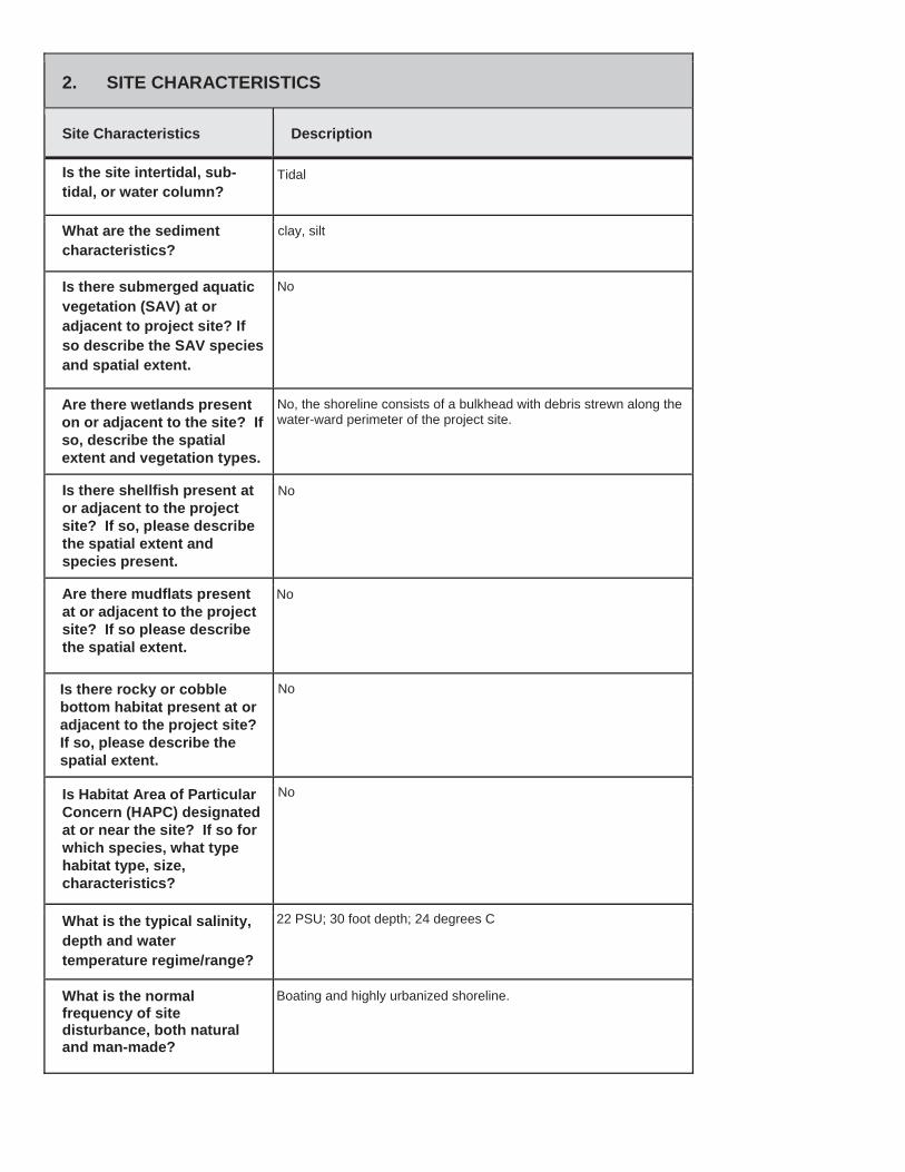
2. SITE CHARACTERISTICS
Site Characteristics Description
Is the site intertidal, sub-tidal, or water column?
What are the sediment characteristics?
Is there submerged aquatic vegetation (SAV) at or adjacent to project site? If so describe the SAV species and spatial extent.
Are there wetlands present on or adjacent to the site? If so, describe the spatial extent and vegetation types.
Is there shellfish present at or adjacent to the project site? If so, please describe the spatial extent and species present.
Are there mudflats present at or adjacent to the project site? If so please describe the spatial extent.
Is there rocky or cobble bottom habitat present at or adjacent to the project site? If so, please describe the spatial extent.
Is Habitat Area of Particular Concern (HAPC) designated at or near the site? If so for which species, what type habitat type, size, characteristics?
What is the typical salinity, depth and water temperature regime/range?
What is the normal frequency of site disturbance, both natural and man-made?
Tidal
clay, silt
No
No, the shoreline consists of a bulkhead with debris strewn along thewater-ward perimeter of the project site.
No
No
No
No
22 PSU; 30 foot depth; 24 degrees C
Boating and highly urbanized shoreline.
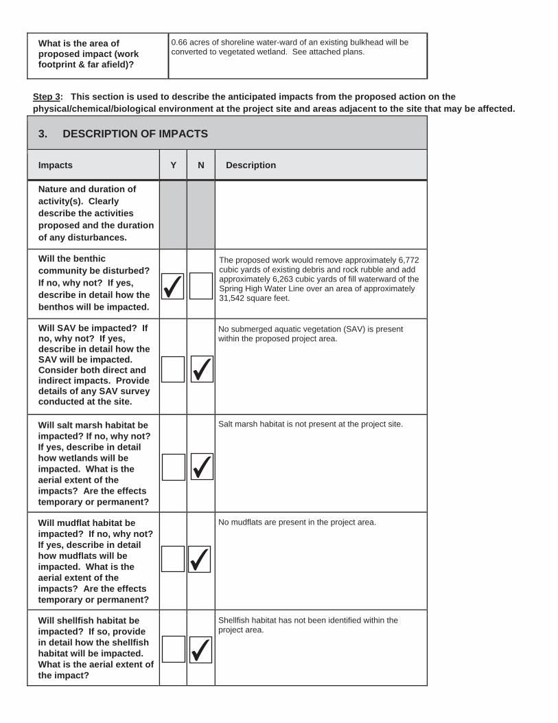
What is the area of proposed impact (work footprint & far afield)?
Step 3: This section is used to describe the anticipated impacts from the proposed action on the physical/chemical/biological environment at the project site and areas adjacent to the site that may be affected.
3. DESCRIPTION OF IMPACTS
Impacts Y N Description
Nature and duration of activity(s). Clearly describe the activities proposed and the duration of any disturbances.
Will the benthic community be disturbed? If no, why not? If yes,describe in detail how the benthos will be impacted.
Will SAV be impacted? Ifno, why not? If yes, describe in detail how the SAV will be impacted. Consider both direct and indirect impacts. Provide details of any SAV survey conducted at the site.
Will salt marsh habitat be impacted? If no, why not? If yes, describe in detail how wetlands will be impacted. What is the aerial extent of the impacts? Are the effects temporary or permanent?
Will mudflat habitat be impacted? If no, why not? If yes, describe in detail how mudflats will be impacted. What is the aerial extent of the impacts? Are the effects temporary or permanent?
Will shellfish habitat be impacted? If so, provide in detail how the shellfish habitat will be impacted.What is the aerial extent of the impact?
✔
✔
✔
✔
✔
0.66 acres of shoreline water-ward of an existing bulkhead will beconverted to vegetated wetland. See attached plans.
The proposed work would remove approximately 6,772cubic yards of existing debris and rock rubble and addapproximately 6,263 cubic yards of fill waterward of theSpring High Water Line over an area of approximately31,542 square feet.
No submerged aquatic vegetation (SAV) is presentwithin the proposed project area.
Salt marsh habitat is not present at the project site.
No mudflats are present in the project area.
Shellfish habitat has not been identified within theproject area.
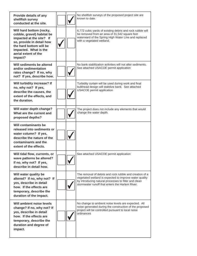
Provide details of any shellfish survey conducted at the site.
Will hard bottom (rocky, cobble, gravel) habitat be impacted at the site? If so, provide in detail how the hard bottom will be impacted. What is the aerial extent of the impact?
Will sediments be altered and/or sedimentation rates change? If no, why not? If yes, describe how.
Will turbidity increase? Ifno, why not? If yes, describe the causes, the extent of the effects, and the duration.
Will water depth change?What are the current and proposed depths?
Will contaminants be released into sediments or water column? If yes,describe the nature of the contaminants and the extent of the effects.
Will tidal flow, currents, or wave patterns be altered?If no, why not? If yes,describe in detail how.
Will water quality be altered? If no, why not? If yes, describe in detail how. If the effects are temporary, describe the duration of the impact.
Will ambient noise levels change? If no, why not? If yes, describe in detail how. If the effects are temporary, describe the duration and degree of impact.
✔
✔
✔
✔
✔
✔
✔
✔✔
✔
✔
✔✔
No shellfish surveys of the proposed project site areknown to date.
6,772 cubic yards of existing debris and rock rubble willbe removed from an area of 31,542 square feetwaterward of the Spring High Water Line and replacedwith a vegetated wetland.
No bank stabilization activities will not alter sediments.See attached USACOE permit application
Turbidity curtain will be used during work and finalbulkhead design will stabilize bank. See attachedUSACOE permit application
The project does not include any elements that wouldchange the water depth.
See attached USACOE permit application
The removal of debris and rock rubble and creation of avegetated wetland is expected to improve water qualityby introducing natural processes to filter and cleanstormwater runoff that enters the Harlem River.
No change to ambient noise levels are expected. Allnoise generated during the construction of the proposedproject will be controlled pursuant to local noiseordinances
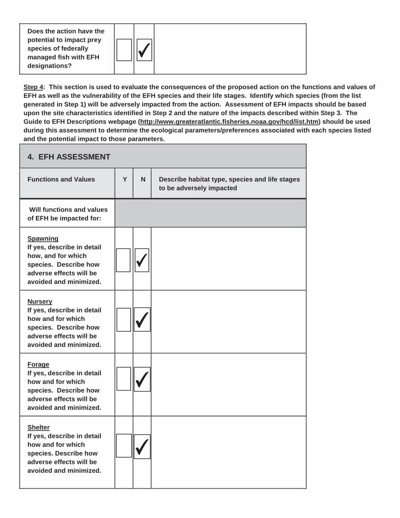
Does the action have the potential to impact prey species of federally managed fish with EFH designations?
Step 4: This section is used to evaluate the consequences of the proposed action on the functions and values of EFH as well as the vulnerability of the EFH species and their life stages. Identify which species (from the listgenerated in Step 1) will be adversely impacted from the action. Assessment of EFH impacts should be based upon the site characteristics identified in Step 2 and the nature of the impacts described within Step 3. The Guide to EFH Descriptions webpage (http://www.greateratlantic.fisheries.noaa.gov/hcd/list.htm) should be used during this assessment to determine the ecological parameters/preferences associated with each species listed and the potential impact to those parameters.
4. EFH ASSESSMENT
Functions and Values Y N Describe habitat type, species and life stages to be adversely impacted
Will functions and values of EFH be impacted for:
SpawningIf yes, describe in detail how, and for which species. Describe how adverse effects will be avoided and minimized.
NurseryIf yes, describe in detail how and for which species. Describe how adverse effects will be avoided and minimized.
ForageIf yes, describe in detail how and for which species. Describe how adverse effects will be avoided and minimized.
ShelterIf yes, describe in detail how and for which species. Describe how adverse effects will be avoided and minimized.
✔
✔
✔
✔
✔
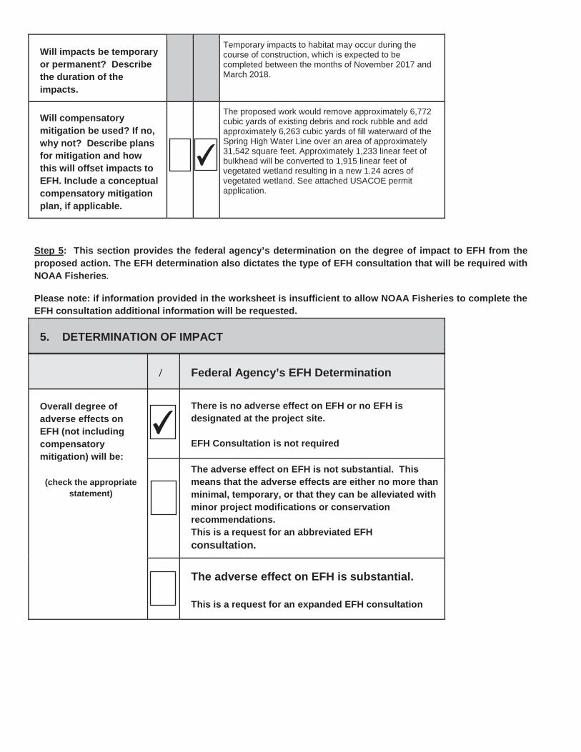
Will impacts be temporary or permanent? Describethe duration of the impacts.
Will compensatory mitigation be used? If no, why not? Describe plans for mitigation and how this will offset impacts to EFH. Include a conceptual compensatory mitigation plan, if applicable.
Step 5: This section provides the federal agency’s determination on the degree of impact to EFH from the proposed action. The EFH determination also dictates the type of EFH consultation that will be required with NOAA Fisheries.
Please note: if information provided in the worksheet is insufficient to allow NOAA Fisheries to complete the EFH consultation additional information will be requested.
5. DETERMINATION OF IMPACT
/ Federal Agency’s EFH Determination
Overall degree of adverse effects on EFH (not including compensatory mitigation) will be:
(check the appropriate statement)
There is no adverse effect on EFH or no EFH is designated at the project site.
EFH Consultation is not required
The adverse effect on EFH is not substantial. This means that the adverse effects are either no more than minimal, temporary, or that they can be alleviated with minor project modifications or conservation recommendations.This is a request for an abbreviated EFHconsultation.
The adverse effect on EFH is substantial.
This is a request for an expanded EFH consultation
✔
✔
Temporary impacts to habitat may occur during thecourse of construction, which is expected to becompleted between the months of November 2017 andMarch 2018.
The proposed work would remove approximately 6,772cubic yards of existing debris and rock rubble and addapproximately 6,263 cubic yards of fill waterward of theSpring High Water Line over an area of approximately31,542 square feet. Approximately 1,233 linear feet ofbulkhead will be converted to 1,915 linear feet ofvegetated wetland resulting in a new 1.24 acres ofvegetated wetland. See attached USACOE permitapplication.
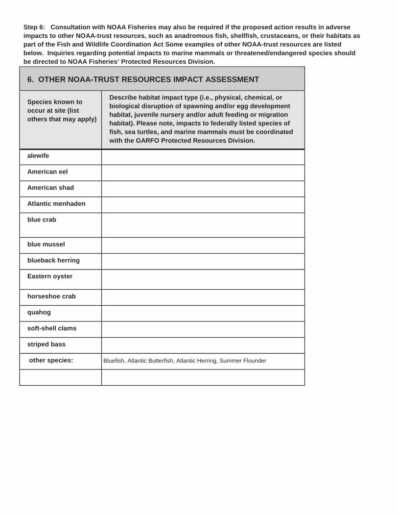
Step 6: Consultation with NOAA Fisheries may also be required if the proposed action results in adverse impacts to other NOAA-trust resources, such as anadromous fish, shellfish, crustaceans, or their habitats aspart of the Fish and Wildlife Coordination Act Some examples of other NOAA-trust resources are listed below. Inquiries regarding potential impacts to marine mammals or threatened/endangered species should be directed to NOAA Fisheries’ Protected Resources Division.
6. OTHER NOAA-TRUST RESOURCES IMPACT ASSESSMENT
Species known to occur at site (list others that may apply)
Describe habitat impact type (i.e., physical, chemical, or biological disruption of spawning and/or egg development habitat, juvenile nursery and/or adult feeding or migration habitat). Please note, impacts to federally listed species of fish, sea turtles, and marine mammals must be coordinated with the GARFO Protected Resources Division.
alewife
American eel
American shad
Atlantic menhaden
blue crab
blue mussel
blueback herring
Eastern oyster
horseshoe crab
quahog
soft-shell clams
striped bass
other species: Bluefish, Atlantic Butterfish, Atlantic Herring, Summer Flounder
Useful Links
National Wetland Inventory Mapshttp://www.fws.gov/wetlands/
EPA’s National Estuaries Programhttp://www.epa.gov/nep/information-about-local-estuary-programs
Northeast Regional Ocean Council (NROC) Data Portalhttp://www.northeastoceandata.org/
Mid-Atlantic Regional Council on the Ocean (MARCO) Data Portalhttp://portal.midatlanticocean.org/
Resources by State:MaineEelgrass mapshttp://www.maine.gov/dmr/rm/eelgrass/Maine Office of GIS Data Cataloghttp://www.maine.gov/megis/catalog/Casco Bay Estuary Partnershiphttp://www.cascobayestuary.org/Maine GIS Stream Habitat Viewerhttp://mapserver.maine.gov/streamviewer/index.html
New Hampshire New Hampshire's Statewide GIS Clearinghouse, NH GRANIThttp://www.granit.unh.edu/New Hampshire Coastal Viewerhttp://www.granit.unh.edu/nhcoastalviewer/
MassachusettsEelgrass mapshttp://maps.massgis.state.ma.us/images/dep/eelgrass/eelgrass_map.htmMADMF Recommended Time of Year Restrictions Documenthttp://www.mass.gov/eea/docs/dfg/dmf/publications/tr-47.pdfMassachusetts Bays National Estuary Programhttp://www.mass.gov/eea/agencies/mass-bays-program/Buzzards Bay National Estuary Programhttp://buzzardsbay.org/Massachusetts Division of Marine Fisherieshttp://www.mass.gov/eea/agencies/dfg/dmf/Massachusetts Office of Coastal Zone Managementhttp://www.mass.gov/eea/agencies/czm/
Rhode IslandEelgrass mapshttp://www.savebay.org/file/2012_Mapping_Submerged_Aquatic_Vegetation_final_report_4_2013.pdfNarraganset Bay Estuary Programhttp://www.dem.ri.gov/programs/benviron/water/wetlands/wetldocs.htmRhode Island Division of Marine Fisherieshttp://www.dem.ri.gov/Rhode Island Coastal Resources Management Councilhttp://www.crmc.ri.gov/
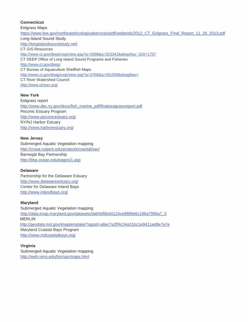
ConnecticutEelgrass Mapshttps://www.fws.gov/northeast/ecologicalservices/pdf/wetlands/2012_CT_Eelgrass_Final_Report_11_26_2013.pdfLong Island Sound Studyhttp://longislandsoundstudy.net/CT GIS Resourceshttp://www.ct.gov/deep/cwp/view.asp?a=2698&q=323342&deepNav_GID=1707CT DEEP Office of Long Island Sound Programs and Fisherieshttp://www.ct.gov/deep/CT Bureau of Aquaculture Shellfish Mapshttp://www.ct.gov/doag/cwp/view.asp?a=3768&q=451508&doagNav=CT River Watershed Councilhttp://www.ctriver.org/
New YorkEelgrass reporthttp://www.dec.ny.gov/docs/fish_marine_pdf/finalseagrassreport.pdfPeconic Estuary Programhttp://www.peconicestuary.org/NY/NJ Harbor Estuaryhttp://www.harborestuary.org/
New JerseySubmerged Aquatic Vegetation mappinghttp://crssa.rutgers.edu/projects/coastal/sav/Barnegat Bay Partnershiphttp://bbp.ocean.edu/pages/1.asp
DelawarePartnership for the Delaware Estuaryhttp://www.delawareestuary.org/Center for Delaware Inland Bayshttp://www.inlandbays.org/
MarylandSubmerged Aquatic Vegetation mappinghttp://data.imap.maryland.gov/datasets/da64df6bd4124ce9989e6c186a7906a7_0MERLIN http://geodata.md.gov/imaptemplate/?appid=a8ec7e2ff4c34a31bc1e9411ed8e7a7eMaryland Coastal Bays Programhttp://www.mdcoastalbays.org/
VirginiaSubmerged Aquatic Vegetation mappinghttp://web.vims.edu/bio/sav/maps.html
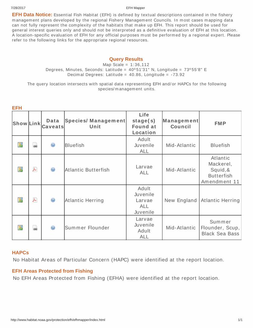
7/28/2017 EFH Mapper
http://www.habitat.noaa.gov/protection/efh/efhmapper/index.html 1/1
EFH Data Notice: Essential Fish Habitat (EFH) is defined by textual descriptions contained in the fisherymanagement plans developed by the regional Fishery Management Councils. In most cases mapping datacan not fully represent the complexity of the habitats that make up EFH. This report should be used forgeneral interest queries only and should not be interpreted as a definitive evaluation of EFH at this location.A location-specific evaluation of EFH for any official purposes must be performed by a regional expert. Pleaserefer to the following links for the appropriate regional resources.
Query Results Map Scale = 1:36,112
Degrees, Minutes, Seconds: Latitude = 40º51'31" N, Longitude = 73º55'8" E Decimal Degrees: Latitude = 40.86, Longitude = -73.92
The query location intersects with spatial data representing EFH and/or HAPCs for the followingspecies/management units.
EFH
Show Link DataCaveats
Species/ManagementUnit
Lifestage(s)Found atLocation
ManagementCouncil FMP
BluefishAdult
JuvenileALL
Mid-Atlantic Bluefish
Atlantic Butterfish LarvaeALL Mid-Atlantic
AtlanticMackerel,Squid,&
ButterfishAmendment 11
Atlantic Herring
AdultJuvenileLarvae
ALLJuvenile
New England Atlantic Herring
Summer Flounder
LarvaeJuvenile
AdultALL
Mid-AtlanticSummer
Flounder, Scup,Black Sea Bass
HAPCsNo Habitat Areas of Particular Concern (HAPC) were identified at the report location.
EFH Areas Protected from FishingNo EFH Areas Protected from Fishing (EFHA) were identified at the report location.