realization aspects of the international height reference...
TRANSCRIPT

Realization aspects of the International Height Reference System
1st Joint IAG Commission II and IGFS Meeting “INTERNATIONAL SYMPOSIUM ON GRAVITY, GEOID
AND HEIGHT SYSTEMS”
September 19-23, 2016, Thessaloniki, Greece
Height Reference SystemAn exposure of some open problems
C. Kotsakis
Department of Geodesy and Surveying
AUTH, Thessaloniki, Greece

International Height Reference System (IHRS)
The IHRS is a geopotential reference system co-rotating
with the Earth in its diurnal motion in space.
Working definition:(by Ad-hoc group on IHRS, Travaux de l’ IAG, vol. 39)
GGHS International Symposium 2016Kotsakis C.
with the Earth in its diurnal motion in space.
The associated coordinates in that system are:
geopotential values W(X)
geocentric Cartesian coordinates X
(and their changes in time)

IHRS scientific objectives
� To merge Earth’s geometrical and physical
representations in a consistent and useful way.
� To provide an accurate (1 cm or better) and stable
physical height frame that is accessible by space
geodetic techniques.
GGHS International Symposium 2016Kotsakis C.
geodetic techniques.
� To facilitate the geophysical “predictability”
and “interpretability” of:
• vertical station motions
• surface gravity variations
• sea level rise

Heighting in the IHRS context
o The primary vertical coordinates are scalar
potential differences.
( ) ( )oC W W= −X X
o Physical heights are derived by suitable metrics.
GGHS International Symposium 2016Kotsakis C.
The parameter “Wo” reflects the vertical datum of the
IHRS and it needs to be clearly specified in its definition.
o Physical heights are derived by suitable metrics.
( )( )
( )
oW WH
g
−=
XX
Xɶ

Conventions for the definition and the realization of IHRS
(IAG Resolution 1, Prague 2015)
1. The vertical reference level is an equipotential surface of
the Earth’s gravity field with the geopotential value Wo.
2. Parameters, observations, and data shall be related to
the mean tidal system and the mean crust.
GGHS International Symposium 2016Kotsakis C.
the mean tidal system and the mean crust.
3. Unit of length is the m and unit of time is the sec (SI).
4. The vertical coordinates are the geopotential numbers
with respect to the reference level Wo.
5. The spatial reference of the position P for the geopotential
determination WP = W(X) is related to the ITRS.
• Wo = 62 636 853.4 m2 s-2 (datum realization).

Open problems …
Z
t
t'δr
P'
P
W(P, t)g(P, t)
GGHS International Symposium 2016Kotsakis C.
X
Y
Correlating Earth’s time-variable gravity field and
its deforming geometry is a complicated task!

IHRS in the deforming Earth
Geopotential
representation
Frame
definitionRemarks
“semi-
dynamic” W(X(t))
GGM with fixed
Stokes’ coefsPhysical heights (& their
temporal changes) given
wrt. a mean gravity field
GGHS International Symposium 2016Kotsakis C.
dynamic”
approach
W(X(t))wrt. a mean gravity field
that is linked to ITRF Time-dependent 3D
Cartesian positions
“fully-
dynamic”
approach
W(X(t),t)
GGM with time-
dependent Stokes’
coefs
Physical heights (& their
temporal changes) given
wrt. the actual gravity field
that is linked to ITRFTime-dependent 3D
Cartesian positions

Geopotential
representation
Frame
definitionRemarks
“semi-
dynamic” W(X(t))
Static
geoid modelPhysical heights (& their
temporal changes) given
wrt. a mean gravity field
IHRS in the deforming Earth
GGHS International Symposium 2016Kotsakis C.
dynamic”
approach
W(X(t))wrt. a mean gravity field
that is linked to ITRF Time-dependent 3D
Cartesian positions
“fully-
dynamic”
approach
W(X(t),t)
Time-dependent
geoid modelPhysical heights (& their
temporal changes) given
wrt. the actual gravity field
that is linked to ITRFTime-dependent 3D
Cartesian positions
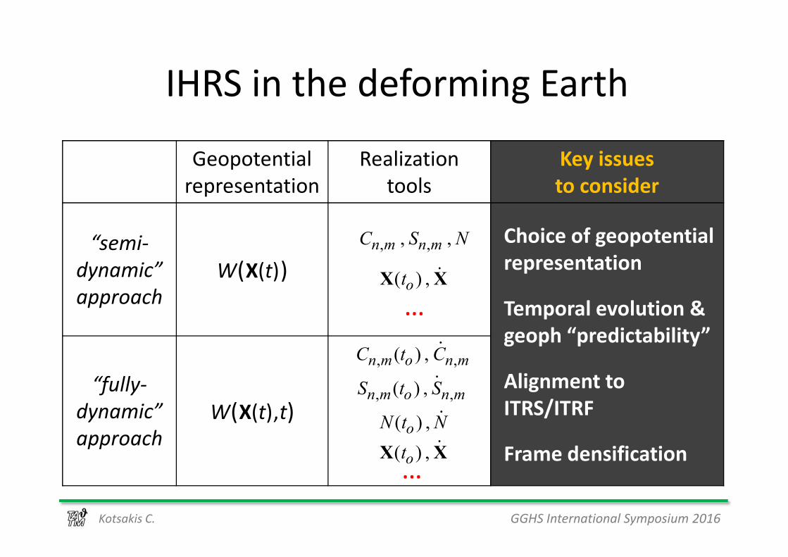
IHRS in the deforming Earth
Geopotential
representation
Realization
tools
Key issues
to consider
“semi-
dynamic” W(X(t))
Choice of geopotential
representation , ,, ,n m n mC S N
( ) ,otX X⋅
GGHS International Symposium 2016Kotsakis C.
dynamic”
approach
W(X(t))
Temporal evolution &
geoph “predictability”
Alignment to
ITRS/ITRF
Frame densification
“fully-
dynamic”
approach
W(X(t),t)
, ,( ) ,n m o n mC t C⋅
( ) ,oN t N⋅
, ,( ) ,n m o n mS t S⋅
( ) ,otX X⋅
( ) ,otX X
…
…

IHRS realization(semi-dynamic approach)
Z
H(t)
W=W(P)
P
terrain
Z
P'
H(t')
W=W(P')
terrain
GGHS International Symposium 2016Kotsakis C.
A mean (static) representation of the gravity field is used.
Physical height changes in IHRS reflect true vertical displacements!
X
Y
Z
W=Wo
W=W(P)
X
Y
Z
W=Wo

IHRS realization(semi-dynamic approach)
H(t)
g
P
Z Z
P'
H(t')g'
GGHS International Symposium 2016Kotsakis C.
but temporal variations of observed gravity cannot be
fully attributed to the physical height changes in IHRS!
⋅⋅ true IHRSg
g HH
∂≠∂
g
X
Y
Z
X
Y
Z
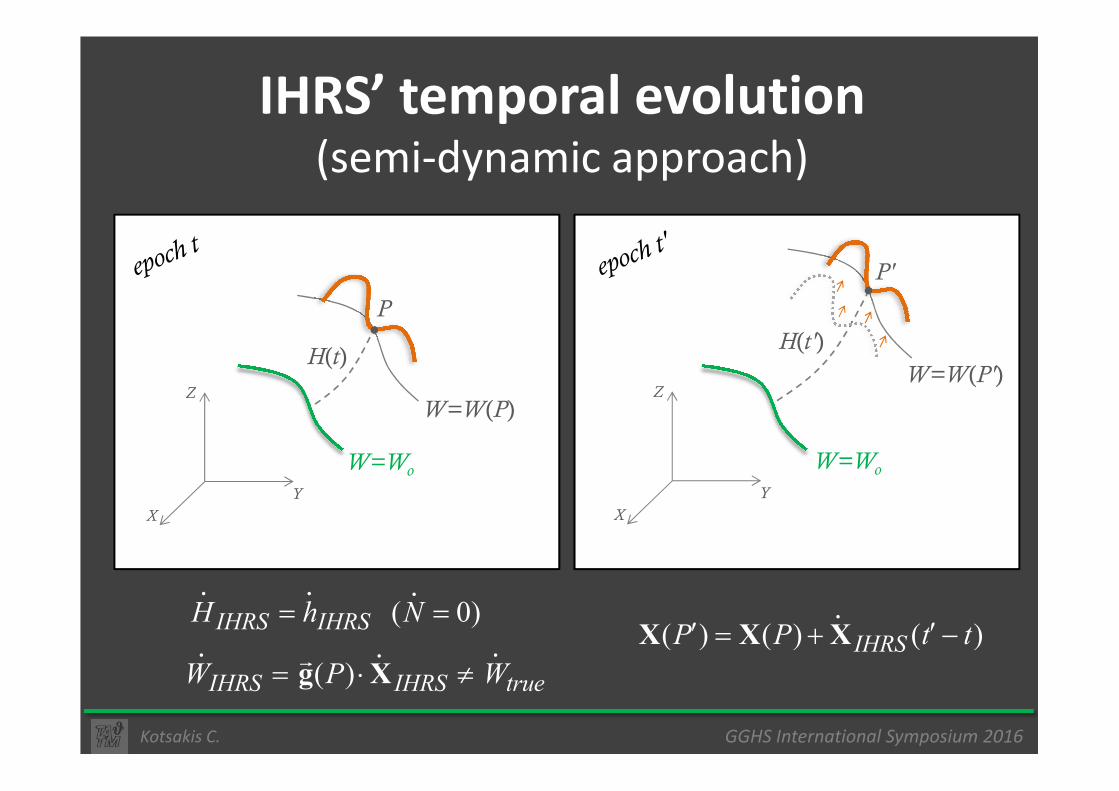
IHRS’ temporal evolution(semi-dynamic approach)
Z
H(t)
W=W(P)
P
Z
P'
H(t')
W=W(P')
GGHS International Symposium 2016Kotsakis C.
X
Y
Z
W=Wo
W=W(P)
X
Y
Z
W=Wo
( ) ( ) ( )IHRSP P t t′ ′= + −X X X⋅ ( 0)IHRS IHRSH h N= =
⋅ ⋅⋅
( )IHRS IHRS trueW P W= ⋅ ≠g X� ⋅⋅⋅

Geophysical monitoring (linearized context)
( ) true IHRSg
g HH
g t∂
≈ ∂+ ∂∂
⋅ ⋅
g⋅ Inferred from models
GGHS International Symposium 2016Kotsakis C.
( ) true IHRS W tW ≈ ⋅ + ∂ ∂g X�⋅ ⋅
IHRSg⋅
IHRSW⋅
Inferred from models
Observed (GRACE)

Geophysical monitoring (time series context)
t ( ) ( ) ( )true IHRSi i iW t W t W t= + ∆
⋮ ⋮ ⋮ ⋮
GGHS International Symposium 2016Kotsakis C.
t'
⋮ ⋮ ⋮ ⋮
( ) ( ) ( )true IHRSi i iW t W t W t′ ′ ′= + ∆
e.g. evaluated by GRACE models at current
point position
e.g. mass-transport & loading effects on the
gravity potential

Two (more practical) questions
1) If IHRS will support the unification of existing
local/regional VDs, then how are we supposed
to deal with the different “potential scales”?
e.g. are we allowed to simply merge a leveling-based
GGHS International Symposium 2016Kotsakis C.
2) What will be the value of spirit-leveled data in
the realization and temporal evolution of IHRS?
e.g. are we allowed to simply merge a leveling-based
height frame with IHRS?

Some comments on Wo
� Same parameter – different roles/meanings
o conventional “zero” vertical level for IHRS
o best estimate of global MSL from altimetry data
o LG = Wo/c2 (IAU 2000 Resolution)
o Earth reference model (i.e. W ↔ U )
GGHS International Symposium 2016Kotsakis C.
o Earth reference model (i.e. Wo ↔ Uo)
� Is there any profound reason to update Wo
in the context of (future) IHRS realizations?
� Should “Wo” be tagged in the IHRS conventions? (to, GM, ω, other)

Conclusions
� IHRS is a much-needed tool to unify the three
pillars of geodesy!
� Three crucial items need to be elucidated:
o choice of geopotential representation
GGHS International Symposium 2016Kotsakis C. EUREF Annual Symposium 2016Kotsakis C., Chatzinikos M.
o choice of geopotential representation
o its alignment procedure to ITRS/ITRF
o the time-dependent character of IHRS
and its geophysical “predictability”
� and …

Conclusions
Is the mean tidal system the best choice for the definition of the IHRS ?
GGHS International Symposium 2016Kotsakis C. EUREF Annual Symposium 2016Kotsakis C., Chatzinikos M.