rebuild of the libby (fec) to troy section of - bpa.gov · rebuild of the libby (fec) to troy...
TRANSCRIPT

B O N N E V I L L E P O W E R A D M I N I S T R A T I O N
Rebuild of the Libby (FEC) to Troy Section of BPA's Libby to Bonners Ferry
115-kilovolt Transmission Line
Draft Environmental Impact Statement
DOE/EIS-0379
July 2007

Rebuild of the Libby (FEC) to Troy Section of
Bonneville Power Administration’s
Libby to Bonners Ferry 115-kilvolt Transmission Line Project
Draft Environmental Impact Statement
Bonneville Power Administration
July 2007

Rebuild of the Libby (FEC) to Troy Section of Bonneville Power Administration’s Libby to Bonners Ferry 115-kilvolt Transmission Line Project
Responsible Agencies: U.S. Department of Energy, Bonneville Power Administration (BPA); U. S. Department of Agriculture, Forest Service (USFS)
Title of Proposed Project: Rebuild of the Libby (FEC) to Troy Section of Bonneville Power Administration’s Libby to Bonners Ferry 115-kilvolt Transmission Line Project, DOE/EIS - 0379 State Involved: Montana
Abstract: The Libby-Troy transmission line, the 17-mile section of the 115-kilovolt (kV) transmission line that extends from a Flathead Electric Cooperative (FEC) substation near the town of Libby, Montana, to a Bonneville substation near the town of Troy, Montana, is an integral part of the larger 115-kV loop in the area that provides electrical service to Libby, Bonners Ferry, Sandpoint and many smaller communities. The Libby-Troy line has been steadily deteriorating and BPA is concerned that it threatens the reliability of the regional system. The line’s cross-arms are rotting and conductor fittings are highly corroded, seriously compromising the integrity of the line. The line is also part of the system that provides redundant load service to the area. BPA needs to rebuild or reinforce the Libby-Troy section of its transmission system to provide redundant load service to northwestern Montana. Without the line, the level of service would be reduced from redundant to radial.
The USFS (Kootenai National Forest) must decide if the project complies with the currently approved forest plan, and decide if they would issue a special use permit for construction, operation, and maintenance of the project facilities.
Both the Proposed Action and Alternative 1 would involve a rebuild of the existing 17-mile-long Libby-Troy section of the 115-kV Libby-Bonners Ferry transmission line. Under the Proposed Action, BPA would rebuild the Libby-Troy section at the same voltage (115 kV) and with the same number of circuits (one) as currently exists. A combination of wood and steel H-frame and single wood pole and steel pole structures would be used. Additional transmission line corridor width would be acquired in the form of additional easements or permitted areas in some sections to bring the corridor up to minimum BPA standards for 115-kV transmission line operation. Under Alternative 1, BPA would rebuild the line as a 230-kV, double-circuit line. Steel single-pole structures would be used, and additional easements and permitted areas would be acquired to bring the corridor up to minimum BPA standards for 230-kV transmission lines.
BPA is considering realignment of the corridor in three locations: Pipe Creek, Quartz Creek, and the Kootenai River Crossing. The line could be built at either 115 kV or 230 kV, depending on whether the Proposed Action or Alternative 1 was selected. These short realignment options were identified to minimize impacts to private properties and cultural resources located along the transmission line corridor. BPA is also considering the No Action Alternative in which the existing line would not be rebuilt but would continue to be operated and maintained in its current location.
The proposed project could create impacts to soils, water resources, land use, vegetation, wildlife, fish, amphibians, reptiles, visual resources, cultural resources, recreation, noise, public health and safety, social and economic resources, transportation, and air quality. Chapter 3 of the EIS describes the affected environment and potential impacts in detail. Based on an evaluation of the alternatives and realignment options, and considering the purpose and need of the proposed project, the affected environment, and environmental consequences, BPA’s preferred alternative is the Proposed Action (rebuild to single-circuit 115-kV) with the Kootenai River realignment option.
Public comments are being accepted through September 4, 2007.
For additional information, contact:
Ms. Tish Eaton – KEC-4 Project Environmental Lead Bonneville Power Administration P. O. Box 3621 Portland, Oregon 97208
Telephone: (503) 230-3469 Email: [email protected]
For additional copies of this document, please call 1-800-622-4520 and ask for the document by name. The EIS is also on the Internet at: http://www.efw.bpa.gov/environmental_services/Document_Library/Libby/. You may also request copies by writing to:
Bonneville Power Administration P. O. Box 3621 Portland, Oregon 97208 ATT : Public Information Center - CHDL-1
For additional information on DOE NEPA activities, please contact Carol M. Borgstrom, Director, Office of NEPA Policy and Compliance, GC-20, U.S. Department of Energy, 1000 Independence Avenue S.W., Washington D.C. 20585-0103, phone: 1-800-472-2756 or visit the DOE NEPA Web site at www.eh.doe.gov/nepa.

Bonneville Power Administration i
Table of Contents
SUMMARY ............................................................................................................S-1
CHAPTER 1 Purpose Of and Need For Action..................................................... 1-1 1.1 Need for Action ..............................................................................................................................1-1 1.2 Purposes.........................................................................................................................................1-2 1.3 Project Background.......................................................................................................................1-2 1.4 Decisions to be Made ....................................................................................................................1-3 1.5 Cooperating Agencies...................................................................................................................1-3 1.6 Scoping and Major Issues ............................................................................................................1-3 1.7 Tribal Involvement to Date............................................................................................................1-5
CHAPTER 2 Alternatives Including the Proposed Action................................... 2-1 2.1 Overview of Proposed Action and Alternatives .........................................................................2-1 2.2 Proposed Action – 115-kV Single-Circuit Rebuild......................................................................2-2
2.2.1 Line Routing and Corridor ..................................................................................................................... 2-2 2.2.2 Transmission Structure Design .............................................................................................................. 2-3 2.2.3 Conductor, Fiber Optic Cable, and Pulling/ Tensioning Sites................................................................. 2-7 2.2.4 Vegetation Clearing................................................................................................................................ 2-9 2.2.5 Access Roads ......................................................................................................................................... 2-9 2.2.6 Removal of Existing Wood-Pole Structures..........................................................................................2-10 2.2.7 Staging Areas ........................................................................................................................................2-11 2.2.8 Construction Schedule and Work Crews...............................................................................................2-11 2.2.9 Maintenance and Vegetation Management ...........................................................................................2-12 2.2.10 Estimated Project Cost .........................................................................................................................2-12
2.3 Alternative 1 – 230-kV Double-Circuit Rebuild .........................................................................2-12 2.3.1 Line Routing and Corridor ....................................................................................................................2-12 2.3.2 Transmission Structure Design .............................................................................................................2-13 2.3.3 Conductor, Fiber Optic Cable and Pulling/Tensioning Sites.................................................................2-13 2.3.4 Vegetation Clearing...............................................................................................................................2-14 2.3.5 Access Roads, Staging Areas, Removal of Existing Structures, Maintenance and Vegetation
Management ................................................................................................................................2-14 2.3.6 Construction Schedule and Work Crews...............................................................................................2-14 2.3.7 Estimated Project Cost ..........................................................................................................................2-14
2.4 Short Realignment Options ........................................................................................................2-14 2.4.1 Pipe Creek Realignment........................................................................................................................2-16 2.4.2 Quartz Creek Realignment ....................................................................................................................2-16 2.4.3 Kootenai River Crossing Realignment..................................................................................................2-17
2.5 No Action Alternative ..................................................................................................................2-18 2.6 Alternatives Considered but Eliminated from Detailed Study ................................................2-18
2.6.1 Alternative Voltage/Number of Circuits ...............................................................................................2-19 2.6.2 1993 Alternative Transmission Line Routes .........................................................................................2-20 2.6.3 Alternative Transmission Line Realignment Options ...........................................................................2-20 2.6.4 Undergrounding the Transmission Line................................................................................................2-22 2.6.5 Non-Transmission Alternatives.............................................................................................................2-23
2.7 Transmission Line Planning and Construction Process.........................................................2-23 2.8 Comparison of Alternatives........................................................................................................2-24

ii Libby to Troy Rebuild Project Draft EIS
2.9 Agency Preferred Alternative .....................................................................................................2-24 CHAPTER 3 Affected Environment, Environmental Consequences, and
Mitigation Measures.......................................................................... 3-1 3.1. Geology, Soils, and Water Resources........................................................................................3-1
3.1.1 Affected Environment ............................................................................................................................ 3-1 3.1.2 Environmental Consequences of Action Alternatives............................................................................ 3-4 3.1.3 Mitigation..............................................................................................................................................3-14 3.1.4 Environmental Consequences of the No Action Alternative.................................................................3-16
3.2 Land Use.......................................................................................................................................3-17 3.2.1 Affected Environment ...........................................................................................................................3-17 3.2.2 Environmental Consequences of Action Alternatives...........................................................................3-19 3.2.3 Mitigation..............................................................................................................................................3-27 3.2.4 Environmental Consequences of the No Action Alternative.................................................................3-27
3.3 Vegetation.....................................................................................................................................3-28 3.3.1 Affected Environment ...........................................................................................................................3-28 3.3.2 Environmental Consequences of Action Alternatives...........................................................................3-36 3.3.3 Mitigation..............................................................................................................................................3-45 3.3.4 Environmental Consequences of the No Action Alternative.................................................................3-47
3.4 Wetlands and Floodplains ..........................................................................................................3-49 3.4.1 Affected Environment ...........................................................................................................................3-49 3.4.2 Environmental Consequences of Action Alternatives...........................................................................3-51 3.4.3 Mitigation..............................................................................................................................................3-56 3.4.4 Environmental Consequences of the No Action Alternative.................................................................3-57
3.5 Wildlife ..........................................................................................................................................3-58 3.5.1 Affected Environment ...........................................................................................................................3-58 3.5.2 Environmental Consequences of Action Alternatives...........................................................................3-78 3.5.3 Mitigation............................................................................................................................................3-118 3.5.4 Environmental Consequences of the No Action Alternative...............................................................3-120
3.6 Fish, Amphibians, and Reptiles ...............................................................................................3-125 3.6.1 Affected Environment .........................................................................................................................3-125 3.6.2 Environmental Consequences of Action Alternatives.........................................................................3-136 3.6.3 Mitigation............................................................................................................................................3-142 3.6.4 Environmental Consequences of the No Action Alternative...............................................................3-143
3.7 Visual Resources.......................................................................................................................3-144 3.7.1 Affected Environment .........................................................................................................................3-144 3.7.2 Environmental Consequences of Action Alternatives.........................................................................3-146 3.7.3 Mitigation............................................................................................................................................3-154 3.7.4 Impacts of the No Action Alternative .................................................................................................3-154
3.8 Cultural Resources....................................................................................................................3-155 3.8.1 Affected Environment .........................................................................................................................3-155 3.8.2 Environmental Consequences of Action Alternatives.........................................................................3-158 3.8.3 Mitigation............................................................................................................................................3-162 3.8.4 Environmental Consequences of the No Action Alternative...............................................................3-163
3.9 Recreation Resources................................................................................................................3-164 3.9.1 Affected Environment .........................................................................................................................3-164 3.9.2 Environmental Consequences of Action Alternatives.........................................................................3-167 3.9.3 Mitigation............................................................................................................................................3-172 3.9.4 Environmental Consequences of the No Action Alternative...............................................................3-172
3.10 Noise, Public Health and Safety.............................................................................................3-173 3.10.1 Affected Environment .......................................................................................................................3-173
Bonneville Power Administration iii
3.10.2 Environmental Consequences of Action Alternatives.......................................................................3-175 3.10.3 Mitigation..........................................................................................................................................3-190 3.10.4 Environmental Consequences of the No Action Alternative.............................................................3-191
3.11 Social and Economic Resources ...........................................................................................3-193 3.11.1 Affected Environment .......................................................................................................................3-193 3.11.2 Environmental Consequences of Action Alternatives.......................................................................3-201 3.11.3 Mitigation..........................................................................................................................................3-208 3.11.4 Environmental Consequences of the No Action Alternative.............................................................3-208
3.12 Transportation..........................................................................................................................3-209 3.12.1 Affected Environment .......................................................................................................................3-209 3.12.2 Environmental Consequences of Action Alternatives.......................................................................3-210 3.12.3 Mitigation..........................................................................................................................................3-213 3.12.4 Environmental Consequences of the No Action Alternative.............................................................3-214
3.13 Air Quality.................................................................................................................................3-215 3.13.1 Affected Environment .......................................................................................................................3-215 3.13.2 Environmental Consequences of Action Alternatives.......................................................................3-217 3.13.3 Mitigation..........................................................................................................................................3-221 3.13.4 Effects of the No Action Alternative.................................................................................................3-222
3.14. Cumulative Impact Analysis ..................................................................................................3-223 3.14.1 Cumulative Development..................................................................................................................3-223 3.14.2 Cumulative Impacts...........................................................................................................................3-224
3.15. Relationship Between Short-term Uses of the Environment and Long-term Productivity ......................................................................................................................................3-231
3.16. Irreversible and Irretrievable Commitment of Resources ..................................................3-231 3.17. Adverse Effects that Cannot be Avoided .............................................................................3-232 3.18. Intentional Destructive Acts ..................................................................................................3-233
CHAPTER 4 Environmental Consultation, Review, and Permit Requirements. 4-1 4.1 National Environmental Policy Act ..............................................................................................4-1 4.2 Endangered Species Act...............................................................................................................4-1 4.3 Fish and Wildlife Conservation Act and Fish and Wildlife Coordination Act..........................4-2 4.4 Magnuson-Stevens Fishery Conservation and Management Act ............................................4-2 4.5 Migratory Bird Treaty Act..............................................................................................................4-3 4.6 Executive Order 13186, Responsibilities of Federal Agencies to Protect Migratory Birds ...4-3 4.7 Bald Eagle Protection Act.............................................................................................................4-3 4.8 National Forest Management Act.................................................................................................4-3 4.9 Heritage Conservation ..................................................................................................................4-5 4.10 State, Area-wide, and Local Plan and Program Consistency .................................................4-8 4.11 Coastal Zone Management Consistency...................................................................................4-9 4.12 Floodplains and Wetlands Protection .......................................................................................4-9 4.13 Farmlands...................................................................................................................................4-10 4.14 Recreation Resources...............................................................................................................4-10 4.15 Global Warming .........................................................................................................................4-11 4.16 Permit for Structures in Navigable Waters .............................................................................4-11

iv Libby to Troy Rebuild Project Draft EIS
4.17 Permit for Discharges into Waters of the United States........................................................4-11 4.18 The Safe Drinking Water Act ....................................................................................................4-12 4.19 Energy Conservation at Federal Facilities ..............................................................................4-12 4.20 Permits for Right-of-Way on Public Lands .............................................................................4-13 4.21 Clean Air Act ..............................................................................................................................4-13 4.22 Noise Control Act.......................................................................................................................4-13 4.23 Pollution Control Acts...............................................................................................................4-14 4.24 Environmental Justice ................................................................................................................. 15 4.25 Notice to the Federal Aviation Administration .......................................................................... 15 4.26 Federal Communications Commission ...................................................................................... 15
CHAPTER 5 References......................................................................................... 5-1
CHAPTER 6 Glossary............................................................................................. 6-1
CHAPTER 7 EIS Preparers..................................................................................... 7-1
CHAPTER 8 List of Agencies, Organizations, and Persons Sent the EIS ......... 8-1
CHAPTER 9 Index................................................................................................... 9-1
Appendices
Appendix A Tribal Involvement ............................................................................................ A-1
Appendix B Water Yield Modeling........................................................................................ B-1
Appendix C Sensitive Plant Species Found on the Kootenai National Forest................. C-1
Appendix D Noxious Weed Species of Concern on the Kootenai National ..................... D-1
Appendix E Forest Service Manual 2080 Noxious Weed Management ............................ E-1
Appendix F ESA and Kootenai National Forest Plan Determinations for the Proposed Libby to Troy Rebuild Project .....................................................................................F-1
Appendix G Cultural Sites.....................................................................................................G-1
Appendix H Electrical Effects ............................................................................................... H-1
Appendix I Living And Working Safely Around High-Voltage Power Lines .......................I-1
Appendix J Assessment of Research Regarding EMF and Health And Environmental Effects ...........................................................................................................................J-1
Appendix K Contractor Disclosure Forms .......................................................................... K-1

Bonneville Power Administration v
List of Figures
Figure S-1 Project Location Map........................................................................................ follows page S-2
Figure S-2 Typical Suspension Structure Types................................................................. follows page S-2
Figure 1-1. Project Vicinity Map ........................................................................................ follows page 1-2
Figure 2-1. Project Location Map ....................................................................................... follows page 2-2
Figure 2-2. Typical Suspension Structure Types ......................................................................................2-5
Figure 2-3. Suspension, Angle, and Dead-end Structures Compared.......................................................2-6
Figure 2-4. Insulator Types.......................................................................................................................2-8
Figure 2-5. Pipe Creek Realignment................................................................................. follows page 2-16
Figure 2-6. Quartz Creek Realignment ............................................................................. follows page 2-16
Figure 2-7. Kootenai River Crossing Realignment........................................................... follows page 2-18
Figure 3-1. Land Types....................................................................................................... follows page 3-2
Figure 3-2. Water Resources............................................................................................... follows page 3-2
Figure 3-3. Land Ownership ............................................................................................. follows page 3-18
Figure 3-4. Old Growth..................................................................................................... follows page 3-32
Figure 3-5. Wetlands......................................................................................................... follows page 3-50
Figure 3-6. Forest Plan Management Areas and Planning Subunits................................. follows page 3-58
Figure 3-7. Grizzly Bear ................................................................................................... follows page 3-64
Figure 3-8. Bald Eagle ...................................................................................................... follows page 3-68
Figure 3-9. Proposed Road Closures in Grizzly Bear Habitat ........................................ follows page 3-120
Figure 3-10. Threatened and Endangered Fish ............................................................... follows page 3-126
Figure 3-11. Visual Quality Objectives, Viewpoints and Forest Management Areas .... follows page 3-146
Figure 3-12. Viewpoint 1 ................................................................................................ follows page 3-148
Figure 3-13. Viewpoint 2 ................................................................................................ follows page 3-148
Figure 3-14. Viewpoint 3 ................................................................................................ follows page 3-148
Figure 3-15. Viewpoint 4 ................................................................................................ follows page 3-148
Figure 3-16. Viewpoint 5 ................................................................................................ follows page 3-148
Figure 3-17. Viewpoint 6 ................................................................................................ follows page 3-148
Figure 3-18. Viewpoint 7 ................................................................................................ follows page 3-148
Figure 3-19. Recreation .................................................................................................. follows page 3-164
Figure 3-20. Electric-field Profiles under Maximum Current and Minimum Clearance Conditions ...3-182
Figure 3-21. Magnetic-field Profiles under Maximum Current and Minimum Clearance Conditions.3-183
Figure 3-22. Electric-field Profiles under Maximum Current and Minimum Clearance Conditions ...3-187
Figure 3-23. Magnetic-field Profiles under Maximum Current and Minimum Clearance Conditions.3-187

vi Libby to Troy Rebuild Project Draft EIS
Figure 3-24. Census County Division (CCD) and Census Tract Boundaries .......................................3-194
Figure 3-25. Transportation ............................................................................................ follows page 3-210
Figure 3-26. PM-10 and PM-2.5 Non-attainment Area .................................................. follows page 3-216
List of Tables
Table S-1. Summary of Impacts of the Proposed Action, Alternative 1, and the No Action Alternative.............................................................................................................................S-13
Table S-2. Summary of Impacts of the Pipe Creek Realignment, the Quartz Creek Realignment, and the Kootenai River Crossing Realignment..................................................................................S-24
Table 2-1. Engineering Characteristics of the Proposed Action and Alternatives....................................2-2
Table 2-2. Summary of Engineering Characteristics for Realignment Options .....................................2-15
Table 2-3. Comparison of Alternatives to Project Purposes ...................................................................2-25
Table 2-4. Summary of Impacts of the Proposed Action, Alternative 1, and the No Action Alternative.............................................................................................................................2-26
Table 2-5. Summary of Impacts of the Pipe Creek Realignment, the Quartz Creek Realignment, and the Kootenai River Crossing Realignment..................................................................................2-37
Table 3-1. Watersheds in the Project Area ...............................................................................................3-2
Table 3-2. Approximate Acres of Disturbance per Soil Type for the Proposed Action Compared to the Existing Condition ..................................................................................................................3-5
Table 3-3. Watershed Effects for the Proposed Action.............................................................................3-8
Table 3-4. Approximate Acres of Disturbance per Soil Type for Alternative 1 Compared to the Existing Condition.................................................................................................................................3-9
Table 3-5. Watershed Effects for Alternative 1 ......................................................................................3-11
Table 3-6. Watershed Effects for the Pipe Creek Realignment Option ..................................................3-12
Table 3-7. Watershed Effects for the Quartz Creek Realignment Option ..............................................3-13
Table 3-8. Watershed Effects for the Kootenai River Crossing Realignment Option ............................3-14
Table 3-9. Land Ownership and Uses within the Existing Corridor.......................................................3-17
Table 3-10. Threatened and Endangered Plant Species Found on the Kootenai National Forest...........3-29
Table 3-11. Sensitive Plant Species Known or with Potential to Occur in the Project Area ..................3-29
Table 3-12. Vegetation Habitat Communities in the Corridor that Support Sensitive Plant Species .....3-30
Table 3-13. Designated and Undesignated Old Growth Acres under 5,500 Feet Elevation on Kootenai National Forest Lands .........................................................................................................3-33
Table 3-14. Acres of Noxious Weeds Currently in the Project Area......................................................3-35
Table 3-15. Weed Classification and Management Strategy ..................................................................3-36
Table 3-16. Area Disturbed for the Proposed Action .............................................................................3-39
Table 3-17. Area Disturbed for Alternative 1 .........................................................................................3-41

Bonneville Power Administration vii
Table 3-18. Short Realignment Options .................................................................................................3-42
Table 3-19. Effects of the Pipe Creek Realignment Option on Old Growth ..........................................3-43
Table 3-20. Effects of the Quartz Creek Realignment Option on Old Growth.......................................3-44
Table 3-21. Old Growth Habitat Mitigation Acres by Alternative and the Pipe Creek and Quartz Creek Realignment Options Including Both Designated and Undesignated Old Growth Habitat 3-45
Table 3-22. Wetland Areas Within the Project Area ..............................................................................3-50
Table 3-23. Federally Protected Species Possibly Occurring in the General Project Vicinity ...............3-60
Table 3-24. Existing Grizzly Bear Habitat Conditions and Associated Standards by BMU ..................3-65
Table 3-25. U.S. Forest Service Terms Used in Grizzly Bear Management ..........................................3-65
Table 3-26. Objectives and Guidelines for Activity in Bald Eagle Nest Management Zones................3-68
Table 3-27. Other Special Status Species Possibly Occurring in the General Project Vicinity..............3-72
Table 3-28. Acres of Clearing by Alternative in Each Planning Subunit ...............................................3-79
Table 3-29. Effects on Grizzly Bear Habitat Conditions and Associated Standards by BMU ...............3-82
Table 3-30. Short-term Effects to Linear ORDs (mi./sq. mi.) in BMU 10 .............................................3-83
Table 3-31. Short-term Effects to Linear ORDs (mi./sq. mi.) in BMU 1 ...............................................3-84
Table 3-32. Changes to Incidental Take Parameters Outside the Bear Recovery Zone .........................3-88
Table 3-33. Bald Eagle Habitat Affected by the Proposed Action Within the Four Nest Site and Primary Use Management Zones......................................................................................................3-90
Table 3-34. Bald Eagle Habitat Affected by the Proposed Action Outside Management Zones I and II, in Acres ...................................................................................................................................3-93
Table 3-35. Potential Population Index for Pileated Woodpeckers for the Proposed Action .................3-95
Table 3-36a. Bald Eagle Habitat Affected by Alternative 1 Within the Four Nest Site and Primary Use Management Zones ...........................................................................................................3-105
Table 3-36b. Bald Eagle Habitat Affected by Alternative 1 Outside Zones I and II (in acres) ............3-106
Table 3-37. Fish Species Found in Project Area Streams.....................................................................3-126
Table 3-38. Bull Trout Redd Counts for Streams in the Middle Kootenai River Section 7 Consultation Population .........................................................................................................................3-128
Table 3-39. Pipe Creek Juvenile Bull Trout Population Estimates.......................................................3-129
Table 3-40. Quartz Creek Juvenile Bull Trout Population Estimates ...................................................3-129
Table 3-41. Population Estimates for Adult Bull Trout in the Kootenai River ....................................3-130
Table 3-42. Amphibian and Reptile Species Found in the Project Area...............................................3-133
Table 3-43. RHCA Categories and Standard Widths............................................................................3-136
Table 3-44. RMO Standards .................................................................................................................3-136
Table 3-45. Visual Quality Objectives for Kootenai National Forest Management Areas..................3-146
Table 3-46. Kootenai National Forest Management Areas Crossed by the Existing Transmission Line3-146
Table 3-47. Key Viewpoints in the Proposed Project Area ..................................................................3-147

viii Libby to Troy Rebuild Project Draft EIS
Table 3-48. Managed Trails in the Kootenai River Recreation Corridor and Project Area..................3-164
Table 3-49. Common Noise Levels ......................................................................................................3-173
Table 3-50. Typical Construction Noise Levels ...................................................................................3-176
Table 3-51. Construction Equipment Noise Associated with the Proposed Project .............................3-177
Table 3-52. Population 1990, 2000, and 2004 ......................................................................................3-195
Table 3-53. Race and Ethnicity, 2000...................................................................................................3-196
Table 3-54. Housing, 2000....................................................................................................................3-197
Table 3-55. Lincoln County Employment, 2003 ..................................................................................3-198
Table 3-56. Total Aggregate Personal Income and Sources of Income, 2004......................................3-199
Table 3-57. Per Capita Income and Persons Below Poverty, 1999 ......................................................3-199
Table 3-58. Traffic Use in Vehicles per Year Within the Project Area ................................................3-209
Table 3-59. Road Construction and Improvement of Proposed Action................................................3-211
Table 3-60. EPA’s NAAQS for Particulate Matter...............................................................................3-215
Table 3-61a. Estimated PM-10 and PM-2.5 Emissions Generated during Construction within the Non-attainment Areas for the Proposed Action ........................................................................3-218
Table 3-61b. Estimated PM-10 and PM-2.5 Emissions Generated during Construction within the Non-attainment Areas for Alternative 1....................................................................................3-220

Bonneville Power Administration S-1
Summary This summary covers the major points of the draft environmental impact statement (DEIS) prepared for the Rebuild of the Libby (FEC) to Troy Section of Bonneville Power Administration’s Libby to Bonners Ferry 115-kilovolt Transmission Line Project (Libby-Troy Project). This DEIS was prepared by Bonneville Power Administration (BPA). The project would include rebuilding a 17-mile section of an existing BPA transmission line located between Libby and Troy, Montana.
S.1 Purpose of and Need for Action Historically, BPA has served electrical loads in northwestern Montana and northern Idaho with transmission facilities from Libby Dam east of Libby, Montana through Bonners Ferry Substation west of Bonners Ferry, Idaho to Albeni Falls Dam near the Idaho-Washington border (Figure S-1). These facilities include a 17-mile section of 115-kilovolt (kV) transmission line that extends from a Flathead Electric Cooperative (FEC) substation near the town of Libby, Montana, to a BPA substation near Troy, Montana. This line section, referred to as the Libby-Troy line, is an integral part of the larger 115-kV transmission loop in the area that provides electrical service to Libby, Bonners Ferry, Sandpoint, and many smaller communities.
The Libby-Troy line section originally belonged to Pacific Power and Light and was purchased by FEC in November 1998. It was the only section of this transmission loop that BPA did not own. In 2003, BPA purchased this section from FEC because BPA was concerned its deteriorating condition could threaten the reliability of the regional transmission system. The transmission line is supported by wooden structures (Figure S-2). Most of the cross-arms that carry the line on the structures are rotting and metal parts, such as fittings, are corroding. In 2003, a fitting failed, and the conductor (the wire that carries the electric current) fell to the ground, starting a fire.
The Libby-Troy transmission line provides backup service (redundant load service) to the area if another transmission line is out of service. This means service to the area is maintained because the Libby-Troy line provides an electrical connection to Libby and Albeni Falls dams. Without the Libby-Troy line, this level of service would be reduced and the area could lose power if another line failed. BPA has taken steps to prevent the line from failing in the near term, but these measures cannot solve the problem for the long term. BPA needs to rebuild or reinforce this section of its transmission system to provide redundant load service to northwestern Montana.
In addition, electrical load for the communities served by the Libby Dam-Albeni Falls Dam transmission system is projected to grow at an average of 1 percent per year. Over time this load growth will increasingly strain the existing electrical system.
BPA must decide whether to rebuild the Libby-Troy transmission line. If BPA’s decision is to rebuild the transmission line, BPA must choose among alternative voltages and alternative routing options in certain locations, and among various measures to mitigate construction and operational impacts. Additionally, the United States Forest Service (USFS) must decide whether to grant BPA a permit for additional corridor areas across the Kootenai National Forest beyond what has been granted under the Special Use permit for the existing transmission line. In making these decisions, BPA and the Kootenai National Forest will consider the following purposes or objectives:

Summary
S-2 Libby to Troy Rebuild Project Draft EIS
• Maintain transmission system reliability to industry standards;
• Continue to meet BPA’s contractual and statutory obligations;
• Minimize environmental impacts; and
• Minimize costs.
S.1.1 Public Involvement During the development of this EIS, BPA solicited input from the public, agencies, interest groups, and others to help determine what issues should be studied in the EIS. BPA requested comments through publishing notices in the Federal Register, mailing letters to about 300 people and agencies requesting comments, holding four public meetings (including one devoted to electric and magnetic fields), and meeting with state agencies. Most scoping comments received by BPA focused on potential impacts to fish, wildlife, visual resources, and cultural resources; public health and safety; residential land use and property values; and proposed realignment options near Pipe Creek, Quartz Creek and across the Kootenai River.
S.1.2 Cooperating Agencies BPA is the lead agency for the Libby-Troy Project EIS. The USFS – Kootenai National Forest, the U.S. Army Corps of Engineers, and the Montana Department of Environmental Quality (DEQ) are cooperating agencies in the development of this EIS because of their roles as managers of lands crossed by the Libby-Troy line, or because the agencies need to make findings on the project.
S.1.3 Tribal Involvement Throughout the EIS process, BPA has strived to involve the potentially affected tribes in the proposed project area: the Kootenai Tribe of Idaho and the Confederated Salish and Kootenai Tribes. Representatives from both tribes participated in site trips conducted in 2002 and 2004 and provided advice and perspective in developing project alternatives. In 2005, BPA sent a letter to these tribes that outlined a process for initiating a formal government-to-government consultation process when or if desired. To date, the tribes have not requested formal government-to-government consultation meetings.
S.2 Alternatives • BPA is considering two alternatives to meet the purpose and need: the Proposed Action (115-kV
single-circuit rebuild) and Alternative 1 (230-kV double-circuit rebuild). Both of these alternatives include rebuilding the existing 17-mile-long Libby-Troy section of the 115-kV, Libby-Bonners Ferry transmission line. BPA is also considering the No Action Alternative. Under the No Action Alternative, the existing line would not be rebuilt but would continue to be operated and maintained in its current location.

Bonneville Power Administration S-3
S.2.1 Proposed Action – 115-kV Single-Circuit Rebuild Under the Proposed Action, BPA would rebuild the Libby-Troy section at the same voltage (115-kV), with the same number of circuits (one) as currently exists. The line would be rebuilt in the same location as the existing line.
Removal of Existing Wood-Pole Structures The 186 existing wood pole structures would be removed. In most cases, the structures would be removed using a backhoe or line truck/crane and would be disposed of by the contractor according to the regulations required for handling hazardous materials (structures contain preservatives that are considered hazardous). In culturally sensitive areas, such as the Kootenai Falls area, the poles would be cut off at the ground line and transported off site via trailer or helicopter.
Line Routing and Corridor BPA’s existing Libby-Troy transmission line corridor crosses a combination of private, City of Libby, county, state, tribal, and federal (USFS) land. BPA holds right-of-way easements, agreements and permits that give BPA the right to clear vegetation a certain width out from the centerline of the corridor; the right to cut and remove trees beyond the stated width if they might endanger the transmission line; and the right to access, operate, and maintain the line along most of the corridor. In some areas, additional right-of-way easements or permitted areas would be acquired because either the existing corridor is not wide enough to accommodate the rebuilt 115-kV line or because BPA does not have a right-of-way easement or permit. Easements or permits giving BPA the rights to construct, operate, rebuild, access, and maintain the line would be needed in the following areas.
• Structures 15/181 to 17/5, 28/7 to 29/1, and 30/2 to 31/1 cross National Forest lands where the existing Special Use Permit limits the clearing width to 60 feet. Additional easement width would be needed.
• Structures 17/15 to 18/8 cross private land along Kootenai River Road near Bobtail Road. BPA would need to acquire right-of-way easements for an additional width because the centerline of the transmission line would need to be moved to the north between structures 17/15 and 18/6. Between structures 17/15 and 17/18, the centerline would be moved to the north side of Kootenai River Road to eliminate the road crossings.
• Land under structures 26/1 to 26/8 is currently owned by Lincoln County; the land rights were originally acquired as an agreement for a license and permit for a power line across property owned by Great Northern Railroad Company. BPA would be acquiring easement rights from Lincoln County.
• Structures 28/3 to 28/7, 29/1 to 30/2, and 31/1 to BPA’s Troy Substation cross private lands where the fixed clearing width was limited to 60 feet. Additional easement width would be needed.
1 BPA transmission structures each have individual numbers (e.g., 1/1, 1/2, etc.). The first number in the pair represents the line-mile number; the second number indicates whether the structure is the first, second, third, etc. structure in that mile. In this case, the rebuild project begins at line-mile 14/structure number 1, indicating that the entire transmission line begins at Libby Dam, 14 miles away. The proposed rebuild project ends at line mile 31/structure number 10.

Summary
S-4 Libby to Troy Rebuild Project Draft EIS
BPA does not permit any use of its rights-of-way that are unsafe or might interfere with constructing, operating, or maintaining the transmission facilities.
Transmission Structure Design About 171 transmission structures would be needed to carry the transmission line conductors for the proposed rebuild on the existing corridor. Wood or colorized steel H-frame structures would be used for about 14.6 miles of the 17-mile-long line. This includes the areas inaccessible to motor vehicles along the historic U.S. Highway 2 west of Kootenai Falls, and along Sheep Range Road. About 1.6 miles of the line would be constructed with single wood poles, and the remaining 0.8 miles would be constructed using colorized steel single-pole structures. The wood or steel H-frame structures and the single wood poles would be about 60 to 80 feet tall. The steel poles would range from 70 to 105 feet tall. The steel structures would be colorized a dark gray to blend with the surrounding environment as much as possible.
Structure Footings At each structure site, an area about 75 feet by 75 feet would be temporarily disturbed during construction, depending on the terrain and structure type. Structures without guy wires would permanently use an area about15 feet by 15 feet; structures with guy wires would use an area about 30 feet by 50 feet. New structures would be constructed in the same holes used for the existing structures where possible, although some new holes may be needed. New footing holes would either be hand dug (in inaccessible areas), augered, or dug with a small backhoe excavator, depending on subsurface conditions. The wood or steel poles would be placed directly in the holes (direct-embedded) and then backfilled with native material or gravel (crushed rock). Concrete could be used as backfill for some structures.
Fiber Optics
Although there is no operational need at this time to install fiber optic cable between Libby and Troy substations, BPA would provide space on the transmission structures for future BPA installation should the need arise.
Conductor, Fiber Optic Cable, and Pulling/Tensioning Sites Conductors are suspended from structures with insulators. Insulators are bell-shaped devices that prevent electricity from jumping from the conductors to the structure and going to the ground. The proposed project would most likely use a combination of ceramic and non-ceramic polymer insulators. Two smaller wires (0.5-inch diameter), called overhead ground wires, would also be attached to the top of the transmission structures for about a half mile coming out of Libby and Troy substations to protect the substations from lightning damage. Overhead ground wires might also be strung in other areas of high lightning exposure. A fiber optic cable may be installed either as the overhead ground wire or independently on the structure.
Every two to three miles a conductor pulling and/or tensioning site is needed so trucks can pull the conductor to the correct tension. These temporary sites typically disturb an area of about one acre.
Vegetation Clearing Clearing of tall-growing vegetation would take into account line voltage, vegetation species height and growth rates, ground slope, conductor location, span length (which influences conductor swing), stringing requirements, and the clearance distance required between the conductors and other objects. Because

Bonneville Power Administration S-5
most vegetation within the existing corridor is low-growing shrubs or young trees and most of the corridor is already 80 feet wide, additional clearing of tall-growing vegetation would be minimal. On either side of both the existing and new right-of-way, danger trees that pose a hazard to construction activities and reliable operation of the transmission line would be removed.
Access Roads Much of BPA’s road system for the existing corridor would be used for rebuilding the line, although roads would need to be improved in most areas. Many of the structures located along the historic U.S. Highway 2 section and a few located along the north side of the Kootenai River are inaccessible except by helicopter.
The proposed transmission line rebuild would require improving about 20 miles of existing access road on and off the existing transmission corridor and constructing about 4.5 miles of new access road on and off the existing corridor. Improvement and construction would consist of the following activities: widening existing roads; installing or improving an estimated 210 culverts, drain dips and water bars; installing two bridges, one at Burrell Creek and one at China Creek; constructing an access road for bridge approaches to China Creek; clearing and disposal of brush and trees; soil excavation and embankment placement for new roads (except roads constructed west of the gate at the end of Kootenai River Road); placing sub-grade reinforcement material (approximately 20,000 cubic yards); and placing crushed rock (approximately 40,000 tons). To protect cultural resources, access road construction and improvement in the area west of the gate at the end of Kootenai River Road would be accomplished primarily by hauling and placing borrow sub-grade reinforcement (fill) material and not by normal soil cutting and filling practices. Normal cut and fill practices could damage or disturb subsurface deposits of cultural materials.
Where BPA needs to acquire rights for access roads, a 50-foot-wide easement would be acquired for new roads and a 20-foot-wide easement would be acquired for existing roads. The 50-foot-wide easement would allow the agency to cut and remove trees and build road cuts and fills. These activities would not be needed on existing roads.
Staging Areas Temporary staging areas would most likely be set up at both the Troy and Libby ends of the project for construction crews to store materials and construction equipment. However, no staging areas would be located along the Sheep Range Road because the road is located in a culturally sensitive area.
Construction Schedule and Work Crews Construction would take place during one season between May and November 2008. One or more construction crews would clear vegetation, improve/construct access roads, and construct the line. A typical crew can usually construct about 10 miles of transmission line in 3 months. In the inaccessible areas along historic U.S. Highway 2 and north of the Kootenai River, construction could take longer due to difficult terrain and limited access. Helicopters could be used for clearing and would be used intermittently for 6 to 7 months during removal of the existing line and construction of the new line.

Summary
S-6 Libby to Troy Rebuild Project Draft EIS
Maintenance and Vegetation Management During the life of the project, BPA would perform routine, periodic maintenance and emergency repair of electrical equipment, structures, and conductors. Tall-growing vegetation would be removed from the corridor and from around structures so as not to interfere with the conductors. Access roads would be graded, seeded, ditched, and rocked to reduce soil erosion as needed.
Noxious weed control is also part of BPA’s vegetation management program. BPA works with the county weed boards and landowners on area-wide plans for noxious weed control.
Estimated Project Cost The estimated cost for rebuilding the Libby to Troy transmission line as a 115-kV single-circuit line is approximately $17 million. Annual maintenance costs would be about $10,000 to $20,000.
S.2.2 Alternative 1 – 230-kV Double-Circuit Rebuild Under Alternative 1, BPA would remove the existing Libby to Troy transmission line and rebuild the line as a 230-kV double-circuit transmission line for its full 17-mile length.
Line Routing and Corridor Additional transmission line right-of-way easements and permitted areas would need to be acquired to accommodate a 230-kV transmission line. BPA would need to acquire an additional 10 to 20 feet from each edge of existing right-of-way easement (on private, county, state, and tribal lands) or permitted area (on National Forest and former Great Northern Railroad lands) so that the cleared width would extend 50 feet on each side of the center conductor, for a total right-of-way easement width or permitted area width of 100 feet.
Transmission Structure Design The structures for the proposed 230-kV rebuild would be single tubular steel pole structures 90 to 110 feet tall with spans of 800 to 900 feet between structures. Three types of structures (suspension, angle, and dead-end would be used. The steel in all the structures would be colorized a dark gray to blend with the surrounding environment as much as possible. About 120 transmission structures would be needed to carry the conductors for this alternative.
Structure Footings Concrete shaft or direct-embed footings would be used for the 230-kV rebuild, depending on the terrain and tower type. Footing holes would either be hand dug, drilled or augered, or dug with an excavator, depending on subsurface conditions. At each structure site, an area about 100 feet by 100 feet would be temporarily disturbed during construction, depending on the terrain and type of structure. An average area of 10 feet by 10 feet would be permanently occupied by the structure.
Conductor, Fiber Optic Cable and Pulling/Tensioning Sites The 230-kV double-circuit structures would hold six conductors or two circuits. The conductors for the proposed transmission line would be dulled to reduce the shininess of the metal. Conductors are attached to the 230-kV structures in the same manner as the 115-kV single-circuit alternative, with about the same number and size of pulling/tensioning sites required. Ground wires and counterpoise would be installed
Bonneville Power Administration S-7
with this alternative. The structures also could accommodate fiber optic cable, as for the 115-kV alternative.
Vegetation Clearing Because the existing corridor would need to be widened to 100 feet to accommodate the higher voltage line, all tall-growing vegetation on the additional right-of-way and permitted areas would be cleared, except where the vegetation would not interfere with construction or operation of the line. Additionally, danger trees located outside the 100-foot right-of-way would also be cleared.
Access Roads, Staging Areas, Removal of Existing Structures, Maintenance and Vegetation Management The 230-kV rebuild alternative would require the same work on existing and new roads as for the 115-kV alternative. Temporary staging areas, wood pole removal processes, and maintenance activities also would be the same.
Construction Schedule and Work Crews The construction schedule and work crews would be similar to those for the Proposed Action.
Estimated Project Cost The estimated cost for rebuilding the Libby to Troy transmission line as a 230-kV double-circuit line is $30 million. Since steel structures require less maintenance than wood structures, annual maintenance costs would be about $7,000 to $9,000.
S.2.3 Short Realignment Options BPA is considering realignment of the corridor in three locations that could be built at either 115-kV or 230-kV, depending on whether the Proposed Action or Alternative 1 is selected. All tall-growing vegetation on the three potential realignments within the 80- to 100-foot new corridor would be cleared (a distance of 40 to 50 feet from the structure centerline to the edge of the corridor), except in areas where the vegetation would not interfere with construction or operation of the line.
Pipe Creek Realignment BPA identified this potential realignment to minimize impacts to private properties located along Kootenai River Road. The realignment would involve acquisition of new right-of-way in the vicinity of Pipe and Bobtail creeks. This realignment would head northwest from existing structure 17/13, cross Pipe Creek, Bobtail Road, and Bobtail Creek to rejoin the existing transmission corridor at existing structure 18/11. This realignment would be located on both private and Kootenai National Forest lands.
Under the 115-kV option, the Pipe Creek realignment would be constructed as a single-circuit wood H-frame line with structures approximately 60 to 80 feet tall on new 80-foot-wide right-of-way. Approximately 7 new structures would be needed. At 230-kV, approximately 6 double-circuit, single-pole structures of colorized steel would be needed. Poles would be 90-110 feet tall and a 100-foot wide right-of-way would be needed.
If this realignment is used on the existing corridor between existing structures 17/14 and 18/7, the upper portions of the wood poles that support BPA’s transmission line through that area would be removed,
Summary
S-8 Libby to Troy Rebuild Project Draft EIS
leaving the lower sections to support an existing electrical distribution line that serves the residential area along Kootenai River Road. BPA would relinquish easement rights or transfer them to FEC, and would remove the conductor and cross arms. From structures 18/7 to 18/10, the entire structures would be removed and the easements abandoned.
Approximately 0.3 miles of existing road would need to be improved (bladed and rocked) for the Pipe Creek realignment. Approximately 0.5 miles of road would need to be constructed to access the new structures along the Pipe Creek realignment.
Approximately 7.4 acres of tall-growing vegetation would be cleared to accommodate a 115-kV single-circuit transmission line on new right-of-way, and approximately 9.4 acres would be cleared for a 230-kV double-circuit line.
Quartz Creek Realignment This possible realignment was suggested during the scoping phase by individuals concerned about impacts to residents in the Big Horn Terrace area. It would involve acquisition of new right-of-way in the vicinity of Quartz Creek. Beginning east of Quartz Creek Road, between structures 19/3 and 19/4, the line would head northwest to an angle structure on the east side of the Quartz Creek drainage. The line would then cross high above Quartz Creek and travel southwest to rejoin the existing line at existing structure 21/5. This realignment would be located on both private and Kootenai National Forest lands.
For the 115-kV option, approximately 22 new structures would be constructed to accommodate the realignment on new 80-foot-wide right-of-way; approximately 18 structures would be needed for the 230-kV option with a right-of-way width of 100 feet. Approximately 19 structures would be removed between existing structures 19/4 and 21/4 from the existing corridor in the Big Horn Terrace area, and BPA’s easement rights would be relinquished.
Approximately 2.2 miles of existing road would need to be bladed and crushed rock added to the surface, and approximately 1.6 miles of new road would need to be constructed, primarily on the corridor, to access the realignment.
About 26 acres of tall-growing vegetation along with individual danger trees would need to be cleared to accommodate a 115-kV single-circuit transmission line on new right-of-way, and about 32 acres would need to be cleared for a 230-kV double-circuit line.
Kootenai River Crossing Realignment BPA identified this possible realignment to minimize visual, cultural, and fish and wildlife impacts to the Kootenai Falls area of the Kootenai River. Not only is the existing line visible from a culturally sensitive site near Kootenai Falls, but also there is no access to the existing line between structures 25/6 and 25/8 due to a wash-out in 1996 at China Creek. Beginning at a new location between existing structures 25/1 and 25/2, the proposed alignment would head southwest across the Kootenai River, and then northwest along the south side of U.S. Highway 2 for about ¾ mile to rejoin the line near existing structure 26/1. This realignment would be located on Lincoln County and Kootenai National Forest lands and within the Burlington Northern – Santa Fe (BNSF) Railroad right-of-way and the Montana Department of Transportation road right-of-way.
About 7 new structures for both the 115-kV and 230-kV would be constructed to accommodate the realignment on new 80- to 100-foot-wide right-of-way. Nine structures on the existing corridor between

Bonneville Power Administration S-9
existing structures 25/2 and 25/10 would be eliminated, seven of which are on the north side of the Kootenai River.
About 300 feet (0.06 mi.) of existing road would need to be improved and about 820 feet (0.2 mi.) of new road would need to be constructed for the Kootenai River Crossing realignment. If the new river crossing is used, a bridge over China Creek and access road improvements from structures 25/1 to 25/8 would not be needed.
Approximately 2.6 acres of tall-growing vegetation along with individual danger trees would need to be cleared to accommodate a 115-kV single-circuit transmission line on new right-of-way; 3.2 acres plus danger trees would need to be cleared for the 230-kV option.
S.2.4 No Action Alternative For the No Action Alternative, BPA would not rebuild the Libby-Troy transmission line. The existing line would remain in place in its current location, and none of the realignment options would be implemented. BPA would continue to attempt to maintain the existing line as it further deteriorates. Some local power outages could occur if the transmission line failed and could not provide redundant load service.
S.2.5 Alternatives Considered but Eliminated from Detailed Study
Since transmission planning studies began in 2004, BPA has examined a wide range of alternatives. The following alternatives were eliminated from further detailed consideration:
• Alternative Voltage/Number of Circuits - BPA initially included a proposal to rebuild the Libby to Troy transmission line as a 115-kV double-circuit transmission line to provide additional transmission capacity in the event loads grow more than expected or additional generation is developed in the area. Because there are no forecasts for load growth beyond 1 percent per year or firm plans for increased generation in the area, there is no need for additional transmission capacity along the Libby–Troy line section. Additionally, rebuilding the Libby to Troy section to 115-kV double circuit would not fit into the overall system plan since portions of the corridor are already built for double-circuit 230-kV and a double-circuit 115-kV transmission line would at most have half the capacity of a double-circuit 230-kV line. BPA did not propose a 230-kV single-circuit option because transfer of additional generation out of the area would require costly upgrades to 230-kV at Libby, Troy, Moyie Springs and Yaak substations to allow for power to be delivered locally. Such upgrades could cost $3-5 million per substation and would include additional equipment in the substations to deliver the power at 230-kV and then to transform it from that voltage to the lower voltages that connect with the local distribution system. Without the need for substantial amounts of additional power in the local area, such upgrades would not be cost effective.
• 1993 Alternative Transmission Line Routes - In 1993, BPA identified a need to upgrade the transmission line between Libby and Bonners Ferry. A number of route combinations were proposed in a 1993 preliminary DEIS (BPA 1994). All routing
Summary
S-10 Libby to Troy Rebuild Project Draft EIS
combinations included at least one line segment that had unworkable engineering constraints.
• Alternative Transmission Line Realignment Options - In addition to the realignment options being considered in this EIS, several other options for realigning portions of the existing line were suggested during the most recent scoping process. For various reasons described below, these alternative realignment options have been considered but eliminated from detailed study in this EIS.
Moving the Quartz Creek crossing to the south - One suggestion proposed moving the proposed Quartz Creek realignment crossing further to the south to avoid having the line cross private land. Because this variation could result in greater visual impacts, increased cost, and potential increased tree clearing than the proposed alignment, this variation was eliminated from detailed evaluation in this EIS.
Moving the transmission line to the south side of Kootenai River
Crossing near the City of Libby – Under this suggested realignment option, the Libby-Troy line would be realigned to cross the Kootenai River near Libby Substation and follow the BNSF Railroad right-of-way to a point that would meet with the alignment for the river crossing east of the Big Horn Terrace area. This realignment has been eliminated from detailed evaluation in this EIS because it would be economically infeasible to relocate the commercial and private developments located along this realignment option.
Crossing east of the Big Horn Terrace area – At a point east of the Big Horn Terrace, this suggested realignment would have the Libby-Troy line cross the Kootenai River to the south side of the river and then head west to Troy Substation. This realignment would use a combination of BNSF Railroad right-of-way, Montana Department of Transportation right-of-way and Kootenai National Forest land to the south of U.S. Highway 2. Because it would not be technically feasible to construct this realignment option, it was eliminated from detailed evaluation in this EIS.
Crossing west of the Big Horn Terrace area – At a point west of the Big Horn Terrace, this suggested realignment would cross the Kootenai River to the south side of the river and then head west to Troy Substation. This realignment would also use a combination of BNSF Railroad right-of-way, Montana Department of Transportation right-of-way and Kootenai National Forest land to the south of U.S. Highway 2. This realignment would require major construction on steep talus slopes, unstable steep slopes, and rock outcrops that would make this option technically and economically infeasible. For these reasons, this option was eliminated from detailed evaluation in this EIS.
Use of the abandoned Northern Lights transmission line route – BPA considered whether it could realign a portion of the Libby-Troy line to follow the former route of the Northern Lights 33-kV transmission line that followed the south side of the Kootenai River and crossed to the north side at the west end of the Big Horn Terrace. BPA’s Proposed Action (115-kV single-circuit line rebuild) and Alternative 1 (230-kv double circuit line rebuild) are both much higher voltage, and therefore many times larger, than the Northern Lights line. Use of the Northern Lights route thus would require extensive acquisition of additional right-of-way. In addition, the route for the Northern Lights line crosses U.S. Highway 2 numerous times between its river crossing and the Kootenai Falls area approximately five miles to the west. Therefore, because this suggested realignment

Bonneville Power Administration S-11
is impractical due to engineering and construction constraints, it was eliminated from detailed evaluation in this EIS.
• Undergrounding of the Transmission Line - Excessively high costs (as much as 5 to 10 times more) of this option prevented its further consideration. BPA considers undergrounding a tool for limited, special considerations.
• Non-Transmission Alternatives - BPA considered whether there could be a solution to the problem that would not require rebuilding the Libby-Troy line. The proposed rebuild project was presented to BPA’s Non-Wires Solutions Panel in December 2005. After its review, the consensus of the Panel was that this proposed project was not a candidate for a non-wire solution. Use of non-transmission alternatives thus was eliminated from detailed evaluation in this EIS.
S.3 Affected Environment, Environmental Impacts, and Mitigation Measures
S.3.1 Affected Environment The proposed project is in central Lincoln County, Montana. Lincoln County is in the northwest corner of the state, bordered by Idaho (Boundary and Bonner counties) to the west and Canada to the north. Lincoln County is bordered in Montana by Sanders and Flathead counties to the south and east, respectively. The 17-mile transmission line corridor passes between the Purcell and Cabinet mountains as it follows the Kootenai River canyon from the town of Libby, Montana to the town of Troy, Montana. The Libby and Troy areas are dominated by natural features that range from the Kootenai River corridor with its massive rock outcrops and forested mountain environments to valley bottoms. Open or partially forested areas are found along the gently sloping Kootenai River valley edges. Topography in the project area was influenced by past glacial scouring, with elevations ranging from 2,000 feet above mean sea level in valley floors to 7,500 feet above mean sea level in the Purcell and Cabinet Mountain ranges.
The existing transmission line corridor lies within Montana’s Montane Forest Ecotype characterized by coniferous forests. Warm, dry summers and cool, wet winters are typical of the project area. Wildlife habitat within the project area includes forest (including old growth), streams and rivers, wetlands and rocky cliffs. The Libby and Troy areas are less forested and more urban. Habitat better suited to wildlife species along the transmission line corridor is in the area west of Pipe Creek Road on the north side of the Kootenai River to near Shannon Road on the south side of the Kootenai River. This area of the Kootenai River corridor is dominated by western larch, Douglas fir, and ponderosa pine forests intermixed with natural grassy and rock openings with grand fir and western red cedar in wetter areas along the Kootenai River. The existing transmission corridor crosses many streams including the following fish-bearing streams: Pipe Creek, Bobtail Creek, Quartz Creek, China Creek and the Kootenai River.
The Kootenai River recreation corridor is used year round. Peak use periods are during the spring-summer for hiking and fall for hunting. Other recreational activities include viewing and photographing scenery and wildlife, fishing, hiking, hunting, and picnicking. The Kootenai River recreation corridor is important due to the ease of access year round from U.S. Highway 2 and to its position between the communities of Libby and Troy. The Kootenai Falls area is a national treasure visited by people from around the world traveling U.S. Highway 2.

Summary
S-12 Libby to Troy Rebuild Project Draft EIS
The existing transmission corridor and proposed realignment options cross lands that provide habitat to a wide variety of wildlife, fish, and plant species. In addition to more common species, several species known to occur in the vicinity of the transmission line are considered to have a special status due to being listed under federal or state laws or having a special designation under the Kootenai National Forest Plan or as assigned by the Regional Forester. In addition, there are several species of noxious weeds present in the project vicinity.
Roads in the project area are a combination of unimproved gravel, improved gravel, paved and highway system controlled access roads. These provide access to and around the existing transmission line corridor and short realignment options.
S.3.2 Environmental Impacts and Mitigation Measures Tables S-1 and S-2 provide a summary of the environmental impacts and mitigation for the Proposed Action, Alternative 1, and short realignment options. Mitigation measures listed in Table S-1 would apply to the Proposed Action, Alternative 1, and short realignment options.
S.3.3 Cumulative Impact Analysis “Cumulative impacts” are the impacts on the environment which result from the incremental impact of an action – such as the Proposed Action, Alternative 1, and short realignment options - when added to other past, present, and reasonably foreseeable future actions.
In addition to reconstruction of the existing transmission line, past actions that have adversely affected natural and human resources in the project area include logging activities on federal, state, and private lands, highway and railroad construction, construction and operation of Libby Dam, and commercial and residential development.
Reasonably foreseeable future actions that may occur in the vicinity of the proposed project could include Kootenai National Forest fuels reduction projects, selling or clearing of private timber lands, construction of residential subdivisions near Libby and Troy, State of Montana road work, and Libby Dam operations with regard to white sturgeon and threatened bull trout.
The Proposed Action, Alternative 1, or the short realignment options, in combination with past, present, and reasonably foreseeable actions, could potentially result in cumulative impacts to a number of resources. The resources include those previously discussed including the following: geology, soils, and water resources; land use; vegetation; wetlands and floodplains; wildlife; fish, amphibians, and reptiles; visual resources; cultural resources; recreational resources; noise, public health and safety; social and economic resources; transportation; and air quality. The contribution of the action alternatives and short realignment options to these cumulative impacts would vary, with the greatest contribution occurring in cumulative impacts on visual resources and cultural resources.
S.4 Agency Preferred Alternative BPA has evaluated the alternatives and realignment options, considering the purpose and need of the proposed project, the affected environment, and environmental consequences, and based on these factors, BPA’s preferred alternative at this time is the Proposed Action (rebuild to single-circuit 115 kV) with the Kootenai River realignment option.

Bonneville Power Administration S-13
Table S-1. Summary of Impacts of the Proposed Action, Alternative 1, and the No Action Alternative
Potential Impacts
Proposed Action Alternative 1 No Action Alternative Mitigation Measures
Soils, Geology and Water Resources
• Approximately 4 acres would be disturbed for the removal of existing wood pole structures, with about 60 percent of the work in soils with low sediment delivery efficiencies.
• Construction of new structures would disturb about 6 acres of soils, with about 60 percent in soils with low sediment delivery efficiencies.
• Construction activities at the 12 proposed conductor tensioning sites would disturb approximately 2 acres of soils. Heavy equipment use and increased vehicular traffic would compact soils affecting soil productivity, reducing infiltration capacity, and increasing runoff and erosion.
• Construction of approximately 4.5 miles of new access roads would disturb about 15 acres of soils.
• Access road improvement on approximately 20 miles of existing roads would disturb about 80 acres of soils.
• The culvert in Burrell Creek would be replaced and a bridge would be constructed across China Creek both of which would disturb soils.
• Soil disturbance could increase sediment delivery to project area fish-bearing streams located near structures including: Pipe Creek (17/5 to 18/5), Bobtail Creek (18/8 to 18/13), Quartz Creek (20/2 to 20/4), and China Creek (25/5 to 25/6).
• Construction activities could contaminate water resources from accidental spills or leaks from construction equipment.
• Overspray of herbicides used for noxious weed control during maintenance activities could potentially affect surface water quality.
• Construction activities would remove danger trees and tall growing vegetation within the corridor potentially resulting in a slight increase in water yields in project area watersheds.
• Maintenance of the rebuilt line could result in localized soil disturbance and potential sedimentation due to vehicular traffic, possible future access road improvements, and vegetation management activities.
• Removal of wood poles would disturb the same amount of soils as the Proposed Action.
• Construction of new structures would disturb about 10 acres of soils, with about 60 percent in soils with low sediment delivery efficiencies.
• Construction activities at the 12 proposed conductor tensioning sites would have the same impact as the Proposed Action.
• Construction of new access roads and access road improvement would disturb the same amount of soils as the Proposed Action.
• Replacement of the culvert in Burrell Creek and installation of the bridge across China Creek would have the same impact as the Proposed Action.
• Soil disturbance from structure construction could increase sediment delivery to project area fish-bearing streams from wider clearing of the right-of-way.
• Similar to the Proposed Action, construction activities could contaminate surface water resources from accidental spills or leaks from construction equipment.
• Similar to the Proposed Action, overspray of herbicides used for noxious weed control during maintenance activities could potentially affect surface water quality.
• Construction activities would remove additional trees to widen the corridor to 100 feet and remove danger trees potentially resulting in a slight increase water yields in project area watersheds.
• Impacts from maintenance of the rebuilt line would be similar to those under the Proposed Action.
• Current levels of disturbance to soils associated with ongoing maintenance activities for the existing transmission line corridor would continue. This would include localized soil disturbance, potential erosion, and soil compaction due to vehicular traffic, transmission structure replacement, vegetation management activities, and access road improvements.
• Impacts to water quality and flow volumes could result if existing transmission structures fail and require immediate repair. New access roads might be needed with little or no planning in their construction due to the emergency nature of the repairs.
• Prepare and implement a Stormwater Pollution Prevention Plan (SWPP) to lessen soil erosion and improve water quality of stormwater run-off. SWPP Plans are developed to prevent movement of sediment off-site to adjacent water bodies during short-term or temporary soil disturbance at construction sites. The plans address stabilization practices, structural practices and stormwater management.
• Comply with the terms and conditions of the permit issued under Section 404 of the Clean Water Act for discharge of dredged and fill material into waters of the United States.
• Comply with the terms and conditions of State of Montana permits for discharge of solid material, including building materials, into waters of the United States including a 318 Authorization under Montana’s Water Quality Act and a Montana Streambed Preservation Act 124 permit.
• Design access roads to control runoff and prevent erosion by using low grades, outsloping, intercepting dips, water bars, ditch-outs, or a combination of these methods.
• Properly space and size culverts, cross-drains, and water bars using methods described in the Kootenai National Forest Hydraulic Guide (USDA Forest Service 1990).
• Construct during the dry season (summer-fall) to minimize erosion, sedimentation, and soil compaction. • Minimize construction equipment use within 150 feet of a water body (stream, river or wetland). • Armor ditches, drain inlets and outlets with rock where needed for erosion control. • Conduct pre-construction assessments with construction personnel to determine appropriate site-specific
mitigation approaches to help reduce erosion and runoff, and to stabilize disturbed areas. • Surface all access roads with rock to help prevent erosion and rutting of road surfaces and to support vehicle
traffic. • Avoid construction on steep, unstable slopes if possible. • Deposit all unused excavated material in upland areas and stabilize.
• Avoid and minimize placement of excavated material in environmentally sensitive areas such as streams, riparian areas, or wetlands.
• Save topsoil removed for structure and new access road construction for onsite restoration activities to promote regrowth from the native seed bank in the topsoil. If contaminated, follow-up weed control would be needed.
• Cover exposed piles of soil with plastic or similar material to reduce erosion potential if there is a threat of rain. • Limit grubbing to the area around structure sites to lessen the impact on the roots of low-growing vegetation, so
they may re-sprout. • Avoid vegetation clearing at sides of existing access roads to the extent possible, to minimize impacts to adjacent
forested areas. • Cut or crush vegetation, rather than blade, in areas that will remain vegetated in order to maximize the ability of
plant roots to keep soil intact and prevent sediment movement offsite. • Install erosion control measures such as silt fence, straw mulch, straw wattles, straw bale check dams, and other
soil stabilizers. • Revegetate or reseed all disturbed areas with a native (where possible) plant/grass seed mixture suited to the site,
to promote vegetation that will hold soil in place. • Till or scarify compacted soils before reseeding where necessary as determined by applicable agencies. • Monitor erosion control BMPs to ensure proper function and nominal erosion levels. • Monitor revegetation and site restoration work for adequate growth; implement contingency measures as
necessary. • Minimize construction equipment access near Kootenai River and other stream bank areas. • Inspect and maintain project facilities, including the access roads, to ensure erosion levels remain the same or
less than current conditions. • Inspect and maintain tanks and equipment containing oil, fuel or chemicals for drips or leaks and to prevent spills
onto the ground or into state waters. • Maintain and repair all equipment and vehicles on impervious surfaces away from all sources of surface water. • Refuel and maintain equipment at least 200 feet from natural or manmade drainage conveyance including
streams, wetlands, ditches, catch basins, ponds, and pipes, and provide spill containment and cleanup. Utilize pumps, funnels and absorbent pads for all equipment fueling operations.
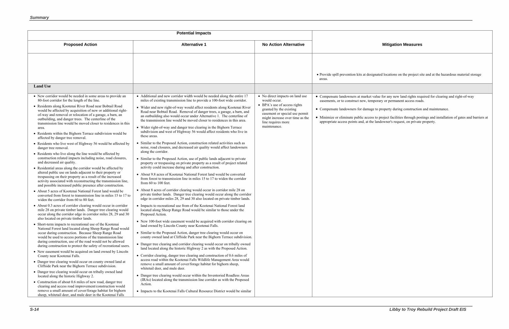
Summary
S-14 Libby to Troy Rebuild Project Draft EIS
Potential Impacts
Proposed Action Alternative 1 No Action Alternative Mitigation Measures
• Provide spill prevention kits at designated locations on the project site and at the hazardous material storage areas.
Land Use
• New corridor would be needed in some areas to provide an 80-foot corridor for the length of the line.
• Residents along Kootenai River Road near Bobtail Road would be affected by acquisition of new or additional right-of-way and removal or relocation of a garage, a barn, an outbuilding, and danger trees. The centerline of the transmission line would be moved closer to residences in this area.
• Residents within the Bighorn Terrace subdivision would be affected by danger tree removal.
• Residents who live west of Highway 56 would be affected by danger tree removal.
• Residents who live along the line would be affected by construction related impacts including noise, road closures, and decreased air quality.
• Residential areas along the corridor would be affected by altered public use on lands adjacent to their property or trespassing on their property as a result of the increased activity associated with reconstructing the transmission line, and possible increased public presence after construction.
• About 5 acres of Kootenai National Forest land would be converted from forest to transmission line in miles 15 to 17 to widen the corridor from 60 to 80 feet.
• About 0.3 acres of corridor clearing would occur in corridor mile 28 on private timber lands. Danger tree clearing would occur along the corridor edge in corridor miles 28, 29 and 30 also located on private timber lands.
• Short-term impacts to recreational use of the Kootenai National Forest land located along Sheep Range Road would occur during construction. Because Sheep Range Road would be used to access portions of the transmission line during construction, use of the road would not be allowed during construction to protect the safety of recreational users.
• New easement would be acquired on land owned by Lincoln County near Kootenai Falls.
• Danger tree clearing would occur on county owned land at Cliffside Park near the Bighorn Terrace subdivision.
• Danger tree clearing would occur on tribally owned land located along the historic Highway 2.
• Construction of about 0.6 miles of new road, danger tree clearing and access road improvement/construction would remove a small amount of cover/forage habitat for bighorn sheep, whitetail deer, and mule deer in the Kootenai Falls
• Additional and new corridor width would be needed along the entire 17 miles of existing transmission line to provide a 100-foot wide corridor.
• Wider and new right-of-way would affect residents along Kootenai River Road near Bobtail Road. Removal of danger trees, a garage, a barn, and an outbuilding also would occur under Alternative 1. The centerline of the transmission line would be moved closer to residences in this area.
• Wider right-of-way and danger tree clearing in the Bighorn Terrace subdivision and west of Highway 56 would affect residents who live in these areas.
• Similar to the Proposed Action, construction related activities such as noise, road closures, and decreased air quality would affect landowners along the corridor.
• Similar to the Proposed Action, use of public lands adjacent to private property or trespassing on private property as a result of project related activity could increase during and after construction.
• About 9.8 acres of Kootenai National Forest land would be converted from forest to transmission line in miles 15 to 17 to widen the corridor from 60 to 100 feet.
• About 8 acres of corridor clearing would occur in corridor mile 28 on private timber lands. Danger tree clearing would occur along the corridor edge in corridor miles 28, 29 and 30 also located on private timber lands.
• Impacts to recreational use from of the Kootenai National Forest land located along Sheep Range Road would be similar to those under the Proposed Action.
• New 100-foot wide easement would be acquired with corridor clearing on land owned by Lincoln County near Kootenai Falls.
• Similar to the Proposed Action, danger tree clearing would occur on county owned land at Cliffside Park near the Bighorn Terrace subdivision.
• Danger tree clearing and corridor clearing would occur on tribally owned land located along the historic Highway 2 as with the Proposed Action.
• Corridor clearing, danger tree clearing and construction of 0.6 miles of access road within the Kootenai Falls Wildlife Management Area would remove a small amount of cover/forage habitat for bighorn sheep, whitetail deer, and mule deer.
• Danger tree clearing would occur within the Inventoried Roadless Areas (IRAs) located along the transmission line corridor as with the Proposed Action.
• Impacts to the Kootenai Falls Cultural Resource District would be similar
• No direct impacts on land use would occur.
• BPA’s use of access rights granted by the existing easement or special use permit might increase over time as the line requires more maintenance.
• Compensate landowners at market value for any new land rights required for clearing and right-of-way easements, or to construct new, temporary or permanent access roads.
• Compensate landowners for damage to property during construction and maintenance.
• Minimize or eliminate public access to project facilities through postings and installation of gates and barriers at appropriate access points and, at the landowner's request, on private property.

Bonneville Power Administration S-15
Potential Impacts
Proposed Action Alternative 1 No Action Alternative Mitigation Measures
Wildlife Management Area. • Danger tree clearing could occur in the Inventoried Roadless
Areas (IRAs) located along the transmission line corridor. • Replacement of structures, road improvement and
construction of a bridge over China Creek would impact the Kootenai Falls Cultural Resource District by potentially disturbing archaeological sites.
to the Proposed Action.
Vegetation
• No impacts to ESA-listed (water howellia and Spalding’s catchfly) species or candidate species (linearleaf moonwort) are expected.
• Removal of old structures and construction of new structures would impact an estimated 350-700 individual Geyer’s biscuit-root (Forest Sensitive and Montana Species of Concern species). Construction of two of the new access roads has the potential to impact 150 or more individuals or subpopulations. One of the conductor tensioning sites would also disturb individual plants or subpopulations.
• Structure replacement and road construction would remove vegetation and expose bare mineral soil possibly increasing weed migration into potential Geyer’s biscuit-root habitat.
• No impacts to common clarkia (Forest Sensitive) are expected although habitat disturbance could occur.
• No impacts to Upswept moonwort (Forest Sensitive), wavy moonwort, and stalked moonwort (Forest Sensitive and Montana Species of Concern species) are expected although habitat disturbance could occur.
• Danger tree removal and construction of about 300 feet of access road to structure 18/11 would occur within the edge-affected area of the designated old growth stand near Bobtail Creek.
• Danger tree removal would occur within the edge-affected area of the designated old growth stand northwest of the Bighorn Terrace subdivision near structure 21/3.
• Weeds from existing access roads and rights-of-way would be transported by vehicles to un-infested areas potentially increasing weed spread within and adjacent to the corridor posing a high risk to adjacent susceptible plant communities, specifically those in the Kootenai River corridor and the north facing slopes. ATVs used to transport people and equipment into this area would increase the risk of weed spread.
• No impacts to ESA-listed (water howellia and Spalding’s catchfly) species or candidate species (linearleaf moonwort) are expected from Alternative 1.
• Impacts to Geyer’s biscuit-root from removal of old structures and construction of new structures would be the same as those under the Proposed Action.
• Wider right-of-way for Alternative 1 would remove more vegetation and expose a larger amount of bare mineral soil possibly increasing weed migration into potential Geyer’s biscuit-root habitat.
• No impacts to common clarkia (Forest Sensitive) are expected from Alternative 1 although habitat disturbance could occur.
• No impacts to upswept moonwort (Forest Sensitive), wavy moonwort, and stalked moonwort (Forest Sensitive and Montana Species of Concern species) are expected from Alternative 1 although habitat disturbance could occur.
• Alternative 1 would clear about 0.06 acres total of designated old growth habitat due to the greater clearing width needed for 230 kV. About 0.01 acres (436 square feet) within the 170-acre designated old growth stand near Bobtail Creek and about 0.05 acres (2,178 square feet) within the 35-acre designated old growth stand northwest of the Bighorn Terrace subdivision would be cleared.
• Similar to the Proposed Action, the potential for the spread of weeds on the existing and additional new right-of-way and roads from Alternative 1 would increase with disturbance.
• Impacts from operation and maintenance of Alternative 1 would similar to the Proposed Action. As with the Proposed Action, spread of weeds within the project area would result from vehicular travel and right-of-way vegetation management.
• Impacts from emergency maintenance or structure replacement could occur to populations of Geyer’s biscuit-root found within the existing corridor.
• Impacts to roadside native species and Geyer’s biscuit-root could occur from road spraying and weed spread.
• Existing access roads and rights-of-way would continue to support weed populations; seeds would be spread by road maintenance equipment, as well as by other administrative and recreational traffic. Existing weeds are expected to continue moving from roadways and rights-of-way into previously disturbed areas and adjacent big game winter ranges and riparian areas.
• Threatened and Endangered and Forest Sensitive Species: Cut or crush vegetation rather than blade, in areas that will remain vegetated in order to maximize the ability
of plants to resprout. (Mitigation measure also listed in Geology, Soils, and Water Resources Section.) Limit soil disturbance and mineral soil exposure during construction activities. Flag populations of Geyer’s biscuit-root for avoidance during construction.
• Old Growth: Implement timing restrictions as described in Section 3.5.3 Wildlife/Mitigation to minimize disturbance and
limit destruction of nests of birds that use old growth habitat and within bald eagle Nest Site Management Zones.
Mitigate for impacts to designated and undesignated (on the Pipe Creek and Quartz Creek realignment options) old growth stands by purchasing private lands or conservation easements on private lands with old growth characteristics that may otherwise be developed or cleared for other purposes. BPA would purchase the lands prior to clearing in old growth areas. Any lands acquired for bald eagle mitigation that meet the definition of old growth habitat will also be acceptable for meeting mitigation objectives for old growth habitat. Details of the mitigation plan will be described in the Biological Assessment for bald eagles being prepared for this project. Table 3-22 provides a summary of proposed old growth habitat mitigation acres by alternative.
• Noxious Weeds: Comply with federal, state and county weed control regulations and guidelines. Implement Forest Service Manual (FSM) 2080 Noxious Weed Management Prevention and control
measures on all Kootenai National Forest lands. See Appendix E. Use certified weed-free forage/mulch if available on all Kootenai National Forest lands in Montana (36 FR
261.50). Pressure or steam wash all equipment before entering the project area and when leaving discrete patches of
weeds. Flag or map weed populations prior to construction for avoidance. Clean vehicles after leaving those areas
to avoid spread of weeds. Seed and fertilize newly constructed and restored roads after use with seed that meets the requirements of
federal, state, and county weed control regulations and guidelines. Use certified weed-free straw for erosion control for all construction, reconstruction and restoration
activities. Treat and sign sites if new invaders are located and defer ground disturbing activities within those sites until
the weed specialist from Lincoln County or the Kootenai National Forest determines the site is no longer a threat, and approves those activities.
Follow site-specific guidelines for weed treatments within or adjacent to known sensitive plant populations. All future treatment sites will be evaluated for sensitive plant habitat suitability; suitable habitats will be surveyed as necessary prior to treatment.
Use the 1000 cubic yards of excess excavated material from 15/4 – 15/7 contaminated with spotted knapweed seed and other weed seeds in areas that have the same weed species. This material will not be used at sites relatively free of these species, such as the Pipe Creek, Quartz Creek, and Kootenai River Crossing realignments.
Treat the Dalmatian toadflax populations located east of structure 21/3 and at the Troy Substation on the Lake Creek road with herbicide prior to any activity, to reduce the potential for plants producing seed to be

Summary
S-16 Libby to Troy Rebuild Project Draft EIS
Potential Impacts
Proposed Action Alternative 1 No Action Alternative Mitigation Measures
carried elsewhere. Cooperate with Lincoln County for the treatment of the common tansy population from structure 26/1 to
26/9 with herbicide prior to any motorized travel to reduce the chance of spreading this species. Wash ATVs and other off-road vehicles before bringing them into the historic Highway 2 area. Cooperate with private, county, and federal landowners to treat the noxious weeds along the access roads
that will be used to bring tree clearing and construction equipment into the Pipe Creek, Quartz Creek, and Kootenai River Crossing realignment areas, to reduce the amount of weed seed that could be available for dispersal.
Wash all vehicles and construction equipment before beginning clearing and construction activities in the realignment areas, to help prevent the transport of weed seeds from areas that are already infested.
Install gates and post signs on access roads to discourage recreational vehicular travel and subsequent weed seed transport. Gates could be installed in the following locations: near structure 17/13 and on the existing access road off Bobtail Road; where the corridor crosses Quartz Creek Road west of structure 19/3; on the existing access road near the new right-of-way crossing of Quartz Creek Road; on the existing access road near the new eastern angle structure for the Quartz Creek realignment; on the west side of Quartz Creek off USFS Road 601; and on the existing access road near structure 21/3.
Revegetate the abandoned section between 19/4 and 21/4 if structures are removed and ground is disturbed. Apply all herbicides according to the labeled rates and recommendations to ensure the protection of surface
water, ecological integrity and public health and safety. Herbicide selection will be based on target species on the site, site factors (such as soil types, distance to water, etc.), and with the objective to minimize impacts to non-target species.
Conduct a post-construction weed survey to confirm whether or not noxious weeds have been spread within the project area, and take curative action if needed.
Floodplains and Wetlands
• Removal of structures 22/4, 23/8, and 26/2 currently located in or near wetland areas would impact wetlands by crushing of vegetation, compacting or rutting of soil.
• Construction of new structures would impact wetlands from crushing of vegetation or sedimentation from construction sites; water quality would be affected if sediment enters streams or covers wetland vegetation. About 0.25 acres around each structure would be disturbed during installation.
• Structures 22/4, 23/8, and 26/2, located within wetlands or wetland buffer, would be relocated. Since the new locations may still be within wetland buffers, impacts would occur from disturbance of vegetation and soil.
• Riparian wetlands would be impacted by clearing of vegetation and construction of a new bridge across China Creek. Other riparian wetlands along project streams would be impacted by tree clearing.
• Impacts from improvement of existing access roads would occur from removal of vegetation and spills of chemicals, oils and pollutants from machinery.
• Between structures 23/7 and 24/1, Sheep Range Road crosses through wetlands; a small amount of sediment could be introduced into wetlands immediately adjacent to the road from vehicular traffic mud splash if the road is used during the wet season. A portion of Sheep Range Road near the
• Impacts to wetlands and floodplains from removal of existing wooden structures would be the same as those under the Proposed Action.
• About 0.5-acres around each new 230-kV structure would be disturbed during installation possibly crushing or removing wetland buffer vegetation. As with the Proposed Action, structures 22/4, 23/8, and 26/2 would be relocated away from wetlands and wetland buffers as much as possible.
• Impacts would be the same as those under the Proposed Action for the new access road and bridge through the riparian wetland of China Creek.
• Impact from Alternative 1 to other riparian wetlands in the project area would be greater than the Proposed Action because more tree clearing to widen the corridor from 80 feet to 100 feet would occur.
• Impacts to wetlands from road improvement would be the same as those under the Proposed Action.
• Impacts from operation and maintenance of Alternative 1 would be similar to those under the Proposed Action although wider right-of-way would require more clearing of vegetation and application of herbicides for noxious weed control.
• Impacts from construction of new structures in Pipe and Bobtail creek floodplains would be similar to those under the Proposed Action. Additional tree clearing to widen the corridor to 100 feet would increase the potential for soil compaction in the floodplains.
• Impacts from construction of tensioning sites in the Kootenai River
• There is the potential for disturbance to wetlands and floodplain functions from structure replacement, vegetation management activities, and access road improvements.
• New impacts to wetlands and floodplains could result when transmission structures fail and require immediate repair.
• Obtain and comply with applicable Clean Water Act permits for all work in wetlands or streams.
• Comply with the terms and conditions of applicable State of Montana Water Quality Act and Streambed Preservation Act permits for all work in wetlands and streams.
• Identify and flag wetlands before construction for avoidance.
• Locate structures, roads, staging areas and tensioning sites to avoid wetlands and floodplains as much as possible.
• Avoid construction within wetlands and wetland buffers to protect wetland functions and values, where possible. The wetland buffer width on federal land is 150 feet from the wetland boundary and 50 feet from the wetland boundary on all other lands.
• Avoid mechanized land clearing within wetlands and riparian areas to minimize soil compaction from heavy machinery, destruction of live plants, and potential alteration of surface water patterns.
• Install erosion control measures such as silt fences, straw mulch, straw wattles, straw bale check dams, other soil stabilizers, and reseed disturbed areas as required; a Stormwater Pollution Prevention Plan would be prepared.
• Use herbicides to control vegetation near wetlands in accordance with the Transmission System Vegetation Management Program (BPA 2000), to limit impacts to water quality.
• Use existing road systems, where possible, to access structure locations and for the clearing of the transmission line corridor.
• Deposit all excavated material not reused in an upland area and stabilize.
• Locate structures to minimize the potential for creating obstructions to floodwaters.
• Recontour and revegetate disturbed areas near floodplains with native and local species.

Bonneville Power Administration S-17
Potential Impacts
Proposed Action Alternative 1 No Action Alternative Mitigation Measures
spring in Wetland 10 would need to have a drainage structure installed to retain the spring’s connectivity with the Kootenai River.
• The existing access road between structures 26/2 and 26/5 would cross approximately 0.6 acres of springs; drainage structures would be installed in that road to allow the spring water to connect to slopes and water systems below the road. Fill would be needed to provide a road bed.
• Operation and maintenance would cause impacts to wetlands from vegetation maintenance activities or the application of herbicides for noxious weed control. Most wetlands and wetland buffers within the corridor are dominated by tree species that at times would need to be cut. Use of access roads during wet periods for structure maintenance would affect wetlands by introducing sediment through vehicular traffic mud splash, potentially affecting water quality.
• One structure currently located in the Bobtail Creek floodplain would be moved about 10 feet closer to the stream. Impacts to floodplains would occur from soil compaction, rutting, and removal of riparian vegetation.
• Four to five conductor tensioning sites would be located in the Kootenai River floodplain. Conductor tensioning sites need to be relatively flat which would require soil disturbance and compaction within the floodplain.
• About 0.6 miles of new road would be constructed in the Kootenai River floodplain to access the line near structure 22/1 and to cross China Creek; soil disturbance and compaction would occur within 75 feet of the Kootenai River.
• Impacts to the Kootenai River floodplain from improvement of Sheep Range Road or would occur from widening the road and potentially increasing the potential for sediment delivery to the Kootenai River.
• Operation and maintenance activities would impact floodplains from soil compaction and removal of vegetation.
floodplain would be the same as those under the Proposed Action.
• Impacts from construction of about 0.6 miles of new road in the Kootenai River floodplain would be the same as those under the Proposed Action
• Impacts from improvement of Sheep Range Road located in the Kootenai River floodplain would be the same as those under the Proposed Action.
• Impacts from operation and maintenance of Alternative 1 would be the same as those under the Proposed Action.
Wildlife
• Common Wildlife Species
The osprey nests located north of existing structure 22/4 and on top of existing structure 28/2 would be impacted during construction. The nest on 28/2 would be removed prior to construction before or after the nesting season depending on the time of year construction would begin. This could cause displacement or abandonment of the osprey nest site. The other nest would be disturbed from construction along the existing corridor near structure 22/4.
The risk for line collision would be only slightly increased as the line would be rebuilt in the same location with the same type of structures. However, placement of overhead ground wire on structures for
• Common Wildlife Species
Impacts to common wildlife species from Alternative 1 would be greater than the Proposed Action because the corridor would be widened from 80 feet to 100 feet. Big game animals would have less cover than under the Proposed Action, but impacts from danger tree clearing and new road construction outside the corridor would be the same as the Proposed Action.
Alternative 1 would increase open road densities and decrease habitat effectiveness for some big game species, and smaller mammals also would be affected by removal of cover within their habitat.
Impacts to osprey would be the same as the Proposed Action.
The risk of bird strikes under Alternative 1 would greater than the
• Common Wildlife Species
Impacts on common wildlife species would be similar to those under the Proposed Action.
Impacts on migratory bird nesting, foraging, and roosting habitat would be similar to the Proposed Action.
Potential for line collision would be similar to the Proposed Action.
• Grizzly bear Implement any mitigation measures for grizzly bear that may be required by the USFWS through Section
7 consultations for the Proposed Action. Measures could include avoidance of certain locations during the den emergence period, restricting construction noise levels in certain areas, and provision of compensation for project effects.
Design action alternatives and realignment options to reduce grizzly bear mortality risk due to human-bear encounters. All construction and maintenance crews will observe proper storage of food, garbage, and other attractants within grizzly bear habitat as specified in the Kootenai National Forest Food Storage Order (Special Order, Kootenai National Forest, 2001; Occupancy and Use Restrictions and Food Storage for the Cabinet/Yaak Ecosystem).
Implement mitigation for action alternatives and realignment options that will increase core habitat and decrease TMRD in BMU 10. The removal of ten gates and the installation of earthen barriers on roads in BMU 10 that are currently closed year round to motorized travel will occur. This work would be done in conjunction with Kootenai National Forest proposed mitigation for upcoming fuels reduction work in

Summary
S-18 Libby to Troy Rebuild Project Draft EIS
Potential Impacts
Proposed Action Alternative 1 No Action Alternative Mitigation Measures
about one mile out of the substations at either end of the line could increase the "fence" effect and contribute to potential bird strikes in those areas.
• Gray wolf: Effects on gray wolf would be minimal.
• Grizzly bear
Bear Management Unit 10: Potential impacts to grizzly bear would occur during construction because of the two to three weeks of helicopter use and its impact on habitat effectiveness, and the addition of new access roads and their effect on linear Open Road Density (ORD) and Open Motorized Route Density (OMRD). After construction is complete, potential impacts to grizzly bear would decrease.
Bear Management Unit 1: Potential impacts to grizzly bear would occur during construction because of the two to three weeks of helicopter use and its impact on habitat effectiveness, and the addition of new access roads and their effect on linear ORD and OMRD. After construction is complete, potential impacts to grizzly bear would decrease.
Bear Outside Recovery Zones: The percentage of OMRD and linear Total Motorized Route Density (TMRD) would remain unchanged within the West Kootenai and Troy Bear Outside Recovery Zone (BORZ) polygons.
• Bald eagle
Inside Management Zones I and II: About 0.5 acres for a new access road would be cleared in Management Zones I and II of the Hunter Gulch nest. A total of 27.5 acres of edge affected area would be impacted within the Management Zones I and II for all four nests. Suitable nesting, perching, and roosting trees would be removed within this edge affected area of the Quartz Creek, Hunter Gulch and Kootenai Falls nests resulting in impacts to nest site habitat suitability and integrity of the breeding area.
Outside Management Zones I and II: The total acres of canopy removed outside of the Zones I and II of the four nests would be about 6.1 acres. About 100.5 acres of edge affected area outside Zones I and II but within Zone III (home range) would be affected resulting in impacts to suitable foraging habitat.
There would a slight increase in the risk for bald eagle line collision as the line would be rebuilt in the same location with the same type of structures.
In the area near the Pipe Creek nest, there is a distribution line that would remain in the lower position of the rebuilt structures. Because of this line, there is an increased possibility for bald eagle electrocutions in this area because collision or electrocution occurs more often
Proposed Action. The taller steel structures (average height of 95 feet) would have a stacked configuration (conductors at various heights) which can create a "fence effect,” or a larger area in which birds must avoid obstacles. The risk would be greater for waterfowl where the transmission line crosses the Kootenai River.
• Gray wolf: Effects on gray wolf from Alternative 1 would be similar to those under the Proposed Action.
• Grizzly bear: Potential impacts to grizzly bear, similar to the Proposed Action, would occur during construction from the two to three weeks of helicopter use and its impact on habitat effectiveness, and the addition of new access roads and their effect on linear ORD and OMRD. After construction is complete, potential impacts to grizzly bear would decrease.
Bear Management Unit 10: Potential impacts to grizzly bear within BMU 10 would be the same as those under the Proposed Action.
Bear Management Unit 1: Potential impacts to grizzly bear within BMU 1 would be the same as those under the Proposed Action.
Bear Outside Recovery Zones: Similar to the Proposed Action, the percentage of OMRD and linear TMRD would remain unchanged within the West Kootenai and Troy BORZ polygons.
• Bald eagle
Inside Management Zones I and II: Under Alternative 1, a total of 6.4 acres of canopy removal would occur inside Management Zones I and II of the four nests and a total of 20.7 acres of edge affected area would be impacted. Removal of suitable nesting trees in the edge affected area would impact nest site habitat suitability and integrity of the breeding area. Clearing of canopy within the management zones would move the edge of the corridor closer to the nests. Taller structures with conductors placed in a stacked configuration could increase strikes for birds flying between the Kootenai River and the nests.
Outside Management Zone I and II: Under Alternative 1, the total acres of canopy that would be removed outside of Zones I and II is about 21.7 acres. Approximately 66.3 acres of edge affected area outside the management zones would be affected.
Alternative 1 would have a greater potential for impact on bald eagle mortality than the Proposed Action. Taller structures with conductors placed in a stacked configuration would increase the potential strikes for birds flying between the Kootenai River and the nests. Near the Pipe Creek nest, the distribution line that would remain in the lower position of the rebuilt structures would increase the potential for bald eagle electrocutions.
• Peregrine falcon: Effects on peregrine falcon would be the same as those under the Proposed Action.
• Pileated woodpecker: Effects on pileated woodpecker would occur from clearing of about 0.01 acres (436 square feet) within the designated stand near Bobtail Creek and about 0.05 acres (2,178 square feet) within the designated stand northwest of Bighorn Terrace. Approximately 134 preferred trees and 3 snags would be removed in pileated woodpecker
• Gray wolf: Effects on gray wolf from No Action would be similar to those under the Proposed Action.
• Grizzly bear: Potential impacts to grizzly bear both inside and outside the bear management units from No Action would be minimal because no construction that would affect grizzly bear habitat is expected.
• Bald eagle
Inside Management Zones I and II: Canopy removal is not expected within the four nest sites Management Zones I and II crossed by the existing transmission line with the exception of hazard trees removed as part of normal maintenance operations.
Outside Management Zones I and II: Right-of-way clearing outside Zones I and II is not expected.
Peregrine falcon: Maintenance of the existing transmission line could result in a slight potential for disturbance to an active peregrine falcon nest should helicopter use be required during nesting season.
Pileated woodpecker: Vegetation management is not expected within effective or replacement old growth habitat and thus would not affect pileated woodpeckers.
Northern goshawk and Flammulated owl: Vegetation management is not expected to remove potential nesting or foraging habitat.
Harlequin duck: Effects on harlequin duck would be similar to the Proposed Action.
Elk and White-tailed deer: Impacts such as removal of cover/forage from ongoing maintenance activities for the
BMU 10. Earthen barriers will make access to closed areas more difficult for motorized vehicles, thus increasing core habitat and reducing overall road density. The drainages and roads are as follows: Lost Fork Creek (Roads 6164, 4653 and 4653 D); Big Foot - Seventeen Mile Creek (Roads 4681 B, C, D, E, F and G); and West Fork Quartz Creek (Roads 4690 F, and 4691). Roads 14470, 14471, 14473 and 14474 will be “placed into storage” rather than removing gates, because they are behind other roads where gates would be removed. Placing roads into storage could entail culvert removal and subsequent recontouring of the stream banks.
Remove the gate on the 402 D spur (in BMU 1) in Cedar Creek and install an earthen barrier. This spur road is currently closed year round to motorized travel.
Install earthen barriers in the West Kootenai BORZ, to close approximately 4.1 miles of road currently open to motorized travel. All roads are located in the Quartz Creek drainage and include Roads 6145, 6704, 6704 A, and 5222.
Use of high intensity motorized disturbance (such as heavy equipment or helicopter use) will not occur in BMUs 10 and 1 between April 1 and June 15 during the grizzly bear den emergence and spring period. This includes: the west leg of the Quartz Creek realignment off Lower Quartz Creek Road #601; existing structures 21/5 to 27/9 along Sheep Range Road; and the historic Highway 2.
• Bald eagle Implement any mitigation measures for bald eagle that may be required by the USFWS through Section 7
consultations for the Proposed Action. Measures could include avoidance of certain locations during the nesting periods, restricting construction noise levels in certain areas, and provision of compensation for project effects.
Implement mitigation for project activities within the primary use areas of the four nests, by purchasing private lands or conservation easements on private lands that may otherwise be developed or cleared for other purposes. Acres required for compensation would equal 100% of the area to be cleared of all tall growing vegetation, as well as a portion of the area that falls within the edge affected area that currently supports trees suitable for bald eagle perching, roosting, and/or nesting.
Use of high intensity motorized disturbance (such as heavy equipment or helicopter use) will not occur between February 1 and August 15 within the primary use areas of an active nest during the nesting and fledging period. This includes: the Pipe Creek realignment; existing structures 17/6 to 18/3; the west leg of the Quartz Creek realignment; existing structures 20/9 to 21/5; the Kootenai River crossing realignment; and existing structures 25/1 to 26/1. A preconstruction survey of the four nests will be done to determine if nests are active. No timing restrictions would apply if nests are not active.
• Peregrine falcon: Use of high intensity motorized disturbance (such as heavy equipment or helicopter use) will not occur between March 15 and August 31 within 0.5 miles of an active nest. This includes the areas between existing structures 26/5 to 27/3. The peregrine falcon nesting area west of Kootenai Falls will be surveyed in April-May 2008 to determine location of nest. If no nest is present timing restrictions would not apply.
• Pileated woodpeacker, northern goshawk, and flammulated owl: Use of high intensity motorized disturbance (such as heavy equipment or helicopter use) will not occur between April 1 and July 15 within the old growth stands near Bobtail Creek and northwest of the Bighorn Terrace subdivision. This mitigation applies to the Proposed Action, Alternative 1, the Pipe Creek realignment option, and the Quartz Creek realignment option.
• Bighorn sheep: Use of high intensity motorized disturbance (such as heavy equipment or helicopter use) will not occur between April 1 and June 30 within the Kootenai Falls Wildlife Management Area during the bighorn sheep lambing period. This includes the areas along Sheep Range Road between existing structures 21/6 to 24/7.
• Osprey: Use of high intensity motorized disturbance (such as heavy equipment or helicopter use) will not occur between April 1 and August 31 within the primary use area of an active nest. This includes the areas between: existing structures 27/7 to 28/6 (the current nest is located on top of structure 28/2); existing structures 22/1 to 23/1 (the current nest is located near structure 22/4).

Bonneville Power Administration S-19
Potential Impacts
Proposed Action Alternative 1 No Action Alternative Mitigation Measures
with distribution lines.
• Peregrine falcon: Effects on peregrine falcon would most likely occur from helicopter disturbance during construction activities during the nesting and fledging periods.
• Pileated woodpecker: Effects on pileated woodpecker would occur from removal of trees in old growth stands and from removal of approximately 40 live trees preferred by pileated woodpecker for nesting (greater than or equal to 20” dbh).
• Northern goshawk: Effects on northern goshawk would occur from clearing of about 8.6 acres within nesting and/or foraging habitat. Suitable nesting habitat is located between structures 18/8 and 19/5, 21/5 and 25/8, and just east of 26/1 to 28/2.
• Flammulated owl: Effects on flammulated owl would occur from clearing of about 3.3 acres within potential nesting and/or foraging habitat. Suitable nesting habitat is located between structures 18/8 and 19/5, 21/5 and 25/8, and just east of 26/1 to 28/2.
• Harlequin duck: Effects on harlequin duck would be minimal.
• Elk and White-tailed deer: Effects on elk and white-tailed deer would occur from changes to cover/forage ratio and opening sizes. Clearing of trees would decrease cover/forage from tree removal although adequate security for elk and deer would remain within or along the transmission line corridor.
• Bighorn sheep: About 0.4 acres of canopy would be removed within the Kootenai Falls Wildlife Management Area although relatively secure corridor for animals to forage close to cover would remain.
nesting habitat under Alternative 1.
• Northern goshawk: Loss of potential goshawk foraging habitat under Alternative 1 would be about 26.8 acres with potential removal of about 71 suitable goshawk nest trees.
• Flammulated owl: Loss of potential owl foraging habitat under Alternative 1 would be about 16.8 acres with potential removal of 3 suitable owl nest trees.
• Harlequin duck: Effects on harlequin duck would be similar to the Proposed Action although the potential for collision could increase with the taller 230-kV structures.
• Elk and White-tailed deer: Effects to elk and white-tailed deer from Alternative 1 would be similar to the Proposed Action except additional tree canopy would be removed.
• Bighorn sheep: About 9.1 acres of canopy would be removed within the Kootenai Falls Wildlife Management Area although relatively secure corridor for animals to forage close to cover would remain.
existing transmission line and right-of-way would occur as the transmission line ages and emergency repairs are needed more frequently.
Bighorn sheep: Current levels of ongoing maintenance activities for the existing transmission line would continue, such as the removal of hazard trees which would decrease cover/forage for sheep.
Fish, Amphibians, and Reptiles
• Removal of large trees in the Riparian Habitat Conservation Areas (RHCA) could impact fish if sediment generated during removal enters the streams.
• Placement of the tensioning site at 18/11 could impact Bobtail Creek if construction generated sediment enters the stream.
• Corridor clearing within the wetland buffer or riparian areas could displace amphibians and reptiles or disturb their habitat.
• Coeur d’Alene salamanders could be displaced from their habitat or killed where the existing corridor runs parallel to the historic Highway 2.
• Short-term increases of small amounts of sediment are expected from construction activities such as timber clearing and road improvement/construction.
• About 1.0 acres of clearing would occur in the riparian area of fish bearing streams.
• Impacts to fish, amphibians, and reptiles from tensioning site placement and road improvement and construction would be similar to the Proposed Action.
• Effects to aquatic habitat from timber clearing for Alternative 1 would be slightly greater than those under the Proposed Action. The existing 80 foot transmission line corridor would be cleared to 100 feet in width so more trees within aquatic habitat would be removed with the potential for greater amounts of sediment delivered to streams.
• About 1.4 acres of clearing would occur in the riparian area of fish bearing streams.
• Fires and suppression efforts could introduce sediment into fish bearing streams or increase water temperature.
• Impact on boreal toads would occur within wetlands or riparian habitats from emergency or other access to structures located in wetlands.
• Implement any mitigation measures for white sturgeon and bull trout that may be required by the USFWS through Section 7 consultations for the Proposed Action. Measures could include provision of buffer zones to avoid sediment generated during construction from entering project area streams and leaving woody debris in certain areas.
• Implement RHCAs (buffer zones) around all project area rivers, streams and wetlands. For the following fish bearing streams, 300 feet on each side of the stream would be buffered: Kootenai River, Pipe Creek, Bobtail Creek, Quartz Creek, and China Creek.
• Remove trees within the RHCAs without the use of heavy equipment.
• Leave low growing brush species uncut with the RHCAs.
• Leave large-diameter trees felled within corridor RHCAs. This would leave recruitable (trees that are ready to fall into the stream) large woody debris within the RHCAs of project area streams.
• Conduct surveys for presence of Coeur d'Alene salamanders during wet weather in May or June during the year when transmission line construction would occur. The areas which have a high probability of occurrence are located on the south side of the Kootenai River in Section 18 (T31N, R32W) for the Kootenai River Crossing Realignment and in Sections 13 and 14 (T31N, R33W) for the Kootenai River Crossing Realignment and existing corridor. High probability areas would be searched in the immediate area planned for disturbance, such as structure locations. The outer boundary of the disturbance zone around each structure would be identified and

Summary
S-20 Libby to Troy Rebuild Project Draft EIS
Potential Impacts
Proposed Action Alternative 1 No Action Alternative Mitigation Measures
marked on the ground. Salamanders present in the area would be collected and moved at least 100 feet to similar habitat beyond the potential disturbance zone.
Visual Resources
• The existing line would be straightened just west of Central Road (structures 17/16 and 17/17) for approximately 500 feet and placed along the north side of Kootenai River Road with slightly taller single-wood-pole structures with stand-off insulators.
• Clearing of trees for new and additional right-of-way would open up views of the new structures and conductors from residences along Kootenai River Road between Pipe and Bobtail Creeks.
• Danger tree removal in the Bighorn Terrace subdivision would open up views of the existing line currently partially screened from view. Road construction and improvement would remove low growing vegetative screening in this area, further opening up views of the corridor.
• Danger tree removal combined with topographically low areas would allow views of some of the new taller structures west of Black Eagle Rock from viewers on the Kootenai River, Sheep Range Road, and Highway 2.
• Short-term construction activities within the corridor would introduce new shapes, lines, and elements into the visual environment such as structures, bolts, conductor reels, insulators, and culverts.
• At Viewpoints 1, 2, and 3 the Visual Quality Objective (VQO) of partial retention would continue to be met. At Viewpoint 4 the VQO of modification would continue to be met.
• The transmission line would be straightened just west of Central Road (structures 17/16 and 17/17) for approximately 500 feet and placed along the north side of Kootenai River Road with taller steel pole structures and six conductors.
• Clearing of trees for new and additional right-of-way would open up views of the new steel structures and conductors from residences along Kootenai River Road between Pipe and Bobtail Creeks.
• In corridor miles 18 and 19, additional clearing and new steel poles would increase the line’s visibility on the east and west slopes of Bobtail Ridge. West of Bobtail Ridge to Quartz Creek Road, the new line would be visible especially from residences located north of the line.
• Danger tree removal and corridor clearing in the Bighorn Terrace subdivision would open up views of the existing line currently partially screened from view. Road construction and improvement would remove low growing vegetative screening in this area, further opening up views of the corridor.
• At the west end of Kootenai River Road, the taller, heavier, and more industrial-looking structure on top of Black Eagle Rock would be visible.
• Danger tree removal and corridor clearing would allow views of the new taller, steel structures above the trees west of Black eagle Rock from viewers on the Kootenai River, Sheep Range Road, and Highway 2.
• The new steel structures would be visible where the line crosses Highway 2 and heads west along historic Highway 2 to Troy Substation.
• In the residential area west of Bull Lake Road and south of Highway 2, residents would see the new steel structures from homes and back yards.
• Similar to the Proposed Action, short-term construction activities within the corridor would introduce new shapes, lines, and elements into the visual environment such as structures, bolts, conductor reels, insulators, and culverts.
• At Viewpoints 1, 2, and 3 the VQO of partial retention would not be met. At Viewpoint 4 the VQO of modification would not be met.
• The existing transmission line would continue to be visible. No new visual impacts would be expected unless maintenance required new access roads or new structures. New access roads and structure would disturb or remove vegetative screening making portions of the line more visible.
• Use existing vegetation and topography whenever possible to limit views of the line and structures.
• Preserve vegetation within the 80-foot or 100-foot-wide right-of-way that would not interfere with the conductor or maintenance access needs, such as small trees and shrubs.
• Locate construction staging and storage areas away from locations that would be clearly visible from Kootenai River Road or Highway 2.
• Colorize all steel structures a dark gray color.
• Use non-reflective conductors.
• Use non-reflective insulators (i.e., non-ceramic insulators or porcelain).
• Locate access roads within previously disturbed areas, wherever possible.
• Revegetate all disturbed areas with approved species.
• Require that contractors maintain a clean construction site and that the corridor is kept free of litter after construction.
Cultural Resources
• Removal of existing structures and construction of new structures would disturb 5 known prehistoric sites (24LN174, 24LN202, 24LN203, 24LN233/24LN234 and 24LN183).
• Construction of tensioning sites would impact prehistoric sites within the Kootenai Falls Cultural Resource District (24LN1825) and proposed Traditional Cultural Property (TCP) sites.
• Five known prehistoric sites (24LN174, 24LN175, 24LN176, 24LN180, and 24LN181) located within the project area would be disturbed by road construction and improvement.
• One of the six known historic mining sites (24LN201) would
• Removal of existing structures and construction of new structures would disturb 5 known prehistoric sites (24LN174, 24LN202, 24LN203, 24LN233/24LN234 and 24LN183). Excavation of larger footing holes for Alternative 1 would potentially disturb more area within the known sites.
• Similar to the Proposed Action, construction of tensioning sites would impact prehistoric sites within the Kootenai Falls Cultural Resource District (24LN1825) and proposed TCP sites.
• Similar to the Proposed Action, five known prehistoric sites (24LN174, 24LN175, 24LN176, 24LN180, and 24LN181) located within the project area would be disturbed by road construction and improvement.
• Impacts to cultural resources would occur if emergency maintenance activities such as structure replacement or conductor splicing disturb cultural sites. Use of the Sheep Range Road during the wet season would continue to disturb known sites.
• Design the transmission line so that structure sites are placed to avoid cultural resources. • Design new access roads to avoid cultural resources. • Place geotextile fabric with rock/gravel overlay on the archaeological sites along Sheep Range Road to reduce or
eliminate adverse impacts to those sites. • Improve the existing access road system in a manner that minimizes new roads and avoids cultural resource sites.
If improvements are needed on existing access roads, such improvements would be limited to the existing roadbed if near a cultural resource site and would be confined to applying new material.
• Excavation for roads will not occur near cultural resource sites. • Remove the existing structures for the portion of existing transmission line that would be abandoned in the China
Creek area if the Kootenai River Crossing realignment is selected, by cutting off at the base. Structures will then be removed by helicopter and or cut and removed.

Bonneville Power Administration S-21
Potential Impacts
Proposed Action Alternative 1 No Action Alternative Mitigation Measures
be affected by excavation for structure construction. • One known historic logging site (24LN778) would be
affected by removal and construction of 15 structures and improvement of access roads to those structures.
• Impacts to portions of the historic Highway 2 (24LN237/24LN462) would occur from ATV use during construction.
• Heavy equipment use and vehicular traffic within known sites would disturb or destroy cultural resources.
• Rebuilding the line at the existing crossing near China Creek would impact the tribal ethnographic and cultural resources in the vicinity of the Kootenai Falls, both directly from structure and road construction, and indirectly from visual impacts.
• One of the six known historic mining sites (24LN201) would be affected by excavation for structure construction for Alternative 1.
• One known historic logging site (24LN778) would be affected by removal of 15 structures, construction of 5 new structures, and improvement of access roads to those structures.
• Similar to the Proposed Action, impacts on portions of the historic Highway 2 (24LN237/24LN462) would occur from ATV use during construction.
• Heavy equipment use and vehicular traffic within known sites would disturb or destroy cultural resources.
• Similar to the Proposed Action, rebuilding the line at the existing crossing and near China Creek would impact the tribal ethnographic and cultural resources in the vicinity of the Kootenai Falls.
• Consult with the Kootenai National Forest, Montana State Historic Preservation Officer (SHPO), and the Confederated Salish and Kootenai Tribes (CSKT) Tribal Historic Preservation Officer (THPO) regarding National Register of Historic Places (NRHP) eligibility of cultural sites and TCPs.
• Develop an Inadvertent Discovery Plan that details crew member responsibilities for reporting in the event of a discovery during construction.
• Ensure tribal monitors from the CSKT and Kootenai of Idaho are present during excavation within prehistoric sites or TCPs.
• Prevent unauthorized collection of cultural materials by ensuring a professional archaeologist and tribal monitor are present during any excavation within known sites.
• Prepare a Mitigation Plan to protect sites in-situ if final placement of project elements results in unavoidable adverse impacts to a significant cultural resource.
• Stop work immediately and notify local law enforcement officials, appropriate BPA personnel, the Kootenai National Forest, Montana SHPO, and the CSKT THPO if cultural resources, either archaeological or historical materials, are discovered during construction activities.
Recreation Resources
• Increased traffic levels would be expected on many of the project area roads during the construction season. Recreationists would be temporarily deterred from using certain areas due to noise, traffic, and dust, and for safety reasons.
• Short-term impacts to recreational use of the Kootenai National Forest land located along Sheep Range Road would occur during construction. Because Sheep Range Road would be used to access portions of the transmission line during construction, use of the road would not be allowed during construction to protect the safety of recreational users.
• ORV trespass of access roads would continue to occur. Recreation Opportunity Spectrum Analysis • Access – Widening of the Bighorn Trail (Sheep Range Road)
to allow wider and heavier vehicles to access the line between structures 21/6 and 25/8 would change the recreational user’s experience from hiking a trail to walking a road. On the other hand, proposed clearing and access road improvements largely would have a positive impact on hunting opportunities by allowing easier travel by hunters and easier viewing of big game animals.
• Social Encounters – Road widening could detract from the recreational user’s experience decreasing social encounter as visitors use other locations for their activities.
• Visitor Management – Visitor regulation and control would be increased under the Proposed Action. New roads on Kootenai National Forest lands would be closed to public motorized use to protect wildlife and watershed values.
• Visitor Impacts – Each segment of new road required for the transmission line rebuild would be closed by gate to public motorized travel to protect wildlife and watershed values. Visitors opposed to road closures may vandalize gates and signs. ORV users would circumvent gates to use new roads and would develop new routes from the roads where terrain is suitable. Such use would spread noxious weeds, eliminate vegetation and result in erosion.
• Impacts to recreation from Alternative 1 would be similar to those under the Proposed Action.
• If access for emergency maintenance work occurs during periods of wet soils, roads and trails used for recreation could be rutted.
• Improve trail surfaces by applying small-diameter compactable crushed rock.
• Monitor gates to assure effectiveness as necessary.

Summary
S-22 Libby to Troy Rebuild Project Draft EIS
Potential Impacts
Proposed Action Alternative 1 No Action Alternative Mitigation Measures
Noise, Public Health and Safety
Noise
• About 44 of the homes in the Pipe Creek area, Bighorn Terrace subdivision, and west of Highway 56 are within 800 feet of the construction activity and may experience noise levels at or above 65 dBA.
• Residents within approximately 1 mile of helicopter use would be exposed to temporary noise levels above 65 dBA. Some residents may perceive air pressure changes as vibrations from the helicopter use.
• Foul-weather corona noise levels would be comparable to or less than those from the existing line.
• On and off the right-of-way, the levels of audible noise from the Proposed Action during foul weather would be well below the 55-dBA level that can produce interference with speech outdoors (estimated Ldn at the edge of the 80-foot right-of-way would be about 15 dBA or less, which is well below the EPA Ldn guideline of 55 dBA and also well below the Montana limit for Ldn of 50 dBA.)
• Potential radio or television interference.
Public Health and Safety
• The Proposed Action would easily meet BPA’s electric-field guideline of 5 kV/m and Montana’s guideline of 1 kV/m at the edge of the right-of-way.
• Impacts from magnetic fields would be less than those present on and near the existing line.
Noise
• Impacts from noise under Alternative 1 would be the same as those under the Proposed Action.
• Potential radio or television interference.
Public Health and Safety
• Alternative 1 would easily meet BPA’s electric-field guideline of 5 kV/m and Montana’s guideline of 1 kV/m at the edge of the right-of-way.
• Similar to the Proposed Action, impacts from magnetic fields would be less than those present on and near the existing line.
• Existing conductor fittings have failed in the recent past causing fires and the transmission line to go out of service. Additionally, as wood pole structures continue to age, there is the potential for failures especially during adverse weather. The potential for these types of failures would increase as the line ages.
• Install sound-control devices on all construction equipment. • Muffled exhaust will be installed on all construction equipment and vehicles except helicopters. • Limit construction activities to daytime hours (i.e., only between 7:00 am and 7:00 pm). • Notify landowners directly impacted along the corridor prior to construction activities, including blasting. • Prepare and maintain a safety plan in compliance with Montana requirements prior to starting construction. This
plan will be kept on-site and will detail how to manage hazardous materials such as fuel, and how to respond to emergency situations.
• Hold crew safety meetings during construction at the start of each workday to go over potential safety issues and concerns.
• Secure the site at the end of each workday to protect equipment and the general public. • Train employees as necessary, in structure climbing, cardiopulmonary resuscitation, first aid, rescue techniques,
and safety equipment inspection. • Fuel all highway-authorized vehicles off-site to minimize the risk of fire. Fueling of construction equipment that
is transported to the site via truck and is not highway authorized will be done in accordance with regulated construction practices and state and local laws. Helicopters will be fueled and housed at local airfields or at staging areas.
• Ensure that helicopter pilots and contractors take into account public safety during flights. • Ensure that safety measures for blasting will be consistent with state and local codes and regulations. All
explosives will be removed from the work site at the end of the workday or placed under lock and key. • Adhere to BPA’s specifications for grounding fences and other objects on and near the existing and proposed
rights-of-way during construction. • Construct and operate the rebuilt transmission line in accordance with the National Electrical Safety Code, as
required by law. • Restore reception quality if radio or television interference occurs as a result of the rebuilt transmission line.
Reception will be as good or better than before the interference. • Carry fire suppression equipment including (but not limited to) shovels, buckets, and fire extinguishers on all
operation and maintenance vehicles. • Use established access roads during routine operation and maintenance activities. • Clear vegetation according to BPA standards to avoid contact with transmission lines. • Use pressure treated wood poles or poles treated with preservatives that do not contribute contaminants to nearby
water bodies. • Contact the appropriate BPA representative if hazardous materials, toxic substances, or petroleum products are
discovered within the project area that would pose an immediate threat to human health or the environment. Other conditions such as large dump sites, drums of unknown substances, suspicious odors, stained soil, etc. will also be reported immediately to BPA.
Social and Economic Resources
• Potential benefit to local and regional economies through employment opportunities and purchase of goods and services.
• Increased demand on local emergency response resources such as fire, police, and medical personnel and facilities.
• Alternative 1 may have a low-level, short-term negative impact on property values from widening of the corridor although long-term impacts in the project area are not expected.
• Negative socioeconomic impacts, primarily those associated with reduced reliability and increased maintenance access requirements could occur with No Action.
• Compensate landowners at market value for any new land rights required for corridor easements or to acquire new, temporary or permanent access roads on private lands.

Bonneville Power Administration S-23
Potential Impacts
Proposed Action Alternative 1 No Action Alternative Mitigation Measures
Transportation
• Increased traffic, detours and delays on Kootenai River Road, state roads and U.S. Highway 2 from movement and use of heavy construction vehicles and equipment during construction.
• Short-term increases in construction related noise and decreased air quality during construction.
• Potential for increased unauthorized access during and following project construction.
• Impacts from Alternative 1 would be similar to those under the Proposed Action.
• Emergency or normal maintenance of the line could result in detours and traffic delays.
• Coordinate routing and scheduling of construction traffic with state and county road staff. • Employ traffic control flaggers and post warning signs of construction activity and merging traffic when
necessary. • Repair damage to roads caused by the project. • Install gates on access roads when requested by property owners to reduce unauthorized use. • Spray and seed access roads to reduce erosion and control noxious weeds. • Protect cultural resources in the Kootenai River area by using borrowed fill material for road building instead of
cut and fill practices. • Install marker balls on the Quartz Creek realignment if the decision is made to construct that realignment.
Air Quality
• Combustion pollutants from equipment exhaust and fugitive dust particles from disturbed soils becoming airborne.
• The maximum annual PM-10 emissions during construction of the Proposed Action would be 4.5 tons (Clean Air Act regulations require that less than 70 tons per year be generated within the PM-10 non-attainment area).
• The maximum PM-2.5 emissions during construction of the Proposed Action would be about 2.9 tons/year (Clean Air Act regulations require that less than 7 tons per year be generated within the PM-2.5 non-attainment area).
• Similar to the Proposed Action, combustion pollutants from equipment exhaust and fugitive dust particles from disturbed soils under Alternative 1 would become airborne.
• The maximum annual PM-10 emissions during construction of Alternative 1 would be 5.6 tons (Clean Air Act regulations require that less than 70 tons per year be generated within the PM-10 non-attainment area).
• The maximum PM-2.5 emissions during construction of Alternative 1 would be about 3.6 tons/year (Clean Air Act regulations require that less than 7 tons per year be generated within the PM-2.5 non-attainment area).
• Pollutants from fire resulting from conductor failure could increase air pollution.
• Use water trucks to control dust during construction operations. • Ensure construction vehicles travel at low speeds on gravel roads and at the construction sites to minimize dust. • Comply with Montana State tailpipe emission standards for all on-road vehicles. • Use low sulfur fuel for all on-road diesel vehicles. • Ensure all vehicle engines are in good operating condition to minimize exhaust emissions. • Lop, chip, and scatter wood debris on site to decay. No burning of wood debris will occur as a result of the
proposed activities. • Replant where needed, as soon as reasonably possible following construction activities. • Use of vehicles will be limited if data collected at Montana’s DEQ Libby Air Quality Monitoring Site indicates
that the air quality is in the “Unhealthy” health effect category. Vehicle miles traveled will be limited on unpaved roads to the extent possible and consultation with the Montana DEQ Air Program staff will occur.

Summary
S-24 Libby to Troy Rebuild Project Draft EIS
Table S-2. Summary of Impacts of the Pipe Creek Realignment, the Quartz Creek Realignment, and the Kootenai River Crossing Realignment
Potential Impacts
Pipe Creek Realignment (115 and 230 kV)
Quartz Creek Realignment (115 and 230 kV)
Kootenai River Crossing Realignment (115 and 230 kV)
Soils, Geology and Water Resources • Clearing of new right-of-way and construction of new
roads would disturb about 3.2 acres of soils. Slightly more soil would be disturbed under the 230-kV voltage because of the wider right-of-way.
• Clearing within the riparian zones of Pipe and Bobtail creeks would potentially increase sediment delivery to those streams.
• New right-of-way clearing and structures sites for the Quartz Creek realignment would disturb about 23 acres of soils. Slightly more soil would be disturbed under the 230-kV voltage because of the wider right-of-way.
• Approximately 4.7 acres of soils would be disturbed from new road construction and road improvement.
• Approximately 1 acre of soils would be disturbed from new road construction and road improvement.
Land Use • Ownership on Kootenai National Forest land would
increase from 2 acres on the existing corridor to 7.4 acres (at 115 kV) or 9.2 acres (at 230 kV) on the new corridor; the new alignment would be removed from Lincoln County land along Kootenai River Road and private ownership would decrease from 4 acres on the existing corridor to 0.6 acres (at 115 kV) or 0.7 acres (at 230 kV) on the new corridor.
• Land use would permanently change on Kootenai Forest land from bald eagle habitat and old growth to transmission line.
• Conductor and one new structure would be visible from the private land crossed by the new realignment where no views of the line currently exist.
• Full use of the existing corridor would not be restored to landowners because the electrical distribution line that is currently attached to the existing transmission line along Kootenai River Road would remain.
• This realignment would move the existing transmission line located on private land in the Bighorn Terrace residential area (between structures 19/4 and 21/5) north to other private land and Kootenai National Forest land. Ownership on Kootenai National Forest land would increase from 3 acres on the existing corridor to 26 acres (at 115 kV) or 32 acres (at 230 kV) on the new corridor. The new alignment would be removed from Lincoln County land north of Bighorn Terrace and private ownership would decrease from 17 acres on the existing corridor to 1.8 acres (at 115 kV) or 2.2 acres (at 230 kV) on the new corridor.
• Land use would permanently change from grizzly bear habitat and old growth to transmission line on portions of Kootenai National Forest land.
• Ownership on Kootenai National Forest land would decrease from 7 acres on the existing corridor to 6 acres (at 115 kV) or 7 acres (at 230 kV) on the new corridor. Ownership by Lincoln County would increase from 1.6 acres on the existing corridor to 3 acres (at 115 kV) or 3.5 acres (at 230 kV) on the new corridor.
• Construction, operation and maintenance activities for the rebuilt transmission line would move about 1.3 miles east from Kootenai Falls and to the eastern edge of the Kootenai Falls Cultural Resource District.
• Placement of about 2 acres (for the 115 kV) and 2.5 acres (for the 230 kV) of the transmission line within the Cabinet Face East Inventoried Road Area would occur. About 5 new structures with spur roads off Highway 2 would be constructed in this area.
• About 4,000 feet of corridor currently within the Grizzly Bear Management Unit (BMU) 10 would be moved to BMU 1 located on the south side of the Kootenai River.

Bonneville Power Administration S-25
Potential Impacts
Pipe Creek Realignment (115 and 230 kV)
Quartz Creek Realignment (115 and 230 kV)
Kootenai River Crossing Realignment (115 and 230 kV)
Vegetation • About 1.5 acres (at 115 kV) and 1.8 acres (at 230 kV)
would be cleared within the 170-acre designated old growth stand located near Bobtail Creek.
• About 38.9 acres of designated and undesignated old growth buffer area would be affected regardless of voltage from danger tree clearing.
• Construction and maintenance activities would increase the spread of noxious weeds within the realignment area. Currently only about 1% of the realignment is infested with weeds.
• The existing corridor between structures 17/14 and 18/10 where the distribution line would remain would continue to be a vector for weed spread unless the right-of-way and associated access roads were sprayed for weeds and re-vegetated.
• About 2.0 acres (at 115 kV) and 2.5 acres (at 230 kV) of the 35 acre designated old growth stand northwest of the Bighorn Terrace subdivision would be cleared for this realignment.
• About 30.9 acres of designated and undesignated buffer habitat would be impacted by danger tree clearing regardless of voltage.
• Construction and maintenance activities would increase the spread of noxious weeds within the realignment area. Currently only about 22% of the realignment is infested with weeds.
• The existing corridor between structures 19/4 and 21/4 would continue to be a significant vector for weed spread after removal of the line in this area unless the right-of-way and associated access roads were sprayed for weeds and re-vegetated.
• Construction and maintenance activities would increase the spread of noxious weeds within the realignment area.
• The existing corridor between structures 25/2 and 25/10 would continue to be a significant vector for weed spread unless the right-of-way and associated access roads were sprayed for weeds and re-vegetated. Currently only about 80% of the realignment is infested with weeds.
Floodplains and Wetlands • Riparian wetlands would be cleared for new right-of-
way along Pipe and Bobtail creeks. • There is the potential that some tall growing vegetation
in the Quartz Creek riparian wetlands within the new right-of-way would be removed if the “sock-line and “hard- line” used to string the conductor sag low enough to hit trees.
• Tall growing vegetation within Kootenai River riparian wetlands would be cleared. Clearing would be greater for the 230-kV voltage.
• One new structure would be constructed about 100 feet from the southern bank of the Kootenai River, within the 1,200-foot-wide floodplain.
Wildlife • Common Wildlife Species
Impacts to common wildlife species from this realignment would be similar to those under the Proposed Action and Alternative 1. Clearing of new right-of-way would impact migratory bird nesting, foraging, and roosting habitat because suitable habitat for those activities would be removed with this realignment. Potential for line collision would increase if taller 230-kV structures with conductor placed in a stacked configuration were placed in new right-of-
• Common Wildlife Species Impacts to common wildlife species from this realignment would be similar to those under the Proposed Action and Alternative 1. Clearing of new right-of-way would decrease migratory bird nesting, foraging, and roosting habitat because suitable habitat for those activities would be removed with this realignment. Potential for line collision would increase slightly if taller 230-kV structures with conductor placed in a stacked configuration were placed in new right-of-way
• Common Wildlife Species
Impacts to common wildlife species from this realignment would be similar to those under the Proposed Action and Alternative 1.
Potential for line collision would increase where the right-of-way would cross the Kootenai River in a new location unfamiliar to birds. Construction of the realignment at 230 kV with conductor placed in a stacked configuration also would increase the risk of collision.

Summary
S-26 Libby to Troy Rebuild Project Draft EIS
Potential Impacts
Pipe Creek Realignment (115 and 230 kV)
Quartz Creek Realignment (115 and 230 kV)
Kootenai River Crossing Realignment (115 and 230 kV)
way. • Gray wolf: Effects would be minimal. • Grizzly bear: No impact • Bald eagle
Inside Management Zones I and II of the Pipe Creek nest: About 6.9 acres (115 kV) and 8.7 acres (230 kV) of mature forest habitat would be cleared within Zones I and II. About 6.8 acres (115 kV) to 5.4 acres (230 kV) of edge affected area would be impacted within Zones I and II. Suitable nesting, perching, and roosting trees would be removed within this edge affected area. This realignment would cross the primary flight corridor between the Pipe Creek nest tree and the Kootenai River increasing the potential for eagles to collide with the conductors. The risk would increase further if 230-kV structures are constructed and multiple wires are present within the flight paths of the nesting eagles. Outside Management Zones I and II of the Pipe Creek nest: About 1.4 acres (at 115 kV) and 2.8 acres (at 230 kV) of canopy and edge affected area would be impacted in Zone III of the Pipe Creek nest site from right-of-way clearing. Additionally, clearing of about 1.5 acres (at 115 kV) and 1.8 acres (at 230 kV) of designated old growth would occur in the old growth stand near Bobtail Creek from this realignment. Right-of-way clearing for this realignment also would remove foraging habitat from Zone III of the Quartz Creek bald eagle nest, as well as general foraging and wintering habitat for the Hunter Gulch and Kootenai Falls nests.
• Peregrine falcon: No impact • Pileated woodpecker: About 1.5 acres (at 115 kV) and
1.8 acres (at 230 kV) within the 170-acre designated old growth stand located near Bobtail Creek would be
above Quartz Creek. • Gray wolf: Effects would be minimal. • Grizzly bear:
Bear Management Unit 10: Potential impacts to grizzly bear would occur during construction because of the two to three weeks of helicopter use and its impact on habitat effectiveness, and the addition of new access roads and their effect on linear Open Road Density (ORD) and Open Motorized Route Density (OMRD). This realignment option would add 550 acres (0.8 square miles) to the helicopter influence zone and would require construction and re-opening of 1.3 miles of new road. After construction is complete, potential impacts to grizzly bear would decrease. Bear Management Unit 1: Potential impacts to grizzly bear would occur during construction because of the two to three weeks of helicopter use and its impact on habitat effectiveness, and the addition of new access roads and their effect on linear ORD and OMRD. This realignment would add 55 acres (0.1 square miles) to the helicopter zone decreasing habitat effectiveness inside BMU 1 during construction. After construction is complete, potential impacts to grizzly bear would decrease. Bear Outside Recovery Zones: Effects on the West Kootenai and Troy BORZ polygons from this realignment option would be similar to those under the Proposed Action and Alternative 1.
• Bald eagle • Inside Management Zones I and II of the Quartz Creek
nest: About 7.7 acres (at 115 kV) and 9.6 acres (at 230 kV) of mature forest habitat would be cleared within Zones I and II. Within those acreages, 2.0 acres (at 115 kV) and 2.5 acres (at 230 kV) would be cleared within the old growth stand northwest of Bighorn Terrace. Additionally, approximately 6.5 acres
• Gray wolf: Effects would be minimal. • Grizzly bear:
Bear Management Unit 10: Effects would be minimal.
Bear Management Unit 1: Potential impacts to grizzly bear would occur during construction because of the two to three weeks of helicopter use and its impact on habitat effectiveness, and the addition of new access roads and their effect on linear ORD and OMRD. This realignment option would require construction of 0.2 miles of new road slightly affecting linear ORD, OMRD, and TMRD. After construction is complete, potential impacts to grizzly bear would decrease.
Bear Outside Recovery Zones: No impact • Bald eagle
Inside Management Zones I and II of the Kootenai Falls nest: About 3.7 acres (at 115 kV) and 4.6 acres (at 230 kV) of forest habitat would be cleared within Zones I and II of the Kootenai Falls nest. Additionally, about 1.0 acres (115 kV) to 0.7 acres (230 kV) of edge affected area would be impacted within Zones I and II.
Outside Management Zones I and II of the Quartz Creek nest: About 5.6 acres (at 115 kV) and 6.4 acres (at 230 kV) of canopy and edge affected area would be impacted in Zone III of the Kootenai Falls nest site. Right-of-way clearing for this realignment also would remove foraging habitat from Zone III of the Kootenai Falls nest, as well as general foraging and wintering habitat for the Pipe Creek, Quartz Creek, and Hunter Gulch bald eagle nests.
• Peregrine falcon: No impact
• Pileated woodpecker: About 3 trees preferred by pileated woodpecker would be removed regardless of

Bonneville Power Administration S-27
Potential Impacts
Pipe Creek Realignment (115 and 230 kV)
Quartz Creek Realignment (115 and 230 kV)
Kootenai River Crossing Realignment (115 and 230 kV)
cleared. About 3.5 acres (at 115 kV) and 4.3 acres (at 230 kV) would be cleared in undesignated old growth located along the realignment. About 38.9 acres at both voltages of old growth buffer zone would be impacted by danger tree clearing or thinning. About 34 trees preferred by pileated woodpecker (species include ponderosa pine, western larch, cottonwood, and aspen) and 10 snags would be removed regardless of voltage.
• Northern goshawk: Approximately 96 suitable goshawk nesting trees would be removed for the Pipe Creek realignment within the Pipestone PSU regardless of voltage. About 12.7 acres (at 115 kV) and 15.7 acres (at 230 kV) of foraging and nesting habitat would be removed.
• Flammulated owl: Approximately 12 suitable flammulated owl nesting trees would be removed for the Pipe Creek realignment within the Pipestone PSU regardless of voltage. About 12.7 acres (at 115 kV) and 15.7 acres (at 230 kV) of foraging and nesting habitat would be removed.
• Harlequin duck: No impact • Elk and White-tailed deer: Effects would similar to
those under the Proposed Action and Alternative 1. • Bighorn sheep: No impact
(115 kV) to 5.1 acres (230 kV) of edge affected area would be impacted within Zones I and II from danger tree removal.
• Outside Management Zones I and II of the Quartz Creek nest: About 36.4 acres (at 115 kV) and 42.3 acres (at 230 kV) of canopy and edge affected area would be impacted in Zone III. Right-of-way clearing for this realignment also would remove foraging habitat from Zone III of the Pipe Creek and Hunter Gulch bald eagle nests, as well as general foraging and wintering habitat for the Kootenai Falls nest.
• Peregrine falcon: No impact • Pileated woodpecker: About 2.0 acres (at 115 kV) and
2.5 acres (at 230 kV) of the 35-acre designated old growth stand located northwest of Bighorn Terrace would be cleared. About 30.9 acres regardless voltages of old growth buffer zone would be impacted by danger tree clearing. About 142 trees preferred by pileated woodpecker and 6 snags regardless of voltage would be removed.
• Northern goshawk: About 326 suitable goshawk nesting trees would be removed for this realignment within the Quartz and Sheep PSUs depending on voltage. About 31.7 acres (at 115 kV) and 39.1 acres (at 230 kV) of foraging and nesting habitat would be removed.
• Flammulated owl: About 21 suitable flammulated owl nesting trees would be removed within the Quartz and Sheep PSUs depending on voltage. About 31.7 acres (at 115 kV) and 39.1 acres (at 230 kV) of foraging and nesting habitat would be removed.
• Harlequin duck: Effects would be minimal • Elk and White-tailed deer: Effects would similar to
those under the Proposed Action and Alternative 1.
voltage. • Northern goshawk: Approximately 15 suitable
goshawk nesting trees would be removed • Flammulated owl: No impact • Harlequin duck: Impacts could occur from clearing of
riparian vegetation along the Kootenai River. • Elk and White-tailed deer: Effects would similar to
those under the Proposed Action and Alternative 1. • Bighorn sheep: About 0.3 acres (at 115 kV) and
0.4 acres (at 230 kV) would be cleared near the northern crossing structure within the Sheep PSU.

Summary
S-28 Libby to Troy Rebuild Project Draft EIS
Potential Impacts
Pipe Creek Realignment (115 and 230 kV)
Quartz Creek Realignment (115 and 230 kV)
Kootenai River Crossing Realignment (115 and 230 kV)
• Bighorn sheep: About 10.6 acres (at 115 kV) and 13.2 acres (at 230 kV) of canopy would be removed in the Sheep PSU.
Fish, Amphibians and Reptiles • About 2.8 acres (1.4 acres in Pipe Creek and 1.4 acres
in Bobtail Creek) of riparian vegetation would be removed at 230-kV. Removal of large trees in the RHCAs could impact fish if sediment generated during removal enters the streams.
• No impact • About 0.8 acres of riparian vegetation (at 230 kV) would be cleared on both sides of the Kootenai River. Less clearing would occur at the 115-kV voltage.
• Coeur d’Alene salamanders could be displaced from their habitat or killed where the new corridor would run parallel to Highway 2.
Visual Resources • About 300 feet of new right-of-way would be visible
from Kootenai River Road east of the Pipe Creek area regardless of voltage.
• Adjacent to Pipe Creek, new structures and conductor would be visible where none currently exist.
• Where the realignment would cross Pipe Creek on Kootenai National Forest land, the “Modification” VQO would not be met because the new structures and right-of-way would dominate the landscape in this area. Where the realignment would cross Bobtail Creek Forest land, the “Partial Retention” VQO would not be met because the new structures and cleared right-of-way would most likely result in modification or maximum modification of the landscape.
• New right-of-way and structures would be visible across the Kootenai River on the west slope north of the Bighorn Terrace area. Conductors crossing the Quartz Creek drainage would be visible from Highway 2 although the viewing duration would be brief.
• Construction of the Quartz Creek realignment would mean that the VQO of “Partial Retention” would not be met under either voltage option. New structures and cleared right-of-way would most likely result in maximum modification at viewpoints 5 and 6.
• Steel structures and conductor would be visible adjacent to the south side of Highway 2.
• This realignment would move the Kootenai River transmission line crossing about 3/4 mile east of the existing crossing and out of the view shed of the Kootenai Falls recreation area, a positive affect. Removal of the line on the north side of the Kootenai River would improve the visual quality in an area where the VQO is “Retention.”
• Construction of the Kootenai River realignment would create a situation in which the VQO of “Partial Retention” would not be met in the area of the realignment, because the transmission line would dominate the landscape along Highway 2, resulting in maximum modification at Viewpoint 7 regardless of voltage option.
Cultural Resources

Bonneville Power Administration S-29
Potential Impacts
Pipe Creek Realignment (115 and 230 kV)
Quartz Creek Realignment (115 and 230 kV)
Kootenai River Crossing Realignment (115 and 230 kV)
• Impacts would be minimal • Impacts would be minimal • Portions of the historic Highway 2 and the BNSF railroad located in the vicinity of this realignment would potentially be impacted during construction.
• A newly recorded prehistoric site located on the north side of the Kootenai River would be disturbed permanently. Access road work, tensioning site preparation and structure installation would disturb soil and potentially subsurface deposits in this area.
• If this realignment were constructed, the river crossing would still be within the Kootenai Falls Cultural Resource District, but impacts to traditional CSKT and other Kootenai tribes’ uses of the Kootenai Falls area as a spiritual site would be reduced.
Recreation Resources • Unauthorized use of new roads would occur. • Unauthorized use of new roads would occur. • Removal of the transmission line from the China Creek
area on the north side of the Kootenai River would allow natural revegetation providing more enjoyable recreational opportunities to hikers or bicyclists.
Noise, Public Health and Safety • Impacts would be similar to those under the Proposed
Action and Alternative 1. • Impacts would be similar to those under the Proposed
Action and Alternative 1. • Impacts would be similar to those under the Proposed
Action and Alternative 1.
Social and Economic Resources • Impacts would be similar to those under the Proposed
Action and Alternative 1. • Impacts would be similar to those under the Proposed
Action and Alternative 1. • Impacts would be similar to those under the Proposed
Action and Alternative 1.
Transportation • Increased traffic, detours and delays on Kootenai
River Road and Bobtail Road during construction.
• Increased traffic, detours and delays on Kootenai River Road east of Quartz Creek during construction.
This realignment would affect small planes or helicopters from the permanent change in location and height of the conductor.
• This realignment would cause traffic delays as conductor is strung across the highway and railroad during construction.

Summary
S-30 Libby to Troy Rebuild Project Draft EIS
Potential Impacts
Pipe Creek Realignment (115 and 230 kV)
Quartz Creek Realignment (115 and 230 kV)
Kootenai River Crossing Realignment (115 and 230 kV)
Air Quality • About 0.6 tons/year of PM-2.5 at 115 kV and
0.7 tons/year of PM-2.5 at 230 kV would be generated from construction of this realignment within the non-attainment area for PM-2.5.
• About 1.3 tons/year of PM-2.5 at 115 kV and 1.5 tons/year of PM-2.5 at 230 kV would be generated from construction of this realignment within the non-attainment area for PM-2.5.
• No impact

Bonneville Power Administration 1-1
CHAPTER 1 Purpose Of and Need For Action Bonneville Power Administration (BPA) is a federal agency that owns and operates more than 15,000 miles of high-voltage transmission lines throughout the Pacific Northwest. This transmission system moves most of the Northwest’s high-voltage power from facilities that generate the power to power-users throughout the region. For example, BPA uses its transmission system to market and transmit power from the Federal Columbia River Power System (FCRPS) to utility customers throughout the region.
BPA has a statutory obligation to ensure that its transmission system has sufficient capability to serve its customers while maintaining a system that is safe and reliable. The Federal Columbia River Transmission Act directs BPA to construct improvements, additions, and replacements to its transmission system that are necessary to maintain electrical stability and reliability (16 U.S.C. § 838b(d)). The Act also directs BPA to construct transmission system improvements, additions, and replacements where necessary to provide service to BPA’s customers (§ 838b(b)).
This chapter explains a problem that currently exists on a portion of BPA’s transmission system in northwestern Montana. It describes BPA’s need to take action to address this problem, as well as BPA’s objectives in implementing a solution.
1.1 Need for Action BPA needs to take action to ensure that it can continue to provide stable and reliable transmission service along an existing transmission line in northwestern Montana. Historically, BPA has served electrical loads in northwestern Montana and northern Idaho from transmission facilities that extend from Libby Dam east of Libby, Montana to Bonners Ferry Substation in Idaho and on to Albeni Falls Dam near the Idaho-Washington border (Figure 1-1). These facilities include a 17-mile section of 115-kilovolt (kV) transmission line that extends from a Flathead Electric Cooperative (FEC) substation near the town of Libby, Montana, to a BPA substation near the town of Troy, Montana. This line section, referred to as the Libby-Troy line, is an integral part of the larger 115-kV loop in the area that provides electrical service to Libby, Bonners Ferry, Sandpoint and many smaller communities.
The Libby-Troy section of the Libby Dam to Bonners Ferry 115-kV transmission line was originally built by Pacific Power and Light (PP&L) in the mid-1950s. PP&L owned and operated this section until FEC purchased it from PP&L in November 1998. In 2003, BPA acquired ownership of the Libby-Troy line from FEC. FEC continues to own the Libby Substation that is the eastern termination of this line.
When BPA acquired the Libby-Troy line, it was the only non-BPA segment of the Libby Dam-Albeni Falls transmission system. The condition of the Libby-Troy line had been steadily deteriorating over the years and BPA was concerned that the section threatened the reliability of the regional system. The vast majority of the line’s cross-arms (the horizontal supports on a wood pole that support the insulators) are still the original wooden cross-arms installed when the line was first built. Field reconnaissance surveys of the line during the summer of 2004 showed that many of the line’s wooden poles have passed their ability to withstand required structural loads, including stresses caused by snow and ice build-up during winter. Most of the cross-arms also are now rotting, and many show splitting and damage, which seriously compromise the integrity of the line.

1 Purpose of and Need for Action
1-2 Libby to Troy Rebuild Project Draft EIS
In addition to these structural problems, many of the conductor fittings on this line are highly corroded. As a result, these fittings have begun to fail, which can cause severe problems. For example, in 2003, one of the conductor fittings along the line failed, which allowed the conductor to fall to the ground and start a fire. After the fire, BPA transmission line maintenance crews (TLM) tested additional fittings along the line. The tests showed that nearly all the fittings were heating up to temperatures that indicated imminent failure.
The Libby-Troy transmission line provides backup service (redundant load service) to the area if another transmission line is out of service. This means service to the area is maintained because the Libby-Troy line provides an electrical connection to Libby and Albeni Falls dams. Without the Libby-Troy line, this level of service would be reduced and the area could lose power if another line failed. While BPA’s Planning Reliability Criteria do not require redundant service, it is the agency’s preferred standard of service due to the increased level of reliability it provides. It is also the agency’s practice not to reduce the level of service to an area. The connection between Libby and Troy must be maintained to continue to provide redundant load service to the area. Without the line, the level of service would be reduced.
BPA TLM has attempted to provide “fixes” for critical situations to prevent the line from failing completely, but these fixes are only a short-term solution to the problem. A longer-term solution needs to be implemented. BPA needs to rebuild or reinforce this section of its transmission system to provide redundant load service to northwestern Montana.
In addition, electrical load for the communities served by the Libby Dam-Albeni Falls Dam transmission system is projected to grow at an average of 1 percent per year. Over time this load growth will increasingly strain the existing electrical system.
1.2 Purposes Purposes are goals or objectives to be achieved while meeting the underlying need. The purposes identified below have been used to evaluate the reasonableness of a range of potential project alternatives. In addition, BPA decision-makers will consider how well the alternatives evaluated in detail in this environmental impact statement (EIS) meet these purposes when making a decision among them. In this case, the alternative selected should:
• Maintain transmission system reliability to industry standards;
• Continue to meet BPA’s contractual and statutory obligations;
• Minimize environmental impacts; and
• Minimize costs.
1.3 Project Background Over at least a 30-year period, the transmission system in the northwest Montana/north Idaho area has been considered for upgrades for a variety of purposes, including to integrate additional generation in the Libby Dam area, to maintain reliability, and to serve loads. EISs were issued beginning in the late 1970s that looked at region-wide alternatives for meeting those needs. In the early 1990s, BPA considered rebuilding the Libby Dam-Bonners Ferry section of the 115-kV system as part of the Northwest Montana/North Idaho Support Project (BPA 1994) to meet an increasing demand for power in the Northwest Montana/North Idaho area. The proposal at that time was to rebuild the portion of the 115-kV transmission line from Libby Substation to Bonners Ferry as a 230-kV double-circuit transmission line. As part of the project, BPA would have acquired the Libby-Troy segment of the line from PP&L. BPA

Bonneville Power Administration 1-3
initiated an EIS for the proposed Support Project and conducted public scoping to help identify potential environmental issues. BPA then collected environmental data and was in the process of preparing a preliminary Draft EIS when the project was cancelled for fiscal reasons. Environmental information and public comments collected for the proposed Support Project have been reviewed to help identify potential environmental issues for the current proposal.
1.4 Decisions to be Made BPA is distributing this Draft EIS to the public and other agencies and entities for review and comment. BPA will consider all comments it receives and prepare a Final EIS that responds to the comments and reflects any necessary changes to the EIS. Federal decision-makers will then use the Final EIS to make the following decisions.
• BPA must decide whether to rebuild the Libby-Troy transmission line to meet the need (see Chapter 2 for descriptions of the proposed action and alternatives).
• If the decision is to rebuild the transmission line, BPA must choose between alternative voltages, alternative routing options in certain locations, and various measures to mitigate construction and operational impacts.
• The United States Forest Service (USFS) must decide whether or not to grant BPA a permit for additional area across the Kootenai National Forest beyond what has been granted under the Special Use Permit for the existing transmission line.
1.5 Cooperating Agencies When a project could involve more than one federal or state agency, those agencies often work together during the planning and decision-making process, with the agency primarily responsible for preparing the EIS identified as the lead agency, and other participating agencies identified as cooperating agencies. The Council on Environmental Quality (CEQ) regulations implementing the National Environmental Policy Act (NEPA) also allow for the designation of state and local agencies and Indian tribes as cooperating agencies where appropriate.
Because BPA is proposing to take action to address the reliability and stability issues of the Libby-Troy line, BPA is the federal lead agency for this EIS. The USFS is a cooperating agency for this EIS because approximately half of the length of the line proposed for rebuild is located on the Kootenai National Forest. USFS staff members are assisting BPA in the identification and impact analysis for specific resources and the USFS must decide whether to grant a Special Use Permit for any additional area required beyond that granted under the existing permit. In addition, the U.S. Army Corps of Engineers is a cooperating agency for this EIS because Clean Water Act Section 404 permits may be required for placement of fill material below the ordinary high water mark in streams or wetlands within the proposed project area. Finally, Montana Department of Environmental Quality (DEQ) is a cooperating agency for this EIS to assist BPA in the identification of applicable state substantive environmental protection standards administered by various state agencies and to assist DEQ in its efforts under the Montana Major Facility Siting Act (MFSA), 75-20-101, et seq, MCA, to ensure that these substantive standards are met (see Section 4.10.1 of this EIS).
1.6 Scoping and Major Issues In May 2005, BPA published in the Federal Register (May 5, 2005, Vol. 70, No. 86) a Notice of Intent to prepare an EIS on its proposal to rebuild the 17-mile-long Libby-Troy section of the Libby Dam-Bonners Ferry transmission line. The formal public scoping period for the EIS occurred between May 19, 2005

1 Purpose of and Need for Action
1-4 Libby to Troy Rebuild Project Draft EIS
and October 30, 2005. As part of scoping, BPA mailed letters on May 2 and 3, 2005 and September 6, 2005 to about 300 potentially interested and affected persons, agencies, tribes and organizations. These letters provided information about the proposed project, gave notice of the scoping period and BPA’s intent to prepare an EIS, and requested public comments on issues to be addressed in the EIS.
BPA also hosted four public scoping meetings to present information and seek comments, including one meeting regarding electric and magnetic fields. Two scoping meetings, conducted in an “open house” format to encourage public participation, were held in May 2005 in Libby. An additional scoping meeting was held in September 2005 in Libby to hear comments from landowners in the Big Horn Terrace subdivision area, who were inadvertently left off the original mailing list and did not receive the original notification of the first two public meetings. Due to considerable public interest, BPA also held an informational meeting specifically on electric and magnetic fields in November 2005 in Libby.
A summary of the scoping comments received was sent in a letter dated January 9, 2006 to BPA’s mailing list, including property owners, interested parties, and tribes. All the comments received were posted on the BPA web site. The following discussion provides a summary of the scoping comments received by BPA.
BPA received 387 comments on the proposed project. Almost half the comments (182) were made by participants at the scoping meetings held by BPA. We also received comments by regular mail, e-mail, and with permission-to-enter forms.
Forty-four percent (173) of the scoping comments dealt with the potential environmental impacts of the proposed project. Fifty of those 173 dealt with socioeconomic impacts. Commenters asked about potential impacts to residential land use and property values. They also questioned how BPA determines land values. Resource impacts that received more than 25 comments each were related to visual resources, public health and safety, and fish and wildlife. Other resource impacts receiving 10 comments or fewer included vegetation, recreation, noise, land use and transportation, cultural resources, and air quality.
Thirty-seven percent (143) of all comments focused on the proposed transmission line realignment options near Pipe and Quartz creeks and across the Kootenai River (see descriptions in Chapter 2). Specifically, comments focused on the proposed width of the transmission line corridor that would be needed to rebuild the line, corridor clearing, the size and type of towers, and timeline for construction. Residents in the Big Horn Terrace area stated their preferred realignment alternative (re-routing the line northwest across Quartz Creek to avoid the residential area) and their least favorite (rebuilding the line in the existing corridor through the Big Horn Terrace area). Residents along Lower Quartz Creek Road and the Confederated Salish and Kootenai Tribes stated their preferred alternative would be to rebuild in the existing corridor through the Big Horn Terrace area. A couple of residents in the Pipe Creek area preferred that BPA rebuild the line in the existing corridor along Kootenai River Road. Some commenters preferred moving the Kootenai River crossing to the east as much as possible away from Kootenai Falls. Other commenters suggested other routing alternatives, including burying the line, moving the line to the south side of the Kootenai River, using the railroad right-of-way, and different variations of the re-routing alternatives.
About 17 percent (68) of the comments were questions about the project need in relation to population growth in the Libby/Troy area. Most of these comments suggested rebuilding the line as a double-circuit 230-kV line to serve potential load growth and to avoid having to enter the area again for many years. A few suggested BPA rebuild in-kind as a single-circuit 115-kV line in the existing corridor. BPA also received many comments and questions on the need to rebuild the line and alternatives to rebuilding the line.

Bonneville Power Administration 1-5
The remaining comments were distributed among a variety of topics; they included suggestions on the Draft EIS process, descriptions of previous fires in the area caused by downed wires along the existing line, and questions regarding which communities receive power from this line and BPA’s plans for the lines west of Troy and east of Libby.
1.7 Tribal Involvement to Date Throughout the EIS process and pursuant to both the BPA Tribal Policy and BPA’s National Historic Preservation Act (NHPA) obligations, the agency has worked to involve and consult with the potentially affected tribes in the proposed project area: the Kootenai Tribe of Idaho and the Confederated Salish and Kootenai Tribes. Representatives from both tribes participated in site trips conducted on August 13, 2002 and April 20, 2004 to provide advice and perspective in developing project alternatives. On May 3, 2005, BPA sent a letter to these tribes that outlined a process for initiating a formal government-to-government consultation process when or if desired. The tribes have not requested formal government-to-government consultation meetings to date. BPA updates tribal technical and policy representatives on project progress (both formally and informally) on an ongoing basis. BPA also meets frequently with the Confederated Salish and Kootenai Tribes Preservation Office as part of NHPA requirements and to coordinate with staff, who are under contract to assist BPA in conducting a Traditional Cultural Properties Study for the proposed project, including an oral history. Additional information about the tribal involvement and NHPA consultation process is contained in Appendix A.

1 Purpose of and Need for Action
1-6 Libby to Troy Rebuild Project Draft EIS

Bonneville Power Administration 2-1
CHAPTER 2 Alternatives Including the Proposed Action This chapter describes the alternatives (including the Proposed Action) considered for the proposed rebuild of the Libby-Troy section of the Libby to Bonners Ferry transmission line. In developing the EIS, BPA considered a wide range of potential alternatives to meet the need. The alternatives included those developed by BPA based on its knowledge of transmission line design and possible environmental issues, as well as alternatives developed from concerns raised during the scoping process. The alternatives considered in detail in the EIS include:
• 115-kV single-circuit rebuild (Proposed Action)
• 230-kV double-circuit rebuild (Alternative 1)
• No Action
This chapter also describes three short realignment options that could apply to either of the two action alternatives (Section 2.4) and alternatives that were considered but eliminated from detailed study in this EIS (Section 2.6). Section 2.7 describes the transmission line planning and construction process as it would apply to this project. The chapter concludes with tables that summarize the environmental impacts of the Proposed Action and alternatives, and that compare the alternatives to the project purposes.
2.1 Overview of Proposed Action and Alternatives The Proposed Action and Alternative 1 both would involve a rebuild of the existing 17-mile-long Libby-Troy section of the 115-kV Libby-Bonners Ferry transmission line. The existing 50-year-old line runs west from FEC’s Libby Substation in the town of Libby, Montana, to BPA’s Troy Substation, east of Troy, Montana. From Libby Substation to the end of Kootenai River Road on the west side of the Big Horn Terrace area, the existing transmission line generally follows the alignment of Kootenai River Road. The line then continues along the north side of the Kootenai River, crossing it just east of Kootenai Falls, follows new Highway 2 for a short distance, and climbs to a ridge above the historic Highway 2 and proceeds to Troy Substation (Figure 2-1).
Under the Proposed Action, BPA would rebuild the Libby-Troy section at the same voltage (115-kV) and with the same number of circuits (one) as currently exists. A combination of wood and steel H-frame and single wood pole and steel pole structures would be used. Additional transmission line corridor width would be acquired in the form of additional easements in some areas to bring the corridor up to minimum BPA standards for 115-kV transmission line operation. In this document, the transmission line corridor is the area cleared of tall-growing vegetation, described in the transmission line right-of-way easements or permits.
Under Alternative 1, BPA would rebuild the line as a 230-kV, double-circuit line. Steel single-pole structures would be used, and additional easements would be acquired to bring the corridor up to minimum BPA standards for 230-kV transmission lines.

2 Alternatives Including the Proposed Action
2-2 Libby to Troy Rebuild Project Draft EIS
Under the No Action Alternative, the existing line would not be rebuilt but would continue to be operated and maintained in its current location.
Table 2-1 summarizes the engineering characteristics for the Proposed Action and the alternatives, which are described in detail in Sections 2.2, 2.3 and 2.5.
Table 2-1. Engineering Characteristics of the Proposed Action and Alternatives
Characteristic Proposed Action Alternative 1 No Action Line length 17 miles 17 miles 17 miles Voltage 115 kV 230 kV 115 kV Corridor width 60-80 ft 100 ft 60-80 ft. (0 in some
areas) Acres of additional corridor width needed
25.2 66.8 0
Structure style and material
Single-circuit ° Wood or colorized steel H-frame (14.6 mi.)
° Wood single-pole (1.6 mi.) ° Steel single-pole (0.8 mi.)
Double-circuit Colorized steel, single-pole
Existing single-circuit wood H-frame and single-pole structures
Structure height 60 – 105 ft. 90 – 110 ft. 60-80 ft. Span length 600 ft. (H-frame);
300 ft. (wood single-pole); 800-900 ft. (steel single-pole)
800 – 900 ft. 600 ft (H-frame); 250 ft. (single-pole)
Number of new structures
171 120 0 (186 existing structures would remain in place)
Area occupied by each structure
225 sq. ft. (unguyed); 1500 sq. ft. (guyed)
100 sq. ft. 225 sq. ft. (unguyed); 1500 sq. ft. (guyed)
Miles of new access roads needed
4.5 mi. on and off corridor 4.3 mi. on and off corridor
0
Miles of access roads needing improvement
20 mi. on and off corridor 20 mi. on and off corridor
0
Number of new bridges 2 2 0 Construction Cost $17 million $30 million 0 Projected Annual Operational Costs
$10,000-$20,000 $7,000-$9,000 $20,000-$50,000, increasing until line is either abandoned or rebuilt
2.2 Proposed Action – 115-kV Single-Circuit Rebuild BPA proposes to rebuild the 17-mile-long section of the existing 115-kV single-circuit transmission line between Libby and Troy, Montana to the same voltage. Under the Proposed Action, BPA would acquire additional necessary easements along the Libby-Troy line, remove existing transmission line structures, and replace these structures with a new 115-kV single-circuit transmission line.
2.2.1 Line Routing and Corridor BPA’s existing Libby-Troy transmission line crosses a combination of private, City of Libby, county, state, tribal, and federal land. BPA holds right-of-way easements, agreements and permits that give BPA the rights to clear vegetation a certain width out from the centerline of the corridor, to cut and remove

Bonneville Power Administration 2-3
trees beyond the stated width which might endanger the transmission line, and to access, operate, and maintain the line.
In most areas, BPA’s existing corridor widths would not be increased because the rights granted are adequate to accommodate the Proposed Action. However, in some areas, additional easement width would need to be acquired. The additional right-of-way easements or permitted areas acquired would give BPA the rights to construct, operate, rebuild, access, and maintain the line. These areas are described below by referencing the nearest existing structure numbers.2 (See Figure 2-1 and the explanation of the structure numbering system in the footnote below.)
• Structures 15/18 to 17/5, 28/7 to 29/1, and 30/2 to 31/1 cross National Forest lands where the existing Special Use Permit limits the clearing width to 60 feet.
• Structures 17/15 to 18/8 cross private land along Kootenai River Road near Bobtail Road. BPA would acquire right-of-way easements for additional width because the centerline of the transmission line would need to be moved to the north between structures 17/15 and 18/6. Between structures 17/15 and 17/18, the centerline would be moved to the north side of Kootenai River Road to eliminate the road crossings.
• Land under structures 26/1 to 26/8 is currently owned by Lincoln County; the land rights were originally acquired as an agreement for a license and permit for a power line across property owned by Great Northern Railroad Company. BPA will be acquiring easement rights from Lincoln County.
• Structures 28/3 to 28/7, 29/1 to 30/2, and 31/1 to the BPA Troy Substation cross private lands where the fixed clearing width was limited to 60 feet.
BPA does not permit any use of the rights-of-way that are unsafe or might interfere with constructing, operating, or maintaining the transmission facilities. These restrictions are part of the legal rights BPA acquires for its transmission line corridors. Landowners might incur delays and redesign or removal costs if they fail to contact BPA for concurrence before planting, digging, or constructing within the transmission corridor (see Section 3.2 Land Use and Ownership).
2.2.2 Transmission Structure Design About 171 transmission structures would be needed to carry the conductors for the proposed rebuild on the existing corridor. BPA would use three types of structures: suspension structures, angle suspension structures and dead-end structures. Suspension structures would be used on relatively straight stretches of line (Figure 2-2). Angle suspension structures would be used on smaller angles. Dead-end structures would be used where the line makes a sharp turn or when the conductor3 tension changes. Dead-end structures are much stronger than suspension structures, in order to hold the tension of the conductors. Dead-end and angle structures would be supported by guy wires. Figure 2-3 shows angle and dead-end structures in comparison to suspension structures.
2 BPA transmission structures each have individual numbers (e.g., 1/1, 1/2, etc.). The first number in the pair represents the line-mile number; the second number indicates whether the structure is the first, second, third, etc. structure in that mile. In this case, the rebuild project begins at line-mile 14/structure number 1, indicating that the entire transmission line begins at Libby Dam, 14 miles away. The proposed rebuild project ends at line-mile 31/structure number 10. 3 The conductor is the wire cable strung between transmission towers through which electric current flows.

2 Alternatives Including the Proposed Action
2-4 Libby to Troy Rebuild Project Draft EIS
Proposed transmission structures include wood or colorized steel H-frame structures for approximately 14.6 miles of the 17-mile-long line (Figure 2-2). Included is the area inaccessible to motor vehicles along the historic Highway 2 west of Kootenai Falls and the stretch of corridor along Sheep Range Road where colorized steel H-frame structures would be installed. Approximately 1.6 miles of the line would be constructed of single wood poles, and the remaining 0.8 miles would be constructed of colorized steel single-pole structures.
The type of structure used in a particular location primarily depends on engineering constraints. H-frame structures are used where there are no issues with corridor width (they require an 80-foot corridor). H-frame structures using wood-equivalent steel poles are used where there is no or limited access and pole replacement would be an issue. Single wood pole structures are used where corridor width is limited (they require only a 60-foot corridor). Single pole steel structures would be used where there is limited space but longer spans are required (steel poles are stronger than wood poles and can support longer spans).
Most new structures would be placed in the same location as the existing poles. Exact tower heights and spans along the line will vary depending on terrain, requirements for highway crossings, clearing needs, or other factors. The wood or steel H-frame structures and the single wood poles would be approximately 60 to 80 feet tall (Figure 2-2). The steel poles would range from 70 to 105 feet tall; they consist of two hollow sections of equal length that are connected before they are embedded in the ground. They are colorized a dark gray to blend with the surrounding environment as much as possible.
“Colorized” steel refers to a special paint process that uses micaceous iron oxide, or similar, paint. This type of paint has greatly enhanced adhesion properties and provides extremely durable protection for steel structures. Micaceous type coatings are available in several colors, and have a dull finish, which increase the camouflage characteristics of the paint.

Bonneville Power Administration 2-5
Figure 2-2. Typical Suspension Structure Types
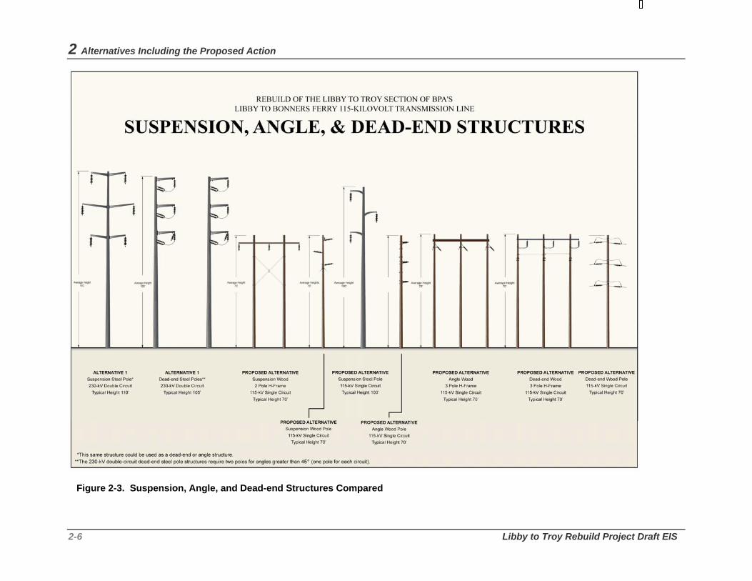
2 Alternatives Including the Proposed Action
2-6 Libby to Troy Rebuild Project Draft EIS
Figure 2-3. Suspension, Angle, and Dead-end Structures Compared

Bonneville Power Administration 2-7
Structure Footings New structures would be constructed in existing holes where possible although some new holes may be needed. New footing holes would either be hand dug (in the inaccessible areas), augered, or dug with a small backhoe excavator, depending on subsurface conditions. The wood or steel poles would be placed directly in the holes (direct-embedded) and then backfilled with native material or gravel (crushed rock). Concrete could be used as backfill for dead-end structures. At each structure site, an area of approximately 75 feet by 75 feet would be temporarily disturbed during construction, depending on the terrain and structure type. An average area of 15 feet by 15 feet would be permanently occupied by structures without guy wires and about 30 feet by 50 feet for structures with guy wires.
Fiber optics Fiber optic cable is used for communications as part of the power system. Fiber optics technology uses light pulses instead of radio or electrical signals to transmit messages. This communication system can gather information about the system (such as the line in service and the amount of power being carried, meter reading at interchange points, and status of equipment and alarms). The fiber optic cable allows voice communications between power dispatchers and line maintenance crews and provides instantaneous commands that control the power system operation. Although there is no operational need at this time to install fiber optic cable between Libby and Troy substations, BPA would provide space on the transmission structures for future BPA installation should the need arise. The fiber cable would be less than one inch in diameter and mounted on the transmission structures. On single-pole structures (wood or steel) the cable would be about two feet below the conductor and the structures would be about five feet taller than the existing single-pole structures. On H-frame structures, the fiber cable would be mounted above the conductor on the cross arm next to one of the poles. Typically these structures would not be taller.
2.2.3 Conductor, Fiber Optic Cable, and Pulling/ Tensioning Sites
The steel-reinforced aluminum wires that make up transmission lines are called conductors. The conductors carry the electrical current and are approximately one inch in diameter. Alternating-current transmission line circuits, which are proposed for this project, require three conductors, each of which is referred to as a "phase." The single-circuit structure would hold three conductors or one circuit. The conductors are not covered with insulating material as are those on, for example, electrical appliances, but are physically separated from one another on the transmission structure. Air serves as the insulating material. For purposes of aesthetics, the conductors for the proposed transmission line would be dulled to reduce the shininess of the metal.
Conductors are attached to the structures using insulators (Figure 2-4). Insulators are bell-shaped devices that prevent electricity from jumping from the conductors to the structure and going to the ground. The proposed project would most likely use a combination of ceramic and non-ceramic polymer insulators.
For safety reasons, the National Electric Safety Code (NESC) establishes minimum conductor heights. Based on its experience with issues of safety and landform variation, BPA exceeds NESC minimums of 19.5 feet for 115-kV construction; for most of the proposed line, the conductor must be at least 24 feet from the ground. Additional clearance would be provided over highway, railroad, or river crossings.
Two smaller wires (0.5-inch diameter), called overhead ground wires, would also be attached to the top of the transmission structures for about a half mile out of the Libby and Troy substations at either end of the

2 Alternatives Including the Proposed Action
2-8 Libby to Troy Rebuild Project Draft EIS
line to protect the substations from lightning damage; they might also be strung in other areas of high lightning exposure. The ground wires are strung from the top of one structure to the next. When lightning strikes, the ground wire takes the charge instead of the conductors. A series of wires, called counterpoise, is buried in the ground at each structure that carries a ground wire to establish a low resistance path to earth for lightning. They are made of either aluminum or copper and are buried about two feet deep.
Figure 2-4. Insulator Types
A fiber optic cable may be installed either as the overhead ground wire or independently on the structure. If fiber optic cable is installed, every 3 to 5 miles there would be a splice box/reeling location for the stringing and tensioning of the fiber optic cable. Splice boxes provide a connection point for the reels of cable and would be located on the structures. An area approximately 1/4 acre in line with the conductors would be temporarily disturbed by a fiber optic reel truck and tensioning equipment, which would be in the same location as the conductor pulling and tensioning sites.
Every two to three miles a conductor pulling and/or tensioning site is needed, where trucks pull the conductor to the correct tension. These temporary sites typically disturb an area of about one acre. A relatively flat area is needed; depending on conditions, the site could be graded, crushed rock with fines could be placed, and/or the area reseeded.

Bonneville Power Administration 2-9
2.2.4 Vegetation Clearing Most of the vegetation within the existing corridor consists of low-growing shrubs or young trees. Because most of the existing corridor is 80 feet wide, additional clearing of tall-growing vegetation within the proposed corridor would be minimal.
On either side of both the existing and new corridor, danger trees4 that pose a hazard to construction activities and reliable operation of the transmission line would be removed. During construction, low-growing plant communities would be protected as much as practicable and promoted as the basis for ongoing vegetation management following construction. Clearing would take into account line voltage, vegetation species height and growth rates, ground slope, conductor location, span length which influences conductor swing, stringing requirements, and the clearance distance required between the conductors and other objects.
Clearing at structure sites may occur at the same time as corridor clearing. Where necessary for construction access, an area adjacent to each structure would be graded to form a level working surface, except in areas where terrain or the presence of sensitive resources does not permit such an activity.
2.2.5 Access Roads Access roads are the system of roads that BPA’s construction and maintenance crews would use to get to the structures or structure sites along the line. The roads are designed to be used by cranes, excavators, supply trucks, boom trucks, bulldozers, backhoes, and maintenance trucks.
Much of BPA’s road system for the existing corridor would be used for rebuilding the line, although it would need to be improved in most areas. Existing access roads either run parallel to the existing line or originate off state highways, county roads, private roads, or USFS roads. Many of the structures located along the historic Highway 2 section and a few located along the north side of the Kootenai River are inaccessible except by helicopter.
The proposed transmission line rebuild would require the following:
• Approximately 20 miles of existing access road on and off the existing transmission corridor would need to be improved.
• Approximately 4.5 miles of new access road on and off the existing corridor would need to be constructed.
Improvement and construction would consist of the following activities:
• Widening existing roads.
• Installing or improving an estimated 210 culverts, drain dips and water bars.
4 A danger tree is a tree located off the right-of-way that is a present or future hazard to the transmission line or substation. Danger trees can be either stable or unstable. A tree would be identified as a danger tree if it would contact BPA facilities should it fall, bend, grow within a swing displacement of the conductor, or grow into the conductor. There is no fixed schedule for danger tree clearing as removal would be in response to environmental conditions such as root rot, insect infestation, or land management activities.

2 Alternatives Including the Proposed Action
2-10 Libby to Troy Rebuild Project Draft EIS
• Installing two bridges, one at Burrell Creek and one at China Creek.
• Constructing an access road for bridge approaches to China Creek.
• Clearing and disposal of brush and trees.
• Soil excavation and embankment placement for new roads (except roads constructed west of the gate at the end of Kootenai River Road).
• Placing sub-grade reinforcement material (approximately 20,000 cubic yards).
• Placing crushed rock (approximately 40,000 tons).
To protect cultural resources, access road construction and improvement in the area west of the gate at the end of Kootenai River Road would be accomplished primarily by hauling and placing borrow sub-grade reinforcement (fill) material and not by normal soil cutting and filling practices. Normal cut and fill practices could damage or disturb subsurface deposits of cultural materials. Excavation would be required at the two bridge sites, at culvert installation sites, and to remove stumps within the roadbeds.
New and existing access roads would be graded and/or rocked to provide a 14-foot-wide travel surface with about an 18- to 20-foot-wide travel surface on curves. Clearing and construction activities for new access roads would disturb an area approximately 10 feet wide along each side of the road for a total disturbance width of 40 feet (including drainage ditches). If tree roots are present in the cleared area, or if drainage and embankment construction work is required, the disturbance area could be greater than 40 feet. The roads would be surfaced with crushed gravel.
Where BPA needs to acquire rights for access roads, a 50-foot-wide easement would be acquired for new roads and 20-foot-wide easement would be acquired for existing roads. The 50-foot-wide easement allows the agency to cut and remove trees and build road cuts and fills, which it does not need to do on existing roads. New roads would be located wherever possible within the corridor to avoid additional vegetation removal. However, some roads would need to be constructed outside of the corridor because of topographical or environmental conditions.
The bridges planned for the Burrell and China creek crossings would be single-lane Modular Steel Vehicle Bridges placed on driven pilings and poured-in-place or pre-cast concrete abutments. These bridges can have asphalt, concrete, or treated timber running surfaces. Guard rails for the bridges would be constructed from galvanized or weathering steel. Wing walls and roadbed fill retaining structures would be designed to fit specific site conditions.
One alternative has been developed for a narrow turn that presents a barrier for safe passage of large construction equipment along the existing access road approximately 1,200 feet west of the gate at the end of Kootenai River Road. BPA proposes to widen the roadbed by placing rock gabions at the road/river edge and at the toe of rock slides above the road. Placing rock next to the Kootenai River at the edge of the road may require federal and/or state permits but eliminates the need to remove rock from the face of Black Eagle Rock (see Section 3.8, Cultural Resources).
2.2.6 Removal of Existing Wood-Pole Structures In most cases, the 186 existing wood pole structures would be removed using a backhoe or line truck/crane and would be disposed of by the contractor according to the regulations required for handling hazardous materials (see Section 4.23, Pollution Control Acts). In culturally sensitive areas such as the

Bonneville Power Administration 2-11
Kootenai Falls area, the poles would be cut off at the ground line and transported off site via trailer or helicopter (see Section 3.8, Cultural Resources).
2.2.7 Staging Areas Temporary staging areas would likely be set up at both the Troy and Libby ends of the project to store materials and construction equipment. However, no staging areas will be located along the Sheep Range Road because the road is in a culturally sensitive area. BPA or the contractor hired to rebuild the transmission line would be responsible for determining appropriate staging area locations in cooperation with the landowner or manager. Often the contractors rent empty parking lots or already developed sites for staging areas. The contractors would also be responsible for working with state and local governments to obtain any required permits for the staging areas, although BPA would survey all staging areas and helicopter fly yards for cultural and natural resources. See Chapter 3 for details of surveys, impacts, and mitigation measures.
2.2.8 Construction Schedule and Work Crews Construction would occur during one season (between May and November 2008). One or more construction crews would clear vegetation, improve/construct access roads, and construct the line. A typical construction crew would have the following:
• 10 to 25 construction workers • 10 vehicles (pickups, vans) • 4 bucket trucks • 2 line trucks with cranes • 1 reel machine • 2 large excavators • 1 line tensioner • 1 helicopter • 2 all terrain vehicles • 1 water truck • 3 water buffalo trucks for fire protection5.
A typical crew can usually construct about 10 miles of transmission line in 3 months. In the inaccessible areas along historic Highway 2 and north of the Kootenai River, construction could take longer due to difficult terrain and limited access.
Helicopters could be used for clearing and would be used intermittently for 6 to 7 months during removal of the existing line and construction of the new line. A small helicopter would be used to remove wood poles in inaccessible areas and for stringing the sock line (see Section 2.7 for a description of the process).
5 A water buffalo is a 500 gallon tank that sits on a small trailer that is pulled by a truck.

2 Alternatives Including the Proposed Action
2-12 Libby to Troy Rebuild Project Draft EIS
2.2.9 Maintenance and Vegetation Management During the life of the project, BPA would perform routine, periodic maintenance and emergency repair of electrical equipment, structures, and conductors.
Routine patrol is typically accomplished by helicopter. Lines are flown on an average of once every 3 to 4 months. Helicopter teams look for damaged insulators, damaged support members, washed-out roads, hazardous vegetation, encroachments and other hazardous material on the right-of-way. Aerial inspections are followed by annual ground inspections for each line.
Vegetation control and soil stabilization are two main components of the maintenance program. Tall-growing vegetation is regularly removed from the corridor and from around structures so as not to interfere with the conductors. Access roads are graded, seeded, ditched, and rocked, in order to reduce soil erosion as needed. In an effort to maintain native low growing vegetation, grass is not removed while brush within the road bed and on each side is mowed. Branches from roadside trees that could affect vehicle traffic are also removed.
BPA’s vegetation management would be guided by its Transmission System Vegetation Management Program EIS (BPA 2000). BPA uses an integrated vegetation management strategy for controlling vegetation along transmission line rights-of-way. This strategy involves choosing the appropriate method for controlling the vegetation based on type of vegetation and its density, the natural resources present at a particular site, landowner requests, regulations, and costs. BPA may use a number of different methods: manual (hand-pulling, clippers, chainsaws), mechanical (roller-choppers, brush hogs), biological (insects or fungus for attacking noxious weeds), and herbicides.
Prior to controlling vegetation, BPA sends notices to landowners and requests information that might help in determining appropriate methods and mitigation measures (such as herbicide-free buffer zones around springs or wells). Noxious weed control is also part of BPA’s vegetation management program. BPA works with the county weed boards and landowners on area-wide plans for noxious weed control.
2.2.10 Estimated Project Cost The estimated cost for rebuilding the Libby to Troy transmission line as a 115-kV single-circuit line is approximately $17 million. Annual maintenance costs would be about $10,000 to $20,000.
2.3 Alternative 1 – 230-kV Double-Circuit Rebuild Under Alternative 1, BPA would rebuild the Libby to Troy transmission line as a 230-kV double-circuit transmission line for its full 17-mile length.
2.3.1 Line Routing and Corridor Additional transmission line right-of-way easements and permitted areas would need to be acquired to accommodate a 230-kV transmission line. BPA standards require that 230-kV transmission lines have a minimum 100-foot-wide cleared right-of-way. This means that BPA would need to acquire an additional 10 to 20 feet from each edge of existing right-of-way easement (on private, county, state, and tribal lands) or permitted area (on National Forest and former Great Northern Railroad lands) so that the cleared width would extend 50 feet each side of the center conductor, for a total right-of-way easement width or permitted area width of 100 feet. These areas are specifically identified in section 2.2.1. The additional

Bonneville Power Administration 2-13
right-of-way easements or permitted areas acquired would give BPA the rights to construct, operate, rebuild, access, and maintain the line.
2.3.2 Transmission Structure Design The structures for the proposed 230-kV rebuild would be single tubular steel pole structures 90 to 110 feet tall with spans of 800 to 900 feet between structures (Figure 2-2). The steel in the structures would be colorized a dark gray to blend with the surrounding environment as much as possible. About 120 transmission structures would be needed to carry the conductors for this alternative.
All three types of structures (suspension, angle, and dead-end) would consist of two tubular sections that are connected about halfway up the structure with a slip joint. Dead-end structures are connected to the concrete base by a flange connection. Suspension structures are connected to the base by a slip-joint connection or a flange connection, depending on foundation type. The diameter at the bottom of all structure types would be about 3 to 5 feet. Davit arms, which hold the insulators and conductor, would be bolted into sleeves at a height that provides the appropriate conductor spacing. Voltage would determine spacing of the davit arms relative to one another.
Exact tower heights and spans along any line may change depending on terrain, requirements for highway, railroad, and river crossings, or other factors.
Structure Footings Two types of footings would be used for the 230-kV rebuild, depending on the terrain and tower type:
• Concrete shaft footings would be used for dead-end structures and for some angle suspension structures in areas where digging is relatively easy. They consist of an 8-foot diameter hole that is 25 to 30 feet deep. Holes are drilled and steel anchor rods are secured within the hole with concrete.
• Direct-embedded footings would be used for suspension structures, and for angle suspension structures with slight angles, in areas where digging is relatively easy. An approximate 5-foot diameter hole is augered for the structure base. Backfill (excavated material or select backfill material) is placed around the edge of the hole and compacted to hold the base in place. The augered holes are about 15 - 25 feet deep.
Footing holes would either be hand dug, drilled or augered, or dug with an excavator, depending on subsurface conditions. At each structure site, an area of approximately 100 feet by 100 feet would be temporarily disturbed during construction, depending on the terrain and type of structure. An average area of 10 feet by 10 feet would be permanently occupied by the structure.
2.3.3 Conductor, Fiber Optic Cable and Pulling/Tensioning Sites
The 230-kV double-circuit structures would hold six conductors on two circuits. The conductors for the proposed transmission line would be dulled to reduce the shininess of the metal. Conductors are attached to the 230-kV structures in the same manner as the 115-kV single-circuit alternative, with approximately the same number and size of pulling/tensioning sites required. Ground wires and counterpoise would be installed with this alternative as described in Section 2.2.3. The structures also could accommodate fiber optic cable, as for the 115-kV alternative.

2 Alternatives Including the Proposed Action
2-14 Libby to Troy Rebuild Project Draft EIS
For safety reasons, the National Electric Safety Code establishes minimum conductor heights. For 230-kV steel-pole construction (as is proposed), the conductor must be at least 26.5 feet from the ground. Additional clearance would be provided over highway, railroad, or river crossings.
2.3.4 Vegetation Clearing Because the existing corridor would need to be widened to 100 feet to accommodate the higher voltage line, all tall-growing vegetation on the additional right-of-way and permitted areas would be cleared except where they would not interfere with construction or operation of the line. Additionally, danger trees located outside the 100-foot right-of-way would also be cleared.
2.3.5 Access Roads, Staging Areas, Removal of Existing Structures, Maintenance and Vegetation Management
The 230-kV rebuild alternative would require the same work on existing and new roads as for the 115-kV alternative. Temporary staging areas, wood pole removal processes, and maintenance activities also would be the same.
2.3.6 Construction Schedule and Work Crews The construction schedule would be similar to that of the Proposed Action.
2.3.7 Estimated Project Cost The estimated cost for rebuilding the Libby to Troy transmission line as a 230-kV double-circuit line is $30 million. Annual maintenance costs would be about $7,000 to $9,000; less than those under the Proposed Action because steel structures would require less maintenance. The cost savings for reduced electrical line losses from having two sets of conductors for the double-circuit 230-kV alternative would not be significant enough to offset maintenance costs for this alternative.
2.4 Short Realignment Options Because BPA has an existing corridor for the Libby to Troy transmission line, the agency could rebuild the line within this corridor for its entire length, as described in Sections 2.2 and 2.3. However, BPA is considering realignment of the corridor in three locations. The following subsections describe each of the three possible realignment options.
The realignment in any of these three locations could be built at either 115 kV or 230 kV, depending on whether the Proposed Action or Alternative 1 is selected. The locations of each realignment option would be the same under either alternative, but if the 230-kV alternative is chosen, there would be fewer, but taller, structures and they would be sited in different locations from those in the Proposed Action due to the longer allowable spans for steel pole structures. Table 2-2 summarizes the engineering characteristics for each of the realignment options at both voltages.
All tall-growing vegetation on the three potential realignments within the 80- to 100-foot new corridor would be cleared (a distance of 40 to 50 feet from the structure centerline to the edge of the corridor), except in areas where the vegetation would not interfere with construction or operation of the line. Such areas can include where the line crosses stream valleys, but stringing the conductor during construction

Bonneville Power Administration 2-15
could require cutting or topping some trees even in these places. Merchantable timber would be removed using conventional logging practices. Line construction roads normally would be used to haul the logs, but if the contractor preferred to use other roads (“convenience roads”), they would first need to be reviewed and approved by BPA, and by the USFS on USFS land.
Table 2-2. Summary of Engineering Characteristics for Realignment Options
Characteristic Pipe Creek Quartz Creek Kootenai River Voltage 115 kV 230 kV 115 kV 230 kV 115 kV 230 kV Line length 0.8 mi. 0.8 mi. 2.9 mi. 2.9 mi. 0.9 mi. 0.9 mi. Corridor width 80 ft. 100 ft. 80 ft. 100 ft. 80 ft. 100 ft. Acres of new corridor needed
8.3 10.4 28 35 10 12.7
Structure style and material
Single-circuit wood H-frame
Double-circuit colorized steel, single-pole
Single-circuit wood H-frame
Double-circuit colorized steel, single-pole
Single-circuit colorized steel, single-pole; colorized steel 3-pole H-frame
Double-circuit colorized steel, single-pole
Structure height
60-80 ft. 90-110 ft. 60-80 ft. 90-110 ft. 60-105 ft. 90-110 ft.
Span length 600 ft. 800-900 ft. 600 ft. 800-900 ft. 600-900 ft. 800-900 ft. Number of new structures
7 6 22 18 7 7
Area occupied by each structure
225 sq. ft. (unguyed); 1500 sq. ft. (guyed)
100 sq. ft. 225 sq. ft. (unguyed); 1500 sq. ft. (guyed)
100 sq. ft. 100 sq. ft. (single pole); 1500 sq. ft. (H-frame)
100 sq. ft.
Number of structures removed on existing corridor
0 (upper portion of existing structures would be removed)
0 (upper portion of existing structures would be removed)
19 19 9 9
Miles of new access road
0.5 mi. 0.5 mi. 1.6 mi. 1.6 mi. 0.2 mi. 0.2 mi.
Miles of new road on existing corridor not needed
0.16 mi. 0.16 mi. 0.57 mi. 0.54 mi. 0.12 mi. 0.12 mi.
Miles of access roads needing improvement
0.3 mi. 0.3 mi. 2.2 mi. 2.2 mi. 0.06 mi. 0.06 mi.
Miles of road improvement on existing alignment not needed
0.0 mi. 0.0 mi. 1.51 mi. 1.51 mi. 0.67 mi. 0.67 mi.
Number of new bridges
0 0 0 0 0 0
Extra cost to construct
$221,000 $420,000 $366,000 $1 million $75,000 $43,000

2 Alternatives Including the Proposed Action
2-16 Libby to Troy Rebuild Project Draft EIS
2.4.1 Pipe Creek Realignment BPA identified this potential realignment to minimize impacts to private properties located along Kootenai River Road. The realignment would involve acquisition and development of a new segment of transmission line corridor in the vicinity of Pipe and Bobtail creeks (Figure 2-5). Heading northwest from the existing structure 17/13, this realignment would cross Pipe Creek to a new angle structure. The realignment would then cross Bobtail Road and Bobtail Creek and rejoin the existing transmission corridor at existing structure 18/11. This realignment would be located on both private and Kootenai National Forest lands (see Section 3.2).
Under the 115-kV option, the Pipe Creek realignment would be constructed as a single-circuit wood H-frame line with structures approximately 60 to 80 feet tall (Figure 2-2). Average span length (distance) between structures would be 600 feet. Approximately 7 new structures would be constructed to accommodate the realignment. Right-of-way 80 feet wide would be needed to construct this realignment at 115-kV. At 230-kV, approximately 6 double-circuit, single-pole structures of colorized steel would be needed. Poles would be 90-110 feet tall, span lengths would be 800-900 feet, and right-of-way 100 feet wide would be needed.
If this realignment is used, on the existing corridor between existing structures 17/14 and 18/7, the upper portions of the wood poles that support BPA’s transmission line through that area would be removed, leaving the lower sections to support an existing electrical distribution line that serves the residential area along Kootenai River Road. BPA would relinquish easement rights or transfer them to FEC, and would remove the conductor and cross arms. From structures 18/7 to 18/10, the entire structures would be removed and the easements abandoned.
Approximately 0.3 miles of existing road would need to be improved (bladed and rocked) for the Pipe Creek realignment. Approximately 0.5 miles of road would need to be constructed to access the new structures along the Pipe Creek realignment. Some temporary or construction agreement roads (roads that are proposed by the construction contractor to facilitate the construction process) may be needed for removal of abandoned structures in miles 17 and 18. All temporary or construction agreement roads would be reviewed and approved by BPA, and by the USFS on USFS land.
Approximately 7.4 acres of tall-growing vegetation would be cleared to accommodate a 115-kV single-circuit transmission line on new right-of-way, and approximately 9.4 acres would be cleared for a 230-kV double-circuit line. This amount is less than the actual right-of-way needed because some areas along the realignment on private land have already been cleared. In addition, to protect the trees adjacent to the realignment from insects and fire, some of the timbered stands adjacent to the realignment would be thinned approximately 150 feet out from the edge of the corridor. Thinning entails removal of the less disease-resistant trees, which improves the overall health of the stand. Merchantable timber would be removed using conventional logging practices.
2.4.2 Quartz Creek Realignment This possible realignment was suggested during the scoping phase by individuals concerned about impacts to residents in the Big Horn Terrace area. It would involve acquisition and development of a new segment of transmission line right-of-way in the vicinity of Quartz Creek (Figure 2-6). Beginning east of Quartz Creek Road between structures 19/3 and 19/4, the line would head northwest to an angle structure on the east side of the Quartz Creek drainage. The line would then cross high above Quartz Creek to the saddle located west of the Quartz Creek drainage. From there the line would travel southwest to rejoin

Bonneville Power Administration 2-17
the existing line at existing structure 21/5. This realignment would be located on both private and Kootenai National Forest lands (see Section 3.2).
The Quartz Creek realignment would be designed the same as the Pipe Creek realignment option, depending on which voltage is chosen (Figure 2-2). For the 115-kV option, approximately 22 new structures would be constructed to accommodate the realignment on new 80-foot-wide right-of-way; approximately 18 structures would be needed for the 230-kV option with a right-of-way width of 100 feet. Approximately 19 structures would be removed between existing structures 19/4 and 21/4 from the existing corridor in the Big Horn Terrace area, and BPA’s easement rights would be relinquished.
Approximately 2.2 miles of existing road would need to be bladed and crushed rock added to the surface, and approximately 1.6 miles of new road would need to be constructed, primarily on the corridor, to access the realignment. Some additional access road work may be needed to remove structures from the existing alignment.
Approximately 26 acres of tall growing vegetation along with individual danger trees would be cleared to accommodate a 115-kV single-circuit transmission line on new right-of-way and approximately 32 acres would be cleared for a 230-kV double-circuit line. This amount is less than the actual right-of-way needed because some areas along the realignment have already been cleared.
2.4.3 Kootenai River Crossing Realignment BPA identified this possible realignment to minimize visual, cultural, and fish and wildlife impacts to the Kootenai Falls area of the Kootenai River (Figure 2-7). Not only is the existing line visible from a culturally sensitive site near Kootenai Falls, but there is also no access to the existing line between structures 25/6 and 25/8 due to a wash-out in 1996 at China Creek. Beginning at a new location between existing structures 25/1 and 25/2, the proposed alignment would turn at an angle structure and head southwest across the Kootenai River to an intermediate structure (between the two angle structures) on the north side of Highway 2 and then to an angle structure on the south side of Highway 2. The intermediate structure would provide additional conductor clearance over the river and Highway 2. The realignment would then travel northwest along the south side of Highway 2 for about ¾ miles to rejoin the line near existing structure 26/1. This realignment would be located on Lincoln County and Kootenai National Forest lands and within the BNSF railroad right-of-way and the Montana Department of Transportation road right-of-way (see Section 3.2).
The Kootenai River Crossing realignment would be designed the same as the other two realignment options, depending on the voltage chosen (Figure 2-2). Approximately 7 new structures for both the 115-kV and 230-kV would be constructed to accommodate the realignment on new 80- to 100-foot-wide right-of-way, which would be acquired as easements and permits. Nine structures on the existing corridor between existing structures 25/2 and 25/10 would be eliminated, seven of which are on the north side of the Kootenai River.
Approximately 300 feet (0.06 mi.) of existing road would need to be improved and about 820 feet (0.2 mi.) of new road would need to be constructed for the Kootenai River Crossing realignment. This new road footage includes new approaches to Highway 2. Some road work also might be needed to remove existing structures on the north side of the Kootenai River. If the new river crossing is used, a bridge over China Creek and access road improvements from structures 25/1 to 25/8 would not be needed.
Approximately 2.6 acres of tall growing vegetation along with individual danger trees would be cleared to accommodate a 115-kV single-circuit transmission line on new right-of-way; 3.2 acres plus danger trees

2 Alternatives Including the Proposed Action
2-18 Libby to Troy Rebuild Project Draft EIS
would be cleared for the 230-kV option. This amount is less than the actual right-of-way needed because some areas along the realignment have already been cleared.
2.5 No Action Alternative For the No Action Alternative, BPA would not rebuild the Libby-Troy transmission line. The existing line would remain in place in its current location, and none of the realignment options would be implemented. BPA would continue to attempt to maintain the existing line as its aged and rotting wood poles and cross arms deteriorate and its corroded conductor fittings fail. The increased risk of fire would continue, as demonstrated by the 2003 fire caused by a conductor that fell due to a failed fitting.
Because of these conditions, it is reasonably foreseeable that under the No Action Alternative, BPA would be required to conduct continual maintenance of the line to keep it operable. It might be possible to plan some of this maintenance, but it is expected that the majority of repairs would occur on an emergency basis as various parts of the line continue to deteriorate. In addition, it is reasonable to expect that as the line structures and conductor fittings continue to fail on an intermittent basis, BPA would not be able to provide generally reliable electric service to customers in Libby and Troy under this alternative.
When the reasonably foreseeable failure of line structures and conductor fittings occurs under this alternative, BPA would need to undertake various maintenance actions to repair the failed portion of the line. These actions could include:
• Accessing the failed portion using the shortest and easiest route.
• Using helicopters to access portions of the line that are inaccessible by vehicles.
• Removing or damaging trees or brush on the corridor as a result of emergency access or repair work.
• Disturbing and compacting soil at repair sites.
• Emergency installation of a new pole or poles off the existing corridor to “shoe-fly” or loop around a portion of the line that fails.
2.6 Alternatives Considered but Eliminated from Detailed Study
Since transmission planning studies began in 2004, BPA has examined a wide range of alternatives, developed initially by agency staff or later in response to concerns raised by others. BPA assessed whether each alternative was reasonable under NEPA and thus merited detailed evaluation in this EIS, or was not reasonable and thus could be eliminated from detailed study.
BPA considered several factors in making this assessment of potential alternatives:
• whether the potential alternative would meet the need and purposes identified for the Proposed Action in Chapter 1;

Bonneville Power Administration 2-19
• whether the alternative would be practical and feasible from a technical and economic standpoint and using common sense, consistent with CEQ Guidance on assessing the reasonableness of alternatives;6 and
• whether the alternative would have unacceptable environmental effects. Alternatives that did not meet the stated need and purposes, were not practical or feasible, or would have unacceptable environmental effects were eliminated from detailed study in this EIS. This section summarizes the alternatives that were considered and why they were eliminated from detailed study. They are grouped in the following categories:
• Alternative voltage/number of circuits
• Alternative transmission line routes considered in 1993 when work on this line was previously proposed
• Alternative transmission line realignment options
• Undergrounding of the transmission line
• Non-transmission alternatives
2.6.1 Alternative Voltage/Number of Circuits During project scoping, BPA initially included a proposal to rebuild the Libby to Troy transmission line as a 115-kV double-circuit transmission line. This alternative was proposed, as is the 230-kV double-circuit alternative, to provide additional transmission capacity in the event loads grow more than expected or additional generation is developed in the area. Because there are no forecasts for load growth beyond 1 percent per year or firm plans for increased generation in the area, there is no need for additional transmission capacity along the Libby–Troy line section. Even if the Libby – Troy section of the Libby – Bonners Ferry line were rebuilt to double circuit (either 115 kV or 230 kV), transmission capacity in the area would not increase until the entire corridor from Libby to Bonners Ferry and ultimately to Bell was rebuilt to double-circuit. Most of the Bonners Ferry to Sandpoint section of line was already reconstructed as double circuit 230 kV when additional generation was being planned for Libby Dam during the 1980s. Rebuilding the Libby – Troy section to 115 kV double circuit would not fit into the current system plan since portions of the corridor are already built for double-circuit 230 kV and a double-circuit 115 kV transmission line would only have half or less of the capacity of a double-circuit 230 kV line . Therefore, the 115-kV double-circuit transmission line was eliminated from detailed evaluation.
BPA did not propose a 230-kV single-circuit option because transfer of additional generation out of the area would require costly upgrades to 230 kV of the existing Libby, Troy, Moyie Springs and Yaak substations to allow for power to be delivered locally. Such upgrades could cost between three to five million per substation and would include additional equipment in the substations to deliver the power at 230-kV and then to transform it from that voltage to the lower voltages that connect with the local distribution system. Without the need for substantial amounts of additional power in the local area, such upgrades would not be cost effective.
However, BPA has analyzed the 230-kV double-circuit alternative because, in the event that generation at Libby Dam or load growth does increase, BPA would need to provide sufficient transmission capacity to
6 See Forty Most Asked Questions Concerning CEQ’s NEPA Regulations, 46 Fed. Reg. 18026 (Mar. 23, 1981) as amended, 51 Fed. Reg. 15618 (Apr. 25, 1986).

2 Alternatives Including the Proposed Action
2-20 Libby to Troy Rebuild Project Draft EIS
transfer power out of the area, and one of the two circuits could continue to be operated at 115-kV to deliver power locally without costly substation equipment upgrades.
2.6.2 1993 Alternative Transmission Line Routes In 1993, BPA identified a need to upgrade the transmission line between Libby and Bonners Ferry. A number of route combinations were proposed in a 1993 preliminary Draft EIS (BPA 1994). The Kootenai National Forest favored routes further to the north of the existing line in the Flagstaff Mountain area and to the south of the Kootenai River in the foothills of the Cabinet Mountains. All of these routing combinations included at least one line segment that had unworkable engineering constraints, such as the unstable slopes on the south slope of Flagstaff Mountain north of the Kootenai River and on the north slope of Grambauer Mountain to the south of Kootenai River. Locating the line on the top of Flagstaff Mountain would have exposed the line to extreme weather conditions and made emergency winter maintenance difficult, if not impossible. Therefore, the routing alternatives considered in 1993 have been eliminated from detailed evaluation in the current process because they are not technically feasible.
2.6.3 Alternative Transmission Line Realignment Options
In addition to the realignment options being considered in this EIS, several other options for realigning portions of the existing line were suggested during the most recent scoping process. For various reasons described below, these alternative realignment options have been considered but eliminated from detailed study in this EIS.
Moving the Quartz Creek crossing to the south One suggestion proposed moving the proposed Quartz Creek crossing further to the south to avoid having the line cross private land. Doing so would place the line across another parcel of private land and increase the visibility of the conductors from several properties, including that of the landowner proposing the move. The length of span required to cross the Quartz Creek canyon would exceed the capacity of steel pole structures proposed for this project and would require using two single lattice steel towers on the east side that would be taller than the proposed steel poles. The east side lattice towers would be taller because the steep terrain on the east side of Quartz Creek would require moving the location of the crossing structures further to the east to a suitable site. Lattice steel towers are more visible and require a greater disturbance area than steel poles. The longer span would result in greater sag7 that could require additional tree clearing, possibly to the bottom of Quartz Creek canyon. Additionally, the east crossing lattice towers and conductor would be more visible from Kootenai River Road and Highway 2 than the proposed realignment. Because this variation could result in greater visual impacts, increased cost, and potential increased tree clearing than the proposed alignment, this variation was eliminated from detailed evaluation in this EIS.
Moving the transmission line to the south side of Kootenai River Crossing near the City of Libby – Under this suggested realignment option, the Libby-Troy line would be realigned to cross the Kootenai River near Libby Substation and follow the Burlington Northern – Santa Fe (BNSF) Railroad right-of-way to a point that would meet with the alignment for the river crossing east of the Big Horn Terrace area discussed below. The transmission line would need to be sited on the south
7 Sag - The distance that the conductor droops below a straight line between adjacent points of support.

Bonneville Power Administration 2-21
side of the railroad tracks to provide uninhibited access during construction and for maintenance activities. Field review of this proposal revealed numerous commercial and private developments on the south side of the railroad tracks just west of the city of Libby that would have to be removed to provide for an adequate transmission line corridor. This realignment has been eliminated from detailed evaluation in this EIS because it would be economically infeasible to relocate the commercial and private developments located along this realignment option.
Crossing east of the Big Horn Terrace area – At a point east of the Big Horn Terrace, this suggested realignment would have the Libby-Troy line cross the Kootenai River to the south side of the river and then head west to Troy Substation. This realignment would use a combination of BNSF Railroad right-of-way, Montana Department of Transportation right-of-way and Kootenai National Forest land to the south of Highway 2. Field review revealed inadequate room to accommodate the railroad, Highway 2 and a transmission line for approximately one mile between this proposed river crossing and the proposed crossing west of the Big Horn Terrace area discussed below. Steep talus slopes and cut rock faces south of Highway 2 and the proximity of the railroad tracks leave inadequate space for a transmission line, making construction impossible in this area. Because it would not be technically feasible to construct this realignment option, it was eliminated from detailed evaluation in this EIS.
Crossing west of the Big Horn Terrace area – At a point west of the Big Horn Terrace, this suggested realignment would cross the Kootenai River to the south side of the river and then head west to Troy Substation. This realignment would also use a combination of BNSF Railroad right-of-way, Montana Department of Transportation (MDT) right-of-way and Kootenai National Forest land to the south of Highway 2. This realignment would require major construction on steep talus slopes, unstable steep slopes, and rock outcrops that would make this option technically and economically infeasible. Construction on steep slopes requires specific construction methods which are considerably more costly than construction in flatter terrain. In addition, numerous crossings of Highway 2 would need to occur. The MDT discourages multiple highway crossings of transmission lines because the placement of transmission structures near or within the road right-of-way increases the likelihood of vehicle collisions. Additionally, these crossings would result in greater visual impacts to views of the Kootenai River for westbound travelers. For these reasons, this option was eliminated from detailed evaluation in this EIS.
Use of the abandoned Northern Lights transmission line route – Although Northern Lights bought the 33-kV transmission line that ran from Lake Creek Powerhouse near Troy to the City of Libby in 1995, the line was never operated because Northern Lights had no electrical contracts to deliver power in the area. This line followed the south side of the Kootenai River and crossed to the north side at the west end of the Big Horn Terrace. Northern Lights abandoned the easement in 2005 after the line was retired. Most of the structures have been removed, although a few remain along Highway 2 and near the current Kootenai River crossing. BPA considered whether it could realign a portion of the Libby-Troy line to follow the former route of the Northern Lights line. Although the Northern Lights transmission line followed the highway and railroad rights-of-way west past the Kootenai Falls area, the line was a single-wood-pole, low-voltage transmission line which required a much smaller right-or-way or none at all. BPA’s proposed 115-kV line is a much higher voltage, and therefore many times larger, than the Northern Lights line. Use of the Northern Lights route thus would require extensive acquisition of additional right-of-way. In addition, the route for the Northern Lights line crossed Highway 2 numerous times between its river crossing and the Kootenai Falls area approximately five miles to the west. As stated above, MDT discourages multiple crossings of Highway 2 because traveler safety is decreased. Furthermore, the river crossing of the Northern Lights route is located in the same impassable section described above for the realignment option involving a crossing west of the Big Horn Terrace area. Therefore, because this

2 Alternatives Including the Proposed Action
2-22 Libby to Troy Rebuild Project Draft EIS
suggested realignment is impractical due to engineering and construction constraints, it was eliminated from detailed evaluation in this EIS.
2.6.4 Undergrounding the Transmission Line During the scoping process, some people suggested burying the transmission line. Underground transmission cables are highly complex when compared to overhead transmission lines and lower-voltage distribution cables used to deliver power to individual homes. For a 115-kV line, three individual cables would have to be manufactured and installed at a total cost of 5 to 10 times the cost of an overhead design.
Because costs are so high, BPA uses underground cable only in limited situations. Underground cables are considered where an overhead route is not possible, such as for long water crossings (e.g., in the San Juan Islands) or in highly developed urban areas. In addition, underground transmission cables used by BPA are short in comparison to typical overhead transmission lines. BPA’s longest underground transmission cable is a submarine cable that is nine miles long in the San Juan Islands.
In addition to significantly higher construction costs, installation and maintenance of underground transmission cables also result in much higher maintenance costs, and environmental impacts that are typically the same or greater than impacts associated with an overhead line. Installation of underground cable would require the use of large excavators and other heavy equipment to dig a continuous cable trench a minimum of ten feet wide and six feet deep to install the cables. All trees and brush would need to be cleared along this construction corridor. This construction activity would cause substantial surface and subsurface disturbance, soil erosion potential, potential impacts to cultural resources, and noise and air quality impacts along the transmission line route. In areas where bedrock is near the surface, construction would also require blasting, which would result in noise and air quality impacts not experienced during construction of overhead lines. In areas where the cables would cross waterbodies such as the Kootenai River, construction could require excavation in wetlands and riparian areas that could largely be avoided with an overhead transmission line. The cables that would be installed likely would be oil-filled, which would require above-ground termination and oil storage equipment at several locations along the line. This equipment would result in visual impacts.
Once the cables are installed, a permanent corridor approximately 50 feet wide would be required, with a continuous parallel access road along the route of the buried transmission line to allow necessary maintenance and repair of the cables. Repairs would require excavation along the affected reach. Because the cables would be underground, the cables would be more susceptible to damage and failure due to geological hazards such as seismic activity, landslides, and soil erosion. Failures also can result from aging of the cables, heat stress, and a variety of other external and internal causes. In addition, because the cables would be buried, it would be much more difficult to locate failed or damaged cables, and service likely would take weeks or months to restore compared to the hours or days it takes to restore service on an overhead line.
Underground cable remains a tool available for low-voltage distribution and for special high-voltage situations, but because of its high cost and environmental impacts, it is not considered a reasonable alternative to solve the high voltage transmission problem identified in Chapter 1. It therefore was eliminated from detailed evaluation.
Bonneville Power Administration 2-23
2.6.5 Non-Transmission Alternatives BPA considered whether there could be a solution to the problem identified in Chapter 1 that would not require rebuilding the Libby-Troy line. As part of this consideration, the proposed rebuild project was presented to the Non-Wires Solutions Panel in December 2005. This panel was formed in 2003 to assist BPA in determining whether non-transmission options can be used as viable alternatives to transmission line construction. The panel, which meets quarterly, is composed of representatives from BPA’s Energy Efficiency, Network Planning, and Customer Service Engineering departments as well as a mix of representatives from environmental groups, city and state government, and other utilities in the region.
After its review of the proposed Libby-Troy rebuild project, the consensus of the Panel was that this proposed project was not a candidate for a non-wires solution. The panel concluded that there is no other way to provide two sources of electrical power (a redundant power source) to the City of Libby or any other customer along this transmission corridor than having a safe and reliable transmission tie between Libby and Troy substations. While BPA’s Planning Reliability Criteria do not require redundant service, it is the agency’s preferred standard of service due to the increased level of reliability it provides. It is also the agency’s practice not to reduce the level of service to an area. The connection between Libby and Troy must be maintained in order to continue to provide redundant load service to the area. Without the line, the level of service would be reduced from redundant to radial. Use of non-transmission alternatives thus was eliminated from detailed evaluation in this EIS.
Some examples of non-transmission alternatives include: distributed generation (siting generation closer to the load so power does not have to be transmitted over the line in question); demand side management (reduces the load during peak demand times); general conservation (reducing load by using more energy efficient appliances).
2.7 Transmission Line Planning and Construction Process
This section describes the typical process used to plan and construct a transmission line and how it might apply under either the Proposed Action or Alternative 1. This process is presented in nine steps, from locating transmission tower structure locations to fitting the conductors on the towers. Some details of the process could vary, depending on numerous factors; this description is intended only to provide the reader with a general sense of what happens and when it happens in the process.
Step 1: To determine exact structure locations along the transmission line corridor, BPA first lays large Xs (photograph panels with exact coordinates) on the ground, takes photographs and gathers topographical data of the route from an airplane. These data are used to determine the profile of the ground. With the profile, engineers can determine where structures and access roads should be located, how tall structures should be, and how much right-of-way is needed. Engineers also use the environmental information and discussions with landowners to help determine structure and access road locations.
Step 2: Since vehicular access to the line along historic Highway 2 does not exist, BPA would prefer to use all terrain vehicles (ATV) for tree marking for corridor and danger tree clearing. ATVs would not be used to access individual structures as access is by foot or helicopter only. Most likely two ATVs would be used during tree marking for 12 to 15 days in the summer/fall of 2007. BPA would also prefer to use ATVs for various activities prior to and during construction. ATVs would not be used during the weekends, and BPA would work with the Kootenai National Forest to ensure no other vehicular traffic is

2 Alternatives Including the Proposed Action
2-24 Libby to Troy Rebuild Project Draft EIS
allowed on historic Highway 2, which is now a non-motorized trail. For the area on the north side of the Kootenai River behind the gate, BPA would need to use the Sheep Range Road to access that portion of the line.
Step 3: New corridor is cleared of vegetation that may hinder line safety or construction access and danger trees are removed (see previous discussion of vegetation clearing for details); however, for safety reasons, some clearing might be done later during structure placement, while the transmission line is de-energized. Access roads are built or upgraded.
Step 4: The existing transmission line is taken out of service and existing conductor and structures are removed. Existing poles are removed or poles are cut off at the ground level. In instances where the new structure is being placed in the same location as the old structure, the old pole is removed, and the hole is cleaned out by re-auguring to the proper depth and spacing for the new poles.
Step 5: New wood poles are transported to the structure sites on a large pole truck (similar to a logging truck), while steel poles are transported in sections on a flatbed truck. A small crane would be used to handle the poles. Delivery of poles for one structure may require more than one trip by a truck. Structures located in inaccessible areas along historic Highway 2 and along the north side of the Kootenai River along Sheep Range Road would be delivered by helicopter.
Step 6: Holes for structure footings are hand dug (in the inaccessible areas), augered, or dug with a small backhoe excavator at each structure site. Footing work for structures located along the historic highway, where no access exists, would most likely be facilitated by a helicopter and hand-operated tools.
Step 7: Wood or steel poles are lifted into place by a crane or helicopter.
Step 8: The conductor is strung from structure to structure through pulleys on the structures. A “sock-line” (a small, very light-weight rope or cable) is placed in the pulleys and pulled through by a helicopter. The sock-line is then attached to the “hard-line” (small steel cable), which is attached to the conductors and used to pull the conductors into place under tension so the conductors are not damaged by contact with the ground or vegetation.
Step 9: When one reel of conductor ends and a new one begins, the conductor has to be fitted together. There are two types of conductor fittings: hydraulic compression and implosive devices. Hydraulic compression uses a press that compresses the fittings on the conductor. With implosive fittings, an explosive device is set off with a sound like a gunshot, causing the fitting to tighten around the conductor to provide a solid connection. Three conductors would need to be fitted about once every 2 to 3 miles.
2.8 Comparison of Alternatives Table 2-3 compares the Proposed Action, Alternative 1, and the No Action Alternative, to the purposes of the project described in Chapter 1, Section 1.2. Tables 2-4 and 2-5 summarize the environmental impacts and mitigation for the action alternatives and short realignment options. Mitigation measures listed in Table 2-4 would also apply to impacts from the short realignment options listed in Table 2-5.
2.9 Agency Preferred Alternative BPA has evaluated the alternatives and realignment options, considered the purpose of and need for the proposed project, the affected environment, and environmental consequences, and based on these factors,

Bonneville Power Administration 2-25
BPA’s preferred alternative at this time is the Proposed Action (rebuild to single-circuit 115 kV) with the Kootenai River realignment option.
Table 2-3. Comparison of Alternatives to Project Purposes
Purpose Proposed Action Alternative 1 No Action Maintain transmission system reliability
Replacing the existing rotting and corroded 115-kV line with new structures and conductor at the same voltage would allow BPA to maintain reliable electric service to its customers.
Replacing the old line with a new double-circuit 230-kV line would provide the same system reliability as the Proposed Action.
Because the existing rotting and corroded 115-kV line would not be replaced, BPA would not be able to provide reliable electric service to its customers should the line fail; outages could be frequent.
Continue to meet BPA’s contractual and statutory obligations
The Proposed Action would provide adequate capacity to enable BPA to continue to meet contractual and statutory obligations for approximately 40 years.
Alternative 1 also would provide adequate capacity to enable BPA to continue to meet its contractual and statutory obligations, but for much longer into the future than the Proposed Action once the entire corridor is built for double-circuit 230 kV from Libby to Bonners Ferry, Sandpoint, and ultimately to Bell (approx. 160 miles).
The No Action alternative would continue to provide adequate capacity to enable BPA to continue to meet contractual and statutory obligations, but at a reduced level of reliability and for a much shorter period into the future than the Proposed Action.
Minimize environmental impacts (See Table 2-4 for details)
• By replacing an existing line in an already developed corridor, the Proposed Action minimizes environmental impacts compared to the clearing and disturbance required to construct a new line and access roads in an undisturbed area.
• The Proposed Action minimizes visual impact compared to Alternative 1 by using structures similar to those on the existing line.
• Additional clearing of vegetation along the corridor edges would be required to replace the existing line with a 230-kV line, disturbing a greater area than the Proposed Action.
• Alternative 1 would have a greater visual impact than the Proposed Action because structures would be taller and more visible from key viewpoints.
Under the No Action alternative, continual maintenance of the existing line would be required, including replacement of individual structures and fittings, which could cause environmental impacts from the possible emergency nature of the activities. Re-placement would take place over longer period of time with many entries into the area.
Minimize costs To construct: $17 million. To maintain: low for several years, then $10,000 - $20,000 annually; wood structures are more costly to maintain than the steel structures proposed for Alternative 1.
To construct: $30 million. To maintain: low for many years, then $7,000 - $9,000 annually; steel structures are less costly to maintain than the wood structures proposed for most of the Proposed Action. Reduced maintenance costs due to reduced electrical line losses are negligible compared to the preferred alternative.
$20,000 - $50,000 annually to maintain; the amount would increase until the line is abandoned or rebuilt. Unknown costs from fire or loss of service if the line fails could increase maintenance costs.

2 Alternatives Including the Proposed Action
2-26 Libby to Troy Rebuild Project Draft EIS
Table 2-4. Summary of Impacts of the Proposed Action, Alternative 1, and the No Action Alternative Potential Impacts
Proposed Action Alternative 1 No Action Alternative Mitigation Measures
Soils, Geology and Water Resources
• Approximately 4 acres would be disturbed for the removal of existing wood pole structures, with about 60 percent of the work in soils with low sediment delivery efficiencies.
• Construction of new structures would disturb about 6 acres of soils, with about 60 percent in soils with low sediment delivery efficiencies.
• Construction activities at the 12 proposed conductor tensioning sites would disturb approximately 2 acres of soils. Heavy equipment use and increased vehicular traffic would compact soils affecting soil productivity, reducing infiltration capacity, and increasing runoff and erosion.
• Construction of approximately 4.5 miles of new access roads would disturb about 15 acres of soils.
• Access road improvement on approximately 20 miles of existing roads would disturb about 80 acres of soils.
• The culvert in Burrell Creek would be replaced and a bridge would be constructed across China Creek both of which would disturb soils.
• Soil disturbance could increase sediment delivery to project area fish-bearing streams located near structures including: Pipe Creek (17/5 to 18/5), Bobtail Creek (18/8 to 18/13), Quartz Creek (20/2 to 20/4), and China Creek (25/5 to 25/6).
• Construction activities could contaminate water resources from accidental spills or leaks from construction equipment.
• Overspray of herbicides used for noxious weed control during maintenance activities could potentially affect surface water quality.
• Construction activities would remove danger trees and tall growing vegetation within the corridor potentially resulting in a slight increase in water yields in project area watersheds.
• Maintenance of the rebuilt line could result in localized soil disturbance and potential sedimentation due to vehicular traffic, possible future access road improvements, and vegetation management activities.
• Removal of wood poles under Alternative 1 would disturb the same amount of soils as the Proposed Action.
• Construction of new structures would disturb about 10 acres of soils, with about 60 percent in soils with low sediment delivery efficiencies.
• Construction activities at the 12 proposed conductor tensioning sites would have the same impact as the Proposed Action.
• Construction of new access roads and access road improvement would disturb the same amount of soils as the Proposed Action.
• Replacement of the culvert in Burrell Creek and installation of the bridge across China Creek would have the same impact as the Proposed Action.
• Soil disturbance from structure construction could increase sediment delivery to project area fish-bearing streams from wider clearing of the right-of-way.
• Similar to the Proposed Action, construction activities could contaminate surface water resources from accidental spills or leaks from construction equipment under Alternative 1.
• Similar to the Proposed Action, overspray of herbicides used for noxious weed control during maintenance activities could potentially affect surface water quality under Alternative 1.
• Construction activities would remove additional trees to widen the corridor to 100 feet and remove danger trees potentially resulting in a slight increase water yields in project area watersheds.
• Impacts from maintenance of the rebuilt 230-kV line would be similar to those under the Proposed Action.
• Current levels of disturbance to soils associated with ongoing maintenance activities for the existing transmission line corridor would continue. This would include localized soil disturbance, potential erosion, and soil compaction due to vehicular traffic, transmission structure replacement, vegetation management activities, and access road improvements.
• Impacts to water quality and flow volumes could result if existing transmission structures fail and require immediate repair. New access roads might be needed with little or no planning in their construction due to the emergency nature of the repairs.
• Prepare and implement a Stormwater Pollution Prevention Plan (SWPP) to lessen soil erosion and improve water quality of stormwater run-off. SWPP Plans are developed to prevent movement of sediment off-site to adjacent water bodies during short-term or temporary soil disturbance at construction sites. The plans address stabilization practices, structural practices and stormwater management.
• Comply with the terms and conditions of the permit issued under Section 404 of the Clean Water Act for discharge of dredged and fill material into waters of the United States.
• Comply with the terms and conditions of State of Montana permits for discharge of solid material, including building materials, into waters of the United States including a 318 Authorization under Montana’s Water Quality Act and a Montana Streambed Preservation Act 124 permit.
• Design access roads to control runoff and prevent erosion by using low grades, outsloping, intercepting dips, water bars, ditch-outs, or a combination of these methods.
• Properly space and size culverts, cross-drains, and water bars using methods described in the Kootenai National Forest Hydraulic Guide (USDA Forest Service 1990).
• Construct during the dry season (summer-fall) to minimize erosion, sedimentation, and soil compaction. • Minimize construction equipment use within 150 feet of a water body (stream, river or wetland). • Armor ditches, drain inlets and outlets with rock where needed for erosion control. • Conduct pre-construction assessments with construction personnel to determine appropriate site-specific
mitigation approaches to help reduce erosion and runoff, and to stabilize disturbed areas. • Surface all access roads with rock to help prevent erosion and rutting of road surfaces and to support vehicle
traffic. • Avoid construction on steep, unstable slopes if possible. • Deposit all unused excavated material in upland areas and stabilize.
• Avoid and minimize placement of excavated material in environmentally sensitive areas such as streams, riparian areas, or wetlands.
• Save topsoil removed for structure and new access road construction for onsite restoration activities to promote regrowth from the native seed bank in the topsoil. If contaminated, follow-up weed control would be needed.
• Cover exposed piles of soil with plastic or similar material to reduce erosion potential if there is a threat of rain. • Limit grubbing to the area around structure sites to lessen the impact on the roots of low-growing vegetation, so
they may re-sprout. • Avoid vegetation clearing at sides of existing access roads to the extent possible, to minimize impacts to adjacent
forested areas. • Cut or crush vegetation, rather than blade, in areas that will remain vegetated in order to maximize the ability of
plant roots to keep soil intact and prevent sediment movement offsite. • Install erosion control measures such as silt fence, straw mulch, straw wattles, straw bale check dams, and other
soil stabilizers. • Revegetate or reseed all disturbed areas with a native (where possible) plant/grass seed mixture suited to the site,
to promote vegetation that will hold soil in place. • Till or scarify compacted soils before reseeding where necessary as determined by applicable agencies. • Monitor erosion control BMPs to ensure proper function and nominal erosion levels. • Monitor revegetation and site restoration work for adequate growth; implement contingency measures as
necessary. • Minimize construction equipment access near Kootenai River and other stream bank areas. • Inspect and maintain project facilities, including the access roads, to ensure erosion levels remain the same or
less than current conditions. • Inspect and maintain tanks and equipment containing oil, fuel or chemicals for drips or leaks and to prevent spills
onto the ground or into state waters. • Maintain and repair all equipment and vehicles on impervious surfaces away from all sources of surface water. • Refuel and maintain equipment at least 200 feet from natural or manmade drainage conveyance including
streams, wetlands, ditches, catch basins, ponds, and pipes, and provide spill containment and cleanup. Utilize pumps, funnels and absorbent pads for all equipment fueling operations.

Bonneville Power Administration 2-27
Potential Impacts
Proposed Action Alternative 1 No Action Alternative Mitigation Measures
• Provide spill prevention kits at designated locations on the project site and at the hazardous material storage areas.
Land Use
• New corridor would be needed in some areas to provide an 80-foot corridor for the length of the line.
• Residents along Kootenai River Road near Bobtail Road would be affected by acquisition of new or additional right-of-way and removal or relocation of a garage, a barn, an outbuilding, and danger trees. The centerline of the transmission line would be moved closer to residences in this area.
• Residents within the Bighorn Terrace subdivision would be affected by danger tree removal.
• Residents who live west of Highway 56 would be affected by danger tree removal.
• Residents who live along the line would be affected by construction related impacts including noise, road closures, and decreased air quality.
• Residential areas along the corridor would be affected by altered public use on lands adjacent to their property or trespassing on their property as a result of the increased activity associated with reconstructing the transmission line, and possible increased public presence after construction.
• About 5 acres of Kootenai National Forest land would be converted from forest to transmission line in miles 15 to 17 to widen the corridor from 60 to 80 feet.
• About 0.3 acres of corridor clearing would occur in corridor mile 28 on private timber lands. Danger tree clearing would occur along the corridor edge in corridor miles 28, 29 and 30 also located on private timber lands.
• Short-term impacts to recreational use of the Kootenai National Forest land located along Sheep Range Road would occur during construction. Because Sheep Range Road would be used to access portions of the transmission line during construction, use of the road would not be allowed during construction to protect the safety of recreational users.
• New easement would be acquired on land owned by Lincoln County near Kootenai Falls.
• Danger tree clearing would occur on county owned land at Cliffside Park near the Bighorn Terrace subdivision.
• Danger tree clearing would occur on tribally owned land located along the historic Highway 2.
• Construction of about 0.6 miles of new road, danger tree clearing and access road improvement/construction would remove a small amount of cover/forage habitat for bighorn sheep, whitetail deer, and mule deer in the Kootenai Falls Wildlife Management Area.
• Danger tree clearing could occur in the Inventoried Roadless Areas (IRAs) located along the transmission line corridor.
• Additional and new corridor width would be needed along the entire 17 miles of existing transmission line to provide a 100-foot wide corridor under Alternative 1.
• Wider and new right-of-way would affect residents along Kootenai River Road near Bobtail Road. Removal of danger trees, a garage, a barn, and an outbuilding also would occur under Alternative 1. The centerline of the transmission line would be moved closer to residences in this area.
• Wider right-of-way and danger tree clearing in the Bighorn Terrace subdivision and west of Highway 56 would affect residents who live in these areas.
• Similar to the Proposed Action, construction related activities such as noise, road closures, and decreased air quality would affect landowners along the corridor under Alternative 1.
• Similar to the Proposed Action, use of public lands adjacent to private property or trespassing on private property as a result of project related activity could increase during and after construction.
• About 9.8 acres of Kootenai National Forest land would be converted from forest to transmission line in miles 15 to 17 to widen the corridor from 60 to 100 feet.
• About 8 acres of corridor clearing would occur in corridor mile 28 on private timber lands. Danger tree clearing would occur along the corridor edge in corridor miles 28, 29 and 30 also located on private timber lands.
• Impacts to recreational use from of the Kootenai National Forest land located along Sheep Range Road would be similar to those under the Proposed Action.
• New 100-foot wide easement would be acquired with corridor clearing on land owned by Lincoln County near Kootenai Falls.
• Similar to the Proposed Action, danger tree clearing would occur on county owned land at Cliffside Park near the Bighorn Terrace subdivision.
• Danger tree clearing and corridor clearing would occur on tribally owned land located along the historic Highway 2 as with the Proposed Action.
• Corridor clearing, danger tree clearing and construction of 0.6 miles of access road within the Kootenai Falls Wildlife Management Area would remove a small amount of cover/forage habitat for bighorn sheep, whitetail deer, and mule deer.
• Danger tree clearing would occur within the Inventoried Roadless Areas (IRAs) located along the transmission line corridor as with the Proposed Action.
• Impacts to the Kootenai Falls Cultural Resource District would be similar to the Proposed Action.
• No direct impacts on land use would occur.
• BPA’s use of access rights granted by the existing easement or special use permit might increase over time as the line requires more maintenance.
• Compensate landowners at market value for any new land rights required for clearing and right-of-way easements, or to construct new, temporary or permanent access roads.
• Compensate landowners for damage to property during construction and maintenance.
• Minimize or eliminate public access to project facilities through postings and installation of gates and barriers at appropriate access points and, at the landowner's request, on private property.

2 Alternatives Including the Proposed Action
2-28 Libby to Troy Rebuild Project Draft EIS
Potential Impacts
Proposed Action Alternative 1 No Action Alternative Mitigation Measures
• Replacement of structures, road improvement and construction of a bridge over China Creek would impact the Kootenai Falls Cultural Resource District by potentially disturbing archaeological sites.
Vegetation
• No impacts to ESA-listed (water howellia and Spalding’s catchfly) species or candidate species (linearleaf moonwort) are expected.
• Removal of old structures and construction of new structures would impact an estimated 350-700 individual Geyer’s biscuit-root (Forest Sensitive and Montana Species of Concern species). Construction of two of the new access roads has the potential to impact 150 or more individuals or subpopulations. One of the conductor tensioning sites would also disturb individual plants or subpopulations.
• Structure replacement and road construction would remove vegetation and expose bare mineral soil possibly increasing weed migration into potential Geyer’s biscuit-root habitat.
• No impacts to common clarkia (Forest Sensitive) are expected although habitat disturbance could occur.
• No impacts to Upswept moonwort (Forest Sensitive), wavy moonwort, and stalked moonwort (Forest Sensitive and Montana Species of Concern species) are expected although habitat disturbance could occur.
• Danger tree removal and construction of about 300 feet of access road to structure 18/11 would occur within the edge-affected area of the designated old growth stand near Bobtail Creek.
• Danger tree removal would occur within the edge-affected area of the designated old growth stand northwest of the Bighorn Terrace subdivision near structure 21/3.
• Weeds from existing access roads and rights-of-way would be transported by vehicles to un-infested areas potentially increasing weed spread within and adjacent to the corridor posing a high risk to adjacent susceptible plant communities, specifically those in the Kootenai River corridor and the north facing slopes. ATVs used to transport people and equipment into this area would increase the risk of weed spread.
• No impacts to ESA-listed (water howellia and Spalding’s catchfly) species or candidate species (linearleaf moonwort) are expected from Alternative 1.
• Impacts to Geyer’s biscuit-root from removal of old structures and construction of new structures would be the same as those under the Proposed Action.
• Wider right-of-way for Alternative 1 would remove more vegetation and expose a larger amount of bare mineral soil possibly increasing weed migration into potential Geyer’s biscuit-root habitat.
• No impacts to common clarkia (Forest Sensitive) are expected from Alternative 1 although habitat disturbance could occur.
• No impacts to upswept moonwort (Forest Sensitive), wavy moonwort, and stalked moonwort (Forest Sensitive and Montana Species of Concern species) are expected from Alternative 1 although habitat disturbance could occur.
• Alternative 1 would clear about 0.06 acres total of designated old growth habitat due to the greater clearing width needed for 230 kV. About 0.01 acres (436 square feet) within the 170-acre designated old growth stand near Bobtail Creek and about 0.05 acres (2,178 square feet) within the 35-acre designated old growth stand northwest of the Bighorn Terrace subdivision would be cleared.
• Similar to the Proposed Action, the potential for the spread of weeds on the existing and additional new right-of-way and roads from Alternative 1 would increase with disturbance.
• Impacts from operation and maintenance of Alternative 1 would similar to the Proposed Action. As with the Proposed Action, spread of weeds within the project area would result from vehicular travel and right-of-way vegetation management.
• Impacts from emergency maintenance or structure replacement could occur to populations of Geyer’s biscuit-root found within the existing corridor.
• Impacts to roadside native species and Geyer’s biscuit-root could occur from road spraying and weed spread.
• Existing access roads and rights-of-way would continue to support weed populations; seeds would be spread by road maintenance equipment, as well as by other administrative and recreational traffic. Existing weeds are expected to continue moving from roadways and rights-of-way into previously disturbed areas and adjacent big game winter ranges and riparian areas.
• Threatened and Endangered and Forest Sensitive Species: Cut or crush vegetation rather than blade, in areas that will remain vegetated in order to maximize the ability
of plants to resprout. (Mitigation measure also listed in Geology, Soils, and Water Resources Section.) Limit soil disturbance and mineral soil exposure during construction activities. Flag populations of Geyer’s biscuit-root for avoidance during construction.
• Old Growth: Implement timing restrictions as described in Section 3.5.3 Wildlife/Mitigation to minimize disturbance and
limit destruction of nests of birds that use old growth habitat and within bald eagle Nest Site Management Zones.
Mitigate for impacts to designated and undesignated (on the Pipe Creek and Quartz Creek realignment options) old growth stands by purchasing private lands or conservation easements on private lands with old growth characteristics that may otherwise be developed or cleared for other purposes. BPA would purchase the lands prior to clearing in old growth areas. Any lands acquired for bald eagle mitigation that meet the definition of old growth habitat will also be acceptable for meeting mitigation objectives for old growth habitat. Details of the mitigation plan will be described in the Biological Assessment for bald eagles being prepared for this project. Table 3-22 provides a summary of proposed old growth habitat mitigation acres by alternative.
• Noxious Weeds: Comply with federal, state and county weed control regulations and guidelines. Implement Forest Service Manual (FSM) 2080 Noxious Weed Management Prevention and control
measures on all Kootenai National Forest lands. See Appendix E. Use certified weed-free forage/mulch if available on all Kootenai National Forest lands in Montana (36 FR
261.50). Pressure or steam wash all equipment before entering the project area and when leaving discrete patches of
weeds. Flag or map weed populations prior to construction for avoidance. Clean vehicles after leaving those areas
to avoid spread of weeds. Seed and fertilize newly constructed and restored roads after use with seed that meets the requirements of
federal, state, and county weed control regulations and guidelines. Use certified weed-free straw for erosion control for all construction, reconstruction and restoration
activities. Treat and sign sites if new invaders are located and defer ground disturbing activities within those sites until
the weed specialist from Lincoln County or the Kootenai National Forest determines the site is no longer a threat, and approves those activities.
Follow site-specific guidelines for weed treatments within or adjacent to known sensitive plant populations. All future treatment sites will be evaluated for sensitive plant habitat suitability; suitable habitats will be surveyed as necessary prior to treatment.
Use the 1000 cubic yards of excess excavated material from 15/4 – 15/7 contaminated with spotted knapweed seed and other weed seeds in areas that have the same weed species. This material will not be used at sites relatively free of these species, such as the Pipe Creek, Quartz Creek, and Kootenai River Crossing realignments.
Treat the Dalmatian toadflax populations located east of structure 21/3 and at the Troy Substation on the Lake Creek road with herbicide prior to any activity, to reduce the potential for plants producing seed to be carried elsewhere.
Cooperate with Lincoln County for the treatment of the common tansy population from structure 26/1 to 26/9 with herbicide prior to any motorized travel to reduce the chance of spreading this species.
Wash ATVs and other off-road vehicles before bringing them into the historic Highway 2 area.

Bonneville Power Administration 2-29
Potential Impacts
Proposed Action Alternative 1 No Action Alternative Mitigation Measures
Cooperate with private, county, and federal landowners to treat the noxious weeds along the access roads that will be used to bring tree clearing and construction equipment into the Pipe Creek, Quartz Creek, and Kootenai River Crossing realignment areas, to reduce the amount of weed seed that could be available for dispersal.
Wash all vehicles and construction equipment before beginning clearing and construction activities in the realignment areas, to help prevent the transport of weed seeds from areas that are already infested.
Install gates and post signs on access roads to discourage recreational vehicular travel and subsequent weed seed transport. Gates could be installed in the following locations: near structure 17/13 and on the existing access road off Bobtail Road; where the corridor crosses Quartz Creek Road west of structure 19/3; on the existing access road near the new right-of-way crossing of Quartz Creek Road; on the existing access road near the new eastern angle structure for the Quartz Creek realignment; on the west side of Quartz Creek off USFS Road 601; and on the existing access road near structure 21/3.
Revegetate the abandoned section between 19/4 and 21/4 if structures are removed and ground is disturbed. Apply all herbicides according to the labeled rates and recommendations to ensure the protection of surface
water, ecological integrity and public health and safety. Herbicide selection will be based on target species on the site, site factors (such as soil types, distance to water, etc.), and with the objective to minimize impacts to non-target species.
Conduct a post-construction weed survey to confirm whether or not noxious weeds have been spread within the project area, and take curative action if needed.
Floodplains and Wetlands
• Removal of structures 22/4, 23/8, and 26/2 currently located in or near wetland areas would impact wetlands by crushing of vegetation, compacting or rutting of soil.
• Construction of new structures would impact wetlands from crushing of vegetation or sedimentation from construction sites; water quality would be affected if sediment enters streams or covers wetland vegetation. About 0.25 acres around each structure would be disturbed during installation.
• Structures 22/4, 23/8, and 26/2, located within wetlands or wetland buffer, would be relocated. Since the new locations may still be within wetland buffers, impacts would occur from disturbance of vegetation and soil.
• Riparian wetlands would be impacted by clearing of vegetation and construction of a new bridge across China Creek. Other riparian wetlands along project streams would be impacted by tree clearing.
• Impacts from improvement of existing access roads would occur from removal of vegetation and spills of chemicals, oils and pollutants from machinery.
• Between structures 23/7 and 24/1, Sheep Range Road crosses through wetlands; a small amount of sediment could be introduced into wetlands immediately adjacent to the road from vehicular traffic mud splash if the road is used during the wet season. A portion of Sheep Range Road near the spring in Wetland 10 would need to have a drainage structure installed to retain the spring’s connectivity with the Kootenai River.
• The existing access road between structures 26/2 and 26/5 would cross approximately 0.6 acres of springs; drainage structures would be installed in that road to allow the spring water to connect to slopes and water systems below the road.
• Impacts to wetlands and floodplains from removal of existing wooden structures would be the same as those under the Proposed Action.
• About 0.5-acres around each new 230-kV structure would be disturbed during installation possibly crushing or removing wetland buffer vegetation. As with the Proposed Action, structures 22/4, 23/8, and 26/2 would be relocated away from wetlands and wetland buffers as much as possible.
• Impacts would be the same as those under the Proposed Action for the new access road and bridge through the riparian wetland of China Creek.
• Impact from Alternative 1 to other riparian wetlands in the project area would be greater than the Proposed Action because more tree clearing to widen the corridor from 80 feet to 100 feet would occur.
• Impacts to wetlands from road improvement would be the same as those under the Proposed Action.
• Impacts from operation and maintenance of Alternative 1 would be similar to those under the Proposed Action although wider right-of-way would require more clearing of vegetation and application of herbicides for noxious weed control.
• Impacts from construction of new structures in Pipe and Bobtail creek floodplains would be similar to those under the Proposed Action. Additional tree clearing to widen the corridor to 100 feet would increase the potential for soil compaction in the floodplains.
• Impacts from construction of tensioning sites in the Kootenai River floodplain would be the same as those under the Proposed Action.
• Impacts from construction of about 0.6 miles of new road in the Kootenai River floodplain would be the same as those under the Proposed Action
• Impacts from improvement of Sheep Range Road located in the Kootenai River floodplain would be the same as those under the Proposed Action.
• There is the potential for disturbance to wetlands and floodplain functions from structure replacement, vegetation management activities, and access road improvements.
• New impacts to wetlands and floodplains could result when transmission structures fail and require immediate repair.
• Obtain and comply with applicable Clean Water Act permits for all work in wetlands or streams.
• Comply with the terms and conditions of applicable State of Montana Water Quality Act and Streambed Preservation Act permits for all work in wetlands and streams.
• Identify and flag wetlands before construction for avoidance.
• Locate structures, roads, staging areas and tensioning sites to avoid wetlands and floodplains as much as possible.
• Avoid construction within wetlands and wetland buffers to protect wetland functions and values, where possible. The wetland buffer width on federal land is 150 feet from the wetland boundary and 50 feet from the wetland boundary on all other lands.
• Avoid mechanized land clearing within wetlands and riparian areas to minimize soil compaction from heavy machinery, destruction of live plants, and potential alteration of surface water patterns.
• Install erosion control measures such as silt fences, straw mulch, straw wattles, straw bale check dams, other soil stabilizers, and reseed disturbed areas as required; a Stormwater Pollution Prevention Plan would be prepared.
• Use herbicides to control vegetation near wetlands in accordance with the Transmission System Vegetation Management Program (BPA 2000), to limit impacts to water quality.
• Use existing road systems, where possible, to access structure locations and for the clearing of the transmission line corridor.
• Deposit all excavated material not reused in an upland area and stabilize.
• Locate structures to minimize the potential for creating obstructions to floodwaters.
• Recontour and revegetate disturbed areas near floodplains with native and local species.

2 Alternatives Including the Proposed Action
2-30 Libby to Troy Rebuild Project Draft EIS
Potential Impacts
Proposed Action Alternative 1 No Action Alternative Mitigation Measures
Fill would be needed to provide a road bed.
• Operation and maintenance would cause impacts to wetlands from vegetation maintenance activities or the application of herbicides for noxious weed control. Most wetlands and wetland buffers within the corridor are dominated by tree species that at times would need to be cut. Use of access roads during wet periods for structure maintenance would affect wetlands by introducing sediment through vehicular traffic mud splash, potentially affecting water quality.
• One structure currently located in the Bobtail Creek floodplain would be moved about 10 feet closer to the stream. Impacts to floodplains would occur from soil compaction, rutting, and removal of riparian vegetation.
• Four to five conductor tensioning sites would be located in the Kootenai River floodplain. Conductor tensioning sites need to be relatively flat which would require soil disturbance and compaction within the floodplain.
• About 0.6 miles of new road would be constructed in the Kootenai River floodplain to access the line near structure 22/1 and to cross China Creek; soil disturbance and compaction would occur within 75 feet of the Kootenai River.
• Impacts to the Kootenai River floodplain from improvement of Sheep Range Road or would occur from widening the road and potentially increasing the potential for sediment delivery to the Kootenai River.
• Operation and maintenance activities would impact floodplains from soil compaction and removal of vegetation.
• Impacts from operation and maintenance of Alternative 1 would be the same as those under the Proposed Action.
Wildlife
• Common Wildlife Species
The osprey nests located north of existing structure 22/4 and on top of existing structure 28/2 would be impacted during construction. The nest on 28/2 would be removed prior to construction before or after the nesting season depending on the time of year construction would begin. This could cause displacement or abandonment of the osprey nest site. The other nest would be disturbed from construction along the existing corridor near structure 22/4.
The risk for line collision would be only slightly increased as the line would be rebuilt in the same location with the same type of structures. However, placement of overhead ground wire on structures for about one mile out of the substations at either end of the line could increase the "fence" effect and contribute to potential bird strikes in those areas.
• Gray wolf: Effects on gray wolf would be minimal.
• Grizzly bear
Bear Management Unit 10: Potential impacts to grizzly
• Common Wildlife Species
Impacts to common wildlife species from Alternative 1 would be greater than the Proposed Action because the corridor would be widened from 80 feet to 100 feet. Big game animals would have less cover than under the Proposed Action, but impacts from danger tree clearing and new road construction outside the corridor would be the same as the Proposed Action.
Alternative 1 would increase open road densities and decrease habitat effectiveness for some big game species, and smaller mammals also would be affected by removal of cover within their habitat.
Impacts to osprey would be the same as the Proposed Action.
The risk of bird strikes under Alternative 1 would greater than the Proposed Action. The taller steel structures (average height of 95 feet) would have a stacked configuration (conductors at various heights) which can create a "fence effect,” or a larger area in which birds must avoid obstacles. The risk would be greater for waterfowl where the transmission line crosses the Kootenai River.
• Gray wolf: Effects on gray wolf from Alternative 1 would be similar to those under the Proposed Action.
• Common Wildlife Species
Impacts on common wildlife species would be similar to those under the Proposed Action.
Impacts on migratory bird nesting, foraging, and roosting habitat would be similar to the Proposed Action.
Potential for line collision would be similar to the Proposed Action.
• Gray wolf: Effects on gray wolf from No Action would be similar to those under the Proposed Action.
• Grizzly bear: Potential impacts to grizzly bear both inside and outside the bear management
• Grizzly bear Implement any mitigation measures for grizzly bear that may be required by the USFWS through Section
7 consultations for the Proposed Action. Measures could include avoidance of certain locations during the den emergence period, restricting construction noise levels in certain areas, and provision of compensation for project effects.
Design action alternatives and realignment options to reduce grizzly bear mortality risk due to human-bear encounters. All construction and maintenance crews will observe proper storage of food, garbage, and other attractants within grizzly bear habitat as specified in the Kootenai National Forest Food Storage Order (Special Order, Kootenai National Forest, 2001; Occupancy and Use Restrictions and Food Storage for the Cabinet/Yaak Ecosystem).
Implement mitigation for action alternatives and realignment options that will increase core habitat and decrease TMRD in BMU 10. The removal of ten gates and the installation of earthen barriers on roads in BMU 10 that are currently closed year round to motorized travel will occur. This work would be done in conjunction with Kootenai National Forest proposed mitigation for upcoming fuels reduction work in BMU 10. Earthen barriers will make access to closed areas more difficult for motorized vehicles, thus increasing core habitat and reducing overall road density. The drainages and roads are as follows: Lost Fork Creek (Roads 6164, 4653 and 4653 D); Big Foot - Seventeen Mile Creek (Roads 4681 B, C, D, E, F and G); and West Fork Quartz Creek (Roads 4690 F, and 4691). Roads 14470, 14471, 14473 and 14474 will be “placed into storage” rather than removing gates, because they are behind other roads where gates would be removed. Placing roads into storage could entail culvert removal and subsequent recontouring of the stream banks.
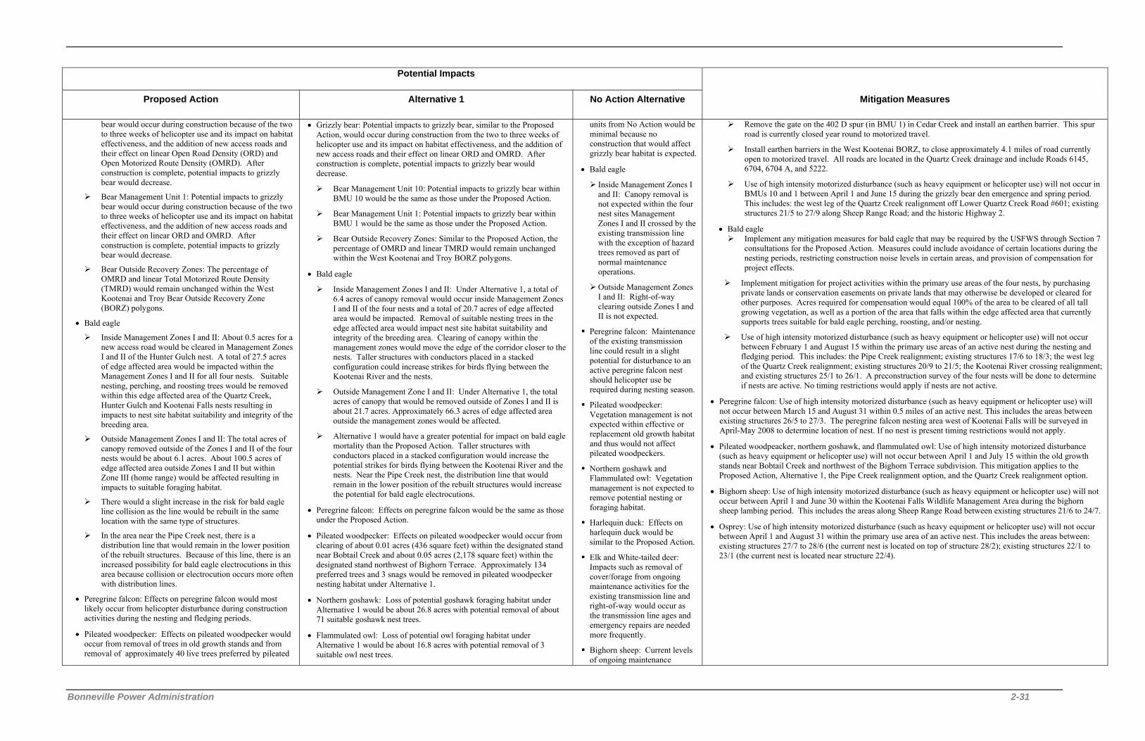
Bonneville Power Administration 2-31
Potential Impacts
Proposed Action Alternative 1 No Action Alternative Mitigation Measures
bear would occur during construction because of the two to three weeks of helicopter use and its impact on habitat effectiveness, and the addition of new access roads and their effect on linear Open Road Density (ORD) and Open Motorized Route Density (OMRD). After construction is complete, potential impacts to grizzly bear would decrease.
Bear Management Unit 1: Potential impacts to grizzly bear would occur during construction because of the two to three weeks of helicopter use and its impact on habitat effectiveness, and the addition of new access roads and their effect on linear ORD and OMRD. After construction is complete, potential impacts to grizzly bear would decrease.
Bear Outside Recovery Zones: The percentage of OMRD and linear Total Motorized Route Density (TMRD) would remain unchanged within the West Kootenai and Troy Bear Outside Recovery Zone (BORZ) polygons.
• Bald eagle
Inside Management Zones I and II: About 0.5 acres for a new access road would be cleared in Management Zones I and II of the Hunter Gulch nest. A total of 27.5 acres of edge affected area would be impacted within the Management Zones I and II for all four nests. Suitable nesting, perching, and roosting trees would be removed within this edge affected area of the Quartz Creek, Hunter Gulch and Kootenai Falls nests resulting in impacts to nest site habitat suitability and integrity of the breeding area.
Outside Management Zones I and II: The total acres of canopy removed outside of the Zones I and II of the four nests would be about 6.1 acres. About 100.5 acres of edge affected area outside Zones I and II but within Zone III (home range) would be affected resulting in impacts to suitable foraging habitat.
There would a slight increase in the risk for bald eagle line collision as the line would be rebuilt in the same location with the same type of structures.
In the area near the Pipe Creek nest, there is a distribution line that would remain in the lower position of the rebuilt structures. Because of this line, there is an increased possibility for bald eagle electrocutions in this area because collision or electrocution occurs more often with distribution lines.
• Peregrine falcon: Effects on peregrine falcon would most likely occur from helicopter disturbance during construction activities during the nesting and fledging periods.
• Pileated woodpecker: Effects on pileated woodpecker would occur from removal of trees in old growth stands and from removal of approximately 40 live trees preferred by pileated
• Grizzly bear: Potential impacts to grizzly bear, similar to the Proposed Action, would occur during construction from the two to three weeks of helicopter use and its impact on habitat effectiveness, and the addition of new access roads and their effect on linear ORD and OMRD. After construction is complete, potential impacts to grizzly bear would decrease.
Bear Management Unit 10: Potential impacts to grizzly bear within BMU 10 would be the same as those under the Proposed Action.
Bear Management Unit 1: Potential impacts to grizzly bear within BMU 1 would be the same as those under the Proposed Action.
Bear Outside Recovery Zones: Similar to the Proposed Action, the percentage of OMRD and linear TMRD would remain unchanged within the West Kootenai and Troy BORZ polygons.
• Bald eagle
Inside Management Zones I and II: Under Alternative 1, a total of 6.4 acres of canopy removal would occur inside Management Zones I and II of the four nests and a total of 20.7 acres of edge affected area would be impacted. Removal of suitable nesting trees in the edge affected area would impact nest site habitat suitability and integrity of the breeding area. Clearing of canopy within the management zones would move the edge of the corridor closer to the nests. Taller structures with conductors placed in a stacked configuration could increase strikes for birds flying between the Kootenai River and the nests.
Outside Management Zone I and II: Under Alternative 1, the total acres of canopy that would be removed outside of Zones I and II is about 21.7 acres. Approximately 66.3 acres of edge affected area outside the management zones would be affected.
Alternative 1 would have a greater potential for impact on bald eagle mortality than the Proposed Action. Taller structures with conductors placed in a stacked configuration would increase the potential strikes for birds flying between the Kootenai River and the nests. Near the Pipe Creek nest, the distribution line that would remain in the lower position of the rebuilt structures would increase the potential for bald eagle electrocutions.
• Peregrine falcon: Effects on peregrine falcon would be the same as those under the Proposed Action.
• Pileated woodpecker: Effects on pileated woodpecker would occur from clearing of about 0.01 acres (436 square feet) within the designated stand near Bobtail Creek and about 0.05 acres (2,178 square feet) within the designated stand northwest of Bighorn Terrace. Approximately 134 preferred trees and 3 snags would be removed in pileated woodpecker nesting habitat under Alternative 1.
• Northern goshawk: Loss of potential goshawk foraging habitat under Alternative 1 would be about 26.8 acres with potential removal of about 71 suitable goshawk nest trees.
• Flammulated owl: Loss of potential owl foraging habitat under Alternative 1 would be about 16.8 acres with potential removal of 3 suitable owl nest trees.
units from No Action would be minimal because no construction that would affect grizzly bear habitat is expected.
• Bald eagle
Inside Management Zones I and II: Canopy removal is not expected within the four nest sites Management Zones I and II crossed by the existing transmission line with the exception of hazard trees removed as part of normal maintenance operations.
Outside Management Zones I and II: Right-of-way clearing outside Zones I and II is not expected.
Peregrine falcon: Maintenance of the existing transmission line could result in a slight potential for disturbance to an active peregrine falcon nest should helicopter use be required during nesting season.
Pileated woodpecker: Vegetation management is not expected within effective or replacement old growth habitat and thus would not affect pileated woodpeckers.
Northern goshawk and Flammulated owl: Vegetation management is not expected to remove potential nesting or foraging habitat.
Harlequin duck: Effects on harlequin duck would be similar to the Proposed Action.
Elk and White-tailed deer: Impacts such as removal of cover/forage from ongoing maintenance activities for the existing transmission line and right-of-way would occur as the transmission line ages and emergency repairs are needed more frequently.
Bighorn sheep: Current levels of ongoing maintenance
Remove the gate on the 402 D spur (in BMU 1) in Cedar Creek and install an earthen barrier. This spur road is currently closed year round to motorized travel.
Install earthen barriers in the West Kootenai BORZ, to close approximately 4.1 miles of road currently open to motorized travel. All roads are located in the Quartz Creek drainage and include Roads 6145, 6704, 6704 A, and 5222.
Use of high intensity motorized disturbance (such as heavy equipment or helicopter use) will not occur in BMUs 10 and 1 between April 1 and June 15 during the grizzly bear den emergence and spring period. This includes: the west leg of the Quartz Creek realignment off Lower Quartz Creek Road #601; existing structures 21/5 to 27/9 along Sheep Range Road; and the historic Highway 2.
• Bald eagle Implement any mitigation measures for bald eagle that may be required by the USFWS through Section 7
consultations for the Proposed Action. Measures could include avoidance of certain locations during the nesting periods, restricting construction noise levels in certain areas, and provision of compensation for project effects.
Implement mitigation for project activities within the primary use areas of the four nests, by purchasing private lands or conservation easements on private lands that may otherwise be developed or cleared for other purposes. Acres required for compensation would equal 100% of the area to be cleared of all tall growing vegetation, as well as a portion of the area that falls within the edge affected area that currently supports trees suitable for bald eagle perching, roosting, and/or nesting.
Use of high intensity motorized disturbance (such as heavy equipment or helicopter use) will not occur between February 1 and August 15 within the primary use areas of an active nest during the nesting and fledging period. This includes: the Pipe Creek realignment; existing structures 17/6 to 18/3; the west leg of the Quartz Creek realignment; existing structures 20/9 to 21/5; the Kootenai River crossing realignment; and existing structures 25/1 to 26/1. A preconstruction survey of the four nests will be done to determine if nests are active. No timing restrictions would apply if nests are not active.
• Peregrine falcon: Use of high intensity motorized disturbance (such as heavy equipment or helicopter use) will not occur between March 15 and August 31 within 0.5 miles of an active nest. This includes the areas between existing structures 26/5 to 27/3. The peregrine falcon nesting area west of Kootenai Falls will be surveyed in April-May 2008 to determine location of nest. If no nest is present timing restrictions would not apply.
• Pileated woodpeacker, northern goshawk, and flammulated owl: Use of high intensity motorized disturbance (such as heavy equipment or helicopter use) will not occur between April 1 and July 15 within the old growth stands near Bobtail Creek and northwest of the Bighorn Terrace subdivision. This mitigation applies to the Proposed Action, Alternative 1, the Pipe Creek realignment option, and the Quartz Creek realignment option.
• Bighorn sheep: Use of high intensity motorized disturbance (such as heavy equipment or helicopter use) will not occur between April 1 and June 30 within the Kootenai Falls Wildlife Management Area during the bighorn sheep lambing period. This includes the areas along Sheep Range Road between existing structures 21/6 to 24/7.
• Osprey: Use of high intensity motorized disturbance (such as heavy equipment or helicopter use) will not occur between April 1 and August 31 within the primary use area of an active nest. This includes the areas between: existing structures 27/7 to 28/6 (the current nest is located on top of structure 28/2); existing structures 22/1 to 23/1 (the current nest is located near structure 22/4).

2 Alternatives Including the Proposed Action
2-32 Libby to Troy Rebuild Project Draft EIS
Potential Impacts
Proposed Action Alternative 1 No Action Alternative Mitigation Measures
woodpecker for nesting (greater than or equal to 20” dbh).
• Northern goshawk: Effects on northern goshawk would occur from clearing of about 8.6 acres within nesting and/or foraging habitat. Suitable nesting habitat is located between structures 18/8 and 19/5, 21/5 and 25/8, and just east of 26/1 to 28/2.
• Flammulated owl: Effects on flammulated owl would occur from clearing of about 3.3 acres within potential nesting and/or foraging habitat. Suitable nesting habitat is located between structures 18/8 and 19/5, 21/5 and 25/8, and just east of 26/1 to 28/2.
• Harlequin duck: Effects on harlequin duck would be minimal.
• Elk and White-tailed deer: Effects on elk and white-tailed deer would occur from changes to cover/forage ratio and opening sizes. Clearing of trees would decrease cover/forage from tree removal although adequate security for elk and deer would remain within or along the transmission line corridor.
• Bighorn sheep: About 0.4 acres of canopy would be removed within the Kootenai Falls Wildlife Management Area although relatively secure corridor for animals to forage close to cover would remain.
• Harlequin duck: Effects on harlequin duck would be similar to the Proposed Action although the potential for collision could increase with the taller 230-kV structures.
• Elk and White-tailed deer: Effects to elk and white-tailed deer from Alternative 1 would be similar to the Proposed Action except additional tree canopy would be removed.
• Bighorn sheep: About 9.1 acres of canopy would be removed within the Kootenai Falls Wildlife Management Area although relatively secure corridor for animals to forage close to cover would remain.
activities for the existing transmission line would continue, such as the removal of hazard trees which would decrease cover/forage for sheep.
Fish, Amphibians, and Reptiles
• Removal of large trees in the Riparian Habitat Conservation Areas (RHCA) could impact fish if sediment generated during removal enters the streams.
• Placement of the tensioning site at 18/11 could impact Bobtail Creek if construction generated sediment enters the stream.
• Corridor clearing within the wetland buffer or riparian areas could displace amphibians and reptiles or disturb their habitat.
• Coeur d’Alene salamanders could be displaced from their habitat or killed where the existing corridor runs parallel to the historic Highway 2.
• Short-term increases of small amounts of sediment are expected from construction activities such as timber clearing and road improvement/construction.
• About 1.0 acres of clearing would occur in the riparian area of fish bearing streams.
• Impacts to fish, amphibians, and reptiles from tensioning site placement and road improvement and construction would be similar to the Proposed Action.
• Effects to aquatic habitat from timber clearing for Alternative 1 would be slightly greater than those under the Proposed Action. The existing 80 foot transmission line corridor would be cleared to 100 feet in width so more trees within aquatic habitat would be removed with the potential for greater amounts of sediment delivered to streams.
• About 1.4 acres of clearing would occur in the riparian area of fish bearing streams.
• Fires and suppression efforts could introduce sediment into fish bearing streams or increase water temperature.
• Impact on boreal toads would occur within wetlands or riparian habitats from emergency or other access to structures located in wetlands.
• Implement any mitigation measures for white sturgeon and bull trout that may be required by the USFWS through Section 7 consultations for the Proposed Action. Measures could include provision of buffer zones to avoid sediment generated during construction from entering project area streams and leaving woody debris in certain areas.
• Implement RHCAs (buffer zones) around all project area rivers, streams and wetlands. For the following fish bearing streams, 300 feet on each side of the stream would be buffered: Kootenai River, Pipe Creek, Bobtail Creek, Quartz Creek, and China Creek.
• Remove trees within the RHCAs without the use of heavy equipment.
• Leave low growing brush species uncut with the RHCAs.
• Leave large-diameter trees felled within corridor RHCAs. This would leave recruitable (trees that are ready to fall into the stream) large woody debris within the RHCAs of project area streams.
• Conduct surveys for presence of Coeur d'Alene salamanders during wet weather in May or June during the year when transmission line construction would occur. The areas which have a high probability of occurrence are located on the south side of the Kootenai River in Section 18 (T31N, R32W) for the Kootenai River Crossing Realignment and in Sections 13 and 14 (T31N, R33W) for the Kootenai River Crossing Realignment and existing corridor. High probability areas would be searched in the immediate area planned for disturbance, such as structure locations. The outer boundary of the disturbance zone around each structure would be identified and marked on the ground. Salamanders present in the area would be collected and moved at least 100 feet to similar habitat beyond the potential disturbance zone.
Visual Resources

Bonneville Power Administration 2-33
Potential Impacts
Proposed Action Alternative 1 No Action Alternative Mitigation Measures
• The existing line would be straightened just west of Central Road (structures 17/16 and 17/17) for approximately 500 feet and placed along the north side of Kootenai River Road with slightly taller single-wood-pole structures with stand-off insulators.
• Clearing of trees for new and additional right-of-way would open up views of the new structures and conductors from residences along Kootenai River Road between Pipe and Bobtail Creeks.
• Danger tree removal in the Bighorn Terrace subdivision would open up views of the existing line currently partially screened from view. Road construction and improvement would remove low growing vegetative screening in this area, further opening up views of the corridor.
• Danger tree removal combined with topographically low areas would allow views of some of the new taller structures west of Black Eagle Rock from viewers on the Kootenai River, Sheep Range Road, and Highway 2.
• Short-term construction activities within the corridor would introduce new shapes, lines, and elements into the visual environment such as structures, bolts, conductor reels, insulators, and culverts.
• At Viewpoints 1, 2, and 3 the Visual Quality Objective (VQO) of partial retention would continue to be met. At Viewpoint 4 the VQO of modification would continue to be met.
• The transmission line would be straightened just west of Central Road (structures 17/16 and 17/17) for approximately 500 feet and placed along the north side of Kootenai River Road with taller steel pole structures and six conductors.
• Clearing of trees for new and additional right-of-way would open up views of the new steel structures and conductors from residences along Kootenai River Road between Pipe and Bobtail Creeks.
• In corridor miles 18 and 19, additional clearing and new steel poles would increase the line’s visibility on the east and west slopes of Bobtail Ridge. West of Bobtail Ridge to Quartz Creek Road, the new line would be visible especially from residences located north of the line.
• Danger tree removal and corridor clearing in the Bighorn Terrace subdivision would open up views of the existing line currently partially screened from view. Road construction and improvement would remove low growing vegetative screening in this area, further opening up views of the corridor.
• At the west end of Kootenai River Road, the taller, heavier, and more industrial-looking structure on top of Black Eagle Rock would be visible.
• Danger tree removal and corridor clearing would allow views of the new taller, steel structures above the trees west of Black eagle Rock from viewers on the Kootenai River, Sheep Range Road, and Highway 2.
• The new steel structures would be visible where the line crosses Highway 2 and heads west along historic Highway 2 to Troy Substation.
• In the residential area west of Bull Lake Road and south of Highway 2, residents would see the new steel structures from homes and back yards.
• Similar to the Proposed Action, short-term construction activities within the corridor would introduce new shapes, lines, and elements into the visual environment such as structures, bolts, conductor reels, insulators, and culverts.
• At Viewpoints 1, 2, and 3 the VQO of partial retention would not be met. At Viewpoint 4 the VQO of modification would not be met.
• The existing transmission line would continue to be visible. No new visual impacts would be expected unless maintenance required new access roads or new structures. New access roads and structure would disturb or remove vegetative screening making portions of the line more visible.
• Use existing vegetation and topography whenever possible to limit views of the line and structures.
• Preserve vegetation within the 80-foot or 100-foot-wide right-of-way that would not interfere with the conductor or maintenance access needs, such as small trees and shrubs.
• Locate construction staging and storage areas away from locations that would be clearly visible from Kootenai River Road or Highway 2.
• Colorize all steel structures a dark gray color.
• Use non-reflective conductors.
• Use non-reflective insulators (i.e., non-ceramic insulators or porcelain).
• Locate access roads within previously disturbed areas, wherever possible.
• Revegetate all disturbed areas with approved species.
• Require that contractors maintain a clean construction site and that the corridor is kept free of litter after construction.
Cultural Resources
• Removal of existing structures and construction of new structures would disturb 5 known prehistoric sites (24LN174, 24LN202, 24LN203, 24LN233/24LN234 and 24LN183).
• Construction of tensioning sites would impact prehistoric sites within the Kootenai Falls Cultural Resource District (24LN1825) and proposed Traditional Cultural Property (TCP) sites.
• Five known prehistoric sites (24LN174, 24LN175, 24LN176, 24LN180, and 24LN181) located within the project area would be disturbed by road construction and improvement.
• One of the six known historic mining sites (24LN201) would be affected by excavation for structure construction.
• One known historic logging site (24LN778) would be affected by removal and construction of 15 structures and improvement of access roads to those structures.
• Impacts to portions of the historic Highway 2 (24LN237/24LN462) would occur from ATV use during
• Removal of existing structures and construction of new structures would disturb 5 known prehistoric sites (24LN174, 24LN202, 24LN203, 24LN233/24LN234 and 24LN183). Excavation of larger footing holes for Alternative 1 would potentially disturb more area within the known sites.
• Similar to the Proposed Action, construction of tensioning sites would impact prehistoric sites within the Kootenai Falls Cultural Resource District (24LN1825) and proposed TCP sites.
• Similar to the Proposed Action, five known prehistoric sites (24LN174, 24LN175, 24LN176, 24LN180, and 24LN181) located within the project area would be disturbed by road construction and improvement.
• One of the six known historic mining sites (24LN201) would be affected by excavation for structure construction for Alternative 1.
• One known historic logging site (24LN778) would be affected by removal of 15 structures, construction of 5 new structures, and improvement of access roads to those structures.
• Similar to the Proposed Action, impacts on portions of the historic
• Impacts to cultural resources would occur if emergency maintenance activities such as structure replacement or conductor splicing disturb cultural sites. Use of the Sheep Range Road during the wet season would continue to disturb known sites.
• Design the transmission line so that structure sites are placed to avoid cultural resources. • Design new access roads to avoid cultural resources. • Place geotextile fabric with rock/gravel overlay on the archaeological sites along Sheep Range Road to reduce or
eliminate adverse impacts to those sites. • Improve the existing access road system in a manner that minimizes new roads and avoids cultural resource sites.
If improvements are needed on existing access roads, such improvements would be limited to the existing roadbed if near a cultural resource site and would be confined to applying new material.
• Excavation for roads will not occur near cultural resource sites. • Remove the existing structures for the portion of existing transmission line that would be abandoned in the China
Creek area if the Kootenai River Crossing realignment is selected, by cutting off at the base. Structures will then be removed by helicopter and or cut and removed.
• Consult with the Kootenai National Forest, Montana State Historic Preservation Officer (SHPO), and the Confederated Salish and Kootenai Tribes (CSKT) Tribal Historic Preservation Officer (THPO) regarding National Register of Historic Places (NRHP) eligibility of cultural sites and TCPs.
• Develop an Inadvertent Discovery Plan that details crew member responsibilities for reporting in the event of a discovery during construction.

2 Alternatives Including the Proposed Action
2-34 Libby to Troy Rebuild Project Draft EIS
Potential Impacts
Proposed Action Alternative 1 No Action Alternative Mitigation Measures
construction. • Heavy equipment use and vehicular traffic within known sites
would disturb or destroy cultural resources. • Rebuilding the line at the existing crossing near China Creek
would impact the tribal ethnographic and cultural resources in the vicinity of the Kootenai Falls, both directly from structure and road construction, and indirectly from visual impacts.
Highway 2 (24LN237/24LN462) would occur from ATV use during construction.
• Heavy equipment use and vehicular traffic within known sites would disturb or destroy cultural resources.
• Similar to the Proposed Action, rebuilding the line at the existing crossing and near China Creek would impact the tribal ethnographic and cultural resources in the vicinity of the Kootenai Falls.
• Ensure tribal monitors from the CSKT and Kootenai of Idaho are present during excavation within prehistoric sites or TCPs.
• Prevent unauthorized collection of cultural materials by ensuring a professional archaeologist and tribal monitor are present during any excavation within known sites.
• Prepare a Mitigation Plan to protect sites in-situ if final placement of project elements results in unavoidable adverse impacts to a significant cultural resource.
• Stop work immediately and notify local law enforcement officials, appropriate BPA personnel, the Kootenai National Forest, Montana SHPO, and the CSKT THPO if cultural resources, either archaeological or historical materials, are discovered during construction activities.
Recreation Resources
• Increased traffic levels would be expected on many of the project area roads during the construction season. Recreationists would be temporarily deterred from using certain areas due to noise, traffic, and dust, and for safety reasons.
• Short-term impacts to recreational use of the Kootenai National Forest land located along Sheep Range Road would occur during construction. Because Sheep Range Road would be used to access portions of the transmission line during construction, use of the road would not be allowed during construction to protect the safety of recreational users.
• ORV trespass of access roads would continue to occur. Recreation Opportunity Spectrum Analysis • Access – Widening of the Bighorn Trail (Sheep Range Road)
to allow wider and heavier vehicles to access the line between structures 21/6 and 25/8 would change the recreational user’s experience from hiking a trail to walking a road. On the other hand, proposed clearing and access road improvements largely would have a positive impact on hunting opportunities by allowing easier travel by hunters and easier viewing of big game animals.
• Social Encounters – Road widening could detract from the recreational user’s experience decreasing social encounter as visitors use other locations for their activities.
• Visitor Management – Visitor regulation and control would be increased under the Proposed Action. New roads on Kootenai National Forest lands would be closed to public motorized use to protect wildlife and watershed values.
• Visitor Impacts – Each segment of new road required for the transmission line rebuild would be closed by gate to public motorized travel to protect wildlife and watershed values. Visitors opposed to road closures may vandalize gates and signs. ORV users would circumvent gates to use new roads and would develop new routes from the roads where terrain is suitable. Such use would spread noxious weeds, eliminate vegetation and result in erosion.
• Impacts to recreation from Alternative 1 would be similar to those under the Proposed Action.
• If access for emergency maintenance work occurs during periods of wet soils, roads and trails used for recreation could be rutted.
• Improve trail surfaces by applying small-diameter compactable crushed rock.
• Monitor gates to assure effectiveness as necessary.

Bonneville Power Administration 2-35
Potential Impacts
Proposed Action Alternative 1 No Action Alternative Mitigation Measures
Noise, Public Health and Safety
Noise
• About 44 of the homes in the Pipe Creek area, Bighorn Terrace subdivision, and west of Highway 56 are within 800 feet of the construction activity and may experience noise levels at or above 65 dBA.
• Residents within approximately 1 mile of helicopter use would be exposed to temporary noise levels above 65 dBA. Some residents may perceive air pressure changes as vibrations from the helicopter use.
• Foul-weather corona noise levels would be comparable to or less than those from the existing line.
• On and off the right-of-way, the levels of audible noise from the Proposed Action during foul weather would be well below the 55-dBA level that can produce interference with speech outdoors (estimated Ldn at the edge of the 80-foot right-of-way would be about 15 dBA or less, which is well below the EPA Ldn guideline of 55 dBA and also well below the Montana limit for Ldn of 50 dBA.)
• Potential radio or television interference.
Public Health and Safety
• The Proposed Action would easily meet BPA’s electric-field guideline of 5 kV/m and Montana’s guideline of 1 kV/m at the edge of the right-of-way.
• Impacts from magnetic fields would be less than those present on and near the existing line.
Noise
• Impacts from noise under Alternative 1 would be the same as those under the Proposed Action.
• Potential radio or television interference.
Public Health and Safety
• Alternative 1 would easily meet BPA’s electric-field guideline of 5 kV/m and Montana’s guideline of 1 kV/m at the edge of the right-of-way.
• Similar to the Proposed Action, impacts from magnetic fields would be less than those present on and near the existing line.
• Existing conductor fittings have failed in the recent past causing fires and the transmission line to go out of service. Additionally, as wood pole structures continue to age, there is the potential for failures especially during adverse weather. The potential for these types of failures would increase as the line ages.
• Install sound-control devices on all construction equipment. • Muffled exhaust will be installed on all construction equipment and vehicles except helicopters. • Limit construction activities to daytime hours (i.e., only between 7:00 am and 7:00 pm). • Notify landowners directly impacted along the corridor prior to construction activities, including blasting. • Prepare and maintain a safety plan in compliance with Montana requirements prior to starting construction. This
plan will be kept on-site and will detail how to manage hazardous materials such as fuel, and how to respond to emergency situations.
• Hold crew safety meetings during construction at the start of each workday to go over potential safety issues and concerns.
• Secure the site at the end of each workday to protect equipment and the general public. • Train employees as necessary, in structure climbing, cardiopulmonary resuscitation, first aid, rescue techniques,
and safety equipment inspection. • Fuel all highway-authorized vehicles off-site to minimize the risk of fire. Fueling of construction equipment that
is transported to the site via truck and is not highway authorized will be done in accordance with regulated construction practices and state and local laws. Helicopters will be fueled and housed at local airfields or at staging areas.
• Ensure that helicopter pilots and contractors take into account public safety during flights. • Ensure that safety measures for blasting will be consistent with state and local codes and regulations. All
explosives will be removed from the work site at the end of the workday or placed under lock and key. • Adhere to BPA’s specifications for grounding fences and other objects on and near the existing and proposed
rights-of-way during construction. • Construct and operate the rebuilt transmission line in accordance with the National Electrical Safety Code, as
required by law. • Restore reception quality if radio or television interference occurs as a result of the rebuilt transmission line.
Reception will be as good or better than before the interference. • Carry fire suppression equipment including (but not limited to) shovels, buckets, and fire extinguishers on all
operation and maintenance vehicles. • Use established access roads during routine operation and maintenance activities. • Clear vegetation according to BPA standards to avoid contact with transmission lines. • Use pressure treated wood poles or poles treated with preservatives that do not contribute contaminants to nearby
water bodies. • Contact the appropriate BPA representative if hazardous materials, toxic substances, or petroleum products are
discovered within the project area that would pose an immediate threat to human health or the environment. Other conditions such as large dump sites, drums of unknown substances, suspicious odors, stained soil, etc. will also be reported immediately to BPA.
Social and Economic Resources
• Potential benefit to local and regional economies through employment opportunities and purchase of goods and services.
• Increased demand on local emergency response resources such as fire, police, and medical personnel and facilities.
• Alternative 1 may have a low-level, short-term negative impact on property values from widening of the corridor although long-term impacts in the project area are not expected.
• Negative socioeconomic impacts, primarily those associated with reduced reliability and increased maintenance access requirements could occur with No Action.
• Compensate landowners at market value for any new land rights required for corridor easements or to acquire new, temporary or permanent access roads on private lands.
Transportation

2 Alternatives Including the Proposed Action
2-36 Libby to Troy Rebuild Project Draft EIS
Potential Impacts
Proposed Action Alternative 1 No Action Alternative Mitigation Measures
• Increased traffic, detours and delays on Kootenai River Road, state roads and U.S. Highway 2 from movement and use of heavy construction vehicles and equipment during construction.
• Short-term increases in construction related noise and decreased air quality during construction.
• Potential for increased unauthorized access during and following project construction.
• Impacts from Alternative 1 would be similar to those under the Proposed Action.
• Emergency or normal maintenance of the line could result in detours and traffic delays.
• Coordinate routing and scheduling of construction traffic with state and county road staff. • Employ traffic control flaggers and post warning signs of construction activity and merging traffic when
necessary. • Repair damage to roads caused by the project. • Install gates on access roads when requested by property owners to reduce unauthorized use. • Spray and seed access roads to reduce erosion and control noxious weeds. • Protect cultural resources in the Kootenai River area by using borrowed fill material for road building instead of
cut and fill practices. • Install marker balls on the Quartz Creek realignment if the decision is made to construct that realignment.
Air Quality
• Combustion pollutants from equipment exhaust and fugitive dust particles from disturbed soils becoming airborne.
• The maximum annual PM-10 emissions during construction of the Proposed Action would be 4.5 tons (Clean Air Act regulations require that less than 70 tons per year be generated within the PM-10 non-attainment area).
• The maximum PM-2.5 emissions during construction of the Proposed Action would be about 2.9 tons/year (Clean Air Act regulations require that less than 7 tons per year be generated within the PM-2.5 non-attainment area).
• Similar to the Proposed Action, combustion pollutants from equipment exhaust and fugitive dust particles from disturbed soils under Alternative 1 would become airborne.
• The maximum annual PM-10 emissions during construction of Alternative 1 would be 5.6 tons (Clean Air Act regulations require that less than 70 tons per year be generated within the PM-10 non-attainment area).
• The maximum PM-2.5 emissions during construction of Alternative 1 would be about 3.6 tons/year (Clean Air Act regulations require that less than 7 tons per year be generated within the PM-2.5 non-attainment area).
• Pollutants from fire resulting from conductor failure could increase air pollution.
• Use water trucks to control dust during construction operations. • Ensure construction vehicles travel at low speeds on gravel roads and at the construction sites to minimize dust. • Comply with Montana State tailpipe emission standards for all on-road vehicles. • Use low sulfur fuel for all on-road diesel vehicles. • Ensure all vehicle engines are in good operating condition to minimize exhaust emissions. • Lop, chip, and scatter wood debris on site to decay. No burning of wood debris will occur as a result of the
proposed activities. • Replant where needed, as soon as reasonably possible following construction activities. • Use of vehicles will be limited if data collected at Montana’s DEQ Libby Air Quality Monitoring Site indicates
that the air quality is in the “Unhealthy” health effect category. Vehicle miles traveled will be limited on unpaved roads to the extent possible and consultation with the Montana DEQ Air Program staff will occur.

Bonneville Power Administration 2-37
Table 2-5. Summary of Impacts of the Pipe Creek Realignment, the Quartz Creek Realignment, and the Kootenai River Crossing
Realignment
Potential Impacts
Pipe Creek Realignment (115 and 230 kV)
Quartz Creek Realignment (115 and 230 kV)
Kootenai River Crossing Realignment (115 and 230 kV)
Soils, Geology and Water Resources • Clearing of new right-of-way and construction of new
roads would disturb about 3.2 acres of soils. Slightly more soil would be disturbed under the 230-kV voltage because of the wider right-of-way.
• Clearing within the riparian zones of Pipe and Bobtail creeks would potentially increase sediment delivery to those streams.
• New right-of-way clearing and structures sites for the Quartz Creek realignment would disturb about 23 acres of soils. Slightly more soil would be disturbed under the 230-kV voltage because of the wider right-of-way.
• Approximately 4.7 acres of soils would be disturbed from new road construction and road improvement.
• Approximately 1 acre of soils would be disturbed from new road construction and road improvement.
Land Use • Ownership on Kootenai National Forest land would
increase from 2 acres on the existing corridor to 7.4 acres (at 115 kV) or 9.2 acres (at 230 kV) on the new corridor; the new alignment would be removed from Lincoln County land along Kootenai River Road and private ownership would decrease from 4 acres on the existing corridor to 0.6 acres (at 115 kV) or 0.7 acres (at 230 kV) on the new corridor.
• Land use would permanently change on Kootenai Forest land from bald eagle habitat and old growth to transmission line.
• Conductor and one new structure would be visible from the private land crossed by the new realignment where no views of the line currently exist.
• Full use of the existing corridor would not be restored to landowners because the electrical distribution line that is currently attached to the existing transmission line along Kootenai River Road would remain.
• This realignment would move the existing transmission line located on private land in the Bighorn Terrace residential area (between structures 19/4 and 21/5) north to other private land and Kootenai National Forest land. Ownership on Kootenai National Forest land would increase from 3 acres on the existing corridor to 26 acres (at 115 kV) or 32 acres (at 230 kV) on the new corridor. The new alignment would be removed from Lincoln County land north of Bighorn Terrace and private ownership would decrease from 17 acres on the existing corridor to 1.8 acres (at 115 kV) or 2.2 acres (at 230 kV) on the new corridor.
• Land use would permanently change from grizzly bear habitat and old growth to transmission line on portions of Kootenai National Forest land.
• Ownership on Kootenai National Forest land would decrease from 7 acres on the existing corridor to 6 acres (at 115 kV) or 7 acres (at 230 kV) on the new corridor. Ownership by Lincoln County would increase from 1.6 acres on the existing corridor to 3 acres (at 115 kV) or 3.5 acres (at 230 kV) on the new corridor.
• Construction, operation and maintenance activities for the rebuilt transmission line would move about 1.3 miles east from Kootenai Falls and to the eastern edge of the Kootenai Falls Cultural Resource District.
• Placement of about 2 acres (for the 115 kV) and 2.5 acres (for the 230 kV) of the transmission line within the Cabinet Face East Inventoried Road Area would occur. About 5 new structures with spur roads off Highway 2 would be constructed in this area.
• About 4,000 feet of corridor currently within the Grizzly Bear Management Unit (BMU) 10 would be moved to BMU 1 located on the south side of the Kootenai River.

2 Alternatives Including the Proposed Action
2-38 Libby to Troy Rebuild Project Draft EIS
Potential Impacts
Pipe Creek Realignment (115 and 230 kV)
Quartz Creek Realignment (115 and 230 kV)
Kootenai River Crossing Realignment (115 and 230 kV)
Vegetation • About 1.5 acres (at 115 kV) and 1.8 acres (at 230 kV)
would be cleared within the 170-acre designated old growth stand located near Bobtail Creek.
• About 38.9 acres of designated and undesignated old growth buffer area would be affected regardless of voltage from danger tree clearing.
• Construction and maintenance activities would increase the spread of noxious weeds within the realignment area. Currently only about 1% of the realignment is infested with weeds.
• The existing corridor between structures 17/14 and 18/10 where the distribution line would remain would continue to be a vector for weed spread unless the right-of-way and associated access roads were sprayed for weeds and re-vegetated.
• About 2.0 acres (at 115 kV) and 2.5 acres (at 230 kV) of the 35 acre designated old growth stand northwest of the Bighorn Terrace subdivision would be cleared for this realignment.
• About 30.9 acres of designated and undesignated buffer habitat would be impacted by danger tree clearing regardless of voltage.
• Construction and maintenance activities would increase the spread of noxious weeds within the realignment area. Currently only about 22% of the realignment is infested with weeds.
• The existing corridor between structures 19/4 and 21/4 would continue to be a significant vector for weed spread after removal of the line in this area unless the right-of-way and associated access roads were sprayed for weeds and re-vegetated.
• Construction and maintenance activities would increase the spread of noxious weeds within the realignment area.
• The existing corridor between structures 25/2 and 25/10 would continue to be a significant vector for weed spread unless the right-of-way and associated access roads were sprayed for weeds and re-vegetated. Currently only about 80% of the realignment is infested with weeds.
Floodplains and Wetlands • Riparian wetlands would be cleared for new right-of-
way along Pipe and Bobtail creeks. • There is the potential that some tall growing vegetation
in the Quartz Creek riparian wetlands within the new right-of-way would be removed if the “sock-line and “hard- line” used to string the conductor sag low enough to hit trees.
• Tall growing vegetation within Kootenai River riparian wetlands would be cleared. Clearing would be greater for the 230-kV voltage.
• One new structure would be constructed about 100 feet from the southern bank of the Kootenai River, within the 1,200-foot-wide floodplain.
Wildlife • Common Wildlife Species
Impacts to common wildlife species from this realignment would be similar to those under the Proposed Action and Alternative 1. Clearing of new right-of-way would impact migratory bird nesting, foraging, and roosting habitat because suitable habitat for those activities would be removed with this realignment.
• Common Wildlife Species Impacts to common wildlife species from this realignment would be similar to those under the Proposed Action and Alternative 1. Clearing of new right-of-way would decrease migratory bird nesting, foraging, and roosting habitat because suitable habitat for those activities would be removed with this realignment.
• Common Wildlife Species
Impacts to common wildlife species from this realignment would be similar to those under the Proposed Action and Alternative 1.
Potential for line collision would increase where the right-of-way would cross the Kootenai River in a new location unfamiliar to birds. Construction of the realignment at 230 kV with conductor placed in a

Bonneville Power Administration 2-39
Potential Impacts
Pipe Creek Realignment (115 and 230 kV)
Quartz Creek Realignment (115 and 230 kV)
Kootenai River Crossing Realignment (115 and 230 kV)
Potential for line collision would increase if taller 230-kV structures with conductor placed in a stacked configuration were placed in new right-of-way.
• Gray wolf: Effects would be minimal. • Grizzly bear: No impact • Bald eagle
Inside Management Zones I and II of the Pipe Creek nest: About 6.9 acres (115 kV) and 8.7 acres (230 kV) of mature forest habitat would be cleared within Zones I and II. About 6.8 acres (115 kV) to 5.4 acres (230 kV) of edge affected area would be impacted within Zones I and II. Suitable nesting, perching, and roosting trees would be removed within this edge affected area. This realignment would cross the primary flight corridor between the Pipe Creek nest tree and the Kootenai River increasing the potential for eagles to collide with the conductors. The risk would increase further if 230-kV structures are constructed and multiple wires are present within the flight paths of the nesting eagles. Outside Management Zones I and II of the Pipe Creek nest: About 1.4 acres (at 115 kV) and 2.8 acres (at 230 kV) of canopy and edge affected area would be impacted in Zone III of the Pipe Creek nest site from right-of-way clearing. Additionally, clearing of about 1.5 acres (at 115 kV) and 1.8 acres (at 230 kV) of designated old growth would occur in the old growth stand near Bobtail Creek from this realignment. Right-of-way clearing for this realignment also would remove foraging habitat from Zone III of the Quartz Creek bald eagle nest, as well as general foraging and wintering habitat for the Hunter Gulch and Kootenai Falls nests.
• Peregrine falcon: No impact • Pileated woodpecker: About 1.5 acres (at 115 kV) and
Potential for line collision would increase slightly if taller 230-kV structures with conductor placed in a stacked configuration were placed in new right-of-way above Quartz Creek.
• Gray wolf: Effects would be minimal. • Grizzly bear:
Bear Management Unit 10: Potential impacts to grizzly bear would occur during construction because of the two to three weeks of helicopter use and its impact on habitat effectiveness, and the addition of new access roads and their effect on linear Open Road Density (ORD) and Open Motorized Route Density (OMRD). This realignment option would add 550 acres (0.8 square miles) to the helicopter influence zone and would require construction and re-opening of 1.3 miles of new road. After construction is complete, potential impacts to grizzly bear would decrease. Bear Management Unit 1: Potential impacts to grizzly bear would occur during construction because of the two to three weeks of helicopter use and its impact on habitat effectiveness, and the addition of new access roads and their effect on linear ORD and OMRD. This realignment would add 55 acres (0.1 square miles) to the helicopter zone decreasing habitat effectiveness inside BMU 1 during construction. After construction is complete, potential impacts to grizzly bear would decrease. Bear Outside Recovery Zones: Effects on the West Kootenai and Troy BORZ polygons from this realignment option would be similar to those under the Proposed Action and Alternative 1.
• Bald eagle • Inside Management Zones I and II of the Quartz Creek
nest: About 7.7 acres (at 115 kV) and 9.6 acres (at 230 kV) of mature forest habitat would be cleared within Zones I and II. Within those acreages, 2.0 acres (at 115 kV) and 2.5 acres (at 230 kV) would be cleared within the old growth stand northwest of Bighorn
stacked configuration also would increase the risk of collision.
• Gray wolf: Effects would be minimal. • Grizzly bear:
Bear Management Unit 10: Effects would be minimal.
Bear Management Unit 1: Potential impacts to grizzly bear would occur during construction because of the two to three weeks of helicopter use and its impact on habitat effectiveness, and the addition of new access roads and their effect on linear ORD and OMRD. This realignment option would require construction of 0.2 miles of new road slightly affecting linear ORD, OMRD, and TMRD. After construction is complete, potential impacts to grizzly bear would decrease.
Bear Outside Recovery Zones: No impact • Bald eagle
Inside Management Zones I and II of the Kootenai Falls nest: About 3.7 acres (at 115 kV) and 4.6 acres (at 230 kV) of forest habitat would be cleared within Zones I and II of the Kootenai Falls nest. Additionally, about 1.0 acres (115 kV) to 0.7 acres (230 kV) of edge affected area would be impacted within Zones I and II.
Outside Management Zones I and II of the Quartz Creek nest: About 5.6 acres (at 115 kV) and 6.4 acres (at 230 kV) of canopy and edge affected area would be impacted in Zone III of the Kootenai Falls nest site. Right-of-way clearing for this realignment also would remove foraging habitat from Zone III of the Kootenai Falls nest, as well as general foraging and wintering habitat for the Pipe Creek, Quartz Creek, and Hunter Gulch bald eagle nests.
• Peregrine falcon: No impact
• Pileated woodpecker: About 3 trees preferred by

2 Alternatives Including the Proposed Action
2-40 Libby to Troy Rebuild Project Draft EIS
Potential Impacts
Pipe Creek Realignment (115 and 230 kV)
Quartz Creek Realignment (115 and 230 kV)
Kootenai River Crossing Realignment (115 and 230 kV)
1.8 acres (at 230 kV) within the 170-acre designated old growth stand located near Bobtail Creek would be cleared. About 3.5 acres (at 115 kV) and 4.3 acres (at 230 kV) would be cleared in undesignated old growth located along the realignment. About 38.9 acres at both voltages of old growth buffer zone would be impacted by danger tree clearing or thinning. About 34 trees preferred by pileated woodpecker (species include ponderosa pine, western larch, cottonwood, and aspen) and 10 snags would be removed regardless of voltage.
• Northern goshawk: Approximately 96 suitable goshawk nesting trees would be removed for the Pipe Creek realignment within the Pipestone PSU regardless of voltage. About 12.7 acres (at 115 kV) and 15.7 acres (at 230 kV) of foraging and nesting habitat would be removed.
• Flammulated owl: Approximately 12 suitable flammulated owl nesting trees would be removed for the Pipe Creek realignment within the Pipestone PSU regardless of voltage. About 12.7 acres (at 115 kV) and 15.7 acres (at 230 kV) of foraging and nesting habitat would be removed.
• Harlequin duck: No impact • Elk and White-tailed deer: Effects would similar to
those under the Proposed Action and Alternative 1. • Bighorn sheep: No impact
Terrace. Additionally, approximately 6.5 acres (115 kV) to 5.1 acres (230 kV) of edge affected area would be impacted within Zones I and II from danger tree removal.
• Outside Management Zones I and II of the Quartz Creek nest: About 36.4 acres (at 115 kV) and 42.3 acres (at 230 kV) of canopy and edge affected area would be impacted in Zone III. Right-of-way clearing for this realignment also would remove foraging habitat from Zone III of the Pipe Creek and Hunter Gulch bald eagle nests, as well as general foraging and wintering habitat for the Kootenai Falls nest.
• Peregrine falcon: No impact • Pileated woodpecker: About 2.0 acres (at 115 kV) and
2.5 acres (at 230 kV) of the 35-acre designated old growth stand located northwest of Bighorn Terrace would be cleared. About 30.9 acres regardless voltages of old growth buffer zone would be impacted by danger tree clearing. About 142 trees preferred by pileated woodpecker and 6 snags regardless of voltage would be removed.
• Northern goshawk: About 326 suitable goshawk nesting trees would be removed for this realignment within the Quartz and Sheep PSUs. About 31.7 acres (at 115 kV) and 39.1 acres (at 230 kV) of foraging and nesting habitat would be removed.
• Flammulated owl: About 21 suitable flammulated owl nesting trees would be removed within the Quartz and Sheep PSUs. About 31.7 acres (at 115 kV) and 39.1 acres (at 230 kV) of foraging and nesting habitat would be removed.
• Harlequin duck: Effects would be minimal • Elk and White-tailed deer: Effects would similar to
those under the Proposed Action and Alternative 1. • Bighorn sheep: About 10.6 acres (at 115 kV) and
13.2 acres (at 230 kV) of canopy would be removed in the Sheep PSU.
pileated woodpecker would be removed regardless of voltage.
• Northern goshawk: Approximately 15 suitable goshawk nesting trees would be removed
• Flammulated owl: No impact • Harlequin duck: Impacts could occur from clearing of
riparian vegetation along the Kootenai River. • Elk and White-tailed deer: Effects would similar to
those under the Proposed Action and Alternative 1. • Bighorn sheep: About 0.3 acres (at 115 kV) and 0.4
acres (at 230 kV) would be cleared near the northern crossing structure within the Sheep PSU.

Bonneville Power Administration 2-41
Potential Impacts
Pipe Creek Realignment (115 and 230 kV)
Quartz Creek Realignment (115 and 230 kV)
Kootenai River Crossing Realignment (115 and 230 kV)
Fish, Amphibians and Reptiles • About 2.8 acres (1.4 acres in Pipe Creek and 1.4 acres
in Bobtail Creek) of riparian vegetation would be removed at 230-kV. Removal of large trees in the RHCAs could impact fish if sediment generated during removal enters the streams.
• No impact • About 0.8 acres of riparian vegetation (at 230 kV) would be cleared on both sides of the Kootenai River. Less clearing would occur at the 115-kV voltage.
• Coeur d’Alene salamanders could be displaced from their habitat or killed where the new corridor would run parallel to Highway 2.
Visual Resources • About 300 feet of new right-of-way would be visible
from Kootenai River Road east of the Pipe Creek area regardless of voltage.
• Adjacent to Pipe Creek, new structures and conductor would be visible where none currently exist.
• Where the realignment would cross Pipe Creek on Kootenai National Forest land, the “Modification” VQO would not be met because the new structures and right-of-way would dominate the landscape in this area. Where the realignment would cross Bobtail Creek Forest land, the “Partial Retention” VQO would not be met because the new structures and cleared right-of-way would most likely result in modification or maximum modification of the landscape.
• New right-of-way and structures would be visible across the Kootenai River on the west slope north of the Bighorn Terrace area. Conductors crossing the Quartz Creek drainage would be visible from Highway 2 although the viewing duration would be brief.
• Construction of the Quartz Creek realignment would mean that the VQO of “Partial Retention” would not be met under either voltage option. New structures and cleared right-of-way would most likely result in maximum modification at viewpoints 5 and 6.
• Steel structures and conductor would be visible adjacent to the south side of Highway 2.
• This realignment would move the Kootenai River transmission line crossing about 3/4 mile east of the existing crossing and out of the view shed of the Kootenai Falls recreation area, a positive affect. Removal of the line on the north side of the Kootenai River would improve the visual quality in an area where the VQO is “Retention.”
• Construction of the Kootenai River realignment would create a situation in which the VQO of “Partial Retention” would not be met in the area of the realignment, because the transmission line would dominate the landscape along Highway 2, resulting in maximum modification at Viewpoint 7 regardless of voltage option.
Cultural Resources • Impacts would be minimal • Impacts would be minimal • Portions of the historic Highway 2 and the BNSF
railroad located in the vicinity of this realignment would potentially be impacted during construction.
• A newly recorded prehistoric site located on the north side of the Kootenai River would be disturbed permanently. Access road work, tensioning site preparation and structure installation would disturb soil and potentially subsurface deposits in this area.
• If this realignment were constructed, the river crossing would still be within the Kootenai Falls Cultural Resource District, but impacts to traditional CSKT and other Kootenai tribes’ uses of the Kootenai Falls area as a spiritual site would be reduced.
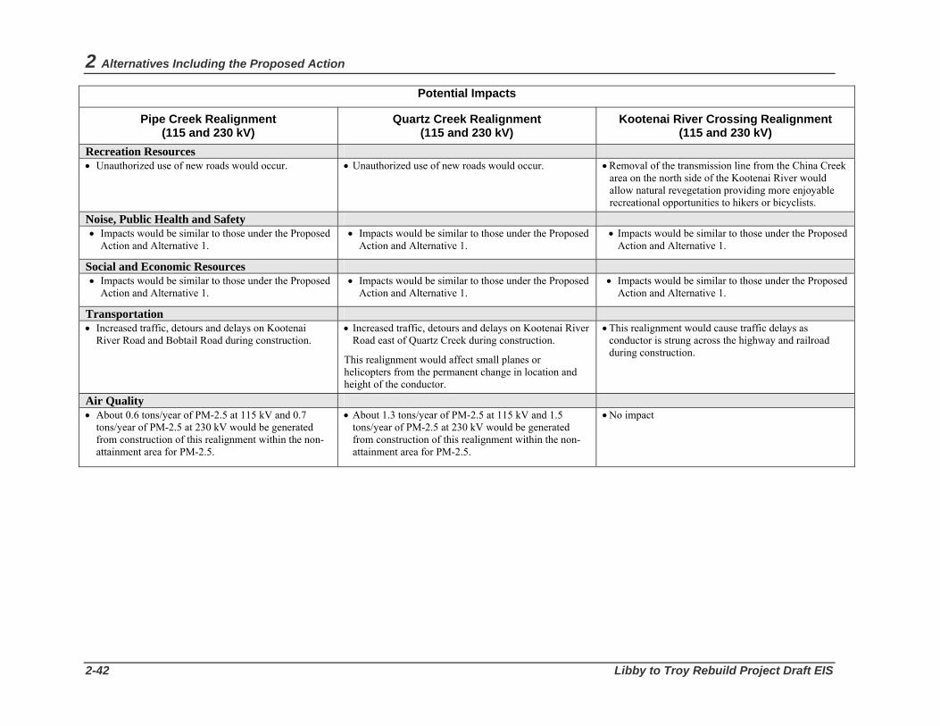
2 Alternatives Including the Proposed Action
2-42 Libby to Troy Rebuild Project Draft EIS
Potential Impacts
Pipe Creek Realignment (115 and 230 kV)
Quartz Creek Realignment (115 and 230 kV)
Kootenai River Crossing Realignment (115 and 230 kV)
Recreation Resources • Unauthorized use of new roads would occur. • Unauthorized use of new roads would occur. • Removal of the transmission line from the China Creek
area on the north side of the Kootenai River would allow natural revegetation providing more enjoyable recreational opportunities to hikers or bicyclists.
Noise, Public Health and Safety • Impacts would be similar to those under the Proposed
Action and Alternative 1. • Impacts would be similar to those under the Proposed
Action and Alternative 1. • Impacts would be similar to those under the Proposed
Action and Alternative 1.
Social and Economic Resources • Impacts would be similar to those under the Proposed
Action and Alternative 1. • Impacts would be similar to those under the Proposed
Action and Alternative 1. • Impacts would be similar to those under the Proposed
Action and Alternative 1.
Transportation • Increased traffic, detours and delays on Kootenai
River Road and Bobtail Road during construction.
• Increased traffic, detours and delays on Kootenai River Road east of Quartz Creek during construction.
This realignment would affect small planes or helicopters from the permanent change in location and height of the conductor.
• This realignment would cause traffic delays as conductor is strung across the highway and railroad during construction.
Air Quality • About 0.6 tons/year of PM-2.5 at 115 kV and 0.7
tons/year of PM-2.5 at 230 kV would be generated from construction of this realignment within the non-attainment area for PM-2.5.
• About 1.3 tons/year of PM-2.5 at 115 kV and 1.5 tons/year of PM-2.5 at 230 kV would be generated from construction of this realignment within the non-attainment area for PM-2.5.
• No impact
Geology, Soils, and Water Resources
Bonneville Power Administration 3-1
CHAPTER 3 Affected Environment, Environmental Consequences, and Mitigation Measures This chapter describes the existing environment of the project area for each resource and evaluates the environmental consequences of the Proposed Action, Alternative 1, short realignment options, and the No Action Alternative on these resources. Mitigation measures to reduce or avoid the impacts of the action alternatives on each resource also are identified. The chapter concludes with discussions of potential cumulative impacts, short-term use and long-term productivity, irreversible and irretrievable commitments of resources, adverse effects that cannot be avoided, and the potential effect of intentional destructive acts to BPA facilities.
3.1. Geology, Soils, and Water Resources 3.1.1 Affected Environment Geology The 17-mile corridor for the proposed transmission line rebuild passes between the Purcell and Cabinet mountains as it follows the Kootenai River canyon from the town of Libby, Montana to the town of Troy, Montana. The parent material for the Purcell and Cabinet mountains in the project area consists of Precambrian Belt materials, and more specifically, the Libby Formation. The Libby is the uppermost formation of the Belt series in southwestern Lincoln County, with the top layer having been removed by erosion. Topography in the project area was influenced by past glacial scouring and is gently rolling to moderately hilly, with elevations ranging from 2,000 to 2,500 feet above mean sea level. Landforms found within the project corridor and vicinity include steep mountain sideslopes and alluvial terraces (Figure 3-1).
Bedrock in the Libby Formation consists of dark- and light-gray to greenish-gray argillite in beds one to three feet thick. The bedrock is somewhat sandy, sericitic, and calcareous with some dark-gray limestone. The formation is at least 6,000 feet thick and is exposed in the syncline crossing the Kootenai River west of Libby, Montana. The Purcell Mountains were nearly covered and eroded by glaciers, which left them looking smooth and rounded.
Soils Soils along the project corridor have formed primarily in alluvial deposits, outwash deposits, and weathered materials from the Precambrian Belt group. Three general categories of soils are found in the corridor.
3 Affected Environment and Environmental Consequences
3-2 Libby to Troy Rebuild Project Draft EIS
Lacustrine Terraces These soils have a surface layer of loess that has been influenced by volcanic ash. The surface layer is about 4 to 14 inches thick and is medium-textured. The content of rounded rock fragments in the subsoil ranges from 0 to 15 percent. Lacustrine terrace soils have a high erosion hazard when exposed and a high sediment delivery efficiency due the proximity to stream channels. Sediment produced by erosion in these soils is particularly damaging to the spawning habitat of fish because fine sediment can cap or fill interstitial spaces of streambed cobbles.
Glacial Outwash Terraces The surface layer of these soils is like the lacustrine terraces, but the content of rounded rock fragments in the subsoil ranges from 35 to 50 percent. Glacial outwash soils have a high erosion hazard when exposed and a low delivery efficiency due to the flatness of the landform.
Glaciated Mountain Slopes (Steep) and Breaklands These soils also have a surface layer of loess that has been influenced by volcanic ash; it is usually 7 to 18 inches thick, but can be up to 40 inches thick. It is medium-textured. The content of rounded rock fragments in the subsoil ranges from 45 to 70 percent. These soils have a moderate erosion hazard when exposed, although the steepness of the landform would cause the sediment delivery efficiency to be high.
Water Resources Watersheds The project corridor crosses 24 separate watersheds, 17 of which are small, unnamed “face” drainages that do not have developed stream channels to deliver water to the Kootenai River. The remaining seven watersheds are Pipe Creek, Bobtail Creek, Quartz Creek, Hunter Gulch, Dad Creek, Burrell Creek, and China Creek (Figure 3-2).
The 17 unnamed drainages range in size from 15 to 4,300 acres, while the seven named drainages range in size from 3,730 to 67,700 acres. The project corridor runs along the Kootenai River and crosses the outlets of all the watersheds. However, only a small portion of each of the watersheds is located within the project corridor. Table 3-1 shows the number of acres that the existing transmission line corridor occupies in each drainage within the project area.
Table 3-1. Watersheds in the Project Area
Kootenai Face (s)
Pipe Creek
Bobtail Creek
Quartz Creek
Hunter Gulch
Dad Creek
Burrell Creek
China Creek
Total Size (Acres)
227,588 67,723 13,982 22,923 573 699 1,228 3,730
Existing Transmission Line (Acres)
129.9 4.0 5.0 1.0 0.75 0.75 0.75 0.75
Precipitation Warm, dry summers and cool, wet winters are typical of the project area. The climatic regime produces large snow packs that can result in large springtime flows. Annual precipitation ranges between 20 and 60 inches, with greater amounts of precipitation in higher elevations.

Geology, Soils, and Water Resources
Bonneville Power Administration 3-3
During the winter months, the area sometimes is subjected to strong warm-frontal storms which bring heavy rain, warm temperatures, and strong winds. These are commonly called "rain-on-snow events." Depending on storm intensity, soil conditions, and snow pack moisture, these storms can produce very high stream discharges, and the high rate of water input to the soil can generate unstable conditions on hill slopes (Johnson 1989). The effects of rain-on-snow events are magnified in drainages where large amounts of the forest canopy have been removed. These large openings allow more wind and rain to reach the snow pack, which results in a more rapid melt and runoff and a "flashier" hydrologic response with shorter time of concentration and higher peak flows. Flow frequencies can be significantly altered in these basins such that higher flows become more common and base flows and low flows are reduced. During such high flows, stream channels may be altered by bank erosion, down cutting, and redistribution of sediment and large woody debris (Harr 1981). The majority of large landslides and large stream flows occur during these events.
Water Quality Surface Water
The project corridor crosses 5 perennial streams and 19 ephemeral streams. Perennial streams generally flow year round, while ephemeral streams contain flowing water only part of the year, typically following snow melt or rain storms. The Kootenai River canyon is the receiving water for all streams crossed by the project corridor (see Figure 3-2). Streams on the north side of the river flow out of the Purcell Mountains, while the streams on the south side of the river flow out of the Cabinet Mountains. The unnamed drainages that flow out of the Cabinet Mountains are located in steep canyons that cross the project corridor between structures 26/3 and 27/7. The perennial drainages to the north of the Kootenai River include Pipe Creek, Bobtail Creek, Quartz Creek, and China Creek. All the places where the transmission line crosses streams are on glacial outwash terraces that have very flat floodplains and are stable, fish bearing channels.
No surface water quality problems are reported in the perennial and ephemeral streams that cross the corridor except for Bobtail Creek (near structure 18/6) and Quartz Creek (near structure 20/3). These creeks are included as Water Quality Limited Streams (WQLS) on the State of Montana's 1996 - 2004 303(d) list of impaired water bodies (305(b) Report). They are listed as partially supporting aquatic life and cold-water fisheries. Probable causes of the impairments are listed as habitat alterations, flow alterations, suspended solids, and siltation. Sources of impairment are listed as agriculture, silviculture, and removal of riparian vegetation. Bobtail Creek has an approved Total Maximum Daily Load (TMDL) but Quartz Creek does not. Any activity conducted in a WQLS stream cannot further degrade any listed impairment.
Groundwater
Groundwater quality is generally good to excellent throughout the area. Groundwater is the major water source for public water supplies and irrigation uses for most of the area. Each basin has its own aquifer associated with the established stream channel, and numerous water rights are on file for wells located in the shallow basin aquifers and deeper Kootenai River aquifer. Ephemeral and perennial stream channels and wetlands of the basins recharge groundwater to the aquifers.
Water Quantity All of the streams crossed by the project corridor are either on or originate in the Kootenai National forest. The Kootenai NF Plan sets standards for the amount of change allowed in streamflow based on
3 Affected Environment and Environmental Consequences
3-4 Libby to Troy Rebuild Project Draft EIS
resources important in a particular watershed. Water yield increases are calculated from the number of acres in a watershed that have been cleared by activities such as timber harvest, road building, and development.
Water yield estimates for the project area were determined using a process developed on the Kootenai National Forest called the Equivalent Clearcut Acres Calculator (ECAC). This process allows watershed specialists to estimate the current equivalent clearcut acres (ECA) within a watershed. The ECAC model calculates ECA for a specified watershed based on the most recent and most impactive action (greatest crown removal) by such activities as road building and timber harvest. ECAC does not model peak flows or sediment production and transport. Watershed specialists must use additional indices, measures, monitoring, site-specific data, models, and experience to analyze effects of the proposed alternatives on water resources. For a detailed description of the model used in this analysis, see Appendix B.
Existing increases in water yield over the natural amount expected for the watersheds in the project area range from about 3 to 39 percent. These increases are all related to road building and timber harvest activities. The Kootenai NF Plan allows a management induced water yield increase up to 20 percent if the increase does not cause a detrimental change to the stream channel or water quality. Natural increases in water yield such as from fire or insect outbreaks are considered in the analysis but do not count against the Forest Plan allowable increase if they have not resulted in a detrimental change to the stream or water quality. The high existing water yield increases observed in Dad Creek, Hunter Gulch, and Burrell Creek are due to past natural fire activity.
3.1.2 Environmental Consequences of Action Alternatives
The proposed reconstruction and maintenance of the Libby-Troy transmission line could affect earth and water resources through soil disturbance from corridor clearing, transmission structure site preparation, and access road construction and widening; erosion of soils from construction sites; increased runoff to streams in the project vicinity from compacted soils; increased sedimentation, turbidity, and bank erosion in project vicinity streams from construction site runoff; changes in groundwater recharge rates; and potential contamination from accidental leaks or spills.
Most impacts to soils and water quality would be from construction activities, and thus would be short-term impacts. Impacts would be greatest during and immediately after construction until revegetation, drainage, and erosion controls are established. Longer-term impacts to water quantity would occur from increased runoff due to vegetation removal and the presence of proposed project facilities such as access roads. Mitigation would reduce both short- and long-term impacts and the effect of erosion, sedimentation, and soil compaction on other resources such as land use, wetlands, vegetation, and fish.
Proposed Action – 115-kV Single-Circuit Rebuild Soil Disturbance and Erosion Removal of existing transmission structures and construction of new structures would result in direct and indirect impacts to soils due to ground surface and subsurface soil disturbance, soil compaction, and vegetation removal. These disturbances increase the risk of soil erosion and mass movement, and may change soil productivity and physical characteristics. Table 3-2 displays the acres of disturbance by soil type that would occur under the Proposed Action compared to the existing condition.

Geology, Soils, and Water Resources
Bonneville Power Administration 3-5
Table 3-2. Approximate Acres of Disturbance per Soil Type for the Proposed Action Compared to the Existing Condition
Soil Type Existing Condition1 Proposed Action 115 kV Change with Proposed
Action Lacustrine Terraces
25 32 +7
Glacial Outwash Terraces
92 102 +10
Glaciated Mountain Slopes and Breaklands
23 23 0
Total 140 157 +17 1 Represents acres of soil disturbance from the existing Libby-Troy transmission line.
As shown in Table 3-2, impacts to soils from the proposed action would be fairly evenly split between lacustrine terraces and glacial outwash terraces. Activities that occur on lacustrine terraces have the highest concern for land managers because of the high erosion hazard and high sediment delivery efficiency. Construction on steep slopes also creates a greater potential for increased erosion offsite. Mitigation measures proposed for construction would reduce soil disturbance and erosion that may occur (see Section 3.1.3 Mitigation). Increases in erosion would be considered a low to moderate impact on the area’s soils resources.
Approximately 4 acres in total would be disturbed for the removal of existing wood pole structures, with about 60 percent of the work in soils with low sediment delivery efficiencies. Wood pole structures located in areas with a high erosion hazard would be cut off at ground level and dragged or lifted out by crane to avoid bringing in construction equipment that would disturb soils. The existing wooden structures in high erosion hazard areas include 14/1 to 18/9, 19/4 to 20/3, 20/7 to 22/7, 24/2 to 25/7, and 28/2 to 31/9. New structures would be placed in existing holes where possible, although some new holes may be needed. Construction of new structures would disturb about 6 acres of soils, with about 60 percent in soils with low sediment delivery efficiencies. Where possible, structures would not be placed on steep slopes with high erosion hazards. The impact on soils from structure removal and construction would be low to moderate.
Construction staging and tensioning areas for the project would be temporary. All proposed staging areas would be located at previously disturbed sites, and the impact to soils from these areas thus would be low. Activities at the 12 proposed conductor tensioning sites would result in direct and indirect impacts to approximately 2 acres of soils. Nine out of 12 sites (14/1, 15/8, 16/7, 20/8, 21/5, 23/7, 25/8, 31/1, and 32/1) are located in soils with low erosion hazard on glacial outwash terraces. Two of the sites (18/11 and 26/1) are located on glaciated mountain slopes with a moderate erosion hazard. One site (28/3) is located on a lacustrine terrace with a high erosion hazard. Heavy equipment use and increased vehicular traffic may compact soils, thereby affecting soil productivity, reducing infiltration capacity, and increasing runoff and erosion. The impact to soils at conductor tensioning sites would be low to moderate.
Construction of approximately 4.5 miles of new access roads would have direct and indirect impacts to about 15 acres of soils, and improvements to approximately 20 miles of existing access roads would have direct and indirect impacts to about 80 acres of soils. Direct impacts would result from soil excavation and grading. Indirect impacts would result from vegetation removal. For the proposed new access roads, these roads would be constructed along the existing alignment generally on glacial outwash terraces

3 Affected Environment and Environmental Consequences
3-6 Libby to Troy Rebuild Project Draft EIS
which have a low sediment delivery efficiency; therefore, impacts would be low. The new roads between structures 18/10 to 18/12, and 18/14 to 19/2 would be on the steep glaciated mountain slopes of Bobtail Ridge with a high erosion hazard; in those locations, the impact would be moderate. For the proposed road improvements, most of these improvements would occur to roads on level or gently sloping areas; however, the impact of road improvements would be low to moderate because some work also would be done on steep slopes or near water bodies such as those noted above on the west side of Bobtail Creek between structures 18/10 to 18/12 and 18/14 to 19/2.
Installing or replacing culverts for roads would impact soils through increased erosion from these activities. There are 24 stream crossings along the route, but only a few of the streams have culverts that allow motorized access. Between 22/1 and 23/5 the transmission line access road crosses Hunter Gulch, Dad Creek and Burrell Creek. These culverts are located in glacial outwash terraces. The Burrell Creek culvert would be replaced because the road base is not wide enough for construction vehicles. The crossing of China Creek at 25/6 would require a new bridge, with all ground disturbance completed on level surfaces. Although the glacial outwash terrace landform where the creeks are located has a high erosion hazard, the low delivery efficiency would result in a low to moderate impact to soils and water resources for culvert replacement activities.
Although operation of the rebuilt transmission line would not directly affect soils, maintenance of the line could result in localized soil disturbance and potential sedimentation due to vehicular traffic and possible future access road improvements. Indirect impacts would result from increased erosion due to vegetation management activities. Anticipated erosion rates during operation and maintenance are expected to remain at or near current levels, once revegetation has occurred; therefore impacts would be low.
Sedimentation and Water Quality Soil erosion can introduce sediment into streams, causing a decrease in water quality and an undesirable increase in water quantity. Construction activities could increase runoff, which could impair water quality by increasing turbidity and sedimentation in the streams. Increased runoff into streams could also increase bank erosion and scouring, which would also increase turbidity and sedimentation. Increases in sediment and turbidity depend on the degree to which watersheds are susceptible to erosion. Areas most vulnerable include soils prone to erosion, mass movement, or compaction; steep slopes; and areas where extensive access road work and clearing are required.
Sediment generated from landforms within the project area and potentially introduced into surface waters is a concern where loess-covered upland soils and soils on glacial and lacustrine terraces would be disturbed. On a Forest-wide basis, natural sediment yield for lacustrine terraces is estimated at 23 tons/square mile/year; for glacial outwash terraces at 3 tons/square mile/year; and for glaciated mountain slopes/breaklands at 11 tons/square mile/year (USDA Forest Service 1991).
The potential for impacts to water resources would be greatest near perennial streams. For the existing alignment, these sites include structures 17/19 to 18/1 (Pipe Creek), 18/6 to 18/7 (Bobtail Creek), 20/2 to 20/3 (Quartz Creek), and 25/5 to 25/6 (China Creek). From structure 17/15 (Near Bobtail Road) to 20/4, the corridor crosses primarily glacial outwash terraces and lacustrine terraces, except for the steep glaciated mountain slopes from 18/8 to 18/13 and 20/2 to 20/4. This section of the transmission line crosses three perennial fish-bearing streams: Pipe Creek (17/5 to 18/5), Bobtail Creek (18/8 to 18/13), and Quartz Creek (20/2 to 20/4) (see Figure 3-2). In these areas, soils with high erosion hazards and steep landforms combined with corridor clearing requirements could cause short term increased runoff, erosion and sedimentation. However, due to the minimal amount of vegetation to be cleared within the riparian

Geology, Soils, and Water Resources
Bonneville Power Administration 3-7
areas, impacts to water quality would be low; use of best management practices would reduce potential sedimentation in Bobtail and Quartz preventing further degradation of these water quality listed streams.
Much of the corridor from structure 21/5 to 25/8 near Kootenai Falls is on relatively level, shallow, rocky soils found in glacial outwash terraces. Impacts on water quality from construction would be low along most of this section, although soil disturbance could increase runoff and sedimentation temporarily.
From structure 26/1 to 28/1 along the historic Highway 2, the line crosses three intermittent streams on steep glaciated mountain slopes. Because slopes range from 30 to 70 percent, the area has a moderate erosion hazard with a high sediment delivery efficiency. The impact on water quality from construction and timber clearing would be low, however, because the streams do not have a direct connection to the Kootenai River across Highway 2 and the railroad tracks. Structures within the historic Highway 2 area would be replaced on steep slopes; however, because helicopters would be used for construction and maintenance, the impact on water quality would be low.
From structure 28/2 to 31/9 near the Troy substation, the impact on water quality would be low except where clearing is needed on slopes exceeding 15 percent (near structure 30/7), where impacts would be low to moderate. Soil disturbance from construction activities could increase runoff and sedimentation temporarily.
Installing or replacing culverts for access roads could impact water quality by increasing sediment delivery due to soil disturbance and vegetation removal. As described above, the culverts where the transmission line access road would cross Hunter Gulch, Dad Creek, and Burrell Creek would be located in glacial outwash terraces. Although this landform has a high erosion hazard, the low delivery efficiency would result in a low to moderate impact to water quality for culvert replacement activities. Best management practices would be implemented at culvert replacement and installation sites to reduce sediment delivery (see Section 3.1.3 Mitigation).
Construction of the proposed tensioning site at structure 18/11 has the greatest potential for generating sediment that could adversely affect Bobtail Creek. Because Bobtail Creek is a listed water quality limited stream, use of best management practices to prevent sediment introduction is required by the approved Total Maximum Daily Load (sediment) for the creek. The impact on water quality from this site would be low to moderate.
Potential contamination of water resources during project construction could result from accidental spills or leaks from construction equipment. However, petroleum products and other chemicals used during construction would not be stored at the project site and mitigation as described in Section 3.1.3 would be implemented to reduce potential contamination. The impact on water quality would be low to moderate.
Increased runoff, as a result of construction and maintenance of a transmission line and related facilities, would not likely impact ground water resources because the surface of the aquifers are well below the ground surface and the excavation depth for new structures. The average well depth in the project area is greater than 35 feet; thus the impact would be low.
Although operation of the rebuilt transmission line would not directly affect water quality, maintenance activities for the line could result in water quality impacts from clearing of riparian vegetation, potentially resulting in localized increases in water temperature of any adjacent streams. Overspray of herbicides used for noxious weed control also could potentially affect surface water quality. However, if vegetation treatment is necessary, appropriate buffers would be established to prevent herbicides from being deposited in surface waters (BPA 2000, Table III-1). Use of access roads for structure maintenance could

3 Affected Environment and Environmental Consequences
3-8 Libby to Troy Rebuild Project Draft EIS
indirectly affect surface water quality due to erosion and sediment deposition from surface runoff. The impact to water resources from maintenance activities is expected to be low to moderate.
Water Quantity Impacts to water quantity from the proposed action would be caused by localized increases in runoff rates from areas where live trees would be removed for additional right-of-way and roads. Danger trees along the right-of-way also would be removed. The clearing of trees and other vegetation increases the water yield from a given area, and thus the overall water yield for a particular watershed.
Table 3-3 displays the acres that would be disturbed and the increase in water yield for each of the watersheds in the project area from construction of the Proposed Action. For roads, all trees and vegetation would be removed. For the right-of-way, although tall-growing trees would be removed, low-growing trees and other vegetation would be allowed to continue to grow, which would serve to reduce runoff and water quantity impacts from the corridor. Construction of the Proposed Action would result in a minimal but long-term increase in water yields for each watershed, which would be considered a low impact.
During operation and maintenance of the rebuilt line, the transmission line would continue to be managed for low growing species. Impacts to water quantity during operation would be the same as shown in Table 3-3, and would be considered low. Water yield increases are calculated using the Kootenai National Forest Equivalent Clearcut Acres (ECA) Calculator as shown in Appendix B. This process is geographic information system (GIS) based and provides a model (estimate) of the current equivalent clearcut acres (ECA) within a watershed. The model calculates disturbances based on the Equivalent Clearcut Acre Calculator (ECAC) procedure. The ECAC model was designed as a quick-analysis tool to enable watershed professionals to estimate the potential effects of forest management (harvest and roading). Column 6 displays the water yield increase from the Proposed Action per watershed. Column 7 displays the total water yield per watershed for all ground disturbing activities that have occurred in each watershed.
Table 3-3. Watershed Effects for the Proposed Action
Watershed Existing
ROW (acres)
New ROW (acres)
Existing Project Roads (miles)
New Proposed
Action Roads (miles)
Proposed Action Water
Yield Increase (%)
Total Water Yield
Increase (%)
Kootenai Face 129.85 19.5 12.46 2.36 0.003 2.9
Pipe Creek 4.0 0.5 0 0.05 0.0004 6.7
Bobtail Creek 5.0 0.1 5.47 0.99 0.02 10.6
Quartz Creek 1.0 0 1.9 1.06 0.09 9.0
Hunter Gulch 0.75 0 0.18 -0.05 -0.08 38.9
Dad Creek 0.75 0 0.18 0.09 0.11 18
Burrell Creek 0.75 0 0.18 0 0 34
China Creek 0.75 0 0.18 0 0 17.2

Geology, Soils, and Water Resources
Bonneville Power Administration 3-9
Alternative 1 – 230-kV Double-Circuit Rebuild Soil Disturbance and Erosion Removal of existing transmission structures and construction of new 230-kV structures for Alternative 1 would result in direct and indirect impacts to soils due to ground surface and subsurface soil disturbance, soil compaction, and vegetation removal. Table 3-4 displays the acres of disturbance by soil type that would occur under Alternative 1.
Table 3-4. Approximate Acres of Disturbance per Soil Type for Alternative 1 Compared to the Existing Condition
Soil Type Existing Condition1
Alternative 1 230 kV
Change with Alternative 1
Lacustrine Terraces 25 32 +7
Glacial Outwash Terraces 92 107 +15
Glaciated Mountain Slopes and Breaklands
23 26 +3
Total 140 165 +25 1 Represents acres of soil disturbance from the existing Libby-Troy transmission line.
As shown in Table 3-4, Alternative 1 would impact an additional 15 acres on glacial outwash terraces from widening of the corridor and road construction as compared to the Proposed Action. As with the proposed action, construction on steep slopes also would create a greater potential for increased erosion offsite. Mitigation measures proposed for Alternative 1 would reduce erosion, runoff, and sedimentation that may occur (see Section 3.1.3 Mitigation). These increases would have a moderate impact on the area’s soils resources.
The impact on soils from wood pole removal would be the same as the Proposed Action (about 4 acres would be disturbed). Existing structures (14/1 to 18/9, 19/4 to 20/3, 20/7 to 22/7, 24/2 to 25/7, and 28/2 to 31/9) located in areas with a high erosion hazard would be cut off at ground level and dragged or lifted out by crane. The impact would be low to moderate from structure removal.
Footing holes for the new 230-kV single-pole steel structures would affect about 10 acres of soil, with about 60 percent in soils with low sediment delivery efficiencies. As with the Proposed Action, structures would be placed in the same location as the existing line although some existing structures are located on steep slopes with high erosion hazards. The impact on soils from structure construction would be moderate because a larger area for each structure would be disturbed.
Impacts on soils from temporary construction staging and tensioning areas for the project would be the same as the Proposed Action. All proposed staging areas for Alternative 1 would be located at previously disturbed sites, and the impact to soils from these areas thus would be low. Impacts from use of the 12 proposed conductor tensioning sites for Alternative 1 would be the same as the Proposed Action (low to moderate).

3 Affected Environment and Environmental Consequences
3-10 Libby to Troy Rebuild Project Draft EIS
Impacts on soils from construction of new access roads (about 4.5 miles) and improvement of existing roads (about 20 miles) for Alternative 1 would be the same as the Proposed Action (low to moderate).
Impacts on soils from culvert replacement and installation for Alternative 1 would be the same as the Proposed Action (low to moderate).
Similar to the Proposed Action, operation of the rebuilt transmission line would not directly affect soils, although maintenance of the line could result in localized soil disturbance and potential sedimentation due to vehicular traffic and possible future access road improvements. Indirect impacts would result from increased erosion due to vegetation management activities for the wider corridor with Alternative 1. Anticipated erosion rates during operation and maintenance are expected to return to near current levels, once revegetation on the new corridor areas has occurred; therefore impacts would be low.
Sedimentation and Water Quality Impacts to water quality from sedimentation as a result of Alternative 1 would be greater than the Proposed Action, because more tall-growing vegetation would be removed within the riparian corridor due to the wider right-of-way (100 feet for 230 kV). Potential for impacts to water resources would be greatest near perennial streams such as Pipe Creek, Bobtail Creek, Quartz Creek and China Creek. In these areas, soils with high erosion hazards and steep landforms combined with the 100-foot-wide corridor clearing requirements could cause short term increased runoff and sedimentation although low-growing vegetation should continue to provide some cover. The extent to which tree clearing would expose soils would depend on how much low-growing vegetation was affected during clearing activities. The impact on the water quality from clearing near these creeks from Alternative 1 would be moderate. However, implementation of best management practices would reduce potential sedimentation in Bobtail and Quartz preventing further degradation of these water quality listed streams.
Impacts on water quality from installation and/or replacement of culverts would be the same as the Proposed Action because the same location and miles of road would be required (low to moderate).
As with the Proposed Action, construction of the proposed tensioning site at structure 18/11 has the greatest potential for generating sediment that could adversely affect Bobtail Creek. The impact on water quality from construction of this site would be the same as the proposed action (low to moderate) because the location and size of the tensioning site would be the same.
Impacts on groundwater quality would be the same as the proposed action (low).
Although operation of the rebuilt 230-kV transmission line would not directly affect water quality, maintenance activities for the line could result in water quality impacts from clearing of riparian vegetation, potentially resulting in localized increases in water temperature of any adjacent streams. Overspray of herbicides used for noxious weed control also could potentially affect surface water quality. As with the Proposed Action, appropriate buffers would be established to prevent herbicides from being deposited in surface waters (BPA 2000, Table III-1). As with the Proposed Action, use of access roads for structure maintenance could indirectly affect surface water quality due to erosion and sediment deposition from surface runoff. The impact to water resources from maintenance activities is expected to be low to moderate.

Geology, Soils, and Water Resources
Bonneville Power Administration 3-11
Water Quantity Table 3-5 shows the acres that would be disturbed and changes in water yield within each watershed under Alternative 1. Because Alternative 1 requires the additional removal of live trees to widen the corridor and as danger trees, there would be an increase in water yield for each of the identified watersheds in the project area. Similar to the Proposed Action, all trees and vegetation would be removed for roads under Alternative 1. For the right-of-way, although tall-growing trees would be removed, low-growing trees and other vegetation would be allowed to continue to grow, which would serve to reduce runoff and water quantity impacts from the corridor. Construction of Alternative 1 would result in a minimal but long-term increase in water yields for each watershed, which would be considered a low impact.
Like the Proposed Action, the transmission line would continue to be managed for low growing species during operation and maintenance of the rebuilt line under Alternative 1. Impacts to water quantity during operation would be the same as shown in Table 3-5, and would be considered low. Column 6 displays the water yield increase from the Proposed Action per watershed. Column 7 displays the total water yield per watershed for all ground disturbing activities that have occurred in each watershed.
Table 3-5. Watershed Effects for Alternative 1
Watershed Existing
ROW (acres)
New ROW (acres)
Existing Project Roads (miles)
New Alternative
1 Roads (miles)
Alternative 1 Water Yield Increase (%)
Total Water Yield
Increase (%)
Kootenai Face 129.85 51.59 12.46 2.36 0.006 2.9
Pipe Creek 4.0 3.54 0.0 0.05 0.002 6.7
Bobtail Creek 5.0 1.38 5.47 0.99 0.02 10.6
Quartz Creek 1.0 0.25 1.9 1.06 0.09 9.0
Hunter Gulch 0.75 0.18 0.18 -0.05 -0.01 39.0
Dad Creek 0.75 0.18 0.18 0.09 0.14 18.0
Burrell Creek 0.75 0.18 0.18 0.18 0.02 34.0
China Creek 0.75 0.18 0.18 0.18 0.005 17.2
Short Realignment Options Pipe Creek Realignment Direct and indirect impacts to soils and water resources from construction of the Pipe Creek realignment option at either 115 kV or 230 kV would be similar. Both voltage options would require clearing of new right-of-way, causing disturbance to soils with potential delivery of sediment to Pipe and Bobtail Creeks. However, direct impacts from the 230-kV option would be slightly greater, as more soils would be exposed from the wider right-of-way clearing. Both voltage options also would involve construction of new transmission structures. Like the right-of-way clearing, impacts from these structures under the 230-kV option would be slightly greater because the 230-kV structures have a larger footprint, with more

3 Affected Environment and Environmental Consequences
3-12 Libby to Troy Rebuild Project Draft EIS
surface disturbance occurring for these structures. Under both voltage options, the impact to soils would be low to moderate.
The Pipe Creek realignment would cross Pipe Creek on mostly lacustrine terraces, which would result in a moderate impact because although the crossing does not require structures to be placed on the terraces, tall growing vegetation would be cleared within the riparian zone to accommodate the conductor. The structures would be located over 300 feet from Pipe Creek on glacial outwash terraces, which have a low sediment delivery efficiency. This realignment would also cross Bobtail Creek on a mix of glacial outwash terraces and lacustrine terraces. The landform in Bobtail Creek is very steep near the crossing location and would have the greatest potential for increased erosion. Although structures would not be constructed near Bobtail Creek, corridor clearing within the riparian zone would result in a moderate impact. Implementation of best management practices would reduce impacts from potential sediment delivery (see Section 3.1.3 Mitigation).
For the Pipe Creek realignment, regardless of the voltage, approximately 0.5 miles of new road would be constructed and 0.3 miles of existing road would be improved, for a total of 3.2 acres of disturbance to soils. The areas disturbed by these roads have a high erosion hazard and a high sediment delivery efficiency although much of the disturbance is located on level to rolling terrain, so the impact is expected to be moderate.
Table 3-6 shows the acres that would be disturbed and changes in water yield within the Pipe and Bobtail watersheds under the Pipe Creek realignment. The impact to water quantity in Pipe Creek and Bobtail Creek would be low from the construction of this realignment option because construction activities occur at the outlet of the watersheds, and new structures are located at least 300 feet from the streams. Additionally, implementation of best management practices would prevent sediment from entering the streams (see Section 3.1.3 Mitigation). Column 6 displays the water yield increase from the Proposed Action per watershed. Column 7 displays the total water yield per watershed for all ground disturbing activities that have occurred in each watershed.
Table 3-6. Watershed Effects for the Pipe Creek Realignment Option
Realignment Option
New ROW Clearing (acres)
Project Road Construction (miles)
Project Water Yield Increase (%)
Total Water Yield Increase (%)
115-kV Option Pipe Creek Bobtail Creek
5.60 1.80
0.41 0.09
0.002 0.01
6.7
10.6 230-kV Option Pipe Creek Bobtail Creek
7.2 2.0
0.41 0.09
0.002 0.01
6.7
10.6
Quartz Creek Realignment Construction of the Quartz Creek realignment option would result in direct and indirect impacts to soils and water resources at either 115 kV or 230 kV. Both voltage options would require clearing of new right-of-way, causing direct impacts. Direct impacts from the 230-kV voltage would be greater because a wider right-of-way would be cleared and larger structures would require disturbing more soil. Indirect impacts would occur from sediment produced during construction being delivered to Quartz Creek. Clearing of new right-of-way and construction of new structures would result in a moderate to high impact regardless of voltage.

Geology, Soils, and Water Resources
Bonneville Power Administration 3-13
New right-of-way clearing and structures sites for the Quartz Creek realignment would disturb an additional 23 acres on lacustrine terraces. Soil disturbance and erosion on the lacustrine terraces would occur; however, because clearing and structure construction would be located at least 550 feet from Quartz Creek, the impact to Quartz Creek from activities occurring on lacustrine terraces would be low.
Approximately 1.6 miles of new road would be needed and approximately 2.2 miles of road would be improved for the Quartz Creek realignment option regardless of voltage. Approximately 4.7 acres of soils would be disturbed on steep glaciated mountain slopes with a high erosion hazard. Because these roads are located at mid to upper slope, the impact level would be moderate.
Table 3-7 displays the impacts to water quantity within the Quartz Creek watershed. The impact to water quantity in Quartz Creek would be low because no clearing would occur within the Quartz Creek riparian area and new structures would be located at least 550 feet from the stream. Additionally, implementation of best management practices would prevent sediment from entering the streams (see Section 3.1.3 Mitigation).
Table 3-7. Watershed Effects for the Quartz Creek Realignment Option
Realignment Option
New ROW Clearing (acres)
Project Road Construction (miles)
Project Water Yield Increase (%)
Total Water Yield Increase (%)
115-kV Option Quartz Creek
25.8
1.6
0.07
8.9
230-kV Option Quartz Creek
32.1
1.6
0.08
8.9
Kootenai River Crossing Realignment Direct and indirect impacts to soils and water resources from the Kootenai River Crossing realignment would be similar at both voltages, although the 230-kV option would have slightly higher direct impacts due to the wider right-of-way and larger structures. Both would require clearing of new right-of-way, causing disturbance to soils with potential delivery of sediment to the Kootenai River. However, clearing of new right-of-way and construction of new structures would result in a low impact regardless of voltage because the realignment crosses relatively level areas already disturbed by highway and railroad construction. Additionally, this realignment would reduce impacts to soils near China Creek where a bridge would have to be constructed to access structures on the existing corridor.
For this realignment option, a new transmission structure would be located about 100 feet from the bank of the Kootenai River. Although the site is relatively flat, construction generated sediment could enter the Kootenai River. This potential impact would be reduced through implementation of erosion and sediment control measures to prevent movement of sediment as described in Section 3.1.3 Mitigation. The impact from construction of this new structure would be low to moderate.
The Kootenai River Crossing realignment crosses glacial outwash terraces and reconnects to the existing corridor on glaciated mountain slopes. Approximately 0.2 miles of new road would be constructed and 0.06 miles of road would be improved, resulting in approximately one acre of new soil disturbance. The majority of this disturbance is located on a glacial outwash terrace that has a low sediment delivery efficiency. Because these roads are on level ground and within the right-of-way for Highway 2, the impact would be low.

3 Affected Environment and Environmental Consequences
3-14 Libby to Troy Rebuild Project Draft EIS
Table 3-8 displays the impacts to water quantity in the Kootenai River. The overall impact to water quantity in the Kootenai River would be low (0.0008 percent increase in water yield). The proposed structure location as described above is well above the active Kootenai River channel edge and flow levels are controlled by operations at Libby Dam. Additionally, implementation of best management practices would prevent sediment from entering the river (see Section 3.1.3 Mitigation).
Table 3-8. Watershed Effects for the Kootenai River Crossing Realignment Option
Realignment Option
New ROW Clearing (acres)
Project Road Construction (miles)
Project Water Yield Increase (%)
Total Water Yield Increase (%)
115-kV Option Kootenai River
7.2
0.2
0.0008
2.9
230-kV Option Kootenai River
7.2
0.2
0.0008
2.9
3.1.3 Mitigation Potential impacts to soils and water resources would be reduced by the installation of runoff and erosion controls and would be further minimized following revegetation. The following mitigation measures and best management practices would minimize or avoid impacts. The specific location and type of mitigation would be determined when road and line designs are finalized.
• Prepare and implement a Stormwater Pollution Prevention Plan (SWPP) to lessen soil erosion and improve water quality of stormwater run-off. SWPP Plans are developed to prevent movement of sediment off-site to adjacent water bodies during short term or temporary soil disturbance at construction sites. The plans address stabilization practices, structural practices and stormwater management.
• Comply with the terms and conditions of the permit issued under Section 404 of the Clean Water Act for discharge of dredged and fill material into waters of the United States.
• Comply with the terms and conditions of State of Montana permits for discharge of solid material, including building materials, into waters of the United States including a 318 Authorization under Montana’s Water Quality Act and a Montana Streambed Preservation Act 124 permit.
• Design access roads to control runoff and prevent erosion by using low grades, outsloping, intercepting dips, water bars, or ditch-outs, or a combination of these methods.
• Properly space and size culverts, cross-drains, and water bars using methods described in the Kootenai National Forest Hydraulic Guide (USDA Forest Service 1990).
• Construct during the dry season (summer-fall) to minimize erosion, sedimentation, and soil compaction.
• Minimize construction equipment use within 150 feet of a water body (stream, river or wetland).
• Armor ditches, drain inlets and outlets with rock where needed for erosion control.
• Conduct pre-construction assessments with construction personnel to determine appropriate site-specific mitigation approaches to help reduce erosion and runoff, and to stabilize disturbed areas.

Geology, Soils, and Water Resources
Bonneville Power Administration 3-15
• Surface all access roads with rock to help prevent erosion and rutting of road surfaces and to support vehicle traffic.
• Avoid construction on steep, unstable slopes if possible.
• Deposit all unused excavated material in upland areas and stabilize.
• Avoid and minimize placement of excavated material in environmentally sensitive areas such as streams, riparian areas, or wetlands.
• Save topsoil removed for structure and new access road construction for onsite restoration activities to promote regrowth from the native seed bank in the topsoil. If contaminated. Follow-up weed control would be needed.
• Cover exposed piles of soil with plastic or similar material to reduce erosion potential if there is a threat of rain.
• Limit grubbing to the area around structure sites to lessen the impact on the roots of low-growing vegetation, so they may re-sprout.
• Avoid vegetation clearing at sides of existing access roads to the extent possible, to minimize impacts to adjacent forested areas.
• Cut or crush vegetation, rather than blade, in areas that will remain vegetated in order to maximize the ability of plant roots to keep soil intact and prevent sediment movement offsite.
• Install erosion control measures such as silt fence, straw mulch, straw wattles, straw bale check dams, and other soil stabilizers.
• Revegetate or reseed all disturbed areas with a native (where possible) plant/grass seed mixture suited to the site, to promote vegetation that will hold soil in place.
• Till or scarify compacted soils before reseeding where necessary as determined by applicable agencies.
• Monitor erosion control BMPs to ensure proper function and nominal erosion levels.
• Monitor revegetation and site restoration work for adequate growth; implement contingency measures as necessary.
• Minimize construction equipment access near Kootenai River and other stream bank areas.
• Inspect and maintain project facilities, including the access roads, to ensure erosion levels remain the same or less than current conditions.
• Inspect and maintain tanks and equipment containing oil, fuel or chemicals for drips or leaks and to prevent spills onto the ground or into state waters.
• Maintain and repair all equipment and vehicles on impervious surfaces away from all sources of surface water.
• Refuel and maintain equipment at least 200 feet from natural or manmade drainage conveyance including streams, wetlands, ditches, catch basins, ponds, and pipes, and provide spill containment and cleanup. Utilize pumps, funnels and absorbent pads for all equipment fueling operations.
• Provide spill prevention kits at designated locations on the project site and at the hazardous material storage areas.

3 Affected Environment and Environmental Consequences
3-16 Libby to Troy Rebuild Project Draft EIS
3.1.4 Environmental Consequences of the No Action Alternative
Current levels of disturbance to soils and geology associated with ongoing maintenance and repair activities for the existing transmission line corridor would continue under the No Action Alternative. These maintenance activities include transmission structure and conductor repairs and replacements, vegetation management activities, and associated vehicular and equipment use. Under the No Action Alternative, these activities would continue to result in localized soil disturbance, soil compaction, erosion, and sedimentation transport to project vicinity streams.
Under the No Action Alternative, there would be a greater likelihood of failure of the existing transmission line due to its age and deteriorating condition. In the event of failures, emergency repairs would be required. Depending on the portion of the line requiring emergency repair, new impacts to soils, water quality and flow volumes could occur. New access routes may be need to be utilized with little or no planning in their construction due to the emergency nature of the repairs. Because failures tend to occur during inclement weather when soils are more prone to erosion, emergency repair activities could increase the potential for erosion effects and sedimentation transport to project vicinity streams. It is expected that these impacts would be temporary and would be reduced after repairs are completed.

Land Use
Bonneville Power Administration 3-17
3.2 Land Use 3.2.1 Affected Environment The existing transmission line corridor crosses lands in central Lincoln County between the cities of Libby and Troy (Figure 3-3 and Table 3-9). This section describes land uses and ownership along the project corridor. Roads and highways are described in Section 3.12 Transportation.
In Montana, land use planning authority resides at the local level. Local jurisdictions have the authority to address land use planning through three authorities: 1) implementation of a growth policy under the Local Planning Enabling Act (76-1-101 et seq., Montana Code Annotated) to comprehensively plan for future growth and development; 2) development of zoning and permitting regulations; and 3) adoption of subdivision laws. Neither Lincoln County nor the cities of Libby and Troy have implemented a growth policy. In addition, there are no county or city zoning regulations or subdivision laws applicable to the project corridor.
Land potentially affected by the proposed project currently is owned by the Kootenai National Forest, Confederated Salish and Kootenai Tribes, the State of Montana, Lincoln County, the City of Libby private timber companies, and other private landowners. Existing land uses within the project area include residential, commercial (Federal and private timber production), industrial, recreational, tribal, and resource protection for wildlife habitat and cultural resources. Table 3-9 displays the land ownership and land uses within the existing corridor. The following describes in more detail the existing land uses in the project area.
Table 3-9. Land Ownership and Uses within the Existing Corridor
Owner Use Acres
Kootenai National Forest Commercial Timber Production, Recreation, Resource Protection 63.4
Confederate Salish and Kootenai Tribes
Tribal 0.6
State of Montana Resource Protection 26.5
Lincoln County Recreation 10.4
City of Libby Industrial 4.8
Private Timber Commercial Timber Production 14.8
Private Landowners Residential 42.5
Source: Kootenai National Forest GIS Library (Ownership layer) and Bonneville Power Administration Mapping Department Library; data as of May 2007.
Residential The project corridor crosses about 42.5 acres of private land between Libby and Troy within which three residential areas are located. The residential area located along Kootenai River Road near Pipe and Bobtail creeks consists of single-family homes of which 4 homes are located within 65 feet of the existing

3 Affected Environment and Environmental Consequences
3-18 Libby to Troy Rebuild Project Draft EIS
transmission line centerline. Other homes in this residential area have driveways off Kootenai River Road or Bobtail Road, or are located south of the Kootenai River Road off side roads. Although these residents do not view the existing transmission line from their homes, they most likely view the line as they enter and exit Kootenai River Road from side roads (see Section 3.7.1 Visual Resources).
The Bighorn Terrace subdivision is located adjacent to the project corridor beginning just east of Quartz Creek and continuing to the end of Kootenai River Road. This subdivision includes both full-time residences and vacation homes. About 23 of the homes in this subdivision have direct views of the existing transmission line. Of these homes, about 13 homes have back or front yards that are crossed by the existing transmission line, and about 9 homes are within 100 feet of the corridor centerline.
The third residential area is located about 0.2 miles east of Highway 56 near Troy. About 6 single-family residences are located within 100 feet of the corridor centerline and view the existing transmission line from backyards. About 11 other residences are located in this area but are not directly adjacent to the corridor.
Commercial Federal Timber Production The predominant land use along the existing transmission line corridor is timber. The existing line crosses about 63.4 acres of Kootenai National Forest lands managed for timber production.
Private Timber Production The project corridor crosses through about 14.8 acres of private lands managed for timber production near Quartz Creek and in corridor miles 28 through 30 east of Highway 56.
Industrial Industrial development in the eastern part of the project area consists of two rock quarries located along Pipe Creek Road near Libby Substation. One of these quarries is located east of the existing line on City of Libby land. The other quarry is located west of the existing line on private land. Near Libby Substation and in corridor miles 14 and 15, the existing corridor crosses about 4.8 acres of the City of Libby-owned land part of which is occupied by the quarry. The remaining city land is forested and undeveloped. The existing transmission line does not cross directly through the privately owned quarry although it does cross the property’s driveway.
Recreation The existing transmission line corridor crosses over and along the Sheep Range Road located on Montana Department of Fish, Wildlife and Parks and Kootenai National Forest lands. The road begins at the western end of Kootenai River Road and is used for recreational activities such as hiking and bicycling (see Section 3.9.1 Recreation). Non-administrative motorized vehicle use of the road is prohibited all year long.
The existing corridor crosses a total of about 10.4 acres of Lincoln County land. One parcel of county land is located at Kootenai Falls and contains trails for the Kootenai Falls recreation area and a picnic area maintained by the Libby Lions Club. The existing transmission line crosses over the eastern portion of this land about 0.5 miles from Kootenai Falls. Cliffside Park, the other portion of Lincoln County land, is located north of the Bighorn Terrace subdivision west of Quartz Creek.

Land Use
Bonneville Power Administration 3-19
Tribal The existing transmission line crosses 0.6 acres of land owned by the Confederated Salish and Kootenai Tribes east of Kootenai Falls along the historic Highway 2 (see Figure 3-3). The tribal land is forested and undeveloped.
Resource Protection Areas Approximately 26.5 acres of the 172-acre Kootenai Falls Wildlife Management Area, managed by the Montana Department of Fish, Wildlife and Parks, is crossed by the existing transmission line corridor. The management goal of this area is to provide year-long habitat for bighorn sheep and seasonal habitat for whitetail deer and mule deer.
The existing transmission line also crosses Kootenai National Forest land protected as wildlife habitat west of the Kootenai Falls Wildlife Management Area (see Section 3.5.1 Wildlife). This portion of Forest land is protected as habitat for ESA-listed species such as grizzly bear and bald eagle. The land is also managed per the Kootenai NF Plan as habitat for whitetail deer, mule deer, and black bear.
The existing corridor is adjacent to but does not cross the Flagstaff Inventoried Roadless Area (IRA) north of the Kootenai River and the Cabinet Face East IRA south of the river (see Figure 3-3). Road construction is not permitted in Inventoried Roadless Areas.
About 1 mile of the existing line is located within the Kootenai Falls Cultural Resource District (see Section 3.8.2 Cultural Resources) on the north side of the Kootenai River. The District is managed by the Kootenai National Forest for sensitive resources such as cultural resources.
3.2.2 Environmental Consequences of Action Alternatives
Reconstruction, operation, and maintenance of the Libby-Troy transmission line could affect some land use within the existing transmission line corridor from corridor clearing and access road construction. The short realignment options would require conversion of forested areas to transmission line right-of-way, permanent structure sites and access roads. However, for most of the length of the existing corridor, transmission structures and access roads already occupy the sites and rebuilding the line would not change this condition.
Proposed Action – 115-kV Single-Circuit Rebuild
The Proposed Action would use the existing 80 foot corridor in most areas but would require acquisition of additional easements or use permits in some areas where none exist in order to provide a 60- to 80-foot corridor for the length of the line (see Section 2.2.1 for a description of these areas).
Residential The Proposed Action would require acquisition of new right-of-way through the Pipe Creek residential area along Kootenai River Road because none exists in this area. In the area between structures 17/15 and 18/6, a 60 foot right-of-way would need to be acquired. In this same portion of corridor, structures 17/16 and 17/17 currently located south of Kootenai River Road, would be moved to the north side of the road placing them where no structures currently exist in front of the first of the four homes within 65 feet of the transmission line centerline. Further along Kootenai River Road west of Bobtail Road, the

3 Affected Environment and Environmental Consequences
3-20 Libby to Troy Rebuild Project Draft EIS
transmission line would be moved about 10 feet north of the present location to accommodate the rebuilt 115-kV line (see Section 2.2.1). Moving the line north between structures 18/2 and 18/3 would require removal or relocation if possible of a garage and removal of danger trees on private land in front of another of the four homes close to the line. Between structures 18/6 and 18/8, the right-of-way would be widened from 40 to 80 feet requiring the removal or relocation of one barn and an outbuilding to the east of the third of the four homes close to the line. The fourth home within 65 feet of the centerline would be impacted by a wider corridor moved closer to the residence, although no buildings would need to be moved or relocated.
The impact to land use from the acquisition of new right-of-way through the Pipe Creek residential area along Kootenai River Road would be low because the use would not change from residential in the Pipe Creek area. However, construction related impacts to residents in this area would be moderate to high from short-term noise, road closures, and air dust generation (see Sections 3.10.2, 3.12.2, and 3.13.2) during the approximately 2 months that construction would take in this area. In addition, long-term impacts from placement of new structures in view of residences would be moderate to high (see Section 3.7 Visual Resources).
Within the Bighorn Terrace subdivision west of Quartz Creek, new corridor width would not be needed for the Proposed Action; however, danger tree removal would occur. The impact to land use would be low as residential use would not change. However, improvement and construction of roads that cross private lands to access the transmission line would result in a moderate to high impact to residents living adjacent to the corridor. Rebuilding the transmission line in this area also would impact residents in Bighorn Terrace through short-term noise, road closures, and dust generation (see Sections 3.10.2, 3.12.2, and 3.13.2) during the approximately 2 months that construction would take in this area, which would be considered a moderate to high impact. In addition, long-term impacts from removal of trees that screen homes from views of the transmission line would result in a moderate to high impact to those residents (see Section 3.7 Visual Resources).
In the residential area west of Highway 56, new corridor width (from 60 to 80 feet) would be required. The private land adjacent to the south side of the corridor would not be impacted by the wider corridor because the additional 20 feet would be located on the north side of the corridor where clearing already occurred for the removed distribution line. However, danger tree removal would occur on the south side of the corridor resulting in a low impact to residents. Land use would remain residential however, resulting in a low impact. Construction related impacts to residents in this area would be moderate from short-term noise, road closures, and dust generation (see Sections 3.10.2, 3.12.2, and 3.13.2) during the approximately 2 months that construction would take in this area.
Other potential impacts to residential areas along the corridor from the Proposed Action could include altered public use on lands adjacent to their property, trespassing on private property as a result of the increased activity associated with reconstructing the transmission line, and possible increased public presence after construction. Mitigation measures designed to control access during and after the project should limit this impact; however, some landowners may not agree that these measures are effective and may not be tolerant of the changed use. Effects to landowners adjacent to the project area would be considered moderate.

Land Use
Bonneville Power Administration 3-21
Commercial Federal Timber Production
In corridor miles 15 to 17, the existing corridor located on Kootenai National Forest would be widened from 60 to 80 feet to accommodate the Proposed Action. About 5 acres would be converted from forest to transmission line corridor resulting in a low to moderate impact to land used for timber. Acres cleared of trees and maintained in that condition would be effectively removed from forest production for the life of the transmission line.
Private Timber Production
An additional 20 feet of corridor width (increase from 60 to 80 feet on the north side of the corridor) would be required for the Proposed Action where the existing transmission line crosses through private timber lands; however tree clearing would not occur on most of this additional corridor because the area was cleared during the operation and maintenance of a distribution line that has since been removed. About 0.3 acres of clearing would occur in corridor mile 28 where previous clearing for removed distribution line did not occur. Danger tree clearing would occur along the corridor edge in corridor miles 28, 29 and 30 where private timber lands are located. Thus, the impact to management of these private lands for timber would be low.
Industrial The Proposed Action would have no impact to industrial uses near Libby Substation. No additional right-of-way width would be needed for replacement of structures in the same location along Pipe Creek Road so the line would not be moved closer to either rock quarry.
Recreation Recreational use of the Kootenai National Forest land located along Sheep Range Road would not change in the long-term; however there would be short-term impacts to land use during construction. Because Sheep Range Road would be used to access portions of the transmission line during construction, use of the road would not be allowed during construction to protect the safety of recreational users thus resulting in a moderate to high short-term impact but no permanent or long-term impact to recreational uses.
Impacts from the Proposed Action to recreational land owned by Lincoln County near Kootenai Falls would include acquisition of new right-of-way easement. However, because the corridor has already been cleared to 80 feet, no additional trees would be removed for the additional right-of-way except for danger trees. At the County’s Cliffside Park near the Bighorn Terrace subdivision, the corridor would not be widened but any danger trees would be removed. Because land use would not change on these county owned properties, this impact would be considered low.
Tribal No transmission structures or access roads are currently located on land owned by the Confederated Salish and Kootenai Tribes, and no structures or roads would be constructed on tribal property as part of the Proposed Action. The Proposed Action would affect land owned by the Confederated Salish and Kootenai Tribes located along the historic Highway 2 from clearing of danger trees along the corridor edge. This would not change the land use on the property; thus the impact level would be low.

3 Affected Environment and Environmental Consequences
3-22 Libby to Troy Rebuild Project Draft EIS
Resource Protection Areas Impacts from the Proposed Action to the Kootenai Falls Wildlife Management Area would occur from danger tree clearing and access road construction. Danger tree clearing and construction of about 0.6 miles of new road would remove a small amount of cover/forage habitat for bighorn sheep, whitetail deer, and mule deer (see Section 3.5.2 Wildlife). Use of timing mitigation that would limit construction activities in the management area during the lambing season would reduce potential impacts to bighorn sheep; thus the impact to management of the area for bighorn sheep and other big game animals would be low (see Section 3.5.3 Wildlife/Mitigation).
Impacts from the Proposed Action to Kootenai National Forest land along Sheep Range Road managed as wildlife habitat would be low to moderate. No additional corridor clearing would occur in this area. However, danger tree removal and road improvement would occur along portions of the corridor. These activities would potentially impact bald eagle habitat if nesting or foraging trees are removed; conversely, grizzly bear may benefit from the more open habitat (see Section 3.5 Wildlife). However, there would be no change in land use in this area from implementation of the Proposed Action. As with the bighorn sheep management area, use of timing mitigation would reduce impacts to ESA-listed species allowing continued management of the area as wildlife habitat (see Section 3.5.3 Wildlife/Mitigation).
No road or structure construction would occur in either of the Inventoried Roadless Areas (IRAs) under the Proposed Action; however, danger trees would be removed within the roadless areas bordering the transmission line corridor. Clearing of danger trees would not change the overall roadless character of the IRAs, because the clearing would occur adjacent to existing roads and the transmission line corridor. Consequently, impacts would be low.
Impacts from the Proposed Action to management of the Kootenai Falls Cultural Resource District as a resource protection area would be moderate to high. Since the District is managed to protect the high concentration of cultural resources present in the area, replacement of structures, road improvement and construction of a bridge over China Creek have the potential to disturb historic, prehistoric, and traditional cultural properties.
Alternative 1 – 230-kV Double-Circuit Rebuild As with the Proposed Action, Alternative 1 would use the existing corridor but would require acquisition of additional right-of-way easements or use permits along the entire corridor to provide a 100-foot corridor for the length of the line (Section 2.3.1). Widening of the corridor would impact all lands crossed by the corridor; impact levels would vary depending on the sensitivity of the land use and owner.
Residential Alternative 1 would require acquisition of new 100-foot right-of-way through the Pipe Creek residential area along Kootenai River Road. As with the Proposed Action, structures 17/16 and 17/17 would be moved to the north side of Kootenai River Road on to private property where no line currently exists (see Figure 3-3). Further west along Kootenai River Road near Bobtail Road, the transmission line would be moved about 10 north of the present location as with the Proposed Action. More corridor clearing would occur in this area, however, for the 100-foot-wide right-of-way. As with the Proposed Action, Alternative 1 also would require removal or relocation if possible of a garage and removal of danger trees between structures 18/2 and 18/3. Between structures 18/6 and 18/8, the right-of-way would be widened from 40 to 100 feet, also requiring the removal or relocation of two barns and an outbuilding.

Land Use
Bonneville Power Administration 3-23
The impact to land use in the Pipe Creek area would be low since land use would not change from residential use as a result of Alternative 1. Construction related impacts would be the same as under the Proposed Action. However, the impact to residents would be high from the wider right-of-way and placement of new, larger structures in view of their homes(see Section 3.7 Visual Resources).
Within the Bighorn Terrace subdivision, new corridor 100 feet wide would be needed for Alternative 1 in addition to danger tree removal. The impact to land use would be low as residential use would not change. For residences adjacent to the project corridor, construction related impacts would be the same as under the Proposed Action, but would be considered a high impact due to the proximity of these residences. Residents living across Kootenai River Road also would also experience moderate to high impact from construction activities. In addition, because of the wider right-of-way under this alternative, long-term impacts from removal of trees that screen homes from views of the transmission line would result in a high impact to those residences (see Section 3.7 Visual Resources).
Within the residential area west of Highway 56, Alternative 1 would require widening of the corridor from 60 to 100 feet on the north side of the corridor where clearing has already occurred. As with the Proposed Action, residential land on the south side of the corridor would not be impacted by corridor widening; however, danger tree removal would occur on the south side of the corridor resulting in a low impact to residential land use. Construction related impacts to residents in this area from noise and decrease air quality would be moderate although short term (see Sections 3.10.2, 3.12.2, and 3.13.2). Construction within this residential area also would take about 2 months to complete.
Other potential impacts to residential areas from Alternative 1 such as altered public use and trespassing on private property along the corridor would be the same as described for the Proposed Action. Effects to landowners adjacent to the project area would be considered moderate.
Commercial Federal Timber Production
Much of the corridor that crosses Kootenai National Forest lands is 80 feet wide and would need to be widened to 100 feet for Alternative 1. This would result in a moderate impact from the clearing of about 31.4 acres of trees currently managed as timber. In corridor miles 15 to 17, the right-of-way located on the Kootenai National Forest would be widened from 60 to 100 feet, which would remove an additional 9.8 acres from timber production, resulting in a moderate impact. Acres cleared of trees and maintained in that condition would be effectively removed from forest production for the life of the transmission line thus changing the land use. Danger tree clearing also would occur for Alternative 1, resulting in a low impact to land use outside of the corridor.
Private Timber Production
Widening of the corridor from 60 to 100 feet and danger tree clearing for Alternative 1 also would be required where the existing transmission line crosses through private timber lands in miles 28, 29, and 30. Additional corridor clearing would impact about 8 acres of private timber land, resulting in a low to moderate impact to land use from Alternative 1. Danger tree clearing would occur along the corridor edge where private timber lands are located, resulting in a low impact to timber management.

3 Affected Environment and Environmental Consequences
3-24 Libby to Troy Rebuild Project Draft EIS
Industrial Alternative 1 would have a low impact to commercial uses near Libby Substation. Additional right-of-way width would be needed along Pipe Creek Road so the corridor edge would move closer to both rock quarries.
Recreation As with the Proposed Action, recreational use of the portion of the Sheep Range Road located on Kootenai National Forest land would not change in the long-term as a result of Alternative 1. There would be short-term impacts during construction as the road would be used to access the transmission line during construction and use of the road would not be allowed to protect the safety of recreational users. Thus the short-term impact would be moderate to high but no permanent or long-term impact would occur to recreational use of the area.
Impacts from Alternative 1 to recreational land owned by Lincoln County near the Kootenai Falls and Bighorn Terrace would occur from additional clearing for a 100-foot corridor and from danger tree clearing. The clearing near Kootenai Falls would occur although at least 0.5 miles from the trails and picnic and recreation areas, resulting in a low impact to the recreational use. However, impacts to recreational land use at Cliffside Park would be moderate; the county-owned parcel is narrow and removal of trees would potentially change the recreational uses.
Tribal Alternative 1 would impact land owned by the Confederated Salish and Kootenai Tribes located along the historic Highway 2. While no structures or access roads would be constructed on tribal land, corridor clearing to 100 feet wide and danger tree removal would occur, resulting in a low to moderate impact to land use.
Resource Protection Areas Impacts from Alternative 1 to the Kootenai Falls Wildlife Management Area would occur from 100-foot corridor clearing, danger tree clearing and access road construction. Corridor clearing would clear an additional 10 feet on each side of the existing corridor impacting cover/forage habitat for bighorn sheep and other big game animal (see Section 3.5.2 Wildlife); this would result in a low to moderate impact to management as habitat for bighorn sheep and other big game species. Danger tree clearing and construction of about 0.6 miles of new road would remove a small amount of cover/forage habitat, resulting in a low impact. Use of timing mitigation in the management area during the lambing season would reduce potential impacts to bighorn sheep and other big game animals.
Impacts from Alternative 1 to the Kootenai National Forest land along Sheep Range Road managed as wildlife habitat would be low to moderate. Additional corridor clearing would potentially impact bald eagle habitat if nesting or foraging trees are removed.
Expanding the corridor width to 100 feet for Alternative 1 would not move the transmission line into either of Inventoried Roadless Areas. No roads would be constructed in the IRAs; however, some trees and other vegetation would be removed within the boundaries from danger tree removal. These effects would not change the overall roadless character of the IRAs because they would occur adjacent to the existing transmission line. Consequently, these impacts would be low.
Land Use
Bonneville Power Administration 3-25
Impacts from Alternative 1 to management of the Kootenai Falls Cultural Resource District as a resource protection area would be high. Construction of new steel structures, road improvement and construction of a bridge over China Creek have the potential to disturb historic, prehistoric, and traditional cultural properties.
Short Realignment Options Pipe Creek Realignment The Pipe Creek realignment would move the existing transmission line (structures 17/13 to 18/11) away from the residential area near Pipe and Bobtail creeks regardless of voltage. The new corridor would cross one parcel of private land; however the realignment would be located primarily on Kootenai National Forest land. This realignment option would increase the amount of Kootenai National Forest land crossed by the line by 5.4 acres (at 115 kV) or 7.2 acres (at 230 kV). The realignment also would remove the line from Lincoln County land along Kootenai River Road, and would decrease the amount of private land crossed by the line 3.4 acres (at 115 kV) or 3.3 acres (at 230 kV).
The impacts to Kootenai National Forest land from the new corridor would be high due to the amount of land in current use as bald eagle habitat and old growth; land use would permanently change from bald eagle habitat and old growth to transmission line. In addition, nesting bald eagles may abandon the Pipe Creek nest site as a result of habitat removal within the Bald Eagle Management Zones (see Section 3.5.2 Wildlife/Bald Eagle). However, long-term impacts to Forest management as big game species habitat would be low to moderate. It is likely that big game species would still use the habitat after the new corridor has been cleared. Vegetation management of the corridor for low growing species would provide foraging habitat to those species.
The impact to the private landowner crossed by the new corridor would be moderate to high although use of the land as residential would not change. No new structures would be located on the private parcel; however conductor and the new structure south of Pipe Creek would be visible. The electrical distribution line that is currently attached to the existing transmission line along Kootenai River Road would remain in the old corridor, so full use of that land would not be restored to the property owners. Because full use of the land would not be restored along the old corridor, impacts to private landowners along the old corridor would be moderate.
The Pipe Creek realignment would have no impact on the current management or use of tribal lands, Inventoried Roadless Areas, recreational areas, industrial property, private timber production lands, or the Kootenai Falls Cultural Resource District because the new corridor would not cross those lands.
Quartz Creek Realignment The Quartz Creek realignment would move the existing transmission line located on private land in the Bighorn Terrace residential area (between structures 19/4 and 21/5) north to other private land and Kootenai National Forest land. This realignment would increase ownership on Kootenai National Forest land from 3 acres on the existing corridor to 26 acres (at 115 kV) or 32 acres (at 230 kV) on the new corridor. The new alignment would be removed from Lincoln County land north of Bighorn Terrace and private ownership would decrease from 17 acres on the existing corridor to 1.8 acres (at 115 kV) or 2.2 acres (at 230 kV) on the new corridor.
Similarly to the Pipe Creek realignment, impacts to Kootenai National Forest land from the realignment would be high due to the amount of land in current use as grizzly bear and big game species habitat and old growth; land use would permanently change from grizzly bear habitat and old growth to transmission
3 Affected Environment and Environmental Consequences
3-26 Libby to Troy Rebuild Project Draft EIS
line. However, while the old growth stand located on the western end of the realignment would most likely take many years to re-establish, grizzly bear may benefit in the long-term from corridor clearing (see Section 3.5.2 Wildlife/Grizzly Bear). Long-term impacts to Forest management as big game species habitat would be low to moderate. It is likely that big game species would still use the habitat after the new corridor has been cleared. Vegetation management of the corridor for low growing species would provide foraging habitat to those species. While the realignment would not cross bighorn sheep lambing areas, it does cross into the Sheep Planning Subunit (PSU) where management for this species is a priority (see Section 3.5.2 Wildlife/Bighorn Sheep). The realignment would not change management of the PSU, however, resulting in a low impact.
For private land located crossed by the Quartz Creek realignment, impacts would be from the overhead conductor crossing. No structures would be located on private land, although the impact to landowners would be low to moderate depending on how the conductor is viewed by residents (see Section 3.7.2 Visual Resources). Residential land use would not change however.
There would a positive impact on the residents of Bighorn Terrace subdivision because the transmission line would be removed entirely from private property in this area.
The Quartz Creek realignment would have no impact on management or use of tribal lands, Inventoried Roadless Areas, recreational areas, industrial property, private timber production lands, or the Kootenai Falls Cultural Resource District because the new corridor would not cross those lands.
Kootenai River Crossing Realignment The Kootenai River crossing realignment would move most of the route that crosses through the Kootenai Falls Cultural Resource District (see Section 3.8.2 Cultural Resources) to the south side of the river. The District is located in the Kootenai National Forest designated Management Area 21 located on the north side of the Kootenai River near Kootenai Falls. This management area is managed for sensitive resources such as cultural resources. Relocation of the existing Kootenai River crossing would move construction, operation and maintenance activities for the rebuilt transmission line about 1.3 miles east from Kootenai Falls and to the eastern edge of the District, resulting in a positive impact to land management and use.
The realignment would decrease ownership on Kootenai National Forest land from 7 acres on the existing corridor to 6 acres (at 115 kV) or 7 acres (at 230 kV) on the new corridor. Ownership by Lincoln County would increase from 1.6 acres on the existing corridor to 3 acres (at 115 kV) or 3.5 acres (at 230 kV) on the new corridor.
Relocation of this portion of corridor to the south side of the Kootenai River would have no or a positive impact to Kootenai National Forest lands managed for timber. The new corridor borders Highway 2 where very few trees are present as compared to the existing corridor where the line crosses through stands managed as timber.
The realignment of the Kootenai River crossing would require placement of about 2 acres (for the 115 kV) and 2.5 acres (for the 230 kV) of the transmission line within the Cabinet Face East Inventoried Road Area. About 5 new structures with spur roads off Highway 2 would be constructed in this area. Because road construction is not allowed in the IRAs, the resulting impact would be high.
The realignment would move about 4,000 feet of corridor currently within the Grizzly Bear Management Unit (BMU) 10 to BMU 1 located on the south side of the Kootenai River. Although there would be impacts to habitat characteristics of BMU 1 (see Section 3.5.2 Wildlife/Grizzly Bear), overall

Land Use
Bonneville Power Administration 3-27
management as grizzly bear habitat would not change, resulting in a low impact. Placement of the realignment along Highway 2 would result in impacts to Coeur d’Alene salamander; however, land management for wildlife would not change. The impact would be low because mitigation as described in Section 3.6.3 Fish, Amphibians, and Reptiles would protect species viability.
There would be a positive impact to recreational lands located near the existing portion of corridor. Removal of the transmission line in that area would allow natural revegetation near China Creek providing more enjoyable recreational opportunities to hikers or bicyclists.
The Kootenai River crossing realignment would have no impact on the current management or use of residential property, tribal lands, industrial property or private timber production lands because the new corridor would not cross those lands.
3.2.3 Mitigation • Compensate landowners at market value for any new land rights required for clearing and right-
of-way easements, or to construct new, temporary or permanent access roads.
• Compensate landowners for damage to property during construction and maintenance.
• Minimize or eliminate public access to project facilities through postings and installation of gates and barriers at appropriate access points and, at the landowner's request, on private property.
3.2.4 Environmental Consequences of the No Action Alternative
The No Action Alternative would have no direct impact on land use. BPA’s use of access rights granted by the existing easement or special use permit likely would increase over time because the line would not be rebuilt under this alternative, which would requires more maintenance.

3 Affected Environment and Environmental Consequences
3-28 Libby to Troy Rebuild Project Draft EIS
3.3 Vegetation 3.3.1 Affected Environment The existing transmission line corridor lies within Montana’s Montane Forest Ecotype characterized by coniferous forests (MDFWP 2005). Topography was influenced by glaciation with elevations ranging from 2,000 to 2,900 feet. Warm, dry summers and cool, wet winters are typical of the project area. In addition to common vegetation species, there are several special status plant species with the potential to occur in the project area, as well as numerous old growth stands. Several species of noxious weeds also are present in the project vicinity.
General Vegetation Vegetation along the existing transmission line corridor is dominated by coniferous forest with grassy and rock openings. Dominant forest types in drier areas consist of western larch, Douglas fir, and ponderosa pine intermixed with natural grassy areas. Along the Kootenai River corridor in moister areas, grand fir and western red cedar are common. Other common species found in the project area include devil’s club, queencup beadlily, trefoil foamflower, wild sarsaparilla, bluebunch wheatgrass, Idaho fescue, rough fescue, snowberry, spirea, pinegrass, ninebark, twinflower, and huckleberry.
Approximately one third of the area adjacent to the corridor is in small private land holdings. Human activity is fairly intense, with the private land and recreational activity along Kootenai River Road, Sheep Range Road and the historic Highway 2 trail. Weeds are prevalent due to the proximity to human activity and dry sites, which tend to be more susceptible to weed infestation.
The analysis area for threatened and endangered, forest sensitive plants, old growth and noxious weeds as well as for the common vegetation, was limited primarily to the existing and proposed transmission line corridor (right-of-way) and the existing and proposed access roads; however, wider areas were examined to determine the viability of sensitive plants and the potential for spread of noxious weeds. Threatened and endangered and Forest sensitive plants and their habitats were identified using a combination of literature searches and corridor surveys during two different blooming periods.
Threatened and Endangered Species The Endangered Species Act of 1973 requires federal agencies to consult with the Secretary of the Interior whenever they authorize an action that is likely to affect a species listed as threatened or endangered under the Act. Federally listed threatened and endangered plant species are native plants that have been given special protection status under the federal Endangered Species Act (ESA) because of concern over their continued existence. Species in danger of extinction are classified as Endangered. The term “Threatened species” means any species that is likely to become endangered within the foreseeable future throughout all or a significant portion of its range. Table 3-10 shows federally listed and candidate species with potential habitat in the project area. Neither of the two listed species was found, as shown in the table.
Linearleaf moonwort is included in this analysis because it is a candidate for listing under ESA although it has no formal protection. Although linearleaf moonwort has the potential to occur within the project area and was surveyed for during rare plant surveys in 2005 and 2006, no populations were found.

Vegetation
Bonneville Power Administration 3-29
Table 3-10. Threatened and Endangered Plant Species Found on the Kootenai National Forest
Species1 Status Habitat Possibly Present in the Project Corridor?
Water howellia (Howellia aquatilis)
Threatened Ephemeral glacial ponds and abandoned river oxbows below 4,500 ft.
Not known to occur in the project area nor found during project surveys. Suitable habitat is not found within the project area.
Spalding’s catchfly (Silene spaldingi)
Threatened Remnant Palouse Prairie and canyon grassland habitat
Not known to occur in the project area nor found during project surveys. Suitable habitat is not found within the project area.
Linearleaf moonwort (Botrychium lineare)
Candidate Early to mid-succession on a wide variety of habitats, including roadsides, grass under conifers, limestone shelf and grasslands.
Not known to occur in the project area nor found during project surveys or on the Kootenai National Forest.
1 From USFWS website: http://www.fws.gov/montanafieldoffice/Endangered_Species/Listed_Species/countylist.pdf Forest Sensitive Species U.S. Forest Service identifies sensitive species on the lands it manages. Forest Service Manual (2670.5 section 19) defines sensitive species as “those plants and animal species identified by a Regional Forester for which population viability is a concern, as evidenced by: significant current or predicted downward trends in population numbers or density; or significant current or predicted downward trends in habitat capability that would reduce a species’ existing distribution.”
Appendix C identifies all of the plant species listed by the Regional Forester as Sensitive on the Kootenai National Forest and the potential for their occurrence in the project area. Table 3-11 shows five species that are either known or have a moderate potential to occur in the project area.
Five recognized habitats with the potential to support sensitive plant species are present in the proposed project area, as shown in Table 3-12. While each of these habitats have the potential to support several sensitive species, surveys found only Geyer’s biscuit root (Lomatium geyeri) in two of them and none in the others.
Table 3-11. Sensitive Plant Species Known or with Potential to Occur in the Project Area
Species Status1 Presence Potential to Occur Upswept moonwort (Botrychium ascendens) Forest Sensitive Suspected Moderate
Wavy moonwort (Botrychium crenulatum)
Forest Sensitive; Montana Species of Concern Suspected Moderate
Stalked moonwort (Botrychium pedunculosum)
Forest Sensitive; Montana Species of Concern Suspected Moderate
Common clarkia (Clarkia rhomboidea)
Forest Sensitive Suspected Moderate
Geyer’s biscuit-root (Lomatium geyeri)
Forest Sensitive; Montana Species of Concern Known Known
1 From USFS. Sensitive Species - Species whose populations on the Kootenai National Forest are considered at risk. 2 From Montana Natural Heritage Program (http://nhp.nris.state.mt.us/SpeciesOfConcern/): Montana Species of Concern - These species are identified by the State of Montana as being at-risk or potentially at-risk due to rarity, restricted distribution, habitat loss, and/or other factors.

3 Affected Environment and Environmental Consequences
3-30 Libby to Troy Rebuild Project Draft EIS
Table 3-12. Vegetation Habitat Communities in the Corridor that Support Sensitive Plant Species
Vegetation habitat Approximate acres/miles
Percentage of corridor Characteristics Sensitive plants found in
project area
Openings along ridges 18 ac 12 Dry; poor rocky soils; grasses, shrubs, or rocky outcrops
Geyer’s biscuit-root
Openings within the forest 27 ac 18
Dry or moist; caused by fire, disease, poor soils, rock outcrop, or high water table
Geyer’s biscuit-root
Riparian and wetland areas* 7 ac 5
Dominated or strongly influenced by water, either in pools or moving through stream channels
None
Forested slopes, mostly dry 98 ac 65
Primarily Douglas fir, larch, ponderosa pine overstory; some lodgepole pine, grand fir, spruce, and subalpine fir
None
Roadsides 24 miles NA Conditions vary from moist and shaded to exposed and dry
None
* Section 3.4 (Wetlands and Floodplains) discusses wetlands, including riparian areas, in detail.
Known Populations Geyer’s biscuit root (Lomatium geyeri) was found at 14 sites along the transmission line right-of-way during field surveys in the spring of 2006. There are over 60 other locations along the Kootenai River corridor on the Three Rivers and Libby Districts of the Kootenai National Forest. These locations are documented in 9 element occurrence (EO) locations in the Montana Natural Heritage Program data base. Element occurrences are documented locations of an observed plant population. An additional EO for some of the sites was identified during the survey of the corridor.
Moderate Potential to Occur Populations of sensitive plant species’ upswept moonwort (Botrychium ascendens), wavy moonwort (Botrychium crenulatum) and stalked moonwort (Botrychium pedunculosum) have been found in roadsides across a variety of habitats on the Three Rivers and Libby Districts of the Kootenai National Forest. A few factors seem to be constant among all known roadside locations. All sites are in wetter habitats, as compared with open hillsides. Cedar, hemlock, subalpine fir, and even spruce habitat types are very common at these sites. Also, shade is found at all of these sites, generally in the mornings and early afternoons. The shade can be from vegetation along the roadside (alder, willow, etc.) or from the surrounding landforms. Additionally, the slope of the road is never extreme: plants are generally in areas having slopes less than ten percent. Finally, the density of the ground cover is such that there are patches of exposed soil.

Vegetation
Bonneville Power Administration 3-31
These wetter habitats can occur whenever a stream channel, or a draw, crosses a road. Other situations where wetter conditions can be found are at roadside seeps (created by the cut-slope) or on any gentle stretch of road where shade and moisture conditions fall into the above parameters. No moonwort species were found in the project area.
Common clarkia (Clarkia rhomboidea) has only been found on the Three Rivers Ranger District on a roadside on the west side of the Cabinet Mountains. The species can occur in dry, open forest slopes with gravelly soils. None were discovered in the project area during surveys.
Old Growth The Kootenai National Forest defines old growth as ecosystems that are distinguished by old trees and related structural attributes, with specific attributes varying by forest type. They encompass the later stages of stand development that typically differ from earlier stages in characteristics such as tree age, tree size, number of large trees per acre and basal area. Old growth stand structure is described by Green et al. (1992, errata corrected 2004). In summary, Green identifies three structural stages that are useful in describing old growth. They are: 1) late seral single story (e.g., ponderosa pine, Douglas fir, lodgepole sites); 2) late seral multi-story (e.g., larch, white pine); and 3) near climax (e.g., cedar, grand fir, sub-alpine fir sites). Stands identified as effective old growth generally contain one of these structure stages described by Green.
In the vicinity of the project corridor, old growth stands are found in the Pipestone, Quartz, and Sheep Planning Subunits (PSUs) and in Kootenai NF Plan Management Area 13 and other old growth management areas (Figure 3-4). Effective old growth stands in the project area are comprised mainly of old larch, ponderosa pine, Douglas fir, and cottonwood. Old growth management area designations in the PSUs were made to conserve the best old growth attributes available and to provide the best distribution, block size, habitat type coverage, and quality of old growth habitat. These old growth stands are physically connected to other old growth stands where possible, or interconnected to adjacent old growth stands by forested habitat composed of multi-aged stands generally in the 50-100+ year old age classes. These old growth stands represent the best distribution of old growth habitat that remains in the PSUs (following Forest Plan direction), recognizing that these areas and their boundaries may change due to natural events such as windstorms, epidemic insect infestations, and stand replacement fires (USDA Forest Service 1987 [Appendix 17, FP II-1, 7, 22, FP III-54], Green et al. 1992; Pfister et al. 2000; Kootenai Supplement No. 85 to FSM 2432.22 1991; and Castenada 2004).
Old growth stand categories on the Kootenai National Forest include:
• Designated old growth – designated effective (stands as described above under effective old growth that have been assigned to an old growth management area); designated replacement (these stands have some old growth characteristics, but not enough to be considered old growth currently although they were designated to provide old growth in the future within the PSUs); and designated unknown (stands that appear from aerial photographs to have old growth characteristics but have not been field verified).
• Undesignated old growth – undesignated effective (stands that have been field verified as effective old growth but not assigned to an old growth management area); and undesignated replacement (these stands have some old growth characteristics, but not enough to be considered old growth currently and have not been assigned to an old growth management area).

3 Affected Environment and Environmental Consequences
3-32 Libby to Troy Rebuild Project Draft EIS
Designated effective old growth stands in the project area are those stands identified in the Kootenai National Forest Plan (1987) and subsequent Forest Plan direction (Castenada 2004). Undesignated effective old growth stands are stands field verified and identified as having old growth characteristics by the Kootenai National Forest after the Forest Plan was published, but have not been assigned to an old growth management area; these stands will be incorporated into an appropriate old growth designation as per interim management guidance provided by the Kootenai National Forest ( Bradford 2007). The current Forest-wide assessment (USDA Forest Service 2003c) shows that the Kootenai National Forest has 11percent old growth designated. The Kootenai Forest Plan established that maintaining 10 percent of old growth habitat is sufficient to support viable populations of old-growth dependent species (Vol. 1, II-1, 7, III-54; Vol. 2, A17).
Table 3-13 summarizes the designated and undesignated old growth acres for the Kootenai National Forest as a whole, as well as within the three PSUs where old growth habitat would be affected by the proposed project. Also shown are the minimum acres of designated old growth needed to meet Kootenai NF Plan standards.
Old growth stands in the Pipestone PSU were field-verified using procedures described in the Old Libby Ranger District Old Growth Process Paper (USDA Forest Service 2003b) and the Kootenai National Forest Old Growth Monitoring Paper (USDA Forest Service 2003c). Old growth stands in the Quartz and Sheep PSUs were field-verified using procedures described in USDA Forest Service 2003b.
While the amount of old growth (both designated and undesignated) remaining in the Pipestone and Quartz PSUs meets or exceeds the minimum Forest Plan standard of 10 percent, only 8 percent of the Sheep PSU currently is designated or undesignated old growth (Table 3-13). This allocation in the Sheep PSU does not meet Forest Plan direction as clarified in FSM 2432.22. However, the Kootenai National Forest is currently in the process of delineating an additional 277 acres (minimum) within the Sheep PSU to meet the Forest Plan direction of 10 percent per PSU. Also within the Sheep PSU, stands 5_7 and 5_14 that are currently shown as undesignated replacement will be changed to designated replacement. Within the Quartz PSU, stands 5_II, 5_NN, and 5_LL that are currently shown as undesignated replacement will be changed to designated replacement. In addition, all undesignated effective old growth habitat in the Pipestone, Quartz, and Sheep PSUs will be changed to designated effective old growth habitat. These changes will be documented in the EIS Project Record, and are consistent with interim management guidance provided by the Kootenai National Forest (Bradford 2007).
Although the existing line does not cross old growth stands, the corridor for the proposed Pipe Creek realignment crosses 1.5 acres (at 115 kV) and 1.8 acres (at 230 kV) of the 170-acre designated old growth stand located near Bobtail Creek. The corridor for the proposed Quartz Creek realignment crosses 2.0 acres (at 115 kV) and 2.5 acres (at 230 kV) of the 35-acre designated old growth stand located northwest of Big Horn Terrace. The corridor for the proposed Kootenai River crossing realignment does not cross old growth stands.

Vegetation
Bonneville Power Administration 3-33
Table 3-13. Designated and Undesignated Old Growth Acres under 5,500 Feet Elevation on Kootenai National Forest Lands1
STATUS
Kootenai National Forest Acres
(Percent)
Pipestone Planning Subunit Acres
(Percent)
Quartz Planning Subunit Acres
(Percent)
Sheep Planning Subunit Acres
(Percent) Total KNF lands 91,619 23,511 14,899 Total KNF lands below 5,500 feet elevation
1,870,058 89,849 (4.8) 21,195 (1.1) 13,869 (0.7)
Minimum acre designation of designated old growth required by Kootenai NF Plan
186,995 (10) 8,985 (10) 2,120 (10) 1,387 (10)
DESIGNATED OLD GROWTH2
Designated Effective Old Growth 129,281 (6.9) 7,227 (8.0) 3,790 (17.9) 536 (3.9) Designated Replacement Old Growth
57,470 (3.1) 1,871 (2.1) 126 (0.6) 474 (3.4)
Designated unknown Old Growth (per KNF Forest Plan)
20,654 (1.1) 0 (0) 0 (0) 0 (0)
Total Designated Old Growth 207,405 (11) 9,098 (10.1) 3,916 (18.5) 1,010 (7.3) UNDESIGNATED OLD GROWTH
Undesignated Effective Old Growth
66,438 (3.5) 38 (0) 1,576 (7.4) 0 (0)
Undesignated Replacement Old Growth
40,028 (2) 137 (0) 604 (2.8) 100 (0.7)
Total Designated and Undesignated Effective Old Growth
196,774 (10.5) 7,265 (8.1) 5,366 (25.3) 536 (3.9)
Total Designated and Undesignated Replacement Old Growth
97,498 (5) 2,008 (2.2) 730 (3.4) 574 (4.1)
ALL OLD GROWTH ACRES BELOW 5,500 FT.
294,272 (15.7) 9,273 (10.3) 6,096 (28.8) 1,110 (8.0)
1 Old growth acres were updated in September 2006 for the Pipestone, Quartz, and Sheep PSUs on the Libby Ranger District. Subsequently, Forest-wide old growth acres will also change as individual PSUs are updated.
2 The old growth management area designation in the Forest Plan includes MA 13 and all other lands with old growth MA designation.
Noxious Weeds Noxious weeds are plant species designated as such by federal or state law. Disturbed areas may become infested with noxious plant species without proper vegetation management. They cause numerous detrimental effects, and their invasion of public and private lands is a matter of great concern. Noxious weeds can displace native species, invade farmlands, and injure humans and animals. Some species form monocultures, reducing biodiversity. Noxious weeds reduce the quality of wildlife habitat when they replace native food source and cover species. Some noxious weeds contribute to the rapid spread of fire

3 Affected Environment and Environmental Consequences
3-34 Libby to Troy Rebuild Project Draft EIS
by providing fuel and most are not as efficient at binding soil, contributing to soil erosion by water and wind.
A number of noxious weed species are found within the project corridor. In June of 2006, a noxious weed survey of the existing right-of-way, proposed realignments, and access roads was conducted. As shown in Table 3-14, spotted knapweed is the predominant noxious weed in the project area. This is a biennial or perennial forb that can produce up to 18,000 seeds per plant per year under favorable conditions (Lacey et al. 1995). Spotted knapweed ranks as the number one weed problem on rangeland in western Montana. It is adapted to a wide range of environmental conditions. On the Kootenai National Forest, invasions of knapweed mostly occur on and along roads. However, infestations also occur on skid trails and other disturbed areas, and have spread into native plant communities, particularly big game winter range and other dry habitats.
Other weed species likely to invade the project area include, yellow toadflax (Linaria vulgaris), rush skeletonweed (Chondrilla juncea), absinth wormwood (Artemesia absinthium), tansy ragwort (Senecio jacobaea), leafy spurge (Euphorbia esula), musk thistle (Carduus natans), whitetop (Cardaria draba), and yellow starthistle (Centaurea solstitialis).
In Lincoln County, noxious weed species have been grouped into categories to identify management priorities. The categories are unique to Lincoln County and the Kootenai National Forest, and are not intended to replace the State of Montana Noxious Weed list. Table 3-15 lists the weed classification and management strategy for known noxious weeds within the project area. The complete noxious weed list that was used to survey the project area is in Appendix D.
Noxious weeds are very effective competitors. Preventing weeds from invading new areas is the cheapest and best way to control them. Herbicide use is currently the most effective method of control for new or smaller populations of noxious weeds. Roads, railways and waterways are common dispersal corridors for weeds, and spraying of these corridors can be effective in reducing the spread of weeds (Sheley et al. 1999).
In the past 10 years, biological control agents, or biocontrols, have been released on the Kootenai National Forest to help control spotted knapweed, Canada thistle, St. John's-wort, and Dalmatian toadflax. A total of eleven different insect species have been released. No releases have been made within the project area. Biocontrol agents require a number of years to increase their populations to a level that will noticeably impact their weed hosts, if they become established at all. One biocontrol insect, Urophora affinis, a seed head fly, is well established on the Kootenai National Forest and in Montana, and is currently decreasing seed production of spotted knapweed.

Vegetation
Bonneville Power Administration 3-35
Table 3-14. Acres of Noxious Weeds Currently in the Project Area
Existing Corridor
Pipe Creek Realignment (115
and 230 kV)*
Quartz Creek Realignment
(115 and 230 kV)
Kootenai River Crossing
Realignment (115 and 230 kV)
Weed Species Right-of-way (acres) (Percent of
total corridor acres)
Roads Right-of-way Roads Right-of-
way Roads Right-of-way Roads
Spotted knapweed (Centaurea maculosa)
115.1(80%) 9.33 .037 .18 1.36 1.42 4.7 __
Oxeye daisy (Chrysanthemum luecanthemum)
6.17 (4%) 3.29 trace __ __ .77 .09 .02
Orange/meadow hawkweeds (Hieracium spp.)
1.45 (1%) .74 __ __ __ .12 __ __
Common St. Johnswort (Hypericum perforatum)
33.0 (23%) 4.3 __ __ .02 .72 .33 __
Common tansy (Tanacetum vulgare)
1.12 (0.7%) .39 __ __ __ __ 2.5 __
Houndstongue (Cynoglossum officinale)
0.44 (0.3%) __ .04 __ __ __ __ __
Common burdock (Arctium minus)
trace __ __ __ __ __ __ __
Sulfur cinquefoil (Potentilla recta)
23.1 (16%) 4.15 .02 __ 1.5 .19 __ __
Canada thistle (Cirsium arvense)
0.73 (0.5%) __ .02 __ .07 __ __ __
Dalmatian toadflax (Linaria dalmatica)
trace trace __ __ __ __ __ __
*Realignments were surveyed out to 50 feet to include both voltage corridor widths.

3 Affected Environment and Environmental Consequences
3-36 Libby to Troy Rebuild Project Draft EIS
Table 3-15. Weed Classification and Management Strategy Weed Category Weed Species Management Strategy
Priority 1A Potential Invaders
No known populations (not currently known to exist in Lincoln County)
Prevention, Eradication
Priority 1B New Invaders
None identified within the analysis area or adjacent to the analysis area.
Eradication
Priority 1C New Invaders
Dalmatian toadflax
Contain main body, eradication of populations outside main body
Priority II Existing Infestations
spotted knapweed sulfur cinquefoil oxeye daisy common burdock common St. John's-wort common tansy Canada thistle meadow hawkweed orange hawkweed houndstongue yellow hawkweed
Prioritize areas to be treated, Reduce size of plant populations. Reduce rate of spread.
Priority III Species of Undetermined Status
No known populations in the analysis area
Monitor known populations for trends.
3.3.2 Environmental Consequences of Action Alternatives
Construction and maintenance activities can cause short- and long-term impacts to sensitive plants by damaging or changing their habitat, as well as by directly destroying plants. Activities that would cause long-term impacts to vegetation include corridor clearing, construction of new access roads, widening and improvement of existing roads, and ongoing vegetation management. Long-term impacts would result if the preconstruction vegetation community is unlikely to be re-established, for example, in forested habitats where tall-growing trees are removed and a grass/forb or shrub plant community dominates after construction.
Short-term impacts occur from actions that would disturb vegetation, but would not permanently prevent the reestablishment of the preconstruction vegetation cover type. Project activities that would result in short-term impacts to vegetation include removal of existing structures and use of construction work areas around structure sites, conductor tensioning sites, and staging areas. With best management practices, mitigation, and weed control, over time these areas could re-vegetate with native vegetation.
Impacts can also be categorized as direct or indirect. Direct impacts, such as changes to native plant species habitat from vegetation clearing and soil compaction, are generally immediate and confined to the

Vegetation
Bonneville Power Administration 3-37
project area. These impacts would occur around structure sites, conductor tensioning sites, staging areas, and where access road improvement and construction would occur. Indirect impacts, such as sedimentation and the introduction of weedy plant species, can occur outside the direct construction area, and it may take some time before effects become apparent.
Proposed Action – 115-kV Single-Circuit Alternative Threatened and Endangered Species Because the two ESA-listed species (water howellia and Spalding’s catchfly) and one candidate species (linearleaf moonwort) were not found in the project area, nor was their habitat, no effects on these species are expected from the Proposed Action.
Forest Sensitive Species Effects on Geyer’s biscuit-root
As the old structures are removed and new structures installed, an estimated 350-700 individual plants would be disturbed or destroyed at several structure locations, a high impact to individual plants or sub-populations. Two of the new access roads required for the Proposed Action have the potential for high impacts to 150 or more individuals or subpopulations. However, additional plants adjacent to these areas, outside the impacted zone, could reseed the affected area. One of the conductor tensioning sites would also disturb plants, resulting in a high impact to individual plants or subpopulations.
Geyer’s biscuit-root was found at 14 sites along the transmission line right-of-way during field surveys in the spring of 2006. There are over 60 other locations along the Kootenai River Corridor on the Three Rivers and Libby Districts of the Kootenai National Forest. These locations are documented in 9 element occurrence (EO) locations in the Montana Natural Heritage Program data base. More than 7,000 plants have been observed at these sites over time. An additional EO for some of the sites identified during the 2006 survey of the right-of-way was documented. An additional 500-2,500 plants were estimated to be adjacent to the impact zone of the right-of-way. Although the project area was surveyed during the proper blooming period, it is probable that several other plant populations could be identified adjacent to the right-of-way within the Kootenai River corridor. The viability of Geyer’s biscuit-root is not threatened because of the relatively small percentage of plants compared to the overall number that would be disturbed as a result of the Proposed Action; thus the impact to the overall population of Geyer’s biscuit-root within the project area would be low. This species is also found in other states. There is also a likelihood that there are more populations along the Kootenai River corridor that have not been observed because this type of dry habitat is common.
Structure replacement and road construction would remove vegetation and expose bare mineral soil. The possibility of weed migration into potential Geyer’s biscuit-root habitat would be increased, reducing opportunities and habitat suitability for the species. There is a potential for moderate to high impact from weed infestation. Adherence to mitigation measures for noxious weeds would help reduce indirect effects of weed encroachment and allow re-establishment of Geyer’s biscuit-root in disturbed areas, although effects would not be precluded entirely.
Effects on Common Clarkia
Common clarkia habitat is found within the project area although none were identified during field surveys. The Proposed Action may result in a moderate impact to individual plants or habitat if they are found and disturbed; however the impact to the overall population would be low.
3 Affected Environment and Environmental Consequences
3-38 Libby to Troy Rebuild Project Draft EIS
Effects on Moonwort Species
Upswept moonwort, wavy moonwort, and stalked moonwort were not identified during field surveys, although habitat is present in the project area. The Proposed Action may result in a moderate impact to individual plants or habitat if they are found and disturbed but would have a low impact on the overall population.
Old Growth Clearing trees can affect adjacent old growth stands by altering six microclimatic factors (solar radiation, soil temperature and moisture, air temperature, relative humidity and wind speed) (Chen et al. 1995). Microclimatic changes lead to vegetative changes (e.g., species richness, diversity, structure, composition) (Russell and Jones 2001). Changes in vegetative conditions may lead to effects such as changes in the species of wildlife that use the area, changes in species abundance, and higher predation rates (Askins 2000: 120) (see Section. 3.5.2 Wildlife/Pileated Woodpecker).
All these effects extend varying distances into the uncut stands depending on a number of variables (e.g., aspect, slope, elevation, wind speed and direction, etc.). There is no definitive answer to how far activities have to be from an old growth stand to not affect the stand (Chen et al. 1995). However, research has identified a three-tree-height rule of thumb as the distance within which effects occur (Harris 1984, Russell et al. 2000, Morrison et al. 1992, Ripple et al. 1991, Province of BC 1995). On the Kootenai National Forest, the average old growth tree height is 100 feet (KNF Timber Stand Management Record System), corresponding to an “edge effect” of 300 feet from any activity into the old growth stand. For this EIS, the analysis of effects to old growth also considered the effects to any stands of trees in a 300-foot buffer zone, or edge, affected by the clearing for the Proposed Action.
The Proposed Action would not require right-of-way tree clearing within designated or undesignated old growth stands. However, removal of danger trees and construction of about 300 feet of access road to structure 18/11 would result in a low impact to the edge-affected old growth area near Bobtail Creek. Removal of danger trees for the Proposed Action would result in a low impact to the edge-affected area of the old growth stand northwest of the Bighorn Terrace subdivision near structure 21/3.
Ground disturbing activities in or adjacent to old growth may also result in noxious weed invasion, which can be harmful to old growth. The project design includes measures to reduce this potential risk (e.g., washing equipment—see Section 3.3.3 Mitigation).
Noxious Weeds Risk of weed spread from the Proposed Action was evaluated by comparing acres of soil and vegetation disturbance due to clearing and road construction activities as well as miles of existing roads and miles of proposed new road construction. Table 3-16 displays acres of disturbance and miles of road construction for the Proposed Action compared to the existing condition. More disturbance correlates to more favorable conditions for spreading noxious weeds. The total number of acres disturbed does not indicate that all of these acres would be infested with noxious weeds if the activities were implemented, but the numbers provide a sense of the difference in the potential for infestation under the Proposed Action.

Vegetation
Bonneville Power Administration 3-39
Table 3-16. Area Disturbed for the Proposed Action
Existing Condition
Proposed Action 115 kV
Corridor (acres) 142.85 162.95 Roads (miles) 20.55 25.05
Impacts from transmission line construction activities that would affect the rate of spread of noxious weeds include those that would result in soil and vegetation disturbance. Tree removal using ground-based equipment, digging the structure footing holes, preparing the conductor-tensioning sites, improving existing access roads and constructing new ones would create areas of bare soil that are prone to weed colonization. Additionally, the excavated material from the structure footings would provide a seedbed for noxious weeds. Approximately 11 new structure sites would be needed for the Proposed Action. These activities would have a moderate to high impact on weed spread within the project area. In addition to the clearing and road work shown in Table 3-17, about 1000 cubic yards of excess material excavated near structures 15/4 to 15/7 would be used to obliterate access roads at structures 15/8 to 15/9 and possibly at other sites as well, resulting in a moderate to high impact to the spread of weeds.
Weed seeds from infested areas on existing access roads and rights-of-way would be transported by vehicles to un-infested areas, resulting in a moderate to high impact on weed spread. A study by Montana State University found that a vehicle driven several feet through a spotted knapweed infestation picks up about 2,000 seeds, which are then dispersed along the route driven afterwards (Trunkle and Fay 1991). Use of mitigation would reduce weed spread by vehicles (see Section 3.3.3 Mitigation).
Even though about 80 percent of the existing right-of-way and access roads are infested with spotted knapweed, the other species (Table 3-14) infest a much lower percentage (1 to 23 percent) of the area. Increased disturbance would increase the rate of spread of these particular species (Mantas 2003). Of particular concern are the two small populations of Dalmatian toadflax. One is just east of structure 21/3 and the other is at the Troy Substation on the Lake Creek Road. Dalmatian toadflax is a Priority 1C noxious weed with a goal of eradication of isolated populations.
Another species of concern is common tansy which currently infests about 1.51 acres, or 0.7 percent, of the existing right-of-way and some access roads. Common tansy is highly invasive following disturbance and can compete well with native vegetation (Mantas 2003), often forming dense monocultures in the cooler, moister habitat types. The disturbance caused by construction activities would increase the rate of spread of this particular species within the project area and would subsequently pose a high risk to adjacent susceptible plant communities, specifically those in the Kootenai River corridor and the north facing slopes. ATVs used to transport people and equipment into this area increase the risk of spread of common tansy, as well as other weed species.
Approximately 36 percent of the existing access roads are infested with weeds. A moderate to high impact to the spread of weeds within the project area would result from activities associated with operation and maintenance due to vehicular travel and right-of-way brushing and the additional risk of bringing in seeds of new invader species from other areas. Weed seeds also can be spread from infested access roads and rights-of-way by wild animals and human recreational users, and by using contaminated gravel from established gravel pits or excess excavated material from road construction.
3 Affected Environment and Environmental Consequences
3-40 Libby to Troy Rebuild Project Draft EIS
Alternative 1 – 230-KV Double-Circuit Rebuild Threatened and Endangered Species Because the two ESA-listed species (water howellia and Spalding’s catchfly) and one candidate species (linearleaf moonwort) were not found in the project area, nor was their habitat, no effects on these species are expected from Alternative 1.
Forest Sensitive Species Effects on Geyer’s Biscuit-root
Similar to the Proposed Action, removal and construction of structures for Alternative 1 would disturb or destroy an estimated 350-700 individual plants at several structure locations, a high impact to individual plants or sub-populations. Because Alternative 1 and the Proposed Action would need the same access roads and conductor tensioning sites, the impact to individual plants or sub-populations would be the same (high). However, as with the Proposed Action, additional plants adjacent to the corridor areas could reseed the affected area. Because the amount of Geyer’s biscuit-root individual plants or sub-populations is relatively small compared to the overall number, the impact to the overall population of Geyer’s biscuit-root from Alternative 1 would be low.
Structure replacement and road building activities for Alternative 1 would remove more vegetation and expose more bare mineral soil than the Proposed Action increasing the possibility of weed migration into potential Geyer’s biscuit-root habitat. This would reduce opportunities and habitat suitability for the species. There is a potential for moderate to high impact from weed infestation for Alternative 1 as with the Proposed Action. Adherence to mitigation measures for noxious weeds would help reduce indirect effects of weed encroachment and allow re-establishment of Geyer’s biscuit-root in disturbed areas.
Effects on Common Clarkia
Common clarkia habitat is found within the project area although none were identified during field surveys. Alternative 1 may result in a moderate impact to individual plants or habitat if found and disturbed; however the impact to the overall population would be low.
Effects on Moonwort Species
Upswept moonwort, wavy moonwort, and stalked moonwort were not identified during field surveys, although habitat is present in the project area. Alternative 1 may result in a moderate impact to individual plants or habitat if found and disturbed but would have a low impact on the overall population.
Old Growth Alternative 1 would clear about 0.06 acres total of designated old growth habitat due to the greater clearing width needed for 230 kV. About 0.01 acres (436 square feet) within the 170-acre designated old growth stand near Bobtail Creek and about 0.05 acres (2,178 square feet) within the 35-acre designated old growth stand northwest of the Bighorn Terrace subdivision would be cleared. Because these acreages are relatively small compared to the total acreages of the individual stands, the impact would be low. Clearing for Alternative 1 would result in a low impact to old growth edge-affected areas for both stands because while changes in vegetation and wildlife use may occur in the buffer zone, those acres will remain functional old growth for some species. The edge effect created by the transmission line clearing
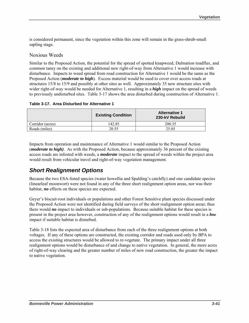
Vegetation
Bonneville Power Administration 3-41
is considered permanent, since the vegetation within this zone will remain in the grass-shrub-small sapling stage.
Noxious Weeds Similar to the Proposed Action, the potential for the spread of spotted knapweed, Dalmation toadflax, and common tansy on the existing and additional new right-of-way from Alternative 1 would increase with disturbance. Impacts to weed spread from road construction for Alternative 1 would be the same as the Proposed Action (moderate to high). Excess material would be used to cover over access roads at structures 15/8 to 15/9 and possibly at other sites as well. Approximately 35 new structure sites with wider right-of-way would be needed for Alternative 1, resulting in a high impact on the spread of weeds to previously undisturbed sites. Table 3-17 shows the area disturbed during construction of Alternative 1.
Table 3-17. Area Disturbed for Alternative 1
Existing Condition Alternative 1
230-kV Rebuild Corridor (acres) 142.85 200.35 Roads (miles) 20.55 25.05
Impacts from operation and maintenance of Alternative 1 would similar to the Proposed Action (moderate to high). As with the Proposed Action, because approximately 36 percent of the existing access roads are infested with weeds, a moderate impact to the spread of weeds within the project area would result from vehicular travel and right-of-way vegetation management.
Short Realignment Options Because the two ESA-listed species (water howellia and Spalding’s catchfly) and one candidate species (linearleaf moonwort) were not found in any of the three short realignment option areas, nor was their habitat, no effects on these species are expected.
Geyer’s biscuit-root individuals or populations and other Forest Sensitive plant species discussed under the Proposed Action were not identified during field surveys of the short realignment option areas; thus there would no impact to individuals or sub-populations. Because suitable habitat for these species is present in the project area however, construction of any of the realignment options would result in a low impact if suitable habitat is disturbed.
Table 3-18 lists the expected area of disturbance from each of the three realignment options at both voltages. If any of these options are constructed, the existing corridor and roads used only by BPA to access the existing structures would be allowed to re-vegetate. The primary impact under all three realignment options would be disturbance of and change to native vegetation. In general, the more acres of right-of-way clearing and the greater number of miles of new road construction, the greater the impact to native vegetation.

3 Affected Environment and Environmental Consequences
3-42 Libby to Troy Rebuild Project Draft EIS
Table 3-18. Short Realignment Options
Realignment Option
New right-of-way clearing (acres)
New road construction (miles)
Pipe Creek 115 kV 7.40 0.5
Pipe Creek 230 kV 9.20 0.5
Quartz Creek 115 kV 25.8 1.6
Quartz Creek 230 kV 32.1 1.6
Kootenai River Crossing 115 kV
7.2 0.2
Kootenai River Crossing 230 kV
7.2 0.2
In addition to general disturbance and change of native vegetation, two of the three realignment options would affect old growth stands in the project vicinity, and all three realignment options would have the potential to increase noxious weed spread. The following discussion describes potential old growth and noxious weed impacts for each realignment option.
Pipe Creek Realignment Old Growth
The Pipe Creek realignment option would cross an old growth stand and would also affect buffer habitat, as shown in Table 3-19 and Figure 3-4. The Pipe Creek realignment would clear 1.5 acres (at 115 kV) and 1.8 acres (at 230 kV) of the 170-acre designated old growth stand located near Bobtail Creek, resulting in a moderate to high impact in this area. Additionally, clearing in undesignated old growth areas and road construction would remove old growth vegetation, resulting in a moderate to high impact. About 38.9 acres of old growth buffer area would be affected, resulting in a low to moderate impact; while changes in vegetation and wildlife use may occur in the buffer zone, those acres would remain functional old growth for some species. The edge effect created by the transmission line clearing is considered permanent, since the vegetation within this zone will remain in the grass-shrub-small sapling stage.

Vegetation
Bonneville Power Administration 3-43
Table 3-19. Effects of the Pipe Creek Realignment Option on Old Growth
Measurement Criteria Pipe Creek
Realignment 115 kV
Pipe Creek Realignment
230 kV Acres of trees removed in Designated Old Growth/Replacement Old Growth
1.5 1.8
Acres of trees removed in Undesignated Old Growth*
3.5 4.3
Road length (in feet) built adjacent to or through Designated or Undesignated Old Growth/Replacement Old Growth
1,300 1,300
Acres of Old Growth edge or buffer affected area
38.9 38.9
Percent of designated Old Growth in PSU (OG+ROG)
10.3 Pipestone
10.3 Pipestone
* Undesignated old growth also includes areas not currently mapped on the Kootenai National Forest but were identified during field surveys along the transmission line corridor as having old growth characteristics (see Figure 3-4).
Noxious Weeds
Construction activities would have a moderate to high impact on the spread of noxious weeds within the Pipe Creek realignment area. Currently only about 1 percent of the proposed right-of-way and access roads are infested with noxious weeds (Table 3-14) while the existing right-of-way segments on each end are heavily infested. Also, the new right-of-way and access roads would likely be an attraction for off-road vehicles, equestrians and hikers, all of whom provide additional opportunities to spread weeds. Installation of gates as described in Section 3.3.3 would reduce recreational use. The 230-kV option would have a slightly higher impact due to the greater amount of disturbance associated with the wider right-of-way.
There would be a moderate to high impact to weed spread within the project area from maintenance activities, due to vehicular travel and right-of-way brushing and the additional risk of bringing seeds from other areas into an area that is relatively free of exotic species. The impacts of the 230-kV option would be slightly higher than those of the 115-kV option due to the 1.8 additional acres of right-of-way clearing.
If this realignment is chosen, BPA would abandon the corridor between existing structures 17/14 and 18/10, but an electrical distribution line would remain in place to serve a residential area on Kootenai River Road. Therefore, the existing corridor would continue to be a vector for weed spread.
Quartz Creek Realignment Old Growth
The Quartz Creek realignment crosses an old growth stand northwest of the Bighorn Terrace subdivision (see Figure 3-4). Approximately 2.0 acres (at 115 kV) and 2.5 acres (at 230 kV) of the 35 acre designated old growth stand would be cleared for this realignment, resulting in a moderate to high impact (see Table 3-20). The realignment would also have a low to moderate impact on about 30.9 acres of buffer habitat from danger tree clearing. While changes in vegetation and wildlife use may occur in the buffer zone,

3 Affected Environment and Environmental Consequences
3-44 Libby to Troy Rebuild Project Draft EIS
those acres would remain functional old growth for some species similar to the old growth stand near Bobtail Creek. The edge effect created by the transmission line clearing is considered permanent, since the vegetation within this zone will remain in the grass-shrub-small sapling stage.
Table 3-20. Effects of the Quartz Creek Realignment Option on Old Growth
Measurement Criteria Quartz Creek Realignment
115 kV
Quartz Creek Realignment
230 kV Acres of trees removed in Designated Old Growth/Replacement Old Growth
2.0 2.5
Acres of trees removed in Undesignated Old Growth
1.8 2.3
Road length (in feet) built adjacent to or through Designated or Undesignated Old Growth/Replacement Old Growth
1,425 1,425
Acres of Old Growth buffer affected 30.9 30.9 Percent of designated Old Growth in PSU (OG+ROG)
28.8 Quartz 10.0 Sheep
28.8 Quartz 10.0 Sheep
* Undesignated old growth also includes areas not currently mapped on the Kootenai National
Forest but which were identified during field surveys along the transmission line corridor (see Figure 3-4).
Noxious Weeds
Similar to the Pipe Creek option, construction activities for the Quartz Creek realignment would have a moderate to high potential to spread noxious weeds within the project area via the same methods. Currently only about 22 percent of the proposed right-of-way and access roads are infested with noxious weeds (Table 3-14), while the existing right-of-way segments on each end are heavily infested. Of particular concern is the small population of Dalmatian toadflax near structure 21/3. Seed from this population could easily be transported by equipment into the realignment area. Washing of all equipment before entering the realignment area and when leaving the Dalmation toadflax population near structure 21/3 would reduce the potential for infestation (see Section 3.3.3 Mitigation). Dalmatian toadflax is a Priority 1C noxious weed with a goal of eradication of isolated populations. Impacts of maintenance activities would be similar to those for the Pipe Creek realignment.
If this alternative is implemented, BPA would abandon the corridor section between existing structures 19/4 and 21/4. This segment would continue to be a significant vector for weed spread unless weeds were controlled and the right-of-way and associated access roads were revegetated (see Section 3.3.3 Mitigation).
Kootenai River Crossing Realignment Old Growth
The Kootenai River crossing realignment does not cross any lands with designated or undesignated old growth stands so there would be no impact.
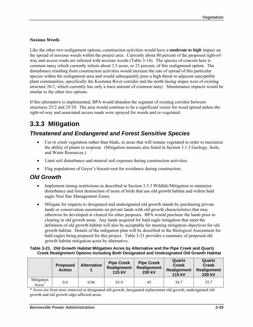
Vegetation
Bonneville Power Administration 3-45
Noxious Weeds
Like the other two realignment options, construction activities would have a moderate to high impact on the spread of noxious weeds within the project area. Currently about 80 percent of the proposed right-of-way and access roads are infested with noxious weeds (Table 3-14). The species of concern here is common tansy which currently infests about 2.5 acres, or 23 percent, of this realignment option. The disturbance resulting from construction activities would increase the rate of spread of this particular species within the realignment area and would subsequently pose a high threat to adjacent susceptible plant communities, specifically the Kootenai River corridor and the north facing slopes west of existing structure 26/1, which currently has only a trace amount of common tansy. Maintenance impacts would be similar to the other two options.
If this alternative is implemented, BPA would abandon the segment of existing corridor between structures 25/2 and 25/10. The area would continue to be a significant vector for weed spread unless the right-of-way and associated access roads were sprayed for weeds and re-vegetated.
3.3.3 Mitigation Threatened and Endangered and Forest Sensitive Species
• Cut or crush vegetation rather than blade, in areas that will remain vegetated in order to maximize the ability of plants to resprout. (Mitigation measure also listed in Section 3.1.3 Geology, Soils, and Water Resources.)
• Limit soil disturbance and mineral soil exposure during construction activities.
• Flag populations of Geyer’s biscuit-root for avoidance during construction.
Old Growth • Implement timing restrictions as described in Section 3.5.3 Wildlife/Mitigation to minimize
disturbance and limit destruction of nests of birds that use old growth habitat and within bald eagle Nest Site Management Zones.
• Mitigate for impacts to designated and undesignated old growth stands by purchasing private lands or conservation easements on private lands with old growth characteristics that may otherwise be developed or cleared for other purposes. BPA would purchase the lands prior to clearing in old growth areas. Any lands acquired for bald eagle mitigation that meet the definition of old growth habitat will also be acceptable for meeting mitigation objectives for old growth habitat. Details of the mitigation plan will be described in the Biological Assessment for bald eagles being prepared for this project. Table 3-21 provides a summary of proposed old growth habitat mitigation acres by alternative.
Table 3-21. Old Growth Habitat Mitigation Acres by Alternative and the Pipe Creek and Quartz Creek Realignment Options Including Both Designated and Undesignated Old Growth Habitat
Proposed Action
Alternative 1
Pipe Creek Realignment
115 kV
Pipe Creek Realignment
230 kV
Quartz Creek
Realignment 115 kV
Quartz Creek
Realignment 230 kV
Mitigation Acres* 0.0 0.06 43.9 45 34.7 35.7
* Acres are from trees removed in designated old growth, designated replacement old growth, undesignated old growth and old growth edge-affected areas.
3 Affected Environment and Environmental Consequences
3-46 Libby to Troy Rebuild Project Draft EIS
Noxious Weeds • Comply with Federal, state and county weed control regulations and guidelines.
• Implement Forest Service Manual (FSM) 2080 Noxious Weed Management Prevention and control measures on all Kootenai National Forest lands. See Appendix E.
• Use certified weed-free forage/mulch if available on all Kootenai National Forest lands in Montana (36 FR 261.50).
• Pressure or steam wash all equipment before entering the project area and when leaving discrete patches of weeds.
• Flag or map weed populations prior to construction for avoidance. Clean vehicles after leaving those areas to avoid spread of weeds.
• Seed and fertilize newly constructed and restored roads after use with seed that meets the requirements of Federal, state, and county weed control regulations and guidelines.
• Use certified weed-free straw for erosion control for all construction, reconstruction and restoration activities.
• Treat and sign sites if new invaders are located and defer ground disturbing activities within those sites until the weed specialist from Lincoln County or the Kootenai National Forest determines the site is no longer a threat, and approves those activities.
• Follow site-specific guidelines for weed treatments within or adjacent to known sensitive plant populations. All future treatment sites will be evaluated for sensitive plant habitat suitability; suitable habitats will be surveyed as necessary prior to treatment.
• Use the 1,000 cubic yards of excess excavated material from 15/4 – 15/7 contaminated with spotted knapweed seed and other weed seeds in areas that have the same weed species. This material will not be used at sites relatively free of these species, such as the Pipe Creek, Quartz Creek, and Kootenai River Crossing realignments.
• Treat the Dalmatian toadflax populations located east of structure 21/3 and at the Troy Substation on the Lake Creek road with herbicide prior to any activity, to eliminate the potential for plants producing seed to be carried elsewhere.
• Cooperate with Lincoln County for the treatment of the common tansy population from structure 26/1 to 26/9 with herbicide prior to any motorized travel to reduce the chance of spreading this species.
• Wash ATVs and other off-road vehicles before bringing them into the historic Highway 2 area.
• Cooperate with private, county, and Federal landowners to treat the noxious weeds along the access roads that will be used to bring tree clearing and construction equipment into the Pipe Creek, Quartz Creek, and Kootenai River Crossing realignment areas, to reduce the amount of weed seed that could be available for dispersal.
• Wash all vehicles and construction equipment before beginning clearing and construction activities in the realignment areas, to help prevent the transport of weed seeds from areas that are already infested.

Vegetation
Bonneville Power Administration 3-47
• Install gates and post signs on access roads to discourage recreational vehicular travel and subsequent weed seed transport. Gates could be installed in the following locations: near structure 17/13 and on the existing access road off Bobtail Road; where the corridor crosses Quartz Creek Road west of structure 19/3; on the existing access road near the new right-of-way crossing of Quartz Creek Road; on the existing access road near the new eastern angle structure for the Quartz Creek realignment; on the west side of Quartz Creek off USFS Road 601; and on the existing access road near structure 21/3.
• Revegetate the abandoned section between 19/4 and 21/4 if structures are removed and ground is disturbed.
• Apply all herbicides according to the labeled rates and recommendations to ensure the protection of surface water, ecological integrity and public health and safety. Herbicide selection will be based on target species on the site, site factors (such as soil types, distance to water, etc.), and with the objective to minimize impacts to non-target species.
• Conduct a post-construction weed survey to confirm whether or not noxious weeds have been spread within the project area, and take curative action if needed.
3.3.4 Environmental Consequences of the No Action Alternative
No new right-of-way clearing or road construction activities have been identified for this alternative. Essentially, existing transmission line right-of-way clearing and maintenance activities would continue, with the potential for increased maintenance activities associated with the failing structures and their replacement, and the potential for more frequent emergency work.
Threatened, Endangered and Forest Sensitive Species During routine maintenance activities, roads are upgraded as needed and trees are cut as they approach the height limit below the transmission line. These activities affect threatened and endangered, Forest Sensitive and native plant species in ways similar to the Proposed Action but to a lesser extent, because only short segments of the line would be worked on at any time. The resulting impact would be low to moderate. However, during emergency maintenance or structure replacement, potential impacts could be high to a population of sensitive plants such as Geyer’s biscuit-root because of the need to do the work immediately. Low to moderate impacts to roadside native species and Geyer’s biscuit-root could still occur from road spraying and weed spread.
Old Growth The No Action Alternative would have no direct effect on designated old growth or associated plant and wildlife species (also see Section 3.5.2 Wildlife/Pileated Woodpecker). The conditions for all measurement criteria would remain unchanged.
Under No Action, natural successional processes would continue to occur throughout existing old growth stands. Habitat would be provided for wildlife species that find suitable feeding and breeding conditions provided by the structural features and overall environment within old growth habitat. Some stands in the drier ponderosa pine/Douglas fir bunchgrass types (particularly within the Sheep PSU) would continue to experience encroachment of Douglas fir saplings in the understory. This encroachment may stress some of the larger ponderosa pine overstory trees, resulting in a higher percentage of Douglas fir trees

3 Affected Environment and Environmental Consequences
3-48 Libby to Troy Rebuild Project Draft EIS
throughout all canopy layers over the next several decades. The affected stands would develop fuel loading and ladder fuels that are uncharacteristic for some sites.
Current levels of disturbance due to ongoing maintenance activities for the existing transmission facilities would continue under the No Action Alternative. Activities could include vehicular traffic along the current access roads and vegetation management activities. These activities are not expected to have any direct or indirect effect on old growth habitat or potential old growth habitat.
Noxious Weeds Existing access roads and rights-of-way would continue to support weed populations; seeds would be spread by road maintenance equipment, as well as by other administrative and recreational traffic, resulting in a low to moderate impact. Existing weeds are expected to continue moving from roadways and rights-of-way into previously disturbed areas and adjacent big game winter ranges and riparian areas.
Weeds impact native vegetation by competing for light, water and nutrients. Native vegetation provides forage, cover or nesting habitat for birds and animals. In comparison, noxious weed species generally do not provide valuable forage or habitat for native animals (Trammell and Butler 1995). The potential replacement of structures would disturb vegetation and compact soil creating dry areas where weed infestations would occur. As weeds invade the disturbed or dry sites, the carrying capacity of big game winter range within and adjacent to the project area would continue to be compromised. By altering the structure of plant communities, noxious weeds alter the structure of animal communities (Sheley 1999). A key invasive on the dry sites is spotted knapweed. Watson and Renney (1974) found that spotted knapweed infestations decreased bluebunch wheatgrass forage yield by 88 percent (Sheley 1999). Associated elk use was reduced by 98 percent on spotted knapweed-dominated range compared to bunchgrass-dominated sites (Sheley 1999). Warm and dry (mesic) forest types are most likely to be invaded by spotted knapweed, Dalmatian toadflax and sulfur cinquefoil over time. Dalmatian toadflax and sulfur cinquefoil can become significant components of the plant community and can dominate sites, particularly the drier sites. Of these species spotted knapweed is the most prevalent and Dalmatian toadflax is present at three sites along the existing right-of-way. If noxious weed control measures are not used to limit weed infestation along BPA’s existing transmission corridor and access roads, native forage could be reduced for big game species.

Wetlands and Floodplains
Bonneville Power Administration 3-49
3.4 Wetlands and Floodplains 3.4.1 Affected Environment Wetlands Wetlands are areas of transition between aquatic and terrestrial systems, where water is the dominant factor determining the development of soil characteristics and associated biological communities. They can be biologically productive and help maintain or improve water quality, contribute to flood control, provide wildlife habitat, and have recreational or aesthetic value.
Several laws provide protection for wetland areas and their functions. The federal Clean Water Act (33 U.S.C. §1251 et seq.) regulates discharges into waters of the United States, including wetlands. The State of Montana also regulates discharge of solid material into waters of the United States through the Montana Water Quality Act and Montana Streambed Preservation Act. In addition, wetland buffer areas have been established to help preserve wetland areas. On National Forest Lands, a buffer width of 150 feet from the wetland boundary has been established by the Inland Native Fish Strategy Environmental Assessment (USDA 1995). On state and private lands, a buffer width of 50 feet from the wetland boundary has been established by the State of Montana Streamside Management Zone Act (77-5-301[1], MCA).
Wetlands in the project corridor are primarily slope, palustrine wetlands that are fed by perennial springs and/or snowmelt and are classified as emergent and scrub-shrub wetlands. Most wetlands within the corridor are dominated by tree species such as black cottonwood, quaking aspen, and speckled alder. Fringe and riparian wetlands make up the remainder of the wetland areas. Fringe wetlands are classified as emergent and scrub-shrub wetlands with reed canarygrass as the dominant vegetation. Riparian wetlands within the project are found along Pipe, Bobtail, Quartz, Dad, Burrell, and China creeks and Hunter Gulch. Typical riparian wetlands are narrow bands of vegetation such as aspen, alder, red-osier dogwood and associated various herbaceous species. These narrow bands of vegetation can be inundated with water during the spring runoff and are always located within the floodplains of the streams or adjacent to spring-fed channels.
Four wetland areas were identified within the 17-mile transmission line corridor during a July 2006 survey (Figure 3-5 and Table 3-22). A fifth wetland area was identified in April 2006. Three of the four wetland areas identified during 2006 survey are located along the Sheep Range Road. These wetlands areas have been disturbed to some extent by access roads that either block the drainage of water to the river or dam up the water, creating a larger “wetland” area that would not have existed without the road in place. They are vegetated primarily with native species, although some wetlands have been invaded by reed canarygrass. The fourth area, located between existing structures 26/1 and 26/5, consists of about 4 springs that drain the hillside on the south slope of Highway 2. The fifth wetland area is located on the western leg of the Quartz Creek realignment north of existing structure 21/2.

3 Affected Environment and Environmental Consequences
3-50 Libby to Troy Rebuild Project Draft EIS
The following three existing structures are located in or near wetland or spring areas: 22/4, 23/8 and 26/2. Structure 22/4 is directly in Wetland 3 while structure 23/8 is located between the pond and fringe wetland of Wetland 4c. Structure 26/2 is located adjacent to a spring fed stream in Wetland 7. Table 3-22 displays all of the wetlands in the project area.
Table 3-22. Wetland Areas Within the Project Area
Wetland Type of Wetland Acreage of
Wetland within Corridor
Total Acreage of
Wetland Location
Wetland 3* Slope, Palustrine Wetland
3.6 8.3 Adjacent to Structure 22/4
Wetland 4a Spring/Wetland 0.08 0.08 Along Sheep range Road near structure
23/7 Wetland 4b Slope, Palustrine
Wetland 1.9 2.1 Along Sheep Range
Road between structures 23/7 and
23/8 Wetland 4c Pond, Emergent and
Scrub-Shrub Wetland 1.9 1.9 Along Sheep Range
Road near structure 23/8
Wetland 4d Slope, Palustrine Wetland
1.5 7.2 Along Sheep Range Road between
structures 23/8 and 24/1
Wetland 4e Spring fed Stream/Wetland
0.04 0.04 Along Sheep Range Road between
structures 23/8 and 24/1
Wetland 7 Spring fed Streams 0.6 0.6 North side of Highway 2 and Kootenai River
between structures 26/2 and 26/5
Wetland 10 Spring 0.1 0.1 Along Sheep Range Road at the end of
Kootenai River Road
Wetland ** Wetland 0.03 0.03 Along the west leg of the Quartz Creek Realignment Option
Total 11.03 21.8 * Ten areas along the transmission line corridor were field surveyed in July 2006 for the presence of wetlands, springs or streams. Of those ten areas, two were streams and four were found not to have wetlands but were upland meadow areas. The numbering for the four remaining areas listed in this table reflects the numbering system used in the wetland delineation report.
** This wetland was identified in the field after the July 2006 survey and so has no number.
Wetlands and Floodplains
Bonneville Power Administration 3-51
Floodplains The Federal Emergency Management Agency identifies areas adjacent to rivers and streams that have a 1percent chance of being flooded in a given year as 100-year floodplains. Like wetlands, floodplains can be biologically productive and are important for absorbing excess water during floods.
The corridor crosses the 100-year floodplains of four drainages: Pipe, Bobtail, and Quartz Creeks and the Kootenai River (Flood Insurance Rate Maps published by Federal Emergency Management Agency, U.S. Department of Housing and Urban Development [now part of the Department of Homeland Security]). Floodplains within the project area are not shown on Figure 3-5 because digital map data is not available from FEMA.
Existing transmission line structures are in the floodplains of Pipe Creek (structures 17/19 and 17/20), and Bobtail Creek (structures 18/6 and 18/7). There are no structures in the floodplain of Quartz Creek. Structures 20/3 to 21/5 and 22/1 to 25/8 (46 structures) are located in the Kootenai River floodplain. Although these structures are in the FEMA-designated floodplain, because the flow volume of the Kootenai River is controlled by Libby Dam 20 miles upstream of the transmission line corridor, it is not expected that river levels would reach the FEMA-designated floodplain height.
Floodplain widths for Pipe, Bobtail, and Quartz creeks are roughly 600, 200, and 250 feet respectively, while the Kootenai River floodplain width is roughly 1,200 feet.
3.4.2 Environmental Consequences of Action Alternatives
Construction activities in wetland and floodplain areas can cause these areas to become degraded and reduce their ability to provide wildlife habitat, flood control, and other functions. In addition, wetlands can be affected by sediment transport from corridor clearing, access road construction and widening, and structure site preparation. Modification and destabilization of floodplains can have adverse effects not only near the disturbance but also downstream in both the stream channel and the floodplain. Adverse impacts include the potential for flood damage to the facilities, increased flooding because the presence of the facilities displaces water from the normal floodplain, and increased potential for soil erosion near construction sites.
Proposed Action – 115-kV Single-Circuit Rebuild Wetlands The Proposed Action would include removal of structures 22/4, 23/8, and 26/2, which are located in or near wetland areas. Removal of these structures could result in impacts to wetlands by crushing vegetation or compacting soil. In order to minimize these impacts, the existing wood-pole structures would be cut off at ground level instead of being excavated and filled. The removed structures would then be dragged out or lifted out by crane to avoid using construction equipment that would compact wetland soils. However, wetland impacts would still occur where structures would be dragged out, thereby destroying wetland vegetation. Because only a very small portion of wetlands would be impacted by removal of existing wood-pole structures, the impact would be low.
None of the new structures under the Proposed Action would be constructed in wetland areas. However, construction of new structures could result in indirect impacts to wetlands from sediment transport crushing or covering wetland vegetation or affecting water quality. Implementation of BMPs (see Section
3 Affected Environment and Environmental Consequences
3-52 Libby to Troy Rebuild Project Draft EIS
3.1 Geology, Soils, and Water Resources) would reduce and minimize the potential for these potential impacts to wetlands. The impact to wetlands from construction of new structures thus would be considered low.
Construction of new structures within the established wetland buffer areas would result in a low to moderate impact. Although no filling of wetland buffer areas would occur, an area of about 0.25 acres around each structure would be disturbed during installation possibly crushing or removing wetland buffer vegetation. Structures 22/4, 23/8, and 26/2 would be relocated outside of the wetlands; however the new locations may still be within wetland buffers. Structure 22/4 would be relocated about 300 feet west of Wetland 3 and structure 23/8 would be relocated about 50 feet east from Wetland 4c. Structure 26/2 would be relocated about 75 feet west of the spring in Wetland 7. Direct impacts from construction of structures within wetland buffers would alter overland water flow patterns, thereby increasing or decreasing wetland hydrology that could change wetland plant communities. The reduction of vegetated buffers adjacent to wetlands would increase overland water flow and increase the likelihood of silts and sediments entering wetland surface waters and degrading water quality. Impacts would be reduced if the removal of the vegetation is done so that the roots are left intact (see Section 3.3.3 Vegetation/Mitigation). With the roots in place, the soils would be less likely to erode and the plants could resprout, re-creating the vegetative buffer. Other indirect impacts would occur if oils and pollutants from machinery enter surface water, potentially affecting water quality.
Conductor tensioning sites and staging areas needed for the Proposed Action would not be placed within 400 feet of wetlands so the impact would be low.
New access roads would not be constructed in wetlands or wetland buffers where possible for the Proposed Action. The new access road to the new structure 22/4 would be constructed west of the structure where no wetlands are located; thus the impact would be low. Although the new access road and bridge across China Creek would be located above the ordinary high water mark of the stream, riparian wetlands would be impacted by clearing, resulting in a moderate to high impact. All applicable permits would be obtained for work in this or other wetlands where fill occurs. Other riparian wetlands along project streams would be impacted by tree clearing; however, because the existing right-of-way has been cleared previously, few trees would be removed, resulting in a low impact. No structures or roads would be constructed in riparian wetlands.
Improvement of existing access roads for the Proposed Action would result in direct and indirect impacts to wetlands or wetland buffers. Direct impacts would include removal of wetland vegetation. Indirect impacts would result in hydrologic changes to the wetland from road drainage alterations. Additionally, wetlands could be impact by potential accidental spills of chemicals, oils and pollutants from machinery that could occur. Sheep Range Road crosses through Wetland 4 (a-e) between structures 23/7 and 24/1. In this area, the road acts as a berm, preventing the wetlands from having surface hydrologic connectivity to the Kootenai River. Although no filling of these wetlands is proposed at this time, a small amount of sediment could be introduced into wetlands immediately adjacent to the road from vehicular traffic mud splash if the road is used during the wet season, resulting in a low to moderate impact. However, these impacts would be short term, and wetland functions would not be impaired because no filling or excavation would occur. Access road improvement overall would result in a low impact because best management practices such as erosion and sediment control measures would be implemented (see Section 3.4.3 Mitigation).
The existing access road between structures 26/2 and 26/5 would cross approximately 0.6 acres of springs (Wetland 7); drainage structures would be installed in that road to allow the spring water to connect to slopes and water systems below the road. Fill would be needed to provide a road bed, resulting in a

Wetlands and Floodplains
Bonneville Power Administration 3-53
moderate impact to this wetland area. A portion of Sheep Range Road near the spring in Wetland 10 would need to have a drainage structure installed to retain the spring’s connectivity with the Kootenai River. Overall, the impact of access road improvements from the Proposed Action would be low to moderate.
Operation and maintenance of the Proposed Action would result in direct and indirect impacts to wetlands. Direct impacts would result from vegetation maintenance activities such as clearing of vegetation or the application of herbicides for noxious weed control. Most wetlands and wetland buffers within the corridor are dominated by tree species that at times would need to be cut. If herbicide application is required, appropriate buffers would be used to keep herbicides out of wetlands (BPA 2000, Table III-1). Use of access roads during wet periods for structure maintenance would indirectly affect wetlands by introducing sediment into wetlands through vehicular traffic mud splash, potentially affecting water quality. The impact level resulting from maintenance activities would be low to moderate.
Floodplains For the Proposed Action, the existing structures located in the Pipe Creek, Bobtail Creek, and Kootenai River floodplains would be removed or poles are cut off at the ground level. The impact would be low because minimal soil compaction and removal of riparian vegetation would occur in these floodplains.
The two new structures closest to Pipe Creek would be replaced in their existing locations. The impact to the Pipe Creek floodplain from the construction of new structures would be low even if new holes are needed. This section of Pipe Creek near the structure sites has been channelized or bermed, preventing flood waters from reaching the structure sites; therefore, soil compaction or disturbance would have little effect on flood storage or the course of flood waters. Currently structure 17/19 is about 180 feet from the creek and structure 17/20 is about 120 feet from the creek; the floodplain in this area is 600 feet wide.
Structure 18/6, located in the Bobtail Creek floodplain, would be moved about 10 feet north to accommodate replacement of the line along the north side of Kootenai River Road. Relocation of structure 18/6 would have a low impact on the Bobtail Creek floodplain; it currently is about 50 feet from the creek and would be moved about 10 feet closer to the stream within the floodplain. However, like Pipe Creek, Bobtail Creek is also channelized in this area so work at the new structure site, located well above flood stage, would not affect flood storage or the course of flood waters.
Construction of new structures in the Kootenai River floodplain would occur in the same location as the existing structures (except for those structures discussed above located in wetlands), resulting in a low impact.
For the Proposed Action, about 4 to 5 conductor tensioning sites would be located in the Kootenai River floodplain, resulting in a moderate impact. Conductor tensioning sites need to be relatively flat which would require soil disturbance and compaction within the floodplain. Conductor tensioning sites would not be located in the floodplains of Pipe or Bobtail creek; thus there would be no impact. Staging areas for the Proposed Action would not be located in any project area floodplains so there would be no impact.
New access roads would not be constructed in the Pipe Creek or Bobtail Creek floodplains so there would be no impact from new road construction to these floodplains. There would be about 0.6 miles of new road constructed in the Kootenai River floodplain to access the line near structure 22/1 and to cross China Creek. Soil disturbance and compaction would occur within 75 feet of the Kootenai River near structure 22/1, but about 250 to 450 feet north of the Kootenai River where the access road would cross China Creek. Use of best management practices as described in Section 3.4.3 Mitigation would minimize

3 Affected Environment and Environmental Consequences
3-54 Libby to Troy Rebuild Project Draft EIS
impacts to the floodplain. Construction of this new access road thus would result in a low to moderate impact to the Kootenai River floodplain.
Although Sheep Range Road is located in the Kootenai River floodplain, improving it would not alter the amount of floodplain storage, local patterns of flooding, or create obstructions to floodwaters beyond what already exists. However access road improvement would widen the road, which would increase the potential for sediment delivery to the Kootenai River. This potential for increased sediment delivery would be a low to moderate impact to the floodplain.
Operation and maintenance activities are expected to have a low impact on floodplains unless new access roads or structures are located in floodplains. If maintenance activities do require construction of new roads or relocation of structures, the resulting impact would be low to moderate if soil is compacted and vegetation removed within the floodplains. Maintenance of the four structures located within the Pipe and Bobtail creek floodplains would not impact the floodplains because they are currently inaccessible to the streams even during flood events due to stream channelization. Potential vegetation management activities, such as removal of danger trees, are expected to be minimal and would not adversely affect floodplain functions, because danger trees felled within the floodplain would be allowed to remain as large woody debris, similar to natural floodplain conditions.
Alternative 1 – 230-kV Double-Circuit Rebuild Wetlands Impacts to wetlands from removal of existing wooden structures for Alternative 1 would be the same as those under the Proposed Action (low). Like the Proposed Action, none of the new structures under Alternative 1 would be constructed in wetland areas. However, construction of larger 230-kV structures for Alternative 1 would disturb a larger area than the Proposed Action and would indirectly impacting wetlands by crushing or removing vegetation, resulting in erosion from construction sites. Because BMPs (see Section 3.1 Geology, Soils, and Water Resources) would reduce and minimize the potential for these potential impacts to wetlands, this would be considered a low impact. Construction of new structures within wetland buffer areas would result in a low to moderate impact similar to the Proposed Action. Although no filling of wetland buffer areas would occur for Alternative 1, an area of about 0.5-acres around each structure would be disturbed during installation possibly crushing or removing wetland buffer vegetation. For Alternative 1, structures 22/4, 23/8, and 26/2 would be relocated the same distance as the Proposed Action from the wetlands; however these new locations may still be within wetland buffers. Use of best management practices would reduce impacts to wetland buffers (see Section 3.3.3 Vegetation/Mitigation).
Similar to the Proposed Action, conductor tensioning sites and staging areas for Alternative 1 would not be placed within 400 feet of wetlands so the impact would be low.
For Alternative 1, new access roads would not be constructed in wetlands or wetland buffers where possible similar to the Proposed Action. Impacts would be similar to those under the Proposed Action for the new access road to the new structure 22/4 (low) and through the riparian wetland of China Creek (moderate to high). Similar to the Proposed Action, all applicable permits would be obtained for work in this or other wetlands where fill occurs. The impact from Alternative 1 to other riparian wetlands in the project area would be greater than the Proposed Action. Tree clearing to widen the corridor from 80 feet to 100 feet would result in a low to moderate impact to riparian wetlands as more tall growing vegetation would be removed. Similar to the Proposed Action, no structures or roads would be constructed in riparian wetlands for Alternative 1.
Wetlands and Floodplains
Bonneville Power Administration 3-55
Impacts to wetlands under Alternative 1 from road improvement would be the same as those under the Proposed Action (low to moderate if work occurs during the wet season and moderate where wetland fill would occur; impacts would be reduced to low by using best management practices; see Section 3.4.3 Mitigation).
Impacts from operation and maintenance of Alternative 1 would be similar to those under the Proposed Action (low to moderate) although wider right-of-way would require more clearing of vegetation and application of herbicides for noxious weed control. Appropriate use of buffers for herbicide application would be required to keep herbicides out of wetlands (BPA 2000, Table III-1) as under the Proposed Action. Similar to the Proposed Action, use of access roads during wet periods for structure maintenance would introduce sediment into wetlands through vehicular traffic mud splash, potentially affecting water quality.
Floodplains Direct and indirect impacts to floodplains from removal of existing wooden structures for Alternative 1 would be the same as those under the Proposed Action (low).
Impacts from construction of new structures in Pipe and Bobtail creek floodplains from Alternative 1 would be the similar to those under the Proposed Action. Additional tree clearing to widen the corridor to 100 feet would increase the potential for soil compaction in the floodplains; however both floodplains have been channelized or bermed, preventing flood waters from reaching the structure sites, resulting in a low to moderate impact. Construction of new structures in the Kootenai River floodplain would occur in the same location as the Proposed Action and existing structures (except for those structures located in wetlands). Because additional clearing would occur with Alternative 1, a low to moderate impact would result.
Similar to the Proposed Action, Alternative 1 would require about 4 to 5 conductor tensioning sites located in the Kootenai River floodplain. The resulting impact would be moderate because tensioning sites need to be relatively flat requiring soil disturbance and compaction. Conductor tensioning sites would not be located in the floodplains of Pipe or Bobtail creek as under the Proposed Action; thus there would be no impact. Staging areas for Alternative 1 would not be located in any project area floodplains so there would be no impact.
Similar to the Proposed Action, new access roads would not be constructed in the Pipe Creek or Bobtail Creek floodplains for Alternative 1 so there would be no impact.
Impacts from construction of about 0.6 miles of new road in the Kootenai River floodplain would be the same as those under the Proposed Action (low to moderate). Best management practices as described in Section 3.4.3 Mitigation would use to minimize impacts to the floodplain.
Impacts from improvement of Sheep Range Road located in the Kootenai River floodplain would be the same as those under the Proposed Action (low to moderate).
Impacts from operation and maintenance of Alternative 1 would be the same as those under the Proposed Action (low if no new roads or structures are required or low to moderate if new roads or structures are needed during maintenance activities).
3 Affected Environment and Environmental Consequences
3-56 Libby to Troy Rebuild Project Draft EIS
Short Realignment Options Pipe Creek Realignment The Pipe Creek realignment would clear tall growing vegetation within the Pipe Creek and Bobtail Creek riparian wetlands. Although the 230-kV option would require wider right-of-way than the 115-kV option, both voltages would result in a moderate to high impact to riparian wetlands because new right-of-way would be cleared where none currently exists. Corridor clearing would increase sediment transport potentially reducing riparian wetland functions. No new structures or access roads for either voltage would be constructed in the riparian wetlands.
The floodplains of Pipe and Bobtail creeks would be spanned by the Pipe Creek realignment, and no structures would be placed in the floodplains. Impacts to floodplains would be low because trees felled within the corridor would be allowed to remain as large woody debris, similar to natural floodplain conditions.
Quartz Creek Realignment During stringing of the conductor for the Quartz Creek realignment, there is the potential that some tall growing vegetation in the Quartz Creek riparian wetlands within the new right-of-way would be removed. Although conductor would be about 270 feet above the ground (at 115 kV) and 230 to 290 feet above the ground (at 230 kV), the “sock-line and “hard- line” used to string the conductor could sag lower than the conductor. The impact would be low because trees that are felled within the right-of-way would be allowed to remain as large woody debris in the riparian area. No new structures or access roads for either voltage would be constructed in Quartz Creek riparian wetlands.
A wetland was identified along the western leg of the realignment north of existing structure 21/2. No structures, roads, tensioning sites or staging areas would be constructed within this wetland; thus there would be no impact.
No structures or access road would be constructed in the floodplain of Quartz Creek; however if tree removal occurs near Quartz Creek for the stringing of conductor the resulting impact would low.
Kootenai River Crossing Realignment The Kootenai River crossing realignment would clear tall growing vegetation within Kootenai River riparian wetlands. Although the 230-kV option would require wider right-of-way than the 115-kV option, both voltages would result in a low to moderate impact to riparian wetlands because new right-of-way would be cleared where none currently exists.
One new structure would be located about 100 feet from the bank of the Kootenai River, within the 1,200-foot-wide floodplain. Because river flow is controlled by Libby Dam and the river level most likely would not reach the new structure site where soil erosion or compaction could affect flood storage, the impact to this floodplain would be low.
3.4.3 Mitigation The following standard mitigation measures would minimize impacts.
• Obtain and comply with applicable Clean Water Act permits for all work in wetlands or streams.
Wetlands and Floodplains
Bonneville Power Administration 3-57
• Comply with the terms and conditions of applicable State of Montana Water Quality Act and Streambed Preservation Act permits for all work in wetlands and streams.
• Identify and flag wetlands before construction for avoidance.
• Locate structures, roads, staging areas and tensioning sites to avoid wetlands and floodplains as much as possible.
• Avoid construction within wetlands and wetland buffers to protect wetland functions and values, where possible. The wetland buffer width on Federal land is 150 feet from the wetland boundary and 50 feet from the wetland boundary on all other lands.
• Avoid mechanized land clearing within wetlands and riparian areas to minimize soil compaction from heavy machinery, destruction of live plants, and potential alteration of surface water patterns.
• Install erosion control measures such as silt fences, straw mulch, straw wattles, straw bale check dams, other soil stabilizers, and reseed disturbed areas as required; a Stormwater Pollution Prevention Plan would be prepared.
• Use herbicides to control vegetation near wetlands in accordance with the Transmission System Vegetation Management Program (BPA 2000), to limit impacts to water quality.
• Use existing road systems, where possible, to access structure locations and for the clearing of the transmission line corridor.
• Deposit all excavated material not reused in an upland area and stabilize.
• Locate structures to minimize the potential for creating obstructions to floodwaters.
• Recontour and revegetate disturbed areas near floodplains with native and local species.
3.4.4 Environmental Consequences of the No Action Alternative
Current levels of disturbance to wetlands and floodplains associated with ongoing maintenance activities for the existing transmission line corridor would continue under the No Action Alternative. This would include potential disturbance to wetlands and floodplain functions from structure replacement, vegetation management activities, and access road improvements. Potential new impacts to wetlands and floodplains could result when transmission structures fail and require immediate repair. In such cases, direct impacts to wetlands may occur if emergency repairs are required for transmission facilities located in or near wetlands. In addition, new access roads might be needed with little or no planning in their construction due to the emergency nature of the repairs, resulting in moderate to high impact. Because failures tend to occur during inclement weather when soils are more prone to erosion and thus have a higher potential to indirectly affect wetlands from sediment transport, emergency repair activities could increase the potential to disturb wetland vegetation and hydrology and floodplain functions.
3 Affected Environment and Environmental Consequences
3-58 Libby to Troy Rebuild Project Draft EIS
3.5 Wildlife 3.5.1 Affected Environment The existing transmission corridor and proposed realignment options cross lands that provide habitat to a wide variety of wildlife, both vertebrate and non-vertebrate. In addition to more common wildlife species, several species known to occur in the vicinity of the transmission line are considered to have a special status due to being listed under Federal or state laws or having a special designation under the Kootenai National Forest Plan or as assigned by the Regional Forester.
Existing Wildlife Habitat Wildlife habitat within the project area includes forest (including old growth), streams and rivers, wetlands and rocky cliffs (see Figures 3-4 and 3-5). The Libby and Troy areas of the project are less forested and more urban. Habitat better suited to wildlife species along the transmission line corridor is located in the area west of Pipe Creek Road on the north side of the Kootenai River to near Shannon Road on the south side of the Kootenai River. As discussed in Section 3.3 Vegetation, this portion of the Kootenai River corridor is dominated by western larch, Douglas fir, and ponderosa pine forests intermixed with natural grassy and rock openings with grand fir and western red cedar in wetter areas along the Kootenai River. For the portion of the project corridor on the Kootenai National Forest, suitable habitat for Federal and other special status species exists within the Pipestone, Quartz, Treasure, Sheep, and Lake Planning Subunits (PSUs) (Figure 3-6). Planning subunits are areas designated by the Kootenai NF Plan as having common resource concerns and sufficient areas to address environmental effects to those resources.
Common Wildlife Species The project area contains a diversity of wildlife species. The most visible species of wildlife found year-round throughout the area include elk, moose, whitetail deer, mule deer, bighorn sheep, black bear, and mountain lion. The project area has long been recognized as important for big game during both winter and summer with resident populations of all species and wintering populations of elk and whitetail deer in particular. The area contains populations of many of the common species of small game including snowshoe hare, pine squirrel, Columbian ground squirrel and coyote. Many other predators, furbearers, and small mammals are common in the project area.
Within the project area, there are many streams and riparian wetlands that provide habitat for songbirds, waterfowl, raptors, and shorebirds. Woodpeckers and other cavity dependent bird species are present, although actual abundance is not known. Species present that are commonly associated with mature and/or old growth forests include pileated woodpeckers, barred owls, and goshawks. Ruffed grouse are common at low and mid-elevations, with blue grouse occurring along ridgetops and in higher elevation habitats. Spruce grouse are present in mid-elevation spruce-fir zones.
In addition, there are numerous migratory bird species known to occur in the general project vicinity during their migration. Approximately 205 bird species are known as breeders, migrants, winter visitors, or transients on the Kootenai National Forest. Species diversity and total numbers are highest during the late spring and summer period when about 70-80 species of neotropical migratory birds return to the Kootenai National Forest annually to breed. Neotropical migratory birds are those species that winter in the tropics but migrate to more northerly latitudes to breed. Those typically present along the existing transmission line corridor adjacent to the Kootenai River include numerous songbirds or perching birds, raptors such as osprey, and shorebirds including spotted sandpipers.

Wildlife
Bonneville Power Administration 3-59
Another distinctive feature of the Kootenai River valley, within which the existing transmission line corridor is located, is its use as a bird migration corridor, particularly during the fall season. Thousands of birds, especially waterfowl, use the Kootenai River during fall migration, occasionally stopping over for several days before moving southward. Fall surveys on the Kootenai River have also shown that raptors migrate through the area in large numbers during the month of November and in early December (A. Bratkovich, KNF, pers. comm., 2007)
Two active osprey nests were located within or directly adjacent to the existing transmission line corridor in 2006. One nest was a couple hundred feet north of structure 22/4, just east of Dad Creek. The nest successfully fledged one bird in late July 2006. Another active nest was located directly on top of structure 28/2, just east of Shannon Lake. This nest successfully fledged three birds in early August 2006. Ospreys, which are fishing birds, typically nest within one-quarter mile of a lake, stream, or river.
Other migratory bird species known to occur in the vicinity of the existing transmission line corridor include red-tailed hawks, great horned owls, Swainson’s thrush, Townsend’s warbler, western tanager, junco, chipping sparrow, and rufous-sided towhee.
Threatened and Endangered Species The Endangered Species Act (ESA) of 1973, as amended, declares that all Federal agencies “…utilize their authorities in furtherance of the purposes of this Act by carrying out programs for the conservation of endangered species and threatened species listed pursuant to section 4 of this Act.” Section 7 of the ESA requires federal agencies to ensure that any agency action (any action authorized, funded, or carried out by the agency) is not likely to jeopardize the continued existence of any threatened, endangered, or proposed species. Agencies are further required to develop and carry out conservation programs for these species.
Table 3-23 shows ESA listed species that have the potential to occur in the general project area. These species include the gray wolf, grizzly bear, bald eagle, and Canada lynx. The gray wolf has been listed by the U.S. Fish and Wildlife Service (USFWS) as Endangered, while the other three species have been listed by the USFWS as Threatened. Of these four species, the gray wolf, grizzly bear, and bald eagle are possibly present in the transmission line corridor, given either sightings or appropriate habitat types. The Canada lynx, however, is not consider to be possibly present in this corridor. This species is a resident of the Kootenai NF in montane spruce/fir forests, and this habitat is not present within or close by the transmission line corridor.

3 Affected Environment and Environmental Consequences
3-60 Libby to Troy Rebuild Project Draft EIS
Table 3-23. Federally Protected Species Possibly Occurring in the General Project Vicinity
Species Federal Status1 Other Special Status2, 3, 4 Possibly Present In the Project Corridor?
Gray Wolf (Canis lupus)
Endangered Forest Service Management Indicator Species; Montana Species of Greatest Concern
Yes
Grizzly Bear (Ursus arctos)
Threatened Forest Service Management Indicator Species; Montana Species of Greatest Concern
Yes
Bald Eagle (Haliaeetus leucocephalus)
Threatened Forest Service Management Indicator Species; Montana Species of Concern; Montana Species of Greatest Concern
Yes
Canada Lynx (Lynx Canadensis)
Threatened Montana Species of Concern; Montana Species of Greatest Concern
No
1 From USFWS website: http://www.fws.gov/montanafieldoffice/Endangered_Species/Listed_Species/countylist.pdf 2 From USFS: Forest Service Management Indicator Species (MIS) - MIS are animals or plants selected because changes in their populations are good indicators of the effects of Forest Service management activities. The MIS list is one of many tools the Forest Service uses to provide for the diversity of plant and animal communities and to gauge the effects of management activities. 3 From Montana Natural Heritage Program (http://nhp.nris.state.mt.us/SpeciesOfConcern/): Montana Species of Concern - These species are identified by the State of Montana as being at-risk or potentially at-risk due to rarity, restricted distribution, habitat loss, and/or other factors. Wildlife Management Area Species – Bighorn sheep are the management focus of the Kootenai Falls Wildlife Management Area.
4 From Montana’s Comprehensive Fish and Wildlife Conservation Strategy (2005): Montana Species of Greatest Concern: The Strategy’s priority is to describe those species and their related habitats that are in greatest conservation need. “In greatest conservation need” is interpreted to mean focus areas, community types, and species that are significantly degraded or declining, federally listed, or where important distribution and occurrence information to assess the status of individuals and/or groups of species is lacking.
The following discussion describes the threatened or endangered species that are identified in Table 3-23 as potentially present in the project corridor.
Gray Wolf The gray wolf in the Rocky Mountain region is listed as endangered under the ESA, and is considered to be a Forest Service Management Indicator Species (MIS) (see Table 3-23). For the species to recover, the Northern Rocky Mountain Wolf Recovery Plan (USFWS 1987) calls for 10 breeding pairs in the Recovery Area as a whole (i.e., northwest Montana). In February 2007, USFWS proposed to designate the Northern Rocky Mountain population of gray wolves as a distinct population segment and to remove that population segment from the Endangered Species list (USFWS 2007). A final decision has not been made.

Wildlife
Bonneville Power Administration 3-61
Gray wolves are the largest wild members of the dog family (Canidae). Adult gray wolves range from 40 to 175 pounds (lbs), depending upon sex and region. In the Northern Rocky Mountains, adult male gray wolves average over 100 lbs, but may weigh up to 130 lb. Females weigh slightly less than males. Wolves’ fur color is frequently a grizzled gray, but it can vary from pure white to coal black. Gray wolf habitat is generally dictated by available prey populations. Wolves are highly social animals, which form packs of 2-30 individuals. They are opportunistic predators of elk, deer and moose, and to a lesser extent, small mammals. Dens are located in underground burrows dug into steep hillsides, in hollow logs or in abandoned beaver lodges. Isolated meadows within forested areas are used as rendezvous sites for the pack. The gray wolf typically occupies general forest habitat, with territories of 200-500 square miles.
As of December 31, 2005, in northwest Montana including the Kootenai National Forest, there were at least 25 wolves in 4 verified packs, with 2 packs meeting the breeding pair criteria (USFWS et al. 2005), about 10 percent of the total in Montana. The Kootenai South pack occupies an area the center of which is about 10 miles northeast of the existing transmission line corridor. In 2006, this pack consisted of 4 wolves without a breeding pair (Sime et al. 2007). The Pulpit Mountain pack, a new pack documented in 2006, consists of 8 wolves with a breeding pair. The estimated territory of this pack is in the O'Brien Creek and China Creek drainages, north and northwest of the existing transmission line corridor (Sime et al. 2007). No known den or rendezvous sites have been documented for this pack.
The following describes three habitat characteristics important to the overall health of gray wolf populations:
• Den and Rendezvous Sites: There are no known established packs, den sites, or rendezvous sites within the five PSUs crossed by the existing transmission line corridor or realignment options. Wolves have not been observed in the immediate area of the existing corridor, nor have any human-caused mortalities been documented.
• Prey Base: The existing transmission corridor and realignment options cross big game winter range habitat (Management Areas 10 and 11, Figure 3-6) used primarily by white-tailed deer, mule deer, and bighorn sheep. Other ungulate prey species such as moose and elk occur in fewer numbers. Together, this mix of species provides a good year-round prey base for wolves.
• Sufficient Space with Minimal Exposure to Humans: Human disturbance and accessibility to wolf habitat, resulting in negative human/wolf encounters, are the principle factors limiting wolf recovery in most areas (Leirfallom 1970, Thiel 1978, USFWS 1978 and 1987 as cited in Frederick 1999). Maintaining open road density standards required by the Kootenai NF Plan and big game security habitat recommendations generally suffice to minimize mortality risk to wolves from human encounters. Although the Kootenai NF Plan does not have open road density standards for Management Areas 10 and 11, a large segment of the existing transmission line corridor has restricted motorized public access on a year-long basis. This includes the Kootenai Falls Wildlife Management Area managed by MFWP for non-motorized use, which provides excellent winter range security habitat for deer and bighorn sheep.
Grizzly Bear In 1975, grizzly bears were listed under the ESA as a threatened species in the conterminous 48 states (Federal Register, Vol. 49, No. 145, July 28, 1975). This species is also considered to be a Forest Service MIS (see Table 3-23). A Grizzly Bear Recovery Plan was adopted in 1993 that established recovery zones and management standards both inside and outside the recovery zones (USFWS 1993). Subsequent biological opinions have refined goals and standards for management of grizzly bears and their habitat on the Kootenai National Forest (McMaster 1995; USFWS 2004).

3 Affected Environment and Environmental Consequences
3-62 Libby to Troy Rebuild Project Draft EIS
The grizzly bear is a large brownish-yellow bear that lives in the uplands of western North America. Grizzly bears reach weights of 400–1,500 pounds); the male is on average 1.8 times as heavy as the female. Normally a solitary nocturnally active animal, the grizzly congregates alongside streams and rivers during the salmon spawn. Grizzly bears live in mountainous areas, with a home range as much as 50 miles, although it usually is less than half that. Bears are omnivorous, feeding on meat, fruit, grass, grubs, or any edible material; they will dig small rodents from their dens and feed on spawning fish such as salmon. Grizzlies mate from May to July; they hibernate in winter and will dig their own dens on slopes. Young are born in January (Burt and Grossenheider 1964). Every other year females produce one to four young (most commonly two) which are small and weigh only about 500 grams (one pound) at birth.
Although there may be considerable variation among individual bears, research has defined general seasons of grizzly bear use as follows:
Denning: October 15 – April 15
Spring: April 1 – June 15
Summer: June 16 – September 15
Fall: September 16 – November 15
Active bear year: April 1 – November 30 (same as non-denning season)
The following two habitat characteristics are important to the overall health of grizzly bear populations:
• Denning Habitat: Characteristics of denning sites in the Cabinet Mountains correspond closely to those in the Northern Continental Divide Ecosystem and in the Selkirk Mountains (Servheen 1981; Almack 1985; Aune et al. 1986). Sites generally are in remote areas above 5,000 feet that have well-developed soils for excavation and adequate snow accumulation. Of six known den sites of native grizzlies in the Cabinet Mountains, four were above 6,200 feet in beargrass sidehill parks, one in a timbered shrubfield, and one in a mixed shrubfield rock outcrop. A successful grizzly den ten miles to the north of the existing transmission line in the Hemlock Creek drainage is the closest known den to the project.
Spring Range: After emerging from their dens in spring, bears seek sites where snow melts early and which produce green vegetation. These sites often overlap with ungulate winter range and provide carrion from winterkills. Spring use (April and May) in the Cabinet-Yaak Ecosystem is in low-elevation sites. Radiolocations done in the Cabinet Mountains (which includes BMU 1) showed most use was below 1,600 meters (5,250 feet), with primary use in south-facing snowchutes, alder shrubfields, grassy sidehill parks, and closed timber. Radiolocations in the Yaak River area (which includes BMU 10) indicated most use was below 1,400 meters (4,593 feet), with primary use in closed timber, timbered shrubfields, cutting units, and grassy sidehill parks on all aspects. This may be due to the lower elevation of the Yaak River area, which allows the snow to melt and vegetation to green-up earlier than in the Cabinet Mountains (Kasworm et al. 2004).
In general, the primary factors contributing to the decline of grizzly bears have been habitat removal or change, displacement of bears from their habitat, and increased mortality risk. The following further describes these factors.

Wildlife
Bonneville Power Administration 3-63
• Habitat removal or change: One of the reasons for listing the grizzly bear as threatened under the ESA was that logging and trail construction in grizzly territory significantly reduced the amount of inaccessible land, making bears more accessible to legal hungers and illegal poachers and increasing the frequency of human-bear conflicts and livestock-bear conflicts. Because grizzlies can be dangerous, and because many people consider them pests, many bears are killed, both legally and illegally, to prevent harm to humans or livestock (USFWS 1975).
• Displacement: Disturbance to bears either from fixed points or from motorized use of roads is recognized as having the potential to displace bears either permanently or temporarily from their habitat. Grizzly bear management documents have established influence zones (zones of effect) on the Kootenai National Forest for point sources, such as construction sites or garbage collection sites, and linear disturbances (Christensen and Madel 1982; USDA Forest Service 1988). For helicopter use, the influence zone assigned is one mile from where the helicopter is being used (USDA Forest Service 1988).
• Mortality risk: Human-caused mortality has been identified as one of the main factors in the decline of the grizzly in the Cabinet-Yaak Ecosystem (Kasworm 1986, 1987; Kasworm and Manley 1988). Livestock and other potential food sources, such as garbage left in accessible places, attract grizzly bears to areas occupied by humans. Bears can become reliant on these food sources, leading to dangerous human/grizzly encounters. Such encounters usually lead to the removal or destruction of the bear. However, most human-caused grizzly bear mortalities on the Kootenai National Forest have resulted from interactions between bears and big game hunters (Kasworm and Manley 1988).
Approach to Grizzly Bear Management Under the Recovery Plan
As described above, the 1993 Grizzly Bear Recovery Plan established various recovery zones for grizzly bears in portions of the U.S. with the potential to support this species. The proposed project is in the 2,600-square-mile Cabinet-Yaak Ecosystem (CYE) grizzly bear recovery zone (USFWS 1993). This grizzly bear recovery zone includes areas with habitat characteristics that are known to be suitable to aid in grizzly bear survival and recovery. Thus, while areas outside the recovery zone can be important habitat, it is the areas inside the recovery zone that are most important for grizzly bear survival and recovery.
Within the recovery zone, Bear Management Units (BMUs) are defined. BMUs generally are the size of a female grizzly’s home range and contain all important habitat components, including denning habitat and spring range. Bear Management Units are further subdivided into Bear Analysis Areas (BAAs) in order to calculate open road densities. Project activities would occur in BMU 10 (Pulpit) in the Yaak portion of the recovery zone, and within BMU 1 (Cedar) in the Cabinet portion of the recovery zone (see Figure 3-7).
Areas outside the recovery zone that are known to be used by grizzly bears on a recurring basis have also been defined (Wittinger et al. 2002). These use areas are referred to as BORZ (Bear Outside Recovery Zone) polygons. The proposed project is in the West Kootenai and Troy BORZ polygons (see Figure 3-7).

3 Affected Environment and Environmental Consequences
3-64 Libby to Troy Rebuild Project Draft EIS
The two subsections below describe in more detail the existing characteristics of bear habitat and the management standards that apply inside and outside the recovery zone.
Inside the Recovery Zone
The grizzly bear population for the entire Cabinet-Yaak recovery area is currently estimated at 30-40 bears (Kasworm et al. 2004). The Yaak portion of the recovery zone may hold 20 to 25 bears (Wakkinen and Kasworm 1997). The grizzly bear population for the Cabinet portion of the CYE is currently estimated at 15 animals (W. Kasworm, pers. comm. 2006). Studies suggest an 89 percent probability that the bear population in these areas is decreasing (Wakkinen and Kasworm 2004; Kasworm et. al. 2005). The 2004 Kootenai National Forest Monitoring Report indicated that both BMU 10 and BMU 1 were not known to be occupied by any females with young, and no known mortality was reported for either BMU in 2004.
The goal for grizzly bear management inside the recovery zone on the Kootenai National Forest is to provide sufficient quantity and quality of habitat to facilitate grizzly bear recovery. An integral part of the goal is to implement measures within the authority of the Forest Service to minimize human-caused grizzly bear mortalities. This goal is accomplished by achieving five objectives common to grizzly bear recovery as described by Harms (1990) in a summary of an interagency meeting between the Forest Service, MFWP and the USFWS. A sixth objective, specific to the Kootenai National Forest concerning acceptable incidental take, has been included in an effort to meet the interim management direction specified in the amended July 27, 1995 biological opinion for grizzly bear (McMaster 1995). The six objectives are as follows:
• Objective 1. Provide adequate space to meet the spatial requirements of a recovered grizzly bear population. The five habitat components considered are: habitat effectiveness, linear open road density, core areas, open motorized route density, and total motorized route density (see below for definitions of these habitat components).
• Objective 2. Manage for an adequate distribution of bears across the ecosystem. Factors such as opening size, movement corridors, seasonal components, and road density and displacement areas are discussed.
• Objective 3. Manage for an acceptable level of mortality risk.
• Objective 4. Maintain/improve habitat suitability with respect to bear food production.
• Objective 5. Meet the management direction outlined in the Interagency Grizzly Bear Guidelines (51 Federal Register 42863) for Management Situations 1, 2 and 3 (see Table 3-25 for a description of management situations).
• Objective 6. Meet the interim management direction specified in the July 27, 1995, Amended Biological Opinion (McMaster 1995). This objective is included because the Forest Plan Amendment for Motorized Access Management Within the Selkirk and Cabinet/Yaak Grizzly Bear Recovery Zones has been remanded until the Kootenai National Forest prepares a supplemental EIS on grizzly bear recovery zone motorized access management.
Related to Objective 1, the USFWS has established five habitat components for describing grizzly bear habitat within the recovery zone, as well as minimum standards for each component (USFWS 2004). The standards define the habitat characteristics of each BMU that are necessary to foster bear recovery or that will not threaten their recovery. The five habitat components and the applicable standards are described
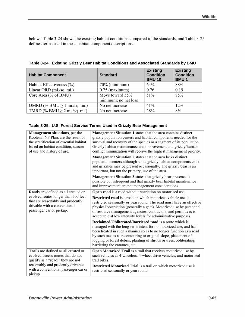
Wildlife
Bonneville Power Administration 3-65
below. Table 3-24 shows the existing habitat conditions compared to the standards, and Table 3-25 defines terms used in these habitat component descriptions.
Table 3-24. Existing Grizzly Bear Habitat Conditions and Associated Standards by BMU
Habitat Component Standard Existing Condition BMU 10
Existing Condition BMU 1
Habitat Effectiveness (%) 70% (minimum) 64% 88% Linear ORD (mi./sq. mi.) 0.75 (maximum) 0.76 0.19 Core Area (% of BMU) Move toward 55%
minimum; no net loss 51% 85%
OMRD (% BMU > 1 mi./sq. mi.) No net increase 41% 12% TMRD (% BMU > 2 mi./sq. mi.) No net increase 28% 8%
Table 3-25. U.S. Forest Service Terms Used in Grizzly Bear Management
Management situations, per the Kootenai NF Plan, are the result of the stratification of essential habitat based on habitat condition, season of use and history of use.
Management Situation 1 states that the area contains distinct grizzly population centers and habitat components needed for the survival and recovery of the species or a segment of its population. Grizzly habitat maintenance and improvement and grizzly/human conflict minimization will receive the highest management priority. Management Situation 2 states that the area lacks distinct population centers although some grizzly habitat components exist and grizzlies may be present occasionally. The grizzly bear is an important, but not the primary, use of the area. Management Situation 3 states that grizzly bear presence is possible but infrequent and that grizzly bear habitat maintenance and improvement are not management considerations.
Roads are defined as all created or evolved routes longer than 500 feet that are reasonably and prudently drivable with a conventional passenger car or pickup.
Open road is a road without restriction on motorized use. Restricted road is a road on which motorized vehicle use is restricted seasonally or year round. The road must have an effective physical obstruction (generally a gate). Motorized use by personnel of resource management agencies, contractors, and permittees is acceptable at low intensity levels for administrative purposes. Reclaimed/Obliterated/Barriered road is a route which is managed with the long-term intent for no motorized use, and has been treated in such a manner so as to no longer function as a road by such means as recontouring to original slope, placement of logging or forest debris, planting of shrubs or trees, obliterating/ barriering the entrance, etc.
Trails are defined as all created or evolved access routes that do not qualify as a “road;” they are not reasonably and prudently drivable with a conventional passenger car or pickup.
Open Motorized Trail is a trail that receives motorized use by such vehicles as 4-wheelers, 4-wheel drive vehicles, and motorized trail bikes. Restricted Motorized Trial is a trail on which motorized use is restricted seasonally or year round.

3 Affected Environment and Environmental Consequences
3-66 Libby to Troy Rebuild Project Draft EIS
A) Habitat Effectiveness is a measure of habitat security in a BMU. It is expressed as the percentage of land in the BMU that meets the following definition: the total number of acres in each BMU minus Management Situation 3 lands and all lands further than ¼ mile from open roads and major activities (such as helicopter use). The standard is to maintain at least 70 percent of each BMU as effective habitat during the active bear year (April 1 – November 30).
B) Linear Open Road Density (ORD) is expressed as the miles per square mile of a BMU or BAA that contains open roads. The standard is to have no more than 0.75 miles of open road per square mile.
C) Core Areas are defined as the percent of a BMU that contains habitat at least 0.31 miles from open roads or gated roads, and which has no motorized access (roads or trails) during the active bear season (April 1 to November 30). The standard for this component, which reflects the Interagency Grizzly Bear Guidelines (IGBC 1986) and the amended biological opinion (McMaster 1995), is for applicable federal agencies to work toward attaining a core area of at least 55 percent in the BMU. Another standard is for no net loss of core area to occur on federal ownership within the BMU. BMU 1 currently has the highest percentage of secure habitat (85 percent core) within the entire Cabinet-Yaak Ecosystem.
D) Open Motorized Route Density (OMRD) is the percent of the BMU that contains open roads, other roads that do not meet all restricted or obliterated criteria, and open motorized trails, at a density greater than or equal to one mile per square mile of the BMU. The percentage is calculated using a Geographic Information System. Currently, 41 percent of BMU 10 has such roaded densities, while only 12 percent of BMU 1 has such densities (Table 3-24). The standard for both BMUs is to have no net increase in the percentage of land in this category.
E) Total Motorized Route Density (TMRD) is the percent of the BMU that contains open roads, restricted roads, roads not meeting all reclaimed/obliterated criteria, and open motorized trails, at a density greater than or equal to two miles per square mile of the BMU. It is calculated using the same method as OMRD is calculated. Currently, 28 percent of BMU 10 is at such densities, and 8 percent of BMU 1 contains such densities (Table 3-24). As for OMRD, the standard is for no net increase in the percentage of land in each BMU in this category.
Outside the Recovery Zone
Grizzly bear reoccurring use areas outside the recovery zones are called BORZ polygons. The proposed project is in the West Kootenai and Troy BORZ polygons (Figure 3-7). In 2005, neither the West Kootenai nor the Troy BORZ polygons were known to be occupied by females with young, and no known mortality was reported for either polygon. The number of animals using these areas is unknown.
The USFWS identified three factors falling under Forest Service jurisdiction that contribute to an “incidental taking” of grizzly bears in these areas. They are:
1) access management;
2) food attractants (human and livestock food storage and garbage); and
3) livestock presence.

Wildlife
Bonneville Power Administration 3-67
The USFWS (2004), using baseline information from Johnson (2003), established access management standards for areas outside the recovery zone with recurring grizzly bear use. The standard for both linear open road density and linear total road density is a no net increase in existing road density. The access management baseline (existing condition) for the West Kootenai BORZ polygon is 1.3 miles/square mile of linear open road density and 3.0 miles/square mile of linear total road density8 (USFWS 2004; updated 3-28-05). The existing condition for the Troy BORZ polygon is 1.2 miles/square mile of linear open road density and 2.6 miles/square mile of linear total road density (USFWS 2004).
Livestock and food attractants are not present in either the West Kootenai or Troy BORZ polygons.
Bald Eagle The bald eagle has been considered at risk in the lower 48 states for many decades. It was originally listed as endangered under the ESA in most states. In July 1995, the USFWS announced that bald eagles in the lower 48 states had recovered to the point that those populations that were previously considered endangered were now considered threatened. The USFWS then formally upgraded those populations from endangered to threatened in 1995. USFWS currently is considering de-listing bald eagles (Federal Register, Vol. 71, No. 32, February 16, 2006). This species is also considered to be a Forest Service MIS, and is listed by the State of Montana as a Species of Concern (see Table 3-1).
The bald eagle is one of North America’s largest raptors, its wingspan stretching as wide as 8 feet. Adults have a dark brown body and wings, white head and tail, and a yellow beak. Juveniles are mostly brown with white mottling on the body, tail, and undersides of wings. .The species lives on coasts, lakes and rivers from Alaska to Northern Mexico, migrating south in the winter only if necessary. One of eight fish eagles, its primary food source is fish, often stolen from other birds, but it also feeds on carrion, water fowl and small mammals. Pairs mate for life, which averages around 25 years in the wild and often reuse nests, situated on rocks or in trees and as large as 8 feet across and 11 feet deep. Females usually produce 1-3 eggs per year. The young remain in the nest for 10-11 weeks and are aggressively competitive. They gain the species’ distinctive white plumage as adults.
Bald eagles are both seasonal migrants and year-round residents within the boundaries of the Kootenai National Forest. Nesting on the Forest has increased significantly over the last two decades. Only one active nest was known in 1978, whereas 37 nests (19 on Forest Service land and 18 on private land) were known and monitored in 2005; they produced a total of 32 fledglings. Nest success for active nests over the last twenty-year period is about 83 percent, with an average of 1.3 fledglings per active nest (KNF bald eagle monitoring records).
Migrating eagles from northern latitudes typically begin arriving in mid-October to winter in the Kootenai valley, with numbers peaking around mid-November to mid-December. In addition, fall surveys on the Kootenai River have shown that bald eagles migrate through the area in large numbers during the month of November and in early December (Libby District wildlife files). The greatest number of bald eagles tallied in one day during migration surveys was 166 on Nov. 17, 1988 along the stretch of river from Libby Dam to Kootenai Falls (Libby District wildlife files). Wintering bald eagle numbers have fluctuated over the years depending on food sources (fish from open waters and dead animals along roads and railroad tracks) and winter conditions (open versus frozen water for foraging habitat). Mid-winter
8 This measure is not the same as Total Motorized Route Density. It is purely a linear distance measurement of all roads (gated or not). TMRD and OMRD are only used inside the BMUs while linear ORD and linear total road density are used in the BORZ.

3 Affected Environment and Environmental Consequences
3-68 Libby to Troy Rebuild Project Draft EIS
counts conducted annually throughout the Kootenai National Forest during the second week of January have averaged 97 bald eagles over the past 20 years (KNF bald eagle monitoring records).
The Pipestone, Quartz, Sheep, Treasure, and Lake PSUs fall within the Upper Columbia Basin Management Zone (Zone 7) of the Pacific Bald Eagle Recovery Area (USFWS 1986). About 20,500 acres of the bald eagle consultation area (USFWS 2001) occur within the PSUs. Forest-wide potential bald eagle habitat covers about 564,558 acres (242,965 USFS; 275,470 Private; and 46,123 water) (based on USFWS 2001). In 1992, the USFWS and the Kootenai National Forest agreed on the boundaries of bald eagle habitat on the Forest, also referred to as the Bald Eagle Consultation Area (Figure 3-8).
The Montana Bald Eagle Management Plan (MBEMP) (MBEWG 1994) identifies four general management issues for bald eagles: nesting habitat, foraging habitat (including perch sites), winter habitat (including roost sites), and mortality risks.
Nesting Habitat
Nesting habitat is typically associated with mature forest stands close to (less than 1 mile from) large bodies of water, including lakes and fourth order streams such as the Kootenai River, which provide an adequate prey base. For each bald eagle nesting site, the MBEMP provides for three management zones: Nest Site Area (Zone I), Primary Use Area (Zone II), and Home Range (Zone III). These zones concentrically surround recently active and alternate nest sites in the bald eagle breeding area. The MBEMP establishes objectives and guidelines for the kinds of activity that can occur within each of the three zones that make up a nest site management zone (see Table 3-26).
Table 3-26. Objectives and Guidelines for Activity in Bald Eagle Nest Management Zones Habitat Designation Objectives Guidelines
Zone 1 - Nest Site Area (area within a ¼-mile (400-meters) radius of all nests in the breeding area that have been active within the last 5 years or until an active nest is found.)
1. Eliminate disturbance. 2. Maintain or enhance nest site habitat suitability.
-Existing levels of human activity can continue if the breeding area has at least a 60 percent next success, has fledged at least 3 young during the preceding 5 years, and has a low potential hazard rating. High intensity activity such as heavy equipment use or logging should not occur during the nesting season (February 1 to August 15). -Additional human activity should not occur from initiation of nest site selection of one month after hatching. -Permanent development should be prohibited, including powerline construction and timber harvest.
Zone II -Primary Use Area (area within ¼ to ½ mile (400 – 800 meters) of all nests active within the last five years or until an active nest is found. )
1. Minimize disturbance. 2. Maintain the integrity of the breeding area. 3. Eliminate hazards.
-High intensity activity such as heavy equipment use should not occur during the nesting season (February 1 to August 15). -Habitat alternations should be designed and regulated to ensure that preferred nesting and feeding habitat characteristics are maintained. -Permanent developments that may increase human activity during the nesting season should not be constructed. -Structures that pose a hazard such as overhead utility lines should not be constructed. Existing structures that pose risks of injury or death should be removed or modified.
Zone III - Home Range (suitable foraging habitat within ½ mile to 2.5 miles (800 meters – 4 kilometers) of all active nest sites in the breeding area that have been active in the last 5 years)
1. Maintain suitability of foraging habitat. 2. Minimize disturbance within key areas. 3. Minimize hazards. 4. Maintain integrity of the breeding area.
-Human activities, including permanent developments, should be designed and regulated to minimize disturbance and avoid conflicts with bald eagle key use areas. -Habitat alterations should be designed to ensure that prey base and important habitat components, such as perch trees or screening vegetation, are maintained or enhanced. -Pesticides should not be used in a manner which poses a hazard to eagles. -Structures which pose a hazard should be located and designed to minimize or avoid risk to bald eagles or their prey.

Wildlife
Bonneville Power Administration 3-69
There are four bald eagle nest sites within the proposed project area (Figure 3-8). The following is a brief summary of the four nest sites and their proximity to the proposed project:
• Pipe Creek (007-047): This nest site was discovered in 1987 and has been active 19 of the last 20 years. It has been the second most productive nest site within the boundaries of the Kootenai National Forest, producing a total of 27 fledglings. Four different nest trees have been used over the last twenty years. The current nest tree is located in a ponderosa pine snag that is 29" dbh (diameter at breast height) and 122 feet tall. The nest was last successful in 2004, when one fledgling was produced. The nest was inactive in 2005, and active but unsuccessful in 2006. The existing transmission line crosses all three management zones (Nest Site Area, Primary Use Area, Home Range) for this nest, and is about 1,000 feet south and down slope of the nest tree (see Figure 3-8).
• Quartz Creek (007-111): This nest site was discovered in 1996, and was active 6 of the last 11 years, producing a total of 8 fledglings. The nest was last successful in 2001 when one fledgling was produced. The historic nest tree is a live ponderosa pine 37" dbh and 125 feet tall. During the fall of 2001, the nest was blown out of the tree. The adults did not attempt to re-build a nest in that same tree. Nest tree searches in 2002 through 2006 did not locate a new nest in the immediate vicinity. It remains uncertain if the adults have re-located their nest site. The existing transmission line crosses all three management zones (Nest Site Area, Primary Use Area, Home Range) for this nest, and is about 200 feet south and down slope of the historic nest tree (see Figure 3-8).
• Hunter Gulch (a number has not been assigned): This occupied nest site was discovered in March 2007. The nest tree is a live ponderosa pine snag 36" dbh and over 100 feet tall. The existing transmission line crosses all three management zones (Nest Site Area, Primary Use Area, Home Range) for this nest, and is about 420 feet south and down slope of the nest tree (see Figure 3-8).
• Kootenai Falls (007-174): This nest site was discovered in 2003 and has been active 3 of the last 4 years. Adults were seen incubating in 2003, 2004, and 2006, but the nesting attempts failed and no young were ever observed. The nest tree is a live ponderosa pine 37" dbh and 128 feet tall. The existing transmission line crosses all three management zones (Nest Site Area, Primary Use Area, Home Range) for this nest, and is about 2,000 feet west and down river of the active nest tree (see Figure 3-8).
Foraging Habitat (including perch sites)
Foraging habitat consists of lakes, rivers, wetlands and meadows that provide open flight paths, perches, and adequate prey. It also includes highway and railroad corridors (especially in the winter) due to higher concentrations of dead animals found in these areas. Large-diameter (>20" dbh) cottonwood, larch, ponderosa pine, and Douglas-fir trees are common perch sites used by eagles along the Kootenai River during daylight feeding hours.
The MBEMP notes that foraging habitat outside of the management zones for identified bald eagle nest sites is important because foraging flights by resident breeding adults may extend well beyond their home range. The MBEMP identifies the following objectives for foraging habitat:
1. Identify foraging habitat outside of Nest Site Management Zones 2. Regulate use of poisons and eliminate contamination box toxic elements and chemicals. 3. Maintain water quality and healthy populations of prey species. 4. Eliminate or reduce collision and electrocution hazards.

3 Affected Environment and Environmental Consequences
3-70 Libby to Troy Rebuild Project Draft EIS
The MBEMP also includes the following relevant guideline for management of bald eagle foraging habitat: “Structures that pose a hazard, such as overhead utility lines, should not be constructed. . . . Seek to route new powerlines away from foraging habitat and ensure that they are well marked and visible where they cross wetlands.”
Winter Habitat (including roost sites)
Winter habitat is generally dictated by the presence and abundance of food, open water, and secure night roost sites (MBEWG 1994). Eagles are known to winter within all the PSUs crossed by the proposed project. Several hundred acres of designated old growth habitat is upslope of the Kootenai River riparian corridor, providing potential night roost sites. Along the Kootenai River, night roost surveys have documented eagles selecting sites consisting of mature and/or old growth Douglas-fir stands near mid-slope. One night roost has been documented in the project area; it is in the Cedar Creek area about one-quarter mile south of the Kootenai River and the existing transmission line corridor.
The MBEMP focuses on the following three habitat components as important to bald eagle seasonal habitat: presence and abundance of food usually associated with open water; availability and distribution of foraging perches; availability of secure night roost sites and freedom from human harassment. The MBEMP identifies the following objectives for winter habitat:
1. Identify bald eagle concentrations and flyways during autumn, winter, and spring and institute spatial and/or temporal restrictions where human activity is disruptive.
2. Encourage provision of a safe food base for migrating and wintering bald eagles.
3. Minimize the risk of bald eagle injury and mortality during the winter and migration periods.
4. Identify and provide protection for communal roosts.
The MBEMP also includes the following relevant guideline for management of bald eagle wintering habitat: “Identify powerlines and poles which pose an electrocution or collision threat to eagles. A threat exists where lead and/or ground lines are placed so that eagles may touch both simultaneously….and where lines cross flight paths.”
Mortality Risk
The MBEMP identifies bald eagle mortality risks as shooting, accidental trapping, poisoning, diseases, and electrocution. The main source of eagle mortality and injury in the Kootenai River valley appears to be associated with birds being hit by vehicles or trains while foraging on carcasses on or adjacent to highways and/or train tracks.
Other Special Status Species In addition to federally protected wildlife species, there are several other special status species with the potential to occur in the general project area. These other special status species are identified in Table 3-27.
With the exception of bighorn sheep, the Forest Service has designated all of these species as sensitive species, management indicator species (MIS), or both. Sensitive species are administratively designated by the Regional Forester (Forest Service Manual [FSM] 2670.5) and managed under the authority of the National Forest Management Act (NFMA). Sensitive species are those species whose populations on the Forest are considered at risk for a variety of reasons. USFS managers are required to maintain suitable

Wildlife
Bonneville Power Administration 3-71
habitat for viable populations of native and desired non-native species and to avoid actions that may cause a species to become threatened or endangered. A viable population is defined as one that has the estimated numbers and distribution of reproductive individuals to insure that its continued existence is well distributed in the planning area, in this case the Kootenai National Forest.
NFMA also requires that Forest plans “preserve and enhance the diversity of plant and animal communities…so that it is at least as great as that which can be expected in the natural forest” (36 CFR 219.27). Based on this direction, the Kootenai NF Plan provides that viable populations of existing native and desirable non-native vertebrate species would be maintained through the maintenance of a diversity of plant communities and habitats, as monitored through indicator species (FP II-22). Accordingly, the Kootenai NF Plan also identifies MIS. Monitoring the numbers and health of MIS indicates the health of the habitat they occupy, and therefore, the health of other species found in that habitat. Monitoring of MIS species is conducted by Montana Fish Wildlife and Parks.
Other special status species include those listed as State of Montana Species of Concern (see Table 3-27). These species are identified as being at-risk or potentially at-risk due to rarity, restricted distribution, habitat loss, and/or other factors. Also of concern are species listed by MFWP as Tier I Species or those with the “Greatest Conservation Need” (see Table 3-27). MFWP is obligated to use its resources to implement conservation actions that provide direct benefit to these species, communities, and focus areas as described in the MFWP’s Comprehensive Fish and Wildlife Conservation Strategy (2005).
Of these special status species, the peregrine falcon, pileated woodpecker, northern goshawk, flammulated owl, harlequin duck, elk, white-tailed deer and bighorn sheep are possibly present in the transmission line corridor, given either sightings or appropriate habitat types. The black backed woodpecker, common loon, fisher, northern bog lemming, Townsend’s big-eared bat, wolverine, and the mountain goat however, are not consider to be present in this corridor because suitable habitat for these species is not present within or close by the transmission line corridor.

3 Affected Environment and Environmental Consequences
3-72 Libby to Troy Rebuild Project Draft EIS
Table 3-27. Other Special Status Species Possibly Occurring in the General Project Vicinity
Species Forest Service Status1
State or Local Special Status2, 3
Possibly Present In Project Corridor?
Peregrine Falcon (Falco peregrinus)
Sensitive Species; Management Indicator Species
Yes
Pileated Woodpecker (Dryocopus pileatus)
Management Indicator Species
Yes
Northern Goshawk (Accipiter gentiles)
Sensitive Species Yes
Flammulated Owl (Otus flammeolus)
Sensitive Species Montana Species of Greatest Concern
Yes
Harlequin Duck (Histrionicus histrionicus)
Sensitive Species Montana Species of Concern; Montana Species of Greatest Concern
Yes
Elk (Cervus elaphus)
Management Indicator Species
Yes
White-tailed Deer (Odocoileus virginianus)
Management Indicator Species
Yes
Bighorn Sheep (Ovis canadensis)
Wildlife Management Area Species
Yes
Black backed Woodpecker (Picoides arcticus)
Sensitive Species Montana Species of Greatest Concern
No
Common Loon (Gavia immer)
Sensitive Species No
Fisher (Martes pinnanti)
Sensitive Species No
Northern Bog Lemming (Synaptomys borealis)
Sensitive Species Montana Species of Greatest Concern
No
Townsend’s Big-eared Bat (Corynorhinus townsendii)
Sensitive Species Montana Species of Greatest Concern
No
Mountain Goat (Oreamnos americanus)
Management Indicator Species
No
Wolverine (Gulo gulo)
Sensitive Species No
1 From USFS. Sensitive Species - Species whose populations on the Kootenai National Forest are considered at risk. Forest Service Management Indicator Species (MIS) - MIS are animals or plants selected because changes in their population are good indicators of the effects of Forest Service management activities. The MIS list is one of many tools the Forest Service uses to provide for the diversity of plant and animal communities and to gauge the effects of management activities. 2 From Montana Natural Heritage Program (http://nhp.nris.state.mt.us/SpeciesOfConcern/). Montana Species of Concern - These species are identified by the State of Montana as being at-risk or potentially at-risk due to rarity, restricted distribution, habitat loss, and/or other factors. Wildlife Management Area Species – Bighorn sheep are the management focus of the Kootenai Falls Wildlife Management Area.
3 From Montana’s Comprehensive Fish and Wildlife Conservation Strategy (2005): Montana Species of Greatest Concern: The Strategy’s priority is to protect those species and their related habitats that are in greatest conservation need. “In greatest conservation need” is interpreted to mean focus areas, community types, and species that are significantly degraded or declining, federally listed, or where important distribution and occurrence information to assess the status of individuals and/or groups of species is lacking.

Wildlife
Bonneville Power Administration 3-73
The following discussion describes the other special status species that are identified in Table 3-27 as potentially present in the project corridor.
Peregrine Falcon The peregrine falcon was removed from the Endangered Species List in 1999 (USFWS 1999b), and was subsequently added to the Northern Region's (USFS) sensitive species list in 2000. Peregrine falcons are sleek, crow-sized birds of prey. They strike and capture birds in mid-air, a strategy that requires open space. Thus, they often hunt over open water, marshes, valleys, and fields. The primary features of peregrine falcon habitat are cliffs or rock ledges (generally greater than 200 feet high) suitable for nesting. Suitable cliffs often dominate the surrounding area and may have a sweeping view of the valley. Nest sites usually are near areas where passerine birds or waterfowl are available for food.
As of October 2006, there was one known peregrine falcon nest site on the Kootenai National Forest the project area (Rogers and Sumner 2004; J. Sumner, Montana Peregrine Institute, pers. comm. 2006). It is in the Sheep PSU in the vicinity of Kootenai Falls, a half mile from the existing transmission corridor. Peregrines arrive at nesting cliffs about the middle of March and leave the nesting cliff toward the end of September. Current peregrine occupancy of the site will be confirmed in spring 2007.
Pileated Woodpecker The pileated woodpecker is designated as a Management Indicator Species for snags and old growth habitat.
Adults are mainly black with a red crest and a white line down the sides of the throat. Their breeding habitat is forested areas with large trees across Canada, the eastern United States and parts of the Pacific coast. They usually excavate large nests in the cavities of dead trees (snags), and often excavate a new home each year, creating habitat for other large cavity nesters. These birds primarily eat insects (especially beetle larvae and carpenter ants) as well as fruits, berries and nuts. They often chip out large and roughly rectangular holes in trees while searching out insects.
The potential population index (PPI) for pileated woodpeckers on the Kootenai National Forest has been calculated by Johnson (2003). Potential population index represents the probable population of woodpeckers the Kootenai NF can support - the carrying capacity. The procedure is based on the assumption that all currently mapped effective and replacement old growth habitat (both designated and undesignated—see Section 3.3.2 Old Growth) is providing suitable habitat to support nesting territories. This assumption also includes the premise that all suitable habitat is spatially distributed across the landscape in a pattern that can be incorporated into individual nesting territories. The procedure was based on territory sizes of pileated woodpeckers as described in research by McClelland (1977) for northwest Montana, and Thomas (1979) and Bull and Holthausen (1993) for northeast Oregon.
Effective old growth habitat was modeled as supporting one nesting pair per 600 acres (McClelland 1977), with replacement old growth habitat supporting one nesting pair per 1,000 acres. The difference in territory size is based on research that suggests that higher quality habitat can support a breeding pair with fewer acres (McClelland 1977; Bull and Holthausen 1993). Also, allowing for larger territory sizes when habitat becomes fragmented appears reasonable, as territory sizes up to 2,600 acres have been reported for western Oregon (Mellen et al. 1992). Of course, numerous and complex interrelated factors influence the actual size of the home range territory (McClelland 1977).

3 Affected Environment and Environmental Consequences
3-74 Libby to Troy Rebuild Project Draft EIS
Based on the mapped old growth habitat as defined above, the modeled minimum potential population index for the pileated woodpecker on the Kootenai National Forest is 425 nesting or breeding pairs (Johnson 2003b). This is within the calculated historic range of variation for the minimum PPI of 335 to 554 breeding pairs (Johnson 1999b).
A detailed summary of old growth habitat for the Pipestone, Quartz, and Sheep PSUs is displayed in Table 3-13 of the Vegetation/Old Growth, Section 3.3.2). This summary indicates that approximately 7,265 acres of effective old growth habitat (both designated and undesignated), and 2,008 acres of replacement habitat (both designated and undesignated) exist within the Pipestone PSU; approximately 5,366 acres of effective old growth habitat (both designated and undesignated), and 730 acres of replacement habitat (both designated and undesignated) exist within the Quartz PSU; and approximately 536 acres of effective old growth habitat (both designated and undesignated), and 574 acres of replacement habitat (both designated and undesignated) exist within the Sheep PSU. Based solely on the quantity of old growth habitat available, the Pipestone PSU could support about 14 nesting territories; the Quartz PSU could support about 10 nesting territories; and the Sheep PSU could support about 2 nesting territories.
No population data are available for pileated woodpeckers within the Kootenai National Forest. Breeding bird point count surveys have been conducted on the Forest since 1994. In this program, transects consisting of multiple bird monitoring points are set up within a wide range of habitats distributed geographically across the Kootenai National Forest. This survey technique is not specifically designed to census woodpecker species, although all migratory and resident bird species detected by specialists trained in bird identification are recorded at each point on each transect. The rate of detection can vary greatly from year to year, especially for a wide-ranging species like the pileated woodpecker, that may or may not be anywhere near a given point on a given day. During the 1994-2004 periods, the pileated woodpecker was tallied 204 times at the 2,638 individual points surveyed (USDA Forest Service 1994-2004).
Within the Pipestone PSU, three active pileated nest cavities have been documented, along with four night winter roost cavities. All of these cavities were located about five miles north of the existing transmission line corridor in the Bobtail Creek and Pipe Creek drainages. The nest trees consisted of a live dead-top western larch (27" dbh), a live aspen (22" dbh), and a broken-top live aspen (16" dbh). No other pileated woodpecker nests have been documented within five miles of the existing transmission corridor, although suitable habitat exists.
Preferred nest trees were identified based on studies of pileated woodpeckers in the northern Rocky Mountains by McClelland and McClelland (1999). Tree species preferred for nesting include ponderosa pine, western larch, cottonwood, and aspen, generally greater than 20 inches in diameter at breast height (20" dbh). Kootenai National Forest personnel walked the existing transmission corridor and realignment options and identified all such trees within fifty feet of each side of the centerline, to determine the maximum number that might be affected by clearing; however, the total number of such trees within the PSUs crossed by the transmission line and alternatives is unknown.
Northern Goshawk Northern goshawk is the largest North American woodland hawk. Goshawks occur in a wide variety of forest successional stages and nesting birds appear most commonly associated with mature and old growth conifer forests in western Montana and northern Idaho (Hayward et. al. 1989). This forest type has structural characteristics that allow this large hawk to maneuver in and below the main canopy while foraging primarily on other birds and small mammals, which they capture on the ground, in trees, or in

Wildlife
Bonneville Power Administration 3-75
the air. Mature and old growth forests also provide abundant large trees for the placement of large stick nests, which are placed next to the bole of a live conifer on a whorl of large branches. Nests are commonly placed about 40 feet above ground in the lower one-third of the living crown. There is usually a clear flight corridor leading to the nest, with the nest tree itself having an open canopy structure to allow easy nest access.
Northern goshawk is listed as Forest Sensitive Species. The analysis area for project impacts to individuals and their habitat is the Pipestone, Quartz, Sheep, and Lake PSUs. The area for determining population trend or viability is the entire Kootenai National Forest.
Northern goshawk habitat was identified by walking the transmission line route and assessing forested habitat potentially impacted by the proposed project. The Kootenai Forest Timber Stand Management Record System habitat modeling parameters provide guidance for delineating nesting and foraging habitat for these birds. Potential nesting habitat for goshawk closely corresponds to the old growth habitat delineated in the Pipestone, Quartz, and Sheep PSUs (see Vegetation/Old Growth, Section 3.3.2). Old growth habitat also closely corresponds to habitat for three known active goshawk nesting territories within six miles of the transmission corridor.
No goshawks were detected during July 2006 surveys, and no goshawk nest sites were located. However, forested habitat potentially suitable as nesting sites for goshawk was found along portions of the project corridor. Suitable nesting trees consist of live conifer and deciduous >20” dbh within a forested area with normally two or three canopy layers. Potentially suitable nesting habitat exists along the following transmission line segments: Structures 18/8 to 19/5, 21/5 to 25/8, and just east of 26/1 to 28/2 on the existing corridor; the Pipe Creek realignment corridor; and the east and west legs of the Quartz Creek realignment corridor.
Flammulated Owl Flammulated owl is migratory in the northern latitude, arriving in their nesting territories in May and leave by mid-October. Most studies indicate that flammulated owls prefer dry habitat groups. However they are known to use a variety of cover types. The flammulated owl is a secondary cavity nester and depends on cavities excavated by woodpeckers such as the flicker and pileated.
Flammulated owl is listed as Forest Sensitive Species and as a Montana Species of Greatest Concern. The analysis area is the Pipestone, Quartz, and Sheep PSUs and the area for determining population trend or viability is the entire Kootenai National Forest. Areas with a mature ponderosa pine/Douglas-fir forest containing larger snags and/or live cull trees with interior heart rot having old pileated woodpecker and/or flicker nest cavities were considered potential nest sites for flammulated owls. These sites closely correspond to habitat where surveys have identified flammulated owls on the Libby District of the Kootenai National Forest since 1991.
Flammulated owl habitat was identified during the July 2006 survey for goshawk by walking the transmission line route and assessing forested habitat potentially impacted by the proposed project. As with goshawk, potential nesting habitat for both species closely corresponds to the old growth habitat delineated in the Pipestone, Quartz, and Sheep PSUs. Since the flammulated owl appears to be strongly associated with ponderosa pine/Douglas-fir mature and old growth forests (Reynolds and Linkhart 1987), it is likely that suitable nesting habitat is being provided along the southern boundaries of the Pipestone, Quartz, and Sheep PSUs. Areas with a mature ponderosa pine/Douglas-fir forest containing larger snags and/or live cull trees with old pileated woodpecker and/or flicker nest cavities were considered potential

3 Affected Environment and Environmental Consequences
3-76 Libby to Troy Rebuild Project Draft EIS
nest sites for flammulated owls. These sites closely correspond to habitat where surveys have identified flammulated owls on the Libby District of the Kootenai NF since 1991.
During surveys conducted in 2006, one flammulated owl observation (vocal response) was documented in the old growth stand just north of structure 21/3. Potentially suitable nesting habitat for flammulated owl exists along the same transmission line segments where this habitat was identified for northern goshawk.
Harlequin Duck The harlequin duck is a rare but regular nester along isolated, swift rivers and streams in the mountains of Montana. Harlequin duck surveys have documented 110 breeding pairs within the state of Montana. Diets consist of crustaceans, mollusks, small fish, and aquatic insects. Degradation of water quality of mountain streams supporting harlequin ducks seriously impacts food resources. Harlequin ducks, especially nesting females, avoid areas frequented by people. Fishing, whitewater rafting and camping are recreational activities associated with harlequin duck habitat.
Harlequin duck observation and monitoring data over the last twenty-five years document the presence of this Forest Sensitive species along the Kootenai River from the confluence of Pipe Creek downriver to Kootenai Falls. Over 30 observations have been made during the course of approximately 40 surveys since 1981. Kootenai Falls and the turbulent shelf rock immediately upriver from the falls has long been documented as a site where harlequin ducks return each spring after their migration inland from wintering areas on the Pacific coast. Harlequin ducks have also been known to occupy the lower reaches of Quartz Creek, about six miles upriver from Kootenai Falls. Successful reproduction has been documented twice along the lower two-mile stretch of Quartz Creek, in July 1987 and July 2003.
Johnson (1999) confirms harlequin duck breeding on a total of 10 streams in 6 of the 8 planning units (planning units are larger than PSUs and usually made up of several PSUs) on the Kootenai National Forest. These streams provide about 71 miles of habitat. Harlequin ducks are known to be fairly versatile in selecting nest sites, and will nest on the ground, within log jams, in tree cavities, or within rock crevices among boulders (Cassirer et al. 1996).
Elk and White-Tailed Deer In the Kootenai NF Plan, elk and white-tailed deer are two of the management indicator species for general forest habitat conditions. This kind of habitat is the predominant vegetative feature on the Kootenai National Forest, consisting of extensive conifer forests up to the subalpine level that are strongly influenced by a maritime climate and soils that feature volcanic ash deposits.
Elk are found throughout the project area; however, in the Treasure and Lake PSUs (Figure 3-6), management for elk is emphasized over that for white-tailed deer (KNF and MFWP 1997). The existing transmission line corridor crosses the very northern edge of both PSUs. Portions of the Treasure and Lake PSUs are heavily used by elk, although most use occurs upslope from the transmission line corridor. Elk use is particularly heavy in the upper basin areas, with ridgelines used as main travel corridors to lower elevation zones. Key habitat components for elk include wallows, wet meadows, and bogs, which provide year-round wet vegetation feeding areas and temperature regulation during the fall rut season.
White-tailed deer also are found throughout the project area, but are particularly numerous in Pipestone, Quartz, and Sheep PSUs, which are crossed by the existing transmission line on their southern-most edges. Key habitat areas for white-tailed deer include riparian areas and wetlands. They are important to deer because the denser, wet vegetation provides cover and food throughout the year. Within these and

Wildlife
Bonneville Power Administration 3-77
other PSUs, the transmission line crosses Kootenai NF Management Areas 10 and 11, which are managed for big game winter range (Figure 3-6).
In general, forest habitat on the Kootenai National Forest is considered healthy because elk and white-tailed deer populations are increasing, although there are large areas of privately owned forest within the Pipestone, Quartz and Sheep PSUs that do not provide as much cover or security as elk habitat within the Treasure and Lake PSUs (A. Bratkovich, KNF, pers. comm., 2007). Elk are more sensitive to higher open road densities and less cover and security than are white-tailed deer.
Bighorn Sheep In 1954 and 1955, bighorn sheep from Wildhorse Island on Flathead Lake were introduced into the Libby area. These sheep became the Kootenai Falls Bighorn Sheep herd. After reaching a population of about 200 animals in 1994, sheep numbers declined abruptly due to unknown causes. Since that time, 40 sheep have been transplanted into the herd that now numbers about 65-75 animals.
Bighorn sheep occupy cliffs, mountain slopes, and rolling foothills. The distribution of cover and quality forage within a given area is important for bighorn sheep. Bighorns are both browsers and grazers and feed on a wide variety of plants including bunchgrasses and shrubs on winter range and a wide variety of grasses, sedges and forbs on summer range. Minimal snow depth is most important in winter, while high quality green forage is most important in spring and summer. The elevations sheep occupy vary accordingly. Immediate or nearby access to cliffy/rocky areas is important year round. Semi-open to open vegetation types are preferred (http://fwp.mt.gov/fieldguide).
The Sheep PSU of the Kootenai National Forest (Figure 3-6) contains a majority of the occupied habitat for this northwest Montana herd (approximately 14,897 acres). Within the Sheep PSU is the 172-acre Kootenai Falls Wildlife Management Area, managed by Montana Fish Wildlife and Parks. Since the mid-1970s, big game management in the Sheep PSU has focused on the Kootenai Falls bighorn sheep herd. The management goal in the Kootenai Falls Wildlife Management Area is to provide year-long habitat for bighorn sheep and seasonal habitat for whitetail deer, mule deer, and black bear (http://fwp.mt.gov/habitat/wma/koot.asp). The existing transmission corridor crosses the Sheep PSU and the Kootenai Falls Wildlife Management Area, including prime lambing habitat in the winter range in the southern section of the Sheep PSU.
The range for the Kootenai Falls bighorn sheep herd is one of the most heavily timbered sheep ranges in Montana. One of the main management objectives is to reduce canopy closure and stimulate shrub and bunchgrass communities. Kootenai NF Plan management objectives II-1 #7 and #12 aspire to “maintain diverse age classes of vegetation for viable populations of all existing native, vertebrate, and wildlife species, including old-growth timber in sufficient quality and quantity to maintain viable populations of old-growth dependent species and to maintain habitat diversity representative of existing conditions”; and “maintain big-game habitat to support the recreational hunting demand for resident big-game species” (USDA Forest Service 1987). This habitat management effort focuses on creating more quality forage and reducing Douglas-fir encroachment due to decades of fire suppression that is gradually diminishing the quality of open foraging areas. Larger openings also increase the security for bighorns by giving animals greater visual command of the surrounding terrain. Under optimum conditions, about 65 percent of the range would be in some form of open foraging condition, although only about 50 percent of the range is currently in an open foraging condition (A. Bratkovich, KNF, pers. comm., 2007).
The most critical period for the Kootenai Falls herd is the lambing period between April 1 and June 30, with the peak on average about May 15. Low-elevation bunchgrass communities and the succulent plants
3 Affected Environment and Environmental Consequences
3-78 Libby to Troy Rebuild Project Draft EIS
of the meadows along the Kootenai River where the proposed project would occur, are important during this period. The lower portion of the slope near the transmission corridor in this area also is characterized by precipitous cliffs, rock bluffs, and benches that provide ewes and young lambs with good security during the lambing period. Lamb production generally has been good in the Kootenai Falls herd, but lamb survival into the early fall period has been poor; the cause of this poor survival is unknown. This characteristic has limited expansion of the current population.
Minimal human disturbance during the April 1 – June 30 lambing period is important for successful lamb production and survival. If disturbed during this period, increased heart rate could adversely affect either the health of the mothers prior to birthing or the newborns if they have to run from human disturbance or from dogs off leash. However, at other times bighorn sheep from the Kootenai Falls herd appear capable of habituating to common human-related stimuli to a certain degree. The non-motorized trail (Sheep Range Road) through the Kootenai Falls Wildlife Management Area is the focal point of predictable human activity along the Kootenai River. Many times only mild alarm reactions in bighorn sheep are observed when humans walk directly from parked vehicles along the trail. Exceptions to this observation occur when people with dogs (particularly unleashed dogs) use the area, causing the sheep to scatter into rocks or timber where visibility is not as good. Females with young are more susceptible to predators during the lambing season, so that forcing them into areas that have more cover may make them easier prey.
3.5.2 Environmental Consequences of Action Alternatives
Construction and operation of the transmission line would affect different species differently. Impacts can be generalized as: changes or removal of habitat; increasing risk of mortality due to collision, electrocution, or increased human access to habitat; disturbance during critical periods, such as nesting or denning; and temporary displacement due to construction or maintenance activity. Under the action alternatives, wildlife habitat change and removal would occur primarily through clearing that would be done for right-of-way and roads. Table 3-28 shows the amount of clearing that would be done for right-of-way and roads in each Planning Subunit (see Figure 3-6 for PSU locations within the project area).

Wildlife
Bonneville Power Administration 3-79
Table 3-28. Acres of Clearing by Alternative in Each Planning Subunit
Planning Subunit Pipestone Quartz Sheep Treasure Lake Alternative Total
Acres No Action
(Existing Condition) 0.0 0.0 0.0 0.0 0.0 0.0
Proposed Action 115-kV Single-Circuit Rebuild 2.2 0.7 0.4 0.0 5.3 8.6
Alternative 1 230-kV Double-Circuit
Rebuild 4.8 2.9 9.1 0.0 10.0 26.8
Pipe Creek Realignment
115 kV 8.3 0.0 0.0 0.0 0.0 8.3
Pipe Creek Realignment
230 kV 10.4 0.0 0.0 0.0 0.0 10.4
Quartz Creek Realignment
115 kV 0.0 17.4 10.6 0.0 0.0 28.0
Quartz Creek Realignment
230 kV 0.0 21.7 13.2 0.0 0.0 35.0
Kootenai River Realignment
115 kV 0.0 0.0 0.3 5.0 4.8 10.0
R
ealig
nmen
t Opt
ions
Kootenai River Realignment
230 kV 0.0 0.0 0.4 6.3 6.0 12.7
Proposed Action – 115-kV Single-Circuit Rebuild The following discussion describes potential impacts of the Proposed Action to common wildlife species potentially present in the project corridor, as well as to threatened, endangered and other special status species. For grizzly bear, potential impacts are described both inside and outside the recovery zone, as is the overall effect to this species. For bald eagle, potential impacts are described both inside and outside Management Zones I and II, as is the overall effect to this species. For determinations concerning ESA-listed and Forest Sensitive species, please see Appendix F.
Common Wildlife Species For the Proposed Action, forested habitat would be removed as a result of the transmission line right-of-way clearing, danger tree clearing, and/or from new road construction outside the transmission line corridor. The type of habitat to be removed would vary along the transmission line corridor, but includes everything from saplings to large (>30" dbh) old growth trees. See Table 3-28 for the total acres of clearing by PSU for the Proposed Action. Common wildlife species found within the project area would be impacted (positively or negatively) by the Proposed Action if clearing of trees and new road construction occurs directly within their habitat. Big game animal habitat would be opened through

3 Affected Environment and Environmental Consequences
3-80 Libby to Troy Rebuild Project Draft EIS
removal of forested habitat, which would provide less cover for these species in some areas. Road construction would increase open road densities and decrease habitat effectiveness for some big game species. Smaller mammals such as hares, squirrels, and coyotes also would be affected by removal of cover within their habitat. However, the total acreage of habitat removed as a result of the Proposed Action would be very minor in relation to the amount of similar habitat available within the individual PSUs and the forest in general. Potential impacts to big game and smaller mammals from the Proposed Action thus would be expected to be low.
Since the Proposed Action would avoid construction of new structures or roads in riparian and wetland areas, the effect to songbirds, waterfowl, some raptors, and shore birds would be low.
Responses of migrant birds to canopy removal from timber harvest or road construction depends upon their individual habitat preferences and needs. Removal of the upper forest canopy reduces nesting habitat used by some species such as the Swainson's thrush, Townsend's warbler, and western tanager. At the same time, removal of overstory canopy creates grass, forb, and low shrub habitat used by other bird species such as the junco, chipping sparrow, and rufous-sided towhee. This activity also produces “edge” habitat that still other bird species such as red-tailed hawks and great-horned owls use as perch sites for hunting prey.
There is one osprey nest located north of existing structure 22/4 and one on top of existing structure 28/2. The nest on 28/2 would be removed prior to construction before or after the nesting season depending on the time of year construction would begin. This could cause displacement or abandonment of the osprey nest site, resulting in a high impact to this nesting osprey pair.
The total acres of canopy removed as a result of the Proposed Action would be very minor in relation to the amount of similar habitat available within the individual PSUs. With the timing mitigation discussed in Section 3.5.3 Mitigation, the Proposed Action would have a low impact on migratory bird nesting, foraging, and roosting habitat.
Concerning potential impacts to individual migrating bird species, heavy-bodied, less agile birds or birds within large flocks may lack the ability to quickly negotiate obstacles, making then more likely to collide with overhead lines. Waterfowl, which fly at high speeds and during inclement weather, can be prone to collision deaths. Also, birds distracted by territorial or courtship activities may collide with lines.
The Proposed Action would only slightly increase the risk for line collision as the line would be rebuilt in the same location with the same type of structures. However, placement of overhead ground wire on structures for about one mile out of the substations at either end of the line could increase the "fence" effect and contribute to potential bird strikes in those areas. Birds tend to be more likely to strike ground wires, which are much smaller in diameter than conductors and normally span the top of the tower to protect the line from lightning strikes (BPA 2002).
Under the Proposed Action, the wood or steel H-frame structures (60 to 70 feet average height) would be used for approximately 15.5 miles of the 17-mile long line. The remaining 1.5 miles of the line would be constructed of single wood poles with stand-off insulators. This segment of line would have conductors in a stacked configuration, which would slightly increase the mortality risk.
Electrocution of birds normally is not an effect of higher voltage transmission lines, even for birds with the largest wingspans, although lower voltage distribution lines can cause electrocutions. Distribution lines, which carry electricity to each consumer, are built with smaller separations between energized conductors and between energized conductors/hardware and grounded line components than are

Wildlife
Bonneville Power Administration 3-81
transmission lines. Transmission conductors are generally spaced 3 to 30 feet apart while distribution line conductors are generally spaced 2 to 6 feet apart (APLIC 2006). Consequently, avian electrocution risk is greater on distribution lines.
There are no specific goals or standards for migratory land birds in the Kootenai NF Plan. The plan does contain the goal to: “Maintain diverse age classes of vegetation for viable populations of all existing native, vertebrate, wildlife species” (FP, Vol. 1, II-1, goal #7). The Proposed Action would be consistent with the Kootenai NF Plan, as a wide range of successional habitats would be available. Impacts to migratory birds thus would be considered low.
Gray Wolf Impacts on gray wolves from the Proposed Action would be low. There are no known dens or rendezvous sites present within the project area, and known den and rendezvous sites thus would not be affected. Additionally, the potential for wolves to frequent the area is considered to be low. Transient use of the area by wolves could still continue, and the rebuilding of the transmission line in the same location under the Proposed Action would not be expected to significantly change this use. Many of the project’s roads would be closed to motorized travel year-round, so the lone animals or transient groups that might pass through the area would be exposed to only a slight increase in the potential for human-induced mortality above the current level. Because existing habitat conditions would be largely maintained for big game animals, the primary prey base for wolves would be expected to remain at current levels.
Grizzly Bear Effects Inside Recovery Zone
Within the CYE recovery zone, impacts to grizzly bear would occur within BMUs 10 and 1. The analysis of impacts of the Proposed Action inside these BMUs is based on whether the Proposed Action detracts from meeting the six established objectives for grizzly bear recovery.
Objective 1. Provide adequate space to meet the spatial requirements of a recovered grizzly bear population.
The analysis under this objective looks at the effect that the Proposed Action would have on the standards for each of the five established habitat components – habitat effectiveness, linear open road density, core areas, open motorized route density, and total motorized route density. These potential effects for BMUs 10 and 1 are summarized in Table 3-29. The following describes these potential effects in more detail.

3 Affected Environment and Environmental Consequences
3-82 Libby to Troy Rebuild Project Draft EIS
Table 3-29. Effects on Grizzly Bear Habitat Conditions and Associated Standards by BMU
BMU 10 BMU 1 Habitat Component Standard
Existing Condition
Proposed Action
Existing Condition
Proposed Action
Habitat Effectiveness (%)
70% (minimum) 64% 56% 88% 81%
Linear ORD (mi./sq. mi.)
0.75 (maximum) 0.76 0.81 0.19 0.22
Core Area (% of BMU)
Move toward 55% minimum; no net loss
51% 55% 85% 86%
OMRD (% BMU > 1 mi./sq. mi.)
No net increase 41% 43% 12% 12%
TMRD (% BMU > 2 mi./sq. mi.)
No net increase 28% 24% 8% 7%
A. Habitat Effectiveness standard: Maintain HE equal to or greater than 70 percent of the BMU.
BMU 10: HE is currently at 64 percent within BMU 10, which is below (worse than) the standard of 70 percent. The Proposed Action would use a helicopter to place some structures and string conductors, which would affect about 5,225 acres (8.2 square miles) and decrease habitat effectiveness to 56 percent during project construction (see Table 3-29). Reduction in HE from helicopter use would result in a high impact to grizzly bear during this use, although helicopter-supported activities would only take place over a 2 to3 week period (a short-term effect). All new access roads would be closed once construction is completed, so there also would be no permanent reduction in the current level of habitat effectiveness as a result of road construction from the Proposed Action.
Although construction activities would occur on grizzly bear spring range, these activities would not be permitted during the April 1 to June 15 period, when bears would most likely be using the low-elevation graminoid sidehill parks (see Section 3.5.3 Mitigation). All other disturbance within the BMU as a result of transmission line construction, including timber harvest for right-of-way clearing, would affect a smaller area than the helicopter disturbance zone.
BMU 1: HE is currently at 88 percent within BMU 1, and well above (better than) the standard of 70 percent. The Proposed Action would include helicopter use to place structures and string conductors, which would affect about 4,265 acres (6.7 square miles) and decrease habitat effectiveness to 81 percent during construction (see Table 3-29). As in BMU 10, reduction in HE from helicopter use would result in a high impact to grizzly bear during this use, although impacts from helicopter-supported activities would be short-term. All other disturbance would affect a smaller area than the helicopter disturbance zone. Motorized use of historic Highway 2 would end once construction is completed, so there also would be no permanent reduction in the current level of habitat effectiveness as a result of opening this road.

Wildlife
Bonneville Power Administration 3-83
Although construction activities would occur on grizzly bear spring range, it would not be permitted during the April 1 to June 15 period, when bears would most likely be using the low-elevation sites (see Section 3.5.3 Mitigation). All affected acreage lies adjacent to the Highway 2 corridor, on a heavily forested north-facing slope. Expected displacement of bears would likely be minimal during the construction season.
B. Linear Open Road Density (ORD) standard: Allow no more than 0.75 miles of open road per square mile of BMU.
BMU 10: Linear ORD is currently at 0.76 mi./sq. mi. in BMU 10, or slightly above (worse than) the standard of 0.75 mi./sq. mi. (see Table 3-29). The Proposed Action would require short-term motorized access behind the gate on Sheep Range Road (Kootenai Falls Wildlife Management Area) which would open 5.7 miles of road during construction. Use of the Sheep Range Road for maintenance two or three times each year also would open the same 5.7 miles of road. In addition, 0.6 miles of new road would be constructed within BMU 10 increasing linear ORD within BMU 10 to 0.81 mi./sq. mi. Opening of roads and construction of new roads during construction would have a high, short-term impact on linear ORD in BMU 10; access to the Sheep Range Road and all new roads in BMU 10 would be closed following construction, returning linear ORD inside BMU 10 to pre-project existing conditions (see Section 3.5.3 Mitigation).
Table 3-30 displays linear ORD calculations for BMU 10 and each individual Bear Analysis Area (BAA) within the BMU. The Proposed Action would take place in BAA 5-10-9, which has an existing linear ORD of 0.79 mi./sq. mi. Project activities would increase the linear ORD in BAA 5-10-9 to 1.10 mi./sq. mi., or above the standard of 0.75 mi./sq. mi. Post-project linear ORD would return to existing conditions.
Table 3-30. Short-term Effects to Linear ORDs (mi./sq. mi.) in BMU 10
Bear Analysis Area Existing ORD (mi./sq. mi)
Proposed Action ORD (mi./sq. mi.)
4-10-1 1.28 1.28 4-10-2 0.63 0.63 4-10-3 0.40 0.40 4-10-4 0.01 0.01 4-10-6 0.72 0.72 4-10-7 1.19 1.19 4-10-8 1.21 1.21 5-10-5 0.74 0.74
5-10-9 * 0.79 1.10 Total BMU 0.76 0.81
* BAA where all action alternatives would occur.
Although project activities would occur on grizzly bear spring range, it would not be permitted during the April 1 to June 15 period, when bears would most likely be using the low elevation graminoid sidehill parks (see Section 3.5.3 Mitigation). Activities would occur during a one or two-year construction season. The motorized use of roads during the construction period could disturb bears and increase the potential for human-bear encounters, but after construction, roads would be closed and restricted to administrative/maintenance use only, so minimal long-term disturbance to bears from the additional roads would be expected.
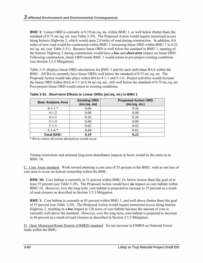
3 Affected Environment and Environmental Consequences
3-84 Libby to Troy Rebuild Project Draft EIS
BMU 1: Linear ORD is currently at 0.19 mi./sq. mi. within BMU 1, or well below (better than) the standard of 0.75 mi./sq. mi. (see Table 3-29). The Proposed Action would require motorized access along historic Highway 2, which would open 2.0 miles of road during construction. In addition, 0.6 miles of new road would be constructed within BMU 1 increasing linear ORD within BMU 1 to 0.22 mi./sq. mi. (see Table 3-31). Because linear ORD is well below the standard in BMU 1, opening of the historic Highway 2 during construction would have a low and short-term impact on linear ORD. Following construction, linear ORD inside BMU 1 would return to pre-project existing conditions (see Section 3.5.3 Mitigation).
Table 3-31 displays linear ORD calculations for BMU 1 and for each individual BAA within the BMU. All BAAs currently have linear ORDs well below the standard of 0.75 mi./sq. mi. The Proposed Action would take place within BAAs 4-1-1 and 5-1-6. Project activities would increase the linear ORD within BAA 4-1-1 to 0.36 mi./sq. mi., still well below the standard of 0.75 mi./sq. mi. Post-project linear ORD would return to existing conditions.
Table 3-31. Short-term Effects to Linear ORDs (mi./sq. mi.) in BMU 1
Bear Analysis Area Existing ORD(mi./sq. mi)
Proposed Action ORD (mi./sq. mi.)
4-1-1 * 0.06 0.36 4-1-2 0.00 0.00 4-1-3 0.26 0.26 5-1-4 0.00 0.00 5-1-5 0.02 0.02
5-1-6 * 0.60 0.63 Total BMU 0.19 0.22
* BAAs where all action alternatives would occur.
Timing restrictions and minimal long-term disturbance impacts to bears would be the same as in BMU 10.
C. Core Areas standard: Work toward attaining a core area of 55 percent in the BMU, with no net loss of core area to occur on federal ownership within the BMU.
BMU 10: Core habitat is currently at 51 percent within BMU 10, below (worse than) the goal of at least 55 percent (see Table 3-29). The Proposed Action would have no impact on core habitat within BMU 10. However, over the long term, core habitat is projected to increase to 55 percent as a result of road closures as described in Section 3.5.3 Mitigation.
BMU 1: Core habitat is currently at 85 percent within BMU 1, and well above (better than) the goal of 55 percent (see Table 3-29). The Proposed Action would require motorized access along historic Highway 2, resulting in a low impact to 120 acres of core habitat because the amount of core is currently well above the standard. However, over the long term, core habitat is projected to increase to 86 percent as a result of road closures as described in Section 3.5.3 Mitigation.
D. Open Motorized Route Density (OMRD) standard: No net increase in OMRD on National Forest lands within the BMU.

Wildlife
Bonneville Power Administration 3-85
BMU 10: OMRD is currently at 41 percent within BMU 10 (see Table 3-29). As described previously, the Proposed Action would require motorized access behind the gate on Sheep Range Road (Kootenai Falls Wildlife Management Area) for the construction period and for routine maintenance in the future, and would open 5.7 miles of road. Approximately 0.6 miles of new road would be constructed in BMU 10, which would increase OMRD to 43 percent within BMU 10 (see Table 3-29); The short-term impact to bear habitat in BMU 10 would be high; however, OMRD would return to the existing condition of 41 percent following project completion because the Sheep Range Road and all roads opened for construction would be closed as discussed above in linear ORD for BMU 10.
BMU 1: OMRD is currently at 12 percent within BMU 1 (see Table 3-29). As described previously, the Proposed Action would require motorized access along historic Highway 2 for construction and maintenance purposes which would open 2.0 miles of road. Approximately 0.6 miles of new road would be constructed within BMU 1. However, OMRD would remain numerically unchanged at 12 percent under the Proposed Action for both the short and long term; thus there would be no net increase in OMRD within BMU 1.
E. Total Motorized Route Density (TMRD) standard: No net increase in TMRD on National Forest lands within the BMU.
BMU 10: TMRD is currently at 28 percent within BMU 10 (see Table 3-29). Project road construction was described above. This level of new road construction would not numerically change the TMRD percentage within the BMU. In addition, as a result of mitigation described in Section 3.5.3 Mitigation, TMRD would improve to 24 percent under the Proposed Action (see Table 3-29).
BMU 1: TMRD is currently at 8 percent within BMU 1. Road construction is described above. This level of new road construction would not numerically change the TMRD percentage within the BMU. In addition, TMRD would improve to 7 percent under the Proposed Action as a result of project mitigation described under in Section 3.5.3 Mitigation.
Objective 2. Manage for an adequate distribution of bears across the ecosystem.
The analysis under this objective looks at the effect that timber clearing and other work under the Proposed Action would have on opening size, movement corridors, important seasonal habitat components (denning habitat and spring range), and road density and core areas.
A. Opening size: Proposed timber harvest units, either individually or in combination with existing unrecovered units, should normally be designed to be less than or equal to 40 acres.
Under the Proposed Action, the total opening size of the transmission line corridor would exceed 40 acres in size, but, in general, no individual point within the corridor would be more than 40 feet from hiding cover. The resulting distribution and availability of cover adjacent to the transmission line corridor would provide adequate security for bears; thus the impact would be low.
B. Movement corridors: Unharvested corridors more than 600 feet wide should be maintained between proposed harvest units and between proposed and unrecovered existing harvest units.
The transmission line corridor would not exceed 80 feet in width under the Proposed Action; therefore, a relatively secure corridor for animals to forage close to cover would still exist.

3 Affected Environment and Environmental Consequences
3-86 Libby to Troy Rebuild Project Draft EIS
On a larger scale, important movement corridors and linkage zones on the Kootenai NF have been identified based on landscape views from the Linkage Zone Prediction Model (Servheen et al. 2003). The existing transmission line corridor crosses the Yaak to Cabinet Mountains Linkage Zone, which essentially encompasses BMU 10 on the north side of the Kootenai River and BMU 1 on the south side.
In the short term, the Proposed Action may temporarily displace grizzly bears crossing the Kootenai River to the north or south. In the long term, as the proposed activities are completed, the project area would be available for bear movement, resulting in a low impact.
C. Seasonal components: In areas with important seasonal components, the guideline is to schedule proposed activities to avoid known spring habitats during the spring use period (April 1 to June 15) and known denning habitats during the winter (October 15 to April 15).
The existing transmission line corridor crosses grizzly bear spring range in both BMU 10 and BMU 1. BMU 10 appears to be of particular importance due to predominantly south facing slopes, an abundance of grassy sidehill parks, and the potential for carrion due to extensive use by wintering big game animals.
Within BMUs 10 and 1, mitigation measures would prohibit any high intensity motorized disturbance (such as heavy equipment or helicopter use) behind closed roads during the den emergence and spring period (April 1 to June 15). This includes Sheep Range Road (Kootenai Falls Wildlife Management Area), the lower Quartz Creek Road #601, and the historic Highway 2 Trail.
The Proposed Action is located in low-elevation sites far removed from high elevation denning habitat and would have no adverse effect on the normal denning behavior of bears.
D. Road density and displacement (core) areas: Effects on these habitat characteristics are discussed under Objectives 1 and 6.
Objective 3. Manage for an acceptable level of mortality risk.
Grizzly bear vulnerability to human-caused mortality is largely a function of habitat security. Therefore, potential mortality risk associated with the Proposed Action can be assessed by the use of habitat factors that maintain or enhance habitat security including opening size, movement corridors, road density, displacement, and attractants.
Project effects on opening size and movement corridors are discussed under Objective 2 above; effects on road density and displacement are discussed under Objectives 1 and 6.
The Proposed Action would not create attractants such as garbage sources that increase the risk of conflict with humans (see Section 3.5.3 Mitigation). Adherence to mitigation would reduce or eliminate the availability of artificial attractants. Thus, the potential for undesirable human/bear encounters on Forest Service land would be minimized, greatly reducing the potential for increased grizzly mortality.
It is important to note that human-caused grizzly bear mortality is also a function of other factors beyond the authority of BPA or the Forest Service to control, such as the regulation of big game hunting, which is the responsibility of the State of Montana. However, the overall mortality risk would not change appreciably due to implementing the Proposed Action.
Wildlife
Bonneville Power Administration 3-87
Objective 4. Maintain/improve habitat suitability with respect to bear food production.
Under the Proposed Action, vegetation clearing would occur, with a generally positive effect on the growth of forage plants important to bears. Riparian habitats are generally considered to be valuable feeding sites. Adherence to riparian area standards would ensure protection of the food resources in this important zone.
Objective 5. Meet the management direction outlined in the Interagency Grizzly Bear Guidelines (51 Federal Register 42863) for management situations 1 2, and 3.
The USFWS has determined that meeting Objectives 1-4 meets the intent of the Interagency Grizzly Bear Guidelines (Buterbaugh 1991). The Proposed Action temporarily would not meet standards for Objective 1 within BMU 10 for habitat effectiveness, linear ORD, and OMRD during construction as described below.
Habitat Effectiveness (HE): Within BMU 10, existing HE is 64 percent, which is below the standard of 70 percent. The Proposed Action would decrease HE values another 5 to 6 percent during short-term helicopter use.
Linear ORD: Within BMU 10 linear ORD is currently at 0.76 mi./sq. mi., or slightly worse than the standard of 0.75 mi./sq. mi. The Proposed Action would increase linear ORD to 0.81 mi./sq. mi. Construction activities would take place in BAA 5-10-9, which has an existing linear ORD of 0.79 mi./sq. mi. Linear ORD would increase to 1.10 mi./sq. mi. within this BAA under the Proposed Action.
OMRD: OMRD is currently at 41 percent within BMU 10. OMRD would increase to 43 percent within BMU 10 under the Proposed Action. A no net increase in OMRD would not be achieved during project construction within BMU 10.
Objective 6. Meet the interim management direction specified in the July 27, 1995, Amended Biological Opinion to include an Incidental Take Statement (McMaster 1995).
A. Linear Open Road Density. Manage the density of open roads within the Forest Plan standard. See Objective 1 for details.
B. Open Motorized Trail or Route Density. Do not increase the existing density of open motorized trails in the affected BMU. See Objective 1 for details regarding the historic Highway 2.
C. Total Motorized Route Density (TMRD). Manage all motorized access routes (open and restricted roads and motorized trails) in the affected BMU to avoid a net increase over the existing density. See Objective 1 for details.
D. Existing Core Area Size. Manage the amount of Existing Core Area in the affected BMU to avoid a net decrease. See Objective 1.
Effects Outside Recovery Zone
Outside the CYE recovery zone, impacts to grizzly bear from the Proposed Action would occur in the West Kootenai and Troy BORZ polygons.
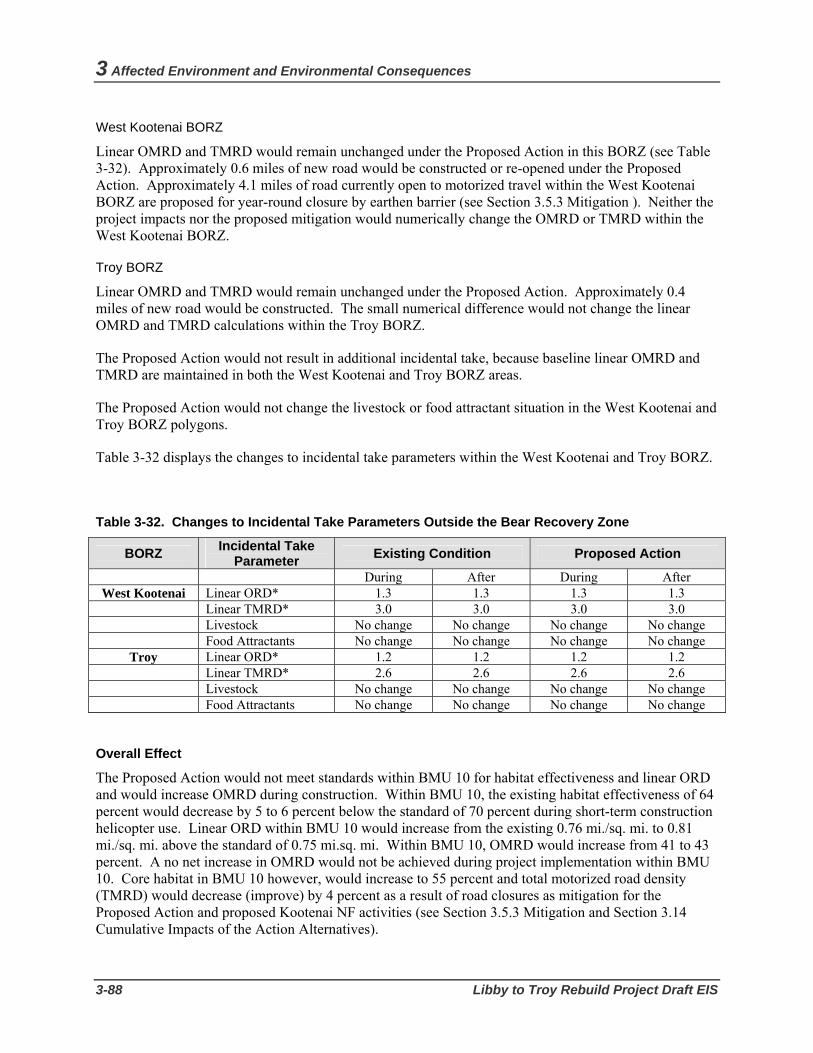
3 Affected Environment and Environmental Consequences
3-88 Libby to Troy Rebuild Project Draft EIS
West Kootenai BORZ
Linear OMRD and TMRD would remain unchanged under the Proposed Action in this BORZ (see Table 3-32). Approximately 0.6 miles of new road would be constructed or re-opened under the Proposed Action. Approximately 4.1 miles of road currently open to motorized travel within the West Kootenai BORZ are proposed for year-round closure by earthen barrier (see Section 3.5.3 Mitigation ). Neither the project impacts nor the proposed mitigation would numerically change the OMRD or TMRD within the West Kootenai BORZ.
Troy BORZ
Linear OMRD and TMRD would remain unchanged under the Proposed Action. Approximately 0.4 miles of new road would be constructed. The small numerical difference would not change the linear OMRD and TMRD calculations within the Troy BORZ.
The Proposed Action would not result in additional incidental take, because baseline linear OMRD and TMRD are maintained in both the West Kootenai and Troy BORZ areas.
The Proposed Action would not change the livestock or food attractant situation in the West Kootenai and Troy BORZ polygons.
Table 3-32 displays the changes to incidental take parameters within the West Kootenai and Troy BORZ.
Table 3-32. Changes to Incidental Take Parameters Outside the Bear Recovery Zone
BORZ Incidental Take Parameter Existing Condition Proposed Action
During After During After West Kootenai Linear ORD* 1.3 1.3 1.3 1.3
Linear TMRD* 3.0 3.0 3.0 3.0 Livestock No change No change No change No change Food Attractants No change No change No change No change
Troy Linear ORD* 1.2 1.2 1.2 1.2 Linear TMRD* 2.6 2.6 2.6 2.6 Livestock No change No change No change No change Food Attractants No change No change No change No change
Overall Effect
The Proposed Action would not meet standards within BMU 10 for habitat effectiveness and linear ORD and would increase OMRD during construction. Within BMU 10, the existing habitat effectiveness of 64 percent would decrease by 5 to 6 percent below the standard of 70 percent during short-term construction helicopter use. Linear ORD within BMU 10 would increase from the existing 0.76 mi./sq. mi. to 0.81 mi./sq. mi. above the standard of 0.75 mi.sq. mi. Within BMU 10, OMRD would increase from 41 to 43 percent. A no net increase in OMRD would not be achieved during project implementation within BMU 10. Core habitat in BMU 10 however, would increase to 55 percent and total motorized road density (TMRD) would decrease (improve) by 4 percent as a result of road closures as mitigation for the Proposed Action and proposed Kootenai NF activities (see Section 3.5.3 Mitigation and Section 3.14 Cumulative Impacts of the Action Alternatives).

Wildlife
Bonneville Power Administration 3-89
The Proposed Action would meet standards within BMU 1 for habitat effectiveness and linear ORD and OMRD and TMRD would remain unchanged. Core habitat would increase to 86 percent as a result of the Proposed Action in BMU 1.
Potential displacement of bears as a result of helicopter activity in both BMUs is expected to be minimal due to timing restrictions on periods of operation. The potential for undesirable human/bear encounters and subsequent human-caused mortality risk should be minimal during project activities. Denning habitat would not be affected.
The percentage of OMRD and linear TMRD would remain unchanged within the West Kootenai and Troy BORZ polygons. KNF food and garbage storage policies would be strictly observed by construction and maintenance crews.
Overall, potential impacts to grizzly bear would be considered high during construction because of the two to three weeks of helicopter use and its impact on habitat effectiveness, and the addition of new access roads and their effect on linear ORD and OMRD. After construction is complete, potential impacts to grizzly bear would be low.
Bald Eagle Effects Inside Management Zones I and II
Within Management Zones I (nest site area) and II (primary use area) of the four identified bald eagle nests located along the project corridor, impacts to bald eagles from the Proposed Action would occur from clearing of habitat through canopy removal and new road construction. Table 3-33 displays potential impacts within Management Zones I and II of the four nests from the Proposed Action.

3 Affected Environment and Environmental Consequences
3-90 Libby to Troy Rebuild Project Draft EIS
Table 3-33. Bald Eagle Habitat Affected by the Proposed Action Within the Four Nest Site and Primary Use Management Zones
Nest Activity Existing Condition Proposed Action
Canopy Removal (Acres)1 0.0 0.0
Edge Affected (Acres)2 6.7 6.7
Qua
rtz C
reek
N
est (
Zone
s I
and
II)
New Road Construction (Miles)3 0.0 0.3
Canopy Removal (Acres)1 0.0 0.5
Edge Affected (Acres)2 6.5 6.5
Hun
ter G
ulch
N
est
(Zon
es I
and
II)
New Road Construction (Miles)3 0.0 0.1
Canopy Removal (Acres)1 0.0 0.0
Edge Affected (Acres)2 11.7 11.7
Koo
tena
i Fal
ls
Nes
t (Z
ones
I an
d II
)
New Road Construction (Miles)3 0.0 0.3
1 Canopy Removal: Removal of tall growing vegetation within the transmission line corridor which includes clearing for new roads both inside and outside the transmission line corridor.
2 Edge Affected Area: Edge affected area was calculated as the total area between the edge of the transmission line corridor and the back line for danger tree clearing. The back line for danger tree clearing is the furthest out from the transmission line that danger trees would be removed.
3 New Road Construction: Miles of new roads within Zones I and II.
The following discussion describes potential impacts within Management Zones I and II of the four nests from the Proposed Action.
Pipe Creek Nest Zones I and II
Table 3-33 shows the amount of clearing of bald eagle habitat that would occur under the Proposed Action inside the Pipe Creek nest Management Zones I and II. Although no canopy removal would occur within these two management zones, about 2.6 acres of edge affected area would be impacted within Zones I and II. In the edge affected area, the impact to the Pipe Creek nest would be low because no suitable nesting, perching or roosting trees would be removed.
Canopy Removal (Acres)1 0.0 0.0
Edge Affected (Acres)2 2.6 2.6
Pipe
Cre
ek
Nes
t (Zo
nes I
an
d II
)
New Road Construction (Miles)3 0.0 0.5

Wildlife
Bonneville Power Administration 3-91
There would be a low impact from construction of 0.5 mile of new road because the road would be constructed at the outer edge of the primary use area (Zone II) within the existing corridor and construction would not occur in the nesting season (see Section 3.5.3 Mitigation).Within Zones I and II, disturbance from construction equipment would be avoided because danger tree clearing and line construction would not occur during the nesting season (see Table 3-33 and Section 3.5.3 Mitigation). This avoidance would be consistent with the MBEMP objectives and guidelines for elimination and minimization of disturbance to Management Zones I, and II. In addition, because the Proposed Action would simply rebuild an existing transmission line within an existing corridor, it would not add to the already existing permanent development in the project vicinity. Thus, the Proposed Action would not conflict with the MBEMP guidelines stating that permanent development should not occur within Zones I and II.
Use of pesticides or herbicides for vegetation management would not occur along the transmission line corridor within Zones I and II of the Pipe Creek nest during the nesting season (see Section 3.5.3 Mitigation).
Quartz Creek Nest Zones I and II
Table 3-33 shows the amount of clearing of bald eagle habitat that would occur under the Proposed Action inside the Quartz Creek nest Management Zones I and II. Although no canopy removal would occur within these two management zones, about 6.7 acres of edge affected area would be impacted within Zones I and II. Suitable nesting, perching, and roosting trees would be removed within the edge affected area resulting in low to moderate impact to nest site habitat suitability and integrity of the breeding area. .
There would be a low impact from construction of 0.1 mile of new road within Zones I and II because the road would be located within the existing corridor. Additionally the road would be constructed in compliance with the timing restrictions (see Section 3.5.3 Mitigation). As with the Pipe Creek nest inside Zones I and II, disturbance to the Quartz Creek nest from construction equipment would be avoided because danger tree clearing and line construction would not occur during the nesting season (see Table 3-26), and this avoidance would be consistent with the MBEMP objectives and guidelines for elimination and minimization of disturbance to Management Zones I, and II. In addition, , as with the Pipe Creek nest, rebuilding the existing line within the existing corridor would not conflict with the MBEMP guidelines regarding permanent development within Zones I and II.
Timing restrictions for pesticide or herbicide use would be the same as for the Pipe Creek nests.
Hunter Gulch Nest Zones I and II
Table 3-33 shows the amount of clearing of bald eagle habitat that would occur under the Proposed Action inside the Hunter Gulch nest Management Zones I and II. Approximately 0.5 acres of canopy removal would occur within these management zones for construction of about 0.1 miles of new access road to structure 22/1; the impact would be moderate. About 6.7 acres of edge affected area would be impacted within Zones I and II. Suitable nesting, perching, and roosting trees would be removed within the edge affected area resulting in moderate impact to nest site habitat suitability and integrity of the breeding area.
Impacts would be lessened by compliance with the timing restrictions (see Section 3.5.3 Mitigation). Disturbance to the Hunter Gulch nest Zones I and II from construction equipment also would be avoided because danger tree clearing and line construction would not occur during the nesting season (see Table 3-26) which is in compliance with the MBEMP objectives and guidelines. As with the Pipe and Quartz

3 Affected Environment and Environmental Consequences
3-92 Libby to Troy Rebuild Project Draft EIS
creek nests, rebuilding the existing line within the existing corridor would not conflict with the MBEMP guidelines regarding permanent development within Zones I and II.
Timing restrictions for pesticide or herbicide use would be the same as for the Pipe and Quartz creek nests.
Kootenai Falls Nest Zones I and II
Table 3-33 shows the amount of clearing of bald eagle habitat that would occur under the Proposed Action inside the Kootenai Falls nest Management Zones I and II. Although no canopy removal would occur within these management zones under the Proposed Action, about 11.7 acres of edge affected area would be impacted within Zones I and II. Suitable nesting, perching, and roosting trees would be removed within the edge affected area resulting in moderate impact to nest site habitat suitability and integrity of the breeding area.
The impact from construction of 0.3 mile of new road would be low because no canopy would be removed and road constructing would not occur during the nesting season (see Section 3.5.3 Mitigation). Disturbance to the Kootenai Falls nest Zones I and II from construction equipment also would be avoided because danger tree clearing and line construction would not occur during the nesting season (see Table 3-26) which is in compliance with the MBEMP objectives and guidelines. As with the above nests, rebuilding the existing line within the existing corridor would not conflict with the MBEMP guidelines regarding permanent development within Zones I and II.
Timing restrictions for pesticide or herbicide use within Zone I and II of the Kootenai Falls nest would be the same as above.
Effects Outside Management Zones I and II
Additional bald eagle habitat outside Management Zones I and II of the four nests would be impacted by the Proposed Action. Project activities would affect suitable foraging habitat within Management Zone III (home range) of each of the four identified bald eagle nests located along the project corridor, as well as other foraging and wintering habitat in the general project vicinity. Danger tree clearing within Zone III would have a low impact on suitable foraging habitat from removal of key habitat components such as perch trees. Non-breeding bald eagles are often excluded from preferred foraging areas by resident bald eagles, thus the quality and quantity of foraging habitat is essential to the entire population, not just the resident breeding eagles.
Table 3-34 shows the impacts to bald eagle habitat within Management Zone III under the Proposed Action. Within this Zone, some large live trees suitable for nesting, perching and/or roosting would be cleared through canopy removal and new road construction that would occur outside the transmission line corridor. The impact would be low because the clearing would be very minor in relation to the amount of similar habitat available adjacent to the corridor.

Wildlife
Bonneville Power Administration 3-93
Table 3-34. Bald Eagle Habitat Affected by the Proposed Action Outside Management Zones I and II, in Acres
Habitat Existing Condition Proposed Action
Overstory Corridor Canopy 0.0 6.1
Edge Affected Area 100.5 100.5
TOTAL 100.5 106.6
Under the Proposed Action, potential impacts to other foraging and winter habitat would occur due to the removal of large live trees suitable for perching. Removal of this habitat feature would occur as a result of right-of-way clearing and/or new road construction outside of the transmission line corridor. At least 44 trees (>20"dbh) would be removed under the Proposed Action resulting in a low impact. However, mature trees and large snags traditionally used for perching/hunting in the Kootenai River riparian corridor would remain abundant. No impact to potential old growth winter night roosting habitat would occur.
Overall Effect
Under the Proposed Action, no canopy removal would occur inside Management Zones I and II of the Pipe Creek, Quartz Creek, and Kootenai Falls nests resulting in a low impact. About 0.5 acres for a new access road would be cleared in Zones I and II of the Hunter Gulch nest; the impact would be moderate. A total of 27.5 acres of edge affected area would be impacted within the Management Zones I and II for all four nests (see Table 3-33). Suitable nesting, perching, and roosting trees would be removed within this edge affected area of the Quartz Creek, Hunter Gulch and Kootenai Falls nests resulting in moderate impact to nest site habitat suitability and integrity of the breeding area. No nesting, perching, and roosting trees would be removed in the Pipe Creek nest Zones I and II. Compliance with the timing restrictions would reduce impacts to active nests during the nesting and fledging periods (see Section 3.5.3 Mitigation).
The total acres of canopy removed outside of the Zones I and II of the four nests as a result of the Proposed Action (6.1 acres) are very minor in relation to the amount of similar habitat available. About 100.5 acres of edge affected area outside Zones I and II but within Zone III (home range) would be affected resulting in a low impact on suitable foraging habitat.
As described above for migratory birds, the Proposed Action would only slightly increase the risk for bald eagle line collision as the line would be rebuilt in the same location with the same type of structures. Placement of overhead ground wire on structures for about one mile out of the substations at either end of the line could increase the "fence" effect and cause an increase in strikes for bald eagles flying along the Kootenai River corridor and to and from nests. The single wood pole structures with stand-off insulators would also increase the mortality risk although they would be constructed on the Libby Substation end of the project not near the four nests.
Electrocution of bald eagles, even with their larger wingspans, is more common with distribution lines with their smaller separations between energized components than with the higher voltage line that would
3 Affected Environment and Environmental Consequences
3-94 Libby to Troy Rebuild Project Draft EIS
rebuilt under the Proposed Action. In general, the potential impact to bald eagle from electrocution from the Proposed Action would be considered low. However, in the area near the Pipe Creek nest, there is a distribution line that would remain in the lower position of the rebuilt structures. Because of this line, there is an increased possibility for bald eagle electrocutions in this area, and the impact at this location thus would be considered moderate.
Peregrine Falcon Effects of the Proposed Action on peregrine falcons would most likely come from disturbance of this species by helicopters used during construction activity during nesting and fledging periods (J. Sumner, Montana Peregrine Institute, pers. comm. 2006). The potential for disturbance of peregrine falcons is greatest during March-May (courtship and incubation) and at fledging time (median fledge date is 7 July). Nest abandonment or premature fledging may occur as a result of disturbance during this period. Compliance with the timing restrictions would reduce impacts to active nests during the nesting and fledging periods (see Section 3.5.3 Mitigation).
The risk of mortality of peregrine falcon from collision with the transmission line would be considered to be low. The risk of bird mortality from collision with transmission lines is primarily a concern for migratory waterfowl, which have the highest incidence of mortality associated with transmission lines. Collisions of raptors such as peregrine falcon with power lines are relatively rare because raptor’s keen eyesight and a tendency to avoid flying in inclement weather are believed to reduce the risk of power line collisions (Olendorff and Lehman 1986).
The risk of peregrine falcon mortality from electrocution would be low because peregrine falcon wingspans are not large enough to reach two conductors that would be installed for the rebuilt transmission line at one time. Overall, impacts to peregrine falcon from the Proposed Action would be considered low.
Pileated Woodpecker Impacts to pileated woodpeckers were evaluated based on the following two factors: (1) acres of designated and undesignated old growth habitat that would be removed by the project (see Section 3.3.2 Vegetation/Old Growth for definitions); and (2) the number of other individual trees suitable for nesting that would be removed by the project.
The Proposed Action would not affect designated or undesignated old growth stands. However, some danger trees would be cleared within the 300-foot-wide old growth buffer zones, which exist along the edge of old growth habitat (see Section 3.3.2 Vegetation/Old Growth). Removal of old growth habitat would eliminate potential nesting or roosting sites for pileated woodpeckers. Foraging habitat would also be eliminated unless downed logs are left on site. The old growth buffer zone would retain some habitat features that can be used by pileated woodpeckers, such as live trees and short snags that do not pose a hazard to the transmission line. However, taller snags and/or leaning live trees that could fall on the transmission line would be removed, reducing the effectiveness of the edge or buffer zone. Compliance with the timing restrictions would reduce impacts to active nests if present in old growth habitat during the nesting and fledging period (see Section 3.5.3 Mitigation).
The Proposed Action would not be expected to change (either increase or decrease) the potential population index for pileated woodpeckers on the Kootenai NF as a result of impacts to old growth habitat (see Table 3-35). Although adverse effects to some attributes of old growth habitat would be

Wildlife
Bonneville Power Administration 3-95
expected within the Pipestone, Quartz, and Sheep PSUs, potential nesting territories of individual birds would not be expected to be rendered ineffective for nesting as a result of project activities.
Table 3-35. Potential Population Index for Pileated Woodpeckers for the Proposed Action 1
Analysis Area Existing PPI Proposed Action
Pipestone PSU 14 14 Quartz PSU 10 10 Sheep PSU 2 2 Forest-wide 425 425 1 Potential population index equals habitat acres divided by average territory acres.
Based on the analysis for pileated woodpecker and old growth habitat, and the KNF Conservation Plan (Johnson 2004), habitat for old growth forest species would be provided in sufficient quality and quantity after project implementation to meet the needs for viable populations. Since sufficient old growth forest would be available, the populations of species using that habitat would remain viable. Accordingly, impacts to pileated woodpecker from the Proposed Action’s effect on old growth habitat would be considered low.
Regarding other individual trees suitable for nesting, suitable tree species include ponderosa pine, western larch, cottonwood, and aspen. The Proposed Action would cross small portions of land designated as MA 10 (Figure 3-6) where the Kootenai NF Plan requires that retention of all existing cavity habitat (snags) occur. Based on the potential clearing of trees within 50 feet from either side of the transmission line centerline, he Proposed Action would remove approximately 40 live trees preferred by pileated woodpecker for nesting (greater than or equal to 20” dbh). Actual tree clearing may be less for the Proposed Action since corridor clearing would be expected to occur only up to 40 feet out from the centerline. In addition, no preferred snags (greater than or equal to 20” dbh) would be removed under the Proposed Action. Given the amount of potential pileated woodpecker habitat available in the PSUs crossed by the Proposed Action, and the large size of woodpecker territories, this impact would be considered low. In addition, this impact would not be expected to change the Potential Population Index in an individual PSU or in the Forest as a whole (Table 3-35). Overall, impacts to pileated woodpecker from the Proposed Action would be considered low.
Northern Goshawk Transmission line right-of-way clearing can reduce nesting and/or foraging habitat for northern goshawk. In addition, removal of large live trees, particularly trees >20” dbh, can decrease the availability of potential nest trees for goshawks.
Because no goshawk nest sites have been identified along the project corridor, the Proposed Action would not impact any known goshawk nest sites. Removal of suitable nesting habitat between structures 18/8 and 19/5, 21/5 and 25/8, and just east of 26/1 to 28/2 would result in a low impact.
Loss of goshawk foraging habitat from the Proposed Action would be about 8.6 acres, which would be considered a low impact because this amount of habitat loss would represent a small fraction of the total habitat available for goshawk on the Kootenai National Forest. Due to the limited amount of habitat being impacted, the potential population index is not expected to change Forest-wide as a result of the Proposed Action. Overall, the impact to northern goshawk would be considered low.

3 Affected Environment and Environmental Consequences
3-96 Libby to Troy Rebuild Project Draft EIS
Flammulated Owl As for northern goshawk, transmission line right-of-way clearing can reduce nesting and/or foraging habitat for flammulated owl, and removal of large live trees, particularly trees >20" dbh, would decrease the availability of potential nest trees for the owl. For owls, snag removal can also remove suitable nesting habitat. In addition, removal of large ponderosa pine or Douglas-fir trees can decrease the availability of early-season feeding sites, song and roost sites, and trees for snag recruitment in areas already limited in large snag abundance (Wright 1996:77).
Although one flammulated owl observation was made during surveys in 2006, no owl nest sites have been identified along the project corridor. The Proposed Action thus would not impact any known flammulated owl nest sites. There is potentially suitable nesting habitat along Structures 18/8 to 19/5, 21/5 to 25/8, and just east of 26/1 to 28/2 and removal would result in a low impact.
Loss of flammulated owl foraging habitat from the Proposed Action would be about 3.3 acres, which would be considered a low impact because this is amount of habitat loss is minimal compared to the total habitat available for owl on the Kootenai NF. Due to the limited amount of habitat being impacted, the potential population index is not expected to change Forest-wide as a result of the Proposed Action. Overall, the impact to flammulated owl would be considered low.
Harlequin Duck The Proposed Action would maintain habitat conditions for harlequin ducks, so a low-or-no impact on ducks would occur. The potential for collisions would remain low because the rebuilt transmission line would cross the Kootenai River in the same location as the existing location. The Proposed Action likely would not impact individual harlequin ducks or their habitat.
Elk and White-Tailed Deer Construction, operation and maintenance of transmission lines can affect white-tailed deer and elk similarly. Impacts to these species have been evaluated based on the following indicators: cover/forage ratio and opening sizes; open road densities/habitat effectiveness; hunting season security; and key habitat components.
Cover/Forage Ratio and Opening Sizes
The cover/forage ratio represents the percentage of an area that meets elk or deer requirements for cover and forage. A cover component of at least 60 percent is recommended on elk summer range, which may be in any combination of hiding and thermal cover (Summerfield 1991). The Kootenai NF Plan (1987) also identifies the general maximum size for an opening in summer and winter range as 40 acres. In addition, the distance from any point inside an opening to cover must be no more than 600 feet (Summerfield 1991).
For white-tailed deer, the Kootenai NF Plan identifies the general maximum size for summer and winter range openings as 20 acres.
Impacts to elk: On National Forest lands, canopy removal for the Proposed Action in elk habitat would be done primarily in Management Area (MA) 17. The goal of MA 17 is to maintain or enhance a natural appearing landscape to provide a pleasing view, produce a programmed volume of timber, and manage the habitat to provide for viable populations of existing native wildlife species. Canopy removal on National Forest lands west of Shannon Lake would occur within MA 17, which is allocated to big game

Wildlife
Bonneville Power Administration 3-97
winter range. Currently, the Lake PSU located in MA 17 has a high percentage of cover (>60 percent) due to the amount of roadless area and designated wilderness within this PSU.
Canopy removal within either Treasure or Lake PSU would total not more than 5.3 acres under the Proposed Action (Table 3-28). The resulting cover/forage ratio would remain essentially unchanged from the existing condition within both PSUs.
The transmission line corridor would not exceed 80 feet in width under the Proposed Action, still providing a relatively secure corridor for animals to forage close to cover. Although the total opening size of the transmission line corridor would exceed 40 acres in size, under most circumstances, no individual point within the corridor would be more than 40 feet from hiding or thermal cover. The resulting distribution and availability of cover adjacent to the transmission line corridor thus would be expected to provide adequate security for elk.
Impacts to white-tailed deer: Almost all canopy removal within the Pipestone, Quartz, and Sheep PSUs would occur within management areas allocated to big game winter range (MAs 10 and 11). Canopy removal within any one of these PSUs would not total more than 2.2 acres under the Proposed Action (Table 3-28). The resulting cover/forage ratio and winter thermal cover percentage would remain essentially unchanged from the existing condition within MAs 10 and 11 in all three PSUs. As described above for elk, even in newly cleared corridor areas, no point within the corridor would be more than 40 feet from hiding or thermal cover, thus maintaining adequate security for white-tailed deer.
Open Road Densities/Habitat Effectiveness
The habitat effectiveness (HE) of an area refers to the percentage of habitat that is usable by elk outside of the hunting season (April 1 to October 15) that does not contain open roads. Numerous studies have shown that there is a strong negative correlation between elk use of an area and the density of open roads, even if those roads are only lightly traveled (Frederick 1991). There is no open road density standard for deer.
Impacts to elk: The Kootenai NF Plan (1987) calls for an open road density (ORD) on several Management Areas, including MA 17, of < 3.0 miles per square mile, which equates to a 38 percent HE value. Currently, both the Treasure and Lake PSUs have high HE values and low ORDs due to the amount of roadless area and designated wilderness within the PSUs.
The Proposed Action would not result in a numerical change to open road density or habitat effectiveness within the Treasure PSU. Within the Lake PSU, the Proposed Action would include motorized use of 2.0 miles of the historic Highway 2 for one construction season. Motorized use along this trail would result in a temporary increase in ORD and a loss of 135 acres of habitat effectiveness within the Lake PSU, but would not change the percentage of habitat effectiveness within the PSU over either the short or long term.
Impacts to white-tailed deer: The Kootenai NF Plan does not have open road density standards for big game winter range (MAs 10 and 11). Under the Proposed Action, new roads would be constructed either within or adjacent to the transmission line corridor. Roads built along segments where motorized access is currently authorized would remain open. Total miles of new road construction within any individual PSU would not exceed 2.4 miles under any alternative. The additional miles of new road on big game winter range likely would have a low impact on whitetail deer.

3 Affected Environment and Environmental Consequences
3-98 Libby to Troy Rebuild Project Draft EIS
Hunting Season Security
For elk, security areas are defined as areas that are larger than 250 contiguous acres in size and more than a half mile from an open road (Hillis et al. 1991). These areas offer elk refuge through reduced vulnerability during the big game fall hunting season (October 15 to November 30), and can greatly influence the age structure and composition of a herd. Although the Kootenai NF Plan has no standard for security habitat, a 2004 Task Force Report (Johnson 2004) recommends a minimum of 30 percent of an elk’s fall use area be maintained as security habitat.
There is no Kootenai NF Plan standard for white-tailed deer.
Impacts to elk: Currently, both the Treasure and Lake PSUs have high elk security habitat values (>50 percent) due to the amount of roadless area and designated wilderness within both PSUs. The Proposed Action would not change the amount of security habitat within the Treasure PSU. Within the Lake PSU, the Proposed Action would include motorized use of two miles of the historic Highway 2. Motorized use of this trail during the construction period could cause a temporary loss of 165 acres of elk security habitat within the Lake PSU. The amount of security habitat would be reduced during only one construction season (late summer-early fall), and during one calendar year. Several square miles of secure displacement habitat exists directly south of the Proposed Action. Access to secure habitat would be maintained throughout the life of the project. No additional shooting lanes would be created for hunters pursuing elk.
Impacts to white-tailed deer: The Proposed Action would not create additional shooting lanes for hunters pursuing white-tailed deer.
Key Habitat Components
No wallows, wet meadows, or bogs would be affected by the Proposed Action in the elk habitat in Treasure and Lake PSUs. In white-tailed deer habitat, the existing transmission line crosses wetlands at structure 21/4, at structure 22/4 (just east of Dad Creek), and at structure 23/8 (west of Dad Creek) in the Sheep PSU (see Figure 3-5 in Section 3.4 Wetlands and Floodplains). Because these wetlands areas would be avoided during construction and no new roads or structures would be constructed within the wetlands, the impact to white-tailed deer wet habitat would be low.
Overall, the impact to elk and white-tailed dear would be low.
Bighorn Sheep The Proposed Action would maintain or improve habitat conditions for bighorn sheep. Canopy removal would be about 0.4 acres, a negligible amount of the cover available. The transmission line corridor would not exceed 80 feet in width under the Proposed Action, still providing a relatively secure corridor for animals to forage close to cover. Because the amount of change would be small, both beneficial and adverse impacts for the Proposed Action would be low.
Section 3.5.3 Mitigation describes mitigation that would prohibit any high intensity motorized disturbance (such as heavy equipment use) behind the closed gate on the Kootenai Falls Wildlife Management Area during the bighorn sheep lambing period (April 1 to June 30). This requirement would eliminate any potential adverse impacts to bighorn ewes and lambs during the spring lambing period. Use of the non-motorized trail through the Kootenai Falls Wildlife Management Area would not change during operation and maintenance of the transmission line.

Wildlife
Bonneville Power Administration 3-99
Alternative 1 – 230-kV Double-Circuit Rebuild The following discussion describes potential impacts from Alternative 1 to common wildlife species potentially present in the project corridor, as well as to threatened, endangered and other special status species. As with the Proposed Action, potential impacts to grizzly bear are described for inside the recovery zone, outside the zone, and overall. Similarly, for bald eagle, potential impacts are described both inside and outside Management Zones I and II as well as overall. For determinations concerning ESA-listed and Forest Sensitive species, please see Appendix F.
Common Wildlife Species The type of habitat that would be removed under Alternative 1 would be the same as described for the Proposed Action. For Alternative 1, impacts to common wildlife species would be greater than the Proposed Action because corridor width would increase from 80 feet to 100 feet in width. See Table 3-28 for the total acres of clearing by PSU for Alternative 1. Big game animals would have less cover than the Proposed Action would provide, but impacts from danger tree clearing and new road construction outside the corridor would be the same as the Proposed Action because the same amount of danger tree clearing and new road construction would occur. Like the Proposed Action, road construction under Alternative 1 would increase open road densities and decrease habitat effectiveness for some big game species, and smaller mammals also would be affected by removal of cover within their habitat. However, the total acreage of habitat removed as a result of Alternative 1 would be very minor in relation to the amount of similar habitat available within the individual PSUs and the forest in general. Potential impacts to big game and smaller mammals from Alternative 1 thus would be expected to be low.
Alternative 1 also would avoid construction of new structures or roads in riparian and wetland areas, so the effect to songbirds, waterfowl, some raptors, and shore birds would be low.
For migratory birds, effects to nesting, foraging, and roosting habitat from Alternative 1 would be the same as the Proposed Action. Mortality risk from Alternative 1 also would be similar to the Proposed Action, although the double-circuit 230-kV line may increase the potential for bird conductor strikes. The taller steel structures (average height of 95 feet) would have a stacked configuration (conductors at various heights) which can create a “fence effect,” or a larger area in which birds must avoid obstacles (BPA 2002). The increased risk would be most likely for waterfowl where the transmission line crosses the Kootenai River. Placement of overhead ground wire on the taller 230-kV structures also could increase the potential for bird strikes.
The potential for effects from electrocution of birds under Alternative 1 would be the same as the Proposed Action. Electrocution of bird species is normally is not an impact resulting from transmission lines. Even birds with large wingspans most likely would not touch two conductors at one time. Bird electrocution is normally a concern for distribution lines because they have less distance between conductors than transmission lines.
Gray Wolf Impacts from Alternative 1 on gray wolves would be similar to impacts under the Proposed Action, and would also be considered to be low for the same reasons. Although a wider corridor would be required for Alternative 1, there would still be a relatively secure corridor for animals such as elk and deer. Existing habitat conditions would be maintained for big game animals so the primary prey base for wolves would remain at current levels.

3 Affected Environment and Environmental Consequences
3-100 Libby to Troy Rebuild Project Draft EIS
Grizzly Bear Effects Inside Recovery Zone
Similar to the Proposed Action, impacts to grizzly bear from Alternative 1 would occur within BMUs 10 and 1. The analysis of impacts inside these BMUs is based on whether Alternative 1 detracts from meeting the six established objectives for grizzly bear recovery.
Objective 1. Provide adequate space to meet the spatial requirements of a recovered grizzly bear population.
A. Habitat Effectiveness standard: Maintain HE equal to or greater than 70 percent of the BMU.
BMU 10: Alternative 1 would have the same affect as the Proposed Action by decreasing habitat effectiveness within BMU 10 from 64 to 56 percent during project construction (see Table 3-29). Helicopter use would result in a high impact to grizzly bear during this use, although helicopter-supported activities would only take place over a 2 to 3 week period (a short-term effect). All new access roads would be closed once construction is completed, so there would be no permanent reduction in the current level of habitat effectiveness as a result of road construction from Alternative 1.
Timing restrictions for construction activities would be followed similar to the Proposed Action (see Section 3.5.3 Mitigation). All other disturbance within the BMU as a result of transmission line construction, including timber harvest for right-of-way clearing, would affect a smaller area than the helicopter disturbance zone.
BMU 1: Alternative 1 would have the same impact as the Proposed Action by decreasing habitat effectiveness within BMU 1 from 88 to 81 percent during construction (see Table 3-29). As with the Proposed Action, helicopter use would result in a high impact to grizzly bear during this use, although impacts from helicopter-supported activities would be short-term. All other disturbance would affect a smaller area than the helicopter disturbance zone.
Timing restrictions for Alternative 1 construction activities would be followed as with the Proposed Action (see Section 3.5.3 Mitigation). All affected acreage lies adjacent to the Highway 2 corridor, on a heavily forested north-facing slope. Expected displacement of bears would likely be minimal during the construction season similar to the Proposed Action.
B. Linear Open Road Density (ORD) standard: Allow no more than 0.75 miles of open road per square mile of BMU.
BMU 10: Impacts to linear ORD in BMU 10 from Alternative 1 would be the same (high but short term) as the Proposed Action (increase in linear ORD within BMU 10 from 0.76 mi./sq. mi. to 0.81 mi./sq. mi.) because the same amount of road opening and construction would occur (see Table 3-30). Following construction, linear ORD inside BMU 10 would return to pre-project existing conditions (see Section 3.5.3 Mitigation).
Timing restrictions for construction activities would be followed similar to the Proposed Action (see Section 3.5.3 Mitigation). Activities would occur during a one year construction season. The motorized use of roads during the construction period could disturb bears and increase the potential for human-bear encounters, but after construction, roads would be closed and restricted to

Wildlife
Bonneville Power Administration 3-101
administrative/maintenance use only, so minimal long-term disturbance to bears from the additional roads would be expected.
BMU 1: Impacts to linear ORD in BMU 1 from Alternative 1 would be the same (short-term and low) as the Proposed Action (increase in linear ORD within BMU 1 from 0.19 mi./sq. mi. to 0.22 mi./sq. mi.) because the same amount of road opening and construction would occur (see Table 3-31). Following construction, linear ORD inside BMU 1 would return to pre-project existing conditions (see Section 3.5.3 Mitigation).
Timing restrictions and minimal long-term disturbance impacts to bears would be the same as the Proposed Action (see Section 3.5.3 Mitigation).
C. Core Areas standard: Work toward attaining a core area of 55 percent in the BMU, with no net loss of core area to occur on federal ownership within the BMU.
BMU 10: Alternative 1 would have no impact core habitat within BMU 10. However, over the long term, core habitat is projected to increase from the current 51 to 55 percent as a result of road closures as described in Section 3.5.3 Mitigation.
BMU 1: As with the Proposed Action, Alternative 1 would require motorized access along the historic Highway 2 Trail, resulting in a low impact to 120 acres of core habitat within BMU 1because the amount of core is currently well above the standard. However, over the long term, core habitat is projected to increase from the current 85 to 86percent as a result of road closures as described in Section 3.5.3 Mitigation.
D. Open Motorized Route Density (OMRD) standard: No net increase in OMRD on National Forest lands within the BMU.
BMU 10: Impacts to OMRD from Alternative 1 would be the same as the Proposed Action (increase in linear OMRD within BMU 10 from 41 to 43 percent) because the same amount of road opening and construction would occur. Similar to the Proposed Action, Alternative 1 would require motorized access behind the gate on Sheep Range Road (Kootenai Falls Wildlife Management Area) for the construction period and for routine maintenance in the future opening 5.7 miles of road and constructing 0.6 miles of new road. As with the Proposed Action, the short-term impact to bear habitat in BMU 10 would be high; however, OMRD would return to the existing condition of 41 percent following project completion because the Sheep Range Road and all roads opened for construction would be closed as discussed above in linear ORD for BMU 10.
BMU 1: Impacts to OMRD from Alternative 1 would be the same as the Proposed Action (OMRD would remain unchanged at 12 percent) because the same amount of road opening and construction would occur in BMU 1. As described previously, Alternative 1 would require motorized access along historic Highway 2 for construction and maintenance purposes opening 2.0 miles of road and constructing 0.6 miles of new road in BMU 1.
E. Total Motorized Route Density (TMRD) standard: No net increase in TMRD on National Forest lands within the BMU.
BMU 10: Similar to the Proposed Action, Alternative 1 would not change the TMRD percentage within BMU 10. Mitigation as described in Section 3.5.3 Mitigation, would improve TMRD from 28 to 24 percent under Alternative 1 as with the Proposed Action (see Table 3-29).
3 Affected Environment and Environmental Consequences
3-102 Libby to Troy Rebuild Project Draft EIS
BMU 1: As with the Proposed Action, Alternative 1 would not change the TMRD percentage within BMU 1. Under Alternative 1 (as with the Proposed Action), TMRD would improve from 8 to 7 percent as a result of project mitigation described in Section 3.5.3 Mitigation.
Objective 2. Manage for an adequate distribution of bears across the ecosystem.
Effects of timber clearing for Alternative 1 on opening size and movement corridors would be greater than the Proposed Action because additional right-of-way (from 80 to 100 feet) would be cleared. Effects to seasonal habitat components (denning habitat and spring range), road density and core areas would be the same as those under the Proposed Action.
A. Opening size: Proposed timber harvest units, either individually or in combination with existing unrecovered units should normally be designed to be less than or equal to 40 acres.
Under the Alternative 1, the total opening size of the transmission line corridor would exceed 40 acres in size, but, in general, no individual point within the corridor would be more than 50 feet from hiding cover. The resulting distribution and availability of cover adjacent to the transmission line corridor would still provide adequate security for bears.
B. Movement corridors: Unharvested corridors more than 600 feet wide should be maintained between proposed harvest units and between proposed and unrecovered existing harvest units.
The transmission line corridor would not exceed 100 feet in width under; therefore, a relatively secure corridor for animals to forage close to cover would still exist even with more corridor clearing for Alternative 1. The project corridor crosses important movement corridors and linkage zones on the Kootenai National Forest and in the short-term may temporarily displace grizzly bears crossing the Kootenai River to the north or south; however, in the long term, as construction activities are completed, the project area would be available for bear movement.
C. Seasonal components: In areas with important seasonal components, the guideline is to schedule proposed activities to avoid known spring habitats during the spring use period (April 1 to June 15) and known denning habitats during the winter (October 15 to April 15).
Alternative 1 would have the same impact on seasonal components important to bear habitat as the Proposed Action. Timing restrictions would be the same as the Proposed Action (see Section 3.5.3 Mitigation).
D. Road density and displacement (core) areas: Effects on road density and core areas from Alternative 1 are the same as for the Proposed Action and are discussed under Objectives 1 and 6.
Objective 3. Manage for an acceptable level of mortality risk.
The potential mortality risk to grizzly bear under Alternative 1 would be generally the same as for the Proposed Action, although larger opening size under this alternative would slightly, but not likely appreciably, increase the potential mortality risk. Effects from Alternative 1 on opening size and movement corridors are discussed under Objective 2 above, and effects on road density and displacement are discussed under Objectives 1 and 6. Impacts from attractants as a result of Alternative 1 construction would be the same as the Proposed Action. Alternative 1 also would not create attractants such as garbage sources that increase the risk of conflict with humans (see Section 3.5.3 Mitigation). Thus, the

Wildlife
Bonneville Power Administration 3-103
potential for undesirable human/bear encounters on Forest Service land would be minimized, greatly reducing the potential for increased grizzly mortality.
Objective 4. Maintain/improve habitat suitability with respect to bear food production.
As with the Proposed Action, vegetation clearing would occur as a result of Alternative 1 construction, with a generally positive effect on the growth of forage plants important to bears. Riparian habitats are generally considered to be valuable feeding sites. Adherence to riparian area standards would ensure protection of the food resources in this important zone.
Objective 5. Meet the management direction outlined in the Interagency Grizzly Bear Guidelines (51 Federal Register 42863) for management situations 1 2, and 3.
As with the Proposed Action, Alternative 1 temporarily would not meet standards for Objectives 1 and 3 within BMU 10 for HE, linear ORD, and OMRD during construction. Like the Proposed Action, Alternative 1 would decrease HE values within BMU 10 another 5 to 6 percent during short-term helicopter use. Alternative 1 also would increase linear ORD from 0.76 mi./sq. mi. to 0.81 mi./sq. mi in BMU 10, and from 0.79 mi./sq. mi to 1.10 mi./sq. mi. within BAA 5-10-9. OMRD would increase from 41 to 43 percent within BMU 10 under Alternative 1 as with the Proposed Action, and a no net increase in OMRD would not be achieved during project construction within BMU 10.
Objective 6. Meet the interim management direction specified in the July 27, 1995, Amended Biological Opinion to include an Incidental Take Statement (McMaster 1995).
A. Linear Open Road Density. Manage the density of open roads within the Forest Plan standard. See Objective 1 for details.
B. Open Motorized Trail or Route Density. Do not increase the existing density of open motorized trails in the affected BMU. See Objective 1 for details regarding the historic Highway 2.
C. Total Motorized Route Density (TMRD). Manage all motorized access routes (open and restricted roads and motorized trails) in the affected BMU to avoid a net increase over the existing density. See Objective 1 for details.
D. Existing Core Area Size. Manage the amount of Existing Core Area in the affected BMU to avoid a net decrease. See Objective 1.
Effects Outside Recovery Zone
Outside the CYE recovery zone (West Kootenai and Troy BORZ), impacts to grizzly bear from Alternative 1 would be the same as the Proposed Action.
West Kootenai BORZ
Linear OMRD and TMRD remain unchanged under Alternative 1 in this BORZ (see Table 3-32) as with the Proposed Action because the same amount of new roads (0.6 miles) would be constructed or re-opened. As with the Proposed Action, road closures within the West Kootenai BORZ would mitigate for the new or re-opened roads (see Section 3.5.3 Mitigation).
Troy BORZ
Linear OMRD and TMRD remain unchanged under Alternative 1. Approximately 0.4 miles of new road would be constructed as with the Proposed Action.

3 Affected Environment and Environmental Consequences
3-104 Libby to Troy Rebuild Project Draft EIS
As with the Proposed Action, Alternative 1 would not result in additional incidental take, because baseline linear OMRD and TMRD are maintained in both the West Kootenai and Troy BORZ areas. Additionally, Alternative 1 would not change the livestock or food attractant situation in the West Kootenai and Troy BORZ polygons.
Overall Effect
Alternative 1 would not meet standards within BMU 10 for habitat effectiveness and linear ORD and would increase OMRD during construction as with the Proposed Action. Within BMU 10, habitat effectiveness would decrease to 56 percent. Linear ORD within BMU 10 would increase to 0.81 mi./sq. mi. OMRD would increase to 43 percent. A no net increase in OMRD would not be achieved during project implementation within BMU 10. Core habitat in BMU 10 however, would increase to 55 percent and total motorized road density (TMRD) would decrease (improve) to 24 percent as a result of road closures as mitigation for Alternative 1 and proposed Kootenai NF activities (see Section 3.5.3 Mitigation and Section 3.14 Cumulative Impacts of the Action Alternatives).
Alternative 1 would meet standards within BMU 1 for habitat effectiveness and linear ORD and OMRD and TMRD would remain unchanged. Core habitat would increase to 86 percent as a result of Alternative 1 as with the Proposed Action in BMU 1.
Effects from Alternative 1 from potential displacement of bears as a result of helicopter activity in both BMUs are the same as the Proposed Action. Impacts would be low because timing restrictions would be followed. The potential for undesirable human/bear encounters and subsequent human-caused mortality risk would be minimal during construction. Denning habitat would not be affected by Alternative 1.
Alternative 1 would not change percentages of OMRD and linear TMRD within the West Kootenai and Troy BORZ polygons. KNF food and garbage storage policies would be strictly observed by construction and maintenance crews.
Overall, potential impacts to grizzly bear would be considered high during construction because of the 2 to 3 weeks of helicopter use and its impact on habitat effectiveness, and the addition of new access roads and their effect on linear ORD and OMRD. After construction is complete, potential impacts to grizzly bear would be low.
Bald Eagle Effects Inside Management Zones I and II
Table 3-36a displays the amounts of habitat that would be affected within Management Zones I (nest site area) and II (primary use area) of the four identified bald eagle nests located along the project corridor under Alternative 1.

Wildlife
Bonneville Power Administration 3-105
Table 3-36a. Bald Eagle Habitat Affected by Alternative 1 Within the Four Nest Site and Primary Use Management Zones
Nest Activity Existing Condition Alternative 1
Canopy Removal (Acres)1 0.0 1.7
Edge Affected (Acres)2 6.7 5.3
Qua
rtz C
reek
N
est (
Zone
s I
and
II)
New Road Construction (Miles)3 0.0 0.3
Canopy Removal (Acres)1 0.0 2.8
Edge Affected (Acres)2 6.5 4.2
Hun
ter G
ulch
N
est
(Zon
es I
and
II)
New Road Construction (Miles)3 0.0 0.1
Canopy Removal (Acres)1 0.0 2.1
Edge Affected (Acres)2 11.7 9.6
Koo
tena
i Fal
ls
Nes
t (Z
ones
I an
d II
)
New Road Construction (Miles)3 0.0 0.3
1 Canopy Removal: Removal of tall growing vegetation within the transmission line corridor which includes clearing for new roads both inside and outside the transmission line corridor.
2 Edge Affected Area: Edge affected area was calculated as the total area between the edge of the transmission line corridor and the back line for danger tree clearing. The back line for danger tree clearing is the furthest out from the transmission line that danger trees would be removed.
3 New Road Construction: Miles of new roads within Zones I and II.
Widening of the corridor and construction of taller structures with Alternative 1 would have a moderate effect on all four nest Management Zones I and II. More canopy would be removed than under the Proposed Action. Although less edge affected area would be disturbed and the same amount of roads (1.2 miles for the existing corridor that crosses near all four nests) would be constructed, the edge of the transmission corridor under Alternative 1 would be closer to the nests than under the Proposed Action (see Figure 3-8). There would be less edge affected area under Alternative 1 because the 230-kV structures would be taller, which would result in the lowest conductor being higher in the air and less likely to come in contact with a tree. Suitable nesting, perching, and roosting trees would be removed within the edge affected area resulting in low to moderate impacts to nest site habitat suitability and integrity of the breeding area.
Canopy Removal (Acres)1 0.0 0.3
Edge Affected (Acres)2 2.6 1.6
Pipe
Cre
ek
Nes
t (Zo
nes I
an
d II
)
New Road Construction (Miles)3 0.0 1.7

3 Affected Environment and Environmental Consequences
3-106 Libby to Troy Rebuild Project Draft EIS
Timing restrictions for construction would apply for Alternative 1 as with the Proposed Action (see Section 3.5.3 Mitigation) which would meet the MBEMP objectives and guidelines for elimination and minimization of disturbance to Management Zones I, and II. In addition, although the existing transmission line corridor would be widened in places under Alternative 1, the rebuilt transmission line would remain within the existing corridor, and this alternative would not be considered to add to the already existing permanent development in the project vicinity. Thus, the Proposed Action would not conflict with the MBEMP guidelines stating that permanent development should not occur within Zones I and II.
Use of pesticides or herbicides for vegetation management would not occur along the transmission line corridor within Zones I and II of the four nests during the nesting season as for the Proposed Action (see Section 3.5.3 Mitigation).
Effects Outside Management Zones I and II
Additional bald eagle habitat outside the management zones of the four nests would be impacted by Alternative 1. As with the Proposed Action, danger tree clearing outside of Zones I and II but within Zone III (home range) would have a low impact on suitable foraging habitat from removal of suitable nesting, perching, and roosting trees.
Table 3-36b shows the impacts to bald eagle habitat outside these management zones under the Alternative 1.
Table 3-36b. Bald Eagle Habitat Affected by Alternative 1 Outside Zones I and II (in acres)
Habitat Existing Condition Proposed Action Overstory Corridor Canopy 0.0 21.7
Edge Affected Area 100.5 66.3 TOTAL 100.5 88.0
Effects from canopy clearing for right-of-way and roads for Alternative 1 to other foraging and wintering habitat would be greater than the Proposed Action because more large trees suitable for perching would be removed for the wider right-of-way needed; the impact would be moderate. At least 354 trees (20-30"dbh), about 14 trees (>30”dbh), and about 8 snags (>20”dbh) would be removed for Alternative 1. There would be small amount of clearing in old growth winter night roosting habitat from Alternative 1 (see Section 3.3.2 Vegetation/Old Growth) resulting in a moderate impact.
Overall Effect
Under Alternative 1, a total of 6.4 acres of canopy removal would occur inside Management Zones I and II of the four nests and a total of 20.7 acres of edge affected area would be impacted (see Table 3-36a). Removal of suitable nesting trees in the edge affected area would result in a moderate impact to nest site habitat suitability and integrity of the breeding area. Clearing of canopy within the management zones would move the edge of the corridor closer to the nests, resulting in a moderate effect to all four nests. Taller structures with conductors placed in a stacked configuration could increase strikes for birds flying between the Kootenai River and the nests.
The total acres of canopy that would be removed outside of Zones I and II as a result of Alternative 1 (21.7 acres) would represent a very minor amount of similar habitat available. Approximately 66.3 acres of edge affected area outside the management zones would be affected resulting in a low to moderate
Wildlife
Bonneville Power Administration 3-107
impact. The impact from Alternative 1 would be lower than for the Proposed Action as less clearing would occur within the edge affected areas.
Alternative 1 would have a greater potential for impact on bald eagle mortality than the Proposed Action. Taller structures with conductors placed in a stacked configuration would increase the potential strikes for birds flying between the Kootenai River and the nests resulting in a low to moderate impact. Near the Pipe Creek nest, the distribution line that would remain in the lower position of the rebuilt structures would increase the potential for bald eagle electrocutions resulting in a moderate impact in this location.
Peregrine Falcon Effects to peregrine falcons from Alternative 1 would be similar to those from the Proposed Action. Although the taller 230-kV structures under Alternative 1 could increase the risk of bird strikes, mortality from electrocution by or collision with the transmission line would be low because raptor collisions with power lines are relatively rare, as described under the Proposed Action.
Pileated Woodpecker Effects to pileated woodpeckers from Alternative 1 would be slightly greater than those from the Proposed Action. Impacts from Alternative 1 to old growth habitat as described in Section 3.3.2 Vegetation/Old Growth would result in clearing about 0.01 acres (436 square feet) within the designated stand near Bobtail Creek and about 0.05 acres (2,178 square feet) within the designated stand northwest of Big Horn Terrace. Approximately 134 preferred trees and 3 snags would be removed in pileated woodpecker nesting habitat for Alternative 1, as compared to 40 preferred trees and no snags under the Proposed Action resulting in a moderate impact.
Although there are no known pileated woodpecker nests within five miles of these areas, potential woodpecker habitat would be removed under Alternative 1. However, given that pileated woodpeckers have relatively large territories (600-1000 acres), removal of potential woodpecker habitat would not likely result in a potential territory becoming ineffective as a nesting territory, and the amount of potential pileated woodpecker habitat available in the area, this impact would be considered low. In addition, Alternative 1 would not be expected to change (either increase or decrease) the potential population index for pileated woodpeckers in an individual PSU or in the Forest as a whole. Overall, impacts to pileated woodpecker under Alternative 1 would be considered low to moderate.
Northern Goshawk Similar to the Proposed Action, Alternative 1 would not be expected to impact any known northern goshawk nest sites because no goshawk nest sites have been identified along the project corridor. There is potentially suitable goshawk nesting habitat along Structures 18/8 to 19/5, 21/5 to 25/8, and just east of 26/1 to 28/2. Based on the July 2006 surveys of the project corridor, 56 suitable nesting trees in the Pipestone PSU and 15 such trees in the Lake PSU would be removed under Alternative 1, and no such trees would be removed in the Quartz or Sheep PSUs. Thus, a total of 71 suitable goshawk nest trees would be removed, and this impact would be considered moderate.
Under Alternative 1, more potential foraging habitat for goshawk would be cleared due to transmission line right-of-way clearing than under the Proposed Action. Loss of potential goshawk foraging habitat under Alternative 1 would be about 26.8 acres, as compared to 8.6 acres under the Proposed Action. However, this habitat loss under Alternative 1 would still be considered a low impact because it would represent a small fraction of the total habitat available for goshawk on the Kootenai National Forest. Due to the limited amount of habitat being impacted, the potential population index is not expected to change
3 Affected Environment and Environmental Consequences
3-108 Libby to Troy Rebuild Project Draft EIS
Forest-wide as a result of the Proposed Action. Overall, the impact to northern goshawk would be considered low-to-moderate.
Flammulated Owl Similar to the Proposed Action, Alternative 1 would not be expected to impact any known flammulated owl nest sites because no owl nest sites have been identified along the project corridor. There is potentially suitable nesting habitat along Structures 18/8 to 19/5, 21/5 to 25/8, and just east of 26/1 to 28/2. Based on the July 2006 surveys of the project corridor, a total of three suitable owl nest trees would be removed under Alternative 1, with one such tree being removed from each of the Pipestone, Quartz, and Lake PSUs. This impact would be considered low-to-moderate.
Under Alternative 1, more potential foraging habitat for the flammulated owl would be cleared due to transmission line right-of-way clearing than under the Proposed Action. Loss of potential owl foraging habitat under Alternative 1 would be about 16.8 acres, as compared to 3.3 acres under the Proposed Action; the impact would be low-to-moderate. However, this habitat loss under Alternative 1 would still be considered a low impact because it would represent a small fraction of the total habitat available for flammulated owl on the Kootenai National Forest. Due to the limited amount of habitat being impacted, the potential population index is not expected to change Forest-wide as a result of the Proposed Action. Overall, the impact to flammulated owl would be considered low-to-moderate.
Harlequin Duck Alternative 1 would have similar impacts as the Proposed Action (no-to-low), although the potential for collision could increase with the taller 230-kV structures.
Elk and White-Tailed Deer Cover/Forage Ratio and Opening Sizes
Impacts to elk: Effects to elk from Alternative 1 would be similar to the Proposed Action, although additional tree canopy would be removed. Canopy removal within either Treasure or Lake PSU would not be greater than 10 acres (Table 3-28).
The transmission line corridor would not exceed 100 feet in width under any action alternative, still providing a relatively secure corridor for animals to forage close to cover. Although the total opening size of the transmission line corridor would exceed 40 acres in size, under most circumstances, no individual point within the corridor would be more than 50 feet from hiding or thermal cover. The resulting distribution and availability of cover adjacent to the transmission line corridor should provide adequate security for elk.
Impacts to white-tailed deer: Effects to white-tailed deer from Alternative 1 would be similar to the Proposed Action although additional tree canopy would be removed. Canopy removal within the Pipestone, Quartz and Sheep PSUs would not be greater than 9.1 acres (Table 3-28). As described above for elk, even in newly cleared corridor areas, no point within the corridor would be more than 50 feet from hiding or thermal cover, thus maintaining adequate security for white-tailed deer.
Open Road Densities/Habitat Effectiveness
Impacts to elk: Effects to elk from Alternative 1 would be the same as the Proposed Action.

Wildlife
Bonneville Power Administration 3-109
Impacts to white-tailed deer: Effects to white-tailed deer from Alternative 1 would be the same as the Proposed Action. As with the Proposed Action, total miles of new road construction within any individual PSU would not exceed 2.4 mile.
Hunting Season Security
Effects to elk and white-tailed deer from Alternative 1 would be the same as the propose action.
Key Habitat Components
Effects to elk and white-tailed deer from Alternative 1 would be the same as the Proposed Action.
Overall, the impact to elk and white-tailed dear would be low.
Bighorn Sheep Effects to bighorn sheep from Alternative 1 would be similar to the Proposed Action, although additional tree canopy would be removed to widen the existing corridor to 100 feet. Approximately 9.1 acres of canopy would be removed for Alternative 1, a tiny percentage of the cover available in the Sheep PSU.
The transmission line corridor would not exceed 100 feet in width, and would still provide a relatively secure corridor for animals to forage close to cover. On the other hand, widening the corridor would increase the opening, allowing sheep to have better views and thus higher security. Permanent reduction of forest canopy also would result in a slight increase in foraging areas for sheep. Because the amount of change is small, both beneficial and adverse impacts for the alternatives would be low.
Project mitigation which prohibits any high intensity motorized disturbance (such as heavy equipment use) behind the closed gate on the Kootenai Falls Wildlife Management Area during the bighorn sheep lambing period (April 1 to June 30) would be the same as with the Proposed Action reducing potential adverse impacts to mothers and lambs.
Short Realignment Options The following discussion describes potential impacts of the three short realignment options to common wildlife species potentially present in the project corridor, as well as to threatened, endangered and other special status species. Since impacts to common wildlife species would generally be the same for all three realignment options, these impacts are described first. Impacts to other species from each of the three realignment options are then described by realignment option. For determinations concerning ESA-listed and Forest Sensitive species, please see Appendix F.
Common Wildlife Species
For the short realignment options at either voltage, the same type of habitat (general forest) as the Proposed Action and Alternative 1 would be removed for transmission line right-of-way clearing, danger tree clearing, and/or from new road construction outside the transmission line corridor. See Table 3-28 for the total acres of clearing by PSU for the short realignment options at both voltages. Effects to common big game species and smaller mammals found within the short realignment option areas would be generally the same as the Proposed Action and Alternative 1 because the realignment options are within the same general area as the existing corridor.
Effects to migrant birds would be greater for the realignment options than for the corresponding portions of the Proposed Action and Alternative 1 because new right-of-way would need to be cleared for the

3 Affected Environment and Environmental Consequences
3-110 Libby to Troy Rebuild Project Draft EIS
realignment. The Pipe Creek realignment option would clear 8.3 acres of new right-of-way at 115 kV, and 10.4 acres at 230 kV. The Quartz Creek realignment option would clear 28.0 acres of new right-of-way at 115 kV, and 35.0 acres at 230 kV. The Kootenai River crossing realignment option would clear 10.0 acres of new right-of-way at 115 kV, and 12.7 acres at 230 kV. Although there is similar abundant habitat available within the individual PSUs that the realignments cross, clearing of new right-of-way would have a moderate impact on migratory bird nesting, foraging, and roosting habitat because suitable habitat for those activities would be removed.
Conductor crossing of bodies of water in new places would potentially increase collisions for individual migrating bird species especially waterfowl. Construction of 115-kV structures for the realignments would only slightly increase the risk for line collisions as described in the Proposed Action; however the impact would be low. Construction of taller 230-kV single-pole steel structures for the realignments would most likely have a moderate impact on migrant birds because of the stacked configuration of the conductors. The Kootenai River crossing realignment at 230 kV is expected to have a moderate impact on bird mortality because taller structures would be constructed in a corridor where no lines currently exist increasing the potential for bird strikes to occur. Additionally, six new conductors would cross the Kootenai River increasing the “fence” effect.
Ground wire would not be placed on the realignment option structures because the realignments are more than one mile from the substations so the impact from collisions with ground wire are low. In addition, electrocution of birds from the higher voltage transmission lines under any of the realignment options would not be expected to occur for the reasons described under the Proposed Action and Alternative 1.
Pipe Creek Realignment Gray Wolf
Impacts from the Pipe Creek realignment on gray wolves would be similar to impacts under the Proposed Action and Alternative 1, and would also be considered to be low for the same reasons. Although a wider corridor would be required for the realignment at 230 kV, there would still be a relatively secure corridor for animals such as deer. Existing habitat conditions would be maintained for big game animals so the primary prey base for wolves would remain at current levels.
Grizzly Bear
The Pipe Creek realignment option would not be expected to affect grizzly bear because the realignment is not located within any grizzly bear recovery area or grizzly bear outside the recovery area.
Bald Eagle
Effects Inside Management Zones I and II: The Pipe Creek realignment crosses through Management Zones I and II of the Pipe Creek nest. This realignment would pass about 320 feet to the west and down slope of the Pipe Creek nest, as compared to the existing transmission corridor, which passes about 1,000 feet south and down slope of the nest. Impacts to the Pipe Creek nest would be high because between 6.9 acres (115 kV) and 8.7 acres (230 kV) of mature forest habitat would be cleared within Zones I and II. Additionally, approximately 6.8 acres (115 kV) to 5.4 acres (230 kV) of edge affected area would be impacted within Zones I and II. The impact would be high in the edge affected area because clearing (100 percent of the trees are removed), thinning (about 40 percent of the trees are removed), danger tree removal (about 10 percent of the trees) and road construction (about 0.4 miles) would occur along the realignment right-of-way.

Wildlife
Bonneville Power Administration 3-111
Within Zones I and II, disturbance from construction equipment would be eliminated because danger tree clearing and line construction would not occur during the nesting season (see Section 3.5.3 Mitigation) which meets the MBEMP objectives and guidelines for elimination and minimization of disturbance to Management Zones I, and II. Construction of the realignment however, would not meet the MBEMP guidelines which state that permanent develop should not occur within Zones I and II.
Use of pesticides or herbicides for vegetation management would not occur along the transmission line corridor within Zones I and II of the Pipe Creek nest during the nesting season (see Section 3.5.3 Mitigation).
Effects Outside Management Zones I and II: Additional bald eagle habitat outside Management Zones I and II of the Pipe Creek nest would be impacted by the Pipe Creek realignment. Approximately 1.4 acres (at 115 kV) and 2.8 acres (at 230 kV) of canopy and edge affected area would be impacted in Zone III of the Pipe Creek nest site. Additionally, there would be a high impact from canopy clearing because 1.5 acres (at 115 kV) and 1.8 acres (at 230 kV) of designated old growth would occur in the old growth stand near Bobtail Creek from this realignment. Clearing in the edge affected area also would include clearing (100 percent of the trees are removed), thinning (about 40 percent of the trees are removed), and danger tree removal (about 10 percent of the trees) which would also occur within portions of the old growth stand.
Right-of-way clearing for the Pipe Creek realignment also would remove foraging habitat from Zone III of the Quartz Creek bald eagle nest, as well as general foraging and wintering habitat for the Hunter Gulch and Kootenai Falls nests. Potential impacts to foraging habitat from right-of-way clearing would be high because large live trees suitable for perching would be removed. At least 69 trees (>20"dbh) and 27 snags (>20”dbh) would be removed for 230-kV construction of the realignment. Slightly less large trees and snags would be removed for the 115-kV option because a 40 foot wide right-of-way would be cleared rather than a 50 foot right-of-way.
Overall Effect: The overall effect of the Pipe Creek realignment option on bald eagle would be a high impact. This realignment would clear mature forest habitat and edge affected area within Zones I and II of the Pipe Creek nest site, would remove foraging habitat from Zone III of the Pipe Creek and Quartz Creek nest site, and would affect general foraging and wintering habitat for the Hunter Gulch and Kootenai Falls nests. In addition, because this realignment would cross the primary flight corridor between the Pipe Creek nest tree and the Kootenai River, the potential for eagles to collide with the conductors would be increased. The Pipe Creek realignment option built at 115 kV thus would be expected to increase the potential risk of bald eagle mortality from collision. The risk would increase further if 230-kV structures are constructed and multiple wires are present within the flight paths of the nesting eagles.
Other Sensitive Species
Peregrine Falcon: Peregrine falcon would not be affected by the Pipe Creek realignment because the nesting cliff is located west of Kootenai Falls, at least 7 miles west of the realignment.
Pileated Woodpecker: The Pipe Creek realignment would clear 1.5 acres (at 115 kV) and 1.8 acres (at 230 kV) of the 170-acre designated old growth stand located near Bobtail Creek (see Figure 3-4 in Section 3.3 for location of stand). About 3.5 acres (at 115 kV) and 4.3 acres (at 230 kV) would be cleared in undesignated old growth located along the realignment. Also affect would be old growth buffer habitat. Approximately 38.9 acres at both voltages of old growth buffer zone would be impacted by danger tree clearing or thinning. While changes in vegetation and wildlife use may occur on the acres in

3 Affected Environment and Environmental Consequences
3-112 Libby to Troy Rebuild Project Draft EIS
the buffer zone, those acres would remain functional old growth for some species, including pileated woodpeckers. Compliance with the timing restrictions would reduce impacts to active nests if present in old growth habitat during the nesting and fledging period (see Section 3.5.3 Mitigation).
The Pipe Creek realignment would remove approximately 34 trees preferred by pileated woodpecker (species include ponderosa pine, western larch, cottonwood, and aspen) and 10 snags regardless of voltage. This would result in a moderate impact to individuals nesting within the area crossed by the Pipe Creek realignment. Given the amount of potential pileated woodpecker habitat available, and the large size of woodpecker territories, these impacts are not expected to change the Potential Population Index in an individual PSU or in the Forest as a whole.
Northern Goshawk: Approximately 96 suitable goshawk nesting trees would be removed for the Pipe Creek realignment within the Pipestone PSU regardless of voltage. About 12.7 acres (at 115 kV) and 15.7 acres (at 230 kV) of foraging and nesting habitat would be removed for the Pipe Creek realignment which would result in a moderate impact to nesting goshawk.
Flammulated Owl: Approximately 12 suitable flammulated owl nesting trees would be removed for the Pipe Creek realignment within the Pipestone PSU regardless of voltage. About 12.7 acres (at 115 kV) and 15.7 acres (at 230 kV) of foraging and nesting habitat would be removed for the Pipe Creek realignment which would result in a moderate impact to nesting flammulated owl.
Harlequin Duck: Harlequin duck would not be affected by the Pipe Creek realignment because the ducks are found primarily along the Kootenai River west of its confluence with Pipe Creek. Additionally, construction of the realignment would not include placement of structures within the riparian zone of Pipe Creek in the event that Harlequin were found along Pipe Creek.
Elk: The Pipe Creek realignment option would similar effects on cover/forage ratio and opening sizes, open road densities/habitat effectiveness, hunting season security, and key habitat components for elk as the Proposed Action and Alternative 1. Even with the new right-of-way, no individual point within the corridor would be more than 50 feet (at 230 kV) from hiding or cover. Open road density would increase during construction; however gates would reduce access keeping open road densities and habitat effectiveness at current levels. Hunting season habitat would be reduced during construction but there would be no long-term effect. Roads or new structures would not be placed in key habitat areas such as wallows, wet meadows or bogs. Thus, impacts to elk from this realignment option would be low.
White-Tailed Deer: The Pipe Creek realignment option would have similar effects on open road densities/habitat effectiveness and key habitat components for deer as the Proposed Action. New roads would be gated to reduce access into the realignment area. Roads or new structures would not be placed in key habitat areas such as wetlands. Effects on cover/forage ratio and opening sizes for deer from this realignment option would be similar to the Proposed Action, although additional tree canopy would be removed. Canopy removal within the Pipestone PSU would not be greater than 10.4 acres at 230 kV (Table 3-28). The transmission line corridor for this realignment option would not exceed 100 feet in width under either voltage, still providing a relatively secure corridor for animals to forage close to cover. Although the total opening size of the transmission line corridor would exceed 40 acres in size, under most circumstances, no individual point within the corridor would be more than 50 feet (230 kV) from hiding or thermal cover. The resulting distribution and availability of cover adjacent to the transmission line corridor would be expected to provide adequate security for deer.
Concerning hunting season security, clearing for the Pipe Creek realignment would create additional shooting and observation lanes for hunters pursuing whitetails in big game winter range (MAs 10 and 11).

Wildlife
Bonneville Power Administration 3-113
However, the maximum amount of acreage cleared (10.4 acres) would cause only minor reductions in habitat security for white-tailed deer because of the large amount of security habitat available within 50 feet of any opening. Overall, the impact to white-tailed deer would be low.
Bighorn Sheep: Bighorn sheep would not be affected by the Pipe Creek realignment because it does not cross through the Kootenai Falls Wildlife Management Area designated as habitat for bighorn sheep. The WMA begins about 3 miles west of the western end of the Pipe Creek realignment.
Quartz Creek Realignment Gray Wolf
Impacts from the Quartz Creek realignment on gray wolves would be similar to impacts under the Proposed Action and Alternative 1, and would also be considered to be low for the same reasons. Although a wider corridor would be required for the realignment at 230 kV, there would still be a relatively secure corridor for animals such as deer. Existing habitat conditions would be maintained for big game animals so the primary prey base for wolves would remain at current levels.
Grizzly Bear
Effects Inside Recovery Zone: In BMU 10, impacts from the Quartz Creek realignment would be similar to the Proposed Action and Alternative 1 although additional roads would be opened or constructed. Helicopter also would be used to string conductor especially over Quartz Creek during construction. This realignment option would add 550 acres (0.8 square miles) to the helicopter influence zone and would require construction and re-opening of 1.3 miles of new road. Re-opening of new roads could include brush and tree removal within the existing roadbed. The impact from construction of the Quartz Creek realignment would be high because habitat effectiveness would decrease and linear ORD would increase in BMU 10 (see Table 3-29). OMRD also would increase and TMRD would remain unchanged as with the Proposed Action and Alternative 1. The Quartz Creek realignment would not affect core habitat; however because BMU 10 core habitat is below the standard of 55 percent, road closures would occur to allow any work to proceed within the BMU (see Section 3.5.5 Mitigation).
In BMU 1, the Quartz Creek realignment would add 55 acres (0.1 square miles) to the helicopter zone decreasing habitat effectiveness inside BMU 1 during construction. Linear ORD would increase and OMRD and TMRD would remain unchanged in BMU 1 as a result of the Quartz Creek realignment.
Effects to habitat removal or change, displacement, and mortality risk from the Quartz Creek realignment option would be the same as for the Proposed Action and Alternative 1.
Effects Outside Recovery Zone: Effects on the West Kootenai and Troy BORZ polygons from the Quartz Creek realignment option would be same as for the Proposed Action and Alternative 1.
Overall Effect: Overall, potential impacts to grizzly bear would be considered high during construction of the Quartz Creek realignment because of the helicopter use and its impact on habitat effectiveness, and the addition of new access roads and their effect on linear ORD and OMRD. After construction is complete, potential impacts to grizzly bear would be low.
Bald Eagle
Effects Inside Management Zones I and II: The Quartz Creek realignment crosses through Management Zones I and II of the Quartz Creek nest. This realignment would pass about 170 feet to the north and upslope of the Quartz Creek nest, as compared to the existing transmission corridor, which passes about

3 Affected Environment and Environmental Consequences
3-114 Libby to Troy Rebuild Project Draft EIS
200 feet south and down slope of the nest. Impacts to the Quartz Creek nest would be high because between 7.7 acres (at 115 kV) and 9.6 acres (at 230 kV) of mature forest habitat would be cleared within Zones I and II. Within those acreages, 2.0 acres (at 115 kV) and 2.5 acres (at 230 kV) would be cleared within the old growth stand northwest of Bighorn Terrace. Clearing of mature forest within Zones I and II would occur closer to the Quartz Creek nest than would occur if the transmission line is rebuilt in the existing transmission corridor. Additionally, approximately 6.5 acres (115 kV) to 5.1 acres (230 kV) of edge affected area would be impacted within Zones I and II. The impact would be high in the edge affected area because clearing, thinning, and danger tree removal and road construction (about 0.3 miles) would occur along the realignment right-of-way.
As with the Pipe Creek nest, disturbance from construction equipment would be eliminated because danger tree clearing and line construction for the Quartz Creek realignment would not occur during the nesting season (see Section 3.5.3 Mitigation) which meets the MBEMP objectives and guidelines for elimination and minimization of disturbance to Management Zones I and II. Construction of the realignment however, would not meet the MBEMP guidelines which state that permanent develop should not occur within Zones I and II.
Use of pesticides or herbicides for vegetation management would not occur along the transmission line corridor within Zones I and II of the Quartz Creek nest during the nesting season (see Section 3.5.3, Mitigation).
Effects Outside Management Zones I and II: Additional bald eagle habitat outside Management Zones I and II of the Quartz Creek nest would be impacted by this realignment. Approximately 36.4 acres (at 115 kV) and 42.3 acres (at 230 kV) of canopy and edge affected area would be impacted in Zone III of the Quartz Creek nest site resulting in a moderate impact.
Right-of-way clearing for the Quartz Creek realignment also would remove foraging habitat from Zone III of the Pipe Creek and Hunter Gulch bald eagle nests, as well as general foraging and wintering habitat for the Kootenai Falls nest. Potential impacts to foraging habitat from right-of-way clearing would be high because large live trees suitable for perching would be removed. At least 81 trees (>20"dbh) and 3 snags (>20”dbh) would be removed for 230-kV construction of the realignment. Slightly less large trees and snags would be removed for the 115-kV option because a 40 foot wide right-of-way would be cleared rather than a 50 foot right-of-way.
Overall Effect: The overall effect of the Quartz Creek realignment option on bald eagle would be a moderate to high impact. This realignment would clear mature forest habitat and edge affected area within Zones I and II of the Quartz Creek nest site, would remove foraging habitat from Zone III of the Quartz Creek, Pipe Creek, and Hunter Gulch nest sites, and would affect general foraging and wintering habitat for the Kootenai Falls nest. However, this realignment would be upslope and out of the primary flight corridor between the Quartz Creek nest tree and the Kootenai River, which would reduce the potential for collision under either voltage for the Quartz Creek realignment option, as compared to the existing transmission line.
Other Sensitive Species
Peregrine Falcon: Peregrine falcon would not be affected by the Quartz Creek realignment because the nesting cliff is located west of Kootenai Falls, about 5 miles west of the realignment.
Pileated Woodpecker: The Quartz Creek realignment would clear about 2.0 acres (at 115 kV) and 2.5 acres (at 230 kV) of the 35-acre designated old growth stand located northwest of Bighorn Terrace

Wildlife
Bonneville Power Administration 3-115
(see Figure 3-4 in Section 3.3 for location of stand). This realignment would also affect buffer habitat. Approximately 30.9 acres regardless voltages of old growth buffer zone would be impacted by danger tree clearing. While changes in vegetation and wildlife use may occur on the acres in the buffer zone, those acres would remain functional old growth for some species, including pileated woodpeckers. Compliance with the timing restrictions would reduce impacts to active nests if present in old growth habitat during the nesting and fledging period (see Section 3.5.3 Mitigation).
The Quartz Creek realignment would remove approximately 142 trees preferred by pileated woodpecker and 6 snags regardless of voltage. This would result in a moderate impact to individuals nesting within the area crossed by the Quartz Creek realignment. Although a relatively large number of preferred nest trees would be removed in the 2.9 miles of the Quartz Creek realignment, which is greater than the number that would be removed in the entire 17 miles of the Proposed Action and Alternative 1, these impacts would not be expected to change the Potential Population Index in an individual PSU or in the Forest as a whole. The Kootenai National Forest currently has a large amount of potential pileated woodpecker habitat available.
Northern Goshawk: Approximately 326 suitable goshawk nesting trees would be removed for the Quartz Creek realignment within the Quartz and Sheep PSUs depending on voltage. About 31.7 acres (at 115 kV) and 39.1 acres (at 230 kV) of foraging and nesting habitat would be removed for the Quartz Creek realignment which would result in a moderate impact to nesting goshawk.
Flammulated Owl: Approximately 21 suitable flammulated owl nesting trees would be removed for the Quartz Creek realignment within the Quartz and Sheep PSUs depending on voltage. About 31.7 acres (at 115 kV) and 39.1 acres (at 230 kV) of foraging and nesting habitat would be removed for the Quartz Creek realignment which would result in a low impact to nesting flammulated owl.
Harlequin Duck: The Quartz Creek realignment would cross Quartz Creek near where harlequins have been sighted in the past. However, due to the steepness of the valley bottom, the line would span Quartz Creek high above the stream bottom, so no vegetation clearing would be required in the riparian area. The impact would be low.
Elk: The Quartz Creek realignment option would have the same effect on cover/forage ratio and opening sizes, open road densities/habitat effectiveness, hunting season security, and key habitat components for elk as the Proposed Action and Alternative 1. Even with the new right-of-way, no individual point within the corridor would be more than 50 feet (at 230 kV) from hiding or cover. Open road density would increase during construction; however gates would reduce access keeping open road densities and habitat effectiveness at current levels. Hunting season habitat would be reduced during construction but there would no long-term effect. Roads or new structures would not be placed in key habitat areas such as wallows, wet meadows or bogs. Thus, impacts to elk from this realignment option would be low.
White-Tailed Deer: The Quartz Creek realignment option would have the same effect on open road densities/habitat effectiveness and key habitat components for deer as the Proposed Action. New roads would be gated or bermed to reduce access into the realignment area. Roads or new structures would not be placed in key habitat areas such as wallows, wet meadows or bogs. Effects on cover/forage ratio and opening sizes for deer from this realignment option would be similar to the Pipe Creek realignment, except canopy removal within either the Quartz or Sheep PSUs would not be more than 21.7 acres. Effects related to hunting season security from the Quartz Creek realignment option also would be would be similar to the Pipe Creek realignment, except the maximum amount of acreage cleared would be 35 acres for the Quartz Creek realignment at 230 kV. This larger cleared area still would be expected to cause only minor reductions in habitat security for white-tailed deer because of the large amount of

3 Affected Environment and Environmental Consequences
3-116 Libby to Troy Rebuild Project Draft EIS
security habitat available within 50 feet of any opening. Overall, the impact to white-tailed deer would be low.
Bighorn Sheep: The Quartz Creek realignment option would affect bighorn sheep habitat, although it would not cross lambing areas. About 10.6 acres (at 115 kV) and 13.2 acres (at 230 kV) of canopy removal would occur from the Quartz Creek realignment within the Sheep PSU. Although the amount of canopy removal along the realignment would be greater than for either the Proposed Action or Alternative 1, the overall change to cover and forage would be small. Both beneficial and adverse effects would be low.
Kootenai River Crossing Realignment Gray Wolf
Impacts from the Kootenai River crossing realignment on gray wolves would be similar to impacts under the Proposed Action and Alternative 1, and would also be considered to be low for the same reasons. Although a wider corridor would be required for the realignment at 230 kV, there would still be a relatively secure corridor for animals such as deer. Existing habitat conditions would be maintained for big game animals so the primary prey base for wolves would remain at current levels.
Grizzly Bear
Effects Inside Recovery Zone: The Kootenai River crossing realignment would not affect BMU 10. In BMU 1, impacts from this realignment would be similar to the Proposed Action and Alternative 1 although additional roads would be opened or constructed. This realignment option would require construction of 0.2 miles of new road slightly affecting linear ORD, OMRD, and TMRD. Construction of the Kootenai River crossing realignment would meet standards within BMU 1 for habitat effectives and linear ORD and OMRD and TMRD would remain unchanged. Core habitat would not be affected.
Effects to habitat removal or change, displacement, and mortality risk from the Kootenai River crossing realignment option would be the same as for the Proposed Action and Alternative 1.
Effects Outside Recovery Zone: The Kootenai River crossing realignment would have no effect on the West Kootenai and Troy BORZ polygons because they are located on the north side of the Kootenai River east of Quartz Creek.
Overall Effect: Overall, potential impacts to grizzly bear would be considered high during construction of the Kootenai River crossing because of the helicopter use and its impact on habitat effectiveness, and the addition of new access roads and their effect on linear ORD and OMRD. After construction is complete, potential impacts to grizzly bear would be low.
Bald Eagle
Effects Inside Management Zones I and II: The Kootenai River crossing realignment option crosses through Management Zones I and II of the Kootenai Falls nest. This realignment would pass about 200 feet to the south of the Kootenai Falls nest, as compared to the existing transmission corridor, which passes about 2,000 feet west of the nest. Impacts to the Kootenai Falls nest would be moderate because between 3.7 acres (at 115 kV) and 4.6 acres (at 230 kV) of forest habitat would be cleared within Zones I and II. Additionally, approximately 1.0 acres (115 kV) to 0.7 acres (230 kV) of edge affected area would be impacted within Zones I and II. The impact would be low in the edge affected area because danger trees would be cleared on the south side of the realignment and a small amount of road (about 0.3 miles) would be constructed.

Wildlife
Bonneville Power Administration 3-117
As with the other nest Zones I and II, disturbance from construction equipment would be eliminated because danger tree clearing and line construction for the Kootenai River crossing realignment would not occur during the nesting season (see Section 3.5.3 Mitigation). Construction of the realignment however, would not meet the MBEMP guidelines which state that permanent develop should not occur within Zones I and II.
Use of pesticides or herbicides for vegetation management would not occur along the transmission line corridor within Zones I and II of the Kootenai Falls nest during the nesting season (see Section 3.5.3, Mitigation).
Effects Outside Management Zones I and II: Additional bald eagle habitat outside Management Zones I and II of the Kootenai Falls nest would be impacted by this realignment. Approximately 5.6 acres (at 115 kV) and 6.4 acres (at 230 kV) of canopy and edge affected area would be impacted in Zone III of the Kootenai Falls nest site.
Right-of-way clearing for the Kootenai River crossing realignment also would remove foraging habitat from Zone III of the Kootenai Falls nest, as well as general foraging and wintering habitat for the Pipe Creek, Quartz Creek, and Hunter Gulch bald eagle nests. Potential impacts to foraging habitat from right-of-way clearing would be low because only about 9 trees (>20"dbh) and 1 snag (>20”dbh) suitable for perching would be removed for the realignment regardless of voltage.
Overall Effect: The overall effect of the Kootenai River crossing realignment option on bald eagle would be a moderate impact. This realignment would clear mature forest habitat and edge affected area within Zones I and II of the Kootenai Falls nest site, would remove foraging habitat from Zone III of this nest site, and would affect general foraging and wintering habitat for the Quartz Creek, Pipe Creek, and Hunter Gulch nest sites. This realignment would not cross the immediate flight corridor between the Kootenai Falls nest tree and the Kootenai River, but it would cross the Kootenai River within the Primary Use Area about 2,000 feet up river from the nest tree. This new crossing location would be unfamiliar to birds that consistently use the area. At both voltages, the Kootenai River crossing realignment would be expected to have a moderate impact on the existing primary use areas based on the amount of clearing of large-diameter live trees and snags, the location of the tree clearing in relation to the nest tree, and the location of the clearing in relation to existing disturbance zones such as Highway 2 and the Burlington Northern railroad.
Other Sensitive Species
Peregrine Falcon: Peregrine falcon would not be affected by the Kootenai River crossing realignment because the nesting cliff is located west of Kootenai Falls, about 0.75 miles west of the realignment.
Pileated Woodpecker: The Kootenai River crossing realignment would not affect any growth stands because none are located near the realignment. The realignment would remove about 3 trees preferred by pileated woodpecker and no snags regardless of voltage. This would result in a low impact to individuals nesting within the area of realignment.
Northern Goshawk: Approximately 15 suitable goshawk nesting trees would be removed for the Kootenai River crossing realignment within the Lake PSU depending on voltage. This would result in a low impact to nesting goshawk.
Flammulated Owl: No suitable flammulated owl nesting trees would be removed for the Kootenai River crossing realignment.

3 Affected Environment and Environmental Consequences
3-118 Libby to Troy Rebuild Project Draft EIS
Harlequin Duck: The Kootenai River Crossing realignment would clear 80 to 100 feet of corridor in riparian habitat on the both the north and south banks of the Kootenai River; the impact to harlequin would be low; however, clearing would constitute a very small percentage of the total nesting habitat available to harlequins within the Kootenai River riparian area.
Elk: The Kootenai River crossing realignment option would have the same effect on cover/forage ratio and opening sizes, open road densities/habitat effectiveness, hunting season security, and key habitat components for elk as the Proposed Action and Alternative 1. Even with the new right-of-way, no individual point within the corridor would be more than 50 feet (at 230 kV) from hiding or cover. Open road density would increase during construction; however open road densities and habitat effectiveness would return to current levels following construction. Hunting season habitat would be reduced during construction but there would no long-term effect. Roads or new structures would not be placed in key habitat areas such as wallows, wet meadows or bogs. Thus, impacts to elk from this realignment option would be low.
White-Tailed Deer: The Kootenai River crossing realignment option would have the same effect on open road densities/habitat effectiveness and key habitat components for deer as the Proposed Action. New spur roads off Highway would be short (<100 feet in length) and would not numerically change open road densities or habitat effectiveness. Roads or new structures would not be placed in key habitat areas such as wallows, wet meadows or bogs. Effects on cover/forage ratio and opening sizes for deer from this realignment would low because clearing would not be greater than 6.3 acres in either the Treasure or Lake PSUs. Effects related to hunting season security from this realignment also would be low because the maximum amount of acreage cleared would be 12.7 acres at 230 kV. This would be expected to cause only minor reductions in habitat security for white-tailed deer because of the large amount of security habitat available within 50 feet of any opening. Overall, the impact to white-tailed deer would be low.
Bighorn Sheep: The Kootenai River crossing realignment option would have a no to low impact on bighorn sheep; about 0.3 acres (at 115 kV) and 0.4 acres (at 230 kV) would be clearing near the northern crossing structure.
3.5.3 Mitigation Grizzly Bear
• Implement any mitigation measures for grizzly bear that may be required by the USFWS through Section 7 consultations for the Proposed Action. Measures could include avoidance of certain locations during the den emergence period, restricting construction noise levels in certain areas, and provision of compensation for project effects.
• Design action alternatives and realignment options to reduce grizzly bear mortality risk due to human-bear encounters. All construction and maintenance crews will observe proper storage of food, garbage, and other attractants within grizzly bear habitat as specified in the Kootenai National Forest Food Storage Order (Special Order, Kootenai National Forest, 2001; Occupancy and Use Restrictions and Food Storage for the Cabinet/Yaak Ecosystem).
• Implement mitigation for action alternatives and realignment options that will increase core habitat and decrease TMRD in BMU 10. The removal of ten gates and the installation of earthen barriers on roads in BMU 10 that are currently closed year round to motorized travel will occur. This work would be done in conjunction with Kootenai National Forest proposed mitigation for upcoming fuels reduction work in BMU 10. Earthen barriers will make access to closed areas more difficult for motorized vehicles, thus increasing core habitat and reducing overall road

Wildlife
Bonneville Power Administration 3-119
density. The drainages and roads are as follows (see Figure 3-9): Lost Fork Creek (Roads 6164, 4653 and 4653 D); Big Foot - Seventeen Mile Creek (Roads 4681 B, C, D, E, F and G); and West Fork Quartz Creek (Roads 4690 F, and 4691). Roads 14470, 14471, 14473 and 14474 will be “placed into storage” rather than removing gates, because they are behind other roads where gates would be removed. Placing roads into storage could entail culvert removal and subsequent recontouring of the stream banks.
• Remove the gate on the 402 D spur (in BMU 1) in Cedar Creek and install an earthen barrier (Figure 3-9) will occur. This spur road is currently closed year round to motorized travel.
• Install earthen barriers in the West Kootenai BORZ, to close approximately 4.1 miles of road currently open to motorized travel. All roads are located in the Quartz Creek drainage and include Roads 6145, 6704, 6704 A, and 5222 (see Figure 3-9).
• Use of high intensity motorized disturbance (such as heavy equipment or helicopter use) will not occur in BMUs 10 and 1 between April 1 and June 15 during the grizzly bear den emergence and spring period. This includes: the west leg of the Quartz Creek realignment off Lower Quartz Creek Road #601; existing structures 21/5 to 27/9 along Sheep Range Road; and the historic Highway 2.
Bald Eagle • Implement any mitigation measures for bald eagle that may be required by the USFWS through
Section 7 consultations for the Proposed Action. Measures could include avoidance of certain locations during the nesting periods, restricting construction noise levels in certain areas, and provision of compensation for project effects.
• Implement mitigation for project activities within the primary use areas of the four nests, by purchasing private lands or conservation easements on private lands that may otherwise be developed or cleared for other purposes. Acres required for compensation would equal 100 percent of the area to be cleared of all tall growing vegetation, as well as a portion of the area that falls within the edge affected area that currently supports trees suitable for bald eagle perching, roosting, and/or nesting.
• Use of high intensity motorized disturbance (such as heavy equipment or helicopter use) will not occur between February 1 and August 15 within the primary use areas of an active nest during the nesting and fledging period. This includes: the Pipe Creek realignment; existing structures 17/6 to 18/3; the west leg of the Quartz Creek realignment; existing structures 20/9 to 21/5; the Kootenai River crossing realignment; and existing structures 25/1 to 26/1. A preconstruction survey of the four nests will be done to determine if nests are active. No timing restrictions would apply if nests are not active.
Other Species • Migratory Birds: Install line markers or bird flight diverters in bird flight paths or migration
corridors, such as across the Kootenai River. This mitigation applies to the Proposed Action, Alternative 1, the Quartz Creek realignment option, and the Kootenai River crossing realignment.
• Peregrine falcon: Use of high intensity motorized disturbance (such as heavy equipment or helicopter use) will not occur between March 15 and August 31 within 0.5 miles of an active nest. This includes the areas between existing structures 26/5 to 27/3. The peregrine falcon nesting area west of Kootenai Falls will be surveyed in April-May 2008 to determine location of nest. If no nest is present timing restrictions would not apply.

3 Affected Environment and Environmental Consequences
3-120 Libby to Troy Rebuild Project Draft EIS
• Pileated woodpecker, northern goshawk, and flammulated owl: Use of high intensity motorized disturbance (such as heavy equipment or helicopter use) will not occur between April 1 and July 15 within the old growth stands near Bobtail Creek and northwest of the Bighorn Terrace subdivision. This mitigation applies to the Proposed Action, Alternative 1, the Pipe Creek realignment option, and the Quartz Creek realignment option.
• Bighorn sheep: Use of high intensity motorized disturbance (such as heavy equipment or helicopter use) will not occur between April 1 and June 30 within the Kootenai Falls Wildlife Management Area during the bighorn sheep lambing period. This includes the areas along Sheep Range Road between existing structures 21/6 to 24/7.
• Osprey: Use of high intensity motorized disturbance (such as heavy equipment or helicopter use) will not occur between April 1 and August 31 within the primary use area of an active nest. This includes the areas between: existing structures 27/7 to 28/6 (the current nest is located on top of structure 28/2); existing structures 22/1 to 23/1 (the current nest is located near structure 22/4).
3.5.4 Environmental Consequences of the No Action Alternative
Common Wildlife Species The No Action Alternative is expected to have similar impacts on common wildlife species present in the project area as the Proposed Action (low). Although no corridor clearing would occur, danger tree clearing or thinning to improve stand health would occur removing forested habitat. Common wildlife species would be impacted (positively or negatively) if these activities occur directly within their habitat. Habitat for big game animals would not be opened through corridor clearing so cover/forage would remain at current levels. Since new road or structure construction is not anticipated for the No Action Alternative, impacts to open road densities and habitat effectiveness would be low. Impacts to songbirds, waterfowl, some raptors, and shore birds who inhabit riparian and wetland areas would be low for the same reason.
The No Action Alternative is expected to have minimal impact on migratory bird nesting, foraging, and roosting habitat. Current minor levels of disturbance due to ongoing maintenance activities for the existing transmission facilities would continue.
Under the No Action Alternative, a slight human-caused mortality risk would continue from the existing transmission line, as a result of the potential for line collision. The existing wood two-pole 115-kV structures are 60 feet tall, most having a flat configuration (conductors on the towers are strung at the same height). Bird collisions with the line are less likely under this configuration (BPA 2002).
Gray Wolf The No Action alternative would be expected to have a low impact on gray wolf for the reasons described under the Proposed Action, such as the lack of known den or rendezvous sites present within or near the existing corridor.

Wildlife
Bonneville Power Administration 3-121
Grizzly Bear Effects Inside Recovery Zone (BMUs 1 & 10) Objective 1. Provide adequate space to meet the spatial requirements of a recovered grizzly bear population.
A. Habitat Effectiveness: Current levels of disturbance due to ongoing maintenance activities for the existing transmission facilities would continue under this alternative. Activities could include vehicular traffic along the current access roads and vegetation management activities. Access required for maintenance behind the gate on Sheep Range Road (Kootenai Falls Wildlife Management Area, BMU 10) would likely be infrequent and of short duration. Habitat effectiveness in BMU 10 would not change from current conditions. Habitat effectiveness could temporarily decrease in BMU 1 if helicopters are used to maintain inaccessible portions along the historic Highway 2. This temporary decrease would not likely displace bears, however, because current HE levels in BMU 1 are well above the standard.
B. Linear Open Road Density (ORD) and D. Open Motorized Route Density (OMRD): No Action is expected to have minor impacts on grizzly bear habitat as a result of maintenance use of existing access roads. Activities could include vehicular traffic along the current access roads. The number of trips needed on an annual or seasonal basis is not expected to result in an open road that would increase the linear ORD or the OMRD within BMU 10 or 1.
C. Core Areas and E. Total Motorized Route Density: The No Action Alternative has the potential to temporarily affect 120 acres of core habitat and TMRD (in BMU 1) if motorized (ATV) access is needed on historic Highway 2. Access would likely be infrequent and of short duration.
Objective 2. Manage for an adequate distribution of bears across the ecosystem.
No Action is expected to have a low impact on grizzly bear habitat in relation to opening size, movement corridors, seasonal components, and road density and displacement. Current levels of disturbance due to ongoing maintenance activities for the existing transmission line and right-of-way would continue under this alternative. Activities could include motorized travel (ATV use) along historic Highway 2 (in BMU 1) and along Sheep Range Road (in BMU 10) to manage vegetation or repair transmission structures. The transmission line corridor will continue to function as open foraging habitat, since vegetation management will not permit a forested overstory to develop under the conductors. This alternative would maintain current conditions for grizzly bear habitat and human access within both BMUs crossed by the transmission line corridor.
Objective 3. Manage for an acceptable level of mortality risk.
Under the No Action Alternative, a slight human-caused mortality risk would remain due to ongoing transmission line maintenance activity, because the potential for a bear encounter always exists when human activity occurs in grizzly bear habitat.
Objective 4. Maintain/improve habitat suitability with respect to bear food production.
This alternative would maintain current conditions for grizzly bear habitat suitability for food production within both BMUs crossed by the existing corridor. As described under Objective 2 above, the transmission line corridor will continue to function as open foraging habitat.

3 Affected Environment and Environmental Consequences
3-122 Libby to Troy Rebuild Project Draft EIS
Objective 5. Meet the management direction outlined in the Interagency Grizzly Bear Guidelines (51 Federal Register 42863) for management situations 1, 2, and 3.
Existing levels of HE and linear ORD within BMU 10 currently do not meet the management direction outlined in the Interagency Grizzly Bear Guidelines, which would continue under the No Action Alternative. Movement toward a minimum of 55 percent core habitat in BMU 10 also would not be achieved under the No Action Alternative. Management direction would continue to be met in BMU 1, where existing conditions for HE and linear ORD are both better than the standard. As described under Objective 1, helicopter maintenance of inaccessible structures could temporarily decrease HE in BMU 1. As described under Objective 1, the number of trips needed on an annual or seasonal basis is not expected to result in an open road that would increase the linear ORD and OMRD within BMU 10 or 1.
Objective 6. Meet the interim management direction specified in the July 27, 1995, Amended Biological Opinion to include an Incidental Take Statement (McMaster 1995b).
Disturbance from ongoing maintenance activities are not likely to result in significant habitat modification that would cause an incidental take of bears. Infrequent and short-duration use of existing access roads would most likely not increase linear ORD and OMRD in BMU 10 or 1 above current levels. Although the No Action Alternative has the potential to temporarily affect 120 acres of core habitat and TMRD in BMU 1, access would likely be infrequent and of short duration.
Effects Outside Recovery Zone (West Kootenai and Troy BORZ) The No Action Alternative would not change linear ORD or TMRD, or the livestock and food attractant situations in the existing transmission line area.
Overall Effect Overall, potential impacts to grizzly bear from No Action would be considered low; no construction that would affect grizzly bear habitat is expected. Road use would be infrequent.
Bald Eagle Effects Inside Management Zones I and II: The No Action alternative is expected to have a low impact on bald eagle nesting, foraging, and winter roosting habitat. Canopy removal within the four nest sites Management Zones I and II crossed by the existing transmission line is not expect with the exception of hazard trees removed as part of normal maintenance operations. There would be no impact to potential old growth night roosting habitat.
Current levels of disturbance due to ongoing maintenance activities for the existing transmission line and right-of-way would continue. Activities could include vehicular traffic along the current access roads and vegetation management activities. Since the maintenance activities would be almost entirely within the existing corridor that has been maintained for nearly 50 years, continued maintenance is expected to have a minor impact on Zones I and II of the four nests.
Under the No Action Alternative, a slight increase in nesting territories (Zone I) along the Kootenai River seems likely based on population trends over the last decade. Foraging activity of eagles from the Pipe Creek, Quartz Creek, Hunter Gulch, and Kootenai Falls nests appears to be centered around the Kootenai River riparian corridor, and this pattern of use is expected to continue under the No Action alternative. Mature trees and large snags traditionally used for perching in the Kootenai River riparian corridor should remain abundant.

Wildlife
Bonneville Power Administration 3-123
Effects Outside Management Zones I and II: Right-of-way clearing outside Zones I and II is not expected for the No Action Alternative so impacts to general foraging and wintering habitat would be low.
Under the No Action Alternative, a slight human-caused mortality risk would continue from the existing transmission line, as a result of the potential for line collision. The existing wood-pole 115-kV structures are 60 feet tall, most having a flat configuration (conductors on the towers are strung at the same height). Line collision is less likely under this configuration, and the structures have been in place for over 50 years, so eagles are familiar with their location.
Overall Effect: Overall, the impact to bald eagle from No Action is low.
Peregrine Falcon Maintenance of the existing transmission line could result in a slight potential for disturbance to an active peregrine falcon nest should work be required during nesting season. Risk of falcon collision with the existing line is minimal, given its long-term location in the same place and its flat configuration, which does not create a “fence” effect.
Pileated Woodpecker Maintenance of the existing transmission line would continue at current or increasing levels; however, no active management is expected within effective or replacement old growth habitat and thus would not affect pileated woodpeckers. While a few snags, an important attribute of pileated woodpecker territory, could be removed from time to time as danger trees, the numbers removed would not affect the viability of existing or potential pileated woodpecker territories. The PPI for pileated woodpeckers would not change (see Table 3-35).
Northern Goshawk and Flammulated Owl The No Action Alternative would not affect northern goshawks or flammulated owls, as no old growth would be cleared, and because only the occasional tree suitable for nesting might be cleared from time to time to maintain the safety of the line.
Harlequin Duck Current levels of disturbance due to ongoing maintenance activities for the existing transmission facility would continue under the No Action Alternative. Activities could include vehicular traffic along the current access roads and vegetation management activities such as the removal of hazard trees. This alternative would maintain current conditions for harlequin duck habitat within all PSUs crossed by the transmission line corridor.
Big Horn Sheep Current levels of ongoing maintenance activities, such as the removal of hazard trees, will continue. These activities will have no impact on the cover-to-forage ratio for bighorn sheep. No Action will not change use of the non-motorized trail through the Kootenai Falls Wildlife Management Area, so it will not change disturbance levels to known lambing areas.

3 Affected Environment and Environmental Consequences
3-124 Libby to Troy Rebuild Project Draft EIS
Elk and White-Tailed Deer Current levels of disturbance to deer and elk due to ongoing maintenance activities would continue under this alternative or could increase to some degree as the transmission line ages and as emergency repairs are needed more frequently. Activities could include vehicular traffic along existing access roads and vegetation management activities such as the removal of hazard trees. The transmission line corridor will continue to function as open foraging habitat, since vegetation management will not permit a forested overstory to develop underneath the conductors. This alternative would maintain current conditions for elk and deer habitat and human access within the PSUs crossed by the transmission line corridor.

Fish, Amphibians, and Reptiles
Bonneville Power Administration 3-125
3.6 Fish, Amphibians, and Reptiles 3.6.1 Affected Environment The streams and riparian areas crossed by the existing transmission corridor provide habitat to a variety of aquatic species, including fish, amphibians, and reptiles. Several fish species found in the project area are listed as Endangered or Threatened under the federal Endangered Species Act (ESA), “Forest Sensitive” by the USFS Regional Forester, as a “Species of Concern” or “Species of Greatest Concern” by the State of Montana. In addition, two amphibians found within the project area are considered to be sensitive species.
Fish The existing transmission corridor crosses the following fish bearing streams: Pipe Creek, Bobtail Creek, Quartz Creek, China Creek and the Kootenai River. Other streams crossed by the corridor either have no fish or the corridor crosses the lower reaches of project area streams (except the Kootenai River) where no spawning occurs. During migrations, fish and amphibians can travel long distances through rivers and streams, so individuals could cross the transmission corridor at some time in their life history (see Figure 3-2 in Section 3.1 for stream locations). Figure 3-10 shows where threatened and endangered fish are found in the project area.
Table 3-37 lists the status of fish discussed in this section and the streams they occupy. These species are important because of their ESA-listed, Forest Sensitive or State of Montana status, or because of their popularity for recreational fishers. Other common fish species found within the project area in addition to those listed as sensitive include longnose dace, blue sucker, Kokanee, northern pike minnow, mountain whitefish, redside shiner, burbot, and peamouth.
Historical data on fish abundance and distribution date from the late 1800s but are limited. Some of the information comes from historic articles from local newspapers and includes fishing stories as well as accounts of fish planting by the local Rod and Gun Club; they are on file at Libby District of the Kootenai National Forest. Information from state and federal agencies also is limited for drainages in the project area.
The State of Montana began phasing out fish planting in streams in 1972; however, the state continues to stock lakes throughout Lincoln County, many of which connect to headwater streams where downstream migration brings non-native fish into contact with native species. The Kootenai River and Pipe Creek both have fish that originate from hatchery planting. In the Pipe Creek drainage, only Loon Lake was planted in the past. The lake was known to be a reservoir for large rainbow trout in the 1930s. The headwater lakes of many tributary streams to the Kootenai River continue to be stocked, which would continue to affect fish in downstream waters. With the amount of connectivity in the project area it is highly likely that non-native fish would continue to access streams in the project area.
Streams in the project area, including Quartz, Pipe, and Bobtail, provide a relatively large amount of recreational fishing on both private and National Forest lands. This comes from the large size of the drainages and the relatively easy access to the streams. China Creek is used far less frequently than the other drainages, due to its remote location and general lack of access.
There are no known natural barriers on the mainstems of any streams or rivers in the project area (Pipe Creek, Bobtail Creek, Quartz Creek and the Kootenai River). Kootenai Falls was thought to be a barrier; however, radio telemetry work on bull trout found that the fish do indeed pass the falls, although small fish (especially those that are not trout) probably would not be able to do so.

3 Affected Environment and Environmental Consequences
3-126 Libby to Troy Rebuild Project Draft EIS
Table 3-37. Fish Species Found in Project Area Streams
Species1 Status Quartz Creek
Pipe Creek
Bobtail Creek
China Creek
Kootenai River
White Sturgeon (Acipenser transmontanus)
Endangered; Montana Species of Concern; Montana Species of Greatest Concern
X2
Bull Trout (Salvelinus confluentus)
Threatened; Montana Species of Concern; Montana Species of Greatest Concern
X3 X3 X
Westslope Cutthroat Trout (Oncorhynchus clarki lewisi)
Forest Sensitive Species; Montana Species of Concern; Montana Species of Greatest
Concern
X (upper reaches only)
X (upper reaches only)
X (upper reaches only)
X
Redband Rainbow Trout (Oncorhynchus mykiss gairdneri)
Forest Sensitive Species; Montana Species of Concern; Montana Species of Greatest
Concern
X X X X
Slimy Sculpin (Cottus cognatus)
Montana Species of Concern
X X X
Brook Trout (Salvelinus fontinalis)
None X X X X
Hybrid Trout None X X X X 1. From USFWS: http://www.fws.gov/montanafieldoffice/Endangered_Species/Listed_Species/countylist.pdf
Montana Natural Heritage Program: (http://nhp.nris.state.mt.us/SpeciesOfConcern/) Montana Species of Concern - These species are identified by the State of Montana as being at-risk or potentially at-risk due to rarity, restricted distribution, habitat loss, and/or other factors. Kootenai National Forest: Sensitive Species - Species whose populations on the Kootenai National Forest are considered at risk. Montana’s Comprehensive Fish and Wildlife Conservation Strategy (2005): Montana Species of Greatest Concern: The Strategy’s priority is to describe those species and their related habitats that are in greatest conservation need. “In greatest conservation need” is interpreted to mean focus areas, community types, and species that are significantly degraded or declining, federally listed, or where important distribution and occurrence information to assess the status of individuals and/or groups of species is lacking.
2. Primarily downstream of Kootenai Falls
3. Kootenai National Forest priority watersheds for bull trout recovery
White Sturgeon The white sturgeon is listed as endangered under the ESA, and is considered to be a Montana Species of Concern and Montana Species of Greatest Concern (see Table 3-37). This species is found on the Pacific shores of North America near most coastal drainages including the Fraser River system (Harrison, Lower Pitt and Stellako Rivers), Fraser and Stuart Lakes, Taku Lake, Kootenay Lake and River, Columbia River, Duncan Lake, and Vancouver Island. Although it is landlocked in the upper Columbia River it is anadromous in most other large rivers. The white Sturgeon moves into large rivers in early spring as

Fish, Amphibians, and Reptiles
Bonneville Power Administration 3-127
spawning usually takes place in May and June, although it is sometimes later in distant migrants. Adults survive spawning and return every 4 years for younger females and 9-11 years in older females each laying about 699,000 eggs per 35 pound fish. Some of the larger specimens are over 100 years old.
Historic accounts of white sturgeon in the area below Kootenai Falls begin as early as 1830. For many years before the construction of Libby Dam, anglers sought out sturgeon. The Kootenai Indians also fished for the species in this area. Since the construction of Libby Dam, the white sturgeon has been restricted to 168 miles of the river between Cora Linn Dam in British Columbia and Kootenai Falls. They migrate freely throughout the area, but are uncommon upstream of Bonners Ferry, Idaho (Apperson and Anders 1991; Graham 1981). Graham (1981) estimated only 1 to 5 individuals above Bonners Ferry in 1980.
Operation of Libby Dam is considered the primary cause for the white sturgeon decline (Holton 1980; Apperson and Anders 1991). Overt or inadvertent harvest of the species by anglers is thought to be virtually non-existent, and a no-kill harvest regulation is in effect throughout the range of this population.
Bull Trout Bull trout are listed as threatened under the ESA, and are considered a Montana Species of Concern and Montana Species of Greatest Concern (see Table 3-37). Bull trout are members of the char subgroup of the salmon family. They require very cold, clean water to thrive and are excellent indicators of water quality and stream health. Some bull trout populations are migratory, spending portions of their life cycle in larger rivers or lakes before returning to smaller streams to spawn, while others complete their entire life cycle in the same stream. Bull trout can grow to more than 20 pounds in lake environments and live up to 12 years.
Historically, bull trout were well distributed in the Kootenai River and in Pipe, Quartz, and Bobtail creeks. Historical data on file at the Libby Ranger District provide accounts of the species being caught by fishers in these streams since the turn of the century. Currently, most bull trout in the project area are part of a migratory population from the Kootenai River that spawns and rears in Pipe and Quartz creeks. Recent population data on these and other drainages in the project area come from MFWP and USFS redd surveys (Table 3-38), MFWP multiple pass electro-fishing surveys (Tables 3-39 and 3-40), and MFWP mark recapture surveys9 (Table 3-41).
Currently, in the project area, only Quartz Creek and the Kootenai River are considered to have stable populations of bull trout. Redd surveys conducted by MFWP and the USFS over the past 10 years have shown Quartz Creek to be a primary spawning tributary for migratory bull trout (Table 3-38). In addition, Quartz Creek has consistently maintained a relatively high density of bull trout (Table 3-40).
For the Kootenai River, the mark recapture surveys conducted by MFWP reveal the fairly high densities of bull trout in this stream (Table 3-41).
The Pipe Creek population appears to have been strong in the past, but numbers in the drainage have fallen in recent years (Tables 3-38 and 3-39). A resident component still exists in this drainage that is not well understood. Based on existing data, as well as habitat and barrier inventories, this subpopulation is thought to be functioning at risk. This designation comes from the small amount of spawning occurring in the upper reaches of Pipe Creek.
9 The mark recapture survey is a standard surveying method in which fish are captured, their fins are clipped and they are released, then the area is re-sampled and previously captured fish are counted.

3 Affected Environment and Environmental Consequences
3-128 Libby to Troy Rebuild Project Draft EIS
The Bobtail Creek population has been removed due to some unknown factor or set of factors. Currently there is no known use of the drainage by bull trout.
Table 3-38. Bull Trout Redd Counts for Streams in the Middle Kootenai River Section 7 Consultation Population1
Year Pipe Creek
Quartz Creek
Bear Creek
Libby Creek
W. Fisher Creek
Silver Butte Creek
Total
1990 6 76 * * * * 82 1991 5 77 * * * * 82 1992 11 17 * 7 * * 35 1993 6 89 * * * * 95 1994 7 64 * * * * 71 1995 5 66 6 6 3 * 86 1996 17 47 10 10 4 * 88 1997 26 69 13 13 * * 121 1998 34 105 22 22 8 * 191 1999 36 102 36 36 18 * 228 2000 30 91 23 23 23 3 193 2001 6 154 4 11 1 * 176 2002 11 62 17 17 1 * 108 2003 10 55 14 14 1 * 94 2004 8 49 14 6 13 * 90 2005 2 71 3 * 27 * 103
1 The Kootenai River Section 7 Consultation Population includes those populations present within the Kootenai River from Libby Dam to Kootenai Falls and all tributaries that flow into the Kootenai River in that area.
* Redd counts not conducted. This does not include disjunct populations in Flower and Parmenter Creeks. Only a small portion of Libby Creek was surveyed.

Fish, Amphibians, and Reptiles
Bonneville Power Administration 3-129
Table 3-39. Pipe Creek Juvenile Bull Trout Population Estimates 1
1 Juvenile bull trout >90mm captured during MFWP sampling in Pipe Creek at road 471 bridge about 12 miles upstream from the transmission line corridor. Density based on area of 1,277 square meters and population estimate based on multiple pass shock to depletion electro-fishing (a sampling method in which fish passing a certain location are shocked and captured until no more fish are present).
Table 3-40. Quartz Creek Juvenile Bull Trout Population Estimates 1
1 Juvenile bull trout >90mm captured during MFWP sampling in Quartz Creek occurred about 5.4 miles upstream from the transmission line corridor. Density based on area of 1,277 square meters and population estimate based on multiple pass shock to depletion electro-fishing (a sampling method in which fish passing a certain location are shocked and captured until no more fish are present).
Year N 95 % C.I. Density (# per 100m2)
1999 31 +/- 1 2.2
2000 54 +/- 9 3.8
2001 23 +/- 4 2.1
2002 18 +/- 1 1.8
2003 24 +/- 4 2.2
2004 22 +/- 2 1.69
2005 12 No Recaptures 1.0
Year N 95 % C.I. Density (# per 100m2)
1997 76 +/- 1 5.4
1998 82 +/- 5 6.6
1999 Not Sampled
2000 87 +/- 14 9.2
2001 89 +/- 9 7.4
2002 89 +/- 4 10.6
2003 70 +/- 6 7.6
2004 72 +/- 6 7.9
2005 64 +/- 10 7.3

3 Affected Environment and Environmental Consequences
3-130 Libby to Troy Rebuild Project Draft EIS
Table 3-41. Population Estimates for Adult Bull Trout in the Kootenai River 1
Dates Number Marked
Number Recaptured
Total Population Estimate (95 % CI)
Fish per Mile (95 % CI)
April 8 & 15 2004 109 N/A
April 21 & 22, 2004 103 13 918 (511 – 1,326) 262 (146 – 379)
May 5 & 6, 2004 61 14 1,068 (600 – 1,537) 305 (176 – 434)
August 18 & 19, 2004 28 11 906 (494 – 1,318) 259 (144 – 374)
April 20 & 21, 2005 38 13 1,012 (608 – 1,415) 289 (177 – 401)
Total 339 51
Mean 68 13 976 (553 – 1,399) 279 (158 – 400)
1Population estimates were done using mark recapture surveys. Westslope Cutthroat Trout The westslope cutthroat trout is identified as a Forest Sensitive Species, and is considered to be a Montana Species of Concern and Montana Species of Greatest Concern (see Table 3-37). Currently, westslope cutthroat trout are common in the project areas and on the Kootenai National Forest, where they exhibit both migratory and resident life histories. Westslopes are capable of traveling over 100 miles on their spawning migration. Migratory fish typically rear in their natal streams until their third year, when, at a length of 7-9 inches, they migrate to either a larger stream or lake to rear to maturity. Resident fish are significantly smaller than their migratory counterparts. Sexual maturity is attained at either age 4 or 5 and a length of 4 to16 inches, at which time these fish migrate back to their natal streams to spawn. Westslopes can typically reach lengths in excess of 20 inches and weigh more than three pounds. Common lifespan for this species is seven years. Westslopes feed primarily on aquatic insects in streams and larger zooplankton in lakes.
The distribution and abundance of westslope cutthroat trout has declined from historic levels across its range, which includes western Montana's Kootenai River drainage. Westslope cutthroat trout persist in only 27 percent of their historic range in Montana. Due to hybridization10, genetically pure populations are present in only 2.5 percent of that range (Rieman and Apperson 1989). Introduced species have hybridized or displaced westslope cutthroat trout populations across their range. Some of these remaining genetically pure populations of westslope cutthroat trout are found above fish passage barriers that protect them from hybridization but isolate them from other populations.
Historically, pure strain westslope cutthroat trout were likely distributed throughout streams in the project area. The suspected pure westslope cutthroat trout population within the project area is composed of a resident component that rears and spawns only in the upper segments of Pipe, Bobtail, and Quartz creeks.
10 Hybridization causes loss of genetic purity of the population through introgression: infiltration of the genes of one species into the gene pool of another through repeated backcrossing of an interspecific hybrid with one of its parents.

Fish, Amphibians, and Reptiles
Bonneville Power Administration 3-131
Migratory cutthroat from the Kootenai River probably spawn in these drainages as well. No pure strain westslope cutthroat trout are known to be present in any mainstem project area stream or river. Past surveying by Libby Ranger District have found strain populations in two headwater streams (Schafer and Noisy creeks) in the Pipe Creek drainage approximately 5 miles upstream from the transmission line corridor; however cutthroat probably migrate downstream bringing them into contact with the transmission corridor.
Redband Rainbow Trout The redband rainbow trout is identified as a Forest Sensitive Species, and is considered to be a Montana Species of Concern and Montana Species of Greatest Concern (see Table 3-37). Redband trout is an interior Columbia River rainbow trout which is widely distributed in northern Idaho and the Kootenai River basin in northwest Montana. The species only differs from steelhead in that steelhead are anadromous, that is they migrate to the ocean. Redband rainbow trout live in fresh water their whole lives. Redbands occupy waters between 2000 and 5000 feet in elevation (D. Perkinson, Kootenai National Forest Fisheries Biologist, personal communication 1990). Redbands spawn from March to June (Scott and Crossman 1973) and prefer gravel-bottomed rivers and streams with swift currents. Fry emerge from the stream-bottom approximately two months after spawning and begin a stream residence that may last one year to a lifetime. Sexual maturity typically occurs at three to five years, except in cold or hot climates, where life expectancy is shortened.
The current redband trout population within the project area spawn and rear in the Kootenai River and in Pipe, Quartz, and China creeks. Before the construction of Libby Dam, an apparent gradient barrier excluded redbands from colonizing streams above that location. Redbands are present in Pipe and China creeks. Genetic analysis has shown that the China Creek population is a pure strain population, the only one known in the project area. Many redband/westslope cutthroat hybrids were found in Pipe Creek (this is probably the situation in Quartz Creek as well due to the close proximity of the drainages and the similar assemblages of fish species). Although no genetic data exist for redband rainbow in Quartz Creek, the USFS suspects that a population of redband rainbow occupies Quartz Creek because rainbows are common in the lower portion of the stream.
Only two barriers are known in the project area, both of which are on tributary streams to Pipe Creek (Doak Creek and Noisy Creek). No known redband populations exist above the barriers on these two drainages. Generally the lack of barriers in project area streams causes the hybridization of redband rainbows. Without a barrier in place, it is unknown why redbands are pure strain in China Creek.
There are no known isolated populations of redband rainbow in any project area stream. Fish can freely migrate into any stream in the project area (with exception of Doak and Noisy creeks). Large migrations of redband rainbows from the Kootenai River are not well documented. Some fish travel into these drainages from the Kootenai River, but only on a minor scale.
Slimy Sculpin The slimy sculpin is a Montana Species of Concern (see Table 37). This wide-ranging species is found in North America from Alaska to as far south as Virginia, across Canada and in the eastern U.S. Generally this species is found in riffle areas among rocks of cold, clear streams, but it can be found along gravel beaches of lakes. This species spawns in the spring. Females lay eggs under rocks and are guarded by males, as in other sculpins. They feed on a variety of aquatic invertebrates. They may attain lengths of 4 inches or slightly more, but most adults are 2 to 3 inches in length. Salmonids, bull trout and brook trout are known to prey upon the slimy sculpin.

3 Affected Environment and Environmental Consequences
3-132 Libby to Troy Rebuild Project Draft EIS
The Inland Native Fish Strategy (INFS) database records and Libby District surveying found these fish in the Kootenai River, Quartz Creek, and Pipe Creek.
Brook Trout The brook trout is widespread across the Kootenai National Forest In western streams, it is an exotic that competes directly with native fish, and in some instances replaces them in water bodies. The brook trout is closely related to bull trout and will hybridize with them. Hybrid brook/bull trout are sterile.
Historic plantings of brook trout started around the turn of the century on the Kootenai National Forest. These fish were stocked in almost all fish bearing streams, as well as in a number of lakes on the Forest.
USFS and MFWP management objectives are to remove brook trout from native trout watersheds. Brook trout occupy all fish bearing watersheds in the project area except China Creek and are considered common in most streams. Brook trout numbers generally decrease the further one progresses up the drainages. Most headwater streams where native fish are more common have steeper and more complex habitat than that preferred by brook trout.
Hybrid Trout Hybrid trout consist of a combination of native and non-native westslope, redband, and coastal rainbows but are usually categorized as coastal/non native rainbow trout. Affected Environment for hybrid trout would be the same as westslope cutthroat and redband rainbow trout.
Amphibians and Reptiles Three amphibians found within the project area are considered sensitive (Table 3-42). The western or boreal toad and the Coeur d’Alene salamander have been listed as sensitive by the USFS Regional Forester, as State of Montana’s Species of Concern, and as Montana Species’ of Greatest Concern. The northern leopard frog is also listed as sensitive and as a Montana Species of Greatest Concern; however, this species is not found in the project area. There are no ESA-listed reptiles or amphibians in the project area.
Other common reptiles and amphibians found in the project area include the long-toed salamander, the most common salamander in western Montana; the Pacific tree frog (aka: Pacific chorus frog) which was found during surveying in June 2006 in a wetland directly under the existing transmission line; the Columbia spotted frog, the most common frog in western Montana; and two species of garter snake (see Table 3-42).
Boreal Toad The western toad (or boreal toad) is a common amphibian species found on the Kootenai National Forest and adjacent areas within the project area. Adult western toads are largely terrestrial and found in a variety of habitats from valley bottoms to high elevations; they breed in lakes, ponds, and slow streams, where they prefer shallow areas with mud bottoms. Breeding and egg laying in western Montana usually takes place 1 to 3 months after snowmelt, and tadpoles are typically 2 to 3 months old before they metamorphose. At metamorphosis, hundreds of small toads, many with the tail remnants still present, can be found on the shores of breeding ponds (Reichel and Flath 1995).
No boreal toads were found during surveys of project area wetlands in June 2006. However, drainages in the project area have characteristics that would make them desirable to boreal toads, and it is assumed that the boreal toad occupies the project area.
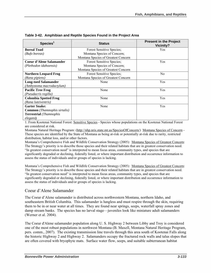
Fish, Amphibians, and Reptiles
Bonneville Power Administration 3-133
Table 3-42. Amphibian and Reptile Species Found in the Project Area
Species1 Status Present in the Project Vicinity?
Boreal Toad (Bufo boreas)
Forest Sensitive Species; Montana Species of Concern;
Montana Species of Greatest Concern
Yes
Coeur d’Alene Salamander (Plethodon idahoensis)
Forest Sensitive Species; Montana Species of Concern;
Montana Species of Greatest Concern
Yes
Northern Leopard Frog (Rana pipiens)
Forest Sensitive Species; Montana Species of Greatest Concern
No
Long-toed Salamander (Ambystoma macrodactylum)
None Yes
Pacific Tree Frog (Pseudacris regilla)
None Yes
Colombia Spotted Frog (Rana luteiventris)
None Yes
Garter Snake: Common (Thamnophis sirtalis) Terrestrial (Thamnophis elegans)
None Yes
1. From Kootenai National Forest: Sensitive Species - Species whose populations on the Kootenai National Forest are considered at risk. Montana Natural Heritage Program: (http://nhp.nris.state.mt.us/SpeciesOfConcern/) Montana Species of Concern - These species are identified by the State of Montana as being at-risk or potentially at-risk due to rarity, restricted distribution, habitat loss, and/or other factors. Montana’s Comprehensive Fish and Wildlife Conservation Strategy (2005): Montana Species of Greatest Concern: The Strategy’s priority is to describe those species and their related habitats that are in greatest conservation need. “In greatest conservation need” is interpreted to mean focus areas, community types, and species that are significantly degraded or declining, federally listed, or where important distribution and occurrence information to assess the status of individuals and/or groups of species is lacking.
Montana’s Comprehensive Fish and Wildlife Conservation Strategy (2005): Montana Species of Greatest Concern: The Strategy’s priority is to describe those species and their related habitats that are in greatest conservation need. “In greatest conservation need” is interpreted to mean focus areas, community types, and species that are significantly degraded or declining, federally listed, or where important distribution and occurrence information to assess the status of individuals and/or groups of species is lacking.
Coeur d’Alene Salamander The Coeur d’Alene salamander is distributed across northwestern Montana, northern Idaho, and southeastern British Columbia. This salamander is lungless and must respire through the skin, requiring them to be in or near water at all times. They are found near springs, seeps, waterfall spray zones and damp stream banks. The species has no larval stage—juveniles look like miniature adult salamanders (Werner et al. 2004).
The Coeur d'Alene salamander population along U. S. Highway 2 between Libby and Troy is considered one of the most robust populations in northwest Montana (B. Maxell, Montana Natural Heritage Program, pers. comm., 2007). The existing transmission line travels through this area south of Kootenai Falls along the historic Highway 2 and Highway 2. Salamanders occupy the fractured rock walls and talus slopes that are often covered with bryophyte mats. Surface water flow, seeps, and suitable subterranean habitat
3 Affected Environment and Environmental Consequences
3-134 Libby to Troy Rebuild Project Draft EIS
provide conditions for a population that likely contains hundreds of individuals (B. Maxell, pers. comm., 2007).
Coeur d'Alene salamander surveys have been conducted along U. S. Highway 2 between Libby and Troy during 1987, 1988, 1994, 2004, and 2005. Between 2 and 8 adults and/or immatures were located during each year of survey. Most of the sightings occurred in Section 23 (T31N, R32W) west of Cedar Creek. Historically, a large number of individuals from this population have been found in Sections 13 and 14 (T31N, R33W) along the historic Highway 2 and the existing transmission line just south of Kootenai Falls. Several hundred individuals were found in this area prior to the reconstruction of U. S. Highway 2 in the late 1980s.
Johnson (1999) shows Coeur d’Alene salamander presence confirmed in four of the eight planning units on the Kootenai National Forest at 13 different sites. Individuals have been confirmed in two additional planning units since 1999, and the known sites now total 36. Known populations on the Kootenai National Forest are isolated by miles of unsuitable habitat that cannot be crossed (Maxell 2000; Maxell et al. 2003).
Long-toed Salamander The long-toed salamander is the most common salamander in western Montana and is found in a variety of habitats from sagebrush to alpine. It typically breeds in ponds or lakes, usually those without fish. Adults go to the breeding ponds immediately after snowmelt and in western Montana are usually the first amphibians to breed. Following breeding, they move to adjacent uplands.
Past Libby District surveys (between 1996 and 2006) have found salamanders to be widespread across the project area. Surveys conducted within the project area in June 2006 found the salamander present in wetland adjacent to Sheep Range Road where Dad Creek crosses the road.
Pacific Tree Frog The Pacific tree frog is regularly found in the water only during the breeding period in spring. The frogs announce their presence during this time by calling frequently at night and sporadically throughout the day. Following breeding, they move into adjacent uplands and are rarely seen. In western Montana they breed in temporary ponds in lower elevation forests and intermountain valleys shortly after snowmelt. Surveys conducted in June 2006 found the tree frog in the wetland adjacent to Sheep Range Road near structure 23/8.
Columbia Spotted Frog The Columbia spotted frog is the most common frog in western Montana and is very common on the Kootenai National Forest. Spotted frogs are regularly found at water’s edge in or near forest opening and in wetlands at or near tree line. Spotted frogs breed in lakes, ponds (temporary and permanent), springs, and occasionally backwaters or beaver ponds in streams. All egg masses in a particular pond are often found in the same location at the margin of the pond. Young and adult frogs often disperse into marsh and forest habitats, but are not usually found far from open water (Reichel and Flath 1995).
June 2006 surveys did not locate any spotted frogs along the transmission corridor; however it is likely that spotted frogs use the area to some extent.
Garter Snake The common garter snake is one of the most common snakes in Montana (Reichel and Flath 1995), as well as on the Kootenai National Forest. The snakes become active early and are often seen in the spring.

Fish, Amphibians, and Reptiles
Bonneville Power Administration 3-135
After breeding they may move several miles from a den to their summer active sites. During the day and warm nights common garter snakes forage around wetlands or in the water. They often prey on amphibians, fish and snails and are a major predator on tadpoles (Werner et al. 2004). During past amphibian surveys, numerous adult snakes were found in project area streams (Bobtail and Pipe creeks) however, common garter snakes were not seen in any wetlands along the transmission line corridor during the June 2006 surveys.
The terrestrial garter snake is also common in Montana and is one of Montana’s most adaptable reptiles, being found at both the highest and lowest elevation of any snake in the state. Their habits are similar to the common garter snake as described above. The major difference between the common and terrestrial garter snake are coloration and some feeding mechanisms (Werner et al. 2004). Surveys conducted in June 2006 found the terrestrial garter snake in the wetland adjacent to Sheep Range Road near structure 23/8.
Aquatic Habitat Quartz and Bobtail creeks are Water Quality Limited Segments (WQLS) (see Section 3.1, Geology, Soils, and Water Resources). Both streams are listed as only partially supporting cold water fisheries. Probable causes for the water quality limited status of these streams include agriculture, removal of riparian vegetation and timber clearing. The water quality limited listing includes all upstream tributaries to the listed segment. Bobtail Creek has an approved Total Maximum Daily Load (TMDL) but Quartz Creek does not. Any activity conducted in a WQLS stream cannot further degrade any listed impairment.
All streams in the Kootenai River drainage including Bobtail and Quartz creeks are classified as B-1 waters (Montana 1996). Waters classified as B-1 are suitable for drinking, culinary and food processing purposes, after conventional treatment; bathing, swimming and recreation; growth and propagation of salmonid fishes and associated aquatic life, waterfowl and furbearers; and agricultural and industrial water supply.
The Inland Native Fish Strategy (INFS) amended the Kootenai NF Plan on an interim basis in 1995 (USDA Forest Service 1995). INFS was designed to provide additional protection for existing populations of native trout, outside the range of anadromous fish, on 22 National Forests in the Pacific Northwest, Northern and Intermountain Regions. Implementing this strategy was deemed necessary as these species were at risk due to habitat degradation, introduction of exotic species, loss of migratory forms and over-fishing. As part of this strategy, the Regional Foresters designated a network of priority watersheds, which are drainages that still contain excellent habitat or assemblages of native fish, provide for population objectives of stable or increasing number of fish, or are watersheds that have excellent potential for restoration. The priority watersheds on the Kootenai National Forest in the project area are Pipe Creek and Quartz Creek.
To implement this strategy, INFS also established stream, wetland and landslide-prone-area protection zones called Riparian Habitat Conservation Areas (RHCAs). RHCAs are portions of watersheds where riparian-dependent resources receive primary emphasis. INFS set standards and guidelines for managing activities that potentially affect conditions within the RHCAs. These standards and guidelines are in addition to existing standards and guidelines in the Kootenai NF Plan. As shown in Table 3-43, RHCAs are defined for four categories of stream or water body, depending on flow conditions and presence of fish, with different RHCA widths for each category. Widths of RHCA buffers are based on current scientific literature that documents them to be adequate to protect streams from non-channelized sediment inputs (sediment produced from overland flow) and provide for other riparian functions. These riparian functions include delivery of organic matter, large woody debris recruitment, and stream shading. Streams in the project area fall into categories 1, 2 and 4.

3 Affected Environment and Environmental Consequences
3-136 Libby to Troy Rebuild Project Draft EIS
Table 3-43. RHCA Categories and Standard Widths
Stream or Waterbody Category Standard Width 1. Fish bearing streams Minimum 300 feet each side of the stream 2. Perennial non fish bearing streams Minimum 150 feet each side of stream 3. Ponds, lakes, and wetlands greater than 1 acre Minimum 150 feet from maximum pool elevation 4. Intermittent and seasonally flowing streams, wetlands less than 1 acre, landslides and landslide prone areas
Minimum 50 feet from edge (except in priority watersheds, where the minimum is 100 feet)
In addition, INFS identifies riparian management objectives (RMOs) that guide management of key habitat variables for good fish habitat. The RMOs for stream channel conditions provide the criteria against which attainment or progress toward attainment of riparian goals is measured. RMOs as established by INFS standards for forested systems include bankfull width, pool frequency, large woody debris (LWD) frequency, bank stability, and width/depth ratio (Table 3-44). Actions that slow attainment of these RMOs, whether existing conditions are better or worse than objective values, are considered to be inconsistent with INFS and therefore not in compliance with the Kootenai NF Plan.
Table 3-44. Riparian Management Objective Standards
Bankfull Width (ft)
Pools per Foot LWD per foot (> BFW)
Bank Stability (%)
Width/Depth Ratio
< 10 1 per 55 1 per 250 > 80 < 10 10 to 20 1 per 94 1 per 250 > 80 < 10 20 to 25 1 per 112 1 per 250 > 80 < 10 25 to 50 1 per 203 1 per 250 > 80 < 10
3.6.2 Environmental Consequences of Action Alternatives
Effects to fish, amphibian, and reptile species can occur through direct effects to individuals or populations, and through impacts to the habitat of these species. For determinations concerning ESA-listed or Forest Sensitive species, please see Appendix F.
Proposed Action – 115-kV Single-Circuit Rebuild Direct Effects to White Sturgeon The Proposed Action would have no impact on white sturgeon or be expected to cause direct mortality of this species. Project activities would not occur in the Kootenai River, which is the only known habitat of this species in the project area. The potential for any direct effect to this species is further reduced by the extreme rarity of the species in the project area.
Direct Effects to Bull Trout The Proposed Action would have a low to no impact on bull trout. Bull trout in the project area are mainly migratory, and there are no known bull trout spawning areas in the project area. In addition, the Proposed Action would only remove a small and localized amount of large trees in the RHCAs for Pipe and Quartz creeks and the Kootenai River where bull trout are present. Although bull trout are not known to use Bobtail Creek, an RHCA would be implemented to prevent potential sediment generated during use of the tensioning site at 18/11 from flowing into Bobtail Creek which could eventually reach the Kootenai River. There would be a short-term indirect impact from removal of large trees in the RHCAs if sediment generated during construction enters the streams. Tree removal would be mitigated by leaving the trees

Fish, Amphibians, and Reptiles
Bonneville Power Administration 3-137
as large woody debris and leaving low growing vegetation. Additionally, trees would be felled without the use of heavy equipment to prevent short-term disturbance of soils or potential fuel spills in or near the stream channel.
No new structures would be constructed within the RHCAs of Pipe, Bobtail, or Quartz creeks. Structures within the Kootenai River RHCA would be replaced in the same location in most cases. Two structures (22/4 and 23/8) would be relocated out of wetland areas present within the transmission line corridor.
There would be no direct impact to bull trout present in Pipe and Quartz creeks from road construction because no new roads would be constructed in those RHCAs. Construction of 0.6 miles of new road within the Kootenai River RHCA would not impact bull trout or their habitat within the Kootenai River because the road would not be located near a tributary to the river and best management practices would be implemented to prevent movement of construction generated sediment during a rain event.
Direct Effects to Westslope Cutthroat Trout, Redband Rainbow Trout, Slimy Sculpin, Brook Trout, and Hybrid Trout The Proposed Action would have a low to no impact on westslope cutthroat trout, redband rainbow trout, slimy sculpin, brook trout, and hybrid trout. Under the Proposed Action, only a small and localized amount of large trees would be removed in the RHCAs for Pipe, Bobtail, Quartz, and China creeks and the Kootenai River which would cause short-term indirect impacts if sediment generated during construction enters the streams. Removal of large trees in the RHCAs would be mitigated by leaving them as large woody debris and leaving low growing vegetation. Trees would be felled without the use of heavy equipment to prevent disturbance of soils or potential fuel spills in or near the stream channel.
No new roads would be constructed in the RHCAs for Pipe, Bobtail and Quartz creeks. Construction of a bridge over China Creek would occur within the RHCA of this stream but would not impact redband rainbow trout. Bridge construction would occur above the ordinary high water mark of the stream and implementation of best management practices as discussed Section 3.1.3 Mitigation would prevent sediment movement into the stream channel in the event rain occurs prior to project completion. Construction of the 0.6 miles of new road within the Kootenai River RHCA also would not impact trout or sculpin present in the Kootenai River as discussed above for bull trout.
Direct Effects to Boreal Toad Under the Proposed Action, corridor clearing within the wetland buffer or riparian areas could displace boreal toads or disturb their habitat resulting in a low impact. Although suitable habitat for boreal toads does exist within the project area, structure placement or road construction along Sheep Range near structure 22/4 and 23/8 or near historic Highway 2 would not occur within wetlands or riparian wetland areas.
Direct Effects to Coeur d’Alene Salamander Under the Proposed Action, there is a risk that individual Coeur d’Alene salamanders could be displaced from their habitat or killed where the existing corridor runs parallel to the historic Highway 2 resulting in a moderate to high impact to individuals. However, the overall population numbers would not be affected. Use of mitigation as described in Section 3.6.3 (relocation of individuals) would reduce the impact to low.

3 Affected Environment and Environmental Consequences
3-138 Libby to Troy Rebuild Project Draft EIS
Direct Effects to Other Species The Proposed Action would a low to no impact on other common fish, amphibian or reptile species present in the project area. Localized removal of large trees in the RHCAs for project area streams would be mitigated by leaving the trees as large woody debris and leaving low growing vegetation. Trees would be felled without the use of heavy equipment.
No new roads would be constructed in the RHCAs for Pipe, Bobtail and Quartz creeks. Construction of the 0.6 miles of new road within the Kootenai River RHCA also would have no impact on common fish species present in the Kootenai River as discussed above for bull trout. New structures and roads would not be constructed in wetlands so there would be no impact to common amphibians and reptiles found within the project area such as the long-toed salamander, Pacific tree frog, Columbia spotted frog or garter snakes.
Effects to Aquatic Habitat Effects to aquatic habitat from timber clearing and road construction for the Proposed Action would be short-term and low and is not expected to affect entire fish, amphibian or reptile populations or result in long-term trends in species abundance. Timber clearing can impact fish, amphibians and their habitat by increasing peak flow. Excessive peak flows can destabilize the stream channel causing degradation of aquatic habitat by decreasing habitat diversity (loss of pools, cover, stable substrates) and increasing in-channel sediment production. Channel instability occurs when the scouring process leads to degradation (downcutting), or excessive sediment deposition results in aggradation (rising of the stream bed) (Rosgen 1996).
Increased sediment production is generally associated with ground-based tree harvest systems and particularly road construction. Sediment decreases habitat diversity, degrades spawning and rearing habitat and consequently fish reproduction and survival. It also reduces aquatic insect production. Fine sediment can greatly reduce the quality and productivity of winter and summer rearing habitats, and as sediment levels reach 30 percent or more, there is a corresponding decrease in the survival of fish eggs to emergence (Shepard et al. 1984). Fine sediment may have the greatest impact on winter rearing habitat for juvenile salmonids because they can cap or fill interstitial spaces of streambed cobbles. Fine sediment has also been shown to cause alterations in macro-invertebrate abundance and diversity.
Short-term increases of small amounts of sediment are expected from construction activities. This amount of sedimentation would be of such small scale (when compared with the large size of the drainages) that any effect would be impossible to measure in project area streams and riparian areas. As described in Section 3.1.2, the tensioning site at structure 18/11 has the greatest potential for generating sediment that could adversely affect Bobtail Creek. Because Bobtail Creek is a listed Water Quality Limited Stream, use of best management practices to prevent sediment introduction is required by the approved Total Maximum Daily Load (sediment) for the creek (see Mitigation in Section 3.1.2). For activities in B-1 waters such as Bobtail Creek, the Proposed Action would not exceed applicable standards set forth by the State of Montana for water quality.
Forest roads can cause serious degradation of salmonid habitats in streams (Furniss et al. 1991). Roads directly affect natural sediment and hydrologic regimes by altering streamflow, sediment loading, sediment transport and deposition, channel morphology, channel stability, substrate composition and water quality within a watershed (Lee et al. 1997). Roads can interrupt hill-slope drainage patterns and alter the timing and magnitude of peak flows and change base stream discharge and sub-surface flows. Poor road location or concentration of surface and sub-surface water by cross-slope roads can lead to road-related mass soil movements. Damaging direct effects to fish habitat occur if roads are located in RHCAs and especially if they cross streams where they can intercept water and sediment and directly
Fish, Amphibians, and Reptiles
Bonneville Power Administration 3-139
route it to streams. Approximately 0.6 miles of road would be constructed within the RHCA of the Kootenai River for the Proposed Action; however the new road would be located on the north side of Sheep Range Road away from the Kootenai River and not near any streams. Use of mitigation (see Section 3.1.3 Soils, Geology, and Water Resources/Mitigation) would prevent potential sediment produced by road construction to flow into the Kootenai River. No new roads would be constructed in the RHCAs for Pipe, Quartz and Bobtail creeks for the Proposed Action. The surface flow and sediment that is channeled to streams by existing access roads would be reduced by rocking the road surfaces and by other using best management practices as described in Section 3.1.3, Soils, Geology, and Water Resources/Mitigation.
Although timber clearing and road construction would take place in project area watersheds, the Cumulative Peak Flow Increase (PFI) from these additional Equivalent clearcut areas (ECAs) would be almost un-measurable in project area streams (Table 3-3 in Section 3.1.2). No long-term in-channel sediment production is expected from the Proposed Action.
In addition, because increases in water yield are not expected to cause channel degradation, there should be no measurable effect on aquatic habitat. RHCAs would protect aquatic from non-channelized sediment inputs, maintain large woody debris recruitment (for the most part) and ensure nutrient delivery and storage (see Section 3.6.3 Mitigation). A review associated with INFS (USDA Forest Service 1995) concluded that non-channelized sediment flow rarely travels more than 300 feet and that 200 - 300-foot riparian buffers are generally effective at protecting streams from sediment from non-channelized flow. Large trees within RHCAs along the existing corridor could be removed although brush species would be left partially mitigating effects of tree removal. This is allowable under INFS. Large-diameter trees within the RHCA that would be removed for the Proposed Action would be left on site under the line, which would leave recruitable large woody debris within the RHCA of project area streams. No long-term changes in channel morphology are expected from the Proposed Action.
The relatively small corridor for the Proposed Action (1.0 acres of clearing in the riparian area of fish bearing streams) would be negligible for the attainment of RMOs. Temperature, the recruitment of large woody debris, and nutrient delivery from riparian areas would not be adversely affected by the Proposed Action. The implementation of INFS RHCAs and mitigation described below would ensure that these riparian characteristics are protected within the project area. Typically, there is a 3- to 4-year increase in nitrogen and phosphorus in streams draining a newly harvested area. This brief increase in the two nutrients critical to stream productivity results from the breakdown of logging slash and the flushing of some soil nutrients normally taken up by trees. These short-term indirect water quality effects do not generally extend very far downstream because instream sediments settle to the bottom and/or are absorbed by plants and animals. However, these nutrients generally are in short supply in the project area, and the potentially affected waters downstream would slightly increase aquatic productivity for a short time, a positive impact.
Revegetation of all disturbed areas would occur although short-term increases in sediment from the Proposed Action are possible because it might rain before vegetation is established (see Section 3.1.3, Soils, Geology, and Water Resources/Mitigation).
Actions that degrade fish habitat can limit the number of adult fish available for recreational fishing. The Proposed Action would not decrease access to fishing in any areas. There are no other known potential effects to recreational fishing from the Proposed Action.

3 Affected Environment and Environmental Consequences
3-140 Libby to Troy Rebuild Project Draft EIS
Alternative 1 – 230-kV Double-Circuit Rebuild Direct Effects to White Sturgeon Alternative 1 would no impact on white sturgeon or be expected to cause direct mortality of this species. Similar to the Proposed Action, Alternative 1 project activities would not occur in the Kootenai River, which is the only known habitat of this species in the project area.
Direct Effects to Bull Trout Alternative 1 would have a low to no impact on bull trout or be expected to cause direct mortality of this species. Similar to the Proposed Action, Alternative 1 would remove a small and localized amount of large trees in the RHCAs for Pipe and Quartz creeks and the Kootenai River where bull trout are present. An RHCA also would be implemented for Bobtail Creek to prevent potential sediment generated during use of the tensioning site at 18/11 for Alternative 1. Similar to the Proposed Action, removal of large trees in the RHCAs for Alternative 1 would be mitigated by leaving the trees as large woody debris and leaving low growing vegetation within the corridor and RHCA. Trees would be felled without the use of heavy equipment to prevent disturbance of soils or potential fuel spills in or near the stream channel. No new structures would be constructed for Alternative 1 within the RHCAs of Pipe, Bobtail, or Quartz creeks and structures within the Kootenai River RHCA would be replaced in the same location in most cases. Similar to the Proposed Action, structures 22/4 and 23/8 would be relocated out of wetland areas.
Impacts from road construction would be similar as those under the Proposed Action. No new roads would be constructed in the RHCAs for Pipe and Quartz creeks and construction of 0.6 miles of new road within the Kootenai River RHCA would not impact bull trout or their habitat.
Direct Effects to Westslope Cutthroat Trout, Redband Rainbow Trout, Slimy Sculpin, Brook Trout, and Hybrid Trout Alternative 1 would have a low to no impact westslope cutthroat trout, redband rainbow trout, slimy sculpin, brook trout, and hybrid trout. Similar to the Proposed Action, a small and localized amount of large trees would be removed in the RHCAs for Pipe, Bobtail, Quartz, and China creeks and the Kootenai River.
Impacts from road construction would be similar to the Proposed Action. Construction of a bridge over China Creek also would be needed for Alternative 1 but would not impact redband rainbow trout as described for the Proposed Action.
Direct Effects to Boreal Toad Similar to the Proposed Action, corridor clearing within the wetland buffer or riparian areas for Alternative 1 could displace boreal toads or disturb their habitat. Structure placement and road construction would not occur in wetlands or riparian wetland areas under Alternative 1
Direct Effects to Coeur d’Alene Salamander Similar to the Proposed Action, construction of Alternative 1 poses a risk that individual Coeur d’Alene salamanders could be displaced from their habitat or killed near the historic Highway 2 resulting in a moderate-to-high impact. Use of mitigation (Section 3.6.3 Mitigation) however, for Alternative 1 would reduce the impact to low.

Fish, Amphibians, and Reptiles
Bonneville Power Administration 3-141
Direct Effects to Other Species Similar to the Proposed Action, no new roads would be constructed in the RHCAs for Pipe, Bobtail and Quartz creeks for Alternative 1. Construction of 0.6 miles of new road within the Kootenai River RHCA also would have a low-to-no impact on common fish present in the Kootenai River as discussed above for bull trout and other fish species. New structures and roads for Alternative 1 would not be constructed in wetlands so there would be no impact to common amphibians and reptiles found within project area wetlands such as the long-toed salamander, Pacific tree frog, Columbia spotted frog or garter snakes. Localized removal of large trees in project area stream RHCAs would be mitigated by leaving the trees as large woody debris and leaving low growing vegetation. Trees would be felled without the use of heavy equipment.
Effects to Aquatic Habitat Effects to aquatic habitat from timber clearing for Alternative 1 would be slightly greater than those under the Proposed Action. The existing 80 foot transmission line corridor would be cleared to 100 feet in width so more trees within aquatic habitat would be removed with the potential for greater amounts of sediment delivered to streams. Even with additional clearing however, impacts from Alternative 1 would be short term and low and are not expected to affect entire fish, amphibian, or reptile populations or result in long-term downward trends in species abundance. Similar to the Proposed Action, the tensioning site at structure 18/11 has the greatest potential for generating sediment that could adversely affect Bobtail Creek. Best management practices as described in Section 3.1.3 Mitigation would be used for Alternative 1 to prevent sediment introduction to Bobtail Creek (a listed Water Quality Limited Stream). Similar to the Proposed Action, Alternative 1 construction activities in B-1 waters such as Bobtail Creek would not exceed applicable standards set forth by the State of Montana for water quality.
Similar to the Proposed Action, Alternative 1 would not increase the Cumulative Peak Flow Increase (PFI) from additional Equivalent clearcut areas (ECAs). No longterm in-channel sediment production is expected from Alternative 1. All disturbed areas would be seeded. Nonetheless, short term increases in sediment from Alternative 1 are possible because it might rain before the vegetation in disturbed areas is established.
Similar to the Proposed Action, large trees within RHCAs along the corridor would be removed although brush species would be left partially mitigating effects of tree removal. Large-diameter trees also would be left on site under the line for Alternative 1. No long-term changes in channel morphology are expected from Alternative 1.
Clearing within riparian area of project fish bearing streams (1.4 acres) would not prevent attainment of the RMOs for Alternative 1. Similar to the Proposed Action, temperature, the recruitment of large woody debris, and nutrient delivery from riparian areas would not be adversely affected by Alternative 1. Implementation of INFS RHCAs and mitigation would occur as described in Section 3.6.3 Mitigation.
Effects from road construction for Alternative 1 would be similar to the Proposed Action because road miles and locations are the same. As with the Proposed Action, 0.6 miles of road would be constructed within the RHCA of the Kootenai River. No new roads would be constructed in the RHCAs for Pipe, Quartz and Bobtail creeks for Alternative 1. Use of best management practices (see Section 3.1.2, Mitigation) would occur similar to the Proposed Action.
There are no known potential effects to recreational fishing from Alternative 1.

3 Affected Environment and Environmental Consequences
3-142 Libby to Troy Rebuild Project Draft EIS
Short Realignment Options Pipe Creek Realignment This realignment option would reroute the existing line north of its present location in both the Pipe and Bobtail creek watersheds. It is expected that about 2.8 acres (1.4 acres in Pipe Creek and 1.4 acres in Bobtail Creek) of riparian vegetation would be removed under this option at 230 kV. Less clearing would occur at the 115-kV voltage. No new roads would be built within the RHCA of either stream for this realignment. As mitigation, large diameter trees that would be felled would be left on site. Also, low growing brush species would be left uncut within the RHCA. These two mitigation measures and the relatively small corridor cut through the RHCA would not prevent the attainment of RMOs. Any change in existing stream conditions would not be measurable and would have no impact on fish, amphibian, or reptile resources.
Quartz Creek Realignment The Quartz Creek realignment would move the existing line north. This line would cross Quartz Creek upstream of the current crossing and would span private property. The realignment would place towers on either side of the drainage and would span riparian vegetation. Therefore, this realignment would have no effect on fish, amphibian, or reptile resources.
Kootenai River Crossing Realignment The realignment would move the existing crossing upstream or east of the existing crossing location. The line would cross the Kootenai River east of China Creek and would be located near the confluence of Williams Creek on the south shore. The new location would require clearing of some riparian vegetation (about 0.8 acres at 230 kV) on both sides of the river but would allow vegetative recovery of the existing corridor that crosses China Creek. Clearing for the new crossing regardless of voltage would have no impact on fisheries and RMOs in the Kootenai River because of the river’s width in this area.
This realignment option regardless of voltage would disturb the Coeur d’Alene salamander, because it requires new structures to be installed on talus slopes covered in bryophytes; the impact would be moderate to high to individuals. Mitigation measures as described under Section 3.6.3, Mitigation below would help reduce or eliminate direct mortality associated with surface disturbance in salamander habitat.
3.6.3 Mitigation Mitigation measures listed in Section 3.1.3 Geology, Soils, and Water Resources, would minimize impacts to fish and amphibians. Additionally, the following mitigation measures would minimize or avoid impacts.
• Implement any mitigation measures for white sturgeon and bull trout that may be required by the USFWS through Section 7 consultations for the Proposed Action. Measures could include provision of buffer zones to avoid sediment generated during construction from entering project area streams and leaving woody debris in certain areas.
• Implement RHCAs (buffer zones) around all project area rivers, streams and wetlands For the following fish bearing streams, 300 feet on each side of the stream would be buffered: Kootenai River, Pipe Creek, Bobtail Creek, Quartz Creek, and China Creek.
• Remove trees within the RHCAs without the use of heavy equipment.
• Leave low growing brush species uncut with the RHCAs.

Fish, Amphibians, and Reptiles
Bonneville Power Administration 3-143
• Leave large-diameter trees felled within corridor RHCAs. This would leave recruitable (trees that ar ready to fall into the stream) large woody debris within the RHCAs of project area streams.
• Conduct surveys for presence of Coeur d'Alene salamanders during wet weather in May or June during the year when transmission line construction would occur. The areas which have a high probability of occurrence are located on the south side of the Kootenai River in Section 18 (T31N, R32W) for the Kootenai River Crossing Realignment and in Sections 13 and 14 (T31N, R33W) for the Kootenai River Crossing Realignment and existing corridor. High probability areas would be searched in the immediate area planned for disturbance, such as structure locations. The outer boundary of the disturbance zone around each structure would be identified and marked on the ground. Salamanders present in the area would be collected and moved at least 100 feet to similar habitat beyond the potential disturbance zone.
3.6.4 Environmental Consequences of the No Action Alternative
Fish This alternative would leave the existing route and structures in place. The aging line would require more frequent maintenance as fittings and poles corrode and rot. Clearings under the line would continue to be maintained as would roads and structure foundations. As the line ages, more emergency repairs would be required, which could compromise ESA-listed and other fish and wildlife protection measures, such as timing restrictions for activities in habitat occupied by a listed threatened and/or endangered species. The likelihood of fire starts from failed conductor fittings would increase substantially, which could create the possibility of large wildfires. Fires and suppression efforts could introduce sediment into fish bearing streams or increase water temperature, both of which can have lasting effects on a stream’s health and its carrying capacity for fish. However, the effects listed above would not decrease the viability of fish populations within the project area because no known spawning occurs within the project area; the impact would be low.
Amphibians and Reptiles No Action would have a low impact on Coeur d'Alene salamanders. Current levels of disturbance such as the use of the historic Highway 2 to access the line by foot due to ongoing maintenance activities would continue, but this alternative would maintain current conditions for Coeur d'Alene salamander habitat crossed by the transmission line corridor. The impact on boreal toads would also be low unless disturbance occurs within wetlands or riparian habitats from emergency or other access to structures located in wetlands.
The No Action Alternative is consistent with INFS because existing conditions would remain stable. Although maintenance activity occasionally might require removal of riparian vegetation within RHCAs of fish bearing streams, including two priority watersheds, the small localized impacts would be so small as to be un-measurable. The existing line would not retard the attainment of RMOs and therefore is consistent with the Kootenai NF Plan.

3 Affected Environment and Environmental Consequences
3-144 Libby to Troy Rebuild Project Draft EIS
3.7 Visual Resources 3.7.1 Affected Environment Visual Setting The project vicinity is dominated by natural features that range from the Kootenai River corridor with its massive rock outcrops and forested mountain environments to valley bottoms. Open or partially forested areas are found along the gently sloping Kootenai River valley edges. The Kootenai Falls area located west of Libby is a destination for tourists because of its turbulent and rocky scenery. The Purcell and Cabinet Mountains with elevations of 6,000 to 7,500 feet are visible from many locations in the project vicinity.
The existing transmission line crosses primarily through forest, residential neighborhoods, and recently harvested forest. Existing vegetation adjacent to roads and the topography of the project area combine to screen views of the transmission line in much of the project area.
Near the north side of Libby, the transmission line leaves Libby Substation and heads northwest through an area that has been extensively modified by private landowners and local governments for gravel pits and associated development. Single-wood-pole wish-bone structures (Figure 2-2 in Chapter 2) are visible along the west side of Pipe Creek Road until the line turns west and crosses onto Kootenai National Forest land. The setting in this area is more urban than other areas along the transmission line, containing subdivisions, roads, and other features associated with development.
From Pipe Creek Road, the existing transmission line crosses onto National Forest land and is screened by trees from viewpoints along Kootenai River Road for approximately 2.5 miles until it reaches the Pipe Creek residential area. Through the residential area, the line crosses to the south side of Kootenai River Road for about 500 feet and back again to the north side, where it parallels the road for about a half mile before turning north and then west up Bobtail Ridge. A distribution line is attached to the lower section of the transmission structures in this area.
The transmission line corridor on Bobtail Ridge is visible from Kootenai River Road and to residents on both the east and west slopes of Bobtail Ridge. From the west toeslope of Bobtail Ridge, the line is screened by trees from Kootenai River Road and residents until it reaches the Bighorn Terrace subdivision. At this point, the structures and conductors are visible along the north side of the housing development.
The first transmission structure west of the Bighorn Terrace subdivision is visible atop Black Eagle Rock. West of this structure, the line is partially screened from views along Sheep Range Road west of the gate at the end of Kootenai River Road, along Highway 2, and from the Kootenai Falls swinging bridge or overlook. A portion of the project in transmission line corridor mile 23 is visible from Highway 2 as it crosses a meadow and wetland on the north side of the Kootenai River. Much of the line on the north side of the river is not visible from Highway 2 because trees along both sides of the Kootenai River screen the view.
The existing Kootenai River transmission line crossing is not visible to travelers driving east or west on Highway 2, although it is visible from the eastern viewpoint of Kootenai Falls. As the line crosses the
Visual Resources
Bonneville Power Administration 3-145
highway at the river crossing, there is a brief view of cleared right-of-way to the north and south but there is no scenic viewpoint off the highway in this location. After the line reaches the historic Highway 2, it is not visible to west-bound travelers on the main highway or from Kootenai Falls. However, the line is visible to east-bound travelers on Highway 2 above a large highway road cut. Further west toward Troy Substation, the grade of the landscape flattens. The flatter grades, combined with vegetation, screen the line from Highway 2 views, although the line is visible from the residential area west of Highway 56 (Bull Lake Road). An H-frame wood pole structure is visible from the north end of the Bull Lake Road as the line crosses it heading west. Troy Substation is visible directly adjacent to Highway 2 about 2 miles east of Troy.
Wildfires have been one of the primary factors that has shaped and altered the visual landscape in the project area throughout history. Records indicate that in the late 1800s the area experienced several major large-scale wildfires. In addition, within the last century, much of the area burned in a series of large stand-replacing wildfires. These fires have been primarily responsible for creating vegetative patterns across the landscape that typically are large-scale, vary in shape, and tend to follow drainage patterns and slopes. National Forest records show that major fires tend to occur in this area every 15 to 30 years. Over time, these areas have again become densely forested with larch, lodgepole pine, Douglas fir and other species.
In addition to fire and the existing transmission line, major alterations in the visual landscape of the project vicinity have resulted from timber harvest, gravel pits, and housing developments.
Visual Quality Objectives The Kootenai National Forest Plan (Forest Plan) delineated management areas (USDA Forest Service 1987). Like a zoning map, management areas identify desired future conditions and appropriate uses for particular areas on the Kootenai National Forest. For each management area, the Forest Plan also established visual quality objectives (VQOs) based on methods described in The Visual Management System-Landscape Management Handbook Number 462 (USDA Forest Service 1974). These objectives identify standards of visual quality that proposed activities in those areas should meet. Figure 3-11 shows the VQOs for management areas in the vicinity of the project. Table 3-45 shows VQOs established in the Forest Plan.
The existing transmission line crosses six management areas with corresponding VQOs. Table 3-46 shows VQOs established in the Forest Plan for each management area crossed by the existing transmission line. About 66 acres of forest management areas with VQOs are crossed by the existing transmission line. The Forest does not designate non-Forest lands with VQOs, so private and other lands crossed by the existing transmission line are not designated with VQOs.

3 Affected Environment and Environmental Consequences
3-146 Libby to Troy Rebuild Project Draft EIS
Table 3-45. Visual Quality Objectives for Kootenai National Forest Management Areas
VQO Description
Retention (R) Management activities are not visually evident. Activities may be present but must repeat form, line, color, texture and pattern common to the character so completely that they are not evident.
Partial Retention (PR) Activities remain visually subordinate. Activities may repeat form, line, color and texture and remain visually subordinate to the characteristic landscape.
Modification (M)
Management activities may visually dominate the characteristic landscape. However, activities of vegetation and landform alteration must borrow from naturally established line, form, color and texture so completely and at such scale that characteristics are those of natural occurrences within the surrounding area.
Maximum Modification (MM)
Vegetation management activities and landform alterations may dominate the characteristic landscape. However, when viewed in the background the activities must be those of natural occurrence.
Table 3-46. Kootenai National Forest Management Areas Crossed by the Existing Transmission Line
Management Areas Acres VQO (R, PR, M, MM) 10 - Big game winter habitat-high elevation 6 PR, M, MM 11 - Big game winter habitat-low elevation 35 PR, M, MM 13 - Old Growth 1 PR 17 - Viewing areas 12 PR 19 - Over steepened lands 2 PR, M, MM 21 - Research Natural Area 10 R
3.7.2 Environmental Consequences of Action Alternatives
Construction, operation, and maintenance of transmission facilities can affect visual resources for both the long and the short term. Any part of the facility can contribute to visual impacts: structures, conductors, insulators, or aeronautical safety markings. In addition, right-of-way clearing, access roads, clearing at structure sites, and temporary construction disturbance such as pulling and tensioning sites for the conductors can cause long- or short-term impacts.
For portions of the corridor on private, state, county, or city lands, the evaluation of visual impacts takes into account the following:
• Relative compatibility with the surrounding landscape. Facilities can be visible from potential viewpoints such as private residences, highways and roads, and commercial areas. Locating facilities in areas where soils are highly erodible or have poor potential for revegetation contributes to visual impact. Distance from sensitive viewpoints tends to decrease visibility and visual impact of management activities. Different landforms and vegetation influence visual impact; some are more able to screen transmission line features. In a forested setting, light-colored structures stand out and appear closer, while dark colors tend to fade into the background and appear further away.

Visual Resources
Bonneville Power Administration 3-147
• Sensitivity of viewers to a transmission line in the landscape. For example, residents normally are sensitive to changes in their surrounding environments and views, as are recreational users of natural and forested areas. However, highway travelers might not be as sensitive because the lines are in view for only a short time and travelers generally are headed to other destinations. On the other hand, travelers on a scenic highway might be sensitive to an industrial-type facility like a transmission line within their view for extended periods.
For portions of the corridor on Kootenai National Forest lands, the evaluation of visual impacts considers whether the changes made by the action alternatives and realignments would meet the VQOs. Along the transmission line corridor, seven key viewpoints were chosen based on the number and sensitivity of viewers and on opportunities for viewing management areas from sensitive locations on the Kootenai National Forest. The analysis of impacts on the forest focuses on whether the proposed transmission project meets the VQOs at these seven viewpoints. Table 3-47 lists the viewpoints and their corresponding VQOs; Figure 3-11 shows their location, and Figures 3-12 through 3-18 show visual simulations in these areas.
Table 3-47. Key Viewpoints in the Proposed Project Area
View-point # Locations Alternative or Realignment Option Simulated VQO
1 View to the west from the turnaround at the west end of Kootenai River Road
Proposed Action and Alternative 1 PR
2 From Highway 2, view to the northwest across the Kootenai River
Proposed Action and Alternative 1 PR
3 View to the east from Highway 2; the existing transmission line is on the ridge above the highway
Proposed Action and Alternative 1 PR
4 View to the south near the intersection of Highway 2 and Highway 56 (Bull Lake Road)
Alternative 1 M
5 View to the east from the turnaround at the west end of Kootenai River Road of the Quartz Creek Realignment
Quartz Creek Realignment PR
6 From Highway 2, looking east towards the west end of the Quartz Creek Realignment
Quartz Creek Realignment PR
7
From the south side of Highway 2 just west of Williams Creek, looking west to the area of the Kootenai River Crossing Realignment
Kootenai River Crossing Realignment PR

3 Affected Environment and Environmental Consequences
3-148 Libby to Troy Rebuild Project Draft EIS
Proposed Action - 115-kV Single-Circuit Rebuild Visual Impacts The impact to visual resources from the Proposed Action would be low near Libby Substation and along Pipe Creek Road where existing single-wood-pole wishbone structures would be replaced with slightly taller single-wood-pole structures with stand-off insulators (see Figure 2-2 in Chapter 2). Although the line would be visible along Pipe Creek Road, it would not be incompatible with the surrounding landscape because the area near Libby Substation has been previously disturbed by Pipe Creek Road and a quarry. Views of the line in this area would be of short-duration to travelers along Pipe Creek Road, thus the viewing sensitivity would be low. Where the line crosses onto National Forest land in corridor mile 15 and is screened by trees, new H-frame wood-pole structures would replace single-wood-pole wishbone structures. In portions of corridor miles 16 and 17, the existing is corridor 60-foot wide but would be cleared to 80 feet; however, the viewing sensitivity in this area would be low because the line would remain screened from Kootenai River Road views and there are no residences along this portion line.
The rebuilt line would look much the same as the existing line as it travels through the Pipe and Bobtail Creek residential area in corridor miles 17 and 18. Only one change to the existing alignment would be made: the line would be straightened just west of Central Road (structures 17/16 and 17/17) for approximately 500 feet and placed along the north side of Kootenai River Road with slightly taller single-wood-pole structures with stand-off insulators. The existing distribution line would remain in a lower position on the new structures. Clearing of trees for new and additional right-of-way could adversely affect residents along Kootenai River Road between Pipe and Bobtail Creeks by opening views of the new structures and conductors. Residents in this area would be sensitive viewers and impacts would moderate-to-high. Residents in the in the Pipe Creek area would also be sensitive to the movement of construction equipment moving between Libby Substation and the end of Kootenai River Road. This is the only route to access the transmission corridor west of the end of Kootenai River Road.
Few changes would occur as the line travels over Bobtail Ridge because the corridor width would remain at 80 feet, and the existing wood H-frame structures would be replaced in the same locations with the same structure types. A limited number of danger trees would be cleared within this area. The line, currently visible as it crosses over Bobtail Ridge, is incompatible with the surrounding forest landscape; however views of the ridge would be of short-duration for travelers along Kootenai River Road and in the background for residents in the Pipe Creek area; thus the impact would be low.
From the west side of Bobtail Ridge to Quartz Creek, the rebuilt line would continue to be screened by vegetation even with removal of a large number of danger trees due to poor stand conditions; the visual impact in this area also would be low.
In the Bighorn Terrace subdivision west of Quartz Creek Road and along Kootenai River Road, the rebuilt line would be visible to residents. The existing corridor would remain 80 feet wide and new structures would be placed at existing sites; however removal of trees that currently screen portions of the existing line from residences would open views of the line and increase incompatibility within the residential area. Residents in the Bighorn Terrace would be sensitive viewers and impacts would be long-term and high. Road construction and improvement would remove low growing vegetative screening in this area, further opening up views of the corridor. Views of construction equipment in backyards and front yards on the transmission line corridor would increase the sensitivity of residents in this area also resulting in a high although short-term impact. Residents in the Bighorn Terrace subdivision and those living along Kootenai River Road also would be sensitive to the movement of construction equipment between Libby Substation and the end of Kootenai River Road resulting in a high, short-term impact.

Visual Resources
Bonneville Power Administration 3-149
At the west end of Kootenai River Road, the existing structure located on Black Eagle Rock would be replaced with a steel 3-pole 115-kV structure in the same location. The viewing sensitivity during construction would be high because the existing line is incompatible with the surrounding forest and river landscape; however impacts following construction would be low-to-moderate because the new structure, although steel, would be consistent with the existing conditions. The steel structure would be painted a dark gray in an effort to blend with the surrounding environment as much as possible.
Impacts to viewers as the line heads west from Black Eagle Rock to the last structure before the line crosses the Kootenai River on the north side of the river would be high. This area is a natural area where viewers would be sensitive to changes in vegetation and access. Although, most of the new structures would be screened from viewers on the Kootenai River, Sheep Range Road, and Highway 2, road improvements to Sheep Range Road would result in a long-term, high impact to visual resources.
The rebuilt line would not be visible from the Kootenai Falls swinging bridge or overlook in this area. However, danger tree removal combined with topographically low areas would allow views of some of the new taller structures. Painting the new steel structures a dark gray would make any unscreened structures less visible. Similar to the existing line, the new steel structures would be visible from Highway 2 in corridor mile 23 as it crosses a meadow and wetland on the north side of the Kootenai River; viewer sensitivity would be low because views would be of short-duration across the river as travelers move along Highway 2.
The visual impact would be low where the corridor crosses Highway 2 and heads west along the historic Highway 2 to Troy Substation. In this area, the new structures would continue to be screened by vegetation from viewers traveling west on Highway 2 through the Kootenai River corridor. Impacts to motorists would be low because view of the line and new structures would be of short-duration. Although wood pole structures along the historic highway would be replaced with steel structures, the new steel structures would be placed in the same locations and painted dark gray to help blend with the background as seen by viewers traveling east on Highway 2. Viewing sensitivity would be low because the line is located above a large road cut which would distract a motorist’s view of the line.
In the residential area west of Bull Lake Road and south of Highway 2, the visual impact would be low to moderate. Although residents would be able to see the line, they might not be as sensitive because it would look the same as the existing line resulting in a low impact to viewers. Existing wood pole structures would be replaced with new slightly taller wood pole structures in approximately the same locations. During construction however, residents would be more sensitive to views of construction equipment in their backyards and movement of equipment along nearby roads resulting in moderate impact to viewers.
Short-term construction activities within the corridor would introduce new shapes, lines, and elements that are incompatible with the visual environment. Access roads would be built or improved as necessary, and staging areas would be designated along the corridor. Materials stockpiled within staging areas such as structures, bolts, conductor reels, insulators, and culverts would add rectangular bulk and linear complexity to the existing visual landscape. The color and texture of these materials may be reflective and different compared to the backdrop of the existing landscape. Areas along the corridor that would be the most sensitive to construction activity are those near residential, recreational or scenic uses. These areas include the Pipe and Bobtail creek area; the Bighorn Terrace subdivision; the recreation area at the end of Kootenai River Road; areas along Sheep Range Road where construction activities may be visible; along Highway 2 during construction of the river and highway crossings; and within the residential area near Bull Lake Road. Viewers in these areas would be most sensitive during construction. Once the line is constructed, all unused material would be disposed of or recycled, equipment removed, and the landscape restored to pre-construction condition. Overall, the level of impact during construction would be

3 Affected Environment and Environmental Consequences
3-150 Libby to Troy Rebuild Project Draft EIS
moderate to high because access to the line parallels frequently used roads such as Kootenai River Road and Highway 2, and because many people live along the line. The sensitivity of viewers would be high because changes, whether temporary or permanent, would impact how residents and travelers view the areas near homes or along roads.
Consistency with Visual Quality Objectives The Proposed Action would be visible from viewpoints 1, 2 and 3, which lie within areas where the VQO is partial retention. Visual simulations of the proposed transmission line at these viewpoints, in comparison to existing views at these viewpoints, are provided in Figures 3-12, 3-13, and 3-14.
VQOs are developed for broad landscapes. Within these landscapes there may be pre-existing features or landscape modifications, such as power lines or other facilities, that are inconsistent with the assigned VQO. Typically, power lines are maintained as long term effects on the landscape. Although the existing transmission line is in a partial retention area for viewpoints 1, 2 and 3, the line existed before the Forest Plan was developed. For this reason and because many of the proposed structures would be similar to existing structures, the VQO of partial retention would continue to be met at viewpoints 1, 2 and 3. Several mitigation measures would be applied to reduce visual impacts of the Proposed Action (see Section 3.7.3 Mitigation). For these reasons, visual impacts at viewpoints 1, 2 and 3 under the Proposed Action would be considered low.
The Proposed Action also would be visible from viewpoint 4, which lies in an area where the VQO is modification. The Proposed Action would look almost identical to the existing view from viewpoint 4 that is shown in Figure 3-15. Because there would be very little alteration to views from viewpoint 4 under the Proposed Action, the VQO of modification would continue to be met under the Proposed Action. Visual impacts at viewpoint 4 under the Proposed Action thus would be considered low.
Alternative 1 – 230-kV Double-Circuit Rebuild Visual Impacts The level of sensitivity to residents and travelers along the line from rebuilding the line at 230 kV would be moderate to high because much of the vegetative screening would be removed to accommodate additional right-of-way needed for this voltage. All existing structures would be replaced with taller, single-pole double-circuit steel structures painted a dark gray to blend with the surrounding environment as much as possible (see Figure 2-2 in Chapter 2). The new steel structures would be visible along Pipe Creek Road from Libby Substation to where the line crosses onto National Forest land in corridor mile 15. Viewer sensitivity would be moderate in this area because although new structures would be steel and double circuit, the area is industrial and compatible with a transmission line. The rebuilt line would be screened by trees in corridor miles 15 and 16 until the line parallels Kootenai River Road east of Pipe Creek in corridor mile 17, where tree clearing for additional right-of-way would make the line visible. Viewing sensitivity would be moderate in this area because views from Kootenai River Road would be of short-duration as motorists travel along Kootenai River Road.
Although there would be fewer structures through the Pipe and Bobtail creek residential area, the new steel structures would be visible from residences along Kootenai River Road in corridor miles 17 and 18 until the line turns north and west up Bobtail Ridge resulting in a high impact to residents. Clearing for additional right-of-way would open up views of the new structures and conductors increasing the sensitivity of residents who live along Kootenai River Road. Similar to the Proposed Action, the existing distribution line would remain in a lower position on the new structures.

Visual Resources
Bonneville Power Administration 3-151
In corridor miles 18 and 19, the impact would be moderate to high due to additional clearing and new steel poles, which would increase the line’s visibility on the east and west slopes of Bobtail Ridge. Although residents in the Pipe Creek area would view the line the background from home or Kootenai River Road, the new steel structures would be more visible than the existing line increasing incompatibility with the surrounding forested landscape. West of Bobtail Ridge to Quartz Creek Road, the new line would be visible especially from residences located north of the line; the resulting impact would be moderate to high for these sensitive viewers.
Similar to the Proposed Action, residents in the Bighorn Terrace subdivision an along Kootenai River Road would be sensitive viewers of the rebuilt line; the resulting impact to these residents would be long-term and high. The existing corridor would be widened to 100 feet and new steel structures would be placed at existing sites. Removal of trees that currently screen portions of the existing line from residences would open views of the line and increase incompatibility within the residential area. As with the Proposed Action, road construction and improvement would remove low growing vegetative screening in this area, further opening up views of the corridor. During construction, equipment would be visible in back and front yards on the transmission line corridor increasing the sensitivity of residents also resulting in a high although short-term impact. Residents in the Bighorn Terrace subdivision and those living along Kootenai River Road also would be sensitive to the movement of construction equipment between Libby Substation and the end of Kootenai River Road resulting in a high, short-term impact.
At the west end of Kootenai River Road, the structure on Black Eagle Rock would be replaced with a steel double-circuit structure in the same location. The viewing sensitivity of this area is high; the new steel, double-circuit structure would not be compatible with the surrounding forested and river landscape. Additionally, the new structure would look very different from the existing structure (taller, heavier, and more industrial-looking) resulting in a high impact to visual resources.
From the west side of Black Eagle Rock to the last structure before the line crosses the Kootenai River, the impact to viewers would be high similar to the Proposed Action; because the 230-kV structures are taller they would be more visible above the trees from Highway 2, the Kootenai River, and Sheep Range Road than the Proposed Action.
The impact would be moderate where the corridor crosses Highway 2 and heads west along historic Highway 2 to Troy Substation. The new taller steel structures would be more visible above the trees than the Proposed Action although viewing sensitivity would be low because views would be of short-duration. New structures would be painted dark gray to help blend with the background as seen by viewers traveling east on Highway 2.
In the residential area west of Bull Lake Road and south of Highway 2, the visual impact to residents would be moderate to high. Residents would be sensitive to the new line because the new steel structures would be visible from homes and back yards. During construction, residents would be more sensitive to views of construction equipment in their backyards and movement of equipment along nearby roads resulting in moderate impact.
Impacts of short-term construction activities would be similar to those under the Proposed Action (moderate to high).
Consistency with Visual Quality Objectives Like the Proposed Action, Alternative 1 would be visible from viewpoints 1, 2 and 3, which lie within areas where the VQO is partial retention. Visual simulations of Alternative 1 at these viewpoints, in comparison to existing views at these viewpoints, are provided in Figures 3-12 through 3-14.

3 Affected Environment and Environmental Consequences
3-152 Libby to Troy Rebuild Project Draft EIS
Rebuilding the transmission line with taller, steel single pole structures would create a situation in which the VQOs of partial retention would not be met. Construction of Alternative 1 would result in a modification at viewpoints 1, 2, and 3 because the structures would be taller than the existing structures, with six cross arms rather than one. Even though the existing transmission corridor would continue to be used for a transmission line, the new structures would be noticeably more visible than existing structures. For these reasons, visual impacts at viewpoints 1, 2 and 3 under Alternative 1 would be considered moderate to high.
Alternative 1 also would be visible from viewpoint 4, which lies in an area where the VQO is modification. Although views from this viewpoint would change due to the taller and visually different structures that would be constructed under Alternative 1, this alternative would not significantly change the visual landscape at this viewpoint because the existing transmission corridor would continue to be used for a transmission line (see Figure 3-14). In addition, the VQO of modification allows for activities that may visually dominate the characteristic landscape, and Alternative 1 would not be inconsistent with this VQO. Visual impacts at viewpoint 4 under Alternative 1 thus would be considered low.
Short Realignment Options Pipe Creek Realignment Visual Impacts
Under this realignment option, visual impacts would not be eliminated from the portion of existing transmission corridor between17/13 and 18/11. The distribution line that is currently located on existing BPA structures would remain in the view of residents. New visual impacts would occur however from the development of a transmission line and associated facilities in the realignment corridor. About 300 feet of new right-of-way would be seen from Kootenai River Road east of the Pipe Creek area regardless of the alternative. The visual impact would be low if 115-kV wood-pole structures were constructed because they would not be visible above the trees and would blend with the background. The viewing duration also would be brief from Kootenai River Road. The visual impact would be moderate to high if 230-kV steel structures were constructed. The viewing duration would be longer because the structures would be visible above the trees.
Adjacent to Pipe Creek, the visual impact would be moderate to high for both voltages because new structures and conductor would be visible where none currently exist. Sensitivity of viewers would be high in this area because the new line would be incompatible with the surrounding forested landscape. After crossing Pipe Creek to the west, both 115-kV and 230-kV structures would be screened by the topography as viewed from residences in the Pipe Creek area, although the line would be visible from Bobtail Road resulting in a low impact. Impacts would be low where the line crosses Bobtail Road and heads up Bobtail Ridge because the viewing duration would be brief.
Consistency with Visual Quality Objectives
The corridor for this realignment option crosses National Forest land with VQO designations of partial retention near Bobtail Creek, and modification for the remainder of the realignment corridor (see Figure 3-11). Where the realignment would cross Bobtail Creek, the partial retention VQO would not be met under either voltage option because the new structures and cleared right-of-way would result in substantial alteration of the visual landscape. This visual impact would be considered high. For the remainder of the realignment corridor, this realignment option would not be entirely consistent with the VQO of modification. Although this VQO allows activities that may visually dominate the characteristic landscape, these activities should borrow from the established visual characteristics of the landscape. The transmission facilities and new right-of-way under this proposed realignment option would represent a

Visual Resources
Bonneville Power Administration 3-153
deviation from the established visual characteristics in this area. For these reasons, this visual impact under either voltage option would be considered moderate.
Quartz Creek Realignment Visual Impacts
The Quartz Creek realignment option would eliminate visual impacts from the portion of the existing transmission corridor that would be replaced by this realignment, but new visual impacts would occur from the development of a transmission line and associated facilities in the Quartz Creek realignment corridor. The visual impact to residents and travelers along Kootenai River Road would be low because this realignment would not be visible from those viewing areas. The impact would be moderate, however, for eastbound travelers on Highway 2 because new right-of-way and structures would be visible across the Kootenai River on the west slope north of the Big Horn Terrace area. Conductors crossing the Quartz Creek drainage would be visible from Highway 2, although the impact would be low because the viewing duration would be brief.
Impacts to residents in the Bighorn Terrace would be removed, resulting in a positive effect if this realignment is constructed. Existing structures would be removed from back and front yards reducing viewer sensitivity and returning the corridor to open space vegetated with low growing plants until trees revegetate the landscape.
Consistency with Visual Quality Objectives
The corridor for this realignment option crosses National Forest land with VQO designations of partial retention at the western end of the realignment near viewpoint 5, and modification for the remainder of the realignment corridor (see Figures 3-11 and 3-16). This realignment would also be visible from across the Kootenai River at viewpoint 6, which has a VQO designation of partial retention (Figure 3-17). At viewpoints 5 and 6, the partial retention VQO would not be met under either voltage option because the new structures and cleared right-of-way would result in substantial alteration of the visual landscape. The visual impact would be high.
For the remainder of the realignment corridor, this realignment option would not be entirely consistent with the VQO of modification, for the reasons described for the Pipe Creek realignment option. This visual impact under either voltage option would be moderate.
Kootenai River Crossing Realignment Visual Impacts
Like the Quartz Creek realignment option, the Kootenai River crossing realignment would eliminate visual impacts from the portion of the existing transmission corridor that would be replaced by this option, but the new alignment would create new visual impacts elsewhere. The viewing sensitivity would be moderate to high for travelers on Highway 2 because steel structures and conductor would be visible adjacent to the south side of the highway. However, this realignment would move the Kootenai River transmission line crossing about 3/4 mile east of the existing crossing and out of the viewshed of the Kootenai Falls recreation area, a positive effect.
Consistency with Visual Quality Objectives
The Kootenai River crossing realignment option would move a portion of the transmission line from an area with a VQO designation of retention to an area with a VQO designation of partial retention (see Figure 3-11). This realignment option would also be visible from viewpoint 7, which has a VQO designation of partial retention (see Figure 3-18). In the removed portion, structures would be removed

3 Affected Environment and Environmental Consequences
3-154 Libby to Troy Rebuild Project Draft EIS
and the corridor would be allowed to revegetate naturally with tall-growing vegetation, thus obscuring previous management activities. This would be considered a positive effect of the realignment. However, the realignment would create a situation in which the VQO of partial retention would not be met in the area of the realignment, because the transmission line would dominate the landscape along Highway 2, resulting in a substantial alteration of the visual landscape at Viewpoint 7 regardless of voltage option. This visual impact under either voltage option would be considered high.
3.7.3 Mitigation The following mitigation measures would help minimize visual impacts:
• Use existing vegetation and topography whenever possible to limit views of the line and structures.
• Preserve vegetation within the 80-foot or 100-foot-wide right-of-way that would not interfere with the conductor or maintenance access needs, such as small trees and shrubs.
• Locate construction staging and storage areas away from locations that would be clearly visible from Kootenai River Road or Highway 2.
• Colorize all steel structures a dark gray color.
• Use non-reflective conductors.
• Use non-reflective insulators (i.e., non-ceramic insulators or porcelain).
• Locate access roads within previously disturbed areas, wherever possible.
• Revegetate all disturbed areas with approved species.
• Require that contractors maintain a clean construction site and that the corridor is kept free of litter after construction.
3.7.4 Impacts of the No Action Alternative The existing transmission line would continue to be visible. No new visual impacts would be expected unless maintenance required new access roads or new structures. New access roads and structure would disturb or remove vegetative screening making portions of the line more visible; the impact would be low to moderate.
Cultural Resources
Bonneville Power Administration 3-155
3.8 Cultural Resources Cultural resources are nonrenewable evidence of human occupation or activity related to American history, architecture, archaeology, engineering, and culture. Historic properties, a subset of cultural resources, consist of any district, site, building, structure, artifact, ruin, object, work of art, or natural feature important in human history at the national, state, or local level. Historic properties include “prehistoric” resources that pre-date European settlement. Traditional Cultural Properties (TCPs) are another category of property evaluated in this section; these properties are identified by an existing community as being important to that community’s historic identity and traditional knowledge and culture. Several archaeological investigations were conducted to determine the existence of cultural resources in the project area. Please see Chapter 4 – Consultation, Review, and Permit Requirements, for a list of the various laws and regulations applicable to cultural resources.
Cultural resources are eligible for inclusion on the National Register of Historic Places (NRHP) when they are determined to be significant, when they meet at least one of four criteria listed in 36CFR6011, and when they retain sufficient integrity to convey the significance. A cultural resource is considered to have integrity if it possesses several, or more, of the following aspects: location, design, setting, materials, workmanship, feeling, and association. Consensus decision on the eligibility of cultural resource sites for the NRHP is a decision reached by the lead federal agency in consultation with the Montana State Historic Preservation Office (SHPO) and Kootenai National Forest for sites on their lands. When the SHPO and the agencies agree on site eligibility, then it is considered a consensus decision.
3.8.1 Affected Environment Following searches of the Montana SHPO and Kootenai National Forest site and report files (USDA Forest Service 2006b), an initial cultural resource inventory was conducted in the fall of 2005, with subsequent inventories in the spring and fall of 2006. The Confederated Salish and Kootenai Tribes’ (CSKT) Tribal Historic Preservation Office (THPO) identified Traditional Cultural Properties (see Traditional Cultural Properties subsection below). Additional surveys will be undertaken as needed until project design is complete. Each cultural resource site that is recorded is assigned a Smithsonian trinomial which consists of a unique number assigned to each state (24 for Montana), a two-letter county abbreviation (LN for Lincoln county), and a consecutive number assigned by the SHPO. Thus each site has a unique trinomial not only in the state, but the entire country.
The study area, or Area of Potential Affect (APE), for this project includes a 125-foot wide corridor that encompasses the existing transmission line, the routes for the short realignment options, a 60-foot wide corridor along access roads, and staging areas. The prehistoric and historic resources identified through background research include 48 sites (33 previously recorded sites and all 15 newly recorded sites) within the project APE (see Appendix G for cultural resources sites located or reported within the project APE).
Eighteen of the previously recorded cultural resources located within what was proposed as the Kootenai Falls Cultural Resource District (24LN1825) in 1981 were reportedly located within the current APE. The district as initially defined is located along both sides of the Kootenai River from about four miles
11 The four NRHP criteria can be summarized as: Criterion A - association with events that made a contribution to the broad patterns of history; Criterion B - association with the lives of significant people; Criterion C – embody distinctive construction characteristics, represent the work of a master, or possess high
artistic value; and Criterion D - has yielded or has the potential to yield additional information important to prehistory or history.
3 Affected Environment and Environmental Consequences
3-156 Libby to Troy Rebuild Project Draft EIS
above to two miles below Kootenai Falls. The district was considered significant for the concentration of cultural resources in a confined area representing as much as 8,000 years of occupation, with the potential to yield important information about resource use, transportation, and religious or ceremonial practices. The district was determined eligible for listing on the NRHP by the Keeper of the NRHP on April 30, 1982. Because of the existence of the Kootenai Falls Cultural Resource District, all prehistoric and many historic sites within the boundaries of the district are considered eligible for the NRHP on the basis of being contributing elements to the district, if not individually eligible.
Prehistoric Resources The 2005 and 2006 surveys identified 9 previously recorded (24LN174, 24LN175, 24LN176, 24LN180, 24LN181, 24LN202, 24LN203, 24LN233/24LN234, and 24LN183) prehistoric sites and 1 newly recorded (24LN2210) prehistoric site located along the Kootenai River.
One other relocated, previously recorded prehistoric/historic site, the Kootenai Trail (24LN112), is also crossed by both the transmission line and access roads. The trail was an established travel route along the north side of the Kootenai River, most importantly providing a route around Kootenai Falls. This linear resource was likely used in ancient times by ancestors of the Kootenai Tribe with use continuing into historic and even modern times. Intact portions of this trail are eligible for listing in the NRHP as part of the Kootenai Falls Cultural Resource District, as a significant prehistoric and historic travel route, and due to the significance assigned by the seven bands of the Kootenai Nation (see Traditional Cultural Properties below).
Historic Resources The 2005 and 2006 surveys identified a total of 28 historic sites within the APE, which include 15 previously recorded sites and 13 newly recorded sites. The sites include types related to mining, logging, settlement (homesteads, farmsteads and a school foundation), transportation, irrigation, and a trash scatter.
A total of six historic mining sites were identified within the APE; five previously recorded (24LN201, 24LN360/456, 24LN477, 24LN738, and 24LN739) and one newly recorded (24LN2211). One of these sites has plank-line shafts (24LN201) and four consist one or mining prospect pit, some with associated wood, metal, cans, and glass. These sites can be attributed to the early mining of the area between the late 1800s and early 1900s. Mining in this area consisted of both placer and lode mining for gold, silver, copper, lead, and zinc. Sites 24LN477, 24LN738 and 24LN739 were identified along the Kootenai River crossing realignment.
A total of eight historic logging sites were also identified and all contain springboard-notched stump sites. Stumps were generally large diameter with one or two notches approximately five feet off the ground. One of the sites (24LN778), a previously recorded springboard stump site, also contains a two-track road that has been identified as an historic logging railroad grade. The remaining seven sites (BH1-3, BH5-7, and BH10) consist of one or more springboard-notched stumps and do not have Smithsonian numbers (BH numbers are temporary numbers assigned during the field survey). The Programmatic Agreement (PA) developed between the Kootenai National Forest and the Montana SHPO, states that individual or small groups of historic springboard stumps will be documented on the appropriate abbreviated site form. These seven sites were located along the Pipe Creek realignment option.
Five previously recorded sites and one newly recorded site (24LN2209) with historic log structures represent early to mid twentieth century settlement of the project area. The previously recorded sites include the Bitterman (24LN185), Brown (24LN483), Hunter (24LN717), and Sheppard (24LN458) homesteads or farmsteads, as well as the foundation depression of an historic school house (24LN184)

Cultural Resources
Bonneville Power Administration 3-157
located on the north side of the Kootenai River. Most of the buildings of these historic settlement sites have been removed and all but the Brown homestead site are considered not eligible for the NRHP. The Brown homestead site is also considered a contributing element of the Kootenai Falls Cultural Resource District. Site 24LN2209 was identified along the Quartz Creek realignment.
In addition to the Kootenai Trail, historic transportation is also represented in the project area in the form of three previously recorded sites and one newly recorded site. These sites include segments of the historic Highway 2 (24LN237/24LN462) (also known as the 1915 Troy-Libby Highway segment of the Great Parks National Automobile Highway or the Theodore Roosevelt Memorial Highway), the former Great Northern Railroad (24LN1737) (currently the Burlington Northern-Santa Fe (BNSF) Railroad), two metal buildings related to the BNSF, and a segment of historic road near Pipe Creek (24LN2205). The latter two sites are not likely eligible for listing in the NRHP, the Great Northern Railroad was previously determined NRHP-eligible through a consensus decision between Montana Department of Transportation and Montana SHPO, and the historic Highway 2 was determined eligible in 1985. A fourth site, likely related to the historic Highway 2, is a previously unrecorded trash scatter (24LN2212), located adjacent to the old roadway. Trash scatters often are not eligible for the NRHP, but due to the location, this site may be considered a contributing element to the historic Highway 2. A portion of site 24LN1737 was identified along the Kootenai River crossing realignment and 24LN2205 was identified along the Pipe Creek realignment.
According to Montanan SHPO standards, irrigation ditches that are listed in the Montana State Engineer's water resources surveys, are still in use, and have not lost their integrity are considered historic and are generally NRHP-eligible. A total of four historic irrigation ditches were identified and recorded in the project APE. Irrigation of the area was largely related to the growing of hay or alfalfa. Of these sites, the Thorson Ditch (24LN841) was the only one previously recorded. Two of the newly recorded ditches are listed as active ditches in the Lincoln County water resources survey as the Weiland (Baker) ditch (24LN2207) and the Grambauer ditch (24LN2208)(Montana State Engineer's Office 1965). The other ditch (24LN2206) is not listed in the water resources survey and was likely abandoned before the 1960s. These four sites lack integrity and are no longer in use, therefore they are recommended not eligible for listing in the NRHP.
Traditional Cultural Properties The Confederated Salish and Kootenai Tribes Preservation Office identified several Traditional Cultural Properties that could be affected by the transmission project, including sacred and traditional sites. The laws and regulations dealing with Native American traditional and sacred sites are summarized in Chapter 4 of this EIS.
A Traditional Cultural Property or “TCP” is a property type potentially eligible for inclusion on the National Register of Historic Places (NRHP). Like other potentially eligible property types, the significance and eligibility of a TCP must be evaluated. “The traditional cultural significance of a historic property is significance derived from the role the property plays in a community’s historically rooted beliefs, customs and practices” (Parker and King 1998). These sites are important in maintaining a community’s historic identity and help preserve and perpetuate traditional knowledge and culture. The nature of a TCP depends on the meaning given to it by the living cultural community, and that community must play a central role in the identification, evaluation and treatment of the property (Hutt 2006).
Traditional cultural properties may be a single site, a district, or a cultural landscape. They may be archaeological, historic or ethnographic in nature. Their setting is variable and may include urban neighborhoods, rural communities, natural settings, or prominent landform features. The concept of TCP does not apply only to Indian Tribes. Communities like a German village in Columbus, Ohio, Chinatown

3 Affected Environment and Environmental Consequences
3-158 Libby to Troy Rebuild Project Draft EIS
in Honolulu, Hawaii and a range of community resources important to ethnic communities throughout the United States are considered TCPs.
Much of the focus of TCP evaluation for Section 106 of the National Historic Preservation Act (NHPA) compliance projects in the Pacific Northwest has been upon American Indian communities. Many Native American communities who have been displaced from their traditional homelands by European settlement still maintain ongoing cultural links with their historic traditional use areas. They recognize traditional cultural properties that are often outside of their modern reservation settings based on pre-European contact settlement and subsistence activities. These include traditional hunting areas, plant gathering and fishing sites, village locations, historic trails, burial grounds, ceremonial use areas, and sacred landscapes. It is the responsibility of federal agencies under the NHPA to work with tribal and other cultural communities to identify TCPs that may be affected by federal undertakings.
Under the NRHP, a TCP may be a place “where Native American religious practitioners have historically gone or are known or thought to have gone to perform ceremonial activities in accordance with traditional rules and practices” (Parker and King 1998). It is the use of a place for customary ritual that forms the basis of protection and recognition, not the content of the ritual or religious practice itself. This issue was clarified in the 1992 amendment to the NHPA that states: “Properties of traditional religious and cultural importance to an Indian tribe or native Hawaiian organization may be determined to be eligible for inclusion on the National Register (16 U.S.C. 470a (d)(6)(A).”
Traditional Cultural Properties identified by the Confederated Salish and Kootenai Tribes in a report to BPA (CSKT 2006) include the portage trail (24LN112) around Kootenai Falls (DeSmet 1845, Glover 1967, Spry 1968), parts of which are still visible; Kootenai Falls Cultural Resource District described above under “Prehistoric Resources”; and sites and trails outside the identified Cultural Resource District. The river was central to the economic life of the Kootenai People as an important traditional fishing area. The falls, as the sole barrier to navigation from the headwaters to Kootenay Lake (Shaeffer 1940), marked a transition zone between the Upper and Lower Kootenai bands (Smith 1984:29). According to the TCP report, the site plays an important role in the historic and ongoing cultural and spiritual lives of the people and is the site of an annual gathering of the seven bands of the Kootenai People (CSKT 2006). It is the Kootenais’ most sacred site and the heart of their spiritual life (Lefthand 1992) and requires privacy, silence, and the non-disturbance of offerings left in prayer (CSKT 2006).
3.8.2 Environmental Consequences of Action Alternatives
Removal and construction of structures, placement of tensioning sites, and access road widening can damage or destroy cultural resources. Visual elements that alter the character or setting of cultural resource sites are forms of disturbance, as are direct physical impacts to site integrity. Increased access to cultural resources due to project construction, operation, and maintenance can increase vandalism and looting.
The NRHP status of each site that has the potential for eligibility has not been determined by BPA, the Kootenai National Forest, and Montana SHPO at this time. For the purposes of the current document, cultural resources will be considered NRHP-eligible if they appear to be significant, if they are likely to meet the NRHP criteria for eligibility, and if they retain several aspects of integrity. Most information about site eligibility will be unavailable until the NRHP process is complete. Because of the nature of an NRHP listing, if a site is determined not eligible for inclusion in the NRHP with SHPO concurrence, then there is no further need to assess project effects.
Cultural Resources
Bonneville Power Administration 3-159
Proposed Action – 115-kV Single-Circuit Rebuild Prehistoric Resources Removal of existing structures and construction of new structures in 3 known prehistoric sites (24LN174, 24LN202, and 24LN203) would result in a moderate to high impact under the Proposed Action; excavation for footing holes and heavy equipment use within known sites would disturb or destroy cultural resources. Vehicle traffic across these sites also would disturb surface soils and potentially could disturb subsurface deposits, which would result in a moderate to high impact.
Construction of tensioning sites for the Proposed Action would impact prehistoric sites within the Kootenai Falls Cultural Resource District (24LN1825) and TCP sites. Tensioning sites require a large area that is graded and flat; the impact would be high. Tensioning sites would not be located in known sites if possible. The impact on known sites (24LN233/24LN234 and 24LN183) would be moderate to high. Although one transmission structure is proposed to be constructed near the sites, construction of this structure would be done using a helicopter to minimize disturbance to the known sites.
Five known prehistoric sites (24LN174, 24LN175, 24LN176, 24LN180, and 24LN181) located within the project area would be disturbed by road construction and improvement for the Proposed Action. Road widening and improvement of Sheep Range Road would disturb known sites resulting in a moderate to high impact. Construction of the new spur road to structure 22/1 from Sheep Range Road would not be located in any known cultural sites so there would no impact. Construction of the access road and bridge across China Creek would occur within the Kootenai Falls Cultural Resource District and TCP sites resulting in a moderate to high impact. Impacts to known sites within existing roads would be reduced by placing geotextile fabric with rock/gravel overlay on the archaeological sites within the road prism (see Section 3.8.3 Mitigation). Additionally, excavation for roads would not occur along Sheep Range Road; all road work would incorporate fill to provide a roadbed.
Impacts from construction of portions of the line that cross the Kootenai Trail (24LN112) would be low because new access roads or structures would not located within the trail bed.
If unauthorized collection of cultural materials were to occur, this would be considered a high impact. Mitigation measures have been identified to reduce or eliminate this potential impact (see Section 3.8.3).
Historic Resources One of the six of known historic mining sites (24LN201) would be affected by excavation for structure construction for the Proposed Action resulting in low to moderate impact. Other historic mining sites located along the corridor would be avoided. No new structures or roads would be located in mining sites.
One known historic logging site (24LN778) would be affected by removal and construction of 15 structures and improvement of access roads to those structures. The impact would low however, because the stumps would not be avoided under the Proposed Action.
Structure construction for the Proposed Action would not affect historic log structures in the project vicinity. However, access road widening along Sheep Range Road has the potential to cause disturbance. Mitigation as described in Section 3.8.3 would reduce impacts; thus the impact would be low to moderate.
The Proposed Action would have short-term, moderate to high impacts on portions of the historic Highway 2 (24LN237/24LN462) from ATV use during construction. No impact would occur to the trash

3 Affected Environment and Environmental Consequences
3-160 Libby to Troy Rebuild Project Draft EIS
scatter (24LN2212) located along the historic Highway 2 (see Section 3.8.3 Mitigation). There would be no impact on the BNSF railroad (24LN1737) and related buildings except during construction; removal of one structure and stringing of conductor would occur over the railroad. However the integrity of the site as an historic resource would not be affected. The segment of historic road near Pipe Creek (24LN2205) would not be affected by the Proposed Action. No roads or structures are currently located within the road and new construction in the site would not occur.
Although portions of the access road system for the Proposed Action would cross some of the four historic irrigation ditches, there would be no impact because they are no longer in use.
Traditional Cultural Properties The existing transmission line has already had a high impact on the tribal ethnographic and cultural resources in the vicinity of the Kootenai Falls, both directly from structure and road construction, and indirectly from visual impacts. (See Section 3.7, Visual Resources for more detail on visual impacts.) The visual intrusion of the existing transmission line crossing of the river is considered a cultural impact because it detracts from the natural setting and privacy necessary for certain cultural uses. Rebuilding the line at the existing crossing and near China Creek would have a high, long-term impact on this important cultural site because cultural resources are a non-renewable resource.
Alternative 1 – 230-kV Double-Circuit Rebuild Prehistoric Resources Similar to the Proposed Action, removal of existing structures and construction of new structures for Alternative 1 in three known prehistoric sites (24LN174, 24LN202, and 24LN203) would result in a moderate to high impact; excavation for larger footing holes and heavy equipment use within known sites would disturb or destroy cultural resources. Vehicular traffic would disturb surface soils and potentially could disturb subsurface deposits, which would result in a moderate to high impact.
Impacts at proposed tensioning sites would be the same under Alternative 1 as described for the Proposed Action, as would impacts to known sites 24LN233/24LN234 and 24LN183 (moderate to high). Impacts from road construction and improvement under Alternative 1 also would be the same as the Proposed Action (moderate to high).
If unauthorized collection of cultural materials were to occur, this would be considered a high impact. Mitigation measures have been identified to reduce or eliminate this potential impact (see Section 3.8.3).
Historic Resources Similar to the Proposed Action, structure construction under Alternative 1 would affect one of the six of known historic mining sites (24LN201) resulting in low to moderate impact. Other historic mining sites located along the corridor would be avoided as under the Proposed Action. No new structures or roads would be located in mining sites.
The impact on the one known historic logging site (24LN778) from removal and construction of structures for Alternative 1 would be low. While 15 existing structures would be removed, only five 230-kV structures would be constructed in their place. Access road improvement to those structures also would have a low because the stumps would not be avoided.
As with the Proposed Action, structure construction for Alternative 1 would not affect historic log structures; however access road widening along Sheep Range Road has the potential to cause disturbance.

Cultural Resources
Bonneville Power Administration 3-161
Mitigation as described in Section 3.8.3 would reduce impacts; thus the impact would be low to moderate.
Alternative 1 would have the same impact as the Proposed Action on portions of the historic Highway 2 (24LN237/24LN462) from ATV use during construction (short-term, moderate to high). No impact would occur to the trash scatter (24LN2212) located along the historic Highway 2 (see Section 3.8.3 Mitigation) similar to the Proposed Action. Impacts to the BNSF railroad (24LN1737) and related buildings would be the same as the Proposed Action (none) during construction; removal of one structure and stringing of conductor would occur over the railroad for Alternative 1. The segment of historic road near Pipe Creek (24LN2205) would not be affected by Alternative 1. No roads or structures are currently located within the road and new construction in the site would not occur similar to the Proposed Action.
Alternative 1 would have the same impact on the four historic irrigation ditches (none) as the Proposed Action.
Traditional Cultural Properties Similar to the existing transmission line, Alternative 1 would have a high impact on the tribal ethnographic and cultural resources in the vicinity of the Kootenai Falls, both directly from structure and road construction, and indirectly from visual impacts. (See Section 3.7, Visual Resources for more detail on visual impacts.) Rebuilding the line at the existing crossing and near China Creek would have a high, long-term impact on this important cultural site.
Short Realignment Options Pipe Creek Realignment The Pipe Creek realignment option would have a low to no impact on prehistoric resources because no sites are known to exist within the realignment area.
Seven of the eight historic logging sites in the project vicinity were identified along the Pipe Creek realignment. Construction of new roads and structures for the realignment would not disturb these sites resulting in a low impact.
The Pipe Creek realignment would have a low impact on a segment of an apparent historic, abandoned road (24LN2205). No roads or structures would be placed near or within the roadway.
Quartz Creek Realignment The Quartz Creek realignment option would have a low to no impact on prehistoric resources because no sites are known to exist within the realignment area.
One site (24LN2209) consisting of two collapsed log cabins was identified along an access road to a structure on the Quartz Creek realignment. There would be a low impact to this site because no new roads or structures would be constructed within the site.
Kootenai River Crossing Realignment The Kootenai River crossing realignment would have a high impact on the newly recorded prehistoric site (24LN2210). Access road work, tensioning site preparation and structure installation would disturb soil and potentially subsurface deposits. Use and mitigation and consultation with appropriate agencies and tribes as described in Section 3.8.3 Mitigation would determine the extent to which disturbance occurs.
3 Affected Environment and Environmental Consequences
3-162 Libby to Troy Rebuild Project Draft EIS
Three historic mining sites (24LN477, 24LN738, and 24LN739) were identified in vicinity of the Kootenai River crossing realignment. Construction of this realignment would have a low impact on these sites. One new structure would be located about 650 feet east of 24LN738. Other historic mining sites located along the realignment corridor would be avoided. No new structures or roads would be located in mining sites.
Portions of the historic Highway 2 (24LN237/24LN462) and the BNSF railroad (24LN1737) are located in the vicinity of the Kootenai River crossing realignment. Impacts would be short-term and low during construction; construction of structures and stringing of conductor would occur over the railroad but not over the historic highway.
If this realignment were constructed, the river crossing would still be within the Kootenai Falls Cultural Resource District, but the high impact to traditional CSKT and other Kootenai tribes’ uses of the Kootenai Falls area as a spiritual site would be reduced.
3.8.3 Mitigation • Design the transmission line so that structure sites are placed to avoid cultural resources.
• Design new access roads to avoid cultural resources.
• Place geotextile fabric with rock/gravel overlay on the archaeological sites along Sheep Range Road to reduce or eliminate adverse impacts to those sites.
• Improve the existing access road system in a manner that minimizes new roads and avoids cultural resource sites. If improvements are needed on existing access roads, such improvements would be limited to the existing roadbed if near a cultural resource site and would be confined to applying new material.
• Excavation for roads will not occur near cultural resource sites.
• Remove the existing structures for the portion of existing transmission line that would be abandoned in the China Creek area if the Kootenai River Crossing realignment is selected, by cutting off at the base. Structure will then be removed by helicopter and or cut and removed.
• Consult with the Kootenai National Forest, Montana SHPO, and the CSKT THPO regarding NRHP eligibility of cultural sites and TCPs.
• Develop an Inadvertent Discovery Plan that details crew member responsibilities for reporting in the event a discovery during construction.
• Ensure tribal monitors from the CSKT and Kootenai of Idaho are present during excavation within prehistoric sites or TCPs.
• Prevent unauthorized collection of cultural materials by ensuring a professional archaeologist and tribal monitor are present during any excavation within known sites.
• Prepare a Mitigation Plan to protect sites in-situ if final placement of project elements results in unavoidable adverse impacts to a significant cultural resource.
• Stop work immediately and notify local law enforcement officials, appropriate BPA personnel, the Kootenai National Forest, Montana SHPO, and the CSKT THPO if cultural resources, either archaeological or historical materials, are discovered during construction activities.

Cultural Resources
Bonneville Power Administration 3-163
3.8.4 Environmental Consequences of the No Action Alternative
Potential impacts associated with the ongoing operations and maintenance activities for the existing transmission line corridor and access roads would continue under the No Action Alternative. Impacts to cultural resources would be moderate if emergency maintenance activities such as structure replacement or conductor splicing disturb cultural sites. Use of the Sheep Range Road during the wet season would continue to disturb sites. Additionally there is the potential for low to moderate impact from possible maintenance or access road improvement, if cultural resources are affected by these activities.

3 Affected Environment and Environmental Consequences
3-164 Libby to Troy Rebuild Project Draft EIS
3.9 Recreation Resources 3.9.1 Affected Environment General Recreation The Kootenai River recreation corridor is used by recreationists at all seasons. Peak use periods are during the spring-summer for hiking and fall for hunting. Other recreational activities include viewing and photographing scenery and wildlife, fishing, hiking, hunting, and picnicking. The Kootenai River recreation corridor is important due to the ease of access year round from Highway 2 and to its position between the communities of Libby and Troy. Residents of the Libby and Troy areas, as well as other Montana residents, make up the highest percentage of visitors to the area. In addition, the Kootenai Falls area is visited by people from around the world traveling Highway 2.
For recreation resources, the analysis area is bounded on the east by Libby Substation, on the west by Troy Substation, and follows the Kootenai River recreation corridor between the substations. The recreation corridor is defined by a distance of 500 yards on each side of the Kootenai River from Quartz Creek to just west of Kootenai Falls (Figure 3-19). The Kootenai River recreation corridor is a Forest Service delineation, within which the existing transmission line corridor is located for about 8 miles of the line’s length.
Figure 3-19 and Table 3-48 show managed trails in the area. All or portions of these trails occupy the valley floor of the Kootenai River recreation corridor. Vistas along these trails offer panoramic views of the Kootenai River and the adjacent Purcell Range and East Cabinet Range.
Table 3-48. Managed Trails in the Kootenai River Recreation Corridor and Project Area
Trail Name Length Motorized (Yes or No) #2E Historic Highway 2.2 miles No #2W Historic Highway 2.3 miles No #42 Bighorn Trail 5.6 miles No Kootenai Falls 0.5 mile No #218 Koot Creek 3.8 miles No #319 Grambauer Mountain 7.1 miles No #322 Williams Creek 3.8 miles No #375 Bobtail Ridge 8.4 miles No
The setting for recreational activities can be characterized through a spectrum of setting characterizations, ranging from primitive to urban. These characterizations are generally defined as follows:
• Primitive – Area is characterized by essentially unmodified natural environment of fairly large size. Interaction between users is very low and evidence of other users is minimal. The area is managed to be essentially free from the evidence of human-induced restrictions and controls. Motorized use within the area is not permitted.
• Semi-Primitive Non-Motorized – Area is characterized by a predominantly natural or natural-appearing environment of moderate to large size. Interaction between users is low, but there is often evidence of other users. The area is managed so that minimum on-site controls and restrictions may be present but are subtle. Motorized use is not permitted.

Recreation Resources
Bonneville Power Administration 3-165
• Semi-Primitive Motorized – Same characteristics as Semi-Primitive Non-Motorized except that motorized use is permitted.
• Roaded Natural – Area is characterized by predominantly natural appearing environment with moderate evidence of the sights and sounds of humans; this evidence harmonizes with the natural environment. Interaction between users may be low to moderate, but with the evidence of other users prevalent. Resource modification and use are evident but harmonize with the natural environment. Conventional motorized use is provided for in construction standards and design of facilities.
• Rural – Area is characterized by substantially modified natural environment. Resource modification and use enhance specific recreation activities and maintain vegetative cover and soils. Sights and sounds of humans are readily evident; interaction between users is often moderate to high. Many facilities are designed for use by a large number of people. Facilities are often provided for special activities. Moderate densities are provided away from developed sites. Facilities for intensified motorized use and parking are available.
• Urban – Area is characterized by a substantially urbanized environment, although the background may have natural appearing elements. Modification and use of renewable resources enhance specific recreation activities. Vegetative cover is often exotic and manicured. Sights and sounds of humans, on site, are predominant. Large numbers of users can be expected, both on site and in nearby areas. Facilities for highly intensified motor use and parking are available with forms of mass transit often available to carry people throughout the site.
The Kootenai River recreation corridor provides important settings for recreation activities ranging from semi-primitive non-motorized to rural. As shown in Figure 3-18, the recreation corridor includes portions of Forest Service designated Inventoried Roadless Areas (IRAs) on both the north and south sides of the river (#690 Flagstaff [9,500 acres]) and (#671 Cabinet Face East [50,400 acres]). However, primitive recreation settings in the corridor itself generally are lacking due to the high level of development (road/rail line construction and power/telephone transmission). The existing transmission line does not cross into either of IRAs.
Currently, horseback riding in the Kootenai River corridor is low. Favored riding areas are associated with the Bighorn Trail and the Bobtail Flats area. Loop opportunities in the eastern portion of the corridor allow a rider to cover new terrain for most of a ride.
People participating in activities where a semi-primitive non-motorized experience is desired for the most part depend on road closures and trail management. Currently the yearlong and seasonal closures on spur roads do a marginal job of maintaining this setting. Four wheelers and motorcycles commonly violate road closures and limit the opportunity for a semi-primitive experience in the area. Snowmobile use is mostly light with no concentrated use areas.
There are seven outfitter/guides permitted in the project area for day-use fishing activities.
Recreation Opportunity Spectrum The proposed transmission line alternatives were analyzed using the USFS Recreation Opportunity Spectrum (USDA Forest Service 1990). It provides the framework to understand how resource management affects settings, activities and ultimately the experience levels of recreationists. Experience levels are defined as highly probable outcomes of participating in recreation activities in specific recreation settings. The key factor that affects most experiences is the setting and how it is managed. As resource managers on much of the land crossed by the transmission line, the Forest Service can facilitate (or hamper) many desired experiences by the way setting indicators are managed. This section describes

3 Affected Environment and Environmental Consequences
3-166 Libby to Troy Rebuild Project Draft EIS
the analysis area in terms of these setting indicators which include access, remoteness, social encounters, visitor management, facilities and site management, visitor impacts and naturalness.
1) Access describes the type and mode of travel. The Kootenai River recreation corridor has a high density of roads (open and closed) that were constructed for a variety of purposes. Roads open year round to motorized vehicle travel serve residential areas and public transportation between Libby and Troy. Most spur roads are closed year round to protect big game winter range. All Kootenai National Forest managed trails are closed to motorized travel year-round. Additionally, Burlington Northern operates a rail line on which Amtrak passenger trains run twice daily through the corridor. Snowmobile use is restricted to open roads to preserve big game winter range values. Off-road vehicle (ORV) trespass of closed roads is common. Closed roads are used extensively by walk-in hunters during the fall. Non-motorized hiking/horseback trails are located near the perimeter of the analysis area. The notable exceptions to this characterization are the Bighorn Trail #42 (also called the Sheep Range Road), Kootenai Falls Trail, and the historic Highway 2 trail. These trails traverse the center of the project area. The Bighorn Trail is the most popular bike trail on the Kootenai Forest due to its scenic qualities and gentle grade that encourages family experiences.
2) Remoteness describes the extent to which individuals perceive themselves removed from the sights and sounds of human activity. Due to the high density of roads and rail lines and to high traffic levels, the perception of remoteness is not easily achieved in the Kootenai River recreation corridor. Exceptions would be for those who travel cross-country or who use the non-motorized hiking trails near the perimeter of the area and densely re-vegetated roads that have been closed for long periods. Drainages within the Kootenai Falls Wildlife Management Area along Sheep Range Road offer visitors a sense of remoteness.
3) Social Encounters describes the number and type of other recreationists met along travelways and at destinations. Contact between recreationists is moderate to high along open roads, trails, and at Kootenai Falls. Contacts are highest during peak seasons such as when hiking during the spring-summer and hunting during the fall. Contact on closed roads is low, as most recreationists respect another person's desire for space. Encounters by season are often by people pursuing the same recreation activity.
4) Visitor Management describes the degree to which visitors are regulated and controlled, as well as the level of information and services provided. The most common control on recreationists in the Kootenai River corridor is road closures to motorized vehicle travel. Over half the road mileage in the area has been closed year round to benefit big game or watershed health. The information most commonly provided to visitors is related to vehicle travel, i.e., road numbers, mile markers, and traffic control signs.
5) Facilities and Site Management describes the level of site development. The Forest Service operates one developed recreation facility within the Kootenai River recreation corridor, the Bighorn boat ramp and trailhead. The Libby Lions Club manages a picnic site and trailhead at Kootenai Falls. Both of these sites are managed for year-round activities. The non-motorized hiking trails in the corridor—#2E Historic Highway, #42 Bighorn, Kootenai Falls, and #2W Historic Highway—are maintained every year. A number of non-motorized trails are located immediately adjacent to the Kootenai River recreation corridor. These trails are maintained every 1-3 years.
6) Visitor Impacts describes the impacts of visitors use on the environment. The most common impacts of visitors are littering and spread of noxious weeds. Vandalism to gates, once common, is now declining. Cross-country ORV use has resulted in the creation of new travelways, vegetation elimination, soil erosion and weed spread. Nearly all signs, regardless of message, have bullet holes in them.

Recreation Resources
Bonneville Power Administration 3-167
7) Naturalness describes the degree of naturalness of the setting, which can affect the visitor’s enjoyment of the area. Visual quality objectives are used to quantify the degree of landscape naturalness. See Visual Resources, Section 3.7.
3.9.2 Environmental Consequences of Action Alternatives
Impacts to recreation resources would occur from right-of-way clearing, new access road construction and improvement of existing roads. This section describes the general impacts to recreation from the action alternatives and short realignment options, as well as impacts to Recreation Opportunity Spectrum setting indicators.
Proposed Action – 115-kV Single-Circuit Rebuild Impacts to Recreation Generally The Proposed Action requires construction of about 4.5 miles of new roads and improvements to 20 miles of existing roads. All new road construction on National Forest lands would be closed by gate to public motorized travel to meet watershed/fisheries and big game security goals; thus the impact to general recreation from new road construction and improvement would be low.
New structures would be placed within the existing 80 foot right-of-way in the recreational areas within the Kootenai River recreation corridor. Additional right-of-way needed in corridor miles 15 through 17, near the Pipe Creek residential area, and near Highway 56 are not recreational areas, and thus impacts in these areas would be considered low. Between structures 25/8 and 26/8 near Kootenai Falls, although new right-of-way would be needed, this new right-of-way is already cleared to 80 feet. Because of the small impact to recreation from implementation of the Proposed Action in this area, the impact would be low. Because construction of the Proposed Action would not place structures or roads within either Inventoried Roadless Area, there would be no impact to recreation in these areas.
Rebuild activities for the Proposed Action would have indirect effects on recreationists and their activities. Increased project-related traffic levels would be expected on many of the area roads during the construction season. Recreationists would be temporarily deterred from using certain areas due to noise, traffic, and dust, and for safety reasons. The impacts would be low to moderate and short-term, depending on construction timing during peak recreation seasons. Recreational opportunities would continue to be varied and dispersed throughout the area. ORV trespass of access roads would continue at a low to moderate level.
Operation and maintenance would have a low impact on recreation in the project area. Maintenance activities would use existing access roads and gates would remain closed during and after maintenance work. Use of Sheep Range Road for transmission line maintenance following rebuilding of the line would be infrequent. Structures located along the historic Highway 2 would be accessed on foot.
Recreation Opportunity Spectrum Analysis The effect of the Proposed Action on setting indicators for recreation would be as follows:
1) Access – The Proposed Action would require widening of the Bighorn Trail (Sheep Range Road) to allow wider and heavier vehicles to access the line between structures 21/6 and 25/8. This would change the recreational user’s experience from hiking a trail to walking a road. It could require as much as 10 years or more to return to a trail-like experience. This would be a moderate to high, long-term impact, depending on the effectiveness of mitigation.

3 Affected Environment and Environmental Consequences
3-168 Libby to Troy Rebuild Project Draft EIS
On the other hand, proposed clearing and access road improvements largely would have a positive impact on hunting opportunities by allowing easier travel by hunters and easier viewing of big game animals. Effects analysis looks at access management to determine if a balance of recreation opportunity is available. In the Kootenai River recreation corridor, a reasonable balance of open and closed road-related recreation settings would be available under the Proposed Action.
2) Remoteness – Public use of the Bighorn Trail likely would be restricted during the construction phase for safety reasons. There would no impact to the public’s sense of remoteness however because there are no other trails that parallel or are near the Bighorn Trail.
3) Social Encounters – Following rebuild of the Proposed Action, social encounters on the Bighorn Trail are expected to remain at current levels. However, if road widening detracts from the recreational user’s experience, social encounters may decrease as visitors use other locations for their activities. Impacts would be low to moderate and short to long term depending on how many people use the trail. Impacts on social encounters on other trails in the project area would be short-term and moderate during construction. Following construction and road closures, social encounters would return to current levels resulting in a low impact to the overall recreational experience.
4) Visitor Management – Visitor regulation and control would be increased under the Proposed Action. New roads on Kootenai National Forest lands would be closed to public motorized use to protect wildlife and watershed values. These roads would provide new non-motorized travel routes for a variety of activities; however, fall hunting likely would dominate. Although public perception of regulation and control is largely negative, the impacts of closing new roads would be low because existing motorized access would not change.
5) Facilities and Site Management – Two managed sites are near the proposed project: Bighorn Trailhead and Boat Ramp (Forest Service) and Kootenai Falls Picnic Site and Trailhead (Libby Lions Club). Neither site would be directly affected by the Proposed Action; thus there would be no impact.
6) Visitor Impacts – Under the Proposed Action, each segment of new road required for the transmission line rebuild would be closed to public motorized travel to protect wildlife and watershed values. Gates probably would be used as the closure device in order to allow BPA future emergency access. Visitors opposed to road closures may vandalize gates and signs. ORV users may circumvent gates to use new roads and could develop new routes from the roads where terrain is suitable. If it occurs, such use likely would spread noxious weeds, eliminate vegetation, and result in erosion. This is considered to be a moderate, long-term impact.
7) Naturalness – For the Proposed Action, the scenic quality of right-of-way clearing, proposed access roads, structures, and conductor is discussed under Visual Resources (Section 3.7.2). Because the Proposed Action would involve rebuilding the transmission line within its existing corridor and would not significantly change the existing natural conditions of the project vicinity, this impact would be considered low.
Overall, while there would be some change in access, social encounters, and visitor impacts, the impact of the Proposed Action on recreation settings, activities, and experiences would largely remain consistent with the goals, objectives, and standards of the Kootenai NF Plan, and would not significantly alter the Recreational Opportunity Spectrum. This impact thus would be considered low.

Recreation Resources
Bonneville Power Administration 3-169
Alternative 1 – 230-kV Single-Circuit Rebuild Impacts to Recreation Generally Alternative 1 would have similar impacts to recreation from road construction and improvement as under the Proposed Action because the same amount of road work would occur. As under the Proposed Action, all new roads on National Forest lands would be closed by gate to public motorized travel to meet watershed/fisheries and big game security goals; thus the impact to general recreation from new road construction and improvement would be low.
A wider right-of-way (100 feet) for Alternative 1 would require more clearing in the Kootenai River recreation corridor. Additional right-of-way needed in corridor miles 15 through 17, near the Pipe Creek residential area, and near Highway 56 would result in a low impact to recreation similar to the Proposed Action because these are not recreational areas. However, between structures 25/8 and 26/8 near Kootenai Falls, additional right-of-way would be cleared to 100 feet potentially resulting in a low to moderate impact to the recreational area near Kootenai Falls.
Similar to the Proposed Action, Alternative 1 would not place structures or roads within either Inventoried Roadless Area; thus there would be no impact.
Alternative 1 would have similar indirect effects on recreationists and their activities as those under the Proposed Action. During the construction season, increased traffic levels would be expected on many of the area roads with temporary displacement of recreationists due to noise, traffic, and dust, and for safety reasons. The impacts would be low to moderate and short-term, depending on construction timing during peak recreation seasons. Similar to the Proposed Action, Alternative 1 would allow recreational opportunities to continue throughout the area and ORV trespass of access roads would continue.
Alternative 1 would have a similar impact (low) on recreation from operation and maintenance as under the Proposed Action. Maintenance activities would use existing access roads and gates would remain closed during and after maintenance work. Use of Sheep Range Road for transmission line maintenance following rebuilding the line with steel structures would be infrequent. Structures located along the historic Highway 2 would be accessed on foot.
Recreation Opportunity Spectrum Analysis The effect of Alternative 1 on setting indicators for recreation would be as follows:
1) Access – Alternative 1 would have the same impact on the recreational user’s experience as the Proposed Action (moderate to high and long-term). However, similar to the Proposed Action, proposed clearing to 100 feet and access road improvements would have a positive impact on hunting opportunities. Additionally, Alternative 1 would continue to allow a reasonable balance of open and closed road-related recreation settings.
2) Remoteness – Public use of the Bighorn Trail likely would be restricted during the construction phase of Alternative 1 as under the Proposed Action for safety reasons. Similar to the Proposed Action, there would no impact to the public’s sense of remoteness because there are no other trails that parallel or are near the Bighorn Trail.
3) Social Encounters – Construction of Alternative 1 may decrease social encounters on the Bighorn Trail depending on how recreationists view the road widening and new steel structures that would be visible above the trees. Impacts would be moderate and short- to long-term, depending on how many people use the trail following construction of Alternative 1. Impacts on social encounters on other trails
3 Affected Environment and Environmental Consequences
3-170 Libby to Troy Rebuild Project Draft EIS
in the project area would be short-term and moderate during construction as under the Proposed Action. Following construction and road closures, social encounters would most likely return to current levels resulting in a low impact to the overall recreational experience.
4) Visitor Management – Similar to the Proposed Action, visitor regulation and control would be increased under Alternative 1. New roads would be closed to public motorized use to protect wildlife and watershed values. Although public perception of regulation and control is largely negative, closing new roads would result in a low impact because existing motorized access within the project area would not change similar to the Proposed Action.
5) Facilities and Site Management – Neither the Bighorn Trailhead and Boat Ramp nor the Kootenai Falls Picnic Site and Trailhead would be directly affected by Alternative 1; thus there would be no impact.
6) Visitor Impacts – Similar to the Proposed Action, new roads required for Alternative 1 on Kootenai National Forest land would be closed by gate to public motorized travel. Similar impacts from vandalism of gates and signs, ORV use of the new roads, and spread noxious weeds would result in a moderate, long-term impact.
7) Naturalness – Alternative 1, the scenic quality of right-of-way clearing, proposed access roads, structures, and conductor is discussed under Visual Resources (Section 3.7.2). Although Alternative 1 would involve rebuilding the transmission line within its existing corridor, this alternative would require a wider right-of-way and associated clearing, as well as different transmission structures. This alternative thus would result in significant changes to the existing natural condition of the project vicinity, and this impact would be considered moderate to high.
Overall, although Alternative 1 would have more of an impact on setting indicators than the Proposed Action, the impact of this alternative on recreation settings, activities, and experiences would largely remain consistent with the goals, objectives, and standards of the Kootenai NF Plan and would not significantly alter the Recreational Opportunity Spectrum. This impact thus would be considered low.
Short Realignment Options Because all three realignment options would be located on National Forest lands, the following analysis of potential recreation impacts is based primarily on the Recreation Opportunity Spectrum setting indicators.
Pipe Creek Realignment Approximately 0.5 miles of new roads would be constructed for the Pipe Creek realignment. However, none of these new roads would cross or affect established recreation areas or trails. In addition, new roads constructed on National Forest lands would be closed by gate to public motorized travel to meet watershed/fisheries and big game security goals. The impact to general recreation thus would be low.
Impacts to recreation from the Pipe Creek realignment in terms of setting indicators would be low to moderate. Access into the realignment areas would possible change from foot traffic to motorized traffic once access roads are constructed. These roads would be gated; however ORV users would most likely find other ways onto these access roads resulting in a moderate impact. There would be a low to moderate impact to remoteness as the realignment would open up new areas that previously were not accessible. Social encounters would most like remain at current levels as a portion of the realignment crosses private land where general recreation would not occur; thus the impact would be low. Visitor management would be controlled by gates and by private lands; thus the impact would be low. There

Recreation Resources
Bonneville Power Administration 3-171
would be no impact to facilities and site management because no recreational facilities are currently located within the realignment area. Similar to the Proposed Action and Alternative 1, new roads required for the Pipe Creek realignment would be gated on Kootenai National Forest land however, vandalism of gates and signs, ORV use of the new roads, and spread noxious weeds would result in a moderate, long-term impact from visitors. Impacts to naturalness are discussed under Visual Resources (Section 3.7.2). Overall, this realignment option would not significantly alter the Recreational Opportunity Spectrum, and this impact thus would be considered low.
Quartz Creek Realignment The Quartz Creek realignment would cross an existing unpaved road used by snowmobiles and other off-road vehicles. While the realignment is not expected to adversely affect user enjoyment of the road, some ORV users might be tempted to ride on the transmission line right-of-way, which could lead to soils, vegetation, or other damage in the area. Approximately 1.6 miles of new roads would be constructed for this realignment option. The new access roads would not cross or affect established recreation areas or trails although ORV trespass of new, gated access roads could occur resulting in a low to moderate impact.
Impacts to recreation from the Quartz Creek realignment in terms of setting indicators would be similar to the Pipe Creek realignment (low to moderate). Access into the realignment area is currently by motorized vehicle on existing roads; construction of the realignment would not change this. Although new transmission line roads would be gated, ORV users would find other ways to access new roads, resulting in a moderate impact. There would be a low impact to remoteness from construction of the Quartz Creek realignment. Many roads currently cross the realignment where motorized vehicle use and recreation occur. Social encounters would most like remain at current levels; thus the impact would be low. Visitor management would be controlled by gates on Kootenai National Forest; however ORV use would continue resulting in moderate impact. There would be no impact to facilities and site management because no recreational facilities are currently located within the realignment area. Similar to the Pipe Creek realignment, new roads required for the Quartz Creek realignment would be gated; however, vandalism of gates and signs, ORV use of the new roads, and the spread of noxious weeds would result in a moderate, long-term impact from visitors. Impacts to naturalness are discussed under Visual Resources (Section 3.7.2). Overall, this realignment option would not significantly alter the Recreational Opportunity Spectrum, and this impact thus would be considered low.
Kootenai River Crossing Realignment The proposed Kootenai River crossing at Williams Creek would cross the Williams Creek Trail where it meets Highway 2. Approximately 0.2 miles of new roads would be constructed for this realignment, a portion of which may cross the trail; however, the trail in this area is next to the highway so the impact would be low.
Once structures are removed from their existing location on the north side of the river, visitors to the downstream end of the Bighorn Trail would enjoy a greater sense of remoteness for the long term as the trail environment re-vegetates. Overall, the Kootenai River crossing realignment would have a moderate, long-term positive impact for recreational users.
Impacts from the Kootenai River crossing realignment to recreation in terms of setting indicators would be low to moderate. Access along the realignment would be along Highway 2 and would not change the recreational use of the area; thus there would be no impact. There would be no impact to remoteness as the realignment would be constructed adjacent to Highway 2. Social encounters would most like remain at current levels; thus the impact would be low. Visitor management would not be controlled because the realignment and spur roads would be adjacent to Highway 2; thus the impact would be low. There would

3 Affected Environment and Environmental Consequences
3-172 Libby to Troy Rebuild Project Draft EIS
be no impact to facilities and site management because no recreational facilities are currently located within the realignment area. Visitor impacts would be low unless vandalism of structures occurs. Impacts to naturalness are discussed under Visual Resources (Section 3.7.2). Overall, this realignment option would not significantly alter the Recreational Opportunity Spectrum, and this impact thus would be considered low.
3.9.3 Mitigation • Improve trail surfaces by applying small-diameter compactable crushed rock.
• Monitor gates to assure effectiveness as necessary.
3.9.4 Environmental Consequences of the No Action Alternative
Under the No Action alternative, the existing transmission line would continue to be operated and maintained. In order to maintain public service, BPA is required to respond immediately to repair the line during a power outage. With this aging facility, the potential for emergency response would be increased. Emergency response for structure failure or power outage would use existing routes where available, but may also require new access though previously undisturbed or minimally disturbed areas. If access were necessary during periods of wet soils, roads and trails used for recreation could be rutted. The impact severity would relate directly to the location of the structure—that is, it might be necessary to drive several miles on a wet road to reach the failed structure. With the deterioration of the facilities, the frequency of such impacts likely would increase. As the facilities deteriorate and the need for maintenance becomes more frequent, the number of times BPA crews would disrupt the remoteness of a setting or encounter visitors likely would increase.

Noise, Public Health and Safety
Bonneville Power Administration 3-173
3.10 Noise, Public Health and Safety 3.10.1 Affected Environment Noise Noise is commonly defined as unwanted sound that disrupts normal human activities or diminishes the quality of the human environment. Transient noise sources, such as passing aircraft or motor vehicles, produce noise usually of short duration excluded from regulation. Stationary sources such as a substation can emit noise over a longer period. Ambient noise is all noise generated in the vicinity of a site by typical noise sources such as traffic, wind, neighboring industries, and aircraft. The total ambient noise level is a typical mix of noise from distant and nearby sources.
Sources of noise associated with electrical transmission systems include construction and maintenance equipment, transmission line corona, and electrical transformer “hum.” Corona is the partial electrical breakdown of the insulating properties of air around the transmission line wires. Corona-generated noise can be characterized as a hissing, crackling sound that is accompanied by a 120-Hertz (Hz) hum under certain conditions.
Noise from transmission lines generally occurs during wet weather. Conductors can be wet during periods of rain, fog, snow, or icing. Based on meteorological records near the route of the proposed project, such conditions are expected to occur about 6.2 percent of the time during the year in the Libby area.
Environmental noise, including transmission line noise, is usually measured in decibels on the A-weighted scale (dBA). This scale measures sound in approximately the same way the human ear responds. Table 3-49 shows typical noise levels for common sources expressed in dBA.
Table 3-49. Common Noise Levels
Sound Level, dBA* Noise Source or Effect
128 Threshold of Pain
108 Rock-and-roll band
80 Truck at 50 feet
70 Gas lawnmower at 100 feet
60 Normal conversation indoors
50 Moderate rainfall on foliage
40 Refrigerator
25 Bedroom at night
20 Edge of 115-kV right-of-way during rain
0 Hearing threshold
*Decibels(A-weighted) Sources: Adapted from Bonneville 1986, 1996.

3 Affected Environment and Environmental Consequences
3-174 Libby to Troy Rebuild Project Draft EIS
Noise levels and, in particular, corona-generated noise vary over time. To account for fluctuating sound levels, statistical descriptors have been developed for environmental noise. Exceedence levels (L levels) refer to the A-weighted sound level that is exceeded for a specified percentage of the time during a specified period. Thus, L50 refers to a particular sound level that is exceeded 50 percent of the time. L5 refers to the sound level exceeded 5 percent of the time. Sound-level measurements and predictions for transmission lines are often expressed in terms of exceedence levels, with the L5 level representing the maximum level and the L50 level representing a median level.
Along the transmission line corridor, existing noise levels vary with the proximity to other noise-generating activities. Most of the transmission line corridor is in rural, undeveloped areas. Noise levels in these areas are generally very low. During foul weather, noise from the existing line is a source of background noise, along with wind and rain hitting vegetation. For the existing line, the calculated median noise level (L50) during foul weather at the edge of the existing right-of-way ranges from 19 dBA for the H-frame configuration (80-foot right-of-way) to 22 dBA for the single-pole configuration (60-foot right-of-way). These levels represent a very quiet condition and it is very likely they are masked by the sound of wind and/or rain during foul weather. In the more developed areas, traffic and noise associated with human activity are major contributors to background noise.
The U.S. Environmental Protection Agency (EPA) has established a guideline of 55 dBA for the average day-night noise level (Ldn) in outdoor areas (EPA 1978). In computing this value, a 10 dB correction (penalty) is added to night-time noise between the hours of 10 p.m. and 7 a.m. Montana regulations for transmission lines call for the average annual noise levels at the edge of the right-of-way not to exceed 50 dBA (Montana 2005). This limit applies to residential and subdivided areas unless the affected landowner waives the condition. The BPA transmission-line design criterion for corona-generated audible noise (L50, foul weather) is 50 dBA at the edge of the right-of-way (USDOE 2006). This criterion applies to new line construction and is under typical conditions of foul weather, altitude, and system voltage. It is generally a consideration only for 500-kV transmission lines.
Public Health and Safety Transmission facilities provide electricity for heating, lighting, and other services essential for public health and safety. These same facilities can potentially harm humans. Contact with transmission lines or any electrical line can kill or seriously injure people and damage aircraft. This section describes public health and safety concerns such as electrical shocks, fires, aircraft obstruction warnings, and electric and magnetic fields related to transmission facilities or construction activities.
Transmission lines, like all electric devices and equipment, produce electric and magnetic fields (EMF). Voltage, the force that drives the current, is the source of the electric field. Current, the flow of electric charge in a wire, produces the magnetic field. The strength of electric and magnetic fields depends on the design of the line and on distance from the line. Field strength decreases rapidly with distance.
Electric and magnetic fields are found around any electrical wiring, including household wiring and electrical appliances and equipment. Electric fields are measured in units of volts per meter (V/m) or kilovolts per meter (thousands of volts per meter, kV/m). Magnetic fields are measured in units of gauss (G) or milligauss (thousandths of a gauss, mG).
Throughout a home, the electric field strength from wiring and appliances is typically less than 0.01 kV/m. However, fields of 0.1 kV/m and higher can be found very close to electrical appliances.

Noise, Public Health and Safety
Bonneville Power Administration 3-175
There are no national (United States) guidelines or standards for electric fields from transmission lines. Montana has a regulation for electric fields from new transmission lines that restricts electric fields at road crossings to 7 kV/m and at the edge of the right-of-way in residential and subdivided areas to 1.0 kV/m (Montana 2005) unless the affected landowner waives this standard. BPA designs transmission lines to meet its electric-field guideline of 9-kV/m maximum on the right-of-way and 5-kV/m maximum at the edge of the right-of-way. The National Electric Safety Code (NESC) specifies that the maximum permissible induced shock current from large vehicles under transmission lines with voltages of 230 kV or greater cannot exceed 5 milliamperes (mA). Because the induced current is directly linked to the electric field, this 5-mA criterion imposes a limit on electric fields where vehicles can be present under transmission lines.
Average magnetic field strength in most homes (away from electrical appliances and home wiring, etc.) is typically less than 2 mG. Very close to appliances carrying high current, fields of tens or hundreds mG are present. Unlike electric fields, magnetic fields from outside power lines are not reduced in strength by trees and building material. Transmission lines and distribution lines (the lines feeding a neighborhood or home) can be a major source of magnetic field exposure throughout a home located close to the line.
There are no national United States guidelines or standards for magnetic fields. Montana does not have a limit for magnetic fields from transmission lines. BPA does not have a guideline for magnetic field exposures. The guidelines that do exist for public and occupational magnetic-field exposures are intended for measuring short-term magnetic field exposures, and are not applicable to determining the effects of long-term exposures.
Toxic and Hazardous Substances There are no known occurrences of hazardous materials or contaminants within the transmission line corridor.
3.10.2 Environmental Consequences of Action Alternatives
Construction of the Proposed Action would generate noise in the project vicinity during the construction period, which would have potential to affect nearby residences, recreational users, and other receptors. During operation and maintenance, noise levels also may periodically increase from these activities. Potential health and safety impacts associated with the project include those that could affect construction workers, operation and maintenance personnel, the public, and others who have occasion to enter the project corridor.

3 Affected Environment and Environmental Consequences
3-176 Libby to Troy Rebuild Project Draft EIS
Proposed Action – 115-kV Single-Circuit Rebuild Construction Noise Construction activities would create noise that would be intermittent and short term during the construction period. In addition, because only segments of the transmission line would be rebuilt at a given time, noise impacts at a given location would not occur for the full construction period. In general, construction activities at a particular location would last for only about two months.
Sources of noise associated with construction of the Proposed Action would include construction of access roads and structure footings, removal of existing structures and erection of new structures, and use of helicopters for structure transport and erection and stringing of conductors.
Access roads and footings at each structure site would be installed using conventional construction equipment (see Chapter 2). Table 3-50 summarizes noise levels produced by typical construction equipment that would likely be used for the Proposed Action.
Table 3-50. Typical Construction Noise Levels
Type of Equipment
Maximum Level (dBA) at 50 Feet
Road Grader 85 Bulldozers 85 Heavy Trucks 88 Backhoe 80 Pneumatic Tools 85 Concrete Pump 82 Crane 85 Combined Equipment 89
Source: Thalheimer 1996.
To account for fluctuating sound levels, statistical descriptors have been developed for environmental noise. The equivalent sound level (Leq) is generally accepted as the average sound level. The estimated overall noise caused by the conventional equipment involved in construction would be 89 dB Leq at a reference distance of 50 feet. Noise produced by construction equipment would decrease with distance at a rate of about 6 dB per doubling of distance from the site. Based on that assumed attenuation rate, Table 3-51 shows the estimated construction noise levels that would occur at various distances from the construction site.

Noise, Public Health and Safety
Bonneville Power Administration 3-177
Table 3-51. Construction Equipment Noise Associated with the Proposed Project
Distance from Construction Site (feet)
Hourly Leq (dBA)
50 89
100 83
200 77
400 71
800 65
1600 59 Note: The following assumptions were used: Equipment used: (1) each- grader, bulldozer, heavy truck, backhoe, Pneumatic tools, concrete pump, crane Reference noise level: 89 dBA (Leq) Distance for the reference noise level: 50 feet Noise attenuation rate: 6 dBA/doubling of distance This calculation does not include the effects, if any, of local shielding or atmospheric attenuation.
Although daytime construction activities are excluded from noise regulations, these regulations can serve as a useful guideline for assessing noise impacts on residences located in the vicinity of the Proposed Action. For the purposes of this evaluation, construction noise levels equal to or less than 50 dBA would be considered a low impact. If construction noise levels exceed 50 dBA, this would be considered a moderate to high although short-term impact.
Construction noise impacts would not occur over most of the corridor due to its sparse development and population. Residential land use adjacent to the transmission line corridor is of low density and consists of single-family houses with barns and outbuildings. The residences are concentrated near Bobtail Road along Kootenai River Road (structures 17/5 to 18/6), within the Bighorn Terrace subdivision (structures 19/5 to 21/5), and west of Highway 56 (structures 31/1 to 31/5). All of these homes would be affected by noise from construction of the Proposed Action because they are within 4800 feet of proposed construction activity and may experience temporary noise levels at or above 50 dBA. The level of noise impacts at these areas is expected to be short-term and moderate to high.
Noise levels generated during construction of structures would depend on the type of method used. If conventional construction methods were used to erect the structures, then the noise levels would be comparable to those listed in Table 3-51. However, in the inaccessible areas along the Sheep Range Road and the historic Highway 2, BPA’s construction contractor may elect to use a helicopter to assist with structure installation. In that case, the structures would be transferred from the staging area to the remote structure sites. The helicopter would hover at each structure site for a total of 30 seconds to 2 minutes while the structures are placed in the footings. In addition, the helicopter would hover at the central staging area for 30 seconds to 2 minutes per structure as it picked up each structure. Residents within approximately 4800 feet (about 1 mile) of the helicopter would be exposed to temporary noise levels above 50 dBA. Some residents may perceive air pressure changes as vibrations from the helicopter use. Impacts from both would be short-term and moderate to high.
3 Affected Environment and Environmental Consequences
3-178 Libby to Troy Rebuild Project Draft EIS
Noise levels during construction (including helicopter use) would have a short-term, moderate to high impact to recreational users along Sheep Range Road, the historic Highway 2, and near Kootenai Falls. Following construction, noise levels would return to preconstruction levels.
Operation and Maintenance Noise Noise impacts during operation and maintenance of the Proposed Action would be low. About every two months, a helicopter would fly the line to look for any problems or repair needs. When and if these needs arise, field vehicles would be used to access the trouble spots.
The Proposed Action would decrease the corona-generated foul weather audible noise level at the edge of the right-of-way resulting in a positive effect. Foul weather occurs fairly infrequently (about 6 percent of the time) in the Libby area. Under the Proposed Action, the calculated median noise level (L50) during foul weather at the edge of the transmission line right-of-way would decrease from 19 dBA to 18 dBA for the H-frame configuration (80-foot right-of-way). For the single-pole configuration (60-foot right-of-way), L50 during foul weather at the edge of the right-of-way would decrease from 22 dBA to 20 dBA. These levels represent a very quiet condition and it is very likely they would continue to be masked by the sound of wind and/or rain during foul weather. The calculated maximum noise levels (L5) during foul weather at the edge of the right-of-way would be only a few dBA higher than the median levels (L50) and still would be very low compared to ambient noise.
During fair-weather conditions, which occur about 94 percent of the time in the Libby area, corona would not likely occur on the proposed 115-kV line, and corona-generated noise impacts thus would likely not occur. There thus would be no corona-generated noise impact during these conditions. The predicted levels of corona-generated audible noise for the existing line and Proposed Action at a voltage of 118.5-kV are given in Table 7 in Appendix H.
On and off the right-of-way, the levels of audible noise from the Proposed Action during foul weather would be well below the 55-dBA level that can produce interference with speech outdoors, as well as the EPA Ldn guideline of 55 dBA and the Montana Ldn limit of 50 dBA. The computed annual Ldn level for the transmission line, based on foul weather occurring 6 percent of the time, would be about Ldn = L50 - 3 dBA (Bracken, 1987). Therefore, the estimated Ldn at the edge of the 80-foot right-of-way would be approximately 15 dBA or less. This impact level would be low.
Corona on transmission line conductors can also generate electromagnetic noise in the frequencies used for radio and television signals. The noise can cause radio and television interference. In certain circumstances, corona-generated electromagnetic interference (EMI) can also affect communications systems and other sensitive receivers. Interference with electromagnetic signals by corona-generated noise is generally associated with lines operating at voltages of 345 kV or higher. This is especially true of interference with television signals.
The design of the Proposed Action would mitigate corona generation and keep radio and television interference levels at acceptable levels comparable to those from the existing 115-kV line. No impacts of corona-generated interference on radio, television, or other reception are anticipated. If the Proposed Action is found to be the source of radio or television interference in areas with reasonably good reception, BPA would take measures to restore the reception to a quality as good or better than before the interference (see the discussion of FCC requirements in Chapter 4 of this EIS).

Noise, Public Health and Safety
Bonneville Power Administration 3-179
General Safety Issues During construction and installation of the structures and conductor/ground wires for the Proposed Action, there is a risk of fire and injury associated with the use of heavy equipment, hazardous materials such as fuels, cranes, helicopters, potential bedrock blasting for structures, and other risks associated with working near high-voltage lines. There is also a potential for fire during refueling of hot equipment such as trackhoes and bulldozers that cannot be taken off-site for refueling. In addition, there are potential safety issues with more traffic on the highways and roads in the project area during construction. The impact would low to moderate.
Electrical Safety Power lines, like electrical wiring, can cause serious electric shocks if certain precautions are not taken. These precautions include building the lines to minimize shock hazard. All BPA lines are designed and constructed in accordance with the National Electrical Safety Code (NESC) and BPA practices. The NESC specifies the minimum allowable distance between the lines and the ground or other objects. These requirements determine the edge of the right-of-way, the height of the line, and how close houses, other buildings, and vehicles are allowed to be in relation to the line.
People must take precautions when working or playing near power lines. It is extremely important that a person not bring anything, such as a TV antenna, irrigation pipe, or water streams from an irrigation sprinkler too close to the lines. BPA provides a free booklet that describes safety precautions for people who live or work near transmission lines (see Appendix I, Living and Working Safely Around High Voltage Power Lines).
BPA does not permit any use of the rights-of-way that are unsafe or might interfere with constructing, operating, or maintaining the transmission facilities. These restrictions are part of the legal rights BPA acquires for its transmission line corridors. Landowners might incur delays and redesign or removal costs if they fail to contact BPA for concurrence before planting, digging, or constructing within the transmission corridor.
Electric and Magnetic Fields Possible effects associated with the interaction of electric and magnetic fields from transmission lines with people on and near a right-of-way fall into two categories: short-term effects that can be perceived and may represent a nuisance, and possible long-term health effects.
Short-term and long-term effects and the levels of electric and magnetic fields near the proposed transmission lines are discussed below and in detail in Appendix H, Electrical Effects. A review of recent studies and their implications for health-related effects is provided in a separate technical report, Appendix J, Assessment of Research Regarding EMF and Health and Environmental Effects. In addition, the Department of Energy provides a booklet on this topic (Questions and Answers about EMF, published in 1995).
The issue of whether there are long-term health effects associated with exposure to fields from transmission lines and other sources has been investigated for several decades. There is little evidence that electric fields cause long-term health effects. Estimates of magnetic-field exposures have been associated with certain health effects in studies of residential and occupational populations. Research in this area is continuing to determine whether such associations might reflect a causal relationship.

3 Affected Environment and Environmental Consequences
3-180 Libby to Troy Rebuild Project Draft EIS
Short-term Effects - Electric Fields. Electric fields from high-voltage transmission lines can cause nuisance shocks when a grounded person touches an ungrounded object under a line or when an ungrounded person touches a grounded object. Such effects occur in the fields associated with transmission lines that have voltages of 230 kV or higher. These effects would be unlikely to occur under the Proposed Action. Transmission lines are designed so that the electric field will be below levels where primary shocks could occur from even the largest (ungrounded) vehicles expected under the line. Fences and other metal structures on and near the right-of-way would be grounded during construction to limit the potential for nuisance shocks. Questions about grounding or reports of nuisance shock received under a line should be directed to BPA.
The calculated peak electric field expected on the right-of-way of the Proposed Action with H-frame structures would be 1.5 kV/m, which is the same as for the existing line. For average conductor clearance, the peak field would be 1.0 kV/m or less. As shown in Figure 3-20, the peak values would be present only at locations directly under the 115-kV line and near mid-span between two support structures, where the conductors are at the minimum clearance. The conditions of minimum conductor clearance at maximum current and maximum voltage occur very infrequently. The calculated peak levels are rarely reached under real-life conditions, because the actual line height is generally above the minimum value used in the computer model, because the actual voltage is below the maximum value used in the model, and because vegetation within and near the edge of the right-of-way tends to shield the field at ground level. Maximum electric fields on existing 115-kV corridors are typically the same as would occur under the Proposed Action.
The largest value expected at the edge of the right-of-way of the proposed 115-kV H-frame line would be about 1.1 kV/m for the very short section with a 60-foot right-of-way, decreasing to 0.7 kV/m for the 80-foot right-of-way. Electric fields under the proposed single-pole configuration with a distribution line underbuild would be less than those under the H-frame configuration because of the increased height of the conductors. Peak fields would be 0.3 kV/m or less on the right-of-way and 0.2 kV/m at the edge of the right-of-way. These field levels would be comparable with those found for the single-pole sections of the existing line.
The Proposed Action would easily meet BPA’s electric-field guideline of 5 kV/m and Montana’s guideline of 1 kV/m at the edge of the right-of-way; the level of impacts would be low.
Short-term Effects - Magnetic fields. Magnetic fields from transmission lines can induce currents and voltages on long conducting objects parallel to the lines. These voltages can also serve as a source of nuisance shocks. However, the effects are well understood and can be mitigated by grounding and other measures. Magnetic fields from transmission lines (and other sources) can distort the image on older style computer monitors. The threshold for interference depends on the type and size of monitor. Historically, this phenomenon is reported at magnetic-field levels at or above 10 mG, but some more sensitive monitors may exhibit image distortion at lower levels. Interference is generally not anticipated to be a problem for the Proposed Action.
For the Proposed Action with H-frame structures, the maximum calculated 60-Hz magnetic field on the right-of-way at 3.28 feet (1 meter) above ground would be 71 mG for a minimum conductor height of 24 feet. The maximum field would decrease for increased conductor clearance. For the average conductor height over a span of 30 feet, the maximum field would be 47 mG.
The calculated maximum magnetic field would be 32 mG at the edges of the 60-foot right-of-way, and 21 mG at the edges of the 80-foot right-of-way. Averaged over a year, these maximum field levels would be about 43 percent of the above values. Thus, the average levels at the edges of the most prevalent

Noise, Public Health and Safety
Bonneville Power Administration 3-181
80-foot right-of-way for the H-frame configuration would be 9 mG or less. The maximum and average fields for the proposed H-frame configuration would be very comparable with the fields from the existing H-frame configuration (Table 4, Appendix H).
Magnetic fields for the Proposed Action with single-pole structures with distribution line underbuild would be reduced from those of the H-frame configuration because of the increased height of the conductors. The maximum magnetic field on the right-of-way for the single-pole configuration would be 14 mG compared to 71 for the H-frame. Fields at the edge of the single-pole right-of-way would be 10 mG for a 60-foot right-of-way width and 8 mG for an 80-foot width. For the single-pole configuration without underbuild, the maximum magnetic field on the right-of-way would be 34 mG for a 60-foot right-of-way and 11 mG at the edge of the 80-foot right-of-way.
The magnetic fields from the Proposed Action would be comparable to or less than those from the existing 115-kV line and other similar lines in Montana and elsewhere. On and very near the right-of-way of the Proposed Action, magnetic fields would be above average residential levels. However, the fields from the proposed H-frame transmission line would decrease rapidly and approach common ambient levels (1 mG) at a distance of about 200 feet from the centerline under maximum current conditions and at about 130 feet under average current conditions. Furthermore, the fields at the edge of the right-of-way under the Proposed Action would not be above those encountered during normal activities near common sources such as hand-held appliances. It is anticipated that the impacts from magnetic fields would be low to none from those present on and near the existing line.
Long-term Health Effects. Scientific reviews of the research on EMF and health have stated that there is insufficient evidence to conclude that EMF exposures lead to long-term health effects, such as adult cancer, or adverse effects on reproduction, pregnancy, or growth and development of the embryo. Based on epidemiology studies, some uncertainty remains about the possible effect of magnetic-field exposure above 3-4 mG on the risk of childhood leukemia and short-term exposures to magnetic fields greater than 16 mG on an increased risk of miscarriage. However, as the scientific reviews also indicate, animal or cellular studies provide little support for the idea that the statistical associations reflect a causal relationship, i.e., that magnetic-field exposure increases the risk of childhood or adult cancer or miscarriage. Furthermore, national and international organizations have established public and occupational EMF exposure guidelines on the basis of short-term stimulation effects, rather than long-term health effects. In so doing, these organizations did not find data sufficient to justify the setting of a standard to restrict long-term exposures to electric or magnetic fields.
Electric and Magnetic Field Levels. An increase in public exposure to electric and magnetic fields could occur if field levels increase and if residences or other structures attract people to these areas. The predicted field levels are only indicators of how the Proposed Action may affect the magnetic-field environment. They are not measures of risk or impacts on health. The 17-mile-long corridor in which the existing line would be rebuilt is sparsely populated along most of its length, except for residences concentrated near Bobtail Road along Kootenai River Road, within the Bighorn Terrace subdivision, and west of Highway 56 (Bull Lake Road).
BPA has predicted the annual peak electric and magnetic fields for different configurations along the corridor (see Appendix H). This allows a comparison between the fields with the existing line and Proposed Action. The field levels from the existing line and Proposed Action change along the corridor, depending on the width of the right-of-way. The predicted levels for electric and magnetic fields are maximum levels that would occur under maximum voltage conditions for electric fields and annual peak current conditions for magnetic fields. Magnetic fields averaged over a year would be half, or less than half, of the estimated maximum values reported in Appendix H.

3 Affected Environment and Environmental Consequences
3-182 Libby to Troy Rebuild Project Draft EIS
Figures 3-20 and 3-21 display the electric and magnetic field profiles for the existing transmission line and the Proposed Action (115-kV single-circuit H-frame and single-pole).
Figure 3-20. Electric-field Profiles under Maximum Current and Minimum Clearance Conditions (115-kV H-Frame and 115-kV Single Pole)
a) 115-kV H-frame
b) 115-kV single-pole
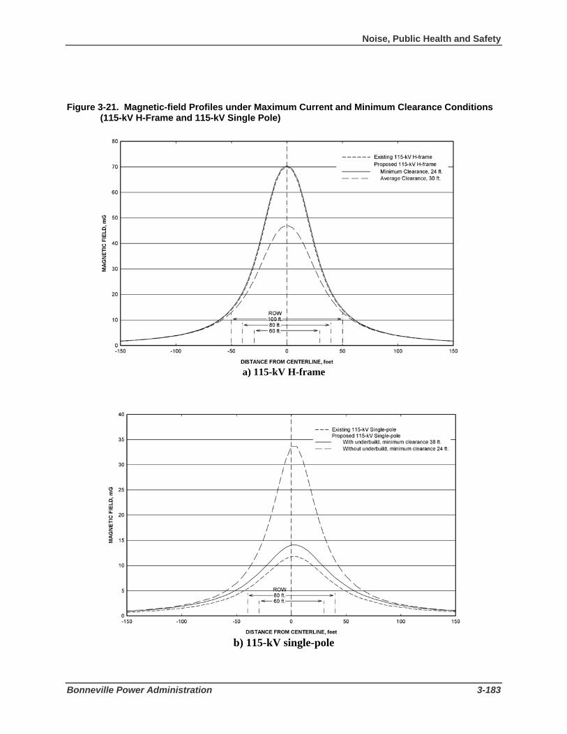
Noise, Public Health and Safety
Bonneville Power Administration 3-183
Figure 3-21. Magnetic-field Profiles under Maximum Current and Minimum Clearance Conditions
(115-kV H-Frame and 115-kV Single Pole)
a) 115-kV H-frame
b) 115-kV single-pole

3 Affected Environment and Environmental Consequences
3-184 Libby to Troy Rebuild Project Draft EIS
Toxic and Hazardous Substances Because there are no known occurrences of hazardous materials or contaminants within the transmission line corridor, the Proposed Action would not be expected to result in impacts from disturbance of toxic or hazardous substances. If hazardous materials are discovered, mitigation as discussed in Section 3.10.3 would be implemented.
Alternative 1 - 230-kV Double-Circuit Rebuild Construction Noise Impacts from construction noise for Alternative 1 would be the same as under the Proposed Action (moderate to high but short-term). Construction noise impacts to people would not occur over most of the corridor due to its sparse development and population except near residences the Bobtail Road area, Bighorn Terrace subdivision, and west of Highway 56. Similar to the Proposed Action, all the homes in the residential areas would be affected by noise from construction of Alternative 1. All the homes within the residential areas are within 4800 feet of the proposed construction activity and may experience noise levels at or above 50 dBA.
Noise levels generated during construction of structures for Alternative 1 would be similar to those under the Proposed Action. Conventional construction methods would generate noise levels comparable to those listed in Table 3-51. In the inaccessible areas along the Sheep Range Road and the historic Highway 2, BPA’s construction contractor may elect to use a helicopter for structure installation. Similar to the Proposed Action, structures would be transferred from the staging area to the remote structure sites by helicopter. The amount of time the helicopter would hover at each structure site would be the same as under the Proposed Action (30 seconds to 2 minutes for structure placement; 30 seconds to 2 minutes per structure at the central staging areas). Homes within approximately 4800 feet (about 1 mile) of the helicopters would be exposed to temporary noise levels above 50 dBA resulting in a moderate to high, short-term impact.
Recreational users within the project area would be affected by construction generated noise (including helicopter) especially along Sheep Range Road, the historic Highway 2, and near Kootenai Falls resulting in a moderate to high, short-term impact. Use of both recreational areas could decrease during construction but would return to preconstruction levels after construction.
Operation and Maintenance Noise Noise impacts during operation and maintenance of Alternative 1 would be the same as those under the Proposed Action (low).
Alternative 1, similar to the Proposed Action, would decrease the corona-generated foul weather audible noise level at the edge of the right-of-way resulting in a positive effect. The calculated L50 level during foul weather at the edge of the proposed rebuilt 230-kV line right-of-way would be 11 dBA for the double-circuit configuration (100-foot right-of-way). This level represents a very quiet condition and very likely would be masked by the sound of wind and/or rain during foul weather. The calculated maximum noise levels (L5) during foul weather at the edge of the 100-foot right-of-way are only a few dBA higher than the L50 levels and still would be very low compared to ambient noise as under the Proposed Action. During fair-weather conditions, corona is not likely to occur on the proposed line and corona-generated noise would not occur resulting in no impact. The predicted levels of corona-generated audible noise for the existing line and Alternative 1 at a voltage of 118.5-kV are given in Table 7 in Appendix H.

Noise, Public Health and Safety
Bonneville Power Administration 3-185
For Alternative 1, both on and off right-of-way the levels of audible noise during foul weather would be well below the 55-dBA level that can produce interference with speech outdoors, as well as the EPA Ldn guideline of 55 dBA and the Montana Ldn limit of 50 dBA. Similar to the Proposed Action, the estimated Ldn at the edge of the right-of-way would be approximately 8 dBA or less. The impact level would be low.
The design of Alternative 1 similar to the Proposed Action would mitigate corona generation and keep radio and television interference levels at acceptable levels comparable to those from the existing 115-kV line. No impacts of corona-generated interference on radio, television, or other reception are anticipated. See the discussion of FCC requirements in Chapter 4 of this EIS for the steps BPA would take if Alternative 1 is found to be the source of radio or television interference in areas with reasonably good reception.
General Safety Issues Similar safety issues to the Proposed Action would be present during construction and installation of the structures and conductor/ground wires for Alternative 1.
Electrical Safety The same precautions and restriction when working or living near power lines as discussed for the Proposed Action would apply to Alternative 1.
Electric and Magnetic Fields Possible effects associated with the interaction of electric and magnetic fields from transmission lines with people on and near a right-of-way from Alternative 1 would be similar to the Proposed Action. Both short-term and long-term effects and the levels of electric and magnetic fields near the proposed transmission lines are discussed below and in detail in Appendix H, Electrical Effects and in Appendix J, Assessment of Research Regarding EMF and Health and Environmental Effects. In addition, the Department of Energy provides a booklet on this topic (Questions and Answers about EMF, published in 1995).
Short-term Effects - Electric Fields. The largest calculated peak electric field expected on the right-of-way of the proposed double-circuit line operated at 115 kV would be 1.2 kV/m for the 100-foot right-of-way and 0.2 kV/m at the edge of the right-of-way. These values are less than those for the existing line and Proposed Action at 115 kV. As shown in Figure 3-22, the peak values would be present only at locations directly under the built to 230-kV line (operated at 115 kV), near mid-span, where the conductors are at the minimum clearance. Maximum electric fields on 230-kV corridors, peak fields are typically 2.5 to 3 kV/m.
Alternative 1 would easily meet BPA’s electric-field guideline of 5 kV/m and Montana’s guideline of 1 kV/m at the edge of the right-of-way; the level of impacts would be low.
Short-term Effects - Magnetic fields. Short-term effects from magnetic fields under Alternative 1 would be similar to the Proposed Action. Alternative 1 would have a maximum magnetic field on the right-of-way of 24 mG. The maximum field at the edge of the 100-foot right-of-way would be 5 mG. The magnetic fields from Alternative 1 would be less than those from the existing 115-kV line or the Proposed Action.

3 Affected Environment and Environmental Consequences
3-186 Libby to Troy Rebuild Project Draft EIS
Long-term Health Effects. Long-term health effects from Alternative would be similar and slightly less than those under the Proposed Action.
Electric and Magnetic Field Levels. Similar to the Proposed Action, BPA has predicted the annual peak electric and magnetic fields for different configurations under Alternative 1 along the corridor (see Appendix H). This allows a comparison between the fields with the existing line and Alternative 1. The field levels from the existing line and Alternative 1 change along the corridor, depending on the width of the right-of-way. The predicted levels for electric and magnetic fields are maximum levels that would occur under maximum voltage conditions for electric fields and annual peak current conditions for magnetic fields. Magnetic fields averaged over a year would be half, or less than half, of the estimated maximum values reported in Appendix H.
Figures 3-22 and 3-23 display the electric and magnetic field profiles for the existing transmission line and Alternative 1 (230-kV double-circuit operated at 115 kV).
Toxic and Hazardous Substances Because there are no known occurrences of hazardous materials or contaminants within the transmission line corridor, Alternative 1 would not be expected to result in impacts from disturbance of toxic or hazardous substances. If hazardous materials are discovered, mitigation as discussed in Section 3.10.3 would be implemented.
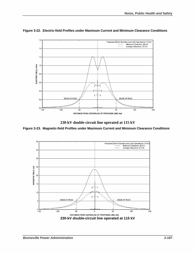
Noise, Public Health and Safety
Bonneville Power Administration 3-187
Figure 3-22. Electric-field Profiles under Maximum Current and Minimum Clearance Conditions
230-kV double-circuit line operated at 115 kV Figure 3-23. Magnetic-field Profiles under Maximum Current and Minimum Clearance Conditions
230-kV double-circuit line operated at 115 kV

3 Affected Environment and Environmental Consequences
3-188 Libby to Troy Rebuild Project Draft EIS
Short Realignment Options Pipe Creek Realignment Residents in the Pipe Creek residential area would be affected by noise from construction of this realignment regardless of voltage. All the homes within the residential area are within 4800 feet of the proposed construction activity and may experience noise levels at or above 50 dBA. Helicopter use to transport structures to the site may further expose residents to temporary noise levels above 50 dBA during construction. Impacts to residents from noise would result in a moderate to high, short-term impact.
The Pipe Creek realignment would move corona-generated foul weather audible noise to a new location; however audible noise at the edge of the right-of-way would be similar to the existing line if the 115-kV voltage is chosen. If the 230-kV voltage is chosen, audible noise would be lower than the 115-kV voltage similar to Alternative 1. The impact from corona generated noise from either voltage would be low as a result of construction of this realignment.
There would be a moderate, short-term impact to recreational users from construction generated noise (including helicopter) within 1 mile of the realignment area. Although the Pipe Creek realignment is not in a recreational area, helicopter use would expose recreational users within 1 mile of the realignment to temporary noise levels above 50 dBA.
Similar safety issues to the Proposed Action and Alternative 1 would be present during construction and installation of the structures and conductor for this realignment.
The same precautions and restrictions when working or living near power lines as discussed for the Proposed Action and Alternative 1 would apply to this realignment.
Impacts from nuisance shocks would be the same as those under the Proposed Action and Alternative 1.
The calculated peak electric fields for the Pipe Creek realignment would be similar to those under the Proposed Action and Alternative 1 depending on which voltage is chosen and therefore would easily meet BPA’s electric-field guideline of 5 kV/m and Montana’s guideline of 1 kV/m at the edge of the right-of-way; the level of impact would be low (see Appendix H).
Similar to the Proposed Action and Alternative 1, short-term interference effects from magnetic fields is generally not anticipated to be a problem if the Pipe Creek realignment is constructed. This realignment would have a maximum magnetic field on the new right-of-way similar to those under the Proposed Action and Alternative 1 depending on which voltage is chosen (see Appendix H). As under Alternative 1, the magnetic fields at 230 kV would be less than those from the 115-kV line.
Long-term health effects from the Pipe Creek realignment would be similar to the Proposed Action and Alternative 1 depending on which voltage is chosen.
Quartz Creek Realignment Residents in the Bighorn Terrace subdivision would be affected by noise from construction of this realignment regardless of voltage. All the homes within the residential areas are within 4800 feet of the proposed construction activity and may experience noise levels at or above 50 dBA. Helicopter use to
Noise, Public Health and Safety
Bonneville Power Administration 3-189
transport structures to the site may further expose residents to temporary noise levels above 50 dBA during construction. Impacts to residents from noise would result in a moderate to high, short-term impact.
The Quartz Creek realignment would move corona-generated foul weather audible noise to a new location away from residents in Bighorn Terrace resulting in a positive impact to those residents. For this realignment as under the Pipe Creek realignment, audible noise at the edge of the right-of-way would be similar to the Proposed Action if the 115-kV voltage is chosen or less than the Proposed Action if the 230-kV voltage is chosen. The impact from corona generated noise from either voltage would be low as a result of construction of this realignment.
There would be a moderate, short-term impact to recreational users from construction generated noise (including helicopter) within the realignment area because helicopter use would expose recreational users within 1 mile of the realignment to temporary noise levels above 50 dBA.
Similar safety issues to the action alternatives and the Pipe Creek realignment would be present during construction and installation of the structures and conductor for this realignment.
The same precautions and restrictions when working or living near power lines as discussed for the Proposed Action and Alternative 1 would apply to this realignment.
Impacts from nuisance shocks would be the same as those under the Proposed Action and Alternative 1.
The calculated peak electric fields for the Quartz Creek realignment would be similar to those under the Proposed Action and Alternative 1 depending on which voltage is chosen and therefore would easily meet BPA’s electric-field guideline of 5 kV/m and Montana’s guideline of 1 kV/m at the edge of the right-of-way; the level of impact would be low (see Appendix H).
Similar to the Proposed Action and Alternative 1, short-term interference effects from magnetic fields is generally not anticipated to be a problem if the Quartz Creek realignment is constructed. This realignment would have a maximum magnetic field on the right-of-way similar to those under the Proposed Action and Alternative 1 depending on which voltage is chosen (see Appendix H). As under Alternative 1, the magnetic fields at 230 kV would be less than those from the 115-kV line.
Long-term health effects along the new Quartz Creek realignment would be similar to the Proposed Action and Alternative 1 depending on which voltage is chosen. Removal of the existing line from the Bighorn Terrace subdivision would result in a positive effect to residents because electric and magnetic fields would no longer be present within the residential area.
Kootenai River Crossing Realignment Impacts to residents along the line would be low from construction of the Kootenai River crossing realignment because there are no residential areas located near or within 1 mile of the realignment. However, there would a moderate, short-term impact to recreational users from construction generated noise (including helicopter) above 50 dBA near Kootenai Falls and along the north side of the Kootenai River.
The Kootenai River crossing realignment would move corona-generated foul weather audible noise to a new location away along Highway 2. Most likely any audible noise generated from corona would not be heard above highway generated noise. Audible noise at the edge of the right-of-way would be similar to

3 Affected Environment and Environmental Consequences
3-190 Libby to Troy Rebuild Project Draft EIS
the Proposed Action if the 115-kV voltage is chosen or less than the Proposed Action if the 230-kV voltage is chosen. There would no-to-low impacts from corona generated noise from either voltage as a result of construction of this realignment.
Similar safety issues to the action alternatives and other realignments would be present during construction and installation of the structures and conductor for this realignment.
The same precautions and restrictions when working or living near power lines as discussed for the Proposed Action and Alternative 1 would apply to this realignment.
Impacts from nuisance shocks would be the same as those under the Proposed Action and Alternative 1 depending on which voltage is chosen.
For the Kootenai River crossing realignment, the single-pole configuration without a distribution line underbuild would have a peak electric field of 1.3 kV/m on the right-of-way and an electric field of 0.2 kV/m at the edge of the 80-foot right-of-way. The realignment would easily meet BPA’s electric-field guideline of 5 kV/m and Montana’s guideline of 1 kV/m at the edge of the right-of-way; the level of impact would be low (see Appendix H).
The peak magnetic field would be the same as single-pole configurations without underbuild for the Proposed Action (see Appendix H).
Similar to the Proposed Action and Alternative 1, short-term interference effects from magnetic fields is generally not anticipated to be a problem if the Kootenai River crossing realignment is constructed. No homes are located near this realignment.
Long-term health effects from this realignment would be similar to the Proposed Action and Alternative 1 depending on which voltage is chosen.
3.10.3 Mitigation The following mitigation measures would help to reduce the potential for temporary, adverse noise impacts during construction and would help minimize potential health and safety risks.
• Install sound-control devices on all construction equipment.
• Muffled exhaust will be installed on all construction equipment and vehicles except helicopters.
• Limit construction activities to daytime hours (i.e., only between 7:00 a.m. and 7:00 p.m.
• Notify landowners directly impacted along the corridor prior to construction activities, including blasting.
• Prepare and maintain and a safety plan in compliance with Montana requirements prior to starting construction. This plan will be kept on-site and will detail how to manage hazardous materials such as fuel, and how to respond to emergency situations.
• Hold crew safety meetings during construction at the start of each workday to go over potential safety issues and concerns.
• Secure the site at the end of each workday to protect equipment and the general public.

Noise, Public Health and Safety
Bonneville Power Administration 3-191
• Train employees as necessary, in structure climbing, cardiopulmonary resuscitation, first aid, rescue techniques, and safety equipment inspection.
• Fuel all highway-authorized vehicles off-site to minimize the risk of fire. Fueling of construction equipment that is transported to the site via truck and is not highway authorized will be done in accordance with regulated construction practices and state and local laws. Helicopters will be fueled and housed at local airfields or at staging areas.
• Ensure that helicopter pilots and contractors take into account public safety during flights.
• Ensure that safety measures for blasting will be consistent with state and local codes and regulations. All explosives will be removed from the work site at the end of the workday or placed under lock and key.
• Adhere to BPA’s specifications for grounding fences and other objects on and near the existing and proposed rights-of-way during construction.
• Construct and operate the rebuilt transmission line in accordance with the National Electrical Safety Code, as required by law.
• Restore reception quality if radio or television interference occurs as a result of the rebuilt transmission line. Reception will be as good or better than before the interference.
• Carry fire suppression equipment including (but not limited to) shovels, buckets, and fire extinguishers on all operation and maintenance vehicles.
• Use established access roads during routine operation and maintenance activities.
• Clear vegetation according to BPA standards to avoid contact with transmission lines.
• Use pressure treated wood poles or poles treated with preservatives that do not contribute contaminants to nearby water bodies.
• Contact the appropriate BPA representative if hazardous materials, toxic substances, or petroleum products are discovered within the project area that would pose an immediate threat to human health or the environment. Other conditions such as large dump sites, drums of unknown substances, suspicious odors, stained soil, etc. will also be reported immediately to BPA.
3.10.4 Environmental Consequences of the No Action Alternative
Potential health and safety risks associated with the ongoing operations and maintenance activities for the existing transmission line, substations, right-of-way, and access roads would continue. Existing conductor fittings have failed in the recent past causing fires and the transmission line to go out of service causing. Additionally, as wood pole structures continue to age, there is the potential for failures especially during adverse weather. If there is an outage, transmission service providing power to local residents could be significantly disrupted. To the extent that this power provides heat, operates medical equipment, or provides other important necessities, significant power outages may impact public health and safety. The potential for

3 Affected Environment and Environmental Consequences
3-192 Libby to Troy Rebuild Project Draft EIS
these types of failures would increase as the line ages resulting in a moderate impact to public health and safety.

Social and Economic Resources
Bonneville Power Administration 3-193
3.11 Social and Economic Resources 3.11.1 Affected Environment The proposed project is located in Lincoln County, Montana. Lincoln County is in the northwest corner of the state, bordered by Idaho (Boundary and Bonner counties) to the west and Canada to the north. Lincoln County is bordered in Montana by Sanders and Flathead counties to the south and east, respectively.
Census Geography The main sources of demographic and economic information used in the following section are the U.S. Census and the U.S. Bureau of Economic Analysis. Census data are available at a number of sub-county levels. Bureau of Economic Analysis data are only available at the county level. Census data are presented for several different geographic units: the county, census county division (CCD), census tract, census block, and incorporated place.
Census County Division A CCD is a subdivision of a county that is a relatively permanent statistical area established cooperatively by the Census Bureau and state and local government authorities. There are three CCDs (Libby, Troy, and Eureka) in Lincoln County. The project area is in the Libby and Troy CCDs, which together comprise more than two thirds of the county (Figure 3-24).
Census Tract Census tracts, also relatively permanent statistical areas, tend to be smaller than CCDs and often follow visible features, but may also follow governmental boundaries and other non-visible features. Census tracts average about 4,000 residents and are designed to be relatively homogenous units with respect to population characteristics, economic status, and living conditions at the time of establishment. There are five census tracts in Lincoln County (Figure 3-24). The existing transmission corridor crosses Census Tracts 3 and 5. Census Tract 5 and the Troy CCD are the same area. Census Tract 3 consists of the north portion of the Libby CCD.
Census Block The census block is the smallest area for which the census compiles data. Many census blocks correspond to individual city blocks bounded by streets, but some blocks, especially those in rural areas, include many square miles.
Incorporated Place An incorporated place is defined by the census as a type of governmental unit incorporated under state law as a city, town, borough, or village and having legally prescribed limits, powers, and functions. Incorporated places within the project area include Libby and Troy.
The following sections present a general overview of the social and economic conditions in the study area and provide a baseline against which the potential effects of the alternatives may be measured. The discussion is organized into two main sections that address demographic characteristics and trends and economic conditions, respectively.

3 Affected Environment and Environmental Consequences
3-194 Libby to Troy Rebuild Project Draft EIS
Figure 3-24. Census County Division (CCD) and Census Tract Boundaries
Demographic Characteristics and Trends Population Lincoln County had an estimated population of 19,101 in 2004. Libby is the county seat and the largest city with an estimated 2004 population of 2,653. Troy had an estimated 2004 population of 976 (Table 3-52). Montana is one of the least densely populated states in the country, with an average population density of 6.2 persons per square mile compared to a national average of 79.6 persons per

Social and Economic Resources
Bonneville Power Administration 3-195
square mile. Lincoln County had a population density of 5.2 persons per square mile in 2000, slightly below the Montana average (U.S. Census Bureau 2005a).
Total county population increased by approximately 1,356 people or 7.8 percent between 1990 and 2000, an increase below the state average of 12.9 percent. Population increased by about 4 percent in Libby and remained about the same in Troy (Table 3-52). Population has continued to increase in the study area, but at a slower rate than the state average (2.7 percent), with the populations of Lincoln County, Libby, and Troy increasing by an estimated 1.4 percent, 1 percent, and 2 percent, respectively (Table 3-52).
Table 3-52. Population 1990, 2000, and 2004
1990 to 2000 2000 to 2004 County/CCD/
City/Town 1990 2000 2004 Absolute Change
Percent Change
Absolute Change
Percent Change
Lincoln County 17,481 18,837 19,101 1,356 7.8% 264 1.4% Libby CCD 10,148 10,161 na 13 0.1% na na Libby 2,532 2,626 2,653 94 3.7% 27 1.0 Troy CCD 3,146 3,293 na 147 4.7% na na Troy 953 957 976 4 0.4% 19 2.0% Montana 799,065 902,195 926,865 103,130 12.9% 24,670 2.7% Sources: U.S. Census Bureau 2005b; Montana Department of Commerce 2005a
The existing transmission corridor crosses 14 (populated) census blocks, some of which extend several miles from the corridor. These 14 census blocks had a total population of 980 in 2000, with much of this population located in the larger blocks (U.S. Census Bureau 2000a). Residential developments in the project area are located mainly on the west and east ends of the corridor near the cities of Libby and Troy, respectively.
Population growth results from either net in-migration or natural increase. Net in-migration occurs when more people move to an area than leave. Natural increase occurs when there are more births than deaths. Migration accounted for 60 percent of statewide population growth between 2000 and 2004, with natural increase accounting for the remaining 40 percent. Migration accounted for all of the population increase in Lincoln County over this period, as the county experienced a natural decrease, with 806 more deaths than births (U.S. Census Bureau 2005b).
A number of people commenting during public scoping for this project noted that development has occurred in the immediate vicinity of the existing transmission line corridor in recent years (BPA 2006). More realtors are working in the area, and there is a perception that retirees from other states, particularly Washington and Oregon, are moving to the area (Jeresek 2006). Land use is discussed further in Section 3.2.
Recent population projections anticipate that population in Lincoln County will be approximately 5 percent larger in 2025 than it was in 2004, with the overall Montana state population expected to increase by about 7 percent over the same period (Montana Department of Commerce 2005).
Race and Ethnicity The population of Montana was predominantly White in 2000, with 90 percent of the population identifying as white compared to 75 percent nationwide. Ninety-five percent of the population in Lincoln

3 Affected Environment and Environmental Consequences
3-196 Libby to Troy Rebuild Project Draft EIS
County identified as White in the 2000 census. American Indian and Alaska Natives accounted for one percent of the population, as did persons of Hispanic or Latino origin (Table 3-53). The population of the two census tracts that encompass the project area was 95 percent White in each case (Table 3-53).
Table 3-53. Race and Ethnicity, 2000
Percent of Total Population
Geographic Area Total White1/
American Indian and
Alaska Native1/
Two or more
races1/ Hispanic or Latino
Other Race1/2/
Lincoln County 18,837 95% 1% 2% 1% 1% Census Tract 3 4,069 95% 1% 2% 2% 1% Census Tract 5 3,293 95% 1% 2% 1% 1% Montana 902,195 90% 6% 2% 2% 1%
Notes: 1/ Non-Hispanic only. The federal government considers race and Hispanic/Latino origin to be two
separate and distinct concepts. People identifying Hispanic or Latino origin may be of any race. The data summarized in this table present Hispanic/Latino as a separate category.
2/ The “Other” category presented here includes census respondents identifying as “Black or African American,” “Asian,” “Native Hawaiian and Other Pacific Islander,” or “Some Other Race.”
Source: U.S. Census Bureau 2000a
A review of data at the block level did not identify any geographic concentrations of minority groups. In most cases the populations of the census blocks crossed by the existing corridor were either 98 percent or 100 percent White (U.S. Census Bureau 2000a).
Housing The overall housing vacancy rate in Lincoln County in 2000 was 17 percent compared to 13 percent statewide. The housing vacancy rates were 10 percent and 23 percent in Census Tracts 3 and 5, respectively (Table 3-54). These vacancy rates include housing units that are classified as seasonal, recreational, or occasional use. This category accounted for approximately 17 percent of the total housing stock in Census Tract 5 (Figure 3-24). Seventy-seven percent of the occupied housing in Lincoln County was owner-occupied compared to 69 percent statewide (Table 3-54).
The number of housing units in Lincoln County and Census Tracts 3 and 5 increased during the 1990s at a faster rate than the population, with increases ranging from 12 percent in Census Tract 3 to 23 percent in Census Tract 5, with the share of units classified as seasonal, recreational, or occasional use also increasing over this period.

Social and Economic Resources
Bonneville Power Administration 3-197
Table 3-54. Housing, 2000
Percent of Total Percent of Occupied
Geographic Area
Total Housing
Units Occupied Vacant Owner
Occupied Renter
Occupied
For Seasonal, Recreational, or Occasional
Use1/ Lincoln County 9,319 83% 17% 77% 23% 9% Census Tract 3 1,850 90% 10% 80% 20% 3% Census Tract 5 1,842 77% 23% 79% 21% 17% Montana 412,633 87% 13% 69% 31% 6% Notes: 1/ These numbers are the percent of total housing units that are for seasonal, recreational, or occasional use.
The Census Bureau counts these properties as a subcategory of vacant housing units. Source: U.S. Census Bureau 2000b
Economic Conditions Slightly more than three-quarters of Lincoln County (76 percent) is within the boundaries of the Kootenai National Forest. Plum Creek Timber and Burlington Northern own a further 14 percent of the land in the county. The remaining 10 percent of the county is individually owned and includes the communities of Libby, Troy, Eureka, Fortine, Rexford, and Trego.
Employment Government employment accounts for 17 percent of total employment in Lincoln County, slightly higher than the Montana average, with federal civilian employment approximately three times the state average (6 percent versus 2 percent) (Table 3-55). Manufacturing accounts for 7 percent of total employment compared to 4 percent statewide, with most of this employment associated with wood products manufacturing (Table 3-55). Farm employment accounts for 4 percent of total employment, mainly in forestry and logging, with an emphasis on Christmas tree farming (Table 3-55) (Montana Department of Labor and Industry 2005).
Income and Poverty In 2004, Lincoln County residents had a total personal income of approximately $396 million (Table 3-56). Total personal income includes net earnings by place of residence; dividends, interest, and rent; and personal transfer payments received by county residents. Transfer payments comprised a larger share of total personal income in Lincoln County in 2004 than they did statewide, 28.4 percent versus 16.4 percent, with retirement and medical benefits making up 80 percent of Lincoln County transfer payments. Transfer payments increased as a share of total personal income over the preceding decade, accounting for 22.5 percent in 1994 (U.S. Bureau of Economic Analysis 2006b).
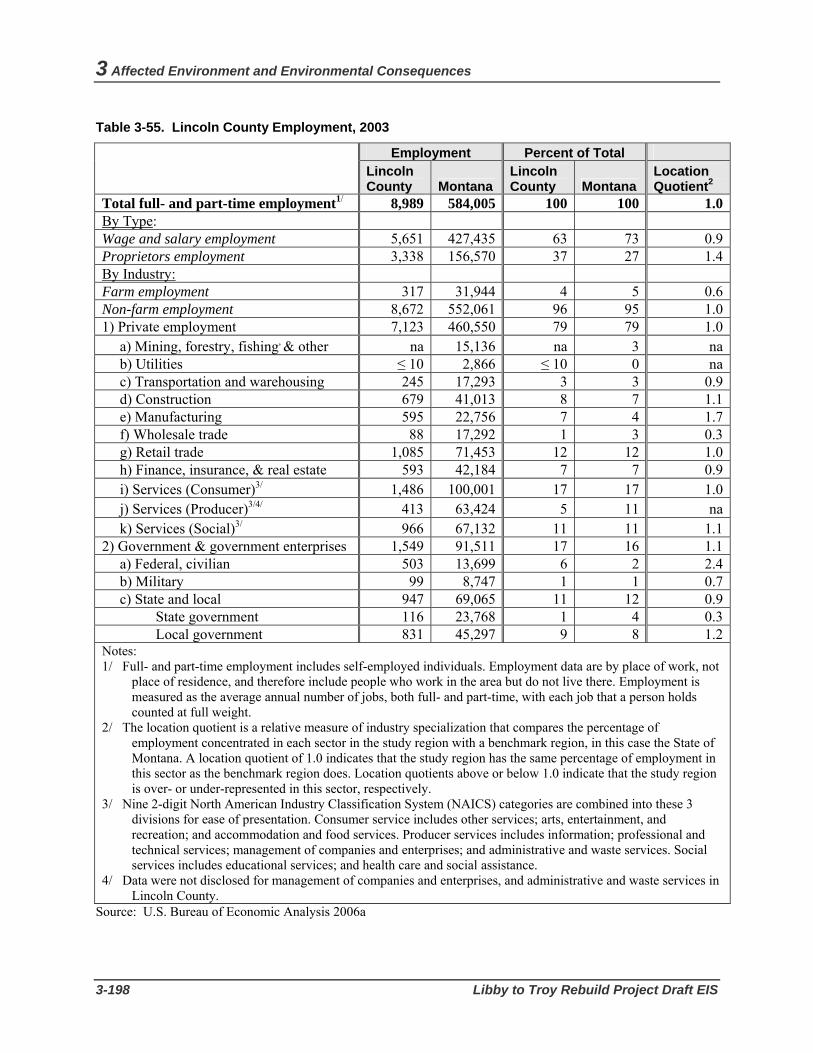
3 Affected Environment and Environmental Consequences
3-198 Libby to Troy Rebuild Project Draft EIS
Table 3-55. Lincoln County Employment, 2003
Employment Percent of Total
Lincoln County Montana
Lincoln County Montana
Location Quotient2
Total full- and part-time employment1/ 8,989 584,005 100 100 1.0By Type: Wage and salary employment 5,651 427,435 63 73 0.9Proprietors employment 3,338 156,570 37 27 1.4By Industry: Farm employment 317 31,944 4 5 0.6Non-farm employment 8,672 552,061 96 95 1.01) Private employment 7,123 460,550 79 79 1.0
a) Mining, forestry, fishing, & other na 15,136 na 3 nab) Utilities ≤ 10 2,866 ≤ 10 0 nac) Transportation and warehousing 245 17,293 3 3 0.9d) Construction 679 41,013 8 7 1.1e) Manufacturing 595 22,756 7 4 1.7f) Wholesale trade 88 17,292 1 3 0.3g) Retail trade 1,085 71,453 12 12 1.0h) Finance, insurance, & real estate 593 42,184 7 7 0.9i) Services (Consumer)3/ 1,486 100,001 17 17 1.0j) Services (Producer)3/4/ 413 63,424 5 11 nak) Services (Social)3/ 966 67,132 11 11 1.1
2) Government & government enterprises 1,549 91,511 17 16 1.1a) Federal, civilian 503 13,699 6 2 2.4b) Military 99 8,747 1 1 0.7c) State and local 947 69,065 11 12 0.9
State government 116 23,768 1 4 0.3Local government 831 45,297 9 8 1.2
Notes: 1/ Full- and part-time employment includes self-employed individuals. Employment data are by place of work, not
place of residence, and therefore include people who work in the area but do not live there. Employment is measured as the average annual number of jobs, both full- and part-time, with each job that a person holds counted at full weight.
2/ The location quotient is a relative measure of industry specialization that compares the percentage of employment concentrated in each sector in the study region with a benchmark region, in this case the State of Montana. A location quotient of 1.0 indicates that the study region has the same percentage of employment in this sector as the benchmark region does. Location quotients above or below 1.0 indicate that the study region is over- or under-represented in this sector, respectively.
3/ Nine 2-digit North American Industry Classification System (NAICS) categories are combined into these 3 divisions for ease of presentation. Consumer service includes other services; arts, entertainment, and recreation; and accommodation and food services. Producer services includes information; professional and technical services; management of companies and enterprises; and administrative and waste services. Social services includes educational services; and health care and social assistance.
4/ Data were not disclosed for management of companies and enterprises, and administrative and waste services in Lincoln County.
Source: U.S. Bureau of Economic Analysis 2006a

Social and Economic Resources
Bonneville Power Administration 3-199
Table 3-56. Total Aggregate Personal Income and Sources of Income, 2004
Percent of Total Aggregate Income
County/State
Total Aggregrate Personal Income ($
thousand) Earnings1/ Transfer
Payments2/
Dividends, Interest,
Rent Lincoln County $396,142 52.2% 28.4% 19.4% Montana $25,635,394 63.5% 16.4% 20.1% Notes: 1/ Includes wage and salary and self-employment income. 2/ Includes retirement and disability insurance benefits, medical benefits, income maintenance benefits,
and veterans benefits. Source: U.S. Bureau of Economic Analysis 2006b
Per capita income, which is calculated by dividing total personal income by population, was lower than the statewide average in Lincoln County in 1999, $13,923 versus $17,151 (Table 3-57). Per capita income was also below the state average in Census Tracts 3 and 5, comprising 92 percent and 72 percent of the state average, respectively.
The percent of the population below the poverty rate in 1999 was higher than the state average in Lincoln County and Census Tracts 3 and 5, ranging from 18.4 percent in Census Tract 3 to 25.1 percent in Census Tract 5 (Table 3-57).
Table 3-57. Per Capita Income and Persons Below Poverty, 1999
Per Capita Income Persons Below Poverty
County/Census Tract/State 1999
Percent of State Average
Individuals Below Poverty
Level
Difference from State Average
Lincoln County $13,923 81% 19.2% 4.6% Census Tract 3 $15,861 92% 18.4% 3.8% Census Tract 5 $12,350 72% 25.1% 10.5% Montana $17,151 100% 14.6% 0.0%
Source: U.S. Census Bureau 2000a
Lincoln County had an unemployment rate of 8.2 percent in 2005, slightly more than twice the state average. The annual unemployment rate in Lincoln County has fluctuated over the past decade, but has consistently been about twice as high as the state average. It should also be noted that 8.2 percent is the lowest annual unemployment rate in Lincoln County over the past decade (Montana Department of Labor and Industry 2006).
Minority and Low-Income Populations Executive Order 12898, Federal Actions to Address Environmental Justice in Minority Populations and Low-Income Populations, states that each federal agency shall identify and address, as appropriate, disproportionately high and adverse human health or environmental effects of its programs, policies, and activities on minority and low income populations. The Order further stipulates that the agencies conduct

3 Affected Environment and Environmental Consequences
3-200 Libby to Troy Rebuild Project Draft EIS
their programs and activities in a manner that does not have the effect of excluding persons from participation in, denying persons the benefits of, or subjecting persons to discrimination because of their race, color, or national origin.
Data on income and poverty status are available at the Census Tract level (see Table 3-57). These data indicate that in 1999 per capita income in Lincoln County was 81 percent of the Montana average. Per capita income was above the Lincoln County average in Census Tract 3, which includes the east portion of the project area, and below the average in Census Tract 5, which includes the west portion (Table 3-57). The poverty rate was also higher than the state average in Lincoln County and above and below the Lincoln County average in Census Tracts 3 and 5, respectively (Table 3-57). Lincoln County includes just five census tracts; Census Tracts 3 and 5 encompass almost half of the land in the county.
Public Services Law Enforcement The principal agency responsible for providing law enforcement in the City of Troy is the Troy Police Department, which consists of three officers (City of Troy 2006a). The Libby Police Department is responsible for providing law enforcement in the City of Libby. The Libby Police Department consists of six officers (City of Libby 2006a). Unincorporated areas of Lincoln County are served by the Lincoln County Sheriff’s office.
Fire Protection Fire protection services for the cities of Troy and Libby are provided by their own fire departments. The City of Troy has one fire station, one water tender, and a fire fighting force of approximately 35 people, all of which are volunteers (City of Troy 2006b). The City of Libby has 2 fire stations housing a total of 6 engines. The total fire fighting force for Libby consists of approximately 25 volunteer fire fighters and 2 paid fire marshals (City of Libby 2006b).
Fire-related emergencies between Libby and Troy are responded to on a case-by-case basis, based on the location, with the Troy Fire Department responding to fires closer to Troy and the Libby Fire Department responding to those closer to Libby. There might also be situations where both departments would respond and the U.S. Forest Service would be involved in fighting wildland fire (McGill 2006).
Medical Facilities The nearest emergency medical facility to the project area is St. John’s Lutheran Hospital in Libby (City-Data.com 2006). This facility provides 25 beds, an emergency helicopter landing area, and a 24-hour fully-staffed emergency department (St. John’s Lutheran Hospital 2006).
Education Lincoln County has ten public schools and manages each as an individual district (Sutton 2006). The county operates two high schools, seven junior high/elementary schools, and one K-12 school. The county is also home to three private schools, all in Libby (Lincoln County School Superintendent’s Office 2005). Total school enrollment in the fall of 2005 was 2,976 students, excluding notified home schooled students (Lincoln County School Superintendent’s Office 2005). The district has an estimated 255 full-time teachers and an approximate 12:1 pupil to teacher ratio (Sutton 2006). In addition to these education facilities, approximately five day care centers are located in Libby. There are no colleges or other higher academic programs in the area.

Social and Economic Resources
Bonneville Power Administration 3-201
3.11.2 Environmental Consequences of Action Alternatives
This section assesses the impacts of the action alternatives and realignment options on employment and income, minority and low-income populations, housing, local businesses, public services, and property values.
Proposed Action – 115-kV Single-Circuit Rebuild Employment and Income The Proposed Action would have a low-level positive impact on the regional economy during construction through the local procurement of materials and equipment and spending by construction workers. These direct expenditures generate economic activity in other parts of the economy through what is known as the multiplier effect, with direct spending generating indirect and induced economic impacts. Indirect impacts consist of spending on goods and services by industries that produce the items purchased as part of the project. Induced impacts include expenditures made by the households of workers involved either directly or indirectly in the construction process.
Total project costs have been estimated at $17 million for the Proposed Action. The construction cost is expected to be approximately $5.5 million. It is estimated that approximately $675,000 would likely be spent on local purchases, including fuel for vehicles and equipment, some equipment rentals, staging area rental, and other incidental materials and supplies. BPA would hire a specialist contractor to build the line. BPA staff would be responsible for engineering design, land acquisition, surveys, environmental analysis and monitoring, and providing the contractor with construction materials, including the transmission structures. These expenditures would not be made locally.
Construction would occur during one construction season (currently anticipated to occur between May and November of 2008). Roads and clearing and some foundation work (if necessary) would be completed first; these activities would be expected to last about 4 months. The remaining foundation and line work would be expected to last about 7 months. The construction labor force would consist of about 26 workers for the first phase, about 80 percent of whom are expected to be hired locally. The labor force for the second phase would vary by month and range from a peak of 65 workers in months 4 and 5 to a low of about 15 workers in the final half month. As much as 30 percent of the line construction labor force would be hired locally, with the remaining workers expected to temporarily relocate from Spokane, Washington or other areas to the project area.
The total construction labor force would be equivalent to 39 full-time equivalent (FTE) jobs or “job-years.” A job-year represents 12 months of employment and may involve more than one worker, which would likely be the case here. Assuming 20 to 30 percent of this employment would involve local workers, construction activities would support 8 to 12 local FTEs. Employment multipliers generated using IMPLAN indicate that 10 jobs in the construction sector support about 3 indirect and induced jobs in other sectors of the local economy (Minnesota IMPLAN Group 2004)12. There were about 9,000 full-
12 IMPLAN is an input-output model commonly used in this sort of application. The software and databases necessary to run IMPLAN are available commercially from the Minnesota IMPLAN Group. The IMPLAN system adjusts national level data to fit the economic composition and estimated trade balance of a chosen region and can be used to construct county models for any region in the United States. The multipliers used in this analysis are based on IMPLAN data for Lincoln County.

3 Affected Environment and Environmental Consequences
3-202 Libby to Troy Rebuild Project Draft EIS
and part-time jobs in Lincoln County in 2003, including about 680 construction jobs (see Table 3-55). The unemployment rate in Lincoln County was 8.2 percent in 2005 (Montana Department of Labor and Industry 2006).
The total income earned by construction workers would average approximately $100,000 per month, with an estimated total of $1.35 million for the duration of the project. This total is equivalent to approximately 0.3 percent of total personal income in Lincoln County in 2004 and less than 0.1 percent of total personal income in the surrounding region, as defined by the U.S. Bureau of Economic Analysis. Lincoln County is part of the Missoula BEA (Bureau of Economic Analysis) economic area, which also includes Flathead, Lake, Mineral, Ravalli, and Sanders counties.13 Approximately 20 to 30 percent of this income ($270,000 to $404,000) would be earned by local residents. These totals are equivalent to 0.07 percent to 0.1 percent of total personal income in Lincoln County in 2004.
As the preceding discussion indicates, estimated local project-related expenditures, employment, and construction-related earnings are small relative to the total amount of economic activity, employment, and income in Lincoln County and are even smaller when viewed as a component of the regional economy. Thus the impact would low and short-term in nature.
Operation of the rebuilt transmission line is not expected to increase economic activity in the local or regional economy following construction of the Proposed Action, but would provide increased reliability.
Minority and Low-Income Populations Environmental justice addresses whether the Proposed Action would disproportionately impact disadvantaged populations such as low-income and minority residents. The population in the study area is predominantly White (see Table 3-53) and a review of data at the block level did not identify any geographic concentrations of minority groups. In most cases the populations of the census blocks crossed by the existing corridor were either 98 percent or 100 percent White (U.S. Census Bureau 2000a). In addition, the Proposed Action would not be expected to disproportionately affect any low-income populations, based on per capita income information at the Census Tract level. Therefore, there would be no disproportionately high or adverse effects to minority or low income groups.
Housing During peak construction in the summer, approximately 65 workers would be employed along various segments of the 17 mile corridor, with different crews operating in different locations. Assuming 70 to 80 percent of this labor force would temporarily relocate to the area, 46 to 52 workers would seek temporary accommodation in the area at the peak of the construction activities. These workers would likely reside in Libby or Troy and would occupy trailer courts, rent apartments or houses, or stay in motels for short stays. Most, if not all, of the construction labor force that would relocate during construction would leave at the end of the project. It is unlikely that any workers would permanently settle in the project area. Lodging facilities and campgrounds are available within commuting distance to house non-local construction workers.
The 2000 Census found that 17 percent of the housing units (1,555 units) in Lincoln County were vacant in 2000, with 10 percent (194 units) and 23 percent (432 units) vacant in Census Tracts 3 and 5, respectively (Table 3-54). There were an additional 178 units vacant in the portion of the Libby CCD not
13 BEA economic areas define the regional markets surrounding regional centers of economic activity based on commuting data from the 2000 Census and may include one or more regional centers.

Social and Economic Resources
Bonneville Power Administration 3-203
included in Census Tract 3. Not all of the vacant units were available for rent. Some were for sale only, some were already rented or sold but not occupied, and others were identified as seasonal, recreational, or occasional use only. A total of 191 housing units was identified as available for rent at the time of the census in the general vicinity of the project (Libby and Troy CCDs), with an additional 65 units available elsewhere in the county (U.S. Census Bureau 2000b).
Short-term accommodation is also available in the project vicinity, including at least six motels in and around Libby with more than 175 rooms for rent (Libby Chamber of Commerce 2005). There are also motels in and around Troy. In addition, the area has more than 20 campgrounds and RV parks (Visit Montana 2006). Many people visit the project area during the summer, with peaks occurring around July 4th and the Nordic Fest held in August (Blystone 2006). Depending on the construction schedule and the number of workers temporarily relocating to the area, construction workers may have to reside further away during these periods. In addition, increased competition for housing would have short-term negative impacts for tourists and other visitors during these periods. These potential impacts would be short-term and low because enough housing is available to accommodate workers, tourists, and local residents during much of the year.
Local Businesses Local purchases, employment of local residents, and the temporary relocation of construction workers to the project area would have a low but positive impact on local businesses. Construction-related multipliers are relatively small in Lincoln County, reflecting the size of the local economy, with many goods and services purchased in the area produced elsewhere. Ten local construction jobs, for example, support just three indirect and induced jobs elsewhere in the local economy, and construction income of $1,000,000 generates about $200,000 in labor income elsewhere in the local economy (Minnesota IMPLAN Group 2004).
Portions of the existing transmission line corridor experience high recreation use. Recreation use includes hunting, mountain biking, and walking. Popular areas include the Bobtail Ridge mountain bike trail; the trail which extends about 5 miles west from Bighorn Terrace through the Kootenai Falls Wildlife Management Area (Sheep Range Road); and the stretch of historic Highway 2 that extends west on the south side of the Kootenai River from where the transmission line crosses the river. Recreation use is discussed further in Section 3.9. The Proposed Action would have a low impact on recreation use and associated businesses, provided that existing access trails are not improved to the extent that they may no longer be used for their current activities (Jeresek 2006).
Public Services The Proposed Action would not be expected to cause significant demands on public services or facilities resulting in a low impact. During construction, public services such as police, fire, and medical facilities, would be needed only in cases of emergency (i.e., construction accidents). Standard safety procedures would be followed at all times during construction and the potential for accidents is expected to be low. Emergency services are provided for the unincorporated project area by Lincoln County and services are also available in the cities of Libby and Troy. The nearest emergency medical facility to the project area is located in Libby. During operations, the potential for public services impacts would be even further reduced due to the infrequency of project-related maintenance activities.
Property Values Residents in the vicinity of the project area expressed a number of concerns during the public scoping process. The comments that addressed potential socioeconomic impacts were mainly concerned with

3 Affected Environment and Environmental Consequences
3-204 Libby to Troy Rebuild Project Draft EIS
potential impacts to residential land use and property values. Concerns about residential property values were primarily related to the proposed width of the corridor that would be needed to rebuild the line, right-of-way clearing, and increased access.
General Property Impacts and Compensation: For the Proposed Action, BPA would acquire additional area along portions of the existing corridor to enable the construction and maintenance of the rebuilt transmission line. BPA would use its existing access road system where possible but additional access road easements would need to be acquired.
BPA would pay market value to nonfederal landowners, as established through the appraisal process, any new land rights required for this project. The appraisal process takes all factors affecting value into consideration, including the impact of transmission lines on property value. The appraisals may reference studies conducted on similar properties to support their conclusions. The strength of any appraisal depends on the individual analysis of the property, using neighborhood-specific market data in order to determine market value.
The easements required may encumber the right-of-way area with land use limitations. Each transmission line easement will specify the present and future right to clear the right-of-way and to keep the same clear of all trees, whether natural or cultivated, and all structure supported crops, other structures, trees, brush, vegetation, fire and electrical hazards, except non-structure supported agricultural crops less than 10 feet in height.
The impact of introducing a new right-of-way for transmission structures and lines can vary dramatically depending on the placement of the right-of-way in relation to the property’s size, shape, and the location of existing improvements. A transmission line may diminish the utility of a portion of property if the line effectively severs this area from the remaining property (called “severance damage”). Whether a transmission line introduces a negative visual impact depends on the placement of the line across a property as well as each individual landowner’s perception of what is visually acceptable or unacceptable. (The potential visual impacts of the Proposed Action are evaluated in Section 3.7 Visual Resources of this EIS). These factors as well as any other elements unique to the property are taken into consideration to determine the loss in value within the easement area, as well as outside the easement area in cases of severance.
Where BPA needs to acquire easements on roads that already exist and the landowner is the only other user, market compensation is generally 50 percent of full fee value. If other landowners share the access road, compensation is usually something less than 50 percent. For fully improved roads, the appraiser may prepare a cost analysis to identify the value of the access road easement. If BPA acquires an easement for the right to construct a new access road and the landowner has equal benefit and need of the access road, market compensation is generally 50 percent of full fee value; if the landowner has little or no use for the new access road, market compensation for the easement is generally close to full fee value.
Property Value Impacts: The Proposed Action is not expected to have long-term impacts on property values in the area. Whenever land uses change, the concern is often raised as to the effect the change may have on property values nearby. Zoning is the primary means by which most local governments protect property values. By allowing some uses and disallowing others, or permitting them only as conditional uses, conflicting uses are avoided. Some residents consider transmission lines to be an incompatible use adjacent to residential areas. Nonetheless, the presence of transmission lines in residential areas is fairly common. In addition, as is the case with the existing transmission corridor, transmission lines often predate adjacent or nearby residential uses – i.e., the transmission lines were already part of the landscape when housing developers and others decided to locate homes and residences in nearby areas.

Social and Economic Resources
Bonneville Power Administration 3-205
The question of whether nearby transmission lines can affect residential property values has been studied numerous times in the United States and Canada over the last twenty years or so, with mixed results. In the 1990s, BPA contributed to the research when it looked at the sale of 296 pairs of residential properties in the Portland, Oregon metropolitan area (including Vancouver, Washington) and in King County, Washington. The study evaluated properties adjoining 16 BPA high-voltage transmission lines (subjects) and compared them with similar property sales located away from transmission lines (comps). All of the sales were in 1990 and 1991 and adjustments were made for time and other factors. Study results showed that the subjects in King County were worth approximately 1 percent less than their matched comps, while the Portland/Vancouver area subjects were worth almost 1.5 percent more (Cowger et al. 1996).
BPA updated this study in 2000 using 1994/95 sales data. The sales of 260 pairs of residential properties in the King County and Portland/Vancouver metropolitan areas were reviewed. The information confirmed the results of the earlier study, i.e., that the presence of high-voltage transmission lines does not significantly affect the sale price of residential properties. The residential sales analysis did, however, identify a small but negative impact from 0 to 2 percent for those properties adjacent to the transmission lines as opposed to those where no transmission lines were present. Although this study identified a negative effect, the results are similar to the earlier study and the differences are relatively small (Bottemiller et al. 2000).
Studies of impacts during periods of physical change, such as new transmission line construction or structural rebuilds, generally have revealed greater short-term impacts than long-term effects. However, most studies have concluded that other factors, such as general location, size of property, improvements, condition, amenities, and supply and demand factors in a specific market area are far more important criteria than the presence or absence of transmission lines in determining the value of residential real estate.
Some low-level, short-term negative impacts on property values (and salability) might occur on an individual basis as a result of the Proposed Action. However, these impacts would be highly variable, individualized, and unpredictable. Rebuilding the transmission line is not expected to cause long-term negative effects to property values along the corridor or in the general vicinity. The majority of work would be confined to the existing transmission line corridor although some new structures may be placed in slightly different locations to the existing structures due to the presence of water bodies, roads, or railroad crossings. The properties located adjacent to the existing transmission line have been developed over time, many since the line was constructed in the 1950s and, as a result, rebuilding the existing line is unlikely to affect the value of these properties. Non-project impacts, along with other general market factors, are already reflected in the market value of properties in the area. These conditions are not expected to change appreciably.
Property Tax Impacts: The Proposed Action would have no effect on the local taxing districts.
Eminent Domain: As a government agency, BPA has the power of eminent domain, or the power to condemn land rights needed to support its projects. If, after good faith negotiations, BPA and a landowner are not able to agree on terms of a purchase, BPA would ask the U.S. Department of Justice to begin condemnation proceedings in the U.S. District Court on its behalf. A landowner may request that the condemnation process be used if they are not willing to negotiate.

3 Affected Environment and Environmental Consequences
3-206 Libby to Troy Rebuild Project Draft EIS
Alternative 1 – 230-kV Double-Circuit Rebuild Employment and Income Alternative 1 would have a similar low-level positive impact to employment and income as that of the Proposed Action.
Total project costs have been estimated at $30 million for Alternative 1. Construction and local costs for Alternative 1 are expected to be the same as under the Proposed Action (about $5.5 million and $675,000 respectively). As under the Proposed Action, BPA would hire a specialist contractor to build the line with BPA staff responsible for engineering design, land acquisition, surveys, environmental analysis and monitoring, and providing the contractor with construction materials, including the transmission structures.
Construction for Alternative 1 would occur during the same time period as the Proposed Action (one season between May and November of 2008) with the same construction labor force both locally and from other areas. As discussed under the Proposed Action, estimated local project-related expenditures, employment, and construction-related earnings are small relative to the total amount of economic activity, employment, and income in Lincoln County and are even smaller when viewed as a component of the regional economy; thus the impact would low and short-term in nature.
Similar to the Proposed Action, operation of the rebuilt transmission line is not expected to increase economic activity in the local or regional economy following construction of Alternative 1. Alternative 1 would provide increased reliability and additional capacity to support future economic and other development should it occur in the future.
Minority and Low-Income Populations Similar to the Proposed Action, there would be no disproportionately high and adverse effects to minority or low income groups from Alternative 1.
Housing Alternative would have similar impacts on housing during construction (short-term and low-level).
Local Businesses Similar to the Proposed Action, local purchases, employment of local residents, and the temporary relocation of construction workers to the project area would have low but positive impact on local businesses.
Alternative 1 is expected to have a low impact on recreation use and associated businesses with some short-term, moderate impacts due to construction noise, traffic, and dust.
Public Services Construction of Alternative 1 is expected to have a low impact on public services or facilities similar to the Proposed Action.
Social and Economic Resources
Bonneville Power Administration 3-207
Property Values General Property Impacts and Compensation: For Alternative 1, BPA would acquire additional area (to 100 feet) along the entire existing corridor to enable the construction and maintenance of the rebuilt transmission line. BPA would use its existing access road system where possible but additional access road easements would need to be acquired.
Similar to the Proposed Action, BPA would pay market value to nonfederal landowners, as established through the appraisal process discussed above, for any new land rights required for Alternative 1. For access roads that already exist, BPA would acquire easements and compensate landowners as discussed above.
Property Value Impacts: Similar to the Proposed Action, Alternative 1 may have low-level, short-term negative impacts on property values but is not expected to have long-term impacts in the project area.
Property Tax Impacts: Alternative 1 would have no effect on the local taxing districts.
Eminent Domain: As with the Proposed Action, BPA has the power of eminent domain, or the power to condemn land rights needed to support its projects. If, after good faith negotiations, BPA and a landowner are not able to agree on terms of a purchase, BPA would ask the U.S. Department of Justice to begin condemnation proceedings in the U.S. District Court on its behalf. A landowner may request that the condemnation process be used if they are not willing to negotiate.
Short Realignment Options The impacts from the short realignment options are expected to be the same as under the Proposed Action and Alternative 1 with the following exceptions.
Employment and Income Construction of each short realignment option would increase the estimated construction costs by about 2 percent per realignment because additional corridor clearing and road building would be required. Total construction costs and local purchases per realignment would increase by about $75,000 and $12,000, respectively. The number of workers and associated payroll would also be expected to increase by about 2 percent per realignment, which would result in the number of FTEs increasing from 39 to 40 and total payroll increasing from about $1.35 million to $1.42 million. These overall impacts are expected to be positive, but low, given the total county income of over $396 million.
Minority and Low-Income Populations Similar to the Proposed Action and Alternative 1, there would be no disproportionately high and adverse effects to minority or low income groups from the realignment options.
Local Businesses Although the proposed Kootenai River crossing realignment likely would have positive impact on local recreation use because a portion of the line would no longer share an alignment with the heavily used trail along the north side of the Kootenai River (Sheep Range Road), the potential improvement is not expected to affect recreation businesses because the trail is used primarily by local residents for short outings (Jeresek 2006).

3 Affected Environment and Environmental Consequences
3-208 Libby to Troy Rebuild Project Draft EIS
Housing A 5 percent increase in the projected number of construction workers required to build the realignment options would result in three additional workers potentially seeking temporary accommodation in the area at the peak of the construction activities. The potential housing impacts from construction of the short realignment options is expected to be the same as under the Proposed Action and Alternative 1. Depending on the construction schedule and the number of workers temporarily relocating to the area, construction workers may have to reside further away during peak tourism times (4th July and Nordic Fest). The potential impact on housing during peak tourism times could be moderate but short-term.
Property Values Residents in the vicinity of the project area expressed a number of concerns during the public scoping process, as discussed for the Proposed Action and Alternative 1. The proposed short realignment options would address the concerns of local residents who support one or more of the realignments, but not the concerns of those who would prefer that the existing corridor be used. Landowner compensation would follow the same process described in the General Property Impacts and Compensation section above. The Pipe Creek and Quartz Creek realignments would move most of the corridor from private, county, and Kootenai National Forest land to National Forest lands with some private land. The Kootenai River crossing realignment would move a portion of the corridor from Kootenai National Forest to Lincoln County and National Forest land. These proposed realignments are not expected to have long-term property value impacts.
3.11.3 Mitigation • Compensate landowners at market value for any new land rights required for corridor easements or to
acquire new, temporary or permanent access roads on private lands.
3.11.4 Environmental Consequences of the No Action Alternative
Potential positive (e.g., income and employment) and negative socioeconomic impacts (tourist housing and short-term property value) associated with construction and operation of the action alternatives would not occur under the No Action Alternative. This alternative could, however, result in other negative socioeconomic impacts, primarily those associated with reduced reliability and increased maintenance access requirements. Reduced reliability could lead to higher energy costs and power outages due to the failing condition of the existing transmission line, which would have moderate, negative effects on local residents, businesses, and employees. Reliable electrical service is also important in attracting and retaining businesses that use digital and other high-end technological equipment that is sensitive to voltage sags.

Transportation
Bonneville Power Administration 3-209
3.12 Transportation 3.12.1 Affected Environment The affected environment for transportation includes roads, railroads, and airports in or near the project area near Libby and Troy, Montana. Roads in the project area are a combination of unimproved gravel, improved gravel, paved and highway system controlled access roads. These provide access to and around the existing transmission line corridor and short realignments.
Roads The corridor north of Libby, starting at Libby Substation, is accessed by county roads 567 (Pipe Creek Road), 5102, 260 (Kootenai River Road), 655 (Bobtail Road), and U.S. Forest Service Road 853 (Sheep Range Road) from east to west respectively. Approximately 10 miles from Libby on Highway 2 the transmission line corridor crosses from the north side to the south side of the Kootenai River and Highway 2. The corridor is then accessed by Highway 2, county roads 14756 (Shannon Road) and 14753, State Highway 56, and county roads 384 (Lake Creek Road) and 9994 and ends at the Troy substation. Figure 3-25 shows the major regional and local transportation routes in the project area. Table 3-58 from the Montana Department of Transportation shows the traffic use of each of the roads it maintains. County road use included residential, recreational, and commercial vehicles.
Table 3-58. Traffic Use in Vehicles per Year Within the Project Area
Road 2002 2003 2004 Highway 2 42,975 44,288 47,687 State Highway 56 949 1003 1180 Kootenai River Road 1006 987 937 Pipe Creek Road 283 231 215
In addition to the state and county roads, BPA has easement rights on an existing private and Kootenai National Forest-owned road system to access the current transmission line corridor. This system would be used for rebuilding the existing transmission line. However, it does not access every structure.
Railroads Burlington Northern Santa Fe (BNSF) Railway operates a railroad within the project area. Between Libby and just east of Kootenai Falls, the railroad is south of the Kootenai River and transmission line corridor. West of the transmission line crossing of the river, the corridor travels south of the railroad and U.S Highway 2. The existing Kootenai River crossing in corridor mile 25 also crosses over the railroad. One existing structure (25/9) located between the railroad and river is currently inaccessible.
Airports There are two local airports and a heliport in the project vicinity (Figure 3-25). The two airports are Libby Airport and Troy Airport, both located in Lincoln County, Montana. Libby Airport is a public airport located approximately 8.5 miles to the southeast of Libby Substation. It is used for general aviation and as of August 2006, it averaged 96 aircraft operations per week (FAA 2006). Troy Airport is a public airport located approximately 3 miles to the northwest of Troy Substation. It also is used for general aviation and as of August 2006, it averaged 58 aircraft operations per month (FAA 2006).

3 Affected Environment and Environmental Consequences
3-210 Libby to Troy Rebuild Project Draft EIS
The heliport in the project vicinity is St. Johns Lutheran Heliport, which is a private heliport located in Lincoln County approximately 1 mile to the southeast of Libby Substation (FAA 2006).
3.12.2 Environmental Consequences of Action Alternatives
Proposed Action – 115-kV Single-Circuit Rebuild Heavy and light vehicles would access the transmission line corridor, and equipment and components would be transported to the corridor along county and state roads and transmission line access roads. Construction of the Proposed Action would increase traffic and cause traffic detours and delays in the project vicinity during the summer tourist season when road use is higher resulting in a moderate impact on area roadways. However construction activity and movement of heavy construction vehicles and equipment would be short-term (during construction). Following construction, U.S. highway, county, state and local traffic would return to preconstruction levels.
Temporary disturbances from increased traffic of heavy equipment along Kootenai River Road would have a moderate, short-term impact on local traffic. Line construction along Kootenai River Road where the transmission line parallels the road would impact traffic flow east and west from potential road closure, detours or delays. Kootenai River Road is the only road that provides access to the Bighorn Terrace residential area and one of two roads that cross through the Pipe Creek residential area.
Construction near Highway 56 area would result in a short-term low impact to traffic on the highway. Traffic delays would occur when construction crews string the conductor across the Highway 56.
During construction of the Proposed Action, BPA or its construction management company would coordinate driveway access with each home owner to minimize any closures during construction. Driveways with entrances on Kootenai River Road occur in the Pipe Creek residential area and in Bighorn Terrace. Kootenai River Road closures would be coordinated with the State of Montana from Libby Substation to Bobtail Road and with Lincoln County from Bobtail Road to the end of Kootenai River Road. Road use and closures near the Troy side of the project would be coordinated with the state and county (see Section 3.12 Mitigation).
Public comments on transportation included concerns about controlling access if temporary roads are built and controlling access on new roads that affect private property. Both temporary and permanent access roads would be accessible during construction. They would be surfaced with crushed aggregate or native material and maintained to accommodate vehicle and construction material movement. After transmission construction is completed, access roads would be seeded with grass or other seed mixtures and ground disturbances would be repaired. Those roads needed for long-term maintenance would be used only 3 to 4 times each year. If requested by an owner, BPA would consider installing controls such as gates to minimize unauthorized access. Impacts would be low.
Approximately 20 miles of existing access roads would need varying degrees of improvement, and easements would be acquired if necessary for construction of the Proposed Action. Improvements range from grading and rocking to minor resurfacing. An additional 4.5 miles of new road is required to construct and maintain the transmission line. Table 3-59 shows the distribution of ownership of these roads. Road improvement and construction would entail installing or improving approximately 210 drainage structures throughout the road network to reduce erosion potential; the result would be a low

Transportation
Bonneville Power Administration 3-211
short-term impact from temporary disruption to local traffic and a potential positive, long-term impact from improved water quality in project areas streams.
Table 3-59. Road Construction and Improvement for Proposed Action
Ownership Approximate Miles of Existing Roads
Approximate Miles of New Roads
Kootenai National Forest 10.5 1.9
State of Montana 3.7 0.2
Lincoln County 0.2 0.6
City of Libby 0 0.3
Private 6.6 1.5
Bridges would be constructed at Burrell and China Creek crossings for the Proposed Action. A bridge currently spans Burrell Creek although it is too narrow for large construction equipment. No crossing structure exists at China Creek as the ford and road washed out in 1996. Some excavation would be required to install the single lane modular steel structures. Impacts to transportation would be low because this would be a temporary disturbance (1 to 2 weeks).
Construction of the Proposed Action could result in temporary impacts to railroad operations near where the existing transmission corridor crosses the Kootenai River. Structure 25/9 would not be rebuilt in the same location but would be rebuilt south of the railroad. This would provide future access to this structure. There would be low impact to the railroad during removal of the existing structure because of construction activities in proximity this operating rail line. Permits from BNSF would be obtained to cross the railroad. Following relocation of the structure, there would be no impact to the railroad.
Overhead transmission conductors, structures, and overhead ground wires would continue to pose a slight hazard to low flying aircraft under the Proposed Action resulting in a low impact. The current Kootenai River crossing would only require markings if one of the following occurs: new structures are taller than 200 feet from the ground; the conductor is 200 feet above the ground; or the realignment is within the plane elevation of an airport. Since none of these apply, BPA would not install spherical balls or flashing lights on the existing river or Highway 2 crossings.
In areas with no vehicle access such as along the historic Highway 2, a helicopter would be used during construction. Its use would be scheduled with other flight plans prior to work, so impacts on air traffic in the area would be low.
Alternative 1 – 230-kV Double-Circuit Rebuild Impacts to transportation from Alternative 1 would be similar to those under the Proposed Action. Construction would increase traffic, cause traffic detours and delays on state roads and highways, and Kootenai River Road resulting in a moderate, short-term impact. Use of Highway 2 to transport construction equipment would result in a low, short-term impact if construction occurs during the summer tourist season when road use is high. Similar to the Proposed Action, U.S. highway, county, state and local traffic would return to preconstruction levels following construction.

3 Affected Environment and Environmental Consequences
3-212 Libby to Troy Rebuild Project Draft EIS
Under Alternative 1, cooperation between BPA or its construction management company and landowners, Lincoln County, or State of Montana for driveway access and road use would occur similar to the Proposed Action (see Section 3.12 Mitigation). Control of access on temporary or new roads during and after construction of Alternative 1 would be similar to the Proposed Action. Roads would be surfaced with crushed aggregate or native material, maintained to accommodate vehicle and construction material movement, and seeded with grass or other seed mixtures following construction. Those roads needed for long-term maintenance of the rebuilt transmission line would be used only 3 or 4 times each year. Similar to the Proposed Action, BPA would consider installing controls such as gates to minimize unauthorized access, if requested by a landowner. Impacts would be low.
Similar to the Proposed Action, about 20 miles of existing access roads would be improved, and easements would be acquired if necessary for construction of Alternative 1. About 4.5 miles of new road would be constructed as under the Proposed Action. Approximately 210 drainage structures throughout the road network would be installed to reduce erosion potential. The impact would be low if local traffic is temporarily disrupted; however, there is the potential for a positive, long-term impact from improved water quality in project areas streams.
Bridges at both Burrell and China Creeks would be installed for Alternative as well as the Proposed Action. Impacts to transportation would be low because this would be a temporary disturbance (1 to 2 weeks).
For Alternative 1, taller structures with overhead transmission conductors and overhead ground wires would pose a hazard to low flying aircraft. However, since the new structures would not be taller than 200 feet from the ground; the conductor would be less than 200 feet above the ground; and the line would not be within the plane elevation of an airport, no markers would be required. The impact would be low.
Impacts from relocation of the structure 25/9 currently located between the Kootenai River and BNSF railroad would be similar to those under the Proposed Action (low during removal of the existing structure with no impact to the railroad after removal).
Similar to the Proposed Action, inaccessible structures along the historic Highway 2 would be accessed with a helicopter during construction of Alternative 1. Helicopter use would be scheduled with other flight plans prior to work, so impacts on air traffic in the area would be low.
Short Realignment Options Pipe Creek Realignment For both voltage alternatives, the proposed Pipe Creek realignment would require construction of approximately 0.5 miles of new access roads and 0.3 miles of improvements to existing roads. Impacts on local traffic during construction would be low; some work would occur near Kootenai River Road although most road work occur along the realignment away from residential, county, and state roads. Impacts to private property owners from construction and use of new roads would be low. The realignment would cause no other impacts to the transportation system.
Quartz Creek Realignment The proposed Quartz Creek realignment would require construction of approximately 1.6 miles of new access roads and 2.2 miles of improvements to existing roads. Use of existing roads may be needed to remove abandoned structures on the existing corridor. Impacts on local traffic during construction would be low. Impacts to private property owners from construction and use of new roads would be low.
Transportation
Bonneville Power Administration 3-213
The Quartz Creek realignment would have the potential to pose a slightly greater hazard to low flying aircraft such as small planes or helicopters than the existing transmission corridor alignment. The impacts would be low to moderate, due to the permanent change in location and height of the conductor. Although the realignment structures would not be taller than 200 feet from the ground; the conductor would be about 270 feet above the ground (at 115 kV) and 230 to 290 feet above the ground (at 230 kV). BPA would install marker balls on the conductor that crosses Quartz Creeks to make the line more visible to aircraft (see Section 3.12.3 Mitigation).
Kootenai River Crossing Realignment The Kootenai River crossing realignment would change the location of a portion of the transmission line corridor, placing it east and south of its current location. The relocation would have a low impact on Highway 2 and the BNSF railroad; there would traffic delays as conductor is strung across the highway and railroad during construction. These delays would be short-term (2 to 4 days). Both voltage options require about 0.2 miles of new road construction and new approaches to Highway 2 would be constructed; again a short-term, low impact would result from possible traffic delays while construction equipment is within the highway right-of-way. Use of existing roads would be used along the existing corridor to remove existing structures.
Like the Quartz Creek realignment, the proposed Kootenai River crossing realignment would have the potential to pose a slightly greater hazard to low flying aircraft than the existing transmission corridor alignment. The impacts would be low to moderate, due to the permanent change in location. However the realignment would only require markings if one of the following occurs: structures are taller than 200 feet from the ground; the conductor is 200 feet above the ground; or the realignment is within the plane elevation of an airport. Since none of these apply, BPA would not install spherical balls or flashing lights on the river or Highway 2 crossings.
3.12.3 Mitigation The following measures are standard BPA practices which would help minimize transportation impacts from the action and no action alternatives.
• Coordinate routing and scheduling of construction traffic with state and county road staff.
• Employ traffic control flaggers and post warning signs of construction activity and merging traffic when necessary.
• Repair damage to roads caused by the project.
• Install gates on access roads when requested by property owners to reduce unauthorized use.
• Spray and seed access roads to reduce erosion and control noxious weeds.
• Protect cultural resources in the Kootenai River area by using borrowed fill material for road building instead of cut and fill practices.
• Install marker balls on the Quartz Creek realignment if the decision is made to construct that realignment.

3 Affected Environment and Environmental Consequences
3-214 Libby to Troy Rebuild Project Draft EIS
3.12.4 Environmental Consequences of the No Action Alternative
Given the poor condition of the existing transmission line, the No Action Alternative could require fairly frequent access by construction vehicles and equipments for repairs and maintenance, as well as the emergency building of access roads to structures or the grading of existing road beds and placement of rock for access to existing structures. In such cases, new access roads might be needed with little or no planning in their construction due to the emergency nature of the repairs; however, effects probably could be mitigated once line repairs were made. This activity could also result in detours and traffic delays, but would be low due to temporary disturbance.

Air Quality
Bonneville Power Administration 3-215
3.13 Air Quality 3.13.1 Affected Environment Under the Clean Air Act of 1970, as amended in 1990, the U.S. Environmental Protection Agency (EPA) is authorized to establish air quality standards for six “criteria” air pollutants: ozone, carbon monoxide (CO), lead, nitrogen dioxide, particulate matter (PM-2.5, PM-10), and sulfur dioxide. The EPA uses these six criteria pollutants as indicators of air quality. For each of these pollutants, the EPA has determined a maximum concentration above which adverse effects on human health could occur. These threshold concentrations are called National Ambient Air Quality Standards (NAAQS); when an area exceeds these standards, it is designated as a non-attainment area. Pollution control measures are mandated for federal actions in non-attainment areas.
A non-attainment area can be listed for any one or more of the criteria pollutants. An area that was once a non-attainment area, but has since improved its air quality enough so that it now meets the EPA established air quality standards and has an EPA-approved redesignation plan, is upgraded to a maintenance area designation. Maintenance areas also have pollution controls, but because the air quality is not as poor as in non-attainment areas, the control standards are not as strict. All other areas not listed by the EPA for air quality degradation are considered attainment areas or not classified. Of the six criteria air pollutants, particulate matter, or PM, is the main concern when transmission lines are constructed or improved. PM-10 are particles with a diameter smaller than 10 micrometers and include: “dust, dirt, soot, smoke and liquid droplets directly emitted into the air by sources such as factories, power plants, cars, construction activity, fires, and natural windblown dust” (EPA 2003). PM-2.5 are “fine particles” with a diameter smaller than 2.5 micrometers. PM-2.5 particles can be “directly emitted from sources such as forest fires or they can form when gases emitted from power plants, industry and automobiles react in the air” (EPA 2006b). Fugitive dust emissions would result from dust caused by road building, on-site travel on unpaved surfaces, and soil disrupting operations. Wind erosion of disturbed areas would also contribute to fugitive dust.
Table 3-60 outlines the current NAAQS for particulate matter, including the standard for PM-2.5 that was revised by the EPA in September 2006 (EPA 2006e). The 24-hour average allowed by the EPA for PM-10 is 50 micrograms/cubic meter (50 µg/m³). The 24-hour average for PM-2.5, which had been 65 µg/m³ prior to the recent EPA revisions, is now 35 µg/m³. The EPA revisions also eliminated the annual PM-10 NAAQS.
Table 3-60. EPA’s NAAQS for Particulate Matter
Pollutant Primary Standards Averaging Times Particulate Matter (PM-10) 150 ug/m3 24-hour
Particulate Matter (PM-2.5) 15.0 µg/m3 Annual (Arith. Mean)
Particulate Matter (PM-2.5) 35 ug/m3 24-hour

3 Affected Environment and Environmental Consequences
3-216 Libby to Troy Rebuild Project Draft EIS
The existing transmission corridor lies entirely in Lincoln County, Montana. The county is an attainment area—within the NAAQS—for ozone, carbon monoxide (CO), lead, nitrogen dioxide, and sulfur dioxide. It is a non-attainment area for PM-10, and in March 2006 was designated a non-attainment area for PM-2.5 (EPA 2006d).
Sec. 107 of the Clean Air Act as amended in 1990 states:
Each State shall have the primary responsibility for assuring air quality within the entire geographic area comprising such State by submitting an implementation plan for such State which will specify the manner in which national primary and secondary ambient air quality standards will be achieved and maintained within each air quality control region in such State.
Montana submitted its PM-10 Attainment Plan for Libby, among other Montana cities, to the EPA in 1992, amended it in 1994, and the EPA approved the amended PM-10 State Implementation Plan (SIP) in 1995 (EPA 2006a). Montana’s Department of Environmental Quality is currently creating a SIP for PM-2.5; it is expected the SIP will be submitted to the EPA by December 2007 (Bob Habeck, Montana Department of Environmental Quality—Air Quality Policy and Planning, personal communication, August 16, 2006.) The primary sources of PM-2.5 emissions in Lincoln and the surrounding counties are residential wood combustion and transportation; the primary sources of PM-10 in those counties are road dust, and again, residential wood burning (Bob Habeck, personal communication, August 16, 2006).
Figure 3-26 shows the portion of the proposed project within the boundaries of the PM-10 and PM-2.5 non-attainment areas.
In Libby, two monitoring stations collect PM-2.5 and PM-10 emissions data. In 2006, they recorded two occasions on which the annual mean exceeded the PM-2.5 NAAQS of 15µg/m3. The annual means at each of the Libby monitoring stations for PM-2.5 were 22.8 µg/m3 and 22.7 µg/m3, respectively. In 2005, the annual mean NAAQS for PM-2.5 was exceeded twice, at the same two monitoring stations, but the recorded annual mean exceedences were 15.8µg/m3 and 15.6 µg/m3.
Records from the Libby monitoring stations show that in 2005 and 2006 so far, neither the 24-hour nor the annual mean PM-10 standards have been exceeded.
Since the EPA Administrator issued a more stringent 24-hour NAAQS for PM-2.5, more areas may fall into non-attainment status. The following areas could be most susceptible to future NAAQS exceedences (Yakima RCAA 2006):
1. Population centers in valley bottoms with persistent fall and winter inversions; 2. Areas where wood burning is common for heating homes; and 3. Areas with extensive, outdoor, agricultural and/or silvicultural burning during inversion periods.
According to the Montana Department of Environmental Quality’s Air Quality Policy and Planning Section, Libby and the surrounding areas are in a meteorological “dead zone,” in that the air is largely stagnant (Bob Habeck, personal communication, August 16, 2006). With the strengthening of the NAAQS for PM-2.5, Lincoln and the surrounding counties, which are already PM-10 non-attainment areas, are likely to exceed particulate matter NAAQS more often.
Air Quality
Bonneville Power Administration 3-217
3.13.2 Environmental Consequences of Action Alternatives
Proposed Action – 115-Single-Circuit Rebuild Construction The Proposed Action would affect air quality by construction and vegetation removal activities which create dust, use of heavy equipment which emits pollutants, and electric field corona which causes minor releases of ozone and nitrogen oxides.
Construction site preparation, including road building and grading, on-site travel on unpaved surfaces, and soil disrupting operations, could create fugitive dust resulting in a low impact. Wind erosion of disturbed areas would contribute to fugitive dust. The amount of dust “kicked-up” on unpaved roads is relative to the amount of small particle silt and moisture found in the roads’ soil. Generally, the coarser the surface road material and the higher the moisture content, the lower the amount of surface dust that would enter the air. Soils in the proposed project areas are medium textured with a surface layer of loess (fine grained materials of mostly silt-sized particles that were deposited via wind). Various locations in the project area have a significant amount of rock in the subsurface layer. Use of water would minimize construction generated dust (see Section 3.13.3 Mitigation).
Access roads would be covered with crushed rock. Proposed construction would take place during one season from late spring to early winter. Moist soil conditions in the spring and late fall construction months, and the rock on access roads, would aid in minimizing fugitive dust; the impact to air quality would be low.
The removal of trees, as well as the removal of existing structures, would emit fugitive dust. Most of the vegetation on the existing corridor consists of low-growing shrubs or young trees; additional clearing of tall growing vegetation within the right-of-way for the Proposed Action would be minimal resulting in a low impact to air quality. Leaving low-lying vegetation and shrubs minimizes the amount of potential fugitive dust both during and after construction activities. According to the construction schedule, tree clearing and site preparation would occur during spring and early summer when soils in the project area are naturally moist from precipitation and when the risk of fugitive dust is very low. Removal of the existing structures would involve construction vehicles traveling over existing graveled access roads and minimal, short-term soil digging and disturbance; the impact to air quality would be low. Revegetation would follow immediately.
Clearing of trees and vegetation can produce debris that would need to be disposed of by lop-and-scatter or chipping. Woody debris would not be burned, not only for air quality reasons, but because soot from fires can cause flashovers from one conductor to another, resulting in outages.
Woody debris from lop-and-scatter would be left on the right-of-way to degrade gradually. Carbon contained in the debris would either be reabsorbed by new vegetation growth or gradually released into the air as carbon dioxide. Chipping would produce the same air emissions as lop-and-scatter, except that the carbon contained in chips would be released over a shorter period of time.
Heavy equipment and vehicles, including those with diesel internal combustion engines, would emit pollutants such as carbon monoxide, carbon dioxide, sulfur oxides, PM-2.5, oxides of nitrogen, volatile organic hydrocarbons, aldehydes, and polycyclic aromatic hydrocarbons. Vehicle and equipment

3 Affected Environment and Environmental Consequences
3-218 Libby to Troy Rebuild Project Draft EIS
emissions would be relatively small and comparable to current conditions in agricultural and urban areas resulting in a low impact.
Within the non-attainment area, the transmission line construction would be subject to conformity with state and federal Clean Air Act regulations, including the completion of a full conformity analysis, if particulate matter less than 10 micrometers (PM-10) generated by the project within the non-attainment area exceeds 70 tons per year (EPA 2006c).
As a rough approximation, it is assumed that construction at each site would require 2 to 5 days to complete. Construction crews can be working on 10 structure sites at any time; approximately 76 transmission structures would be constructed or replaced in the non-attainment area for the Proposed Action. Therefore, it is estimated that actual construction activities will last 1.9 months in the non-attainment areas.
A PM-10 emissions factor of 0.11 tons/acre-month is appropriate for general construction activities, assuming routine dust control measures, such as roadway watering, are conducted at the site (California Air Resources Board 2003). Based on the estimated construction acreage within the PM-10 non-attainment area and the assumed emissions factor, the maximum annual PM-10 emissions during construction of the Proposed Action would be 4.5 tons (21.7 acres x 0.11 tons/acre-month x 1.9 months) (Table 3-61a).
A PM-2.5 emissions factor of 0.022 tons/acre-month is appropriate for general construction activities, assuming best management practices are being enforced to control fugitive dust (EPA 2001). Therefore, it is estimated that construction activities within the PM-2.5 non-attainment area of the Proposed Action would produce approximately 2.9 tons/year of PM-2.5 (71.4 acres x .022 tons/acre-month x 1.9 months) (Table 3-61a).
Table 3-61a. Estimated PM-10 and PM-2.5 Emissions Generated during Construction within the Non-attainment Areas for the Proposed Action
Proposed Action 115-kV Single-Circuit Rebuild
Acres Affected within PM-10 Non-attainment Area 21.7 PM-10* (tons) 4.5
Acres Affected within PM-2.5 Non-attainment Area 71.4 PM-2.5** (tons) 2.9
* PM-10 = Affected acres x 0.11 tons/acre-month (construction site PM-10 coefficient) x 1.9 months (active construction timing)
** PM-2.5 = Affected acres x .022 tons/acre-month (construction site PM-2.5 coefficient) x 1.9 months (active construction timing)
Because the estimated annual PM-10 emissions are lower than the 70 tons per year for conformity in a non-attainment area, and proportionally, PM-2.5 emissions are below 7 tons per year, the Proposed Action would conform with state and federal Clean Air Act regulations.
All of the construction and maintenance activities associated with the Proposed Action would pose a low impact to air quality because:
• Dust emissions from construction activities, including vehicle travel on access roads, would be largely mitigated;

Air Quality
Bonneville Power Administration 3-219
• The amount of PM released from heavy construction vehicles has been significantly reduced in recent decades due to lower new vehicle emission standards and changes in fuel characteristics; and
• The impact to air quality from electric corona is considered negligible, especially in ozone and nitrogen dioxide attainment areas.
Operation and Maintenance Air quality impacts during operation and maintenance of the Proposed Action would be low. Operation and maintenance vehicles would mainly use access roads with native or rocked surfaces, causing fugitive dust to be stirred up. Quantities of potential emissions would be very small, temporary, and localized.
The transmission lines themselves cause limited air emissions, which would be the same for the Proposed Action as for the existing line. The high electric field strength of transmission lines causes a breakdown of air at the surface of the conductors called corona. Corona has a popping sound that is most easily heard during rainstorms. When corona occurs, small amounts of ozone and nitrogen oxides are released in such small quantities that they are generally too small to be measured or to have any significant effect on humans, plants, or animals. See Section 3.10.2 for more detailed information about corona.
Alternative 1 – 230-Double-Circuit Rebuild Construction Similar to the Proposed Action, Alternative 1 would affect air quality by construction and vegetation removal activities which create dust, use of heavy equipment which emits pollutants, and electric field corona which causes minor releases of ozone and nitrogen oxides.
The impacts from construction activities for Alternative 1, similar to the Proposed Action, could create fugitive dust resulting in a low impact. Use of water would minimize construction generated dust (see Section 3.13.3 Mitigation).
Similar to the Proposed Action, access road work would result in a low impact to air quality.
The removal of trees, as well as the removal of existing structures, would emit fugitive dust. Additional clearing of trees to widen the corridor to 100 feet would result in a low to moderate impact to air quality. Leaving low-lying vegetation and shrubs would minimize the amount of potential fugitive dust produced both during and after construction activities. Tree clearing and site preparation would however occur during spring and early summer when soils are naturally moist and the risk of fugitive dust is very low. Impact from the removal of the existing structures for Alternative 1 would be similar to the Proposed Action (low). Revegetation would follow immediately. Tree and vegetation debris generated under Alternative 1 would be disposed of by lop-and-scatter or chipping rather than burning similar to the Proposed Action. The woody debris would be left on right-of-way to degrade gradually. Burning within the project corridor would not occur because of the potential impact to air quality and because soot from fires can cause flashovers from one conductor to another, resulting in outages.
Impacts from the use of heavy equipment and vehicles would be similar to the Proposed Action; vehicle and equipment emissions would be relatively small and comparable to current conditions resulting in a low impact.
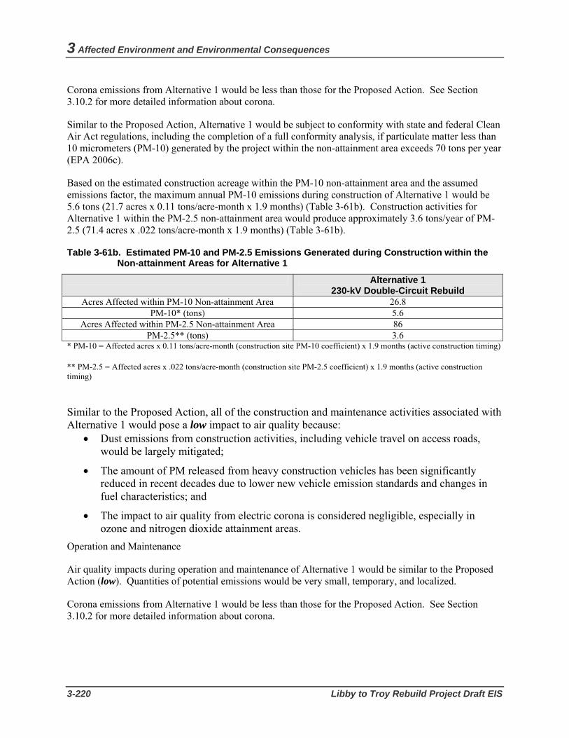
3 Affected Environment and Environmental Consequences
3-220 Libby to Troy Rebuild Project Draft EIS
Corona emissions from Alternative 1 would be less than those for the Proposed Action. See Section 3.10.2 for more detailed information about corona.
Similar to the Proposed Action, Alternative 1 would be subject to conformity with state and federal Clean Air Act regulations, including the completion of a full conformity analysis, if particulate matter less than 10 micrometers (PM-10) generated by the project within the non-attainment area exceeds 70 tons per year (EPA 2006c).
Based on the estimated construction acreage within the PM-10 non-attainment area and the assumed emissions factor, the maximum annual PM-10 emissions during construction of Alternative 1 would be 5.6 tons (21.7 acres x 0.11 tons/acre-month x 1.9 months) (Table 3-61b). Construction activities for Alternative 1 within the PM-2.5 non-attainment area would produce approximately 3.6 tons/year of PM-2.5 (71.4 acres x .022 tons/acre-month x 1.9 months) (Table 3-61b).
Table 3-61b. Estimated PM-10 and PM-2.5 Emissions Generated during Construction within the Non-attainment Areas for Alternative 1
Alternative 1 230-kV Double-Circuit Rebuild
Acres Affected within PM-10 Non-attainment Area 26.8 PM-10* (tons) 5.6
Acres Affected within PM-2.5 Non-attainment Area 86 PM-2.5** (tons) 3.6
* PM-10 = Affected acres x 0.11 tons/acre-month (construction site PM-10 coefficient) x 1.9 months (active construction timing)
** PM-2.5 = Affected acres x .022 tons/acre-month (construction site PM-2.5 coefficient) x 1.9 months (active construction timing)
Similar to the Proposed Action, all of the construction and maintenance activities associated with Alternative 1 would pose a low impact to air quality because:
• Dust emissions from construction activities, including vehicle travel on access roads, would be largely mitigated;
• The amount of PM released from heavy construction vehicles has been significantly reduced in recent decades due to lower new vehicle emission standards and changes in fuel characteristics; and
• The impact to air quality from electric corona is considered negligible, especially in ozone and nitrogen dioxide attainment areas.
Operation and Maintenance
Air quality impacts during operation and maintenance of Alternative 1 would be similar to the Proposed Action (low). Quantities of potential emissions would be very small, temporary, and localized.
Corona emissions from Alternative 1 would be less than those for the Proposed Action. See Section 3.10.2 for more detailed information about corona.
Air Quality
Bonneville Power Administration 3-221
Short Realignment Options Pipe Creek Realignment Similar to the Proposed Action, construction of the proposed Pipe Creek realignment option would affect air quality by construction and vegetation removal activities which create dust and use of heavy equipment which emits pollutants. Given the small area affected and short period of construction, the fugitive dust impacts from construction activities for this realignment option would be considered a low impact. Use of water would minimize construction generated dust (see Section 3.13.3 Mitigation).
All tall-growing vegetation on this realignment option would be cleared for new right-of-way. Merchantable timber would be removed using conventional logging practices. Leaving low-lying vegetation and shrubs would minimize the amount of potential fugitive dust both during and after construction activities.
It is estimated that construction activities within the PM-2.5 non-attainment area of the Pipe Creek realignment would produce approximately 0.6 tons/year of PM-2.5 at 115 kV and 0.7 tons/year of PM-2.5 at 230 kV resulting in a low impact. The Pipe Creek realignment is not within the non-attainment area for PM-10 so there would be no impact.
Quartz Creek Realignment Construction impacts on air quality from the proposed Quartz Creek realignment option would be largely the same as described for the proposed Pipe Creek realignment option. It is estimated that construction activities within the PM-2.5 non-attainment area of the Quartz Creek realignment would produce approximately 1.3 tons/year of PM-2.5 at 115 kV and 1.5 tons/year of PM-2.5 at 230 kV resulting in a low impact. The Quartz Creek realignment is not within the non-attainment area for PM-10; there would be no impact.
Kootenai River Crossing Realignment Construction impacts on air quality from the proposed Kootenai River crossing realignment option would be largely the same as described for the other two realignment options. The Kootenai River crossing realignment is not within either PM-10 or PM-2.5 non-attainment areas. There would be no impact to those non-attainment areas.
3.13.3 Mitigation BPA would apply for and comply with the applicable Montana State Air Quality Permit. BPA would also mitigate for dust during construction and follow all applicable local or federal requirements. Mitigation activities in the project area, and mitigation actions strictly applied in the non-attainment area, include the following:
• Use water trucks to control dust during construction operations.
• Ensure construction vehicles travel at low speeds on gravel roads and at the construction sites to minimize dust.
• Comply with Montana State tailpipe emission standards for all on-road vehicles.
• Use low sulfur fuel for all on-road diesel vehicles.
• Ensure all vehicle engines are in good operating condition to minimize exhaust emissions.

3 Affected Environment and Environmental Consequences
3-222 Libby to Troy Rebuild Project Draft EIS
• Lop, chip, and scatter wood debris on site to decay. No burning of wood debris will occur as a result of the proposed activities.
• Replant where needed, as soon as reasonably possible following construction activities.
• Use of vehicles will be limited if data collected at Montana’s DEQ Libby Air Quality Monitoring Site indicates that the air quality is in the “Unhealthy” health effect category. Vehicle miles traveled will be limited on unpaved roads to the extent possible and consultation with the Montana DEQ Air Program staff will occur.
3.13.4 Effects of the No Action Alternative Many of the existing wooden transmission structures are rotting, splitting, or damaged. Considering the environmental stresses, including the weight of snow and ice build-up during the winter, and the natural deterioration of the wooden poles, the threat of line failure and the risk of a falling electrical line starting a serious fire are distinct possibilities; in fact, it has already happened. The major air pollutants resulting from wildfires include particulate matter, carbon monoxide, volatile organics, and, to a lesser extent, nitrogen oxides. It can be anticipated that, depending on the size of a wildfire in the proposed project area, the pollutants from a fire could have a high impact on air quality and human health, particularly given the meteorological characteristics of the area and the amount of fuel in the surrounding forests. Other than potential wildfire effects, the dust and emissions from the existing transmission line and continuing maintenance activities would be low.

Cumulative Impacts
Bonneville Power Administration 3-223
3.14. Cumulative Impact Analysis This section describes the potential cumulative impacts of the Proposed Action. Cumulative impacts are the impacts on the environment which result from the incremental impact of the Proposed Action when added to other past, present, and reasonably foreseeable future actions, regardless of what agency (federal or non-federal) or person undertakes such other actions. Cumulative impacts can result from individually minor but collectively significant actions taking place over a period of time. (40 C.F.R. 1508.7.)
This section first describes existing development in the vicinity of the proposed project, as well as current and reasonably foreseeable future development planned for the area. Potential cumulative impacts then are analyzed and described. The past, present, and reasonably foreseeable future actions provide the context in which to assess the cumulative impacts of these actions in combination with the Proposed Action.
3.14.1 Cumulative Development The nature and extent of existing development due to past and present actions in the vicinity of the proposed project is largely described earlier in this chapter in the “Affected Environment” sections for each environmental resource. In addition to reconstruction of the existing transmission line, past actions that have adversely affected natural and human resources in the project area include logging activities on Federal, state, and private lands, highway and railroad construction, construction and operation of Libby Dam, and commercial and residential development. Reasonably foreseeable future actions include:
Kootenai National Forest:
• Kootenai River North Fuels Reduction Project includes treatment of hazardous fuels in the urban interface in the vicinity of Kootenai River Road, Quartz Creek Road, Pipe Creek Road, and Bobtail Creek Road. The total treatment area is about 2,573 acres, of which, 1,994 acres involve timber harvest and the remaining acres involve mechanical treatments such as slashing and chipping. Approximately 5.14 miles of temporary road construction is proposed to access potential units. As part of the project, fuel reduction is proposed in some old growth stands. These treatments would include hand fuels treatment (19 acres in designated old growth) or helicopter logging of understory ladder fuels (133 acres in undesignated old growth). No roads are proposed for these old growth units.
• Bobtail Ridge Fuel Reduction Project includes timber harvest treatments and burning. The project is located along Bobtail Ridge and northwest toward Quartz Creek Road.
Private Timber Lands:
• Plum Creek Timber Company intends to sell property located just west of the east leg of the Quartz Creek realignment, which potentially would be subdivided and developed.

3 Affected Environment and Environmental Consequences
3-224 Libby to Troy Rebuild Project Draft EIS
Lincoln County:
• Four subdivisions within or adjacent to Libby city limits are proposed. One is south of Libby, two are south of Highway 2 within city limits, and another is off Bull Lake Road north of the transmission line and south of Highway 2. The Shannon Flats Subdivision off Bull Lake Road consists of 20- to 30-acre parcels (T31N, R33W, Sec. 21). Although the existing transmission line does not go through the parcels, it does traverse the 34-acre remainder portion owned by Stimson Lumber Company.
Montana Department of Transportation:
• Widening and other road work on Highway 2 beginning at milepost 38, about six miles south of Libby.
• No new roads are proposed through 2008, but some maintenance activities such as paving and chipping could occur in the project area.
• Rock scaling along Highway 2, milepost 27 toward Libby from Kootenai Falls. Rock scaling includes chipping of rock from the hill slope above the highway to reduce slides. BPA’s existing and proposed Kootenai River crossings are at MPs 21 and 22 respectively.
U.S. Army Corps of Engineers and Bonneville Power Administration:
• In February 2006, the U.S. Fish and Wildlife Service (USFWS) issued its Biological Opinion (BiOp) regarding the effects of operations of Libby Dam on endangered Kootenai River white sturgeon and threatened bull trout. The BiOp recommends a series of performance-based actions for the Corps and BPA to implement, including a mixture of flow management, habitat improvements, and other activities to support these species. It provides for several possible flow regimes over the next 10 years, including the possibility of periodic flow releases of up to 10,000 cubic feet per second (cfs) to provide the desired attributes in the spawning area near Bonners Ferry, Idaho. In May 2006, the Corps issued a decision document that documents the Corps’ decision to follow the provisions of the USFWS BiOp for Libby Dam operations. BPA issued a similar decision document in November 2006.
3.14.2 Cumulative Impacts The Proposed Action, in combination with past, present, and reasonably foreseeable actions, could potentially result in cumulative impacts to the natural, physical, and socioeconomic resources described in Section 3.1 through 3.13 of this EIS. The following analysis describes these potential cumulative impacts, in the order that the resources are presented in Section 3.1 through 3.13 of this EIS.
Geology, Soils, and Water Resources Past and present the cumulative actions in the project vicinity have adversely affected soils, water quality, and water quantity through soil disturbance, increased erosion, and sedimentation transport to project vicinity streams . Reasonably foreseeable future projects likely would result in additional impacts on soils and water quality and quantity such as reduced soil productivity, compaction, rutting, and erosion. The major cumulative impacts to streams in the project area would continue to be from forest management and grazing. Impacts from forest management will continue as the Kootenai National Forest, Plum Creek Timber Co. and other private landowners remove timber and prepare lands for development. However, improvements to streams, and thereby fish habitat, will be made as vegetation recovers, as stream enhancement projects are implemented (such as an ongoing project on Pipe Creek),

Cumulative Impacts
Bonneville Power Administration 3-225
and as stream barriers are removed. Grazing on private lands probably will continue, but projects like the ongoing Bobtail Watershed Group’s streams restoration will cumulatively improve conditions in grazed areas. The Proposed Action would add an insignificant impact to the cumulative soil and water changes that have been and will continue to be caused by other development.
Land Use Land use in the project vicinity has incrementally changed due to past and present development, and this trend would be expected to continue with the cumulative future development identified in Section 3.14.1. Because the Proposed Action would rebuild an existing transmission line in an already existing transmission line corridor, the Proposed Action would not contribute to cumulative land use impacts. If the realignment options were chosen, development of the Proposed Action would contribute incrementally, though in a relatively minor way, to potential cumulative land use impacts.
Vegetation Past and present land development and timber harvest have resulted in a cumulatively significant change in the composition of vegetation in the project area. Reasonably foreseeable future actions, such as ongoing subdivision development, timber harvest, and use of ORVs, would continue this trend. By removing additional trees and other vegetation along the existing and already cleared transmission line right-of-way, development of the Proposed Action would contribute incrementally, though in a relatively minor way, to these cumulative impacts.
The Proposed Action, in combination with other reasonably foreseeable Forest Service, State and private activities, would maintain the designated management level of old growth. The Kootenai National Forest is currently in the process of delineating an additional 277 acres within the Sheep PSU to meet the Forest Plan direction of 10percent per PSU.
Past and present activities in the project vicinity have led to a cumulatively significant spread of noxious weeds in the vicinity, and noxious weed spread could continue with reasonably foreseeable future actions. Although mitigation measures have been identified to minimize the spread of noxious weeds by the Proposed Action, it is likely that noxious weed impacts would nonetheless still occur under the Proposed Action. The Proposed Action thus would contribute incrementally, though in a relatively minor way, to this cumulative impact.
Wetlands and Floodplains Incremental losses and degradation of wetlands over time have cumulatively depleted wetland resources in the United States. In the project area, some wetlands likely were previously impacted by construction of the existing line from access road construction and placement of structures in wetlands, agricultural activities, and past timber harvest. The reasonably foreseeable future actions may also affect wetlands in the project vicinity, but it is expected that these future projects would be required to avoid, minimize, and compensate for any potential impacts to wetlands from filling or other activities as part of project Section 404 permitting requirements. Accordingly, it is expected that the current approximate acreage of wetlands and mix of wetland function and values would be maintained. Therefore, the proposed transmission project would not be expected to significantly contribute to cumulative impacts to wetlands.
Lincoln County has a floodplain development ordinance that requires private property owners to file for and obtain a permit before constructing any building within a designated 100-year floodplain. The extent to which cumulative development may impact floodplain function is unknown, but is expected to be low

3 Affected Environment and Environmental Consequences
3-226 Libby to Troy Rebuild Project Draft EIS
because all private land within floodplains crossed by the transmission line has already been developed. Although project construction would occur in floodplains, both Pipe and Bobtail creeks are channelized, which prevents water from reaching the structure sites. Libby Dam management of the Kootenai River level prevents water from reaching the proposed structure located west of structure 25/1. Therefore, the cumulative impact of the Proposed Action and other cumulative projects on floodplains would be low.
Wildlife Past and present development and other activities have had a cumulative adverse impact on wildlife species and their habitat in the project vicinity. The clearing and conversion of land for urban development, home sites, utility infrastructure (such as the existing transmission line corridor), and other uses since approximately the 19th century has resulted in the cumulative loss of wildlife habitat. Wildlife habitat also has been cumulatively modified through activities such as logging and farming, which have altered and fragmented habitat. This habitat loss and modification has resulted in the displacement of wildlife species. Wildlife species also have been directly affected by hunting and trapping activities, as well as incidental harm and killing from other human activities in the area. Reasonably foreseeable future actions involving development would be expected to incrementally add to these cumulative impacts.
The Proposed Action would impact wildlife habitat by removing additional trees and other vegetation along the existing and already cleared transmission line right-of-way. The Proposed Action thus would contribute incrementally, though in a relatively minor way, to the cumulative impact on wildlife habitat. The Proposed Action also could contribute to cumulative impacts to grizzly bears, bald eagles, and other special status species, although only slightly and for a short time during construction of the Proposed Action. In addition, mitigation measures are proposed in Section 3.5 Wildlife that would avoid the Proposed Action’s contribution to cumulative impacts to these species if implemented.
Fish, Amphibians, and Reptiles Cumulative impacts to fish, amphibians, and reptiles in the project area include past and current effects of increased peak flows and input of fine sediments to the watershed from large wildfires, past timber harvest, road-building activities, grazing, operation of Libby Dam, and natural events. These activities and many other reasonably foreseeable future actions would be expected to continue to affect fish habitat and populations. However, implementation of Plum Creek Timber’s Habitat Conservation Plan (HCP), the Inland Native Fish Strategy (INFS), flow regimes proposed for Libby Dam, and U.S. Forest Service BMPs would be expected to generally maintain the existing level of cumulative effects on fish, amphibians, and reptiles, and may even reduce these cumulative impacts as habitat conditions improve due to these cumulative actions. The Proposed Action would result in only small localized impacts to streams in the project area primarily during the project’s construction period. The Proposed Action thus would contribute only slightly and for a short time to cumulative impacts on fish, amphibians, and reptiles in the project vicinity.
Visual Resources While much of the project vicinity remains undeveloped, past and present development and activities have changed the visual landscape in the immediate project vicinity by introducing manmade features and altering natural forms. These features include urbanized uses in the Cities of Libby and Troy, rural residential uses scatted throughout the project vicinity, and project area roads and utility infrastructure (such as the existing transmission line corridor). Areas cleared for timber harvest and agriculture also have changed the visual quality in some areas within the project vicinity. Reasonably foreseeable future actions involving development would be expected to continue this trend.

Cumulative Impacts
Bonneville Power Administration 3-227
Additional right-of-way and road clearing for the Proposed Action would make the existing transmission line corridor more visible and open due to the removal of vegetation. Over time, the growth of vegetation in some of the cleared areas would help these areas better blend in with the surrounding landscape. However, areas directly under the line would need to continue to be maintained to prevent tall-growing vegetation, and BPA’s vegetation management activities for the transmission line corridor would continue to affect the area’s visual character. The Proposed Action thus would contribute incrementally, though in a relatively minor way, to this cumulative impact.
Cultural Resources Cultural resources in the project vicinity have been and are being affected because of past, present, and current development and activities. These cumulative impacts include disturbance of cultural sites, reduction of the cultural integrity of certain sites, and removal of cultural artifacts. Because the Proposed Action would impact prehistoric and historic sites, as well as certain TCPs identified by the Confederated Salish and Kootenai Tribes, the Proposed Action would contribute incrementally to these cumulative impacts, In addition, there is the potential for the Proposed Action to impact previously undiscovered cultural resources or artifacts. Mitigation measures are identified in Section 3.8 Cultural Resources to lessen or avoid the potential for this impact. However, if the Proposed Action does impact previously undiscovered cultural resources or artifacts, it also would contribute incrementally to the adverse cumulative impact to cultural resources in the area.
Recreational Resources Past and present actions in the proposed vicinity have cumulatively had both a positive and negative effect on recreational resources. While these actions have increased recreational access and opportunities in the vicinity, some actions such as timber harvest and the introduction of human uses and development in otherwise natural areas can be viewed as having diminished the recreational experience for some users.
The availability and management of roads has been a major factor affecting the setting indicators in the USFS Recreation Opportunity Spectrum. Before 1950, very few roads had been developed in the project vicinity, which kept social encounters and visitor impacts low, and remoteness and naturalness were high. Visitor management was nonexistent and there were few facilities that were built specifically for recreation. During this time, the public generally used the vast network of fire suppression trails maintained by the Forest Service for accessing recreational opportunities in the project vicinity.
With the advent of expanded timber harvest by the Forest Service and timber companies and the accompanying development of roads, motorized recreation access in the project vicinity increased, as did social encounters and visitor impacts such as the spread of noxious weeds and litter, while remoteness and naturalness decreased. From 1990 to present, tree harvest has been reduced and has used smaller unit sizes and irregular shapes. Few new timber harvest roads have been constructed and other methods to access timber such as helicopter use have been employed. Recreation settings have shown a slight movement to the more primitive side of the spectrum with road closures and revegetation of harvest areas. However, despite road closures and increased visitor management, the number of visitor-created trails from ORV use is expected to increase in the Kootenai River recreation corridor.
Reasonably foreseeable future actions and ongoing management activities would have impacts, both positive and negative, that would contribute to cumulative impacts on recreation resources. The Forest Service’s Kootenai River North Fuels Reduction and Pipestone Projects, which include tree harvest, prescribed fire, and road restoration, over the long term could have largely positive effects on non-motorized recreation settings and activities adjacent to the Kootenai River recreation corridor, although

3 Affected Environment and Environmental Consequences
3-228 Libby to Troy Rebuild Project Draft EIS
prescribed burning could have negative short-term effects on nearby recreational users and residents. The proposed Forest Service fuels treatment on Bobtail Ridge would enhance hunting in the long term by providing greater sight distances and easier cross country travel, but also could negatively affect recreational users from smoke and noise in the short term. It is expected that the proposed sale by Plum Creek Timber Company of its parcel near the proposed Quartz Creek realignment would result in this parcel being subdivided, which would reduce public access to open space for a variety of recreation activities. Finally, changes in Libby Dam operation by the Corps in compliance with the 2006 USWFS Biological Opinion would have a profound influence on the Kootenai River through the recreation corridor and on fish populations and recreation fishing. Although these changes may improve conditions for white sturgeon and bull trout, the occasional high flows from discharges at Libby Dam associated with these changes may adversely affect large trout retention in the recreation corridor, based on previous experience with similar high flows.
The Proposed Action would be expected to have low impacts to recreational uses and the Recreation Opportunity Spectrum. Thus, the Proposed Action would contribute incrementally, though in a relatively minor way, to cumulative impacts to recreation.
Noise, Public Health and Safety Implementation of past and present actions in the project vicinity has generally not result in lasting noise effects, and the project vicinity continues to enjoy relatively low noise levels on a continual basis. Cumulative noise impacts in the project vicinity typically occur when noise receptors are exposed to noise from sources at approximately the same time, such as from vehicles, logging, and train noise. For the reasonably foreseeable future actions, there could be cumulative noise impacts if these actions are undertaken simultaneously and in relative close relation to each other. However, it is expected that these actions would not result in cumulative noise impacts due to temporal or spatial separation.
Construction noise from the proposed project would temporarily add to noise from other activities in the area, such as logging and traffic on local roads and Highway 2. Once the line is rebuilt, however, corona-generated noise would be less than the existing line, thus slightly reducing cumulative noise impacts near the project.
The proposed project would contribute a small increase in the overall risk of fire and injury to the public that could occur during construction and operation/maintenance.
The Proposed Action, Alternative 1, and the realignment options would not cumulatively increase the overall level of EMF exposure along the corridor. The Proposed Action would have similar EMF levels to those of the existing line and Alternative 1 would reduce EMF levels within the corridor. The realignment options would have EMF levels similar to the Proposed Action or Alternative 1 depending on the voltage chosen; however, all three realignments are primarily located on public lands rather than near residential areas so potential impacts to residents would be low. There are no known plans to construct additional transmission lines in the project area so cumulative levels of EMF would not increase above the existing levels.
Social and Economic Resources Population in Lincoln County is projected to grow by about 5 percent by 2025 (Montana Department of Commerce 2005b). Because the Proposed Action would not be expected to result in any changes in population, the Proposed Action would not contribute to cumulative population levels. In addition,

Cumulative Impacts
Bonneville Power Administration 3-229
because the Proposed Action would not be expected to disproportionately affect any low-income populations, it would not cumulatively contribute to any such impacts.
While the action alternatives, realignment options and other cumulative actions would increase the number of construction workers in the project vicinity, there appears to sufficient vacant rental dwellings and available temporary housing, hotel/motel, camping, and RV units in the Libby-Troy area to accommodate the potentially overlapping construction schedule of the proposed project and some possible concurrent cumulative actions such as residential construction in Libby and near Troy and Montana DOT road work
The proposed project would not be expected to cause significant demands on public services or facilities. During construction, public services such as police, fire, and medical facilities, would be needed only in cases of emergency. During operations, the potential for public services impacts would be even further reduced due to the infrequency of project-related maintenance activities. Thus the proposed project would not be expected to contribute to cumulative impacts to public services.
During construction, the Proposed Action may contribute incrementally to a positive cumulative impact on the economy of the local community by providing additional employment and increased need for goods and services. Employment projections developed by Montana State University (2005) suggest that total employment in Lincoln County will increase from about 8,900 in 2005 to 12,000 by 2025, with employment in the construction sector decreasing from 550 jobs to about 480 jobs. Total construction employment under the Proposed Action would be approximately 40 FTE jobs, with local residents expected to be employed for approximately 10 of these jobs. During operation, the Proposed Action would not contribute to cumulative employment levels because the Proposed Action would not be expected to create any long-term employment positions.
Transportation Past and present cumulative actions have resulted in the development of numerous roads in the project vicinity, including highways, rural roads, other paved and graveled roads, and unimproved access roads. The existing transmission lines and access roads have been in the corridor for over 50 years, and the existing access roads have been used primarily for maintaining the lines and by several private landowners. Some public recreational use of access roads has also occurred on roads and line segments. Reasonably foreseeable future actions may result in the development of additional roads in the project vicinity. In addition, some of these future actions would likely increase localized vehicle traffic on existing project area roadways.
Because the Proposed Action would develop additional access roads, the Proposed Action would contribute to cumulative road development in the project vicinity. The Proposed Action also would contribute incrementally, though in a relatively minor way, to cumulative traffic levels on existing project area roadways during construction of the Proposed Action.
Air Quality Agricultural activities, logging activities, and residential wood burning cumulatively affect air quality year-round in the region. Occasional wildfires on forested lands also result in emissions that can significantly contribute to cumulative air quality impacts in the region. However, the area continues to enjoy relatively excellent air quality, with the exception of some occasional degradation of air quality due to cumulative particulate matter (PM) emissions and concentrations (see Section 3.13 Air Quality). Reasonably foreseeable future actions that may contribute to cumulative impacts to air quality include

3 Affected Environment and Environmental Consequences
3-230 Libby to Troy Rebuild Project Draft EIS
Montana Department of Transportation road work that is scheduled for approximately six miles south of Libby in 2007-2008, as well as the Forest Service’s Kootenai River North and Bobtail Ridge fuels reduction projects in 2007 - 2008. These projects would emit PM through controlled burns and dust generation from vegetation removal.
Air emissions from the Proposed Action would occur during project construction from construction and vegetation removal activities, as well as use of vehicles and heavy equipment. These emissions would result in a minor and short-term contribution to cumulative impacts on air quality from pollutants generated by agricultural uses, logging, forest management, and other sources in the region. During construction, the Proposed Action also would contribute incrementally, though in a relatively minor way, to cumulative impacts related to PM emissions.

Bonneville Power Administration 3-231
3.15. Relationship Between Short-term Uses of the Environment and Long-term Productivity
The Proposed Action would not pose impacts that would significantly alter the long-term productivity of the affected environment. A good example of this is the existing line. This line was built in the 1950s. Soils within the affected environment have largely recovered since then; while there is never complete recovery, long-term productivity of the affected environment has not been significantly altered because revegetation continues to occur. Although the cleared corridor eliminates the ability of the land to support timber resources or other tall-growing vegetation, most of the impact to that productivity occurred when the line was originally built, and would not change significantly with the small amount of clearing that would be required for the proposed rebuild or realignments. Likewise, if the proposed line was removed and the affected areas restored, little change in the long-term environmental productivity would occur, except for the acres of corridor that might be returned to timber production.
The Proposed Action would involve improvements to the existing Libby to Troy section of the Libby to Bonners Ferry transmission line. These improvements are expected to serve the area for the foreseeable future and may be considered a long-term use of the land. There would be no tradeoff of long-term productivity at the expense of short-term use.
3.16. Irreversible and Irretrievable Commitment of Resources
Irreversible commitments of resources occur when a non-renewable resource such as minerals or petroleum-based fuels is used for the construction or operation of a Proposed Action. An irretrievable commitment of resources occurs when a federal agency gives up all rights or protections for a particular resource that it has ownership of or jurisdiction over, whether it be land, trees, water, animal or plant species, or some other resource.
The Proposed Action would consume aluminum, steel, other metals, wood, gravel, sand, plastics, and various forms of petroleum products in rebuilding the transmission line and developing and improving access roads. Most of these materials are not renewable and could potentially be an irreversible commitment of resources if not recycled (metals and glass) or reused (sand and gravel) at the end of the life of the project.
The Proposed Action would involve the continued use of land for a transmission line and related facilities. The commitment of the transmission right-of-way to this use occurred in the 1950s. While the existing right-of-way would be widened and possibly realigned in places, the foregone use of these small areas would not be considered a substantial commitment of additional resources. Ultimately at some point in the future if it is determined the transmission line is no longer needed, this line could be fully removed and the area returned to its natural state.
Under the Proposed Action, BPA would continue to retain its right to the transmission line right-of-way, and the Forest Service would retain jurisdiction over portions of the corridor located on Forest lands. The Proposed Action thus would not result in an irretrievable commitment of resources.

3 Affected Environment and Environmental Consequences
3-232 Libby to Troy Rebuild Project Draft EIS
3.17. Adverse Effects that Cannot be Avoided Implementation of the Proposed Action would result in some adverse impacts that cannot be fully avoided even with implementation of mitigation measures. Most of these impacts would occur during the construction phase of the Proposed Action and thus would be temporary. Adverse effects that cannot be avoided by the Proposed Action include the following:
• Short-term soil compaction, erosion, vegetation degradation, and stream sedimentation from construction and maintenance.
• Short-term wetland buffer vegetation and soil disturbance from construction and maintenance equipment.
• Short-term disturbance to and displacement of some species of wildlife.
• Short-term disturbance to nearby residents during construction.
• Short-term displacement of recreational users from access to parts of Bighorn Trail.
• Short-term delays to traffic in some areas during construction.
• Short-term, minor reductions in air quality from fugitive dust during construction.
• Long-term soil compaction and minor reduced soil productivity under new structures and on roadbeds.
• Long-term wetland buffer fill and encroachment on floodplains from new structures or access road work.
• Long-term removal of tall-growing vegetation and danger trees from the transmission line corridor.
• Long-term disturbance to cultural resources from structure replacement or access road work.
Alternative 1 would result in similar unavoidable adverse effects as the Proposed Action, with the following differences:
• Long-term removal of tall-growing vegetation to widen the transmission line corridor to 100 feet.
• Long-term changes in the viewing sensitivity along the corridor from larger, taller steel structures.
The three realignment options also would result in similar unavoidable adverse effects as the Proposed Action, with the following differences:
• Pipe Creek realignment option would include; long-term removal of tall-growing vegetation within the new right-of-way and riparian areas of Pipe and Bobtail creeks; long-term removal or disturbance of habitat within the Pipe Creek bald eagle nest Management Zones I and II; long-term removal of old growth; and long-term visual impacts to the private land crossed by the realignment.
• Quartz Creek realignment option would include: long-term removal of tall-growing vegetation within the new right-of-way; potentially greater hazard to low flying aircraft through the Quartz creek drainage; short-term disturbance to habitat within the grizzly bear recovery zones; long-term removal or disturbance of habitat within the Quartz Creek bald eagle nest Management Zones I and II; and long-term removal of old growth.
• The Kootenai River Crossing realignment option would include: potentially greater hazard to low flying aircraft within the Kootenai River corridor; long-term impacts to known cultural sites along the
Bonneville Power Administration 3-233
Kootenai River; long-term impacts to visual resources within the Kootenai River corridor; long-term removal of tall-growing vegetation within the new right-of-way; short-term disturbance to habitat within the grizzly bear recovery zones; and long-term removal or disturbance of habitat within the Kootenai Falls bald eagle nest Management Zones I and II.
Under the No Action alternative, although many of the potential impacts of the Proposed Action would not occur, the existing transmission line would continue to remain in place. Adverse effects to some landowners who find the line’s presence annoying and who are concerned about public use of access roads thus would not be avoided. In addition, impacts related to the need for ongoing repairs and maintenance of the existing line, such as soil disturbance, noise, and vegetation removal, would be unavoidable, as would an increased risk to health and safety from line failure. Given the deteriorating state of the transmission line, additional unavoidable impacts from emergency repairs and access under the No Action alternative likely would include additional disturbance of vegetation and soils, potential sedimentation effects, and wildlife disruption.
3.18. Intentional Destructive Acts Intentional destructive acts, that is, acts of sabotage, terrorism, vandalism, and theft sometimes occur at power utility facilities. Vandalism and thefts are most common, and recent increases in the prices of metal and other materials have accelerated thefts and destruction of federal, state and local utility property. BPA has seen a significant increase in metal theft from its facilities over the past several months due in large part to the high price of metals on the salvage market. There were more than 50 burglaries at BPA substations in 2006. The conservative estimate of damages for these crimes is $150,000, but the actual amount is likely much higher since this number does not factor in all the labor-related costs associated with repairing the damage.
The impacts from vandalism and theft, though expensive, do not generally cause a disruption of service to the area. Stealing equipment from electrical substations, however, can be extremely dangerous. In fact, nationwide, many would-be thieves have been electrocuted while attempting to steal equipment from energized facilities. On Oct. 11, 2006, a man in La Center, Washington, was electrocuted while apparently attempting to steal copper from an electrical substation.
Federal and other utilities use physical deterrents such as fencing, cameras, and warning signs to help prevent theft, vandalism and unauthorized access to facilities. In addition, through its Crime Witness Program, BPA offers up to $25,000 for information that leads to the arrest and conviction of individuals committing crimes against BPA facilities. Anyone having such information can call BPA’s Crime Witness Hotline at (800) 437-2744. The line is confidential, and rewards are issued in such a way that the caller’s identity remains confidential.
Acts of sabotage or terrorism on electrical facilities in the Pacific Northwest are rare, though some have occurred. These acts generally focused on attempts to destroy large transmission line steel towers. For example, in 1999, a large transmission line steel tower in Bend, Oregon was toppled.
Depending on the size and voltage of the line, destroying towers or other equipment could cause electrical service to be disrupted to utility customers and end users. The effects of these acts would be as varied as those from the occasional sudden storm, accident or blackout and would depend on the particular configuration of the transmission system in the area. While in some situations these acts would have no noticeable effect on electrical service, in other situations, service could be disrupted in the local area, or if the damaged equipment was part of the main transmission system, a much larger area could be left without power.

3 Affected Environment and Environmental Consequences
3-234 Libby to Troy Rebuild Project Draft EIS
When a loss of electricity occurs, all services provided by electrical energy cease. Illumination is lost. Lighting used by residential, commercial, industrial and municipal customers for safe movement and security is affected. Residential consumers lose heat. Electricity for cooking and refrigeration is also lost, so residential, commercial, and industrial customers cannot prepare or preserve food and perishables. Residential, commercial, and industrial customers experience comfort/safety and temperature impacts, increases in smoke and pollen, and changes in humidity, due to loss of ventilation. Mechanical drives stop, causing impacts as elevators, food preparation machines, and appliances for cleaning, hygiene, and grooming are unavailable to residential customers. Commercial and industrial customers also lose service for elevators, food preparation, cleaning, office equipment, heavy equipment, and fuel pumps.
In addition, roadways experience gridlock where traffic signals fail to operate. Mass transit that depends on electricity, such as light rail systems, can be impacted. Sewage transportation and treatment can be disrupted.
A special problem is the loss of industrial continuous process heat. Electricity loss also affects alarm systems, communication systems, cash registers, and equipment for fire and police departments. Loss of power to hospitals and people on life-support systems can be life-threatening.
Overhead transmission conductors and the structures that carry them are mostly on unfenced utility rights-of-way. The conductors use the air as insulation. The structures and tension between conductors make sure they are high enough above ground to meet safety standards. Structures are constructed on footings in the ground and are difficult to dislodge.
While the likelihood for sabotage or terrorist acts on the Proposed Action or alternatives is difficult to predict given the characteristics of the project, it is unlikely that such acts would occur. If such an act did occur, it could have a significant impact on the transmission system or electrical service because the Libby-Troy transmission line is an integral part of BPA’s transmission system; however, any impacts from sabotage or terrorist acts likely could be quickly isolated. The Department of Energy, public and private utilities, and energy resource developers include the security measures mentioned above and others to help prevent such acts and to respond quickly if human or natural disasters occur.

Bonneville Power Administration 4-1
CHAPTER 4 Environmental Consultation, Review, and Permit Requirements This chapter addresses federal statutes, implementing regulations, and Executive Orders requiring consultation, review, and/or permits or approvals, and discusses the applicability of these requirements to the proposed project. This Draft EIS is being sent to tribes, federal agencies, and state and local governments as part of the consultation process for this project.
4.1 National Environmental Policy Act This Draft EIS was prepared by BPA pursuant to regulations implementing the National Environmental Policy Act (NEPA) (42 USC 4321 et seq.), which requires federal agencies to assess, consider, and disclose the impacts that their actions may have on the environment. BPA will consider the project’s potential environmental consequences and comments from agencies, tribes, and the public when making decisions regarding the proposed project.
4.2 Endangered Species Act The Endangered Species Act (ESA) of 1973 (16 USC 1536) as amended in 1988, establishes a national program for the conservation of threatened and endangered species of fish, wildlife and plants, and the preservation of the ecosystems on which they depend. The ESA is administered by the U.S. Fish and Wildlife Service (USFWS) for wildlife and freshwater species, and by NOAA Fisheries Service (NOAA Fisheries) for marine and anadromous species. The ESA defines procedures for listing species, designating critical habitat for listed species, and preparing recovery plans. It also specifies prohibited actions and exceptions.
Section 7 of the ESA requires federal agencies to ensure that the actions they authorize, fund, and carry out do not jeopardize endangered or threatened species or their critical habitats. A federal agency also is required to consult with USFWS and/or NOAA Fisheries if it is proposing an action that may affect listed species or their designated critical habitat. If listed species or designated critical habitat are present and could be affected by the Proposed Action, Section 7 requires that the federal agency prepare a biological assessment (BA) to analyze the potential effects of the action on listed species and critical habitat and make an effect determination for each species. USFWS and/or NOAA Fisheries review the BA and, if they conclude that the action may adversely affect a listed species or their habitat, issue a biological opinion, which includes a take statement and a list of reasonable and prudent alternatives to follow during construction. If USFWS and/or NOAA Fisheries find that the project may affect, but is not likely to adversely affect a listed species or their habitat, they will issue a letter of concurrence.
In a letter to the USFWS dated May 31, 2005, BPA requested a list of the threatened and endangered fish and wildlife species occurring within the vicinity of the proposed project. The USFWS identified nine species (Kootenai River population of white sturgeon, gray wolf, bald eagle, grizzly bear, Canada lynx, bull trout, Spalding’s campion, water howellia, and slender moonwort) as potentially occurring within the project vicinity (letter from R. Mark Wilson, June 22, 2005; see Appendix C -ESA-letter). No species administered by the NOAA Fisheries occur in the project corridor or in the vicinity of the corridor.

4 Environmental Consultation, Review, and Permit Requirements
4-2 Libby to Troy Rebuild Project Draft EIS
Field surveys of the project corridor were conducted during the summers of 2005 and 2006. The potential for occurrences of threatened and endangered plant, animal, and fish species and their habitat and potential impacts to these species from the proposed project are discussed in Sections 3.3 Vegetation, 3.5 Wildlife, and 3.6 Fish, Amphibians, and Reptiles of this EIS.
Two informational consultation meetings with USFWS and Kootenai National Forest biologists were held on October 19, 2006, and February 21, 2007. Consultation with USFWS has focused primarily on potential impacts to grizzly bear recovery zone and bald eagle habitat and possible mitigation measures to minimize impacts. Also of importance is project compliance with USFWS’ 1995 amended biological opinion regarding impacts to grizzly bear habitat on the Kootenai National Forest. In addition to the meetings, further consultation was conducted through phone conversations with USFWS specifically regarding bald eagle and grizzly bear habitat mitigation. A BA is being prepared for the proposed project and will be submitted to the USFWS.
4.3 Fish and Wildlife Conservation Act and Fish and Wildlife Coordination Act
The Fish and Wildlife Conservation Act of 1980 (16 USC 2901 et seq.) encourages federal agencies to conserve and promote conservation of non-game fish and wildlife species and their habitats. In addition, the Fish and Wildlife Coordination Act (16 USC 661 et seq.) requires federal agencies undertaking projects affecting water resources to consult with the USFWS and the state agency responsible for fish and wildlife resources.
As described in Section 4.2, BPA is in the process of consulting with the USFWS concerning fish and wildlife resources that could be affected by the proposed project. In addition, BPA has consulted with Montana Fish, Wildlife and Parks (MFWP) and has incorporated recommendations to avoid and minimize potential impacts to fish and wildlife resources. Mitigation designed to avoid and minimize impacts to fish and wildlife and their habitat is identified in Sections 3.5 Wildlife, and 3.6 Fish, Amphibians, and Reptiles of this EIS.
4.4 Magnuson-Stevens Fishery Conservation and Management Act
NOAA Fisheries is responsible for ensuring compliance with the Magnuson-Stevens Fishery Conservation and Management Act of 1976 (Magnuson-Stevens Act). In the exclusive economic zone (EEZ), except as provided in Section 102, the United States claims, and will exercise, sovereign rights and exclusive fishery management authority over all fish and all continental shelf fishery resources. Beyond the EEZ, the United States claims and will exercise exclusive fishery management authority over all anadromous species throughout the migratory range of each such species, except when in a foreign nation’s waters, and all continental shelf fishery resources.
Public Law 104-297, the Sustainable Fisheries Act of 1996, amended the Magnuson-Stevens Act to establish requirements for Essential Fish Habitat (EFH) descriptions in federal fishery management plans, and to require federal agencies to consult with NOAA Fisheries on activities that may adversely affect EFH. EFH can include all streams, lakes, ponds, wetlands, and other viable water bodies and most of the habitat historically accessible to salmon. Activities above impassible barriers are subject to consultation provisions of the Magnuson-Stevens Act.

Bonneville Power Administration 4-3
No species administered under the amended Magnuson-Stevens Act occur in the vicinity of the proposed project. No salmon are present in the Kootenai River.
4.5 Migratory Bird Treaty Act The Migratory Bird Treaty Act implements various treaties and conventions between the United States and other countries, including Canada, Japan, Mexico, and the former Soviet Union, for the protection of migratory birds (16 U.S.C. 703-712, July 3, 1918, as amended 1936, 1960, 1968, 1969, 1974, 1978, 1986, and 1989). Under the act, taking, killing, or possessing migratory birds or the eggs or nests is unlawful. Most species of birds are classified as migratory under the Act, except for upland and nonnative birds such as pheasant, chukar, gray partridge, house sparrow, European starling, and rock dove.
Potential impacts to migratory birds as a result of the proposed project are discussed in the Section 3.5 Wildlife of this EIS. Although the proposed project would not be expected to result in a take or killing of migratory bird species within the meaning of the Act, impacts to migratory birds could occur through temporary disturbance during construction and removal of some potential nesting habitat. BPA would ensure appropriate mitigating measures are employed to minimize and avoid impacts to migratory birds.
4.6 Executive Order 13186, Responsibilities of Federal Agencies to Protect Migratory Birds
Executive Order 13186 was issued on January 17, 2001. It directs each federal agency that is taking actions that may negatively impact migratory bird populations to work with the USFWS to develop an agreement to conserve those birds. The protocols developed by this consultation are intended to guide future agency regulatory actions and policy decisions; renewal of permits, contracts, or other agreements; and the creation of or revisions to land management plans. This order also requires that the environmental analysis process include effects of federal actions on migratory birds. On August 3, 2006, the USFWS and the U.S. Department of Energy signed a Memorandum of Understanding (MOU) to complement the Executive Order. BPA, as part of the Department of Energy, will work cooperatively in accordance with the protocols of the MOU.
4.7 Bald Eagle Protection Act The Bald Eagle Protection Act of 1940 prohibits the taking or possessing of and commerce in bald and golden eagles, with limited exceptions (16 U.S.C. 668-668d, June 8, 1940, as amended 1959, 1962, 1972, and 1978). The Act only covers intentional acts or acts in “wanton disregard” of the safety of bald or golden eagles.
Potential occurrence of bald eagles in the project vicinity and potential impacts from the proposed project are discussed in Section 3.5 Wildlife of this EIS. Mitigation measures to avoid and minimize impacts to bald eagle are also identified. Because the project would not involve intentional acts or acts in wanton disregard of bald or golden eagles, this project is not considered to be subject to compliance with the Act.
4.8 National Forest Management Act The National Forest Management Act (NFMA), passed in 1976, requires the U.S. Forest Service to prepare Forest Plans and regulations to guide development in National Forests. The current Kootenai National Forest Plan was adopted by the Kootenai National Forest in 1987. Although the Kootenai

4 Environmental Consultation, Review, and Permit Requirements
4-4 Libby to Troy Rebuild Project Draft EIS
National Forest has initiated a process to revise the 1987 Forest Plan, this process has been indefinitely put on hold due to a recent court ruling that enjoined the Forest Service from implementing its 2005 Planning Rule, on which the planned Kootenai National Forest Plan revision, as well as plan amendments or revisions for several other national forests, were based (USFS 2007). The following describes provisions NFMA and the current Forest Plan that are applicable to the proposed project.
4.8.1 Plants and Animals Forest plans must “preserve and enhance the diversity of plant and animal communities…so that it is at least as great as that which can be expected in the natural forest” (36 CFR 219.27). Additional direction states that “management prescriptions, where appropriate and to the extent practicable, shall preserve and enhance the diversity of plant and animal communities, including endemic and desirable naturalized plant and animal species, so that it is at least as great as that which could be expected in a natural forest.” Furthermore, implementation regulations for the NFMA specify that “fish and wildlife habitat shall be managed to maintain viable populations of existing native and desired non-native vertebrate species in the planning area” (Federal Register, Vol. 47, No. 190 219.19). Sensitive species are managed under the authority of the NFMA and are administratively designated by the Regional Forester (FSM 2670.5).
Under the authority of the NMFA, Forest Service Manual (FSM 2670.45) directs that the Forest Supervisors shall:
1) Ensure that legal and biological requirements for the conservation of endangered, threatened, and proposed plants and animals are met in forest land and resource management planning, and ensure compliance with procedural and biological requirements for sensitive species.
2) Develop quantifiable recovery objectives and develop strategies to effect recovery of threatened and endangered species, and develop quantifiable objectives for managing populations and/or habitat for sensitive species.
3) Make recommendations to the Regional Forester for critical or essential habitat designation on National Forest System Lands.
4) Determine distribution, status, and trend of threatened, endangered, proposed, and sensitive species and their habitats on forest lands.
5) Coordinate forest programs with other federal agencies, states, and other groups and individuals concerned with the conservation of threatened, endangered, proposed, and sensitive species.
6) Ensure that consultation and conferencing requirements pursuant to Section 7 of the ESA, as amended are met in all forest programs and activities.
Potential occurrences of special status plant, animal, and fish species and their habitat and potential impacts to these species from the proposed project are discussed in Sections 3.3, Vegetation, 3.5 Wildlife, and 3.6 Fish, Amphibians, and Reptiles of this EIS. In cooperation with the Kootenai National Forest, BPA has incorporated recommendations to be consistent with NMFA and FMS provisions to avoid and minimize impacts to fish, wildlife, and plants under federal jurisdiction. Possible impacts of the action alternatives and short realignment options are discussed in Chapter 3 of the EIS. Mitigation measures designed to minimize impacts to fish, wildlife, plants, and their habitat are listed in Chapter 3.
4.8.2 Inventoried Roadless Areas The 1987 Forest Plan identifies areas that are considered to be inventoried roadless areas on the Kootenai National Forest. Inventoried roadless areas contain important environmental values that warrant

Bonneville Power Administration 4-5
protection, and are in general to be managed to preserve their roadless characteristics. Portions of the existing corridor are adjacent to inventoried roadless areas where road construction is not permitted.
4.8.3 Old Growth The 1987 Forest Plan designates old growth stands on the Kootenai National Forest, and additional old growth stands have been identified since the Plan was published. The current Forest-wide assessment (USDA Forest Service 2003c) shows that the Kootenai National Forest has 11 percent old growth designated. These old growth stands are considered to be within Management Area 13 of the 1987 Forest Plan, which provides direction on management activities within this area. Management Area 13 is classified as a corridor avoidance area, and written approval from the Forest Supervisor is required for activities within this area (Castenada 2004).
Potential impacts to old growth habitat from the proposed project are discussed in Section 3.3, Vegetation, of this EIS. All alternatives are consistent with Forest Plan direction to maintain a minimum of 10 percent old growth below 5,500 feet in elevation in each planning sub-unit, or a combination of sub-units (Kootenai Supplement No. 85, supplement to FSM 2432.22). After implementation of the action alternatives including project mitigation, the Pipestone PSU will have 10.3 percent designated old growth below 5,500 feet elevation, the Quartz PSU will have 28.8 percent designated old growth below 5,500 feet elevation, and the Sheep PSU will have a minimum of 10.0 percent designated old growth below 5,500 feet elevation.
Two of the proposed short realignment options – the Pipe Creek realignment and the Quartz Creek realignment – are located within areas considered to be within Management Area 13. If either or both of these realignment options are selected, written approval from the Forest Supervisor would be required to be consistent with Forest Plan direction. In addition, a Forest Plan amendment would be required if either or both of these realignments options are selected.
4.8.4 Weed Control Forest Service Manual (FSM) 2080.1 directs the National Forests to conform to the Federal
Noxious Weed Act of 1974, as amended. The Federal Noxious Weed Act, the Montana Noxious Weed Law and the Participating Agreement (PA) with Lincoln County require the Forest Service to treat noxious weeds on Forest Service lands. In addition, Forest Service Regional Supplement 2000-2001-1 requires that Best Management Practices (BMPs) be used and enforced.
Weed treatment in the area is independent of the alternative selected for this project. Those practices would in part help mitigate some of the potential negative effects from the spread of noxious weeds caused by the proposed project. Implementation of the mitigation measures described in Section 3.3 Vegetation of this EIS also would minimize or avoid potential impacts due to weeds. These actions would further the goal for noxious weed management as stated in the Forest Plan, and it thus is expected that the Proposed Action would be consistent with the PA and the Federal Noxious Weed Act.
4.9 Heritage Conservation Preserving cultural resources allows Americans to have an understanding and appreciation of their origins and history. A cultural resource is an object, structure, building, site or district that provides irreplaceable evidence of natural or human history of national, state or local significance. Cultural resources include National Landmarks, archeological sites, and properties listed (or eligible for listing) on the National Register of Historic Places. In addition, American Indian Tribes are afforded special rights under certain

4 Environmental Consultation, Review, and Permit Requirements
4-6 Libby to Troy Rebuild Project Draft EIS
laws, as well as the opportunity to voice concerns about issues under these laws when their aboriginal territory falls within a proposed project area. Laws and other directives for the management of cultural resources include:
Antiquities Act of 1906 (16 U.S.C. 431-433);
Historic Sites Act of 1935 (16 U.S.C. 461-467);
National Historic Preservation Act (NHPA) of 1966 (16 U.S.C. 470 et seq.), as amended, inclusive of Section 106;
Archaeological Data Preservation Act (ADPA) of 1974 (16 U.S.C. 469 a-c);
Archaeological Resources Protection Act (ARPA) of 1979 (16 U.S.C. 470 et seq.), as amended;
Native American Graves Protection and Repatriation Act (NAGPRA) (25 U.S.C. 3001 et seq.);
Executive Order 13007 Indian Sacred Sites; and
American Indian Religions Freedom Act of 1978 (PL 95-341, 92 Stat. 469, 42 U.S.C. 1996, 1996a).
Section 106 of the NHPA requires federal agencies to take into account the effects of their undertakings on historic properties, and afford the Advisory Council on Historic Preservation (ACHP) a reasonable opportunity to comment. Historic properties are properties that are included in the National Register of Historic Places or that meet the criteria for the National Register. If a federal agency plans to undertake a type of activity that could affect historic properties, it must consult with the appropriate State Historic Preservation Officer (SHPO) and/or Tribal Historic Preservation Officer (THPO) to make an assessment of adverse effects on identified historic properties. BPA’s 1996 government-to-government agreement with 13 federally-recognized Native American Tribes of the Columbia River basin provides guidance for the Section 106 consultation process with the Tribes.
The NHPA amendments specify that properties of traditional religious and cultural importance to a Native American Tribe (also known as Traditional Cultural Properties [TCPs]) may be determined to be eligible for inclusion on the National Register of Historic Places. In carrying out its responsibilities under Section 106, a federal agency is required to consult with any Native American Tribe that attaches religious or cultural significance to any such properties.
NAGPRA requires consultation with appropriate Native American Tribal authorities prior to the excavation of human remains or cultural items (including funerary objects, sacred objects, and cultural patrimony) on federal lands or for projects that receive federal funding. NAGPRA recognizes Native American ownership interests in some human remains and cultural items found on federal lands and makes illegal the sale or purchase of Native American human remains, whether or not they derive from federal or Indian land. Repatriation, on request, to the culturally affiliated tribe is required for human remains.
Executive Order 13007 addresses “Indian sacred sites” on federal and tribal land. “Sacred site” means any specific, discrete, narrowly delineated location on federal land that is identified by a Tribe, or a Tribal individual determined to be any appropriately authoritative representative of a Native American religion. The site is sacred by virtue of its established religious significance to, or ceremonial use by, a Native American religion, provided that the tribe or appropriately authoritative representative of an Indian religion has informed the agency of the existence of such a site. This order calls on agencies to do what they can to avoid physical damage to such sites, accommodate access to and ceremonial use of Tribal

Bonneville Power Administration 4-7
sacred sites, facilitate consultation with appropriate Native American Tribes and religious leaders, and expedite resolution of disputes relating to agency action on federal lands.
The American Indian Religious Freedom Act protects and preserves to American Indians their inherent right of freedom to believe, express, and exercise traditional religions. The Kootenai National Forest has identified the Confederated Salish and Kootenai Tribes (CSKT) of the Flathead Reservation and Kootenai Tribe of Idaho as having general concerns about the management of certain areas on Forest lands, including the project vicinity. These concerns include, but are not limited to, access to sites, use and possession of sacred objects, and the freedom to practice sacred worship ceremonies.
In addition to these various laws and directives, the federal government has general trust responsibilities to tribes under a government-to-government relationship to insure that their reserved rights are protected. The project vicinity is located within lands encompassed by the Hellgate Treaty of 1855, which was signed between the United States and the Flathead Indians, Upper Pend d’Oreilles Indians, and the Kootenai Tribes and Kootenai Tribe of Idaho. Within the area covered by this Treaty, the Tribes retained certain rights including fishing, hunting, gathering plants, erecting temporary buildings for the curing, and pasturing their horses and cattle. Ongoing consultation with the CSKT ensures that their rights are protected.
BPA has undertaken the Section 106 consultation process for this project with the Kootenai National Forest, the Montana SHPO, the ACHP, and the affected Native American tribes. The CSKT and the Kootenai Tribe of Idaho were consulted for this project. BPA and the Forest also are consulting with these Tribes under the other applicable laws and responsibilities described above. The CSKT also have prepared a TCP report for this project.
Throughout the EIS process, BPA has worked to involve and consult with Kootenai Tribe of Idaho and the CSKT. Representatives from both tribes participated in site trips conducted in 2002 and 2004 to provide advice and perspective in developing project alternatives. In 2005, BPA sent a letter to these tribes that outlined a process for initiating a formal government-to-government consultation process when or if desired. The tribes have not requested formal government-to-government consultation meetings to date. Both the CSKT and Kootenai Tribe of Idaho have expressed concerns pertaining to areas known to be sensitive within the project vicinity.
Construction and maintenance of the transmission line and related facilities could potentially affect historic properties and other cultural resources. A cultural resources survey of the corridor was conducted to determine if any cultural resources are present and would be impacted (see Section 3.8 Cultural Resources of this EIS). Several prehistoric and historic sites have been identified.
Through the design process, BPA will seek to avoid all known cultural resources sites. If some sites cannot be avoided, BPA will consult with federal and state agency landowners and the Montana SHPO to determine if those sites are eligible for a listing under the NRHP. If they are, then in consultation with the appropriate federal and state agency landowners, SHPO, and/or the CSKT THPO, effects will be evaluated and appropriate mitigation applied.
If, during construction, previously unidentified cultural resources that would be adversely affected by the proposed project are found, BPA would follow all required procedures set forth in the NHPA, NAGPRA, ARPA, and the American Indian Religious Freedom Act.

4 Environmental Consultation, Review, and Permit Requirements
4-8 Libby to Troy Rebuild Project Draft EIS
4.10 State, Area-wide, and Local Plan and Program Consistency
The proposed project would be constructed and owned by BPA, which is a federal agency. Pursuant to the supremacy clause of the U.S. Constitution, the federal government has not waived federal supremacy in the area of land use planning. However, BPA is committed to plan the project to be consistent or compatible to the extent practicable with state and local land use plans and programs and would provide the local jurisdictions with information relevant to any permits. In addition, BPA would strive to meet or exceed the substantive standards and policies of state and local regulations, and would enter into appropriate agreements with local jurisdictions concerning road crossings and approaches to ensure safety and compatibility..
4.10.1 Montana Major Facility Siting Act The Montana Major Facility Siting Act (MFSA), Title 75, chapter 20, Montana Code Annotated (MCA), was enacted by the State of Montana in 1973 to provide a certification process for the location, construction, and operation of certain energy facilities, including pipelines, electric transmission lines, and geothermal facilities. Due to federal supremacy, BPA is not required to obtain MFSA certification for the proposed project from the State. However, BPA is required to comply with specific substantive provisions for environmental protection that may be identified by the State under the MFSA for portions of the proposed project that would be located on federal lands, pursuant to the requirements of the Federal Land Policy Management Act (FLPMA), 43 U.S.C. §1701 et seq.
Accordingly, BPA is providing relevant project information to Montana Department of Environmental Quality (DEQ), which is coordinating the State’s involvement in the proposed project. Montana DEQ also is acting as a cooperating agency for this EIS. In this role, Montana DEQ is assisting in the identification of applicable substantive environmental protection standards administered by various state agencies, and will continue to participate in the project to ensure that applicable substantive standards are met. Montana DEQ may also prepare a report or other documentation concerning its review of the project for compliance with applicable substantive environmental protection standards. Because BPA is providing necessary project information to the State and fully intends to comply with applicable substantive standards identified by the State, it is expected that the proposed project would be consistent with the MFSA to the extent that is applicable to BPA’s project.
4.10.2 Montana Environmental Policy Act The Montana Environmental Policy Act (MEPA), Title 75, chapter 1, part 2, MCA, was enacted by the State of Montana in 1971 to ensure that governmental agencies in Montana give proper consideration to environmental quality when making decisions on actions that may impact the environment. MEPA was patterned almost word for word after NEPA (Montana Environmental Quality Council 2006). Because no Montana governmental agency has any decision-making authority over BPA’s proposed project, the requirements of MEPA are not triggered. However, BPA is complying with NEPA in its evaluation and consideration of the proposed project. Due to the parallel nature of NEPA and MEPA requirements, this compliance means that the environmental work being done for the proposed project also is consistent with the objectives of MEPA.

Bonneville Power Administration 4-9
4.10.3 Kootenai Falls Wildlife Management Area The 172-acre Kootenai Falls Wildlife Management Area is managed by Montana Fish, Wildlife, and Parks. The 1981 management plan designates this wildlife management area for the purpose of preserving big horn sheep grazing (Knapp 2006). Motorized use is prohibited in the winter, and non-administrative vehicle use is prohibited all year long. The existing transmission line predates establishment of this wildlife management area.
Potential impacts to big horn sheep from the proposed project are discussed in the Section 3.5 Wildlife of this EIS, and mitigation measures are identified to minimize or avoid these potential impacts. Because the proposed project would be expected to maintain or improve habitat conditions for bighorn sheep, the proposed project would not conflict with the objectives of the Kootenai Falls Wildlife Management Area.
4.10.4 Lincoln County Lincoln County currently has no land use policies or zoning regulations for the vicinity of the proposed project.
4.10.5 City of Libby The City of Libby currently has no land use policies or zoning regulations for the vicinity of the proposed project.
4.10.6 Transportation Permits The construction contractor and transmission line facilities manufacturers would consult with the Montana Department of Transportation and Lincoln County Planning Department to secure necessary permits for the transportation of large loads on the roadways.
4.11 Coastal Zone Management Consistency As an agency of the federal government, BPA follows the guidelines of the Coastal Zone Management Act of 1972 (CZM) (16 U.S.C. Sections 1451-1464) and would ensure that projects would be, to the maximum extent practicable, consistent with the enforceable policies of the state management programs. The proposed project is not in the coastal zone, nor would it directly affect the coastal zone.
4.12 Floodplains and Wetlands Protection The Department of Energy mandates that impacts to floodplains and wetlands be assessed and alternatives for protection of these resources be evaluated in accordance with Compliance with Floodplain/Wetlands Environmental Review Requirements (10 CFR 1022.12), and Federal Executive Orders 11988 and 11990. Evaluation of project impacts on floodplains and wetlands is included in Section 3.4 Wetlands and Floodplains of this EIS. This evaluation serves as the notice of floodplain/wetlands involvement for this project.
The transmission line corridor crosses the 100-year floodplains of four drainages: Pipe, Bobtail, and Quartz Creeks and the Kootenai River as determined from Flood Insurance Rate Maps published by Federal Emergency Management Agency, U.S. Department of Housing and Urban Development [now part of the Department of Homeland Security]. Existing structures 17/19 and 17/20 located in the

4 Environmental Consultation, Review, and Permit Requirements
4-10 Libby to Troy Rebuild Project Draft EIS
floodplain of Pipe Creek would be replaced in the same location. Existing structure 18/6 located in the floodplain of Bobtail Creek would be moved about 10 feet closer to the creek. The section of Pipe Creek near the structure site has been channelized or bermed, preventing flood waters from reaching the structure site; therefore, construction would have little effect on the floodplain even when the structure is located closer to the creek. Structure 18/7 is also located in the floodplain of Bobtail Creek and would be replaced in the same location. There are no structures in the floodplain of Quartz Creek.
Structures 20/3 to 21/5 and 22/1 to 25/8 are located in the Kootenai River floodplain. Although these structures are in the FEMA-designated floodplain, because the flow volume of the Kootenai River is controlled by Libby Dam 20 miles upstream of the transmission line corridor, it is not expected that river levels would reach the FEMA-designated floodplain height.
Five wetlands totaling 21.8 acres were identified in the project area, 11.0 acres of which are within the transmission line corridor. The majority of these wetlands would be avoided by the project. However, Structure 22/4 is currently located in a wetland and would need to be relocated about 300 feet west of the current location, which would require work in this wetland. In addition, Structure 23/8 is adjacent to a wetland and would be relocated about 50 feet east, which could impact this wetland. Mitigation measures are identified in Section 3.4 Wetlands and Floodplains of this EIS to avoid, minimize, and compensate for any impacts to these wetlands.
4.13 Farmlands The Farmland Protection Policy Act (7 USC 4201 et seq.) directs federal agencies to identify and quantify adverse impacts of federal programs on farmlands. The Act’s purpose is to minimize the number of federal programs that contribute to the unnecessary and irreversible conversion of agricultural land to non-agricultural uses.
The location and extent of prime and other important farmlands is designated by the Natural Resource conservation Service (NRCS) and can be found in NRCS soil survey information. Prime farmland refers to land that has the best combination of physical and chemical characteristics for producing food, feed, forage, fiber and oil seed crops.
None of the lands within the project corridor are considered to be prime farmland, and the corridor also does not cross or affect other farmlands.
4.14 Recreation Resources BPA used the Wild and Scenic River inventory of listed and proposed rivers (16 USC Sec. 1273 (b)) qualifying for Wild, Scenic, or Recreation River to evaluate recreational resources and impacts. The corridor will not cross any listed segments, but the Kootenai River is a candidate. Impacts to the visual quality in the vicinity of the river are discussed in Section 3.7, Visual Resources of this EIS.
The Northwest Power Planning Council’s Protected Area Amendments to the Pacific Northwest Electric Power Planning Council Designation Act of 1980 are not applicable to the project.
No National Recreation or National Scenic Trails identified in the National Trail System (16 U.S.C. Sec. 1242-1245) either cross or are in the vicinity of the right-of-way.

Bonneville Power Administration 4-11
The Cabinet Mountains Wilderness is a few miles south of the existing Libby-Troy transmission line but would not be affected by the proposal. No other areas of national environmental concern are found on or near the right-of-way.
Executive Order 12962 mandates disclosure of effects to recreational fishing. The Proposed Action would not be expected to significantly affect recreational fishing species or opportunities in the project vicinity. For more information, see Section 3.6 Fish, Amphibians, and Reptiles of this EIS.
4.15 Global Warming Gasses that absorb infrared radiation and prevent heat loss to space are called greenhouse gases. Greenhouse gases are thought to be connected to global warming. Greenhouse gases include water vapor, carbon dioxide, methane, nitrous oxide, nitrogen oxides, non-methane volatile organic compounds and stratospheric ozone depleting substances such as chlorofluorocarbons. Without greenhouse gases some believe the mean temperature on earth would be around 5 degrees Fahrenheit.
The atmosphere, plants, oceans, rocks and sediments act as reservoirs for carbon. A finite amount of carbon is available, most stored in non-atmospheric sinks. This carbon balance has been upset in industrial times through activities such as burning fossil fuels and logging old growth forests. Plants uptake carbon dioxide from the atmosphere during photosynthesis and use the carbon to construct leaves and branches, in effect, storing carbon.
The proposed project would not generate emissions of gases (such as carbon dioxide) that contribute to global warming. About 25 acres of tall-growing vegetation would be cleared for the Proposed Action,, and about 67 acres would be cleared for Alternative 1. For the three realignment options, a total of about 36 acres would be cleared for the 115-kV option and 45 acres for the 230-kV option. The removal of this vegetation would result in a net reduction in the collectors of carbon in the project area. However, because the amount of clearing would be extremely small, and because low-growing vegetation would re-grow in cleared areas, the proposed project's contribution to global warming would be negligible to non-existent.
4.16 Permit for Structures in Navigable Waters Section 10 of the Rivers and Harbors Act of 1899 (33 U.S.C. §403) regulates all work done in or structures placed below the ordinary high water mark of navigable waters of the U.S. Pursuant to the implementing regulations for Section 10, Section 10 permits are required for power transmission lines crossing navigable waters of the United States unless those lines are part of a water power project subject to the regulatory authorities of the U.S. Department of Energy under the Federal Power Act of 1920. See 33 C.F.R. §322. Because the Kootenai River between Libby and Troy is not considered to be a navigable water of the U.S. within the meaning of Section 10 it is not considered a Section 10 water and a Section 10 permit would not be required for the rebuilding or rerouting of the existing transmission line where it crosses the Kootenai River.
4.17 Permit for Discharges into Waters of the United States
The Clean Water Act 933 U.S.C. §1251 et seq.) regulates discharges into waters of the United States. Field delineation may be necessary to fulfill permitting requirements.

4 Environmental Consultation, Review, and Permit Requirements
4-12 Libby to Troy Rebuild Project Draft EIS
Section 401 – A federal permit to conduct an activity that causes discharges into navigable waters is issued only after the affected state certifies that existing water quality standards would not be violated if the permit were issued. The following State of Montana permits could be applicable to activities proposed by this project:
• Short-term Water Quality Standard for Turbidity No. 318 Authorization administered by Montana DEQ.
• Montana Stream Protection Act No. 124 administered by the Montana Department of Fish, Wildlife and Parks.
Section 402 – This section authorizes storm water discharges under the National Pollutant Discharge Elimination System (NPDES). The State of Montana was delegated the NPDES program under the Clean Water Act in 1974, and has adopted its own Montana Pollutant Discharge Elimination system (MPDES) program. Montana MDEQ also has a general permit for federal facilities for discharges from construction activities. BPA would issue a Notice of Intent to obtain coverage under the MDEQ general permit and would prepare a Storm Water Pollution Prevention Plan. The SWPP Plan will address stabilization practices, structural practices, stormwater management, and other controls (see Section 3.1 Geology, Soils, and Water Resources in this EIS).
Section 404 –Authorization from the U.S. Army Corps of Engineers (Corps) under Section 404 is required when there is a discharge of dredge material or fill material into waters of the U.S., including wetlands. As discussed in Section 3.4 Wetlands and Floodplains of this EIS, the proposed project may impact some wetland areas. BPA is coordinating with the Corps, which is a cooperating agency for this EIS, concerning the proposed project and its potential impacts to waters of the U.S. and wetlands. The following Nationwide Permits (NWP) under 33 CFR 330 may be applicable to activities proposed by this project:
• NWP No. 3 – Maintenance: allows for the repair, rehabilitation, or replacement of any previously authorized, currently serviceable, structure, or fill; this includes minor changes in the structure’s configuration or filled area from changes in materials or construction techniques, provided the adverse environmental effects resulting from the repair, rehabilitation, or replacement are minimal
• NWP No. 12 – Utility Line Activities: allows for the construction, maintenance, and repair of utility lines and associated facilities in waters of the U.S.; this includes wetlands provided the activity does not result in a loss of greater than 0.50 acre of non-tidal wetlands.
4.18 The Safe Drinking Water Act The Safe Drinking Water Act (42 U.S.C. Section 200f et seq.) protects the quality of public drinking water and its source. BPA would comply with state and local public drinking water regulations. The proposed project would not affect any sole source aquifers or other critical aquifers, or adversely affect any surface water supplies.
4.19 Energy Conservation at Federal Facilities Federal energy conservation design standards apply to new buildings constructed by the federal government. The proposed project would not involve construction of new buildings, so the conservation design standards would not apply.

Bonneville Power Administration 4-13
4.20 Permits for Right-of-Way on Public Lands Building a transmission line across federally owned lands requires the approval of the land managing agency. The U.S. Forest Service is a cooperating agency on this EIS and must decide whether or not to grant BPA a permit for additional corridor width across the Kootenai National Forest beyond what has been granted under the Special Use permit for the existing transmission line.
4.21 Clean Air Act The Federal Clean Air Act, as revised in 1990 (PL 101-542 (42 USC 7401), requires the EPA and individual states to carry out a wide range of regulatory programs intended to assure attainment of the National Ambient Air Quality Standards.
The proposed Libby to Troy transmission line rebuild project lies entirely in Lincoln County, Montana. As discussed in Section 3.13, Air Quality of this EIS, the county is an attainment area—within the NAAQS—for ozone, carbon monoxide (CO), lead, nitrogen dioxide, and sulfur dioxide. It is a non-attainment area for PM-10, and in March 2006 was designated a non-attainment area for PM-2.5 (EPA 2006d).
Montana submitted its PM-10 Attainment Plan for Libby, among other Montana cities, to the EPA in 1992, amended it in 1994, and the EPA approved the amended PM-10 State Implementation Plan (SIP) in 1995 (EPA 2006a). Montana DEQ is currently creating a SIP for PM-2.5; it is expected the SIP will be submitted to the EPA by December 2007 (Bob Habeck, Montana Department of Environmental Quality—Air Quality Policy and Planning, personal communication, August 16, 2006.)
The General Conformity Requirements of the Code of Federal Regulations require that federal actions do not interfere with state programs to improve air quality in non-attainment areas. Because the estimated annual PM-10 emissions are lower than the 70 tons per year for conformity in a non-attainment area, and proportionally, PM-2.5 emissions are below 7 tons per year, BPA’s proposed activities conform with state and federal Clean Air Act regulations. See Section 3.13, Air Quality of this EIS for a complete analysis and discussion of this issue.
4.22 Noise Control Act The Federal Noise Control Act of 1972 (42 USC 4901) requires that federal entities, such as BPA, comply with state and local noise requirements. The EPA has established a guideline of 55 dBA for the annual average day-night level (Ldn) in outdoor areas (EPA 1978). In computing this value, a 10 dB correction (penalty) is added to night-time noise between the hours of 10 p.m. and 7 a.m.
Montana regulations for transmission lines call for the average annual Ldn noise levels at the edge of the right-of-way not to exceed 50 dBA (Montana 2005). This limit applies to residential and subdivided areas unless the affected landowner waives the condition.
BPA transmission-line design criterion for corona-generated audible noise (L50, foul weather) is 50 dBA at the edge of the ROW (USDOE 2006). This criterion applies to new line construction and is under typical conditions of foul weather, altitude, and system voltage.
The Proposed Action would operate at or below existing state noise limits. The facilities would be designed to meet these limits for the worst case, that is, at night, at the edge of the right-of-way, during

4 Environmental Consultation, Review, and Permit Requirements
4-14 Libby to Troy Rebuild Project Draft EIS
rainy weather. See Section 3.10 Noise, Public Health and Safety and Appendix F for detailed analysis of this issue.
4.23 Pollution Control Acts Several pollution control acts potentially apply to the proposed project, depending upon the exact quantities and types of hazardous materials that may be stored on-site. Regulations would be enforced by Montana DEQ, and development of a Hazardous Materials Management Plan in accordance with the Uniform Fire Code may be required by local fire districts.
The Resource Conservation and Recovery Act (RCRA), as amended, is designed to provide a program for managing and controlling hazardous waste by imposing requirements on generators and transporters of this waste, and on owners and operators of treatment, storage, and disposal (TSD) facilities. Each TSD facility owner or operator is required to have a permit issued by EPA or the state. Typical construction and maintenance activities in BPA’s experience have generated small amounts of these hazardous wastes: solvents, pesticides, paint products, motor and lubricating oils, and cleaners. Small amounts of hazardous wastes may be generated by the project. These materials would be disposed of according to state law and RCRA.
The proposed project would not generate large amounts of solid waste. Most of the poles and crossarms removed from the 115-kV line were likely treated with a wood preservative (creosote or pentachlorophenol), listed as hazardous waste under RCRA. These materials would be disposed of according to state law and RCRA.
The Toxic Substances Control Act is intended to protect human health and the environment from toxic chemicals. Section 6 of the Act regulates the use, storage, and disposal of PCBs. BPA adopted guidelines to ensure that PCBs are not introduced into the environment. Equipment used for this project will not contain PCBs. Any equipment removed that may have PCBs will be handled according to the disposal provisions of this Act.
The Spill Prevention Control and Countermeasures Act is intended to prevent discharge of oil into navigable waters of the US or adjoining shorelines as opposed to response and cleanup after a spill occurs. Facilities subject to the Act must prepare and implement a plan to prevent any discharge of oil into or upon navigable waters or adjoining shorelines. The plan is called a Spill Prevention, Control, and Countermeasure (SPCC) Plan. Because the proposed project does not include the storage of large amounts of oil, thus the project is not subject to this Act.
The Federal Insecticide, Fungicide and Rodenticide Act (FIFRA) registers and regulates pesticides. BPA uses herbicides (a kind of pesticide) only in a limited fashion and under controlled circumstances. Herbicides are used on transmission line rights-of-way and in substation yards to control vegetation, including noxious weeds. When BPA uses herbicides, the date, dose, and chemical used are recorded and reported to state government officials. Herbicide containers are disposed of according to RCRA standards.
If a hazardous material, toxic substance, or petroleum product is discovered, and may pose an immediate threat to human health or the environment, BPA requires that the contractor notify the Contracting Officer’s Technical Representative (COTR) immediately. Other conditions such as large dump sites, drums of unknown substances, suspicious odors, stained soil, etc., must also be reported immediately to

Bonneville Power Administration 4-15
the COTR. The COTR will coordinate with the appropriate personnel within BPA. In addition, the contractor will not be allowed to disturb such conditions until the COTR has given the notice to proceed.
4.24 Environmental Justice Executive Order 12898, Federal Actions to Address Environmental Justice in Minority Populations and Low-Income Populations, states that each federal agency shall identify and address, as appropriate, disproportionately high and adverse human health or environmental effects of its programs, policies, and activities on minority and low income populations. Minority populations are considered members of the following groups: American Indian or Alaska Native; Asian or Pacific Islander; Black, not of Hispanic Origin; or Hispanic if the minority population of the affected area exceeds 50 percent, or is meaningfully greater than the minority population in the project area. The Order further stipulates that the agencies conduct their programs and activities in a manner that does not have the effect of excluding persons from participation in, denying persons the benefits of, or subjecting persons to discrimination because of their race, color, or national origin.
The proposed project has been evaluated for disproportionately high environmental effects on minority and low-income populations; see Section 3.11, Social and Economics Resources, of this EIS. Neither the action alternatives nor the short realignment options would result in disproportionately high and adverse effects to minority or low income groups.
BPA has considered all input from persons or groups regardless of race, income status, or other social and economic characteristics. Potentially affected minority populations include American Indian tribes with an interest in the federal lands that could be affected. BPA, with KNF as a participant, is consulting with the Confederated Salish and Kootenai Tribes regarding the potential impacts of the Proposed Action alternatives and short realignment options. For more information on these consultations, see Section 4.9 in this chapter, as well as Section 3.8, Cultural Resources of this EIS.
4.25 Notice to the Federal Aviation Administration As part of transmission line design, BPA seeks to comply with Federal Aviation Administration (FAA) procedures. The FAA requires BPA to submit its designs for FAA approval if a proposed structure is taller than 200 feet from the ground, if a conductor is 200 feet above the ground, or we are within the approach path of an airport. Final locations, structures, and structure heights would not be required to be submitted to the FAA for the project because the project as designed does not meet any of the FAA criteria for submittal.
4.26 Federal Communications Commission Federal Communications Commission (FCC) regulations require that transmission lines be operated so that radio and television reception would not be seriously degraded or repeatedly interrupted. Further, the FCC regulations require that the operators of these devices mitigate such interference. It is expected that there would be no interference with radio, television, or other reception as a result of the proposed project (see Section 3.10, Public Health and Safety of this EIS). BPA would comply with FCC requirements relating to radio and television interference from the proposed project if any such interference occurs.

4 Environmental Consultation, Review, and Permit Requirements
4-16 Libby to Troy Rebuild Project Draft EIS

Bonneville Power Administration 5-1
CHAPTER 5 References Almack, J. A. 1985. An evaluation of grizzly bear habitat in the Selkirk Mountains of north Idaho. M.S.
Thesis, Univ. of Idaho, Moscow, ID. 87 pp.
APLIC (Avian Power Line Interaction Committee). 2006. Suggested Practices for Avian Protection on Power Lines: The State of the Art in 2006. Edison Electric Institute, APLIC, and the California Energy Commission. Washington, D.C. and Sacramento, CA.
Apperson, K.A., and P.J. Anders. 1991. Kootenai River white sturgeon investigations and experimental culture. Annual Progress Report FY1990. Idaho Department of Fish and Game and Bonneville Power Administration, Contract DE-A179-88BP93497.
Askins, R. A. 2000. Restoring North America’s Birds: Lessons from Landscape Ecology. Yale University Press. 319 pp.
Aune, K., M. Madel and C. Hunt. 1986. Rocky Mountain Front grizzly bear monitoring and investigation. Montana Dept. Fish, Wildlife, and Parks. Helena, MT. 175 pp.
Behnke, R. J. 1992. Native trout of western North America. Am. Fish. Soc. Monograph No. 6. 275 pp.
Berglund, J. 1999. Montana Wetland Assessment Method. Montana Department of Transportation, Environmental Services. Helena, MT.
Blystone, D. 2006. Personal communication with Debbie Blystone, Lincoln County Planning Department. May 31.
BPA (Bonneville Power Administration). 1994. Northwest Montana/North Idaho Support Project, Preliminary Draft Environmental Impact Statement. Prepared by Bonneville Power Administration, US Department of Energy, Portland OR.
BPA. 2000. Transmission System Vegetation Management Program, Final Environmental Impact Statement, DOE/EIS 0285. Prepared by Bonneville Power Administration, US Department of Energy, Portland, OR.
BPA. 2002. Grand Coulee-Bell 500-kV Transmission Line Project Draft Environmental Impact Statement. DOE/EIS-0344. Portland, OR. August 2002.
BPA. 2006. Libby to Troy Scoping Comment Summary.
BPA. n.d. Landowner’s Guide to Use of BPA Rights-of-Way. Available online at http://www.transmission.bpa.gov/NewsEv/PDFs/RoWGuide.pdf.
Bottemiller, S. C., J. M. Cahill, and J. R. Cowger. 2000. Impacts on Residential Property Values along Transmission Lines. An Update of Three Pacific Northwest Metropolitan Areas Right of Way. July/August.

5 References
5-2 Libby to Troy Rebuild Project Draft EIS
Brown, J. 1974. Distribution and Population Characteristics of Bighorn Sheep near Thompson Falls in Northwestern Montana. MS Thesis, Univ. of Montana, Missoula, MT. 134 pp.
Brown, J. 1979. Ural-Tweed Bighorn Sheep Investigations. Montana Dept. of Fish and Game Report, Libby, MT. 94 pp.
Bull, E. L., and R. S. Holthausen. 1993. Habitat use and management of pileated woodpeckers in northeastern Oregon. Journal of Wildlife Management, 57: 335-345.
Burt, W. H. and R. P. Grossenheider. 1964. A Field Guide to the Mammals. Houghton Mifflin Co., Boston, MA.
Buterbaugh, G. L. 1991. Biological Opinion on Grouse-Keeler Timber Sale Biological Assessment, Kootenai National Forest. U.S. Fish and Wildlife Service, Denver, CO. 22 pp.
California Air Resources Board. 2003. Summary of Fugitive Dust and Ammonia Emission Inventory Changes for the SJVU APCD Particulate Matter SIP. May 2003. http://www.valleyair.org/Air_Quality_Plans/docs/2003%20PM10%20Plan/PDF%202003%20PM10%20Plan%20adpt%20app/App%20C-EI%20Changes.pdf
Cassirer, E. Francis, J. D. Reichel, R. L. Wallen, and E. C. Atkinson. 1996. Harlequin duck (Histrionicus histrionicus) conservation assessment and strategy for the U.S. Rocky Mountains. Idaho Dept. Fish & Game, MT Nat. Heritage Program, Grand Teton National Park, and Hawk Mt. Sanctuary Assoc. Lewiston, ID. 54 pp.
Castaneda, Bob. 2004. Old Growth Management. 1900/2600 letter, April 26, 2004. USDA Forest Service, Kootenai National Forest, Libby, MT. 1 pg. + 61 pp attachment: “Kootenai National Forest Considerations for the Management of Old-Growth.”
Chen, Jiquan, J. F. Franklin and T. A. Spies. 1995. Growing-season microclimatic gradients from clearcut edges into old-growth Douglas-fir forests. Ecological Applications, Vol. 5, No. 1 (Feb. 1995) 74-86.
Christensen, A. G. and M. Madel. 1982. Cumulative effects analysis process. USDA, Kootenai National Forest, Libby, MT. 11 pp.
City-Data.com. 2006. Website, accessed May 31, 2006. http://www.city-data.com/city/Libby-Montana.html
City of Libby. 2006a. Personal communication with the general city information line. May 30.
City of Libby. 2006b. Website, accessed May 30, 2006. http://www.libbymontana.com/
City of Troy. 2006a. Website, accessed May 30, 2006. http://www.cityoftroymontana.com/
City of Troy. 2006b. Personal communication with the general city information line. May 30.
Cowger, J. R., S. C. Bottemiller, and J. M. Cahill. 1996. Transmission Line Impact on Residential Property Values. A Study of Three Pacific Northwest Metropolitan Areas. Right of Way. September/October.
Bonneville Power Administration 5-3
CSKT (Confederated Salish and Kootenai Tribes). 2006. Traditional Cultural Properties Study and Impact Assessment of the Libby-Troy Power Line Rebuild Corridor for the Libby-Bonners Ferry 115 kV Line, Northwestern Montana (Draft). Report prepared for Bonneville Power Administration by CSKT Tribal Historic Preservation Office, Pablo, MT, Dec. 2006.
DeSmet, Father Pierre. 1845. Letter No. 1 VII – Among the Skalsi (Flatbow and Kutenai) – September 2, 1845. Unpublished document.
EPA (U.S. Environmental Protection Agency). 1978. Protective Noise Levels. Condensed Version of EPA Levels Document. (No. PB82-138827) U.S Environmental Protection Agency, Washington, DC.
EPA. 2001. Procedures Document for National Emission Inventory, Criteria Air Pollutants 1985-1999. Office of Air Quality Planning and Standards. March 2001. http://www.epa.gov/ttn/chief/trends/procedures/neiproc_99.pdf (Section 4.8.1.7.1.2 pg. 4-287).
EPA. 2003. U.S. Environmental Protection Agency Green Book: Criteria Pollutants. September, 2003. http://www.epa.gov/oar/oaqps/greenbk/o3co.html#Particulate%20Matter
EPA. 2006a. “Federal Register Environmental Documents: Approval and Promulgation of Air Quality Implementation Plans; Montana.” February 2006: http://www.epa.gov/EPA-AIR/1995/July/Day-18/pr-842.html
EPA. 2006b. Particulate Matter. March 1, 2006: http://www.epa.gov/air/particlepollution/index.html
EPA. 2006c. General Conformity Revisions: De Minimus Levels. April 2006. http://www.epa.gov/air/genconform/deminimis.htm
EPA. 2006d. Nonattainment Areas Map – Criteria Air Pollutants. May 2006: http://www.epa.gov/air/data
EPA. 2006e. Particulate Matter: Regulatory Actions. September 2006. http://www.epa.gov/air/particlepollution/standards.html
FAA (Federal Aviation Administration). 2000. Advisory Circular: Obstruction marking and lighting. Publication AC 70/7460-1K. Pp. 62. Available at: http://www.faa.gov/ATS/ata/ai/AC70_7460_1K.pdf. May 15, 2006.
FAA. 2006. Libby Airport, S59. Libby, Montana. Accessed at: http://www.airnav.com/airport/S59, August 3, 2006.
Ferriel, Roger. 1999. Revised Sensitive Species Habitat Descriptions. On file, Kootenai National Forest. Libby, MT.
Frederick, Glenn P. 1991. Effects of Forest Roads on Grizzly Bears, Elk, and Gray Wolves: A Literature Review. USDA Forest Service, Kootenai National Forest, Libby, MT. 53 pp.
Furniss, M.D., T.D. Roelofs, and C.S. Yee. 1991. Road Construction and Maintenance. American Fisheries Society Special Publication 19:297-323.

5 References
5-4 Libby to Troy Rebuild Project Draft EIS
Gauger, J. September 1985. Household Appliance Magnetic Field Survey. IEEE Transactions on Power Apparatus and Systems, 104(9, September):2436-2445.
Glover, Richard (editor). 1967. David Thompson’s Narrative. The Champlain Society, Toronto, Canada.
Green, P., J. Joy, D. Sirucek, W. Hann, A. Zack, and B. Naumann. 1992. Old-growth forests types of the northern region. (Errata corrected 2004) USDA Forest Service, Northern Region, Missoula, MT.
Harms, D. 1990. Summary of the interagency biologist meeting of February 22, 1990; Grizzly Bear Standards and Guidelines. Unpublished meeting notes. U. S. Fish & Wildlife Service, Helena, MT. 20 pp.
Harr, R.D. 1981. Some characteristics and consequences of snowmelt during rainfall in western Oregon. J. Hydrol. 53: pp. 277-304.
Harris, L.D. 1984. The Fragmented Forest: Island Biogeography Theory and the Preservation of Biotic Diversity. 211 pp.
Hillis, J. Michael, M. J. Thompson, J. E. Canfield, L. J. Lyon, C. L. Marcum, P. M. Dolan, and D. W. McCleery. 1991. Defining elk security: the Hillis paradigm. Pages 38-43 in A. G. Christensen, L. J. Lyon and T. N. Lonner, comps., Proc. Elk Vulnerability Symp., Montana State Univ., Bozeman. 330 pp.
Holton, G.S. 1980. The riddle of existence: fishes of special concern. Montana Outdoors 11:2-6.
Hutt, Sherry. 2006. Perspectives on Traditional Cultural Properties. Paper presented at the 2006 Department of Defense Cultural Resources Workshop, Seattle, WA.
IGBC (Interagency Grizzly Bear Committee). 1986. Interagency Grizzly Bear Guidelines. 51 Federal Register 42863. 99 pp.
Jeresek, J. 2006. Personal communication with John Jeresek, Recreation Planner, Kootenai National Forest. June 1.
Johnson, Wayne J. 1999 (unpublished). Sensitive Species Status Summary: Kootenai National Forest. USDA Forest Service, Libby, MT. 36 pp.
Johnson, Wayne J. 1999b. Old growth and pileated woodpecker analysis. USFS, Kootenai National Forest. Libby, MT.
Johnson, Wayne J. 2003 (unpublished). Incidental Take Analysis for Grizzly Bears that occur outside Recovery Zones on the Kootenai and Idaho Panhandle National Forests and a portion of the Lolo National Forest. USDA Forest Service, Kootenai NF, Libby, MT. 32 pp.
Johnson, Wayne J. 2003b. Old growth and pileated woodpecker analysis: update. USFS, Kootenai National Forest. Libby, MT.

Bonneville Power Administration 5-5
Johnson, Wayne J. (editor). 2004 (unpublished). A Conservation Plan Based on the 1987 Kootenai National Forest Land Management Plan as Amended. KNF WFB Steering Group Kootenai National Forest, Libby, MT. 17 pp. plus appendices.
Kasworm, Wayne F. 1986. Cabinet Mountains grizzly bear study: 1985 annual progress report. Montana Dept. Fish, Wildlife, and Parks, Kalispell, MT.
Kasworm, Wayne F. 1987. Cabinet Mountains grizzly bear study: 1986 annual progress report. Montana Dept. Fish, Wildlife, and Parks, Kalispell, MT.
Kasworm, W. F., H. Carriles, and T. G. Radandt. 2004. Cabinet-Yaak grizzly bear recovery area 2003 research and monitoring progress report. U. S. Fish and Wildlife Service, Missoula, MT. 62 pp.
Kasworm, W. F., H. Carriles, and T. G. Radandt. 2005. Cabinet-Yaak grizzly bear recovery area 2004 research and monitoring progress report. U. S. Fish and Wildlife Service, Univ. of Montana, Missoula, MT. 69 pp.
Kasworm, Wayne and Timothy Manley. 1988. Grizzly Bear and Black Bear Ecology in the Cabinet Mountains of Northwest Montana. MDFWP, Helena, MT. 122 pp.
Kimbell, Abigail R. 2005. Northern Region revised sensitive species list. 2670 letter, R-1 USFS, Missoula, MT. 10 pp.
Knapp, S. 2006. Personal communication with Stephen Knapp, Montana Fish, Wildlife and Parks, regarding the content of the Kootenai Falls Wildlife Management Area Management Plan (1981).
KNF and MFWP (Kootenai National Forest and Montana Fish, Wildlife and Parks). 1997 (unpublished). Integrating Kootenai National Forest Plan and Fish, Wildlife and Parks Elk Management Plan: Elk Task Force: Final Task Force Report. Libby, MT. 8 pp. in: Appendix H of Johnson, Wayne J. (editor). 2004 (unpublished). A Conservation Plan Based on the 1987 Kootenai National Forest Land Management Plan as Amended. KNF WFB Steering Group Kootenai National Forest, Libby, MT. 17 pp. plus appendices.
Lacey, John R., Clayton B. Marlow, and John R. Lane. 1989. Influence of Spotted Knapweed (Centaurea maculosa) on Surface Runoff and Sediment Yield. In: Weed Technology. Vol. 3:627-631.
Lacey, C. A., J. R. Lacey, P. K. Fay, J. M. Story, and D. L. Zamora. 1995. Controlling Knapweed on Montana Rangeland. Montana State University Extension Service. Circular 311. 17 pp.
Leavell, D.M. and F.J. Triepke. 1995. Sensitive Plant Program for the Kootenai National Forest. Report on file. Kootenai National Forest, Libby, MT.
Lee, D. C., J. R. Sedell, B. E. Rieman, R. F. Thurow, and J. E. Williams. 1997. Broad Scale Assessment of Aquatic Species and Habitats: An Assessment of Ecosystem Components in the Interior Columbia Basin and Portions of the Klamath and Great Basins. Vol. 3, Chap. 4. U.S. Forest Service General Technical Report PNW-GTR-405.

5 References
5-6 Libby to Troy Rebuild Project Draft EIS
Lefthand, Patrick. 1992. Testimony of Patrick Lefthand, Councilman of the Confederated Salish and Kootenai Tribes of the Flathead Nation, Montana. Oversight meetings on Indian Religious Freedom Issues, Senate Select Committee on Indian Affairs, March 7, 1992, Portland, OR.
Leirfallom, J. 1970. Wolf management in Minnesota. In: Jorgensen, S. E., L. E. Faulkner and L. D. Mech (eds). Proceeding symposium on wolf management in selected areas of North America. USDI Fish and Wildlife Service. 50 pp.
Lesica, P. and J. S. Shelly. 1992. Sensitive, Threatened and Endangered Vascular Plants of Montana. Montana Natural Heritage Program, Occ. Publ. 1: 1992.
Libby Chamber of Commerce. 2005. Lodging: Motels. Sponsored by LibbyMT.com
Lincoln County School Superintendents Office. 2005. Lincoln County, Montana School Superintendent 2005 Statistical Report.
Mantas, M. 2003. Evaluating Risk to Native Plant Communities from Selected Exotic Plant Species. USDA Forest Service and The Nature Conservancy. Unpublished report with CD.
Maxell, B. A. 2000. Management of Montana’s Amphibians: A Review of Factors that may present a Risk to Population Viability and Accounts on the Identification, Distribution, Taxonomy, Habitat Use, Natural History and the Status and Conservation of Individual Species. A Report (#43-0343-0-0224) to Northern Regional Office, USDA Forest Service, 200 East Broadway, Missoula Mt, 59807. 161 pp.
Maxell, B. A., J. K. Werner, P. Hendricks, and D. Flath. 2003. Herpetology in Montana: A history, status summary, checklists, dichotomous keys, accounts for native, potentially native and exotic species, and indexed bibliography. Northwest Fauna 5. Society for Northwestern Vertebrate Biology. Olympia, WA. 138 pp.
Maxim Technologies. 2006. Bonneville Power Administration – Libby to Troy Transmission Line Corridor Wetlands Delineation Report. Job Number 1156570708, 15 pp. plus appendices and figures.
MBEWG (Montana Bald Eagle Working Group). 1994. Montana bald eagle management plan. Dept. of the Interior, Bureau of Land Management, Billings, MT. 61 pp.
McClelland, B. R. 1977. Relationship between hole-nesting birds, forest snags, and decay in western larch-Douglas-fir forests of the northern Rocky Mountains. PhD dissertation, Univ. of Montana, Missoula, MT. 495 pp.
McClelland, B. R., and P. T. McClelland. 1999. Pileated woodpecker nest and roost trees in Montana: links with old-growth and forest "health." Wildlife Society Bulletin 27 (3): 846-857.
McGill, M. 2006. Personal communication with M. McGill, Lincoln County Emergency Response Agency. June 1.
McMaster, K. M. 1995. Amended Biological Opinion on the Kootenai Forest Plan to include an Incidental Take Statement. U.S. Fish and Wildlife Service, Helena, MT. 15 pp.

Bonneville Power Administration 5-7
Mellen, T.K., E.C. Meslow, and R.W. Mannan. 1992. Summertime home range and habitat use of pileated woodpeckers in western Oregon. Journal of Wildlife Management 56 (1): 96-103.
Minnesota IMPLAN Group, Inc. 2004. 2001 IMPLAN Data for Montana Counties. Stillwater, MN.
Montana. 2005. Administrative Rules of Montana: Environmental Quality Major Facility Siting: 17.20.1607 Linear Facilities, Minimum Impact Standard. (2)(a)(i) Audible noise; (2)(b) Electromagnetic interference; (2)(c) NESC adherence; (2)(d) Electric field.
Montana Department of Commerce. 2005a. U.S. Bureau of Census, Decennial Censuses of Population (Title varies per census), 1890-2000. Processed by the Census and Economic Information Center. http://ceic.commerce.state.mt.us/Demog/historic/censusplace18902000.htm
Montana Department of Commerce. 2005b. Montana Population Projections. Total Population. http://ceic.mt.gov/Demog/project/NPAallcounties_0205.pdf
Montana Department of Fish, Wildlife & Parks (MDFWP). 2005. Montana’s Comprehensive Fish and Wildlife Conservation Strategy. Helena, MT.
Montana Department of Labor and Industry. 2005. Labor Market Information for Lincoln County. July 2005.
Montana Department of Labor and Industry. 2006. Unemployment Rates and Labor Force Statistics. http://www.ourfactsyourfuture.org/
Montana Environmental Quality Council. 2006. A Guide to the Montana Environmental Policy Act. Available at http://leg.mt.gov/content/publications/lepo/2006mepaguide.pdf> (last visited June 6, 2007).
Montana State Engineer's Office. 1965. Water Resources Survey, Flathead and Lincoln Counties, Montana. Montana State Engineer's Office, Helena, MT.
Montana State University Billings. 2005. Economic and Demographic Databook 2005. Prepared by the Center for Applied Economic Research for the Montana Department of Commerce. June.
Morrison, Michael L., B.G. Marcot, R.W. Mannan. 1992. Wildlife-Habitat Relationships Concepts and Applications. The University of Wisconsin Press. Madison, Wisconsin. 337 pp.
Olendorff, R. R., and R. N. Lehman. 1986. Raptor collisions with utility lines: An analysis using subjective field observations. San Ramon, CA.
Parker, P. and T. King. 1998. National Register Bulletin 38: Guidelines for Evaluating and Documenting Traditional Cultural Properties. U.S. Department of the Interior, National Park Service, Interagency Resources Division, Washington, D.C.
Pfister, R. D., W. L. Baker, C. E. Fiedler, and J. W. Thomas. 2000. Contract review of old growth management on school trust lands: supplemental bio-diversity guidance 8/02/00. DNRC, State of Montana, Helena, MT. 31 pp.
5 References
5-8 Libby to Troy Rebuild Project Draft EIS
Province of British Columbia. 1995. Forest practices code guidebook: Biodiversity. Government Publication Services, Ministry of Forests, Forest Practices Branch, Victoria, BC.
Reichel, J. and D. Flath. 1995. Identification of Montana’s Amphibians and Reptiles. Montana Outdoors May/June.
Reynolds, R. T. and B. D. Linkhart. 1987. The nesting biology of flammulated owls in Colorado. Pages 239-248 in R. W. Nero, R. J. Clark, R. J. Knapton, and R. H. Hamre, editors. Biology and conservation of northern forest owls. Proceedings of a symposium. USDA Forest Service, Gen. Tech. Report RM-142.
Rieman, B. E. and K. A. Apperson. 1989. Status and analysis of salmonids fisheries: westslope cutthroat trout synopsis and analysis of fishery information, Idaho Department of Fish and Game, Boise, ID. Job Performance Report, Project F-73-R-11, Subproject II, Job 1.
Rieman, B.E. and J.D. McIntyre. 1993. Demographic and habitat requirements for conservation of bull trout. General Technical Report INT-302, U.S. Department of Agriculture, Forest Service, Intermountain Research Station, Ogden, UT.
Ripple, W.J., G.A. Bradshaw, T.A. Spies. 1991. Measuring forest landscape patterns in the Cascade Range of Oregon, USA. Biological Conservation 57 (1991): 73-88.
Rogers, Ralph and Jay Sumner. 2004. Montana Peregrine Falcon Survey. MFWP, Bozeman, MT. 32 pp.
Rosgen, D. 1996. Applied Fluvial Geomorphology. Wildland Hydrology Consultants, Pagosa Springs, CO.
Russell, William H., and Cristina Jones. 2001. The effects of timber harvesting on the structure and composition of adjacent old-growth coast redwood forest, California, USA. Landscape Ecology 16: 731-741, 2001.
Russell, William H., J.R. McBride, K. Carnell. 2000. Edge effects and the effective size of old-growth coast redwood preserves. USDA Forest Service Proceedings RMRS-P-15 Vol. 3. pp. 128-136.
Schaeffer, Claude E. 1940. The Subsistence quest of the Kutenai. Dissertation in Anthropology, University of Pennsylvania, Philadelphia.
Scott, W.B. and E.J. Crossman. 1973. Freshwater Fishes of Canada. Fisheries Research Board of Canada. Ottawa, Canada.
Servheen, C. 1981. Grizzly bear ecology and management in the Mission Mountains, Montana. Ph. D. Dissertation., Univ. of Montana, Missoula, MT. 139 pp.
Servheen, Christopher, J. S. Waller, and P. Sandstrom. 2003. Identification and Management of Linkage Zones for Wildlife Between the Large Blocks of Public Land in the Northern Rocky Mountains, U. S. Fish and Wildlife Service, Univ. of Montana, Missoula, MT. 87 pp.
Sheley, R. L., and J. K. Petroff (eds). 1999. Biology and Management of Noxious Rangeland Weeds. Oregon State University Press, Corvallis.
Bonneville Power Administration 5-9
Shepard, B.B., B.E. May, and W. Urie. 2003. Status of Westslope Cutthroat Trout (Oncorhynchus clarki lewisi) in the United States: 2002. Montana Cooperative Fishery Research Unit, Bozeman, MT. 94 pp.
Shepard B. S., S. Leathe, T. Weaver, and M. Enk. 1984. Monitoring Levels of Fine Sediment within Tributaries to Flathead Lake and Impacts of Fine Sediment on Bull Trout Recruitment. In: Proceedings of the Wild Trout III Symposium. Mammoth Hot Springs, Yellowstone National Park, WY. Sept. 24-25, 1984.
Sime, Carolyn A., V. Asher, L. Bradley, K. Laudon, M. Ross, J. Trapp, M. Atkinson, L. Handegard, and J. Steuber. 2007. Montana Gray Wolf Conservation and Management 2006 Annual Report. Montana Fish, Wildlife and Parks. Helena, Montana. 96 pp. plus appendices.
Smith, Alan H. 1984. Kutenai Indian Subsistence and Settlement Patterns, Northwest Montana. U.S. Army Corps of Engineers, Seattle District, Project Report #2, Vol. 2.
Spry, Irene M. 1968. The Papers of the Palliser Expedition 1857-1860. The Champlain Society, Toronto, Canada.
St. John’s Lutheran Hospital. 2006. Personal communication with St. John’s Lutheran Hospital administrative staff. Libby, Montana. May 31.
Summerfield, R. L. 1991. Coordinating big game and grizzly bear standards. Internal 2600 memo, December 2, 1991. USDA Forest Service, Kootenai NF, Libby, MT. 4 pp.
Sutton, N. T. 2006. Personal communication with Nancy Trotter Sutton, Lincoln County School Superintendents Office, May 30.
Thiel, R. P. 1978. The status of the timber wolf in Wisconsin, 1975. Wisconsin Academy of Sciences, Arts and Letters. 66:186-194.
Thomas, J. W., technical editor. 1979. Wildlife habitats in managed forests: the Blue Mountains of Oregon and Washington. USDA, Agricultural Handbook Number 553. Washington, DC.
Trammel, Michael A., and Jack L. Butler. 1995. Effects of Exotic Plants on Native Ungulate Use of Habitat. In Journal of Wildlife Management. Vol. 59(4):808-816.
Trunkle, P. and P. Fay. 1991. Transportation of spotted knapweed seeds by vehicles. 1991 proceedings of the Montana Weed Control Association.
U.S. Bureau of Economic Analysis. 2006a. Regional Economic Information System. 2003. Table CA25N--Total Full-time and Part-time Employment by Industry. http://www.bea.doc.gov/bea/regional/reis/
U.S. Bureau of Economic Analysis. 2006b. Regional Economic Information System. Table CA05N--Personal Income by Major Source and Earnings by Industry. http://www.bea.gov/bea/regional/reis/
U.S. Census Bureau. 2000a. Census 2000 Summary File 1 (SF 1) 100-Percent Data. Available online at: http://factfinder.census.gov.

5 References
5-10 Libby to Troy Rebuild Project Draft EIS
U.S. Census Bureau. 2000b. Census 2000 Summary File 3 (SF 3) – Sample Data. Available online at: http://factfinder.census.gov.
U.S. Census Bureau. 2005a. State and County QuickFacts. http://quickfacts.census.gov/qfd/
U.S. Census Bureau. 2005b. Cumulative Estimates of the Components of Population Change for Counties of Montana: April 1, 2000 to July 1, 2004 (CO-EST2004-04-30). April.
USDA Forest Service. 1974. The Visual Management System-Landscape Management Handbook Number 462.
USDA Forest Service. 1987. Land and Resource Management Plan. Kootenai National Forest, Region 1, Libby, MT.
USDA Forest Service. 1988. Cumulative effects analysis process for the Selkirk/Cabinet-Yaak grizzly bear ecosystems. 32 pp.
USDA Forest Service. 1990. ROS Primer and Field Guide, R-6-REC-021-90. April 1990.
USDA Forest Service. 1991. R1-WATSED Water Yield and Sediment Yield Model. USDA Forest Service, Northern Region. Pp. 66-85 plus additions.
USDA Forest Service. 1995. Soil Survey of Kootenai National Forest Area, Montana and Idaho. USDA Forest Service, Natural Resources Conservation Service, Montana Agricultural Experiment Station. 122 pp., plus maps.
USDA Forest Service. 1999. Vegetation Response Unit Characterizations and Target Landscape Prescriptions. Pp. 21-23 and 39-41.
USDA Forest Service. 2003a. Kootenai National Forest Monitoring and Evaluation Report, Fiscal Year 2002. USDA Forest Service, Kootenai National Forest. Libby, MT. 59 pp. Report is available at: www.fs.fed.us/r1/kootenai/projects/planning/documents/forest_plan/monitoring
USDA Forest Service. 2003b. Old Libby Ranger District (D5) Old Growth Process Paper. Kootenai National Forest. January 2003. 8 pp.
USDA Forest Service. 2003c. Old Growth Monitoring. Kootenai National Forest, February 2003, and July 2003.
USDA Forest Service. 2005. Kootenai National Forest Sensitive Plant Field Guide, Fifth Ed.
USDA Forest Service. 2006. Troy Shooting Range EA. Northern Region, Kootenai National Forest, Libby, MT. 160 pp.
USDA Forest Service. 2007. “2005 Land Management Planning Rule Status.” Available at: <http://www.fs.fed.us/r1/projects/plan_rule.shtml> (last visited June 6, 2007).
USDOE Bonneville Power Administration. 2006. Audible Noise Policy. TBL Policy T2006-1. Bonneville Power Administration, Portland, OR.

Bonneville Power Administration 5-11
USFWS (United States Fish and Wildlife Service). 1975. Amendment Listing the Grizzly Bear of the 48 Conterminous States as Threatened. Federal Register Vol. 40, No. 145, July 28, 1975, pp. 31734 – 31735.
USFWS. 1978. Recovery plan for the eastern timber wolf. U.S. Gov. Printing Office, Washington, D.C. 79 pp.
USFWS. 1986. Recovery Plan for the Pacific Bald Eagle. United States Fish and Wildlife Service, Portland, OR. 186 pp.
USFWS. 1987. Northern Rocky Mountain wolf recovery plan. Denver, CO. 119 pp.
USFWS. 1993. Grizzly bear recovery plan. Missoula, MT. 181 pp.
USFWS. 1999b. Final Rule to remove the American Peregrine Falcon from the Federal list of Endangered and Threatened Wildlife. Federal Register August 25, 1999. pp. 46541-46557.
USFWS. 2001. U.S. Fish and Wildlife Service March 6, 2001 Concurrence letter from Mark R. Wilson, on maps of threatened and endangered species potential distribution on the Kootenai National Forest. 2 pp. (plus attachments). USFWS Montana Field Office, Helena, MT.
USFWS. 2004. Biological Opinion for the Kootenai, Idaho Panhandle, and Lolo National Forests Land and Resource Management Plans Amendment for Motorized Access Management within the Selkirk and Cabinet Yaak Grizzly Bear Recovery Zones. USFWS Upper Colum-bia (Spokane, WA) and Montana (Helena, MT) Field Offices. February 9, 2004. 163 pp.
USFWS. 2006. Bald Eagle Haliaeetus leucocephalus. http://www.fws.gov/migratorybirds/issues/BaldEagle/bald.eagle.info.pdf. February 2006.
USFWS. 2007. Endangered and Threatened Wildlife and Plants; Designating the Northern Rocky Mountain Population of Gray Wolf as a Distinct Population Segment and Removing This Distinct Population Segment From the Federal List of Endangered and Threatened Wildlife; Proposed Rule. 50 CFR Part 17, Federal Register Vol. 72, No. 26, February 8, 2007, pp. 6106-6139.
USFWS, Nez Perce Tribe, National Park Service, and USDA Wildlife Services. 2005. Rocky Mountain Wolf Recovery 2004 Annual Report. T. Meier, ed. USFWS, Ecological Services, 100 N Park, Suite 320, Helena MT. 65 pp.
USDT-Federal Aviation Administration. 2000. Advisory Circular: Obstruction marking and lighting. Publication AC 70/7460-1K. Pp. 62. Available at: http://www.faa.gov/ATS/ata/ai/AC70_7460_1K.pdf. May 15, 2006.
Vanderhorst, J. 1996. Status report on Sensitive Lady's Slipper Orchids (Cypripedium calceolus var. parviflorum and Cypripedium passerinum) on the Kootenai National Forest. Unpublished report, Montana Natural Heritage Program.
Visit Montana. 2006. Lodging & Camping. Official State Travel Information Site. www.visitmt.com

5 References
5-12 Libby to Troy Rebuild Project Draft EIS
Wakkinen, Wayne L. and Wayne F. Kasworm. 1997. Grizzly Bear and Road Density Relationships in the Selkirk and Cabinet-Yaak Recovery Zones. Idaho Department of Fish and Game, U.S Fish and Wildlife Service. April 1997. 29 pages.
Wakkinen, Wayne L. and Wayne F. Kasworm. 2004. Demographics and population trends of grizzly bears in the Cabinet-Yaak and Selkirk Ecosystems of British Columbia, Idaho, Montana and Washington. Ursus 15(1) Workshop Supplement: 65-752004.
Watson, A.K., and A.J. Renney. 1974. The Biology of Canadian weeds. Vol. 6, Centaurea diffusa and C. maculosa. Can. J. Plant Sci. 54:687-701.
Werner, K.J., B. Maxell, P. Hendricks, and D. Flath. 2004. Amphibians and Reptiles of Montana. Mountain Press Publishing Company, Missoula, MT.
Wittinger, Tom, et. al. 2002 (unpublished). Grizzly Bear Distribution Outside of Recovery Zones. USDA Forest Service, Northern Region, Missoula, MT. 2 pp.
Wright, V. 1996. Multi-scale analysis of flammulated owl habitat use: owl distribution, habitat management, and conservation. M.S. Thesis. University of Montana, Missoula, MT. 91 pp.
Yakima RCAA (Yakima Regional Clean Air Authority). 2006. Briefing Paper for the Proposed New National Ambient Air Quality Standards for Particulate Matter. http://www.co.yakima.wa.us/cleanair/New_Standards.htm

Bonneville Power Administration 6-1
CHAPTER 6 Glossary BAA (Bear Analysis Area) – A subdivision of a BMU (see below) used to calculate linear open road densities (ORDs) (see ORD definition below).
BMU (Bear Management Unit) – Established for use in grizzly bear analysis; generally they are the size of a female grizzly’s home range and include all important habitat components, including spring range and denning habitat.
Beargrass sidehill – High elevation openings on slopes covered predominantly by beargrass.
Biological Opinion – A document that states the opinion of the United States fish and Wildlife Service (USFWS) as to whether a federal action is likely to jeopardize the continued existence of a listed species or result in the destruction or adverse modification of critical habitat. It may also determine if the proposed action would result in an “incidental taking” of a listed species (see definition of “ incidental take” below).
Breaklands – The steep or very steep broken land at the border of an upland that is dissected by ravines or canyons.
Breading area – The geographic area used by a pair of bald eagles during the breeding season. Breading areas must include some evidence of past reproduction but may not include an existing nest of bald eagles.
Brush hog – A heavy-duty mower that is pulled behind a tractor.
Bryophyte mats – Primarily moss in combination with lichen adhering to rocks, wood, and/or soil.
Circuit – One alternating current transmission line, made up of three conductors; this would be called a “single-circuit line.” A “double-circuit line” would be made up of two sets of three conductors.
Conductor – The wire cable strung between transmission towers through which electric current flows; each conductor in one electrical circuit is called a “phase.”
Conductor Fitting – A steel inner sleeve, and an aluminum outer sleeve that when compressed with an hydraulic press, connect two lengths of conductor together.
Construction agreement roads – Roads that are proposed by the construction contractor to facilitate the construction process.
Cross arms – The horizontal supports on a wood pole or steel transmission tower that support the insulators.
Cull – Culls are live trees with external, visible defects that make them unsuitable for sawtimber.
Danger tree – A tree of sufficient height to potentially hit a structure or the conductors if it were to fall or

6 Glossary
6-2 Libby to Troy Rebuild Project Draft EIS
be blown over.
Debitage – Residual material resulting from stone tool manufacture or maintenance. Individual pieces are referred to as flakes or blades if they contain evidence of manufacturing, or shatter if they lack such evidence.
Emergent wetlands – Wetlands characterized by erect, rooted, herbaceous hydrophytes, excluding mosses and lichens. This vegetation is present for most of the growing season in most years. These wetlands are usually dominated by perennial plants.
Erosion hazard – The probability that erosion damage may occur as a result of ground disturbance. For example, a highly erosive soil on steep slopes would have high erosion hazard, whereas a low erosive soil on flat areas would have low erosion hazard.
Flange connection – Transmission structure pole sections have a round steel plate, or flange, welded to the end of the pole. The flange has bolt holes drilled in a set pattern around the perimeter. The flange connection is made by aligning the bolt holes of the two flanges and bolting them together. A flange connection is typically used for joining dead-end structure sections.
Floodplains – Areas adjacent to rivers and streams that might be flooded during high water; those that have a 1% chance of being flooded in a given year are 100-year floodplains.
4th Order Streams - Refers to the size of the stream. First-order streams are the headwaters of a river, where the river actually begins; as streams join one another, their stream order increases. At the other end of the range are 4th, 5th, and larger order rivers and streams.
Fringe wetlands - Wetlands that are adjacent to water bodies where the water elevation of the water body maintains the water table in the wetland.
Glacial outwash – Materials deposited by glacial meltwaters.
Graminoid sidehill – Opening on slopes with grasses and sedges.
Grubbing – Removal of all surface objects, brush, roots, and other protruding obstructions, not designated to remain, and all trees and stumps marked for removal.
Hydrology – The scientific study of the properties, distribution, and effects of water on the earth’s surface, in the soil and underlying rocks, and in the atmosphere.
Incidental take – As defined by the Endangered Species Act, to harass, harm, pursue, hunt, shoot, wound, kill, trap, capture, or collect, or to attempt to engage in any such conduct. Taking is prohibited, unless a permit is issued under Section 10 of the ESA.
Introgression – Infiltration of the genes of one species into the gene pool of another through repeated backcrossing of an interspecific hybrid with one of its parents.
Lacustrine – Sediments deposited in a lake environment.
Late-seral – Pioneer species of vegetation that grow after a disturbance. These are not the species you would find in the long term and are part of the stand that would be replaced by the climax species.

Bonneville Power Administration 6-3
Lithic scatters – Areas of human activity where the primary material observed is debitage.
Loess – Fine grained material, dominantly of silt-sized particles, deposited by wind.
Mark recapture survey –A standard surveying method in which fish are captured, their fins are clipped and they are released, then the area is re-sampled and previously captured fish are counted.
Mass movement – The dislodgment and downhill transport of soil and rock materials under the direct influence of gravity. Includes movements such as creep, debris torrents, rock slides, and avalanches.
Multi-story – Climax species are coming into a stand of vegetation, creating more layers.
Near climax – Climax species of vegetation are present that have taken over from the seral species and will be there in the long term.
Open roads – roads with no restriction on motorized use.
Palustrine wetlands – Includes all non-tidal wetlands dominated by trees, shrubs, emergents, mosses or lichens, and all such wetlands that occur in tidal areas where salinity due to ocean derived salts is below 0.5 parts per thousand.
Radial power source – A single source of power to a particular customer.
Redundant power source – Two sources of power to a particular customer.
Riparian – Of, on, or relating to the bank of a natural course of water.
Riparian area – A geographically delineated area having distinctive resource values and characteristics, containing both riparian and aquatic ecosystems. Riparian areas are associated with lakes, reservoirs, potholes, springs, bogs, wet meadows, and ephemeral, intermittent, or perennial streams. Riparian areas include wetlands.
Roller-chopper – A drum with bars attached to the side that is pulled behind a bulldozer or tractor. The roller-chopper is used break down slash.
Sag – The distance that the conductor droops below a straight line between adjacent points of support.
Scrub-shrub wetlands - Includes areas dominated by woody vegetation less than 6 meters (20 feet) tall. The species include true shrubs, young trees (saplings), and trees or shrubs that are small or stunted because of environmental conditions.
Sediment delivery efficiency – The probability of sediment being moved off site from a disturbance.
Sericitic – Consisting of a white, fine-grained potassium mica occurring in small scales and flakes as an alteration product of various aluminosilicate minerals. Similar to muscovite.
Shrubfield – Either low- or high-elevation areas dominated by shrubs.
Single-story – A stand of trees that has one main overstory canopy (no younger species underneath).
6 Glossary
6-4 Libby to Troy Rebuild Project Draft EIS
Slip joint – A method of joining two tapered pole sections by slipping one pole section over the other. The pole sections are then forced together by means of a hydraulic jacking device, and the final joint is held together by friction.
Slope, Palustrine wetlands – Wetlands normally found where there is a discharge of groundwater to the land surface. They normally occur on sloping land; elevation gradients may range from steep hillsides to slight slopes. Slope wetlands can also occur in nearly flat landscapes if groundwater discharge is a dominant source to the wetland surface.
Stolon – Commonly referred to as a runner, a stolon is an aerial shoot from a plant with the ability to produce adventitious roots and new clones of the same plant.
Sympatric – Occupying the same or overlapping geographic areas without interbreeding.
Syncline – A concave upward rock formation the core of which contains the younger rocks.
VARQ – Variable discharge operation standards at Libby Dam; these standards use runoff forecasts to adjust the refill rate for Koocanusa Reservoir (the reservoir behind Libby Dam).
Water buffalo truck – A water buffalo is a 500 gallon tank that sits on a small trailer that is pulled by a truck.
Waters of the US (WUS) – These waters are regulated by section 404 of the Clean Water Act (CWA) or the Swampbuster Provision under the Food Security Act, and defined by Title 33 Code of Federal Regulations Part 328 (33 CFR 328). In general, the term WUS includes all of the traditional navigable waters of the United States, which include all waters that are currently used, or were used in the past, or may be susceptible to use in interstate or foreign commerce. In addition, WUS include all interstate waters, interstate wetlands, and all impoundments, tributaries or wetlands adjacent to any water body defined as a WUS. A recent Supreme Court ruling (known as the SWANCC decision) removed “isolated wetlands” from the U.S. Army Corps of Engineers’ (USACE) jurisdiction. Isolated wetlands are those that have no connection with any tributary system that flows into traditional navigable waters or interstate waters (i.e, intrastate lakes, streams, prairie potholes, etc.). This decision does not alter state or tribal jurisdiction over wetlands and regulatory authority over isolated wetlands varies from state to state. This delineation will identify any occurring wetlands at the site and make a statement as to their status (isolated or jurisdictional).
Wetland – An area where the soil experiences anaerobic conditions because of inundation of water during the growing season. Indicators of a wetland include types of plants, soil characteristics and hydrology of the area. Wetlands include landscape units such as bogs, fens, carrs, marshes, and lowlands covered with shallow, and sometimes ephemeral or intermittent waters. Wetlands are also potholes, sloughs, wet meadows, riparian zones, overflow areas, and shallow lakes and ponds having submerged and emergent vegetation. Permanent waters of streams and water deeper than 3 meters in lakes and reservoirs are not considered wetlands.
Wetland buffers - Areas that surround a wetland and reduce adverse impacts to wetland functions and values from adjacent development. Wetland buffers are essential for wetlands protection. Buffers reduce impacts by moderating the effects of stormwater runoff including stabilizing soil to prevent erosion; filtering suspended solids, nutrients, and harmful or toxic substances; and moderating water level fluctuations. Buffers also provide essential habitat for wetland-associated species.

Bonneville Power Administration 7-1
CHAPTER 7 EIS Preparers
Name Project Role Years’
Experience Highest Degree/
Discipline Affiliation Bailey, William H.
Principal Scientist and Health Practice Group Manager
30 Ph.D. Neuropsychology, M.B.A. Post-doctorate Neurochemistry
Exponent
Bond, Debra E.
Certified Silviculturist/Botanist,
25 B.S. Forest Resource Management, some post graduate studies
USDA Forest Service, Kootenai National
Forest Bracken, T. Dan
Principal, T.D.Bracken Inc. responsible for electrical effects
30 B.S., M.S., and Ph.D. Physics
T.D. Bracken Inc. Researcher/Consultant (with BPA from 1973 to 1980)
Bratkovich, Al
Wildlife Biologist 29 B.S. Forest and Wildlife Science
USDA Forest Service Kootenai National
Forest Collins, Dana
Geographer/GIS Analyst
15 B.S., Geography BPA
Dadswell, Matt
Senior Social Scientist
13 B.A. Economics and Geography, M.A. Geography, PhD. Candidate Geography
Tetra Tech, Inc.
Eaton, Tish Environmental Coordinator
8 B.A. Industrial Arts, B.S. Soil Science minor in Watershed Management and Hydrology
BPA
Flood, Cameo
Forester 20 B.S. Forest Resource Management
Tetra Tech, Inc.
Forward, David
Access Road Engineering Technician
35 3 ½ years majoring in Forestry, Agriculture and Engineering
7 years BPA contract employee
Greiser, T. Weber
Cultural Resources Specialist/Associate Archaeologist
26 B.A. Anthropology, M.A. Anthropology
Historical Research Associates, Inc.
Hooper, Paul
Fisheries Biologist 14 B.S. Fisheries Science USDA Forest Service, Kootenai National
Forest Jeresek, Jon Recreation Forester 30 M.S. Forest Pathology USDA Forest Service,
Kootenai National Forest
Jones, Thad Co-wrote Transportation section of EIS
5 B.S. Forestry, M.S. Forestry Tetra Tech - MTI
Ochs, Robert
PE, Project Engineer 8 B.S. Civil Engineering BPA

7 EIS Preparers
7-2 Libby to Troy Rebuild Project Draft EIS
Name Project Role Years’
Experience Highest Degree/
Discipline Affiliation Odor, Ann
Forestry Technician 20 B.S. Forestry, Resources Management
USDA Forest Service, Kootenai National
Forest Pierce, John Botanist 4 B.S. Horticultural Studies,
M.A. Botany Private Consultant
Robinson, Kirk
Project Manager 26 BS Civil Engineering, M.S. Civil Engineering
BPA
Sanchez, Leroy
Visual Information Specialist
29 EIS graphics coordination, cartographic technical studies
BPA, retired 2005
Schulz, Christina
Electrical Engineer 3 B.S. Electrical Engineering BPA
Stephenson, Kathy
System Forester 15 B.S. Forest Management BPA
Thomas, Patrick
Landscape Architect 25 B.S. Landscape Architecture USDA Forest Service, Flathead National
Forest Tuominen, Monty,
PE, Electrical Engineer
25 B.S. Electrical Engineering, M.S. Electrical Engineering, Licensed at PE in Oregon
BPA 25 years (retired March 2006)
Van Kerkhove, Maria D.
Senior Epidemiologist 6 M.S. Epidemiology, B.S. Biological Sciences
Formerly served at Stanford University
Medical School, Division of
Epidemiology Wegner, Steven
District Hydrologist 10 B.S. Watershed Management USDA Forest Service, Kootenai National
Forest Williams, Laura
Public Affairs Specialist
9 B.A. Journalism BPA
Williams, Patricia
Co-wrote Transportation section of EIS
5 B.S. Wildlife, M.A. Geography
Tetra Tech- MTI
Wolcott, Thomas
Oregon Certified General Appraiser
26 B.S. Accounting/Business BPA

Bonneville Power Administration 8-1
CHAPTER 8 List of Agencies, Organizations, and Persons Sent the EIS
Federal Agencies U.S. Environmental Protection Agency
U.S. Army Corps of Engineers
U.S. Fish and Wildlife Service
U.S. Forest Service, Kootenai National Forest
Tribes or Tribal Groups Confederated Salish and Kootenai Tribes of the Flathead Reservation
Kootenai Tribe of Idaho
State Agencies Montana Department of Commerce and Regional Development
Montana Department of Environmental Quality
Montana Department of Fish, Wildlife and Parks
Montana Department of Natural Resources and Conservation
Montana State Historic Preservation Office
Montana Department of Revenue
Montana Department of Transportation
Public Officials Federal Congressional U.S. House of Representatives, Dennis Rehberg
U.S. Senate, Jon Tester
U.S. Senate, Max Baucus
State Aubyn Curtiss (Senator)
Ralph Heinert (Representative)

8 List of Agencies, Organizations and Persons Sent the EIS
8-2 Libby to Troy Rebuild Project Draft EIS
Rick Maedje (Representative)
Brian Schweitzer (Governor)
Local Governments Cities Libby
Troy
Bonners Ferry
County Lincoln County Board of Commissioners
Lincoln County Economic Development Council
Lincoln County Department of Planning
Lincoln County Department of Weed Control
Businesses Avista Corporation
Plum Creek Timberlands
Northwest Power and Conservation Council
Stimson Lumber Company
TBC Timber Inc.
Western Montana Electric Generating and Transmission Cooperative, Inc.
Utilities Flathead Electric Cooperative, Inc.
Kootenai Electric Cooperative, Inc.
Lincoln Electric Cooperative, Inc.
Northern Lights, Inc.
Portland General Electric
Libraries Libby Public Library
Troy Branch Library
Interest Groups American Fisheries Society
Cabinet Resource Group

Bonneville Power Administration 8-3
Idaho Conservation League
Kootenai River Development Council
Kootenai River Network
Kootenai Valley Partners for Habitat
Kootenai Valley Trout Club
Kootenai Valley Trout Unlimited
Montana Fish, Wildlife and Parks Foundation
Montana River Action Network
Montana Trout Unlimited
Montana Wilderness Association
Montana Wildlife Federation
Rock Creek Alliance
Rural Northwest
Sierra Club
Yaak Valley Forest Council
Media Bonners Ferry Herald (Bonners Ferry, ID)
Clearing Up News (Seattle, WA)
Daily Interlake (Kalispell, MT)
Hungry Horse News (Columbia Falls, MT)
Missoulian (Missoula, MT)
Tobacco Valley News (Eureka, MT)
Western News (Libby, MT)

8 List of Agencies, Organizations and Persons Sent the EIS
8-4 Libby to Troy Rebuild Project Draft EIS
Individuals Fahland Living Trust Edymon, Barbara Meenb, Marchette Alton Doyle Vaughn Living Trust Elletson, George A Miller, William M Alward, Raymond F Erickson, Debra H Neisess, Charles Anderson, Gerald M Evey, Scott A Nelson, Norman D Anderson, Ronald L Fera, Carolyn M Newman, Larry G Axe, David M Ferguson, Robert L Noble, Chris Bailey, Deborah Foiles, Joseph L Okonski, Jerome P Barnes, Paul Fuhlendorf, Russell Oleson, Anna C Bartel, Steven Gamble, James E Olteanu, Dan Bischoff, Bill Gleaves Jr, Glen L Ramondelli, Richard Boltres, Natalie Graham, Jay Rauschmier, Davene A Bowe, Delbert E Hambleton, David F Ricke, Joseph F Brenner, Virginia A Hanley, Robert D Roark, Thomas W Buckner, Randy Haywood, Reginold Robinson, Terri L Buesch, Brian Higgins, James W Sauer, John F Buti, Richard E Hightower, John B Schile, Philip Carney, Eileen Hoadley, Garry L Shea, Donald H Carpenter, Alice H Huffman, Kevin L Signani, Scott D Charvat, Jack E Jensen, Roger M Silvestri, Vincent Chasey, Thomas M Johnson, F W Skranak, Gloria Chvilicek, Joel Johnston, Lillian B Smith, Tony A Cielak, Joseph L Kehn, Robert A Sprecher, James A Coates, Alan B Kelly, Larry Stephenson, David R Coons, Phillip V Kerkvliet, Karen M Steiger, George H Cory, Lawrence Earl Kimberlin, Anthony Swapinski, Dale E Crawford, Donald G Kirschenmann, Eugene Swing, John A Crawford, Grant A Knisely, William Dean Syth, Clint Dearth, Alfred J Knoblach, Donald G Thomas, Janice Mora Deshazer, Charlene R Landon, John M Thomson, Eva A Devlin, Mary Lee Larson, Daniel O Thornton, Robert Dotson, Larry D Lawson, Kelly Wilkonski, Henry Driggers, Gene Lawson, Thomas J Wilkonski, Richard H Dumont, Dennis Paul Lin, Terry Wolcott, Jerry B Eanes, Eltalsee Scott Mason, Malcom A Wyss, Kenneth A Eanes, Paul May, Mark L Yonally, Edward E Earle, Elizabeth Ann McCabe, Gary Young, Glena Eby, Rickey E McCartney, Earl D Edwards, Randall L McCrohan, Kenneth J

Bonneville Power Administration 9-1
CHAPTER 9 Index
A Air Quality, S-23, S-30, 2-36, 2-42, 3-217, 3-218, 3-223, 3-
224, 3-231, 4-13, 5-3, 5-12 Alternative 1, 2, vi, vii, viii, S-2, S-6, S-7, S-10, S-12, S-13,
S-14, S-15, S-16, S-17, S-19, S-20, S-21, S-22, S-23, S-25, S-29, 2-1, 2-2, 2-12, 2-14, 2-23, 2-24, 2-25, 2-26, 2-27, 2-28, 2-29, 2-30, 2-30, 2-31, 2-32, 2-31, 2-32, 2-33, 2-34, 2-35, 2-36, 38, 42, 3-1, 3-9, 3-10, 3-11, 3-22, 3-23, 3-24, 3-25, 3-40, 3-41, 3-45, 3-54, 3-55, 3-80, 3-100, 3-101, 3-102, 3-103, 3-104, 3-105, 3-106, 3-107, 3-108, 3-109, 3-110, 3-111, 3-113, 3-114, 3-116, 3-117, 3-119, 3-120, 3-121, 3-141, 3-142, 3-149, 3-152, 3-153, 3-154, 3-162, 3-163, 3-171, 3-172, 3-173, 3-186, 3-187, 3-188, 3-190, 3-191, 3-192, 3-208, 3-209, 3-210, 3-213, 3-214, 3-221, 3-222, 3-230, 3-234, 4-11
Alternatives, vi, S-2, S-9, S-11, 2-1, 2-2, 2-18, 2-19, 2-23, 2-24, 2-25, 3-4, 3-19, 3-36, 3-51, 3-79, 3-89, 3-105, 3-137, 3-148, 3-160, 3-169, 3-177, 3-203, 3-212, 3-219
Amphibians, S-19, S-28, 2-32, 2-41, 3-27, 3-126, 3-133, 3-144, 3-228, 4-2, 4-4, 4-11, 5-6, 5-8, 5-12
B Bald Eagle, v, vii, 3-25, 3-60, 3-68, 3-69, 3-90, 3-91, 3-94,
3-105, 3-106, 3-107, 3-111, 3-114, 3-117, 3-120, 3-123, 4-3, 5-6, 5-11
Bear Management Unit, S-17, S-25, 2-30, 2-31, 38, 3-63, 6-1
Bear Outside Recovery Zone, S-17, S-25, 2-31, 38, 3-63 Best Management Practices, 4-5 Bighorn Sheep, 3-26, 3-73, 3-78, 3-99, 3-110, 3-114, 3-
117, 3-119, 5-2 Biological Assessment, S-15, 2-28, 3-45, 5-2 Bobtail Road, S-3, S-7, S-14, S-15, S-29, 2-3, 2-16, 2-27,
2-29, 42, 3-6, 3-18, 3-19, 3-22, 3-47, 3-154, 3-179, 3-183, 3-186, 3-211, 3-212
Bonneville Power Administration, S-1, S-2, 1-1, 3-17, 3-226, 5-1, 5-3, 5-6, 5-10
Bull Trout, vii, 3-127, 3-128, 3-129, 3-130, 3-131, 3-137, 3-141, 5-9
C Canada Lynx, 3-60 Canopy, S-17, 2-31, 3-91, 3-94, 3-97, 3-98, 3-99, 3-106, 3-
107, 3-109, 3-113, 3-123 Circuit, S-3, S-6, 2-2, 2-12, 3-4, 3-9, 3-19, 3-22, 3-37, 3-40,
3-51, 3-54, 3-80, 3-100, 3-137, 3-141, 3-150, 3-152, 3-161, 3-162, 3-169, 3-171, 3-178, 3-186, 3-203, 3-208, 3-212, 3-213, 3-219, 3-220, 3-221, 3-222, 6-1
City of Libby, S-3, S-10, 2-2, 2-20, 2-21, 2-23, 3-17, 3-18, 3-202, 3-213, 4-9, 5-2
City of Troy, 3-202, 5-2 Clean Air Act, S-23, 2-36, 3-217, 3-218, 3-220, 3-222, 4-13 Clean Water Act, S-13, S-16, 1-3, 2-26, 2-29, 3-14, 3-49, 3-
56, 4-11, 4-12, 6-4 Clearing, vii, S-4, S-7, S-17, S-20, S-24, S-25, 2-9, 2-10, 2-
14, 2-32, 2-31, 2-33, 37, 38, 3-12, 3-13, 3-14, 3-22, 3-38, 3-40, 3-80, 3-107, 3-112, 3-115, 3-142, 3-143, 3-150, 3-152, 3-219, 8-3
Coeur d’Alene salamander, S-19, S-28, 2-32, 41, 3-27, 3-133, 3-134, 3-135, 3-138, 3-141, 3-143
Conductors, S-4, S-6, S-28, 2-7, 2-13, 41, 3-155, 3-175 Construction, viii, S-5, S-7, S-13, S-14, S-15, S-16, S-20,
S-24, S-25, S-28, 2-2, 2-11, 2-14, 2-21, 2-23, 2-26, 2-27, 2-28, 2-29, 2-33, 37, 38, 41, 3-5, 3-6, 3-7, 3-8, 3-11, 3-12, 3-13, 3-14, 3-20, 3-23, 3-25, 3-36, 3-43, 3-51, 3-52, 3-53, 3-54, 3-55, 3-79, 3-88, 3-91, 3-97, 3-106, 3-111, 3-112, 3-115, 3-117, 3-118, 3-138, 3-139, 3-141, 3-142, 3-148, 3-154, 3-161, 3-163, 3-164, 3-171, 3-177, 3-178, 3-179, 3-186, 3-200, 3-203, 3-205, 3-208, 3-209, 3-212, 3-213, 3-219, 3-220, 3-221, 3-222, 3-223, 3-230, 4-7, 5-3, 6-1
Consultation, vii, 3-69, 3-129, 3-157, 4-1, 4-2 Cultural Resources, S-20, S-28, 2-10, 2-11, 2-33, 41, 3-19,
3-26, 3-157, 3-229, 4-7, 15, 5-4, 7-1 Cultural Sites, iv Cumulative Impacts, 3-89, 3-105, 3-226
D Danger tree, S-14, S-15, S-20, 2-9, 2-27, 2-28, 2-33, 3-8, 3-
21, 3-22, 3-23, 3-24, 3-93, 6-1 Dust, 3-220, 3-222, 5-2
E Electric and Magnetic Fields, 3-181, 3-187 Electric Fields, 3-182, 3-187 Elk, S-17, S-25, 2-32, 2-31, 38, 3-73, 3-77, 3-78, 3-97, 3-
109, 3-113, 3-116, 3-119, 3-125, 5-3, 5-4, 5-5 Endangered Species, 3-28, 3-37, 3-40, 3-59, 3-60, 3-74, 3-
126, 4-1, 6-2 Endangered Species Act, 3-28, 3-59, 3-126, 4-1, 6-2 Erosion hazard, 6-2
F Fiber optic cable, 2-7 Fish, v, vii, S-19, S-28, 2-32, 41, 3-18, 3-19, 3-27, 3-49, 3-
59, 3-60, 3-72, 3-73, 3-78, 3-126, 3-127, 3-131, 3-132, 3-133, 3-134, 3-136, 3-137, 3-144, 3-226, 3-228, 4-1, 4-

9 Index
9-2 Libby to Troy Rebuild Project Draft EIS
2, 4-4, 4-9, 4-11, 4-12, 5-1, 5-2, 5-4, 5-5, 5-6, 5-7, 5-8, 5-11, 5-12, 8-1
Flammulated Owl, 3-73, 3-76, 3-97, 3-109, 3-113, 3-116, 3-118, 3-124
Floodplain, 3-51, 4-9 Forest Sensitive, S-15, 2-28, 3-29, 3-37, 3-40, 3-41, 3-45,
3-47, 3-76, 3-77, 3-80, 3-100, 3-110, 3-126, 3-127, 3-131, 3-132, 3-134, 3-137
G Gray Wolf, 3-60, 3-82, 3-100, 3-111, 3-114, 3-117, 3-121,
5-9, 5-11 Grizzly Bear, v, vii, S-24, S-37, 3-26, 3-60, 3-61, 3-63, 3-
64, 3-66, 3-67, 3-82, 3-83, 3-88, 3-101, 3-104, 3-111, 3-114, 3-117, 3-119, 3-122, 3-123, 5-3, 5-4, 5-5, 5-11, 5-12
Groundwater, 3-3
H Harlequin Duck, 3-73, 3-77, 3-97, 3-109, 3-113, 3-116, 3-
119, 3-124 Health and Safety, S-22, S-29, 2-35, 42, 3-175, 3-176, 3-
230, 4-14, 15 Highway S-2, S-4, S-5, S-8, S-10, S-11, S-14, S-15, S-17,
S-19, S-20, S-23, S-24, S-28, S-29, 2-1, 2-4, 2-9, 2-11, 2-17, 2-20, 2-21, 2-23, 2-24, 2-27, 2-28, 2-31, 2-32, 2-33, 2-34, 2-36, 37, 41, 3-7, 3-13, 3-19, 3-21, 3-24, 3-26, 3-27, 3-28, 3-46, 3-49, 3-50, 3-83, 3-84, 3-85, 3-86, 3-87, 3-88, 3-98, 3-99, 3-101, 3-102, 3-104, 3-118, 3-120, 3-122, 3-134, 3-135, 3-138, 3-141, 3-144, 3-145, 3-147, 3-149, 3-151, 3-153, 3-155, 3-156, 3-159, 3-161, 3-163, 3-164, 3-166, 3-168, 3-169, 3-171, 3-173, 3-179, 3-180, 3-186, 3-191, 3-205, 3-211, 3-213, 3-214, 3-215, 3-226, 3-230
Housing, viii, 3-51, 3-198, 3-199, 3-204, 3-208, 3-210, 4-9
I Impacts, vi, S-11, S-12, S-13, S-14, S-15, S-16, S-17, S-19,
S-20, S-21, S-22, S-23, S-24, S-25, S-29, 2-26, 2-27, 2-28, 2-29, 2-30, 2-29, 2-30, 2-30, 2-31, 2-32, 2-33, 2-34, 2-35, 2-36, 37, 38, 41, 42, 3-4, 3-7, 3-8, 3-9, 3-10, 3-11, 3-21, 3-22, 3-24, 3-25, 3-36, 3-39, 3-41, 3-44, 3-52, 3-54, 3-55, 3-56, 3-79, 3-82, 3-92, 3-95, 3-97, 3-98, 3-99, 3-100, 3-101, 3-102, 3-103, 3-105, 3-108, 3-109, 3-110, 3-111, 3-114, 3-115, 3-117, 3-121, 3-141, 3-150, 3-151, 3-152, 3-153, 3-154, 3-155, 3-156, 3-161, 3-162, 3-163, 3-164, 3-165, 3-168, 3-169, 3-170, 3-171, 3-172, 3-173, 3-179, 3-186, 3-190, 3-191, 3-192, 3-206, 3-207, 3-209, 3-210, 3-212, 3-213, 3-214, 3-221, 3-226, 4-10, 5-1, 5-9
K Kootenai Falls, S-3, S-4, S-8, S-10, S-11, S-14, S-17, S-20,
S-24, S-25, S-28, S-29, 1-4, 2-1, 2-4, 2-11, 2-17, 2-21, 2-27, 2-28, 2-27, 2-31, 2-32, 2-31, 2-33, 2-34, 2-33, 2-34, 37, 38, 41, 3-7, 3-18, 3-19, 3-21, 3-22, 3-24, 3-25, 3-26, 3-60, 3-61, 3-68, 3-70, 3-73, 3-74, 3-77, 3-78, 3-79,
3-84, 3-86, 3-87, 3-91, 3-93, 3-94, 3-99, 3-102, 3-106, 3-110, 3-112, 3-114, 3-115, 3-117, 3-118, 3-120, 3-121, 3-122, 3-123, 3-124, 3-127, 3-128, 3-129, 3-134, 3-135, 3-145, 3-147, 3-151, 3-155, 3-157, 3-158, 3-159, 3-160, 3-161, 3-162, 3-163, 3-164, 3-166, 3-168, 3-169, 3-170, 3-171, 3-172, 3-180, 3-186, 3-191, 3-205, 3-211, 3-226, 3-235, 4-9, 5-5
Kootenai National Forest, iv, vi, vii, S-1, S-2, S-7, S-8, S-10, S-12, S-13, S-14, S-15, S-17, S-20, S-21, S-24, S-28, 1-3, 2-16, 2-17, 2-20, 2-21, 2-23, 2-26, 2-27, 2-28, 2-30, 2-33, 2-34, 2-34, 37, 41, 3-4, 3-8, 3-14, 3-17, 3-18, 3-19, 3-21, 3-22, 3-23, 3-24, 3-25, 3-26, 3-29, 3-30, 3-31, 3-32, 3-33, 3-34, 3-37, 3-38, 3-43, 3-46, 3-58, 3-61, 3-63, 3-64, 3-68, 3-69, 3-70, 3-72, 3-73, 3-74, 3-75, 3-76, 3-77, 3-78, 3-96, 3-103, 3-108, 3-109, 3-116, 3-119, 3-126, 3-127, 3-131, 3-132, 3-133, 3-134, 3-135, 3-136, 3-145, 3-147, 3-148, 3-149, 3-157, 3-158, 3-160, 3-164, 3-168, 3-170, 3-172, 3-173, 3-199, 3-210, 3-211, 3-213, 3-225, 3-226, 3-227, 4-2, 4-3, 4-4, 4-5, 4-7, 4-13, 5-2, 5-3, 5-4, 5-5, 5-10, 5-11, 7-1, 7-2, 8-1
Kootenai River, v, vi, vii, viii, S-2, S-3, S-5, S-7, S-8, S-9, S-10, S-11, S-12, S-13, S-14, S-15, S-16, S-17, S-19, S-20, S-23, S-24, S-25, S-28, S-29, 1-4, 2-1, 2-3, 2-9, 2-10, 2-11, 2-15, 2-16, 2-17, 2-20, 2-21, 2-22, 2-24, 2-25, 2-26, 2-27, 2-28, 2-29, 2-29, 2-30, 2-29, 2-30, 2-31, 2-32, 2-33, 2-36, 37, 38, 41, 42, 3-1, 3-2, 3-3, 3-7, 3-13, 3-14, 3-15, 3-17, 3-18, 3-19, 3-20, 3-22, 3-23, 3-25, 3-26, 3-27, 3-28, 3-30, 3-32, 3-35, 3-37, 3-39, 3-42, 3-43, 3-44, 3-45, 3-46, 3-50, 3-51, 3-52, 3-53, 3-54, 3-55, 3-56, 3-58, 3-59, 3-68, 3-69, 3-70, 3-71, 3-77, 3-79, 3-80, 3-87, 3-94, 3-97, 3-100, 3-103, 3-107, 3-108, 3-111, 3-112, 3-113, 3-115, 3-117, 3-118, 3-119, 3-120, 3-123, 3-126, 3-127, 3-128, 3-129, 3-131, 3-132, 3-133, 3-136, 3-137, 3-138, 3-139, 3-140, 3-141, 3-142, 3-143, 3-144, 3-145, 3-147, 3-149, 3-150, 3-151, 3-152, 3-153, 3-154, 3-155, 3-156, 3-157, 3-158, 3-159, 3-163, 3-164, 3-166, 3-167, 3-168, 3-169, 3-170, 3-171, 3-173, 3-179, 3-183, 3-191, 3-192, 3-205, 3-209, 3-210, 3-211, 3-212, 3-213, 3-214, 3-215, 3-223, 3-225, 3-226, 3-228, 3-229, 3-232, 3-234, 4-1, 4-3, 4-9, 4-10, 4-11, 5-1, 8-3
Kootenai River Road, S-3, S-5, S-7, S-8, S-14, S-20, S-23, S-24, S-28, S-29, 1-4, 2-1, 2-3, 2-10, 2-16, 2-20, 2-27, 2-33, 2-36, 37, 41, 42, 3-17, 3-18, 3-19, 3-20, 3-22, 3-23, 3-25, 3-28, 3-43, 3-50, 3-53, 3-145, 3-149, 3-150, 3-151, 3-152, 3-153, 3-154, 3-155, 3-156, 3-179, 3-183, 3-211, 3-212, 3-213, 3-214, 3-225
L Lacustrine, 3-2, 3-5, 3-9, 6-2 Land Use, S-14, S-24, 2-3, 2-27, 37, 3-17, 3-227 Lincoln County, viii, S-3, S-8, S-11, S-14, S-15, S-24, 2-3,
2-17, 2-27, 2-28, 37, 3-1, 3-17, 3-18, 3-21, 3-24, 3-25, 3-26, 3-34, 3-36, 3-46, 3-126, 3-159, 3-195, 3-196, 3-197, 3-198, 3-199, 3-200, 3-201, 3-202, 3-203, 3-204, 3-205, 3-208, 3-210, 3-211, 3-212, 3-213, 3-214, 3-218, 3-226, 3-227, 3-230, 3-231, 4-5, 4-9, 4-13, 5-1, 5-6, 5-7, 5-9, 8-2
Loess, 6-3

Bonneville Power Administration 9-3
M Maintenance, S-6, S-7, S-13, S-17, 2-12, 2-14, 2-26, 2-31,
3-45, 3-54, 3-124, 3-169, 3-171, 3-180, 3-186, 3-217, 3-221, 3-222, 4-12, 5-3
Mark recapture survey, 6-3 Mitigation, vii, S-11, S-12, S-13, S-15, S-20, 2-24, 2-26, 2-
28, 2-34, 3-1, 3-4, 3-5, 3-7, 3-9, 3-12, 3-13, 3-14, 3-20, 3-22, 3-27, 3-38, 3-39, 3-44, 3-45, 3-52, 3-53, 3-54, 3-55, 3-56, 3-81, 3-83, 3-84, 3-85, 3-86, 3-87, 3-89, 3-92, 3-93, 3-94, 3-95, 3-99, 3-101, 3-102, 3-103, 3-104, 3-105, 3-107, 3-112, 3-113, 3-114, 3-115, 3-116, 3-118, 3-119, 3-138, 3-139, 3-140, 3-141, 3-142, 3-143, 3-152, 3-156, 3-161, 3-162, 3-163, 3-164, 3-174, 3-192, 3-210, 3-212, 3-214, 3-215, 3-219, 3-221, 3-223, 3-229, 4-2, 4-3, 4-4, 4-10
Montana Department of Environmental Quality, S-2, 1-3, 3-218, 4-8, 4-13, 8-1
Montana Fish, Wildlife and Parks, 4-2, 5-5, 5-9, 8-3 Montana Species of Concern, S-15, 2-28, 3-29, 3-30, 3-60,
3-72, 3-73, 3-127, 3-128, 3-131, 3-132, 3-134
N National Environmental Policy Act (NEPA), 1-3, 4-1 No Action Alternative, S-2, S-9, S-13, 2-2, 2-18, 2-24, 2-
26, 3-1, 3-16, 3-27, 3-47, 3-48, 3-57, 3-121, 3-122, 3-123, 3-124, 3-144, 3-156, 3-165, 3-174, 3-193, 3-210, 3-216, 3-224
Noise, viii, S-22, S-29, 2-35, 42, 3-175, 3-176, 3-178, 3-179, 3-180, 3-186, 3-230, 4-13, 4-14, 5-3, 5-10
Non-attainment Area, vi, viii, 3-220, 3-222 Northern Goshawk, 3-73, 3-75, 3-96, 3-108, 3-113, 3-116,
3-118, 3-124 Noxious Weeds, vi, S-15, 2-28, 3-33, 3-35, 3-38, 3-41, 3-
43, 3-44, 3-45, 3-46, 3-48
O Old Growth, v, vi, vii, S-15, 2-28, 3-31, 3-32, 3-33, 3-38,
3-40, 3-42, 3-43, 3-44, 3-45, 3-47, 3-74, 3-75, 3-76, 3-95, 3-107, 3-108, 3-148, 4-5, 5-2, 5-10
Operation, S-16, 2-30, 3-53, 3-54, 3-128, 3-169, 3-180, 3-186, 3-204, 3-221, 3-222
P Peregrine Falcon, 3-73, 3-74, 3-95, 3-108, 3-112, 3-115, 3-
118, 3-124, 5-8, 5-11 Pileated Woodpecker, vii, 3-38, 3-47, 3-73, 3-74, 3-95, 3-
96, 3-108, 3-112, 3-115, 3-118, 3-124 Property Values, 3-205, 3-209, 3-210, 5-1, 5-2 Proposed Action, vi, vii, viii, S-2, S-3, S-7, S-10, S-12, S-
13, S-14, S-15, S-16, S-17, S-19, S-20, S-21, S-22, S-23, S-25, S-29, 2-1, 2-2, 2-3, 2-14, 2-18, 2-23, 2-24, 2-25, 2-26, 2-27, 2-28, 2-29, 2-30, 2-30, 2-31, 2-32, 2-30, 2-31, 2-30, 2-31, 2-32, 2-33, 2-34, 2-34, 2-35, 2-36, 38, 42, 3-1, 3-4, 3-5, 3-8, 3-9, 3-10, 3-11, 3-12, 3-19, 3-20, 3-21, 3-22, 3-23, 3-24, 3-37, 3-38, 3-39, 3-40, 3-41, 3-45, 3-47, 3-51, 3-52, 3-53, 3-54, 3-55, 3-80, 3-81, 3-82, 3-83,
3-84, 3-85, 3-86, 3-87, 3-88, 3-89, 3-90, 3-91, 3-92, 3-93, 3-94, 3-95, 3-96, 3-97, 3-98, 3-99, 3-100, 3-101, 3-102, 3-103, 3-104, 3-105, 3-106, 3-107, 3-108, 3-109, 3-110, 3-111, 3-113, 3-114, 3-116, 3-117, 3-119, 3-120, 3-121, 3-137, 3-138, 3-139, 3-140, 3-141, 3-142, 3-143, 3-149, 3-150, 3-152, 3-153, 3-161, 3-162, 3-163, 3-169, 3-170, 3-171, 3-172, 3-173, 3-177, 3-178, 3-179, 3-180, 3-181, 3-182, 3-183, 3-184, 3-186, 3-187, 3-188, 3-190, 3-191, 3-192, 3-203, 3-204, 3-205, 3-206, 3-207, 3-208, 3-209, 3-210, 3-212, 3-213, 3-214, 3-219, 3-220, 3-221, 3-222, 3-223, 3-225, 3-226, 3-227, 3-228, 3-229, 3-230, 3-231, 3-232, 3-233, 3-234, 3-235, 3-236, 4-1, 4-5, 4-11, 4-13, 15
Public Services, 3-202, 3-205, 3-208
R Radial power source, 6-3 Realignment, v, vi, vii, S-7, S-8, S-10, S-19, S-24, 2-14, 2-
15, 2-16, 2-17, 2-20, 2-32, 37, 3-11, 3-12, 3-13, 3-14, 3-25, 3-26, 3-35, 3-41, 3-42, 3-43, 3-44, 3-45, 3-50, 3-56, 3-80, 3-110, 3-111, 3-114, 3-117, 3-143, 3-144, 3-149, 3-154, 3-155, 3-163, 3-172, 3-173, 3-190, 3-191, 3-209, 3-214, 3-215, 3-223
Recreation, v, viii, S-21, S-29, 2-34, 42, 3-17, 3-18, 3-21, 3-24, 3-166, 3-167, 3-169, 3-171, 3-172, 3-205, 3-229, 3-230, 4-10, 5-4, 7-1
Recreation Opportunity Spectrum Analysis, S-21, 2-34, 3-169, 3-171
Redundant power source, 6-3 Reliability, 1-2, 2-23 Reptiles, S-19, S-28, 2-32, 41, 3-27, 3-126, 3-133, 3-144,
3-228, 4-2, 4-4, 4-11, 5-8, 5-12 Resource Protection Areas, 3-19, 3-22, 3-24 Riparian area, 6-3 Road Closures, v
S Sag, 2-20, 6-3 Scoping, 1-3, 5-1 Sedimentation, 3-6, 3-10 Soils, S-13, S-15, S-24, 2-26, 2-28, 37, 3-1, 3-45, 3-52, 3-
54, 3-136, 3-140, 3-143, 3-219, 3-226, 3-233, 4-12
T Timber, 3-17, 3-18, 3-21, 3-23, 3-38, 3-76, 3-139, 3-199, 3-
225, 3-226, 3-228, 3-230, 5-2, 8-2 Traditional Cultural Properties, 1-5, 3-157, 3-158, 3-159, 3-
160, 3-162, 3-163, 4-6, 5-3, 5-4, 5-7 Traffic, viii, 3-211, 3-212 Transportation, vi,S- 8, S-10, S-23, S-29, 2-17, 2-21, 2-35,
42, 3-17, 3-159, 3-200, 3-211, 3-226, 3-231, 3-232, 4-9, 5-1, 5-9, 7-1, 7-2, 8-1
U United States Fish and Wildlife Service, 5-11

9 Index
9-4 Libby to Troy Rebuild Project Draft EIS
V Vegetation, vi, S-4, S-6, S-7, S-15, S-16, S-17, S-25, 2-9,
2-12, 2-14, 2-28, 2-29, 2-31, 38, 3-25, 3-26, 3-28, 3-30, 3-52, 3-54, 3-57, 3-58, 3-75, 3-76, 3-95, 3-107, 3-108, 3-148, 3-227, 4-2, 4-4, 4-5, 5-1, 5-10
Visual Quality Objectives, v, vii, 3-147, 3-148, 3-152, 3-153, 3-154, 3-155
Visual Resources, S-20, S-28, 2-32, 41, 3-18, 3-20, 3-23, 3-26, 3-145, 3-162, 3-163, 3-169, 3-170, 3-172, 3-173, 3-174, 3-206, 3-228, 4-10
W Water Quality, S-13, S-16, 2-26, 2-29, 3-3, 3-6, 3-10, 3-14,
3-49, 3-57, 3-136, 3-139, 3-142, 4-12
Water Quantity, 3-3, 3-8, 3-11 Weeds, S-15, 2-28, 3-28, 3-48, 5-8 Wetland buffers, 6-4 Wetlands, v, S-16, S-25, 2-29, 38, 3-30, 3-49, 3-51, 3-54,
3-99, 3-227, 4-9, 4-10, 4-12, 5-6, 6-2, 6-4 White-tailed Deer, 3-73 Wildlife, S-11, S-14, S-15, S-17, S-25, 2-27, 2-28, 2-30, 2-
32, 2-30, 2-32, 2-30, 2-31, 38, 3-18, 3-19, 3-22, 3-24, 3-25, 3-26, 3-38, 3-45, 3-47, 3-58, 3-59, 3-60, 3-61, 3-72, 3-73, 3-78, 3-79, 3-80, 3-84, 3-86, 3-87, 3-99, 3-100, 3-102, 3-110, 3-114, 3-121, 3-122, 3-124, 3-127, 3-134, 3-168, 3-205, 3-226, 3-228, 4-1, 4-2, 4-3, 4-4, 4-9, 4-12, 5-1, 5-2, 5-4, 5-5, 5-6, 5-7, 5-8, 5-9, 5-11, 5-12, 6-1, 7-1, 7-2, 8-1, 8-3