reclamation and closure plan - donlin gold eis vol iv_reclamation_plan...plan of operations...
TRANSCRIPT
PLAN OF OPERATIONS RECLAMATION AND CLOSURE
PLAN
Donlin Gold Project
June 2015
4720 Business Park Blvd. Suite G-25 Anchorage, Alaska 99503
Prepared By:
SRK Consulting (U.S.), Inc. 4700 Business Park Blvd. Suite E-12
Anchorage, Alaska 99503
Reclamation and Closure Plan Donlin Gold Project Table of Contents
TABLE OF CONTENTS
Table of Contents ................................................................................................................. i Appendices ................................................................................................................ ii Figures ..................................................................................................................... iii Tables. ...................................................................................................................... iii Acronyms ................................................................................................................. iv Units of Measure ....................................................................................................... v
EXECUTIVE SUMMARY ...................................................................................................... 1 1.0 INTRODUCTION ......................................................................................................1-2
1.1 Alaska Reclamation and Closure Requirements..........................................1-2 1.1.1 Alaska Department of Natural Resources (ADNR) ........................1-2 1.1.2 Alaska Department of Environmental Conservation (ADEC) .........1-3
2.0 APPLICANT INFORMATION ...................................................................................2-1 2.1 Surface and Mineral Lease Information .......................................................2-1 2.2 Corporation Officer Completing Application .................................................2-1 2.3 Designated Contact Person ........................................................................2-1 2.4 Corporate Information .................................................................................2-1 2.5 Alaska Registered Agent .............................................................................2-1
3.0 PROJECT DESCRIPTION ........................................................................................3-1 3.1 Location and Land Status ............................................................................3-1 3.2 Project History .............................................................................................3-4 3.3 Project Summary .........................................................................................3-4 3.4 Geology ......................................................................................................3-5
3.4.1 Development Overview .................................................................3-6 3.5 Proposed Project Disturbance .....................................................................3-6
4.0 IMPLEMENTATION PLAN .......................................................................................4-1 4.1 General .......................................................................................................4-1
4.1.1 Land Use ......................................................................................4-2 4.1.2 Schedule of Reclamation Activities ...............................................4-4
4.2 Reclamation Plan Submission and Approval ...............................................4-7 4.3 Reclamation Cost Calculation and Bond Release .......................................4-7
4.3.1 Incremental Bond Release ............................................................4-8 4.4 Public Safety ...............................................................................................4-8 4.5 Post-Reclamation Topography ....................................................................4-8 4.6 Closure Social Impact Assessment .............................................................4-8 4.7 General Reclamation Procedures ............................................................. 4-12
4.7.1 Earthwork ................................................................................... 4-12
Donlin Gold i June 2015
Reclamation and Closure Plan Donlin Gold Project Table of Contents
4.7.2 Revegetation and Growth Media Placement ............................... 4-13 4.7.3 Seedbed Preparation .................................................................. 4-13 4.7.4 Soil Amendments ........................................................................ 4-14 4.7.5 Seed and Seeding ...................................................................... 4-15 4.7.6 Mulch .......................................................................................... 4-16 4.7.7 Control of Invasive Species ........................................................ 4-16 4.7.8 Revegetation Timing ................................................................... 4-16 4.7.9 Revegetation Cover Criterion ...................................................... 4-16
4.8 Area-Specific Reclamation ........................................................................ 4-17 4.8.1 Roads and Airstrip ...................................................................... 4-17 4.8.2 Open Pit(s) ................................................................................. 4-17 4.8.3 Waste Rock Facility .................................................................... 4-18 4.8.4 Tailings Storage Facility .............................................................. 4-20 4.8.5 Buildings and Equipment Sites ................................................... 4-24 4.8.6 Yard Areas.................................................................................. 4-24 4.8.7 Miscellaneous Sites .................................................................... 4-25 4.8.8 Control of Sedimentation ............................................................ 4-27 4.8.9 Monitoring and Maintenance ....................................................... 4-28
5.0 APPLICANT STATEMENT OF RESPONSIBILITY...................................................5-1 6.0 ESTIMATE OF RECLAMATION COSTS ..................................................................6-1
6.1.1 Closure Cost Rates .......................................................................6-1 6.1.2 Closure Cost Productivities ...........................................................6-1 6.1.3 Key Cost Assumptions ..................................................................6-1 6.1.4 Conclusions ..................................................................................6-2
7.0 ACKNOWLEDGEMENTS .........................................................................................7-1 8.0 REFERENCES .........................................................................................................8-1
APPENDICES
Appendix A: Reclamation Plan Land Status
Appendix B: Reclamation Cost Estimate
Appendix C: Post-Closure Trust Fund Model
Donlin Gold ii June 2015

Reclamation and Closure Plan Donlin Gold Project Table of Contents
FIGURES
Figure 1-1: Project Location Map ..................................................................................1-4 Figure 3-1: Location of Mine Footprint and Offsite Facilities ..........................................3-2 Figure 3-2: Regional Land Status Map ..........................................................................3-3 Figure 3-3: Life-of-Mine Disturbance Footprint ..............................................................3-8 Figure 4-1: WRF Post-Reclamation Topography ......................................................... 4-10 Figure 4-2: TSF Post-Reclamation Plan View ............................................................. 4-11 Figure 4-3: Typical Facility Drainage Channels ........................................................... 4-21 Figure 4-4: Surface and Seepage Collection Schematic .............................................. 4-22 Figure 4-5: Conceptual Final Reclamation and Closure View ........................................4-1
TABLES
Table 3-1: Proposed Surface Disturbances ..................................................................3-7 Table 4-1: Reclamation and Closure Timeline ..............................................................4-5 Table 4-2: Estimated Growth Media Volumes ............................................................ 4-13 Table 4-3: Proposed Reclamation Seed Mix – (Hydric) Wetland ................................ 4-15 Table 4-4: Proposed Reclamation Seed Mix – (Mesic) Upland ................................... 4-15
Donlin Gold iii June 2015
Reclamation and Closure Plan Donlin Gold Project Table of Contents
ACRONYMS
ADEC Alaska Department of Environmental Conservation ADF&G Alaska Department of Fish & Game ADNR Alaska Department of Natural Resources ANCSA Alaska Native Claims Settlement Act ANFO ammonium nitrate and fuel oil AS Alaska Statute BGC BGC Engineering, Inc. BLM Bureau Land Management BMP best management practices Calista Calista Native Corporation CIL carbon-in-leach CSIA Closure Social Impact Assessment CWD Contact Water Dam DCJV Donlin Creek Joint Venture Donlin Gold Donlin Gold LLC EPA U.S. Environmental Protection Agency HDPE high density polyethylene ICMM International Council on Mining and Metals K potassium LLDPE linear low-density polyethylene LOM life of mine MLW ADNR-Mining Land & Water N nitrogen NAG non-acid generating P phosphorus PAG potentially acid generating PDUS Placer Dome U.S. PLS pure live seed PMP probable maximum precipitation RAA Resource Associates of Alaska RC reverse circulation SAG semi-autogenous grinding SRCE Standard Reclamation Cost Estimator Model SRK SRK Consulting (US), Inc. SWPPP Storm Water Pollution Prevention Plan TKC The Kuskokwim Corporation TSF tailings storage facility USACE U.S. Army Corps of Engineers WRF waste rock facility WTP water treatment plant
Donlin Gold iv June 2015

Reclamation and Closure Plan Donlin Gold Project Table of Contents
UNITS OF MEASURE
a year (annum) acre-ft 43,560 cubic feet or 325,851 gallons amsl above mean sea level B billion cfs cubic feet per second cm centimeter ft foot/feet g/t grams per tones ha hectares kg kilogram km kilometers km2 square kilometers L liter lbs pounds m meter m3 cubic meters ML million liters mm millimeters mm3 cubic millimeters Moz/a million ounce annual Mst million short tons Mt million tonnes Mt/a million tonnes annual MW mega watts M/y million per year Myd3 million cubic yards oz/st troy ounces per short ton st short tons stpd short ton per day sq square miles t tonne tpd tonne per day yd3 cubic yards
Donlin Gold v June 2015
Reclamation and Closure Plan Donlin Gold Project Executive Summary
EXECUTIVE SUMMARY Donlin Gold LLC (Donlin Gold) recognizes that its responsibility to the communities of the Yukon-Kuskokwim Delta extends beyond exploration, development, and operations to include the critical stage of mine closure. Since the very inception of the proposed Donlin Gold exploration program, there has been a conscious effort to design exploration, development, and operations for closure. By “designing for closure” at a very early stage in the life of a project, the potential post-closure impacts on the physical resources of the area and on local communities can be addressed. Realizing the proposed Donlin Gold project clearly has a role to play in contributing to the long-term sustainability of the communities surrounding the project, planning for closure in collaboration with state, federal, and local authorities is essential.
In addition to reclaiming disturbances associated with mining, processing, and ancillary support facilities in a manner compatible with the designated post-mining land use, the goal of the Donlin Gold Reclamation and Closure Plan is to minimize the area affected by operations. During operations, whenever possible, concurrent reclamation would be performed in those areas that are no longer required for active mining.
Donlin Gold would complete a Closure Social Impact Assessment (CSIA), targeted for three years prior to closure of the operation. While appropriate planning of sustainable community projects support the long-term sustainability of nearby communities, the CSIA would focus on the net positive benefits from the operation and identify alternative uses for the skills and infrastructure that have been developed during operations.
Reclamation and closure of the proposed Donlin Gold project falls under the jurisdiction of the Alaska Department of Natural Resources (ADNR), Division of Mining, Land, and Water (MLW); the Alaska Department of Environmental Conservation (ADEC), the U.S. Army Corps of Engineers (USACE), and the U.S. Environmental Protection Agency (EPA). The Alaska Reclamation Act, Alaska Statute (AS) 27.19, is administered by ADNR and applies to state, federal, municipal and private land and water subject to mining operations. Except as provided in an exemption for small operations, a miner may not engage in a mining operation until ADNR has approved a reclamation plan for the operation.
The cost for concurrent and final reclamation of the Donlin Gold project to meet the designated post-mining land use of wildlife habitat and dispersed recreation is estimated at $257,107,579. The annual funding amount for the Post-Closure Trust Fund Summary is estimated at approximately US$2.7 million. This amount would be paid over a four year construction period and 27.5-year life of mine (LOM), for a total of $87 million, which does not include accumulated interest.
The final reclamation and abandonment of the proposed natural gas pipeline portion of the project falls under the jurisdiction of the U.S. Department of Interior, Bureau of Land Management (BLM), and the State of Alaska Pipeline Coordinator’s Office. Closure and reclamation of the 315 mile long 14-inch diameter natural gas pipeline is covered by a separate plan. Donlin Gold will be required to comply with applicable federal and state statutes and regulations for reclamation and abandonment of pipelines as addressed in the Plan of Development, Natural Gas Pipeline, Donlin Gold Project (SRK Consulting (U.S.), Inc. [SRK] 2012a).
Donlin Gold ES-1 June 2015
Reclamation and Closure Plan Donlin Gold Project Introduction
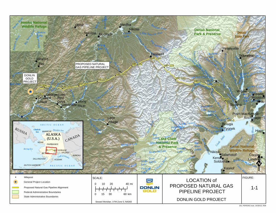
1.0 INTRODUCTION Donlin Gold LLC1 (Donlin Gold) is proposing the development of an open pit, hardrock gold mine in southwestern Alaska, about 277 miles (446 km) west of Anchorage, 145 miles (233 km) northeast of Bethel, and 10 miles (16 km) north of the village of Crooked Creek (Figure 1-1). This document was prepared in accordance with state and federal regulations governing the reclamation of mined lands and describes reclamation goals and techniques for the mine site and ancillary facilities. Reclamation and closure of the 315 mile long 14-inch diameter natural gas pipeline that will provide a reliable source of energy to the mine is covered by a separate plan.
The purpose of this Reclamation and Closure Plan is to provide guidelines for implementing stabilization and reclamation procedures for the various facilities associated with the proposed Donlin Gold project. These guidelines are based on the best available reclamation technologies. As Donlin Gold is committed to concurrent reclamation of portions of the site during operations, these guidelines may be modified as actual reclamation data are gathered during field reclamation of individual facilities or reclamation test plots. Revisions to this Plan would be made to address changes in the design, construction, operations, and concurrent stabilization and reclamation of the facility. This approach will:
• allow the incorporation of new design information as subsequent phases of the project are developed
• reflect changes in the operating plans and mining schedule
• account for the stabilization and reclamation of previous phases or specific components of the facility
• incorporate information and actual operating experience developed during the initial phases of the project
• allow for the utilization of new, reasonable and practical reclamation techniques as they are developed.
1.1 Alaska Reclamation and Closure Requirements Reclamation and closure of the proposed Donlin Gold project falls under the jurisdiction of the Alaska Department of Natural Resources (ADNR), Division of Mining, Land, and Water (MLW); the Alaska Department of Environmental Conservation (ADEC), the U.S. Army Corps of Engineers (USACE), and the U.S. Environmental Protection Agency (EPA). ADNR and ADEC are the primary agencies implementing reclamation plan and bonding approval.
1.1.1 Alaska Department of Natural Resources (ADNR) Alaska Statute (AS) 27.19, the Reclamation Act, applies to state, federal, municipal, and private land and water subject to mining operations. This statute is administered by the commissioner of ADNR. The Reclamation Act states that "a mining operation shall be conducted in a manner that prevents unnecessary and undue degradation of land and water
1 Donlin Gold LLC is a limited liability company jointly owned by Barrick Gold U.S. Inc. and NovaGold Resources Alaska, Inc. on a 50/50 basis.
Donlin Gold 1-2 June 2015
Reclamation and Closure Plan Donlin Gold Project Introduction
resources and the mining operation shall be reclaimed as contemporaneously as practicable with the mining operation to leave the site in a stable condition” and 11 AAC 97.240 further states “a miner shall reclaim a mined area that has potential to generate acid rock drainage (acid mine drainage) in a manner that prevents the generation of acid rock drainage or prevents the offsite discharge of acid rock drainage.” An approved reclamation plan is required by the State mining regulations adopted in 1992 (11 AAC 97.300 – 97.350 and a performance bond are required prior to approval of a mining operation with the exception of certain small operations. The bond amount shall be set at a level not more than an amount reasonably necessary to ensure the faithful performance of the requirements of the reclamation plan. Alaska Administrative Code (11 AAC 97 Mining Reclamation) applies to the approval of reclamation plans, reclamation bonding, and enforcement of reclamation requirements under AS 27.19 for locatable mineral, leasable mineral, and material mining operations on state, federal, municipal, and private land. Nothing in the Reclamation Act precludes a federal or state agency (including the ADNR), acting under its own regulatory or proprietary authority, from establishing and enforcing additional requirements or higher standards for reclamation. The Reclamation Performance Standards are defined in 11 AAC 97.200.
An amendment to the State Dam Safety Regulation (11 AAC 93) in 2004 has a similar financial assurance requirement:
“… the owner must provide a performance bond or other financial assurance adequate to provide sufficient money to pay for the costs of safely breaching the dam at the end of the dam's service life and restoring the stream channel and reservoir land to natural conditions, or for the costs of performing reclamation and post-closure monitoring and maintenance”.
1.1.2 Alaska Department of Environmental Conservation (ADEC)
In 1998, ADEC adopted Solid Waste Permit regulations (18 AAC 60.265) that have more comprehensive requirements for closure and reclamation planning, including provision for funding for long-term water treatment. Specifically, 18 AAC 60.265 states:
"...(ADEC) will require proof of financial responsibility to cover the cost of closing a landfill and, if monitoring is required, the cost of post closure monitoring, if the department determines proof of financial responsibility is necessary to protect the public health, safety, welfare, or the environment. Proof of financial responsibility under this section may be demonstrated by self-insurance, insurance, surety, or other guarantee approved by the department to assure compliance applicable closure standards and post closure monitoring requirements."
Donlin Gold 1-3 June 2015
!̂
!
!
!
!
!
!
!
!
!
!
!
!
!
North For
k Kusko
kwim River
Stony
River
Mulchatna River
Tonzona River
Windy Fork
South Fork Ku skokwim River
Chuli tn
a Rive
r
Little Tonzona River
EastFo r k Yentna River
Johnson Creek
Skwentna River
TsusenaCreekPorta
ge Creek
Chuitna River
Kustatan River
C urrant CreekKijik River Tlik
ak ilaRiv
er
Chilligan River
Katlitna River
Iditar
odRiv
er
BigYet
na River
Re
indeer River
Nu s hagak
River
Hoholitna River
Cheeneetnuk River
Gagaryah River
George
River
Oskawalik River
Holo kuk River
Owha
t River
Chilikadrotna R iver
Shotgun Creek
Chukowan River
C hilchitn a River
W illow Creek
DeshkaRiver
Lake Creek
Innoko
River
Innoko
River
Susitn
a River
West Fork Yentna River
Kahiltna River
Lake Creek
Drift River
Chakachatna River
Theodore River
Talac hul i tna River
Yentna R iver
Ha
yesRiver
Susitn
a Rive
r
Yentna R iver
Kashwitna River
Kenai River
Ku sk okwim R
iver
Neac ola River
Little Nelchi n a River
Moose Creek
Shun gnak
River
Nixon
Fork
Talotn
a River
Big River
Sto ny RiverSti n k River
Swift River
Kogrukluk River
Ho
lilna River
Sh eep River
Iro n Creek
Peter
s Cre e
k
Tr apper Cr.
Talk
ee tna River
Montana Creek
Moose
Creek
T rappe
r Cr.
Camp Creek
Alexander Creek
Beluga R iver
Little
Susitn
a River
Moose
Cr.
Big S almon River
W. ForkNixonFork
Sel a t na River
Netle
tnaRiv
er
East Fork
Geo rgeRiv
er
K ing Salmon R.
Bon an za Creek
Funny River
SwansonRiver
C h
ick aloon
Ri ve r Bir
d Creek
Ship Creek
Sandy RiverBear R.
Goose Creek
RedShirtLake
Teshekpuk Lake
Tustumena LakeLake ClarkUpnukLake
Turquoise Lake
Telaquana Lake
Congahbuna Lake
Koluktak LakesSquare Lake
Skilak Lake
Big Lake
Nancy Lake
HorseshoeLake
Whitefish Lake
TundraLake Two
Lakes
TwinLakesSnipe
LakeFishtrapLake
SummitLake
KenibunaLake
ChakachamnaLake
CrescentLake
Kontrashibuna Lake
SixmileLake
WilsonLake
KisaralikLake
StrandlineLake
TrapperLake
GuitarLake
ChelatnaLake
StephanLake
Paxson Lake
FishLakeMiddle
Lake
KlutinaLake
TonsinaLake
Kenai Lake
UpperTrailLake
ShellLake
BelugaLake
BigRiverLakes
Reindeer Lake
NishlikLake
Crescent Lake
Kuskokw
imRiv
er
Cook In
let
Innoko National Wildlife Refuge
Denali National Park & Preserve
Lake Clark National Park
& Preserve
DONLIN GOLD
PROJECT
Kenai NationalWildlife Refuge
Denali State Park
&
PROPOSED NATURALGAS PIPELINE PROJECT
MP-315
MP-175
MP-25
MP-300
MP-0
MP-275
MP-225 MP-100MP-75
MP-200
MP-150
MP-50
MP-125
MP-250
Anchorage
Georgetown
Petersville
SalamatofNikiski
Iditarod
CooperLanding
WasillaHouston
KnikSusitna
Willow
Kasilof
KenaiSoldotna
HopeTyonek
Talkeetna
Flat
CrookedCreek
SleetmuteStonyRiver
LimeVillage
RedDevil
McGrathTakotna
OphirNikolai
Medfra
Beluga
Point MacKenzie
Farewell
LOCATION of PROPOSED NATURAL GAS
PIPELINE PROJECT
FIGURE:SCALE:
K
DG: PER0342.mxd, 10/29/13, R08
DONLIN GOLD PROJECT
1-1
(!̂
Gulf of Alaska
Bering Sea
Chukchi Sea
Beaufort Sea
P A C I F I C O C E A N
A R C T I C O C E A NRUSSIA
CANADAALASKA(U.S.A.)
NOME
VALDEZ
KODIAK
BARROW
BETHELANCHORAGE
FAIRBANKS
DILLINGHAM
Chukchi Sea ALASKA
(U.S.A.)
DUTCH HARBOR
JUNEAUYu k on D e lt a Na ti on a l W ild li fe R ef ug e
Yu k on De lt a Na ti on a l Wild li fe Re fu g e
Yuko
n Del
ta Na
tiona
l Wild
life R
efug
e Yu k on D e lt a Na ti on a l Wild li fe R ef u ge
Yu k on D e lt a Na ti on a l W ild li fe R ef ug e
To g ia k Na ti on a l Wild li fe Re fu g e
To g ia k Na ti o na l Wild li fe R ef u ge
To g ia k Na ti on a l Wild li fe Re fu g e "
"
Woo d -T ik ch i k St at e Pa r k
Wal ru s Is la nd s St at e G ame S a nc tu a ry
"
"" Br is to l Ba y Fi sh e rie s R es e rv e
In no k o Na t io na l Wild li fe R e fu ge
De n al i N a ti on a l Pa rk & Pr es e rv e
De n al i N a ti on a l P a rk & P r es er v e
La ke C la rk Na tio n al Pa rk & Pr es er ve
Be ri ng La n d Na ti on a l P r es e rv e
In no k o Na t io na l Wild li fe R ef u ge
Nu n iv ak I sl an d R e fu ge
Ke n aiFj or dsNa ti on a lPa rk
K A T M A I N A T I O N A L P A R K
& P R E S E R V E
No w it na N a ti on a l Wild li fe R ef u ge
Ko y uk u k N at io na l Wild li fe R ef u ge
Ko y uk u k N WRWild e rn es s
Ar ea
Ka n ut i N a ti on a lWild li fe R ef u ge
Ga te s o f t h e Ar c tic N a tio n al Pa rk a n d P re se rv e
Ga te s o f t h e Ar c tic N a tio n al Pa rk a n d P re se rv e
Yu k on F la ts N a ti on a lWild li fe R ef u ge
Ar ct ic N a tio n al Wild li fe R ef u ge
Ar ct ic N a tio n al Wild li fe R ef u ge
Whi te M o un t ain s Na ti on a l R e c re at io n
Ar ea
St ee s e Na ti o na l Co n se r va ti on A r ea
St ee s e Na ti o na l Co n se r va ti on A r ea
Ko y uk u k N WRWild e rn es s
Ar ea
Ko b uk V a ll ey Na ti on a l P a rk
No a ta k N at io na l Pa r kCa p e K ru se n st er nNa ti on a l M o n u men t
No a ta k N at io na l Pr e se rv e
Ch u ga c h Na ti on a l F o re s t
Wra ng e ll S t. El ia s Na t io na l Pa rk a n d P re se rv e
Ch u ga c h Na ti on a l F o re s t
Ch u ga c h Na ti on a l F o re s t
Wra ng e ll S t. El ai s Na t io na l Pa rk a n d P re se rv e
Ch u ga c h Na ti on a l F o re s t
Ke n ai N at io n alWild li fe R ef u ge
KA C H E M AK BA Y S WP
Ne lc h in aPu b lic U s e A re a
De nal i Sta te Pa rk
Ch u ga c hSt at e Pa r k
La ke C la rk Na tio n al Pa rk & Pr es er ve
De n al i N a ti on a l Pa rk & Pr es e rv eInn ok o N ati on al Wild life Re fu ge Wild e rne ss A re a
Ke n ai N at io n alWild li fe R ef u ge
De n al i N a ti on a l Pa rk & Pr es e rv eYu k on D e lt a Na ti on a l W ild li fe R ef ug e
Yu k on D e lt a Na ti on a l W ild li fe R ef ug e
Yu k on D e lt a Na ti on a l W ild li fe R ef ug e
Ch u ga c h Na ti on a l F o re s t
0 20 4010 mi
0 30 6015 km
Seward Meridian, UTM Zone 5, NAD83
! Milepost
Federal Administrative Boundaries
State Administrative Boundaries
General Project Location!̂Proposed Natural Gas Pipeline Alignment
Reclamation and Closure Plan Donlin Gold Project Applicant Information
2.0 APPLICANT INFORMATION
2.1 Surface and Mineral Lease Information Detailed information on land status for the Donlin Gold project is listed in Appendix A.
2.2 Corporation Officer Completing Application
Name: Stanley Foo Title: President / General Manager Telephone: (907) 273-0200 Date: June 2015
2.3 Designated Contact Person
Name: Robert Enos Title: Environmental and Permitting Manager Telephone: (907) 273-0200
2.4 Corporate Information
Business Name: Donlin Gold LLC Address: 4720 Business Park Blvd., Suite G-25
Anchorage, Alaska 99503 Telephone: (907) 273-0200
President: Stanley Foo Vice President: TBD Treasurer TBD Secretary TBD
Donlin Gold is a Delaware Limited Liability Company jointly owned by Barrick Gold U.S. Inc. and NovaGold Resources Alaska, Inc. on a 50/50 basis.
2.5 Alaska Registered Agent
Name: Corporation Service Company Address: 9360 Glacier Hwy, Suite 202 Juneau, Alaska 99801
Donlin Gold 2-1 June 2015
Reclamation and Closure Plan Donlin Gold Project Project Description
3.0 PROJECT DESCRIPTION
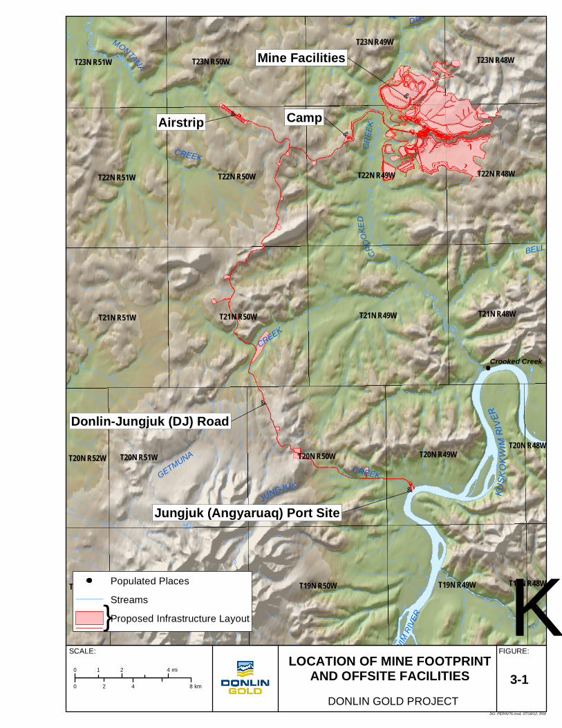
3.1 Location and Land Status The proposed Donlin Gold project is located approximately 277 miles (446 km) west of Anchorage, 145 miles (233 km) northeast of Bethel and 10 miles (16 km) north of the village of Crooked Creek (Figure 1-1). Bethel, 73 river miles (117 km) upstream from the mouth of the Kuskokwim River on the Bering Sea, is the regional center for the Yukon Kuskokwim region of Alaska. Bethel is 177 river miles (285 km) southwest of the proposed Jungjuk (Angyaruaq) Port site. The village of Aniak, located on the Kuskokwim River, approximately 57 river miles (92 km) southwest of the proposed Jungjuk Port site, is the regional center for the middle Kuskokwim Valley (Figure 1-1).
Currently there is no road or rail access to the site, and all personnel and supplies are transported by air. The project is completely isolated from existing power and other infrastructure.
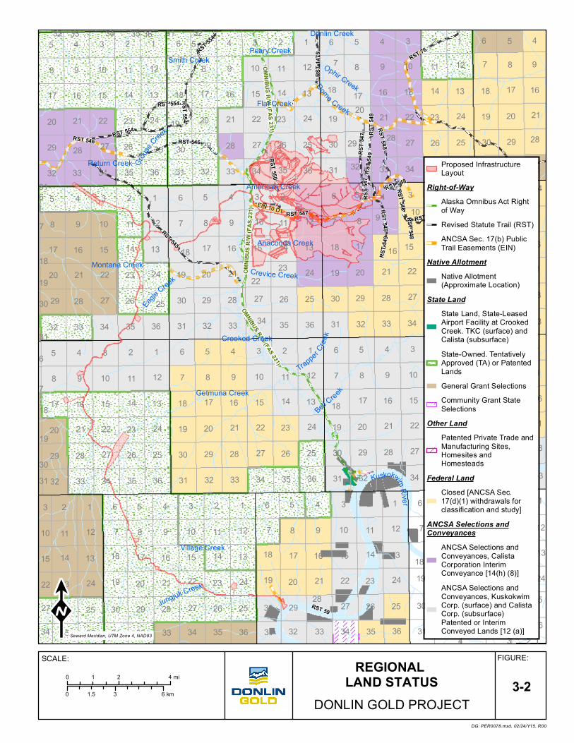
The proposed Donlin Gold project includes land leased from Calista Native Corporation (Calista), an Alaska Native Claims Settlement Act (ANCSA) regional corporation that holds the subsurface (mineral) estate for ANCSA lands in the region (Figure 3-1 and Figure 3-2). All titled sections in the lease area have been conveyed to Calista. In addition to the subsurface estate, Calista owns some surface estate lands in the lease area. A surface use agreement with The Kuskokwim Corporation (TKC), an ANCSA village corporation, grants surface use rights to lands that TKC holds in the area.
The currently identified mineral resource, all mine facilities, and the Jungjuk Port site are located on the leased lands. Additional lands required for the road to the port site, material sites, natural gas pipeline, and pipeline-related infrastructure are located on a combination of Native-owned, State of Alaska, and Bureau of Land Management lands.
A small-scale placer mining operation has existing placer mining leases covering approximately 4 sq. miles (10 km2) within the proposed Donlin Gold project lease area. The placer operation also has title to approximately 13 acres (5.26 ha) of surface estate within the Snow Gulch area. This lease area lies immediately to the north of the proposed facilities.
All exploration activities on leased lands are covered under the terms of the lease agreement with Calista and the surface use agreement with TKC. Activities on ANCSA-owned lands not currently within the agreement, or on state and federal lands, are permitted on an individual basis as required.
Donlin Gold 3-1 June 2015
MONTANA
CREEK
CROO
KED
CREE
K
GETMUNA
CREEK
JUNGJUK CREEK
DONLIN CR
EEKFLAT CREEK
BELL
KUSK
OKWIM
RIVE
R
KUSK
O KWI
M RI
VER
&
Mine Facilities
&
Camp&Airstrip
&
Donlin-Jungjuk (DJ) Road
&
Jungjuk (Angyaruaq) Port Site
T21N R49WT21N R50W
T22N R49WT22N R50W
T20N R49WT20N R50WT20N R51W
T19N R49WT19N R50WT19N R51W
T21N R51W
T22N R51W T22N R48W
T21N R48W
T23N R50W
T23N R49W
T23N R51W T23N R48W
T20N R52W
T19N R52W
T20N R48W
T19N R48W
Crooked Creek
KDG: PER0076.mxd, 07/18/12, R04
LOCATION OF MINE FOOTPRINTAND OFFSITE FACILITIES
0 4 82 km
FIGURE:SCALE:
0 2 41 mi
DONLIN GOLD PROJECT
3-1
}Populated Places
Streams
Proposed Infrastructure Layout
32 33 34 35 36 31 325 4 3 2 1 6 5 4 3 2 1 6 5 4 3 2
8
1
9
6 5
10
4
11 12 7 8 9 10 11 12 7 8 9 10 11
17
12
16
7 8
15
9
14 13 18 17 16 15 14 13 18 17 16 15 14
20
13
21
18 17
22
16
23 24 19 20 21 22 23 24 1920 21 22 23
29
24
28
19 20
27
21
26 25 30 29 28 27 26 25 30 29 28 27
31
26
32
25
33
30 29
34
28
35 36 31 32 33 34 35 36 31 32 33 34
6
35
5
36
4
31 32
3
33
2 1 6 5 4 3 2 1 6 5 4 3
7
2
8
1
9
6 5
10
4
11 12 7 8 9 10 11 12 7 8 9 10
18
11
17
12
16
7 8
15
9
14 13 18 17 16 15 14 13 18 17 16 15
19
14
20
13
21
18 17
22
16
23 24 19 20 2223 24 19 20 21 22
30
23
29
24
28
19
27
20 21
26 25 30 29 28 27 26 25 30 29 28 27
31
26
32
25
33
30
34
29 28
35 36 31 32 33 34 35 36 31 32 33 34
6
35
5
36
4
31
3
32 33
2 1 6 5 4 3 2 1 6 5 4 3
7
2
8
1
9
6
10
5 4
11 12 7 8 9 10 11 12 7 8 9 10
18
11
17
12
16
7
15
8 9
14 13 18 17 16 15 14 13 18 17 16 15
19
14
20
13
21
18
22
17 16
23 24 19 20 21 22 23 24 19 20 21 22
30
23
29
24
28
19
27
20 21
26 25 30 29 28 27 26 25 30 29 28 27
31
26
32
25
33
30
34
29 28
35 36 31 32 33 34 35 36 31 32 33 34
3
35 36
2
31
1
32
6
33
5 4 3 2 1 6 5 4 3 2 1 6
10
5
11
4 3
12
2
7
1
8 9 10 11 12 7 8 9 10 11 12 7
15
8
14
9 10
13
11
18
12
17 16 15 14 13 18 17 16 15 14 13 18
22
17
23
16 15
24
14
19
13
20 21 22 23 24 19 20 21 22 23 24 19
27
20
26
21 22
25
23
30
24
29 28 27 26 25 30 2928 27 26 25 30
34
29
35
28 27
36
26
31
25
32 33 34 35 36 31 32 33 34 35 36 31 32 33 34 35 364 3 2 1
21
RST 548
RST 546
RST 5
47
RST 548
RST 5
49
RST 5
49
RST 548
RST 548
RST 550
RST 554
RST 554
RST 5
49RST 5
47
RST 549
RST 554
RST 554
RST 548
RST 76
RST 1
475
RST 547
RST 546
RST 76
RST 545
RST 59
EIN 10 D1
OMNI
BUS R
/W (F
AS 23
1)
OMNIBUS R/W (FAS 231)
OMNIBUS R/W (FAS 231)
Dome Creek
Crevice Creek
Eagle Creek
Grous
e Creek
Ophir Creek
Trapper Cree
kBell Creek
KuskokwimRive r
Jungjuk Creek
Flat Creek
Peary Creek
Village Creek
Anaconda Creek
Donlin Creek
Smith Creek
Return Creek
Central Creek
Montana Creek
American Creek
Getmuna Creek
Crooked Creek
DG: PER0078.mxd, 02/24/Y15, R00
REGIONAL LAND STATUS
0 3 61.5 km
FIGURE:SCALE:0 2 41 mi
DONLIN GOLD PROJECT3-2
Proposed InfrastructureLayout
Right-of-WayAlaska Omnibus Act Rightof WayRevised Statute Trail (RST)ANCSA Sec. 17(b) PublicTrail Easements (EIN)
Native AllotmentNative Allotment(Approximate Location)
State LandState Land, State-LeasedAirport Facility at CrookedCreek. TKC (surface) andCalista (subsurface)State-Owned. TentativelyApproved (TA) or PatentedLandsGeneral Grant SelectionsCommunity Grant StateSelections
Other LandPatented Private Trade andManufacturing Sites,Homesites andHomesteads
Federal LandClosed [ANCSA Sec.17(d)(1) withdrawals forclassification and study]
ANCSA Selections andConveyances
ANCSA Selections andConveyances, CalistaCorporation InterimConveyance [14(h) (8)]ANCSA Selections andConveyances, KuskokwimCorp. (surface) and CalistaCorp. (subsurface)Patented or InterimConveyed Lands [12 (a)]Seward Meridian, UTM Zone 4, NAD83
Reclamation and Closure Plan Donlin Gold Project Project Description
3.2 Project History Placer gold was first discovered at Snow Gulch, a tributary of Donlin Creek in 1909. Resource Associates of Alaska (RAA) carried out a regional evaluation for Calista in 1974 to 1975. Calista conducted prospecting and limited exploration activities in 1984. The first substantial exploration drill program was carried out by Westgold in 1988 to 1989. Teck operated the project briefly in 1993. Placer Dome U.S. (PDUS) explored the property from 1995 to 2000; formed the Donlin Creek Joint Venture (DCJV), with NovaGold Resources Alaska, Inc. as operator in 2001; and then resumed management of the DCJV as operator in late 2002. Barrick Gold U.S. Inc. merged with Placer Dome in 2006 and acquired the PDUS interest in the DCJV. In December 2007, Donlin Creek LLC was formed as a limited liability company with 50/50 ownership by Barrick Gold U.S. Inc. and NovaGold Resources Alaska, Inc. In 2011, Donlin Creek LLC changed its name to Donlin Gold LLC.
From 1988 through 2010, a total of 1,834 exploration and development diamond core and reverse circulation (RC) drill holes were completed totaling 1,337,321 ft. (407,720 m). An additional 108 core holes, totaling 109,662 ft. (33,425 m), were added in 2008 to explore near-pit expansions and satellite deposits, and for facility-related condemnation and geotechnical studies.
3.3 Project Summary The proposed Donlin Gold project would require approximately three to four years to construct, with the mine life currently projected to be 27.5 years. The mine is proposed to be a year-round, conventional “truck and shovel” operation using both bulk and selective mining methods. The proposed operation would have a projected average mining rate of 422,000 stpd (383,000 tpd), or 154 Mst per year (140 Mt/a), and an average mill production rate of 59,000 stpd (53,500 tpd). Milling components would include a gyratory crusher, semi-autogenous grinding (SAG) and ball mills, followed by flotation, concentration, pressure oxidation, and carbon-in-leach (CIL) process circuits. Conventional carbon stripping and electrolytic gold recovery would produce an end product of gold doré bars, which would be shipped to a custom refinery for further processing. State-of-the-art mercury abatement controls would be installed at each of the major thermal sources, including the autoclave, carbon kiln, carbon strip vessels, electrowinning cells, gold furnaces, and retort. Figure 3-1 depicts proposed facility locations.
The gold resource is hosted in intrusive and sedimentary rock in two main areas of the property, Lewis and ACMA, with 80% found in intrusive rock. The proven and probable2 reserves total 556.5 Mst (504.8 Mt), with an average grade of 0.061 oz/st (2.09 g/t). With mill
2 Based on an assessment of qualitative, non-technical factors, Barrick Gold Corporation treats mineralization at Donlin Creek as measured and indicated resources, rather than proven and probable reserves for securities reporting, accounting, and other public disclosure purposes. Mineral reserves are those parts of mineral resources that, after the application of all mining factors, result in an estimated tonnage and grade which is the basis of an economically viable project after taking account of all relevant processing, metallurgical, economic, marketing, legal, environment, socio-economic, and government factors. Mineral reserves are inclusive of diluting material that will be mined in conjunction with the mineral reserves and delivered to the treatment plant or equivalent facility. The term ‘mineral reserve’ need not necessarily signify that extraction facilities are in place or operative, or that all governmental approvals have been received. It does signify there are reasonable expectations of such approvals.
Donlin Gold 3-4 June 2015
Reclamation and Closure Plan Donlin Gold Project Project Description
recovery at approximately 90%, the operation would produce gold at an average of over 1 Moz/a.
Tailings storage would encompass an area of 2,351 acres (951 ha), with a total capacity of approximately 356,714 acre-ft. (440 Mm3) for mill tailings, decant water, and flood events. Total waste rock material is estimated at 2,990 Mst (2,720 Mt), with approximately 2,460 Mst (2,232 Mt) placed in a waste rock facility (WRF) located outside the mine pit and the remaining waste rock backfilled in the pit. Approximately 93% of the total waste rock tonnage would be non-acid generating (NAG) material and overburden with the remaining 7% a combination of potentially acid generating (PAG) material. The Waste Rock Management Plan Donlin Gold Project (SRK 2012b) provides additional information on the WRF and material management.
Electrical power would be supplied by onsite reciprocating engines (burning natural gas fuel) with a heat recovery system and generation from a steam turbine (heat recovery steam generation) for a total connected load of 227 MW, an average running load of 153 MW, and a peak load of 184 MW.
Natural gas will be transported via a 315-mile (507 km), 14-inch (35.6 cm) diameter buried pipeline originating from an existing 20-inch (51 cm) natural gas pipeline near Beluga, Alaska to the proposed Donlin Gold mine site (SRK 2012a).
General cargo for operations would be transported from terminals in Seattle/Tacoma, Vancouver, BC, or Dutch Harbor via marine barge to Bethel. At Bethel, cargo would be transferred to the dock for temporary storage or loading onto river barges for transport up the Kuskokwim River to a port constructed at Jungjuk Creek. A 30-mile (48 km) all-season access road would be constructed from the proposed Jungjuk Port to the mine site (Figure 3-1).
Fuel would be transported to Dutch Harbor by tanker, then to Bethel via marine barge. At Bethel, fuel would either be transferred directly to double-hull river barges, or off-loaded for temporary storage. From Jungjuk Port, fuel would be transferred to the mine site fuel storage facility via tank trucks.
The proposed Donlin Gold project would be a camp operation accessible primarily by a 5,000 ft. (1,542 m) gravel airstrip and include a camp capable of housing 638 workers. Other ancillary support facilities would be located within the project area.
3.4 Geology The Donlin Gold deposit is located in the Kuskokwim basin, which consists of a thick sequence of clastic sedimentary rocks of the Upper Cretaceous Kuskokwim Group. The sedimentary rocks accumulated between a series of Proterozoic to Mesozoic age amalgamated terranes, and are cut by the northeast-trending Iditarod-Nixon Fork and Denali-Farewell strike slip faults (Project Description, Donlin Gold Project [SRK 2011]). Igneous intrusive rocks include Late Cretaceous to early Tertiary granitic volcano-plutonic complexes and “granite porphyry.” The granite porphyry rocks were emplaced within or near northeast-trending fault zones, and are often associated with placer and lode gold occurrences such as those found at Donlin Gold.
Donlin Gold 3-5 June 2015
Reclamation and Closure Plan Donlin Gold Project Project Description
The Donlin Gold mineralized area is underlain by Kuskokwim Group sedimentary rocks and granite porphyry. The sedimentary rocks are broadly folded and generally dip 10° to 50° southwest. Lithic sandstone is the most common sedimentary rock type but intercalated siltstone and shale increases in the southern part of the resource area. Igneous rocks consist primarily of five textural variations of granite porphyry, locally called rhyodacite. Northerly dipping thrust faults are cut by northeast- and northwest-striking strike-slip faults. Steeply southeast dipping, north-northeast striking fractures provided the primary fluid channels for gold-bearing hydrothermal solutions.
A northeast elongated, roughly 5,000 ft. (1.5 km) wide by 10,000 ft. (3 km) long, cluster of gold deposits has an aggregate vertical range that exceeds 2,800 ft. (850 m). The deposits are hosted primarily in igneous rocks and are associated with an extensive Late Cretaceous gold-arsenic-antimony-mercury hydrothermal system. Gold occurs in broad disseminated sulfide zones in rhyodacite and minor mafic intrusive rocks, and in sulfide and quartz-carbonate-sulfide vein networks in igneous and sedimentary rocks. Sub-microscopic gold is contained primarily in arsenopyrite, and secondarily in pyrite and marcasite.
3.4.1 Development Overview This document provides an overview of the company’s proposed approach to mining and milling the ore, and the support facilities and infrastructure required to operate the mine. A more comprehensive overview can be found in the Project Description, Donlin Gold Project (SRK 2011).
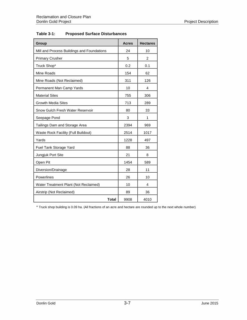
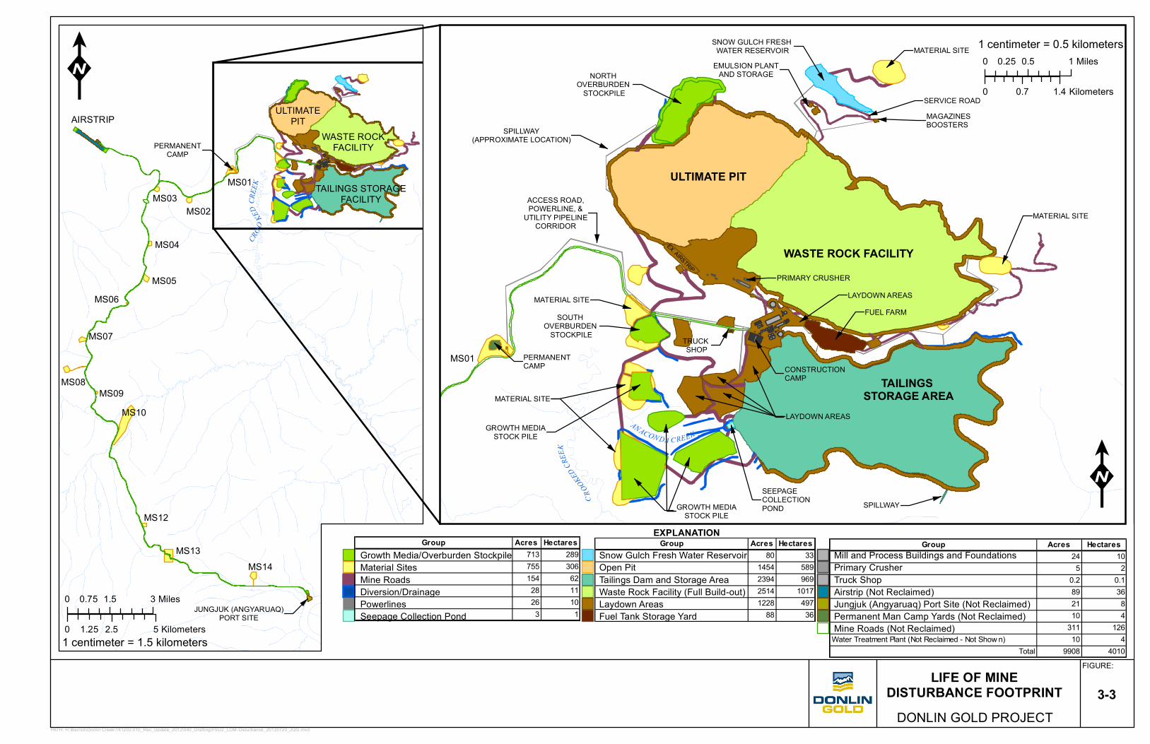
3.5 Proposed Project Disturbance The acreage of surface disturbances associated with the proposed Donlin Gold project (at the end of mine life) is detailed by facility in Table 3-1 and depicted on Figure 3-3.
Donlin Gold 3-6 June 2015
Reclamation and Closure Plan Donlin Gold Project Project Description
Table 3-1: Proposed Surface Disturbances
Group Acres Hectares
Mill and Process Buildings and Foundations 24 10
Primary Crusher 5 2
Truck Shop* 0.2 0.1
Mine Roads 154 62
Mine Roads (Not Reclaimed) 311 126
Permanent Man Camp Yards 10 4
Material Sites 755 306
Growth Media Sites 713 289
Snow Gulch Fresh Water Reservoir 80 33
Seepage Pond 3 1
Tailings Dam and Storage Area 2394 969
Waste Rock Facility (Full Buildout) 2514 1017
Yards 1228 497
Fuel Tank Storage Yard 88 36
Jungjuk Port Site 21 8
Open Pit 1454 589
Diversion/Drainage 28 11
Powerlines 26 10
Water Treatment Plant (Not Reclaimed) 10 4
Airstrip (Not Reclaimed) 89 36
Total 9908 4010
* Truck shop building is 0.09 ha. (All fractions of an acre and hectare are rounded up to the next whole number)
Donlin Gold 3-7 June 2015
PERMANENTCAMP
MS01
MS02MS03
MS04 CROO
KEDCR
EEK
AIRSTRIP
MS05MS06
MS07
MS08MS09
MS10
MS12
MS13MS14
JUNGJUK (ANGYARUAQ)PORT SITE
ULTIMATEPIT
WASTE ROCKFACILITY
TAILINGS STORAGEFACILITY
PATH: H:\Barrick\Donlin Creek\181202.010_Rec_Update_2012\040_Drafting\FSU2_LOM-Disturbance_20120720_JQG.mxd
1 centimeter = 1.5 kilometers
EX. AIRSTRIP
EMULSION PLANTAND STORAGE
MAGAZINESBOOSTERS
SERVICE ROAD
NORTH OVERBURDEN
STOCKPILE
ACCESS ROAD,POWERLINE, &
UTILITY PIPELINECORRIDOR
ULTIMATE PIT
WASTE ROCK FACILITYPRIMARY CRUSHER
LAYDOWN AREAS
SOUTH OVERBURDEN
STOCKPILE
TAILINGS STORAGE AREA
TRUCK SHOP
CONSTRUCTION CAMP
LAYDOWN AREAS
SEEPAGECOLLECTION PONDGROWTH MEDIA
STOCK PILE
MATERIAL SITE
MATERIAL SITE
PERMANENTCAMPMS01
CROOKED
CREEK
ANACON DA C REEK
SNOW GULCH FRESH WATER RESERVOIR
SPILLWAY
MATERIAL SITE
SPILLWAY(APPROXIMATE LOCATION)
FUEL FARM
GROWTH MEDIASTOCK PILE
MATERIAL SITE
K
LIFE OF MINEDISTURBANCE FOOTPRINT
FIGURE:
DONLIN GOLD PROJECT3-3
K
0 1.5 30.75 Miles
0 2.5 51.25 Kilometers
0 0.5 10.25 Miles
0 0.7 1.4 Kilometers
1 centimeter = 0.5 kilometers
EXPLANATION
Growth Media/Overburden StockpileMaterial SitesMine RoadsDiversion/DrainagePowerlinesSeepage Collection Pond
Snow Gulch Fresh Water ReservoirOpen PitTailings Dam and Storage AreaWaste Rock Facility (Full Build-out)Laydown AreasFuel Tank Storage Yard
Mill and Process Buildings and FoundationsPrimary CrusherTruck ShopAirstrip (Not Reclaimed)Jungjuk (Angyaruaq) Port Site (Not Reclaimed)Permanent Man Camp Yards (Not Reclaimed)Mine Roads (Not Reclaimed)
Group Acres Hectares713 289755 306154 6228 1126 103 1
Group Acres Hectares80 33
1454 5892394 9692514 10171228 497
88 36
Group Acres Hectares24 105 2
0.2 0.189 3621 810 4
311 126Water Treatment Plant (Not Reclaimed - Not Show n) 10 4
Total 9908 4010
Reclamation and Closure Plan Donlin Gold Project Implementation Plan
4.0 IMPLEMENTATION PLAN
4.1 General Donlin Gold’s and the land owners’ long-term reclamation goals during and after mining and milling operations are to shape, revegetate, or otherwise stabilize the land to meet the objectives of the designated post-mining land use. The current designated post-mining uses for the proposed Donlin Gold project area are for wildlife habitat and dispersed recreation, as prescribed by:
AS 27.19.020 Reclamation Standard:
“A mining operation shall be conducted in a manner that prevents unnecessary and undue degradation of land and water resources, and the mining operation shall be reclaimed as contemporaneously as practicable with the mining operation to leave the site in a stable condition.”
AS 27.19.030 (b)
“In reviewing a reclamation plan for state, federal, or municipal land under (a) of this section, the commissioner may consider, after consultation with the commissioners of environmental conservation and fish and game and with the concurrence of the miner and landowner, uses to which the land may be put after mining has been completed, including trails, lakes, recreation sites, fish and wildlife enhancement, commercial, and agriculture uses.” and,
11 AAC 97.200 (b)
“A miner shall reclaim an area disturbed by a mining operation so that the surface contours after reclamation is complete are conducive to natural revegetation or are consistent with an alternate post-mining land use approved under AS 27.19.030 (b) on state, federal, or municipal land, or with the post-mining land use intended by the landowner on private land.”
Donlin Gold will incorporate practices that include contouring and stabilizing disturbed areas using best engineering practices to create seed beds that invites and promotes early seral colonization, using commercially available native plant species and soil amendments with proven track records.
Donlin Gold would continue to adhere to the above goals in developing and implementing this Reclamation and Closure Plan for the proposed Donlin Gold project. Therefore, the objectives of the Reclamation and Closure Plan are:
• provide for public safety
• stabilize and protect surficial soil materials from wind and water erosion
• stabilize steep slopes through contouring and leveling to provide rounded land forms and suitable seedbeds
• establish a productive vegetative community based on the applicable land use plan, pertinent visual resources, and designated post-mining land uses
• design closure plans, to the extent feasible, that would address community concerns and be aligned with local community land use and development objectives.
Donlin Gold 4-1 June 2015
Reclamation and Closure Plan Donlin Gold Project Implementation Plan
Attainment of these objectives would be measured by the success of concurrent reclamation of disturbed areas and would include long-term mine revegetation research and evaluation (Czapla and Wright 2012). Donlin Gold would work with ADNR, Division of Agriculture/Plant Materials Center, and Alaska Department of Fish & Game (ADF&G) in the implementation and evaluation of both concurrent and long-term reclamation activities at the site and other mine reclamation projects in interior Alaska.
The design and implementation of the mine reclamation and closure plans are important for the surrounding communities during mine closure. Measures to mitigate the potential socioeconomic effects associated with mine closure would be reviewed and discussed every five years during permit renewals throughout the mine life. To the extent feasible, the project’s community development program would encourage development projects that are sustainable without ongoing support from the mine project. The goals would be to encourage development of local capacity from the start of the mine project and to engage the community throughout the mine life. Closure planning would also include regularly scheduled outreach to the communities (minimum of once every five years) within the area of mine influence to hear residents’ concerns and objectives before and during the active closure period.
Donlin Gold considers reclamation to be a progressive process tied directly to the design, construction, operation, and closure of the project. The physical reclamation of the proposed Donlin Gold site would utilize best practicable, proven, and documented technology. The specifics of this technology are discussed in the following sections. The details and procedures for stockpiling initial topsoil and overburden (growth media) stripping and for area-specific reclamation of such facilities as the pit, WRF, tailing impoundment are discussed in Section 4.7.
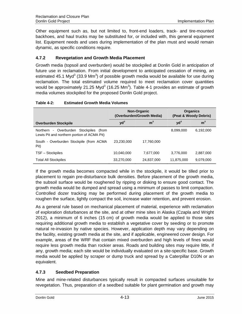
For the purposes of this Reclamation and Closure Plan, the term "growth media" refers to all native (in-place) soil material with the physical and chemical properties capable of germinating and sustaining vegetation growth with or without amendments, and is interchangeable with the terms "topsoil" and "overburden"3 in relation to the proposed Donlin Gold site. Overburden material suitable for use as growth media is unconsolidated material that may consist of terrace gravels, colluvium, loess, and other non-organic material that lies between the topsoil horizon (where present) and bedrock.
4.1.1 Land Use
Land Use Prior to Operations The Donlin Gold area has been subject to prospecting, small-scale mining, and exploration since placer gold was first discovered in Snow Gulch in 1909. A small-scale mining operation, with existing placer mining leases covering approximately 2,560 acres (1,036 ha) within the Donlin lease area, continues to operate seasonally. The operation also has title to approximately 13 acres (5.26 ha) of surface estate within the Snow Gulch area.
3 “topsoil” is the upper, outermost layer of soil, usually the top 2 inches (5.1 cm) to 8 inches (20 cm). It has the highest concentration of organic matter and microorganisms
“overburden” is the material that lies above an area of economic or scientific interest. Overburden is also described as the soil and other material that lies above a specific geologic feature.
Donlin Gold 4-2 June 2015
Reclamation and Closure Plan Donlin Gold Project Implementation Plan
A regional evaluation carried out for Calista from 1974 to 1975 further identified mineral potential in the area and led to limited exploration activities and prospecting. Exploration drilling programs began in 1988 and continued intermittently until 1995, when PDUS began the current project in earnest.
Approximately 1,676 exploration and development core (88%) and RC (12%) drill holes, totaling 1,289,163 ft. (392,937 m), were completed from 1988 through 2007. All but 8% (district exploration, carbonate resource, geotechnical, waste rock, condemnation, and hydrology) of this drilling was utilized for the feasibility study resource model. Approximately 50% of the core and 40% of the holes were drilled during the 2006-2007 period.
Land Use during Operations The Donlin Gold deposit would be mined with a combination of bulk and selective mining methods. RC drilling would be the primary source of ore control samples, and blasthole sampling would be done for waste characterization. The open pit mine design and production schedule were developed for a nominal mill throughput of 59,000 st (53,500 t) of ore per day, 19.8 Mst (18 Mt) based on 92% availability per year, after two-year ramp-up. The estimated mine life is 27.5 years. A combination of 20 ft. (6 m) and 40 ft. (12 m) bench heights have been used in mine planning to allow a relatively high mining rate, while allowing for more selective mining in complex ore zones.
The resource is divided into two main areas, ACMA and Lewis. The pits have similar mineralization characteristics, with ore-grade gold hosted in both intrusive and sedimentary rock units. The grade of the gold mineralization in ACMA is higher than in the Lewis area. ACMA would be mined in nine phases, and Lewis would be mined in five phases. The initial phases of the two pits are independent, but they partially merge later in the mine life.
A blend of 70% emulsion and 30% ammonium nitrate and fuel oil (ANFO) would be used for blasting, based on anticipated groundwater conditions. An explosives supplier would provide blasting services and supply the explosives, emulsion plant, explosives magazines, mixing equipment, and delivery trucks. An explosives supplier would be contracted to provide a “down-the-hole” blasting service. The supplier would provide the ammonium nitrate, emulsion components, and blasting accessories. The operator would provide fuel oil and accommodations. Supplier personnel would charge the holes, place the detonators and boosters, and tie-in the patterns.
Waste rock from open pit mining would be placed in the WRF, located in the American Creek valley (east of the pit area) and as backfill in ACMA pit. Sufficient overburden would be stored separately for use in final site reclamation; the remainder would be dumped into the WRF or used for construction.
Tailings consist of streams from flotation tailings, wash thickener overflow, and the detoxified cyanide slurry from the CIL. The TSF constructed in Anaconda Creek valley is designed for zero discharge (containment of all process fluids). The TSF consists of a main line embankment, a lined impoundment, a reclaim water system, and a seepage collection system.
The tailings dam would be constructed of compacted rockfill using the downstream method, with a 60 mm single-side, textured (lower side), and linear low-density polyethylene (LLDPE)
Donlin Gold 4-3 June 2015

Reclamation and Closure Plan Donlin Gold Project Implementation Plan
composite liner on the upstream face. The tailings impoundment footprint would be lined with a 60 mm textured LLDPE liner over a 3.3 ft. (1.0 m) thick layer of broadly graded silty sand and gravel acting as low-permeability bedding material and providing secondary containment.
The TSF would be constructed in eight stages over the 27.5-year mine life. The TSF is designed to handle the 200-year return period snowmelt, 24-hour probable maximum precipitation rainfall event, excess water accumulation under average conditions in the site water balance, and emergency freeboard.
A seepage collection system consisting of a pond, diversion ditches, and a line of four monitoring/seepage collection wells would be constructed immediately downstream of the footprint of the main tailings dam. The seepage rate from the lined TSF is anticipated to be de minimus. During operations, water from the seepage collection system would be pumped to the mill or back into the impoundment.
Decant water would be reclaimed from the impoundment using a floating barge. This reclaimed water would be recycled back to the mill.
4.1.2 Schedule of Reclamation Activities The proposed Donlin Gold operation would alter the landscape of the site for the long term, while creating opportunities to establish more diverse wildlife habitat and dispersed recreation. The open pit would be reclaimed as an impoundment, creating a source of open water, where none existed previously, for use by avian and terrestrial wildlife (Arcadis 2013). Likewise, potential to develop proposed artificial wetlands, with their associated open water, formed from the material borrow sites (terrace gravel sites) along Crooked Creek, would alter, diversify, and enhance the use of these areas by humans and wildlife following reclamation. These sites would be developed to receive storm water runoff and diverted flow from Omega Gulch, and have overall depths such that over-wintering of resident and anadromous fish would be supported. In addition to the opportunities associated with the open-water impoundments and enhanced upland habitat areas, Donlin Gold would reclaim upland sites by establishing successive vegetation, leading to more productive post-mining land use as wildlife habitat.
Donlin Gold 4-4 June 2015

Reclamation and Closure Plan Donlin Gold Project Implementation Plan
Table 4-1: Reclamation and Closure Timeline
Period Construction Operation End of Mine Life
Final Closure
Post Closure
Long-Term Water
Treatment
Year 1-4 Year 0-5
Year 6-10
Year 11-15
Year 16-20
Year 21-26
Year 27.5-33
Year 34->
Year ~80>
Construction
Operation
Concurrent Reclamation
Final Reclamation/ Closure
Post Closure
Post Closure Water Treatment
Reclamation during and Directly after Construction During stripping operations for construction of the process components (tailings dam, freshwater dam, mill site, crusher, maintenance shops, etc.), topsoil (growth media) including organic material would be selectively stockpiled. Topsoil and overburden stripping would continue as the ore body and waste rock dumps are fully developed, and suitable growth media would continue to be stockpiled throughout the mine life. Interim reclamation of the growth media stockpiles, which includes stripped vegetation/peat, terrace gavels, and colluvium, would proceed after placement to stabilize and maintain viability of all stockpiled material for potential use in final reclamation.
Areas disturbed during construction that are not subject to re-disturbance during operations would be reclaimed. Construction access roads and material borrow sites in the immediate area of the mine, WRF, and TSF have been identified for final reclamation during or immediately after construction. The Jungjuk Port access road would require 13 borrow pits during construction; all but three would be reclaimed immediately after construction is completed.
Concurrent Reclamation The WRF and overburden stockpiles would be constructed as side-hill and head-of-valley dumps in steps or terraced lifts to achieve the desired overall slope. Inactive portions of these dumps would be recontoured and reclaimed as contemporaneously as practicable during the mine life.
Material pits developed for construction of the TSF would be evaluated for potential additional ponds to provide rearing and overwintering habitat. Borrow pits in Alaska, with adequate depth (>20 ft. or 6 m) and a low gradient surface water connection to riverine systems, have provided excellent overwintering habitat for resident and anadromous fish.
Other material pits when no longer needed for construction or road maintenance will be reclaimed as contemporaneously as possible.
Donlin Gold 4-5 June 2015
Reclamation and Closure Plan Donlin Gold Project Implementation Plan
Temporary Closure “Temporary closure” means the cessation of the mining and milling operations for a period of not more than three years. If conditions require temporary closure to extend beyond three years, final reclamation would begin, unless an extension is requested by the company and approved by ADNR. Temporary closure scenarios, which require modifications to the Plan of Operation, Reclamation and Closure Plan, solid waste, and possibly the 404 Permit, would be coordinated with and submitted to the appropriate federal and state agencies for approval.
Temporary closure may include planned or unplanned cessation of the mining and milling processes. Planned temporary closures, which have specific conditions defining their beginning and end include, but are not limited to, the following:
• interruptions in the active beneficiation processes to provide planned periods of quiescence for metallurgical or operating reasons
• any other planned condition, which would interrupt the active beneficiation process including modification to process components or suppressed metal market conditions
• change in ownership requiring the temporary cessation of operations while operating permits are transferred to the new owner/operator.
Unplanned temporary closures may include, but are not limited to, the following:
• closure because of unforeseen weather events
• a failure in a major system component or a process failure, which causes the fluid management system, or a portion thereof, to shut down
• the cessation of operations because of litigation.
Donlin Gold would notify the Agencies within ten days of the first day of the temporary closure of any unanticipated suspension or cessation of operations that is expected to last more than ninety days or more. The notice would state the nature and reason for the temporary closure, the anticipated duration of the temporary closure and any event that would reasonably be anticipated to result in either the resumption or abandonment of operations. Project operations must resume for not less than ninety consecutive days in order to terminate the temporary closure status. Donlin Gold would maintain the project area in a safe and secure condition during a temporary closure and not allow the project area to be degraded or eroded during or as a result of the temporary closure. Donlin Gold wouldl continue, in full force, all water collection and treatment, monitoring and reporting required by the reclamation plan unless otherwise agreed to by the agencies.
While the mine operation is inactive, environmental monitoring programs would continue to be implemented. The need for implementation of interim reclamation activities or final reclamation on components of the mine would be addressed on the basis of environmental monitoring results and consultation with the appropriate agencies.
Final Reclamation After Donlin Gold has completed operations at the mine site, or at any individual facility or mine unit e.g. waste rock facility, final reclamation can be initiated. When a facility is no longer needed for mine operations or when it has reached its design capacity, then reclamation will be initiated as soon as practical. It is assumed that at the final stage of
Donlin Gold 4-6 June 2015

Reclamation and Closure Plan Donlin Gold Project Implementation Plan
operations, a significant amount of site-specific reclamation experience and performance data will have been incorporated into periodic reclamation plan updates. The final reclamation plan will be submitted for approval two-years prior to planned, final reclamation of the facility. Unlike the periodic updates, which make assumptions about the anticipated closure conditions (i.e., Basis of Cost Estimate); the final plan will be based on the actual conditions that exist at closure.
Post –Closure Care and Maintenance Many reclamation goals would be expected to be completed over a five year period after cessation of milling. Following final reclamation, the site will be inspected, monitored, and maintained in a fashion that helps achieve the long-term goals set out in this Plan. Donlin Gold has determined long-term post-closure water pumping during tailings consolidation and water treatment after the pit lake fills would be required. Specific water management practices will be estimated based on closure assumptions prior to final closure, will be defined more clearly when actual closure conditions exist and may be further refined based on information obtained during post-closure monitoring. Appendix C provides more details on assumptions regarding post-closure care and maintenance.
4.2 Reclamation Plan Submission and Approval
Donlin Gold would continue to submit an updated Reclamation Plan as required to keep current with operations, regulatory changes, and issues identified during the regular five year third-party Environmental Compliance Audits. Each updated and revised Plan will contain sufficient detail to allow for calculation of estimated closure costs including post-closure maintenance and monitoring.
More frequent Plan revisions may be required by the agencies if substantial increases in the disturbed area have occurred since the last update, or if specific portions of the Plan are shown to be inconsistent with performance goals or changes to the designated post-mining land use.
The Plan shall contain cost calculations and a tabulation of material quantities required to complete the reclamation. The Annual Report required by ADNR and ADEC would contain a description of concurrent reclamation that has occurred and anticipated reclamation projects for the following year.
The Reclamation Plan and other environmental management plans would be maintained in accordance with agency monitoring requirements. These documents describe the sites monitored, the data collected, and the monitoring frequency and duration.
4.3 Reclamation Cost Calculation and Bond Release
The regulatory agencies would coordinate their financial assurance authority through a Memorandum of Understanding (MOU) to require financial assurance for performance of reclamation and facility closure and post-closure monitoring activities at Donlin Gold. Proof of financial assurance, which may take any form mutually agreed upon by the agencies and Donlin Gold, is referred to as a “bond” in this section. Unless otherwise agreed between the agencies and Donlin Gold, the bond amount would be calculated on the basis of the Reclamation Plan and use of the Standard Reclamation Cost Estimate Model (SRCE)
Donlin Gold 4-7 June 2015
Reclamation and Closure Plan Donlin Gold Project Implementation Plan
Version 1.4.1 Build 16. The bond will address all costs that would be incurred by the agencies in taking over reclamation activities in the event of Operator default (Appendix B).
4.3.1 Incremental Bond Release
A site or area would be eligible for release or partial release of the bond amount directly attributable to that site or area when all pertinent aspects of final reclamation activities are complete. This includes, but is not limited to removing any facility and necessary materials, grading the surface, applying cover-soils as necessary, applying the approved final seed mix, and the area exhibits vegetative cover meeting the specific plant community goals. Bond release can be sought for areas reclaimed concurrently (during operation) or after final reclamation.
For a site or area subject to overlapping jurisdiction of the agencies, concurrence from all agencies having jurisdiction over the site or area will be sought as to the completeness of the reclamation. Donlin Gold would apply for incremental bond release by submitting a letter to the appropriate agencies requesting release of the specific site or area(s). The letter will summarize the conducted reclamation activities, the reclamation activity schedule, and the final revegetation completion date.
The agencies will approve incremental bond release through a process upon which they have agreed. The agencies may require a joint agency/Donlin Gold site visit to confirm that Donlin Gold has completed pertinent reclamation activities at the site or area(s). These reclamation requirements would be described in the final reclamation plan, in the waste management permit, and in other applicable permits.
4.4 Public Safety Public safety is a principal concern in closure and reclamation of mining operations. The ACMA and Lewis pits’ highwall safety berms would remain in place to restrict access to the pit area along pit perimeters. Generally, 4 to 6 ft. (1.2 to 1.8 m) vegetated berms would be used to restrict access to the steeper highwall sections of the pit. Signs would be posted to provide additional warning of potentially hazardous areas. Final signage and placement would be coordinated with the landowner.
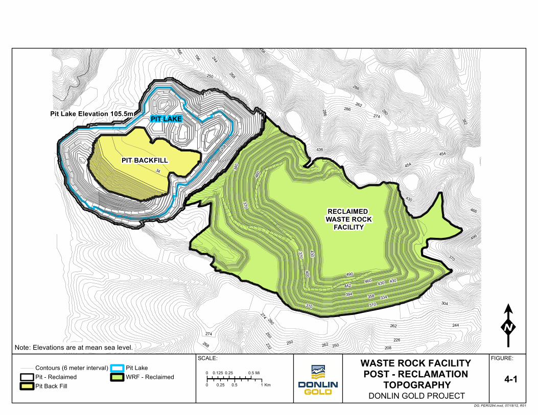
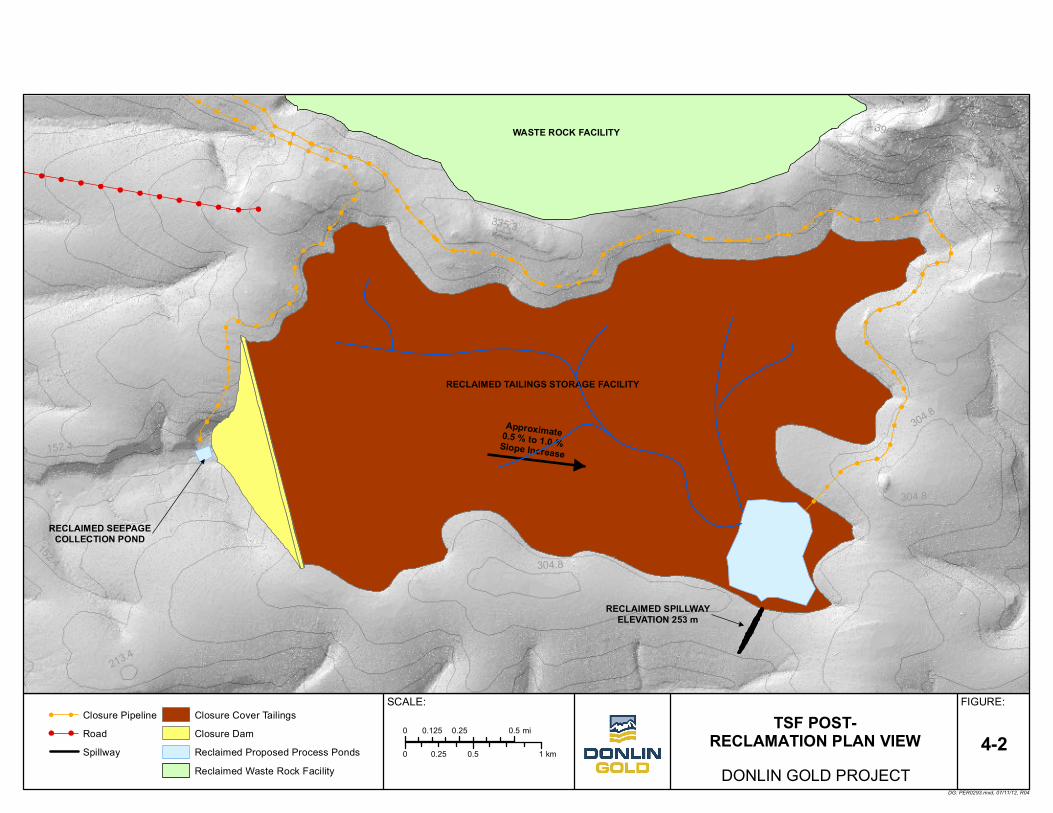
4.5 Post-Reclamation Topography Figure 4-1 and Figure 4-2 depict the anticipated post-reclamation topography (i.e., end of operations) of the Donlin Gold WRF and pit and a plan view of the TSF, respectively, once final re-contouring of surfaces has occurred.
4.6 Closure Social Impact Assessment It should be noted, given the long duration of the proposed Donlin Gold project, the development of final reclamation strategies will be an iterative process, evolving as new and potentially innovative technologies are developed, and as more refined information is gathered about the individual mine components at the site. The process followed to develop a Closure Social Impact Assessment (CSIA) for the final reclamation strategies is not a regulatory requirement and is based in part on the International Council on Mining and Metals, Financial Assurance for Mine Closure and Reclamation (ICMM 2006). Because of the evolving nature of this iterative process, Donlin Gold is committed to continually
Donlin Gold 4-8 June 2015
Reclamation and Closure Plan Donlin Gold Project Implementation Plan
evaluating social impacts, as identified in Section 4.1, and completing a CSIA as mine closure nears. The CSIA will enable a more accurate and up-to-date assessment of potential impacts on the nearby communities by mine closure. The results of the CSIA provide a basis for addressing and managing community needs. While appropriate planning of sustainable community projects support the long-term sustainability of the nearby communities, the CSIA would focus on positive benefits from the operation and identify alternative uses for the skills and infrastructure developed during operations.
Donlin Gold 4-9 June 2015
PIT BACKFILL
RECLAIMED WASTE ROCK
FACILITY
PIT LAKEPit Lake Elevation 105.5m
490
460
430
340
430370
334
400
442
358310 310
370
460 430
394
34
316
208
280
274262
250
250 226208
232 250
304
262
244
274
268
244
250
256
262
268
274
280
286
382
436
286
196
286
166
466
454
370
496
430
454
WASTE ROCK FACILITY POST - RECLAMATION
TOPOGRAPHY0 0.5 10.25 Km
FIGURE:SCALE:
DG: PER0294.mxd, 07/18/12, R01
0 0.25 0.50.125 Mi
DONLIN GOLD PROJECT4-1
Contours (6 meter interval)Pit - ReclaimedPit Back Fill
Pit LakeWRF - Reclaimed
Note: Elevations are at mean sea level.
Approximate 0.5 % to 1.0 % Slope Increase
RECLAIMED SEEPAGECOLLECTION POND
RECLAIMED SPILLWAYELEVATION 253 m
RECLAIMED TAILINGS STORAGE FACILITY
WASTE ROCK FACILITY 396.2
304.8
396.2
213.4
304.8
152.4
304.8
335.3
304.8
243.8
152.4
121.9
TSF POST-RECLAMATION PLAN VIEW
0 0.5 10.25 km
FIGURE:SCALE:
DG: PER0293.mxd, 07/11/12, R04
0 0.25 0.50.125 mi
DONLIN GOLD PROJECT4-2
Closure PipelineRoadSpillway
Closure Cover TailingsClosure DamReclaimed Proposed Process PondsReclaimed Waste Rock Facility
Reclamation and Closure Plan Donlin Gold Project Implementation Plan
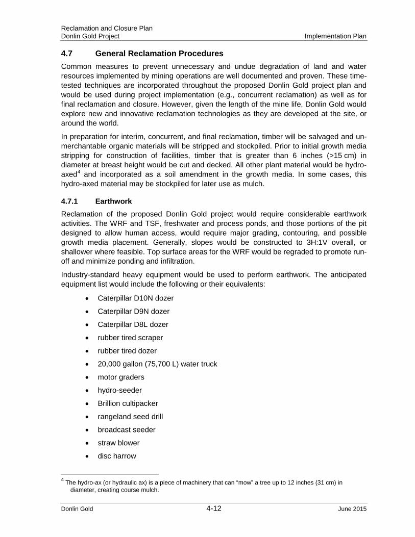
4.7 General Reclamation Procedures Common measures to prevent unnecessary and undue degradation of land and water resources implemented by mining operations are well documented and proven. These time-tested techniques are incorporated throughout the proposed Donlin Gold project plan and would be used during project implementation (e.g., concurrent reclamation) as well as for final reclamation and closure. However, given the length of the mine life, Donlin Gold would explore new and innovative reclamation technologies as they are developed at the site, or around the world.
In preparation for interim, concurrent, and final reclamation, timber will be salvaged and un-merchantable organic materials will be stripped and stockpiled. Prior to initial growth media stripping for construction of facilities, timber that is greater than 6 inches (>15 cm) in diameter at breast height would be cut and decked. All other plant material would be hydro-axed4 and incorporated as a soil amendment in the growth media. In some cases, this hydro-axed material may be stockpiled for later use as mulch.
4.7.1 Earthwork Reclamation of the proposed Donlin Gold project would require considerable earthwork activities. The WRF and TSF, freshwater and process ponds, and those portions of the pit designed to allow human access, would require major grading, contouring, and possible growth media placement. Generally, slopes would be constructed to 3H:1V overall, or shallower where feasible. Top surface areas for the WRF would be regraded to promote run-off and minimize ponding and infiltration.
Industry-standard heavy equipment would be used to perform earthwork. The anticipated equipment list would include the following or their equivalents:
• Caterpillar D10N dozer
• Caterpillar D9N dozer
• Caterpillar D8L dozer
• rubber tired scraper
• rubber tired dozer
• 20,000 gallon (75,700 L) water truck
• motor graders
• hydro-seeder
• Brillion cultipacker
• rangeland seed drill
• broadcast seeder
• straw blower
• disc harrow
4 The hydro-ax (or hydraulic ax) is a piece of machinery that can “mow” a tree up to 12 inches (31 cm) in diameter, creating course mulch.
Donlin Gold 4-12 June 2015
Reclamation and Closure Plan Donlin Gold Project Implementation Plan
Other equipment such as, but not limited to, front-end loaders, track- and tire-mounted backhoes, and haul trucks may be substituted for, or included with, this general equipment list. Equipment needs and uses during implementation of the plan must and would remain dynamic, as specific conditions require.
4.7.2 Revegetation and Growth Media Placement Growth media (topsoil and overburden) would be stockpiled at Donlin Gold in anticipation of future use in reclamation. From initial development to anticipated cessation of mining, an estimated 45.1 Myd3 (33.9 Mm3) of possible growth media would be available for use during reclamation. The total estimated volume required to meet reclamation cover quantities would be approximately 21.25 Myd3 (16.25 Mm3). Table 4-1 provides an estimate of growth media volumes stockpiled for the proposed Donlin Gold project.
Table 4-2: Estimated Growth Media Volumes
Overburden Stockpile
Non-Organic (Overburden/Growth Media)
Organics (Peat & Woody Debris)
yd3 m3 yd3 m3
Northern - Overburden Stockpiles (from Lewis Pit and northern portion of ACMA Pit)
8,099,000 6,192,000
South - Overburden Stockpile (from ACMA Pit)
23,230,000 17,760,000
TSF – Stockpiles 10,040,000 7,677,000 3,776,000 2,887,000
Total All Stockpiles 33,270,000 24,837,000 11,875,000 9,079,000
If the growth media becomes compacted while in the stockpile, it would be tilled prior to placement to regain pre-disturbance bulk densities. Before placement of the growth media, the subsoil surface would be roughened by ripping or disking to ensure good contact. The growth media would be dumped and spread using a minimum of passes to limit compaction. Controlled dozer tracking may be performed during placement of the growth media to roughen the surface, lightly compact the soil, increase water retention, and prevent erosion.
As a general rule based on mechanical placement of material, experience with reclamation of exploration disturbances at the site, and at other mine sites in Alaska (Czapla and Wright 2012), a minimum of 6 inches (15 cm) of growth media would be applied to those sites requiring additional growth media to establish a vegetative cover by seeding or to promote natural re-invasion by native species. However, application depth may vary depending on the facility, existing growth media at the site, and if applicable, engineered cover design. For example, areas of the WRF that contain mixed overburden and high levels of fines would require less growth media than rockier areas. Roads and building sites may require little, if any, growth media; each site would be individually evaluated on a site-specific base. Growth media would be applied by scraper or dump truck and spread by a Caterpillar D10N or an equivalent.
4.7.3 Seedbed Preparation Mine and mine-related disturbances typically result in compacted surfaces unsuitable for revegetation. Thus, preparation of a seedbed suitable for plant germination and growth may
Donlin Gold 4-13 June 2015
Reclamation and Closure Plan Donlin Gold Project Implementation Plan
be the most critical task in any successful land reclamation project. Growth media (whether applied or in situ) and the underlying subsurface must be prepared in such a manner as to retain moisture and allow adequate root development and penetration in those areas where infiltration and surface water retention is desired. Reclamation of the WRF will require only surficial scarification of the growth media cover to facilitate plant growth, but minimize infiltration.
The method of primary seedbed preparation at Donlin Gold would be ripping or scarifying (depending on the area) using a Caterpillar D10N (or equivalent). If necessary, ripping with two or three shanks would occur along contours of sloped areas. Highly compacted areas such as equipment lots and roads would be ripped in a linear fashion. If needed, the surface of growth media would be scarified after application just prior to seeding. A broken, roughened surface would serve to trap moisture, reduce wind shear, minimize surface erosion by increasing infiltration, and create micro habitats conducive to seed germination and development.
4.7.4 Soil Amendments Vegetation test plots and/or concurrent reclaimed sites would be evaluated to determine the revegetation potential of applied growth media. Donlin Gold may conduct nutrient analyses of the soil materials that would be used for growth media. Donlin Gold does not currently project that fertilizer would be required or desirable for establishing a permanent perennial cover. However, for reclamation cost estimating purposes, Donlin Gold has assumed some level of soil amendment would be required during reclamation. In the event future nutrient testing indicates a need for soil amendments, the procedures described below would be employed.
Prepared seedbeds would be amended prior to, after, or during (when a hydro-seeder is used) the seeding operation. Specific soil amendment requirements would depend on the quality of growth media used for a particular area. Growth media would be tested for standard soil agricultural constituents, including organic matter, nitrogen (N), phosphorus (P), and potassium (K).
Application of soil amendments at Donlin Gold could produce mixed results and must be managed carefully. Although soil amendments may enhance the initial establishment of desirable species, the projected low nutrient retention capacity of waste rock and tailings may lead to nitrogen and potassium leaching from the materials or being tied up in the biomass within several years. Soil amendments may also increase the establishment and growth of undesirable colonizing species and dormant ruderals present in the growth media.
Based on results at other locations within Interior Alaska, the general recommended rate of fertilizer application would be on the order of 100 to 500 lbs. (45 to 227 kg) per acre of 20N-20P-10K.
The selection of final products and their application rates would be determined from information acquired during concurrent reclamation and revegetation test plots. Mine revegetation research and monitoring would be conducted in cooperation with ADNR-Plant Material Center (A Revegetation Manual for Alaska [Wright 2008]).
Donlin Gold 4-14 June 2015
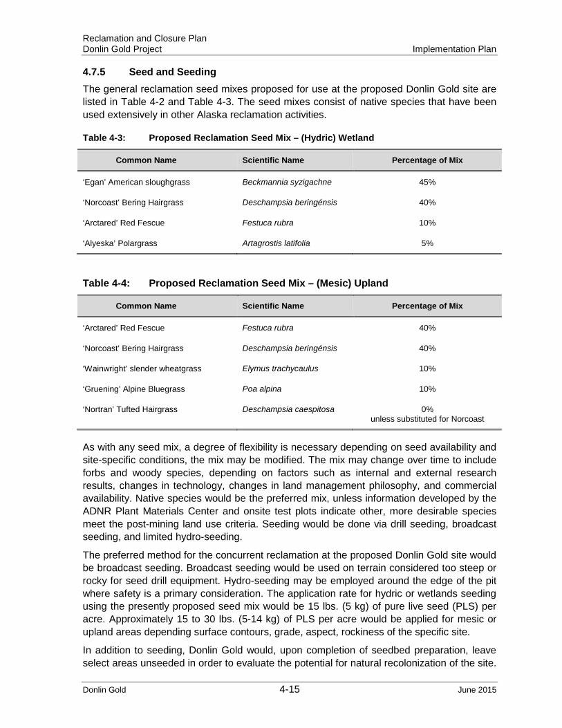
Reclamation and Closure Plan Donlin Gold Project Implementation Plan
4.7.5 Seed and Seeding The general reclamation seed mixes proposed for use at the proposed Donlin Gold site are listed in Table 4-2 and Table 4-3. The seed mixes consist of native species that have been used extensively in other Alaska reclamation activities.
Table 4-3: Proposed Reclamation Seed Mix – (Hydric) Wetland
Common Name Scientific Name Percentage of Mix
‘Egan’ American sloughgrass Beckmannia syzigachne 45%
‘Norcoast’ Bering Hairgrass Deschampsia beringénsis 40%
‘Arctared’ Red Fescue Festuca rubra 10%
‘Alyeska’ Polargrass Artagrostis latifolia 5%
Table 4-4: Proposed Reclamation Seed Mix – (Mesic) Upland
Common Name Scientific Name Percentage of Mix
‘Arctared’ Red Fescue Festuca rubra 40%
‘Norcoast’ Bering Hairgrass Deschampsia beringénsis 40%
‘Wainwright’ slender wheatgrass Elymus trachycaulus 10%
‘Gruening’ Alpine Bluegrass Poa alpina 10%
‘Nortran’ Tufted Hairgrass Deschampsia caespitosa 0% unless substituted for Norcoast
As with any seed mix, a degree of flexibility is necessary depending on seed availability and site-specific conditions, the mix may be modified. The mix may change over time to include forbs and woody species, depending on factors such as internal and external research results, changes in technology, changes in land management philosophy, and commercial availability. Native species would be the preferred mix, unless information developed by the ADNR Plant Materials Center and onsite test plots indicate other, more desirable species meet the post-mining land use criteria. Seeding would be done via drill seeding, broadcast seeding, and limited hydro-seeding.
The preferred method for the concurrent reclamation at the proposed Donlin Gold site would be broadcast seeding. Broadcast seeding would be used on terrain considered too steep or rocky for seed drill equipment. Hydro-seeding may be employed around the edge of the pit where safety is a primary consideration. The application rate for hydric or wetlands seeding using the presently proposed seed mix would be 15 lbs. (5 kg) of pure live seed (PLS) per acre. Approximately 15 to 30 lbs. (5-14 kg) of PLS per acre would be applied for mesic or upland areas depending surface contours, grade, aspect, rockiness of the specific site.
In addition to seeding, Donlin Gold would, upon completion of seedbed preparation, leave select areas unseeded in order to evaluate the potential for natural recolonization of the site.
Donlin Gold 4-15 June 2015

Reclamation and Closure Plan Donlin Gold Project Implementation Plan
If these areas do not meet the revegetation criteria discussed in the following sections, they would be seeded using the methods described above.
4.7.6 Mulch In most instances of mined land reclamation in the Lower 48 states, mulches are necessary to protect the seed and help retain soil moisture during the critical germination process. Numerous types of materials have been used successfully as mulch in revegetation efforts. However, experience has proven that straw or grass hay at a rate of 12 st (11 t) per acre is most cost effective. Slopes too steep for equipment generally require an application of hydro-mulch via a hydro-seeder at an approximate rate of 1 st (0.9 t) per acre. Commercial hydro-mulch generally consists of wood fiber byproducts or other forms of cellulose.
If mulch application is necessary, it would be applied following seeding and soil amendment application with a standard straw (or hay)5 blower mounted behind a truck or tractor. If necessary, the mulch would then be crimped into the seedbed using a cultipacker or shallow set disk harrow to prevent wind blow and increase microhabitat for seed germination.
On those areas where a hydro-seeder may be used, hydro-mulch, if needed, would be incorporated into the seed and amendment mix for one-time application. The hydro-mulch would contain a tackifier, if necessary, to help hold the mulch mix in place.
4.7.7 Control of Invasive Species During vegetation establishment, weed control practices would be implemented to limit the growth and spread of noxious weeds and benefit the revegetation process. The control program would include the use of weed-free mulch in the reclamation program, and all seeds would be tested and certified “weed-free” before planting. The primary method of control would be to seed disturbed areas as soon as practicable after the seedbed has been prepared.
4.7.8 Revegetation Timing Generally, seeding would be implemented after spring break-up until mid-July to allow the seed to take advantage of the summer moisture period, seeding as soon as possible following seedbed preparation. Mine revegetation test plot research and experience with concurrent reclamation would be used to determine the most productive planting time, and evaluate the potential for dormant seeding of the same plant material used in spring/summer seeded plots.
4.7.9 Revegetation Cover Criterion A vegetative cover criterion of at least 70% used at other interior Alaska hard rock mines since 1994 would be achieved prior to requesting bond release and/or final abandonment of the project site6. Concurrent reclamation areas also would be required to meet the aforementioned criteria prior to Donlin Gold requesting bond release.
5 Certified Noxious Weed Free 6 Alaska Reclamation Performance Standard (AAC97.200) also defines successful re-vegetation as re-vegetation that occurs “within 5-years after reclamation is completed without the need for fertilization or re-seeding.”
Donlin Gold 4-16 June 2015
Reclamation and Closure Plan Donlin Gold Project Implementation Plan
The reclamation goal of at least 30% vegetative cover over a three-year period is an interim action level criterion, which would indicate to Donlin Gold whether additional reclamation action would need to be taken to establish a viable vegetative cover and a continuing natural succession of plant species. Further action could include reseeding the area, additional application of soil amendments, and/or incorporation of additional growth media on a particular site or facility. Donlin Gold would be responsible for determining the cause and resolution of substandard revegetation cover.
4.8 Area-Specific Reclamation
4.8.1 Roads and Airstrip Both Donlin Gold’s corporate standards and state and federal regulatory standards require most proposed mine site roads be reclaimed. However, the 30-mile (48 km) Jungjuk Port access road to the mine site would be required for long-term monitoring of the project site and would remain into the foreseeable future following mine closure.
Although many of the mine roads (i.e., access roads, haul roads, construction roads, etc.) differ somewhat in width and construction; essentially, reclamation would be the same for all mine roads. Culverts would be removed, natural drainage areas restored or stabilized, and roadbeds would be graded where necessary to provide adequate drainage. Water bars to divert run-on and run-off, and control erosion and berms to restrict human access, would be incorporated where necessary and as approved by ADNR. Reclamation of these features would include development of a streambank stabilization protocol that would consider the variability of stream crossings, as well as more site-specific options as identified in the State of Alaska publication, Streambank Revegetation and Protection – A Guide for Alaska (Walter et al, 2005).
Onsite roads not required for long-term monitoring would be ripped, as necessary, to eliminate the effects of compaction, recontoured to blend with the original topography, covered with a layer of growth media, and reseeded to meet the general reclamation standards. Berms, side-cast material, and road drainage ditches would be reclaimed in this process. Blacktop road and parking surfaces would be ripped and buried in place in road ditches and depressions prior to regrading.
The airstrip would also remain as a long-term asset; therefore, it is not included in the reclamation cost estimate.
4.8.2 Open Pit(s) During active mining, reclamation activity in and around the open pit(s) would be limited to controlling erosion on the haul roads to prevent undue degradation to adjacent undisturbed area. Upon final mine closure, haul roads in and around the pit would be smoothed of all berms except those necessary for erosion control and public safety. The safety berms would be far enough from the highwalls to prevent them from damage in the event of highwall failure. Road cuts and fills would be recontoured as much as feasible, and the roadbeds would be ripped and scarified where necessary.
The ACMA pit advances into the smaller Lewis pit area in the later years of mining, resulting in a single large pit upon closure. Approximately 446 M tons (404.06 Mt) of backfill (primarily overburden and waste rock) would be placed in this ultimate pit. Pit highwalls would be
Donlin Gold 4-17 June 2015
Reclamation and Closure Plan Donlin Gold Project Implementation Plan
stabilized where practicable based on Donlin Gold engineering recommendations. Stable highwalls, which are suitable for raptor nesting, would be left in place.
Upon closure, a pit lake would begin to form from groundwater and surface water inflows. It is estimated that it would take approximately eight years for the void areas in the backfill material to fill prior to a pit lake forming and slowly increase in size, to a maximum surface area of approximately 1,070 acres (433 ha). A water treatment plant (WTP), described in detail in the Water Resources Management Plan, Donlin Gold Project, SRK 2012c, would begin to operate when the water reaches an elevation approximately 33 ft. (10 m) below invert level of the spillway that would allow free flow into Crooked Creek. An approximate average lake level of 316 ft. msl (96 m amsl) would be maintained. This average water level provides sufficient freeboard for the design runoff event (100-year snowmelt plus 100-year, 24-hour rainfall event) and a sequence of years with above-average precipitation.
Preliminary predictions of water quality in the pit lake, as reported in the pit lake modeling assessment (Lorax 2011), suggest that the overall pit lake water quality will not meet Alaska’s most stringent water quality limits, as defined by 18 AAC 70, Water Quality Standards (as amended April 8, 2012) and the Alaska Water Quality Criteria Manual for Toxic and Other Deleterious Organic and Inorganic Substances (as amended through December 12, 2008). However, the Donlin Gold Ecological Risk Assessment for the Proposed Future ACMA Pit Lake (Arcadis 2013) concluded that the pit lake water would be non-toxic to avian and terrestrial wildlife that may occasionally use the area, but pit lake water will required water treatment to meet applicable water effluent limits prior to discharge into Crooked Creek. The capital and operating costs for the WTP (perpetuity), as well as the cost of long-term monitoring, are included in Appendix C and were developed to provide adequate financial surety to fund post-closure activities.
4.8.3 Waste Rock Facility During active operations, inactive or dormant areas of the WRF will be re-grade to final reclamation slopes of approximately 3H:1V. Once the area is recontoured, a minimum of 1 ft. (0.3 m) of terrace gravel and/or colluvium will be spread over the surface, and then a layer growth medium consisting of organics and fine grained materials 1.15 ft. (0.35 m) thick will be placed on top of the mineral soil. This concurrent reclamation of inactive portions of the WRF would improve the quality of the surface water runoff, minimize the overburden material stockpiled for final reclamation, and establish a vegetative cover that would be monitored and augmented, if needed, during ongoing operations.
Upon cessation of mining, the proposed Donlin Gold WRF, containing approximately 2.46 B tons (2.23 B tonnes) of overburden and waste rock, would require reclamation. However, the WRF has been designed to maximize concurrent reclamation, minimize the effects of any potentially metal leaching or acid generating (ML/ARD) materials that is inadvertently remains on the surface, and optimize the cost of closure. The proposed Donlin Gold WRF would be constructed in lifts and would be reclaimed as soon as practical after each lift or portion of the facility is complete. After active dumping ceases on each lift, the slopes would be regraded to less than or equal to 3H:1V. Large (geochemically inert) boulders uncovered during grading would be left on the surface to provide topographic diversity and microhabitats for wildlife and vegetation, and to break the linear appearance of the final slope.
Donlin Gold 4-18 June 2015
Reclamation and Closure Plan Donlin Gold Project Implementation Plan
An intermediate cover, consisting of a minimum of 3.3 ft. (1 m) of terrace gravel to minimize infiltration, would be placed on potential acid generating (PAG)-6 material in the waste rock dumps during operations as each lift is completed. PAG-6 material would be expected to generate acid rock drainage during the life of the mine. Further discussion of the waste material geochemistry and the proposed management of these materials are provided in Waste Rock Management Plan, Donlin Gold Project (SRK 2012b`). The final cover for the WRF would consist of a layer of non-acid generating rock (>20 ft. or 6 m) over the final PAG lift, followed by a minimum of 1.15 ft. (0.35 m) of growth medium (peat mineral mix) over a minimum of 1 ft. (0.3 m) of terrace gravel and/or colluvium.
When final grading, contouring, and application of growth media have been completed, the WRF would be ripped along contours. Intervals between contour rips would be based on best engineering judgment and length of slope. The distance between drainage breaks would depend on the final slope angle of the WRF, and would be based on best management practices (BMPs) as specified in the stormwater pollution prevention plan (SWPPP) for closure.
Surficial scarification along contour would reduce erosion potential by reducing smooth slope length, provide micro habitats for increased moisture retention and seed germination, and help break linear aspects relative to aesthetics. Brush berms and/or sedimentation berms, constructed at the toe of each dump, would remain until a vegetative cover is established and the potential for erosion is minimized.
The WRF would be seeded and mulched, as necessary, following physical preparation. It is anticipated that broadcast-seeding methods would be utilized for this facility.
WRF reclamation and water management conditions at closure are projected to be as follows:
• The WRF would be covered with approximately 14 inches (35.5 cm) of peat/organic (growth medium) cover over approximately 12 inches (30.5 cm) of colluvium or terrace gravel. Progressive reclamation would be conducted during operations, but final cover materials would need to be placed in the remaining incomplete areas such as active haul roads and Upper Contact Water Dam (CWD).
• The Lower and Upper CWDs would be removed.
• Surface runoff from the WRF would gravity flow to the ACMA pit through constructed collection and drainage channels (Figure 4-3).
• Seepage from the WRF would gravity flow into collection pipes and piped to the bottom of the ACMA pit (Figure 4-4).
• The ACMA pit and part of Lewis pit would be progressively backfilled with waste rock during operations, starting in year 22. The deepest portion of the ACMA pit would be backfilled to approximately 695.5 ft. below mean sea level (msl) (212 m below msl) elevation, at which, a pit lake can be maintained at an approximate maximum depth of 1,023.5 ft. (312 m). Other portions of the Lewis and ACMA pits would be backfilled to approximately 111.5 ft. above msl (34 m above msl) to maintain a depth of approximately 216 ft. (66 m). Once the pit lake is near capacity, water would be treated and discharged to Crooked Creek in accordance with the processes and standards set out in Section 4.8.2 to avoid uncontrolled flow over the spillway.
Donlin Gold 4-19 June 2015
Reclamation and Closure Plan Donlin Gold Project Implementation Plan
The seepage flows from the WRF would be isolated by constructing four small, concrete containment structures at the outlet of the rock drains for American Creek and Rob’s Gulch. The seepage water then would be piped to the bottom of ACMA pit to encourage pit lake stratification. Surface runoff would drain naturally to the surface of the pit lake (Figure 4-4).
4.8.4 Tailings Storage Facility Several years before the end of operations, tailings deposition would be modified to direct the operating pond toward the southeast corner of the TSF. This would be done in anticipation of final closure of the TSF, when the tailings surface runoff would be directed to the closure spillway into Crevice Creek. At cessation of milling operation, the TSF water would be pumped from a small lined impoundment located on the southeast corner of the TSF to the ACMA pit through a reclaim pipeline until the applicable Alaska Water Quality Standards are met for discharge over the spillway. The physical closure of the TSF (i.e. pumping of the TSF decant pool to ACMA Pit, placement of cover, construction of the spillway, etc.) is expected to take approximately five years (Water Resources Management Plan, Donlin Gold Project (SRK 2012c).
The tailings impoundment will require a closure cover to minimize groundwater interaction and reduce salt mobilization. The cover would include coarse NAG waste rock overlain by colluvium/terrace gravel, overlain by a peat/mineral growth media mix. In addition, the soil cover would promote surface runoff and reduce the potential for meteoric waters to infiltrate through the consolidated tailings.
The closure spillway has been sized to pass the peak instantaneous flow associated with the 24-hour probable maximum precipitation (PMP) event: to 9,959 cfs (282 m3/s). The closure spillway will be a 33 ft. (10 m) wide, 26 ft. (8 m) deep cut-in rock at 1H:1V side slopes, with excavation of the overlying overburden at 2.5H:1V slopes (BGC 2011c).
Donlin Gold 4-20 June 2015
TYPICAL FACILITY DRAINAGE CHANNELS
FIGURE:SCALE:
DG: PER0166.mxd, 08/27/09, R00
DONLIN GOLD PROJECT
4-3N/A
4-4Surface and Seepage Collection
Schematic
SCALE:
0 1 2 3
Kilometers
0 0.5 1 1.5 2
Miles
(E(Ñ
(E(Ñ
(E(Ñ
(E(Ñ
"
!?
"
"
PIT LAKE
SEEPAGE MONITORINGSYSTEM
American Creek
Cro
oked
Cre
ek
Anaconda Creek RECLAIMED TAILINGS STORAGE FACILITY (TSF)
Omega Gulch
RECLAIMEDWASTE ROCK
FACILITY (WRF)
ELEVATION 253 m
300
400
200
500600
200
200
300
200
500
400
400
400
500
300
500
400
300
400
200
538,000
538,000
540,000
540,000
542,000
542,000
544,000
544,000
546,000
546,000
548,000
548,000
550,000
550,000
552,000
552,000
6,87
4,00
0
6,87
4,00
0
6,87
6,00
0
6,87
6,00
0
6,87
8,00
0
6,87
8,00
0
6,88
0,00
0
6,88
0,00
0
TSF RECLAIMED ULTIMATE DAM FACES
WRF SEEPAGE COLLECTION POINT
CLOSURE & POST CLOSUREPUMP STATION
PRIMARY DRAINAGE CHANNEL
RECLAIMED FACILITIES
NON DISCHARGEABLEWATER COLLECTION LINE (TYP.)
SECONDARY DRAINAGE CHANNEL
(E(Ñ SEEPAGE MONITORING/RECYCLE WELLS
!?CLOSURE WATERTREATMENT PLANT
POND OR LAKE
"
CONTOURS100 m
10 m
³ TSF IMPOUNDMENT CLOSURE SPILLWAY
TSF IMPOUNDMENT CLOSURE COVER
Reclamation and Closure Plan Donlin Gold Project Implementation Plan
During the first year of closure, an estimated 23,057 acre-ft. (28.44 Mm3) of tailings pond water will be pumped to the open pit using the tailings decant reclaim pipeline. Pumping of the water to the pit will allow for the subsequent placement of cover material on the western quarter of the TSF. The resulting exposed tailings surface will be allowed to sit for one year to dry providing a suitable working surface for cover placement with low ground-pressure equipment. The operating pond would be controlled during the closure period to minimize dusting issues.
During year two of the closure period, the first quarter of the cover will be constructed to along the western end of the facility. The pond will be further lowered to expose the second quarter of the tailings beach for the subsequent construction season. The tailings pore water that is released in response to loading the tailings with the closure cover will report to the remaining operating pond. During the reclamation period, pumping to ACMA Pit will continue to prevent a large pond from redeveloping on the TSF.
During year three of closure, the pond will be drained to expose the third quarter of the impoundment and the second quarter of the closure cover will be completed. By year four, the pond will be substantially drained and the third quarter of the closure cover will be completed. The tailings pore water released in response to tailings loading by the closure cover will report to the low point adjacent to the closure spillway and will be pumped to the Pit Lake.
During the final year of the closure period, the remaining quarter of the tailings closure cover will be completed. A small lined pond will be constructed in this area to allow for monitoring and control of the tailings cover surface runoff to verify that it is suitable for discharge. The pond will store 162 acre-ft. (200,000 m3) and will have approximate dimensions of 10 ft. x 738 ft. x 984 ft. (3 m x 225 m x 300 m) and a depth of 9.8 ft. (3.0 m). If this water is not suitable for discharge, it will be pumped to the pit lake as a contingency. Additional water management details for this period are provided in the Water Resources Management Plan, Donlin Gold Project (SRK 2012c).
It is expected that the tailings will consolidate with time over the five-year closure period. Predicted near terminal density will be reached approximately 52 years after the end of operations. An allowance has been made in the quantity of rockfill placed as part of the closure cover to compensate for the expected settlement due to consolidation.
The tailings closure cover will be comprised of a minimum 3.3 ft. (1 m) coarse NAG waste rock overlain by a minimum 1.0 ft. (0.3 m) of colluvium/terrace gravel overlain by a approximately 1.15 ft. (0.35 m) of peat/mineral mix. Stripped overburden material temporarily stored in the TSF stockpiles will be used for the closure cover. The resulting runoff from the constructed cover is expected to be suitable for discharge without treatment.
From year 6 to 52 of the closure period, pumping will occur out of the rockfill layer that provides a capillary break between the tailings and the cover. Pumping will be required out of this layer to capture void water generated by ongoing consolidation of the tailings and water infiltrating the TSF cover. Drain sumps installed in manholes would be used for this purpose. The consolidation water will mix with water that infiltrates the cover. This mixed water is assumed to be unacceptable for discharge and would be pumped to ACMA Pit.
Surface runoff water will be held and tested to verify it meets Alaska Water Quality Standards for discharge through the closure spillway. The Water Resources Management
Donlin Gold 4-23 June 2015
Reclamation and Closure Plan Donlin Gold Project Implementation Plan
Plan (SRK 2012c) was developed assuming that this water will be of suitable quality for discharge, and that runoff from the pond will be permitted to drain to Crevice Creek from year six on (BGC 2011b).
Due to the metal leaching nature of all waste rock from the open pit (SRK 2007), all downstream rockfill dam faces will require covering at closure. The downstream face of the tailings dam will be flattened from 1.7H:1V to 2H:1V to allow placement of 1 ft. (0.3 m) of colluvium beneath 1.15 ft. (0.35 m) of organic growth medium on the rockfill face. The resulting runoff from the cover is expected to be suitable for discharge without treatment.
The seepage recovery system downstream of the TSF main dam, consisting of a monitoring pond and seepage monitoring/collection wells, would be maintained during closure and into post-closure. Downgradient compliance monitoring wells will be maintained indefinitely.
4.8.5 Buildings and Equipment Sites As facility components of the site are decommissioned, materials, equipment, and buildings would be removed. Equipment and piping not needed for the reclamation and post-closure monitoring activities would be utilized at another mining site, sold or salvaged, or disposed of in an approved manner. Process components (those that are in direct contact with process reagents) would be rinsed with fresh water during decommissioning. This rinsate would be collected and treated at the WTP.
Remaining structures on the site and foundations would be reduced to rubble and disposed of in a manner approved by the ADEC. Donlin Gold currently anticipates that, once the buildings have been demolished, the foundations would be broken up to prevent them from being an impermeable impediment to natural percolation of meteoric waters. Following equipment and structure removal, sites would be graded lightly for proper drainage, ripped and scarified, seeded, and mulched if necessary. Although it is not likely that growth media would be needed, each site would be evaluated following grading. A thickness of approximately 3.3 ft. (1 m) of cover colluvium would be established over the buried debris to ensure it remains subsurface into the foreseeable future.
The primary intake for the primary crusher would be demolished to original grade, and the subsurface portion backfilled with inert construction debris or inert waste rock. During demolition of the rock groyne (crusher conveyor berm), approximately 464,300 yd3 (355,000 m3) of rock would be removed and placed in adjacent yard areas for final reclamation.
4.8.6 Yard Areas Considering their large size, the stable yard areas (e.g., platforms created for buildings, laydown areas, and other undefined disturbances) would be reclaimed in a manner similar to the WRF. In keeping with the reclamation plan for the property, each of the disturbed areas would be regraded to acceptable slopes.
Given the topographical relief at Donlin Gold, most of the working areas, including the mill, crusher, shop, and fuel storage, are on large pads constructed primarily by balanced cut-and-fill techniques. Once internal structures and foundations have been appropriately demolished, removed, or buried, the next step in meeting reclamation criteria for large yard areas is to regrade the cut-and-fill sections to blend with the surrounding topography, where
Donlin Gold 4-24 June 2015
Reclamation and Closure Plan Donlin Gold Project Implementation Plan
appropriate. The areas would then be ripped to mitigate the compaction effects of traffic and infrastructure, covered with growth media (as necessary), and seeded.
4.8.7 Miscellaneous Sites
Wells and Well Closure Once monitoring of the TSF indicates component stability, the applicable monitoring wells for this facility would be abandoned by plugging the well and removing the surface casing. Pit dewatering wells also would be abandoned, when no longer required, as part of the mining operation.
Well abandonment would be conducted in accordance with ADEC regulations (18 AAC 80.015) and would be in a manner to prevent the transmission of water from one vertical level within the well to another (e.g., cross-aquifer contamination). Abandonment procedures generally include removal and disposal of pumps and piping, removal of the casing where possible, plugging of the well with an approved sealing material at total depth, removal of the collar, minor grading around the well site, and seeding and mulching to re-vegetate the immediate area of the well and service road.
At Donlin Gold, bentonite or cement grout would be forced into the perforated screened interval and into the remainder of the well casing to decommission the well in a way that protects the groundwater resources.
After mining ceases, additional wells not needed for post-closure monitoring would require abandonment. This issue would be revisited on a periodic basis as additional operating data becomes available and during development of final process component closure plans. Final process component closure and monitoring plans would require approval from ADEC.
Fence Removal The use of fences as a post-mining reclamation structure would be minimized in favor of more permanent structures, such as earthen berms, to restrict access to the open pits. The use of fencing during closure would be limited to reagent areas necessary for the security and safety at the WTP facilities. All other reagents and chemicals (including, but not limited to petroleum products) would be removed from the site.
Electrical Power Facilities When the large electrical power requirements are no longer necessary, substations, overhead power lines, and associated facilities would be removed from the site, unless it is agreed upon by the land owner to keep them.
The main power generating facilities would no longer be necessary at the end of mining and milling operations, and the generators would be removed from the site or demolished and buried on site, in keeping with regulatory and corporate requirements.
Donlin Gold currently assumes that only a small generator will be required to operate the post-closure WTP and associated pumps needed for the seasonal operations.
Donlin Gold 4-25 June 2015
Reclamation and Closure Plan Donlin Gold Project Implementation Plan
Fuel Storage Facility, Natural Gas Metering Station, Pipeline Distribution System The fifteen 2.5 Mgal (9.5 ML) diesel fuel tanks would be drained, rinsed, dismantled, foundations demolished and materials disposed of in the on-site landfill. Rinsate water would be sent to an oil/water separator for treatment prior to discharge.
The 313-mile (503 km) proposed Donlin Gold natural gas pipeline reclamation and abandonment falls under the jurisdiction of the U.S. Department of Interior, BLM and the State of Alaska Pipeline Coordinator’s Office and will require Donlin Gold to comply with the applicable federal and state statutes and regulations for pipelines (SRK 2012a).
However, metering station and natural gas distribution systems at the Donlin Gold site would be covered by this Reclamation and Closure Plan. The metering facilities and aboveground piping will be removed, salvaged, or disposed of on the onsite inert landfill. Below ground piping will be abandoned in place, and any surface exposure would be cut below ground level and buried.
Waste Disposal Non-hazardous demolition debris would be placed in the inert landfills located in the WRF or used to fill subsurface voids exposed during the demolition of surface facilities. The resulting surface of any voids filled with construction debris would be shaped to reduce ponding, covered with approximately 1 ft. (30.5 cm) of cover, and revegetated in the same manner as the WRF.
Hazardous and toxic materials, such as reagents, petroleum products, acids, and solvents, would be transferred off site by licensed transporters and either returned to the vendor or disposed of at licensed treatment, storage and disposal facilities, see the Integrated Waste Management and Disposal Plan, Donlin Gold Project (SRK 2012d). Hydrocarbon-contaminated soils would be removed from the site for offsite treatment and/or disposal.
Port Facilities and Access Road The Jungjuk Port facilities also would be reclaimed. All mine support facilities would be removed and reclaimed, as described in previous sections. The sheet piles and fill would be removed, and the area recontoured (Wright and Czapla 2010). The 30-mile (48 km) Jungjuk Port access road to the mines site would be required for long-term monitoring of the project site, seasonal operation of the WTP, and would remain into the foreseeable future following mine closure.
Mobile Equipment
For the purposes of this Plan, no salvage value would be assigned to the mobile equipment. Therefore, this equipment would be buried in the WRF at closure. To prevent degradation of water resources or other contaminant mobilization, all fluids would be drained and batteries remove from all mobile vehicles prior to burial in compliance with the applicable solid waste disposal regulations (18 AAC 60). The inert equipment would then be covered under reclaimed dump faces during regrading activities. The inert equipment burial locations within the WRF would be surveyed and reported to the ADEC in the final closure report for the site (SRK 2012d).
Donlin Gold 4-26 June 2015
Reclamation and Closure Plan Donlin Gold Project Implementation Plan
Snow Gulch Reservoir Fresh Water Reservoir
The Snow Gulch Fresh Water Reservoir will be drained, the dam breached, and the footprint recontoured and revegetated. Associated power line and pipelines will be decommissioned, removed, and the access road reclaimed.
4.8.8 Control of Sedimentation Each of the reclaimed components would be able to withstand design storm events (e.g., 100-year, 24-hour storm event). As discussed previously, it is critical to successful closure of the WRF that runoff is directed away from any potentially reactive ore, and that runoff is quickly conveyed from the facility without posing a risk to the long-term stability of the cover and the structure itself. Similarly, drainage control from the tailings cover is critical to the long-term success of the closed TSF. The precise technical specifications for the management of storm water runoff following closure of the site would be developed as part of the update SWPPP for closure.
Reclaimed WRF Cover Runoff Collector Channel A flat-bottom runoff collection channel would be constructed on the cover of the reclaimed WRF, running along the south margin of the facility. The purpose of the channel is to collect runoff from the WRF cover system and convey it to the pit lake at closure. Overburden stripping would not be required because the channel would be constructed on the final cover system.
The channel would be lined with 40-mm LLDPE to mitigate the potential for erosion of the WRF cover system. The channel would have a 13 ft. (4 m) base, 2H:1V side slopes, a channel depth of 7.5 ft. (2 m), and a 2 ft. (0.6 m) thick armor layer placed over a 1 ft. (0.3 m) thick cushion liner above the LLDPE liner. For protection, the liner would also be underlain by a 1 ft. (0.3 m) bedding layer of terrace gravel or colluvium on top of the waste materials. The liner would extend one-third of the way up the channel slopes to permit ingress from channels that develop in the cover system over time during closure.
WRF Seepage Intakes and Pipeline At closure, seepage from the base of the WRF would be collected into a 2 ft. (609.6 mm) diameter pipe and conveyed to the bottom of the pit lake (Figure 4-3). Two intakes are required: one at the downstream toe of the WRF in Rob’s Gulch and one at the downstream toe of the WRF in American Creek. The pipes would join at the confluence of American Creek and Rob’s Gulch, and run on grade (1% slope) to the edge of the pit lake. The pipe would be insulated (not heat traced) and would be approximately 1.75 miles (2.8 km) long, constructed of high-density polyethylene (HDPE) DR17, with 3 inches (7.6 cm) of polyurethane insulation.
At the edge of the pit lake, the water would feed into the pipeline used to convey TSF water to the bottom of the pit. Based on the dimensions of the TSF reclaim water and contact water dam systems, this pipe would be 32 to 36 inches (813 to 914 mm) in diameter. The intake structure would be a concrete thrust block and sump. The area between the pipeline inlet and the preproduction toe of the dump would be graded to funnel the seepage into the sump. Rock from the WRF rock drain would be used to armor this sloped area against erosion. The reclaimed surface of the WRF in this area would be graded to divert runoff from
Donlin Gold 4-27 June 2015
Reclamation and Closure Plan Donlin Gold Project Implementation Plan
the upgradient cover system around the intake structure. Annual maintenance would be required until revegetation is established. Periodic maintenance would be done thereafter to maintain drainage grades (Figure 4-4).
4.8.9 Monitoring and Maintenance Monitoring systems for process components would remain in place until each specific facility has been chemically stabilized to the satisfaction of the ADEC; see the Integrated Waste Management Monitoring Plan, Donlin Gold Project (SRK 2012e) for Closure and Post-Closure. Once physical reclamation has begun, temporary diversions and sedimentation control systems would be monitored on a routine basis (weekly when weather conditions allow) by Donlin Gold personnel. These systems would be cleaned, repaired, and modified as necessary.
Long-term or permanent diversions and the safety fencing and signage would be monitored and maintained as needed until the reclamation sureties have been released.
Success of reclamation would be monitored in two ways:
1. Physical reclamation such as earthwork and growth media application would be checked for excess erosion problems periodically and immediately following major rain storms. Remedial action to correct instability would be taken as soon as feasible following detection of substantial erosion or loss of growth media.
2. Vegetation success would be monitored qualitatively by visual inspection on an ongoing basis by Donlin Gold and ADNR personnel, and quantitatively once per year. A consulting professional would conduct quantitative analysis at the end of the growing season (end of August).
The ADNR, ADF&G, and Donlin Gold would determine performance criteria for vegetation success. Presently, revegetation cover criterion is outlined in Section 4.7.9. Donlin Gold would seek release of the reclamation surety on a facility-by-facility basis (as per 11 AAC 97.435) as quantitative data indicate the established criteria have been met.
Donlin Gold 4-28 June 2015
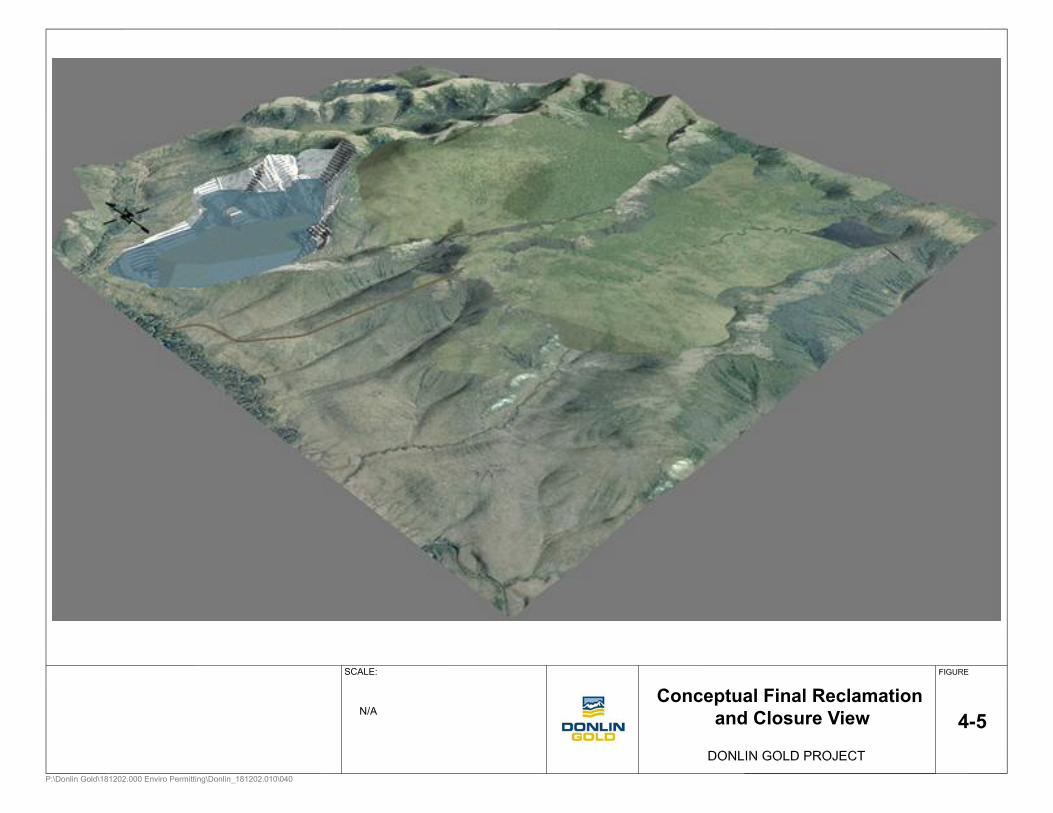
4-5Conceptual Final Reclamation
and Closure View
SCALE:
N/A
Reclamation and Closure Plan Donlin Gold Project Applicant Statement of Responsibility
5.0 APPLICANT STATEMENT OF RESPONSIBILITY Donlin Gold recognizes its responsibility in the use of private and public (state) lands, and accepts that responsibility in agreeing to reclaim the proposed Donlin Gold project site. This acknowledgement includes, but is not necessarily limited to conformance with applicable statutes and regulations implemented by ADNR and ADEC (Section 1.1). Donlin Gold would meet the requirements of its reclamation plan and return the site to a safe and stable condition consistent with the approved post-mining land use. Donlin Gold would meet required local, state, and federal regulations regarding reclamation of any surface area affected by the mining and processing operations. Reclamation activities and post-reclamation maintenance of remaining structures are Donlin Gold’s responsibility.
In the event a new operator/land owner assumes control of the proposed Donlin Gold project, at that time, the new operator or land owner would agree to assume responsibility for the reclamation and maintenance of any affected land and structures that are the subject of this Plan or existing permits. The new operator/land owner would request transfer of all applicable state and federal permits. The new operator/land owner would provide evidence that a surety is filed with ADNR that would cover reclamation of disturbed lands, including privately owned and state land, as well as post-reclamation maintenance of remaining structures.
Donlin Gold 5-1 June 2015
Reclamation and Closure Plan Donlin Gold Project Estimate of Reclamation Costs
6.0 ESTIMATE OF RECLAMATION COSTS The estimated reclamation costs for the various components of the proposed Donlin Gold project represent conceptual reclamation and closure methods. The Standard Reclamation Cost Estimator (SRCE) Version 1.4.1.16 was used to prepare this cost estimate. Modifications to SRCE Version 1.4.1.16 included the addition of equipment needed for reclamation activities, as well as additional building demolition equipment.
6.1.1 Closure Cost Rates Costs used to populate the SRCE model were based on the following sources:
• 2014 costs from current vendors doing business in Alaska
• Alaska Davis Bacon Labor Rates (September 2014)
• Material costs from the RS Means Heavy Construction Cost Data, Western Edition (2012)
• Caterpillar Performance Handbook (2010)
• NC Machinery Equipment Rental Rates
• Construction Machinery, Inc. Equipment Rental Rates (2015)
• Alaska Marine Lines – Tariff Rates (2015) In determining the prevailing labor rates, the Alaska Department of Labor and Workforces Development, Division of Labor Standards and Safety’s Laborers' & Mechanics' Minimum Rates of Pay (Pamphlet 600) (Alaska “Little Davis-Bacon”) was used and will be updated as the Pamphlet is updated.
Material costs for fuel, concrete, etc., were provided by Alaska vendors. Information provided in 2012 RS Means Heavy Construction Cost Data, 26th Edition, was used where equipment, labor, or material rates were unavailable from other sources.
6.1.2 Closure Cost Productivities Productivity data and calculations were based on:
• Caterpillar Handbook, Edition 36, for productivity calculations as incorporated into the SRCE.
• R.S Means Heavy Construction Cost Data (2012) for productivities/crews for demolition. A large excavator with shears and a medium excavator with grapples were added to the building demolition fleet, but no productivity increase was included because of unfamiliarity with this methodology.
• Use of best estimates and available data to populate the SRCE cost model.
6.1.3 Key Cost Assumptions The following closure cost assumptions were made:
• Mine mobile equipment on site will not be used for reclamation
• All structures and infrastructure will be removed
Donlin Gold 6-1 June 2015
Reclamation and Closure Plan Donlin Gold Project Estimate of Reclamation Costs
• Demolition shears are likely to be used to demolish buildings. Hourly costs for use of the shears and estimated productivity of the shears were not available at this time. Costs for building, foundation, and wall demolition were derived from R. S. Means Heavy Construction Cost Data
• Demolition shears are likely to be used to demolish large storage tanks. Since this is a cutting exercise only, productivity was estimated based on shear cut depth and opening and closing times as provided by the manufacturer
• No salvage value is assumed for scrap, equipment, or mobile fleet
• Waste rock is used for tailings cover
6.1.4 Conclusions Acknowledging the social and environmental responsibility associated with modern mining operations, Donlin Gold recognizes and commits to the comprehensive closure and reclamation of the proposed Donlin Gold site and ancillary facilities. All reclamation activities and post-reclamation maintenance of remaining structures (tailings dam, airstrip, and access roads) are the responsibility of Donlin Gold, unless and until a subsequent landowner assumes responsibility. A modification to the designated post-mining land use may require further changes to the Reclamation and Closure Plan, along with the timelines for implementing and finalizing closure.
The reclamation cost estimate, as discussed herein and included in Appendix B, is US$257,107,579. An additional amount is required to establish the Post-Closure Trust Fund (Appendix C), which is required to generate sufficient cash flow to ensure the following:
• capital to construct the WTP for long-term water treatment
• capital to replace the WTP every 30 years
• reagent and operating costs for the WTP (including monitoring and sampling)
• associated facility and access maintenance (includes Crooked Creek bridge replacement)
Post-closure activities (pumping, water treatment, monitoring, site maintenance, etc.) would commence five years after the mine is closed when all of the physical reclamation is complete. Financial assurance for long-term closure costs would be established in a trust fund. Costs for long-term post closure actives were estimated out to 200 years after closure of the operation. The 200-year time period is sufficient to demonstrate that the post-closure trust fund can be self-sustaining in perpetuity, should long term water management be required post closure. To make the trust fund self-sustaining and able to cover annual post-closure costs, a total of approximately $87 million dollars is required to be in place at the time of mine closure. Post closure growth of the trust fund is calculated using targeted returns for the Alaska Permanent Fund, while annual cost inflation is calculated using a five year average of the Anchorage consumer price index (CPI).
In order to build the trust fund to $87 million dollars at closure, Donlin would make annual contributions of approximately $2.7 million per year into the trust fund during Project construction and operations. Because this estimate will continue to be refined during Project
Donlin Gold 6-2 June 2015
Reclamation and Closure Plan Donlin Gold Project Estimate of Reclamation Costs
permitting, and review by the State of Alaska, the estimate of annual contributions is subject to change.
Donlin Gold would continue to submit an updated Reclamation Plan as required to keep current with operations, regulatory changes, and issues identified during the regular reclamation plan re-authorization, IWMP renewal cycle, and five year third-party Environmental Compliance Audits. During the review and update the annual payment would be adjusted based on any changes to the inflation rate, interest rates, estimated net rate of return, and any additional long-term closure items not previously included in the trust fund.
Donlin Gold 6-3 June 2015
Reclamation and Closure Plan Donlin Gold Project Acknowledgements
7.0 ACKNOWLEDGEMENTS
A. It is understood that should the nature of the operation change, a modified or supplemental plan of operations and reclamation may be required.
B. It is understood that approval of this Plan does not constitute:
1. Certification of ownership to any person named herein; and
2. Recognition of the validity of any mining claim herein.
C. It is understood that a bond equivalent to the estimated cost of performing the agreed upon reclamation measures would be required before this Plan can be approved. Bonding and any bond reduction amounts would be set on a site-specific basis by ADNR in coordination with the cooperating agencies.
D. It is understood that any information provided with this Plan or provided in the future, that is marked “Confidential” would be treated by the agency in accordance with that agency's laws, rules, and regulations.
E. Donlin Gold would conduct an environmental closure audit to determine if any previously unknown environmental liabilities exist as a direct or indirect result of the Donlin Gold project.
Donlin Gold has reviewed and agrees to comply with all conditions in the Reclamation and Closure Plan. Donlin Gold understands the bond would not be released until ADNR and ADEC give written approval of the reclamation work.
Donlin Gold LLC
By:
Title:
Signature:
Date:
Donlin Gold 7-1 June 2015

Reclamation and Closure Plan Donlin Gold Project References
8.0 REFERENCES
Arcadis U.S., Inc. 2013. Donlin Gold Project Ecological Risk Assessment for Proposed Future ACMA Pit Lake, Jamuary15.
BGC Engineering Inc., 2011a. Donlin Creek Gold Project, Feasibility Study Update, Waste Rock Facility Design-Final Report, July.
BGC Engineering Inc., 2011b. Donlin Creek Gold Project Feasibility Study Update Water Management Plan-Final, July 22.
BGC Engineering Inc., 2011c. Donlin Creek Gold Project Feasibility Study Update II, Tailings Storage Facility Design-Final Report, July 22.
Caterpillar, 2012. Caterpillar Performance Handbook Edition 36, Aril 10.
Czapla, P., & Wright, S. (2012) Interior Alaska Revegetation & Erosion Control Guide, State of Alaska Plant Material Center, July
Ferrians, O.J., 1965. Permafrost Map of Alaska, U.S. Geological Survey EROS Alaska Field Office
International Council on Mining and Metals (ICMM), 2006, Guidance - Paper Financial Assurance for Mine Closure and Reclamation.
Lorax Environmental, 2011. Donlin Creek Gold Project Feasibility Study Update II, Pit Lake Modeling Assessment, Final, July 22.
Means, R.S., 2012. Means Heavy Construction Cost Data, 26th Edition.
State of Alaska 2012. Alaska Department of Labor and Workforces Development, Division of Labor Standards and Safety’s Laborers' & Mechanics' Minimum Rates of Pay (Pamphlet 600) January 25.
State of Alaska, 2012. Water Quality Standards Amended April 8.
State of Alaska, 2011. Alaska Water Quality Criteria Manual for Toxic and Other Deleterious Organic and Inorganic Substances (Draft), as amended through December 12.
SRK Consulting (U.S.), Inc. 2007, Waste Rock Metal Leaching and Acid Rock Drainage Assessment for Feasibility Study - Donlin Creek Project, Final, September.
SRK Consulting (U.S.), Inc., 2011. Project Description, Donlin Gold Project.
SRK Consulting (U.S.), Inc. 2012a. Plan of Development - Natural Gas Pipeline, Donlin Gold Project.
SRK Consulting (U.S.), Inc. 2012b. Waste Rock Management Plan, Donlin Gold Project.
SRK Consulting (U.S.), Inc. 2012c. Water Resources Management Plan, Donlin Gold Project.
Donlin Gold 8-1 June 2015
Reclamation and Closure Plan Donlin Gold Project References
SRK Consulting (U.S.), Inc. 2012d. Integrated Waste Management Plan, Donlin Gold Project.
SRK Consulting (U.S.), Inc. 2012e. Integrated Waste Management Plan Monitoring Plan, Donlin Gold Project
Wright, Stoney J., 2008. A Revegetation Manual for Alaska. Alaska Plant Material Center, August.
Wright, Stoney J., Czapla, Philip K., 2010. Alaska Coastal Revegetation & Erosion Control Guide. Alaska Plant Material Center, December.
Walter, Jeanne, Hughes, Dean, Moore, Nancy J., Muhlberg, Gay, revised 2005. Streambank Revegetation and Protection – A Guide for Alaska. Alaska Department of Fish and Game, Division of Sport Fish.
Donlin Gold 8-2 June 2015
Appendix A Reclamation Plan Land Status
Reclamation Plan Land Status Lands Required for Proposed Donlin Project
Calista Corporation, Surface and Subsurface Estates The following real property is located in the Kuskokwim and/or Mt. McKinley Recording Districts, Seward Meridian, Alaska.
LANDS FOR MINING AND MINING RELATED PURPOSES Township 22 North, Range 48 West Sections 4, 5, 6, 7, 8, 9, 17, 18, 19, 20 Township 22 North, Range 49 West Sections I, 12, 13, 24 Township 23 North, Range 48 West Sections 3, 4, 5, 6, 9, 10, 15, 16, 21, 22, 27, 28, 32, 33, 34 Township 23 North, Range 49 West Section 28 Township 23 North, Range 50 West South 1/2 of Section 33 LANDS FOR ACCESS. ROADWAY. MATERIAL SITES. PORT SITE. AND EQUIPMENT LAYDOWN AREAS
Township 22 North, Range 50 West 20 acre material site within Section 12, exact location to be determined after construction with a survey 20 acre material site within Section 13, exact location to be determined after construction with a survey 20 acre material site within Section 35, exact location to be determined after construction with a survey Township 21 North, Range 50 West 20 acre material site within Section 2, exact location to be determined after construction with a survey 20 acre material site within Section 4, exact location to be determined after construction with a survey 20 acre material site within Section 9, exact location to be determined after construction with a survey
The Kuskokwim Corporation (TKC), Surface Estate
The following real property is located in the Kuskokwim and/or Mt. McKinley Recording Districts, Seward Meridian, Alaska.
LANDS FOR MINING AND MINING RELATED PURPOSES
Township 22 North, Range 49 West Sections 2, 3, 4, 5, 6, 7, 8, 9, l 0, 11, 14, 15, 16, 17, 18, 19, 20, 21, 22, 23, 26, 27, 28, 29, 30, 31, 32, 33, 34, 35, 36 Township 23 North, Range 48 West Sections 5, 6, 7, 8, 17, 18, 19, 20, 29, 30, 31 Township 23 North, Range 49 West Sections 1, 10, 11, 12, 13, 14•, 15, 21, 22, 23•, 24, 25, 26, 27, 33, 34, 35, 36 (•excluding from TKC's surface estate a 13.91 acre parcel located within unsurveyed Sections 14 and 23 as described in the Record of Survey recorded as Plat 96-1 in the Kuskokwim Recording District on January 17, 1996) Township 22 North, Range 48 West Sections 31 Township 22 North, Range 50 West Sections 1, 12, 13
LANDS FOR ACCESS. ROADWAY. MATERIAL SITES. PORT SITE, AND EQUIPMENT LAYDOWN AREAS
Township 20 North, Range 49 West Port site containing approximately 100 acres within Section 29, exact location to be determined after construction with a survey Township 20 North, Range 49 West 400 ft wide roadway of approximately 48 acres within Section 29, exact location to be determined after construction with a survey 400 ft wide road way of approximately 48 acres within Section 30, exact location to be determined after construction with a survey.
Township 21 North, Range 50 West 400ft wide roadway of approximately 48 acres within Section 2, exact location to be determined after construction with a survey 400 ft wide roadway of approximately 48 acres within Section 3, exact location to be determined after construction with a survey 400 ft wide roadway of approximately 48 acres within Section 4, exact location to be determined after construction with a survey

400 ft wide roadway of approximately 48 acres within Section 9, exact location to be determined after construction with a survey Township 21 North, Range 50 West 20 acre material site within Section 2, exact location to be determined after construction with a survey 20 acre material site within Section 4, exact location to be determined after construction with a survey 20 acre material site within Section 9, exact location to be determined after construction with a survey Township 22 North, Range 50 West 400 ft wide roadway of approximately 48 acres within Section 34, exact location to be determined after construction with a survey 400 ft wide roadway of approximately 48 acres within Section 35, exact location to be determined after construction with a survey 400 ft wide roadway of approximately 48 acres within Section 36, exact location to be determined after construction with a survey Township 22 North, Range 50 West 20 acre material site within Section 35, exact location to be determined after construction with a survey 20 acre material site within Section 36, exact location to be determined after construction with a survey
Partial sections related to road right-of-way(400-ft wide)
Proposed port site (~100-ac) & partial sections related to road right-of-way (400-ft wide)
Private parcel controlled by Donlin Gold
20 21 22 23 24 19 20 21 22 23 24 19 20 21 22 23
29
24
28
19
27
20
26 25 30 29 28 27 26 25 30 29 28 27 26
32
25
33
30
34
29
35
28
36
27
31
26
32
25
33
30
34 35 36 31 32 33 34 35
5
36
4
31
3
32
2
33
1
34
6
35
5
36
4
31
3 2 1 6 5 4 3 2
8
1
9
6
10
5
11
4
12
3
7
2
8
1
9
6
10 11 12 7 8 9 10 11
17
12
16
7
15
8
14
9
13
10
18
11
17
12
16
7
15 14
20
13
21
18
22
17
23
16
24
15
19
14
20
13
21
18
22 23 24 19 20 21 22 23
29
24
28
19
27
20
26
21
25
22
30
23
29
24
28
19
27 26 25 30 29 28 27 26
32
25
33
30
34
29
35
28
36
27
31
26
32
25
33
30
34 35 36 31 32 33 34 35
5
36
4
31
3
32
2
33
1
34
6
35
5
36
4
31
3 2 1 6 5 4 3 2
8
1
9
6
10
5
11
4
12
3
7
2
8
1
9
6
10 11 12 7 8 9 10 11
17
12
16
7
15
8
14
9
13
10
18
11
17
12
16
7
15 14 13 18 17 16 15 14
20
13
21
18
22
17
23
16
24
15
19
14
20
13
21
18
22 23 24 19 20 22 23
29
24
28
19
27
20 21 22 23 24 19
27 26 25 30 29 28 27 26
32
25
33
30
34
29
35
28
36
27
31
26
32
25
33
30
34 35 36 31 32 33 34 35
5
36
4
31
3
32
2
33
1
34
6
35
5
36
4
31
3 2 1 6 5 4 3 2
8
1
9
6
10
5
11
4
12
3
7
2
8
1
9
6
10 11 12 7 8 9 10 11
17
12
16
7
15
8
14
9
13
10
18
11
17
12
16
7
15 14 13 18 17 16 15 14
20
13
21
18
22
17
23
16
24
15
19
14
20
13
21
18
22 23 24 19 20 21 22 23
29
24
28
19
27
20
26
21
25
22
30
23
29
24
28
19
27 26 25 30 29 28 27 26
32
25
33
30
34
29
35
28
36
27
31
26
32
25
33
30
34 35 36 31 32 33 34 35
2
36
1
31
6
32
5
33
4
34
3
35 36
2
31
1 6 5 4 3 2 1 6 5
11
4
12
3
7
2
8
1
9
6
10
5
11
4 3
12 7 8 9 10 11 12 7 8
14
9
13
10
18
11
17
12
16
7
15
8
14
9 10
13 18 17 16 15 14 13 18 17
23
16
24
15
19
14
20
13
21
18
22
17
23
16 15
24 19 20 21 22 23 24 19 20
26
21
25
22
30
23
29
24 19 20 21
27 25 30 29
35
28
36
27
31
26
32
25
33
30
34
29
35
28
36 31 32 33 34 35 36 31 32 33 34 35 36 31 32 33
21
S024N051W S024N050W S024N049W S024N048W S024N047W
S023N051W S023N050W S023N049W S023N048W S023N047W
S022N051W S022N050W S022N049W S022N048W S022N047W
S021N051W S021N050W S021N049W S021N048W S021N047W
S020N052W S020N051W S020N050W S020N049W S020N048W
S019N052W S019N051W S019N050W S019N049W S019N048W
Crooked Creek
Timber Creek
Glacier Creek
FlatCreek
Dom
e C
reek
Anaconda Creek
Littl
eC
reek
Donlin Creek
Village Creek
Return Creek
Peary
CreekSmith Creek
Kolm
akof River
Central Cr eek
American Creek
Crev ice Creek
Eagl
eCreek
Grous
e Creek
Ophir Creek
TrapperC
reek
Idita
rodR
iver
MontanaC
reek
Get muna Creek
Crooke
dCreek
Bell Cree
k
KuskokwimR
iv er
JungjukCreek
Copyright:© 2013 National Geographic Society, i-cubed
DG: PER0481.mxd, 02/23/15, R03
RECLAMATION PLANLAND STATUS
0 3 61.5 km
FIGURE:0 2 41 mi
SCALE:
Seward Meridian, UTM Zone 4 NAD83
A-1
Land Status DetailsANCSA Selections and Conveyances
Native Allotments
State Land
The Kuskokwim Corp Village SelectionBoundaries
DONLIN GOLD PROJECT
Proposed Infrastructure
Lands Covered Under Donlin Gold AgreementsThe Kuskokwim Corporation (TKC)
Calista Corporation (Calista)
Road Corridors and Port Site
Private Land Controlled by Donlin Gold, LLC

Appendix B Reclamation Cost Estimate
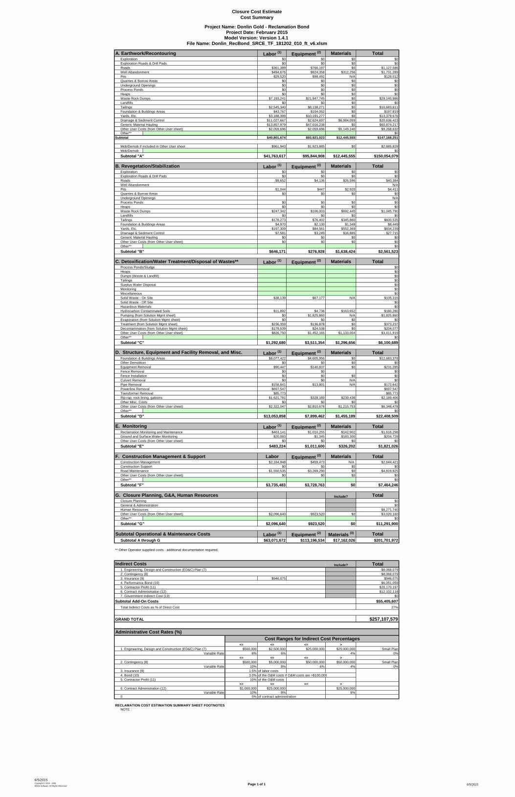
Closure Cost EstimateCost Summary
6/5/2015Copyright © 2004 - 2008 SRCE Software. All Rights Reserved.
Page 1 of 1 6/5/2015
Project Name: Donlin Gold - Reclamation BondProject Date: February 2015
Model Version: Version 1.4.1 File Name: Donlin_RecBond_SRCE_TF_181202_010_ft_v6.xlsm
A. Earthwork/Recontouring Labor (1) Equipment (2) Materials TotalExploration $0 $0 $0 $0Exploration Roads & Drill Pads $0 $0 $0 $0Roads $361,389 $766,197 $0 $1,127,586Well Abandonment $494,676 $924,358 $312,256 $1,731,289Pits $29,520 $98,492 N/A $128,012Quarries & Borrow Areas $0 $0 $0 $0Underground Openings $0 $0 $0 $0Process Ponds $0 $0 $0 $0Heaps $0 $0 $0 $0Waste Rock Dumps $7,193,241 $21,947,745 $0 $29,140,986Landfills $0 $0 $0 $0Tailings $2,545,340 $8,138,271 $0 $10,683,611Foundation & Buildings Areas $43,767 $154,052 $0 $197,819Yards, Etc. $3,188,399 $10,191,277 $0 $13,379,676Drainage & Sediment Control $11,027,667 $2,624,697 $6,984,059 $20,636,423Generic Material Hauling $13,857,979 $47,016,238 $0 $60,874,217Other User Costs (from Other User sheet) $2,059,696 $2,059,696 $5,149,240 $9,268,632Other** $0
Subtotal $40,801,674 $93,921,023 $12,445,555 $147,168,251
Mob/Demob if included in Other User sheet $961,943 $1,923,885 $0 $2,885,828Mob/Demob $0Subtotal "A" $41,763,617 $95,844,908 $12,445,555 $150,054,079
B. Revegetation/Stabilization Labor (1) Equipment (2) Materials TotalExploration $0 $0 $0 $0Exploration Roads & Drill Pads $0 $0 $0 $0Roads $9,652 $4,136 $26,596 $40,384Well Abandonment N/APits $1,044 $447 $2,920 $4,411Quarries & Borrow Areas $0 $0 $0 $0Underground Openings N/AProcess Ponds $0 $0 $0 $0Heaps $0 $0 $0 $0Waste Rock Dumps $247,342 $106,003 $692,445 $1,045,790Landfills $0 $0 $0 $0Tailings $178,273 $76,402 $345,860 $600,535Foundation & Buildings Areas $4,970 $2,130 $1,349 $8,449Yards, Etc. $197,309 $84,561 $552,369 $834,239Drainage & Sediment Control $7,581 $3,249 $16,885 $27,715Generic Material Hauling $0 $0 $0 $0Other User Costs (from Other User sheet) $0 $0 $0 $0Other** $0Subtotal "B" $646,171 $276,928 $1,638,424 $2,561,523
C. Detoxification/Water Treatment/Disposal of Wastes** Labor (1) Equipment (2) Materials TotalProcess Ponds/Sludge $0Heaps $0Dumps (Waste & Landfill) $0Tailings $0Surplus Water Disposal $0Monitoring $0Miscellaneous $0Solid Waste - On Site $38,139 $67,177 N/A $105,316Solid Waste - Off Site $0Hazardous Materials $0Hydrocarbon Contaminated Soils $11,892 $4,736 $163,652 $180,280Pumping (from Solution Mgmt sheet) $0 $1,825,860 N/A $1,825,860Evaporation (from Solution Mgmt sheet) $0 $0 $0 $0Treatment (from Solution Mgmt sheet) $236,359 $136,878 $0 $373,237Decontamination (from Solution Mgmt sheet) $179,539 $24,538 $0 $204,077Other User Costs (from Other User sheet) $826,750 $1,452,165 $1,133,004 $3,411,919Other** $0Subtotal "C" $1,292,680 $3,511,354 $1,296,656 $6,100,689
Labor (1) Equipment (2) Materials TotalFoundation & Buildings Areas $8,077,422 $4,605,956 $0 $12,683,378Other Demolition $0 $0 $0 $0Equipment Removal $90,447 $140,837 $0 $231,285Fence Removal $0 $0 $0Fence Installation $0 $0 $0 $0Culvert Removal $0 $0 N/A $0Pipe Removal $158,841 $13,801 N/A $172,642Powerline Removal $697,547 $697,547Transformer Removal $85,773 $85,773Rip-rap, rock lining, gabions $1,621,781 $328,189 $239,436 $2,189,406Other Misc. Costs $0 $0 $0 $0Other User Costs (from Other User sheet) $2,322,047 $2,810,678 $1,215,753 $6,348,478Other** $0Subtotal "D" $13,053,858 $7,899,462 $1,455,189 $22,408,509
Labor (1) Equipment (2) Materials TotalReclamation Monitoring and Maintenance $463,141 $1,010,255 $142,902 $1,616,298Ground and Surface Water Monitoring $20,083 $1,345 $183,300 $204,728Other User Costs (from Other User sheet) $0 $0 $0 $0Subtotal "E" $483,224 $1,011,600 $326,202 $1,821,026
F. Construction Management & Support Labor Equipment (2) Materials TotalConstruction Management $2,184,948 $459,473 N/A $2,644,421Construction Support $0 $0 $0 $0Road Maintenance $1,550,535 $3,269,290 $0 $4,819,825Other User Costs (from Other User sheet) $0 $0 $0 $0Other** $0Subtotal "F" $3,735,483 $3,728,763 $0 $7,464,246
G. Closure Planning, G&A, Human Resources Include? TotalClosure Planning $0General & Administration $0Human Resources $8,271,740Other User Costs (from Other User sheet) $2,096,640 $923,520 $0 $3,020,160Other** $0Subtotal "G" $2,096,640 $923,520 $0 $11,291,900
Subtotal Operational & Maintenance Costs Labor (1) Equipment (2) Materials (3) TotalSubtotal A through G $63,071,672 $113,196,534 $17,162,026 $201,701,972
** Other Operator supplied costs - additional documentation required.
Indirect Costs Include? Total1. Engineering, Design and Construction (ED&C) Plan (7) $8,068,0792. Contingency (8) $8,068,0793. Insurance (9) $946,075 $946,0754. Performance Bond (10) $6,051,0595. Contractor Profit (11) $20,170,1976. Contract Administration (12) $12,102,1187. Government Indirect Cost (13) $0
Subtotal Add-On Costs $55,405,607Total Indirect Costs as % of Direct Cost 27%
GRAND TOTAL $257,107,579
Administrative Cost Rates (%)
<= <= <= >1. Engineering, Design and Construction (ED&C) Plan (7) $500,000 $2,500,000 $25,000,000 $25,000,000 Small Plan
Variable Rate 8% 6% 4% 0%<= <= <= >
2. Contingency (8) $500,000 $5,000,000 $50,000,000 $50,000,000 Small PlanVariable Rate 10% 8% 6% 4% 0%
3. Insurance (9) 1.5% of labor costs4. Bond (10) 3.0% of the O&M costs if O&M costs are >$100,0005. Contractor Profit (11) 10% of the O&M costs
<= <= <= >6. Contract Administration (12) $1,000,000 $25,000,000 $25,000,000
Variable Rate 10% 8% 6%0 0% of contract administration
RECLAMATION COST ESTIMATION SUMMARY SHEET FOOTNOTESNOTE :
E. Monitoring
D. Structure, Equipment and Facility Removal, and Misc.
Cost Ranges for Indirect Cost Percentages
Appendix C Post-Closure
Trust Fund Model Summary
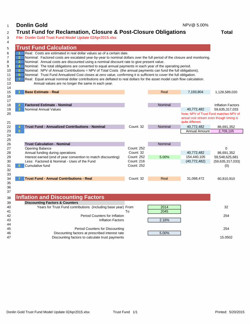
Donlin Gold Trust Fund Model Update 02Apr2015.xlsx Trust Fund 1/1 Printed: 5/20/2015
1 Donlin Gold NPV@ 5.00%
2 Trust Fund for Reclamation, Closure & Post-Closure Obligations Total3 File: Donlin Gold Trust Fund Model Update 02Apr2015.xlsx4
5 Trust Fund Calculation6 1 Real: Costs are estimated in real dollar values as of a certain date.7 2 Nominal: Factored costs are escalated year-by-year to nominal dollars over the full period of the closure and monitoring.8 3 Nominal: Annual costs are discounted using a nominal discount rate to give present value.9 4 Nominal: The total obligations are converted to equal annual payments in each year of the operating period.10 5 Nominal: NPV of Annual Contributions = NPV of Total Costs (the annual payments can fund the full obligations).11 6 Nominal: Trust Fund Annualized Cost closes at zero value, confirming it is sufficient to cover the full obligation.12 7 Real: Equal annual nominal dollar contributions are deflated to real dollars for the asset model cash flow calculation.13 Annual values are no longer the same in each year.1415 1 Base Estimate - Real Real 7,193,804 1,128,589,020161718 2 Factored Estimate - Nominal Nominal Inflation Factors19 3 Nominal Annual Values 40,772,482 59,635,317,03320 Note: NPV of Trust Fund matches NPV of
2122 4 Trust Fund - Annualized Contributions - Nominal Count: 32 Nominal 40,772,482 86,691,35223 5 Annual Amount 2,709,105242526 Trust Calculation - Nominal Nominal27 Opening Balance Count: 252 028 Annual funding during operations Count: 32 40,772,482 86,691,35229 Interest earned (end of year convention to match discounting) Count: 252 5.00% 154,440,105 59,548,625,68130 Less: Factored & Nominal - Uses of the Fund Count: 216 (40,772,482) (59,635,317,033)31 6 Cumulative fund Count: 252 (0)323334 7 Trust Fund - Annual Contributions - Real Count: 32 Real 31,068,472 60,810,910353637
38 Inflation and Discounting Factors39 Discounting Factors & Counters40 Years for Trust Fund contributions (including base year) From 2014 3241 To 204542 Period Counters for Inflation 25443 Inflation Factors 2.16%4445 Period Counters for Discounting 25446 Discounting factors at prescribed interest rate 5.00%47 Discounting factors to calculate trust payments 15.0502
actual cost stream even though timing is quite different.