reconsideration of ground-level seismic records … · reconsideration of ground-level seismic...
TRANSCRIPT
CONSTRUCŢII – No. 2 / 2015
35
RECONSIDERATION OF GROUND-LEVEL SEISMIC RECORDS
OBTAINED IN INSTRUMENTED BUILDINGS:
A PRELIMINARY STUDY FOR STRONG VRANCEA EARTHQUAKES
Iolanda-Gabriela CRAIFALEANU
1,2, Ioan Sorin BORCIA
2†
1 Associate Professor, Technical University of Civil Engineering Bucharest, Romania, [email protected]
2 Senior Researcher, National Institute for Research and Development in Constructions, Urbanism and Sustainable Spatial Development, URBAN-INCERC, INCERC Bucharest Branch & European Center for
Buildings Rehabilitation, Bucharest, Romania
ABSTRACT
Currently, a large number of seismic records, obtained over the years on instrumented buildings with various heights, located in urban environment, are available at global scale. The valorization of these records is important, as frequently no other information exists for the corresponding or neighboring locations. Several studies carried out recently have shown that the influence of the building can be separated, if certain characteristics of the structure-foundation-soil system are known. The paper presents the first results of an investigation concerning the usability of seismic records obtained in the past on stations located on buildings from densely urbanized areas in Romania. The reconsideration of the information provided by these stations could provide new perspectives on the spatial distribution of the ground motion parameters for the past earthquakes and, implicitly, a better understanding of the characteristics of seismic hazard in Romania. Keywords: seismic motions; densely urbanized areas; ground motion parameters; seismic maps; Vrancea earthquakes
REZUMAT
În prezent, la scară globală este disponibil un număr mare de înregistrări seismice, obţinute de-a lungul anilor pe clădiri instrumentate având diverse regimuri de înălţime, amplasate în mediul urban. Valorificarea acestor înregistrări este importantă, deoarece deseori nu există alte informaţii pentru amplasamentul respectiv sau pentru cele învecinate. Numeroase studii realizate recent au arătat că influenţa clădirilor poate fi separată, dacă se cunosc anumite caracteristici ale ansamblului structură-fundaţie-teren. Articolul prezintă primele rezultate ale unei cercetări privind posibilităţile de utilizare a înregistrărilor seismice obţinute în trecut în staţii amplasate în clădiri din zonele dens urbanizate din România. Reconsiderarea informaţiilor furnizate de aceste staţii ar putea oferi noi perspective asupra distribuţiei spaţiale a parametrilor mişcării terenului pentru cutremurele din trecut şi, implicit, o mai bună înţelegere a caracteristicilor hazardului seismic din România. Cuvinte cheie: mişcări seismice; zone dens urbanizate, parametri ai mişcării terenului, hărţi seismice; cutremure vrâncene
1. INTRODUCTION
Seismic instrumentation dates in Romania from the end of the 19th century; however, the first modern seismic network of the country was established in 1967, by the National Institute for Building Research, INCERC. On March 4, 1977, when the catastrophic Mw = 7.4 Vrancea earthquake hit Romania, the network consisted of nine strong-motion accelerographs and two seismoscopes, located at various sites on the eastern and southern
sides of the Carpathian arc, including the capital city, Bucharest (Balan et al., 1982; Berg et al., 1980). Of these accelerographs, six were installed at ground level or in the basement of low- or medium-rise buildings in Bucharest (two instruments) and in other localities (Bacau, Focsani, Galati and Vrancioaia). The rest were located near to or at the top of three 11-, 12- and 13-story buildings in Bucharest and Galati (Berg et al., 1980). It is not without interest to mention that, despite this relatively large number or recording

I. G. Craifaleanu, I. S. Borcia
CONSTRUCŢII – No. 2 / 2015
36
instruments, only one complete accelerographic record could be obtained from the 1977 earthquake, namely from the SMAC-B accelerograph located in the basement of the one-story high INCERC building in Bucharest.
After the 1977 earthquake, the network was substantially extended, by the addition of modern instruments (Craifaleanu, 2011). A rather large number of accelerographs were installed in low- and mid-rise buildings, located in county administrative centers. Typically the instrumentation of these buildings consisted of an accelerograph placed in the basement or on the ground floor and, in the case of taller buildings (i.e. for mid-rise buildings), a second accelerograph was installed on the top floor. Most accelerographs were of type Kinemetrics SMA or SMAC.
Most of the seismic stations were installed in the extra-Carpathian area; this was justified by the predominant propagation pattern characteristic to strong subcrustal Vrancea earthquakes.
The characteristics of the seismic stations located in low rise buildings match rather closely the SMRS-SB (Strong-Motion
Reference Station: Small Building) category in the COSMOS classification (COSMOS 2001), while those located in mid-rise buildings correspond quite well to the SMBRS-DU (Strong-Motion Building Reference Station:
Densely Urbanized Area) type in the same classification.
Records obtained from stations assimilable with the SMBRS-DU type were systematically excluded in the studies performed during the past decades on Vrancea earthquakes. However, as there are several areas in Romania for which these are the only available records, their reconsideration could offer valuable information, provided that sufficient data exists to allow separation of the building influence on the characteristics of the motions recorded in the basement or on their ground floor.
An investigation was launched by the authors in order to gather as much as possible information about the instrumented buildings, including: structure and foundation type,
dynamic characteristics, as well as site soil conditions. Given that obtaining the complete set of required data for all buildings might pose difficulties, a preliminary numerical investigation was performed, to assess the effect of the potential addition of values from SMBRS-DU stations on the overall spatial distribution of various ground motion parameters. The study used records from the two strongest earthquakes that occurred in Romania during the past century and for which data is available from several stations. The context and the results of the investigation are presented in the following.
2. STATE OF THE ART
The use of ground motions recorded at foundation level in instrumented buildings requires either detailed knowledge on building and site characteristics or, at least, the existence of a minimal data set. This information would form the input of the various methods used in the literature for the assessment of the influence of soil-structure interaction on recorded ground motions.
Besides the foundation level record, records obtained at the upper stories of the building (or at least at the top level) are also useful for modal characteristics identification. A reference free-field record in a nearby location is needed to complete the information. The USGS-ANSS technical guidelines (ANSS, 2002) provide a list of requirements for building instrumentation (“Structural Response Station”). Criteria for the optimal distance between the free-field station and the building are reviewed in (Stewart, 2000). However, in practice, the whole set of required data is seldom available.
Methods used for separating the effect of buildings on recorded seismic motion are generally based on the study of parameters pertaining to soil-structure interaction (SSI). A detailed description of the basic approaches used during to investigate SSI effects on ground motion is given in (Stewart et al., 1998). Several other studies were conducted, in recent years, to calibrate the significant parameters that determine the inertial and
Reconsideration of ground-level seismic records obtained in instrumented buildings: a preliminary study
CONSTRUCŢII – No. 2 / 2015
37
kinematical effects due to SSI (Kim and Stewart, 2003, Rayhani and El Naggar, 2008, Pandey et al., 2012, Mason et al., 2013 etc.). The main findings were implemented in the ASCE/SEI 41-13 standard (ASCE/SEI, 2014), which includes provisions for the modification of seismic input level at building base due to SSI effects. Related studies in the field concern site-city interaction (Semblat et al. 2008) and effects induced by the seismic vibrations of buildings on ground motions recorded nearby (Guéguen et al., 2000, Ditommaso et al., 2010).
3. AVAILABLE SMBRS-DU DATA
Analyses were performed for the strongest Vrancea seismic events for which instrumental data are available from several stations, i.e. for the earthquakes of August 30, 1986 (Mw = 7.1) and May 30, 1990 (Mw = 6.9). Data were taken from the SM-ROM-GL (Strong Motion
Romania Ground Level) Database, compiled by Borcia et al. (2014).
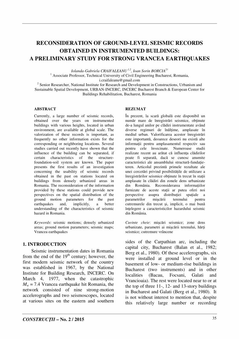
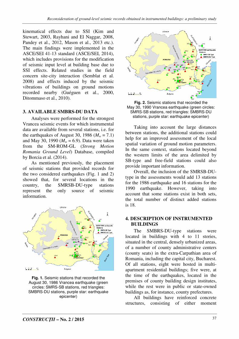
As mentioned previously, the placement of seismic stations that provided records for the two considered earthquakes (Fig. 1 and 2) showed that, for several locations in the country, the SMRSB-DU-type stations represent the only source of seismic information.
Fig. 1. Seismic stations that recorded the August 30, 1986 Vrancea earthquake (green
circles: SMRS-SB stations, red triangles: SMBRS-DU stations, purple star: earthquake
epicenter)
Fig. 2. Seismic stations that recorded the
May 30, 1990 Vrancea earthquake (green circles: SMRS-SB stations, red triangles: SMBRS-DU
stations, purple star: earthquake epicenter)
Taking into account the large distances
between stations, the additional stations could help for an improved assessment of the local spatial variation of ground motion parameters. In the same context, stations located beyond the western limits of the area delimited by SB-type and free-field stations could also provide important information.
Overall, the inclusion of the SMRSB-DU-type in the assessments would add 13 stations for the 1986 earthquake and 16 stations for the 1990 earthquake. However, taking into account that some stations exist in both sets, the total number of distinct added stations is 18.
4. DESCRIPTION OF INSTRUMENTED
BUILDINGS
The SMBRS-DU-type stations were located in buildings with 4 to 11 stories, situated in the central, densely urbanized areas, of a number of county administrative centers (county seats) in the extra-Carpathian area of Romania, including the capital city, Bucharest. Of all stations, eight were hosted in multi-apartment residential buildings; five were, at the time of the earthquakes, located in the premises of county building design institutes, while the rest were in public or state-owned buildings as, for instance, county prefectures.
All buildings have reinforced concrete structures, consisting of either moment

I. G. Craifaleanu, I. S. Borcia
CONSTRUCŢII – No. 2 / 2015
38
resisting frames or shear walls. At the time of station installation, most of them were newly-built, which means that they were designed according to the earlier editions of the Romanian seismic code.
In most cases, the buildings have continuous foundations (spread footings), with three known exceptions: two in the city of Galati (stations GLT1 and GLT2 in Figures 1 and 2), where mat foundations were used due to the local loess deposits, and one in the city of Braila (station BRL1) where, for the same reason of poor soil conditions, pile foundations were used. The foundation embedment depth is about one story high in current cases.
Presently, all the mentioned buildings are in use; however, most of them do not host seismic stations anymore. This situation is due to various reasons, such as: impossibility to obtain owners’ agreement/guarantee for further station hosting, including power supply and secure sheltering; termination of building instrumentation program etc.
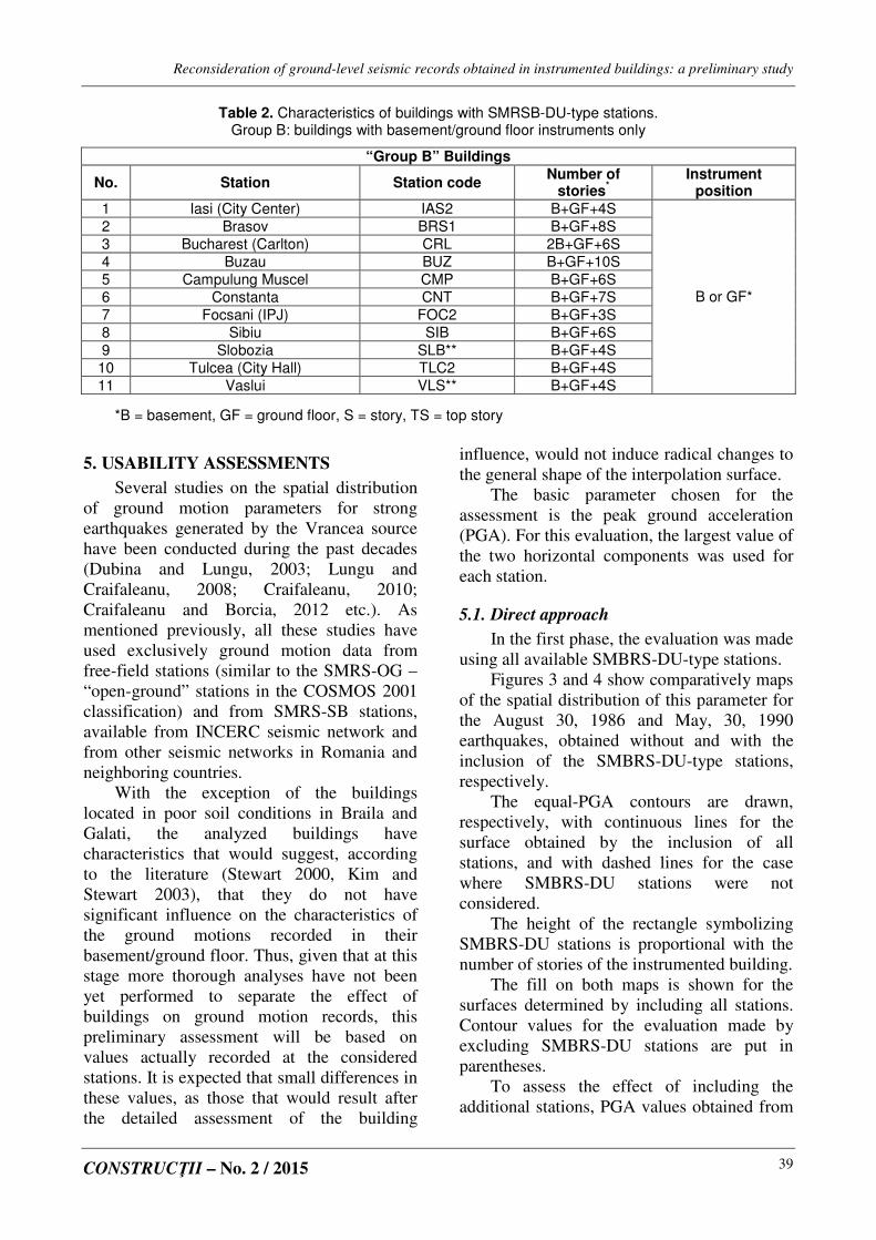
The buildings can be divided in two groups, A and B, according to their instrumentation. Buildings in group A have basement and top story instruments, while buildings in group B have only basement or ground floor instruments. Characteristics of the buildings are shown in Tables 1 and 2, according to information in the SM-ROM-GL
database (Borcia et al., 2014) and to the results of modal identification analyses performed for buildings in group A by Demetriu and Borcia (2001) and by Demetriu (2002). Additional data was provided, for some of the buildings in the first group, by measurements and analyses performed before and after the 1986 and 1990 earthquakes, and also from the assessment of the state of these buildings after significant seismic events.
As it can be noticed from Figures 1 and 2, there are cities, such as Iasi (“IAS” stations), Focsani (“FOC” stations), Bacau (“BAC” stations), Tulcea (“TLC” stations) and Bucharest (several stations), in which both the SB- and DU-type stations have recorded the seismic motion. The usability of motions recorded by SB-type stations by their potential assimilation with reference “free-field” stations was considered as acceptable, according to past research, based on criteria in the literature.
From the above, it can be observed that information available on the analyzed stations is rather lacunary. Collection of additional information, as well as future measurements will allow the computation of parameters required to assess, on an individual basis, the effect of the buildings on recorded ground motions. An analysis based on existing data is presented in the following.
Table 1. Characteristics of buildings with SMRSB-DU-type stations.
Group A: buildings with base and top instruments
“Group A” Buildings
No. Station Station code
Number of stories
Instrument position
Structure type
Estimated natural periods on orthogonal
directions
1 Bacau
(Cornisa) BAC1 B+GF+10S RC Shear Walls 0.48; 0.76
2 Braila BRL1 B+GF+11S RC frames
w. Masonry Infills 0.87…1.04; 0.92…0.95
3 Bucharest
(Balta Alba) BLA1 B+GF+10S RC Shear Walls 0.66; 0.73
4 Craiova CRV1 B+GF+7S RC frames
w. Masonry Infills 0.75; 0.99
5 Galati (IPJ)
GLT2 B+GF+9S RC frames
w. Masonry Infills 1; 1.06
6 Galati
(Tiglina I1) GLT1 B+GF+10S RC Shear Walls 0.69; 0.74
7 Ploiesti-Vest PLS B+GF+10S
B & TS
RC Shear Walls 0.61…0.72; 0.81…1.02
Reconsideration of ground-level seismic records obtained in instrumented buildings: a preliminary study
CONSTRUCŢII – No. 2 / 2015
39
Table 2. Characteristics of buildings with SMRSB-DU-type stations. Group B: buildings with basement/ground floor instruments only
“Group B” Buildings
No. Station Station code Number of
stories*
Instrument position
1 Iasi (City Center) IAS2 B+GF+4S
2 Brasov BRS1 B+GF+8S
3 Bucharest (Carlton) CRL 2B+GF+6S
4 Buzau BUZ B+GF+10S
5 Campulung Muscel CMP B+GF+6S
6 Constanta CNT B+GF+7S
7 Focsani (IPJ) FOC2 B+GF+3S
8 Sibiu SIB B+GF+6S
9 Slobozia SLB** B+GF+4S
10 Tulcea (City Hall) TLC2 B+GF+4S
11 Vaslui VLS** B+GF+4S
B or GF*
*B = basement, GF = ground floor, S = story, TS = top story
5. USABILITY ASSESSMENTS
Several studies on the spatial distribution of ground motion parameters for strong earthquakes generated by the Vrancea source have been conducted during the past decades (Dubina and Lungu, 2003; Lungu and Craifaleanu, 2008; Craifaleanu, 2010; Craifaleanu and Borcia, 2012 etc.). As mentioned previously, all these studies have used exclusively ground motion data from free-field stations (similar to the SMRS-OG – “open-ground” stations in the COSMOS 2001 classification) and from SMRS-SB stations, available from INCERC seismic network and from other seismic networks in Romania and neighboring countries.
With the exception of the buildings located in poor soil conditions in Braila and Galati, the analyzed buildings have characteristics that would suggest, according to the literature (Stewart 2000, Kim and Stewart 2003), that they do not have significant influence on the characteristics of the ground motions recorded in their basement/ground floor. Thus, given that at this stage more thorough analyses have not been yet performed to separate the effect of buildings on ground motion records, this preliminary assessment will be based on values actually recorded at the considered stations. It is expected that small differences in these values, as those that would result after the detailed assessment of the building
influence, would not induce radical changes to the general shape of the interpolation surface.
The basic parameter chosen for the assessment is the peak ground acceleration (PGA). For this evaluation, the largest value of the two horizontal components was used for each station.
5.1. Direct approach
In the first phase, the evaluation was made using all available SMBRS-DU-type stations.
Figures 3 and 4 show comparatively maps of the spatial distribution of this parameter for the August 30, 1986 and May, 30, 1990 earthquakes, obtained without and with the inclusion of the SMBRS-DU-type stations, respectively.
The equal-PGA contours are drawn, respectively, with continuous lines for the surface obtained by the inclusion of all stations, and with dashed lines for the case where SMBRS-DU stations were not considered.
The height of the rectangle symbolizing SMBRS-DU stations is proportional with the number of stories of the instrumented building.
The fill on both maps is shown for the surfaces determined by including all stations. Contour values for the evaluation made by excluding SMBRS-DU stations are put in parentheses.
To assess the effect of including the additional stations, PGA values obtained from

I. G. Craifaleanu, I. S. Borcia
CONSTRUCŢII – No. 2 / 2015
40
SMBRS-DU records were compared with the values estimated, in their absence, at the same locations, by the interpolation surface The stations for which the actually recorded value was larger than the estimated value are shown
with magenta rectangles, while the stations where the actual value was smaller than the predicted one are shown with blue rectangles. Stations where no estimation was available are shown with white rectangles.
Fig. 3. Comparative representations of PGA contours obtained for the August 30, 1986 earthquake:
a) free-field and SMRS-SB stations (dotted line), b) all stations (continuous line)
Fig. 4. Comparative representations of PGA contours obtained for the May 30, 1990 earthquake:
a) free-field and SMRS-SB stations (dotted line), b) all stations (continuous line)

Reconsideration of ground-level seismic records obtained in instrumented buildings: a preliminary study
CONSTRUCŢII – No. 2 / 2015
41
By examining the spatial distribution of PGA values, it can be noticed that the contours obtained by including the SMBRS-DU-type stations maintain the general pattern and orientation determined in their absence, i.e. the SW-NE orientation for the 1986 event and the N-S orientation for the 1990 event.
On the other hand, the “offset” of the contours, as well as several local changes are observable on the maps. In this context, it is worth noticing that, due to the non-uniform spatial distribution of the stations across the investigated area, the contour configuration has a significant degree of approximation in the regions where fewer stations were available, i.e. especially in the north-western part of the analyzed zone, for the 1986 earthquake, and in the south-western part of the analyzed zone, for the 1990 earthquake.
Fig. 5. Comparative representations of Arias
intensity contours obtained for the Aug.30, 1986 earthquake: a) free field and SMRS-SB stations
(dotted line), b) all stations (continuous line)
Fig. 6. Comparative representations of Arias
intensity contours obtained for the Aug.30, 1986 earthquake: a) free field and SMRS-SB stations
(dotted line), b) all stations (continuous line)
The above assessments depend both on the several factors that influence the shape of the interpolation surfaces and on the individual building and site characteristics; thus their interpretation should be made cautiously. Despite this imprecision, it can be, however, noticed, that the inclusion of SMBRS-DU stations does not essentially modify the trends reflected by the contour patterns with some exceptions generated mainly by the lack of stations in certain areas. This could be due to either the low amplification or deamplification of free-field motions due to building influence or/and the relatively small number of stations situated in locations that would influence significantly the shape of the interpolation surface.
For a quantitative assessment, further investigations are necessary, based on the evaluation of each station.
The same assessment was performed also for other ground motion parameters available in the SM-ROM-GL database, with similar conclusions. To exemplify, comparative maps of the Arias-type intensity (Borcia et al., 2014), for the two considered earthquakes, are shown in Figures 5 and 6.
5.2. Alternative approach
It can be noticed from Figures 3 and 4 that there are several buildings for which the ratio between the recorded and the estimated value is greater than unity for one earthquake and less than unity for the other.
To eliminate the influence of the variation from one event to another of the stations considered in interpolation, a separate assessment was made for the city of Bucharest. Here, the relatively small distance between stations allowed that interpolation is made only for stations that recorded both earthquakes, again without SMBRS-DU stations.
The examined stations were BLA1 (from group “A”) and CRL (from group “B”). The amplification / deamplification tendency obtained from the previous interpolation persisted (Fig. 7), even though the ratios between actual and estimated PGA values

I. G. Craifaleanu, I. S. Borcia
CONSTRUCŢII – No. 2 / 2015
42
differed. Thus, for the BLA1 building, ratios smaller than unity were obtained for both earthquakes, while, for the CRL building, a ratio smaller than unity was obtained for the 1986 earthquake and a ratio larger than unity was obtained for the 1990 earthquake. Assuming that the estimations given by the interpolation surfaces are acceptable approximations of the spatial variation of the
free-field PGA, this would suggest that the change of the deamplification tendency observed for the CRL building would be due to the differences in the frequency content of the ground motions recorded in Bucharest during the two considered earthquakes. Detailed information on these specific features of each of the two earthquakes can be found in (Sandi and Borcia, 2011).
a) August 30, 1986 earthquake b) May 30, 1990 earthquake
Fig. 7. Spatial distribution of PGA values for the city of Bucharest, obtained without the inclusion of SMBRS-DU stations, by preserving the same set of stations for both the 1986 and 1990 earthquake
6. CONCLUSIONS
The usability of ground motion records obtained during the strong Vrancea earthquakes of 1986 and 1990 in the basement or at the ground floor of eighteen medium-rise instrumented buildings was assessed. The buildings match rather well the description of the SMBRS-DU stations in the COSMOS classification, being located in densely urbanized areas of county administrative centers in Romania. According to the criteria and methods used in the literature, it is expected that most considered buildings will have low to moderate influence on the characteristics of the recorded ground motions.
Based on values actually recorded for the above buildings, maps of the spatial distribution of peak ground acceleration for all stations were generated and compared with results obtained without the inclusion of SMBRS-DU stations. It was shown that, by
assuming, in the first instance, that the spatial distribution determined in the second variant represents a reasonable approximation of the free-field motion, various information can be obtained both on the effects of including records obtained from SMBRS-DU stations in the assessments and on the potential influence of buildings on the “free-field” ground motion.
Further investigations are needed in the future to complete this information.
ACKNOWLEDGEMENTS
Funding for the research presented in the paper was partially provided by the Romanian Ministry of National Education, UEFISCDI Agency, under Contract No. 72/2012, Project BIGSEES, and by the National Agency for Scientific Research, ANCS, under Contract No. PN09 14-01-03, “Nucleu” Programme.
This paper represents an extended and revised version of the contribution presented

Reconsideration of ground-level seismic records obtained in instrumented buildings: a preliminary study
CONSTRUCŢII – No. 2 / 2015
43
by the authors at the Second European Conference on Earthquake Engineering and Seismology, 2ECEES, August 24-29, 2014, Istanbul, Turkey (Paper No. 499).
Dr. Ioan Sorin Borcia, the second author of the paper, sadly passed away before the presented investigation could be completed. His contribution to the study is gratefully acknowledged. This paper is dedicated to his memory.
REFERENCES
1. Balan St., Cristescu V., Cornea I. (Eds.) (1982) Cutremurul de pămînt din România de la 4 martie 1977. Editura Academiei R.S.R., Bucharest
2. Berg, G.V., Bolt, B.A., Sozen, M.A., Rojahn, C. (1980) Earthquake in Romania, March 4, 1977: An engineering report. National Academy Press, Washington DC
3. *** COSMOS (2001) Guidelines for Installation of Advanced National Seismic System Strong-Motion Reference Stations. Consortium of Organizations for Strong-Motion Observation Systems, Richmond, California
4. Craifaleanu I.G., Borcia I.S., Praun, I.C. (2011) Strong-Motion Networks in Romania and Their Efficient Use in the Structural Engineering Applications. Chapter 17 in Earthquake Data in Engineering Seismology. Predictive Models, Data Management and Networks. S Akkar, P Gülkan, & T van Eck, Eds, Springer, Dordrecht
5. Stewart J.P., Seed R.B., Fenves G.L. (1998) Empirical evaluation of inertial soil-structure interaction effects. Report No. PEER-98/07, University of California, Berkeley, California
6. Kim S., Stewart J.P. (2003) Kinematic soil-structure interaction from strong motion recordings, Journal of Geotechnical and Geoenvironmental Engineering, 129(4):323
7. Rayhani M.H., El Naggar M.H. (2008) Numerical modeling of seismic response of rigid foundation on soft soil, International Journal of Geomechanics, 8(6):336-346
8. Pandey B.H., Finn W.L., Ventura C.E. (2012) Modification of Free-Field Motions by Soil-Foundation-Structure Interaction for Shallow Foundations. Proceedings of the 15th World Conference on Earthquake Engineering, Lisbon, Portugal, September 24-28, 2012
9. Mason H.B., Trombetta N.W., Chen Z., Bray J.D., Hutchinson T.C., Kutter B.L. (2013) Seismic soil–foundation–structure interaction observed in
geotechnical centrifuge experiments, Soil Dynamics and Earthquake Engineering, 48:162-174
10. *** ASCE/SEI Seismic Rehabilitation Standards Committee (2014) Seismic Evaluation and Retrofit of Existing Buildings (ASCE/SEI 41-06). American Society of Civil Engineers, Reston, Virginia
11. Semblat J.F., Kham M., Bard P.Y. (2008) Seismic-wave propagation in alluvial basins and influence of site-city interaction. Bulletin of the Seismological Society of America, 98(6):2665-2678
12. Guéguen P., Bard P.-Y., Oliveira C.S. (2000) Experimental and numerical analysis of soil motion caused by free vibration of a building model. Bulletin of the Seismological Society of America, 90(6):1464-1479
13. Ditommaso R., Mucciarelli M., Gallipoli M.R., Ponzo F.C. (2010) Effect of a single vibrating building on free-field ground motion: numerical and experimental evidences. Bulletin of Earthquake Engineering, 8(3): 693-703
14. Borcia I.S., Craifaleanu I.G., Calarasu E.A., Tanase F.N., Praun I.C. (2014) SM-ROM-GL (Strong Motion Romania Ground Level) Database. 2nd European Conference on Earthquake Engineering and Seismology, Istanbul, Turkey, August 24-29, Paper No 487
15. Craifaleanu I. G., Borcia I. S. (2014) An analysis of the usability of strong ground motion records obtained from stations located in densely urbanized areas in Romania. Proceedings of the 2nd European Conference on Earthquake Engineering and Seismology, August 24-29, 2014, Istanbul, Turkey, Paper No. 499
16. Demetriu S., Borcia I.S. (2001) Seismic Response of Instrumented Buildings during Vrancea Earthquakes. Buletinul Ştiinţific al UTCB, (2):1 12
17. Demetriu S. (2002), Modal Identification of Instrumented Buildings from Vrancea Earthquake Records. Buletinul Ştiinţific al UTCB, (2):13 21
18. Dubină D., Lungu D. (Eds.) (2003) Construcţii amplasate în zone cu mişcări seismice puternice. Orizonturi Universitare, Timisoara (in Romanian)
19. Craifaleanu I. G., Lungu D., Borcia, I. S. (2006) Shakemaps of Nonlinear Spectral Ordinates for Romanian Earthquakes. Proceedings of the First European Conference on Earthquake Engineering and Seismology, Geneva, Switzerland, 3-8 September 2006, Paper No. 1257
20. Lungu D., Craifaleanu I.G. (2009) Shake Maps Of Strength And Displacement Demands For Romanian Vrancea Earthquakes, in: Harmonization of Seismic Hazard in Vrancea Zone, with Special Emphasis on Seismic Risk Reduction. NATO

I. G. Craifaleanu, I. S. Borcia
CONSTRUCŢII – No. 2 / 2015
44
Science for Peace and Security, Series C: Environmental Security, Zaicenco A., Craifaleanu I., Paskaleva I. (Eds), Springer, Dordrecht, The Netherlands
21. Craifaleanu I.G. (2010) Analytical Assessment of Damage Distribution vs. Actually Reported Effects of Vrancea Earthquakes. Proceedings of the 14th European Conference on Earthquake Engineering, Ohrid, Aug. 30 – Sept. 3, 2010, Paper No 748
22. Craifaleanu I.G., Borcia I.S. (2012) Damage Index vs. Instrumental Intensity: A Comparison of Two Different Approaches in Seismic Damage Assessment. Proceedings of the 15th World Conference on Earthquake Engineering, Lisbon, Portugal, Sept 24-28, 2012, Paper No 620
23. Sandi H, Borcia IS (2011) A Summary of Instrumental Data on the Recent Strong Vrancea Earthquakes and Implications for Seismic Hazard. Pure and Applied Geophysics, 168 (3-4):659-694