reconstruction of quaternary landscape …kretzoi 1969, jÁnossy 1979, kordos 1991). colder, glacial...
TRANSCRIPT

Anna Dobos GEOMORPHOLOGIA SLOVACA ET BOHEMICA 1/2012
7
INTRODUCTION
Dual, dissected pediment surface (the Bükk-alja Foothill Area) can be found at the southern boundary of the Bükk Mountains (Fig. 1) in Hungary.
There were more opportunity for the pedi-mentation at the margin of the Bükk Mountains in some periods, for example in the Miocene and at the boundary between Pliocene and Pleistocene periods, too (PINCZÉS 1968, PIN-CZÉS 1970, PINCZÉS 1980, HEVESI 1978, HEVESI 1986, HEVESI 1990, PINCZÉS et al. 1993, MARTONNÉ ERDŐS 2000, DOBOS 2000, DOBOS 2001, or VÁGÓ and HEGEDŰS 2011). In the dual pediment surface of the Bükkalja, the older and more shattered
pediment can be seen only at the summit of the hills (Sümegium-Bérbaltavárium period, 8 – 5.5 million years), while the lower, extended and younger pediment (Villányium period, 2 – 1.8 million years) gives the basis for the Qua-ternary landforms here (DOBOS 2001, DO-BOS 2002, VÁGÓ and HEGEDŰS 2011).
We have some information and fossils about the climate and fauna changes during the Quaternary period at the surroundings of the Cserépfalu Basin, in the sudy area. In the Suba-lyuk Cave situated 200 metres north from the northern part of the studied area, in the South-ern Bükk Mts. (Fig. 2.), different types of sedi-ment layers could be found which represented different climate phases during the Quaternary period: 1st – 3rd layers - warm period before the latest glacial period (130 – 117 000 years ago),
RECONSTRUCTION OF QUATERNARY LANDSCAPE DEVELOPMENT
WITH GEOMORPHOLOGICAL MAPPING AND ANALYSING OF SEDIMENTS AT THE CSERÉPFALU BASIN
(THE BÜKK MTS., HUNGARY)
ANNA DOBOS*
Anna Dobos: Reconstruction of Quaternary landscape development with geomorphological map-ping and analysing of sediments at the Cserépfalu Basin (the Bükk Mts., Hungary). Geomorpho-logia Slovaca et Bohemica, 12, 2012, 1, 11 figs., 26 refs.
The Cserépfalu Basin is a pediment basin situated in the dual pediment surface of the Bükkalja Foothill Area, at the southern margin of the Bükk Mountains, 20 kilometres far away from Eger, in the North Hungarian Mountain Range. The remnants of the older pediment (Sümegium – Bérbaltavárium period, 8 – 5,5 million years ago) and the lower, younger and more extended pediment surface (Villányium pe-riod, 1,8 million years ago) can be shown in the surroundings of the basin. The younger pediment sur-face developed on different Miocene rhyolite tuffs (Gyulakeszi Rhyolite Tuff Formation, Tar Dacite Tuff Formation, Harsány Rhyolite Tuff Formation) and Pliocene sand and clay series was dissected by denudation appeared because of Quaternary tectonic movements and climate changes. After the forma-tion of younger pediment surface new, Quaternary landforms and sediments appeared in the basin. The Hór Stream, the Cseresznyés Stream and the Szoros Stream have transported a lot of sediments accumu-lated during the Tertiary period from the basin towards the Borsod Plain. New types of sediments ap-peared along the slopes and its surroundings, in alluvium. Cryoplanational processes formed the surface of the younger pediment too; Pleistocene fluvial terraces (No. II/b., No. II/a.), Holocene fluvial terraces (No. I.) and mass movements developed along slopes in different levels during the Quaternary period. 500 and 1 000 metre wide alluvium with alluvial fans evaluated in this territory. The aim of our article is to examine and map the Quaternary landforms and sediments developed during the Pleistocene and Holocene period here and to reconstruct the Quaternary landscape development in the basin. To point out different, various types of sediments, we investigated smaller study areas in the Cserépfalu Basin and we could explain different climate changes during the Würm and Holocene period here. Key words: landscape development, pediments, the Quaternary period, sediments, climate change, the Bükk Mts.
———————– * Department of Environmental Sciences, Eszterházy Károly College, Eger, Leányka Street 6., 3300 Eger,
Hungary, e-mail: [email protected]
Anna Dobos GEOMORPHOLOGIA SLOVACA ET BOHEMICA 1/2012
8
4th layer – cooler climate (117 – 105 000 years ago), 5th – 6th layers – warmer climate (105 –71 000 years ago) [1st – 6th layers: the Eemian / Riss-Würm interglacial period], 7th – 12th lay-ers – cold period, the latest Weichselian / Würm glacial period (71 – 61 000 years ago), 13th – 16th layers – warmer phase inside the glacial period (20 – 18 000 years ago), 17th layer – the latest cold maximum of the Ice Age, 18th layer – Holocene interglacial period (RIN-GER and MESTER 1998).
Scientists have found paleolithic findings of Homo Neanderthalensis with moustérien cul-ture in the Suba-lyuk Cave (BARTUCZ et al. 1938, KADIĆ 1940) in the 11th layer which are very famous in Europe. We have got faunal fossils from this territory. The „Suba-lyuk fauna phase” appeared between 70 000 – 60 000 years ago after the „Varbó fauna layer” (80 000 years ago) which closed the la-test warmer phase of Eemian interglacial pe-riod in the Carpathian Basin (KRETZOI 1953, KRETZOI 1969, JÁNOSSY 1979, KORDOS 1991). Colder, glacial fauna (Ursus spelaeus, Mammuthus primigenius, Coelodonta antiqui-tatis, Leo spelaeus, Microtus arvalis, Spalax,
Citellus citellus, Cricetus cricetus, Lagurus lagurus, Ochotona, etc. – steppe fauna) and the neanderthal man were characteristic for the „Suba-lyuk fauna phase” around Cserépfalu.
The aim of our article is to explain what kind of landforms appeared in the Cserépfalu Basin and what kind of sediments accumulated during the Quaternary period. Have we got evi-dences of landforms or sediments for such cli-mate changes like in sediment layers of the Suba-lyuk Cave in the environs of Cserépfalu? We would like to do the reconstruction of Qua-ternary landscape development on the basis of results of geomorphological mapping and sedi-ment analysis (choosed smaller study areas).
THE STUDY AREA
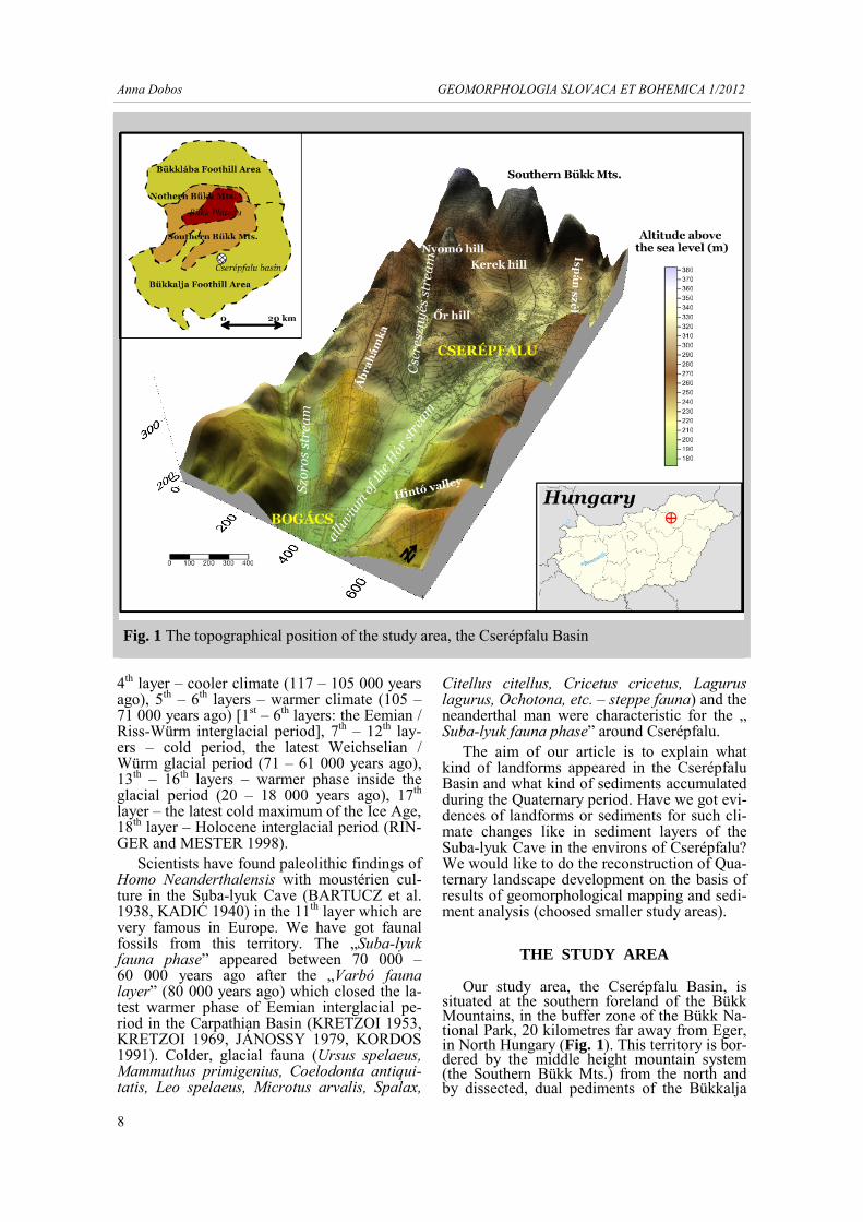
Our study area, the Cserépfalu Basin, is situated at the southern foreland of the Bükk Mountains, in the buffer zone of the Bükk Na-tional Park, 20 kilometres far away from Eger, in North Hungary (Fig. 1). This territory is bor-dered by the middle height mountain system (the Southern Bükk Mts.) from the north and by dissected, dual pediments of the Bükkalja
8
Fig. 1 The topographical position of the study area, the Cserépfalu Basin

Anna Dobos GEOMORPHOLOGIA SLOVACA ET BOHEMICA 1/2012
9
Foothill Area from the west, east and south di-rection (HEVESI 1978, PINCZÉS 1980, PIN- CZÉS et al. 1993, DOBOS 2002, VÁGÓ and HEGEDŰS 2011). The main valley of the ba-sin was formed by the Hór Stream, and its tributaries are the Cseresznyés Stream and the Szoros Stream.
The northern part of the Cserépfalu Basin is built up with Middle and Upper Triassic Berva Limestone, Middle and Upper Jurassic slate series, sediments of Oldalvölgy Formation and Upper Eocene Szépvölgy Limestone (Fig. 2, PELIKÁN et al 2002, CSÁSZÁR 1997). Mid-dle and Upper Miocene Harsány Rhyolite Tuffs layered in the middle part of the basin. These tuff layers were covered in smaller areas by Upper Miocene Csákvár clay marls or Pleis-tocene and Holocene slope sediments between Cserépfalu and Bogács settlements. The non-welded rhyolite tuffs of Lower Miocene Gyu-lakeszi Rhyolite Tuff Formation can be seen in the geological cross sections in the northern and southern part of the basin. Harder, more resistant ignimbrites of NNE and SSW direc-tion (Kisgyőr Series, in Nyomó hill) was ap-peared inside these easily eroded rhyolite tuffs. Younger ignimbrite layers (Lower Miocene Tar Dacite Tuff Formation) appear in patches and larger ranges (the Őr Hill, the Dóc Hill, the Ábrahámka Hill, the Kőkötő Hill, the Borda Hill, the Vén hill, the Mangó Hill, the Hegyes Hill, the Mész Hill) at the boundary of
Harsány and Gyulakeszi Rhyolite tuffs. Pleis-tocene slope sediments covered the slopes and Pleistocene and Holocene alluvial sediments accumulated in the alluvium of streams.
MATERIALS AND METHODS
At the first stage of our investigation we garthered the geological, topographical maps and bibliography of the study area. We ana-lysed landforms and draw geomorphological maps during our field trips (based on PÉCSI 1963, SMITH et al. 2011). We have made the digital elevation model and geomorphological maps at the scale of 1:10 000. At the second stage of the investigation, 236 boreholes were deepened into the surface and gathered sedi-ment samples in the Cserépfalu Basin. The sediment samples were analysed in the Geo-graphical Laboratory of Debrecen University and in the Environmental Science Laboratory of Eszterházy Károly College. We have made grain-size composition analysis, draw grain-size composition curves and sedimentological cross sections. During the analysis of sedi-ments we used drier mashine, Leybold sieves, and Khön pipette for the separation of smaller components. Our results was shown by Corel-Draw 12 and Golden Software SURFER 9.0 programs.
Legend:
Middle - Upper Triassic Berva Limestone (beT)
Middle - Upper Jurassic Lökvölgy Formation (lJ)
Middle - Upper Jurassic Mónosbél and Oldalvölgy Formation (mJ)
Upper Eocene Szépvölgy Limestone Formation (sE)
Lower Miocene Gyulakeszi Rhyolite Tuff Formation Kisgyőr T. (ignimbrite) (gkM)
Lower Miocene Gyulakeszi Rhyolite Tuff Formation (gM)
Lower Miocene Tar Dacite Tuff Formation (tM)
Middle and Upper Miocene Harsanyi Rhyolite Tuff Formation (hM)
Upper (Pannonian) Miocene Csakvar Clay Formation (cPa)
Pleistocene - Holocene slope sediments (d)
Pleistocene - Holocene alluvial sediments (f)
1:100 000
Fig. 2 The geological map of the Cserépfalu Basin (PELIKÁN et al. 2002)

Anna Dobos GEOMORPHOLOGIA SLOVACA ET BOHEMICA 1/2012
10
Fig. 3 Geomorphological map of the northern part of the Cserépfalu Basin
Anna Dobos GEOMORPHOLOGIA SLOVACA ET BOHEMICA 1/2012
11
RESULTS GEOMORPHOLOGICAL MAPS OF THE STUDY
AREA
The structural basis for the Cserépfalu Ba-sin developed during the Attika orogenic pha-se, when the Bükk Mts. were uplifted and the southern margin of the Bükk Mts. was dis-sected along tectonic lines. The Cserépfalu-Bogács Depression appeared in the study area. This depression can be seen in the geological maps of the Bükk Mts. (BALOGH 1963, PE-LIKÁN ed. 2002). At the end of the Miocene or after that, there were tectonic movements in direction of NE and SW along the Hór Stream, in Bogács and these movements were shown by breaking ignimbrite layers in geological maps (Fig. 2).
The oldest geomorphological levels of the Cserépfalu Basin are the remnants of dissected, dual pediments, as we can see in the geomor-phological maps (Fig. 3 and Fig. 4).
The development of the first, older pedi-ment surface in the basin was dated to the Miocene Sümegium – Bérbaltavarium period (8-5,5 million years ago, M), but its chrono-logy is still uncertain (PINCZÉS 1968, PIN-CZÉS 1980, HEVESI 1986, HEVESI 1990, MARTONNÉ ERDŐS 2000, DOBOS 2001) because we could not find sedimentological evidences for the pediment. We could date these geomorphological levels on the basis of landforms. Lot of sediments were transported from this territory towards the southern plain areas. The remnant of the older pediment sur-face can be seen in the northern part of the ba-sin, in the Nyomó Hill, the Mész Hill, the Kút Hill and the Perpác Hill. We could investigate the older pediment surface as the followings:
- we could find remnants of the extended surface at the margin of the Bükk Mts., which was developed in such a territory built up with different rocks (Mesozoic limestones, slate se-ries and Tertiary limestones, clay marls or Miocene ignimbrites) into the same levels (PINCZÉS et al 1993, DOBOS 2001, DOBOS 2002, VÁGÓ and HEGEDŰS 2011). This sur-face has a low slope degree (1o – 5o).
- the same top levels of the hills show a for-mer, larger and extended planation surface, which can be investigated in the Bükkalja Foothill Areas next to Eger and Miskolc, too.
The older pediment surface was uplifted in the Rhodan orogenic phase (5.5 million years ago) and this territory was dissected by tec-tonic lines. Wetter and cooler climate began in the Pliocene, during the Ruscinium-Csarnó-tanum periods (5.5 – 3 million years ago) and
that is why the pedimentation was interrupted. In consequence of the New Roman structural movements (Csarnótánum period, 3.5 – 3 mil-lion years ago), the Bükk Mts. was uplifted and streams (the Hór Stream, PINCZÉS 1955) deepened their stream channels into the former pediment surface and they became as perma-nent water-courses. At this time, the Hór Stream became a main water coarse of the Cserépfalu Basin. There was cooler and drier climate phase at the end of the Pliocene, in the Villányium period (3 – 2 million years ago). In the Villanyium period (2 – 1.8 million years ago, Pl/Q), the new, second pediment surface was developed at the lower level under the drier, semiarid climatic conditions first, but af-ter that it was planated by periglacial processes during the Quaternary period, too. This surface can be point out a larger, extended surface, but at the lower level in the Cserépfalu Basin: the Kerek Hill, the Balóca Hill, the Ispán szél Hill, the Galagonyás Hill, the Őr Hill, the Csurdóka Hill, the Oldal föld Hill, the Gyűr Hill, the Tardi Hill, the Égés Hill, the Kőkötő Hill.
Hungary was not covered by the ice sheet during the Pleistocene, but it was a periglacial territory in Europe. That is why the colder cli-mate, the changing between glacial and inter-glacial periods and tectonic movements ef-fected to the evolution of the basin. In accor-dance to this effects, new geomorphological levels were appeared in the Quaternary period: the Pleistocene fluvial terraces (No. II/b. 25-30 m relative height (Q3), No. II/a. 10-15 m rela-tive height (Q3w) and derasional levels (Fig. 3 and Fig. 4). There is a 5 m height derasional level in front of the slopes because of the trans-portation of slope sediments towards the allu-vium. Somewhere, there is 500 – 1 000 m wide Holocene (H) alluvium with remnants of the 1 m height Holocene fluvial terraces (No. I).
INVESTIGATION OF QUATERNARY SEDIMENTS
We deepened 236 boreholes into the Cse-répfalu Basin between 1989 and 2000 (Fig. 5) to investigate the spatial distribution and ori-gins of Quaternary sediments. We made an ef-forts than we could gather sediment samples in different geomorphological positions and le-vels. That is why we deepened boreholes in the following territories: - at the top and slopes of the older pediment
surface, - at the top and slopes of younger pediment
surface, - at the level of Pleistocene fluvial terraces
(No. II/b, No. II/a),

Anna Dobos GEOMORPHOLOGIA SLOVACA ET BOHEMICA 1/2012
12
Fig. 4 Geomorphological map of the southern part of the Cserépfalu Basin

Anna Dobos GEOMORPHOLOGIA SLOVACA ET BOHEMICA 1/2012
13
- along the slopes of fluvial terraces and - in the Holocene alluvium.
We have explored Quaternary sediments based on two case studies in the northern and southern part of the Cserépfalu Basin. Bore-holes and cross sections (Fig. 5 and 6) in the
northern territory can be found between the Kerek Hill and the Ispán szél Hill. There are sediments of younger cryopediment, Pleisto-cene fluvial terraces, slopes and alluvium. Cross sections and sediment map-series of the Hintó Valley, in the southern part of the basin (Fig. 5 and 8), will explore different types and
Fig. 5 The topographical situation of boreholes in the Cserépfalu Basin and two case study areas in the basin

Anna Dobos GEOMORPHOLOGIA SLOVACA ET BOHEMICA 1/2012
14
origins of sediments in case of the Quaternary alluvial fan.
THE NORTHERN CASE STUDY OF THE CSERÉPFALU BASIN
A) We have investigated the first (A – B)
cross section (Fig. 6) in the northern part of the basin. There is 219. borehole at the top of the Kerek Hill, where dark brown (10 YR 4/3) and yellowish brown (10 YR 5/4) silty sand accu-mulated with Miocene rhyolite tuff fractions between 0 and 110 cm. Yellowish brown (10 YR 5/4) squared gravel and fine rhyolite tuff contents appeared in 110 – 130 cm depth and light browish grey (10 YR 6/2) sandy clay sedimented with lots of fine rhyolite tuffs and gravel fractions (rhyolite tuffs) between 130 and 210 cm. We have reached the base rock in 210 cm depth (Miocene Gyulakeszi Rhyolite Tuff Formation: non welded rhyolite tuffs).
In case of 224. borehole, yellowish brown (10 YR 5/6) loess silty sand (0 – 50 cm), loess sandy silt (50 – 130 cm) and dark yellowish brown (10 YR 4/4) gravel, tuff sands, loess, silt and clay (130 – 340 cm) were deposited.
In the 215. borehole, we could find dark yellowish brown (10 YR 4/4) sandy clayey silt with squared rubble and fine gravels between 0 and 20 cm. There are dark yellowish brown (10 YR 4/4) sandy loess, silt and lots of fine rub-bles in 20 – 90 cm depth, dark yellowish brown (10 YR 4/4) coarser rubbles, gravel, sand, loess and silt contents in 90 – 160 cm depth.
Dark brown (10 YR 3/3) and dark greyish brown (10 YR 4/2) silty sand, rubbles and flu-vial gravel fractions can be found between 0 and 70 cm in the 201. borehole. The gravel was accumulated at the surface so that it is a level of the fluvial terrace. There are dark yel-lowish brown (10 YR 4/4) loess silt and fine rubbles in 70 – 150 cm depth. Yellowish brown (10 YR 5/4) silty sandy clay and silty clayey sand and more gravel and rubble frac-tions were accumulated between 150 – 360 and 360 – 490 cm. We could find brown (10 YR 5/3) silty clayey sand and bigger gravel con-tents at the bottom of the borehole (490 – 540 cm).
In the alluvium of the Hór Stream (211. borehole), dark greyish brown (10 YR 4/2) silty clayey sand and lots of fluvial rubble and gravel fractions appeared at the surface and its surroundings (0 – 100 cm). There are brown (10 YR 5/3) clayey silt and fluvial rubbles (100 – 140 cm), dark greyish brown (10 YR 4/2) sandy silt and fine rubbles (140 – 180 cm) and brown fluvial gravels and rubbles (180 – 220 cm) in different depth.
Next to the stream chanel of the Hór Stream, at the first layer (0 – 40 cm) of the 209. borehole greyish brown (10 YR 4/2 – 4/3) fluvial gravel, rubbles, silty sand and clay were sedimented. After that very dark greyish brown (10 YR 3/2) sandy silty clay and fine rubbles (40 – 130 cm) and dark greyish brown (10 YR 4/2) clayey silt, rubbles and gravel fractions apeared here, in 130 – 180 cm depth.
Along the A-B cross section, frosted, squared rhyolite tuff contents accumuled at the top of 219. borehole, which refers to the younger cryopediment developed in the Kerek Hill and the Ispán Szél Hill. In the middle part of the slopes (201. borehole), we have explored fluvial sediments and slope sediments with high proportion of gravels and fine, clayey al-luvial sediments with fine rubbles and gravels in the alluvium. These sediments investigated here showed the significant connections be-tween Quaternary sediment types and land-forms developed inside the Cserépfalu Basin (Fig. 3).
B) The second (C – D) cross section (Fig. 6), which runs NW and SE direction in the Kerek Hill, has explored the Pleistocene cryopediment of 219. borehole firstly. After that shallow fluvial gravels and rubbles ap-peared in this territory above the base rock (55. borehole).
At the first layer of the 220. borehole (0 – 40 cm), dark brown (10 YR 3/3) sandy silt ac-cumulated with rubble and gravel fractions. There are brown (10 YR 5/3) sandy loess silt in 40 – 110 cm depth, where gravel and rubble conents became the most significant fractions in 90 – 110 cm depth. Yellowish brown (10 YR 5/6, 5/4) loess silt, fine rhyolite tuffs, rub-bles and gravels layered between 110 and 250 cm. The sediment sample contained lots of fine base rocks, the rhyolite tuffs in 250 – 280 m depth and we reached the base rock (Miocene rhyolite tuff) at 280 m depth.
In the 225. borehole, firstly sandy silt and gravel were accumulated and then mixed flu-vial gravel, sand, and gravel, rubble sandy clay and fluvial gravel appeared here. This borehole is an example of slope sediment series.
In the first layer of 228. borehole fluvial gravel and clayey silt sedimented then sandy silt and fluvial gravel fractions layered at the bottom of this borehole.
The 54. borehole is situated at the beginning of the derasional valley which was marged the south part of the Kerek Hill. There are fluvial sand and gravels.
Let us summarize what has been written, we could find frosted, coarse, squared gravels at

Anna Dobos GEOMORPHOLOGIA SLOVACA ET BOHEMICA 1/2012
15
Fig. 6 The A-B and C-D cross sections and their sediments in the northern part of the Cserépfalu Basin

Anna Dobos GEOMORPHOLOGIA SLOVACA ET BOHEMICA 1/2012
16
the top of the Kerek Hill, which was shown sediments of younger cryopediment. There are mixed slope sediment series under the top of the hill, along steeper slope (400 – 450) and transferred fluvial sand and gravel fractions were accumulated at the bottom of the cross section. The connections between geomor-phological landforms (Fig. 3) and the spatial distribution of Quaternary sediments (Fig. 6) are significant.
ANALYSIS OF THE GRAIN-SIZE COMPOSITION
CURVES
As the most characteristic Quaternary sedi-mentation was appeared in the alluvium of the Hór Stream in the Cserépfalu Basin, we choosed 199. borehole for presentation of dif-ferent types and genesis of sediments (Fig. 7). We have drawn grain-size composition curves to point out different types of sediments and different climatic characteristics of their deve-lopment.
The grain-size composition curves has seve-ral maxima which means reagglomerated mate-rial between 0 and 220 cm in case of 199. bore-hole. The proportion of clay content is 28 – 47 %, the proportion of silt is 26 – 30 % and sand is 21 – 40 %. There is a high proportion of fine fractions in the middle and upper part of the borehole. The rubble and gravel fractions are low, 0 – 2 %. This character of curve shows several reagglomerated fluvial material which was developed under warmer climatic condi-tions (interglacial period). The-re is a change in depth of 230 – 260 cm, because the propor-tion of rubble and gravel fraction were grown (9 – 8 %). It shows the effect of the frost activ-ity and that is why the gravel is coarse and squared. The curve is of diagonal run, the ma-terial was reagglomerated several times. The possibility of chemical weathering is low, be-cause the proportion of clay content is lower (27 %) than sediment samples before. This layer contains coarser sediments developed un-der the periglacial climatic conditions.
We could not find fossils inside sediments appeared in 199. borehole and in the territory of the northern case study. These sediments mentioned above show general characteristic features of sediments in the alluvium. Without fossils, we come to the conclusion that sedi-ments accumulated at the bottom of boreholes could indicate the effects of the latest glacial period in the Cserépfalu Basin. After that cooler period, new warmer Holocene period appeared and finer fluvial sediments with high proportion of clay content accumulated next to the channels of streams.
THE SOUTHERN CASE STUDY OF THE CSERÉPFALU BASIN
The large alluvial fan was evolved during
the Quaternary period at the entrance of the Hintó Valley (erosional valley) in the southern part of the Cserépfalu Basin (Fig. 8).
The erosional valley appeared as the Hintó Valley today dissected the older pediment sur-face of the Vén Hill and the younger pediment surface of the Égés Hill (Fig. 4). We can study the Pleistocene fluvial terrace No. II/b. above the valley. The valley is mainly erosional val-ley, but its valley heads are derasional ones and the slopes are dissected by several water cuts. The Hintó Stream transported lots of sediments and rocks from this territory and these sedi-ments were accumulated in the alluvium of the Hór Stream. That is why, the large alluvial fan developed at the entrance of the Hintó Valley (Fig. 8). Opposite of the Hintó Valley, there is a younger and lower pediment surface of the Ábrahámka Hill, where derasional niches evolved along slopes in the Quaternary period. We could find some little alluvial fan-series in front of the derasional niches.
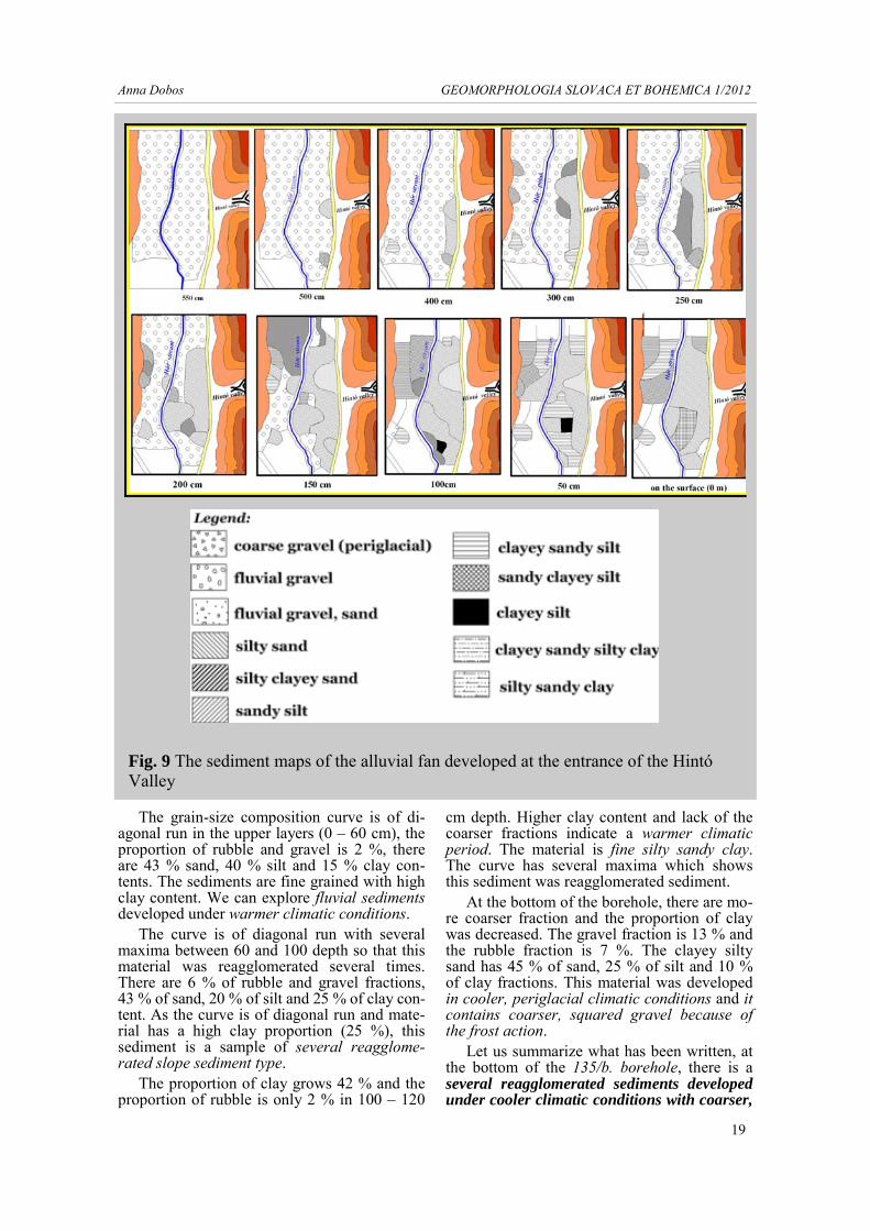
In the case study area, we have deepened 33 borholes into the alluvium to point out the spa-tial changes of sediments and landforms in case of alluvial fan. We have drawn the sedi-ment maps which show different sediment types in different levels inside the boreholes (Fig. 9).
There are unique, extended fluvial gravel layers in 550 cm depth in the alluvium of the Hór Stream. The first time, sediments accumu-lated in the centre part of the valley mouth in 500 cm depth and after that Hintó Stream runned towards the SW direction and silty sand and sandy silt accumulated here. Smaller allu-vial fan-series were appeared in 300 cm depth, in front of the Ábrahámka Hill and the Hintó Stream changed its channel towards NW (because of tectonic movements). New depo-sits accumulated in NW direction. In 250 cm depth, the Hintó Valley changed its channel again so that finer clayey material sedimented in the central part of the alluvial fan. Signifi-cant changes can be seen in 150 cm depth, where new deposits accumulated in the NW direction. The large shape of alluvial fan is not on the surface level today, because younger sediments have covered the former landform. The development of the alluvial fan show a fossil landform development.
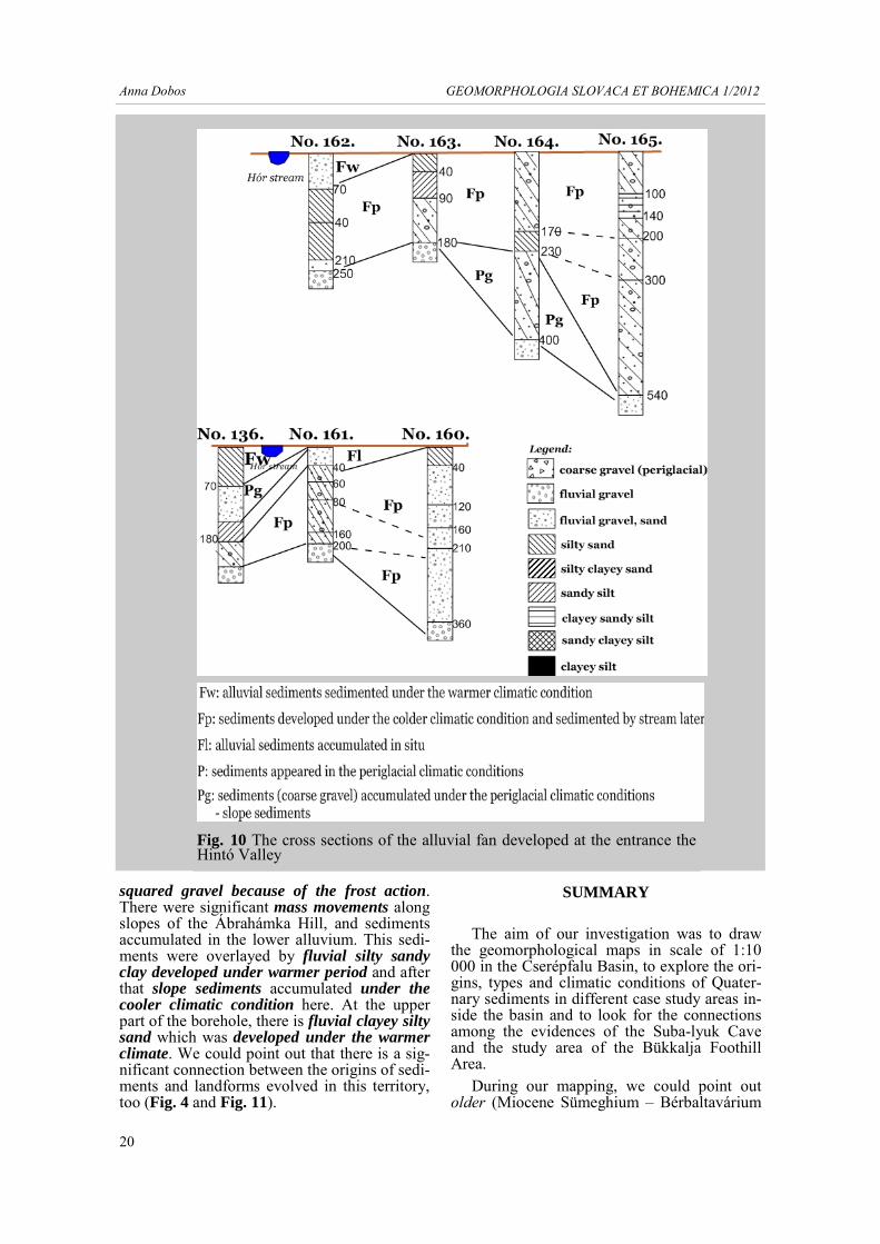
We have constructed cross sections at the entrance of the Hintó Valley (Fig. 10). There is a large fluvial gravel layer at the bottoms of the boreholes 162. (in 250 cm depth), 163. (in 180

Anna Dobos GEOMORPHOLOGIA SLOVACA ET BOHEMICA 1/2012
17
Fig.
7 T
he g
rain
-siz
e co
mpo
sitio
n cu
rves
of 1
99. b
oreh
ole

Anna Dobos GEOMORPHOLOGIA SLOVACA ET BOHEMICA 1/2012
18
cm depth), 164. (in 400 cm depth) and 165. (in 540 cm depth).This high gravel content shows a warmer and wetter climatic period in this territory. After this layer, we could find coar-ser and squared gravels which were developed under the cooler, periglacial climatic condi-tions because of the frost activity. It is prob-able that there was a short cooler period in the basin and sediments along the slopes was reag-glomerated by gelisolifluction and they accu-mulated in the alluvium. The mass movements appeared in the evolution of alluvial fan. Un-der the cooler climatic conditions, but fluvial sediments transported by the Hintó Stream or the Hór Stream accumulated in the upper part of the boreholes. We could investigate the ef-fects of cooler climatic period more distant from the channel of the Hór Stream, but we could see fluvial sediments developed under warmer climatic conditions next to the chan-
nel. That is why we could explore different ty-pes of sediments and climatic conditions at the end of Pleistocene and during the Holocene in surroundings of the alluvial fan. The periglacial sediments could marked the last glacial period (würm), while sediments accumulated under the warmer period could indicate sediments developed during the last 10 000 years. We ha-ve only relative stratigraphic evidences for the dating of sediments and we could not find fos-sils in different layers.
In the southern part of the Cserépfalu Basin, we have also chosen such a borehole that is situ-ated next to the Hór Stream in the alluvium (Fig. 11) and its sediments show significant fea-tures of different types, origins of sediments and their climatic conditions. In case of 135/b. borehole, we have constructed grain-size com-position curve with several maxima. It shows several reagglomerated sediments along slopes.
Fig. 8 The territory of the alluvial fan developed at the entrance of the Hintó Valley. Its boreholes and topographical position
Anna Dobos GEOMORPHOLOGIA SLOVACA ET BOHEMICA 1/2012
19
The grain-size composition curve is of di-agonal run in the upper layers (0 – 60 cm), the proportion of rubble and gravel is 2 %, there are 43 % sand, 40 % silt and 15 % clay con-tents. The sediments are fine grained with high clay content. We can explore fluvial sediments developed under warmer climatic conditions.
The curve is of diagonal run with several maxima between 60 and 100 depth so that this material was reagglomerated several times. There are 6 % of rubble and gravel fractions, 43 % of sand, 20 % of silt and 25 % of clay con-tent. As the curve is of diagonal run and mate-rial has a high clay proportion (25 %), this sediment is a sample of several reagglome-rated slope sediment type.
The proportion of clay grows 42 % and the proportion of rubble is only 2 % in 100 – 120
cm depth. Higher clay content and lack of the coarser fractions indicate a warmer climatic period. The material is fine silty sandy clay. The curve has several maxima which shows this sediment was reagglomerated sediment.
At the bottom of the borehole, there are mo-re coarser fraction and the proportion of clay was decreased. The gravel fraction is 13 % and the rubble fraction is 7 %. The clayey silty sand has 45 % of sand, 25 % of silt and 10 % of clay fractions. This material was developed in cooler, periglacial climatic conditions and it contains coarser, squared gravel because of the frost action.
Let us summarize what has been written, at the bottom of the 135/b. borehole, there is a several reagglomerated sediments developed under cooler climatic conditions with coarser,
Fig. 9 The sediment maps of the alluvial fan developed at the entrance of the Hintó Valley
Anna Dobos GEOMORPHOLOGIA SLOVACA ET BOHEMICA 1/2012
20
squared gravel because of the frost action. There were significant mass movements along slopes of the Ábrahámka Hill, and sediments accumulated in the lower alluvium. This sedi-ments were overlayed by fluvial silty sandy clay developed under warmer period and after that slope sediments accumulated under the cooler climatic condition here. At the upper part of the borehole, there is fluvial clayey silty sand which was developed under the warmer climate. We could point out that there is a sig-nificant connection between the origins of sedi-ments and landforms evolved in this territory, too (Fig. 4 and Fig. 11).
SUMMARY
The aim of our investigation was to draw the geomorphological maps in scale of 1:10 000 in the Cserépfalu Basin, to explore the ori-gins, types and climatic conditions of Quater-nary sediments in different case study areas in-side the basin and to look for the connections among the evidences of the Suba-lyuk Cave and the study area of the Bükkalja Foothill Area.
During our mapping, we could point out older (Miocene Sümeghium – Bérbaltavárium
Fig. 10 The cross sections of the alluvial fan developed at the entrance the Hintó Valley

Anna Dobos GEOMORPHOLOGIA SLOVACA ET BOHEMICA 1/2012
21
period - M) and younger pediments (Pliocene/Pleistocene - Pl/Q), Upper Pleistocene fluvial terraces No. II/b. (Riss-Würm period – Q3) and No. II/a. (Würm period – Q3w), Holocene flu-vial terrace No. I. and alluvium (Holocene pe-riod – H). There are erosional valleys, ero-sional-derasional valleys, derasional niches and Holocene water cuts along the slopes. In-vestigating of landforms, we could explore the cryoplanation of the younger pediment, the de-velopment of the cryoglacis (the Kerek Hill, the Ispán-szél Hill), frost-riven cliffs with talus cones (the Nyomó Hill, the Túrbucka Hill, the Southern Bükk Mts.) and derasional processes as the colder climatic conditions appeared at the beginning of the Quaternary period (the Bi-harian Age [1,0 – 1,1 million years ago] with Rangifer, Bison priscus, Mammuthus primige-nius and Coelodonta antiquitatis species, SCHWEITZER 2005). Later fluvial terraces, gelisolifluctions and derasional valleys and niches showed the effects of cooler, glacial pe-riods. In the warmer interglacial periods, valley deepening, mass movements, erosional valleys and water cuts appeared in this territory. The valley deepening of the Hór Stream and its tributaries was very active in several times dur-ing the Quaternary period that is why lots of sediments were transported from this territory. The Quaternary sediments can be explored in the alluvium or along slopes mainly.
Sediments and palaeontologic evidences of the Suba-lyuk Cave have given us the basic point for the relative chronology, because we could not find fossils in our boreholes. The cryoplanational processes and frost activity were characteristic at the beginning of the Pleistocene period when the cryopediment of
the Kerek hill and the Ispán szél Hill developed (during the Biharian Age). Coarser, frosted, squared fractions and loess sedimented during this cold climate on the surface of the younger pediment. After that we could manage to point out different climatic changes and different types of sediments (for example: periglacial slope sediments, periglacial fluvial sediments, Holocene fluvial sediments, etc.) developed during the Quaternary period in the Cserépfalu Basin. We have explored sediments in the northern and in the southern part of the basin. We can say that sediments accumulated in the alluvium were developed during the Upper Pleistocene (last glacial/würm period) and the Holocene period (interglacial period). There are intermittent interglacial, glacial (würm) and recent interglacial sediments under the surface in the basin. These sediment layers can make parallel in geological times with sediment lay-ers of the Suba-lyuk Cave (see the Introduc-tion). We could testify that Upper Pleistocene (Würm) and Holocene sediments developed in the foothill area and in the medium-height mountain system, too. There are some possibi-lity to make use this mapping methods and se-diment analysis to explore the Quaternary de-velopment of the other territory of the Bükk Mts. or other mountain systems.
REFERENCES
BALOGH, K., ed. (1963). A Bükk hegység és környékének földtani térképe (Geological map 1:100 000). Magyar Állami Földtani Intézet, Budapest.
Fig. 11 The grain-size composition curves of the 135/b. borehole

Anna Dobos GEOMORPHOLOGIA SLOVACA ET BOHEMICA 1/2012
22
BARTUCZ, L., DANCZA, J., HOLLEN-DONNER, F., KADIĆ, O., MOTTL, M., PATAKI, V., PÁLOSI, E., SZABÓ, J., VENDL, A. (1938). A cserépfalui Mussolini-barlang (Subalyuk). Geologica Hungarica Se-ries Paleontologica, fasc. 14.
CSÁSZÁR, G. (1997). Basic Litostratigraphic Units of Hungary (Charts and short description). The Geological Institute of Hungary, Budapest, 114 p.
DOBOS, A. (2000). A Hór-völgy fejlődéstör-ténete és természetvédelmi szempontú tájér- tékelése. PhD thesis, Debreceni Egyetem, Ter-mészettudományi Kar, Debrecen, 119 p.
DOBOS, A. (2001). Az átmeneti (puffer)-zóna geológiai értelemben játszott szerepének bemu- tatása egy bükkaljai mintaterület alapján. SZTE TTK, Természeti Földrajzi Tanszék, Szeged, 17 p.
DOBOS, A. (2002). A Bükkalja II. Felszínalak-tani leírás. In Baráz, Cs., ed. A Bükki Nemzeti Park. Hegyek, erdők, emberek. Bükki Nemzeti Park Igazgatóság, Eger, 217 – 227.
HEVESI, A. (1978). A Bükk szerkezet – és felszínfejlődésének vázlata. Földrajzi Értesítő, XXVII., Budapest, 169 – 198.
HEVESI, A. (1986). A Bükk hegység fel-színfejlődése és karsztja. PhD thesis,University of Budapest.
HEVESI, A. (1990). A Bükk szerkezet - és fel-színfejlődése, különös tekintettel a karszto- sodásra. MFT, 43, Vándorgyűlése, Miskolc, 67 p.
JÁNOSSY, D. (1979). A magyarországi pleisztocén tagolása gerinces faunák alapján. Akadémiai Kiadó, Budapest, 207 p.
KADIĆ, O. (1940). Cserépfalu vidékének bar-langjai. Barlangkutatás, 16, 2, 141 – 228.
KORDOS, L. (1991). A közép-európai felső-pleisztocén pocok-fauna fejlődése és biosztra-tigráfiai értékelése. A Magyar Állami Föld-tani Intézet Évi Jelentése 1989-ről, Budapest, 495 – 522.
KRETZOI, M. (1953). A negyedkor taglalása gerinces faunák alapján. A MTA Műszaki Tud. Oszt. Alföldi Kongresszusa, Budapest, 89 – 99.
KRETZOI, M. (1969). A magyarországi quater és pliocén szárazföldi biosztratigráfiájának vázlata. Földrajzi Közlemények, 17, 3, 179 – 204.
MARTONNÉ ERDŐS, K. (2000). A Bükkvidék. Kézirat, Debreceni Egyetem, Debre-cen.
PÉCSI, M. (1963). Magyarország részletes geomorfológiai térképeinek jelkulcsa. Magyar Tudományos Akadémia Földrajztudományi Kutatócsoport Természeti Földrajzi Munka-közössége, Budapest, 23 p.
PELIKÁN, P., ed. (2002). A Bükk hegység földtani térképe (1:100 000). Magyar Állami Földtani Intézet, Budapest.
PINCZÉS, Z. (1955). Morfológiai megfigyelé-sek a Hór-völgyben. Földrajzi Értesítő, IV, 1 – 4, Budapest, 145 – 156.
PINCZÉS, Z. (1968). A Bükk-hegység tönk és pediments felszínei. Természetföldrajzi Doku-mentáció, 7, MTA Földrajztudományi Kutató Intézet, Budapest, 32 – 39.
PINCZÉS, Z. (1970). Planated surfaces and pediments of the Bükk Mountains. Studies in Hungarian Geography, 8, Problems of Relief Planation, Budapest, 55 – 63.
PINCZÉS, Z. (1980). Production of planation surfaces and their types as illustrated on the examples of a Tertiary volcanic and of a Meso-zoic mountain. Acta Geographica Debrecina 1975-1976, XIV – XV, 5 – 29.
PINCZÉS, Z., MARTONNÉ ERDŐS, K., DO-BOS, A. (1993). Eltérések és hasonlóságok a hegylábfelszínek pleisztocén felszínfejlődésében. Földrajzi Közlemények, CXVII (XLI), 3, 149 – 162.
RINGER, Á,. MESTER, Zs. (1998). A Cserép-falui Suba-lyuk. In Nagy, K., ed. Cserépfalu hét és fél évszázada, Cserépfalu, 99 – 116.
SCHWEITZER, F. (2005). Jégkorszakok ciklu-sos váltakozásának lehetősége a neogénben. Fizi-kai Szemle, 3, Budapest, 96 – 100.
SMITH, M. J., PARON, P., GRIFFITHS, J. S. (2011). Geomorphological Mapping: Methods and Applications. Developments in Earth Sur-face Processes, 115, Elsevire, Oxford, 612 p.
VÁGÓ, J., HEGEDŰS, A. (2011). DEM based examination of pediment levels: a case study in Bükkalja, Hungary. Hungarian Geographical Bulletin, 60, 1, 25 – 44.