recreational access to privately owned rural land: a case study in canterbury hill country, new...
TRANSCRIPT

RESEARCH ZEALAND NEW GeozmDAer 60 [21 2004: 48
Recreational Access to Privately
Canterbury Hill Country, New Zealand Owned Rural Land: A Case Study in
GRANT HUNTER
ABSTRACT
There is public concern that private ownership restricts public access to land for such uses as recreation and amenity value. There is little systematically collected information about the extent of unfawourable attitudes to public access in New Zealand. This case study analyses the responses of 94 farmers/foresters to a request to operate a series of large-scale sporting events that traversed priwately owned rural land. Issues of concern to landowners included wisitor health and safety, disturbance to farm or forest management, and spread of disease. Despite these concerns 90 percent of the tandowners who were approached allowed access to their tand for recreation. An approach for handling possible landowner requests to charge for access for large-scale events is suggested.
ABOUTTHEAUTHOR
Grant Hunter is involved in supporting participation in outdoor recreation. He is also a land resource scientist with Landcare Research, Lincoln.
HunterG@landcareresearc h.co. nz
Introduction
Property rights associated with public access to privately owned land are a contentious issue in rural New Zealand (Ministry of Agriculture and Fisheries, 2003a), as is the case in many other ‘new world’ countries including Australia and Canada (Jenkins and Prin, 1998). Except where they are explicitly designated on a site-by-site basis (e.g., New Zealand Walkways, covenants, easements) there are no legal rights for the public to access privately owned land in New Zealand for recreation, and owners of private land have the authority to restrict or deny public access. A corollary is that the public must gain the landowner’s permission for access to be legal.
New Zealand recreationalists who have concerns about such arrangements may look for more enabling models from overseas. The ‘old world’ has a range of laws and/or social customs which give greater certainty to the public. Rights range from open ‘rights to roam’ or ‘every man’s rights’ in several Scandinavian countries, through to rights of public access through forests and woodlands but not necessarily all farmland, in countries such as Germany, Switzerland, Austria, England and Wales. Many of these situations reflect traditional land-societal relationships going back many hundreds of years, and may still be grounded in customary practice rather than clear laws (Pigram and Jenkins, 1999).
Some public-interest groups and individuals see private ownership of land in the New Zealand model as synonymous with restricted access for recreation and amenity, if not now, then in the future. As land uses become more specialised, landowners are considered less able or willing to enable access for the public.
Messages about public access are mixed. Anecdotally, recreational groups generally have good relationships with landowners, and a high proportion of recreational activities take place on private land (Hunter, 2000). However, specific failed relationships between landowners and recreationalists, and concern about future prospects, are sometimes used to argue for maximising public ownership of land or for providing legal provision for access.
Restrictions on public access to private rural land in New Zealand may arise from a conflict of interest such as

RESEARCH ZEA:;! GeograDher 60 [21 2004: 49
disturbance to stock or fire risk, from past experiences such as damage to property, or simply because visitors are unwelcome for a range of reasons. Most people are aware that access onto private land is a privilege rather than a right, and accept that where one use restricts another, the owner’s needs will take priority over other uses, such as recreation. Of greatest concern to the public are cases where access is declined with no apparent ‘good reason’.
In practice, rigid laws that favour the property rights of the landowner have been tempered informally by a flexible and enabling attitude adopted by many landowners towards access to private land, providing such access is with their consent and on their terms. However, as pressure on land changes, as land use diversifies, and as landowners themselves are changing, there is evidence that the situation underpinned by such traditional goodwill is deteriorating (Ministry of Agriculture and Fisheries, 2003a).
There is little systematically collected information to assess the predominant attitudes of private landowners to public access. The author’s role in arranging land access to enable six large-scale recreation events to range over 87 rural properties formed the basis of this case study of landowner attitudes to public access.
Rogaining - an intrusion into private land
Rogaining is a cross-country, walking/running event that calls on a combination of map reading and navigation skills, as well as physical fitness, It has strong similarities with orienteering but events cover a longer time duration and a larger area of land. Rogaining originated in Australia and is now practiced in a number of countries, notably Canada, some states of the USA, and some eastern European countries such as the Czech Republic.
For some participants, rogaining is a competitive event and for others it is a non-competitive recreation which fosters map reading, landscape interpretation, and navigation skills in the outdoors. Rogaining has become popular in New Zealand as a form of endurance or ‘multisport’ event which involves competition in the natural environment. New Zealand has succeeded in such activities, both in fielding winning teams in international events such as EcoChallenge and in organising world class events such as the Coast-toCoast and Southern Traverse. At the elite level, many ‘multisporters’ value rogaining as a way to hone their navigation and map reading skills for the larger, multi- disciplinary events. Another factor driving the popularity of such events has been the wish of many recreationalists to fit short, sharp, organised but challenging outdoor experiences into their increasingly busy and complex lives, in a ‘time deepening’ process (e.g., Horn et al., 1995).
In rogaining, teams of two to five people are given a topographical map of the event area (generally the standard, published 1:50,000 scale Infomap260 topographical map) overprinted with a network of 40-60 checkpoints. The checkpoints, which are typically on an informal grid 1-2 km apart, are located on features such as knolls, stream junctions,
and prominent rock outcrops, each marked in the field by a small flag. Teams have a specified number of hours (usually 6, 12 or 24) to visit as many checkpoints as possible (Figures 1 and 2). Each checkpoint is worth a number of points and the team accumulating the most points wins.
A rogaine event typically extends over from 25 km2 (a 6- hour event) to 150 km2 (a 24-hour event) of land. Good rogaining terrain offers a navigational and physical challenge, without posing unreasonable physical and safety hazards. In New Zealand, events typically cover steep, dissected hill country with slopes of contrasting aspects, and valley floors and streams. Rolling down lands may also provide terrain with suitable complexity for rogaining. Vegetation is ideally mixed grassland, patchy scrub, and forest. Landform and vegetation features must be faithfully depicted on the topographical map used for the event. These physical characteristics which are sought for rogaining make much rural farmland ideal.
Rogaines are a relatively intrusive recreational activity from a landowner’s perspective as they may involve up to 300 participants traveling in a largely unpredictable fashion across properties, rather than following a defined and confined route such as a formed track or stream bed as for more traditional forms of recreation. Rogaines are also a relatively well-controlled activity, within which organisers can influence accessibility (e.g., respect for ‘no-go’ areas) and safety requirements more effectively than smaller, informal visits, thus reducing some risks to landowners.
We chose six areas for the 12-hour ‘Heights of Winter’ series of rogaines in Canterbury in the eastern central South Island: the Scargill/lower Waikari River area in North Canterbury in 1998 and 2000, the Whitecliffs area of the upper Selwyn catchment in midcanterbury in 1999, the Waipara, Waikari and Cheviot areas in North Canterbury in 2001, 2002 and 2004’ (Figure 3). There were never any associations between the event organisers and landowners which may have influenced landowner responses, nor was there any conscious selection of properties based on perceptions of more favourable-than-average landowner attitudes towards access; each landowner was approached on a coldcanvassing basis.
These events ranged across 50-100 km2 of land, involving between seven and 26 separate, contiguous landholdings in lowland hill country. These properties were relatively small sheep and cattle hill country farming units, with some deer and woodlots, ranging in size from 200 to 1600 ha (one property was 4000 ha), and subdivided using post and wire and electric fences to control stock grazing. At Whitecliffs a significant area of hill country was used for exotic plantation forestry, managed by two forest companies. The Scargill, Waikari and Cheviot areas, being dry, open hill country are relatively infrequently used for recreation. The Whitecliffs area, in contrast, is a more popular recreational setting and some of the farms are often visited by school groups. The Waipara area, being close to Christchurch and with coastal frontage, is also used for recreation, mainly hiking. In all cases there was very limited legal public access

RESEARCH
easements within the event areas, and those that do exist were poorly understood by the general public and few were marked on the ground or signposted. The event organisers placed no reliance on formal public access easements and worked on the assumption that there was no access-of-right across any of the areas past the formed public roads. The farthest reach of events was set by the outer boundary of the outermost properties for which access approval had been sought and gained.
Figure 1: A sample of a topographical map marked up for a rogaine event. The numbered circles represent the location of checkpoints.
ZEALAND NEW Geographer 60 [21 2004: 50
Approaching landowners for access
A standard procedure was followed in the lead-up to a rogaine event. After selecting the general preferred locality, based on the physical landscape and proximity to the city, individual, adjacent landowners were approached for their access agreement until a sufficiently large area of contiguous land had been made accessible. Property boundaries and ownership was determined by consulting farm maps, a digital land-tenure database, letter box names and the telephone book, backed up by local enquiries.
A letter explaining the nature of the event and its lead- up, the number of participants, what organisers sought from landowners, what the organisers could offer to the community, an outline of safety and insurance procedures, and a contact number for the organiser, was sent to each. This was followed-up by telephone calls and/or visits. As planning of the event progressed, landowners were kept informed with at least one additional letter, and were generally advised by telephone of event-planning visits.
Within the event area, the planners could, where necessary, influence where participants went by declaring areas out of bounds (such as deer paddocks, areas of young tree plantings, and buildings) and by careful positioning of checkpoints to ‘steer’ teams either towards, or away from, particular places or features.
Landowner responses
At Scargill, 25 property owners agreed to allow access to the whole or most of the property and four declined in event 1, and one out of 14 declined in event 2 (Table 1). At Whitecliffs, all 23 property owners agreed, and at Waipara, four out of seven consented. All 12 properties approached consented at Waikari, and 10 out of 12 at Cheviot. Landowner concerns regarding access related to health and safety,
disruption to fardforest management, biosecurity (weeds and pests), and environmental issues. These concerns warrant some elaboration.
Figure 2: A rogainer visits a check point on North Canterbury farmland.
Health and safery: At Scargill in 1998, four farmers expressed concern about their responsibilities under the Health and Safety in Employment Act 1992. The Act was then ambiguous about farmer responsibilities to visitors such as non- paying recreationalists. However, this was a contributing factor in only one decline. In March 1998 a revision of Section 16 of the Act clarified this, stating that people who control workplaces, such as farmers, have only a simple duty to warn visitors, who have permission to be on their properties, of any work-related, out- of-theardinary hazards that may cause serious harm. Safety issues were not raised as a concern by any landowner at

RESEARCH ZEAEF Geognpher 60 2004: 51
Whitecliffs, or at Scargill in 2000. Health and safety concerns were raised by several landowners at Waipara in 2001: on a property being subjected to a major geotechnical investigation that was unrelated to agriculture; by a farmer; and by a forestry company that was actively logging much of its area. It was also raised as a secondary concern by two farmers at Waikari. All cases were resolved favourably for the event. Several landowners pointed out management- related (e.g., logging, pest control) hazards, which they are required to do by law, as well as some unusual natural hazards (e.g., rock bluffs, sink holes) that they considered event organisers and participants should be aware of. One forest owner sought confirmation that the organisers carried adequate insurance to cover damage to property. At Cheviot, two landowners stressed that they would accept no liability for safety in the event of visitor accident.
Farm/forest management: Although possible disturbance to farm/forestry operations was mentioned by a number of landowners, it was mostly in the context of ‘we expect you to take due care’ rather than posing a real limitation to either recreation or the prevailing land use. The only exception that limited access for the events was an apologetic decline because of the risk to young tree seedlings on a smallholding. Unrecorded in this category were also a number of cases where event planners made sensitive areas, such as deer paddocks, out of bounds, without being prompted to do so by landowners. Many practical, farm management reasons for declining or limiting access varied over time as well as by place. Mid-winter was chosen as an event innovation, rather than because it was known to be a convenient time
for access to farmland. However, organisers discovered that winter is a suitable, low risk time for farmers to allow access, as one farmer put it, “If a gate is kft open the consequences to stock are lower in winter. You may not have got the same support at other times of the year.” For example, severe limitations would be placed on access during lambing in spring, or during times of high fire risk.
Biosecurity: Several farmers were concerned about the risk of people moving across neighbouring properties spreading disease, pests, or weeds. The risk of participants spreading foot rot, an infectious, bacteria-borne disease in sheep that is spread by their feet coming in contact with contaminated pasture and ground, was the single main reason for declining or limiting access. While the risk of spread by visitors was acknowledged to be low, the cost-consequences of spread from contaminated to uncontaminated properties might be high. Risks are likely to be highest during the moist, winter months when the event is held. Farmers who had this concern were apologetic and stressed they normally welcome visitors. Those operating stud stock farms were particularly likely to be concerned. At Waikari we met this concern by placing disinfectant foot-baths at some property boundaries.
Environment: Sensitivity of landowners to their own responsibilities under the Resource Management Act 199 1 (RMA) is often anecdotally suggested to be a trigger for landowners to decline public access. This concern might arise if visitors report land condition or management practices that could be seen as contrary to sustainable land management, or because access may lead to increased
community expectations and interests in areas for recreation or nature conservation. We found limited evidence of such attitudes. One farmer, self-judged to be conservation-friendly, welcomed us as visitors, but stipulated that participants who were also members of a conservation group were unwelcome on his property. This requirement was to convey to group membership that some actions of its officials were regarded as making it difficult for farmers to responsibly manage conservation values while also sustaining their farming livelihood. Another farmer expressed some concern that visitors may later report natural features that may be identified for protection under regulatory provisions. Interestingly, one property owner at Whitecliffs observed that sensitivity to issues under the RMA may colour other landowner’s attitudes to permission for access (but did not appear to affect his own).
Figure 3: Location map
This relatively restricted level of concern is perhaps surprising given the number of ‘outsider’s eyes and ears’ that these events represented and the extent of ground that they covered. It was particularly surprising at Scargill given the stressed condition of much of the vegetation cover during severe drought

RESEARCH ZEALAND NEW GeograDher 60 [21 2004: 52
Landowner responsibility for health and safety
Table 1: Summary responses of landowners to requests for access to privately owned land for rogaine events
4 (contributed to 1 decline)
Event locality
1 (access restricted within farm - early lambing)
Scargllll
2 (resolved)
Scargill 2’
Spreading weeds, pests, diseases
1 Cheviot
1 (access declined)
I Waipara Walkari
Number of property owners approached I number approving access
1411 3 714 12/12 23/23
Issues of concern
Number of landowners raising the concern
HEALTH AND SAFETY
0 3 (2 resolved)
2 (resolved)
2 (resolved)
FARMFOREST MANAGEMENT
Stock disturbance (e.g., lambing, deer)
4 (3 resolved, 1 contributed to access declined)
0 1 (resolved)
1 (resolved)
several general discussions (resolved)
0 0 0 Gates left openlphysical damage to fences, etc.
Trampling young pine trees
several general discussions (resolved)
1 (access declined)
0 0 0
Forest harvesting in operation
1 (resolved)
0
BIOSECURITY
1 (resolved)
l o (access declined
1 3
3 (resolved) (access denied) II
ENVIRONMENT
Litter 1 (resolved)
Visitor perceptions of environmental management (e.g., attracting public interest in high natural values, or poor land condition or environmental degradation)
0 1 (access granted with a condition, event organisers withdrew from property)
0 1 (resolved, visitors might place pressure for regulatory protection of natural values)
1 (“other landowners
I
* Included three propmties also included in Scargill 1
conditions in 1998, and the personal stress that the farmers were also exposed to, The Scargill, Waipara and Cheviot events were in Hurunui District where there had been ongoing rural-community concern about the regulatory
approach being taken towards protection of natural areas in the District Plan.
Interestingly, one farmer at Cheviot pointed Out that the farm had a strong policy on rubbish and that it was

unacceptable for visitors to leave litter. At least four landowners drew positive attention to natural areas (e.g., shrubland remnants tucked in gullies, rock formations with high landscape value) that they thought might be attractive for event participants to visit.
Two possible further reasons to decline public access are: risk of fire (more of a summer and autumn than a winter concern), and the general security of rural community and property (probably not seen to be an issue for an organised event). Neither of these issues were raised by any landowner.
Discussion
Although rural-based recreation (such as rogaining) may require relatively large areas of land, activities are largely non-consumptive, and can be incorporated into multiple land use situations such as agriculture and forestry (Jenkins and Prin, 1998). However relationships between recreationalists are influenced by land manager attitudes, which in turn will be based on a range of factors including their practical requirements for their own land management, policy or legal requirements, and their past experiences.
Issues raised by landowners
The array of issues raised by landowners was broadly consistent with experience elsewhere in the world, within a distinctive New Zealand legislative and social context. Thus, they are based on the categories of personal beliefs and experiences, and legal (e.g., health and safety, biosecurity), economic (including practical concerns about disruption to land management practices such as stock disturbance, damage to young trees, and biosecurity risk), social (e.g., privacy, personal safety), and ecological/environmental concerns listed by Pigram and Jenkins (1999). The latter two categories were only weakly expressed in this case study.
Although concerns about visitor health and safety by ‘our’ landowners did not prevent access, evidence from this study and wider experience in outdoor recreation and land- enterprise management point to health and safety concerns growing as a barrier to land access under prevailing legislation, on private and public land. These concerns have been exacerbated by increasing nervousness about liability and hence increasing barriers to access. Outcomes such as the death of a participant in a road cycle race and the subsequent conviction of criminal nuisance of the event organiser (2001 Le Race, Akaroa), and the charging of volunteer marshals following a fatal motor race accident near Queenstown (Lynch, 2003), as well as the generally increasing responsibility of all business owners for health and safety.
Event organisers and landowners are less willing to expose themselves to the risks their respective roles expose them to, even where the legislation does not deem them to be liable. The position of two landowners in our Cheviot event was that they would welcome the event on the express condition that they were absolved, in writing, of any liability for health and safety, encapsulates this underlying concern.
At the time of writing, there is considerable uncertainty at all levels about where such liability lies. The future delivery of adventure events to the outdoors public is dependent on the formulation and clear enunciation of legislated requirements that will provide appropriate levels of safety for all parties, remove the ‘fear factor’, and enable the introduction of best practice to event organisation.
It was not surprising that no landowners expressed concern about adverse effects that the rogaine activity may have on their land or water environment. Such impacts would be very much less than those of the background activities of the farming or forestry operations. Douglas (1990) reported impacts of orienteering, a similar activity, in the New Forest, Hampshire, England, an area considered to have international importance for nature conservation and biological science. In response to concern about the impact of large numbers of people on plants and animals, the researchers assessed impacts of an event that involved 1200 competitors ranging over an area of 11 km2, an average use density some 20 times greater than for a typical rogaine in New Zealand. They found that most vegetation had recovered within three weeks, but with some wetland sites taking more than six months and a moss habitat more than one year to recover.
In comparison with private landowners, the Department of Conservation, which manages the public lands of the conservation estate, takes a strongly precautionary approach to possible adverse environmental impacts arising from rogaine-like events on these lands. It achieves this approach by placing performance requirements upon event organisers to avoid, remedy, or mitigate such effects as a condition of being awarded a concession to operate the event.
Access agreement
Within the agreements for access there were some initial reservations. One farmer noted that “I carry all the ‘11sks but get no benefit.” Another was at first apprehensive about having a large number of people running at random across their property, even though he welcomed the more usual smaller groups of visitors. With another farmer who was reticent about large numbers of visitors (which he saw as overwhelming), we reached an accommodation by limiting use to one half of the farm. Managers of larger-scale plantation forests required that runners avoid young trees, which could be damaged by trampling. Two farmers in the first year indicated that they would follow the lead of their neighbours, that is, they might agree to or decline access, and did not give an immediate ‘yes’ or ‘no’. They did not want to be seen to be out of line or unreasonable to either party. Both were subsequently supportive.
Although most landowners’ initial responses were ‘passively accommodating’ rather than ‘actively welcoming’, there was more positive support than negative concerns amongst them. Overall, event organisers interpreted their responses as showing strong and enabling commitment to the public interest in access to their land, at least within the case-study

RESEARCH ZEAE’ Geographer 60 (21 2004: 54
contexts. The supportive response of a farmer in the Scargill- Hurunui area (“We get almost as much satisfaction from having visitors enjoy our area as we get from being here ourselves”), was matched by several others, and in each area. Some landowners offered direct help such as a guided farm inspection for event planners, use of a farm vehicle, shifting stock, switching off electric fences, opening gates for the events, and use of facilities. The only time a landowner initiated contact with the event organisers was to advise about new tree plantings. The single complaint we received arose from a situation when we failed to keep farmers informed of a course pre- planning visit.
We found no evidence of landowners using legislative requirements or land management issues as ‘leverage’ to justify declining access. Rather, there was an apparent though small drop-off in landowner concerns about safety matters as a result of partial relaxing of attitudes to health and safety concerns following clarification of the legislation between 1998 and 1999 in favour of fewer barriers to access.
As one farmer put it afterwards, certain land management factors may present a major barrier at some times and not at others. He used the example of the prevalence of foot rot after a wet summer and autumn being of particular concern regarding one winter event, whereas in a dry summer, the risk of fire might close-off access to some properties, and not necessarily the same ones. The organisers were seldom requested to declare specific areas out of bounds or to steer participants away from areas. More usually the event organisers took these initiatives, such as to routinely place deer paddocks, and clusters of buildings, out of bounds.
The event organisers let catering contracts to provide participants with an after-event meal to local community groups such as schools and youth groups. This initiative arose from wanting to provide this service locally and affordably, as well as wishing to offer a tangible benefit to the community. There was no evidence in our discussions with landowners that this influenced their decision regarding access (though clearly it would have done no harm). It was rarely a topic of conversation. As one farmer put it later: “Giving the locals the opportunity to cater was appreciated and seen as worthwhile.” The author’s personal knowledge of other similar outdoor events on private land, many of which offered no direct benefit to the host community, reinforces an interpretation that the community benefit did not significantly influence landowner decisions on access. However, two people providing catering services commented on how much rural communities appreciated the opportunity to raise funds from external sources (e.g., recreational visitors) rather than by the more usual recycling of funds already within their local community.
Several rogaine participants commented that they were surprised that so many neighbouring landowners had so consistently enabled access over their properties. A question that arises is “why are these results apparently more favourable than the wider public perception that there are access difficulties and /or that difficulties are increasing?“ (Ministry of Agriculture and Fisheries, 2003a). Set against the particularly intrusive nature of the event, a number of other
factors may have worked in its favour. The relatively stable rural communities in these parts of Canterbury may have retained traditional, enabling values more than some other areas. Because the land is far-enough distant from urban areas (Pigram and Jenkins, 1999), and because their land is not routinely sought for general recreation, they are likely to have faced relatively low exposure to pressure for access.
Another perspective - and this is a personal observation based on the author’s wider experience in outdoor recreation - may be that cases of negative outcomes, such as access refusal, remain disproportionately embedded within the recreational community memory, and are often brought up in conversation, even years later. The more normal success stories do not command such ongoing attention, but rather are taken for granted, (i.e., the reality of the problem may be less than the perception of it).
It would be interesting to know in this regard how many of the 116 specific access problems throughout New Zealand identified in submissions to the Land Access Ministerial Reference Group (Ministry of Agriculture and Fisheries, 2003b) were of an historical or ongoing nature and how many were recent and/or new instances.
Most farms appeared to be owned and managed by individuals or families, often operated as private trusts or companies. A few had absentee but, as far as we could determine, Canterbury-based owners who employed an on- site farm manager. While we found no direct evidence in our samples that the generally increasing level of overseas ownership of land is alienating traditional arrangements for public access (Ministry of Agriculture and Fisheries, 2003a), as one farmer pointed out, some new owners, particularly from overseas, are starting to bring in a more ‘black and white’ perspective to property rights, land use, and the public interest. This perspective may be driven by single-minded, commercially driven management goals and /or rigid legal perspectives about property rights within which public access has a zero or even negative ranking. He was concerned that this trend may progressively push aside the traditional give-and-take, informal attitude that has so far characterised the ‘New Zealand way’.
A number of specific trends are influencing access to at least localised areas of private land, and under present trends, these will affect greater areas in the future. Intensification and diversification of land use, such as into horticulture and deer farming, and lifestyle blocks, is limiting the extent of land that is physically available for recreation. The rogaine organisers deliberately avoided areas dominated by such land use, since there were more suitable alternatives at the time. While areas being ‘fenced&’ from recreation because of intensification of land use are still relatively localized, the accelerating trends in this process may leave little space for complacency in the longer term. Jenkins and Prin (1998) note that the dependency of the future for recreation in rural areas upon its ongoing integration with traditional and new forms of economic land uses is an issue internationally.

RESEARCH Z d K Geogra,bher,,2,2,,:55 These results seem a little more optimistic than those
reported by Reiser (in McDonald, 2003) in his analysis of 125 questionnaires returned by farmers on the Otago Peninsula. Sixty percent of respondents had permitted public access for recreation in the past and only 46 percent would so now, although responses varied according to type of recreational activity. Abuse of rights by users was given as reason for this change in attitude, among them failure to close gates and dogs worrying sheep.
Payment for access
Only one landowner sought payment or compensation for access to land, or for the use of on-farm facilities, even though a woolshed or other farm building was used as an event base on some properties in some years. While the author is aware of several similar events for which landowners have sought payment, this has been unusual. However, any trend towards charging for access could accelerate as farmers see this as an opportunity to diversify ‘production’ and increase revenue, especially if such sporting events become commercial activities in their own right. Landowners facing greater liability under the Health and Safety in Employment Act in cases where revenue is gained from visitors may be a disincentive for charging for access.
In view of the current Government-level initiatives to improve public access to rural lands (Ministry of Agriculture and Fisheries, 2003a) it seems pertinent to note that the two most complex and rigorous negotiations for access for rogaine or rogaine-like recreational events that the author has been involved with - both of which were operated by non-commercial, community groups - were for access to publicly owned lands of the conservation estate. The transaction costs incurred to assure the Department of Conservation that the environmental and social impacts of these events were compatible with the requirement of the Conservation Act (1987) to “foster the use of natural resources for recreation to the extent that this use is not inconsistent with its conservation”, and to meet departmental requirements for health and safety, was higher for both the applicant organisation and the administering department than has been the case to meet equivalent requirements placed by private landowners.
Although the fees levied by, or required by, the Department were contributions to cover processing costs rather than revenue collection per se, the author notes the Ministry of Agriculture and Fisheries (2003a) concern that such charges may encourage private land owners to levy charges, thus imposing new barriers to public access. Alternatively, the level of transaction required to gain a concession for access to public land may simply foreshadow increasing demands by private landowners as they respond to their own increasing legislative and industry requirements. In this case, the complexity of process associated with gaining access approval could become a greater barrier for recreational organisers than any direct financial cost, as access to public conservation lands has already shown.
Farmers’ perspectives
The quality of direct relationships between landowners and members of the public and in particular the perceptions of landowners are important to the public access debate. An apparently (to the recreationalist) unduly harsh response for public access for recreation may be influenced by land manager’s past experience with a conspicuous (to the land manager) minority who fail to consider the relationship between the activity and the resulting interactions with, and impacts upon, the land manager (Jenkins‘ and Prin, 1998).
One of the landowners interviewed after a rogaine event noted that they expect to be approached in a way that acknowledges their status as landowner and their need to run their business and, as far as possible, their lifestyle, without undue disruption. He pointed out that the nature of first impressions conveyed by those requesting access often set the scene for landowners’ relationships with visitors and the decisions they reach, at least where such decisions are influenced by personal judgment of the situation rather than by practical land management reasons such as seasonal disturbance to stock or fire risk.
The landowner further commented that many farmers feel that their ‘backs are to the wall’ as a result of the pursuit of the protection of natural areas within the Resource Management Act, which some perceive to have been mis- used by people with agendas, including council employees, non-government organisations and government departments. Despite that, we found little practical evidence that landowners link together the dual public goods of natural values protection and recreational land access, although another farmer we spoke to after the event commented that strained relationships associated with different views about ways to conserve natural values probably had hardened some landowner attitudes towards land access in North Canterbury.
Most rural communities and families have moved well past the phase where they actively welcome any visitors, as a break from isolation or farm duties, or as a link with ‘civilisation’, and in which unknown visitors might have expected to feel welcomed as a matter of course. One farmer pointed out how tasks such as unlocking gates, shifting stock for visitors, and recently, helping a tramping party that got into difficulties, though willingly-enough done, can be costly in time and convenience when aggregated. He had recently supported an organised multisport event, a four wheel driving safari, and a tramping club group within just a few months, as well as fielding ongoing and frequent requests for small-group access for mountain biking, four wheel driving, walking and hunting. He noted that such interactions lose their novelty value and become instead an invasion of privacy, even a nuisance.
Alignment elsewhere in New Zealand
To assess the alignment of these findings with experience elsewhere in New Zealand, feedback was received from the organisers of two similar, 24-hour rogaine events, one in hill country in the Roxburgh area of Otago and the other in hilly
RESEARCH ZEALAND NEW GeoyyaDber 60 (21 2004: 56
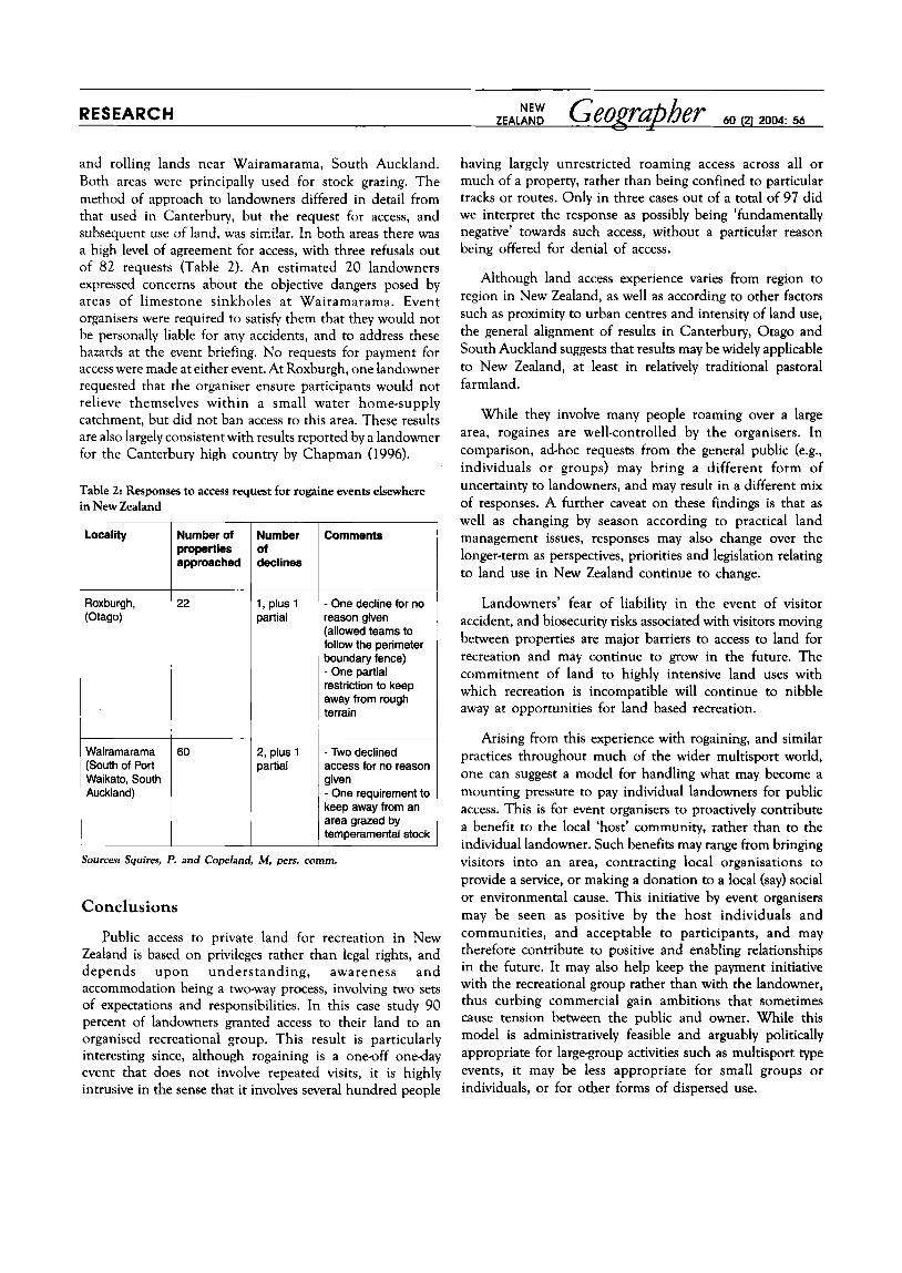
and rolling lands near Wairamarama, South Auckland. Both areas were principally used for stock grazing. The method of approach to landowners differed in detail from that used in Canterbury, but the request for access, and subsequent use of land, was similar. In both areas there was a high level of agreement for access, with three refusals out of 82 requests (Table 2 ) . An estimated 20 landowners expressed concerns about the objective dangers posed by areas of limestone sinkholes at Wairamarama. Event organisers were required to satisfy them that they would not be personally liable for any accidents, and to address these hazards at the event briefing. No requests for payment for access were made at either event. At Roxburgh, one landowner requested that the organiser ensure participants would not relieve themselves within a small water home-supply catchment, but did not ban access to this area. These results are also largely consistent with results reported by a landowner for the Canterbury high country by Chapman (1996).
Table 2: Responses to access request for rogaine events elsewhere in New Zealand
Wairamarama (South of Port Waikato, South Auckland)
Number of properties approached
22
60
Number of declines
1, plus 1 partial
2, plus 1 partial
Comments ~
- One decline for no reason given (allowed teams to follow the perimeter boundary fence) - One partial restriction to keep away from rough terrain
- Two declined access for no reason given - One requirement to keep away from an area grazed by temperamental stock
Sourcesr Squires, P. and Copeland, M, pets. comm.
Conclusions
Public access to private land for recreation in New Zealand is based on privileges rather than legal rights, and depends upon understanding, awareness and accommodation being a two-way process, involving two sets of expectations and responsibilities. In this case study 90 percent of landowners granted access to their land to an organised recreational group. This result is particularly interesting since, although rogaining is a one-off one-day event that does not involve repeated visits, it is highly intrusive in the sense that it involves several hundred people
having largely unrestricted roaming access across all or much of a property, rather than being confined to particular tracks or routes. Only in three cases out of a total of 97 did we interpret the response as possibly being ‘fundamentally negative’ towards such access, without a particular reason being offered for denial of access.
Although land access experience varies from region to region in New Zealand, as well as according to other factors such as proximity to urban centres and intensity of land use, the general alignment of results in Canterbury, Otago and South Auckland suggests that results may be widely applicable to New Zealand, at least in relatively traditional pastoral farmland.
While they involve many people roaming over a large area, rogaines are well-controlled by the organisers. In comparison, ad-hoc requests from the general public (e.g., individuals or groups) may bring a different form of uncertainty to landowners, and may result in a different mix of responses. A further caveat on these findings is that as well as changing by season according to practical land management issues, responses may also change over the longer-term as perspectives, priorities and legislation relating to land use in New Zealand continue to change.
Landowners’ fear of liability in the event of visitor accident, and biosecurity risks associated with visitors moving between properties are major barriers to access to land for recreation and may continue to grow in the future. The commitment of land to highly intensive land uses with which recreation is incompatible will continue to nibble away at opportunities for land based recreation.
Arising from this experience with rogaining, and similar practices throughout much of the wider multisport world, one can suggest a model for handling what may become a mounting pressure to pay individual landowners for public access. This is for event organisers to proactively contribute a benefit to the local ‘host’ community, rather than to the individual landowner. Such benefits may range from bringing visitors into an area, contracting local organisations to provide a service, or making a donation to a local (say) social or environmental cause. This initiative by event organisers may be seen as positive by the host individuals and communities, and acceptable to participants, and may therefore contribute to positive and enabling relationships in the future. It may also help keep the payment initiative with the recreational group rather than with the landowner, thus curbing commercial gain ambitions that sometimes cause tension between the public and owner. While this model is administratively feasible and arguably politically appropriate for large-group activities such as multisport type events, it may be less appropriate for small groups or individuals, or for other forms of dispersed use.

Note
I Results for the 2003 event are not reported here because a different event organiser used a slightly different method for approaching landowners. However, 13 out of 14 landowners approached enabled access in that year (Payne, S., pers. comm.).
Acknowledgements
The rogaine events were presented by Peninsula and Plains Orienteers and the New Zealand Rogaining Association, with the support of rural communities in Canterbury. Roger Wilkinson, Margaret Kilvington, Chrys Horn, Phil Novis, Claire Mulcock and Peter Squires advised me on drafts of this paper, and the journal referees on the final cut.
References
Chapman, J. 1996: Interaction of recreationalvisitors and pastoral residents in the Mid-Canterbury high country, New Zealand, in Ralston, M. M.. Hughey,
Douglas, E. A. 1990: Impacts on flora and fauna of the November Classic 1988, held in the New Forest, Hampshire, England, ScientificJoumal ofhenteering,
House of Commons 2000: The Countryside and Rights of Way Bill: Access Rights of Way Bill 78 of 1999-2000, Research Paper 00/31, 17 March Horn, C., Devlin, P. and Simmons, D.: 1995: Mountain-biking, social change and substitution, Australian/New Zealand Association for Leisure Studies,
Hunter, G. 2000: Working together for resource-based recreation and tourism, sustainable management, and biodiversity, New Zealnnd Geographer, 56(2),
Jenkins, J. M. and Prin, E. 1998: Rural landholder attitudes: the case of public recreational access to ‘private’ rural lands, in Butler, R., Hall, C. and Jenkins,
Lynch, P. 2003: Criminal nuisance prosecutions in recreation cause for concern?, FMC Bulktin No. 153, Federated Mountain Clubs of New Zealand,
K. F. D. and OConnor, K. F. (eds), Mountains of E a t Asia and the Pacific, Centre of Mountain Studies, Lincoln University, 207-10.
(61, 64-82.
Leisure Connexions Conference January 17-20, Lincoln University, New Zealand.
47-5 1.
J. (eds) 1998, Tourism and Reneation in Rural Areas, John Wiley, New York.
Wellington. McDonald, P. 2003: Going out for a bike ride. An AOK diary, 2002-3, web version htm//homeDaees.Daradise.nert.nz/petemcd/eob/~ . . Ministry of Agriculture and Fisheries 2003a Walking access in the New Zealand Outdoors, A Report by the Land Access Minisrevial Reference Group (Acland
Ministry of Agriculture and Fisheries 2003b: Summary of submissions to the Land Access Ministerial Reference Group, MAF Policy, Wellington, New
Pigram, J. J. and Jenkins, J. M. 1999: Outdoor Reneation Management, Routledge, London.
Report), MAF Policy, Wellington, New Zealand.
Zealand.