reducing the fog of war dr. amit mukherjee (an … · add your company logo here on master slide...
TRANSCRIPT

Add your company logo here on master slide
Add your company logo and other footers here on master slide
GEOSPATIAL WORLD FORUM
2018
Geo4IR
Emerging Military & Security Solutions
Dr. AMIT MUKHERJEE
(An Academic Perspective)
Geospatial Intelligence with Fuzzy Logic– Reducing the Fog of War
Add your company logo here on master slide
FOG OF WAR
• The fog of war - is the uncertainty in situational awareness experienced by participants in military operations. The
term seeks to capture the uncertainty regarding one's own capability, adversary capability, and
adversary intent during an engagement, operation, or campaign. Military forces try to reduce the fog of war
through military intelligence and friendly force tracking systems. The term is also used to define uncertainty
mechanics in wargames.
• War is the realm of uncertainty; three quarters of the factors on which action in war is based are wrapped in a fog
of greater or lesser uncertainty. A sensitive and discriminating judgment is called for; a skilled intelligence to scent
out the truth.
— Carl von Clausewitz
Add your company logo here on master slide
Geo-Spatial Intelligence
The term "geospatial intelligence" means the exploitation and analysis of imagery and geospatial
information to describe, assess, and visually depict physical features and geographically referenced
activities on the earth. Geospatial intelligence consists of imagery, imagery intelligence, and geospatial
information.
(The NIMA Act of 1996 establishing the National Imagery and Mapping Agency and the subsequent
amended language in the 2003 Defense Authorization Act as codified in the U.S. Code governs the
mission of the National Geospatial-Intelligence Agency (NGA). The de jure definition of Geospatial
Intelligence is found in U.S. Code Title 10, 467)

Add your company logo here on master slide
Geo-Spatial Intelligence
• Geospatial intelligence (GEOINT) is intelligence derived from the exploitation and analysis of imagery and geospatial information about
features and events, with reference to space and time. This definition applies not only to products and services, but also to the process of
conducting analysis. GEOINT is comprised of the following sub-disciplines:
• Imagery Analysis
The process of examining an image collected from satellites or aircraft to identify features, describe activity and interpret what is occurring
at a given place on the Earth’s surface. AGOis responsible for the tasking, collection, processing, dissemination and archiving of imagery
used by the Australian Defence Force and other government agencies.
• Geospatial Analysis
Entails collecting and analyzing information about features on the ground, their relationships to the Earth and to each other. Geographic
features can be hills and valleys, rivers, buildings, streets or even schools. Using geographic information systems (GIS), the data can be
sorted, examined, analyzed and conclusions can be drawn and displayed in a multitude of ways that would not be possible without GIS.
• Geospatial Information and Services
A combination of the precise location information and associated attributes of natural and man-made features. This combination conveys
the 'what' and 'where' of a feature on the Earth's surface and provides the foundation for a wide range of information to
be integrated and displayed.

Add your company logo here on master slide
FUZZY LOGIC - PRINCIPLE
The question as to how GEOINT is different from other geospatial analytic activities is occasionally asked.
Bacastow Postulations:
GEOINT, rooted in the geospatial sciences, geospatial technologies and critical geospatial thinking, seeks knowledge to
achieve a decision advantage. Analysis occurs as a natural human to technical to human sequence of events.
GEOINT reveals how human intent is constrained by the physical landscape and human perceptions of Earth.
GEOINT seeks to anticipate patterns of life through time.
Data and technical systems used by analysts are human creations and reflect human biases.

Add your company logo here on master slide
FUZZY LOGIC - PRINCIPLE
• GIS, at present, has several limitations, which make them inefficient tools for decision-making.
Biggest limitation is that current commercial systems are based on logical foundation. Current GIS
are predominantly based on Boolean logic.
• Fuzzy logic is an alternative logical foundation coming from artificial intelligence (AI) technology
with several useful implications for spatial data handling. Contrary to traditional logic, fuzzy logic
accommodates the imprecision in information, human cognition, perception and thought. This is
more suitable for dealing with real world problems, because most human reasoning is imprecise.
• Major advantage of this fuzzy logic theory is that it allows the natural description, in linguistic
terms, of problems that should be solved rather than in terms of relationships between precise
numerical values. This advantage, dealing with the complex systems in simple way, is the main
reason why fuzzy logic theory is widely applied in technique.
• Fuzzy Logic Theory vs Probability Theory
• Fuzzy Logic – Fuzzification & De-Fuzzification
Add your company logo here on master slide
• Fuzzification: Fuzzification is the first step in the fuzzy inference process.
This involves a domain transformation where crisp inputs are transformed
into fuzzy inputs. Crisp inputs are exact inputs measured by sensors and
passed into the control system for processing, such as temperature,
pressure, rpm's, etc..
• Defuzzification: Defuzzification is the process of producing a quantifiable
result in Crisp logic, given fuzzy sets and corresponding membership
degrees. It is typically needed in fuzzy control systems.

Add your company logo here on master slide
Weighted Overlay

Add your company logo here on master slide

Add your company logo here on master slide
Reliability Score Distance Terrain Conditions
Rules Based Evaluation Output

Add your company logo here on master slide
Fuzzy Logic Operator Overlay

Add your company logo here on master slide
Fuzzy Logic Operator

Add your company logo here on master slide
Artillery Accuracy with Uni-variate Membership Model : Range

Add your company logo here on master slide
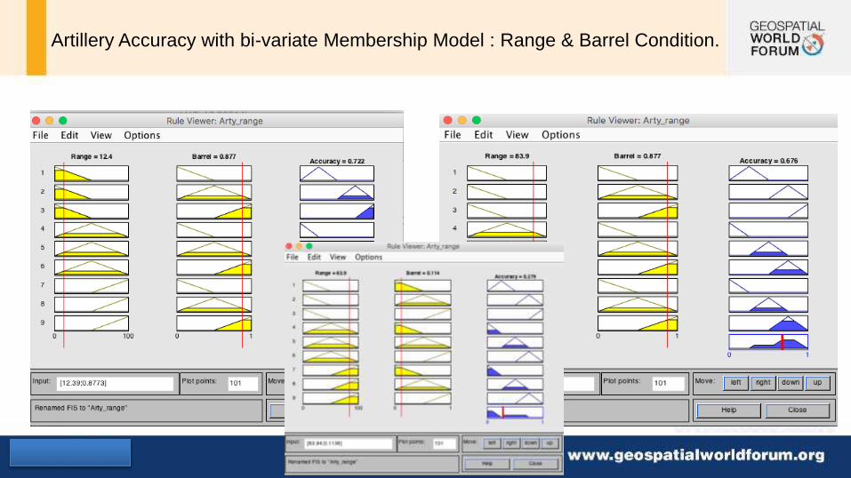
Artillery Accuracy with bi-variate Membership Model : Range & Barrel Condition.
Add your company logo here on master slide
Artillery Accuracy with bi-variate Membership Model : Range & Barrel Condition.

Add your company logo here on master slide
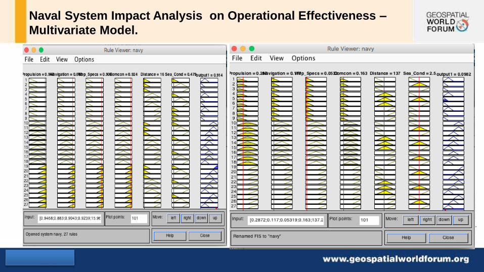
Naval System Impact Analysis on Operational Effectiveness –
Multivariate Model.
Propulsion
Navigation
Weapons Specs.
Command & Control
Sea Condition
Distance

Add your company logo here on master slide
Naval System Impact Analysis on Operational Effectiveness –
Multivariate Model.
Add your company logo here on master slide
Naval System Impact Analysis on Operational Effectiveness –
Multivariate Model.

Add your company logo here on master slide
FUZZY LOGIC IN COUNTER-INSURGENCY
OPERATIONS
• - with Fuzzy Logic
• Mobility Maps and Training
• Cross Country Route
• Along track route
• Mine Location - > Energy Focusing Ground Penetrating Radar + Automatic Target Recognition
• Ambush points
• Obstacles
• Attack –Counter attack

Add your company logo here on master slide
Is line-of-sight enough to analyze a vehicles vulnerability to an attack?
• Speed?
• Continuous line-of-sight?
• Kill Chain Sequence Time?
• Goal: Improve current methodology to incorporate vehicle speed, target
acquisition time, and continuous line-of-sight to better analyze a moving target.
Add your company logo here on master slide
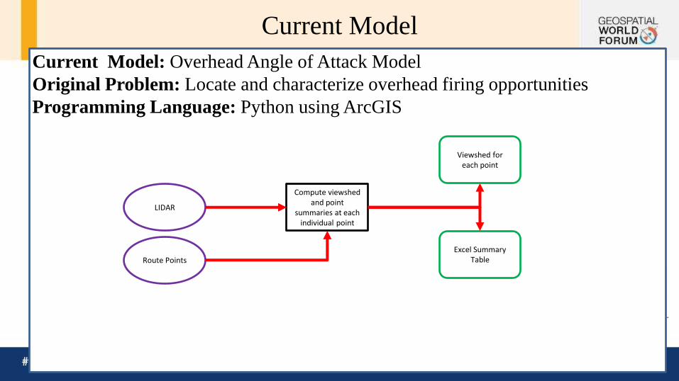
Current Model: Overhead Angle of Attack Model
Original Problem: Locate and characterize overhead firing opportunities
Programming Language: Python using ArcGIS
Current Model
LIDAR
Route Points
Compute viewshed and point
summaries at each individual point
Excel Summary Table
Viewshed for each point

Add your company logo here on master slide
Identifies every point the vehicle can see and be seen by a 2m tall fire-position above the vehicle (>1° angles).
Viewshed Analysis
0:7,000

Add your company logo here on master slide
Angle and distance are calculated for every visible point (>1° angles).
Higher angles represent a threat from a higher vantage point.
Green = 1-7°
Yellow = 7-14°
Red = 14-80°
Angle and Distance Calculation
0:7,000

Add your company logo here on master slide
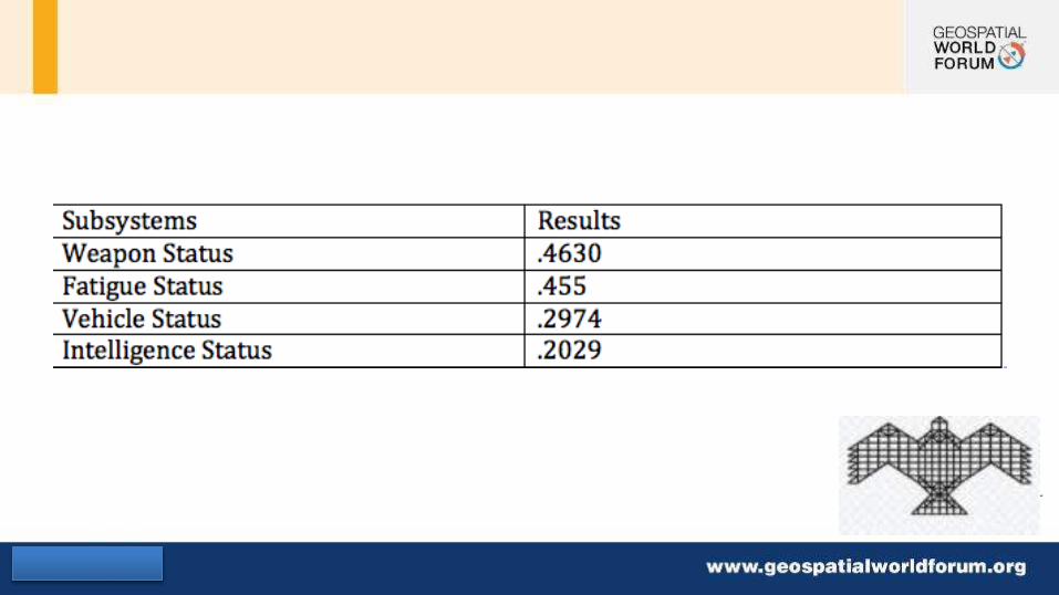
• Threat occurrences over total firing opportunities
• Averaged over all route points.
• Table for distribution.
Statistical Aggregation

Add your company logo here on master slide

Add your company logo here on master slide

Add your company logo here on master slide

Add your company logo here on master slide

Add your company logo here on master slide

Add your company logo here on master slide
Infantry - Platoon Level Attack Simulation
DESIGN OBJECTIVES STEP 1. Receive the mission.
STEP 2. Issue a warning order.
STEP 3. Make a tentative plan.
STEP 4. Start necessary movement.
STEP 5. Reconnoiter.
STEP 6. Complete the plan.
STEP 7. Issue the complete order.
STEP 8. Supervise.

Add your company logo here on master slide
Infantry - Platoon Level Attack Simulation
• Movement – Guidelines
Make enemy contact with the smallest element possible.
Prevent detection of elements not in contact until they are in the assault.
Maintain 360-degree security at all times.
Report all information quickly and accurately.
Maintain contact once it is gained.
Generate combat power rapidly upon contact.
Fight through at the lowest level possible.

Add your company logo here on master slide
Infantry - Platoon Level Attack Simulation
• Infiltration - Guidelines To gather information.
To attack enemy positions from the rear.
To conduct raids or ambushes in enemy rear areas.
To capture prisoners.
To seize key terrain in support of other operations.
To aid a main attack.

Add your company logo here on master slide
Attack Simulation
Receive new Mission Parameters
Tactical deployment Final
Goal / Mission Accomplished
Enemy Analysis Weapons Analysis Terrain Analysis
Issue Warning
Issue Order
Reconnoiter
Tentative Plan
Complete Action plan
Fight / Attack
Fuzzy Supervisor / ANN
Add your company logo here on master slide

Add your company logo here on master slide
PL1-SEC 1 PL1-SEC 2
PL1-SEC 3
PL2-SEC 2
PL2-SEC 3
PL3-SEC 2 PL3-SEC 3 PL3-SEC 1
PL3-SEC 3 PL3-SEC 3
Forest Area – Tree Cover
Hillock 1 Hillock 2
Stream
Bridge 2
Bridge 1
Mound
Cover
Enemy Section 1 Enemy Section 2
Enemy Section 2

Add your company logo here on master slide
THANKS
JAI HIND