refuge on the rio grande
TRANSCRIPT

Refuge on the Rio Grande:A Regional History of
Bentsen-Rio Grande Valley State Parkby John J. Leffler


Refuge on the Rio Grande:A Regional History of
Bentsen-Rio Grande Valley State Park
by John J. Leffler
for State Parks Division Texas Parks and Wildlife Department
August 2013

TPWD receives federal assistance from the U.S. Fish and Wildlife Service and other federal agencies and is subject to Title VI of the Civil Rights Act of 1964, Section 504 of the Rehabilitation Act of 1973, Title II of the Americans with Disabilities Act of 1990, the Age Discrimination Act of 1975, Title IX of the Education Amendments of 1972, and state anti-discrimination laws which prohibit discrimina-tion the basis of race, color, national origin, age, sex or disability. If you believe that you have been discriminated against in any TPWD program, activity or facility, or need more information, please contact Civil Rights Coordinator for Public Access, U.S. Fish and Wildlife Service, 4401 N. Fairfax Drive, Mail Stop: MBSP-4020, Arlington, VA 22203.
© 2013 TPWD. PWD BK P4502-0058N (8/13)
In accordance with Texas State Depository Law, this publication is available at the Texas State Publications Clearinghouse and/or Texas Depository Libraries.

iii
A Regional History of Bentsen-Rio Grande Valley State Park
Acknowledgements
Researching history is always collaborative work, and I am very grateful to the many people who contributed to this study in many ways. First, I want to thank people at the Texas Parks and Wildlife Department headquarters in Austin. I did the initial research and writing for this project in 1998 at the request of Dr. Karen Harry, former director of TPWD’s Cultural Resources Program. She introduced me to the topic, provided me with many valuable contacts, and helped me in many ways to produce the initial study. I also want to thank Dr. Cynthia Brandimarte, director of TPWD’s Historic Sites and Structures Program, who asked me on behalf of the park to revisit the project for publication. As always, she has been a capable and sympathetic administrator and editor.
TPWD personnel at Bentsen-Rio Grande Valley State Park were very helpful when I did my initial research in 1998. Rey Ortiz, the park’s former superintendent and park ranger Nelda Flores explained the park to me, gave me access to its historical files, introduced me to key informants, and generally helped to make my park visits very enjoyable. Former ranger Tony Salinas toured the park with me and hospitably shared his knowledge and memories. Assistant Superintendent Javier de León has recently spent many hours of his time assisting me with historical photos of the park and providing me with new photos of the Jardín de Flores ranchhouse. He suggested new sources and explained recent developments in the park. Javier also took time to review the manuscript and helped to improve it. Other TPWD staff members provided valuable support in direct and indirect ways: Archeology Lab Supervisor Aina Dodge, Regional Cultural Resources Coordinator Kent Hicks, Regional Interpretive Specialist Ben Horstmann, Regional Director Russell Fishbeck, and Research Specialist Jennifer Carpenter.
Many residents of Hidalgo County have helped me to understand the Lower Rio Grande Valley and the park. I particularly want to thank Osvaldo Ochoa, who was born at the Jardín de Flores ranch and lived at Las Nuevas as a child in the 1930s. Mr. Ochoa graciously spent hours of his time describing Las Nuevas and giving me a personal tour of the Jardín de Flores site. David Mycue, former curator of the Hidalgo County Historical Museum (now the Museum of South Texas History, or MOSTH) in Edinburg, initially suggested promising avenues of research and helped me track down sources and photographs. Arturo Gonzalez also helped to shape my understanding of area history. Mission resident Jeanne Gonzalez generously shared with me her extensive collection of photographs and articles relating to the history of the park since the 1940s.
Refuge on the Rio Grande
iv
Cartographer John Cotter’s work has graced many books over the years and three are included here. He also created the map of the Nueces Strip which was first published in William Goetzmann’s book Sam Chamberlain’s Mexican War; it appears here courtesy of the Texas State Historical Association. Thanks also to Jim Kattner of Spring, Texas, who found the Jardín de Flores token and shared photographs of the site. My gratitude to the archivists and staff at the Briscoe Center for American History at the University of Texas at Austin, the Texas State Library and Archives, the Texas General Land Office, and MOSTH in Edinburg. Special thanks to Phyllis Kinnison, archivist at MOSTH, who patiently and diligently spent hours helping me to identify and reproduce photos for this study, and to her assistant René Ballesteros, who helped me to meet my deadline.
Finally I’d like to thank my wife, Vivian Goldman-Leffler, who was often inconvenienced by my work on this project. Vivi also read and proofed the manuscript, and helped to improve it despite her husband’s stubborn self.
John LefflerAugust 2013

v
A Regional History of Bentsen-Rio Grande Valley State Park
Contents
Maps and Figures ................................................................................................. vii
Introduction ........................................................................................................... 1
Early Settlement in the Lower Rio Grande Valley ................................................... 3
Dislocation and Readjustment in the Lower Rio Grande Valley, 1836-1900 ......... 11
The Transformation of the Valley, 1900-1940 ....................................................... 27
The Creation of Bentsen-Rio Grande Valley State Park ......................................... 39
Endnotes .............................................................................................................. 47
Bibliography ......................................................................................................... 57

vii
A Regional History of Bentsen-Rio Grande Valley State Park
Maps and Figures
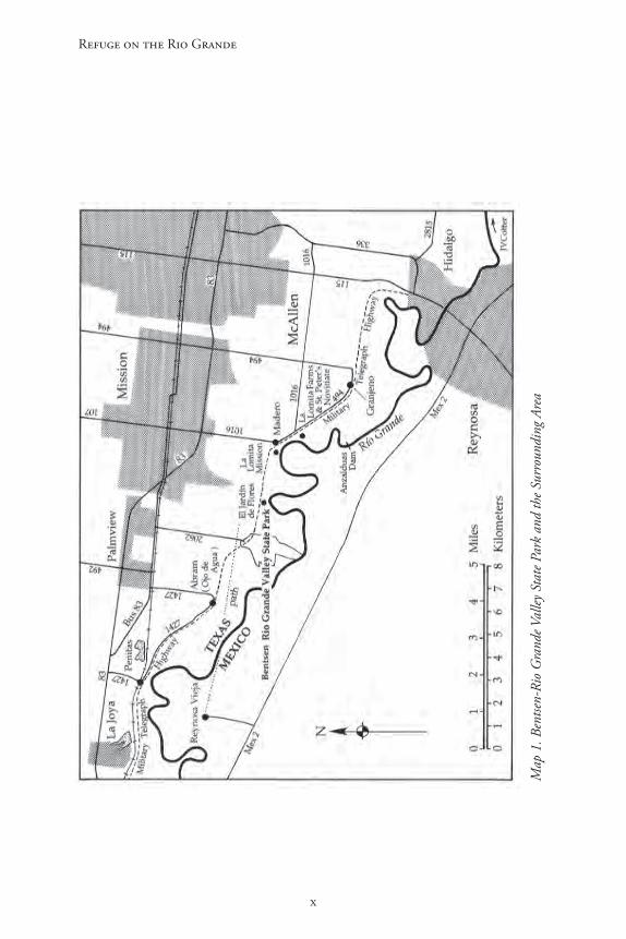
Map 1: Bentsen-Rio Grande Valley State Park and the Surrounding Area ...................................................................................... x
Map 2: Spanish Land Grants in Southwestern Hidalgo County ............................. 5
Map 3: Historic Roads and Sites in Bentsen-Rio Grande Valley State Park and the Surrounding Area ...................................................................................... 7
Map 4: The Disputed Area Between the Nueces and the Rio Grande ................... 12
Figure 1. Detail from map of resurvey of Porción 50 conducted in 1850, showing the “Sendero” (path) leading from the original site of Reynosa and passing just north of the present site of Bentsen-Rio Grande Valley State Park. Note also the location of the Military Road, used by American troops during the Mexican War, which passed through the present boundaries of the Park, and the location of the ranch (known at least as early as 1858 as “Las Nuebas”), also within the present confines of the Park. Spanish Land Grant files, Porción 50 Reynosa, Texas General Land Office, Austin. ............................................................................................... 8
Figure 2. Dr. Alexander Manford Headley, who owned Porción 50 and the Las Nuebas ranch into the early 20th century. Photo courtesy of the Museum of South Texas History, Edinburg. ...................................................................................... 18
Figure 3. Abraham (Abram) Dillard (top left), with his siblings. Dillard moved to the Valley as a Texas Ranger, married Manuela Villareal, and established a ranch near Ojo de Agua. The town was later named “Abram” in his honor. He died in 1913. Photo courtesy of the Museum of South Texas History, Edinburg. ............. 20
Figure 4. A jacal in Hidalgo County in the early 20th century, ca. 1920s. Photo courtesy of the Museum of South Texas History, Edinburg. .................................. 21
Figure 5. Priests at the La Lomita Mission, located about two miles east of the present park, ca. 1950s. The mission supported a “bustling little village” until the early 1900s. Photo courtesy of the Museum of South Texas History, Edinburg. .... 22
Figure 6. The Jardín de Flores ranch house, circa 1914. Eloísa Dougherty is in the rear seat to the left; the coachman is Tomás Ochoa. Photo courtesy of the Museum of South Texas History, Edinburg. ........................................................................ 24
Figure 7. The Jardín de Flores ranch house in the 1980s, view from the west. Photo courtesy of the Museum of South Texas History, Edinburg. .................................. 25

Refuge on the Rio Grande
viii
Figure 8. A brick outbuilding, about fifty yards northwest of the Jardín de Flores ranch house, which once served as housing for workers at the ranch. In the early 20th century, perhaps four or five others like it stood nearby. Photo by John Leffler, 1998..................................................................................................................... 25
Figure 9. Two sides of a copper token, dated 1902, which was once used as currency at the store on the Jardín de Flores Ranch. Workers who purchased goods at the store probably received tokens like this one in their change. Photo courtesy of James E. Kattner. ............................................................................................................ 26
Figure 10. A handbill of the Plan of San Diego, 1915. From Sandos, Rebellion in the Borderlands. Original in the National Archives, Washington, D.C. ...................... 30
Figures 11 and 12. Two views of the buildings occupied by U.S. troops in Ojo de Agua during the attack on October 21, 1915. Photo courtesy of the Museum of South Texas History, Edinburg. ............................................................................ 31
Figure 13. U.S. troopers stationed in Hidalgo County, circa 1916. Photo courtesy of the Museum of South Texas History, Edinburg. ............................................... 32
Figure 14. Two jacales in Hidalgo County, ca. 1940. Photo courtesy of the Museum of South Texas History, Edinburg. ........................................................................ 35
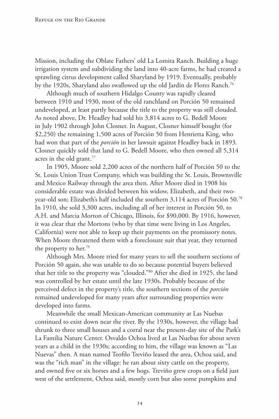
Figure 15. Another example of jacales in the Lower Rio Grande Valley during the early 20th century, ca. 1920s. Photo courtesy of the Museum of South Texas History, Edinburg. ............................................................................................... 36
Figure 16. Detail from 1936 map of Hidalgo County, showing the site of Las Nuebas (also called “Las Nuevas”) at that time. The single dark square near the center-right part of the image shows a dwelling at the present-day location of the park’s La Familia nature center. Note also the two other dwellings just northwest, near the center of the image. Texas State Department of Highways, Highway Map of Hidalgo County, 1936. ............................................................................ 37
Figure 17. Osvaldo Ochoa, who was born on the Jardín de Flores ranch and lived at Las Nuevas for about seven years during the 1930s. Photo by John Leffler, 1998..................................................................................................................... 38
Figure 18. Platmap of the southern part of the Bentsen Groves Subdivision (the Rio Grande appears on the far left), which cut up southern Porción 50 into dozens of farms in 1937. From Hidalgo County plat records, vol. 7, p. 13, Hidalgo County Courthouse. ......................................................................................................... 40

ix
A Regional History of Bentsen-Rio Grande Valley State Park
Figures 19 and 20. In the 1950s, local families used the Park area for recreation, and Boy Scouts and Girl Scouts camped there. The photos show Boy Scout Troop 83 from Mission camping and hiking in the park in 1951. Photos courtesy of Jeanne Martinez. ............................................................................................................. 44
Figure 21. Visitors at Bentsen-Rio Grande Valley State Park, Easter 1962. Photo courtesy of Bentsen-Rio Grande Valley State Park. ............................................... 45
Refuge on the Rio Grande
x
Map
1. B
entse
n-Ri
o G
rand
e Val
ley S
tate
Par
k an
d th
e Sur
roun
ding
Are
a

1
A Regional History of Bentsen-Rio Grande Valley State Park
Introduction
Bentsen-Rio Grande Valley State Park encompasses 760 acres of brushy woodlands along the Rio Grande just south of Mission in Hidalgo County, Texas. The park is best known today as a nature preserve, one of the few places where the unique riparian woodlands native to the Rio Grande Valley can still be found. Stands of cedar elm, Rio Grande ash, Texas ebony, black willow, anacua, huisache and other species attract an incredible variety of birds. Some 340 different species of birds have been sighted in the park, including the green jay, Altamira oriole, white-tipped dove, plain chachalaca, hook-billed kite, groove-billed ani, common paraque and ringed kingfisher.1
Approximately 24,000 visitors travel to the park every year, usually to admire its flora and fauna, but most are probably unaware of the human history connected to the park and the area around it. Some of the earliest Spanish settlements in Texas were established in the vicinity of the park area, part of a Spanish land grant issued in 1767, and were probably being ranched by the late 1700s. The first roads in the region, including a “path” from old Reynosa, Mexico, and the Military Road used by General Zachary Taylor during the Mexican-American War, passed through or adjacent to the park. And a small ranching village known as “Las Nuebas” (or “Las Nuevas”), established by 1850, still existed into the 1930s at the site of the park’s La Familia Nature Center. Nothing of it remains today.
During the late 19th and early 20th centuries the park area and the immediate vicinity were directly connected to some of the most significant people and events in South Texas history. For much of the late 19th century the park property was owned by Dr. Alexander Headley, the colorful Confederate veteran and soldier-of-fortune who once attempted to overthrow the Hidalgo County government by force. Much of the area around the current park was then shaped by prominent South Texas figures such as Abraham Dillard and William S. and Eloísa Vela Dougherty. “El Jardín de Flores,” the Dougherty’s ranch home that still stands about a mile east of the park, earned an almost mythical reputation in the county for the entertainments held there.
During the last decades of the 19th century a dramatic shift occurred in the landholding patterns in the lower Rio Grande Valley, as more and more land moved into the hands of Anglo-Americans and Europeans. Nevertheless, old social and cultural norms persisted in many parts of the Valley, including Hidalgo County, which remained isolated from economic and social trends that were already shaping other parts of Texas and the nation. Few Anglo-Americans moved into the area before 1900, and most of those who did melded into its
Refuge on the Rio Grande
2
traditional way of life. During the first decades of the 20th century, however, Hidalgo County experienced rapid changes that fundamentally altered its economy and its society.
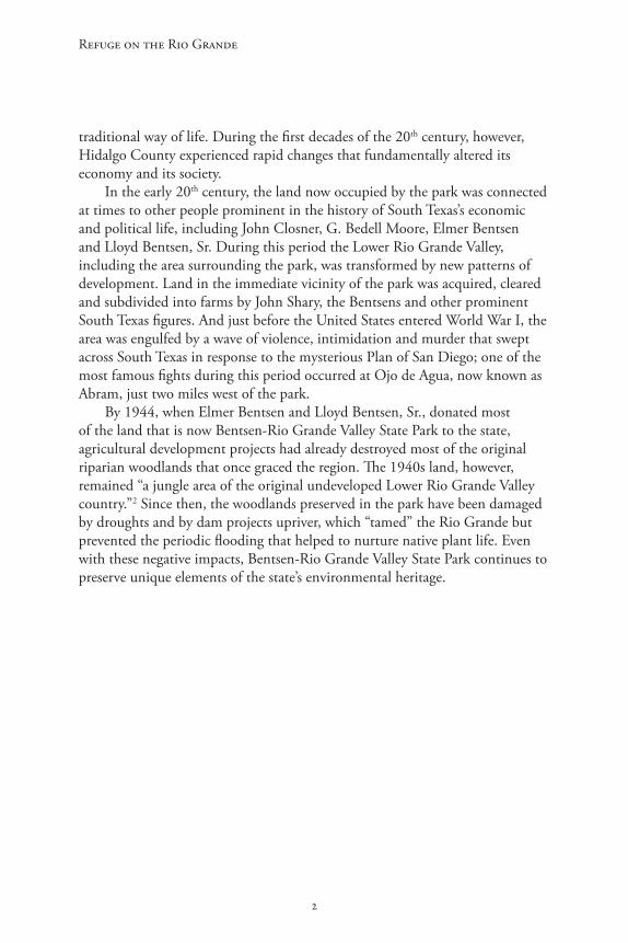
In the early 20th century, the land now occupied by the park was connected at times to other people prominent in the history of South Texas’s economic and political life, including John Closner, G. Bedell Moore, Elmer Bentsen and Lloyd Bentsen, Sr. During this period the Lower Rio Grande Valley, including the area surrounding the park, was transformed by new patterns of development. Land in the immediate vicinity of the park was acquired, cleared and subdivided into farms by John Shary, the Bentsens and other prominent South Texas figures. And just before the United States entered World War I, the area was engulfed by a wave of violence, intimidation and murder that swept across South Texas in response to the mysterious Plan of San Diego; one of the most famous fights during this period occurred at Ojo de Agua, now known as Abram, just two miles west of the park.
By 1944, when Elmer Bentsen and Lloyd Bentsen, Sr., donated most of the land that is now Bentsen-Rio Grande Valley State Park to the state, agricultural development projects had already destroyed most of the original riparian woodlands that once graced the region. The 1940s land, however, remained “a jungle area of the original undeveloped Lower Rio Grande Valley country.”2 Since then, the woodlands preserved in the park have been damaged by droughts and by dam projects upriver, which “tamed” the Rio Grande but prevented the periodic flooding that helped to nurture native plant life. Even with these negative impacts, Bentsen-Rio Grande Valley State Park continues to preserve unique elements of the state’s environmental heritage.

3
A Regional History of Bentsen-Rio Grande Valley State Park
Early Settlement in the Lower Rio Grande Valley
Archeological surveys conducted in Bentsen-Rio Grande Valley State Park in 1995 uncovered no material evidence of prehistoric activity there, but other more general studies have indicated that humans probably have been living in what is now Hidalgo County for at least 11,000 years. During the Paleoindian period (ca. 11,000-8,000 B.P.) inhabitants of the area hunted large animals such as now-extinct mammoths. During the Archaic age (8,000 to 1,200 B.P.) the people were hunters and gatherers; by the early Pre-historic period (1,200 to 500 B.P.) bows and arrows were being used to hunt bison and small game. These prehistoric inhabitants usually lived along the banks of the Rio Grande, where they had easy access to water. Archeologists puzzle over their disappearance, but we know that by the 1500s, when the Spanish began to explore the region, present-day Hidalgo County was occupied by Coahuiltecan peoples.
The various Coahuiltecan groups along the lower Rio Grande were hunter-gatherers who harvested the area’s indigenous fish, animals and plants for food, medicines and clothing. In the 1700s many of them moved into missions established by the Spanish along the Rio Grande, where disease and conflicts with other American Indians reduced their numbers. By the early 1800s, Lipan Apaches had pushed the Coahuiltecans out of South Texas, but the Apaches were, in turn, being challenged by the Spanish and by Comanches moving into the Rio Grande Valley from the north.3
The first Spaniard to pass through or near present-day Hidalgo County may have been Álvar Nuñez Cabeza de Vaca, who traveled into southern Texas after he was shipwrecked in 1528. The region’s oppressive heat and lack of reliable water supplies except along the Rio Grande deterred Spanish settlement in the region for more than two hundred years after Cabeza de Vaca wandered there. Nevertheless, several Spanish expeditions still tried to explore along the Rio Grande during the 17th and 18th centuries. In 1653, 1686, and 1687, for example, Alonso de León led expeditions that traveled along the Rio Grande to learn more about the area’s resources and to ward off possible incursions by the French.4
By the mid-1700s the Spanish were increasingly worried that the region might fall into the hands of another power. They were also determined to subdue and Christianize the American Indians living there and to develop valuable salt deposits noted by various explorers. In 1746 José de Escandón was chosen to lead a push to colonize the province of Nuevo Santander between the Panuco and Nueces rivers. Escandón, a wealthy, well-connected peninsulare who had recently “pacified” the native populations in Sierra Gorda, quickly
Refuge on the Rio Grande
4
organized a large expeditionary force that included hundreds of soldiers, missionaries and American Indian allies. In 1747, Escandón’s main column reached the Rio Grande and began to explore the region; on March 5, 1749 Escandón’s first settlement, Camargo, was formally founded at the confluence of the San Juan and Rio Grande rivers. Nine days later a second settlement, named Nuestra Señora de Guadalupe de Reynosa, was formally established near the south bank of the Rio Grande about five miles northwest of what is now Bentsen-Rio Grande Valley State Park (“Reynosa Vieja” on Map 1).5
Like several other Spanish villas Escandón established in Nuevo Santander at that time, Reynosa developed gradually from a military camp to a municipality. Streets were marked off around a central plaza, and adjacent to the town itself were common lands (ejidos) reserved for agriculture. Reynosa’s original ejidal land extended north of the Rio Grande to their eastern boundary about a mile and a half from present day Bentsen-Rio Grande Valley State Park (“Los Ejidos” on Map 2).
Dozens of families moved to the new settlement almost as soon as it was founded, attracted by incentives, such as payment of up to 100 pesos for resettlement costs and the promise of free land that would not be taxed for ten years. As early as 1749, the year the villa was officially established, 279 people were living in Reynosa. By 1750, although no mission had yet been built, there were also a number of American Indians living in the settlement, including those in the Comecrudos, Tejones y Sacatiles, Pintos, Nazos and Navisos tribes.
Despite recurring floods that sometimes devastated the town, it continued to grow and prosper. In 1755, Spanish officials counted 289 people living in Reynosa, tending an estimated 1,600 head of cattle, horses and sheep in the surrounding countryside.6 By 1757, a mission had been built to accommodate American Indians. One early visitor observed that many of the Spanish settlers in the area “had become rich” through stock-raising or the salt trade. According to historian Florence Scott, Reynosa at this time was dominated by six wealthy and influential men: “almost all the others,” she writes, “were poor and of humble origin with no official standing.”7
Reynosa quickly became a significant center of Spanish settlement along the Rio Grande and figured prominently in the early development of what is now Hidalgo County. In 1767, the viceroy of New Spain sent a Royal Commission to Nuevo Santander to survey and distribute the land grants that had long been promised to settlers in the area. Arriving in Reynosa in August, the Commission issued eighty land grants to inhabitants of the town. Although the settlers preferred land south of the Rio Grande because of its attractive thick forest over dangerous “pagan” Indians north of the river, forty-three of the grants were located in present-day Hidalgo County. Varying in size from 4,200 to
5
A Regional History of Bentsen-Rio Grande Valley State Park
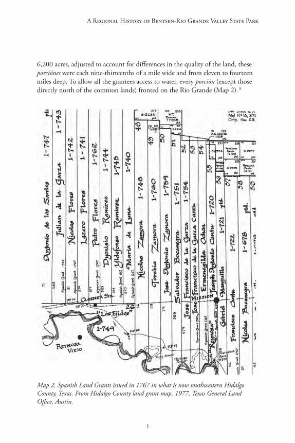
6,200 acres, adjusted to account for differences in the quality of the land, these porciónes were each nine-thirteenths of a mile wide and from eleven to fourteen miles deep. To allow all the grantees access to water, every porción (except those directly north of the common lands) fronted on the Rio Grande (Map 2). 8
Map 2. Spanish Land Grants issued in 1767 in what is now southwestern Hidalgo County, Texas. From Hidalgo County land grant map, 1977, Texas General Land Office, Austin.

Refuge on the Rio Grande
6
The Royal Commission granted 5,314 acres in Porción 50 (the southern tip of which is now Bentsen-Rio Grande Valley State Park) to one José Antonio Zamora.9 Very little is known about Zamora,10 but circumstances surrounding his acquisition of the property suggest that he may have belonged to one of Reynosa’s more influential families. Some Spanish officials complained that the distribution of lands surrounding Reynosa seemed “unequal, since most of the land was owned by six families.”11 Examination of a list of the Reynosa grantees reveals that the Zamora family received five porciónes—only one less than the influential Cano family, which received six. And all of the Zamora grants were favorably located close to Reynosa, including three (Porciónes 48, 49, and 50) directly east of the town’s common lands.12
In any case Zamora, like the other grantees, was obligated by the terms of his grant to take possession of the land within two months and to begin to raise stock on it. Since the grantees were also required to remain living in Reynosa for the sake of community safety and solidarity, many of them moved back and forth between their ranch holdings and the town. Men with wives and children ordinarily left their families in Reynosa, where they could receive education and the ministrations of the Church. Due to the continuing threat of Lipan Apache raids, ranch settlements were often established near property lines, so that two neighboring landowners could live in proximity, and small communities often formed around them.13
As Reynosa continued to grow, tallying almost 1,200 people by 1794, during the late 1700s the ranch settlements north of the Rio Grande also developed and prospered. Between 1770 and 1800 several large new land grants were issued in the areas north and east of the original Reynosa porciónes, and ranching activity expanded dramatically in what is now Hidalgo County. Some idea of the scope and magnitude of ranching in the region then can be seen in the fortunes of José Narciso Cavasos (or Cabazos), a resident of Reynosa who in 1767 was granted Porción 71 north of the Rio Grande, about 14 miles east of Porción 50. Over the next decades Cavasos gradually expanded his holdings through marriages and purchases and by 1807 he owned over 6,400 sheep, about 5,000 cattle, and more than 200 horses. José Antonio Zamora apparently also prospered as he was able to purchase two leagues of land from Maria de los Santos Cavazos, and his seven children later inherited the property.14
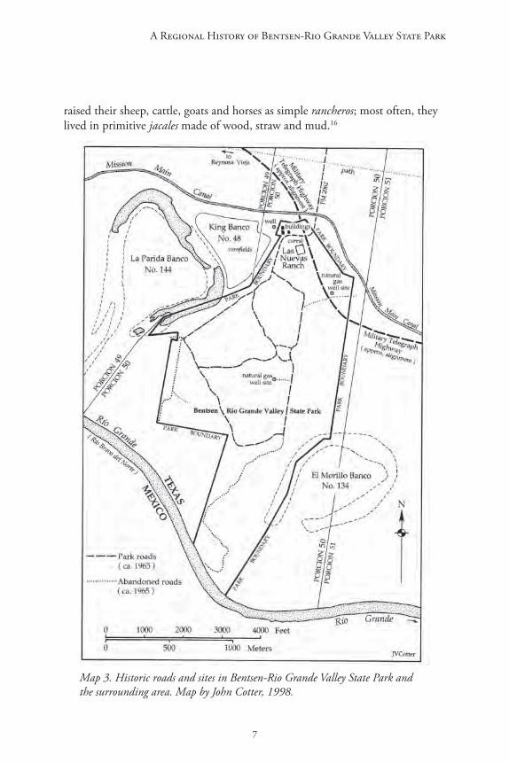
Members of Zamora’s family seem to have owned Porción 50 for almost ninety years, and may well have operated a ranch there for all or most of that time. At least two of Jose Antonio Zamora’s grandchildren lived on the property as late as 1858. It is likely that they occupied the ranch site, within the boundary of Bentsen-Rio Grande Valley State Park) shown on a map drawn in 1850 (Figure 2; Map 3).15 Most settlers were not as successful as Cavasos, and
7
A Regional History of Bentsen-Rio Grande Valley State Park
raised their sheep, cattle, goats and horses as simple rancheros; most often, they lived in primitive jacales made of wood, straw and mud.16
Map 3. Historic roads and sites in Bentsen-Rio Grande Valley State Park and the surrounding area. Map by John Cotter, 1998.
Refuge on the Rio Grande
8
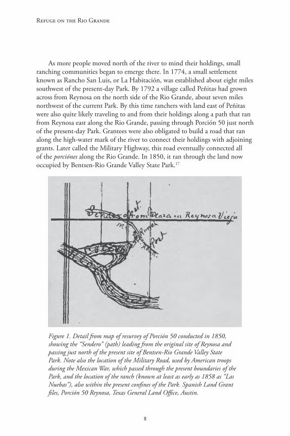
As more people moved north of the river to mind their holdings, small ranching communities began to emerge there. In 1774, a small settlement known as Rancho San Luis, or La Habitación, was established about eight miles southwest of the present-day Park. By 1792 a village called Peñitas had grown across from Reynosa on the north side of the Rio Grande, about seven miles northwest of the current Park. By this time ranchers with land east of Peñitas were also quite likely traveling to and from their holdings along a path that ran from Reynosa east along the Rio Grande, passing through Porción 50 just north of the present-day Park. Grantees were also obligated to build a road that ran along the high-water mark of the river to connect their holdings with adjoining grants. Later called the Military Highway, this road eventually connected all of the porciónes along the Rio Grande. In 1850, it ran through the land now occupied by Bentsen-Rio Grande Valley State Park.17
Figure 1. Detail from map of resurvey of Porción 50 conducted in 1850, showing the “Sendero” (path) leading from the original site of Reynosa and passing just north of the present site of Bentsen-Rio Grande Valley State Park. Note also the location of the Military Road, used by American troops during the Mexican War, which passed through the present boundaries of the Park, and the location of the ranch (known at least as early as 1858 as “Las Nuebas”), also within the present confines of the Park. Spanish Land Grant files, Porción 50 Reynosa, Texas General Land Office, Austin.

9
A Regional History of Bentsen-Rio Grande Valley State Park
By the early 1800s a stable and fairly prosperous society had grown in the Spanish towns and villages of the Rio Grande Valley. Although a disastrous flood finally convinced Spanish authorities to move Reynosa to its present site (about eight miles southeast of Bentsen-Rio Grande Valley State Park), the town grew rapidly at its new location. In 1829, more than 4,000 people lived there. By then about 25,000 people lived in the Rio Grande villas of Reynosa, Camargo, Mier, Revilla, Laredo and Matamoros, and thousands more were scattered on the many ranches that now dotted the region.18


11
A Regional History of Bentsen-Rio Grande Valley State Park
Dislocation and Readjustment in the Lower Rio Grande Valley,
1836-1900
Despite the area’s hot and unforgiving environment, ranching society of the Rio Grande Valley continued to expand and prosper. An estimated 3,000,000 cattle grazed on ranches in the region, and exports produced by the area’s growing economy were carried in wagons and mule trains deep into Mexico, which had become an independent nation in 1821.19 The Texas Revolution of 1835-1836, however, set off a chain of events that severely disrupted life in the area for many years and led to significant political, social and economic changes.
The area between the Rio Grande and the Nueces River, once part of the Spanish province of Nuevo Santander, had been folded into the Mexican state of Tamaulipas after Mexico won its independence from Spain. But after 1836, when the new Republic of Texas claimed the Rio Grande as its southern border, the disputed area between the rivers devolved into a no-man’s-land; neither Mexico nor Texas could assert effective control over the region, and the people who lived there were repeatedly victimized by outlaws and Indian attacks (Map 4).
Animosities intensified during the Texans’ war for independence helped to fuel contempt for the rights of Mexicans in the area, and encouraged “Anglo” Texans to raid it for their own profit. The new Texas Republic declared Mexican cattle to be public property, and rustlers roamed the area between the Nueces and the Rio Grande, sometimes known as the Nueces Strip. As historian David Montejano has written, at that time all a Texan needed to become a cowman was to enter the area with “a rope, a branding iron, and the nerve to use them.” Texan military units regularly raided ranches south of the Nueces to procure beef for their men, and Mexican outlaws entered from the south. By the early 1840s the area’s cattle herds were severely depleted.20
Meanwhile, the Mexican government had not yet accepted Texan independence. In 1842, in response to the Texans’ bumbling attempt to take Santa Fe, Mexican forces twice crossed the Rio Grande and captured San Antonio. Enraged, Texas President Sam Houston allowed General Alexander Somerville to raise a volunteer force to invade Mexico. Somerville was able to capture Laredo and Guerrero, but when he prudently decided not to advance any further about 300 men broke from his command and moved down the Rio Grande, hoping to continue the raid into Mexico itself. In late December 1842, the expedition ended in complete disaster. At Mier, 226 Texans were

Refuge on the Rio Grande
12
Map 4. The disputed area between the Nueces and the Rio Grande. Map by John Cotter in William H. Goetzmann, Sam Chamberlain’s Mexican War, used courtesy of the Texas State Historical Association.

13
A Regional History of Bentsen-Rio Grande Valley State Park
captured by the Mexican army, and were then marched down the Rio Grande. On January 3, 1843, the column camped at the old site of Reynosa (Reynosa Vieja); the next day, the Texans were ceremoniously marched through the streets of “new” Reynosa, where “great preparations had been made for the triumphal entry of the victor [Mexican General Pedro Ampudia] and a fantastic and colorful celebration was held.”21 After the column of Mexican soldiers and their prisoners left Reynosa on the way to Matamoros, the Texans attempted an escape and about 176 were recaptured near Salado. As punishment for the escape, the Mexican government decreed that the prisoners would be “decimated”—one out of every ten men would be executed. This led to the famous “Black Bean” incident, when the Texans unlucky enough to choose a black bean were shot to death by a Mexican firing squad.22
In 1845, the United States annexed Texas and the next year President James Polk sent a military expedition to the Rio Grande Valley to assert American claims to the Nueces Strip and, perhaps, to provoke the Mexican government into a war. On May 8, 1846 the American army, led by General Zachary Taylor, encountered a Mexican force in the disputed area, just north of Brownsville. Five American soldiers and 102 Mexicans were killed at the Battle of Palo Alto, as the engagement came to be known. The next day, May 9, the two forces clashed again at the Battle of Resaca de la Palma, in which 33 Americans and at least 154 Mexicans died. On May 11 President Polk, claiming that “Mexico has passed the boundary of the United States, has invaded our territory, and shed American blood on American soil,” asked Congress for a declaration of war. 23
Over the next few months, as Zachary Taylor assembled an invasion army at Camp Brown (now Brownsville), he sent detachments down the Rio Grande to capture and hold key positions. By June, American troops occupied Reynosa. Companies of Texas Rangers conducting scouting missions into Mexico sometimes crossed the river near Reynosa and what is now Bentsen-Rio Grande Valley State Park. Meanwhile, riverboats carrying men and supplies to Camargo steamed up the Rio Grande, passing by the site of the present-day Park. When Taylor’s invasion army finally set out for Monterrey in August, part of his force marched along the river on what is now known as the Military Highway, which at that time ran through the current state park.24
In the Treaty of Guadalupe-Hidalgo of 1848, which ended the Mexican-American War, Mexico ceded about half its national territory, including its claims to Texas and the Nueces Strip, to the United States in return for $15 million and American assumption of various claims against Mexico. According to the terms of the treaty, all Mexicans living within the ceded area would receive full rights of American citizenship, and their property would be respected. The treaty did not establish any standards for validating pre-existing

Refuge on the Rio Grande
14
land grants, however, and in Texas the process would be controlled by the new state government. Not surprisingly, many of the Mexicans who found themselves living on the U.S. side of the Rio Grande were not sure that the treaty’s promises would be kept.25
Even before the war had ended, some enterprising Texans had begun to exploit the unsettled situation by buying up questionable titles or filing their own claims for Texas state land grants for property in the area. As David Montejano writes, “squatters and adventurers were everywhere; tales of fraud and chicanery were common; and deliberations in the Texas Legislature and the Texas courts all suggested an eventual confiscation of Mexican property.” As many Mexicans living in the Nueces Strip moved south to Mexican towns like Reynosa and Camargo during and after the war, Anglo-American and European speculators traveled through the region buying derechos (undivided rights to properties) from owners and heirs for just a few dollars each.26
To help settle the considerable confusion about the status of land titles in the former disputed area, in 1850 the governor of Texas appointed a board of commissioners, known as the Bourland-Miller Commission, to examine land claims there. After collecting evidence at hearings in Laredo, Eagle Pass, Rio Grande City, Brownsville and Corpus Christi, the Commission reported to the state legislature, which in February voted to confirm 194 Spanish and Mexican land grants in the area. Only a few Anglo-Americans received land in the process.27
One of the grants that the Bourland-Miller Commission recommended to the legislature for approval was José Antonio Zamora’s 1767 grant to Porción 50, which was confirmed in the name of Severano Quirva, one of Zamora’s grandsons. It is not at all clear, however, whether Quirva actually lived on the land or how much of the original grant was legitimately his. Unlike many others in the area who applied for confirmation of the old Reynosa grants, Quirva apparently produced no evidence that he or his relatives had occupied or cultivated the property. Moreover, at least three other Zamora grandchildren were alive at the time, and only a few years later they all claimed to own a part of the property.28
As people living in the region adjusted to new conditions, the State of Texas and the U.S. government worked to organize and pacify the area. In 1852, the state legislature created Hidalgo County. The old settlement of La Habitación (at the present site of Hidalgo, about seven miles southeast of the Park), was renamed Edinburg and designated the county seat of government. Meanwhile, to deter Indian attacks and border incursions, the U.S. Army remained at Fort Brown and at Ringgold Barracks at Rio Grande City.29
Despite a federal presence, life in the Nueces Strip remained unstable for many years, and titles to many of the old grants became hopelessly enmeshed

15
A Regional History of Bentsen-Rio Grande Valley State Park
in claims and counterclaims occasioned by the many squatters and by the profusion of derechos sold, legitimately or not, to Anglo-American speculators during and after the war. A number of Mexicans along the border felt they had unjustly lost their lands through the clever practices of Anglo attorneys and speculators. In September 1859, these pent-up resentments led Juan Nepomuceno Cortina, a Mexican aristocrat who believed his family’s lands had been stolen, to invade Brownsville with a group of twenty to forty armed men. Shouting “Death to the Americans!” and “Viva Mexico!” Cortina’s men briefly occupied Brownsville before retreating back into Mexico.30 In November he issued a manifesto to the Mexicans in Texas:
Mexicans! When the State of Texas began to receive the new organization which its sovereignty required as a part of the United States, flocks of vampires, in the guise of men, came and scattered themselves in the settlements, without any capital except the corrupt heart and the most perverse intentions. … Many of you have been robbed of your property, incarcerated, chased, murdered, and hunted like wild beasts. …31
Cortina attracted hundreds of Mexicans to his cause. Although defeated near Rio Grande City in December, he continued to raid ranches and settlements along the Lower Rio Grande until 1860, when he was driven back into Mexico. In the raids and counter-raids that occurred during the “Cortina War,” however, much of the area along the Rio Grande between Brownsville and Rio Grande City was depopulated and ranching activity severely disrupted. According to one source, fifteen Americans and eighty “friendly” Mexicans were killed during this period. Cortina lost about one hundred of his own men, some at the hands of the Texas Rangers who burned the ranches of anyone they believed supported Cortina.
A second “Cortina War” broke out after Texas joined the Confederacy in 1861. Now aligned with Texas Unionists, Cortina raided into Zapata County and engaged a Confederate force near Carrizo. Defeated again, he retreated to Mexico, and ultimately fought with Benito Juarez against Maximilian’s French interventionists. He returned to the border in 1870 but, despite his services for the Unionists during the Civil War, he was subsequently accused of masterminding a ring of cattle thieves, detained by Mexican authorities, and hustled off to Mexico City.32
Political strife and lawlessness troubled the new county for many years, as groups of Anglo-Americans struggled amongst themselves for control of the

Refuge on the Rio Grande
16
area, which had a long tradition as a haven for cattle rustlers, violent criminals and deserters since the American Civil War. The Democrats, known locally as the “Reds,” included influential landholders such as W.P. Dougherty, James Dougherty, Thaddeus Rhodes and John Closner. For many years, the Reds effectively controlled the county’s political institutions, supposedly through their skillful use of the pachanga, or block Mexican vote. Their Republican opponents, the “Blues,” counted prominent men like John McAllen, Jesse Bennett and, eventually, Alexander M. Headley among their numbers. By the late 1800s, with Closner as deputy sheriff, the area’s lawlessness had been tamed, but the “Blues” nursed strong resentments against their enemies.33
The violence and political dislocations that followed the Mexican-American War of the 1840s coincided with changes in the patterns of landholding in the lower Rio Grande Valley during the last half of the 19th century. Sometimes Mexicans owning small ranches were driven off their lands through strong-armed tactics employed by Anglo ranchers willing to resort to violence to get what they wanted. As Mexican vaquero Faustino Morales later remembered, “there were many small ranches belonging to Mexicans, but then the Americans came in and drove the Mexicans out and took over the ranches … after that they fenced the ranches, they fenced some land that wasn’t theirs.”34
No doubt a good deal of Mexican land was simply stolen. But as David Montejano and Armando Alonzo have shown, other, more inexorable and legal forces were also at work and were probably more significant in lower Rio Grande counties like Starr and Hidalgo, where the Bourland-Miller Commission had confirmed many of the original Spanish and Mexican land grants. Many Mexican holdings were collectively held by entire families in undivided interests. This informal and extended practice made it relatively easy for speculators to buy up portions of property titles from those relatives who had little or no interest in actually working the land. Family members who wanted to defend their title against claims and counterclaims often needed expensive legal help that many rancheros could not afford. To further complicate the fluid situation, new fencing practices cut landholders off from water, making their properties virtually useless without expensive investments in wells and tanks. Falling cattle and wool prices during the 1880s and 1890s also made survival difficult for small ranchers. Some Anglos and Tejanos had access to credit that could help them get through droughts and hard times, but other Mexican rancheros did not, and had to sell. Still others did not have hard currency to pay debts and taxes, and many Mexican properties were grabbed up by Anglos for very low prices at quickly arranged sheriff’s sales. In 1877, for example, a 3,000-acre tract was sold at auction by Leo J. Leo, the Hidalgo County sheriff, for $15.00 to cover unpaid taxes; the next year, another
17
A Regional History of Bentsen-Rio Grande Valley State Park
4,000-acre property was sold the same way for only $17.15. In many cases, especially during the 1870s, the purchasers were county officials.35
The number of Tejano landholders in Hidalgo County actually increased during the late 19th century, mainly because family properties were being divided and re-divided among heirs to old holdings. But small landowners were finding it harder and harder to compete with the large commercial ranches, and during the 1880s and 1890s the percentage of land in the county owned by Anglo-Americans and Europeans steadily increased, so by 1900 only about 29 percent of the land in Hidalgo County was owned by Tejanos.36
The chain of title for Porción 50 during the mid-19th century, broken and clouded by missing transactions and inexplicable omissions, mirrors the confused and confusing state of real estate sales in the Valley during this period. Although the Bourland-Miller Commission had confirmed the Porción 50 grant to Servana Quirva in 1852, there is no record that Quirva ever transferred the title to anyone. Yet in March 1858, Manuel Villareal y Zamora, Manuel Ramirez, and Maria Lorenza Villareal (all of them illiterate), all claiming to be grandchildren of José Antonio Zamora, sold their undivided shares of Porción 50 (or 3/12 of the entire tract) for $75.00 to James Walworth, a friend of Richard King, founder of the legendary King Ranch. Two weeks later, Maria Louisa Villareal, Francesca Villareal, and Manuel Villareal sold their shares, totaling 1/9 of Porción 50), to Walworth for $33.00.37
Their claims to the property may have been spurious. Although Walworth recorded the deeds in the Hidalgo County courthouse, he never seems to have sold them or received anything for them from the next owner of record, one Pacifico Ochoa Cornelio Villanueva. Villanueva sold the entire Porción 50 tract at an unspecified date to one Estephanio Mungia, who resold it to Ramona Benavides on a deed signed May 4, 1858, at “el Rancho de las Nuebas” (the ranch village then located within the present boundaries of the Park). That very day, Benavides sold it to one Segundio Recio, who that same day sold it to Dr. Alexander M. Headley for 1,400 pesos. 38 Headley did not file the deed until many years later, however, and in 1878, Leo J. Leo, the sheriff of Hidalgo County, sold the property—all 4,725 acres—at public auction to one John B. Burbois for $6.75—the exact sum due on the property for back taxes supposedly unpaid by Recio back in 1875. 39

Refuge on the Rio Grande
18
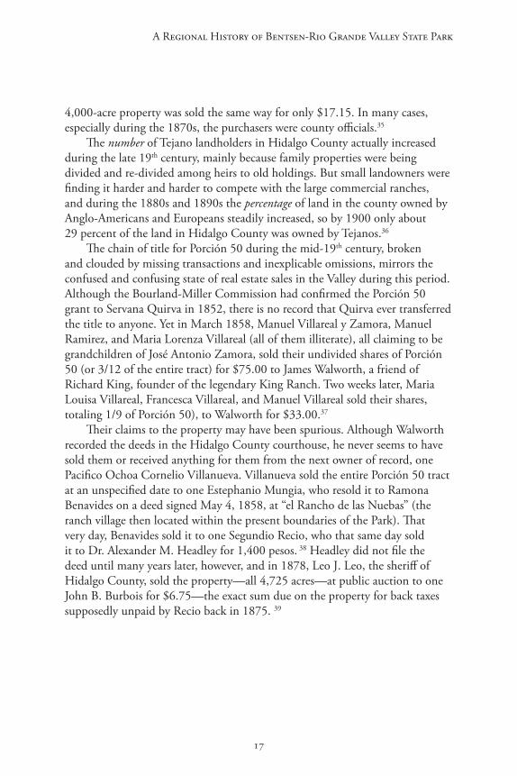
If in fact Headley actually bought the land in 1858, a dubious proposition, it is unlikely that he took possession of the property until much later. Headley, “one of the most colorful characters this chaparral country has ever known,” as one author describes him, was born in Rothbury, England, in 1836, and served in the British navy before migrating to the United States in the 1850s. He attended a medical school in Cincinnati, and then moved to Arkansas; during the Civil War he served as a surgeon in the Confederate army. After the war, he went to Mexico as part of General Joseph Shelby’s band of “undefeated rebels,” and in 1866 he moved to Camargo, began a medical practice there and established the Casa de Comercio, a large mercantile business. During
Figure 2. Dr. Alexander Manford Headley, who owned Porción 50 and the Las Nuebas ranch into the early 20th century. Photo courtesy of the Museum of South Texas History, Edinburgh.
19
A Regional History of Bentsen-Rio Grande Valley State Park
the 1870s he was appointed military commandant of Camargo by Mexican President Lerdo de Tejada. While there, he married his fourth wife, Pilar Treviño, a twenty-eight-year-old Mexican woman.40
By the late 1870s Headley’s Civil War transgressions seem to have been forgiven, and he had become well-known and respected in the area as el doctor canoso (“they grey-haired doctor”), feared by some and apparently hated by others. In 1878 he helped to clear his title to Porción 50, which had been clouded after the sheriff’s sale, by paying $24.50 to Burbois.41 He undoubtedly spent at least some of his time at Las Nuebas, the small ranch community on the property (Map 3). In 1880, Headley regained his American citizenship, practiced medicine on both sides of the border, and began to actively participate in Republican (“Blue”) party politics in Hidalgo County.42
Meanwhile, the actual ownership of Porción 50 was apparently still in doubt. In 1890, a person named G. Zamora sold the title to 3,814 acres of the tract to S.V. Rios.43 And about that same time, Headley was embroiled in a lawsuit brought against him by Henrietta King, who claimed she owned all or part of Porción 50. When the suit was finally settled in 1893, she was awarded 1,500 acres of the property, and Headley received 3,814 acres, the rest of the porción.44
In 1890, when Headley was Commissioner of Hidalgo County’s third district, the antagonism between the Reds and the Blues exploded. Convinced that their Democratic enemies had stolen the last election, an armed party of about 150 Republicans, led by Headley, took over the Hidalgo County courthouse in August and for a few days presided over what they called the “Independent Republic of Hidalgo.” The federal government quickly put an end to the fledgling “republic,” and Headley apparently escaped any legal punishment for the rebellion. Nevertheless, his bold, impetuous nature soon led him into another adventure that nearly cost him his life. When the wife of one of his political allies shot and killed a Hidalgo County judge in Reynosa, Headley took her back across the border to the U.S. to help her escape punishment. On the way back to his ranch at Las Nuebas, however, one of his “friends” gave him a cup of coffee poisoned with arsenic. Headley saved himself by ingesting a massive dose of castor oil, but the experience apparently convinced him that he had enemies in Hidalgo County. Soon afterward he moved from Las Nuebas to Rio Grande City, where he remained active in Republican politics and practiced medicine until his death in 1912.45 Headley sold his 3,814 acres of Porción 50 in 1902 for $4,767 to G. Bedell Moore, a wealthy and influential San Antonio lumberman, businessman and banker who was investing widely in Texas real estate and ranchland. Ironically, Headley gave John Closner, one of his old political enemies, his power of attorney to conclude the sale.46

Refuge on the Rio Grande
20
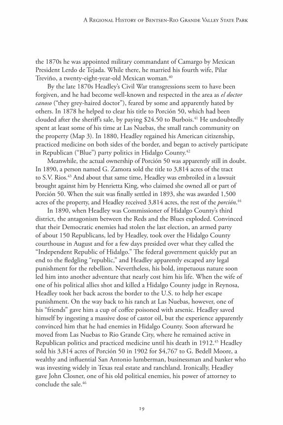
Despite the flamboyance of some area residents and the dislocations that troubled the region, in many ways the patterns of most residents’ lives in Hidalgo County had changed little over the past fifty years. Although a few Anglo-Americans and Europeans, like John Young, Abraham Dillard, Alexander Headley, and William Dougherty, had moved into the county, several of them had married Mexican women and had blended into the prevailing Mexican culture. Abraham Dillard, for example, was a Texas Ranger when he first arrived in Hidalgo County in the late 1800s. He became active in local politics and in 1890 was appointed to be the county’s sheriff and tax collector. That same year he married Manuela Villareal, “a beautiful young Mexican-American lady” who was born at Las Nuebas, the ranch community that once existed in what is now Bentsen-Rio Grande Valley State Park. Dillard, known as a “tough and rugged” but sentimental man, bought ranchland and soon built his home near Ojo de Agua, a village on the old Military Highway about two miles northwest of Las Nuebas (Map 1). 47
Figure 3. Abraham (Abram) Dillard (top left), with his siblings. Dillard moved to the Valley as a Texas Ranger, married Manuela Villareal, and established a ranch near Ojo de Agua. The town was later named “Abram” in his honor. He died in 1913. Photo courtesy of the Museum of South Texas History, Edinburgh.
21
A Regional History of Bentsen-Rio Grande Valley State Park
Most people living in the area then were descendants of the old Rio Grande settlements of Reynosa, Camargo, and Matamoros, and until the early 20th century, as Emilia Ramírez writes, “there was hardly any difference in the way of life between the people on the Mexican side of the Rio Grande and the native inhabitants of Hidalgo, Starr, and Cameron counties.” People in the area routinely crossed and re-crossed the border to visit relatives, to buy and sell goods, and to participate in various civic celebrations, religious festivals and other activities.48
Most of the people in the Hidalgo area lived in and around the fifty or so ranches that were scattered around the county. Along the river, ranchers and landless workers tended to cluster into villages and small towns like Peñitas and Ojo de Agua; Las Nuebas was quite likely a small village of this sort.49 Schools were established on many of the ranches and in the riverside settlements to educate the children; in 1896, there were twenty-seven small schools in the county. Eighteen children attended the Ojo de Agua schoolhouse that year and fifteen took lessons at Peñitas.50
Figure 4. A jacal in Hidalgo County in the early 20th century, circa 1920s. Photo courtesy of the Museum of South Texas History, Edinburg.
Refuge on the Rio Grande
22
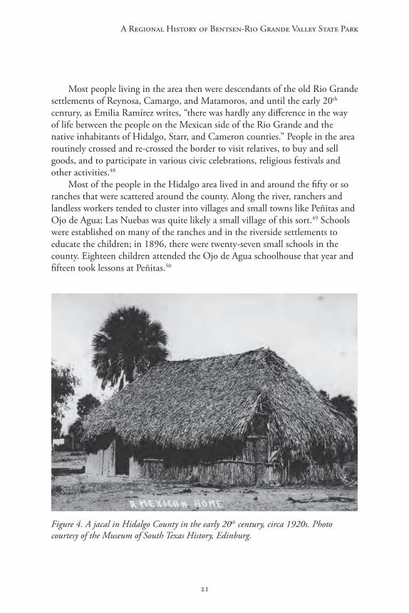
While some ranchers built their homes from limestone or brick, and a few lived in frame houses, most people in the area lived in two-room jacales, sturdy thatched huts built of interconnected mesquite posts, with walls filled with dirt and rock for strength and insulation. One room was dedicated to cooking, eating and other family activities. The other room, usually connected to the first by a roof to form a sort of breezeway, served as the sleeping area. Packed dirt, or sometimes tipichil, a rudimentary type of concrete, was used for the floors. Often the exteriors were whitewashed to reflect away the glaring rays of the sun.51
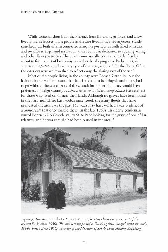
Most of the people living in the county were Roman Catholics, but the lack of churches often meant that baptisms had to be delayed, and many had to go without the sacraments of the church for longer than they would have preferred. Hidalgo County rancheros often established camposantos (cemeteries) for those who lived on or near their lands. Although no graves have been found in the Park area where Las Nuebas once stood, the many floods that have inundated the area over the past 150 years may have washed away evidence of a camposanto that once existed there. In the late 1960s, an elderly gentleman visited Bentsen-Rio Grande Valley State Park looking for the grave of one of his relatives, and he was sure she had been buried in the area.52
Figure 5. Two priests at the La Lomita Mission, located about two miles east of the present Park, circa 1950s. The mission supported a “bustling little village” until the early 1900s. Photo circa 1950s, courtesy of the Museum of South Texas History, Edinburg.
23
A Regional History of Bentsen-Rio Grande Valley State Park
Catholic Oblate missionaries did travel regularly through the county’s communities. But in 1865 they built the La Lomita chapel, on the old Military Highway about two miles east of the Park, to minister to believers in the surrounding area (Map 1). Over the years the chapel complex was expanded to include a rectory and a livery stable; by the late 1800s a “bustling little village,” which included a blacksmith shop, a store and a post office, had grown around the old mission. The original adobe chapel was torn down and in 1889 it was replaced by the brick structure that, restored in 1937, is still used today.53
About a mile west of the La Lomita village—about halfway to Las Nuebas along the Military Highway—William S. Dougherty and his wife, Eloísa Vela Dougherty, built a large ranch complex that in the early 1900s came to be known as “El Jardín de Flores” (Map 1). William was the son of James Dougherty, who had followed his brother Edward to the Valley in 1852, after the Mexican-American War; by the late 19th century, William Dougherty had acquired considerable wealth. His wife Eloísa was the daughter of Macendonio Vela, a prominent Hidalgo County citizen and the owner of Laguna Seca Ranch. An educated, cultured and refined woman, Eloísa had encouraged her husband to carve a new ranch out of the “unspoiled wilderness” along the Rio Grande: “Que bueno, Willie … allí haremos una casa, y sembraré un jardín con el agua del rio … !” 54
Together they planned and built a “lovely and gracious home” within sight of the river and surrounded by old cypress and elm trees draped with Spanish moss. The Doughertys spared no expense in building the house, which was constructed of beautiful woods and sun-baked Mexican bricks manufactured in Mexico. It had spacious, high-ceilinged rooms graced with elegant mantled fireplaces. For security against floods and bandits, it also had a large upstairs bedroom that could serve as a watchtower in times of trouble. With its swimming pool and spectacular gardens, the home became one of the county’s showplaces. Eloísa, who had been educated as a young woman at the Incarnate Word Convent in Brownsville, was a devout Catholic and attended Mass daily at the La Lomita chapel. Also very sociable, she and her husband often held “lavish” entertainments at their home and hosted picnics along the river.55 Going to Jardín de Flores was “a real treat,” Teresa Chapa Alamía later remembered, “not only because of the gorgeous spots by the river that Eloísa had developed, but also, because her hospitality was unsurpassed.”56
In time the ranch house came to be the center of a small village, which included a store for the families of the men who worked on Dougherty’s ranch.57 For several years after William died in 1908, Eloísa continued to spend a great deal of time at the Jardín de Flores, even though extensive repairs were necessary after the great flood of 1909 completely inundated the lower floors

Refuge on the Rio Grande
24
Figure 6. The Jardín de Flores ranch house, circa 1914. Eloísa Dougherty is in the rear seat to the left; the coachman is Tomás Ochoa. Photo courtesy of the Museum of South Texas History, Edinburg.
of the house. “My life on the river has brought me more happiness than I have ever known,” she said years later, “and the river has left its mark on me and on my way of life.”58
By 1908, the village surrounding the La Lomita mission had all but disappeared. Although Catholic services were still held there regularly for many years, a new church had been built about three miles to the north in a new city—named Mission after the La Lomita chapel.59 New economic and social trends were beginning to transform Hidalgo County and other parts of the Rio Grande Valley.
25
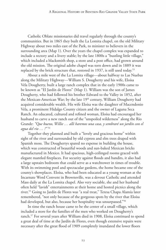
A Regional History of Bentsen-Rio Grande Valley State Park
Figure 7. The Jardín de Flores ranch house in the 1980s, view from the west. Photo courtesy of the Museum of South Texas History, Edinburg.
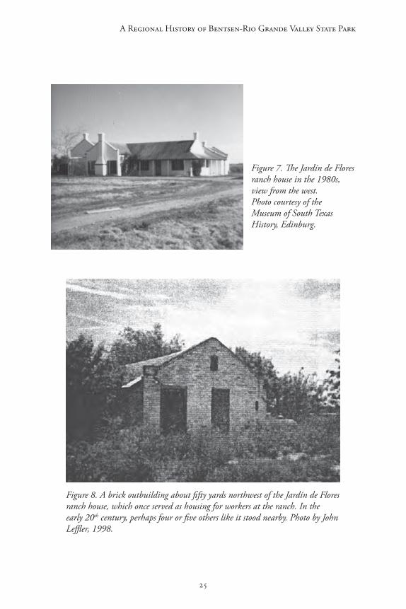
Figure 8. A brick outbuilding about fifty yards northwest of the Jardín de Flores ranch house, which once served as housing for workers at the ranch. In the early 20th century, perhaps four or five others like it stood nearby. Photo by John Leffler, 1998.

Refuge on the Rio Grande
26
Figure 9. Two sides of a copper token, dated 1902, which was once used as currency at the store on the Jardín de Flores Ranch. Workers who purchased goods at the store probably received tokens like this one in their change. Photo courtesy of James E. Kattner.

27
A Regional History of Bentsen-Rio Grande Valley State Park
The Transformation of the Valley, 1900-1940
During the last decades of the 19th century a dramatic shift in the landholding patterns in the lower Rio Grande Valley had occurred, as more and more land had moved into the hands of Anglo-Americans and Europeans. Nevertheless, old social and cultural norms had persisted in many parts of the Valley, including Hidalgo County, which had remained isolated from economic and social trends that were already shaping other parts of Texas and the nation. Few Anglo-Americans had moved into the area before 1900, and most of those who did had melded into its traditional way of life. During the first decades of the 20th century, however, Hidalgo County experienced rapid changes that fundamentally altered its economy and society.
For centuries the area’s aridity and isolation had hindered its economic development. Edward Dougherty, an Irish immigrant who had first moved to the Valley during the Mexican-American War, had tried during the late 1860s to interest eastern investors in the area by describing its agricultural potential in glowing terms, but he received little response.60 The soil of the Valley (which is, technically, the delta of the Rio Grande), built up by flood siltation over thousands of years, could be quite productive. In the mid-1880s, John Closner successfully raised a good vegetable crop in Hidalgo County, proving that with irrigation the area had good agricultural potential. Nevertheless, irrigation was too expensive to encourage others to follow his example on a large scale at this early time.
The area’s isolation had also delayed its development. According to one account, during the 1890s an eastern tobacco expert grew a 100-acre plot of “perfect” tobacco in Hidalgo County, but found he could only transport his crop to buyers on the coast by hauling it in small ox-carts along the narrow Military Road. Since that was much too expensive, the tobacco simply “withered on the stem.”
For a while it had been hoped that river navigation could open the area to development, but by the late 1860s early riverboat men had concluded that because of shifting sandbanks and the Rio Grande’s unpredictable flow, the river could not reliably support a profitable traffic. And, as Sarah Sanborne Weaver has written, “for many years … building a good road or even considering a railroad down along the river was impossible” because of the ferocious floods that swept through the Valley about twice every year. “As long as the sand cut us off and our native brush escaped greed that men call progress,” Weaver wrote, “we [in Hidalgo County] were unique.”61 No doubt the region’s notorious political instability

Refuge on the Rio Grande
28
had also discouraged investors for many years, although by 1900 the powerful dictatorship established in Mexico by Porfirio Diaz had helped to stabilize conditions, at least temporarily, along the Texas-Mexico border.
The area began to experience dramatic change during the first years of the 20th century, when the St. Louis, Brownsville and Mexico Railway, financed by a well-connected and ambitious syndicate managed by the St. Louis Trust Company, began to lay tracks through the Rio Grande Valley. By 1905, the line had reached the present site of Mission, and soon ran east-to-west across all of southern Hidalgo County (three to ten miles north of the river, safe from the floods).62 Connecting the region directly to the national market, the railroad opened the county to large-scale commercial agriculture, actively encouraged investment in the area and opened it to a new wave of immigrants.
Even before the railroad arrived, a few far-sighted developers had already begun to buy up large tracts of ranchland. About 1901, for example, Thomas J. Hooks, originally from Louisiana, investigated the Valley. He found that “the fertility and productiveness of the soil was beyond his fondest anticipation,” and bought about 23,000 acres in southeastern Hidalgo County. With irrigation, he was convinced, the land could be incredibly productive.63 Others followed his example, and by 1903 various investors were already drawing up plans for large irrigation projects.
Almost immediately after the railroad arrived in Hidalgo County new towns appeared along its tracks, established by ambitious developers who anticipated a farming boom. The townsite for Donna, one of the first new cities, was laid out in 1904, and was soon followed by McAllen (1904), Mission (1905), Mercedes (1906) and Pharr (1911).64 Development spawned other communities around the county at about the same time. In 1908 John Closner, William Briggs and Dennis Chapin, who were engaged in farm development projects, established a townsite, originally called Chapin, about seventeen miles north of the river. By 1909, when a railroad spur reached the new town, the county seat was moved there, and it was renamed Edinburg (at the same time, the old county seat was renamed Hidalgo).65
Massive irrigation systems built across the southern part of the county suddenly changed cheap ranchland into many thousands of acres of highly productive farmland, which was cleared, graded, subdivided and sold. By 1907, William S. Dougherty was irrigating 600 acres of his Jardín de Flores ranch, and that year he invited farmers to lease this “excellent land” to grow sugar cane, onions, and other crops.66 Developers brought prospective farmers on “excursions” to the county by the trainload, and thousands of them bought land and stayed to grow cotton, corn, citrus and vegetables.

29
A Regional History of Bentsen-Rio Grande Valley State Park
The transformation of the county’s economy was temporarily stymied by a wave of violence that swept across the Rio Grande Valley between 1915 and 1917. The roots of the border troubles are complex and are still being debated by historians and others. To some extent the violence was a byproduct of unsettled conditions south of the border: the beginning of the Mexican Revolution in 1910 completely destabilized conditions in that nation. By 1914, Mexico was being ripped apart by armed factions fighting amongst themselves for control as Diaz’s dictatorial order broke down. The Revolution had also encouraged a new sense of Mexican nationalism, both north and south of the border. To some extent the violence of 1915-1917 grew out of resentments harbored by Mexican-Americans in the Valley, many of whom felt cheated or dispossessed by the events of the last sixty years. The violence was intensified by Anglo-American fears, and by prejudices and hatreds that still remained strong many years after the Texas Revolution. Some historians further believe that German agents helped to foment and intensify conflict along the border during this period, hoping to distract the United States away from involvement in World War I, which was ravaging Europe at the time.67
In January 1915, a Hidalgo County deputy sheriff arrested Basilio Ramos, Jr., a Mexican national, in McAllen. Ramos was carrying a copy of a revolutionary document known as the Plan of San Diego, which urged Mexican Americans and African Americans to stage an armed uprising against the United States Government. According to the Plan, a new independent republic would be created from Texas, California, New Mexico, Arizona and Colorado. Every North American white male over sixteen years old would be executed. The revolution was supposed to begin on February 20, 1915. At first the Plan seemed so absurd that when Ramos was brought to trial the judge released him, saying “You ought to be tried for lunacy—not conspiracy against the United States.”68
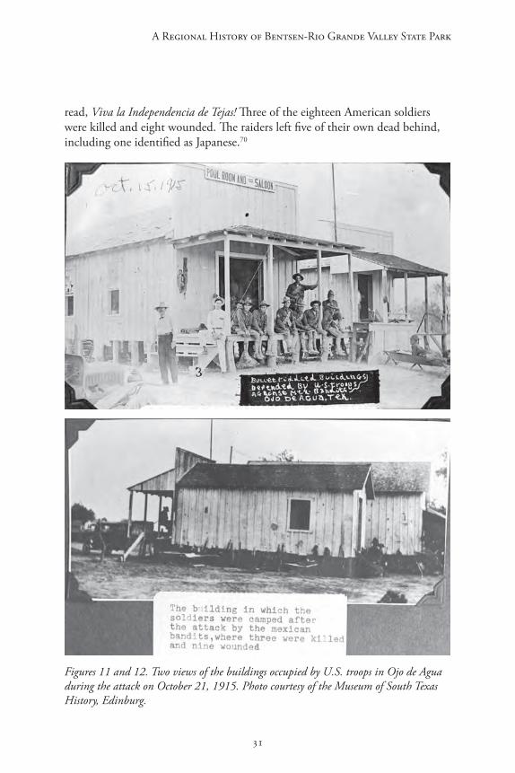
In May 1915, bands of armed men, usually identified as “Mexican,” attacked a number of ranches in the Rio Grande Valley, and as the year progressed the raids intensified. Raiders hit dozens of ranches and small towns in the Valley, including several in Hidalgo County, and clashed with U.S. troops and Texas Rangers all along the border. Fears and anxieties in the area rapidly escalated, and in July some ranchers began to move their families into towns. On October 15, a group of men led by Luis de la Rosa, a former Cameron County deputy sheriff, derailed a train near Brownsville and then shot or robbed many of its passengers.69 Three days later, about sixty armed men crossed the Rio Grande and attacked a small unit of U.S. troops at Ojo de Agua, about two miles west of what is now Bentsen-Rio Grande Valley State Park. According to witnesses, a number of the raiders wore headbands that

Refuge on the Rio Grande
30
Figure 10. A handbill of the Plan of San Diego, 1915. From Sandos, Rebellion in the Borderlands. Original in the National Archives, Washington, D.C.
31
A Regional History of Bentsen-Rio Grande Valley State Park
read, Viva la Independencia de Tejas! Three of the eighteen American soldiers were killed and eight wounded. The raiders left five of their own dead behind, including one identified as Japanese.70
Figures 11 and 12. Two views of the buildings occupied by U.S. troops in Ojo de Agua during the attack on October 21, 1915. Photo courtesy of the Museum of South Texas History, Edinburg.

Refuge on the Rio Grande
32
Figure 13. U.S. troopers stationed in Hidalgo County, circa 1916. Photo courtesy of the Museum of South Texas History, Edinburg.
The attack on the train and new raids along the border “galvanized fear into terror” in the Valley and led to some brutal reprisals against people of Mexican descent, who many Anglos believed sympathized with the attacks. On October 18, Texas Ranger Captain H. L. Ransom personally executed without trial four ranch workers who, according to historian James Sandos, “seem to have been guilty of no other ‘crimes’ than being Mexican and available.”
Across the valley Anglo-Americans formed vigilante groups. As a U.S. military commander reported, “[t]he wide use of arms by white citizens and the extreme difficulty of the civil authorities supervising their use, leading to personal aggression, revenge, and terrorism by [the] white population upon Mexican citizens are certainly complicating the situation.” The military reported that vigilantes had killed more than 150 Tejanos and Mexicans by the end of October.71 Meanwhile, the Brownsville Herald reported that thousands of Mexicans were moving south of the border, leaving their lands and taking with them everything they could carry. By the end of October, the paper estimated, more than 7,000 Mexicans in Cameron and Hidalgo counties—about forty percent of the Tejano population there—had left.
33
A Regional History of Bentsen-Rio Grande Valley State Park
By early 1916, with the raids intensifying and spreading west, the border raids had helped to create an international crisis. Tensions between the U.S. and Mexican governments reached the boiling point in March, when a band of almost 500 Mexicans supposedly led by Pancho Villa attacked Columbus, New Mexico, and killed sixteen Americans. Responding to urgent requests for help from citizens along the Rio Grande, the Texas governor deployed about three-quarters of the state’s Rangers to the border, and the federal government sent thousands of troops. National Guard units from several states were mobilized, and the regular army units were reinforced. By the middle of 1916, more than 110,000 men had been deployed along the Mexican border in Texas and New Mexico. In Hidalgo County, U.S. troops were positioned at Peñitas, Donna, Pharr, McAllen and Hidalgo.72
President Woodrow Wilson’s decision to send an armed force into Mexico to chase down Pancho Villa nearly led to a war between the United States and Mexico that summer. By late 1916, the crisis had passed; by 1917, the border raids had ended. The violence of the past two years had taken a terrible toll. Texas historian Walter Prescott Webb estimated that at least 500 Mexicans had been killed in the Valley during “the troubles,” along with sixty-two U.S. soldiers and more than sixty American civilians.73 And for the residents of the Valley, the period left other wounds that would take a long time to heal.
With peace restored the economic development of the Valley resumed and intensified, and thousands of new farmers moved into the lands being opened up in Hidalgo County. In 1900, the U.S. Census had counted only 490 farms and ranches in the county, but the number of farms grew steadily after the railroads came: 677 by 1910, 1,729 by 1920, and 4,321 by 1930. Meanwhile the area’s population also grew dramatically, rising from 6,934 in 1900 to 13,778 by 1910, and to 28,110 by 1920; by 1930 there were more than 77,000 people (including 41,522 officially classified as racially “Mexican”) living in the county.74
Many of the new farmers in the area had moved from other parts of Texas, but many others came from Eastern and Midwestern states. Unlike most of the county’s earliest Anglo-American settlers, as Alicia Garza writes, most of the newcomers “were not willing to adapt to Hispanic culture and considered themselves superior to Mexican Americans.” And now, unlike the old settlements of Hidalgo and Peñitas, virtually all of the new towns established along the railway were segregated, with separate “Mexican” and “American” schools and other facilities.75
Much of the land in the vicinity of present-day Bentsen-Rio Grande Valley State Park was cleared, irrigated and developed during this period. Beginning in 1914, John H. Shary bought tens of thousands of acres of land south of
Refuge on the Rio Grande
34
Mission, including the Oblate Fathers’ old La Lomita Ranch. Building a huge irrigation system and subdividing the land into 40-acre farms, he had created a sprawling citrus development called Sharyland by 1919. Eventually, probably by the 1920s, Sharyland also swallowed up the old Jardín de Flores Ranch.76
Although much of southern Hidalgo County was rapidly cleared between 1910 and 1930, most of the old ranchland on Porción 50 remained undeveloped, at least partly because the title to the property was still clouded. As noted above, Dr. Headley had sold his 3,814 acres to G. Bedell Moore in July 1902 through John Closner. In August, Closner himself bought (for $2,250) the remaining 1,500 acres of Porción 50 from Henrietta King, who had won that part of the porción in her lawsuit against Headley back in 1893. Closner quickly sold that land to G. Bedell Moore, who then owned all 5,314 acres in the old grant.77
In 1905, Moore sold 2,200 acres of the northern half of Porción 50 to the St. Louis Union Trust Company, which was building the St. Louis, Brownsville and Mexico Railway through the area then. After Moore died in 1908 his considerable estate was divided between his widow, Elizabeth, and their two-year-old son; Elizabeth’s half included the southern 3,114 acres of Porción 50.78 In 1910, she sold 3,300 acres, including all of her interest in Porción 50, to A.H. and Marcia Morton of Chicago, Illinois, for $90,000. By 1916, however, it was clear that the Mortons (who by that time were living in Los Angeles, California) were not able to keep up their payments on the promissory notes. When Moore threatened them with a foreclosure suit that year, they returned the property to her.79
Although Mrs. Moore tried for many years to sell the southern sections of Porción 50 again, she was unable to do so because potential buyers believed that her title to the property was “clouded.”80 After she died in 1925, the land was controlled by her estate until the late 1930s. Probably because of the perceived defect in the property’s title, the southern sections of the porción remained undeveloped for many years after surrounding properties were developed into farms.
Meanwhile the small Mexican-American community at Las Nuebas continued to exist down near the river. By the 1930s, however, the village had shrunk to three small houses and a corral near the present-day site of the Park’s La Familia Nature Center. Osvaldo Ochoa lived at Las Nuebas for about seven years as a child in the 1930s; according to him, the village was known as “Las Nuevas” then. A man named Teofilo Treviño leased the area, Ochoa said, and was the “rich man” in the village: he ran about sixty cattle on the property, and owned five or six horses and a few hogs. Treviño grew crops on a field just west of the settlement, Ochoa said, mostly corn but also some pumpkins and

35
A Regional History of Bentsen-Rio Grande Valley State Park
a little cotton. Teofilo and his wife Esteva had three children, Domingo, Pilara and Alberto, and the family lived in the village’s most substantial dwelling, a thatched two-room jacal with a chimney.81
Two branches of the Ochoa family lived in Las Nuebas then, headed by Leonardo Ochoa and Mario Ochoa, whose ancestors had once owned the Ojo de Agua Ranch, Osvaldo said. Mario Ochoa had grown up in Abram but for years had worked as a laborer on various farms in the area. He and his wife Rosalia, a Mexican native, had five children: Oscar, Osvaldo, Alejandro, Francisco and Orelia. At one time, Mario had worked and lived with his family on the Jardín de Flores Ranch, where his son Osvaldo was born in the 1910s. The family had moved to Mexico during “the troubles,” but returned after peace was restored.
Figure 14. Two jacales in southern Hidalgo County, circa 1940. Photo courtesy of the Museum of South Texas History, Edinburg.
Refuge on the Rio Grande
36
Figure 15. Another example of jacales in southern Hidalgo County during the early 20th century, circa 1920s. Photo courtesy of the Museum of South Texas History, Edinburg.
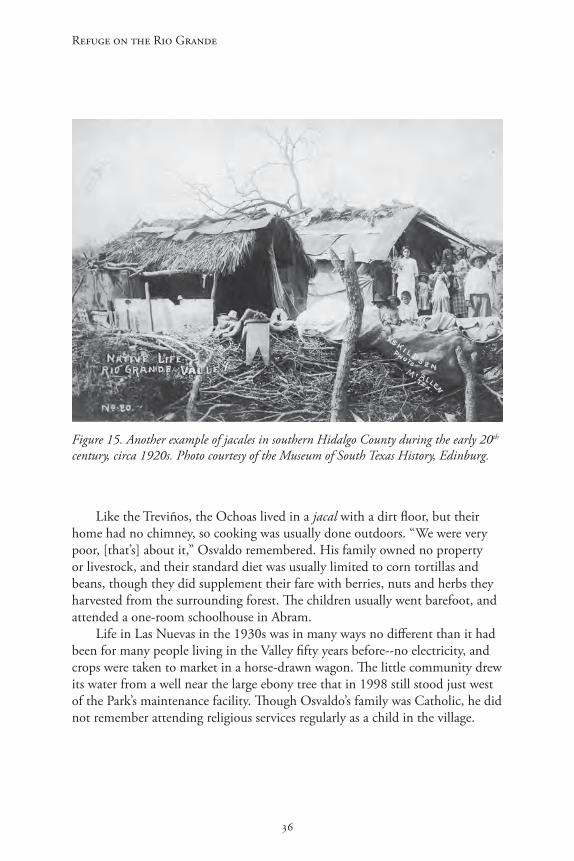
Like the Treviños, the Ochoas lived in a jacal with a dirt floor, but their home had no chimney, so cooking was usually done outdoors. “We were very poor, [that’s] about it,” Osvaldo remembered. His family owned no property or livestock, and their standard diet was usually limited to corn tortillas and beans, though they did supplement their fare with berries, nuts and herbs they harvested from the surrounding forest. The children usually went barefoot, and attended a one-room schoolhouse in Abram.
Life in Las Nuevas in the 1930s was in many ways no different than it had been for many people living in the Valley fifty years before--no electricity, and crops were taken to market in a horse-drawn wagon. The little community drew its water from a well near the large ebony tree that in 1998 still stood just west of the Park’s maintenance facility. Though Osvaldo’s family was Catholic, he did not remember attending religious services regularly as a child in the village.

37
A Regional History of Bentsen-Rio Grande Valley State Park
Figure 16. Detail from 1936 map of Hidalgo County, showing the site of Las Nuebas (also called “Las Nuevas”) at that time. The single dark square near the center-right part of the image shows a dwelling at the present-day location of the park’s La Familia nature center. Note also the two other dwellings just northwest, near the center of the image. Texas State Department of Highways, Highway Map of Hidalgo County, 1936.
Las Nuevas was abandoned in the late 1930s after Lloyd Bentsen, Sr., bought the southern sections of Porción 50 and, together with his brother Elmer, began to develop the property. The people who had lived there moved to other parts of the county; Mario Ochoa took his family to Abram, and they went on with life there. An inspection of the site in 1998 found no evidence of the little ranching village that had been there for almost ninety years.
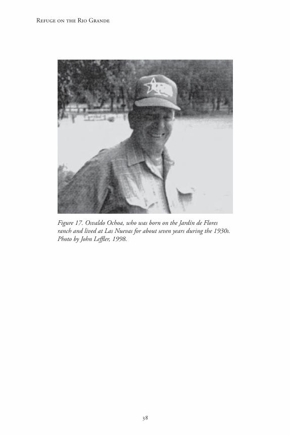
Refuge on the Rio Grande
38
Figure 17. Osvaldo Ochoa, who was born on the Jardín de Flores ranch and lived at Las Nuevas for about seven years during the 1930s. Photo by John Leffler, 1998.

39
A Regional History of Bentsen-Rio Grande Valley State Park
The Creation of Bentsen-Rio Grande Valley State Park
The Bentsen family first became acquainted with the lower Rio Grande Valley in 1914, when Peter Bentsen traveled south from his farm in South Dakota in search of a healthy climate and economic opportunity. He bought fourteen acres in Hidalgo County’s Sharyland development, and in 1918 returned with his wife Tena to begin a citrus nursery. By that time his son Lloyd (later known as Lloyd, Sr.) had already visited the area. In 1917, while in San Antonio training for service during World War I, Lloyd had been invited on a hunting trip to Hidalgo County. He visited Mission and enjoyed “the tropical laid-back atmosphere of the Valley.” He also fell in love with “a beautiful young lady,” Edna Ruth (“Dolly”) Colbath. Lloyd promised her he would return after the war, and after the two married in 1920 they stayed in Hidalgo County. Other members of the Bentsen family also moved to the area at about that same time, including Lloyd’s brothers, Elmer and Alton.82
In the early 1920s Lloyd and Elmer formed the Bentsen Brothers Development Company, which bought raw land, then cleared and planted citrus farms for sale. By the 1930s, partners Elmer and Lloyd were among the most active and successful developers in Hidalgo County. Their brother Alton was also involved in the Bentsen Brothers Company, working in its citrus caretaking business.83
In January 1937, Lloyd bought the southern 3,162 acres of Porción 50 from Elizabeth Moore’s estate for ten dollars “and other valuable considerations,”84 and the brothers began to plan the area’s development. By June 2,020 acres of the property, extending south to the present northern boundary of Bentsen-Rio Grande Valley State Park, was formally cut into 202 ten-acre lots and platted as the “Bentsen Groves Subdivision.”85 It is not clear why the area that is now the Park was not platted into the subdivision at that time.
In an interview many years later, Lloyd, Sr., credited his brother Elmer with the idea that the woodlands along the Rio Grande should be preserved. According to Lloyd, Elmer was bulldozing some of the land they had bought when the thought occurred to him, and he approached his brother: “Lloyd, there are some of the most beautiful ebony trees I’ve seen here in the valley on that stretch of the river and I’d sure hate to take them down.” When Lloyd asked him what he wanted to do about it, Elmer replied “Well, how about a park?” Sometime afterward, Lloyd contacted the Texas State Parks Board and “commenced drawing up the papers.”86
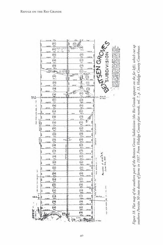
Refuge on the Rio Grande
40
Figu
re 1
8. P
lat m
ap o
f the
sout
hern
par
t of t
he B
entse
n G
rove
s Sub
divi
sion
(the R
io G
rand
e app
ears
on th
e far
left)
, whi
ch cu
t up
sout
hern
Por
ción
50 in
to d
ozen
s of f
arm
s in
1937
. Fro
m H
idal
go C
ount
y pla
t rec
ords
, vol
. 7, p
. 13,
Hid
algo
Cou
nty C
ourt
hous
e.

41
A Regional History of Bentsen-Rio Grande Valley State Park
On January 28, 1944, Lloyd and his wife, Edna Ruth, joined Elmer and his wife, Marie, and signed over 586.9 acres of Porción 50 to the Texas State Parks Board for one dollar. The contract stipulated that the land would be used “solely for Public Park Purposes and shall be maintained, operated, known and designated as BENTSEN RIO GRANDE VALLEY STATE PARK.”87 This original contract provided that the land would revert to the Bentsens within three years after the end of “the present conflict” (World War II) if the State had not developed the Park by then.
Members of the Texas State Parks Board were delighted with the new acquisition. “It is really what might be called a jungle area, typical of the original undeveloped Lower Rio Grande Valley country,” said Frank Quinn, who was then the board’s Executive Secretary. “It is a beautiful site and highly desirable.”88 In February 1945, anticipating an end to the war, the Board asked the state legislature for $5,000 to make preliminary improvements, including a road and a park entrance. A reporter asked Quinn what the Park would look like in ten years. “I am glad you said ten years instead of five,” Quinn replied. “We cannot hope to do it overnight.” Still, he envisioned a “palm-lined boulevard” leading up to the park from the Military Road, cabins for vacationers, and plenty of opportunities for outdoor fun, including a man-made bathing beach at the lake, tennis courts, baseball diamonds, softball parks “and other spots for outdoor enthusiasts.”89
In June the legislature appropriated $5,500 for the park for the 1945-1946 fiscal year, including $4,000 to build a residence for a park manager, $900 for the manager’s yearly salary, and $600 for maintenance. Work on the house was expected to begin in late 1946. The legislature also approved another $1,500 for the 1946-1947 fiscal year for the manager’s salary and maintenance. 90 By early 1947, a “modest little cottage” just inside the park had been completed, and George H. Harper, apparently the park’s first manager, had moved there from his previous post at Caddo Lake.91 In February 1948, the McAllen Monitor reported that main roads into the park had been cleared, but for the most part the park was still covered with “a tangled undergrowth of brush and stately border trees.” “[H]ere and there,” the story continued, “a few clearings have been hewn out so visitors can find space for picnicking, but by and large the development of the park’s attractions still is a matter for the future.”92 Bulldozers owned by Hidalgo County did much if not all of the roadwork in the park at this time. By March seven miles of new roads had been cut through the park area, but they were all unpaved, so that traffic sometimes produced “clouds of choking, powdery dust.”93
Although relatively little had been done to improve the park, it was nevertheless attracting thousands of visitors, most of them from the

Refuge on the Rio Grande
42
surrounding area. Boy Scout troops from Mission had been camping and hiking in the area since 1947, and perhaps even earlier. Manager George Harper worked out an arrangement: scouts were welcome to use the area if in return they agreed to clear brush out of their campsites. Cub Scouts were also welcomed, as were civic groups like McAllen’s 30-20 Club. On Easter Sunday 1947, Harper counted 212 visitors, a new daily record for the park. On February 15, 1948, he reported 408 visitors, another record.94
In an area where many people had few choices for outdoor recreation, the park was beginning to be a “popular place,” as a writer for the McAllen Monitor noted in 1948. “[F]ew other stands of virgin Valley woodland are in such an excellent state of preservation,” he wrote. For visitors, the park’s trails led into a “wonderland of tall trees, underbrush and matted vines” with “shaded glens and grassy plots where picnics can be delightful and youngsters can be provided with a few hours in the open.”95
In 1948, the State Parks Board announced ambitious plans to improve the park, but very little was done for many years because the state legislature did not appropriate the necessary funds. For each of the fiscal years 1947-1948 and 1948-1949, for example, only $1,850 ($1,200 for the manager’s salary, $650 for maintenance) was approved for the park. “It’s easily seen,” the McAllen Monitor complained, “that such a budget doesn’t allow for much of the work which the park needs to put it into good shape.”96
By the early 1950s, the park had not been improved much since 1948, despite the Park Board’s plans. Apparently Lloyd and Elmer were becoming frustrated by the lack of progress at the park. They had donated the land in 1944 with the stipulation that it would be “maintained and operated” as a state park, but too little had been done to meet that goal. According to an article by Pete Wittenberg, a writer for the McAllen Monitor, in late 1951 or early 1952 Lloyd and Elmer may have seriously considered taking the land back, as the original contract stipulated they were entitled to do.97
According to Wittenberg, Alton Bentsen was responsible for saving the park. He quotes Alton: “I was at my mother’s for dinner, and I heard my brother Lloyd tell Elmer about an offer for that land, for something like $150,000. Elmer was ready to sell the land; he said he was tired of it.” By that time, Alton said, “I’d already been working at the park for three years, and I thought that the county needed a playground area of that kind.” He wasn’t willing to give up on the project, and the next morning he asked Elmer for “some more time to get the park going.” According to Wittenberg, “Elmer gave him [Alton] six months, then the bulldozers would move in to clear the rich land for farming.”98

43
A Regional History of Bentsen-Rio Grande Valley State Park
In 1952, Elmer and Alton began an energetic campaign to enlist local and state support for the park. The two met with local civic leaders in Mission, Pharr, McAllen and Edinburg to drum up funds and enlist political support for more state funding. At a key meeting of the Hidalgo County Commissioner’s Court in June, Elmer asked the county to build a road to the park and gravel the roads already there; he also wanted the county to budget $4,000 a year to hire Alton as the park’s caretaker.99 By August Alton had been named chairman of an organization called the “Bentsen State Park Improvement Committee,” and that month he and Elmer traveled to Austin to meet with members of the Texas State Parks Board to discuss “plans for the development of the park.”100 The Bentsens might also have been threatening to challenge the state’s title to the land. As noted earlier they had a legal right to do that, and they might have used it for leverage in their discussions with the state.
These efforts bore fruit. “Just before Elmer’s deadline was up,” Wittenberg writes, “the state agreed and named Alton park manager. … At the same time, [Alton] Bentsen acquired another title, that of [Hidalgo] county parks manager. Beto Reyna of La Joya, then county commissioner, notified him … of his appointment, and he began receiving $333 a month for his services.”101 In February 1953, the Bentsens signed a new donation contract with the State Parks Board for the park property. The agreement adjusted the borders of the park to expand its riverfront acreage and enlarged it overall to 587.5 acres. The new contract again stipulated that the property would have to be used as a state park “for the use and benefit of the public,” but it was less specific than the original agreement about exactly when that should happen. It also reserved the land’s mineral rights to the Bentsens until 1969.102 The Bentsens would operate at least two natural gas wells on the property during the 1950s and early 1960s.103
Alton was wealthy enough not to need the money he earned for managing the park, and he generously spent his salary to improve the park. One of his first acts was to hire thirty or forty laborers from Mexico, who crossed the Rio Grande to “hack away at the unsightly growth.” Next, he began to lay down water lines, which began to spread across the park. In March 1954, Elmer Bentsen announced plans for major improvements at the park, including camping and trailer sites, restrooms, boat docks, and water taps for campers, and paving the road to the park’s entrance. In early April, Alton hired W. Herman Kinsey to be the park’s on-site manager; at about that same time, the State Fish, Game and Oyster Commission stocked the park’s lake with 30,000 fish.104
Meanwhile, visitation continued to grow. Local Boy Scout troops camped and hiked there, and local scout organizations often used the area for “Camporees,” where boys could hone their scouting skills. As before, the scouts sometimes cleared brush in the area. For example, Boy Scout Troop 83 from
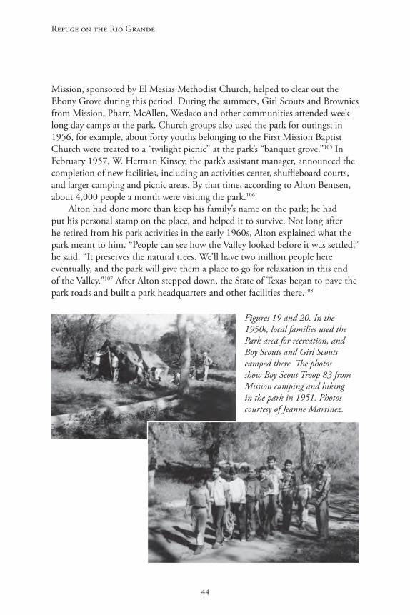
Refuge on the Rio Grande
44
Mission, sponsored by El Mesias Methodist Church, helped to clear out the Ebony Grove during this period. During the summers, Girl Scouts and Brownies from Mission, Pharr, McAllen, Weslaco and other communities attended week-long day camps at the park. Church groups also used the park for outings; in 1956, for example, about forty youths belonging to the First Mission Baptist Church were treated to a “twilight picnic” at the park’s “banquet grove.”105 In February 1957, W. Herman Kinsey, the park’s assistant manager, announced the completion of new facilities, including an activities center, shuffleboard courts, and larger camping and picnic areas. By that time, according to Alton Bentsen, about 4,000 people a month were visiting the park.106
Alton had done more than keep his family’s name on the park; he had put his personal stamp on the place, and helped it to survive. Not long after he retired from his park activities in the early 1960s, Alton explained what the park meant to him. “People can see how the Valley looked before it was settled,” he said. “It preserves the natural trees. We’ll have two million people here eventually, and the park will give them a place to go for relaxation in this end of the Valley.”107 After Alton stepped down, the State of Texas began to pave the park roads and built a park headquarters and other facilities there.108
Figures 19 and 20. In the 1950s, local families used the Park area for recreation, and Boy Scouts and Girl Scouts camped there. The photos show Boy Scout Troop 83 from Mission camping and hiking in the park in 1951. Photos courtesy of Jeanne Martinez.

45
A Regional History of Bentsen-Rio Grande Valley State Park
Figure 21. Visitors in the park, Easter 1962. Photo courtesy Bentsen-Rio Grande Valley State Park.
Since the 1950s, droughts and dam construction projects along the Rio Grande have damaged the Park’s original woodlands, but the area remains one of the few spots on the river where visitors can glimpse the region’s original state. 109 Bentsen-Rio Grande Valley State Park has become especially well-known for the many species of birds that can be found there. In 2002, Mike and Lori Rhodes donated 270 acres to the park to help create the World Birding Center, which was dedicated in 2004. By 2013, the Center included nine sites spread across 120 miles of the Rio Grande Valley, including properties owned by the Texas Parks and Wildlife Department, the U.S. Fish and Wildlife Service, and several communities in the Valley. It is headquartered at Bentsen-Rio Grande Valley State Park, where important elements of the area’s old habitat are still preserved.110 As Robert Norton noted in 1986, when a historical marker was dedicated at the park, its “tranquility. . . stands with more and more contrast to the rest of the Lower Rio Grande Valley which was so recently, in its entirety, an area unspoiled by the advance of people and machines.”111

47
A Regional History of Bentsen-Rio Grande Valley State Park
Endnotes
1 Rob McCorkle, “Subtropical Allure Beckons at Bentsen-Rio Grande State Park, Texas Parks and Wildlife (February, 1997); “Bentsen-Rio Grande State Park,” anonymous, undated typescript in historical files of Bentsen-Rio Grande State Park; “Bentsen Park Provides Close Look at Nature of Valley,” undated clipping in Bentsen-Rio Grande Valley State Park vertical file in the Briscoe Center for American History, University of Texas at Austin.
2 Quote from Frank Quinn, Executive Secretary of the Texas State Parks Board, in “Quinn to Back Valley State Park Site,” McAllen Monitor, December 1, 1943.
3 Mark J. Hartmann, Bobbie L. Lovett, and Barry W. Walker, “Results of an Archeological Survey of Bentsen-Rio Grande Valley State Park, Hidalgo County, Texas” (Texas A&M Dept. of Anthropology, Feb. 1995), p. 22; Bruce Saunders, “Historical Survey of the Rio Grande Area in Starr County,” in Rio Grande-Falcon Thorn Woodland: A Natural Area Survey, No. 13 (Lyndon B. Johnson School of Public Affairs, University of Texas-Austin, 1976), pp. 3-4; Armando C. Alonzo, Tejano Legacy: Rancheros and Settlers in South Texas, 1734-1900 (Albuquerque: Univ. of New Mexico Press, 1998), pp. 23-34; Alicia A. Garza, “Hidalgo County,” New Handbook of Texas (six vols. Austin: Texas State Historical Association, 1996, hereafter cited as NHT), p. 590.
4 J. Lee and Lillian J. Stambaugh, The Lower Rio Grande Valley of Texas (Austin: Jenkins Publishing Co., 1974), pp. 10-14, 21-23.
5 Stambaugh and Stambaugh, The Lower Rio Grande Valley, pp. 26-29; Florence Johnson Scott, Historical Heritage of the Lower Rio Grande: A Historical Record of Spanish Exploration, Subjugation and Colonization of the Lower Rio Grande Valley and the Activities of José Escandón, Count of Sierra Gorda, together with the Development of Towns and Ranches Under Spanish, Mexican and Texas Sovereignties, 1747-1848 (Texian Press, 1970 [1937]), pp. 14-19; Alonzo, Tejano Legacy, pp. 29-30, 38.
6 Scott, Historical Heritage, pp. 21-22; Alonzo, Tejano Legacy, p. 41; Stambaugh and Stambaugh, Lower Rio Grande Valley, p. 31. It is not clear whether the 1755 population figure includes the villa’s American Indian population.
7 Alonzo, Tejano Legacy, pp. 38, 46; Scott, Historical Heritage, p. 110.
8 Scott, Historical Heritage, pp. 95-96; Alonzo, Tejano Legacy, pp. 37-40.

Refuge on the Rio Grande
48
9 Texas General Land Office, Guide to Spanish and Mexican Land Grants in South Texas (Austin: Texas General Land Office, 1988), entry 355.
10 According to a legend still circulating, Zamora was a descendant of, or related to, a Father Zamora who, along with five other Spaniards, supposedly settled at the present site of Peñitas (in present-day Hidalgo County) in the 1520s or 1530s. The legend holds that Zamora and his companions were part of a group of Spaniards sent to Mexico from Cuba to arrest Hernán Cortez on a political charge; after forces loyal to Cortez dispersed the group, a remnant of the force, including Father Zamora, wandered north to the Rio Grande and established Peñitas. Later, according to the legend, other members of the Zamora family, including José Antonio, moved to the area. In 1946 a Dallas woman named Ellen O’Shea (today more widely known as Elena Zamora O’Shea), who had been born in Peñitas, claimed to have found evidence that a number of Zamoras moved from Vera Cruz to the Rio Grande in the late 16th century, but she never produced any documentary evidence to support her claim. Historian Carlos Castaneda, who knew Mrs. O’Shea, expressed strong doubts that the legend was true, and others have also debunked the myth. See Alicia Garza, “Peñitas,” NHT 5:138-139; Pete Wittenberg, “Valley Community Still Claims Title of Oldest Town in Texas,” McAllen Monitor, December 11, 1966; A.W. Edwards, “Penitas Puzzling Pirogue,” McAllen Monitor, May 9, 1979; Penitas Given Honor,” McAllen Monitor, April 26, 1981; Virginia N. Lott and Virginia M. Fenwick, People and Plots on the Rio Grande (San Antonio: 1957), pp. 17-18. Interestingly, nothing of the legend seems to be expressed in Mrs. O’Shea’s novelette El Mesquite, which was first published in 1935. See Elena Zamora O’Shea, El Mesquite: A Story of the Early Spanish Settlements Between the Nueces and the Rio Grande, As Told By “La Posta del Palo Alto” (College Station: Texas A&M Univ. Press, 2000 [1935]). See also the comments by Texas Historical Commission staff members in the THC’s historical marker files for Penitas in 1970 and 2007, Texas Historical Commission, Austin.
11 Scott, Historical Heritage, p. 101.
12 Scott, Historical Heritage, pp. 102-102, 95-96. Scott’s list of the grantees mistakenly indicates that the Zamora family received six grants rather than five, and incorrectly lists José Antonio Zamora as the recipient of Porción 51 rather than 50.
13 Scott, Historical Heritage, p. 97; Oran Randolph Scott, “History of Hidalgo County, 1749-1852” (M.A. thesis, Texas Christian University, 1927), p. 42.
14 Dorothy Abott McCoy, “Some Valley Descendants of the Grantees,” in Valley By-Liners [Teresa Chapa Alamia, et al], Roots by the River: A Story of Texas Tropical Borderland, Book II (Mission, Texas: Border Kingdom Press, 1978), p. 27.

49
A Regional History of Bentsen-Rio Grande Valley State Park
15 The property was certainly still in the family’s hands in 1852, when Antonio Zamora’s grandson, Servana Quirva, defended his title to the land and was awarded the property by the State of Texas. As noted below, a ranch establishment existed on the property in 1850, when the land was resurveyed: Texas General Land Office, Guide to Spanish and Mexican Land Grants, entry 355; notes of resurvey in Spanish Land Grant files, Porción 50, Texas General Land Office [hereafter TGLO]. Two of Zamora’s grandchildren lived on the property in 1858: deed from Manuel Villereal Zamora to James Walworth, March 7, 1858, Hidalgo County Deed Records [hereafter HCDR] A:396.
16 Alonzo, Tejano Legacy, pp. 81-83.
17 Garza, “Hidalgo County,” p. 590; Ordaz, “Penitas said site of county’s first mission.” In the surveyor’s notes accompanying the map of the path from old Reynosa shown in Figure 2, the path is said to have led to the plaza of old Reynosa. Since Reynosa was moved to its present location in 1803, there is a good chance this path had been established earlier, though it is not mentioned by W. Clyde Norris in his discussion of early roads in the area. See Norris, “History of Hidalgo County” (M.A. thesis, Texas College of Arts and Industries, Kingsville), pp. 41-42. For the creation of the original Military Road, see Scott, “History of Hidalgo County,” pp. 41. For more about various theories concerning the original settlement of Peñitas, see note 9 above.
18 Alonzo, Texas Legacy, pp. 41, 48; Garza, “Hidalgo County,” p. 590.
19 Alonzo, Texas Legacy, p. 89; Garza, “Hidalgo County,” p. 590.
20 David Montejano, Anglos and Mexicans in the Making of Texas, 1836-1986 (Austin: Univ. of Texas Press, 1987), p. 30; Alonzo, Tejano Legacy, pp. 88-89.
21 Robert A. Calvert and Arnoldo de Leon, The History of Texas (Arlington Heights, Illinois: Harlan Davidson, 1990), pp. 90-91; Joseph Milton Nance, “Mier Expedition,” NHT 4:715-16; Stambaugh and Stambaugh, Lower Rio Grande Valley, pp. 52-53.
22 Nance, “Mier Expedition,” p. 716.
23 Calvert and de Leon, History of Texas, pp. 94-95; Joseph P. Sanchez, “Palo Alto, Battle of,” NHT 5:26-27; Art Leatherwood, “Resaca de la Palma, Battle of,” NHT 5:550.
24 Stambaugh and Stambaugh, Lower Rio Grande Valley, 68-44; see also 1850 map of Porción 50 (Figure 2), which shows the “Military Telegraph Road” running through the area that is now the Park.

Refuge on the Rio Grande
50
25 Alonzo, Tejano Legacy, pp. 92, 145.
26 Montejano, Anglos and Mexicans in the Making of Texas, p. 30; Alonzo, Tejano Legacy, pp. 146-149.
27 Texas General Land Office, Guide to Spanish and Mexican Land Grants, p. 3 of introduction; Alonzo, Tejano Legacy, pp. 153-154.
28 Texas General Land Office, Guide to Spanish and Mexican Land Grants, entry 355; deed from Manuel Villareal y Zamora, Miguel Ramirez, and Maria Lorenza Villareal to James Walworth, March 7, 1858, HCDR A:396.
29 Garza, “Hidalgo County,” 592.
30 Charles Goldfinch, “Juan N. Cortina: A Reappraisal,” in Charles Goldfinch and Jose T. Canales, Juan Cortina: Two Interpretations (New York: Arno Press, 1974), p. 65; Jerry Thompson, “Cortina, Juan Nepomuceno,” NHT 2:343.
31 Montejano, Anglos and Mexicans, p. 32.
32 Garza, “Hildalgo County,” pp. 590-91; Elizabeth P. Davenport, “Fort Brown,” NHT 2:1090; Garna L. Christianson, “Fort Ringgold,” NHT 2:1116.
33 Garza, “Hildalgo County,” p. 591.
34 Garza, “Hidalgo County,” p. 591.
35 Montejano, Anglos and Mexicans, pp. 58-59; Alonzo, Tejano Legacy, p. 177.
36 Montejano, Anglos and Mexicans, pp. 59-54; Alonzo, Tejano Legacy, pp. 161-173.
37 Deeds to Walworth in HCDR A: 396, 398. The deed from Maria, Francesca and Manuel show that all three lived in Cameron County at the time; and all three signed with an “X,” indicating that they were illiterate.
38 Mention of sale from Villanueva to Mungia in deed from Mungia to Benavides, HCDR B:415; mention of sale from Benavides to Recio in HCDR B:315; “Mexican” deed from Recio to Headley, HCDR B:375.
39 Sheriff’s deed to Burbois, March 8, 1878, HCDR C:59-60.
40 According to one source, he also served as Cortina’s chief medical officer in the second “Cortina War.” George H. Edgerton, “Headley, Alexander Munford,” NHT 3:523; Lott and Fenwick, People and Plots on the Rio Grande, pp. 27-29;

51
A Regional History of Bentsen-Rio Grande Valley State Park
see also W.D. Hornaday, “Border Citizen Has Led Life of Adventure,” 1909 clipping from the San Antonio Express in Alexander Headley file in the genealogical collection at the Hidalgo County Historical Museum [now called the Museum of South Texas History], Edinburg, Texas.
41 Edgerton, “Headley,” p. 523; Lott and Fenwick, People and Plots, pp. 27-28; deed from Burbois to Headley, Sept. 9, 1878, HCDR C:111-112.
42 Edgerton, “Headley,” p. 523.
43 Deed from Zamora to Rios, HCDR G:592. The deed was not recorded until April 24, 1897, and I was not able to find any other record relating to this claim.
44 The lawsuit, #66 on the Hidalgo County civil docket in 1893, and its outcome are mentioned in later deeds: see HCDR I:407-408 and HCDR J:493. It is quite possible that Mrs. King’s claim to the land was based on the derechos purchased by James Walworth in the 1850s. Walworth was a friend of Richard King, and both were active in the real estate market in south Texas during the late 19th century. (See John Ashton and Edgar P. Sneed, “King Ranch,” NHT 3:111-112.) The documentation concerning the lawsuit could not be found by clerks in the Hidalgo County courthouse in 1998.
45 Edgerton, “Headley,” p. 524.
46 Deed from Headley through Closner to Moore, July 19, 1902, HCDR I:406-408; “Moore, G. Bedell,” NHT 4:818. The acreage of the property seems to have expanded and contracted periodically due to changes in the course of the Rio Grande, which changed the southern boundary of the tract.
47 “The Men and Their Time,” (anonymous, undated typescript written by one of Dillard’s descendants, in Abraham Dillard file, Hildalgo County Historical Museum [now called the Museum of South Texas History]), pp. 2, 5, 6. In this manuscript the author asserts that Manuela was probably born on land that is now part of the Park, but –mistakenly, I believe—identifies the ranch that she was born on as the Jardín de Flores ranch. The Jardín de Flores ranch was not established until years after Manuela was born (see Teresa Chapman Alamía, “The Mark of the River,” in Roots by the River, pp. 200-201); and in his brief history of the Villareal family, Ignacio de Luna (who was born about 1897) repeatedly places the Villareal family at Las Nuebas.
48 Emilia Schunior Ramírez, Ranch Life in Hidalgo County After 1850 (Edinburg, Texas: New Santander Press, 1971), p. 1.
Refuge on the Rio Grande
52
49 Ramirez, Ranch Life, pp. 1-2. The settlement at Las Nuebas persisted into the 1930s, and at that time none of the fifteen or twenty people living there owned the land they lived on. Interview with Oswaldo Ochoa, a former resident of the village, May 20, 1998 at Bentsen-Rio Grande Valley State Park.
50 Alicia Garza, compilation of Hidalgo County school records, in The New Handbook of Texas county research files, Texas State Historical Association, Austin. A comparison of the names of the schools in the county with the names of the ranches listed by Ramirez in Ranch Life, pp. 2-3 seems to indicate that many of the schools were in fact located in the ranch communities.
51 Ramirez, Ranch Life, p. 5.
52 Alonzo, Tejano Legacy, p. 123; interview with Tony Salinas, former ranger at Bentsen-Rio Grande Valley State Park, August 1998.
53 Historical Moments, Events and Facts in the Development of Mission (Mission, Texas [?], Mission Historical Society and Hidalgo County Historical Society, n.d.), p. 13.
54 Lucy H. Wallace, “The Brothers Dougherty,” in Alamía et al, Roots by the River, pp. 54-56; Alamía, “Mark of the River,” in Roots by the River, p. 200.
55 Alamía, “Mark of the River,” p. 210; Cleo Dawson, “Genevieve Jeffries—One of a Kind,” in Roots by the River, p. 303. Parts of the description of the house are drawn from the author’s observation of the structure in August, 1998.
56 Alamía, “Mark of the River,” p. 201.
57 The men and their families could buy goods at the store, which issued brass tokens in change. Telephone interview with Jim Kattner, of Spring, Texas, February 20, 1998. Kattner collects such tokens and owns an example of those used at the Jardín de Flores ranch.
58 Alamía, “Mark of the River,” pp. 202-204.
59 Norris, “History of Hidalgo County,” p. 112.
60 J.L. Bryan, “Dougherty, Edward,” NHT 2:686-687; for his appeal see Edward Dougherty, Availability of the Counties of Cameron & Hidalgo on the Rio Grande, Texas, for Agricultural, Stock Raising, and Manufacturing Purposes (Brownsville, Texas: Sentinel Book and Job Printing Office, 1869).
61 Sarah Sanborne Weaver, “Nature Conditioned Hidalgo,” in Selections from the Collected Papers of the Lower Rio Grande Valley Historical Society, 1949-1979,
53
A Regional History of Bentsen-Rio Grande Valley State Park
Volume I. (Harlingen: Lower Rio Grande Valley Historical Society, 1979), p. 33.
62 Garza, “Hidalgo County,” p. 591; George C. Werner, “St. Louis, Brownsville and Mexico Railway,” NHT 5:760; Mary M. Orozco-Vallejo, “Yoakum, Benjamin Franklin,” NHT 6:1120-21.
63 Norris, “Hidalgo County,” p. 51; Alicia Garza, “Donna, Texas,” NHT 2:678.
64 Various sources disagree about the exact dates these towns were established; the dates here have been drawn from the histories of each of the towns in The New Handbook of Texas.
65 Garza, “Hidalgo County,” p. 591; Hubert J. Miller, “Edinburg, Texas,” NHT 2:786.
66 “Jardin de Flores,” Special Irrigation Section, Hidalgo Advance, November 1907, clipping in Jardin de Flores file, Hidalgo County Historical Museum [now Museum of South Texas History].
67 For various interpretations see, for example, Montejano, Anglos and Mexicans, pp. 113-125; Stambaugh and Stambaugh, The Lower Rio Grande Valley, pp. 211-222; James A. Sandos, Rebellion in the Borderlands: Anarchism and the Plan of San Diego, 1904-1923; John J. Leffler, “Germany, Mexico, and the United States, 1911-1917” (M.A. thesis, Portland State University, 1982), pp. 115-118.
68 Sandos, Rebellion, p. 85
69 Sandos, Rebellion, pp. 74, 101-103.
70 Sandos, Rebellion, pp. 106, 108; Stambaugh and Stambaugh, Lower Rio Grande Valley, p. 215.
71 Sandos, Rebellion, p. 109.
72 Clarence Clendenon, The U.S. and Pancho Villa: A Study in Unconventional Diplomacy (Ithaca, New York, 1961), p. 241.
73 Stambaugh and Stambaugh, Lower Rio Grande Valley, pp. 221-222; Montejano, Anglos and Mexicans, p. 123.
74 Alicia Garza, Population and Agricultural Statistics for Hidalgo County, compiled from U.S. Census publications, in New Handbook of Texas files, Texas State Historical Association, Austin.

Refuge on the Rio Grande
54
75 Garza, “Hidalgo County,” p. 592.
76 Mary Jane Walsh, “Sharyland, Texas,” and Weldon Hart, “Shary, John Harry,” NHT 5:998-999; interview with David Mycue, curator of the Hildalgo County Historical Museum, August 1998.
77 Deeds from King to Closner, Closner to Moore, both recorded August 7, 1902 in HCDR J:493-495.
78 Sale to St. Louis Trust mentioned in deed from H.R. Morton to Elizabeth Moore, HCDR 54:620-622; partition suit filed December 17, 1909 between Moore and her son in HCDR 7:565-580 and judgment in that case, December 18, 1909, filed May 2, 1933 in HCDR 375:639-41.
79 Deed from Elizabeth Moore to Mortons, HCDR 8:321-324; deed from Mortons to Moore, October 17, 1916, HCDR 54:620-622.
80 Affidavit sworn by Chauncey Dunn, January 1926, in HCDR 375:639.
81 The information about Las Nuebas (or “Las Nuevas”) is drawn from the author’s interview with Osvaldo Ochoa at Bentsen-Rio Grande Valley State Park, June 27, 1998.
82 Joan R. Sloan Johnson, The Bentsen Family: From Denmark to Texas (Austin: Hart Graphics, 1983, pp. 43, 47, 49; Denise Kemp and Richard Kemp, “Bentsen-Rio Grande Valley State Park” (manuscript dated July 20, 1985), in Bentsen-Rio Grande Valley State Park file, Hidalgo County Historical Museum [now Museum of South Texas History].
83 Johnson, Bentsen Family, pp. 49, 58, 61; Lackman, Howard, “Bentsen, Lloyd M., Sr.,” NHT 1:495.
84 Deed from Moore trustees to Lloyd Bentsen, January 15, 1937, HCDR 424:526.
85 Plat map of Bentsen Groves Subdivision, in plat map records, vol. 7, p. 13, Hidalgo County Courthouse.
86 Kemp and Kemp, “Bentsen-Rio Grande Valley State Park,” pp. 2-3.
87 Deed from Bentsens to State Parks Board, HCDR 526:197.
88 “Quinn to Back Valley State Park Site,” December 1, 1943.
55
A Regional History of Bentsen-Rio Grande Valley State Park
89 Mynatt Smith, “State Plans Huge Playground for Valley in 587-Acre Park,” McAllen Valley Evening Monitor, February 1, 1945.
90 “State Grants Funds for Bentsen Park,” Harlingen Valley Star, June 22, 1945; “First Funds for New Valley State Park Will Total $5,500,” Corpus Christi Caller, June 23, 1945; “First Funds Approved for New State Park in Valley,” McAllen Monitor, June 21, 1945.
91 See notes, with attached clippings, from George Harper to a Mr. Camiade, April 15, 1947, in Benson-Rio Grande Valley State Park acquisition and development publicity files, Box 2005/041-12, Texas State Parks Board Records, Texas State Library and Archives [hereafter TSLA], Austin.
92 “State Planning $135,000 Program for Valley Park,” McAllen Monitor, February 8, 1948.
93 “Record Attendance Tallied at Bentsen Park for Week-End,” clipping [1947] with Harper note to Camiade, Bentsen-Rio Grande Valley State Park acquisition and development publicity files, Box 2005/041-12, Texas State Parks Board Records, TSLA; “Bentsen State Park Roads are Completed,” Edinburg Review, March 22, 1948; “State Planning $135,000 Program for Valley Park.”
94 “Record Attendance Tallied at Bentsen Park for Week-End” and other clippings [1947] with Harper note to Camiade, and Harper letter to Lawrence Ingram, February 15, 1948, in Bentsen-Rio Grande Valley State Park acquisition and development publicity files, Box 2005/041-12, Texas State Parks Board Records, TSLA;
95 “State Planning $135,000 Program for State Park.”
96 “State Planning $135,000 Program for State Park.”
97 Pete Wittenberg, “Bentsen State Park Product of One Man’s Time and Money,” unidentified clipping [McAllen Monitor, ca. 1965] in Jeanne Martinez collection, Mission.
98 All quotes from Wittenberg, “Bentsen State Park Product of One Man’s Time and Money.”
99 “Wittenberg, “Bentsen State Park Product of One Man’s Time and Money”; “Pharr Group Raises $555 to Fund to Beautify State Park,” McAllen Monitor, July 6, 1952; “Pharr Gives Impetus to Bentsen State Park By Raising $500,” clipping from Pharr newspaper, June 27, 1952, “County Asked to Help Improve Bentsen Park,” unidentified clipping, June 1952, “Committees Named
Refuge on the Rio Grande
56
to Push Bentsen Park Improvements,” unidentified clipping, June 1952, all in Bentsen-Rio Grande Valley State Park acquisition and development publicity files, Box 2005/041-12, Texas State Parks Board Records, TSLA.
100 Clipping from Pharr newspaper, August 8, 1952, in Bentsen-Rio Grande Valley State Park acquisition and development publicity files, Box 2005/041-12, Texas State Parks Board Records, TSLA.
101 Wittenberg, “Bentsen State Park Product of One Man’s Time and Money.”
102 Deed from Bentsens to State Parks Board, HCDR 768:269.
103 Interview with Tony Salinas, park ranger at Bentsen-Rio Grande Valley State Park, June 1998.
104 Wittenberg, “Bentsen State Park Product of One Man’s Time and Money”; “Development of Bentsen Park is Charted by Board,” Mission Times, March 5, 1954; “Bentsens Stock Park Lake With Bass Fingerlings,” McAllen Monitor, April 2, 1954.
105 “Boy Scouts Plan Camporee at Bentsen State Park,” Weslaco News, April 29, 1954; Troop 83 and Girl Scout information from phone interview with Jeanne Martinez, June 23, 2013; “Review Spends a Day at Girl Scout Camp in Bentsen Park Last Week,” Edinburg Review, June 10, 1957.
106 “Activity Programs At Bentsen Park to Show Increase,” Mission Times, February 28, 1956.
107 Wittenberg, “Bentsen State Park Product of One Man’s Time and Money.”
108 Interview with Tony Salinas, park ranger at Bentsen-Rio Grande Valley State Park, June 1998.
109 Interview with Tony Salinas, June 1998.
110 Telephone interview with Javier de León, Assistant Superintendent, Bentsen-Rio Grande Valley State Park, June 28, 2013; information from the World Birding Center, http://www.theworldbirdingcenter.com/aboutus.html. , accessed June 28, 2013.
111 Robert E. Norton, “The Significance of Bentsen-Rio Grande Valley State Park,” in program for dedication ceremony for the Park’s historical marker, November 28, 1986. Program in Bentsen-Rio Grande Valley State Park file, Hidalgo County Historical Museum [now Museum of South Texas History].

57
A Regional History of Bentsen-Rio Grande Valley State Park
Bibliography
Government Records, Documents and PublicationsHidalgo County Deed Records, Hidalgo County Courthouse, Edinburg, Texas.
Hidalgo County plat map records. Hidalgo County Courthouse, Edinburg.
Rio Grande-Falcon Thorn Woodland: A Natural Area Survey, No. 13. Austin: Lyndon B. Johnson School of Public Affairs, 1976.
Texas General Land Office, Austin. Connally, Preston, and Joan Kilpatrick, Land Grant Map for Hidalgo County, Texas, October 6, 1977.
Texas General Land Office, Austin. Field notes for re-survey of Porción 50, Reynosa, in Spanish and Mexican land grant files.
Texas General Land Office, Austin. Guide to Spanish and Mexican Land Grants in South Texas. Austin: Texas General Land Office, 1988.
Texas Historical Commission. Historical marker files for Penitas, 1970 and 2004, Texas Historical Commission, Austin.
Texas Parks and Wildlife Department. Acquisition and development files relating to Bentsen-Rio Grande Valley State Park, TPWD Headquarters, Austin.
Texas Parks and Wildlife Department. Historical files and photos, Headquarters at Bentsen-Rio Grande Valley State Park, Hidalgo County, Texas.
Texas State Highway Department. General Highway Map of Hidalgo County, Texas, 1936.
Texas State Parks Board Records. Acquisition and development files for Bentsen-Rio Grande Valley State Park, Publicity, 1943-1948 and 1952-1957, Box 2005/0041-12, Texas State Library and Archives, Austin.
Miscellaneous Documents, Papers, and Unpublished Manuscripts“Bentsen-Rio Grande Valley State Park.” Anonymous, undated typescript in
historical files in headquarters building at Bentsen-Rio Grande Valley State Park.
Chapa, Laura Cynthia, “Family History.” Manuscript dated April 10, 1981 in Dillard genealogical file, Hidalgo County Historical Museum [now Museum of South Texas History], Edinburg.

Refuge on the Rio Grande
58
De Luna, Ignacio, “[H]istoria de las Villareals.” Manuscript dated November 15, 1975, in Villareal genealogical file, Hidalgo County Historical Museum [now Museum of South Texas History].
Garza, Alicia, Population and agricultural statistics for Hidalgo County, Texas, drawn from published U.S. Census reports, 1960-1980. In New Handbook of Texas county history files, Texas State Historical Association, Austin.
Hartman, Mark J., and Bobbie L. Lovett and Barry W. Baker, “Results of an Archeological Survey at Bentsen-Rio Grande Valley State Park, Hidalgo County, Texas.” Department of Anthropology, Texas A&M University. Report submitted to the Texas Parks and Wildlife Department February, 1995.
Kemp, Denise, and Richard Kemp, “Bentsen-Rio Grande Valley State Park.” Manuscript dated July 20, 1985, in Bentsen-Rio Grande Valley State Park file, Hidalgo County Historical Museum [now Museum of South Texas History].
Maddox, Winnie, “History of the Donna Community.” M.A. thesis, Texas College of Arts and Industries, Kingsville, Texas, 1955.
Martinez, Jeanne, Private collection of photographs, articles and notes relating to history of Bentsen-Rio Grande Valley State Park. Mrs. Martinez, who lives in Mission, Texas, generously gave the author a complete copy of her collection.
Norris, W. Clyde, “History of Hidalgo County.” M.A. thesis, Texas College of Arts and Industries, Kingsville, Texas, 1952.
Poteet, Ernest H.L., “History of the Public School Lands of Hidalgo County, Texas.” M.A. thesis, Baylor University, Waco, Texas, 1933.
Scott, Oran Randolph, “History of Hidalgo County, 1749-1852.” M.A. thesis, Texas Christian University, Fort Worth, Texas, 1934.
“The Men and Their Time.” Anonymous, undated typescript, in Dillard genealogical file, Hidalgo County Historical Museum [now Museum of South Texas History].
Published Books, Essays, and Periodical LiteratureAlonzo, Armando C., Tejano Legacy: Rancheros and Settlers in South Texas, 1734-
1900. Albuquerque: University of New Mexico Press, 1998.
Anders, Evan, Boss Rule in South Texas: The Progressive Era. Austin: University of Texas Press, 1982.

59
A Regional History of Bentsen-Rio Grande Valley State Park
Ashton, John, and Edgar P. Sneed, “King Ranch,” in Ron Tyler, ed., The New Handbook of Texas [hereafter NHT]. 6 vols. Austin: Texas State Historical Association, 1996, pp. 3:111-112.
Bousman, Britt and Steve Tomka and Gail L. Bailey, Prehistoric Archeology and Paleoenvironments in Hidalgo and Willacy Counties, South Texas: Results of the Phase II Test Excavations. Reports of Investigations, No. 76. Austin: Prewitt and Associates, December 1990.
Bryan, J.L., “Dougherty, Edward.” NHT: 2:686-687.
Calvert, Robert A. and Arnoldo de Leon, The History of Texas. Arlington Heights, Illinois: Harlan Davidson, 1990.
Clendenon, Clarence, The U.S. and Pancho Villa: A Study in Unconventional Diplomacy. Ithaca, New York, 1961.
Dougherty, Edward, Availability of the Counties of Cameron & Hidalgo on the Rio Grande, Texas, for Agricultural, Stock Raising, and Manufacturing Purposes. Brownsville, Texas: Sentinel Book and Job Printing Office, 1869.
Garza, Alicia, “Hidalgo County,” NHT 3:590-593.
Garza, Alicia, “Peñitas.” NHT 5:138-139.
Goetzmann, William M., Sam Chamberlain’s Mexican War: The San Jacinto Museum of History Paintings. Austin: Texas State Historical Association, 1993.
Goldfinch, Charles W., and Jose T. Canales, Juan N. Cortina: Two Interpretations. New York: Arno Press, 1974.
Hester, Thomas, Digging into South Texas Prehistory: A Guide for Amateur Archeologists. San Antonio: Corona Press, 1980.
Hidalgo County Centennial Corporation, The Centennial Celebration of the Organization of Hidalgo County. Mission, Texas: Times Publishing Co., 1952.
Historical Moments, Events and Facts in the Development of Mission (And the Surrounding Areas). Mission, Texas[?]: Mission Historical Society and Hidalgo County Historical Society, n.d.
Johnson, Joan R. Sloan, The Bentsen Family: From Denmark to Texas. Austin: Hart Graphics, 1983.
Lackman, Howard, “Bentsen, Lloyd M., Sr.” NHT 1:495
Refuge on the Rio Grande
60
Leatherman, Art, “Resaca de la Palma, Battle of.” NHT 5:550
Lott, Virginia N., and Virginia M. Fenwick, People and Plots on the Rio Grande. San Antonio: The Naylor Company, 1957.
Montejano, David, Anglos and Mexicans in the Making of Texas. Austin: University of Texas Press, 1987.
“Moore, G. Bedell.” NHT 4:818-819.
Nance, John Milton, “Meir Expedition.” NHT 4:715-716.
Norton, Robert E., “Abram, Texas.” NHT 1:13-14.
Orozco-Vallejo, Mary M., “Yoakum, Benjamin Franklin.” NHT 6:1120-1121.
O’Shea, Elena Zamora, El Mesquite: A Story of the Early Spanish Settlements Between the Nueces and the Rio Grande, as Told by “La Posta del Palo Alto.” College Station: Texas A&M Univ. Press, 2000 [1935].
Ramirez, Emilia Schunior, Ranch Life in Hidalgo County After 1850. Edinburg: New Santander Press, 1971[?].
Samponaro, Frank N., and Paul J. Vanderwood, War Scare on the Rio Grande: Robert Runyon’s Photographs of the Border Conflict, 1913-1916. Austin: Texas State Historical Association, 1992.
Sandos, James A., Rebellion in the Borderlands: Anarchism and the Plan of San Diego, 1904-1923. Norman and London: University of Oklahoma Press, 1992.
Scott, Florence J., Historical Heritage of the Lower Rio Grande: A Historical Record of Spanish Exploration, Subjugation and Colonization of the Lower Rio Grande Valley and the Activities of Jose Escandon, together with the Development of Towns and Ranches Under Spanish, Mexican and Texas Sovereignties, 1747-1848. n.p.: Texian Press, 1970 [1937].
Stambaugh, Lee and Stambaugh, Lillian J., The Lower Rio Grande Valley of Texas. San Antonio: Naylor, 1954.
Thompson, Jerry, “Cortina, Juan Nepomuceno.” NHT 2:343.
Valley By-Liners [Teresa Chapa Alamía, et al], Roots by the River: A Story of Texas Tropical Borderland, Book II. Mission, Texas: Border Kingdom Press, 1978.
Weaver, Sarah Sanborne, “Nature Conditioned Hidalgo,” in Selections from the Collected Papers of the Lower Rio Grande Valley Historical Society, 1949-1979.

61
A Regional History of Bentsen-Rio Grande Valley State Park
Volume I, pp. 23-35. Harlingen, Texas: Lower Rio Grande Valley Historical Society, 1979.
Werner, George C., “St. Louis, Brownsville and Mexico Railway.” NHT 5:760.
Newspaper Articles“Activity Programs At Bentsen Park to Show Increase,” Mission Times,
February 28, 1956.
“Bentsen Park Provides Close Look at Nature of Valley.” Undated clipping in Bentsen-Rio Grande Valley State Park vertical file in the Briscoe Center for American History, University of Texas at Austin.
“Bentsen Park’s Muddy Roads Get Gravel,” Harlingen Valley Star, September 2, 1952.
“Bentsen State Park Roads are Completed.” Edinburg Review, March 22, 1948.
“Bentsens Stock Park Lake With Bass Fingerlings,” McAllen Monitor, April 2, 1954.
“Boy Scouts Plan Camporee at Bentsen State Park,” Weslaco News, April 29, 1954
“Development of Bentsen Park is Charted by Board,” Mission Times, March 5, 1954.
Dillard, Abraham, “Highways of Hidalgo County.” Clipping from The Advance [Hidalgo], November 1907, in Dillard file, Hidalgo County Historical Museum [now Museum of South Texas History], Edinburg.
Edwards, A.W., “Penitas Puzzling Pirogue.” McAllen Monitor, May 9, 1979.
“First Funds Approved for New State Park in Valley,” McAllen Monitor, June 21, 1945.
“First Funds for New Valley State Park Will Total $5,500.” Corpus Christi Caller, June 23, 1945.
“First Ranger.” Mission Times, January 22, 1959.
“Great-granddaughter praises Abram Dillard.” McAllen Monitor, December 17, 1993.
“Jardin de Flores.” Special Irrigation Section, Hidalgo Advance, clipping in Jardin de Flores file, Hidalgo County Historical Museum [now Museum of South Texas History], Edinburg.

Refuge on the Rio Grande
62
Hornaday, W.D., “Border Citizen Has Led Life of Adventure.” Clipping from the San Antonio Express in Alexander Headley file, Hidalgo County Historical Museum [now Museum of South Texas History], Edinburg.
Ordaz, Rigo, “Penitas said site of county’s first mission.” McAllen Monitor, December 28, 1986.
“Penitas.” Valley Town Crier, July 9, 1986.
“Penitas Given Honor.” McAllen Monitor, May 1998.
“Pharr Group Raises $555 to Fund to Beautify State Park.” McAllen Monitor, July 6, 1952.
“Record Attendance Tallied at Bentsen Park for Week-End.” Newspaper clipping [1947] with Harper note to Camiade, April 15, 1948, Bentsen-Rio Grande Valley State Park acquisition and development publicity files, Box 2005/041-12, Texas State Parks Board Records, TSLA.
“Review Spends a Day at Girl Scout Camp in Bentsen Park Last Week,” Edinburg Review, June 10, 1957.
Smith, Mynatt, “State Plans Huge Playground for Valley in 587-Acre Park,” McAllen Valley Evening Monitor, February 1, 1945.
“State Grants Funds for Bentsen Park.” Harlingen Valley Star, June 22, 1945.
“State Planning $135,000 Program for Valley Park,” McAllen Monitor, February 8, 1948.
“Quinn to Back Valley State Park Site. McAllen Monitor, December 1, 1943.
Wittenberg, Pete, “Bentsen State Park Product of One Man’s Time and Money.”
Unidentified clipping [McAllen Monitor?], n.d., in Jeanne Martinez’s Bentsen-Rio Grande Valley State Park research collection, Mission.
Wittenberg, Pete, “Valley Community Still Claims Title of Oldest Town in Texas.” McAllen Monitor, December 11, 1966.

63
A Regional History of Bentsen-Rio Grande Valley State Park
Personal InformantsDe León, Javier, Assistant Superintendent, Bentsen-Rio Grande Valley State Park,
e-mail correspondence and phone interviews, April-June 2013.
Flores, Nelda, Park Ranger at Bentsen-Rio Grande Valley State Park, interviewed at the Park, May and August 1998.
Gonzalez, Arturo, of Hidalgo County, Texas, interviewed by telephone, February 20, 1998.
Kattner, Jim, of Spring, Texas, interviewed by telephone, February 20, 1998.
Mycue, David, curator of Hidalgo County Historical Museum, interviewed at the museum, August 1998.
Martinez, Jeanne, of Mission, Texas, interviewed by telephone, June 23, 2013.
Ochoa, Osvaldo, of Hidalgo County, Texas, interviewed at the Park and at the site of the Jardín de Flores ranch house, June and August 1998.
Ortiz, Rey, Superintendent of Bentsen-Rio Grande Valley State Park, interviewed at the Park, February and May 1998.
Salinas, Tony, former Ranger at Bentsen-Rio Grande Valley State Park, interviewed at the Park, June 1998.


John J. Leffler has been researching and writing Texas history for more than twenty years. He received his B.A. in history from the College of William and Mary and his Ph.D. in history from the University of Texas at Austin. He has taught U.S. history for twenty-six years, mostly at Southwestern University,
Texas State University, and the University of Texas at Austin. He lives in Austin with his wife, Vivian Goldman-Leffler.