region-wide water quantity - proposed plan change 9 to · pdf fileversion 3.8 18 october 2016...
TRANSCRIPT

Version 3.8 18 October 2016
Region-wide Water Quantity - Proposed Plan Change 9
to the Bay of Plenty Regional Water and Land Plan
(Track Change Version from Operative Plan)
Bay of Plenty Regional Council PO Box 364
Whakatane 3158


1 December 2008 Bay of Plenty Regional Water and Land Plan Water Quantity and Allocation (updated 18 October 2016)
Region-wide Water Quantity - Proposed Plan Change 9 – Version 3.8 3
The Water Quantity provisions in the Bay of Plenty Regional Water and Land Plan are being changed to become a separate subject. The introduction, issues, objectives, policies and methods are contained in Part II. Rules including definitions and schedules are contained in Part III. Both parts of this subject are identified by the unique identifier ‘WQ’..
PART II : Water Quantity
This part contains provisions relating to the allocation, taking and use of surface water and groundwater; damming and diversion; artificial control of lake water levels; and, flood hazard management. The non-consumptive use of water (e.g. for hydro-electricity generation), is also addressed in Section 5.2 Damming and Diversion of the regional plan.
Unless otherwise specified all clauses apply within each provision.
Para 1 The allocation, taking take and use of geothermal fluid (water >30 degrees Celsius) is covered by provisions in Section 7 Geothermal Resources of this regional plan, and the Rotorua Geothermal Regional Plan (for activities in the Rotorua Field), and is not subject to the provisions in Section 5 Water Quantity and Allocation Part II WQ. The exception to this is the Tauranga Geothermal Resource, covering much of the Western Bay of Plenty, which shares the same aquifer systems as the groundwater resource. Therefore, groundwater management in this area must account for, and consider the effect on, the Tauranga Geothermal Resource.
5.1 Take and Use of Surface Water and Groundwater
Para 1 Section 5.1 Part II WQ of this regional plan addresses consumptive use of water where the water is taken out of a surface water body or groundwater system (e.g. irrigation, industrial use, municipal water supply). The non-consumptive use of water where water is used within the water body and not abstracted from the river, stream or lake (e.g. hydro-generation systems), is addressed in section 5.2 Damming and Diversion.
To enable the implementation of the National Policy Statement on Freshwater Management 2014 (NPSFM), Water Management Areas (WMAs) have been established throughout the region. The Council will work with tāngata whenua, city and district councils, resource users and the community to progressively develop water management frameworks (i.e. sub-regional plans) for each of the WMAs. These planning processes will involve the setting of freshwater objectives and limits for the water bodies within the WMAs. Part II WQ in its entirety will continue to apply across all catchments in the region, except where the sub-regional plans specify that its application has been superseded. Part II WQ will also guide the development of these sub-regional plans. This is to ensure an holistic and integrated approach to developing sub-regional frameworks for managing freshwater.
The NPSFM recognises that tāngata whenua have particular values and interests in freshwater. Therefore, it is important that freshwater management and decision-making reflects these values and interests. A
Plan Change 9 : Water Quantity (WQ)

Proposed Water quantity Plan Change 9 – Version 3.6 4
key element of the WMA process will be working with tāngata whenua to determine how this can best be achieved.
5.1.1 Issues
Issue 29WQ I1 The over-abstraction of surface water can degrade water quality and adversely affect ecological values, landscape values, recreational values, tāngata whenua values Maori customary values and traditional instream uses, the downstream environment, and existing uses.
Para 1 ‘Pressure abstraction’ areas are those where surface water is at or near full allocation relative to the allocation policy, which determines the flow available for use from a specific stream or river. In all WMAs, there are rivers and streams under abstraction pressure. Catchments that are under abstraction pressure are largely in the western Bay of Plenty area (e.g. Waiari, Waimapu, Waipapa, Ohaurere, Kopurereroa, Mangawahi, Uretara (Wharawhara streams), and the Haumea Stream catchment on the Galatea plains. Municipal water takes consume a large proportion of the available low flow allocation in the majority of pressure abstraction catchments. Potential Aadverse effects of over-abstraction that are evident in the Bay of Plenty are reduced habitat for fish and invertebrates, reduced water velocities (which can allow the accumulation of sediment and algae), reduced dilution of contaminants (which increases the impact of contaminants such as ammonia), increased water temperature, and reduced oxygen concentration as re-aeration is reduced and plant respiration increases. Over-abstraction of surface water can adversely affect other users, including non-consumptive uses.
Objective 40, 41, 46 Policy 64, 66, 67, 68, 69, 72, 76, 79 Method 54, 66, 67, 159, 166, 167, 169, 171, 173, 174, 175, 176, 177, 178,
179, 180, 181, 182, 185 Rule 41, 43 Schedule 7
Issue 30WQ I2 Increasing demand for water in the Bay of Plenty is placing pressure on streams, rivers, springs and groundwater.
Para 1 Increasing water demand in the Bay of Plenty is evident due to increasing amounts of water being abstracted for irrigation, domestic water supply (e.g. life-style blocks), and municipal water supply as a result of population growth. Increased water abstraction may not be appropriate where it may cause significant adverse effects on the environment and the resulting The lack of availability of water resources may limit land use intensification or urban growth in some areas of the region. as increased water abstraction may cause significant adverse effects on the environment.
Objective 44 Policy 68, 77, 78 Method 152, 153, 154, 155, 156, 157, 158, 159 Rule 39, 40, 41, 52,
Issue 31WQ I3 The inefficient allocation and use of water can significantly reduce the overall benefits to be derived from the use of the resource.
The inefficient use of water can exclude other abstractors from streams and rivers.

5
Para 1 Other potential water abstractors may be excluded where a water body is fully allocated, but actual water use is lower than the volume consented by water permits. Inefficient water use also occurs where a greater volume of water is taken than is actually that required to operate the use without wastage or when an activity wastes water.
Para 2 There are a significant number of resource consents, particularly those rolled over from the Water and Soil Conservation Act 1967, that provide Council with limited ability to review the amount of water that is allocated or whether the quantity taken is used efficiently.
Objective 39 Policy 73 Method 155, 157, 160, 161, 162, 164, 168, 170 Rule 40, 41, 41A, 43
Issue 32WQ I4 Over-abstraction of groundwater can degrade groundwater quality, and reduce water levels in aquifer systems and associated surface water bodies.
Para 1 Over abstraction in coastal aquifers can result in seawater entering the aquifer. Groundwater provides base flow to streams and maintains the water level in wetlands.
Objective 43 Policy 70, 71, 74, 75 Method 54, 66, 155, 156, 159, 165, 166, 167, 169, 183, 184 Rule 38, 42, 43
Issue 33WQ I5 Continued abstraction of surface water from streams and rivers during low flows drought conditions may reduce surface water flows below that necessary to safeguard the mauri and life-supporting capacity of water bodies sustain aquatic life.
Para 1 It may be necessary to restrict the take and use of surface water during meteorological and hydrological droughts to ensure the mauri and life-supporting capacity of water bodies is safeguarded aquatic life is sustained.
Objective 45 Policy 80 Method 158, 163, 172 Rule 41, 41A, 43
Issue 34WQ I6 Water abstraction from streams and rivers can reduce stream flow variability, which is necessary for to maintain instream biota ecological integrity and the flushing of stream systems to remove deposited sediment and growths of nuisance algae.
Objective 42 Policy 65, 68 Method 152, 155, 158, 159, 169, 171, 172, 173, 175, 176, 177, 181, 185 Rule 43
WQ I7 The effective management of water allocation and use relies on the availability of good quality information.
The Council requires robust information on both the amount of available water and the amount being taken to effectively make decisions around the management of rivers, streams and aquifers. This includes understanding the values and interests associated with freshwater bodies, access to scientific information and mātauranga Māori.

Proposed Water quantity Plan Change 9 – Version 3.6 6
WQ I8 The ability to provide for the growing social and economic needs of people is dependent on water being available.
Key social and economic activities in the region require reliable and secure access to water.
WQ I9 The unauthorised taking of water creates difficulties managing allocation, and can impede achieving the objectives of this regional plan and is unfair to authorised users.
These difficulties include lack of accurate information on the number of existing water takes and the amount of water taken; an inability to ensure that each take and use is efficient; and managing the potential adverse effects of such takes.
WQ I10 Inadequate recognition of tāngata whenua values and interests in freshwater management.
Cross reference: Issues 1-9 (Chapter 2: Kaitiakitanga)
WQ I11 The taking of water in over-allocated or fully allocated catchments or aquifers should be more stringently regulated than in under-allocated catchments or aquifers.
The NPSFM requires the avoidance of any further over-allocation of freshwater and phasing out of existing over-allocation.
5.1.2 Objectives
Objective 39 Efficient allocation and use of water resources in the Bay of Plenty. WQ O1
Objective 40 Allocation of water resources in the Bay of Plenty recognises and maintains the WQ O2 generation capacity of hydroelectric power schemes as a renewable energy
source.
Objective 41 Manage the abstraction of surface water at a volume and rate that: WQ O3 Water flows in streams and rivers are maintained to:
(a) Provide protection for existing aquatic life in the water body.
(a) Safeguards the mauri and life-supporting capacity of the water body.
(b) Maintains identified significant ecological integrity, significant ecological values, landscape values, recreational values, and tāngata whenua values Maori customary values and traditional instream uses of associated with rivers and streams.
(c) Maintains water quality relative to the values, objectives and limits assimilative capacity of the water body,. and the Water Quality Classification of the water body.
(d) Avoids or mitigates adverse effects on downstream environments, and existing uses of the water resource.
(e) Meets the reasonably foreseeable needs of future generations.
(f) Maintains flow variability to allow for ecological integrity and the flushing of stream systems to remove deposited sediment and growths of nuisance algae.
Objective 42 Instream flow variability is maintained to sufficient levels to allow for instream biota and stream flushing requirements.

7
Objective 43 Manage the allocation and abstraction of groundwater at a volume and rate that WQ O4 does not:
(a) Result in a sustained decline in groundwater levels.
Permanently or unsustainably lower water levels or decrease groundwater quality in aquifer systems.
(b) Permanently or unsustainably lower water levels in streams or rivers where groundwater and surface water bodies are linked to an extent that is contrary to WQ O3.
(c) Adversely affect groundwater quality in aquifer systems, including taking into account the risk of saltwater intrusion.
(d) Cause the mixing of water between different aquifers where those aquifers are not naturally connected.
Objective 44 Land use changes, including urban growth and land use intensification, are WQ O5 planned to account for water resource limitations of the location, particularly in
areas with existing and projected high water demand, and limited water resources.
Objective 45 The potential adverse effects of water abstraction during low surface water flows WQ O6 or low aquifer levels are avoided or mitigated to an acceptable level.
Water abstractions account for water availability limitations during drought events.
Objective 46 Adequate flows are restored to rivers, streams, including individual reaches where allocation or diversion causes water flow to be at or below the Instream Minimum Flow Requirements set in Schedule 7.
WQ O7 Limits are set and applied for:
(a) Instream minimum flows for surface water bodies to safeguard their life-supporting capacity, ecological integrity, significant ecological values, mauri, landscape values, recreational values, existing uses and take into account tāngata whenua values where relevant.
(b) The total amount of water that can be taken from surface water bodies to ensure a reliable and accessible amount of water is available for users.
(c) Groundwater, which takes into account:
(i) The interaction between groundwater and surface water;
(ii) Surface water flows in groundwater-fed streams and wetlands;
(iii) The prevention of aquifer contamination by saltwater intrusion; and
(iv) Water levels in aquifers.
WQ O8 Decision-making and allocation of freshwater water resources in the Bay of Plenty recognises the:
(a) Social benefits from the use of water for domestic, marae, or municipal water supply, including in particular essential drinking and sanitation requirements.
(b) Social, economic and cultural benefits that existing water takes contribute, which is often associated with significant investment.
(c) Social, economic and cultural benefits that new water takes can provide.

Proposed Water quantity Plan Change 9 – Version 3.6 8
WQ O9 Integrated management of freshwater resources within WMAs that reflects:
(a) Tāngata whenua values and aspirations.
(b) Community values and aspirations.
(c) Scientific research and mātauranga Māori.
(d) Understanding of the relationship between freshwater quantity and quality.
WQ O10 All water takes are authorised and accounted for.
WQ O11 Where water shortage is a significant problem potential solutions are explored so the allocation and use of water is improved over time by enabling:
(a) Water storage and managed aquifer recharge.
(b) The transfer of water take consents.
(c) Water harvesting.
5.1.3 Policies
Water Management Areas
Policy 64 Establish freshwater management units and for each of these freshwater values, WQ P1 freshwater objectives and environmental flows and levels applying within the
following WMAs:
• Tauranga Harbour
• Kaituna, Maketū, Pongakawa and Waitahanui
• Rotorua Lakes
• Tarawera
• Rangitaiki
• Whakatāne and Tauranga
• Ohiwa Harbour and Waiotahi
• Waioeka and Otara
• East Coast

9
Map WQ 1 Water Management Areas
To establish Instream Minimum Flow Requirements for streams and rivers where water abstraction occurs, that will:
(a) Provide protection for existing aquatic life in the water body.
(b) Maintain identified significant ecological values, landscape values, recreational values, Maori customary values and traditional instream uses of rivers and streams where such values can be adversely affected by lower water flows.
(c) Maintain water quality relative to the assimilative capacity and water quality classification of the water body.
(d) Avoid or mitigate adverse effects on downstream environments.
(e) Provide for the assimilative capacity of the river or stream where there are existing discharges of contaminants to water (refer to Methods 172 and 177).
Proposed Water quantity Plan Change 9 – Version 3.6 10
WQ P2 Work with co-governance partners, tāngata whenua, city and district councils and the community, within each WMA, to identify freshwater management units, that
include all freshwater bodies in the WMA, and within in each of these to deliver (a) to (m) below:
(a) Evaluate:
(i) Surface water and groundwater resource quantities;
(ii) Water quality, and the suitability of surface and groundwater quality to support various values and uses;
(iii) The capacity of surface and groundwater resources to meet expected future water demand; and
(iv) Information needs for the purposes of water accounting.
(b) Identify tāngata whenua values and interests relating to freshwater.
(c) Identify social, economic and environmental values relating to freshwater.
(d) Establish freshwater objectives taking into consideration:
(i) The current state of the freshwater management unit, and its anticipated future state on the basis of past and current resource use;
(ii) The limits that would be required to achieve the freshwater objectives;
(iii) Any choices between values that would be required to achieve them;
(iv) Any implications for resource users, including implications for actions, investments, ongoing management changes and any social, economic or cultural implications;
(v) Timeframes required to achieve them; and
(vi) Other matters relevant and reasonably necessary to give effect to the objectives.
(e) Set environmental flows and levels for rivers, streams, lakes and aquifers:
(i) Based on the freshwater values and objectives; and
(ii) That reflect tāngata whenua values and interests.
(f) Set water allocation and water quality limits for rivers, streams and aquifers based on the freshwater values and objectives, that have regard to:
(i) The reasonably foreseeable impacts of climate change;
(ii) The connection between water bodies;
(iii) The connection between freshwater bodies and coastal water;
(iv) The connection between land use, water quantity and water quality;
(v) The connection between groundwater and low temperature geothermal resources, where applicable;
(vi) The level of reliability for abstraction from rivers and streams;
(vii) Whether water is to be allocated to a particular type of use or value; and
(viii) The protection of significant values of wetlands and outstanding freshwater bodies.
(g) Consider the status of new takes under section 14(3)(b) of the Act and permitted activity takes within fully allocated catchments, and the extent to which these as well as existing takes under section 14(3)(b) and permitted activities should be accounted for within limits.

11
(h) Identify opportunities to incorporate mātauranga and tikanga Māori into fresh water planning, management and decision-making.
(i) Identify methods to avoid or phase out over-allocation of water.
(j) Identify opportunities to enhance water availability in areas under abstraction pressure.
(k) Identify opportunities to improve the efficient allocation and use of water, including:
i) Metering and reporting;
ii) Shared use and management of water such as water user groups and rostering; and
iii) Community awareness and education.
(l) Identify specific actions to manage water allocation, including triggers for water take restrictions during times of low water flows or aquifer levels.
(m) Consider initiating a collective review of resource consents, in accordance with section 128(b) of the Act, once a rule imposing environmental flows and levels is made operative.
Existing over allocation
WQ P3 Take steps to phase out over-allocation, where applicable, by 1 October 2027, by:
(a) Encouraging voluntary reductions in allocation.
(b) Reviewing resource consents to determine reasonable and efficient use requirements and whether any efficiency gains can be made, including through altering the volume, rate or timing of take.
(c) Rostering users or reducing the rate of take.
(d) Encouraging the establishment of water user groups and voluntary agreements between water users, provided that does not enable an increase in the actual volume of water abstracted.
(e) Directing applicants to consider alternative sources including water harvesting, storage or roof water.
(f) Shared reduction applied to all users of the water resource, including permitted activity volumes via a plan change.
Setting limits, managing allocation and providing for flow variability
Policy 65 To maintain allow for flow variation in streams and rivers when setting limits, WQ P4 allocating water and setting resource consent conditions for takes, controlling the
effects of damming and diversion activities.
Policy 66 To allocate surface water according to Policy 71, Policy 73, and Policy 69, and the WQ P5 following (refer to Figure 5 for explanation):
Table 13 – Water Allocation Methodology
Aspect Policy
Use of Water excluding existing Hydroelectric Power Schemes listed in Schedule 11
(a) Low flow allocation. To allocate no more than the maximum allocatable flow in a stream reach. The maximum allocatable flow is Q5 7 day low flow minus the instream minimum flow requirement.

Proposed Water quantity Plan Change 9 – Version 3.6 12
Aspect Policy
(b) High flow allocation (water harvesting) during periods of high flow.
To consider allocating water flow above the Q5 7 day low flow for water takes that are of short duration, and do not compromise the instream minimum flow requirement.
(c) Water allocation for new Hydroelectric Power Schemes that are not otherwise provided for in (a) or (b).
To consider allocating water for new Hydroelectric Power Schemes on a case by case basis to avoid, remedy or mitigate adverse effects on the environment, while:
(i) Maintaining the instream minimum flow requirements set in accordance with this regional plan (refer to Schedule 7 or Policy 68).
(ii) Requiring the efficient use of the water.
Also refer to Policies 65, 67 and 72, and Section 5.2 for Policies relating to the Damming and Diversion of Water.
Dam, diversion or take of water associated with existing Hydroelectric Power Schemes listed in Schedule 11
(d) Water allocation for existing Hydroelectric Power Schemes listed in Schedule 11.
To allocate water to avoid, remedy or mitigate adverse effects on the environment, while having regard to relevant instream minimum flow requirements set in accordance with this regional plan, and the value of investment by the existing consent holder.
Policy 66(d) applies at the time existing resource consents come in for replacement. Also refer to Section 5.2 for policies relating to the Damming and Diversion of Water.
Notes:
1 All consumptive abstractions and non-consumptive uses, excluding existing Hydroelectric Power Schemes listed in Schedule 11, as defined by their existing resource consents, will be allocated water in accordance with Policy 66(a), (b) and (c). Both consumptive and non-consumptive water uses will reduce the remaining allocatable flow, even though non-consumptive uses may not physically take water out of the water body. Water allocated to non-consumptive uses may be available for allocation downstream of the activity site subject to Policy 66(a), (b) and (c) as appropriate. The release of water from dams is addressed by Policy 81(a).
2 Resource consent conditions will specify the rate of take of water allocated to a consumptive or non-consumptive use.
3 In relation to Policy 66(d), the effects of existing Hydroelectric Power Schemes listed in Schedule 11 will also be considered on case by case basis in accordance with Policy 83. Both consumptive and non-consumptive water uses will reduce the remaining allocatable flow, even though non-consumptive uses may not physically take water out of the water body. Water allocated to non-consumptive uses may be available for allocation downstream of the activity site subject to Policy 66(a), (b) and (c) as appropriate. The release of water from dams is addressed by Policy 81(a).
To use the following interim allocation limits, until permanent limits are set through regional and/or sub-regional plans within each WMA:
(a) Instream flows: 90% of Q5 7 day low flow for each river or stream.
(b) Allocation limit for surface water: 10% of Q5 7 day low flow for each river or stream.
(c) Allocation limit for groundwater: 35% of the long-term average annual recharge for each aquifer.
Advice Note: Information on the assessment of the limits and current allocation status is available at Council’s offices and on its website.

13
Policy 67 To take into account adverse effects of water abstraction from rivers and streams WQ P6 on existing downstream water users, including non-consumptive users.
To provide for the harvesting of water during periods of high river or stream flow where:
(a) The flow upstream of the take is above the median flow.
(b) The additional take, combined with all other harvesting takes, does not compromise the achievement of WQ O3.
(c) The take is not upstream of a hydroelectric power scheme identified in Schedule 11, unless the flow into the dam of the hydroelectric power scheme exceeds the flow allocated to the dam operator (where applicable).
(d) It will result in social, cultural, economic or environmental benefits.
WQ P7 To take a precautionary approach to water allocation (including through the imposition of short-term durations and robust review conditions), where there is uncertainty about the level of effects a proposed abstraction may have on the environment. This may include adaptive management conditions (where the allowable abstraction is linked to surface water flows or aquifer levels) on any resource consent granted, where the allocated volume of water is at or exceeding the interim limits in WQ P5.
WQ P8 To consider providing for secondary allocation of surface water to that identified in WQ P5, where:
(a) The applicant accepts an instream minimum flow of Q5 7 day low flow, so that the reliability of existing authorised takes is not reduced and flow variability is provided for abstraction in relation to this secondary allocable flow must cease when the flow reaches Q5 7 day low flow; or
(b) The applicant can demonstrate that an alternative allocable flow meets the requirements of WQ O3 and WQ P9.
Advice Notes:
1. WQ P8(a) provides for a second tier of lower reliability surface water takes. In fully allocated catchments, this enables more water to be allocated providing the applicant accepts the lower reliability. Applicants may build on-site storage to enable continued operation during low flow periods, or use for an activity such as frost protection that generally doesn’t occur during low flow periods.
2. WQ P8(b) enables the applicant to provide information that demonstrates that an alternative limit to the interim limit set in WQ P5 meets the requirements of WQ P9.
Policy 74 To investigate the linkage between groundwater and surface water bodies to
WQ P9 determine if groundwater takes are adversely affecting water flows in
streams, rivers and springs.
To integrate the management of groundwater and surface water resources to:
(a) Recognise the interrelationship between adjoining bodies of water.
(b) Manage abstraction from aquifers that have a direct or partial connection to surface water.
(c) Avoid adverse impacts from the abstraction of groundwater on associated values and uses of linked surface water.
Proposed Water quantity Plan Change 9 – Version 3.6 14
(d) Support freshwater accounting.
Figure 5 – Water Allocation Program [diagram deleted]
Consent processing
Policy 68 To consider granting an application for a resource consent to take water from a WQ P10 river or stream, subject to an instream minimum flow that is an alternative to that
specified in Schedule 7 or Method 179, on a case by case basis, where:
(a) The applicant has proposed an appropriate Instream Minimum Flow Requirement based on new or improved scientific knowledge; and
(b) The adverse effect on aquatic ecosystems is no more than minor; and
(c) The adverse effect on significant landscape, recreational, and Maori customary and traditional heritage values is no more that minor (where the values have been identified as significant through the use of the Criteria for Assessing Specified Matters in the Bay of Plenty Region in the Bay of Plenty Regional Policy Statement); and
(d) The matters listed in Method 177(c) have been considered; and
(e) The adverse effects of the take on existing downstream users, including non-consumptive users, are no more than minor.
To generally decline applications to take and use surface water or groundwater, where the water resource is allocated above the limits identified in, WQ P5 unless the application is:
(a) A renewal of an existing authorised take that is:
(i) At the same or lesser rate and volume of take; and
(ii) Assessed as a reasonable and efficient rate and volume of take; or
(b) For the harvesting of surface water under WQ P6; or
(c) For secondary allocable flow under WQ P8(a); or
(d) Supported by a detailed assessment of environmental effects which
demonstrates:
(i) That the proposed take is reasonable, efficient and will meet WQ O3 or WQ O4;
(ii) Consideration has been given to alternative water supplies, rates of take and timing of take;
(iii) Water conservation measures are proposed for times of low water flows or aquifer levels; and
(iv) The extent to which the proposed take will result in social, economic, cultural or ecological benefits.
Advice Note: Adverse effects on aquifer characteristics include reduction in aquifer recharge, sustained reduction in aquifer water level and changes to water chemistry or quality. With regard to the Tauranga Geothermal Resource
(Tauranga and Kaituna-Maketū-Pongakawa WMAs), additional consideration may be required in relation to Chapter 7 of this regional plan. Where a groundwater take may have an effect on stream flow, the associated allocation should also be reflected in freshwater quantity accounting.

15
Policy 70 To allocate groundwater according to Policy 73, and at a sustainable yield that WQ P11 avoids permanently or unsustainably lowering water levels, or degrading water
quality in aquifer systems.
To consider granting an application to take and use surface water or groundwater, that will not result in the total allocation exceeding the interim limits identified in
WQ P5, provided that:
(a) The proposed rate and volume of take are reasonable and efficient.
(b) In the case of surface water, the take does not result in localised adverse effects including on fish entrainment and river bed or bank erosion.
(c) In the case of groundwater:
(i) The take does not result in adverse localised adverse effects, including bore interference;
(ii) If applicable, the potential for saltwater intrusion can be avoided or mitigated to an acceptable level; and
(iii) If applicable, adverse effects on the Tauranga Geothermal Resource or associated surface water bodies can be avoided or mitigated to an acceptable level.
Advice Notes:
1 Adverse effects on aquifer characteristics include reduction in aquifer recharge, sustained reduction in aquifer water level and changes to water chemistry.
2 With regard to the Tauranga Geothermal Resource (Tauranga and Kaituna-Maketū-Pongakawa WMAs) additional consideration may be required in relation to Chapter 7 of this regional plan.
Policy 72 To ensure that any allocation of water does not derogate from any existing
WQ P12 consents.
To recognise and provide certainty to existing authorised users of freshwater, including non-consumptive users, by:
(a) Ensuring that any new allocation of water does not adversely impact upon the use of existing resource consents.
(b) Giving priority to existing users over new users when considering the renewal of existing resource consents.
(c) Considering granting an application that meets the criteria specified by WQ P9 where limits have not been set under WQ P2(f).
Policy 73 To require the efficient use of water where the efficiency is assessed as defined in WQ P13 Method 168.
To promote the efficient use of freshwater resources by:
(a) Requiring the quantity of water granted to be no more than that required for the intended use of water and apply the reasonable and efficient use criteria in Schedule 7.
(b) Requiring the use of water conservation methods and encourage the use of alternative water sources.
(c) Requiring good management practices for all uses.

Proposed Water quantity Plan Change 9 – Version 3.6 16
(d) Promoting the shared use and management of water, through water user groups or other arrangements where it results in an increased efficient in the allocation and use of water.
(e) Enabling the transfer of water permits.
(f) Working with, and seeking co-operation from, holders of existing rights granted under section 386(1) of the Act to encourage:
(i) Consent renewal prior to 1 October 2026 to match allocation to use; and
(ii) Greater water use efficiency.
Policy 75 To take appropriate action within the framework of this regional plan (including
WQ P14 future plan changes) to address the adverse effects of groundwater takes
on associated surface water bodies where investigations prove this is a
significant issue in the areas noted in Method 184.
To provide an opportunity for existing users who require but do not have resource consents for their activities to become or remain authorised by:
(a) Providing a more permissive activity status for applications to authorise those activities, where applications are lodged within 12 months of WQ R4 and WQ R5 becoming operative;
(b) Providing information regarding the need for resource consent;
(c) Working in conjunction with industry groups and representatives of unauthorised users to increase awareness and share information;
(d) Providing opportunities for authorisation in preference to compliance action; and
(e) Undertaking compliance when the period provided for those activities to become authorised expires
while giving effect to WQ P1 to 12 and WQ P18 to WQ P20.
Policy 78 To develop and implement a long-term water sustainability strategy to manage
WQ P15 future water use in areas of high population growth, or where there is high
demand for commercial, industrial, agricultural or horticultural uses.
When considering any application for resource consent to take and use water, have regard to:
(a) The volume of water sought in relation to the intended use of water.
(b) Water availability and allocation within the catchment to which the application relates.
(c) The rate of take for surface of takes.
(d) The relative social and economic benefits of the proposed use of the water.
(e) The value of investment that existing consent holders have made which depend on the water abstracted.
(f) The assimilative capacity of the water body with regard to the effects on water quality.
(g) The potential effect on:
(i) Instream flows;
(ii) Authorised users;

17
(iii) Ecological, landscape and recreational values, where applicable; and
(iv) Tāngata whenua values.
(h) The outcome of pumping tests and hydrogeological assessments for groundwater takes.
(i) The degree of connectivity between groundwater and surface water.
(j) The potential risk of saltwater intrusion, where applicable.
(k) The potential risk on the sustainability of the Tauranga Geothermal Resource, where applicable.
(l) Relevant iwi and hapū resource management plans.
(m) The extent to which the applicant has considered other sources of water, for example deep groundwater, where the water body is at or exceeding the interim limits in WQ P5.
(n) The duration of the take.
WQ P16 Decision-makers must include any of the following conditions on resource consents for the take and use of water unless site specific circumstances determine that to be unnecessary:
(a) The maximum allowable water take over specific time periods, including maximum seasonal allocation for irrigation and frost protection based on estimated crop water requirements.
(b) The maximum abstraction rate.
(c) The requirement to measure, record and report on water use and rate of take.
(d) The requirement to measure and record water flows or levels and cease taking when certain flows are reached to minimise impacts on the environment and other users.
(e) The requirement to monitor the risk of saltwater intrusion associated with groundwater takes near the coast.
(f) Common review dates within specified catchments or WMAs.
(g) To review the resource consent, in accordance with section 128 of the Act, to:
(i) Determine whether any efficiency gains can be made, including through altering the volume, rate or timing of take; and
(ii) Deal with any adverse effects on the environment which may arise from the exercise of that consent.
Policy 79 To assess the adverse effects of proposed abstraction of surface water or the WQ P17 discharge of contaminants to water on the assimilative capacity of the water body
when processing resource consent applications. The assimilative capacity will be
determined relative to the water quality classification, instream minimum flow
requirement, ecological values, landscape values, recreational values, Maori
customary values and traditional instream uses of the water body, amount of water
already abstracted from the water body, and cumulative effect of existing and
proposed activities in the catchment.
When determining the duration of a resource consent to take and use water, to apply a:
(a) Consent term of no more than 10 years for water bodies which are at or exceeding the interim limits in WQ P5.

Proposed Water quantity Plan Change 9 – Version 3.6 18
(b) Consent term of no more than 15 years for all other water bodies.
(c) Longer consent term if the take and use of water:
(i) Enables the use or development of regionally significant infrastructure; or
(ii) Is for a non-typical activity such as dewatering and the access to, and use and development of, mineral resources; or
(iii) Is demonstrated by the applicant to be appropriate in the circumstances.
Requirement of National Policy Statement Freshwater Management
Policy 68A When considering any application the consent authority must have regard to the WQ P18 following matters:
(a) The extent to which the change would adversely affect safeguarding the life-supporting capacity of fresh water and of any associated ecosystem; and
(b) The extent to which it is feasible and dependable that any adverse effect on the life-supporting capacity of fresh water and of any associated ecosystem resulting from the change would be avoided.
This policy applies to:
(a) Any new activity; and
(b) Any change in the character, intensity or scale of any established activity -
that involves any taking, using, damming or diverting of fresh water or draining of any wetland which is likely to result in any more than minor adverse change in the natural variability of flows or level of any fresh water, compared to that which immediately preceded the commencement of the new activity or the change in the established activity (or in the case of a change in an intermittent or seasonal activity, compared to that on the last occasion on which the activity was carried out).
This policy does not apply to any application for consent first lodged before the National Policy Statement for Freshwater Management takes took effect on 1 July 2011.
Advice Note: This policy was inserted to meet the requirements of the National Policy Statement for Freshwater Management 2011 (now the National Policy Statement Freshwater Management 2014).
Renewable electricity generation
Policy 69 To recognise the importance of maintaining existing renewable electricity WQ P19 generation capacity by not allowing any new taking or diversion of surface water or
shallow groundwater connected to surface water upstream of the hydroelectric power schemes listed in Schedule 11 at all times unless:
(a) For the Wheao, Aniwhenua and Matahina hydroelectric power schemes the flow into Lake Matahina is greater than 160 cubic metres per second; or
(b) The take is a controlled activity under WQ R4; or
(c) WQ P20 applies.
Advice Note: The upstream extent of hydroelectric power schemes listed in Schedule 11 is shown in Maps WQ 2 and WQ 3.

19
WQ P20 To enable the reasonable and efficient taking and use of water upstream of existing hydroelectric power schemes listed in Schedule 11 provided that:
(a) Upon the expiry of existing resource consents for the taking or diversion of water upstream of the schemes, the consents may be renewed:
(i) At the same or a lessor volume of take;
(ii) At the same or a lessor rate of take; and
(iii) Having regard to the matters set out in WQ P16.
(b) Surface water or shallow groundwater water that is allocated to a resource consent that expires and is not renewed or has its allocation reduced by a review or renewal on the basis of reasonable and efficient use requirements or technical efficiency, may be available for reallocation to other users:
(i) At the same or a lessor volume of take;
(ii) At the same or lessor rate of take; and
(iii) Having regard to the matters set out in WQ P16.
(c) Any water released from the schemes may be available for allocation downstream, subject to the protection of any instream and recreational flow requirements specified in the resource consents for the hydroelectric power scheme and where the downstream abstractors accept that the reliability of
Map 2
Map WQ 3 Wheao, Aniwhenua, Matahina and Karaponga Upstream Extent
Map WQ2 Kaimai Upstream Extent
Proposed Water quantity Plan Change 9 – Version 3.6 20
the released water is subject to the consented operating regime for the scheme.
Advice Note:
1. Other provisions within this Part II continue to apply to all applications to take water within the catchments of existing hydroelectric power schemes.
2. Takes of water for milk cooling and dairy shed washdown above the Matahina dam need to obtain resource consent in accordance with WQ R4.
3. Policy 81 and Table 18 apply to the release of water from dams.
4. The upstream extent of hydroelectric power schemes listed in Schedule 11 is shown in Maps WQ2 and WQ3.
To manage water allocation on surface water bodies where there are existing Hydroelectric Power Schemes listed in Schedule 11 in accordance with the following, until resource consents for the existing Hydroelectric Power Schemes come in for replacement:
Table 14 – Water Allocation on Surface Water bodies with Hydroelectric Power Schemes
Hydroelectric Power Scheme as listed in Schedule 11
Water Allocation Management
(a) Kaimai (i) Upstream of the:
McLaren Falls Dam on the Wairoa River, including Mangakarengorengo River and Tributaries, Opuiaki River and tributaries (including Ngatuhoa, Awakotuku and Mangaonui Streams), Mangapapa River and tributaries; and
Dam and intake structure on the Omanawa River; and
Dam on the Ruakaka Stream; and
Points on Tributary streams 1, 2 and 3 of the Wairoa River where they intersect the Ruahihi Canal,
water allocation held by existing consent holders (other than the power scheme owner) will be recognised until the consent expires.
(ii) There is no more surface water available for allocation from the following areas:
Upstream of the McLarens Falls Dam on the Wairoa River, including Mangakarengorengo River and tributaries, Opuiaki River and tributaries (including Ngatuhoa, Awakotuku and Mangaonui Streams), Mangapapa River and tributaries;
Upstream of the dam and intake structure on the Omanawa River;
Upstream of the dam on the Ruakaka Stream;
Upstream of the points on tributary streams 1, 2 and 3 of the Wairoa River where they intersect the Ruahihi Canal;
unless the water flow in the rivers and streams are above the levels allocated to the power scheme owner.
(iii) On the Wairoa River between the McLarens Falls Dam and the Ruahihi Power Station, surface water will be allocated in accordance with Policy 66(a). Any water released from the dam above the required discharge flow is available for reallocation under Policy 66(b) while fully accounting for recreational use between the McLaren Falls Dam and the State Highway 29 Bridge, and where the proposed users recognise that the additional flow is subject to the operating regime used by the hydroelectric power scheme owner.
(iv) On the:
Wairoa River downstream of the Ruahihi Power Station;

21
Hydroelectric Power Scheme as listed in Schedule 11
Water Allocation Management
Omanawa River downstream of the dam and intake structure;
Ruakaka Stream downstream of the dam;
Mangakarengorengo River between the diversion structure and McLarens Falls Dam;
Opuiaki River and tributaries (including Ngatuhoa, Awakotuku and Mangaonui Streams) between the diversion structures and McLarens Falls Dam;
Mangapapa River between the diversion structure and McLarens Falls Dam;
surface water will be allocated in accordance with Policy 66(a).
Any water released from the scheme or dam is available for allocation under Policy 66(b) where the proposed users recognise that the additional flow is subject to the operating regime used by the hydroelectric power scheme owner.
(b) Wheao (ii) Upstream of the:
Rangitaiki Intake structure on the Rangitaiki River; and
Wheao Intake structure on the Wheao River; and
Flaxy Dam on Flaxy Creek,
water allocation held by existing consent holders and authorised users (other that the power scheme owner) will be recognised until the consent expires.
(iii) There is no more surface water, or groundwater connected to surface water bodies, available for allocation from the following areas:
Rangitaiki River and tributaries above the Rangitaiki Intake structure;
Wheao River and tributaries above the Wheao Intake structure;
Flaxy Creek and tributaries above the Flaxy Dam;
Unless the river flow into Lake Matahina is greater than 160 cubic metres per second (160,000 litres per second).
(c) Aniwhenua (i) Upstream of the Aniwhenua dam, water allocation held by existing consent holders and authorised users (other than the power scheme owner) will be recognised until the consent expires.
(ii) There is no more surface water or groundwater connected to surface water bodies, available for allocation from the Rangitaiki River and tributaries above the Aniwhenua Dam unless the river flow into Lake Matahina is greater than 160 cubic metres per second (160,000 litres per second).
(d) Matahina (i) Upstream of the Matahina dam, water allocation held by existing consent holders and authorised users will be recognised until the consent expires.
(ii) There is no more surface water or groundwater connected to surface water bodies, available for allocation from the Rangitaiki River and tributaries above the Matahina Dam unless the river flow into Lake Matahina is greater than 160 cubic metres per second (160,000 per second).
(iii) Water downstream of the Matahina dam will be allocated in accordance with policy 66(b) where the proposed users recognise that the additional flow is subject to the operating regime used by the hydroelectric power scheme owner.

Proposed Water quantity Plan Change 9 – Version 3.6 22
Hydroelectric Power Scheme as listed in Schedule 11
Water Allocation Management
(e) Karaponga (i) Upstream of the Karaponga dam, water allocation held by existing consent holders and authorised users (other than the hydroelectric power scheme owner) will be recognised until the consent expires.
(ii) There is no more surface water available for allocation from the Karaponga Stream and tributaries above the Karaponga dam.
(iii) Water downstream of the Karaponga dam will be allocated in accordance with Policy 66(a). Any additional water released from the dam above the required discharge flow from the dam is available for allocation under Policy 66(b) where the proposed users recognise that the additional flow is subject to the operating regime used by the hydroelectric power scheme owner.
Note:
1 Existing consented, permitted and 14(3)(b) surface water and shallow groundwater takes, and transfers of such consents in the areas specified in Policy 69 will be allowed to continue. However, there will be no increase in the rate or volume of surface water and shallow groundwater allocated upstream of the Hydroelectric Power Schemes listed in Policy 69, except for water harvesting where river flows are greater than the levels already allocated to the Hydroelectric Power Scheme.
Importance of domestic, marae and municipal water supply
WQ P21 To recognise the essential nature of domestic, marae and municipal water supply requirements when allocating water and to require all applications to take water for
municipal water supply to provide a water management plan in accordance with the requirements of Schedule 7.
Construction of bores
WQ P22 Require groundwater bores to be constructed to:
(a) Minimise the leakage of water.
(b) Protect headworks against wastage.
(c) Have appropriate casing and construction.
(d) Be screened for only one aquifer to prevent cross contamination between aquifers.
(e) Prevent backflow of water and contaminants into the aquifer.
Policy 71 To allocate water on a first in first served basis, subject to efficient use as specified in Policy 73.
Transfer of water permits
WQ P23 To enable the transfer of resource consents to take or use water in whole or part to another site providing the transfer:
(a) Is within the same catchment or aquifer as the original resource consent.
(b) Is for the same or a lesser amount of water.
(c) Does not result in more than minor adverse effects.
(d) Is no more than that required for the intended use.
(e) Where it is in an over allocated surface water catchment or groundwater aquifer, involves the surrender of a proportion of the allocated water to be surrendered and not re-allocated when water is transferred, unless there is an alternative method and defined timeframe to phase out over-allocation set out in an applicable WMA.

23
Water metering, reporting and accounting
WQ P24 Require the installation of a water measuring device (water meter) for consumptive water takes, and electronic reporting as follows:
(a) For permitted takes, where in combination with a take of water for stock drinking water under section 14(3)(b) of the Act, the total volume of water taken for the property exceeds the permitted activity volumes, require the total daily volumes (in cubic metres) of abstracted water to be separately recorded.
(b) For consented takes, require the daily volume (in cubic metres) of abstracted water to be recorded.
(c) For consented groundwater takes where the rate of take is less than 5 litres, records must be in a suitable format for electronic storage and reported on a monthly basis.
(d) For consented groundwater takes where the rate of take is equal to or exceeds 5 litres, records must be transferred from the meter to Council in a suitable format for electronic storage and reported electronically on a daily basis.
(e) For consented surface water takes where the water body is not over allocated and the rate of take does not exceed 2.5 litres, records must be in a suitable format for electronic storage and reported on a monthly basis to Council.
(f) For consented surface water takes where the rate of take exceeds 2.5 litres or is from an over allocated water body records must be transferred from the meter to Council in a suitable format for electronic storage and reported electronically on a daily basis.
Activity status and source of water
Meter Report frequency
Property size 5ha or more
Stock drinking water and/or permitted use does not exceed 35 cubic metres per day (ground water) or 15 cubic metres per day (surface water)
Not required Not required
Property size less than 5ha
Stock drinking water and/or permitted use does not exceed 15 cubic metres per day (ground water or surface water)
Not required Not required
Stock drinking water and/or permitted use exceeds 35 cubic metres per day (groundwater and property exceeds 5ha) or exceeds 15 cubic metres per day (surface and groundwater and property less than or equal to 5ha)
Yes
Will require 2 meters if RMA section 14(3)(b) and permitted activity water used.
Monthly unless rate of take exceeds 2.5l/s (surface water) or 5 l/s (groundwater)
Consent groundwater rate of take equals or exceeds 5l/s
Yes Daily
Consent groundwater rate of take less than 5 litres
Yes Monthly

Proposed Water quantity Plan Change 9 – Version 3.6 24
Consent surface water rate of take equals or exceeds 2.5 litres
Yes Daily
Consent surface water, rate of take less than 2.5 litres.
Yes Monthly
Policy 76 To identify catchments that are under abstraction pressure, relative to low WQ P25 flow allocation in Policy 66, and take appropriate action to manage
consented water takes in those areas. Pressure abstraction areas are
those where surface water abstraction in a stream or river reach is at, or
near, full allocation relative to the allocation limits in Policy 66.
For each freshwater management unit where objectives and limits are being, or have been set, establish, maintain and make publicly available a freshwater quantity accounting system to record the following information:
(a) Amount of freshwater:
(i) Available for allocation;
(ii) Allocated by resource consent and actually taken; and
(iii) Permitted under WQ R1 and R3 and allowed by section 14(3)(b) of the Act.
(b) Where limits have been set, the proportion of the limit that has been allocated.
(c) The proportion of water allocated to, and taken by, each major category of use.
WQ P26 To establish an accurate record of permitted takes within the region by:
(a) Requiring all water takes permitted under WQ R1 and R3 to be registered and to be metered if, in combination with water taken for stock drinking water under section 14(3)(b) of the Act the total volume exceeds the Permitted Activity volume on a property.
(b) Establishing and maintaining a model to quantify water takes permitted under WQ R1, R2 and R3 and allowed by section 14(3)(b) of the Act.
(c) Undertaking audits in selected areas to estimate or verify water use.
Ensuring and enhancing water availability
Policy 77 To encourage landowners, developers, the city council and district councils to take WQ P27 into account any water resource limitations before making any land use changes.
including land use intensification and urban growth.
WQ P28 Promote and help investigate enhanced water availability options, including water harvesting, water storage and managed aquifer recharge that provide for the
social, economic or cultural well-being of communities while remedying existing adverse effects and avoiding further adverse effects on water resources.
Low flows and aquifer levels
Policy 80 To require water conservation procedures in accordance with WQ P30 and P3
WQ P29 during times of low water flows or aquifer levels, specifically:
Table WQ 1 Summary of Activity Status Metering and Reporting Requirements

25
(a) When surface water flows or aquifer levels fall below minimum flows or levels set within WMAs under WQ P2.
(b) When a water shortage direction is issued under section 329 of the Act.
Policy 80 To use appropriate measures to restrict the take and use of water during hydrologic
WQ P30 or meteorological drought events to ensure the instream minimum flow
requirement is not breached as a result of abstraction, while recognising
and providing for public health requirements.
To take the following actions during times of low water flows or aquifer levels:
(a) Advise abstractors and work with councils and industry groups to conserve water and limit non-essential use of water as far as practicable.
(b) Provide water conservation advice to the community.
(c) Work with water users and encourage support from the horticultural and agricultural sectors to encourage and support the use of rationing or rostering.
(d) Require resource consent holders to cease abstraction in accordance with the minimum flows or levels specified as conditions on their consents.
(e) Require non-consumptive users to ensure that the discharge from a dam/impoundment is equal to the inflow.
(f) Consider the need to issue a water shortage direction under section 329 of the Act.
WQ P31 To give priority to water abstraction for the following uses during times of low water flows or aquifer levels:
(a) Essential domestic drinking and sanitation requirements.
(b) Reasonable animal drinking and sanitation needs.
(c) Non-consumptive takes, provided that the discharge from a dam/ impoundment is equal to the inflow.
(d) Municipal water supplies, subject to the requirements of the Water Management Plan prepared in accordance with Schedule 7.
(e) Crop and rootstock survival water.
Advice Note: This above list is not in order of priority. If a water shortage direction is issued under section 329 of the Act, it is expected that all water users will
reduce the volume of their takes.
5.1.4 Methods of Implementation
Environment Bay of Plenty Regional Council will:
Long-Term Strategic Overview
Method 152 Develop a long-term water sustainability strategy in conjunction with the city council, district councils, stakeholders and the community (including representatives from commercial, industrial, horticultural and agricultural organisations) to manage future water use requirements in areas of high water demand. The strategy will:
(a) Determine the potential long-term requirement for water resources in the region according to future population growth projections, possible

Proposed Water quantity Plan Change 9 – Version 3.6 26
horticultural and agricultural land use changes, and possible industrial growth.
(b) Investigate:
(i) Surface water and groundwater resource quantities, availability and reliability.
(ii) Water quality, and the suitability of surface and groundwater quality for various uses.
(iii) The capacity of those surface and groundwater resources to meet expected future water demand.
(iv) Water resources that are likely to come under abstraction pressure.
(c) Identify appropriate mechanisms to manage future water use to ensure water is allocated in a fair and equitable manner.
(d) Integrate long-term development and the protection of the Bay of Plenty’s water resources in relation to Policy 66 and 70.
(e) Identify areas in the region where:
(i) There is a lack of water resources that may limit land use intensification or urban growth, as increased water abstraction may cause significant adverse effects on the environment.
(ii) The area is suitable for non-consumptive uses based on the availability of water resources.
Any changes to the regional plan resulting from the Water Sustainability Strategy will be in accordance with the requirements of Schedule 1 to the Act, and in consultation with the community and stakeholders.
Method 153 Make submissions on district plans and district resource consents in accordance WQ M1 with statutory contacts processes, to advise that land use changes, intensification
and urban growth should not occur without adequate assessment of water resources, and account for any limitations on the available resource.
Method 154 Undertake surveys in areas of the region where water is at or near full allocation, or where location-specific projects are being carried out, to identify water takes permitted under Rule 38 and 41, and allowed by Section 14(3)(b) of the Act, for the purpose of establishing an accurate record of water takes in the region.
Method 155 Raise community awareness of:
(a) The adverse effects of the over-abstraction of surface water on the ecological values, landscape values, recreational values, Maori customary values and traditional instream uses, downstream environments, and water users,
(b) The finite characteristics of high quality fresh water resources,
(c) The present allocation of surface and groundwater resources,
(d) The long-term effects of depletion and degradation of groundwater resources, and
(e) The availability of water resources in the region, abstraction pressures, and water limitations in the region.
Method 156 Provide information to the community on the availability and quality of freshwater WQ M2 resources, where such information is available. This includes:
(a) Reference to technical reports detailing the calculation of flow statistics for surface water allocation or aquifer recharge for groundwater allocation.

27
(b) Reference to information regarding the hydraulic connection of ground and surface water bodies.
(c) A map showing surface and groundwater boundaries.
(d) The present allocation of surface and groundwater resources.
(e) Advice for potential water users within fully allocated resources regarding alternatives such as accessing lower reliability water (2
nd tier surface water);
harvesting of high flow surface water or accessing groundwater.
(f) How freshwater objectives, values and limits are set or evaluated.
Method 157 Encourage city councils, district councils and the community, including the WQ M3 commercial, industrial, horticultural, agricultural and energy sectors to:
(a) Use water audits or irrigation performance assessments to identify water losses, wastage, or opportunities to conserve or use water more efficiently.
(b) Adopt efficient water use and conservation practices.
(c) Utilise water conservation devices.
(d) Adopt recognised industry good management practices.
(e) Use alternative water sources to supplement supply, such as water harvesting, managed aquifer recharge and storage.
Method 158 Promote and encourage the use of water management methods to reduce surface water abstraction during low flow, particularly in catchments under water abstraction pressure, and to buffer sensitive streams. Such methods include:
(a) Collection of rainwater.
(b) Water harvesting and peak flow collection and storage.
WQ M4 Support initiatives by local communities, sector groups or tāngata whenua to identify and evaluate options to enhance water availability such as:
(a) Community water supply schemes.
(b) Water storage dams.
(c) Managed aquifer recharge.
(d) Water harvesting
through the following:
(i) Council provision of data and information that will assist identification and evaluation of the options; and
(ii) Council participation, as appropriate, in the option identification and evaluation process.
Method 159 Develop and implement a surface water allocation database system that will document the following information for each river or stream where water abstraction is occurring, where appropriate:
(a) The instream minimum flow requirement for each stream reach.
(b) The total volume of water that is available for allocation from each stream reach.
(c) The total volume of water that has been allocated through resource consents.

Proposed Water quantity Plan Change 9 – Version 3.6 28
(d) The volume of water that is available for allocation with regards to (b) and (c).
(e) Other information relevant to water allocation in the water body.
Education, Promotion and Provision of Information
Method 160 Advise the community that section 3A of the Act provides the opportunity for people to use water that has been allocated to another person as part of a resource consent, where the activity complies with the conditions of the original resource consent and the permission of the consent holder has been obtained. Note: Water may only be taken from the surface water intake structure or groundwater bore on the original resource consent, but may then be piped or otherwise transported to another site or property.
Method 161 Encourage the adoption of best irrigation management practices.
Method 162 Provide information to the community about the need to use efficient pump technology and appropriate bore construction techniques to adequately and efficiently access groundwater resources. Efficient pump technology and bore construction is where a bore penetrates the aquifer from which water is being drawn at a depth sufficient to enable water to be drawn all year (i.e. the bore depth is below the range of seasonal fluctuations in groundwater level), is adequately maintained, of sufficient diameter, and is screened to minimise drawdown within the bore with a pump capable of drawing water from the base of the bore to the land surface.
Working with Other Resource Management Agencies and the Community
Method 163 Establish a Memorandum of Understanding with the city council, district councils and the Medical Officer of Health regarding the management of water abstraction for municipal water supply during drought events.
Advocacy
Method 164 Advocate that the city council and district councils use individual property water WQ M5 metering systems in reticulated areas to reduce water usage and wastage.
Regulatory Methods
Method 165 Consider using any of the following methods to address the adverse effects of
WQ M6 groundwater takes on associated surface water bodies:
(a) Initiate a Plan change to address the outcomes of the investigations in respect to the linkage between groundwater and surface water bodies. This may include, but not be limited to, provisions to control the proximity of groundwater bores to surface water bodies, and the volume of groundwater abstractions.
(b) Work with existing groundwater abstractors, including water user groups where appropriate.
Cross-Reference Also refer to Method 54, Rules 38, 41, 42, 43.
Require resource consent applicants for groundwater to use an appropriate scientific method to calculate the likely degree of connection between groundwater and surface water at the location of the groundwater take.
Matters Relevant to Resource Consent Applications and Processing

29
Method 166 Give preference to existing holders of resource consents for the take and use of water when allocating water in pressure abstraction catchments and existing consents are being replaced. This is subject to the efficient use of water (refer to Policy 73), and that the mechanisms to use the water have already been installed in association with the existing consent (including, but not limited to, irrigation systems).
Method 167 Require the installation of a water measuring device to measure the take of water
WQ M7 as a condition on a resource consent for the take of water where any of the
following are met:
(a) The take is from a stream where the Q5 7day low flow is less than 250 litres per second.
(b) The take is for municipal water supply.
(c) The take is from groundwater and the aquifer is at or near full allocation of the sustainable yield. This will be applied to applications for the take and use of groundwater where a sustainable yield for an identified aquifer has been included in the regional plan through a publicly notified change.
(d) The take is from surface water and the cumulative take from the river or stream is approaching full allocation within the river or stream reach.
(e) The take is from surface water in an area that has sensitive or significant ecological values, landscape values, recreational values, or Maori customary values and traditional instream uses.
(f) The take is from a surface water body where water quality is degraded below its Water Quality Classification, or it is necessary to maintain the assimilative capacity of the water body.
Resource consent applicants are advised to consult with Environment Bay of Plenty to determine if this requirement will be enacted for their proposed activity. Water measuring devices can be located on portable pumps. Water measuring devices or methods will be required, as appropriate, relative to the specific activity and site characterises. For example, where a take of water is physically restricted, that restriction may be accepted as a means to measure water flows. A flow meter is not necessarily required to comply with Method 167.
All measurements taken relating to water quantity should adhere to the:
(a) National Environmental Monitoring Standards.
(b) Bay of Plenty Regional Council’s specified format documents.
(c) Resource Management (Measurement and Reporting of Water Takes) Regulations 2010.
(d) Any other specified format stated within resource consent conditions.
Method 168 Assess the efficiency of the water use of a proposed activity on a case by case basis relative to the proposed use with consideration to the following:
(a) For irrigation activities – soil moisture deficit, evapotranspiration, and reasonable water coverage for crop type. Efficient irrigation use is the minimum volume of water required to optimise production while avoiding or mitigating adverse effects on the environment, using current best management practices.
(b) For commercial, trade and industrial processes – sufficient to meet the needs of the use with minimal waste of water.

Proposed Water quantity Plan Change 9 – Version 3.6 30
(c) For municipal or community water takes – sufficient to meet the needs of the urban area, including projected population growth based on Census figures.
Method 169 Include any of the following conditions on resource consents for the take and use of water where appropriate:
(a) The maximum allowable water take over specific time periods and maximum abstraction rates.
(b) The maximum abstraction rate or volume during water short periods, and the river or stream flow levels at which the action outlined in Method 172 are to be implemented.
(c) Variations to the maximum allowable take over the duration of the consent.
(d) For the take and use of surface water, specify no-take days by catchment, or processes that will be enacted, to allow monitoring of stream flows in their natural condition.
Note: There are also conditions on surface water intake structures in this regional plan that must be complied with – refer to Rule 52 (permitted).
Method 170 Require groundwater bores to be constructed to minimise the leakage of water, including, but not limited to, the protection of headworks against wastage, and the appropriate casing and construction of bores.
Method 171 Use any of the following instruments, where appropriate, to manage existing water takes in surface water abstraction pressure catchments, and aquifers where groundwater levels or quality has been adversely affected:
(a) Use water user groups to encourage the voluntary rostering or rationing of water takes, or pro rata reduction of water takes.
(b) Encouraging, or recommending the surrender or cancellation of unused resource consents pursuant to section 126 and 138 of the Act.
(c) Reviewing consent conditions on large water takes pursuant to section 128 (1) (b) of the Act. Environment Bay of Plenty will review a resource consent in accordance with section 128 of the Act, where it is proven that adverse environmental effects will occur or continue due to the exercise of that consent.
(d) Reviewing resource consent conditions according to actual use pursuant to section 128(1) (a) or (b) of the Act, while allowing for matters under Method 168 (b) and (c).
(e) Promote efficient use of water.
(f) Promote the use of alternative water sources.
In relation to groundwater, such methods may be temporary until groundwater levels or quality return to ‘normal’, particularly where there is saline intrusion of fresh water.
WQ M8 Support the establishment of water user groups to assist Council and water users in the management of water through the following:
(a) Co-ordinating the take and use of water authorised by resource consent.
(b) Voluntary rostering or rationing of water takes during times of low water availability.
(c) Pro rata reduction of water allocated by resource consent.

31
(d) Recording and reporting information to Council.
Advice Note: Support may include provision of staff time, co-ordination and administration to help establish and maintain groups.
Method 172 Manage water abstraction during drought/low flow events according to the WQ M9 following:
Recognise:
(a) The value of involving iwi and hapu to identify the extent of cultural impacts associated with resource consent applications to take water.
(b) The value of iwi and hapū management plans to articulate issues of
significance to tāngata whenua.
(c) The role of specialists in mātauranga and tikanga, such as kaumātua and pūkenga, in resource management decisions where tāngata whenua values are affected.
Advice Note: WQ M9(c) supports the preparation of Cultural Values/Impact Assessments as well as the use of Hearing Commissioners who have a strong background and understanding of mātauranga and tikanga.
Table 15 – Water Management during Drought and Low Flow Events
Water Flow Action Taken
Consumptive Water Use
(a) River or stream flow is within 10% of the instream minimum flow requirement, or default instream minimum flow requirement.
Consider giving water shortage advice, including:
(i) Advising abstractors to restrict non-essential use of water in order to meet water take reduction requirements;
(ii) Providing water conservation advice to the community;
(iii) Working with city and district councils to reduce community usage of water
(iv) Suggesting rostering or rationing to abstractors.
Water user groups may also be used to facilitate the voluntary reduction of abstraction during drought events.
(b) River or stream flow is at the instream minimum flow requirement.
Issue, where appropriate, water shortage directions under Section 329 of the Act to apportion, restrict or suspend water takes, and restrict the discharge of contaminants to water. This includes rationing, rostering, water user groups, or no take days for selected or all abstractors. The memorandum of understanding developed under Method 163 will be implemented at this stage.
Non-Consumptive Water Use
(c) River or stream flow is at the instream minimum flow requirement.
Issue, where appropriate, water shortage directions under Section 329 of the Act to apportion, restrict or suspend water use. This includes requiring such uses to be managed to ensure that the discharge from a dam/impoundment is equal to the inflow.
Note:
Water flow is measured assuming all consumptive water takes are occurring, and at their full allocated rate, on the river or stream.
Method 173 Assess the adverse effects of the take of water from rivers and streams on downstream users, including non-consumptive users, in the resource consent process.
Method 174 Initiate early discussion with resource consent holders where an existing water take is above the water allocation limits in Policy 66 or Policy 70, or there is a

Proposed Water quantity Plan Change 9 – Version 3.6 32
diversion of water that is greater than required for the use. The discussion will identify measures to comply with the requirements of this regional plan, and be included in resource consent conditions at the time of consent renewal.
Monitoring and Investigation of the Environment
Method 175 Prioritise the establishment of instream minimum flow requirements using the methodology in Method 177 in catchments where:
(a) There are large abstractions and low residual flows.
(b) There are large abstractions and the water permits were issued prior to 1991.
(c) A catchment is under abstraction pressure with regards to Policy 66(a). Pressure abstraction catchments will be identified using Method 182.
(d) Significant ecological values, landscape values, recreational values, Maori customary values and traditional instream uses are potentially adversely affected by water abstraction.
This does not restrict the establishment of an instream minimum flow requirement by a resource consent applicant in other areas.
Method 176 Identify the ecological values, landscape values, recreational values, and Maori customary values and traditional instream uses of a stream or river reach at the time of determining an instream minimum flow in accordance with Method 177.
Method 177 Use the following process and methodology to determine an appropriate instream minimum flow requirement:
Table 16 – Instream Minimum Flow Requirement Methodology
Process Methodology to be used
(a) Determine the water flow necessary to sustain aquatic life evident in the stream or river reach.
Use a scientifically accepted ecological assessment method, such as Instream Flow Incremental Methodology (IFIM) or similar. In assessing the effects on instream aquatic life, the method will consider factors including:
(i) Hydrological parameters.
(ii) Substrate.
(iii) Dissolved oxygen.
(iv) Water temperature.
If RHYHABSIM is selected, use the following steps to interpret habitat flow response curves:
Step 1
For each species present in the stream or river reach identify a primary flow where habitat is optimum (greatest). Where the flow equating to optimal habitat exceeds the stream’s median flow, use the MALF as the primary flow.
Step 2
Multiply habitat at the primary flow by the protection level in Method 178 to obtain a minimum flow for each species present in the stream or river reach. The point of inflection may be used instead of the scaled primary flow in cases where this exceeds the minimum flow otherwise produced, or where any additional loss of habitat is insignificant.

33
Process Methodology to be used
Step 3
Identify the highest flow of the minimum flows identified for the species present. This is the Instream Minimum Flow Requirement necessary to sustain aquatic life.
(b) Determine the water flow necessary to sustain significant landscape, recreational, Maori customary and traditional heritage values, where these have been identified as significant through the use of the Criteria for Assessing Specified Matters in the Bay of Plenty Region in the Bay of Plenty Regional Policy Statement, and where those values may be adversely affected by water abstraction.
Ministry for the Environment Flow Guidelines for Instream Values (May 1998)
1.
(c) Assess the importance of other factors that may be relevant to the environmental quality of the stream or river reach.
Assess effect of lower water flow on the following factors, and take this into account if the effect is important:
(i) Water quality class in the river or stream, assimilative capacity of the river or stream and effects on downstream surface water bodies.
(ii) Coastal or lake environments.
(iii) Instream minimum flow requirements in downstream areas.
(iv) Wetlands.
(v) Fish migratory pathways and spawning sites.
(vi) River or stream mouth closure (some mouths may naturally close periodically).
(vii) Flow variability.
(viii) Habitat requirements of indigenous fauna and trout.
(ix) Water temperature.
(x) Aquatic flora requirements (e.g. watercress beds).
(xi) Lagoon or estuary habitat requirements.
The Ministry for the Environment Flow Guidelines for Instream Values (May 1998) may assist this assessment.
(d) Determine the highest flow resulting from the assessments in (a) to (c).
(e) Assess the social, economic, cultural and environmental benefits and costs.
Have regard to the following matters:
(i) The value of investment by existing consent holders.
(ii) The effect on the operation of existing infrastructure.
(iii) Other relevant social, economic, cultural and environmental matters relevant to the stream or river reach.
(f) Determine the most appropriate instream minimum flow requirement resulting from the assessments in (a) to (e).
Notes:
1 An Instream Minimum Flow Requirement will not be determined in the following circumstances:
(a) Ephemeral flowpaths (refer to Definition of Terms), or
(b) Artificial watercourses (refer to Definition of Terms), or
1 Ministry for the Environment, May 1998. Flow Guidelines for Instream Values. Wellington, New Zealand.

Proposed Water quantity Plan Change 9 – Version 3.6 34
(c) Dry streams reaches allowed for in existing resource consent conditions.
2 The adverse effects of existing dams and diversions on aquatic ecosystems and water flows will be considered on a case by case basis when consents are reviewed or replaced consistent with Policy 83.
3 When the Instream Minimum Flow Requirement, determined under Method 177(f) is less than the flow determined by Method 177(d), then the flow determined under Methods 177(d) will included as an Advisory Note in Schedule 7.
Method 178 Use the following protection levels for aquatic life in relation to Method 177(a), except where alternative catchment-specific or area-specific protection levels are ecologically justified:
Table 17 – Protection Levels for Aquatic Life
Significance Criteria Protection Level (percentage of
primary habitat)
(a) Short-jawed kokopu, Giant Kokopu. 100%
(b) Banded Kokopu, koaro, black mudfish, dwarf galaxias. 95%
(c) Significant trout fisheries and spawning habitat as identified in Schedule 1D. 95%
(d) Diverse indigenous fish communities: Fish community featuring a significant high number of indigenous species. Constituent species that do not meet criteria in (a) or (b) are individually given this protection level.
90%
(e) Other indigenous aquatic species, migratory pathways of trout to Schedule 1D areas, and other trout populations contributing to Schedule 1D areas.
85%
Notes:
1 Species in (a) and (b) have been sourced from Molly, J., and Davies, A., as upgraded by Tisdall, C., 1994. Setting Priorities for the Conservation of New Zealand’s Threatened Plants and Animals. 2
nd edition.
Department of Conservation.
2 Documents that determine Instream Minimum Flow Requirements will include justification of the protection levels used for that catchment or area.
Method 179 Where an instream minimum flow has not been established in accordance with Method 177, the following flow will be used as the default instream minimum flow requirement: 90% of Q5 7 day low flow.
Method 180 Initiate a plan change or plan variation in accordance with the requirements of the Act and in consultation with stakeholders and the community, to include Instream Minimum Flow Requirements in Schedule 7 of this regional plan, where they have been determined in accordance with Method 177. Plan changes for the following areas will be publicly notified by the specified dates:
(a) Kaimai area, and Tauranga area – July 2007.
(b) Rotorua area – July 2007.
(c) Rangitaiki River downstream of the Matahina Dam – December 2007.
(d) Eastern Bay of Plenty (excluding (c) and the Rangitaiki River above the Matahina Dam) – December 2008.
(e) Main stem of the Rangitaiki River above the Matahina Dam, Whirinaki River, Haumea River – December 2009.
Method 181 Identify the location of each river or stream reach where an Instream Minimum Flow Requirement will apply as part of each plan change to Schedule 7.

35
Method 182 Identify pressure abstraction catchments in technical publications that report on stream flows. Such reports are prepared as part of NERMN.
Method 183 Determine sustainable yields for groundwater systems.
Method 184 Investigate the linkages between groundwater and surface water in the Bay of Plenty, as necessary, in the Galatea plains, Opotiki plains, and areas where there are large abstractions of groundwater in the recharge areas of springs used for municipal water supply.
Method 185 Monitor the ongoing appropriateness of instream minimum flow requirements with regards to the ecology of rivers and streams.
Cross-reference Also refer to Methods 66 and 67.
5.1.5 Explanation/Principal Reasons
Para 1 The objectives, policies and methods in this section are necessary to promote the sustainable management of water resources, maintain good quantity of groundwater and surface water, and achieve the integrated management of water and land resources in the Bay of Plenty Region.
Para 2 Objective 39, Policy 73, Method 155, 157, 160, 161, 162, 164 and 170 are to require the efficient use of water, which is a major factor in the sustainable management of water resources. Environment Bay of Plenty is required to have particular regard to the efficient use and development of natural and physical resources by section 7(b) of the Act. Policy 73 is intended to sustain the use rather than allow for peak use, for example to sustain pasture through summer rather than allow for peak growth rates.
Para 3 Policy 66 establishes the surface water allocation regime for the Bay of Plenty, and is necessary to achieve Objective 41. The Q5 management level for low flow allocation has been set as it represents an acceptable level of risk (the community can expect water restriction one in every five years on fully allocated streams) while allowing sufficient allocatable volume to service reasonable needs. Those communities who can expect water restrictions one in every five years on fully allocated streams will be advised of water restrictions in relation to Method 172. High flow allocation provides for water harvesting or short-term abstractions during high flows (e.g. frost protection, municipal water supply storage), and contributes to the efficient allocation of water while protecting the Instream Minimum Flow Requirement. Method 177 takes into consideration the effect of water abstraction on water quality for consistency with Policy 79 and Objective 45. The methodology to determine Instream Minimum Flow Requirements to sustain ecological values has been established by assessments carried out by Environment Bay of Plenty (refer to Environmental Reports 99/22 and 2000/25
2). Method 179 will be used
where an Instream Minimum Flow Requirement has not been set in accordance with Method 177. The default Instream Minimum Flow Requirement will generally apply where there is low water abstraction from a catchment and it is not cost-effective to carry out investigations. In the absence of an Instream Minimum Flow Requirement established under Method 177, water allocation will be conservative, and as such it is expected that an Instream Minimum Flow Requirement (under Method 177) will be lower than the default Instream Minimum Flow Requirement (under Method 179).
Over-allocated streams will be identified and addressed on a case by case basis using measures appropriate to the circumstances of the individual catchment
2
Wilding, T.K., 1999. Instream Flow requirements and Water Takes in the Bay of Plenty – A Discussion Document. Environmental Report 99/22. Environment Bay of Plenty. Wilding, T.K., 2000. Minimum Flow report for the Waitahanui Stream. Environmental Report 2000/25. Environment Bay of Plenty.
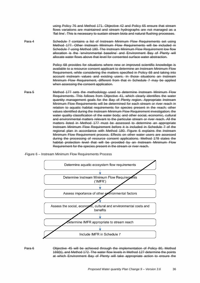
Proposed Water quantity Plan Change 9 – Version 3.6 36
using Policy 76 and Method 171. Objective 42 and Policy 65 ensure that stream flows variations are maintained and stream hydrographs are not managed as a ‘flat line’. This is necessary to sustain stream biota and natural flushing processes.
Para 4 Schedule 7 contains a list of Instream Minimum Flow Requirements set using Method 177. Other Instream Minimum Flow Requirements will be included in Schedule 7 using Method 180. The Instream Minimum Flow Requirement low flow allocation is the ‘environmental baseline’ and Environment Bay of Plenty will allocate water flows above that level for consented surface water abstraction.
Policy 68 provides for situations where new or improved scientific knowledge is available to a resource consent applicant to determine an Instream Minimum Flow Requirement, while considering the matters specified in Policy 68 and taking into account instream values and existing users. In those situations an Instream Minimum Flow Requirement, different from that in Schedule 7 may be applied when assessing the consent application.
Para 5 Method 177 sets the methodology used to determine Instream Minimum Flow Requirements. This follows from Objective 41, which clearly identifies the water quantity management goals for the Bay of Plenty region. Appropriate Instream Minimum Flow Requirements will be determined for each stream or river reach in relation to aquatic habitat requirements for species present in the reach; other values identified during the Instream Minimum Flow Requirement investigation; the water quality classification of the water body; and other social, economic, cultural and environmental matters relevant to the particular stream or river reach. All the matters listed in Method 177 must be assessed to determine an appropriate Instream Minimum Flow Requirement before it is included in Schedule 7 of the regional plan in accordance with Method 180. Figure 6 explains the Instream Minimum Flow Requirement process. Effects on other water users are assessed during the processing of resource consent applications. Method 178 states the habitat protection level that will be provided by an Instream Minimum Flow Requirement for the species present in the stream or river reach.
Figure 6 – Instream Minimum Flow Requirements Process
Para 6 Objective 45 will be achieved through the implementation of Policy 80, Method 169(b), and Method 172. The water flow levels in Method 127 determine the points at which Environment Bay of Plenty will take appropriate action to ensure the
37
Instream Minimum Flow Requirement is not breached as a result of abstractions. The type of actions that will be considered are also listed in Method 172.
Para 7 Policy 71 and Method 166 provide guidance to the community on water allocation. It is not appropriate or economically efficient to specify priority allocation uses in particular catchments as the dominant use may change over the life of the regional plan due to market forces or landowner choice.
Para 8 Policy 77 identifies that water is scarce in some catchments, particularly those under existing abstraction pressure or where water is naturally in low volume, and consideration of this matter should be made before investment is undertaken in major developments that require large amounts of water.
Para 9 Policy 73 and Method 168 are consistent with section 7(b) of the Act. Method 168 provides guidance to the community on how the efficiency of water use will be assessed as part of a resource consent application, and lists the matters relevant to different types of water use activities. Efficient water uses are subject to the water allocation regimes established in Policies 66 and 67 (surface water), and Policy 70 (groundwater). Resource users should not expect to be able to abstract the maximum consented water take during drought events when measures in Method 172 are enacted. Efficient use of water will also be achieved through the implementation of Methods 157, 158, 160, 161, 162, 164 and 170.


Region-wide Water Quantity - Proposed Plan Change 9 – Version 3.8 39
Part III WQ: Water Quantity
9.6 Take and Use of Water
Advisory Advice Note:
1 Section 14(3)(e) of the Act allows the take and use of water for fire-fighting purposes. This applies to surface water, groundwater, geothermal and coastal water.
2 Section 14(3)(b) of the Act allows the take and use of freshwater (this excludes geothermal water [greater than 30º Celsius] and coastal water) for:
(a) An individual's reasonable domestic needs,
(b) The reasonable needs of an individual's animals for drinking water, providing the take or use does not, or is not likely to, have an adverse effect on the environment. Adverse effects include, but are not limited to, effects on other persons, abstraction (either singularly or cumulative takes within the stream) at a rate or volume that cause the water flow to fall below the instream minimum flow requirement (including the default instream minimum flow requirement).
People taking and using water may take a reasonable volume of water for the purposes of (a) and/or (b) above, plus an additional volume permitted by Rule 38 WQ R1 or R2 (groundwater) or Rule 41 WQ R3 (surface water).
3 Unless otherwise specified all clauses apply within each rule.
Rule 38 Permitted Activity – Take and Use of Groundwater WQ R1
The take and use of groundwater with a temperature of less than 30o Celsius,
where the quantity of water does not exceed 35 cubic metres per day per property, is a permitted activity.
In addition to any take under section 14(3)(b) of the Act, the take and use of groundwater with a temperature of less than 30º Celsius, where the property size is less than 5 hectares and the quantity of water taken does not exceed 15 cubic metres per day per property, is a Permitted Activity subject to the following conditions:
(a) The take and use is registered with the Bay of Plenty Regional Council within one year of the plan becoming operative, or for new takes prior to the commencement with the following information:
(i) Location of the take;
(ii) General purpose for which the water is being used or is proposed to be used;
(iii) Confirmation that conditions (b) to (e) below can be met;
(iv) Whether the take provides for stock or domestic drinking requirements; and
(v) Name, address and contact details of person responsible for the take and use.
(b) The rate of take does not exceed 2.5 litres per second.
(c) No additional water is taken under WQ R3.
40 Region-wide Water Quantity - Proposed Plan Change 9 – Version 3.8
(d) The take is not from water resource that is fully allocated at the time the take first commences, unless the take was established prior to 18 October 2016.
(e) Where the quantity of water taken under this rule, in combination with stock drinking water taken under section 14(3)(b) of the Act exceeds 15
cubic
metres per day, water meters must be installed to separately record stock drinking water and all other water taken. Records are to be provided to Bay of Plenty Regional Council in an electronic format on a monthly basis within 28 days following the end of each month.
Advice Note: This rule requires the metering and reporting of stock drinking water where the volume used, in combination with any permitted uses on the property, exceeds the permitted activity limit. Stock drinking water is provided for in addition to the permitted activity volume. The purpose of metering and reporting is to assist with water accounts, to encourage efficiency by providing information about water use and to ensure that the volume is reasonable, as required by the Act.
Explanation/Intent of Rule
To allow minor takes of groundwater for any purpose that are unlikely to have adverse effects on the environment, and to prevent a proliferation of small takes on a single property that may have significant cumulative effects on a groundwater system. This rule allows the take of water for the supply of the persons for their reasonable domestic needs and the needs of their animals. A greater volume is permitted for groundwater takes than for surface water takes (refer to Rule 41) to encourage people to use groundwater, and reduce abstraction pressure on surface water bodies (particularly small streams)
WQ R2 Permitted Activity – Take and Use of Groundwater
In addition to take under section 14(3)(b) of the Act, the take and use of groundwater with a temperature of less than 30º Celsius, where the property size is equal or greater than 5 hectares and the quantity of water taken does not exceed 35 cubic metres per day per property, is a Permitted Activity subject to the following conditions:
(a) The take and use is registered with Bay of Plenty Regional Council within one year of this regional plan becoming operative, or for new takes prior to their commencement, and the following information is provided to Council:
(i) Location of the take;
(ii) General purpose for which the water is being used or is proposed to be used;
(iii) Confirmation that conditions (b) to (e) below can be met;
(iv) Whether the take provides for stock or domestic drinking requirements; and
(v) Name, address and contact details of person responsible for the take and use.
(b) The rate of take does not exceed 2.5 litres per second.
(c) No additional water is taken under WQ R1 or WQ R3.
(d) The take is not from a water resource that is fully allocated at the time the take first commences, unless the take was established prior to 18 October 2016.
(e) Where the quantity of water taken under this rule, in combination with stock drinking water taken under section 14(3)(b) of the Act, exceeds 35 cubic metres per day, water meters must be installed to separately record stock

Region-wide Water Quantity - Proposed Plan Change 9 – Version 3.8 41
drinking water and all other water taken. Records are to be provided to Bay of Plenty Regional Council in an electronic format on a monthly basis within 28 days following the end of each month.
Advice Note: This rule requires the metering and reporting of stock drinking water where the volume used, in combination with any permitted uses on the property, exceeds the permitted activity limit. Stock drinking water is provided for in addition to the permitted activity volume. The purpose of metering and reporting is to assist with water accounts, to encourage efficiency by providing information about water use and to ensure that the volume is reasonable, as required by the Act.
Explanation/Intent of Rule
To allow minor takes of groundwater for any purpose that are unlikely to have adverse effects on the environment, and to prevent a proliferation of small takes on a single property that may have significant cumulative effects on a groundwater system. This rule allows the take of water for the supply of the persons for their reasonable domestic needs and the needs of their animals. A greater volume is permitted for groundwater takes than for surface water takes (refer to Rule 41) to encourage people to use groundwater, and reduce abstraction pressure on surface water bodies (particularly small streams).
Rules 39-40B [are not relevant for this Plan Change and will be shifted under a new heading Groundwater Bores and Flooding Conditions].
Rule 41 Permitted Activity – Take and Use of Surface Water WQ R3
In addition to any take under section 14(3)(b) of the Act, the take and use of water from any surface water body for any purpose, where the water has a temperature of less than 30º Celsius, and the quantity taken does not exceed 15 cubic metres per day per property is a Permitted Activity subject to the following conditions:
(a) The take of water shall not be from a wetland.
(b) The quantity of water taken shall not exceed 15 cubic metres per day per property.
(c) Where the take is from a river or stream, the rate of abstraction shall not exceed 2.5 litres per second or 10% of the estimated five year low flow (Q5 7 day low flow) at the point of abstraction whichever is the lesser.
(d) Where the take is from a river or stream, the total abstraction (all users) of surface water takes shall not exceed the instream minimum flow requirement (including the default instream minimum flow requirement) for the river or stream at any point.
(e) The intake structure shall be screened with a mesh aperture size:
(i) Not exceeding three (3) millimetres by 30 millimetres in the tidal areas of rivers and streams.
(ii) Not exceeding five (5) millimetres by 30 millimetres or five (5) mm diameter holes in any other area that is not in the tidal area of a river or stream.
(f) The intake velocity through the screen shall not exceed 0.3 metres per second.
(a) The take and use is registered with the Bay of Plenty Regional Council within one year of this regional plan becoming operative, or for new takes, prior to their commencement and the following information is provided to Council:
(i) Location of take;
42 Region-wide Water Quantity - Proposed Plan Change 9 – Version 3.8
(ii) General purpose for which water is being used;
(iii) Confirmation that requirements (b) to (g) can be met;
(iv) Whether the take also provides for stock or domestic drinking requirements; and
(v) Name, address and contact details of person responsible for the take and use.
(b) Where the quantity of water taken under this rule, in combination with stock drinking water taken under section 14(3)(b) of the Act exceeds 15 cubic metres per day per property, water meters must be installed to separately record stock drinking water and all other water taken. Records are to be provided to Bay of Plenty Regional Council in an electronic format on a monthly basis within 28 days following the end of each month.
(c) The rate of take does not exceed 2.5 litres per second.
(d) No additional water is taken under WQ R1 or WQ R2.
(e) The take is not from a water resource that is fully allocated at the time the take is established, unless the take was established prior to 18 October 2016.
(f) The take is not from a wetland or waters draining into a wetland.
(g) The intake velocity through the screen shall not exceed 0.3 meters per second.
(h) Where the take is from a river or stream, the total abstraction (all users) of surface water takes shall not exceed the interim instream flow at any point.
Advisory Advice Note:
1 Potential water abstractors are encouraged to seek the advice of Environment Bay of Plenty Regional Council to ensure that there is sufficient flow in a water body to accommodate their water take and comply with condition (d) (e). This is particularly relevant for small streams. Environment Bay of Plenty Regional Council will take appropriate action when flows fall below the instream minimum flow. requirement.
2 Surface water intake structures for the take and use of water under this rule must also be authorised (refer to Rule 52).
3 This rule requires the metering and reporting of stock drinking water where the volume used, in combination with any permitted uses on the property exceeds the permitted activity limit. Stock drinking water is provided for in addition to the permitted activity volume. The purpose of metering and reporting is to assist with water accounts, to encourage efficiency by providing information about water use and to ensure that the volume is reasonable, as required by the Act.
Explanation/Intent of Rule
To allow small takes of water from rivers, streams, lakes and other surface water bodies excluding wetlands which are unlikely to cause adverse environmental effects. Conditions (c) and (d) are to avoid adverse effects on small streams, which are particularly sensitive to abstraction pressure. 15 m
3 cubic metres per
day is a reasonable amount for small uses, such as dairy shed wash-down and milk cooling for small dairy sheds, small glasshouse operations, horticultural spray makeup, or irrigation of gardens (up to approximately 0.5 hectares). Condition (b) is to prevent a proliferation of small takes on a single property, which may have significant cumulative effects on streams and rivers. Intake velocity and screening conditions are to prevent adverse effects on aquatic life.
Region-wide Water Quantity - Proposed Plan Change 9 – Version 3.8 43
This rule allows the take of water for the supply of the persons for their reasonable domestic needs and the needs of their animals.
Rule 41A Controlled – Take and Use of Surface Water within Allocation Regime
The take and use of surface water or groundwater that:
1 Is not permitted by a rule in this regional plan, and
2 Is not prohibited by Rule 49, and
3 Complies with the low flow allocation specified in Policy 66 and where an instream minimum flow requirement has been established in Schedule 7 for the stream or river reach, and
4 Does not have an adverse effect on downstream water users.
Is a controlled activity.
Environment Bay of Plenty reserves its control over the following matters:
(a) Volume and rate of water take.
(b) Measures to achieve the efficient use of water.
(c) Measures to restrict the water take during low flow or drought events.
(d) Measures to avoid, remedy or mitigate adverse effects on downstream water users.
(e) Requirements to temporarily stop water takes to enable Environment Bay of Plenty water flow monitoring.
(f) Monitoring requirements.
Explanation/Intent of Rule
To provide for the take and use of water where the activity complies with Policy 66(a), and Policy 67. Matters of which Environment Bay of Plenty retains control are those relevant to effects on water flows and administrative issues. The take and use of surface water that does not meet the conditions of Rule 41A is a discretionary activity under Rule 43.
WQ R4 Controlled Activity – Take and Use of Water for Existing Dairy Shed Wash Down and Milk Cooling Purposes
The take and use of surface water and/or groundwater for the purposes of dairy shed washdown and milk cooling is a Controlled Activity that does not require notification, subject to the following:
1 The take and use is not permitted by a rule in this regional plan.
2 The take and use is not prohibited by Rule 49.
3 A resource consent application is lodged within 12 months of this rule becoming operative.
4 The application information contains verifiable evidence of the existence of the take at the time of notification of this plan change, including but not limited to:
(i) Any consent to discharge dairy shed effluent; and
(ii) Evidence of the presence of a water pump on the property
and the volume and rate is proven to be the same or less than that occurring as at 18 October 2016.

44 Region-wide Water Quantity - Proposed Plan Change 9 – Version 3.8
Bay of Plenty Regional Council reserves its control over the following matters:
(a) Rate and volume of take.
(b) Measures to restrict or stop the take during periods of low flow or to enable flow monitoring by Council.
(c) Metering and reporting requirements, including separate metering of any water taken under provisions of section 14(3)(b) of the Act.
(d) Measures to achieve efficient use of water.
Advice Note:
1 This rule does not enable an additional volume to be added to an existing resource consent or permitted activity relating to the take and use of water on the same property.
2 No pump testing or ecological assessment is required.
3 The rate of take maybe reduced to the minimum required to achieve the daily volume. Storage maybe needed to enable higher rates of use.
4 Efficient use of water is 55 litres per cow per day.
WQ R5 Controlled Activity – Take and Use of Groundwater
The take and use of groundwater is a Controlled Activity that does not require
notification, subject to the following:
1 The total daily volume of take does not exceed 35 cubic metres per
property.
2 The take and use is not permitted by a rule in this regional plan.
3 The take and use is not prohibited by Rule 49.
4 A resource consent application is lodged within 12 months of this rule
becoming operative.
5 The application incudes verifiable evidence of the existence of the take as at
18 October 2016, including but not limited to:
(i) Any resource consent to discharge the volume of water sought; and
(ii) Evidence of the presence of a water pump on the property
and the volume and rate is proven to be the same or less than that
occurring as at 18 October 2016.
Bay of Plenty Regional Council reserves its control over the following matters:
(a) Rate and volume of take.
(b) Measures to restrict or stop the take to enable monitoring by Council.
(c) The restriction or cessation of the takes at times of low aquifer levels.
(d) Metering and reporting requirements, including separate metering of any
water taken under provisions of section 14(3)(b) of the Act.
(e) Measures to achieve the efficient use of water.

Region-wide Water Quantity - Proposed Plan Change 9 – Version 3.8 45
Advice Note:
1 This rule does not enable an additional volume to be added to an existing
resource consent or permitted activity relating to the take and use of water
on the same property.
2 No pump testing or ecological assessment is required.
WQ R6 Controlled Activity – Take and Use of Water for Existing Municipal Water Supplies
The taking and use of water for a municipal water supply is a Controlled Activity, providing that the application:
1 Relates to an existing take authorised by a resource consent as of 18 October 2016.
2 Retains the same or lessor rate and volume of water authorised by a resource consent as of 18 October 2016.
3 Is subject to a Water Management Plan, which meets the requirements outlined in Schedule 7.
Bay of Plenty Regional Council reserves its control over the following matters:
(a) All issues contained in the municipal water supplies component of Schedule 7 - Reasonable and efficient use criteria.
(b) The rate and volume of water to be taken.
(c) The restriction or cessation of the take when minimum flow or minimum aquifer levels are reached.
(d) Measures to avoid, remedy or mitigate any adverse effects on:
(i) River and stream flows (including effects on flow variability and duration) or aquifer water levels;
(ii) The mauri and life-supporting capacity of the water body; and
(iii) Life-supporting capacity, ecological integrity, landscape values, recreational values, existing uses and tāngata whenua values.
(e) The availability and reliability of supply for existing users and water quality.
(f) Water measurement, monitoring and reporting requirements.
(g) The extent to which the applicant has consulted with Māori and taken into account Māori values.
Advice Note: Tāngata whenua values include those of the owners of Māori owned land, if the water source is on such land.
WQ R7 Permitted Activity – Temporary Transfer of Water Permits to Take and Use Water
The transfer of a resource consent to take or to use surface water, in whole or part, on a temporary basis, to another site is a Permitted Activity subject to the following conditions:
(a) The transferor and transferee are part of the same Water User Group.
(b) The transfer is within the same catchment to any point downstream (excluding downstream tributaries) of the location to which the permit applies.

46 Region-wide Water Quantity - Proposed Plan Change 9 – Version 3.8
Written notice signed by the transferor and transferee is given to the Bay of
Plenty Regional Council five working days prior to the transfer specifying:
(i) Full names and addresses of transferor and transferee;
(ii) If the whole resource consent is not being transferred, the portion of the consent being transferred;
(iii) Proposed daily volume (cubic metres per day) and rate (litres per second) of take at both sites;
(iv) The number of the consent to be transferred and the number of the use consent, if required, held by each party;
(v) The location of new take and use site (shown on a map or identified by NZMS map reference);
(vi) The date of transfer;
(vii) Description of purpose for which water is to be used; and
(viii) The date on which the transfer ceases.
(c) The resource consent shall retain the same conditions (excluding location).
(d) In the case of transfers of more than five days per annum, all parties to the
transfer shall have metering and reporting at the appropriate recording and
reporting level as defined in WQ M7.
Advice Note: The transferee is required to have any necessary resource consent to use the water transferred.
WQ R8 Controlled Activity – Transfer of Water Permits to Take and Use Water
The transfer of a resource consent to take or to use water, in whole or part, to another site, is a Controlled Activity where the transfer:
1 Is within the same catchment or groundwater aquifer as the original consent.
2 Is not from downstream to upstream of an existing hydroelectric power scheme, where the transfer relates to surface water.
3 Is for the same or lessor rate and volume of take.
4 Does not increase the total rate of take, where the transfer relates to surface water.
5 Does not affect any lawfully established takes.
6 Is not to a water resource that is over-allocated, or will not cause the water resource to become over allocated.
7 Will not result in a greater total volume of water actually being abstracted from an aquifer, where the transfer relates to groundwater.
Bay of Plenty Regional Council restricts its control to the following matters:
(a) Location, volume and rate of take.
(b) The nature and/or duration of the transfer – whole or partial/short term or permanent, including having regard to any seasonal restrictions that may be necessary.
(c) The appropriateness of existing conditions to avoid or mitigate effects of the transfer to the new site including conditions on minimum flows and annual volumes.

Region-wide Water Quantity - Proposed Plan Change 9 – Version 3.8 47
(d) The need for conditions preventing concurrent taking where there is a partial transfer or the transfer is to two or more points of take.
(e) The need for conditions relating to water measurement and reporting, including telemetry requirements.
(f) The potential effect of the transfer on existing users; on springs or surface water bodies and their values (including water quality); and on tangata whenua values.
Advisory Advice Note: Tāngata whenua values include those of the owners of Māori land, if the water source is on such land.
WQ R9 Restricted Discretionary Activity – Transfer of Water Permits to Take and Use Water
The transfer of a resource consent to take or to use water, in whole or part, temporary or permanent, to another site, where the transfer is within the same catchment or groundwater aquifer and does not meet one or more of the conditions of WQ R8 is a Restricted Discretionary Activity.
Bay of Plenty Regional Council reserves its discretion over the following matters:
(a) Location, volume and rate of take.
(b) The nature and/or duration of the transfer – whole or partial/short term or permanent, including having regard to any seasonal restrictions that may be necessary.
(c) The appropriateness of existing conditions to avoid or mitigate effects of the transfer to the new site including conditions on minimum flow and annual volumes.
(d) The need for conditions preventing concurrent taking where there is a partial transfer or the transfer is to two or more points of take.
(e) The need for conditions relating to water measurement and reporting, including telemetry requirements.
(f) The potential effect of the transfer on:
(i) Other users;
(ii) Springs, connected groundwater aquifers or surface water bodies; and
(iii) Tāngata whenua values.
(g) Where surface water and/or groundwater allocation exceeds the relevant limits for the catchment, whether a reduction in the rate or volume of take may be required to assist with phasing out that exceedance.
Advisory Advice Note: Reductions in the rate or volume of take to assist in phasing out over-allocation will be considered in over-allocated resources and may result in the transferred rate or volume being reduced.
Tāngata whenua values include those of the owners of Māori land, if the water source is on such land.
Rule 42 [This Rule is not part of the plan change and will be shifted under a new heading].
WQ R10 Restricted Discretionary Activity – Take and Use of Water
The take and use of surface water or groundwater is a Restricted Discretionary Activity where:

48 Region-wide Water Quantity - Proposed Plan Change 9 – Version 3.8
1 The take will not result in the interim limits set out in WQ P5 being exceeded.
2 The take and use is not permitted by a rule in this regional plan.
3 The take and use is not prohibited by Rule 49.
4 A water meter is installed.
Bay of Plenty Regional Council reserves its discretion over the following matters:
(a) Location, rate and volume of take.
(b) Measures to restrict or stop the take during periods of low flow or aquifer levels.
(c) Metering and reporting requirements, including separate metering of any water taken under provisions of section 14(3)(b) of the Act.
(d) Measures to achieve reasonable and efficient use of water.
(e) Measures to avoid, or mitigate to an acceptable level, adverse localised effects on the surface water or groundwater resource and adverse effects on existing authorised groundwater abstractors.
(f) The potential effect of the take on existing authorised users; on springs or
surface water bodies and their values (including water quality); and on
tāngata whenua values.
Advice Note: Information on the assessment of the limits and current allocation status is available at Bay of Plenty Regional Council’s offices and on its website.
Rule 43 Discretionary Activity – Take and Use of Water WQ R11
The take and use of surface water or groundwater that:
1 Is not a Permitted, Controlled or Restricted Discretionary Activity by under a rule in this regional plan; and
2 Is not a controlled activity under a rule in this regional plan, and,
2 Is not prohibited by Rule 49
is a discretionary activity.
In relation to this rule, Environment Bay of Plenty Regional Council may review resource consents for the take and use of surface water where the total volume of water authorised to be taken from a stream or river reach is greater than that provided for in the low flow allocation specified in Policy 66 WQ P5. and an Instream Minimum Flow Requirement for the stream or river reach has been specified in Schedule 7.
Explanation/Intent of Rule
To allow Environment Bay of Plenty Regional Council to assess the effects of water takes on the environment on a case by case basis according to the objectives, policies and methods in Section 5.1 Part II WQ of this regional plan. This rule includes, but is not limited to municipal water supply, irrigation, non-consumptive use by human activities, and other uses.
Assessment Criteria
When assessing resource consent applications under this rule, Environment Bay of Plenty Regional Council will have particular regard to, but not be limited to, the following provisions as appropriate to the source of the proposed water take:

Region-wide Water Quantity - Proposed Plan Change 9 – Version 3.8 49
Objective 4, 5, 6, 8, 36, 39, 41, 42, 43, 45 Policy 5, 11, 14, 15, 17, 18, 19, 20, 21, 66, 69, 70, 71, 72, 73, 79, 80
Method 13, 17, 18, 20, 21, 56, 60, 66, 67, 169, 170, 172, Schedule 7 Other matters relevant to existing water takes: (a) Investment in existing infrastructure for the activity. (b) Site characteristics. (c) Statistical variations on water flow data. (d) Adverse effects of the activity on the matters listed in Method 169. (e) Adverse effects on existing users of the surface water body.
Other matters relevant to new water takes: (a) Site characteristics. (b) Statistical variations in water flow data. (c) Adverse effects of the activity on the matters listed in Method 169. (d) Adverse effects on existing users of the surface water body.


1 December 2008 Bay of Plenty Regional Water and Land Plan Water Quantity and Allocation (updated 18 October 2016)
Region-wide Water Quantity - Proposed Plan Change 9 – Version 3.8 51
Definition of Terms
Plan change 9 introduces new definitions for the following:
Crop and rootstock survival water - Water provided for the survival of crop or root stock intended
for human consumption. This includes permanent horticultural crops (e.g. kiwifruit, avocado,
stonefruit, pipfruit) and hydroponic glasshouse crops and excludes pasture species, animal fodder
crops and maize.
Instream Minimum Flow Requirement – the flow of water in a river or stream necessary to sustain aquatic life, water quality, recreational use, outstanding natural features or Maori cultural values.
Municipal water supply - A reticulated water supply provided by a territorial authority primarily to meet domestic, drinking water and public health requirements. The supply may include industrial commercial and irrigation supplies.
The following definitions are from the Regional Policy Statement and are provided for information purposes only. They are not part of the plan change.
Efficient allocation – In relation to freshwater allocation, including economic, technical and dynamic efficiency.
Efficient use – In relation to the use of freshwater, the amount of water beneficially used in relation to that taken. It relates to the performance of a water-use system, including avoiding water wastage.
Instream minimum flows – The flow of water in a river or stream necessary to sustain aquatic life, water quality, recreational use, outstanding natural features or Māori cultural values.
Kaumātua – Elder.
Mauri – The essential life force, energy or principle that tāngata whenua believe exists in all things in the natural
world, including people. Tāngata whenua believe it is the vital essence or life force by which all things cohere in
nature. When Mauri is absent there is no life. When Mauri is degraded, or absent, tāngata whenua believe this
can mean that they have been remiss in their kaitiakitanga responsibilities and this affects their relationship with the atua (Māori gods). Mauri can also be imbued within manmade or physical objects.
Pūkenga – Tāngata whenua persons acknowledged by their iwi, hapū or whānau as having the appropriate
knowledge, expertise and genealogical linkages to allow them to assist kaitiaki to determine and express the group’s relationships and their culture and traditions with their ancestral lands, water, waahi tapu, special sites and other taonga.
Tikanga Māori – Māori customary values and practices.


1 December 2008 Bay of Plenty Regional Water and Land Plan Water Quantity and Allocation (updated 18 October 2016)
Region-wide Water Quantity - Proposed Plan Change 9 – Version 3.8 53
Replace “Schedule 7 - Instream Minimum Flow Requirement” with “Schedule 7 - Reasonable and efficient use criteria”.
Schedule 7 – Instream Minimum Flow Requirements
River or Stream Stream Reach Instream Minimum Flow Requirement
Waitahanui Stream From confluence with Whakahaupapa Stream to stream mouth
3.8 m3/s
Schedule 7 – Reasonable and Efficient Use Criteria
Irrigation
Use of a field validated model that considers land use, crop water use requirements, on site physical factors such as soil water holding capacity, and climatic factors such as rainfall variability and potential evapo-transpiration. The model must reliably predict annual irrigation volume within an accuracy of 15%.
The annual volume calculated using the model shall meet with the following criteria:
(a) An irrigation application efficiency of 80%, and
(b) Demand conditions that occur in nine out of 10 years.
Municipal water supplies
The Water Management Plan shall establish a long term strategy for the water requirements of domestic or municipal suppliers and their communities. It shall demonstrate that the volume of water required, including any increase over that previously authorised, has been justified and that the water take will be used efficiently and effectively. A Water Management Plan is required whether the application is for the renewal of an existing take, or a new application. To this end the Water Management Plan shall, to an extent which is appropriate for the scale of the activity, provide the following information:
1 A description of the water supply system including system operation, distribution extent, levels of service, water use measurement, maintenance and asset management procedures.
2 A comprehensive assessment of existing and future demands for water with regard to an assessment of reasonable population growth within the planning horizon to meet the following:
a) Reasonable domestic needs.
b) Public health needs in accordance with requirements under any Act of Parliament or regulation.
c) Reasonable community needs (e.g. for public amenities).

54 Region-wide Water Quantity - Proposed Plan Change 9 – Version 3.8
d) Reasonable commercial, rural supply and industrial needs.
e) An assessment as to how each of the assessments required by clauses a) to d) above is predicted to vary over time.
f) A justification for each of the assessments required by clauses a) to e) above including reference to any relevant planning instruments promulgated under the Resource Management Act 1991 that provide for future growth or relevant documents promulgated under the Local Government Act 2002 such as long term plans, growth strategies or spatial plans.
3 Any existing or proposed water pricing procedures, including the extent of metering of individual customers and any linkages with wastewater pricing or management.
4 How water reticulation networks are planned and managed to minimise their water losses as far as practicable.
5 A description of patterns of water use practices and/or behaviour in all sectors of use (and distribution) with the objective of maximising water use efficiency and reducing water use, as far as practicable.
6 Water saving targets for the full range of demand conditions including demand saving targets for council owned facilities, domestic demand targets and demand saving targets for commercial and industrial customers.
7 Key performance indicators for each of the water saving targets.
8 Any external auditing and benchmarking procedures that have been adopted.
9 A drought management plan that includes:
(i) Steps to be taken to reduce consumption during water shortage conditions, including ensuring that uses not identified as priorities in Policy 80B are restricted to a similar extent to which that that use would be restricted if it was not part of the municipal supply network.
(ii) Public and commercial user education programmes.
(iii) steps taken to reduce consumption when demand is approaching the maximum take volume specified under the relevant resource consent.
(iv) Enforcement procedures.
10 Actions, performance measures and a timeline for implementing actions. The actions and performance measures identified will depend on the circumstances of each applicant.
11 Any consultation undertaken with key stakeholders and outcomes of such consultation.
12 Details of an appropriate water conservation and demand management plan review process.
13 Identification of any anticipated increases in water demand over the term of the consent and ability to stage water take volumes to more closely reflect demand requirements over time.
14 Ability to reduce the amount of water used by existing industrial and agricultural users, as a result of improvements in the efficiency of the use of water, in order to meet any increase in water demand over the term of the consent.
15 Identification of any single industrial, commercial or agricultural use of water that uses more than 15 cubic metres of water per day (not being water used for human drinking or human sanitation purposes).
16 Identification of future domestic or municipal supply take needs over and above that already authorised.
17 Domestic or municipal supply takes required to meet growth and development that is provided for in planning instruments promulgated under the Resource Management Act 1991 or relevant documents promulgated under the Local Government Act 2002, such as Long Term Plans, growth strategies or spatial plans (or similar).
18 The projected future needs shall be identified in terms of:

Region-wide Water Quantity - Proposed Plan Change 9 – Version 3.8 55
(a) Location of take; and
(b) Volume of take (including any seasonal variations); and
(c) The date at which the water is likely to be required.
Other Uses
The amount calculated in accordance with good management practices for efficient use of water in relation to that use or by demonstrating that water is not being wasted, such as by means of a water use audit by an independent party to identify any wastage and any opportunities for re-use or conservation.