regional development proposal 78.1 - west... · this proposal sets out the high conservation values...
TRANSCRIPT
WWWESTESTEST WWWELLINGTONELLINGTONELLINGTON
Regional Development Regional Development Regional Development ProposalProposalProposal
West Wellington Protection Group March 2012
West Wellington Regional
Development Proposal
Contents
Executive Summary … … … … … 3
Introduction … … … … … … 4
High Conservation Values of West Wellington … … ... 6
Flora … … … … … ... 6
Regeneration … … … … … 7
Fauna … … … … … … 7
Wellington Park … ... … … … 8
Water Catchment ... … … … … 10
Visibility … … … … … … 11
Tourism Potential … … … … … 12
Communities … … … … … 13
Heritage … … … … … … 14
Tourism Proposal … … … … … 14
The Wellington Trail … … … … … 14
Mountain Biking … … … … … 15
Other Tourism Possibilities … … … … 16
Tourism Development Needs … … … … 16
Benefits .. … … … … … 17
Conclusion … … … … … … 18
Page 2 of 18
West Wellington Regional
Development Proposal
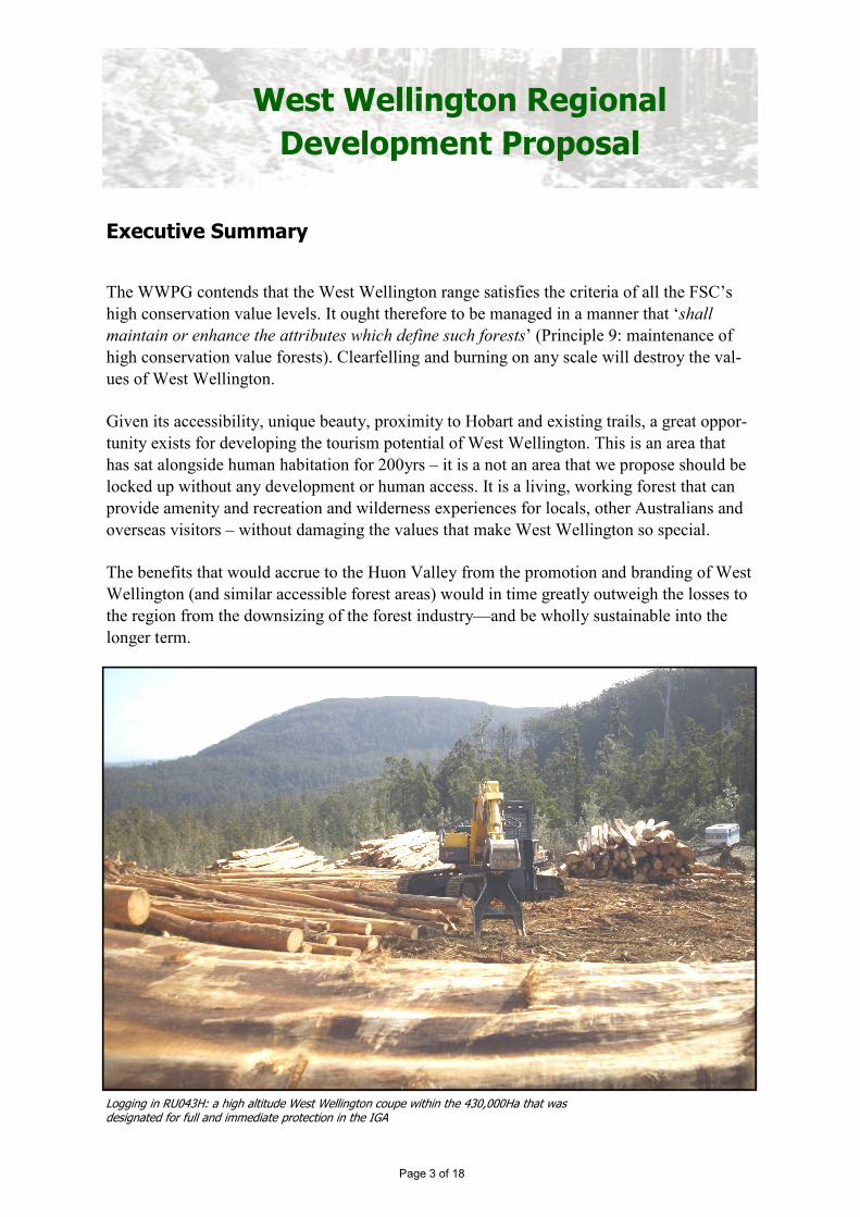
Executive Summary
The WWPG contends that the West Wellington range satisfies the criteria of all the FSC’s
high conservation value levels. It ought therefore to be managed in a manner that ‘shall
maintain or enhance the attributes which define such forests’ (Principle 9: maintenance of
high conservation value forests). Clearfelling and burning on any scale will destroy the val-
ues of West Wellington.
Given its accessibility, unique beauty, proximity to Hobart and existing trails, a great oppor-
tunity exists for developing the tourism potential of West Wellington. This is an area that
has sat alongside human habitation for 200yrs – it is a not an area that we propose should be
locked up without any development or human access. It is a living, working forest that can
provide amenity and recreation and wilderness experiences for locals, other Australians and
overseas visitors – without damaging the values that make West Wellington so special.
The benefits that would accrue to the Huon Valley from the promotion and branding of West
Wellington (and similar accessible forest areas) would in time greatly outweigh the losses to
the region from the downsizing of the forest industry—and be wholly sustainable into the
longer term.
Page 3 of 18
Logging in RU043H: a high altitude West Wellington coupe within the 430,000Ha that was designated for full and immediate protection in the IGA
West Wellington Regional
Development Proposal
1. Introduction
West Wellington is the western-
most stretch of the Wellington
Range, which starts in Hobart
and contains the often snow-
covered peaks of Mount Wel-
lington and Sleeping Beauty.
Whilst much of this range is
protected within Wellington
Park, the high plateau adjoining
the Park on its south-west
boundary is State Forest. Forest-
ry Tasmania (FT) has moved
into this area in the last three
years and has driven a fully-
formed 11km logging road
through from Judbury to Plenty (the Plenty Link Road). A further logging road has been pushed into coupes
directly adjacent to Wellington Park (Judds Link Road). Many more are on the drawing board, including access
roads from Jeffreys Track - a heritage trail between Crabtree and Lachlan.
Aerial photo (from Google Maps) showing location of West Wellington
Coupe map for West Wellington
Page 4 of 18
RU043H (partially clearfelled)
RU43C 80% clear-felled Feb 2011
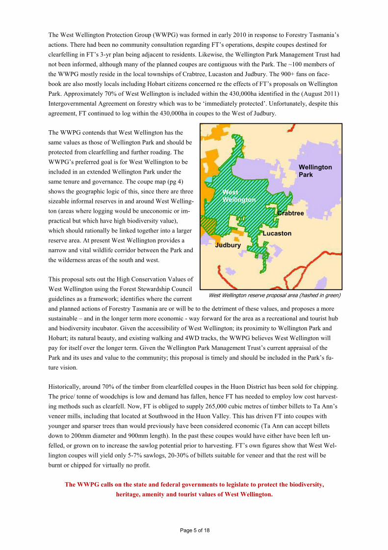
The West Wellington Protection Group (WWPG) was formed in early 2010 in response to Forestry Tasmania’s
actions. There had been no community consultation regarding FT’s operations, despite coupes destined for
clearfelling in FT’s 3-yr plan being adjacent to residents. Likewise, the Wellington Park Management Trust had
not been informed, although many of the planned coupes are contiguous with the Park. The ~100 members of
the WWPG mostly reside in the local townships of Crabtree, Lucaston and Judbury. The 900+ fans on face-
book are also mostly locals including Hobart citizens concerned re the effects of FT’s proposals on Wellington
Park. Approximately 70% of West Wellington is included within the 430,000ha identified in the (August 2011)
Intergovernmental Agreement on forestry which was to be ‘immediately protected’. Unfortunately, despite this
agreement, FT continued to log within the 430,000ha in coupes to the West of Judbury.
The WWPG contends that West Wellington has the
same values as those of Wellington Park and should be
protected from clearfelling and further roading. The
WWPG’s preferred goal is for West Wellington to be
included in an extended Wellington Park under the
same tenure and governance. The coupe map (pg 4)
shows the geographic logic of this, since there are three
sizeable informal reserves in and around West Welling-
ton (areas where logging would be uneconomic or im-
practical but which have high biodiversity value),
which should rationally be linked together into a larger
reserve area. At present West Wellington provides a
narrow and vital wildlife corridor between the Park and
the wilderness areas of the south and west.
This proposal sets out the High Conservation Values of
West Wellington using the Forest Stewardship Council
guidelines as a framework; identifies where the current
and planned actions of Forestry Tasmania are or will be to the detriment of these values, and proposes a more
sustainable – and in the longer term more economic - way forward for the area as a recreational and tourist hub
and biodiversity incubator. Given the accessibility of West Wellington; its proximity to Wellington Park and
Hobart; its natural beauty, and existing walking and 4WD tracks, the WWPG believes West Wellington will
pay for itself over the longer term. Given the Wellington Park Management Trust’s current appraisal of the
Park and its uses and value to the community; this proposal is timely and should be included in the Park’s fu-
ture vision.
Historically, around 70% of the timber from clearfelled coupes in the Huon District has been sold for chipping.
The price/ tonne of woodchips is low and demand has fallen, hence FT has needed to employ low cost harvest-
ing methods such as clearfell. Now, FT is obliged to supply 265,000 cubic metres of timber billets to Ta Ann’s
veneer mills, including that located at Southwood in the Huon Valley. This has driven FT into coupes with
younger and sparser trees than would previously have been considered economic (Ta Ann can accept billets
down to 200mm diameter and 900mm length). In the past these coupes would have either have been left un-
felled, or grown on to increase the sawlog potential prior to harvesting. FT’s own figures show that West Wel-
lington coupes will yield only 5-7% sawlogs, 20-30% of billets suitable for veneer and that the rest will be
burnt or chipped for virtually no profit.
The WWPG calls on the state and federal governments to legislate to protect the biodiversity,
heritage, amenity and tourist values of West Wellington.
Page 5 of 18
West Wellington reserve proposal area (hashed in green)
Wellington Park
Crabtree
Lucaston
Judbury
West Wellington
2. High Conservation Values of West Wellington
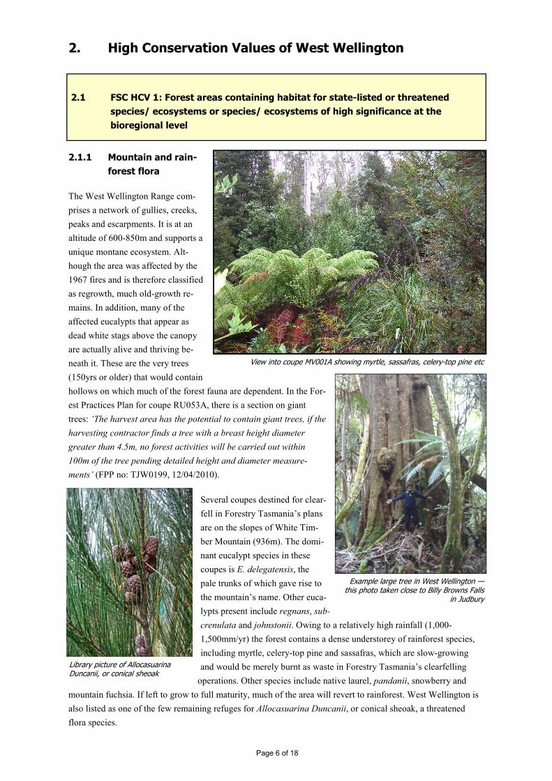
2.1.1 Mountain and rain-
forest flora
The West Wellington Range com-
prises a network of gullies, creeks,
peaks and escarpments. It is at an
altitude of 600-850m and supports a
unique montane ecosystem. Alt-
hough the area was affected by the
1967 fires and is therefore classified
as regrowth, much old-growth re-
mains. In addition, many of the
affected eucalypts that appear as
dead white stags above the canopy
are actually alive and thriving be-
neath it. These are the very trees
(150yrs or older) that would contain
hollows on which much of the forest fauna are dependent. In the For-
est Practices Plan for coupe RU053A, there is a section on giant
trees: ‘The harvest area has the potential to contain giant trees, if the
harvesting contractor finds a tree with a breast height diameter
greater than 4.5m, no forest activities will be carried out within
100m of the tree pending detailed height and diameter measure-
ments’ (FPP no: TJW0199, 12/04/2010).
Several coupes destined for clear-
fell in Forestry Tasmania’s plans
are on the slopes of White Tim-
ber Mountain (936m). The domi-
nant eucalypt species in these
coupes is E. delegatensis, the
pale trunks of which gave rise to
the mountain’s name. Other euca-
lypts present include regnans, sub-
crenulata and johnstonii. Owing to a relatively high rainfall (1,000-
1,500mm/yr) the forest contains a dense understorey of rainforest species,
including myrtle, celery-top pine and sassafras, which are slow-growing
and would be merely burnt as waste in Forestry Tasmania’s clearfelling
operations. Other species include native laurel, pandanii, snowberry and
mountain fuchsia. If left to grow to full maturity, much of the area will revert to rainforest. West Wellington is
also listed as one of the few remaining refuges for Allocasuarina Duncanii, or conical sheoak, a threatened
flora species.
Page 6 of 18
View into coupe MV001A showing myrtle, sassafras, celery-top pine etc
Example large tree in West Wellington — this photo taken close to Billy Browns Falls
in Judbury
Library picture of Allocasuarina Duncanii, or conical sheoak
2.1 FSC HCV 1: Forest areas containing habitat for state-listed or threatened
species/ ecosystems or species/ ecosystems of high significance at the
bioregional level
No formal botanical survey has been carried out by Forestry Tasmania, nor has the impact of clearfelling and
burning on the flora of West Wellington been adequately assessed. FT’s own scientists have criticised the
practice of clearfelling as ecologically damaging, pointing out that clearfelling and regeneration reduces forest
complexity (Grove & Meggs, 2003, p265). The removal of mixed-age trees and their replacement (through
clearfell and sowing) by even-age young trees disturbs fanua that require older and malformed trees for habitat.
2.1.2 Problems with regeneration
Whilst Forestry Tasmania intends to return the area to mixed native forest following clearfelling and burning, it
re-seeds only with eucalypts and relies on other species to regenerate unaided. Many of the minor species will
not have matured sufficiently to set seed and hence may never regenerate. They would certainly never have the
opportunity to grow to maturity under FT’s stated planned regime of 80 yr clearfell rotations in West Welling-
ton. These rainforest species’ seeds are also less tolerant to the intense burning carried out following clearfell.
Given the steepness of most of the coupes in West Wellington it is quite possible that many of the nutrients
required for regeneration will wash into the creeks before regeneration can take place. Coupes in which even
the eucalypts are struggling to regenerate are evident on Jacobsens Road, on the western fringes of West Wel-
lington. Much of West Wellington is exposed and at high altitude. In coupe RU051A for instance, which strad-
dles the watershed between the Upper Judbury and Crabtree catchments, the recoverable trees are relatively
sparse, of small diameter (~200-350mm as measured in surveys by the WWPG) and limited to around 40m in
height. Nonetheless it is the opinion of the Forest Practices Officer who reviewed the coupe, that the trees had
largely escaped the ’67 fires and their stunted size was owing to altitude, exposure and eroded soil. This partic-
ular coupe is slated for partial clearfell under FT’s current 1-year plan. Given the length of time the existing
trees may have taken to reach their current size, regeneration will be slow and unpredictable.
2.1.3 Iconic and endangered fauna
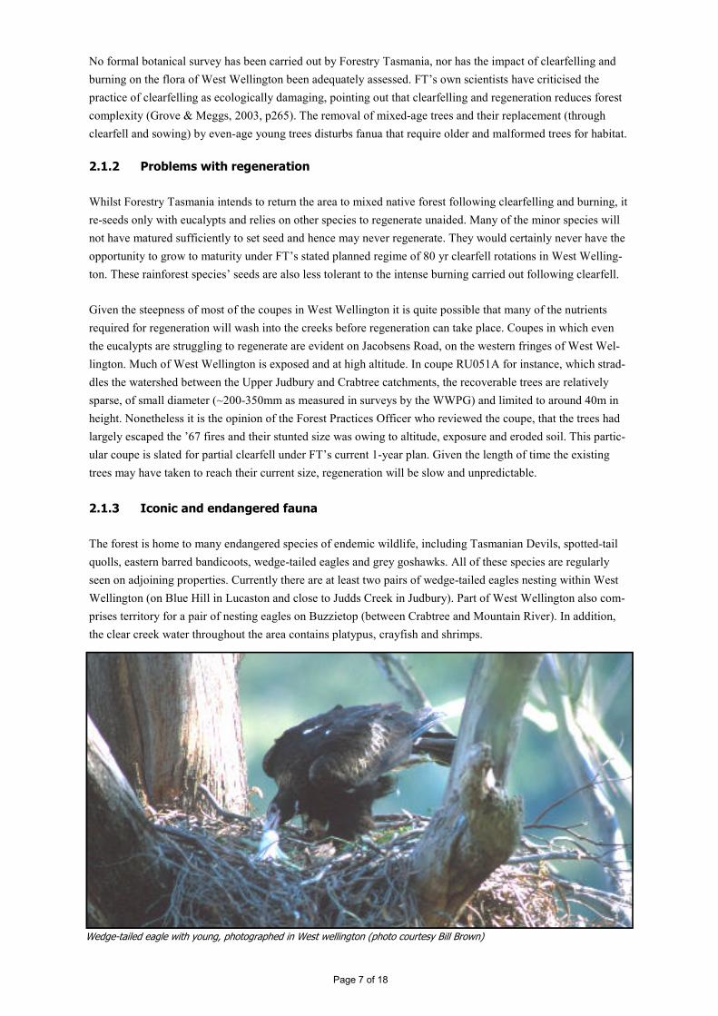
The forest is home to many endangered species of endemic wildlife, including Tasmanian Devils, spotted-tail
quolls, eastern barred bandicoots, wedge-tailed eagles and grey goshawks. All of these species are regularly
seen on adjoining properties. Currently there are at least two pairs of wedge-tailed eagles nesting within West
Wellington (on Blue Hill in Lucaston and close to Judds Creek in Judbury). Part of West Wellington also com-
prises territory for a pair of nesting eagles on Buzzietop (between Crabtree and Mountain River). In addition,
the clear creek water throughout the area contains platypus, crayfish and shrimps.
Wedge-tailed eagle with young, photographed in West wellington (photo courtesy Bill Brown)
Page 7 of 18
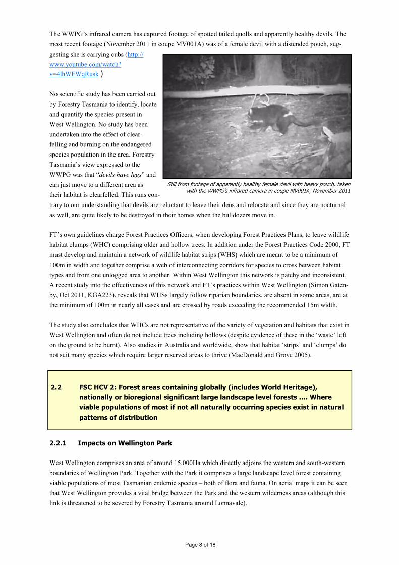
The WWPG’s infrared camera has captured footage of spotted tailed quolls and apparently healthy devils. The
most recent footage (November 2011 in coupe MV001A) was of a female devil with a distended pouch, sug-
gesting she is carrying cubs (http://
www.youtube.com/watch?
v=4lhWFWqRusk )
No scientific study has been carried out
by Forestry Tasmania to identify, locate
and quantify the species present in
West Wellington. No study has been
undertaken into the effect of clear-
felling and burning on the endangered
species population in the area. Forestry
Tasmania’s view expressed to the
WWPG was that “devils have legs” and
can just move to a different area as
their habitat is clearfelled. This runs con-
trary to our understanding that devils are reluctant to leave their dens and relocate and since they are nocturnal
as well, are quite likely to be destroyed in their homes when the bulldozers move in.
FT’s own guidelines charge Forest Practices Officers, when developing Forest Practices Plans, to leave wildlife
habitat clumps (WHC) comprising older and hollow trees. In addition under the Forest Practices Code 2000, FT
must develop and maintain a network of wildlife habitat strips (WHS) which are meant to be a minimum of
100m in width and together comprise a web of interconnecting corridors for species to cross between habitat
types and from one unlogged area to another. Within West Wellington this network is patchy and inconsistent.
A recent study into the effectiveness of this network and FT’s practices within West Wellington (Simon Gaten-
by, Oct 2011, KGA223), reveals that WHSs largely follow riparian boundaries, are absent in some areas, are at
the minimum of 100m in nearly all cases and are crossed by roads exceeding the recommended 15m width.
The study also concludes that WHCs are not representative of the variety of vegetation and habitats that exist in
West Wellington and often do not include trees including hollows (despite evidence of these in the ‘waste’ left
on the ground to be burnt). Also studies in Australia and worldwide, show that habitat ‘strips’ and ‘clumps’ do
not suit many species which require larger reserved areas to thrive (MacDonald and Grove 2005).
2.2.1 Impacts on Wellington Park
West Wellington comprises an area of around 15,000Ha which directly adjoins the western and south-western
boundaries of Wellington Park. Together with the Park it comprises a large landscape level forest containing
viable populations of most Tasmanian endemic species – both of flora and fauna. On aerial maps it can be seen
that West Wellington provides a vital bridge between the Park and the western wilderness areas (although this
link is threatened to be severed by Forestry Tasmania around Lonnavale).
Page 8 of 18
Still from footage of apparently healthy female devil with heavy pouch, taken with the WWPG’s infrared camera in coupe MV001A, November 2011
2.2 FSC HCV 2: Forest areas containing globally (includes World Heritage),
nationally or bioregional significant large landscape level forests …. Where
viable populations of most if not all naturally occurring species exist in natural
patterns of distribution

The Wellington Park Management Trust (WPMT) has expressed grave concerns re the clearfelling plans. Many
of the coupes share a boundary with the Park. Forestry Tasmania did not notify the Trust of their clearfell plans
and when first approached by the WWPG had no intention of leaving a buffer zone between the coupes and the
Park. The WWPG was told only that FT would try to stop felled trees from falling across the boundary into the
Park. Having received objections from the WWPG and the WPMT, FT undertook a study resulting in their pro-
posal that a 90m buffer strip would be left between coupes and the Park. This would help reduce edge effects,
but there will still be risks to the Park and significant landscape and aesthetic impacts such that clearfelled scars
will be easily visible from within the Park and its surrounding areas.
Fire is a major risk for Wellington Park. To date Forestry Tasmania has put for-
ward no satisfactory management plan for how it will ensure fire from its
‘regeneration’ burns cannot escape into the Park. Its only comment to the WWPG
has been that it will “make sure the wind is blowing in the opposite direction”.
Forestry Tasmania’s burn-offs have threatened Mount Field National Park twice
in recent years, causing it to be closed on at least one occasion.
Although Forestry Tasmania’s Forest Practices Plans contain wash-down proce-
dures for vehicles and machinery, it is evident that wherever logging occurs,
weeds such as Californian Thistle follow. Once established in West Wellington
(which is currently weed-free) and hence Wellington Park, it will be impossible
to eradicate. The smallest bit of root is sufficient for Californian Thistle to propa-
gate.
Library picture of Californian Thistle
Page 9 of 18
Aerial map (from Google Maps) from a viewpoint above Huonville, showing West Wellington is an elevated oasis of green linking Wellington Park with the western wilderness
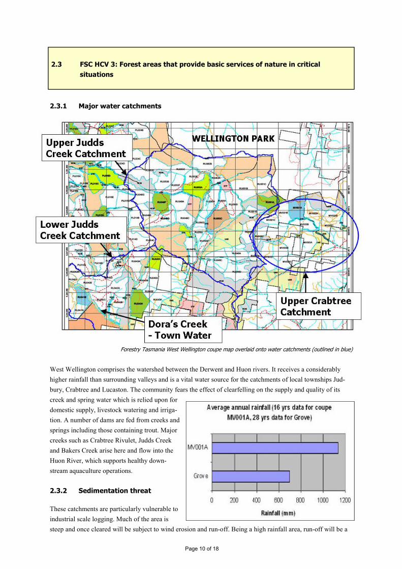
2.3.1 Major water catchments
West Wellington comprises the watershed between the Derwent and Huon rivers. It receives a considerably
higher rainfall than surrounding valleys and is a vital water source for the catchments of local townships Jud-
bury, Crabtree and Lucaston. The community fears the effect of clearfelling on the supply and quality of its
creek and spring water which is relied upon for
domestic supply, livestock watering and irriga-
tion. A number of dams are fed from creeks and
springs including those containing trout. Major
creeks such as Crabtree Rivulet, Judds Creek
and Bakers Creek arise here and flow into the
Huon River, which supports healthy down-
stream aquaculture operations.
2.3.2 Sedimentation threat
These catchments are particularly vulnerable to
industrial scale logging. Much of the area is
steep and once cleared will be subject to wind erosion and run-off. Being a high rainfall area, run-off will be a
Page 10 of 18
Forestry Tasmania West Wellington coupe map overlaid onto water catchments (outlined in blue)
2.3 FSC HCV 3: Forest areas that provide basic services of nature in critical
situations

major issue. Soil, ash and other debris will inevitably be carried into creeks, despite the narrow streamside buff-
ers. FT is obliged to leave buffers of between 10 and 40m width alongside streams, depending on the class of
the watercourse. However, this classification system is quite inadequate for a high rainfall area that is heavily
webbed with streams and springs, many of which are seasonal. These buffer strips are often affected by the post
-harvest intense burning, which can take out the understory and organic material which help prevent sediment
reaching watercourses.
Independent studies in Australia and overseas show that stream quality is directly affected by logging opera-
tions. The TEER Tamar Catchment Model (March 2010) forecast that sedimentation from forestry operations
would be much greater in high rainfall areas and quoted various other Australian studies to support this asser-
tion. The impact of commercial selective logging on stream hydrology, chemistry and sediment loads in the
Ulu Segama rainforest in Sabah, Malaysia is reported at http://www.jstor.org/pss/55626. Five months after the
logging had taken place, the monthly suspended sediment yield was still 18 times greater than that of a nearby
unlogged catchment.
2.3.3 Water flow and drought
Forestry Tasmania’s hydrological models look
at the effect of clearfelling on average annual
creek flow but do not take into account the fact
that rainfall comes in peaks and troughs, not as
a steady precipitation throughout the year. The
chart to the right demonstrates the average
monthly variation, but does not show that it is
quite common to get heavy rainfalls of 50-
60mm in a few hours – at any time of year. The
actual effect of clearfelling therefore, is that
there will be large peaks in creek flows follow-
ing a rain event, such that downstream flooding
and siltation may occur, but very low or no flow during drier months. The existing forest moderates the flow
of water, releasing it into creeks and springs steadily, such that water continues to flow even in drought
conditions.
It is acknowledged that Tasmania, along with the rest of the world, is seeing more extreme weather events,
therefore we can expect warmer, drier summers and heavier sporadic rainfall events in years to come. Any in-
dustrial scale logging in West Wellington will have a deleterious effect on water quality and water security for
local residents. FT has a self-imposed limit of logging 5% of any water catchment in any one year, however,
this may be exceeded in areas not supplying a town-water offtake or feeding directly into an aquaculture opera-
tion.
2.4.1 High coupe visibility
Many of the coupes in West Wellington are steep and at altitude, therefore visibility will be a major issue. For
instance coupes above Crabtree are visible from popular tourist look-outs on the Huon Highway as well as
Page 11 of 18
2.4 FSC HCV 4: Forest areas fundamental to meeting basic needs of local
communities
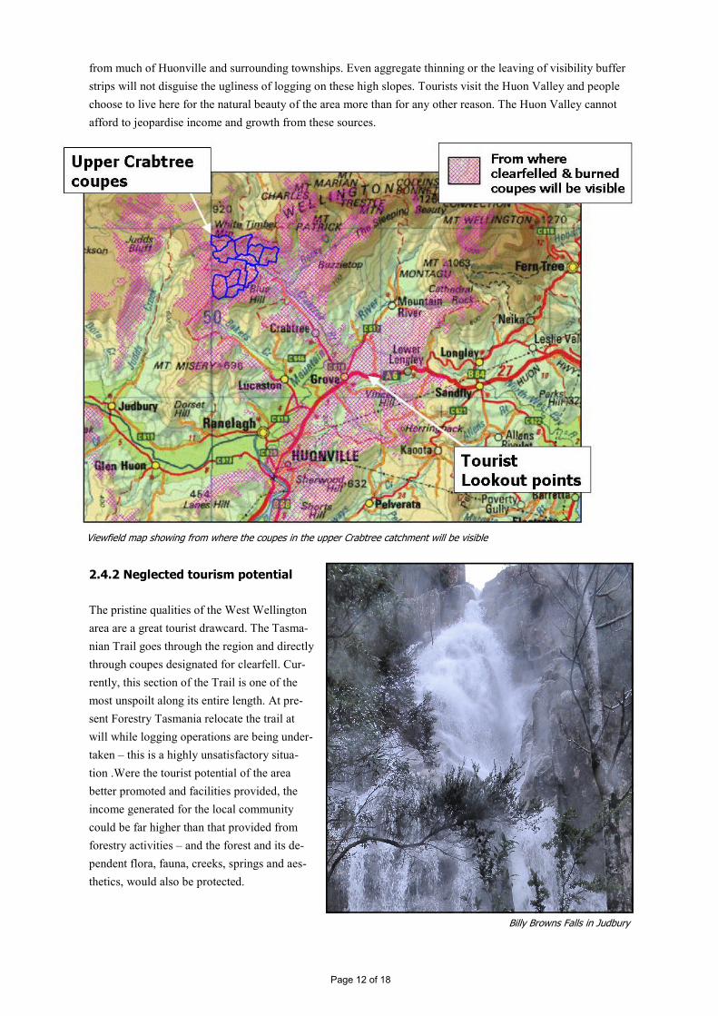
from much of Huonville and surrounding townships. Even aggregate thinning or the leaving of visibility buffer
strips will not disguise the ugliness of logging on these high slopes. Tourists visit the Huon Valley and people
choose to live here for the natural beauty of the area more than for any other reason. The Huon Valley cannot
afford to jeopardise income and growth from these sources.
2.4.2 Neglected tourism potential
The pristine qualities of the West Wellington
area are a great tourist drawcard. The Tasma-
nian Trail goes through the region and directly
through coupes designated for clearfell. Cur-
rently, this section of the Trail is one of the
most unspoilt along its entire length. At pre-
sent Forestry Tasmania relocate the trail at
will while logging operations are being under-
taken – this is a highly unsatisfactory situa-
tion .Were the tourist potential of the area
better promoted and facilities provided, the
income generated for the local community
could be far higher than that provided from
forestry activities – and the forest and its de-
pendent flora, fauna, creeks, springs and aes-
thetics, would also be protected.
Page 12 of 18
Viewfield map showing from where the coupes in the upper Crabtree catchment will be visible
Billy Browns Falls in Judbury

Tourist operators local to West Wellington are reliant on the landscape values remaining untouched to bring
people to the area and encourage them to stay. Clearfelling and burning is to the direct detriment of tourism and
hence to the tourist-based economy of the region. Already local businesses receive complaints about the exces-
sive smoke from burn-offs for instance. The WWPG knows businesses that have been forced to move from
areas such as The Weld when Forestry Tasmania built its logging roads and began clearfelling. Now those
businesses are under threat again.
2.4.3 Amenity value
The tracks through West Welling-
ton are used by a large cross-
section of the local community
including four-wheel drivers,
mountain bikers, bushwalkers and
horse-riders. The potential for
extending responsible recreation
and tourist activities in the region
is huge, particularly if directed
towards providing facilities, sign-
age and maps for bushwalkers.
Local tourist operators are keen
to promote a Judbury to Hobart
walk for instance, which could
become as iconic as Tasmania’s
other well-known walks (see section 3. for further details).
2.5.1 Community opposition
There is a large groundswell of opinion within the communities local to West Wellington, against the existing
and planned activities of Forestry Tasmania. The West Wellington Protection Group has a dedicated mailing
list of 100 local residents and its facebook page has over 700 friends, mostly local including Hobart residents
alarmed at the impacts on Wellington Park.
It is not just activists who are concerned. The repeated comment the members of the WWPG hear (from estab-
lished families and landowners, farmers, householders and business owners local to West Wellington) is
“they’ve got to stop somewhere”. Many of these people support the forestry industry but not the industrial-scale
and indiscriminate nature of clearfelling. The townships of Judbury, Crabtree and Lucaston are growing on the
back of their natural values, rural charm and proximity to Hobart. There is no community endorsement for in-
dustrial logging in these native forests. It should also be noted that the actions of Forestry Tasmania are creat-
ing a great deal of stress and conflict between peoples living in these neighbouring communities.
Four wheel driving on White Timber Trail
2.5 FSC HCV 5: Forest areas critical to local communities’ traditional cultural
identity (both indigenous and post-colonisation)
Page 13 of 18
2.5.2 Heritage values
Many of the tracks within West Wellington are old and have significant heritage value. Jeffreys Track for in-
stance, which links Crabtree in the south to Lachlan and the Derwent Valley in the north, was believed to have
been cut soon after 1850. It is suspected that it followed an old aboriginal trail. There are still remnants of the
original cobbled banks in places and short sections of the old track that have been bypassed by subsequent bull-
dozing. The stretch of the Tasmanian Trail between Judbury and Lachlan is a similar heritage trail and was
used for the same purposes as Jeffreys
Track, ie to bring stock to market, to enable
families from the two valleys to meet and
inter-wed and also to look for work in a dif-
ferent area.
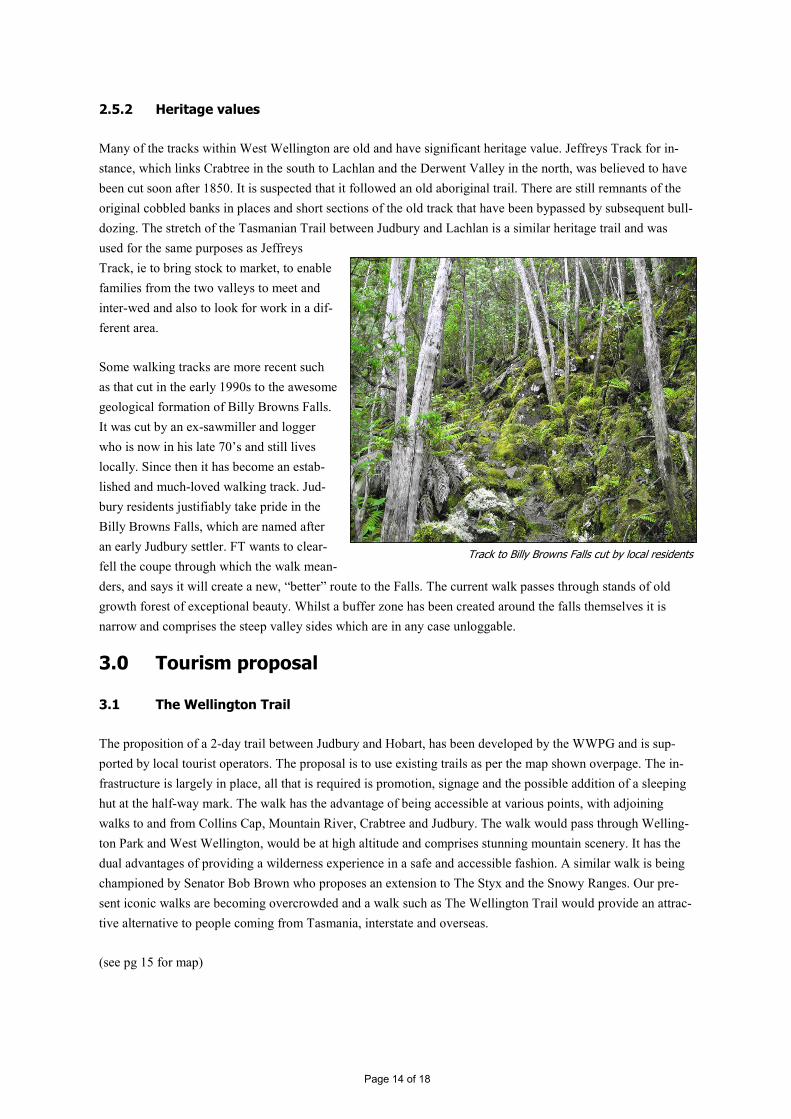
Some walking tracks are more recent such
as that cut in the early 1990s to the awesome
geological formation of Billy Browns Falls.
It was cut by an ex-sawmiller and logger
who is now in his late 70’s and still lives
locally. Since then it has become an estab-
lished and much-loved walking track. Jud-
bury residents justifiably take pride in the
Billy Browns Falls, which are named after
an early Judbury settler. FT wants to clear-
fell the coupe through which the walk mean-
ders, and says it will create a new, “better” route to the Falls. The current walk passes through stands of old
growth forest of exceptional beauty. Whilst a buffer zone has been created around the falls themselves it is
narrow and comprises the steep valley sides which are in any case unloggable.
3.0 Tourism proposal
3.1 The Wellington Trail
The proposition of a 2-day trail between Judbury and Hobart, has been developed by the WWPG and is sup-
ported by local tourist operators. The proposal is to use existing trails as per the map shown overpage. The in-
frastructure is largely in place, all that is required is promotion, signage and the possible addition of a sleeping
hut at the half-way mark. The walk has the advantage of being accessible at various points, with adjoining
walks to and from Collins Cap, Mountain River, Crabtree and Judbury. The walk would pass through Welling-
ton Park and West Wellington, would be at high altitude and comprises stunning mountain scenery. It has the
dual advantages of providing a wilderness experience in a safe and accessible fashion. A similar walk is being
championed by Senator Bob Brown who proposes an extension to The Styx and the Snowy Ranges. Our pre-
sent iconic walks are becoming overcrowded and a walk such as The Wellington Trail would provide an attrac-
tive alternative to people coming from Tasmania, interstate and overseas.
(see pg 15 for map)
Track to Billy Browns Falls cut by local residents
Page 14 of 18
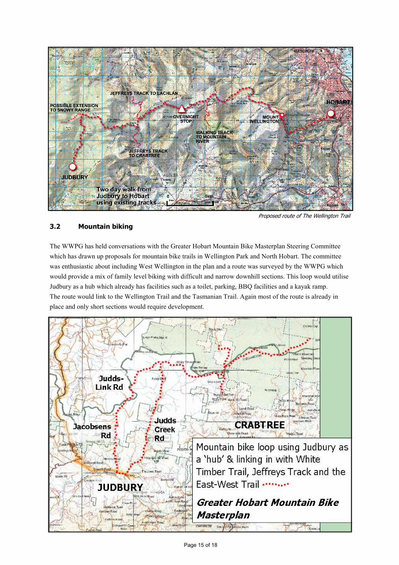
3.2 Mountain biking
The WWPG has held conversations with the Greater Hobart Mountain Bike Masterplan Steering Committee
which has drawn up proposals for mountain bike trails in Wellington Park and North Hobart. The committee
was enthusiastic about including West Wellington in the plan and a route was surveyed by the WWPG which
would provide a mix of family level biking with difficult and narrow downhill sections. This loop would utilise
Judbury as a hub which already has facilities such as a toilet, parking, BBQ facilities and a kayak ramp.
The route would link to the Wellington Trail and the Tasmanian Trail. Again most of the route is already in
place and only short sections would require development.
Page 15 of 18
Proposed route of The Wellington Trail
3.3 Other tourist opportunities
The Tasmanian Trail already goes through the heart of West Wellington. Unfortunately, FT has turned a por-
tion of White Timber Trail (a leafy 4WD track down which the Tasmanian Trail passes) into a wide and soul-
less logging road with smashed trees on either side. This is not the type of scenery that will attract tourists or
compel them to revisit. Most of the Trail however, remains intact and scenic and this is a brand that could be
readily built upon.
Other possibilities include the following:
3.4 Requirements
Clearly there is some infrastructure
development required to maximise
the tourism potential of the area and
there must be a sustained marketing
drive. We cannot sit back and expect
tourists to arrive without first know-
ing about the opportunities and sec-
ondly, the infrastructure being in
place to support their needs.
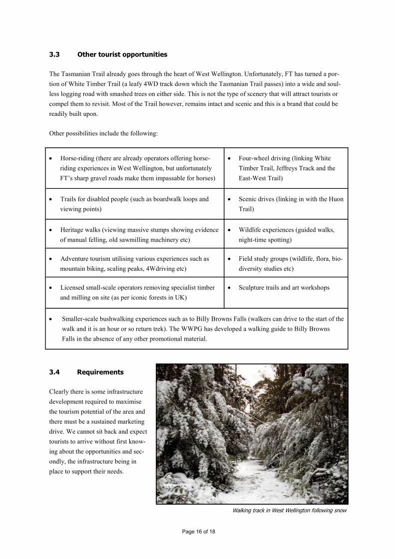
Walking track in West Wellington following snow
Page 16 of 18
• Horse-riding (there are already operators offering horse-
riding experiences in West Wellington, but unfortunately
FT’s sharp gravel roads make them impassable for horses)
• Four-wheel driving (linking White
Timber Trail, Jeffreys Track and the
East-West Trail)
• Trails for disabled people (such as boardwalk loops and
viewing points)
• Scenic drives (linking in with the Huon
Trail)
• Heritage walks (viewing massive stumps showing evidence
of manual felling, old sawmilling machinery etc)
• Wildlife experiences (guided walks,
night-time spotting)
• Adventure tourism utilising various experiences such as
mountain biking, scaling peaks, 4Wdriving etc)
• Field study groups (wildlife, flora, bio-
diversity studies etc)
• Licensed small-scale operators removing specialist timber
and milling on site (as per iconic forests in UK)
• Sculpture trails and art workshops
• Smaller-scale bushwalking experiences such as to Billy Browns Falls (walkers can drive to the start of the
walk and it is an hour or so return trek). The WWPG has developed a walking guide to Billy Browns
Falls in the absence of any other promotional material.

Some of the requirements are as listed:
Possible funding sources for recommended improvements and campaigns include:
• Foundations and other grant bodies
• State and federal governments (eg funding for regional development under the Intergovernmental
Agreement)
• Councils
• Beneficiary businesses
• Tourism Tasmania
• Parks and Wildlife
3.5 Outcomes and benefits
Some of the benefits and outcomes of developing West Wellington into a tourist hub are as follows:
• Creation of new tourism ventures such as hospitality and catering (B&Bs, cafés etc); hire of mountain
bikes; walking gear hire/ sale; guided walks and rides; operators of adventure and eco-tourism experiences
• Businesses producing signage, leaflets, walking guides and other promotional material
• Demand for people to build and maintain tracks
• Increased specialist timber crafts
• Increased economic wealth through job creation and general longer-term viability of region
• West Wellington’s biodiversity and other values protected through reduced or no logging
Page 17 of 18
• Development of the West Wellington brand
(locally, insterstate and overseas) – may re-
quire full-time marketing officer
• Brochures, guides and maps on walking, horse-
riding, mountain biking, driving and 4Wdriving
routes, plus guides to the flora, fauna and history of
the area
• Parking, signage and other facilities at other
starting points into West Wellington (eg Crab-
tree)
• Picnic areas, boardwalks, interpretation signs, huts
and toilets, plus some improvements to existing
tracks
• Possible long-term improvement of Jeffreys
Track to become for example a single-lane
tourist route with passing places, car parking
etc.
• Big reduction in logging intensity. Clearfelling and
tourism are mutually exclusive. Preferably West
Wellington to become an extension to Wellington
Park.
• Training and re-training for people to become
trackworkers, hospitality workers, guides etc
• Possible incentives for tourism operators to set up
in the area – help for locals to set up their own en-
terprises
• Someone/ somebody to take leadership!
4. Conclusion
The WWPG contends that the West Wellington range satisfies the definition of all the FSC’s high conservation
value levels. It ought therefore to be managed in a manner that ‘shall maintain or enhance the attributes which
define such forests’ (Principle 9: maintenance of high conservation value forests). Clearfelling and burning on
any scale will destroy the values of West Wellington.
Given its accessibility, unique beauty, proximity to Hobart and existing trails, a great opportunity exists for de-
veloping the tourism potential of West Wellington. This is an area that has sat alongside human habitation for
200yrs – it is a not an area that we propose should be locked up without any development or human access. It is
a living, working forest that can provide amenity and recreation and wilderness experiences for locals, other
Australians and overseas visitors – without damaging the values that make West Wellington so special.
**********************************
Submitted by the West Wellington Protection Group
e: [email protected] p: PO Box 458, Huonville Tasmania 7109 Australia
w: www.wwpg.info facebook: protect West Wellington from clearfelling
Page 18 of 18