regional geology of the bonaparte basin - ga.gov.au · web viewin the late campanian, a sea-level...
TRANSCRIPT
Regional Geology of the Bonaparte Basin
The Bonaparte Basin represents Australia’s easternmost offshore province of the Westralian Superbasin comprising also the Browse, Roebuck, Offshore Canning and Northern Carnarvon basins, collectively known as basins of the North West Shelf (Figure 1). Located predominantly offshore (Figure 2), the Bonaparte Basin contains a Paleozoic, Mesozoic and Cenozoic sedimentary succession that exceeds 15 000 m in thickness in the southern portion (“Petrel Sub-basin”) and a Mesozoic-Cenozoic basin fill in the northern part. Since the development of the Bayu-Undan and Blacktip gas discoveries (1995 and 2001 respectively) and first oil discoveries in the Vulcan Sub-basin (Jabiru in 1986; Challis and Cassini in1989), the basin is an established oil and gas province.
Basin outlineThe Bonaparte Basin belongs to a series of extensional basins, which formed during late Paleozoic-early Mesozoic rifting in the context of Gondwana break-up. In the northeast, beyond the limits of the Darwin Shelf, the Bonaparte Basin adjoins the Money Shoal Basin and to the southwest it is contiguous with the Browse Basin. The basin’s northwestern border is the Timor Trough (Figure 2), which defines the tectonic boundary between the Australian plate and Banda orogen.
Basin evolutionThe Bonaparte Basin developed during two phases of Paleozoic extension, followed by Middle–Late Triassic compression and further extension in the Mesozoic that culminated in the breakup of Gondwana in the Middle Jurassic (O’Brien et al, 1993). Thermal subsidence in the Early Cretaceous developed a thick, prograding wedge of siliciclastic and carbonate sediment. Preliminary post-survey analysis and modelling of the WestraliaSPAN seismic data suggest that rifting in the Bonaparte Basin has been more extreme than previously reported (Pryer et al, 2014, 2015).
Convergence of the Australia-India Plate and Southeast Asian microplates in the Neogene resulted in lithospheric flexural downwarp of the Timor Trough and widespread fault reactivation across the Bonaparte Basin, which is particularly evident in the northwest. The convergence and associated uplift and erosion has created thick sedimentary deposits in the Cartier and Nancar troughs and Malita Graben (Keep et al, 2002, 2007; Langhi et al, 2011).
The regional geology, structural evolution and petroleum potential of the Bonaparte Basin have been described by Laws and Kraus (1974), Gunn (1988), Lee and Gunn (1988), Gunn and Ly (1989), MacDaniel (1988), Mory (1988, 1991), Botten and Wulff (1990), Petroconsultants Australasia Pty Ltd (1990), Hocking et al (1994) and Woods (1992, 1994), and summarised by Longley et al (2002), Cadman and Temple (2003) and Ahmad and Munson (2013). In addition, numerous papers on the petroleum geology of the region were presented in the Proceedings of the Timor Sea Symposium, Darwin, June 2003 (Ellis et al, 2004).
The Bonaparte Basin contains several sub-basins and regional structural elements (Figure 3) each of which represents a distinct geologic domain. These are described below.
Petrel Sub-basinLocation and extent
The Petrel Sub-basin covers much of the Joseph Bonaparte Gulf and extends onshore where its southern geological boundary, abuts the Hall Creek-Fitzmaurice Mobile Zone, which separates the sub-basin from the Proterozoic Victoria River Basin (Figure 1-2 in Colwell and Kennard, 1996) The offshore part of the sub-basin
AUSTRALIA Bonaparte Basin Regional Geology 1
Last updated 2019 https://www.ga.gov.au/petroleum
is located across an extensive modern-day shallow shelf where water depths do not exceed 150 m (Figure 4, Figure 5).
Structural evolution
The sub-basin consists of a broad northwest-trending syncline that plunges to the northwest, resulting in exposure of lower Paleozoic sediments in the southern onshore area, and in the progressive sub-cropping of upper Paleozoic, Mesozoic and Cenozoic sediments offshore. Late Triassic compression produced uplift and erosion along the southern margin. In terms of temporal and spatial extent, different interpretations have been put forward (e.g. Petroconsultants Australasia Pty Ltd, 1990 and Hocking et al., 1994). Since only the southern part of the Bonaparte Basin contains lower Paleozoic sediments, it could be argued that the Petrel Sub-basin is a distinct regional depocentre and should be ranked as a separate basin. The depositional history from the Middle Triassic onwards relates to the regional rift-system that created the major depocentres along the northern part of the Bonaparte Basin, including the Vulcan Sub-basin, the Malita and Calder graben.
The asymmetric, northwest-trending Petrel Sub-basin is located in the east of the Bonaparte Basin and was formed by Late Devonian to Mississippian rifting. The sub-basin contains a thick Paleozoic succession which is overlain by a thinner Mesozoic and Cenozoic succession (Figure 6, Figure 7) and underlain by Proterozoic crystalline basement and sediments/metasediments of the Kimberley Basin (Colwell and Kennard, 1996). It contains more than 15 000 m of siliciclastics, carbonates and minor basal volcanics (Gunn, 1988). The eastern and southwestern faulted margins of the sub-basin converge onshore to form the southern termination. To the south and east of the Petrel Sub-basin, extensions of the Halls Creek–Fitzmaurice Mobile Zone separate it from the Proterozoic Victoria River Basin and the Pine Creek Geosyncline. Extensive basement shelves lie on the eastern, western and southern margins of the Petrel Sub-basin and have a thin cover of Phanerozoic sediments. To the southeast, the Kulshill Terrace and Moyle Platform extend to the north-northeast towards the Darwin Shelf. In the southwest, the Berkley Platform is subdivided into several smaller northwest–southeast oriented horst and graben structures that include the Lacrosse Terrace, Turtle-Barnett High and Cambridge Trough (Figure 3-1 in Colwell and Kennard, 1996).
Stratigraphy
Sedimentation in the Petrel Sub-basin commenced in the Cambrian and continued into the Early Ordovician, with the deposition of shallow marine clastics and carbonates (Figure 8 and Figure 9a, b). This was followed, most probably in the Late Ordovician, by extensive evaporite deposits of unknown lateral continuity. These evaporites appear to be of similar age as those of the Carribuddy Group in the Canning Basin. A detailed account of salt diapirs and salt-related tectonics are given by Edgerley and Crist (1974), Woodside Australian Energy (2002) and Leonard et al (2004).
Rifting was initiated in the Late Devonian and siliciclastic sediments and carbonates were deposited in terrestrial and shallow marine environments. In the southern onshore portion of the basin, the Frasnian sediments of the Cockatoo Group are dominated by coarse clastics and conglomerates, some of which may be non-marine (Mory and Beere, 1988). Northward, the coarse-grained facies of the Cockatoo Group is gradually replaced by siltstones and shales with interbedded sandstones and sandy limestones of the Bonaparte Formation (Mory and Beere, 1988).
In the Famennian, the clastics of the Cockatoo Group are replaced by the reefal carbonates of the Ningbing Group around the margins of the basin, while in the deeper central onshore and offshore portions of the basin, deposition of the Bonaparte Formation continued essentially unchanged (Mory and Beere, 1988).
By the Mississippian, rifting had produced a northwest-trending basin, in which marine, fluvio-deltaic and glacial sediments accumulated as a result of post-rift subsidence and salt withdrawal during the Carboniferous and Permian. These Permo-Carboniferous sediments represent the bulk of the basin-fill in the Petrel Sub-basin.
In the Tournaisian the reefal facies was replaced by mixed carbonates and fine-grained clastics of the Langfield Group (Mory and Beere, 1988; Gorter, 2006a) on the basin margins, with deposition of the Bonaparte Formation continuing in the deeper portion of the basin. The type section for the Bonaparte Formation is defined between 2280 and 3210 mKB total depth (TD) in Bonaparte 1 (Beere and Mory, 1986; Mory, 1991) and comprises a sequence of shale, siltstone, sandstone and minor sandy limestone. Towards the end of the Tournaisian, an unconformity separates the Langfield Group and offshore Bonaparte Formation from the overlying Weaber Group, its base represented by the Milligans Formation.
AUSTRALIA Bonaparte Basin Regional Geology 2
The Mississippian Weaber Group, as developed in the southern part of the Petrel Sub-basin, is a complex package of clastic and carbonate sediments separated by several unconformities. The original definition of the Weaber Group as described by Mory and Beere (1988) and Mory (1991) has been revised by Gorter et al (2005), so that it now comprises the Milligans Formation (including the Waggon Creek facies), Yow Creek Formation, Utting Calcarenite, Kingfisher Shale/Burvill Formation, Tanmurra Formation, Sandbar Sandstone and Sunbird Formation.
The Tournaisian–Visean Milligans Formation was originally defined by Mory (1991) as consisting of fossiliferous shales and siltstones with the type section occurring over the depth range 44–155 m in Milligans No.1 Bore (Veevers and Roberts, 1968). Thick Milligans Formation is penetrated in the onshore wells Keep River 1 and Bonaparte 1 and 2, with the thickest offshore section occurring in Kingfisher 1 (Gorter et al, 2005). The ‘Milligans Beds’ is a term used to describe the shales overlying the Langfield Group in some of the earliest wells drilled in the Petrel Sub-basin, but may not correspond to the Milligans Formation as currently defined. The Milligans Formation extends throughout the Cambridge Trough, Keep Inlet Sub-basin (Figure 3-1 in Colwell and Kennard, 1996) and the onshore parts of the sub-basin. The age of this formation has been redefined and is regarded as being of latest Tournaisian–early Visean in age (Gorter et al, 2004, 2005). The basin margin equivalent of the Milligans Formation is known as the Waggon Creek facies that comprises predominately pebbly sandstones and conglomerates overlain by sandstones and shales, as intersected at Keep River 1 and Waggon Creek 1 (Beere, 1984; Gorter et al, 2005).
The Visean Yow Creek Formation is a basinal shale that commonly contains ironstone, which is bounded by unconformities at its base and top (Gorter et al, 2005). The type section is between 980–1160 mKB in Bonaparte 1. The overlying Utting Calcarenite is named from the type section in Utting Gap and comprises fossiliferous sandy limestone and calcareous sandstone (Veevers and Roberts, 1968; Mory and Beere, 1988). This may be the lowstand portion of the Yow Creek Formation (Gorter et al, 2005). The abrupt lithological change from the Utting Calcarenite to the carbonaceous claystone of the Kingfisher Shale is taken to represent a rapid deepening event (Gorter et al, 2005). The type section for the Kingfisher Shale is between 1950–2091 mRT in Kingfisher 1. The Utting Calcarenite and Kingfisher Shale are lateral equivalents of the coarse clastic-dominated Burvill Formation developed near the basin margin.
The Visean Tanmurra Formation unconformably overlies the Kingfisher Shale and comprises a thick succession of calcareous and dolomitic sandstones and sandy carbonates deposited throughout the Carlton Shelf and the Cambridge Trough and Keep Inlet Sub-basin (Figure 3-1 in Colwell and Kennard, 1996). Carbonates of this age are known as the ‘Medusa Beds’ in Lacrosse 1 (Arco Limited, 1969). Gorter et al (2005) redefined the type section for the Tanmurra Formation from that of Mory (1991) to being between 220–497 mKB in Bonaparte 1. Shales within the sandstones contain high organic content as intersected at NBF-1002, Keep River 1, and possibly within a poorly sampled section of Kingfisher 1.
The uppermost units of the Weaber Group are the Visean Sandbar Sandstone and overlying Visean–Serpukhovian Sunbird Formation (Gorter et al, 2005). The Sandbar Sandstone consists of mixed lithology with the lower part dominantly carbonate and the middle and upper parts comprising carbonates and interbedded quartzose sandstones. The type section is between 1634–1695 mRT in Sandbar 1. The Sandbar Sandstone occurs within the Cambridge Trough, but it is not present on the Barnett-Turtle High or in Matilda 1. Seismic profiles show that the Sandbar Sandstone either pinches out or is truncated by the Sunbird Formation. The Sunbird Formation is present widely throughout the southern Petrel Sub-basin and comprises massive limestone with minor quartzose sandstone, with the type section being between 2236.5–2598.5 mRT in Sunbird 1 (Gorter et al, 2005).
The late Mississippian–early Pennsylvanian Wadeye Group is represented on the basin margins by the Point Spring Sandstone, comprising sandstones, pebbly sandstones and minor siltstones, and in the deeper parts of the basin by the finer grained clastics of the Arco and Aquitaine formations (Gorter et al, 2005). Note that the Wadeye Subgroup of Gorter et al (2008) has not been adopted herein. The base of the Wadeye Group is characterised by canyon incision as a result of a major fall in sea level.
The Wadeye Group is overlain unconformably by the early Pennsylvanian–Cisuralian Kulshill Group. The Kulshill Group, as redefined by Gorter (2006b) and Gorter et al (2008) comprises the Kuriyippi, Treachery, Quoin, Ditji and Keyling formations. The Kulshill Group was deposited in an overall transgressive cycle, overprinted by the onset of glaciation in the Kuriyippi Formation (Mory, 1991). The Bashkirian–Asselian Kuriyippi Formation, and its western basin-margin equivalent Border Creek Formation and eastern onshore sub-basin equivalent, the Keep Inlet Formation, are overlain by the regional Treachery Formation. The
AUSTRALIA Bonaparte Basin Regional Geology 3
Kuriyippi Formation, as defined by Mory (1991), is a thick succession of upward fining cycles of sandstones, siltstones, shales and minor coals, overlain by glacial sandstones and conglomerates. The complex incised channel network at the top of the Kuriyippi Formation suggests that the area lay under an ice sheet at this time (Gorter et al, 2008). The capacity of this formation to entrap oil is demonstrated at Barnett and Turtle on the Turtle-Barnett High and gas at Blacktip. The type section is named after the Kuriyippi Hills and is defined in Lesueur 1 between 1784–2801 mKB, which is the thickest section penetrated in the Petrel Sub-basin (Mory, 1991).
The Sakmarian Treachery Formation extends throughout the southern Petrel Sub-basin where it unconformably overlies the Kuriyippi Formation (Gorter 2006b; Gorter et al, 2008). It comprises tillites, diamictites, carbonaceous shales, varved siltstones, sandstones and minor limestones and coals, and provides top seal to accumulations in the underlying Kuriyippi Formation. The type section is between 1094–1227 mRT in Kulshill 1 where it was named the Treachery Shale (Mory, 1991). However, Gorter et al (2008) renamed the unit the Treachery Formation, and included the informally named Blacktip member, a reservoir at Blacktip 1. These authors also propose a reference section between 2827.3–3072.8 mRT in Blacktip North 1. In the Keep Inlet Sub-basin (Figure 3-1 in Colwell and Kennard, 1996), the formation is over 300 m thick in Kingfisher 1, Sunbird 1 and Kulshill 1, with the formation thinning towards the basins margins.
The Sakmarian Quoin and Ditji formations as defined by Gorter et al (2008) were originally included within the overlying Keyling Formation of Mory (1991). The type section of the Quoin Formation is between 1145–1350 mKB in Barnett 1, with a reference section established in Blacktip 1 (Gorter et al, 2008). The Quoin Formation is a sharp-based blocky sandstone that fines upwards into thinner sandstones, siltstones and shales. These sediments were deposited in a fluvial environment after deglaciation when melt water from the ice sheet carried vast quantities of sediments into the basin. The formation is thickest (~750 m) in the vicinity of Kulshill 1 and 2. The overlying Ditji Formation is interpreted as a transgressive sequence deposited in response to the end of glaciation (Gorter et al, 2008). The type section of the Ditji Formation is between 1721–1795 mKB in Kinmore 1 with a reference section of 1079–1132 mKB in Barnett 1 where a characteristic ash bed is present (Gorter et al, 2008). The formation comprises hard calcareous sandstone grading into sandy limestone, with minor interbedded coals. The marine transgression was terminated by the prograding coarse-grained sediments of the Keyling Formation.
The Sakmarian Keyling Formation was originally defined as the type section between 254–1094 mRT in Kulshill 1 (Mory, 1991). Gorter et al (2008) redefined the formation and suggested a reference section within Blacktip 1 (2152.5–2601.5 mRT). The formation probably unconformably overlies the Ditji Formation, and is unconformably to conformably (in the north) overlain by the Fossil Head Formation. The formation comprises delta-plain and marginal marine sandstones, siltstones, shales and minor coals and limestones. The coals are intersected in the eastern Petrel Sub-basin and on the Darwin Shelf by Kinmore 1 and Flat Top 1, respectively. The coals and marginal marine shales have moderate to very good oil and gas potential. The Keyling Formation is present throughout the southeastern Petrel Sub-basin, being 525 m thick at Polkadot 1 and 450 m thick at Blacktip 1. The Keyling Formation is about 300 m thick in Kulshill 1 and 2. It generally thins towards the southern basin margin, where it is truncated below the Fossil Head Formation. The Keyling Formation was deposited in a marginal marine environment. It is the primary reservoir below the Fossil Head Formation regional seal, and is a gas-bearing reservoir at Blacktip 1 (Leonard et al, 2004) and Tern 1, and contains oil at Turtle 1.
The Cisuralian to Middle Triassic Kinmore Group of Mory (1991) has been redefined by Gorter et al (1998) so that it now comprises the Fossil Head Formation, Hyland Bay Subgroup and Mount Goodwin Subgroup (Figure 8a, b). The Sakmarian–Roadian Fossil Head Formation comprises carbonaceous siltstones and mudstones with sandstones and minor limestones. The type section is between 2993–3569 mKB in Tern 1 (Mory, 1991). It occurs throughout the southern Petrel Sub-basin, south of Petrel 1 and was deposited under marine shelfal conditions. This transgressive sequence forms the regional seal in the Petrel Sub-basin.
The Hyland Bay Formation of Mory (1991) was renamed the Hyland Bay Subgroup by Gorter (1998), with both names being used herein in the well completion report extracts, depending on the vintage of the report being quoted. The Hyland Bay Subgroup consists of pro-delta, deltaic and shoreface mudstones, siltstones and sandstones, as well as open shelf carbonates that are particularly thick (up to around 2300 m) in the central and outer parts of the Petrel Sub-basin. Gorter (1998) and Gorter et al (1998) divided the subgroup into five formations; Pearce, Cape Hay, Dombey, Tern and Penguin formations. However, the basal Torrens Member, as defined between 1208–1230 mRT in Torrens 1 (Gorter, 1998) has since been given formation status (Figure 7 and Figure 8), and the Penguin Formation is now classed as the base of the overlying Mount
AUSTRALIA Bonaparte Basin Regional Geology 4
Goodwin Subgroup (Gorter et al, 2009). Robinson and McInerney (2004) published palaeogeographic reconstructions of the most important reservoir units within the Hyland Bay Subgroup. The Torrens Formation hosts gas at Penguin 1, Petrel 2 and Polkadot 1. The Pearce Formation comprises shelf and platform carbonates. The Cape Hay Formation (Gorter, 1998) is the equivalent to the Hay Member of Bhatia et al (1984). It is the reservoir unit for the gas accumulations at Ascalon 1A, Petrel, Tern 4 and oil shows at Turtle 2. It was deposited as part of a widespread, river-dominated delta system with restricted shoreface conditions (Robinson and McInerney, 2004). The Dombey Formation carbonates provide the top-seal to the Cape Hay Formation. The Tern Formation is the reservoir for the Tern gas accumulation and gas shows at Ascalon 1A. The formation is interpreted to represent shoreface and shoal environments (Robinson and McInerney, 2004) and forms a broad, prograding shoreface system. The Hyland Bay Subgroup is conformably overlain by the thick transgressive claystones of the latest Permian–Early Triassic (Changhsingian–Olenekian) Penguin and Mairmull formations, which provide both vertical and lateral seal across the Petrel Sub-basin. Where the Penguin Formation is absent, the Mairmull Formation unconformably overlies the Hyland Bay Subgroup.
Collectively the Penguin, Mairmull, Ascalon and Fishburn formations comprise the Mount Goodwin Subgroup (Gorter et al, 2009). The type section for the Penguin Formation is between 2400–2449 mKB in Tern 3 (Gorter, 1998) and is believed to have been deposited in a lacustrine setting. Although the formation is predominantly claystones, it hosts gas at Fishburn 1. The Mairmull Formation consists of claystones and siltstones with the type section being between 2121–2320 mRT in Fishburn 1 (Gorter et al, 2009), where it was deposited in a shallow water marine environment. The Olenekian Ascalon Formation is a prominent, widespread sandstone and siltstone unit deposited throughout the southern Bonaparte Basin. The type section is between 4072.5–4105 mRT in Ascalon 1A (Gorter et al, 2009). The sandstones were deposited in a marginal marine setting and probably represent a lowstand package. Gas is reservoired within the Ascalon Formation at Blacktip 1 and gas shows occur at Ascalon 1A. The Olenekian–Anisian Fishburn Formation consists of claystones with minor siltstone and sandstone, probably deposited in a nearshore environment. The type section is between 1904.5–2084 mRT in Fishburn 1 (Gorter et al, 2009).
The Kinmore Group is unconformably overlain by the Troughton Group in the eastern Bonaparte Basin, and the partially time equivalent Sahul Group in the western Bonaparte Basin (Mory, 1991; Gorter et al, 2009). The Middle Triassic to Middle Jurassic Troughton Group comprises the Cape Londonderry, Malita and Plover formations (Mory, 1991). It is a thick clastic sequence of marginal-marine to marine sandstones, siltstones and dolomitic shales. The Sahul Group is also marine to marginal marine, but contains more carbonates and shales than the Troughton Group and is defined from well penetrations on the Ashmore Platform, Vulcan Sub-basin and Londonderry High.
The Anisian Osprey Formation is recognised in wells in the Vulcan Sub-basin and on the Ashmore Platform and Londonderry High. In the eastern Bonaparte Basin, the Osprey Formation is equivalent to the basal part of the Cape Londonderry Formation (Mory, 1991). The formation has been mapped within wells in the central Petrel Sub-basin as a package of interbedded sandstones and shales, with some minor carbonates underlying the sandstone-dominated Cape Londonderry Formation (Gorter et al, 2009).
The regressive Cape Londonderry Formation (Anisian–Norian) consists of sandstones and minor amounts of siltstones and shales, and was deposited during a relatively stable sag phase in a fluvial to braided stream environment. The type section is between 2471–2887 mKB in Petrel 1 (Helby, 1974; Mory, 1991). In the Middle Triassic, uplift and northeast–southwest rifting was initiated, which resulted in the widespread erosion of the Cape Londonderry Formation and parts of the Mount Goodwin Subgroup. Depositional environments changed from marine to terrestrial, culminating in red-bed deposition of the Late Triassic (Norian–Rhaetian) Malita Formation. The type section of this formation is between 2229–2471 mKB in Petrel 1 (Helby, 1974; Mory, 1991). Late Triassic compressional inversion related to the Fitzroy Movement involved extensive uplift and erosion along the southern margin, and created structural traps within the sub-basin.
The Early–Middle Jurassic Plover Formation (‘Petrel C’ of Arco Australia Limited, 1971a) contains sandstones that may have excellent reservoir qualities, as well as shales with some source potential. These sediments were deposited as thick sequences in deltaic to nearshore environments within the central and northern Petrel Sub-basin.
The Middle Jurassic–Early Cretaceous Flamingo Group represents a time of minor extension and subsidence and herein comprises the Elang Formation, Lower Frigate Shale/Cleia Formation, Frigate Shale and Sandpiper Sandstone, as modified from Mory (1991), Pattillo and Nicholls (1990) and Whittam et al (1996).
AUSTRALIA Bonaparte Basin Regional Geology 5
The Flamingo Group includes the packages of sediments referred to as ‘Petrel A’ and ‘Petrel B’ by Arco Australia Limited (1971a). The Callovian–Oxfordian Elang Formation is an excellent reservoir elsewhere in the Bonaparte Basin, whereas the basal marine shale, the Oxfordian–Tithonian Cleia Formation/Lower Frigate Shale and Frigate Shale, can form an excellent top seal and cross-fault seal to the Plover Formation. The overlying Berriasian–Valanginian Sandpiper Sandstone is an excellent reservoir unit, although no hydrocarbon shows have been recorded in this formation in the Petrel Sub-basin.
The intra-Valanginian unconformity separates the Flamingo Group from the overlying Cretaceous Bathurst Island Group that comprises the Echuca Shoals Formation, Darwin Radiolarite and Wangarlu Formation. During this time, the Bonaparte Basin was submerged during a post-rift sag phase, and widespread, thick, shale-dominated marine sediments were deposited across the basin, with the thickest sections occurring in the Petrel Sub-basin, Malita Graben and Calder Graben. The basal glauconitic claystones of the Valanginian–Aptian Bathurst Island Group were originally defined as the Darwin Formation by Mory (1988, 1991). However, many subsequent workers have referred to this section as the Echuca Shoals Formation, and applied the term ‘Darwin Formation’ to the overlying Aptian to Albian section of radiolarian-bearing calcareous claystones and calcilutites (referred to herein as the ‘Darwin Radiolarite’).
The mid-Valanginian–early Aptian Echuca Shoals Formation comprises a condensed section of glauconitic, marine claystones and siltstones. These sediments were deposited widely across the Bonaparte Basin as a result of the foundering of the Australian margin following continental break up, sea-floor spreading and subsidence. The dark-grey to black claystones within this formation contain good quality, oil-prone kerogen that provides a potential liquids source within the northern Bonaparte Basin. The peak of the transgression is represented by a condensed sequence of radiolarian cherts, claystones and calcilutites, which is commonly referred to as the “Darwin Radiolarite” (Whittam et al, 1996).
The overlying Wangarlu Formation is an Albian to mid-Campanian progradational sequence that was deposited in a marine shelf to slope environment. The basal section predominantly comprises massive claystones with subordinate siltstones and minor sandstones. These lithologies grade into claystones, calcilutites and marls until the Santonian where sandstones are locally developed in the upper part of the formation, in the Vulcan Sub-basin and northern Bonaparte Basin.
A regional erosional event occurred between the Late Cretaceous (Santonian) and Miocene leading to the accumulation of the Woodbine Group on a progradational shelf of the passive margin. The collision of the Australian Plate with the Banda Arc resulted in north–south compression and minor inversion of the generally east–west normal faults and possible strike-slip along older northeast–southwest-trending Triassic-aged faults.
Vulcan Sub-basinLocation and extent
The Vulcan Sub-basin is a major northeast-trending Late Jurassic extensional depocentre in the western Bonaparte Basin. The sub-basin comprises a complex series of horsts, graben and marginal terrace sand is flanked by the Permo-Triassic platforms of the Londonderry High and the Ashmore Platform to the southeast and northwest, respectively (Figure 2, Figure 10, Figure 11). The proven hydrocarbon provinces of the Swan Graben and Paqualin Graben terminate in the northeast beneath the Neogene Cartier Trough. The Montara Terrace flanks the Swan Graben to the east, while the Jabiru Terrace borders the eastern margin of the Paqualin Graben and Cartier Trough. The boundary between the southern Vulcan Sub-basin and the northern Browse Basin (Caswell Sub-basin) is poorly defined. O’Brien et al (1999) considered the boundary to be a fault relay zone that overlies a major northwest-trending Proterozoic fracture system. The suggested abutting Abalone Sub-basin, in the north of the Caswell Sub-basin, is based on Proterozoic and Paleozoic structural trends identified in gravity and seismic data (Lawrence et al, 2014), and may have implications for sediment transport pathways in the area.
Structural evolution
O’Brien (1993) described the Vulcan Sub-basin as forming part of a single upper plate rift margin. This margin comprises orthogonal to northeast-trending normal faults linked by northwest-trending accommodation zones (Etheridge and O’Brien, 1994; O’Brien et al, 1996; O’Brien et al, 1999). Deposition during the basin’s thermal
AUSTRALIA Bonaparte Basin Regional Geology 6
sag phase continued until the late Neogene and resulted in the accumulation of over 10000 m of sediments in the deeper graben, such as the Swan Graben (Baxter et al, 1997).
Mesozoic extension in the Vulcan Sub-basin commenced in the late Callovian, coincident with the onset of seafloor spreading in the Argo Abyssal Plain to the southwest, and continued through to the Tithonian (Pattillo and Nicholls, 1990; O’Brien et al, 1996a). Initial extension in the late Callovian–early Oxfordian created a broad graben. During the mid-Oxfordian to early Kimmeridgian, faulting was focussed in the western portion of the sub-basin, forming the deep, narrow Swan and Paqualin graben where thick Oxfordian marine source rocks accumulated. The Jabiru, Challis and other intra-basinal horsts were semi-emergent to emergent at this time. Early Kimmeridgian–early Tithonian marine sediments are presently restricted to the main graben depocentres, but probably extended across the adjoining terraces to the east, prior to uplift and erosion in the Tithonian.
Mid-Tithonian structuring resulted in uplift and erosion of the flanking eastern terraces and central horst blocks, whereas marine deposition continued in the Swan and Paqualin graben. The dominant northeast-southwest oriented fault trend was overprinted in the northern portion of the sub-basin by east-trending faults at this time, which resulted in the development of ‘hourglass’ horsts and graben (Woods, 1992). Fitall and Cowley (1992) and Woods (1992) suggested that this Tithonian structuring was extensional in nature, whereas O’Brien et al (1993) argued for a more transpressive intra-plate stress origin.
Post-rift regional thermal subsidence commenced in response to Valanginian breakup, and was marked by the deposition of a thick Cretaceous–Cenozoic succession. A condensed Valanginian–Barremian section is confined largely to the graben and adjoining terraces, but with continuing subsidence during the Aptian–Albian, marine sediments transgressed the adjacent, previously emergent, areas of the Londonderry High and Ashmore Platform. Upper Cretaceous marine carbonates are widespread across the region, and their progradation marks the termination of the transgressive peak of the post-rift succession. The Cenozoic succession was characterised by the establishment of a sub-tropical carbonate platform, and as the Australian Plate continued to move northward, culminated in the development of tropical carbonates, banks and reefs.
The late Miocene–Pliocene was characterised by the convergence of the Australian and Eurasian plates to the northwest. This resulted in flexural downwarp of the Australian margin at the Timor Trough and widespread reactivation of the previous extensional fault systems (Woods, 1992; Shuster et al, 1998).
The presence of salt in the Vulcan Sub-basin was established with the drilling of Paqualin 1 (1989). The well intersected a pre-Permian salt layer at considerable depth, indicating that the Vulcan Sub-basin has an affinity with the Petrel Sub-basin to the east where salt diapirs are more widespread (Woods, 1994). Structural analysis indicates that the salt at Paqualin began to move and form salt pillows in the Late Jurassic, while salt diapirism occurred towards the end of the Miocene. The timing of these two main phases of salt movement coincided with the two major tectonic events in the region: the breakup of the Australian northwest continental margin, and the collision between the Australian and South East Asian plates.
The margins of the depocentre are characterised by northeast-striking faults. The impact of repeated episodes of fault reactivation on the preservation of petroleum accumulations varies widely. Trap breach, vertical and lateral water migration, secondary migration of oil and gas flushing all occur in parts of the sub-basin (O’Brien et al, 2003).
Stratigraphy
The stratigraphy of the Vulcan Sub-basin (Figure 7 and Figure 12) has been compiled from Mory (1988), Osborne (1990), Pattillo and Nicholls (1990), and Gorter et al (2009) and has recently been updated to the geological timescale after Ogg et al (2016).
The Kinmore Group (Mory, 1988, 1991; Gorter, 1998) marks the top of ‘uneconomic basement’ in the Vulcan Sub-basin. A continuous high-amplitude seismic reflector produced by a limestone bed near the top of the Hyland Bay Sub-group is a key marker for the top of the Permian, and as a signature for deep-basinal architecture over much of the Bonaparte Basin. The uppermost claystone unit of the Kinmore Group, the Mt Goodwin Sub-group straddles the Permo-Triassic boundary (Gorter et al, 2009) and passes vertically into the Middle-Upper Triassic Sahul Group.
The Sahul Group comprises the Osprey, Pollard, Challis and Nome formations. The Osprey Formation consists predominantly of turbidites that grade upwards into deltaic sediments. The overlying Pollard
AUSTRALIA Bonaparte Basin Regional Geology 7
Formation consists of shallow marine sandstones. Clastic and carbonate sediments of the Challis Formation succeed the Pollard Formation, and represent a shoreline sequence with complex lateral facies relationships. The Challis Formation is petroleum-bearing at the Challis–Cassini and Talbot accumulations. The overlying Nome Formation comprises delta front to delta plain sediments, which resulted from the progradation of a major deltaic lobe across the platform during the Late Triassic.
The Sahul Group is unconformably overlain by the thick Lower–Middle Jurassic Plover Formation (Troughton Group), which was deposited following Late Triassic uplift and erosion. The Plover Formation comprises deltaic and barrier bar sandstones, siltstones, shales and coals. The top of the Plover Formation sandstone facies, as intersected by wells in the northern and western Bonaparte Basin, represents a widespread transgressive surface. This surface marks the termination of deltaic sedimentation and the onset of shallow marine shelf deposition. Regionally, this is interpreted to mark a phase of increased rifting leading into the breakup event along the Argo margin in the Callovian.
The Upper Jurassic–Lower Cretaceous Swan Group overlies the Callovian Unconformity and comprises the Montara and lower and upper Vulcan formations. The Swan Group contains organic-rich source rocks which have been correlated with a significant proportion of the hydrocarbons found in the offshore Bonaparte Basin (Edwards et al, 2004). The Montara Formation comprises prograding fan-delta sandstones that fringe the southeast flanks of the Vulcan Sub-basin. Laterally equivalent to these sediments are low-energy marine deposits that represent major source rock accumulations. Continued extension and faulting through the Oxfordian to the Tithonian resulted in widespread marine conditions in the Vulcan Sub-basin, and the deposition of restricted marine shales and more localised fan systems of the Vulcan Formation.
Post-rift thermal subsidence resulted in widespread flooding of the continental margin and deposition of the Valanginian–Maastrichtian Bathurst Island Group. The basal unit of this group, the Valanginian–Aptian Echuca Shoals Formation, comprises largely glauconitic claystones and minor sandstones. From the Aptian to the Campanian, fine-grained clastic sediments and carbonates were deposited as part of a shelf-to-slope facies assemblage. In the late Campanian, a sea-level lowstand resulted in the development of a channel-fed submarine fan system (Puffin Formation) in the southern Vulcan Sub-basin.
Subtropical and tropical carbonates accumulated in the Paleogene and Neogene (Woodbine Group). Sedimentation was interrupted by a major Oligocene hiatus that is recognised throughout the North West Shelf. Sea-level lowstands during the early Eocene and Miocene resulted in prograding sand-prone shoreline facies and localised submarine fans (Grebe Sandstone Member and the Oliver Formation, respectively).
Ashmore PlatformLocation and extent
The Ashmore Platform is an extensive, elevated and structurally complex region. It borders the Vulcan Sub-basin to the east, the northern Browse Basin to the south and deepens into the Timor Trough to the west and north (Figure 2).
Structural evolution
Late Jurassic rifting in the Vulcan Sub-basin to the east, and during the breakup of the Argo margin to the southwest, led to tilted fault-block development on the Ashmore Platform prior to widespread peneplanation, subsidence and burial in the Cretaceous–Cenozoic. Miocene-Pliocene convergence of the Australian plate and southeast Asian microplates resulted in thrusting and foreland loading of the Timor margin of the Australian Plate. This led to rapid subsidence of the Timor Trough between the Ashmore Platform and the island of Timor. Significant fault reactivation occurred on the Ashmore Platform during this convergence.
Complex faulting across the Ashmore Platform is (Figure 13) characterised by a westerly concave fault zone which divides the platform into two segments; a western terrain with mainly west dipping faults, and an eastern terrain with both east and west dipping faults. The deeper Permo-Triassic section of the western terrain is dominated by westward-dipping faults, developed in response to pre-breakup rifting. In the east, the steeper eastward-dipping faults developed in response to the formation of the Vulcan Graben. The overlying Cretaceous–Cenozoic section is characterised largely by the upward propagation of this deep-seated faulting; related synthetic and secondary faulting resulted in the widespread development of hour-glass structures.
AUSTRALIA Bonaparte Basin Regional Geology 8
Fault reactivation occurred during the Neogene convergence of northern Australia and the Banda Arc (Keep et al, 2007).
Stratigraphy
The stratigraphy of the Ashmore Platform and adjacent Vulcan Sub-basin is shown in Figure 7. The stratigraphy of the Ashmore Platform is similar to that in the Vulcan Sub-basin, except that Jurassic sediments are either thin or absent and volcanics dominate (Figure 14). The Cretaceous to Cenozoic sediments have a maximum thickness of 2000 m, forming a relatively thin cover across Permo-Triassic tilted fault blocks (Figure 9).
Sedimentation in the area was probably initiated as a result of Pennsylvanian to Cisuralian rifting with deposition of a thick succession of shallow marine to fluvio-deltaic sediments during the Permian to Triassic (Hyland Bay Sub-Group, Mount Goodwin Sub-Group and Sahul Group). North–south transpression in the Late Triassic resulted in uplift and erosion. The Plover Formation was deposited in a fluvio-deltaic environment throughout the Early–Middle Jurassic, but is generally absent across the Ashmore Platform. Widespread faulting and uplift commenced in the late Middle Jurassic, concurrent with intracratonic rifting in the adjacent Vulcan Sub-basin, and led to extensive erosion of (?)Jurassic and Triassic strata. Post-rift thermal subsidence in the Valanginian resulted in transgression and in renewed shallow marine deposition on the platform (Echuca Shoals Formation mudstone). Subsidence continued through the Cretaceous with the deposition of marine mudstone and marl (Bathurst Island Group), passing westward into shallow marine carbonates on the western portion of the Ashmore Platform (Brown Gannet Formation). An extensive submarine fan system developed across the southeastern margin of the Ashmore Platform and adjacent Vulcan Sub-basin and Caswell Sub-basin in the Late Cretaceous (Puffin Formation). Subtropical and tropical carbonates were deposited throughout the region in the Cenozoic (Woodbine Group), but sedimentation was interrupted by a major hiatus in the Oligocene.
Londonderry High
The Londonderry High is a submerged basement block separating the Petrel Sub-basin in the east from the Vulcan Sub-basin in the west. Its northern boundary is abutted by the Sahul Syncline. Basement rocks are onlapped by upper Paleozoic and Mesozoic sediments which are preserved as part of a strongly faulted horst and graben complex (Figure 13). Uplift during the Late Jurassic rifting provided the sediment source for adjacent depocentres (Whibley and Jacobsen, 1990; de Ruig et al, 2000).
The stratigraphy of the Londonderry High is essentially similar to that in the Vulcan Sub-basin (Figure 7, Figure 15), however deposition was interrupted during the Fitzroy Movement in the Late Triassic which led to inversion and deep erosion of previously accumulated basin fill sequences. Subsequent to tectonic inversion, the large deltaic system represented by the Plover Formation covered much of the Londonderry High during the Jurassic. This succession is overlain by a relatively unfaulted Upper Jurassic and younger sediments. There is evidence of fault reactivation in the Miocene
The northern Bonaparte Basin
The northern Bonaparte Basin, as defined by Whittam et al (1996), encompasses the area to the northwest of the Petrel Sub-basin containing a thick Mesozoic and Cenozoic succession. Two major depocentres of Late Jurassic to Early Cretaceous age are recognised in the northern Bonaparte Basin; the northeast–trending Malita and Calder graben, and the northwest–trending Sahul Syncline, including its western extension, the Nancar Trough. These depocentres are flanked to the north by the Sahul Platform and to the south by the Londonderry High (Figure 3).
Whittam et al (1996) concluded that the geological histories of the northern Bonaparte Basin and Vulcan Sub-basin are broadly similar, but there are significant differences recognised in the northern Bonaparte Basin:
The strong influence of the Permo–Carboniferous structural fabric in the distribution and thickness of the Triassic succession.
The tectonic event at the Triassic–Jurassic boundary, which marks the onset of extension during the Mesozoic.
AUSTRALIA Bonaparte Basin Regional Geology 9
The relative unimportance of the Callovian phase of tectonism that initiated subsidence in the Vulcan Sub-basin.
The Tithonian extensional event resulted in the development of the east-trending horsts and graben that characterise the structure of the Sahul Syncline and Flamingo Syncline region, and which have proven to be the most prospective structural traps in the area.
The identification of the base-Aptian disconformity as a regional seismic marker that is the principal structural mapping horizon in the region and the most reliable indicator of regional structure at the top of the Callovian reservoir section.
These differences have important implications for petroleum exploration in the region. Variations in the subsidence history and timing of tectonic events between the two regions influenced the distribution and preservation of potential reservoir and source rocks (Whittam et al, 1996). For example, it is considered unlikely that deposition of the Elang (Laminaria) Formation reservoir sandstones would be widespread on the Laminaria and Flamingo highs and Sahul Platform if the major Callovian extension that affected the Vulcan Sub-basin had occurred on the western part of the Sahul Platform. Similarly, differences in subsidence history and in the thickness of the mid-Cretaceous to Cenozoic succession had a major impact on the timing of hydrocarbon generation, and on the extent to which later episodes of faulting affected the integrity of Jurassic traps.
Sahul Platform
The Sahul Platform is located within the Northern Bonaparte Basin in water depths of 50 m to 1500 m (Figure 3). Most of the platform lies within the Joint Petroleum Development Area (JPDA) between Australia and Timor Leste, with the northernmost part located in Australian and Indonesian waters. The Sahul Platform is an area of relatively shallow basement. It is divided into the Troubadour High in the east, where basement is approximately 3000 m deep, and the Kelp High in the west, where basement is interpreted to be significantly deeper (Whittam et al, 1996). The Troubadour High is also referred to as the Sunrise High (Longley et al, 2002). Sediment thicknesses vary from 3000 m on the Troubadour High to more than 5000 m on the Kelp High. The Troubadour Terrace is an area of relatively shallow basement that is arbitrarily separated from the Sahul Platform. The southern boundary of the Sahul Platform is marked by northeast-trending Mesozoic normal faults showing displacement down into the Malita and Calder graben creating a series of prominent blocks and terraces. The Heron Terrace is a perched, down-faulted block covering an extensive area adjacent to the Troubadour Terrace.
The Sahul Platform was originally part of a broad, northeast-trending, Late Paleozoic sag basin. Following Early Jurassic rifting, the platform became a depocentre for non-marine and marginal to shallow marine clastics in the Early to Middle Jurassic (Figure 7, Figure 16). Subsequent breakup in the Callovian produced a series of narrow, confined depocentres (Malita Graben and Sahul Syncline) to the south and west of the elevated Sahul Platform. Upper Jurassic and Lower Cretaceous sediments are absent or are mainly confined to these depocentres, and both consist of thin, condensed marine mudstones across the Sahul Platform and Troubadour Terrace. Late Miocene to Pliocene convergence of the Australia-India Plate and the Southeast Asian microplates resulted in flexural down-warp of the Timor Trough to the north, and generation of the Kelp High and Troubadour High faulted anticlinal structures. The Upper Cretaceous to Cenozoic sediments consist predominantly of marine carbonates.
Lower–Middle Jurassic Plover Formation sediments contain the main reservoir and source rock units. There is also additional, but limited, reservoir potential in Permian to Triassic sediments—gas flowed on test from the Hyland Bay Subgroup at Kelp Deep 1. A regional seal is provided by Upper Jurassic and Cretaceous mudstones. The main exploration targets are complex, faulted anticlines with hydrocarbons trapped at the apex of large, regional structural closures. Hydrocarbon discoveries on the Sahul Platform include the Greater Sunrise and Evans Shoal gas fields and the gas accumulation at Chuditch 1. Recent drilling has encountered gas accumulations at Heron 2 and Blackwood 1. The Indonesian Abadi gas field is located on what is inferred to be the northeastern extension of the Sahul Platform.
Sahul Syncline
The Sahul Syncline (and its western extension, the Nancar Trough) is a prominent Paleozoic to Mesozoic northwest-trending trough located between the Londonderry and Flamingo highs in the northern Bonaparte Basin. It is the primary source kitchen for petroleum accumulations discovered on the adjacent Laminaria and Flamingo highs.
AUSTRALIA Bonaparte Basin Regional Geology 10
Botten and Wulff (1990) considered that the Sahul Syncline formed in the Late Triassic to Middle Jurassic, whereas Durrant et al (1990) believe it formed as part of the Late Devonian rift system in the Petrel Sub-basin. O’Brien et al (1993) and Robinson et al (1994) described the Sahul Syncline as a ‘sag’ feature, and suggested that the latest Carboniferous to earliest Permian extension reactivated pre-existing, northwest-trending fault zones (such as the Sahul Syncline) as transfer faults.
Subsidence in the Permian and Triassic led to the deposition of a thick sedimentary succession in the region between the Londonderry High and Sahul Platform (including the present day Sahul Syncline, Flamingo High and Flamingo Syncline). Tectonic compression in the Late Triassic resulted in uplift and erosion of the Flamingo High, but deposition continued within the Sahul Syncline where a thick section of the Plover Formation was deposited during the Early–Middle Jurassic (Figure 7, Figure 16).
Further subsidence, as a result of minor Callovian and then more pronounced Tithonian extension, controlled the deposition of the Upper Jurassic to Lower Cretaceous clastic sequences (Elang Formation, Frigate Shale and Sandpiper Sandstone).
In axial areas of the syncline, the sandstones of the Plover and Elang formations lie too deep to constitute valid exploration objectives, but these units form good quality reservoirs on the Laminaria and Flamingo highs and Sahul Platform. Following continental breakup in the Valanginian, a thick Cretaceous–Cenozoic thermal sag section accumulated across the Sahul Syncline.
Malita Graben
The Malita and Calder graben form a major, northeast-trending rift system that contains a significant thickness of upper Paleozoic, Triassic, Jurassic and Lower Cretaceous sediments. These graben are bounded by northeast to east-northeast–trending faults that show large displacement. Mesozoic and Cenozoic sediments are probably up to 10 000 m thick in the graben and are underlain by a considerable section of Pennsylvanian–Permian sediments. Key features of the stratigraphic succession deposited in these areas are:
Lower–Middle Jurassic Plover Formation sediments thicken markedly into the graben, and may include good quality source rocks.
Mudstones of the upper Middle Jurassic–Lower Cretaceous Flamingo Group may have some source potential in the area.
Tithonian turbiditic sandstones (which were intersected in Heron 1) may provide valid exploration targets in the graben.
The Lower Cretaceous Echuca Shoals Formation may provide additional source potential in the graben.
The Cretaceous–Cenozoic section exceeds 4000 m in thickness in the central Malita Graben.
Exploration in the Malita and Calder graben has resulted in the discovery of the Caldita and Barossa (Lynedoch) gas accumulations (Figure 2).
Darwin Shelf
The Darwin Shelf has a thin succession of Jurassic to Cenozoic sedimentary rocks overlying shallow basement to the northeast of the Petrel Sub-basin and to the south of the Malita and Calder graben. Given that only one unsuccessful exploration well (Figure 5) has been drilled on the Darwin Shelf (Newby 1; Australian Aquitaine Petroleum Pty Ltd, 1970) this part of the Bonaparte is considered to be of low hydrocarbon prospectivity.
Exploration historyThe Bonaparte Basin is one of Australia’s most prolific offshore hydrocarbon-producing basins. As at March 2019, the remaining 2P gas reserves totalled 747 PJ, while the total 2P combined liquid reserves, which includes crude oil, condensate and naturally occurring LPG reserves, is 36 MMbbl (5.72 GL) (Energy Quest, 2019).
For the following, all petroleum exploration well information may be obtained from the Australian Government’s National Offshore Petroleum Titles Administrator (NOPIMS, 2018).
AUSTRALIA Bonaparte Basin Regional Geology 11
Information on recent drilling successes, permit histories and reserves are given by Geoscience Australia and ABARE (2016), Department of Primary Industry and Resources (2018) for the Northern Territory and Government of Western Australia, Department of Mines, Industry Regulation and Safety (2017) for Western Australia. The location of discoveries and exploration wells in the Bonaparte Basin is shown in Figure 2 and Figure 3. Current permits and operators in the Bonaparte Basin are shown in Figure 17.
In recent years there have been no exploration wells drilled in the Bonaparte Basin, with drilling, instead, focussed on appraisal wells Barossa 5 and 6 over the Barossa gas field in the Calder Graben (2017) and the development well Montara-H5 ST-2 over the Montara oil field in the Vulcan Sub-basin (2017)—Montara recommencing production in 2013 (PTTEP, 2016).
Exploration in the offshore Bonaparte Basin commenced in 1965 when regional aeromagnetic data were acquired. This was supplemented by regional seismic data acquired between 1965–74. The first offshore well to be drilled in the basin was Ashmore Reef 1, on the Ashmore Platform, which was drilled in 1968 as a stratigraphic test. Although the well failed to encounter hydrocarbons, it suggested that the Jurassic section is either thin or absent, and that Triassic sandstones form potential petroleum reservoirs over much of the platform.
Between 1969–71, seven wells were drilled in the offshore Petrel Sub-basin. This drilling campaign resulted in the discovery of the Petrel and Tern gas accumulations of the Permian Hyland Bay Subgroup. Units within the subgroup are considered primary exploration targets in the central Petrel Sub-basin.
In the early 1970s, exploration expanded beyond the limits of the Petrel Sub-basin into the Vulcan Sub-basin and onto the adjoining Londonderry High and Sahul Platform. A total of 24 wells were drilled; five in the Petrel Sub-basin, two on the Sahul Platform, six in the Vulcan Sub-basin, five on the Londonderry High, three on the Ashmore Platform, two in the Malita Graben and one in the Calder Graben. Several significant hydrocarbon discoveries were made, including the Penguin (gas), Puffin (oil), Troubadour (gas) and Sunrise (gas) accumulations. Between 1975–82, due to disputation over sovereignty of the seabed boundary, only eight new exploration wells were drilled in the basin, with an additional six appraisal wells.
In 1983, the discovery of a commercial oil accumulation in a Jurassic horst block in the Vulcan Sub-basin, at Jabiru 1A, stimulated further exploration in the offshore Bonaparte Basin. Another 20 exploration wells were subsequently drilled between 1984–86, as well as eight appraisal wells. Of these exploration wells, 12 were located in the Vulcan Sub-basin and on the western flank of the Londonderry High, which resulted in the discovery of a further three oil fields in the sub-basin (Cassini, Challis and Skua). In addition, two oil discoveries were made in stacked reservoirs within the Permo–Carboniferous succession of the Petrel Sub-basin, at Turtle 1 and Barnett 1.
After a brief downturn in 1987, the level of offshore exploration drilling accelerated. Between 1988–90, 32 exploration wells were drilled in the Vulcan Sub-basin resulting in the discovery of gas at Maple 1 and oil and gas at Montara 1. In the northern Bonaparte Basin, Lynedoch 1 ST1 encountered gas and Evans Shoal 1 discovered a significant gas accumulation within the Jurassic Plover Formation (West and Miyazaki, 1994). However, it was ten years before this discovery was appraised with Evans Shoal 2 (1998).
In the early 1990s, appraisal of the offshore Petrel and Tern accumulations continued, as did that of the onshore Weaber gas accumulation, which was first discovered in 1982. Of the eight offshore exploration wells drilled during this time, only Fishburn 1 made a gas discovery. And of the four wells drilled onshore, only Waggon Creek 1 and Vienta 1 were gas discoveries.
The 1991 resolution of the territorial dispute between Indonesia and Australia established the Zone of Cooperation (ZOC). ZOC Area A allowed exploration on the Sahul Platform and adjacent areas to resume (Botten and Wulff, 1990). Between 1992–98, the exploration focus in the offshore Bonaparte Basin shifted to this area. Of the 73 exploration wells drilled here during this period, 43 were located either on, or adjacent to, the Sahul Platform, Laminaria High and Flamingo High. The first commercial petroleum success resulting from this phase occurred in 1994, when Elang 1 and Kakatua 1 discovered liquid hydrocarbons, and identified a new oil play on the Flamingo and Laminaria highs. The Elang Kakatua field was in production between 1998–2007 (Santos, 1998; 2008a). This was followed by further discoveries of oil at Laminaria 1 (1994), Buffalo 1 (1996) and Corallina 1 (1996) and the gas discoveries at Bayu (1995) and Undan (1995). The only other significant oil discovery during this time was at Tenacious 1 (1997) in the Vulcan Sub-basin (Woods and
AUSTRALIA Bonaparte Basin Regional Geology 12
Maxwell, 2004). Appraisal drilling continued around the Troubadour and Sunrise discoveries such that the gas field is planned for LNG development (Woodside, 2016).
In 1999, Timor-Leste was granted independence by Indonesia, and only the well Jura 1 was drilled in the former ZOC Area A. During 2002–03, the Joint Petroleum Development Area (JPDA) was established by the governments of Australia and Timor-Leste (Department of Foreign Affairs and Trade, 2017).
During 2000–01, exploration drilling in the Vulcan Sub-basin discovered oil in Audacious 1 (Maxwell et al, 2004; Woods, 2004), while exploration drilling on the Londonderry High identified numerous gas accumulations within the Hyland Bay Subgroup at Prometheus 1 and Rubicon 1 and within the Upper Flamingo Formation at Saratoga 1. Despite a decrease in drilling activity post-2001, the Heron, Blackwood, Evans Shoal and Evans Shoal South, Barossa and Caldita gas discoveries were made in the northern Bonaparte Basin; the Cash, Maple, Vesta and Great Auk gas discoveries were made in the Vulcan Sub-basin; and gas was discovered at Polkadot, Frigate Deep and Marina in the Petrel Sub-basin. Significant numbers of appraisal and production wells were drilled at the Bayu-Undan (Flamingo High) and Blacktip (Petrel Sub-basin) gas fields, and the Laminaria-Corallina and Buffalo oil fields (Laminaria High). The Skua, Swift-Swallow and Montara oil accumulations were developed by the Montara Project (PTTEP Australasia, 2013) in the Vulcan Sub-basin.
Details of post-2001 petroleum well exploration activity are provided below for each basin element.
In terms of geophysical acquisition, most of the Bonaparte Basin is covered by variable vintage and spacing 2D seismic data. 3D seismic coverage is more sparely spaced, being concentrated over those areas of more intense exploration activity, such as over the various terrace and graben of the Vulcan Sub-basin (Figure 3) and the elevated Laminaria High and Troubadour High.
In recent years several regional 2D deep-seismic surveys have been acquired in the Bonaparte Basin. The Petroleum Geo-Services 2007–2010 “New Dawn” NWS Australia MC2D survey covers the Bonaparte, Browse, Roebuck and Northern Carnarvon basins (Petroleum Geo-Services, 2014) and employed a seismic broadband technique to provide a good mid-crustal view of regional structure. The WestraliaSPAN survey was completed in 2013 and comprises 11 500 km of deep-crustal 2D seismic over the Exmouth Plateau in the Northern Carnarvon Basin, and the Browse and Bonaparte basins (Ion Geophysical, 2013).
For the central part of the Bonaparte Basin the Falcon 2D survey was acquired to the west of the Blacktip gas field in 2011 (Octanex N.L., 2013). In 2012, the Floyd 3D seismic survey was acquired over the Breakwater and Marina prospects in the western Petrel Sub-basin (MEO Australia, 2013). The Kingfisher and Hawk 2D surveys (2011) and Ascalon 3D, Tamar 3D and Rissa 3D surveys (2012) were acquired on various leads and discoveries over the Londonderry High (Octanex N.L., 2013). Santos completed the Fishburn 2D survey over the northwest Petrel Sub-basin in 2013 (Santos, 2013). Also in 2013, an extensive airborne geophysical survey was acquired in the onshore Bonaparte Basin over the Weaber, Waggon Creek, Vienta and Bonaparte gas accumulations (MEC Resouces, 2013). Santos then acquired the Fishburn 3D survey over the central Petrel Sub-basin in mid-2017 (Santos, 2017), which was followed by the Bethany 3D survey over the Malita Graben (Santos, 2017). Also in 2017, Origin completed the Gulpener 2D survey over the eastern Petrel Sub-basin (Origin Energy, 2017). In 2018, Polarcus aquired the multi-client Zenaide 3D survey over the western Petrel Sub-basin flank with the Londonderry High (NOPSEMA, 2017).
In the Ashmore Platform/Vulcan Sub-basin/Browse Basin region, the Cartier 3D, Cartier West 3D, and Tiffany 3D seismic surveys were acquired in 2010 to target the Zeta and Alpha prospects (Finder Exploration, 2012), and were followed by the Sandalford 3D survey (PTTEP, 2012) and the Zeppelin 2D and 3D seismic surveys in 2012 (MEO Australia, 2013). In 2015–16, for the southern half of the sub-basin, Polarcus completed phases 1 and 2 of the multi-client Cygnus 3D broadband seismic survey, with phase 3 due for completion in early 2019 (Polarcus, 2018).
In the northern Bonaparte Basin, the Bathurst 3D seismic survey covering the Heron, Blackwood and Blackwood East structures in the northern Malita Graben–Troubadour Terrace area was acquired over 2011–12 (Subsea World News, 2012). In 2012–13, the multi-client Kyranis 3D survey was acquired over the same area, as well as extending into the southern Malita Graben (NOPSEMA, 2012a). In 2013, the Zeekoet 3D survey was acquired across the northern Petrel Sub-basin and southern Malita Graben (NOPSEMA, 2012b).
As shown on Figure 10 numerous operators hold active exploration permits and/or retention/production leases.
AUSTRALIA Bonaparte Basin Regional Geology 13
Petrel Sub-basin
Between 2001–09, there were moderate levels of exploration activity within the Petrel Sub-basin. Blacktip 1 (2001) was completed as a commercial gas discovery (Leonard et al, 2004), where a gas pay with a gross column of 188 m was encountered over five separate intervals in the Permian Mount Goodwin and Hyland Bay subgroups and underlying Keyling and Treachery formations. Other exploration wells drilled include Polkadot 1 (2004), Marina 1 (2007), Frigate Deep 1 (2008), Sidestep 1 (2008) and Windjana 1 (2009). Of these, Polkadot 1 encountered a non-commercial gas accumulation, Marina 1 was reported to be a gas and condensate discovery (MEO Australia, 2012) and Frigate Deep 1 as a gas discovery (Santos, 2008b).
In 2009, the Blacktip gas field was appraised by ENI’s Blacktip 2 and two development wells, Blacktip P1 and P2. In 2011, Santos drilled Petrel 7 to further appraise the Petrel accumulation, hosted within the Cape Hay Formation of the Hyland Bay Subgroup. In the onshore Petrel Sub-basin, Advent Energy re-entered the Waggon Creek 1 and Vienta 1 wells to undertake production testing. Both of these wells were cased and suspended for future production (MEC Resources, 2011). Advent Energy states that the Milligans Formation in their EP 386 and RL 1 permits hosts a 9.8 Tcf (277 Bcm) unconventional and 356 Bcf (10 Bcm) conventional resource (prospective, recoverable) over the Weaber gas field and other discoveries (Ningbing, Bonaparte, Garimala and Waggon Creek). Advent Energy also estimates that gas-bearing shales between 300 m and 1700 m thick are present in their permit, substantially more than the 36 m average net thickness used in the ACOLA assessment, which yielded a 6 Tcf (170 Bcm) estimate of recoverable resources from the Milligans Formation play (MEC Resources, 2014).
In 2014, Beach Energy drilled Cullen 1, which is located in the relatively underexplored Keep Inlet area of the onshore Bonaparte Basin. The objective of Cullen 1 was to test the conventional and unconventional hydrocarbon potential in the lower Milligans Formation, and the deeper Devonian–Carboniferous Langfield Group (Beach Energy, 2014). Cullen 1 was cased and suspended for future testing after elevated mud gas readings were recorded while drilling a 1000 m unit of fractured limestone and interbedded shale. In addition, a 1600 m unit of dark grey to black marine shale was intersected from which two cores were cut for evaluation purposes (Beach Energy, 2014).
In the offshore, Finniss Offshore Exploration, a subsidiary of Melbana Energy Ltd, had identified the upper Carboniferous and Ordovician Beehive prospect southeast of the Blacktip gas field. Melbana Energy estimates P50 recoverable oil at 598 MMbbl (95 GL) for the Carboniferous play, and 328 MMbbl (52 GL) for the Ordovician ‘Buried Hill’ carbonate play (MEO Australia, 2016), and has committed further exploration activity (Melbana Energy, 2017).
In 2014, ENI submitted a proposal to drill Penguin Deep 1 in the central part of the sub-basin (NOPSEMA, 2014a).
Vulcan Sub-basin
Post-2001, considerable exploration activity continued in the Vulcan Sub-basin, with gas being discovered at Vesta 1 (2005) and oil at Katandra 1A (2004) and Swallow 1 (2006). Other exploration wells include Sea Eagle 1 (2007) and Wisteria 1 (2008), as well as Clairault 1, Great Auk 1 and Spruce 1 ST1 (all in 2009).
For many years extension/appraisal and development drilling in the Vulcan Sub-basin was concentrated over the Challis-Cassini and Jabiru oil fields, Puffin and Skua oil fields. This activity peaked during 2008-09 when the Montara, Skua and Swift-Swallow accumulations were developed. Extension/appraisal drilling of other discoveries in the sub-basin included Audacious 5, Vesta 2 and Oliver 2. The Puffin oil field ceased production in 2009 followed by decommissioning of remaining equipment (NOPSEMA, 2015).
In 2011, PTTEP drilled Ironstone 1 and Kingtree 1 on the eastern flank of the Vulcan Sub-basin. The Cash-Maple accumulation was initially appraised in 2011–12 when PTTEP drilled Cash 2 and Maple 2, and later by Maple East 1 (2014), such that development of the gas field is under consideration (PTTEP, 2013). Further north in the sub-basin, PTTEP appraised the Dillon Shoals accumulation with Dillon South 1 ST1 (2014).
Vulcan Exploration P/L, a subsidiary of Melbana Energy, identified the Ramble On prospect in permit AC/P51, on the western flank of the Vulcan Sub-basin. The prospect was mapped using data from the Zeppelin 3D seismic survey and reprocessed data from the Onnia 3D seismic survey. The prospect has estimated resources of up to 150 MMboe (24 Gl), and is on-trend with the Jur’maker prospect, as well as several other leads (Melbana Energy, 2016).
AUSTRALIA Bonaparte Basin Regional Geology 14
In 2014, ENI submitted a proposal to drill Numisia 1 in the central part of the sub-basin, to the east of the Swan gas field (NOPSEMA, 2014b). Also in 2014, north of the Montara oil field, Bounty Oil and Gas identified the large Azalea prospect, as well as several other leads (Bounty Oil and Gas NL, 2014). Nearby, in 2016, Finder Exploration identified the Gem prospect (Finder Exploration, 2016).
The latest gas/condensate discovery was made in March 2019 by PTTEP Australasia at Orchid 1 in the immediate vicinity of the Cash/Maple oil fields. According to Energy News Bulletin (2019), initial resource estimates indicate a total volume of 3.5 Tcf (99.1 Gm3).
Northern Bonaparte Basin
In the Calder Graben, gas was discovered in the Jurassic Plover and Elang formations at Caldita 1 (2005) and Barossa 1 ST1 (2006).
On the Sahul Platform, Oilex Ltd drilled Lore 1 in 2009 recording oil shows in the Elang and Plover formations (Oilex Ltd, 2009) and Lolotoe 1 ST1 in 2010 which did not encounter any hydrocarbon zones (Oilex Ltd, 2010).
Exploration continued in the Nancar Trough and Sahul Syncline with the drilling of the dry holes Fu Niu 1, Jin Niu 1 and Hong Niu 1 in 2009. Three wells were then drilled in the Flamingo Syncline in 2009–10: Baleia 1, Kurita 1 and Makikit 1. A further two dry wells Laperouse 1 and Durville 1 (both 2011) were drilled in the Malita Graben.
Gas was discovered on the flank of the Flamingo High at Firebird 1 (2005) and on the Troubadour Terrace at Blackwood 1 ST1 (2008). In 2008, oil was discovered at Kitan 1 on the Laminaria High (Simon et al, 2010). There was further drilling on the Laminaria High in 2010 with Karongo 1 and Kasareta 1. Since 2002, further extension/appraisal and development drilling on the Laminaria and Flamingo highs has occurred at Buffalo, Laminaria-Corallina, Bayu-Undan and Kuda Tasi. Recent seismic analysis highlights the potential of the Buffalo oil field (Carnarvon Petroleum, 2018). Development activities have also focused on the Kitan field where the wells Kitan 6 and Kitan South 1 (2014) confirmed the presence of an undrained reservoir. After commencing oil production in 2011 the Kitan field has produced 26 MMbbls (4.1 GL) in just over four years, with a peak rate of near 42 000 bbl/day, before ceasing production in 2015/16 (Platts, 2015).
Extension and appraisal of other discoveries in the northern Bonaparte Basin include Caldita 2 (2007), Heron 2 ST1 (2008), Heron South 1 (2012) and Evans Shoal North 1 (2013). Evans Shoal North 1 flowed gas at a rate 30 MMscfd (0.85 MMm3/d) (ENI, 2013) and the gas in-place for the Evans Shoal field is estimated at 7000 PJ (Energy Quest, 2017). The appraisal well Blackwood 2 (2013) indicated that the hydrocarbon bearing reservoirs penetrated are deeper than in the discovery well Blackwood 1 (2008).
In 2014, Barossa 2 was drilled to appraise the Barossa 1 ST1 gas discovery, which flowed at a rate of 30.1 MMcfd (0.85 MMm3/d) with a condensate/gas ratio of 7–9 bbl/MMcf. Barossa 2 intersected 88 m of net pay across a 217 m interval in the Elang and Plover formations (Santos, 2015a). Barossa 3 (2014–15) intersected 104 m of net pay across a total gas-bearing sandstone interval of 152 m within the Elang Formation and flowed gas at 27 MMcfd (0.77 MMm3/d) on test. Barossa 4 ST1 (2015) has further confirmed these resources (Santos, 2015a). After these wells the Barossa gas field was seen to provide an effective supply solution for the Darwin LNG plant as production from Bayu-Undan diminishes over the next decade, and has become a major development proposal (ConocoPhillips, 2017). Most recently in this gas field, Barossa 5 and Barossa 6 were drilled in 2017, with Barossa 6 flowing gas at a maximum rate of 65 MMcfd (1.84 MMm3/d) with a condensate/gas ratio of 7 bbl/MMcf (Santos, 2017).
Production and developmentCurrently, there are four petroleum production projects active in the Bonaparte Basin (Figure 18): Montara, Laminaria-Corallina, Bayu-Undan and Blacktip.
The Montara Project, in the Vulcan Sub-basin, comprises the Montara, Skua, Swift and Swallow oil fields (Figure 10, Figure 11). After a considerable hiatus the project recommenced oil production in 2013 (PTTEP Australasia, 2013; PTTEP, 2018). Oil is extracted from the four fields via subsea completions and fed to a single Floating Production Storage and Offloading (FPSO) facility. For the 12-month period to December 2019
AUSTRALIA Bonaparte Basin Regional Geology 15
Montara had produced 2.41 MMbbls (0.38 GL) of oil with reported reserves of 28 MMbbls (4.45 GL) (EnergyQuest, 2019).
The Laminaria-Corallina Project, in the Nancar Trough, comprises the Laminaria and Corallina oil fields (Figure 10, Figure 11). Oil has been produced since 1999 and is fed via subsea completions to a FPSO (Northern Oil and Gas, 2018). For the 12-month period to December 2018 the project had produced 705 000 bbls of oil and was then believed to be nearly depleted (EnergyQuest, 2019).
The Bayu-Undan Project, on the edge of the Sahul Syncline, produces gas and condensate from the large Bayu-Undan gas field (Figure 2, Figure 3). Following its discovery in 1995, LPG production began in 2004 and LNG production in 2006. The development includes a two platform central production and processing complex and a Floating, Storage and Offloading (FSO) facility. Development of the Bayu-Undan field has occurred in three phases (ConocoPhillips, 2016). Phase one commenced in 2004, with the construction of offshore facilities to produce and process LPG and the drilling of production/injection wells. Phase two was completed in 2006 and included the construction of a subsea pipeline to the Darwin LNG processing facility. Phase three, completed in 2015, consisted of a subsea production well tied back to the existing platform facilities (Santos, 2015b). For the 12-month period to September 2017 the project had produced 267 000 bbls of condensate (a decline of 20.5% from the previous year, and 17 000 tonnes of LPG (EnergyQuest, 2019).
The Blacktip Project, in the southern offshore Petrel Sub-basin, produces gas from the Blacktip gas field (Figure 4 and Figure 5). After its discovery in 2001, gas production began in 2006 from two wellheads connected to an unmanned platform, from there the gas is transported via subsea pipeline to a gas processing facility onshore. The gas produced is used for domestic consumption in the Northern Territory (ENI, 2018). For the 12-month period to December 2018 the project had produced 4.4 MMbbl (0.70 GL) of oil and 25.8 PJ of gas (EnergyQuest, 2019).
Currently, there are five LNG/methanol and oil development projects being planned in the Bonaparte Basin:
The Greater Sunrise project (Sunrise/Sunset and Troubadour gas/condensate fields) is operated by Woodside (33.44%) with Sunrise Joint Venture partners ConocoPhillips (30%), Shell (26.56%) and Osaka Gas (10%) (Woodside, 2018). The gas fields straddle an area of exclusive Australian jurisdiction and the JPDA (Figure 2, Figure 3, Figure 18), and are to be exploited jointly once agreement over the maritime boundary jurisdiction is finalised (Parliament of Australia, 2018). The fields are estimated to contain 5.13 Tcf (145.3 Bcm) of gas and 226 MMbbl (35.93 GL) of condensate. As of November 2017, Greater Sunrise project reserves are 5.264 Tcf gas and 216 MMbbls oil/natural gas liquids (EnergyQuest, 2017).
The Bonaparte LNG project is a development plan by Neptune Energy (Engie) and Santos to produce gas from the Petrel, Tern and Frigate fields in the southern Petrel Sub-basin (Neptune Energy, 2018), and has recently received further impetus (Energy News Bulletin, 2018b). The Petrel, Tern and Frigate fields have 2C gas resources of 2.3 Tcf (65.1 Bcm), 350 Bcf (9.9 Bcm) and 40 Bcf (1.1 Bcm), respectively. As of November 2017, Bonaparte LNG project Petrel-Tern field reserves are 2.69 Tcf gas and 8 MMbbls oil/natural gas liquids (EnergyQuest, 2017).
PTTEP Australasia is considering development of the Cash-Maple gas field in the Vulcan Sub-basin, with both conventional and floating LNG options under consideration (PTTEP, 2013). Additional supply from the Padthaway, Bilyara, Tahbilk, Montara and Oliver accumulations is also under consideration.
The Tassie Shoals projects refer to the Tassie Shoal LNG Project and the Tassie Shoal Methanol Project (TSMP), both requiring production facilities emplaced on the shallow water Tassie Shoals, in the northeastern Malita Graben (Melbana Energy, 2018). The Tassie Shoal LNG Project would provide a floating LNG facility for gas to be piped from nearby fields, such as Evans Shoal and Barossa-Caldita. Co-located, the TSMP would be used to extract the high CO2 volumes from these gas fields to then be converted to methanol. Federal Government approval for the TSMP was granted in 2002. As of November 2017, Tassie Shoals project Evans Shoal field gas reserves are 8 Tcf, while the Barossa-Caldita field has reserves of 4.3 Tcf gas and 30 MMbbls oil/natural gas liquids (EnergyQuest, 2017).
AUSTRALIA Bonaparte Basin Regional Geology 16
The Buffalo project is a development proposal by Carnavon Petroleum to redevelop the Buffalo oil field (Carnarvon Petroleum, 2018), southeast of Laminaria-Corallina, after it was decommissioned by Nexen Petroleum Australia Pty in 2004. The proposal is currently focused on understanding the reservoir issues; in particular, how further seismic imaging is able to clarify field geometry (Energy-pedia News, 2018). As of November 2017, Buffalo project field reserves are 31 MMbbls oil/natural gas liquids (EnergyQuest, 2017).
In the context of the imminent depletion of the Bayu-Undan gas/condensate field, the Barossa-Caldita joint venture, comprising ConocoPhillips, Santos, and SK E&S is have flagged 2019 as the year when a final investment decision will be made on progressing with the field as a backfill option for Darwin LNG (Australian Parliament, 2018). In March 2018, the National Offshore Petroleum Safety and Environmental Management Authority (NOPSEMA) approved the Barossa Area Development Offshore Project Proposal and the project entered the Front-End-Engineering-Design (FEED) shortly thereafter. The project is designed as FPSO development including a subsea production system and a gas export pipeline. It is anticipated that gas production will commence 4-5 years after the Final Investment Decision (FID) is made. First development drilling is planned for 2020/21 and the overall life span of the project is estimated to be 25 years (ConocoPhillips, 2019).
Regional petroleum systems Numerous petroleum systems of Paleozoic and Mesozoic age have been mapped within the Bonaparte Basin by combining geochemical studies of hydrocarbon families with their postulated source rocks, interpreted from geological and palaeogeographic studies. Bradshaw (1993) and Bradshaw et al (1994, 1997, 1998) developed a petroleum systems and supersystems framework linking together Australian basins of similar age, facies, structural history and generated hydrocarbons. Each petroleum system within a supersystem is defined by a combination of play elements separated by either tectonic and/or climatic events. The Oils of Western Australia studies (AGSO and GeoMark, 1996; Edwards and Zumberge, 2005) put the geochemically defined oil families from the Bonaparte, Browse, Canning, Carnarvon and Perth basins into this framework. The following petroleum systems are recognised in the Bonaparte Basin:
Lower Cretaceous-sourced petroleum system (Westralian 3)
Upper Jurassic-sourced petroleum system (Westralian 2)
Lower–Middle Jurassic-sourced petroleum system (Westralian 1)
Permian-sourced petroleum system (Gondwanan 1)
Lower Carboniferous (Mississippian)-sourced petroleum system (Larapintine 4)
Upper Devonian-sourced petroleum system (Larapintine 3).
Revisions and remapping of all systems are required as new data from the basin becomes available. In particular, numerous hydrocarbon charges have been expelled from the Permo-Carboniferous system in the southern Petrel Sub-basin, as exemplified by gas at Blacktip and Penguin, and significant oil and gas shows at the Turtle and Barnett accumulations, and Marina 1 and Torrens 1. However, the source potential of the Carboniferous to Permian Langfield, Weaber, Kulshill and Kinmore groups (Figure 8a) is not well understood and the source potential of older Paleozoic rocks needs more analysis.
Geochemical analysis of the palaeo-oil column in the Permian Hyland Bay Subgroup at Torrens 1 (Londonderry High), gas/condensate in the Hyland Bay Subgroup at the Petrel-Tern fields (Petrel Sub-basin) and dry gas in the same unit at Kelp Deep 1 (Sahul Platform) suggests a land-plant-rich source in the Permian (Kennard et al, 2000).
Oil shows within the Devonian Ningbing Group have been recorded in petroleum wells, mineral drill holes and from outcrop in the onshore part of the Petrel sub-basin (Edwards and Summons, 1996). Ordovician strata are known onshore, with fossiliferous glauconitic greensand outcroping at Pander Ridge (Mory and Beere, 1988). Equivalents of the oil-prone Ordovician Goldwyer and Bongabinni formations in the Canning Basin, and the Ordovician Horn Valley Siltstone in the Amadeus Basin have yet to be proven in the Petrel Sub-basin, nevertheless the Beehive Prospect has been mapped on the premise that age-equivalent source rocks could charge this structure (MEO Australia, 2016; Melbana Energy, 2017).
AUSTRALIA Bonaparte Basin Regional Geology 17
AUSTRALIA Bonaparte Basin Regional Geology 18
Petroleum Systems Elements
Petrel Sub-basin
Sources Permian pro-delta, shoreface and open marine Hyland Bay Subgroup Permian fluvial shales and coaly shales of the Keyling Formation Mississippian marine Bonaparte Formation equivalent (Langfield Group equivalent) and Tanmurra
Formation Upper Devonian–Carboniferous marine mudstone of Bonaparte Formation (Ningbing Group
equivalent)Other unproven Ordovician sources
Reservoirs Lower Jurassic to Lower Cretaceous fluvio-deltaic to shallow marine sandstones of the Flamingo and Plover formations
Lower Triassic marginal marine Ascalon Formation and Permian lacustrine Penguin Formation (Mount Goodwin Subgroup)
Permian shoreface to marine including stratigraphic pinch-out plays in the Tern, Cape Hay, Pearce and Torrens formations (Hyland Bay Subgroup)
Pennsylvanian to Cisuralian marginal marine Keyling, fluvial Quoin, and glacial Treachery and Kuriyippi formations
Carboniferous marine Aquitaine and Arco formationsDevonian–Carboniferous marine Kingfisher Shale, Utting Calcarenite, Tanmurra (reefal), and Yow
Creek Formation and Milligans Formation (basin floor fans), and undifferentiated Bonaparte formations
Other untested Ordovician sediments
Seals Regional seals
Jurassic–Cretaceous marine shales of the Flamingo and Bathurst Island groups Triassic marine shales of the Mount Goodwin Subgroup Permian marine Fossil Head Formation and Treachery Shale
Intraformational seals
Permian shoreface to open marine carbonates of the Dombey and Pearce formations (Hyland Bay Subgroup)
Permo-Carboniferous shales of the Kulshill Group Permian shales and fine-grained clastics of the Fossil Head Formation Carboniferous marine Weaber Group and Langfield Group equivalent Carboniferous Kingfisher Shale, Milligans and Bonaparte formations Devonian marine Ningbing Group equivalent Ordovician–?Silurian salt diapirs
Traps Inversion anticlines, salt mobilisation faulted anticlines, tilted fault blocks, fault rollover, fault dependent closure, drape and pinch-outs
AUSTRALIA Bonaparte Basin Regional Geology 19
Vulcan Sub-basin
Sources Potential Lower Cretaceous Echuca Shoals Formation marine claystones Middle–Upper Jurassic marine shales of the Montara and lower Vulcan formations and their
potential inboard coaly facies equivalents Lower–Middle Jurassic fluvio-deltaic Plover Formation shales Potential Permian sources
Reservoirs Paleogene marine sands of the Oliver Sandstone Member (Oliver Formation) and Grebe Sandstone Member (Hibernia Formation)
Upper Cretaceous Puffin Formation submarine fan sands Upper Cretaceous Brown Gannet Limestone Upper Jurassic–Lower Cretaceous Vulcan Formation submarine fan and shelfal sandstones Middle–Upper Jurassic Montara Formation marine shoreface/barrier bar sandstones Lower–Middle Jurassic Plover Formation fluvio-deltaic sands Upper Triassic estuarine to intertidal Challis Formation and deltaic Nome Formation Triassic Pollard Formation fluvio-deltaic sands Potential Permian plays
Seals Regional seals
Paleocene Johnson Formation marine carbonates Cretaceous Jamieson and Echuca Shoals formations marine claystones Upper Jurassic–Lower Cretaceous Vulcan Formation marine claystones
Intraformational seals
Paleogene–Neogene Woodbine Group carbonates Lower Triassic Mount Goodwin Formation marine shales
Traps Stratigraphic traps including submarine fan/channel sandstones, reefs and pinchouts Structural traps consisting of tilted fault blocks, horst blocks and unproven salt induced anticlines
Londonderry High
Sources Potential Lower Cretaceous Echuca Shoals Formation marine claystones Lopingian Hyland Bay Subgroup shales
Reservoirs Potential Paleogene fractured carbonates Potential Paleogene marine sands of the Oliver Sandstone Member (Oliver Formation) and
Grebe Sandstone Member (Hibernia Formation) Upper Jurassic–Lower Cretaceous Flamingo Group sandstones Jurassic Plover Formation sandstones Lower Triassic Mount Goodwin Subgroup sandstones Lopingian Hyland Bay Subgroup sandstones
Seals Regional seals
Paleocene Johnson Formation marine carbonates Cretaceous Jamieson and Echuca Shoals formations marine claystones Triassic Mount Goodwin Subgroup marine shales Permian Fossil Head Formation marine shales
Intraformational seals
Permian shoreface to open marine carbonates of the Dombey and Pearce formations
Traps Stratigraphic traps including unconformity pinchouts Structural traps consisting of tilted fault blocks, horst blocks, and faulted and unproven salt
induced anticlines
AUSTRALIA Bonaparte Basin Regional Geology 20
Shallow targets due to fault breach and updip migration
Nancar Trough
Sources Lower Cretaceous Echuca Shoals Formation marine claystones Lower Cretaceous Flamingo Formation marine shales Upper Jurassic marine shales of the Laminaria and Frigate formations Lower–Middle Jurassic Plover Formation fluvio-deltaic shales
Reservoirs Eocene Grebe Sandstone Member (Hibernia Formation) Upper Cretaceous Puffin Formation sandstones Upper Jurassic Laminaria Formation sandstones Jurassic Plover Formation channel sandstones
Seals Regional seals
Paleocene Johnson Formation marine carbonates Lower Cretaceous Echuca Shoals Formation marine shales Lower Cretaceous Flamingo Formation marine claystones/shales
Traps Stratigraphic traps including unconformity pinchouts Structural traps consisting of east-west trending tilted fault blocks and horst blocks Shallow targets due to fault breach and updip migration
Northern Bonaparte Sahul Syncline and Malita/Calder graben
Sources Lower Cretaceous Echuca Shoals Formation marine shales Upper Jurassic–Lower Cretaceous marine shales of the Frigate and Elang formations Lower–Middle Jurassic Plover Formation fluvial-deltaic shales
Reservoirs Upper Cretaceous Puffin Formation basin floor fan sandstones Cretaceous carbonates of the Bathurst Island Group including Darwin and Woolaston formations Upper Jurassic–Lower Cretaceous Sandpiper Sandstone submarine fan sandstones Middle–Upper Jurassic Elang Formation deltaic to marine sandstones Lower–Middle Jurassic Plover Formation fluvial-deltaic sandstones
Seals Regional Seals
Paleocene Johnson Formation carbonates Cretaceous shales/claystones of the Echuca Shoals and Wangarlu formations Upper Jurassic–Lower Cretaceous Flamingo Group marine shales
Intra-formational Seals
Paleogene–Neogene Woodbine Group carbonates Upper Cretaceous Wangarlu Formation marine shales Lower–Middle Jurassic Plover Formation fluvial-deltaic fine-grained sediments
Traps Jurassic horsts/tilted fault blocks and associated drapes Stratigraphic traps at the Flamingo Group level
Source RocksPetrel Sub-basin
McConachie et al (1995, 1996), Colwell and Kennard (1996), Loutit et al (1996) and Taylor (2006) describe the petroleum system elements present in the Petrel Sub-basin. Geochemical studies of natural gases from the sub-basin have been undertaken by AGSO and Geotech (2000), Boreham et al (2001) and Edwards et al
AUSTRALIA Bonaparte Basin Regional Geology 21
(2006). The geochemistry of oils and source rocks from the Petrel Sub-basin has been documented by Kraus and Parker (1979), McKirdy (1987), Jefferies (1988), Edwards and Summons (1996), Edwards et al (1997, 2000), Gorter et al (2004, 2005), Gorter (2006a), and Gorter and McKirdy (2013). These studies recognised oil- and gas-prone mudstones within the Langfield Group equivalent (previously assigned to the Milligans Formation) and the Tanmurra Formation (Weaber Group), gas-prone shales and coaly shales within the Keyling Formation (upper Kulshill Group) and gas-prone shales within the Hyland Bay Subgroup (Kinmore Group).
The Guadalupian to Lopingian Hyland Bay Subgroup is dominated by fluvial-deltaic facies, including pro-delta mudstones with moderate to good source potential (Kennard et al, 2002; Barrett et al, 2004; Earl, 2004). The Cisuralian Keyling Formation is dominated by marginal marine and coastal plain mudstones and coaly mudstones that have significant source potential. Integration of hydrocarbon maturation/expulsion models with geochemical analyses of recovered hydrocarbons indicate that the Petrel, Tern, Penguin (Polkadot) and Fishburn gas accumulations were generated from either the Hyland Bay Subgroup or the Keyling Formation (Kennard et al, 2002), or both, and therefore belong to the Gondwanan 1 Petroleum System. The Blacktip 1 gas accumulation has also been attributed to this lower Permian system, probably sourced from, and reservoired within the Keyling Formation. Some of the gas within these accumulations may also come from other Permian and Carboniferous sources (Kennard et al, 2002). The gases from Prometheus and potentially Rubicon on the Londonderry High, as well as the gas discovered at Kelp Deep on the Kelp High of the Sahul Platform, are also attributed to derivation from Permian source rocks (Edwards et al, 2000; Kennard et al, 2000).
In the southern Petrel Sub-basin, anoxic marine mudstones in the lower–middle Tournaisian Langfield Group equivalent (lower Carboniferous Bonaparte Formation) and Visean Tanmurra Formation penetrated in the onshore NBF 1002 well are the source of the Larapintine 4 oils present in the offshore Barnett 2, Turtle 1 and Turtle 2 wells (Figure 8b) and the oil show in the onshore Waggon Creek 1 well (Edwards and Summons, 1996; Edwards et al, 1997, 2013; Gorter and McKirdy, 2013). However, the source potential of the Milligans Formation remains unknown, since this formation is not present in the NBF 1002 well and, where penetrated offshore, it is organically lean but mature for hydrocarbon generation. The source potential of the Upper Devonian and older Ningbing-Bonaparte succession, as possibly intersected in Ningbing 1, Bonaparte 1 and Garimala 1, is still unknown. Biomarker analyses of oil stains from Devonian outcrop and in Ningbing 1 originate from carbonate source rocks that contain alga- and bacteria-rich organic matter (Edwards and Summons, 1996; Colwell and Kennard, 1996). The presence of probable locally reworked Gloeocapsomorpha prisca (G. prisca) remains in Upper Devonian cuttings from Kingfisher 1 suggests that rocks equivalent to either the Middle Ordovician Goldwyer Formation of the Canning Basin or the Lower–Middle Ordovician Horn Valley Siltstone in the Amadeus Basin may exist at depth in the Bonaparte Basin, since G. prisca has not been identified in Devonian strata in Australia. Lower Ordovician rocks are found in outcrop in the onshore Bonaparte Basin, where greensands on the Pander Ridge have been described by Mory and Beere (1988). However, no wells have penetrated an Ordovician source rock in the basin, and sediments older than the Devonian have yet to be encountered offshore.
Vulcan Sub-basin
Geochemical studies of Vulcan Sub-basin oils include those by Carroll and Syme (1994), George et al (1997, 1998, 2004c), and van Aarssen et al (1998a, 1998b). Oil and gas families are discussed by Edwards et al (2004) and Edwards and Zumberge (2005). Comprehensive assessments of the source rock potential of the Vulcan Sub-basin are given by Kennard et al (1999) and Edwards et al (2004), and oil-source rock correlations have been made by Edwards et al (2004) and Dawson et al (2007).
Local, thin, high-quality coals and pro-delta shales with high source potential occur within the Lower–Middle Jurassic fluvio-deltaic Plover Formation on the Montara Terrace, where they are thermally immature. If these source rocks are present within the Swan and Paqualin graben to the northeast, the increased depth of burial would have allowed generation and expulsion of hydrocarbons, including along the elevated and faulted eastern flank with the Londonderry High. Mature marine, oil- and gas-prone source rocks occur within the Oxfordian–Kimmeridgian lower Vulcan Formation and underlying Montara Formation within the Swan and Paqualin graben (Figure 11). These graben are the major source kitchens for the accumulations found in the Vulcan Sub-basin and on the adjoining margins of the Ashmore Platform and Londonderry High (Edwards et al, 2004).
AUSTRALIA Bonaparte Basin Regional Geology 22
The majority of the oil accumulations (including all produced oils) in the Vulcan Sub-basin are sourced from the Upper Jurassic lower Vulcan Formation (Edwards and Zumberge, 2005; Dawson et al, 2007) and are classified as belonging to the Westralian 2 Petroleum System. These source rocks predominantly comprise marine mudstones that contain variable amounts of terrigenous organic matter (Type II/III kerogen; Edwards et al, 2004). Waxy oils, such as those found in the southern part of the sub-basin at Maret and Montara, are derived from fluvio-deltaic to marginal marine mudstones and coals developed within the Plover Formation. Source rocks within the Plover Formation contain a greater terrestrial component than the source rocks within the lower Vulcan Formation (Edwards et al, 2004) and are, therefore, classified as belonging to the Westralian 1 Petroleum System. Gases within the sub-basin are derived from both Plover and lower Vulcan Formation source rocks (Kennard et al, 1999; Edwards et al, 2004).
A comprehensive analysis of the hydrocarbon charge and formation water history for the Vulcan Sub-basin was conducted by Lisk (2012). The study recognises three distinct hydrocarbon phases and suggests that the Westralian 2 Petroleum System is made up of two oil families of marine and terrestrially derived Vulcan Formation source rocks (Figure 19). The prevention of the complete preservation of this petroleum system has been attributed to:
Neogene fault reactivation and/or structural tilting;
Oil displacement by late-stage gas charge;
Inability to refill traps owing to increased fault sealing due to changes in the regional stress field from the Banda Arc Miocene collision; and
Reactivation of pre-existing fault intersections promoting leakage that may influence trap capacity.
Northern Bonaparte Basin—Sahul Syncline/Nancar Trough
For the northern Bonaparte Basin, the principal source rocks are fluvio-deltaic to marginal marine shales of the Plover Formation, and marine to open marine shales of the Laminaria, Frigate and Flamingo formations (Botten and Wulff, 1990; Gorter and Kirk, 1995; Preston and Edwards, 2000). Appraisal of the hydrocarbon potential of the Jurassic–Lower Cretaceous source rocks has been undertaken by Brooks et al (1996a, 1996b), Preston and Edwards (2000), and Abbassi et al (2014, 2015). Oil–oil and oil–source rock correlations in this region have been made by Gorter and Hartung-Kagi (1998), and Preston and Edwards (2000), while George et al (2002a, 2002b, 2004a, 2004b, 2004c) carried out oil–fluid inclusion correlations. Geochemical studies of natural gases from this region are included in studies undertaken by AGSO and Geotech (2000) and Edwards et al (2006).
In the central northern Bonaparte Basin, on the Laminaria and Flamingo highs, oils reservoired within the Jurassic Plover and Elang formations have been divided into two end-member families by Preston and Edwards (2000). The oils from the Laminaria and Corallina accumulations and those from the neighbouring Sahul Syncline region have a mixed land-plant and marine source affinity whereas the oils/condensates of the Elang, Kakatua and Bayu-Undan accumulations to the southeast, on and near the Flamingo High, have a marine source affinity. Abbassi et al (2014) suggest that the Upper Jurassic–Lower Cretaceous marine shales of the Flamingo and Frigate formations are the main potential sources of oils reservoired in the Laminaria and Corallina accumulations.
Organic-rich marine sediments of the Lower Cretaceous Echuca Shoals Formation within the Sahul Syncline are a potential source of wet gas and some light oil (Abbassi et al, 2014, 2015). Oil shows within the Lower Cretaceous Darwin Formation from Elang West 1, Layang 1 and Kakatua North 1 (Preston and Edwards, 2000), as well as gas at Firebird 1 on the Flamingo High, are likely to have originated from the Echuca Shoals Formation. These hydrocarbons are assigned to the Westralian 3 Petroleum System, which is also active in the Browse Basin (Blevin et al, 1998).
Londonderry High
For the Londonderry High, the principal source rocks are expected to be the Upper Jurassic lower Vulcan Formation centred in the Vulcan Sub-basin graben to the west and shales of the Lower Jurassic Plover Formation in the Nancar Trough and Sahul Syncline graben to the north and east, respectively. Expulsion and migration routes would most likely see entrapment occurring along the High’s flanks with these deeper basinal
AUSTRALIA Bonaparte Basin Regional Geology 23
elements. The possibility of deeper Paleozoic sources on the platform cannot be discounted, as is suggested by geochemical studies of palaeo-oil in the Permian Hyland Bay Subgroup at Torrens 1 (Kennard et al, 2000).
Reservoirs and sealsPetrel Sub-basin
The most prospective reservoirs within the central Petrel Sub-basin are the upper Permian Cape Hay and Tern formations of the Hyland Bay Subgroup (Figure 8b), as exemplified by the gas reservoirs at Petrel and Tern, and the Torrens Formation (Hyland Bay Subgroup), which hosts the gas at Petrel 2, Penguin 1 and Polkadot 1. Reservoir distribution and characterisation of the Hyland Bay Subgroup has been detailed by Robinson and McInerney (2004). In addition, the Penguin Formation is an important reservoir for gas at Fishburn 1. The transgressive, thick marine shales of the Mount Goodwin Subgroup form the regional seal to the reservoirs of the Hyland Bay Subgroup. Additional regional seal is provided by marine shales of the Flamingo Group and potentially the Bathurst Island Group, although polygonal faulting in the latter (Seebeck et al, 2015) may compromise sealing capacity. Intraformational seals within the Hyland Bay Subgroup include the marine shales of the Cape Hay Formation and biomicritic limestones of the Dombey and Pearce formations (Colwell and Kennard, 1996; McConachie et al, 1996). Salt diapirs are also likely to provide effective seals in some settings. Gas at Blacktip 1 is reservoired in sandstones of the Ascalon Formation (Mount Goodwin Subgroup), Fossil Head Formation and the Keyling, Quoin and Treachery formations of the Kulshill Group (Figure 8a; Gorter et al, 2008). The Fossil Head Formation provides the seal to Keyling Formation reservoirs, with intraformational seals occurring within the upper Kulshill Group.
Prospective reservoirs within the offshore southern Petrel Sub-basin include those in the Permian Keyling and Treachery formations, the Permo-Carboniferous Kulshill Group and the Carboniferous Tanmurra Formation, Kingfisher Shale and Yow Creek Formation, as exemplified by the oil accumulations at Turtle and Barnett (Figure 20). Oil shows were also recorded in the Pelican Island 1 well within the Carboniferous Arco Formation. While the reservoir quality of Keyling Formation sandstones is typically excellent, the reservoir quality of the Carboniferous sandstones is typically poor due to the presence of a calcareous matrix and authigenic clay. The Permian Fossil Head Formation and Treachery Shale provide regional seals for the underlying Keyling and Kuriyippi formations, respectively.
Onshore, the Mississippian Milligans Formation was penetrated by Waggon Creek 1A which encountered gas with oil shows. The well tested a play that consists of an incised channel system within the Bonaparte Formation which are infilled with transgressive Milligans Formation sandstones that pinch-out up-dip against either the Milligans Formation shales, or the Devonian Ningbing Limestone. Elsewhere, the Milligans Formation or Bonaparte Formation/Langfield Group, or both, are gas reservoirs in Bonaparte 1, Garimala 1, Keep River 1, Ningbing 1, Vienta 1 and the Weaber gas accumulation. In addition, the Carboniferous Kingfisher Shale and Utting Calcarenite are gas reservoirs in Bonaparte 2. Gas is also hosted within the Devonian Ningbing Group in Vienta 1.
In the onshore Petrel Sub-basin, oil shows are found within the Carboniferous Milligans Formation (Ningbing 2 and Waggon Creek 1A) and the Devonian Bonaparte Formation (Pincombe 1, and residual oil in Ningbing 1 and 2). Top seal is provided by intraformational Milligans shales and shaly limestones within the Langfield Group. Lateral seals are provided through onlap relationships between the Milligans Formation and the lower Langfield Group (Burt Range and Ningbing Limestone); this appears to be the primary trapping mechanism for reservoirs within the Waggon Creek Embayment. On the Kulshill Terrace, Kulshill 1 and 2 have oil shows in the Permo-Carboniferous Kuriyippi and Carboniferous Arco formations, respectively. The siliciclastic and carbonate units of the Bonaparte Formation have highly variable primary porosity and permeability, but have good secondary porosity in Vienta 1. The Bonaparte and Lower Milligans formations shale facies may provide an unconventional resource potential.
Vulcan Sub-basin
The main exploration targets in the Vulcan Sub-basin are clastic units within pre-rift and syn-rift sequences developed beneath the regional seals (Figure 19). Reservoirs from which petroleum production has taken place include the shallow marine Upper Triassic Challis Formation (Challis and Cassini oil fields), the fluvio-deltaic Jurassic Plover Formation (Skua and Jabiru oil fields) and the Upper Cretaceous Puffin Formation submarine fan sandstones (Puffin oil accumulation). Other reservoirs include: the shallow marine Upper Triassic Nome Formation; Middle to Upper Jurassic shoreface/barrier bar sandstone of the Montara
AUSTRALIA Bonaparte Basin Regional Geology 24
Formation; and the Oxfordian and Tithonian submarine fan sandstones of the Vulcan Formation. The Upper Jurassic–Lower Cretaceous Vulcan Formation and Lower Cretaceous Echuca Shoals Formation form widespread, competent seals across the sub-basin (Kivior et al, 2002) though the presence of polygonal faulting, as mapped in the southern Petrel Sub-basin (Seebeck et al, 2015), provides some risk to seal competence. Claystones and marls of the overlying Jamieson Formation may provide an additional uppermost regional seal.
Generally, the Cretaceous and Upper Jurassic sandstones have good to excellent reservoir qualities. Where intersected, reservoir quality within the Middle Jurassic and Triassic sections is good (Cash 1) to locally poor (Maple 1).
Within the Cenozoic section, the Eocene Grebe Sandstone Member (Hibernia Formation) is sealed by carbonates within the Hibernia Formation. The Oligocene–Miocene Oliver Sandstone Member is sealed by either intraformational carbonates of the Oliver Formation or by carbonates of the overlying Barracouta Formation.
For the deeper potential Permian plays, the seal is provided by Lower Triassic shales of the Mount Goodwin Subgroup.
Northern Bonaparte Basin—Sahul Syncline/Nancar Trough
Reservoirs from which commercial petroleum production has occurred in the northern Bonaparte Basin include the Oxfordian shoreface/barrier bar sandstone of the Elang Formation in the Buffalo, Elang and Laminaria-Corallina oil fields, and the fluvio-deltaic Jurassic Plover Formation in the Bayu-Undan gas field (Figure 2). These reservoirs are also the primary targets within the northern Sahul Platform, Malita Graben and Calder Graben, as exemplified by the Barossa, Blackwood, Caldita, Chuditch, Evans Shoal, Heron and Greater Sunrise gas accumulations. Thick claystones of the Echuca Shoals Formation form a regional seal. Additional top seal is provided by claystones of the Frigate Formation and equivalent units within the Flamingo Group.
The Sandpiper Sandstone (Flamingo Group) is a secondary reservoir target in the region (Matthews, 2015). These quartz clastics were deposited on a marine shelf and possibly in slope and basin-floor fan complexes (Anderson et al, 1993; Barber et al, 2004). The Bathurst Island Group contains high quality reservoirs that include regionally developed sandstones within the Wangarlu Formation and the Maastrichtian Turnstone Formation. These units are commonly sealed by carbonates of the Paleocene Johnson Formation.
Londonderry High
For the Londonderry High sandstones of the Jurassic Sandpiper Sandstone and underlying Plover Formation represent important petroleum reservoirs. Shales/claystones of the Cretaceous Bathurst Island Group act as the regional seal.
Deeper in the section, fluvio-deltaic sandstones of the Nome and Challis formations are good reservoirs while deeper still, sandstones of the Highland Bay Subgroup are also effective reservoirs (Torrens 1). In these cases, shales/claystones of the Mount Goodwin Subgroup and carbonates of the Hyland Bay Subgroup are likely to act as seals.
Timing of generation
Petrel Sub-basin
Hydrocarbon expulsion modelling by Kennard et al (2002) of Mississippian and Permian petroleum systems in the Petrel Sub-basin suggests multiple effective source units for oil and gas expulsion in the sub-basin. Mesozoic source rocks are immature for hydrocarbon generation.
The timing of hydrocarbon expulsion for Devonian–Carboniferous petroleum systems in the Petrel Sub-basin is poorly understood. Modelled oil and gas expulsion from postulated source rocks within the Mississippian Milligans Formation is restricted to two offshore depocentres immediately north and south of the Turtle-Barnett High. Expulsion of hydrocarbons is thought to have commenced in the Pennsylvanian and to have reached a peak in the Cisuralian. This model was originally used to explain the occurrence of oil at Barnett and Turtle.
AUSTRALIA Bonaparte Basin Regional Geology 25
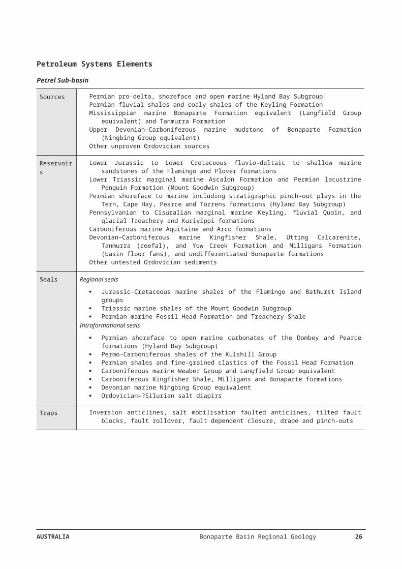
However, since it has been shown that these oils are generated from the slightly older Langfield Group (Gorter et al, 2004, 2005; Gorter, 2006b) and the younger Tanmurra Formation (Gorter and McKirdy, 2013) further modelling of these alternative source rocks is required. Similarly, the origin of many of the oil shows within the southern Petrel Sub-basin is unclear. Further oil-source correlation studies are required to determine if source rocks within the Milligans Formation, Devonian Ningbing and Cockatoo groups, and inferred older Paleozoic units, have contributed to oil accumulations in the Petrel Sub-basin. Additional research regarding the age and distribution of the source pods, and the timing of seal deposition are also warranted.
Modelling of expulsion from shales and coaly shales of the Cisuralian Keyling Formation suggests hydrocarbon generation is restricted to the central and outer portions of the Petrel Sub-basin. Expulsion from the outer Petrel Sub-basin occurred in the Lopingian–Early Triassic, whereas, in the central Petrel Sub-basin (i.e. below TD of the Petrel wells), it commenced and peaked in the Early Triassic and continued into the mid-Cretaceous. Structural traps within the sub-basin predominantly formed during the Middle–Late Triassic Fitzroy Movement, and hence, post-date the main phase of modelled oil expulsion from any oil-prone source units within the Keyling Formation, Treachery Shale and Kuriyippi Formation. Modelled gas expulsion from the Hyland Bay Subgroup is limited to the outer portions of the Petrel Sub-basin adjacent to the Malita Graben. Expulsion occurred throughout the Jurassic and Cretaceous, with peak expulsion occurring in the middle–late Cretaceous. This subgroup is considered too lean to expel significant quantities of oil. The Petrel, Tern, Penguin and possibly the Fishburn gas accumulations are probably sourced from either the Hyland Bay Subgroup or Keyling Formation, although a Carboniferous input to the Fishburn and Blacktip gas accumulations has not been discounted.
Vulcan Sub-basin
Various models have been proposed to explain hydrocarbon expulsion and migration in the Vulcan Sub-basin. The 1D modelling undertaken by Kennard et al (1999) predicted relatively restricted areas of oil and gas expulsion from the lower Vulcan Formation in the Swan and Paqualin graben. Subsequent 2D and 3D modelling undertaken by Chen et al (2002), Fujii et al (2004) and Neumann et al (2009) showed more widespread expulsion extending northward into the Cartier Trough, and migration paths within the underlying Plover Formation westward onto the Ashmore Platform and eastward to the Skua, Cassini-Challis and Jabiru accumulations. Significantly, Chen et al (2002) modelled hydrocarbon migration westward to Puffin and northwestward onto the Ashmore Platform, providing an explanation for the oil show in Warb 1A.
Modelling suggests that hydrocarbon generation and expulsion in the Vulcan Sub-basin commenced in the Late Jurassic and continued through to the Early Cretaceous (Figure 19), largely in response to elevated heat flow associated with rifting (Kennard et al, 1999; Fujii et al, 2004; Neumann et al, 2009). However, the main phase of oil expulsion in the Swan Graben occurred in the Late Jurassic to Early Cretaceous and during the middle to late Cenozoic in the Cartier Trough, being largely driven by burial compaction. The main phase of gas expulsion coincided with the main phase of gas generation, which occurred in the Late Jurassic to Early Cretaceous. Later phases of gas expulsion, in response to burial and compaction, took place in the Paleocene–Eocene and the Pliocene–Holocene. Source rock transformation ratios and bulk generation rates indicate that the source rocks are still generating hydrocarbons (Neumann et al, 2009; Abbassi et al, 2014).
Fujii et al (2004) and Neumann et al (2009) also modelled generation and migration from the combined lower Vulcan and Plover formations, which resulted in more pervasive expulsion, migration and accumulation in the eastern portion of the Vulcan Sub-basin, especially on the Montara Terrace. These models suggest middle Cenozoic expulsion and migration from the Plover Formation in the southwestern Swan Graben into the Montara and Tahbilk structures, which is consistent with the geochemical interpretation of Edwards et al (2004), that these oils and gases are sourced from the Plover Formation.
Northern Bonaparte Basin—Sahul Syncline/Nancar Trough
Temperature maps of the ‘Top Elang’ surface showing 120°C and 140°C isotherms by Preston and Edwards (2000) provide a basic understanding of the effective limits for expulsion of hydrocarbons from the Elang/Plover formations and basal Frigate Formation, respectively. They determined that the Elang and Plover formations are mature for hydrocarbon generation across the Sahul Syncline, northern Flamingo Syncline and southwestern Malita Graben, and are the likely source for the majority of hydrocarbon accumulations in the area, including all producing fields. Geochemical differences between the Laminaria-Corallina oils and the Bayu-Undan gas/condensates were explained by a more mature hydrocarbon charge and an additional source input from the marine Flamingo Group at Bayu-Undan.
AUSTRALIA Bonaparte Basin Regional Geology 26
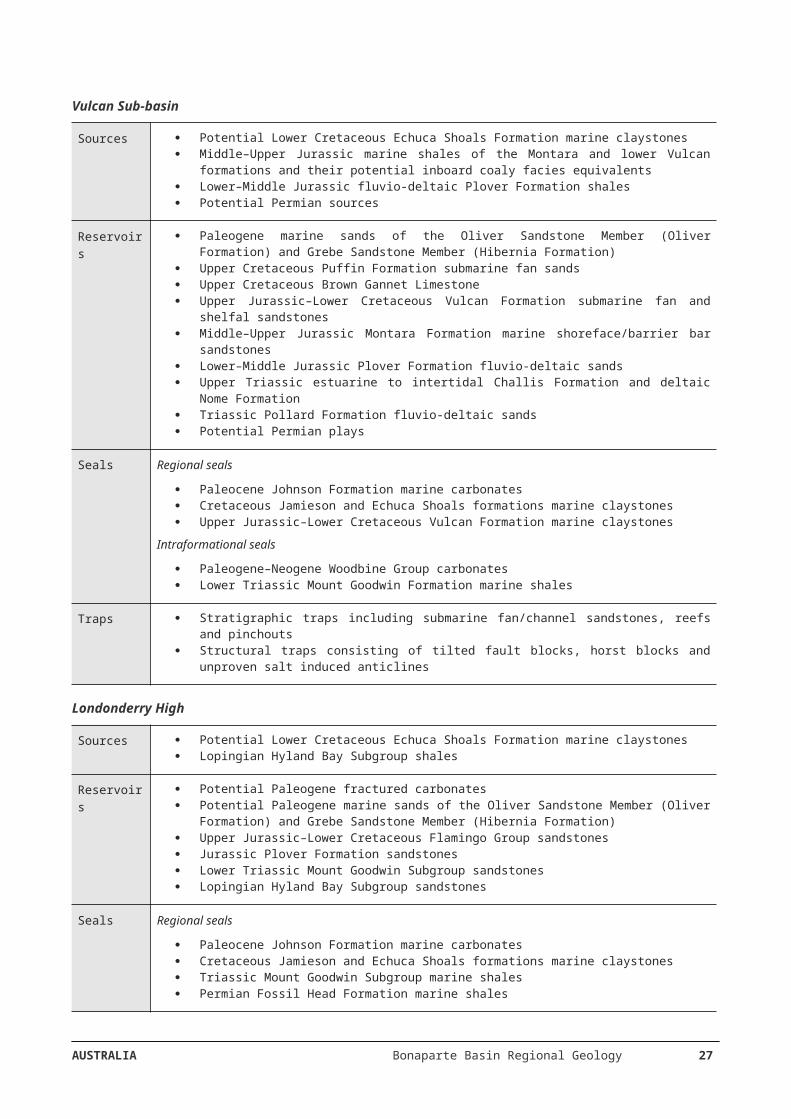
In the central northern Bonaparte Basin, on the Laminaria and Flamingo highs, oils reservoired within the Jurassic Plover and Elang formations have been divided into two end-member families by Preston and Edwards (2000). The oils from the Laminaria and Corallina accumulations, as well as those from the neighbouring Sahul Syncline region, have a mixed land-plant and marine source affinity, whereas the oils/condensates of the Elang, Kakatua and Bayu-Undan accumulations to the southeast, on and near the Flamingo High, have a marine source affinity. The Jurassic–Lower Cretaceous marine shales within the Flamingo Group are the main sources of oils reservoired in the Laminaria and Corallina accumulations.
Organic-rich marine sediments of the Lower Cretaceous Echuca Shoals Formation within the Sahul Syncline are a potential source of wet gas and some light oil (Abbassi et al, 2014, 2015). Oil shows within the Lower Cretaceous Darwin Formation from Elang West 1, Layang 1 and Kakatua North 1 (Preston and Edwards, 2000), as well as gas at Firebird 1 on the Flamingo High, are also likely to originate from the Echuca Shoals Formation. These hydrocarbons are assigned to the Westralian 3 Petroleum System.
Geochemical studies of the gases from the northern Sahul Platform Greater Sunrise area, and in the Malita and Calder graben, indicate that they are probably sourced from the Plover Formation in the main depocentres and on the Heron and Troubadour terraces (Longley et al, 2002; Edwards et al, 2006). Thus, these northern Bonaparte Basin gas accumulations are assigned to the Westralian 1 Petroleum System. Jules et al (2016a, 2016b) conducted burial history modelling and studied the source rock richness and hydrocarbon generative potential of Loxton Shoals 1, Sunset 1 and Chuditch 1 (Sahul Platform), Heron 1 (Malita Graben) and Lynedoch 1 and 2 (western flank of the Calder Graben). In addition to the Plover Formation, they suggest that the Petrel (Frigate) and Echuca Shoals formations also have generative potential, and the latter continues to expel hydrocarbons.
Londonderry High
Work on several wells of the Londonderry High, using apatite fission track analysis and vitrinite reflectance, has identified two paleo-thermal episodes: Eocene-Oligocene and, probably, Pliocene (Geotrack, 2012; Duddy et al, 2004). The information generated is used to construct a thermal history framework from which the burial/uplift and hydrocarbon generation history can be understood.
Play types
Petrel Sub-basin
The Fitzroy Movement was responsible for creating large-scale inversion anticlines (commonly associated with salt mobilisation), such as those drilled by the Petrel wells, and the Bougainville 1, Curlew 1, Gull 1, Penguin 1 and Sandpiper 1 wells. Anticlines associated with faulting include those drilled by the Tern and Blacktip wells, and the Billabong 1, Frigate 1, Lacrosse 1 and Lesueur 1 wells (Figure 21). A tilted fault block was drilled at Fishburn 1.
Salt tectonics (flow, diapirism and withdrawal) has created numerous potential structural and stratigraphic petroleum traps. These features have been identified across most of the sub-basin (Edgerley and Crist, 1974;
Durrant et al, 1990). Salt movement may have triggered petroleum migration and influenced migration pathways throughout the development of the Petrel Sub-basin.
Salt-related petroleum plays in the Petrel Sub-basin range from salt-core plays to salt-withdrawal basin plays (Figure 22). The timing of salt movements in the sub-basin varies widely, although many such salt-related traps may have formed too late with respect to hydrocarbon generation and migration. There is abundant evidence on seismic data for the presence of turbidites, basin-floor sandstones, slope-fan sandstones and coastal onlap of sandstone bodies within local depocentres over slowly migrating salt bodies (Lemon and Barnes, 1997; Miyazaki, 1997). These sandstones constitute primary exploration objectives when found in favourable trap geometries.
Stratigraphic pinch-out plays of Permian sandstones within the Hyland Bay Subgroup at the basin margin have been tested by wells such as Flat Top 1 and Newby 1, although success has proven elusive.
AUSTRALIA Bonaparte Basin Regional Geology 27
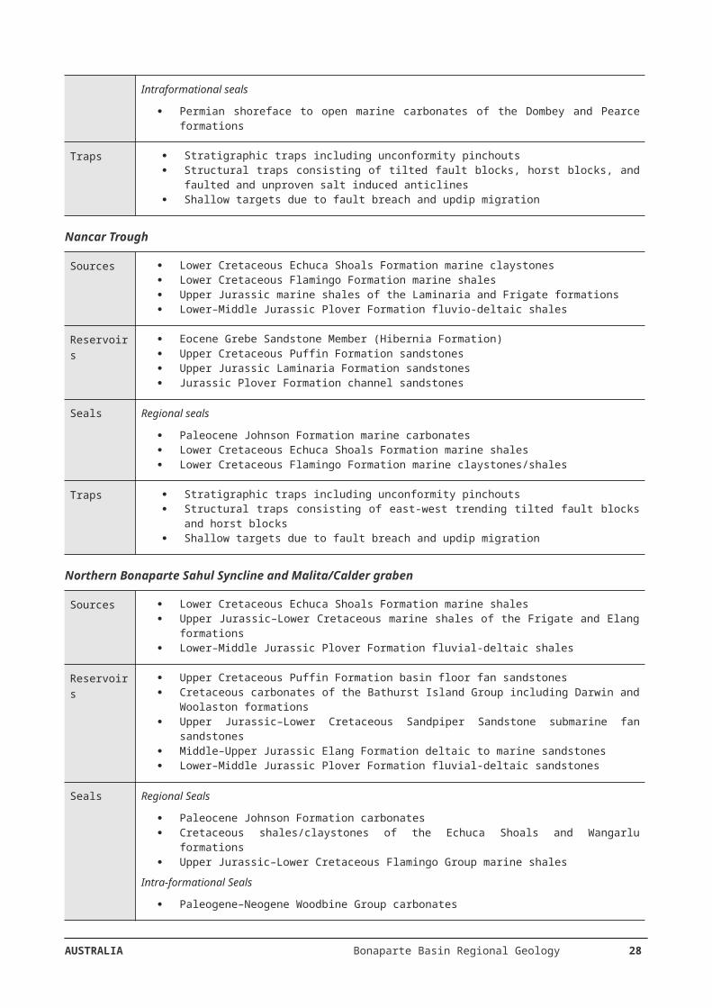
Vulcan Sub-basin
For the Vulcan Sub-basin the main targets have been structural traps comprising tilted fault blocks or hour-glass structures, where the latter dominates in the north (Woods, 1992). Explorers in the Vulcan Sub-basin have traditionally targeted tilted fault blocks and horsts sealed by the Lower Cretaceous Echuca Shoals Formation or Jurassic–Cretaceous lower/upper Vulcan Formation. Many successful discoveries of petroleum have resulted—most of which are reservoired either in the Jurassic Plover and Montara formations (Jabiru, Skua) or in the Late Triassic Nome and Challis Formations (Challis-Cassini). Higher in the stratigraphic succession, the Late Cretaceous Puffin Formation hosts several petroleum accumulations (Puffin, Swan and East Swan), which are plays of four-way dip closure with a stratigraphic component of sands within carbonates. Shallower still, a small oil pool was discovered in the Grebe Sandstone Member (Hibernia Formation; Pituri 1) and reinforces the potential for shallow sand targets sealed within marine carbonate facies (Figure 23, Figure 24).
Hydrocarbon entrapment due to deep-seated Paleozoic salt diapir structuring (Figure 25) is also a valid play type (Swan and Paqualin).
O’Brien et al (1993) observed that all of the significant hydrocarbon discoveries in the Vulcan Sub-basin appear to be preferentially located either along, or at the intersection of, northwest and north–south trending fault sets with the northeast/eastnortheast trending structural grain. They suggest that a number of largely untested ‘fairways’ exist within the Vulcan Sub-basin and include rollovers into the downthrown side of faults, fans, mounds, scours and stratigraphic pinchouts as shown on a sequence stratigraphic well correlation across the sub-basin(Figure 26).
Northern Bonaparte Basin—Sahul Syncline/Nancar Trough
Plays in the southern part of the Nancar Trough (Figure 27), just north of the Release Areas, are expected to be similar to those in the Vulcan Sub-basin, with the added structural risk/potential of trap compartmentalisation, tilt and breach due to the greater proximity of the Neogene initiated plate collision boundary.
For the Sahul Syncline, its sag-like geometry highlights its flanks as play type locations (e.g. turbidite fans), although Jurassic Plover Formation reservoir facies within horst structures remain prospective (Rambler 1).
Londonderry High
For the Londonderry High, identified plays are primarily those of Sandpiper Sandstone sands sealed by Bathurst Island Group claystones/shales within tilted Triassic horst/fault blocks, as well as similar structural settings for Hyland Bay Subgroup sands sealed by claystones/shales of the Mount Goodwin Subgroup. Further potential exists for combined structural/stratigraphic plays in Plover Formation sands on the flanks with the surrounding deeper Vulcan Sub-basin, Nancar Trough and Sahul Syncline. As the northernmost parts of the Londonderry High have a higher potential of trap breach via fault reactivation it has been suggested that stratigraphic traps are an alternative potential play in the area (Brincat et al, 2001). The possibility of the vertical migration of hydrocarbons, due to fault leakage, to charge shallower reservoirs beneath effective seals should also be considered.
Critical risks
The fundamental risks for petroleum accumulation integrity in the Bonaparte Basin include: proximity to source kitchens; source-to-trap charging mechanisms and timings; and post-accumulation leakage via fault breach and structural tilt. Although the conjoined Release Areas are surrounded by deeper basinal elements (Figure 5), which are proven source kitchens that host oil/gas fields and exploration wells with significant hydrocarbon markers, a commercial discovery therein has been lacking.
Exploration success in the Petrel Sub-basin is dependent on the identification of good quality reservoirs and traps capable of retaining economic volumes of hydrocarbons that have access to active source kitchens. Exploration risks include preservation of hydrocarbon accumulations following early and late Carboniferous tectonic activity, Triassic uplift and erosion, and Miocene fault reactivation. Salt diapir intrusions, as seen at Pelican Island 1, Matilda 1 and Sandpiper 1, may locally disturb stratigraphy and primary seal capacity but also provide secondary sealing capability. Although the timing of salt movements in the sub-basin varies
AUSTRALIA Bonaparte Basin Regional Geology 28
widely, many salt-related traps may have formed too late with respect to hydrocarbon generation and migration (Lemon and Barnes, 1997; Miyazaki, 1997). As oil shows occur throughout the Carboniferous and Permian sediments in wells in the southern Petrel Sub-basin, further investigation of vertical and lateral seal integrity is required. Reservoir and source rock quality is variable and poorly understood in older units, with the preservation of porosity and permeability within Devonian–Carboniferous reservoirs and the Keyling Formation a significant risk. The timing of hydrocarbon expulsion for Devonian–Carboniferous petroleum systems in the Petrel Sub-basin is poorly understood. To date, wells have not penetrated either Silurian or older Paleozoic units in the offshore Bonaparte Basin, so offshore plays of this age are highly speculative. Biodegradation and fresh-water flushing is a risk in shallow reservoirs as demonstrated in the Turtle and Barnett accumulations, although oil in deeper reservoirs may be unaltered. Elevated geothermal gradients during the Middle Jurassic, as modelled in Keep River 1, may affect the timing of hydrocarbon generation and expulsion in the southern Petrel Sub-basin and adversely affect reservoir quality. The key risks in Release Areas NT17-2 and W17-1 are the absence of a proven oil-prone system in the central Petrel Sub-basin, and the small number of suitably sized trap closures for economic gas accumulations. The southern part of Release Area W17-2 may be at the limit of the effective late Carboniferous–Permian gas-prone petroleum system to the north. Gas charge is confirmed at Blacktip immediately to the south, and at Fishburn, Tern, Petrel and Penguin accumulations in the central Petrel Sub-basin.
Structural complexity in the Vulcan Sub-basin has meant unambiguous imaging of reservoir-trap-seal geometries has been difficult. Repeated episodes of fault reactivation (particularly during the Neogene) and associated remigration, water-washing and gas-flushing have locally degraded oil accumulations in ‘leaky traps’, such as Skua and Jabiru. The risk of water washing degrading any oil accumulations in the Release Areas is a risk—oil from Puffin 1, 2 and 5 shows significant water washing; the Skua, Jabiru and Tenacious oils show moderate water washing; and the Bilyara 1 and Crux 1 oils show negligible evidence of water washing (Edwards et al, 2004). To the southwest, the Montara 1 and 2 oil accumulation is biodegraded (Edwards et al, 2004). In addition, while remobilised evaporites, as seen at Paqualin 1 and adjacent to Vulcan 1B, are less extensive in the Vulcan Sub-basin than in other parts of the Bonaparte Basin, there is a risk that localised salt intrusions could impact on seal integrity. Elevated geothermal gradients during the Middle Jurassic, as modelled in Jabiru 1 and Swan 2 (Lisk, 2012), may affect the timing of hydrocarbon generation and expulsion in the Vulcan Sub-basin, as well as adversely affect reservoir quality.
For the Sahul Syncline, although proven petroleum systems and traps have been identified, a detailed understanding of reservoir distribution and fault-associated migration pathways in this underexplored region is lacking. Elevated geothermal gradients may preclude the generation and preservation of liquid hydrocarbons in deeper parts of the syncline. Heterogeneity of source rocks, particularly within the Plover Formation, is a risk that may affect charge potential. Diagenetic and structural overprinting together reduce the probability of sufficient charge reaching traps outwards on the flanks. Reservoir quality, hydrocarbon migration pathways and potential hydrocarbon recovery factors have been adversely impacted by sandstone diagenesis in the deeper parts of the Sahul Syncline (Passmore et al, 1997).
For the Nancar Trough region, including the Laminaria High, the key risks are underfilled or completely breached traps. Given its proximity to the Banda Arc collisional front, the geometry of faults within the prevailing stress direction will strongly influence the sealing capacity of those faults (Castillo et al, 2000).
For the Londonderry High, the key risks are adequate charge and migration from adjacent synclinal source kitchens, coupled with variable reservoir character and fault-trap breach. Apart from Halcyon 1 in the north, gas charge on the platform proper, in the south, is confirmed by Prometheus 1 and Rubicon 1, and oil generation/migration is confirmed by the palaeo-oil accumulations at Torrens 1 and Prometheus 1.
For the Calder Graben, reservoir quality is variable due to localised diagenesis and irregularity of the natural fracture networks, which potentially reduce trap capacity and hydrocarbon recoverability. Intraformational heterogeneity within the Plover Formation reservoir and source rocks is a risk. Where developed (e.g. at Sunrise 1), the distribution of shelly interbeds play a primary role in vertical reservoir connectivity. Diagenetic variability in reservoirs is likely related to high geothermal gradients as measured at Evans Shoal 1 and Blackwood 1, which may preclude the generation and preservation of liquid hydrocarbons in deeper plays. Reservoir quality of the Frigate Shale and Elang Formation is likely to decrease basinward as more distal sediments become finer-grained. The complex rifting history and extensive faulting in the region increase the risk of trap breach. Gas flushing is pervasive in the northern Bonaparte Basin and is a major risk for the preservation of liquid hydrocarbons. Gas reservoired within the Plover Formation typically has a high carbon dioxide content.
AUSTRALIA Bonaparte Basin Regional Geology 29
Marine environment informationThe following section contains information about the existing marine parks, their special habitat zones and physiographic features (Figure 28). The information is provided in support of business decisions with respect to planned exploration and development activities.
Marine Parks
Australian Marine Parks (Commonwealth reserves proclaimed under the EPBC Act in 2007 and 2013) are located in Commonwealth waters that start at the outer edge of state and territory waters, generally three nautical miles from the shore, and extend to the outer boundary of Australia’s Exclusive Economic Zone, 200 nautical miles from the shore. Marine parks have also been established by the state and territory governments in their respective waters. The marine parks operate under management plans that provide a balance between protection of the marine environment, and sustainable use of the area. Links to these management plans are provided for each marine park or marine park network in the Bonaparte Basin region.
Australian Marine Parks: North Marine Parks Network
The North Marine Parks Network comprises eight marine parks within the North Marine Region, which extends from the west Cape York Peninsula to the Northern Territory-Western Australia border. The marine environment of the area is characterised by shallow-water tropical marine ecosystems and a large area of continental shelf. The region has high species diversity and globally significant populations of internationally significant threatened species.
Two of the marine parks within the North Marine Parks Network overlie the Bonaparte Basin: Oceanic Shoals Marine Park and Joseph Bonaparte Gulf Marine Park.
Management plans for the North Marine Parks Network are in place, and can be viewed at: https://parksaustralia.gov.au/marine/pub/plans/north-management-plan-2018.pdf
Oceanic Shoals Marine Park
The Oceanic Shoals Marine Park is located west of the Tiwi Islands, approximately 155 km northwest of Darwin, Northern Territory, and 305 km north of Wyndham, Western Australia. It extends to the limit of Australia’s exclusive economic zone. The Marine Park covers an area of 71,743 km² and water depths from less than 15 m up to 500 m.
Statement of significance
The Oceanic Shoals Marine Park is significant because it contains habitats, species and ecological communities associated with the Northwest Shelf Transition. It contains four key ecological features: carbonate bank and terrace systems of the Van Diemen Rise, carbonate bank and terrace systems of the Sahul Shelf, pinnacles of the Bonaparte Basin, and shelf break and slope of the Arafura Shelf—all valued as unique seafloor features with ecological properties of regional significance. The Oceanic Shoals Marine Park is the largest marine park in the North Marine Parks Network.
The Oceanic Shoals Marine Park is assigned International Union for the Conservation of Nature (IUCN) category VI (Protected Area with sustainable use of natural resources). The park includes four zones assigned under the North Marine Parks Network Management Plan (2018): National Park Zone (II); Habitat Protection Zone (IV); Multiple Use Zone (VI); and Special Purpose Zone (Trawl) (VI). Note that mining operations including exploration are not allowed in designated National Park Zone (II) or Habitat Protection Zone (IV).
Joseph Bonaparte Gulf Marine Park
The Joseph Bonaparte Gulf Marine Park is located approximately 15 km west of Wadeye, Northern Territory, and approximately 90 km north of Wyndham, Western Australia, in the Joseph Bonaparte Gulf. It is adjacent to the Western Australian North Kimberley Marine Park. The Marine Park covers an area of 8597 km² and water depth ranges between less than 15 m up to 100 m.
AUSTRALIA Bonaparte Basin Regional Geology 30
Statement of significance
The Joseph Bonaparte Gulf Marine Park is significant because it contains habitats, species and ecological communities associated with the Northwest Shelf Transition bioregion. It includes one key ecological feature: the carbonate bank and terrace system of the Sahul Shelf (valued as a unique seafloor feature with ecological properties of regional significance).
The Marine Park contains a number of prominent shallow seafloor features including an emergent reef system, shoals, and sand banks. It is near an important wetland systems including the Ord River floodplain Ramsar site, and provides connectivity between the nearshore and sea environments. The Marine Park includes habitats connecting to and complementing the adjacent Western Australian North Kimberley Marine Park.
The Marine Park is assigned IUCN category VI and includes two zones assigned under the North Marine Parks Network Management Plan (2018): Multiple Use Zone (VI) and Special Purpose Zone (VI).
Australian Marine Parks: North-west Marine Parks Network
The North-west Marine Parks Network comprises thirteen marine parks within the North-west Marine Region, which extends from the Western Australian-Northern Territory border to Kalbarri, south of Shark Bay. The marine environment of the area is characterised by shallow-water tropical marine ecosystems, a large area of continental shelf (including the narrowest part of continental shelf on Australia’s coastal margin), and continental slope, with two areas of abyssal plain to depths of 600 m. The region has high species diversity and globally significant populations of internationally significant threatened species. A small number of species are found nowhere else, but most of the region’s species are tropical and found in other parts of the Indian Ocean and the western Pacific Ocean.
Three of the marine parks within the North-west Marine Parks Network overly the Bonaparte Basin: Kimberley Marine Park, Ashmore Reef Marine Park, and Cartier Island Marine Park.
Management plans for the North-west Marine Parks Network are in place, and can be viewed at: https://parksaustralia.gov.au/marine/pub/plans/north-west-management-plan-2018.pdf
Kimberley Marine Park
The Kimberley Marine Park is located approximately 100 km north of Broome, extending from the Western Australian state water boundary north from the Lacepede Islands to the Holothuria Banks offshore from Cape Bougainville. The Marine Park is adjacent to the Western Australian Lalang-garram / Camden Sound Marine Park and the North Kimberley Marine Park. The Marine Park covers an area of 74 469 km² and water depths from less than 15 m up to 800 m.
Statement of significance
The Kimberley Marine Park is significant because it includes habitats, species and ecological communities associated with the Northwest Shelf Province, Northwest Shelf Transition and Timor Province. It includes two key ecological features: the ancient coastline at the 125 m depth contour (an area of enhanced productivity and migratory pathway for cetaceans and pelagic marine species), and continental slope demersal fish communities (valued for high levels of endemism and diversity and the second richest area for demersal fish species in Australia).
The Marine Park provides connectivity between deeper offshore waters, and the inshore waters of the adjacent Western Australia North Kimberley Marine Park and Lalang-garram / Camden Sound Marine Park.
The Marine Park is assigned IUCN category VI and includes three zones assigned under the North-west Marine Parks Network Management Plan (2018): National Park Zone (II), Habitat Protection Zone (IV) and Multiple Use Zone (VI).
Ashmore Reef Marine Park
The Ashmore Reef Marine Park is located approximately 630 km north of Broome and 110 km south of the Indonesian island of Roti. The Marine Park is located in Australia’s External Territory of Ashmore and Cartier
AUSTRALIA Bonaparte Basin Regional Geology 31
Islands and is within an area subject to a Memorandum of Understanding (MoU) between Indonesia and Australia, known as the ‘MoU Box’. The Marine Park covers an area of 583 km² and water depths from less than 15 m up to 500 m. The Marine Park contains three vegetated sand cays that are permanently above water: West, Middle and East islands.
Statement of significance
The Ashmore Reef Marine Park is significant because it includes habitats, species and ecological communities associated with the Timor Province. It includes two key ecological features: Ashmore Reef and Cartier Island and surrounding Commonwealth waters (valued for high productivity and breeding aggregations of birds and other marine life); and continental slope demersal fish communities (valued for high levels of endemism).
Ashmore Reef is the largest of three emergent oceanic reefs in the region and the only one with vegetated islands. The Marine Park is an area of enhanced biological productivity and a biodiversity hotspot, supporting a range of pelagic and benthic marine species and an important biological stepping stone facilitating the transport of biological material to the reef systems along the Western Australian coast via the south-flowing Leeuwin Current which originates in the region.
The Ashmore Reef Ramsar site is located within the boundary of the Marine Park. The site was listed under the Ramsar Convention in 2002 and is a wetland of international importance under the Environment Protection and Biodiversity Conservation (EPBC) Act. An Ecological Character Description that sets out the Ramsar listing criteria met by the site, the key threats and knowledge gaps, is available on the Department’s website.
The Marine Park is assigned IUCN category Ia and includes two zones assigned under the North-west Marine Parks Network Management Plan (2018): Sanctuary Zone (Ia) and Recreational Use Zone (IV). Note that mining operations including exploration are not allowed in designated Sanctuary Zones (Ia).
Cartier Island Marine Park
The Cartier Island Marine Park is located approximately 45 km south-east of Ashmore Reef Marine Park and 610 km north of Broome, Western Australia. Both Marine Parks are located in Australia’s External Territory of Ashmore and Cartier Islands and are within an area subject to a Memorandum of Understanding (MoU) between Indonesia and Australia, known as the ‘MoU Box’. The Marine Park covers an area of 172 km² and water depths from less than 15 m up to 500 m.
Statement of significance
The Cartier Island Marine Park is significant because it includes habitats, species and ecological communities associated with the Timor Province. It includes two key ecological features: Ashmore Reef and Cartier Island and surrounding Commonwealth waters (valued for high productivity and breeding aggregations of birds and other marine life); and continental slope demersal fish communities (valued for high levels of endemism).
Like the islands of Ashmore Reef, Cartier Island is a biodiversity hotspot and an important biological stepping stone, facilitating the transport of biological material to the reef systems along the Western Australian coast via the south-flowing Leeuwin Current which originates in the region.
The Marine Park is assigned IUCN category Ia (Strict Nature Reserve) and includes one zone assigned under the North-west Marine Parks Network Management Plan (2018): Sanctuary Zone (Ia).
Western Australian Marine Parks
North Kimberley Marine Park
The North Kimberley Marine Park is located in the Indian Ocean and the Timor Sea in the waters of Western Australia’s Kimberley region. The Marine Park extends north-east from York Sound, around Cape Londonderry and the Joseph Bonaparte Gulf to the Western Australia/Northern Territory boundary, and from the mainland high water mark to the limit of State coastal waters. The Marine Park covers approximately 1 845 000 hectares with its south-western boundary located about 270 km northeast of Derby.
AUSTRALIA Bonaparte Basin Regional Geology 32
The zoning scheme for the North Kimberley Marine Park comprises
eight sanctuary zones
nine special purpose zones (recreation and conservation)
two special purpose zones (cultural heritage)
general use in the remainder of the park.
Special purpose zones (recreational and conservation) acknowledge the recreational and cultural value of the area and allow for some commercial activities whilst providing enhanced protection and conservation for ecological values. Special purpose zones (cultural heritage) provide for recognition and protection of sites of high cultural significance to the traditional owners. Sanctuary zones protect areas of critical habitat to maintain healthy functioning of the complex ecosystems that make up the marine park.
The North Kimberley Marine Park will be jointly managed by Western Australian Parks and Wildlife Service and the Wunambal Gaambera, Balanggarra, Ngarinyin and Miriuwung Gajerrong traditional owners for each of their respective saltwater management areas. Wunambal Gaambera country extends from south of Prince Frederick Harbour to Napier Broome Bay in the north of the Kimberley. Balanggarra sea country stretches from Napier Broome Bay to Cambridge Gulf and Wyndham. Miriuwung Gajerrong country extends from Cambridge Gulf into the Northern Territory. For further details, refer to the North Kimberley Marine Park Management Plan.
Biologically important areasThe Bonaparte Basin overlaps or is close to the following biologically important areas:
The Crested Crested Tern, Lesser Crested Tern, Lesser Frigatebird, Roseate Tern and Little Tern breeding and foraging areas lie on the coast and islands adjacent to the Basin, including Ashmore Reef
The Pygmy Blue Whale distribution and migration area overlaps the north of the Basin
Biologically important area for Australian Snubfin, Indo-Pacific Humpback and Indo-Pacific/Spotted Bottlenose dolphins, which breed, calve, and forage to the east and south of the Basin
Habitat critical and biologically important area for the Flatback, Green, Leatherback, Loggerhead and Olive Ridley turtles, which nest and forage to the east and south of the Basin, including offshore islands.
The Whale Shark foraging area overlaps the Basin, extending inland to the shore from the 200 m isobath.
The National Conservation Values Atlas and the Atlas of Living Australia provide further information and visualisations concerning animals and plants recorded in the Bonaparte Basin region.
HeritageMaritime HeritageAustralia protects its shipwrecks and associated relics that are older than 75 years through the Historic Shipwrecks Act 1976.
There is one historic shipwreck protected zone in the Bonaparte Basin region: the merchant ship Florence D, which is located in the Timor Sea near Bathurst Island. This shipwreck is of considerable wartime significance to Australia, the United States and the Philippines. The protected zone extends in all directions from the shipwreck, with a radius of 797 metres.
AUSTRALIA Bonaparte Basin Regional Geology 33
There are several additional shipwrecks within the Bonaparte Basin that are not associated with a defined protected zone. These can be identified using the Australian National Shipwreck Database map search tool.
FisheriesThe following Commonwealth fisheries operate within the Bonaparte Basin area:
The Northern Prawn Fishery is located off Australia’s northern coast from Cape York in Queensland to Cape Londonderry in Western Australia. Season one runs from 1 April to 15 June, and season two runs from 1 August to 30 November.
The Southern Bluefin Tuna Fishery covers the entire sea area around Australia, out to 200 nm from the coast. The fishing season runs for 12 months, starting on 1 December.
The Western Tuna and Billfish Fishery covers the sea area west from the tip of Cape York in Queensland, around Western Australia, to the border between Victoria and South Australia. Fishing occurs in both the Australian Fishing Zone (generally between 3 nautical miles and 200 nautical miles from the coast) and adjacent high seas. The fishing season runs for 12 months, starting on 1 February.
The North West Slope Trawl Fishery is located in deep water from the coast of the Prince Regent National Park to Exmouth between the 200 m depth contour to the outer limit of the Australian Fishing Zone. The fishing season runs for 12 months, starting on 1 July.
The following Northern Territory fisheries operate within the Bonaparte Basin area:
The Northern Territory demersal fishery operates from 15 nautical miles from the low water mark to the outer boundary of the Australian Fishing Zone (200 nautical miles offshore), excluding the area of the Timor Reef fishery.
The Northern Territory offshore net and line fishery operates in all Northern Territory waters from the low water mark to the boundary of the Australian Fishing Zone. Most fishing is done within 12 nautical miles of the coast and immediately offshore in the Gulf of Carpentaria.
The Northern Territory Spanish Mackerel fishery operates from the high water mark to the outer boundary of the Australian Fishing Zone. Fishing generally takes place around reefs, headlands and shoals.
The Timor Reef fishery operates in a region known as the ‘Timor Box’, which extends north-west of Darwin to the Western Australia/Northern Territory border, and to the out boundary of the Australian Fishing Zone.
Recreational and charter fishing also occurs in Northern Territory waters.
The Bonaparte Basin is located within the Western Australia North Coast Bioregion. The Western Australian Government manages 12 commercial fisheries within the bioregion. Recreational fishing also occurs within the Western Australian North Coast Bioregion.
Climate of the region
The Joseph Bonaparte Gulf and Timor Sea region is characterised by a tropical climate with a dry season from April to November and a pronounced wet season for the remainder of the year. This rainfall pattern results in a peak fluvial discharge during December–March. Mean monthly average temperatures at the nearby Troughton Island weather station range from 25.3°C (July) to 30.3°C (November). The average annual rainfall at Troughton Island is 811.8 mm, with an average of 715.3 mm falling from December to March
AUSTRALIA Bonaparte Basin Regional Geology 34
(Bureau of Meteorology, 2019a). Tropical cyclones occur between November and April, at an average rate of one per year in the Timor Sea region, generally tracking to the south-west (Bureau of Meteorology, 2019b).
Oceanic regime
The coastal region onshore from the Bonaparte Basin is macrotidal, with spring tides reaching 7.8 m at Darwin, and 7.9 m at Wyndham. Offshore, the tidal range decreases to 4–5 m. Within the Joseph Bonaparte Gulf, diurnal components of tides form anticlockwise-moving tidal waves, while the semi-diurnal waves travel clockwise (Louis and Radok, 1975). Offshore, the Bonaparte Basin region is dominated by the Indonesian Throughflow, which flows southwest and principally affects the offshore Timor Sea region (Tomczak and Godfrey, 1994). Sea surface temperatures in this region are the highest in Australia at 29–30°C, and there is no major warming predicted here in the immediate future (Foster et al, 2014). Surface particle tracks suggest that during January to March, surface drift along the northwest shelf is directed northeast while during April–June drift is towards the southwest (Bahmanpour et al, 2016). However, tracks from drifters released in the Oceanic Shoals region indicate that some surface current motion is directed towards the coast (Nichol et al, 2013). Compared to other north and northwest regions, the Joseph Bonaparte Gulf and adjacent Timor Sea play a dominant role in influencing connectivity among marine parks (Kool and Nichol, 2015).
During monsoonal months, coastal waters to depths of around 100 m are affected by outflow from the major rivers. Annual significant wave heights of up to 2.5 m occur in the Timor Sea while annual significant wave heights of only 0.25 m occur along the coastal region, with wave heights increasing with distance from the shore. Under fair-weather conditions, wave heights are generally 1–1.2 m, with short wave periods of 5–6 seconds being typical. During cyclones, waves can be up to 8 m in height.
Seabed environments: regional overview
Discrete areas of the Bonaparte Basin seabed have been mapped in several surveys, providing detailed information on the composition of the seabed, seabed habitats and shallow subsurface (Heap et al, 2010; Anderson et al, 2011, Carroll et al, 2012; Nichol et al, 2013). Regional summaries of the geomorphology, habitats and environments (Heap and Harris, 2008; Przeslawski et al, 2011) are complemented by detailed scientific insights on aspects of recently mapped areas (Przeslawski et al, 2019; Picard et al, 2018; Radke et al, 2017; Nicholas et al, 2014).
The seabed overlying the Bonaparte Basin extends for more than 600 km northward from the Joseph Bonaparte Gulf, to beyond the shelf edge within the Timor Sea. This low-profile shallow shelf has a central broad shallow depression (less than 125 m depth), named the Bonaparte Depression. The Bonaparte Depression sits over the northern part of the Petrel Sub-basin, the southern part of the Sahul Syncline and the western part of the Malita Graben. Expansive carbonate platforms (Ashmore and Sahul Platforms, Darwin Shelf and Londonderry High) enclose the Bonaparte Depression to the north, west and east, in water depths of 50-70 m. Many small pinnacles and banks are present within the Bonaparte Depression. Offshore banks (e.g. Big Bank Shoals) up to 10 km2 in surface area are present across the shelf, with their bases in water depths of 300 m or more. These are particularly prominent on the Ashmore Platform, Vulcan Sub-basin, Nancar Trough and Laminaria High, and Troubador Terrace. The deepest seabed (~1800 m) lies to the north of the Sahul Platform within the Timor Sea on the southern flank of the Timor Strait.
The Malita Valley (maximum 237 m deep) extends northward from the Bonaparte Depression through the Malita Graben and across the Sahul Platform. Multiple unnamed shelf-incising valleys are also present across the raised carbonate platforms that enclose the Bonaparte Depression. In addition, submerged shallow channels cross the inner shelf toward the centre of the depression from the modern coastline. Similar channels are also present in the shallow subsurface (Anderson et al, 2011; Nicholas et al, 2014).
The most seaward sections of the Bonaparte Basin are dominated by extensive carbonate banks, shoals and terraces, and areas of seabed are dissected by channels up to 200 m deep. It has been proposed that large banks within the Joseph Bonaparte Gulf may be directly related to hydrocarbon seeps; however, evidence is limited (Ryan et al, 2009; Logan et al, 2010).
Much of the inner shelf, Bonaparte Depression, and banks and terraces are sediment-starved. Conversely, thick sequences of recent sediment are present across the Sahul Syncline-Malita Graben (Oceanic Shoals)
AUSTRALIA Bonaparte Basin Regional Geology 35
region, and on the shelf margin north of the Malita Valley (Nichol et al, 2013; Bourget et al, 2013). The thickest sediments are located in water depths of 200 m to the north of the Malita Valley outlet (Bourget et al, 2013).
In general, sediments within the Bonaparte region are a mixture of carbonate and siliciclastic, with higher percentages of carbonate in areas on and adjacent to banks, terraces and platforms. Shallow pockmarks are visible in detailed bathymetry and seabed photographs (Przeslawski et al, 2011; Nichol et al, 2013; Nicholas et al, 2014). These features likely formed due to shallow CO2 seepage from decomposing flooded Holocene mangrove beds (Nicholas et al, 2014; Nicholas et al, 2015a, 2015b but see also Mueller, 2015).
Within the modern Bonaparte Basin, sediment supply is primarily controlled by fluvial input, supplemented by biogenic carbonate sedimentation and carbonate bank erosion (Ishiwa et al, 2016). Nearshore, Holocene siliciclastic deposition is particularly evident in the south, where the Ord, Keep and Victoria rivers, among others, discharge into a shallow broad embayment, and tidal currents transport sediment into deeper water (Clarke and Ringis, 2000; Przeslawski et al, 2011). With increasing distance from the coast, the proportion of carbonate sediment increases, reaching a maximum of ~70% at the inner margin of the Oceanic Shoals area, beyond which the carbonate content decreases with increasing water depth (van Andel and Veevers, 1967). Clay content in seabed sediment samples from this region is near zero.
Strong seabed erosion occurs in the shallow inner shelf Cambridge Gulf where inshore gravels transition to muds with increasing depth. Further seaward, a transition zone of sand ribbons and sand ridges pass into sand waves and ripples (Clarke and Ringis, 2000). Spatially extensive areas with similar high-amplitude bedforms (e.g. sand waves) have not been documented in deeper parts of the modern Bonaparte Basin (Clarke and Ringis, 2000).
Ecology
The epibenthos over most of the inner Joseph Bonaparte Gulf (JBG) is sparse (URS Australia Pty Ltd, 2009; Woodside, 2004; Carroll et al, 2012; Nicholas et al, 2015a, 2015b). Although some scattered islands, reefs and other raised features in the inner JBG may support corals, macroalgae and seagrass (eg. King Shoals, Medusa Banks, Howland Shoals, Emu Reefs) (RPS, 2009), these communities are few compared to the dense assemblages of sessile invertebrates recorded in the far northwestern and northeastern JBG (URS Australia Pty Ltd, 2009; Przeslawski et al, 2015) and neighbouring areas (i.e. Big Banks of Heyward et al [1997], Sahul Shelf of Wienberg et al [2010]). Previous surveys in the JBG have shown no seagrass or macroalgae beyond coastal habitats and only isolated hard corals (ENI, 2005; LDM, 1994; Woodside, 2004; Carroll et al, 2012). Seabed sediments support these findings, with an absence of colonial corals, the green alga Halimeda, large foraminifera and coralline (red) algae (Clarke et al, 2001). Similarly, species composition of by-catch from the prawn fishery is distinctly different from that of other tropical regions in northern Australia (Tonks et al, 2008), indicating that the biota in the inner JBG differs from the biota from other areas in the Timor Sea (Heyward et al, 1997). Prawns represent one of the dominant epifauna of the soft sediment expanses, while diverse infaunal communities are dominated by polychaetes and other crustaceans (Woodside, 2004). Infaunal species overlap was high (~90%) between crustaceans collected from the inner JBG and those collected in the outer northeastern JBG (Carroll et al, 2012).
To the outer northwest and northeast of the JBG, rocky outcrops and carbonate banks support high abundances of epibenthic fauna, particularly crinoids (URS Australia Pty Ltd, 2009), sponges and gorgonians (soft corals) (Heap et al, 2010; Anderson et al, 2011; Nichol et al, 2013). These carbonate banks have been identified as hotspots of sponge biodiversity associated with overall high epibenthic biodiversity, although there are no obvious differences in sponge species assemblages between the eastern and western sides of the JBG (Przeslawski et al, 2014, 2015).
Recent geological history
The Bonaparte Basin is a drowned landscape built on weathered Cretaceous to Neogene strata, capped by Quaternary sediments. During Quaternary intervals of low sea-level, much of the Bonaparte Basin was subaerially exposed for prolonged intervals, and most of the carbonate banks, shoals and terraces would have undergone erosion and weathering. Seismic evidence from the intra-shelf basin indicates a prominent mid-Quaternary unconformity, which marks a partial burial of early Quaternary carbonate platforms, and the initiation of platform growth characterised by increased siliciclastic input, with only isolated carbonate build-
AUSTRALIA Bonaparte Basin Regional Geology 36
ups (Bourget et al, 2013). Sea level in the Bonaparte Basin region was 125 m lower during the last glacial maximum (23–19 ka BP) than at present (Ishiwa et al, 2016; Yokoyama et al, 2001b). At this time, the central basin was partially isolated from the Timor Sea (Yokoyama et al, 2001b, 2001a; Keep et al, 2002; Bourget et al, 2012, 2013; Langhi et al, 2011; Saqab and Bourget, 2015; Ishiwa et al, 2016); the modern basin (the Bonaparte Depression) was a brackish lake until 16 ka BP, and the majority of the shelf was not flooded until 12 ka BP (Yokoyama et al, 2001a).
National seabed mapping data and information
Geoscience Australia provides acoustic datasets including bathymetry, backscatter and sidescan sonar to assist in understanding the shape and composition of the sea floor. Geoscience Australia also maintain the Marine Sediment database (MARS), comprising information from seabed sediment samples collected during marine surveys between 1905 and 2017. Data available include percentage mud/sand/gravel, mean grain size and sediment texture.
These data are easily discoverable and accessible through the AusSeabed Marine Data Discovery Interface. AusSeabed is an innovative national seabed mapping initiative designed to coordinate data collection efforts in Australian waters, and provide open access to quality-controlled seabed data. AusSeabed is currently focussed on the enabling accessibility of bathymetry data in Australian waters, however the long-term goal is to establish a comprehensive online platform containing data and information, including tools to support data collectors and users in connecting with the broader seabed mapping community. This platform will also include derived data products including morphological and geomorphological maps of the sea floor.
Other online information resources
Please follow these links for more detailed information pertaining to the marine and environmental summaries provided in this section.
Bureau of Meteorology: climate statistics
National Conservation Values Atlas
Australian Marine Parks: North Marine Parks Network
Australian Marine Parks: North-west Marine Parks Network
Western Australian Marine Parks and Reserves
Commonwealth Fisheries
Historic shipwrecks
Protected Matters Search Tool
ReferencesABBASSI, S., DI PRIMIO, R., HORSFIELD, B., EDWARDS, D.S., VOLK, H., ANKA, Z. AND GEORGE, S.C., 2015—On the filling and leakage of petroleum from traps in the Laminaria High region of the northern Bonaparte Basin, Australia. Marine and Petroleum Geology, 59, 91–113.
ABBASSI, S., GEORGE, S.C., EDWARDS, D.S., DI PRIMIO, R., HORSFIELD, B. AND VOLK, H., 2014—Generation characteristics of Mesozoic syn- and post-rift source rocks, Bonaparte Basin, Australia: new insights from compositional kinetic modelling. Marine and Petroleum Geology, 50, 148–165.
AGSO AND GEOMARK, 1996—The Oils of Western Australia I. Petroleum Geochemistry and Correlation. Australian Geological Survey Organisation and GeoMark Research, Inc., Proprietary report, Canberra and
AUSTRALIA Bonaparte Basin Regional Geology 37
Houston, unpublished. http://www.ga.gov.au/metadata-gateway/metadata/record/36999/ (last accessed 1 March 2018).
AGSO AND GEOTECH, 2000—Characterisation of Natural Gases from West Australian Basins, Bonaparte Module. Australian Geological Survey Organisation, Canberra and Geotechnical Services Pty Ltd, Perth, Australia, Non-Exclusive Study.
AHMAD, M. AND MUNSON, T.J., 2013—Chapter 36: Bonaparte Basin. In: Ahmad, M. and Munson, T.J. (compilers), Geology and mineral resources of the Northern Territory, Northern Territory Geological Survey, Special Publication 5.
ANDERSON, A.D., DURHAM, M.S. AND SUTHERLAND, A.J., 1993—The integration of geology and geophysics to post-well evaluations – example from Beluga-1, offshore northern Australia. The APEA Journal, 33,15–27.
ANDERSON, T.J., NICHOL, S., RADKE, L., HEAP, A.D., BATTERSHILL, C., HUGHES, M., SIWABESSY, P.J., BARRIE, V., ALVAREZ DE GLASBY, B., TRAN, M. AND DANIELL, J., 2011—Seabed environments of the eastern Joseph Bonaparte Gulf, northern Australia: GA0325/Sol5117 - Post-survey report. Geoscience Australia, Record 2011/08, 61pp.
ARCO AUSTRALIA LIMITED,1969—Well Completion Report, Lacrosse No. 1, unpublished.
AUSTRALIAN AQUITAINE PETROLEUM PTY LTD,1970—Well Completion Report, Newby-1, unpublished.
BAHMANPOUR, M.H., PATTIARATCHI, C., WIJERATNE, E.M.S., STEINBERG, C. AND D'ADAMO, N., 2016—Multi-year observation of Holloway Current along the shelf edge of north Western Australia. Journal of Coastal Research, 75(sp1), 517–521.
BAKER, C., POTTER, A., TRAN, M. AND HEAP, A.D., 2008—Geomorphology and Sedimentology of the Northwest Marine Region of Australia. Geoscience Australia, Record 2008/07. Geoscience Australia, Canberra, 220pp.
BARBER, P., CARTER, P., FRASER, T., BAILLIE, P.W. AND MYERS, K., 2004—Under-explored Palaeozoic and Mesozoic petroleum systems of the Timor and Arafura seas, northern Australian continental margin. In: Ellis, G.K., Baillie, P.W. and Munson, T.J. (eds), Timor Sea Petroleum Geoscience, Proceedings of the Timor Sea Symposium, Darwin, Northern Territory, 19–20 June 2003. Northern Territory Geological Survey, Special Publication, 1, 143–154.
BARRETT, A.G., HINDE, A.L. AND KENNARD, J.M., 2004—Undiscovered resource assessment methodologies and application to the Bonaparte Basin. In: Ellis, G.K., Baillie, P.W. and Munson, T.J. (Eds), Timor Sea Petroleum Geoscience, Proceedings of the Timor Sea Symposium, Darwin, 19–20 June 2003. Northern Territory Geological Survey, Special Publication, 1, 353–372.
BAXTER, K., COOPER, G.T., O’BRIEN, G.W., HILL, K.C. AND STURROCK, S., 1997—Flexural isostatic modelling as a constraint on basin evolution, the development of sediment systems and palaeo-heat flow: application to the Vulcan Sub-basin, Timor Sea. The APPEA Journal, 37(1), 136–153.
BEACH ENERGY, 2014—[Web page] ASX announcement, 3 September 2014. Monthly Drilling Report, August 2014. http://www.asx.com.au/asxpdf/20140903/pdf/42rzmwkzmvbvwv.pdf (last accessed 1 March 2018).
BEERE, G.M., 1984—The Waggon Creek Formation—an early Carboniferous submarine fan deposit in the Bonaparte Gulf Basin. GSWA Report 12, 7–14.
BEERE, G.M. AND MORY, A.J., 1986—Revised stratigraphic nomenclature of the onshore Bonaparte and Ord Basins, Western Australia. Western Australia Geological Survey Record 1986/5.
BHATIA, M.R., THOMAS, M. AND BOIRIE, J.M.—1984. Depositional framework and diagenesis of the Late Permian gas reservoirs of the Bonaparte Basin. The APEA Journal, 24(1), 299-313.
BLEVIN, J.E., BOREHAM, C.J., SUMMONS, R.E., STRUCKMEYER, H.I.M. AND LOUTIT, T.S., 1998—An effective Lower Cretaceous petroleum system on the North West Shelf: evidence from the Browse Basin. In:
AUSTRALIA Bonaparte Basin Regional Geology 38
Purcell, P.G. and Purcell, R.R. (eds), The Sedimentary Basins of Western Australia 2: Proceedings of the Petroleum Exploration Society of Australia Symposium, Perth, 1998, 397–420.
BOREHAM, C.J., HOPE, J.M. AND HARTUNG-KAGI, B., 2001—Understanding source, distribution and preservation of Australian natural gas: a geochemical perspective. The APPEA Journal, 41(1), 523–547.
BOTTEN, P.R. AND WULFF, K., 1990—Exploration potential of the Timor Gap Zone of Cooperation. The APEA Journal, 30(1), 53–68.
BOUNTY OIL AND GAS NL, 2014—[Web page] AC/P 32 Vulcan Sub-basin 500 MMboip Prospect, Timor Sea, Australia. Farmin Opportunity. http://www.bountyoil.com/wp-content/uploads/2014/01/ACP-32-Management-Final-10012014.pdf (last accessed 1 March 2018).
BOURGET, J., AINSWORTH, R.B., BACKE, G. AND KEEP, M., 2012—Tectonic evolution of the northern Bonaparte Basin: impact on continental shelf architecture and sediment distribution during the Pleistocene. Australian Journal of Earth Sciences, 59, 877–897.
BOURGET, J., AINSWORTH, R. B. AND NANSON, R., 2013—Origin of mixed carbonate and siliciclastic sequences at the margin of a “giant” platform during the Quaternary (Bonaparte Basin, NW Australia). In: Verwer, K., Playton, T. E., Harris, P. M. (eds). Deposits, Architecture and Controls of Carbonate Margin, Slope and Basinal Settings. SEPM Special Publications No. 105, 21 pages.
BOURGET, J., NANSON, R., AINSWORTH, R.B., COURGEON, S., JORRY, S.J. AND AL-ANZI, H., 2013—Seismic stratigraphy of a Plio-Quaternary intra-shelf basin (Bonaparte Shelf, NW Australia). West Australian Basins Symposium 2013, 18–21 August 2013 Perth, WA.
BRADSHAW, J., SAYERS, J., BRADSHAW, M., KNEALE, R., FORD, C., SPENCER, L. AND LISK, M., 1998—Palaeogeography and its impact on the petroleum systems of the North West Shelf, Australia. In: Purcell, P.G. and Purcell, R.R. (eds), The Sedimentary Basins of Western Australia 2: Proceedings of the Petroleum Exploration Society of Australia Symposium, Perth, 1998, pp. 95–121.
BRADSHAW, M.T., 1993—Australian petroleum systems. PESA Journal, No. 21, 43–53.
BRADSHAW, M.T., BRADSHAW, J., MURRAY, A.P., NEEDHAM, D.J., SPENCER, L., SUMMONS, R.E., WILMOT, J. AND WINN, S., 1994—Petroleum systems in west Australian basins. In: Purcell, P.G. and Purcell, R.R. (eds), The Sedimentary Basins of Western Australia 1, Proceedings of the Petroleum Exploration Society of Australia Symposium, Perth, 1994, 93–118.
BRADSHAW, M.T., EDWARDS, D., BRADSHAW, J., FOSTER, C., LOUTIT, T., MCCONACHIE, B., MOORE, A., MURRAY, A.P. AND SUMMONS, R.E., 1997—Australian and Eastern Indonesian petroleum systems. In: Howes, J.V.C. and Noble, R.A. (eds), Proceedings of the Conference on Petroleum Systems of SE Asia and Australasia, Indonesian Petroleum Association, Jakarta, May 1997, 141–153.
BRINCAT, M.P., O’BRIEN, G.W., LISK, M. AND DE RUIG, M.J., 2001. Hydrocarbon charge history of the Northern Londonderry High: implications for trap integrity and future prospectivity. The APPEA Journal, 41(1), 483–495.
BROOKS, D.M., GOODY, A.K., O’REILLY, J.B. AND MCCARTY, K.L., 1996a—Discovery and petroleum geology of the Bayu-Undan gas-condensate field: Timor Gap Zone of Cooperation, Area A. Proceedings of the Indonesian Petroleum Association, Twenty–fifth Silver Anniversary Convention, Jakarta, October 1996, 25(1), 131–145.
BROOKS, D.M., GOODY, A.K., O’REILLY, J.B. AND MCCARTY, K.L., 1996b—Bayu/Undan gas-condensate discovery: western Timor Gap Zone of Cooperation, Area A. The APPEA Journal, 36(1), 142–160.
BUREAU OF METEOROLOGY, 2019a—Climate statistics for Australian locations: Summary statistics for TROUGHTON ISLAND. Bureau of Meteorology, Commonwealth of Australia. Available from http://www.bom.gov.au/climate/averages/tables/cw_001007.shtml
BUREAU OF METEOROLOGY, 2019b—Tropical Cyclones in the Northern Territory. Bureau of Meteorology, Commonwealth of Australia. Available from http://www.bom.gov.au/cyclone/about/northern.shtml
AUSTRALIA Bonaparte Basin Regional Geology 39
CADMAN, S.J. AND TEMPLE, P.R., 2003—Bonaparte Basin, Northern Territory (NT), Western Australia (WA), Territory of Ashmore and Cartier Islands Adjacent Area (AC) and Joint Petroleum Development Area (JPDA), Australian Petroleum Accumulations Report 5, 2nd Edition, Geoscience Australia, Canberra.
CARNARVON PETROLEUM LTD, 2018—[Web page] Buffalo Project update, 20 February 2018. http://www.carnarvon.com.au/wp-content/uploads/2018/02/1771718.pdf (last accessed 1 March 2018).
CARROLL, A.G., JORGENSEN, D.C., SIWABESSY, P.J.W., JONES, L.E.A., SEXTON, M.J., TRAN, M., NICHOLAS, W.A., RADKE, L., CAREY, M.P., HOWARD, F.J.F., STOWAR, M.J., HEYWARD, A.J., POTTER, A. AND PARTY, S., 2012—Seabed Environments and Shallow Geology of the Petrel Sub-basin, Northern Australia: SOL5463 (GA0335) - Post Survey Report. Record 2012/66, 112pp.
CARROLL, P.G. AND SYME, A., 1994—Hydrocarbon habitat study of the Vulcan Graben (Browse and Bonaparte Basins) Permits: AC/P2 & AC/P4 and Licences: AC/L1, 2, 3, 4. A study commissioned by the AC/P2 & AC/P4 Joint Ventures. BHP Petroleum Pty Ltd report, unpublished.
CASTILLO, D.A., BISHOP, D.J., DONALDSON, I., KUEK, D., DE RUIG, M., TRUPP, M. AND SHUSTER, M.W., 2000. Trap Integrity in the Laminaria High – Nancar Trough region, Timor Sea: prediction of fault seal failure using well-constrained stress tensors and fault surfaces interpreted from 3D seismic. The APPEA Journal, 40(1), 151–173.
CHEN, G., HILL, K.C. AND HOFFMAN, N., 2002—3D structural analysis of hydrocarbon migration in the Vulcan Sub-basin, Timor Sea. In: Keep, M. and Moss, S.J. (eds), 2002, The Sedimentary Basins of Western Australia 3: Proceedings of the Petroleum Exploration Society of Australia Symposium, Perth, WA, 2002, 377–388.
CLARKE, J.D.A., BONE, Y., CANN, J.H., DAVIES, M., MACPHAIL, M.K. AND WELLS, F., 2001—Post-glacial biota from the inner part of southwest Joseph Bonaparte Gulf. Australian Journal of Earth Sciences, 48(1), 63–79.
CLARKE, J.D.A. AND RINGIS, J., 2000—Late Quaternary stratigraphy and sedimentology of the inner part of southwest Joseph Bonaparte Gulf. Australian Journal of Earth Sciences, 47, 715–732.
COLWELL, J.B. AND KENNARD, J.M. (eds), 1996—Petrel Sub-basin Study 1995–1996: Summary Report. Australian Geological Survey Organisation Record, 1996/40, 122pp.
CONOCOPHILLIPS, 2016—[Web page] Bayu-Undan. http://www.conocophillips.com.au/what-we-do/our-projects-activities/bayu-undan/ (last accessed 1 March 2018).
CONOCOPHILLIPS, 2017—[Web page] Barossa Project. http://www.conocophillips.com.au/what-we-do/our-projects-activities/barossa-project/ (last accessed 1 March 2018).
CONOCOPHILLIPS, 2019—[Web page] Barossa Project. http://www.conocophillips.com.au/what-we-do/our-projects-activities/barossa-project/ (last accessed 9 July 2019).
DAWSON, D., GRICE, K., ALEXANDER, R. AND EDWARDS, D., 2007—The effect of source and maturity on the stable isotopic compositions of individual hydrocarbons in sediments and crude oils from the Vulcan Sub-basin, Timor Sea, Northern Australia. Organic Geochemistry, 38(7), 1015–1038.
DEPARTMENT OF FOREIGN AFFAIRS AND TRADE, 2017—[Web page] Timor Sea Maritime Arrangements. http://dfat.gov.au/geo/timor-leste/pages/timor-leste.aspx (last accessed 1 March 2018).
DEPARTMENT OF PARKS AND WILDLIFE, 2016—North Kimberley Marine Park Joint Management Plan 2016, 51pp.
DEPARTMENT OF PRIMARY INDUSTRY AND RESOURCES, 2018—[Web page] Petroleum facts and figures https://dpir.nt.gov.au/mining-and-energy/mines-and-energy-publications-information-and-statistics/petroleum-facts-and-figures (last accessed 1 March 2018).
DE RUIG, M.J., TRUPP, M., BISHOP, D.J., KUEK, D. AND CASTILLO, D.A., 2000—Fault architecture and the mechanics of fault reactivation in the Nancar Trough/Laminaria area of the Timor Sea, northern Australia. The APPEA Journal, 40(1), 174–193.
AUSTRALIA Bonaparte Basin Regional Geology 40
DUDDY, I.R., GREEN, P.F., GIBSON, H.J. AND HEGARTY, K.A., 2004—Regional palaeothermal episodes in northern Australia. In: Ellis, G.K., Baillie, P.W. and Munson, T.J. (eds), Timor Sea Petroleum Geoscience, Proceedings of the Timor Sea Symposium, Darwin, 19–20 June 2003. Northern Territory Geological Survey, Special Publication 1, 2004, 567–591. http://www.geotrack.com.au/papers/timor_sea_symposium_duddy_et_al.pdf (last accessed 1 March 2018).
DURRANT, J.M., FRANCE, R.E., DAUZACKER, M.V. AND NILSEN, T., 1990—The southern Bonaparte Gulf Basin: new plays. The APEA Journal, 30(1), 52–67.
EARL, K.L., 2004—The Petroleum Systems of the Bonaparte Basin. Geoscience Australia.
EDGERLEY, D.W., AND CRIST, R.P., 1974—Salt and diapiric anomalies in the southeastBonaparte Gulf Basin. The APEA Journal, 14(1), 85-94.
EDWARDS, D.S., BOREHAM, C.J., CHEN, J., GROSJEAN, E., MORY, A.J., SOHN, J. AND ZUMBERGE J.E., 2013—Stable carbon and hydrogen isotope compositions of Paleozoic marine crude oils from the Canning Basin: comparison with other west Australian crude oils. In Proceedings, West Australian Basins Symposium. Petroleum Exploration Society of Australia, 2013, 1–32.
EDWARDS, D.S., BOREHAM, C.J., ZUMBERGE, J.E., HOPE, J.M., KENNARD, J.M. AND SUMMONS, R.E., 2006—Hydrocarbon families of the Australian North West Shelf: a regional synthesis of the bulk, molecular and isotopic composition of oils and gases. 2006 AAPG International Conference and Exhibition, 5–8 November, Perth, Australia, Abstract. http://www.searchanddiscovery.com/abstracts/pdf/2006/intl_perth/abstracts/ndx_edwards.pdf (last accessed 1 March 2018).
EDWARDS, D.S., KENNARD, J.M., , PRESTON, J.C., SUMMONS, R.E., BOREHAM, C.J. AND ZUMBERGE, J.E., 2000—Bonaparte Basin: Geochemical characteristics of hydrocarbon families and petroleum systems. AGSO Research Newsletter, 33, December 2000.
EDWARDS, D.S., PRESTON, J.C., KENNARD, J.M., BOREHAM, C.J., VAN AARSSEN, B.G.K., SUMMONS, R.E. AND ZUMBERGE, J.E., 2004—Geochemical characteristics of hydrocarbons from the Vulcan Sub-basin, western Bonaparte Basin, Australia. In: Ellis, G.K., Baillie, P.W. and Munson, T.J. (eds), Timor Sea Petroleum Geoscience, Proceedings of the Timor Sea Symposium, Darwin, 19–20 June 2003. Northern Territory Geological Survey, Special Publication 1, 2004, 169–201.
EDWARDS, D.S. AND SUMMONS, R.E., 1996—Petrel Sub-basin Study 1995–1996: Organic Geochemistry of Oils and Source Rocks. Australian Geological Survey Organisation, Record 1996/42, 77pp.
EDWARDS, D.S., SUMMONS, R.E., KENNARD, J.M., NICOLL, R.S., BRADSHAW, J., BRADSHAW, M., FOSTER, C.B., O’BRIEN, G.W. AND ZUMBERGE, J.E., 1997—Geochemical characterisation of Palaeozoic petroleum systems in north-western Australia. The APPEA Journal, 37(1), 351–379.
EDWARDS, D.S. AND ZUMBERGE, J.E., 2005—The Oils of Western Australia II. Regional Petroleum Geochemistry and Correlation of Crude Oils and Condensates from Western Australia and Papua New Guinea. Geoscience Australia, Canberra and GeoMark Research Ltd, Houston.
ELLIS, G.K., BAILLIE, P.W. AND MUNSON, T.J. (eds), 2004—Timor Sea Petroleum Geoscience, Proceedings of the Timor Sea Symposium, Darwin, 19–20 June 2003. Northern Territory Geological Survey, Special Publication 1.
ENERGY NEWS BULLETIN, 2017—[Web page] Barossa development begins. http://www.energynewsbulletin.net/lng/news/1143819/barossa-development-begins (last accessed 1 March 2018).
ENERGY NEWS BULLETIN, 2018a—[Web page] Barossa’s FEED deadline. http://www.energynewsbulletin.net/development/news/1311374/barossa%E2%80%99-feed-deadline (last accessed 1 March 2018).
AUSTRALIA Bonaparte Basin Regional Geology 41
ENERGY NEWS BULLETIN, 2018b—[Web page] Santos, Neptune eye southern Bonaparte fields. http://www.energynewsbulletin.net/outlook-analysis/news/1315835/santos-neptune-eye-southern-bonaparte-fields (last accessed 1 March 2018).
ENERGY-PEDIA NEWS, 2018—[Web page] Australia: Carnarvon looking to take Buffalo oil field project forward to drilling and redevelopment. https://www.energy-pedia.com/news/australia/carnarvon-looking-to-take-buffalo-oil-field-project-forward-to-drilling-and-development-172908 (last accessed 1 March 2018).
ENERGYQUEST, 2019—Energy Quarterly December 2019 Report. Available at: http://www.energyquest.com.au/reports.php?id=1 (last accessed 8 July 2019).
ENI, 2005. Proposal to Undertake 2-D Seismic Survey in TP/22 and WA-280-P, Published EPBC Referral 2005/2100. Canberra, Department of Environment and Heritage. 26pp
ENI, 2013—[Web page] Media release, 24/10/2013. Eni drills successful Evans Shoal appraisal well in Offshore Australia. https://www.eni.com/en_IT/media/2013/10/eni-drills-successful-evans-shoal-appraisal-well-in-offshore-australia (last accessed 1 March 2018).
ENI, 2018—[Web page] The Blacktip Gas Field and the Yelcherr Gas Plant. https://www.eni.com/en_IT/media/focus-on/australia/blacktip_gas_field_yelcherr_gas_plant.page (last accessed 1 March 2018).
ETHERIDGE, M.A. AND O’BRIEN, G.W., 1994—Structural and tectonic evolution of the Western Australian margin basin system. PESA Journal, No. 22, 45–63.
FINDER EXPLORATION, 2012—[Web page] Finder Exploration: Good Oil Conference, 5 September 2012. http://www.finderexp.com/wp-content/uploads/2012/05/Finder%20Exp%20-%20C%20Gumley.pdf (last accessed 1 March 2018).
FINDER EXPLORATION, 2016—[Web page] AC/P 61 – Vulcan Sub-basin – Southern Bonaparte Basin: Highly prospective – surrounded by oil and gas discoveries. http://www.finderexp.com/portfolios/acp-61-vulcan-sub-basin-southern-bonaparte-basin/ (last accessed 1 March 2018).
FITALL, A.M. AND COWLEY, R.G., 1992—The HV11 3-D seismic survey: Skua Swift area geology revealed? The APEA Journal, 32(1), 159-170.
FOSTER, S.D., GRIFFIN, D.A. AND DUNSTAN, P.K., 2014—Twenty years of high-resolution sea surface temperature imagery around Australia: Inter-Annual and Annual Variability, PLOS one, 9(7), e100762, 13pp.
FUJII, T., O’BRIEN, G.W., TINGATE, P. AND CHEN, G., 2004—Using 2D and 3D basin modelling to investigate controls on hydrocarbon migration and accumulation in the Vulcan Sub-basin, Timor Sea, northwestern Australia. The APPEA Journal, 44(1), 93–122.
GEORGE, S.C., AHMED, M., LIE, K. AND VOLK, H., 2004a—The analysis of oil trapped during secondary migration. Organic Geochemistry, 35(11–12), 1489–1511.
GEORGE, S.C., LISK, M. AND EADINGTON, P.J., 2004b—Fluid inclusion evidence for an early, marine-sourced oil charge prior to gas-condensate migration, Bayu-1, Timor Sea, Australia. Marine and Petroleum Geology, 21(9), 1107–1128.
GEORGE, S.C., RUBLE, T.E., VOLK, H., LISK, M., BRINCAT, M.P., DUTKIEWICZ, A. AND AHMED, M., 2004c—Comparing the geochemical composition of fluid inclusion and crude oils from wells on the Laminaria High, Timor Sea. In: Ellis, G.K., Baillie, P.W. and Munson, T.J. (eds), Timor Sea Petroleum Geoscience, Proceedings of the Timor Sea Symposium, Darwin, Northern Territory, 19–20 June 2003, Northern Territory Geological Survey, Special Publication 1, 203–230.
GEORGE, S.C., LISK, M., EADINGTON, P.J. AND QUEZADA, R.A., 2002a—Evidence for an early, marine-sourced oil charge to the Bayu gas-condensate field, Timor Sea. In: Keep, M. and Moss, S.J. (eds), 2002, The Sedimentary Basins of Western Australia 3: Proceedings of the Petroleum Exploration Society of Australia Symposium, Perth, WA, 2002, 465–474.
AUSTRALIA Bonaparte Basin Regional Geology 42
GEORGE, S.C., VOLK, H., RUBLE, T.E. AND BRINCAT, M.P., 2002b—Evidence for a new oil family in the Nancar Trough area, Timor Sea. The APPEA Journal, 42(1), 387–404.
GEORGE, S.C., LISK, M., EADINGTON, P.J. AND QUEZADA, R.A., 1998—Geochemistry of a Palaeo-oil column, Octavius 2, Vulcan Sub-basin. In: P.G. Purcell and R.R. Purcell (eds), The Sedimentary Basins of Western Australia 2, Proceedings of the Petroleum Exploration Society of Australia Symposium, Perth, 1998, 195–210.
GEORGE, S.C., GREENWOOD, P.F., LOGAN, G.A., QUEZADA, R.A., PANG, L.S.K., LISK, M., KRIEGER, F.W. AND EADINGTON, P.J., 1997—Comparison of palaeo oil charges with currently reservoired hydrocarbons using molecular and isotopic analyses of oil-bearing fluid inclusions: Jabiru Oil Field, Timor Sea. The APPEA Journal, 37(1), 490–503.
GEOSCIENCE AUSTRALIA AND ABARE, 2016—[Web page] Australian Energy Resource Assessment http://www.ga.gov.au/scientific-topics/energy/resources/australian-energy-resource-assessment (last accessed 1 March 2018).
GEOTRACK, 2012—[Web page] Londonderry High and Western Bonaparte Basin—thermal history reconstruction in thirteen wells using apatite fission track analysis and vitrinite reflectance. http://www.geotrack.com.au/studies/london.htm (last accessed 1 March 2018).
GORTER, J.D., ZIOLKOWSKI, V. AND BAYFORD, S.W., 1998—Evidence of Lower Triassic reservoirs with possible hydrocarbon charge in the southern Bonaparte Basin. In: Purcell, P.G. and Purcell, R.R. (eds), The Sedimentary Basins of Western Australia 2, Proceedings of the Petroleum Exploration Society of Australia Symposium, Perth, 1998, 229–235.
GORTER, J.D., 1998—Revised Upper Permian stratigraphy of the Bonaparte Basin. In: Purcell, P.G. and Purcell, R.R. (eds), The Sedimentary Basins of Western Australia 2, Proceedings of the Petroleum Exploration Society of Australia Symposium, Perth, 1998, 213–228.
GORTER, J.D., 2006a—Fluvioglacial deposits of the Lower Kulshill Group (Late Carboniferous) of the southeastern Bonaparte Basin, Western Australia. 2006 AAPG International Conference and Exhibition, 5–8 November, Perth, Australia, Abstract. http://www.searchanddiscovery.com/pdfz/abstracts/pdf/2006/intl_perth/abstracts/ndx_gorter01.pdf.html (last accessed 1 March 2018).
GORTER, J.D., 2006b—Ground truthing published stratigraphic and geochemical information for petroleum exploration programs: an example from the Early Carboniferous of the southeastern Bonaparte Basin, Australia. 2006 AAPG International Conference and Exhibition, 5–8 November, Perth, Australia, Abstract.
GORTER, J.D. AND HARTUNG-KAGI, B., 1998—Hydrous pyrolysis of samples from Bayu-1, Zone of Co-operation, Bonaparte Basin, Australia: relevance to the potential misidentification of source rock facies in cap rocks and interbedded reservoir shales. PESA Journal, No. 26, 82–96.
GORTER, J.D., JONES, P.J. NICOLL, R.S. AND GOLDING, C.J., 2005—A reappraisal of the Carboniferous stratigraphy and the petroleum potential of the southeastern Bonaparte Basin (Petrel Sub-basin), northwestern Australia. The APPEA Journal, 45(1), 275–296.
GORTER, J.D. AND KIRK, A., 1995—The Kimmeridgian marl in the Timor Sea: relevance to regional and geological evolution and possible hydrocarbon plays. The APPEA Journal, 35(1), 152–168.
GORTER, J.D. AND MCKIRDY, D.M., 2013—Early Carboniferous petroleum source rocks of the Southeastern Bonaparte Basin, Australia. In: Keep, M. and Moss, S.J. (eds), 2013, The Sedimentary Basins of Western Australia IV: Proceedings of the Petroleum Exploration Society of Australia Symposium, Perth, WA, 2013.
GORTER, J.D., MCKIRDY, D.M., JONES, P.J. AND PLAYFORD, G., 2004—Reappraisal of the Early Carboniferous Milligans Formation source rocks system in the southern Bonaparte Basin, northwestern Australia. In: Ellis, G.K., Baillie, P.W. and Munson, T.J. (eds), Timor Sea Petroleum Geoscience. Proceedings of the Timor Sea Symposium, Darwin, 19–20 June 2003. Northern Territory Geological Survey, Special Publication 1, 231–255.
AUSTRALIA Bonaparte Basin Regional Geology 43
GORTER, J.D., POYNTER, S.E., BAYFORD, S.W. AND CAUDULLO, A., 2008—Glacially influenced petroleum plays in the Kulshill Group (Late Carboniferous–Early Permian) of the southeastern Bonaparte Basin, Western Australia. The APPEA Journal, 48(1), 69–113.
GORTER ET AL 2009
GOVERNMENT OF WESTERN AUSTRALIA, DEPARTMENT OF MINES, INDUSTRY REGULATION AND SAFETY, 2017—Petroleum in Western Australia, September 2017, 60pp.
GUNN, P.J., 1988—Bonaparte Basin: evolution and structural framework. In: Purcell, P.G. and Purcell, R.R. (eds), The North West Shelf Australia, Proceedings of Petroleum Exploration Society of Australia Symposium, Perth, 1988, 275–285.
GUNN, P.J. AND LY, K.C., 1989—The petroleum prospectivity of the Joseph Bonaparte Gulf area, northwestern Australia. The APEA Journal, 29(1), 509–526.
HEAP, A.D. AND HARRIS, P.T., 2008—Geomorphology of the Australian margin and adjacent seafloor. Australian Journal of Earth Sciences, 55(4), 555–585.
HEAP, A.D., PRZESLAWSKI, R., RADKE, L., TRAFFORD, J. AND BATTERSHILL, C., 2010—Seabed Environments of the Eastern Joseph Bonaparte Gulf, Northern Australia: SOL4934 Post-Survey Report. Geoscience Australia, Record, 2010/9, 81-82pp.
HELBY, R.J., 1974—A palynological study of the Petrel Formation. Report to ARCO Australia Limited (unpublished). Also In Jell, P.A., (Ed.), Studies in Australia Mesozoic Palynology, Association of Australasian Palaeontologists, Memoir 4 (1987), microfiche.
HEYWARD, A., PINCERATTO, E. AND SMITH, L., 1997. Big Bank Shoals of the Timor Sea: an environmental resource atlas. Melbourne, Victoria 3001, Australia: BHP Petroleum, 125pp.
HOCKING, R.M., MORY, A.J. AND WILLIAMS, I.R., 1994—An atlas of Neoproterozoic and Phanerozoic basins of Western Australia. In: Purcell, P.G. and Purcell, R.R. (eds), The Sedimentary Basins of Western Australia 1, Proceedings of the Petroleum Exploration Society of Australia Symposium, Perth, 1994, 21–43.
ION GEOPHYSICAL, 2013—[Web page] WestraliaSPAN, Australia’s Northwest Shelf Program Overview. https://www.iongeo.com/Data_Library/Asia_Pacific/WestraliaSPAN/ (last accessed 1 March 2018).
ISHIWA, T., YOKOYAMA, Y., MIYAIRI, Y., OBROCHTA, S., SASAKI, T., KITAMURA, A., SUZUKI, A., IKEHARA, M., IKEHARA, K., KIMOTO, K., BOURGET, J. AND MATSUZAKI, H., 2016—Reappraisal of sea-level lowstand during the Last Glacial Maximum observed in the Bonaparte Gulf sediments, northwestern Australia. Quaternary International, 397, 373–379.
ISHIWA, T., YOKOYAMA, Y., MIYAIRI, Y., IKEHARA, M. AND OBROCHTA, S., 2016—Sedimentary environmental change induced from late Quaternary sea-level change in the Bonaparte Gulf, northwestern Australia. Geoscience Letters, 3 (33), 11 pages.
JEFFERIES, P.J., 1988—Geochemistry of the Turtle oil accumulation, offshore southern Bonaparte Basin. In: Purcell, P.G. and Purcell, R.R. (eds), The North West Shelf, Australia, Proceedings of Petroleum Exploration Society Australia Symposium, Perth, 1988, 563–570.
JULES, R., YE, J. AND CAO, Q., 2016a—Geological Conditions and Hydrocarbon Accumulation Processes in the Sahul Platform, Northern Bonaparte Basin, Australia, International Journal of Geosciences, 7, 782–827.
JULES, R., YE, J. AND CAO, Q., 2016b—Evaluation of Hydrocarbon Generated and Expelled from the Jurassic to Early Cretaceous Source Rocks in the Lynedoch Field, Northern Bonaparte Basin, Australia, International Journal of Geosciences, 7(4), 584–597.
KEEP, M., CLOUGH, M. AND LANGHI, L., 2002—Neogene tectonic and structural evolution of the Timor Sea region, NW Australia. In: Keep, M. and Moss, S.J. (eds), 2002, The Sedimentary Basins of Western Australia 3: Proceedings of the Petroleum Exploration Society of Australia Symposium, Perth, WA, 2002, 341–353.
KEEP, M., HARROWFIELD, M. AND CROWE, W. 2007—The Neogene tectonic history of the North West Shelf, Australia. Exploration Geophysics, 38, 151–174.
AUSTRALIA Bonaparte Basin Regional Geology 44
KELMAN, A.P., EDWARDS, D.S., KENNARD, J.M., LAURIE, J.R, LEPOIDEVIN, S., LEWIS, B., MANTLE, D.J. AND NICOLL, R.S., 2014—Bonaparte Basin Biozonation and Stratigraphy, Chart 33, Geoscience Australia.
KENNARD, J.M., DEIGHTON, I., EDWARDS, D.S., BOREHAM, C.J. AND BARRETT, A.G., 2002—Subsidence and thermal history modelling: new insights into hydrocarbon expulsion from multiple petroleum systems in the Petrel Sub-basin, Bonaparte Basin. In: Keep, M. and Moss, S.J. (eds), 2002, The Sedimentary Basins of Western Australia 3: Proceedings of the Petroleum Exploration Society of Australia Symposium, Perth, WA, 2002, 409–437.
KENNARD, J.M., DEIGHTON, I., EDWARDS, D.S., COLWELL, J.B., O’BRIEN, G.W. AND BOREHAM, C.J., 1999—Thermal history modelling and transient heat pulses: new insights into hydrocarbon expulsion and ‘hot flushes’ in the Vulcan Sub-basin, Timor Sea. The APPEA Journal, 39(1), 177–207.
KENNARD, J.M., EDWARDS, D.S., BOREHAM, C.J., GORTER, J.D., KING, M.R., RUBLE, T.E. AND LISK, M., 2000—Evidence for a Permian petroleum system in the Timor Sea, Northwestern Australia. 2000 AAPG International Conference and Exhibition, Bali, 15–18 October 2000, Abstracts,A45. http://www.searchanddiscovery.com/abstracts/html/2000/intl/abstracts/204.htm?q=%2BtextStrip%3Akennard (last accessed 1 March 2018).
KIVIOR, T., KALDI, J.G. AND LANG, S.C., 2002—Seal Potential in Cretaceous and Late Jurassic rocks of the Vulcan Sub-basin, North West Shelf Australia. The APPEA Journal, 42(1), 203–224.
KOOL, J. AND NICHOL, S.L., 2015—Four-dimensional connectivity modelling with application to Australia’s north and northwest marine environments. Environmental Modelling and Software, 65, 67–78.
KRAUS, G.P. AND PARKER, K.A., 1979—Geochemical evaluation of petroleum source rocks in the Bonaparte Gulf-Timor Sea region, Northwestern Australia. AAPG Bulletin, 63(11), 2021–2041.
LANGHI, L., CIFTCI, N.B. AND BOREL, G.D., 2011—Impact of lithospheric flexure on the evolution of shallow faults in the Timor foreland system. Marine Geology, 284, 40–54.
LAWRENCE, S.H.F, THOMPSON, M., RANKIN, A.P.C., ALEXANDER, J.C., BISHOP, D.J. AND BOTERHOVEN, B. A., 2014—New structural analysis of the Browse Basin, Australian North West Margin. The APPEA Journal, 54(1), 1–10.
LAWS, R.A. AND KRAUS, G.P., 1974—The regional geology of the Bonaparte Gulf, Timor Sea area. The APEA Journal, 14(1), 77–84.
LDM (LeProvost Dames & Moore), 1994. Exploration Drilling, EP32 and EP57 Joseph Bonaparte Gulf, Northern Territory, Environmental Review Report. Tokyo, Teikoku Oil (Bonaparte Gulf) Co Ltd.
LEE, R.J. AND GUNN, P.J., 1988—Bonaparte Basin. In: Petroleum in Australia: The First Century. Australian Petroleum Exploration Association, 252–269.
LEMON, N.M. AND BARNES, C.R., 1997—Salt migration and subtle structures: modelling of the Petrel Sub-basin, northwest Australia. The APPEA Journal, 37(1), 245–258.
LEONARD, A.A., VEAR, A., PANTING, A.L., DE RUIG, M.J., DUNNE, J.C. AND LEWIS, K.A., 2004—Blacktip-1 gas discovery: an AVO success in the southern Bonaparte Basin, Western Australia. In: Ellis, G.K., Baillie, P.W. and Munson, T.J. (eds), Timor Sea Petroleum Geoscience, Proceedings of the Timor Sea Symposium, Darwin, 19–20 June 2003. Northern Territory Geological Survey, Special Publication 1, 25–35.
LISK, M., 2012—Fluid Migration and Hydrocarbon Charge History of the Vulcan Sub-basin. Department of Applied Geology, Curtin University, PhD Thesis, unpublished.
LOGAN, G.A., JONES, A.T., KENNARD, J.M., RYAN, G.J. AND ROLLET, N., 2010—Australian offshore natural hydrocarbon seepage studies, a review and re-evaluation. Marine and Petroleum Geology, 27(1), 26–45.
LONGLEY, I.M., BUESSENSCHUETT, C., CLYDSDALE, L., CUBITT, C.J., DAVIS, R.C., JOHNSON, M.K., MARSHALL, N.M., MURRAY, A.P., SOMERVILLE, R., SPRY, T.B. AND THOMPSON, N.B., 2002—The North
AUSTRALIA Bonaparte Basin Regional Geology 45

West Shelf of Australia - a Woodside Perspective. In: Keep, M. and Moss, S.J. (eds), The Sedimentary Basins of Western Australia 3: Proceedings of the Petroleum Exploration Society of Australia Symposium, Perth, WA, 2002, 28–88.
LOUIS, J.P. AND RADOK, J.R.M., 1975. Propagation of tidal waves in the Joseph Bonaparte Gulf. Journal of Geophysical Research, 80, 1689–1690.
LOUTIT, T.S., SUMMONS R.E., BRADSHAW M.T. AND BRADSHAW, J., 1996—Petroleum systems of the North West Shelf, Australia – how many are there? In: Establishing Indonesia’s Sustainable Growth in the Energy Industry: Proceedings of the Indonesian Petroleum Association’s Twenty-fifth Silver Anniversary Convention, Jakarta, 8–10 October, 1996, 437–452.
MACDANIEL, R.P., 1988—The geological evolution and hydrocarbon potential of the western Timor Sea region. In: Petroleum in Australia: The First Century. Australian Petroleum Exploration Association, 270–284.
MATTHEWS, J., 2015—Reservoir quality controls for the Sandpiper Sandstones (Upper Jurassic), Bonaparte Basin, Offshore Australia: Pre-drill predictions and post-mortem. 2015 AAPG International Conference and Exhibition, 13–16 September 2015, Melbourne, Australia. http://www.ep.total.com/en/reservoir-quality-controls-sandpiper-sandstones-upper-jurassic-bonaparte-basin-offshore-australia; and http://www.searchanddiscovery.com/abstracts/html/2015/-90217ice/abstracts/2210374.html?q=%2BtextStrip%3Asandpiper+textStrip%3Asandstones+textStrip%3Abonaparte+textStrip%3Abasin (last accessed 1 March 2018).
MAXWELL, A.J., VINCENT, L.W. AND WOODS, E.P., 2004—The Audacious discovery, Timor Sea, and the role of pre-stack depth migration seismic processing. In: Ellis, G.K., Baillie, P.W. and Munson, T.J. (eds), Timor Sea Petroleum Geoscience, Proceedings of the Timor Sea Symposium, Darwin, Northern Territory, 19–20 June 2003, Northern Territory Geological Survey, Special Publication 1, 53–65.
MCCONACHIE, B.A., BRADSHAW, M.T. AND BRADSHAW, J., 1996—Petroleum systems of the Petrel Sub-basin – an integrated approach to basin analysis and identification of hydrocarbon exploration opportunities. The APPEA Journal, 36(1), 248–268.
MCCONACHIE, B., BRADSHAW, M., EDGECOMBE, S., FOSTER, C., BRADSHAW, J., EVANS, D., NICOLL, B. AND JONES, P., 1995—Australian Petroleum Systems, Petrel Sub-basin Module. Australian Geological Survey Organisation Record, 1995/07, 561pp.
MCKIRDY, D.M., 1987—Oil-Source Correlation Study, Bonaparte Basin. AMDEL Report F 6773/87 for Elf Aquitaine Petroleum Australia Pty. Ltd., unpublished.
MEC RESOURCES, 2011—[Web page] Advent Energy Vienta-1 Gas Flow. http://www.mecresources.com.au/pdf/ASX%20MMR%20Advent%20Vienta-1%20Gas%20Flows%2018-10-2011.pdf (last accessed 1 March 2018).
MEC RESOURCES, 2013—[Web page] ASX announcement 24 May 2013, Advent Energy – airborne geophysical survey completed in Advent Energy’s Bonaparte Basin assets EP386 & RL1. http://www.asx.com.au/asxpdf/20130524/pdf/42g2xn03s72rzt.pdf (last accessed 1 March 2018).
MEC RESOURCES, 2014—[Web page] ASX announcement, 22 August 2014. Company Presentation SEAAOC Conference, Darwin. http://www.asx.com.au/asxpdf/20140822/pdf/42rnxtt5nl9chs.pdf (last accessed 1 March 2018).
MELBANA ENERGY, 2016—[Web page] Australia – Vulcan Sub-basin: AC/P51. http://www.melbana.com/site/PDF/2475_1/ACP51ProjectFlyerJan2018 (last accessed 1 March 2018).
MELBANA ENERGY, 2017—[Web page] Beehive (WA-488-P) Seismic Funding and Farmin Option Agreement with Total and Santos. http://www.melbana.com/site/cpfile/2434_1/MAY_1932692.pdf (last accessed 1 March 2018).
MELBANA ENERGY, 2018—[Web page] Tassie Shoals Projects. http://www.melbana.com/site/projects/tassie-shoal-projects (last accessed 1 March 2018).
AUSTRALIA Bonaparte Basin Regional Geology 46
MEO AUSTRALIA, 2012—[Web page] Quarterly activities summary for period ended 31st December 2011. https://www.asx.com.au/asxpdf/20120123/pdf/423wn6s8z07lwd.pdf (last accessed 1 March 2018).
MEO AUSTRALIA, 2013—[Web page] Quarterly activities summary for period ended 30th June 2013. http://www.asx.com.au/asxpdf/20130723/pdf/42h5zspwdpt9b9.pdf (last accessed 1 March 2018).
MEO AUSTRALIA, 2016—[Web page] MEO ASX and media release. WA-488-P prospective resources estimate. http://www.asx.com.au/asxpdf/20130715/pdf/42h1kq5w1bxygm.pdf (last accessed 1 March 2018).
MIYAZAKI, S., 1997—Australia’s southeastern Bonaparte Basin has plenty of potential. Oil & Gas Journal, 95, 78-81.
MORY, A.J., 1988—Regional geology of the offshore Bonaparte Basin. In: Purcell, P.G. and Purcell, R.R. (eds), The North West Shelf Australia, Proceedings of Petroleum Exploration Society of Australia Symposium, Perth, 1988, 287–309.
MORY, A.J., 1991—Geology of the Offshore Bonaparte Basin, Northwestern Australia. Geological Survey of Western Australia Report, 29, 50pp.
MORY, A.J. AND BEERE, G.M., 1988—Geology of the onshore Bonaparte and Ord Basins. Geological Survey of Western Australia Bulletin, 134, 183pp.
MUELLER, R.J., 2015—Evidence for the biotic origin of seabed pockmarks on the Australian Continental Shelf. Marine and Petroleum Geology, 64, 276–293.
MUELLER, R.J., 2016—Response to comments on “Evidence for the biotic origin of seabed pockmarks on the Australian continental shelf”. Marine and Petroleum Geology, 69, 262–265.
NATIONAL ENVIRONMENTAL RESEARCH PROGRAM (NERP) MARINE BIODIVERSITY HUB, 2017a—Predicted seabed sand content in the north-northwest region of the Australian continental EEZ 2013.
NATIONAL ENVIRONMENTAL RESEARCH PROGRAM (NERP) MARINE BIODIVERSITY HUB, 2017b—Predicted seabed mud content in the north-northwest region of the Australian continental EEZ 2013.
NATIONAL ENVIRONMENTAL RESEARCH PROGRAM (NERP) MARINE BIODIVERSITY HUB, 2017c—Predicted seabed gravel content in the north-northwest region of the Australian continental EEZ 2013.
NEPTUNE ENERGY, 2018—[Web page] Bonaparte (AU). https://www.neptuneenergy.com/en/activities/development-projects/bonaparte-au (last accessed 1 March 2018).
NEUMANN, V., DI PRIMO, R. AND HORSFIELD, B., 2009—Source rock distributions and petroleum fluid bulk compositional predictions on the Vulcan Sub-basin, offshore Western Australia. Report for Geoscience Australia 67.
NICHOL, S., HOWARD, F.J.F., KOOL, J., STOWAR, M., BOUCHET, P., RADKE, L., SIWABESSY, J., PRZESLAWSKI, R., PICARD, K., ALVAREZ DE GLASBY, B., COLQUHOUN, J., LETESSIER, T. AND HEYWARD, A., 2013—Oceanic Shoals Commonwealth Marine Reserve (Timor Sea) Biodiversity Survey: GA0339/SOL5650 Post-survey Report. Geoscience Australia, Record, 2013/38, 112pp.
NICHOLAS, W.A., CARROLL, A., PICARD, K., RADKE, L., SIWABESSY, J., CHEN, J., HOWARD, F.J.F., DULFER, H., TRAN, M., CONSOLI, C., PRZESLAWSKI, R., Li, J. AND JONES, L.E.A., 2015a—Seabed environments, shallow sub-surface geology and connectivity, Petrel Sub-basin, Bonaparte Basin, Timor Sea: Interpretative report from marine survey GA0335/SOL5463. Geoscience Australia, Record 2015/24, 133pp.
NICHOLAS, W.A., NICHOL, S.L., CARROLL, A., KOOL, J. AND ROLLET, N., 2015b—Comment on "Evidence for the biotic origin of seabed pockmarks on the Australian continental shelf" by R.J. Mueller [Marine and Petroleum Geology (2015)]. Marine and Petroleum Geology, 69, 266–268.
NICHOLAS, W.A., NICHOL, S.L., HOWARD, F.J.F., PICARD, K., DULFER, H., RADKE, L.C., CARROLL, A.G., TRAN, M. AND SIWABESSY, P.J.W., 2014—Pockmark development in the Petrel Sub-basin, Timor Sea, northern Australia: seabed habitat mapping in support of CO2 storage assessments. Continental Shelf Research, 83, 129–142.
AUSTRALIA Bonaparte Basin Regional Geology 47
NOPIMS, 2018—[Web page] Wells. https://nopims.dmp.wa.gov.au/Nopims/Search/Wells (last accessed 1 March 2018).
NOPSEMA, 2012a—[Web page] Kyranis MC3D marine seismic survey environmental plan: public summary. https://www.nopsema.gov.au/assets/epdocuments/Kyranis-MC3D-MSS-EP-Public-Summary-Rev-0.pdf (last accessed 1 March 2018).
NOPSEMA, 2012b—[Web page] Zeekoet MC3D marine seismic survey environmental plan: public summary. https://www.nopsema.gov.au/assets/epdocuments/EP-Summary-Zeekoet-MC3D.pdf (last accessed 1 March 2018).
NOPSEMA, 2014a—[Web page] WA-313-P Drilling Environment Plan Summary. https://www.nopsema.gov.au/assets/epdocuments/EP-Summary-Eni-Penguin-Deep.pdf (last accessed 1 March 2018).
NOPSEMA, 2014b—[Web page] ENI AC/P-21 Numisia 1 drilling environment plan summary. http://www.nopsema.gov.au/assets/epsummaries/EP-Summary-Eni-Numisia-Drilling.pdf (last accessed 1 March 2018).
NOPSEMA, 2015—[Web page] Puffin Field Decommissioning Activities. https://www.nopsema.gov.au/environmental-management/activity-status-and-summaries/details/336 (last accessed 1 March 2018).
NOPSEMA, 2017—[Web page] Environment Plan Summary Zénaïde 3D Marine Seismic Survey 2017–2018. https://www.nopsema.gov.au/assets/epdocuments/A586425.pdf (last accessed 1 March 2018).
NORTHERN OIL AND GAS AUSTRALIA, 2018—Laminaria-Corallina. http://www.northernoil.com.au/laminaria-corallina (last accessed 1 March 2018).
O’BRIEN, G.W., 1993—Some ideas on the rifting history of the Timor Sea from the integration of deep crustal seismic and other data. PESA Journal, 21, 95–113.
O’BRIEN, G.W., COWLEY, R., LAWRENCE, G., WILLIAMS, A.K., EDWARDS, D. AND BURNS, S., 2003—`Margin to prospect scale controls on fluid flow within the Mesozoic and Tertiary sequences, offshore Bonaparte and northern Browse Basins, north-western Australia. In: Ellis, G.K., Baillie, P.W. and Munson, T.J. (eds), Timor Sea Petroleum Geoscience: Proceedings of the Timor Sea Symposium, Darwin, Northern Territory, 19–20 June 2003. Northern Territory Geological Survey, Special Publication 1, 1–26.
O’BRIEN, G.W., LISK, M., DUDDY, I.R., HAMILTON, J., WOODS, P. AND COWLEY, R., 1999—Plate convergence, foreland development and fault reactivation: primary controls on brine migration, thermal histories and trap breach in the Timor Sea, Australia. Marine and Petroleum Geology, 16, 533–560.
O’BRIEN, G.W., HIGGINS, R., SYMONDS, P., QUAIFE, P., COLWELL, J. AND BLEVIN, J., 1996—Basement control on the development of extensional systems in Australia’s Timor Sea: an example of hybrid hard linked/soft linked faulting? The APPEA Journal, 36(1), 161–201.
O’BRIEN, G.W., STURROCK, S. AND BARBER, P., 1996—Vulcan Tertiary Tie (VTT) Basin Study, Vulcan Sub-basin, Timor Sea, northwestern Australia. Australian Geological Survey Organisation Record 1996/61.
O’BRIEN, G.W., ETHERIDGE, M.A., WILLCOX, J.B., MORSE, M., SYMONDS, P., NORMAN, C. AND NEEDHAM, D.J., 1993—The structural architecture of the Timor Sea, north-western Australia: implications for basin development and hydrocarbon exploration. The APEA Journal, 33(1), 258–278.
OCTANEX N.L., 2013—[Web page] ASX Quarterly Activity Report 31 December 2013. http://www.asx.com.au/asxpdf/20140131/pdf/42mg4f8y7xjhsv.pdf (last accessed 1 March 2018).
OGG, J.G., OGG, G.M. AND GRADSTEIN, F.M., 2016—A Concise Geologic Time Scale 2016. Elsevier, Oxford, 234pp.
OILEX LTD, 2010—[Web page] Timor Sea drilling update–Lolotoe-1 well. http://member.afraccess.com/media?id=CMN&filename=20100125/01031150.pdf (last accessed 17 April 2017)
AUSTRALIA Bonaparte Basin Regional Geology 48
OILEX LTD, 2009—[Web page] Timor Sea drilling update–Loré-1 well. http://www.oilex.com.au/docs/default-source/announcements/091207-lore-1-update.pdf?sfvrsn=2 (last acessed 17 April 2019)Lolo
ORIGIN ENERGY, 2017—[Web page] Gulpener 2D Marine Seismic Survey, Joseph Bonaparte Gulf. https://www.originenergy.com.au/content/dam/origin/about/who-we-are/docs/Gulpener%202DMSS%20Updated%20Project%20Info%20Sheet%20May%202017.pdf (last accessed 1 March 2018).
OSBORNE, M., 1990—The exploration and appraisal history of the Skua field, AC/P2 – Timor Sea. The APEA Journal, 30 (1), 197-212.
PARLIAMENT OF AUSTRALIA, 2018—[Web page] Timor Treaty-Maritime Boundaries. https://www.aph.gov.au/Parliamentary_Business/Committees/Joint/Treaties/ScienceTechnicalBrazil/Report_180/section?id=committees%2Freportjnt%2F024178%2F26096 (last accessed 17 April 2019)
PASSMORE, V.L., CONOLLY, J.R., WEST, B.G., PASSLOW, V., MIYAZAKI, S., VUCKOVIC, V. AND DAVEY, S., 1997—Southern Timor Sea, Petroleum Prospectivity Bulletin and Data Package, Bonaparte Basin, Western Australia. Petroleum Resources Branch, Bureau of Resource Sciences, Canberra, Australia.
PATILLO, J. AND NICHOLLS, P.J., 1990—A tectonostratigraphic framework for the Vulcan Graben, Timor Sea region. The APEA Journal, 30 (1), 27-51.
PETROCONSULTANTS AUSTRALASIA PTY LTD, 1990—Northern Territory Geological Survey Petroleum Basin Study: Bonaparte Basin. Northern Territory Geological Survey, Darwin.
PETROLEUM GEO-SERVICES, 2014—[Web page] NWS Australia 2D GeoStreamer. https://www.pgs.com/data-library/asia-pacific/nw-australia/northern-margin/nws-australia/ (last accessed 1 March 2018).
PICARD, K., RADKE, L.C., WILLIAMS, D.K., NICHOLAS, W.A., SIWABESSY, P.J., HOWARD, F.J.F.,GAFEIRA, J., PRZESLAWSKI, R., HUANG, Z. AND NICHOL, S., 2018—Origin of high density seabed pockmark fields and their use in inferring bottom currents. Geosciences, 8, 195, 23 pages. doi:10.3390/geosciences8060195
PLATTS, 2014—[Web page] Santos and GDF Suez drop plans for Bonaparte floating LNG project. https://www.platts.com/latest-news/natural-gas/sydney/santos-and-gdf-suez-drop-plans-for-bonaparte-26815084 (last accessed 1 March 2018).
PLATTS, 2015—[Web page] East Timor's Kitan condensate no longer available as field reaches end of life. http://www.platts.com/latest-news/oil/singapore/east-timors-kitan-condensate-no-longer-available-27050558 (last accessed 1 March 2018).
POLARCUS, 2018—[Web page] Zenaide 3D, multiclient seismic survey, Bonaparte Basin, Australia https://www.polarcus.com/media/2327/zenaide_mc3d_datasheet_180904.pdf (last accessed 17 April 2019)
POLARCUS, 2018—[Web page] Australia Cygnus Vulcan Sub-Basin 3D. https://www.polarcus.com/multi-client/australia/australia-cygnus-vulcan-sub-basin-3d/ (last accessed 1 March 2018).
PRESTON, J.C. AND EDWARDS, D.S., 2000—The petroleum geochemistry of oils and source rocks from the northern Bonaparte Basin, offshore northern Australia. The APPEA Journal, 40(1), 257–282.
PRYER, L., BLEVIN, J., NELSON, G., SANCHEZ, G., LEE, J-D., CATHRO, D., GRAHAM, R. AND HORN, B., 2014—Structural architecture and basin evaluation of the North West Shelf. The APPEA Journal, extended abstracts, 6–9 April 2014.
PRYER, L.L., SHI, Z., SANCHEZ, G., ROMINE, K. AND NOVIANTI, I., 2015—Crustal Structure of the Bonaparte Basin: Evidence From Deep Seismic Data and Gravity Models. 2015 AAPG International Conference and Exhibition, 13–16 September 2015, Melbourne, Australia, Abstract.
PRZESLAWSKI, R., ALVAREZ, B., BATTERSHILL, C. AND SMITH, T., 2014—Sponge biodiversity and ecology of the Van Diemen Rise and eastern Joseph Bonaparte Gulf, northern Australia. Hydrobiologia, 730, 1–16.
AUSTRALIA Bonaparte Basin Regional Geology 49
PRZESLAWSKI, R., ALVAREZ, B., KOOL, J., BRIDGE, T., CALEY, M.J. AND NICHOL, S., 2015—Implications of sponge biodiversity patterns for the management of a marine reserve in northern Australia. PLoS One, 10, e0141813.
PRZESLAWSKI, R., DANIELL, J. ANDERSON, T.J., BARRIE, V., HEAP, A.D., HUGHES, M., LI, J., POTTER, A., RADKE, L., SIWABESSY, J., TRAN, M., WHITEWAY, T. AND NICHOL, S. 2011—Seabed habitats and hazards of the Joseph Bonaparte Gulf and Timor Sea, northern Australia. Geoscience Australia, Record 2011/40, 156pp.
PRZESLAWSKI, R., GLASBY, C. J., NICHOL, S., 2019—Polychaetes (Annelida) of the Oceanic Shoals region, northern Australia: considering small macrofauna in marine management. Marine and Freshwater Research, 70(3), 307-321.
PTTEP, 2012—[Web page] Sandalford 3D Seismic Survey Environmental Plan Summary. http://www.au.pttep.com/wp-content/uploads/2014/07/EP-Summary-Sandalford-3DSS.pdf (last accessed 1 March 2018).
PTTEP, 2013—[Web page] Cash Maple—Project Details. http://www.au.pttep.com/our-business/cash-maple/ (last accessed 1 March 2018).
PTTEP, 2016—[Web page] Montara project. http://www.au.pttep.com/our-business/montara/ (last accessed 20 January 2017
PTTEP, 2018—[Web page] Montara—Project Details. http://www.au.pttep.com/our-business/montara/ (last accessed 1 March 2018).
PTTEP AUSTRALASIA, 2013—[Web page] Montara Project: Fact Sheet. http://www.au.pttep.com/wp-content/uploads/2013/10/Montara-Factsheet-October-2013.pdf (last accessed 1 March 2018).
RADKE, L.C., LI, J., DOUGLAS, G., PRZESLAWSKI, R., NICHOL, S., SIWABESSI, J., HUANG, Z., TRAFFORD, J., WATSON, T. AND WHITEWAY, T., 2015—Characterising sediments of a tropical sediment-starved shelf using cluster analysis of physical and geochemical variables. Environmental Chemistry, 12(2), 204–226.
RADKE, L.C., NICHOLAS, T., THOMPSON, P.A., LI, J., RAES, E., CAREY, M., ATKINSON, I., HUANG, Z., TRAFFORD, J. AND NICHOL, S., 2017—Baseline biogeochemical data from Australia’s continental margin links seabed sediments to water column characteristics. Marine and Freshwater Research, 68(9), 1593–1617. http://dx.doi.org/10.1071/MF16219 (last accessed 1 March 2018).
ROBINSON, P. AND MCINERNEY, K., 2004—Permo-Triassic reservoir fairways of the Petrel Sub-basin, Timor Sea. In: Ellis, G.K., Baillie, P.W. and Munson, T.J. (eds), Timor Sea Petroleum Geoscience. Proceedings of the Timor Sea Symposium, Darwin, 19–20 June 2003. Northern Territory Geological Survey, Special Publication 1, 295–312.
ROBINSON, P.H., STEAD, H.S., O’REILLY, J.B. AND GUPPY, N.K., 1994—Meanders to fans: a sequence stratigraphic approach to Upper Jurassic – Early Cretaceous sedimentation in the Sahul Syncline, north Bonaparte Basin. In: Purcell, P.G. and Purcell, R.R. (eds), The Sedimentary Basins of Western Australia 1, Proceedings of the Petroleum Exploration Society of Australia Symposium, Perth, 1994, 223–242.
RPS, 2009—Environment Plan: PGS 2D Seismic Survey: Bonaparte Gulf, Timor and Arafura Seas. West Perth, Petroleum Geoservices.
RYAN, G.J., BERNARDEL, G., KENNARD, J.M., JONES, A.T., LOGAN, G.A. AND ROLLET, N., 2009—A precursor extensive Miocene reef system to the Rowley Shoals reefs, Western Australia: evidence for natural hydrocarbon seepage or structural control of reef growth? The APPEA Journal, 49, 1–28.
SANTOS, 1998—[Web page] 1998 Third Quarter Activities Report. https://www.santos.com/media-centre/announcements/1998-third-quarter-activities-report/ (last accessed 1 March 2018).
AUSTRALIA Bonaparte Basin Regional Geology 50
SANTOS, 2008a—[Web page] ASX/Media Release, 24 January 2008, Fourth Quarter Activities Report. (https://www.santos.com/media/2085/080124_fourth_quarter_activities_report.pdf (last accessed 1 March 2018).
SANTOS, 2008b—[Web page] ASX/Media Release, 23 October 2008, Third Quarter Activities Report for Period Ended 30 September 2008. https://www.santos.com/media/2082/081023_third_quarter_activities_report.pdf (last accessed 1 March 2018).
SANTOS, 2013—[Web page] Second Quarter Activities Report for period ending 30 June 2013. http://www.asx.com.au/asxpdf/20130719/pdf/42h46yhgyqcx6v.pdf (last accessed 1 March 2018).
SANTOS, 2015a—[Web page] Caldita and Barossa https://www.santos.com/what-we-do/activities/northern-territory/bonaparte-basin/caldita-and-barossa/ (last accessed 1 March 2018).
SANTOS, 2015b—[Web page] Bayu Undan/Darwin LNG. https://www.santos.com/what-we-do/activities/northern-territory/bonaparte-basin/bayu-undan-darwin-lng/ (last accessed 1 March 2018).
SANTOS, 2017—[Web page] Information Sheet #1. Marine seismic surveys in the Joseph Bonaparte Gulf, offshore Northern Australia. https://www.santos.com/media/3418/info_sheet_1_santos-seismic-surveys-2017.pdf (last accessed 1 March 2018).
SANTOS, 2017—[Web page] Barossa appraisal program successfully completed, strengthening Darwin LNG backfill project. https://www.santos.com/media-centre/announcements/barossa-appraisal-program-successfully-completed-strengthening-darwin-lng-backfill-project/ (last accessed 17 April 2019)
SAQAB, M.M. AND BOURGET, J., 2015—Controls on the distribution and growth of isolated carbonate build-ups in the Timor Sea (NW Australia) during the Quaternary. Marine and Petroleum Geology, 62, 123–143.
SEEBECK, H., TENTHOREY, E., CONSOLI, C. AND NICOL, A., 2015—Polygonal faulting and seal integrity in the Bonaparte Basin, Australia. Marine and Petroleum Geology, 60, 120–135.
SHUSTER, M.W., EATON, S., WAKEFIELD, L.L. AND KLOOSTERMAN, H.J.1998—Neogene tectonics, greater Timor Sea, offshore Australia: implications for trap risk. The APPEA Journal, 38(1), 351–379.
SIMON, G., ELLIS, G. AND BOND, A., 2010—The Kitan Oil Discovery, Timor Sea, Joint Petroleum Development Area, Timor Leste and Australia. In: 2010 AAPG Annual Convention Unmasking the Potential of Exploration & Production, April 11–14, 2010, New Orleans, Louisiana, #90104. http://www.searchanddiscovery.com/abstracts/pdf/2010/annual/abstracts/ndx_simon.pdf (last accessed 1 March 2018).
SUBSEA WORLD NEWS, 2012—[Web page] MEO Australia Announces Completion of Bathurst 3D Seismic Survey. https://subseaworldnews.com/2012/01/06/meo-australia-announces-completion-of-bathurst-3d-seismic-survey/ (last accessed 1 March 2018).
TAYLOR, D.P., 2006—Predicting new plays in the Carboniferous: Milligans Formation, Bonaparte Basin. 2006 AAPG International Conference and Exhibition, 5–8 November, Perth, Australia, Abstract.
TOMCZAK, M. AND GODFREY, J.S., 1994—Regional Oceanography: An Introduction. Pergamon Press, Oxford, 390pp.
TONKS, M.L., GRIFFITHS, S.P., HEALES, D.S., BREWER, D.T. AND DELL, Q., 2008—Species composition and temporal variation of prawn trawl bycatch in the Joseph Bonaparte Gulf, northwestern Australia. Fisheries Research, 89(3), 276–293.
URS AUSTRALIA PTY LTD., 2009—Ichthys Gas Field Development Project: studies of the offshore marine environment. Perth, INPEX Browse Ltd. 168pp.
VAN AARSSEN, B.G.K., ALEXANDER, R. AND KAGI, R.I., 1998a—Higher plant biomarkers on the North West Shelf: application in stratigraphic correlation and palaeoclimate reconstruction. In: Purcell, P.G. and
AUSTRALIA Bonaparte Basin Regional Geology 51
Purcell R.R. (eds), The Sedimentary Basins of Western Australia 2, Proceedings of the Petroleum Exploration Society of Australia Symposium, Perth, 1998, 123–128.
VAN AARSSEN, B.G.K., ALEXANDER, R. AND KAGI, R.I., 1998b—Molecular indicators for palaeoenvironmental changes. PESA Journal, 26, 98–105.
VAN ANDEL, T.H. AND VEEVERS, J.J., 1967—Morphology and sediments of the Timor Sea. Bureau of Mineral Resources, Geology and Geophysics, Bulletin, 83, 173pp.
VEEVERS, J.J., & ROBERTS, J., 1968—Upper Palaeozoic rocks, Bonaparte Gulf Basin of Northwestern Australia. Australian Bureau of Mineral Resources, Bulletin 97.
WEST, B.G. AND MIYAZAKI, S., 1994—Evans Shoal Area. Bureau of Resource Sciences, Petroleum Prospectivity Bulletin and Data Package.
WHIBLEY, M. AND JACOBSON, T., 1990—Exploration in the northern Bonaparte Basin, Timor Sea – WA-199-P. The APEA Journal, 30(1), 7–25.
WHITTAM, D.B., NORVICK, M.S. AND MCINTYRE, C.L., 1996—Mesozoic and Cainozoic tectonostratigraphy of western ZOCA and adjacent areas. The APPEA Journal, 36(1), 209–231.
WIENBERG, C., WESTPHAL, H., KWOLL, E. AND HEBBELN, D., 2010—An isolated carbonate knoll in the Timor Sea (Sahul Shelf, NW Australia): facies zonation and sediment composition. Facies, 56, 179–193.
WILSON, B., 2013—The biogeography of the Australian North West Shelf: environmental change and life's response. Elsevier, 640pp.
WOODS, E.P., 1992—Vulcan Sub-basin fault styles–implications for hydrocarbon migration and entrapment. The APEA Journal, 32(1), 138–158.
WOODS, E.P., 1994—A salt-related detachment model for the development of the Vulcan Sub-basin. In: Purcell, P.G. and Purcell, R.R. (eds), The Sedimentary Basins of Western Australia 1, Proceedings of the Petroleum Exploration Society of Australia Symposium, Perth, 1994, 260–274.
WOODS, E.P., 2004—Twenty years of Vulcan Sub-basin exploration since Jabiru – what lessons have been learnt? In: Ellis, G.K., Baillie, P.W. and Munson, T.J. (eds), Timor Sea Petroleum Geoscience. Proceedings of the Timor Sea Symposium, Darwin, 19–20 June 2003. Northern Territory Geological Survey, Special Publication 1, 83–97.
WOODS, E.P. AND MAXWELL, A.J., 2004—The significance of the Tenacious oil discovery, Vulcan Sub-basin, Australia. In: Ellis, G.K., Baillie, P.W. and Munson, T.J. (eds), Timor Sea Petroleum Geoscience. Proceedings of the Timor Sea Symposium, Darwin, 19–20 June 2003. Northern Territory Geological Survey, Special Publication 1, 471–482.
WOODSIDE, 2004—Blacktip Project: Draft Environmental Impact Statement, 28pp. http://www.territorystories.nt.gov.au/handle/10070/229928 (last accessed 1 March 2018).
WOODSIDE, 2016—[Web page] Sunrise LNG Development – Overview, January 2016. http://www.woodside.com.au/Our-Business/Developing/Documents/Sunrise%20fact%20sheet.pdf (last accessed 1 March 2018).
WOODSIDE, 2018—[Web page] Sunrise LNG. http://www.woodside.com.au/Our-Business/Developing/Pages/Sunrise.aspx#.WpONOP5lI-U (last accessed 1 March 2018).
WOODSIDE AUSTRALIAN ENERGY—2002. Blacktip-1, Well Completion Report, Interpretive Data, WA-279-P, Southern Bonaparte Basin.
YOKOYAMA, Y., DE DECKKER, P., LAMBECK, K., JOHNSTON, P. AND FIFIELD, L.K., 2001a—Sea-level at the Last Glacial Maximum: evidence from northwestern Australia to constrain ice volumes for oxygen isotope stage 2. Palaeogeography, Palaeoclimatology, Palaeoecology, 165(3–4), 281–297.
AUSTRALIA Bonaparte Basin Regional Geology 52
YOKOYAMA, Y., LAMBECK, K., DE DECKKER, P., JOHNSTON, P. AND FIFIELD, L.K., 2000—Timing of the Last Glacial Maximum from observed sea-level minima. Nature, 406, 713–716.
YOKOYAMA, Y., PURCELL, A., LAMBECK, K. AND JOHNSTON, P., 2001b—Shore-line reconstruction around Australia during the Last Glacial Maximum and Late Glacial Stage. Quaternary International, vol. 83–85, 9–18.
AUSTRALIA Bonaparte Basin Regional Geology 53
Figure Captions
Figure 1: Location map showing the sedimentary basins of the Westralian Superbasin on Australia’s North West Shelf.
Figure 2: Map of the Bonaparte Basin showing bathymetry, petroleum well distribution and oil and gas fields.
Figure 3: Tectonic elements map of the Bonaparte Basin showing bathymetry, petroleum well distribution and oil and gas fields.
Figure 4: Map of the Petrel Sub-basin showing bathymetry, petroleum well distribution, oil and gas fields and pipelines.
Figure 5: Tectonic elements map of the Petrel Sub-basin showing bathymetry, maximum hydrocarbon shows, oil and gas fields and pipelines.
Figure 6: Seismic section (line r9710003) across the Petrel Sub-basin highlighting the Paleozoic depocentre and thin Mesozoic sedimentary succession.
Figure 7: Seismic section (line s100r/05) across the Petrel Sub-basin showing example of salt-tectonics in Gull 1 area).
Figure 8: Stratigraphic chart for the Bonaparte Basin showing hydrocarbon occurrences (Geologic Time Scale after Ogg et al, 2016).
Figure 9: Stratigraphic chart for the Petrel Sub-basin showing well intersections of hydrocarbons; a: Devonian to Permian interval; b: upper Permian to Neogene interval (Geologic Time Scale after Ogg et al, 2016).
Figure 10: Map of the Vulcan Sub-basin showing bathymetry, petroleum well distribution, oil and gas fields and pipelines.
Figure 11: Tectonic elements map of the Vulcan Sub-basin showing bathymetry, maximum hydrocarbon shows, oil and gas fields and pipelines.
Figure 12: Stratigraphic chart for the Vulcan Sub-basin showing hydrocarbon discoveries (Geologic Time Scale after Ogg et al, 2016).
Figure 13: Seismic section (line n98/r02) across the Vulcan Sub-basin highlighting the depocentre and rift architecture.
Figure 14: Stratigraphic chart for the Ashmore Platform showing hydrocarbon discovery of Brown Gannet 1 (Geologic Time Scale after Ogg et al, 2016).
Figure 15: Stratigraphic chart for the Londonderry High showing hydrocarbon discoveries (Geologic Time Scale after Ogg et al, 2016).
Figure 16: Stratigraphic chart for the Flamingo/Sahul synclines and the Nancar Trough showing hydrocarbon discoveries (Geologic Time Scale after Ogg et al, 2016).
Figure 17: Map showing petroleum exploration permits, retention and production licences and operators in the Bonaparte Basin.
Figure 18: Map showing petroleum exploration permits, oil and gas fields and petroleum production facilities in the Bonaparte Basin.
Figure 19: Schematic time-space diagram of the Jurassic Vulcan-Plover petroleum system in the Vulcan Sub-basin (modified after Edwards et al, 2004).
Figure 20: Geological cross-section of the southern Petrel Sub-basin (modified after Miyazaki, 1997)
AUSTRALIA Bonaparte Basin Regional Geology 54
Figure 21: Schematic diagrams showing hydrocarbon play types in the central Petrel Sub-basin.
Figure 22: Schematic diagrams showing salt-related plays in the central Petrel Sub-basin.
Figure 23: Schematic diagrams showing hydrocarbon play types in the southern Vulcan Sub-basin
Figure 24: Schematic diagrams showing hydrocarbon play types in the central Vulcan Sub-basin.
Figure 25: Seismic cross sections and conceptual diagram across the central Vulcan Sub-basin showing structural complexity and salt diapirism.
Figure 26: Sequence stratigraphic well correlation across the southern Vulcan Sub-basin (modified after O’Brien et al, 1996).
Figure 27: Schematic diagrams showing hydrocarbon play types in the Nancar Trough and the Sahul Syncline.
Figure 28: Map showing marine reserves, marine parks, multiple use zones and ecological features in the Bonaparte Basin.
AUSTRALIA Bonaparte Basin Regional Geology 55