registered by australia post postage blackwood · michael and sheila parsons (family) glenda...
TRANSCRIPT
THE TRAIL WALKER NEWSLETTER OF THE FRIENDS OF ISSUE No . 18
THE HEYSEN TRAIL AND OTHER WALKING TRAILS INC.
Registered by Australia Post Publication No. SBH 1454
"Trailwalker" Friends of the Heysen Trail , GPO Box 1865, ADELAIDE, 5001
T
AUGUST 1989
·"·
POSTAGE
PAID
BLACKWOOD
S. AUST
5051

WELCOME! MEMBERSHIP ACKNOWLEDGEMENTS
A warm welcome is extended by the President and members of the Friends' Council to the following new members who have joined our ranks since June.
Floy Treleaven Natalie Hobba Ann Rymill Rhonwyn and Roger Knecht (family) A. R. & Pamela Hamilton (family) Michael and Sheila Parsons (family) Glenda Williams Noel Kelly Joan Chennell Peter Hammond (family) Trevor McGrath (family) Peter and Maureen Buckland (family) Frances Walls Rae McAinsh Carol Ward Russell Freak
G.A. & P. Gardner (family) Peter & Carol Anne Lambon (family) Barbara Radcliffe B. Wales Alan Thomas N.H. Luckett Edith St. George Valerie and Ken Wade (family) Power Family (family) Mr. & Mrs. L. Farrant (family) T. Oyster Max and Elizabeth Bull
All members are automatically placed on the •ailing list to receive the "Trailwalker" on alternate months and any notices relating to the Friends' activities as they occur.
POSTERS
All members and schools will find enclosed with this issue two copies of a promotional poster which has been prepared for publicity purposes.
Will members please ask local business places, e.g. banks, shops, post offices, councils, surgeries, etc. to display them as a public information service.
Schools are requested to display the posters in a prominent position for the information of students and staff.
"THE TRAIL WALKER"
IS PUBLISHED BY "THE FRIENDS OF THE HEYSEN TRAIL
AND OTHER WALKING TRAILS INC."
PROUDLY SPONSORED BY THE SOUTH AUSTRALIAN GOVERNMENT
THROUGH THE SOUTH AUSTRALIAN RECREATION INSTITUTE
HEYSEN TRAIL
EDITOR DOUG PAICE
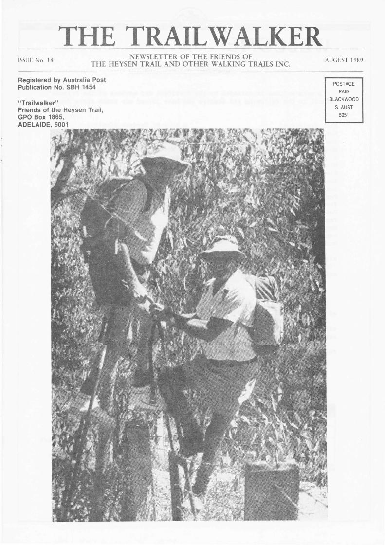
Cover Photo "Friends" Norm Taylor and Tom Thomasson
LETTERS TO THE EDITOR
Sir, At the conclusion of the Friends' walk held at Jupiter Creek on Sunday, 23
July, a large number of the walkers were disappointed that they aissed out on thanking the leader, Mr. Norm Taylor for a most enjoyable and interesting walk. They asked me to write to your organisation requesting you to convey their thanks to him for a very pleasant day.
They were most impressed that one person could organise and lead a group of so many walkers whose ages ranged from seven to seventy years on a successful walk through such diverse terrain without one minor hitch. Quite a number were impressed at the work that has been done by "The Friends" and I have no doubt that you will gain a number of new members as a result of last Sunday's outing. More importantly, a larger number will undoubtedly take up bushwalking as a recreation.
So once again, congratulations, and thank you Nora, from all of us who enjoyed a really pleasant Sunday. Yours faithfully, (Signed) J.P. Thomasson 24 July, 1989
(Members of the Friends' Council heartily endorse these sentiments and add their thanks to Norm for yet another of various activities in which he is involved on behalf of the organisation. Ed.)
The following letter, addressed to the Administrative Officer, refers to the many volunteers associated with various Friends' activities:-
Dear Thelma, I would like to take this opportunity to thank you and all the meabers of
the "Friends", for the very valuable time and effort put into projects associated with the Heysen Trail over the last six months. In particular, Colin Malcolm's organisation of several construction adventures. I know there are many people who devote a lot of time into the trails area, soae of whom I may not know by name, but certainly by face. To all those people, a very hearty thank you. Let's look forward to the new financial year and hope for better and bigger things. Yours sincerely, (Signed) Martin Foster, District Manager, Recreation Trails. P.S. I hope you can pass on my thanks to as many "Friends" as possible. They all deserve recognition of their worthy efforts.
(Again, members of the Council add their special thanks for Colin's untiring efforts as Maintenance Co-ordinator in organising and leading groups of volunteers to extend and maintain the walking trails. Ed.)
The Trailwalker, Dear Friend,
I would like to express my appreciation to Fred Brooks, Peter Buttery. Bill Gordon, Doug Leane and Margaret Herdson who have worked on the trail at Giles Corner (off Old Norton Summit Road). It was a very hazardous stretch but now, thanks to those few diligent workers, it has become a pleasant walking area.
Sincerely, (Signed) Jessie Miller
(The President and members of Council thank you for your efforts along the Trail too Jessie. Ed.)
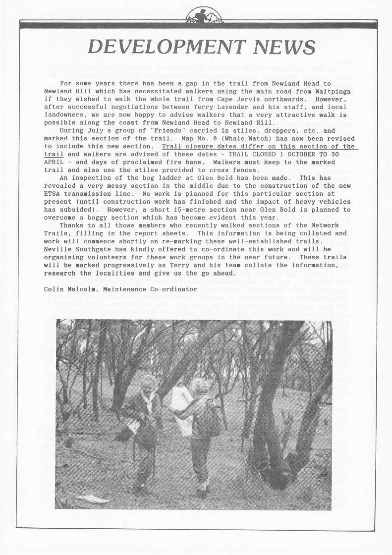
DEVELOPMENT NEWS
For some years there has been a gap in the trail from Newland Head to Newland Hill which has necessitated walkers using the main road from Waitpinga if they wished to walk the whole trail from Cape Jervis northwards. However, after successful negotiations between Terry Lavender and his staff, and local landowners, we are now happy to advise walkers that a very attractive walk is possible along the coast from Newland Head to Newland Hill.
During July a group of "Friends" carried in stiles, droppers, etc. and marked this section of the trail. Map No. 8 (Whale Watch) has now been revised to include this new section. Trail closure dates differ on this section of the trail and walkers are advised of these dates - TRAIL CLOSED 1 OCTOBER TO 30 APRIL - and days of proclaimed fire bans. Walkers •ust keep to the marked trail and also use the stiles provided to cross fences.
An inspection of the bog ladder at Glen Bold has been made. This has revealed a very messy section in the middle due to the construction of the new ETSA transmission line. No work is planned for this particular section at present (until construction work has finished and the impact of heavy vehicles has subsided). However, a short 15-metre section near Glen Bold is planned to overcome a boggy section which has become evident this year.
Thanks to all those members who recently walked sections of the Network Trails, filling in the report sheets. This information is being collated and work will commence shortly on re-marking these well-established trails. Neville Southgate has kindly offered to co-ordinate this work and will be organising volunteers for these work groups in the near future. These trails will be marked progressively as Terry and his team collate the information, research the localities and give us the go ahead.
Colin Malcolm, Maintenance Co-ordinator
SOCIAL MEETING AT BLACK HILL FLORA CENTRE
The most recent social meeting of the Friends held at the Mason Theatre at Black Hill Flora Centre on Friday, 4 August, was again very well attended by approximately 70 Friends and prospective Friends who were richly rewarded for braving the soaewhat wintry conditions by the absorbing and interesting content of the topic presented by the Guest Speaker, John Hunwick, entitled "National Park Manageaent and the Heysen Trail". John illustrated the subject with a video presentation of minimal impact caaping in Tasmania which clearly demonstrated the importance for walkers to observe basic rules relating to camping generally and in particular to maintain constant awareness of the effect of caaping, and walking, on our fragile natural environaent. The message, briefly, is to "walk softly" along our walking trails, especially in conservation and national parks, in order to minimise any adverse effects of our search for relaxation, knowledge, pleasure, fitness, or any of the many and varied reasons motivating walkers to explore the outdoors. We were reminded of the devastation of native vegetation and the resultant total and threatened extinction of increasing nuabers of our unique wildlife which has taken place since white settleaent, a short 200 years ago, compared with the more positive and non-destructive aanagement of our country by the aborigine for thousands of years previously. It was, indeed, a very thought-provoking theme, and a reminder of our responsibility to posterity for the preservation of what is left, insignificant though our contribution aay seea.
John also steered us in the direction of creating our own video on ainiaal impact camping by suggesting that it could be readily put together froa a series of slides. Perhaps the outdoor education staff in schools recognise the value of such a medium from an educational point of view for students involved in outdoor pursuits and may see their way clear to co-operate in providing appropriate slides for the purpose.
The meeting was chaired by the President, Barbara Mattsson, who, in the absence of the Maintenance Co- ordinator, Colin Malcolm, on a well-earned safari to Mt. Babbage, outlined aspects of recent and projected activities along the Trails. These included a continuation of the Heysen Trail in the Burra area; a re-route of the Trail at Chain of Ponds and through Woodhouse at Piccadilly; a short extension of the bog ladder near Glen Bold; the re-laying of erosion barriers at Giles Corner (near Old Norton Su11ait Road) to iaprove safety for walkers in this steep area; and light trimming of overgrown vegetation between Woodgate Hill Road and Blackfellows Creek. Details of these activities and their completion, where applicable, will be announced by Colin Malcolm under "Developmental News" in the next issue of the "Trailwalker".
Barbara introduced Vice-President, Neville Southgate who referred to the Official Opening of Mayo Cottage, north of Hawker, which will be officially opened by the Chief Executive Officer of the Departaent of Recreation and Sport on Sunday, 3 September, 1989. Limited accommodation is available at Graham Dunn Camps at Arkaba Station for aembers wishing to attend and, at the saae time, enjoy soae walking in the Flinders Ranges where the scenery is at its best following excellent rains throughout the year. (Details in separate itea in this issue.) A concert will be held at Mayo Cottage on Saturday night and a barbecue lunch will follow the opening.
Neville has also agreed to co-ordinate a special maintenance project which involves re-marking some of the network trails. Those present were invited to volunteer their services for this project which will be carried out both mid-week and at week-ends. Meabers who have completed the green "Maintenance" fora will also be contacted in cases where they have indicated interest in assisting in areas north of Mt. Lofty.
Supper was capably prepared and supervised by Richard Avery of St. Agnes Bushwalkers who cheerfully filled in for wife Judith, suffering an eleventh hour attack of an influenza virus. Thank you, Richard, well done!
Special thanks are also due to Betty Wise who prepared a delightful basket of "goodies" for presentation to our guest speaker, John Hunwick, and sold raffle tickets, maps and badges; to Fred Brooks for his valuable assistance in setting up and packing up and to everyone who saw the need for help and gave it, both in
the kitchen and in tidying up the hall. Last, but by no means least, to Warren Bonython who drew the names of the prizewinners of the raffle. Results elsewhere in this issue.
Details of the next Friends' Social Meeting, to be held on Friday, 27 October, 1989, at the Girl Guides Association Upstairs Hall, at 7.30 p.m. will be announced in the October edition of ther "Trailwalker".
PHOTOGRAPHIC COMPETITION
Members of the Friends and students and staff of schools are invited to submit 35mm slides of activities - walking, camping, native birds and plant watching - along the Heysen Trail or any of the network trails. The photographs will be assessed for use in the preparation of a video on various aspects of the Heysen Trail, including minimal impact camping as it applies to South Australian conditions.
Entries should include name of member or school, locality of area where photograph(s) was (or were) taken, year level if submitted by school, and any other relevant information.
Prizes, to be donated by a sponsor, will be awarded for photographic merit. All slides become the property of the Friends of the Heysen Trail and Other Walking Trails.
Entries should be addressed to Doug Paice, Editor, "Trailwalker", Friends of the Heysen Trail and Other Walking Trails, 304 Henley Beach Road, Underdale, 5032 and marked "Photographic Competition". (Doug is also the Convenor of the Publicity and Promotions Committee of the Friends' Council.
GET WELL MESSAGE
Best wishes to Jennifer Dow for a speedy recovery and return to the walking trails following a recent stay in hospital.
CONGRATULATIONS
Congratulations and best wishes to our editor, Doug Paice and to Diana Moser for whom wedding bells will ring at Christmas time.
STOP PRESS
News has just been received that Norm Taylor is in hospital following an injury received on one of his many voluntary exercises. Norm was assisting with the marking of a trail near Tunkalilla Beach a week ago when he slipped and injured his ankle. When he finally obtained a medical opinion it was discovered he had dislocated his ankle requiring hospital treatment to be followed by a plaster cast. Best wishes to Norm for a speedy recovery.
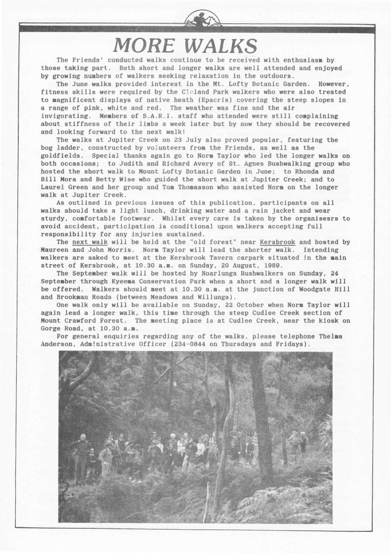
MORE WALKS The Friends' conducted walks continue to be received with enthusiasm by
those taking part. Both short and longer walks are well attended and enjoyed by growing numbers of walkers seeking relaxation in the outdoors.
The June walks provided interest in the Mt. Lofty Botanic Garden. However, fitness skills were required by the Cl e land Park walkers who were also treated to magnificent displays of native heath (Epacris) covering the steep slopes in a range of pink, white and red. The weather was fine and the air invigorating. Me•bers of S.A.R.I. staff who attended were still co•plaining about stiffness of their li•bs a week later but by now they should be recovered and looking forward to the next walk!
The walks at Jupiter Creek on 23 July also proved popular, featuring the bog ladder, constructed by vo l unteers from the Friends, as well as the goldfields. Special thanks again go to Nor• Taylor who led the longer walks on both occasions; to Judith and Richard Avery of St. Agnes Bushwalking group who hosted the short walk to Mount Lofty Botanic Garden in June; to Rhonda and Bill Mora and Betty Wise who guided the short walk at Jupiter Creek; and to Laurel Green and her group and Toa Thoaasson who assisted Nor• on the longer walk at Jupiter Creek.
As outlined in previous issues of this publication, participants on all walks should take a light lunch, drinking water and a rain jacket and wear sturdy, comfortable footwear. Whilst every care is taken by the organisesrs to avoid accident, participation is conditional upon walkers accepting full responsibility for any injuries sustained.
The next walk will be held at the "old forest" near Kersbrook and hosted by Maureen and John Morris. Nor• Taylor will lead the shorter walk. Intending walkers are asked to meet at the Kersbrook Tavern carpark situated in the •ain street of Kersbrook, at 10.30 a.•. on Sunday, 20 August, 1989.
The Septe•ber walk will be hosted by Noarlunga Bushwalkers on Sunday, 24 Septeaber through Kyeema Conservation Park when a short and a longer walk will be offered. Walkers should meet at 10.30 a.a. at the junction of Woodgate Hill and Brookman Roads (between Meadows and Willunga).
One walk only will be available on Sunday, 22 October when Norm Taylor will again lead a longer walk, this time through the steep Cudlee Creek section of Mount Crawford Forest. The meeting place is at Cudlee Creek, near the kiosk on Gorge Road, at 10.30 a.a.
For general enquiries regarding any of the walks, please telephone Thelaa Anderson, Administrative Officer (234-0844 on Thursdays and Fridays).
RAFFLE
NEWS IN BRIEF
Results of raffle drawn at Social Meeting at Black Hill Flora Centre on Friday, 4 August, 1989 -1st Prize - Day back-pack - Donated by Thor Adventure - Won by
Liz. O'Shea. 2nd Prize - Double ticket to dawn or dusk walk - Donated by
Warrawong Sanctuary - Won by Bunty Bonython. 3rd Prize - The Heysen Trail book - Flinders Ranges . Won by
Dai Weatherald. Proceeds amounted to $88.
SHIRTS There has been a slight delay in the availability of polo-style shirts (collar with three buttons at the neck) displaying the Friends' logo due to a technical problem. However, the problem is expected to be resolved shortly and, initially, a limited number of shirts in a range of sizes and colours will be available for purchase at a cost of $25. An effort is also being made to obtain badges of the logo. More information about the shirts and badges in the next issue.
OFFICIAL OPENING OF MAYO COTTAGE
A limited number of vacancies exist for accommodation at Graham Dunn Camps, Arkaba Station, (see advertisement in this issue) for Friday and Saturday nights, 1 and 2 September, 1989 to enable interested members to attend the official opening of the Mayo Cottage, near Hawker, on Sunday, 3 September, 1989 at 10.30 a.a. This special offer will cost $80 per person for two nights' accommodation, two breakfasts (Saturday and Sunday), cut lunch on Saturday, dinner on Saturday night and transport between the Camp and Mayo Cottage.
A walk is planned along the Heysen Trail from Arkaba Station to Mayo Cottage (approximately 15 kilometres) on Saturday. The official programme includes a concert at Mayo Cottage on Saturday night. There will be an ''Aussie" lunchtime barbecue following the ceremony on Sunday.
If anyone is interested in this special offer to attend the opening festivities and to enjoy a walk along the Red Range on Saturday, will you please contact the Administrative OffJcer, Thelma Anderson on Thursdays and Fridays (Tel.234-0844) to make a booking or complete the tear-off slip below and return it no later than Thursday, 24 August, 1989.
The Administrative Officer, Friends of the Heysen Trail and Other Walking Trails, Inc., C/o S.A. Recreation Institute, 304 Henley Beach Road, UNDERDALE, S.A. 5032
OFFICIAL OPENING OF MAYO COTTAGE
Accommodation at Graham Dunn Camps, Arkaba Station, required on Friday and Saturday nights, 1 and 2 September, 1989 for
(Name(s) Block letters please)
(Address)
(Post Code) (Telephone No.)
GRAHAM DUNN CAMPS AR~\BA HILLS - FLINDERS RANGES
"Comfort in the bush"
21 kms . north of Hawker.
;·Talk and tour a beautiful section of the Heysen Trail near the Elder Range. Return each night to a delightful camp, just south of Wilpena Pound, with everything provided.
Furnished tents. Sleep between sheets on comfortable beds. Hot showers. Meal s served in the bush hut. A fully hosted holiday nestled in one of the most scenic areas of the Flinders Ranges. An easy bitumen drive from Adelaide.
4 nights S325 all inclusive . Aug 28 , Sept 18, Oct 9, Oct 23. 0ther dates by arrangement .
Bookings 08 2126386 or wri te to Graham Dunn Box 21A, Crafers. Phone 08 3391989, for brochure.
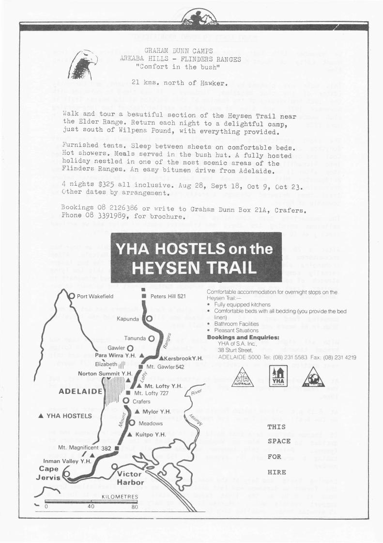
VHA HOSTELS on the HEYSEN TRAIL
• Port Wakefield • Peters Hill 521
Kapunda 0
Tanunda 0 Gawler 0
Para Wirra Y.H. A
Eli~b_;th 11ll 1 • Mt. Gawler 542
Norton Su~mit/ lyll ~· ,f IJ: Mt. Lofty Y.H.
ADELAIDE • Mt. Lofty727
0 Crafers
Comfortable accommodation for overnight stops on the Heysen Trail :-• Fully equipped kitchens • Comfortable beds With all bedding (you provide the bed
linen) • Bathroom Facilities • Pleasant Situations Bookings and Enquiries:
YHA of S.A. Inc., 38 Sturt Street, ADELAIDE 5000 Te1. (08) 231 5583 Fax (08) 231 4219
A YHA HOSTElS Meadows
Kuitpo Y.H.
Inman Valley Y.H. Cape
Jervis ~111111111!!!!!!'="---...J
40
KILO METRES
80
THIS
SPACE
FOR
HIRE
On November Mount Lofty time.
MOUNT LOFTY TO MOUNT MAGNIFICENT
19th last, eight members of Adelaide Bushwalkers walked from to Mount Magnificent, a distance of 65km in 13 hours walking
This walk was planned by Graeme Oats, Club Past President, and currently Editor of the club magazine, 'Tandanya'. It was timed to coincide with the lOth Anniversary of the opening of this section of the Heysen Trail in November 1978, and also to emulate the earlier feat of two long-serving club members, Don and Lyn Steven, who had completed the walk in one day in June 1978 .
The eight participants in the walk met on the Summit Road near Mount Bonython at 6.00 a.m. and set off shortly afterwards on the long trek. Cool and overcast weather provided perfect walking conditions as we headed into Piccadilly Valley and across Mt. Lofty golf course. A brief scroggin stop after 1t hours walking, then we continued along Cox's Creek, past the Bridgewater Mill and through the back streets of Bridgewater before rp ~ r Jssing Cox's Creek and following the main road towards Mylor. The trail then detoured through a pretty reserve before descending into the township of Mylor.
The supporting team consisting of three club members had set up a delicious morning tea about one kilometre south of Mylor and we arrived exactly at 10 a.m., 3 3/4 hours and 17km after leaving Mt. Lofty.
After a 20 minute break we recommenced walking and within an hour had encountered a working party from the Friends led by Colin Malcolm. After exchanging pleasantries, we tried out new sections of the bog ladder recently completed near Glen Bold to avoid wet feet across this low lying stretch of countryside. A short detour into the newly opened mineshaft in Jupiter Creek and we continued on through Kuitpo Forest for an hour to our lunch stop near Pocock Road .
Here further volunteers from our club's Family Members had set up more tempting food and a 45 minute break was allowed. We had now travelled 32km in 6t hours and were close to half way.
With all eight walkers still keen to go, we left our support team and headed towards our next stop at Chookarloo Picnic Ground in Kuitpo Forest. To date we had maintained or exceeded our planned times and this next section proved no exception, the 14km being completed in 2 3/4 hours.
At Chookarloo, Ralph was forced to withdraw with badly blistered feet, but the rema1n1ng seven set out after a 20 minute break on the last leg of 19km.
At 6.15 p.m. within Kuitpo Forest we stopped briefly to celebrate 12 hours on the trai 'l, and at 7 p.m. had reached Kyeema Conservation Park.
It became obvious here that David was in trouble with muscle cramps and we decided to leave him on Woodgate Hill Road on the southern boundary of Kyeema. Prior to this, however, we made our walk just a little harder by taking a wrong turn in Kyeema for 750 metres after we missed a track marker.
leaving David and Gary at the road, we decided to jog the next 2km within the forest as darkness was fast descending. We reached Blackfellows Creek Road at 8.30 as the light faded completely. We were able to locate a support vehicle which returned to pick up Gary and David. They returned 15 minutes later, enabling Gary to rejoin the walk.
We reached the foot of Mount Magnificent just before 9 p.m. and found an extra burst of energy to reach the summit at 9.15, fifteen hours after the start.
A celebration glass of champagne was a most enjoyable way to conclude an excellent day's walking.
The eight intrepid walkers were: Graeme Oats, John Bartlett, John Butler, Joe Scibiorski, Gary Hamann, Ralph Schwer, David Saunders and Frank Hall.
The hard working members of our support team to whom we are all extremely grateful were: Lee Kendall, Eva Scibiorski, Rod Hill, John Bojczuk and the Sanderson and McNeill families.
FRANK HALL COUNCIL JOTTINGS
The following ite•s have been discussed at recent Council •eetings:-
1. Design for Friends' logo . (A design has finally been selected and will be embroide~ed onto polo style shirts in a range of colours for sale to members at a cost of $25J
2. Leaflets have been printed and placed in boxes at Heysen Trail •onitor sites for the information of walkers.
3. A colour poster is being prepared and will soon be available for distribution and display.
4. Official opening of Mayo Cottage (near Hawker) arranged for week-end of 2/3 September, 1989 .
5. Neville Southgate, a vice-president of the Friends, attended Friends of Aldinga Scrub •eeting as guest speaker.
6. Walking Progra.•e arranged for 1989. (More leaders required.) 7. A computer and printer have been supplied to Friends under a sponsorship
grant by the South Australian Recreation Institute. 8. St. John's first aid kits have been purchased for use of •aintenance
groups. 9. Hallett Cove to Willunga railway being investigated for adaptation as
walking/cycling, horseriding trail . 10. Onkaparinga Council will provide pedestrian access along Beaumont Road
(near Balhannah) as alternative to use of Gallasch Road when sufficient need is expressed by walking groups. (The Friends sub•itted objection to the proposed closure and sale of Gallasch Road but offered to withdraw the objection if Onkaparinga Council provided suitable pedestrian access along Beaumont Road.)
11. A representative is sought for Friends of Engelbrecht Reserve. 12. Advertising space being provided for Friends in "Getting Out" section of
"Advertiser" on Fridays. 13. Representation by Friends at Life Be In It Leisure Day in the Park at
Bonython Park on Sunday 22 October, 1989. 14. Suggestions sought for Friends' project for National Parks Centenary, 1991. 15. Social meetings to be held on 4 August, (Mason Theatre, Black Hill
Conservation Park) and Friday, 27 October, 1989 at Guide Association Hall, South Terrace, Adelaide.
16. Survey of network trails being conducted by Friends for inforaation of Recreation Trails Division of S.A. Recreation Institute.
17. Negotiations nearing completion for re - route of Heysen Trail at Piccadilly (Woodhouse) and Chain of Ponds. Friends will be advised of details when these two detours are in place.
18. Map No. 8 has been revised and is now available for purchase. 19. Photographic competition of scenes (including walkers) along the Heysen
Trail suggested.
----------------------------
A TEN-DAY TREK FROM CAPE JERVIS TO MOUNT LOFTY
Having finally decided to fulfil a long-term ambition to walk from Cape Jervis to Mount Lofty, I made the appropriate arrangements and set off on 22 April, 1989. Due to some difficulties in arranging dates to stay at Y.H.A. Hostels I had to cut off two days from my intended itinerary. I decided to drop off the Cape Jervis to Deep Creek section as I had done this section many times in the past.
The first day was cool and overcast but made for ideal walking conditions. Starting at the eastern boundary of Deep Creek Conservation Park at Boat Harbour Creek, I made good time to Tunkalilla Creek where the water was fresh. I set off for Coolawang Creek where I was to camp at the mouth.
I was fortunate to be accompanied part of the way by two white-breasted Sea Eagles which gave a graceful aerial mating display. Other birds en route were Nankeen Kestrels, white-fronted Chats and Hooded Dotterels.
The water in the Coolawang Creek was quite salty so I had to conserve what little water I had as I didn't bother to stock up at Tunkalilla. This section was approximately 18 kilometres and took about five hours' walking.
The night was very wet with the rain continuing next day. With wet gear I set off in the rain to Newland Head Conservation Park approximately seven kilometres away. I hung out my gear to dry at Dennis Hut in the campground for about three hours. I decided to eat, then set off for another three kilometres to the eastern end of the park where I set up camp to try to dry out my gear a bit more. The weather fined up briefly, but an hour after setting up camp it began to rain again. I only made ten kilometres this day in approximately three and a half hours. Fortunately I packed some candles and a book so I went to bed early and read.
The wet, windy weather continued through the night and early next day. I left early and set off to Victor Harbour. After a brief stay to stock up, I walked back to the Heysen Trail and continued. The weather had improved and by early afternoon it was quite fine. Over the Sheoak Hill and onto Back Valley the walk was through some very pretty country. The trail has been re-routed up Keans Road, but the diversion is quite pleasant. This night I camped alongside a section of pine forest after walking approximately, 22 kilometres.
There was a steady overnight rain which cleared up by morning. During the night I was visited by possums which tried to share my food with me ·. The area where I camped was very pretty, so as I only had a short distance to travel, I walked over to Inman Valley Cemetery then onto the Y.H.A. Hostel at Inman Valley. The Hostel was a welcome stop .. It allowed me to dry all my gear off and to have a shower. As the walk was approximately seven kilometres, the rest of the day was spent being very lazy.
Next day I set off for Yulte Conservation Park, via Myponga Conservation Park where I had a brief stop to check out the waterfall. This section of the trail was very steep especially the section leaving Inman Valley over the Sugarloaf and Myponga Conservation Park. The wildflowers were prolific with carpets of the Parsons Band Orchid in the higher section. After a cuppa at Wild Dog Creek where the water was good, I set off for Yulte. The re-route was very steep and slowed me down considerably. I set up camp just as rain began to fall again. The walk this day was approximately 17 kilometres but took six and a half hours' solid walking. It was an early night.
The rain kept up very heavy all night. The weather was extremely cold as I set off next day. I stopped at a dairy on the Hindmarsh Tiers Road and bought some fresh, still warm milk. I think it saved my life! It was a great reviver. The trail went up Mount Cone where it was extremely cold. The chill factor of the wind was approximately 2-3 degrees. Due to this cold weather I kept moving at a good pace (just to keep warm) and made it to Mount Compass by midday. I planned to camp nearby that night but cattle were grazing in my proposed site. I rang my wife who intended to meet me later and asked her to meet me on the road to Mount Magnificent. She met me about five kilometres short of the Mount so I hitched a lift. That night we had a barbie with real steak and a bottle of great wine. I walked approximately 22 kilometres this day. The rain had cleared up and I spent a pleasant evening with my family.
Next day, with a fully loaded pack re-supplied with food which my wife brought, I packed up in a thick fog. My back was extremely painful. I had caught a chill in my kidney from the previous day's cold conditions. I set off very slowly up through Kyeema Conservation Park then onto Kuitpo Y.H.A. Hostel. By midday the fog lifted to reveal a beautiful day. I arrived at the Hostel around .this time and spent the day sitting in the sun resting my back and reading. I had only walked 11 kilometres but it took nearly four hours to complete.
That night I sat in the Hostel under gas lights by an open fireplace. It was quite cosy inside . Outside there was a terrific thunderstorm with rain bucketing down. The heavens turned on a superb lightning show.
Next day my back was still painful and it took some time to pack and get moving. In the Kuitpo Forest I met a school group who had weathered the storm. The children were hanging up their gear to dry in the sunshine. They were all about eight or nine years old and were reminiscing their adventures to me. It was great to see their enthusiasa. I continued onto the Rocky River Hut campsite which I shared with another school group. The weather held out and I was feeling a bi t better by the time I set up camp. That day I walked only 14 kilometres in approximately four and a half hours. That evening I received a pleasant visit from friends who had spoken to my wife who told them of my proposed location. They brought a superb meal with them for ae to share. Very nice! There was a bit of thunder and lightning that night but fortunately no rain. Things were looking up!
My back was feeling much better next day and the weather was quite fine. The walk through the Jupiter Creek Goldfields was very interesting and onto Glen Bold was through some fine scenery. The swamp crossings and the bridge over the Onkaparinga River were interesting diversions. Unfortunately, by aid afternoon the weather was looking a bit shaky and by the time I arrived in Mylor it was raining again. That night I stayed at the Y.H.A. Hostel. This was another welcome rest allowing me to dry out and clean up. I walked into Mylor about one and a half kiloaetres from the Hostel to ring ay faaily that evening, but got wet all over again! It was great to sit outside the shop and recognise a few old faces who were there when I lived nearby seven years previously.
Next day I set off for Bridgewater but lost the trail and ended up in Aldgate. After walking back to Bridgewater I had aorning tea and set off for Mount Lofty. It was all uphill but the colours of the leaves on the route was a beautiful distraction. Up the Mount Lofty Golf course, up to Woodhouse, into the Piccadilly Valley the trail rose. Finally, at exactly 2.55 p.a. on 1 May, 1989, I was at the Mount Lofty Summit. The fog had lifted to reveal a sunlit Adelaide below. It was beautiful! I stopped at the remembrance cairn erected in honour of the fire-fighters who gave their lives in the 1983 fire and remembered my time in these fires at this location.
Well, it is over! After walking approximately 148 kiloaetres in the past ten days I felt extremely satisfied. Even though the weather was not the best there were many highlights. The lightning storas, foggy mornings, bracing winds were all part of the experience. The trail allows walkers to see some beautiful scenery. It is a walk to be recommended.
Fortunately I was able to reduce the weight I carried due to the abundance of fresh water collected from my tent during the rain. I averaged approximately 42 lbs. for the trip.
Due to the varied lengths of each day's walk, I took longer than would be required. I averaged approximately 15 kilometres per day over ten days, but estimate this could be increased to 18-20 kilometres per day, thus dropping off two days' walk. The distance from Cape Jervis to where I started is approximately 22 kilometres so another full, hard day's walk would be required for this section.
Thanks to the efforts of the people who plan, develop and maintain the trail it is possible for walkers to experience this section of the Heysen Trail that I found to be an exhilarating and enjoyable experience.
Volker Scholz (Ranger, Deep Creek Conservation Park)
~ MOUNT DECEPTION ~ &~C~O~M~M~E~M~Oi-!iR~,.~T~I~V!-iiiE~~B~U~S~H~Vtl~~~L~K~&
A COMMUNITY ORIENATED PROJECT BY MEMBERS OF THE LEIGH CREEK BUSHWALKING GROUP TO COMMEMORATE THE EARLY PIONEERING ACHIEVEMENTS OF THE GREAT AUSTRALIAN EXPLORER
EDWARD J, EYRE AND GOVERNMENT SURVEYOR SAMUEL PARRY IN NORTHERN SOUTH AUSTRALIA.
CO-ORDINATOR ::ALAN THOMAS, PO BOX 115; LEIGH CREEK, SA; 5731. PI!:: 086/752444. LOCATION : : MOUNT DECEPTION, NORTHERN FLINDERS RANGES, WHEN : : 28 to 30 APRIL 1989 •
. . . . ~hy Climb a Mountain? An addition to the history books was recently made when members of the Leigh
Creek Bushwalking Group participated in the Mount Deception Commemorative Bushwalk. The walk was a culmination of over twelve months planning by co-ordinator Mr. Alan Thomas. The primary aim of the walk was to commemorate the achievements of explorer Edward Eyre and surveyor Samuel Parry. In addition the group established trial markers and made various observations of fauna, flora, geology and astrology for use in a commemorative journal which will be compiled in due course.
Members of the official team of walkers were Mr. Alan Thomas, Mr. Chris Willis and Mr. Andrew Vidale, all of Leigh Creek. A fourth member Mr. Peter Horsley was unable to attend due to a recent injury. The Leigh Creek Bushwalking Group were joined in the venture by a team from the S.A. Department of Lands.
Laden with heavy packs the walkers departed Tea Tree Well, Beltana Station at 8.00 am on Friday the 28th of April. The first leg of the walk entailed a 10~ Km climb along the Southern ridge to Mount Deception. Setting their compass bearings they followed a scenic creek into the foothills, frequently stopping to build the small stone cairns used to mark the trial. During these breaks Alan and Andrew took the opportunity to photograph various aspects of the local fauna and flora plus views of the splendid surrounding landscape. Due to the heavy ' unseasonal rains the country had exploded in extensive growth and was covered in a magnificent carpet of wildflowers.
The land being so abundantly green was certainly a direct contrast to the dry and barren conditions that must have confronted explorer Eyre as he descibed it as being 'a cheerless looking waste'. The walkers found the terrain to be very rough and rocky as they continued out of the foothills into the first of many steep climbs, which often made rest stops a necessary occurrence. The route along the ridge offered unending views of the encompassing land in addition to the spectacular ravines, spurs, cliffs and amphitheatres leading to the East and West of the range.
Reaching an altitude of 400m the group stopped for lunch in amongst a clump of windswept trees. Whilst resting they viewed a small group of pinnacles to the East and after some discussion, named them the 'Horseshoe Peaks' in recognition of an old horseshoe they found nearby. Speculation arose as to whether the shoe came from one of Eyre's horses when he descended the mountain and rode South-east to a waterhole near Beltana, of which he named Depot Pool.
Numerous kangaroos and wild goats were observed during the walk plus a large variety of birdlife including wedgetail eagles, cockatoos and parrots. Of much interest on the mountain was the discovery of a very unusual cricket/locust which was covered in an array of shapes and dots.
Stomachs full, the walkers pulled t~eir packs on over sore muscles and awaited the unwanted arrival of flies looking for a free ride. Within seconds, the brightly colored packs turned black and it proved necessary to tap the packs often to lighten the load.
• ••• continued-
Chris Willis needed abit of first aid 5 kms into the walk when his knee decided to play-up. Confident that he would make it, the group continued their trek, thankful of the cooling breeze that came along. Progress over the rugged terrain proved to be slower than anticipated and as such the team decided to establish their first camp at an altitude of 63lm, just lf kms short of the summit.
With the campfire burning nicely, the base camp team at Deception outstation, were notified by radio of the walkers position and slight change of plans. During the radio transmission, Department of Lands officers Mr. Alex Poznanski and Mr. Peter Williss arrived back at the outstation. Alex informed the walkers that they had made the summit with their 60 pound packs containing the cement, water and tools necessary to prepare the plaque's foundation.
Following a welcome cup of coffee the walkers then set about establishing the campsite on the exposed plateau. Finding a decent piece of ground to lay their sleeping bags was quite a challenge as the ground was covered with plenty of rocks. Appetites satisfied the team relaxed around the fire and enjoyed the spectacular sunset over Lake Torrens. It was quite an experience to see the normally dry salt lake near full capacity, supposedly for the first time this century. As darkness fell they spent some time viewing various astrological groupings before settling down to a much needed sleep.
Cool winds and dark clouds greeted the walkers as they awoke on the Saturday morning. Resisting t~e temptation to remain in their warm bags they got up, stoked the fire back into life, and enjoyed a hot breakfast as the rising sun gave a stunning display through breaks in the clouds.
Refreshed and with lighter packs, the team enthusiastically embarked on the final If km trek to the top. Hampered by occassional rain, they reached the summit mid-morning and proudly tied the Australian flag to the centre pole of the stone cairn. The walkers were joined shortly thereafter by the Department of Lands team who had set out from their camp. situated in the foothills a few kms to the East.
Friendly introductions followed, and the combined group reflected on the achievements of explorer Edward John Eyre during his epic 1840 exploration of the North and consequent ascent and naming of Mount Deception in July of that year. The group were equally inspired by the cairn, one of the many stone cairns built by surveyor Samuel Parry. The Deception cairn, erected by Parry in 1858, isof much historical importance as it formed the basis of his trigonometrical survey of the land between the Flinders Ranges and Lake Torrens.
All agreed, that the extensive view from the 691m summit, was worth every short breath and sore muscle experienced during the climb of the mountain. To the West, Lake Torrens lay as large and mysterious as ever, a description often repeated bv exolorer Eyre as he tried to solve the mystery of the supposed 'Horseshoe Lake'.
Even with the approaching rain to the West, the group could see Mt Nor-West and Termination Hill to the North. To the East they viewed the splendid main body of the Northern Flinders Ranges and identified many landmarks that were plainly visable from their vantage point. Department of Lands Surveyor-General, Mr. John Porter enlightened the walkers on the methods of the early surveyors, in the days when time was on their side. The Surveyor-General, John Portor, was accompanied to the summit by his wife Janie Porter and Master's Tom Moore and Tom Becker. John raised the question of whether Janie was the first woman to ever stand on the peak?
Much discussion continued over lunch, after which surveyors Poznanski and Williss prepared the cement to set the commemorative plaque in. Shortly after l.OOpm John Porter and Alan Thomas jointly placed the plaque, which was proceeded by an unveiling ceremony and champagne toast to the sucess of the joint venture. SurveyorGeneral John Porter expressed his support and that of his department towards projects such as this and wished the Leigh Creek Bushwalking group every success in future endeavours in preserving Australia's heritage. Co-ordinator of the commemorative bushwalk Mr. Alan Thomas, thanked John Porter and his team for their support and attendance in addition to the groups appreciation of the donation of the commemorative plaque. Further more, he conveyed the groups ongoing interest in future projects undertaken by them. . .•• continued-
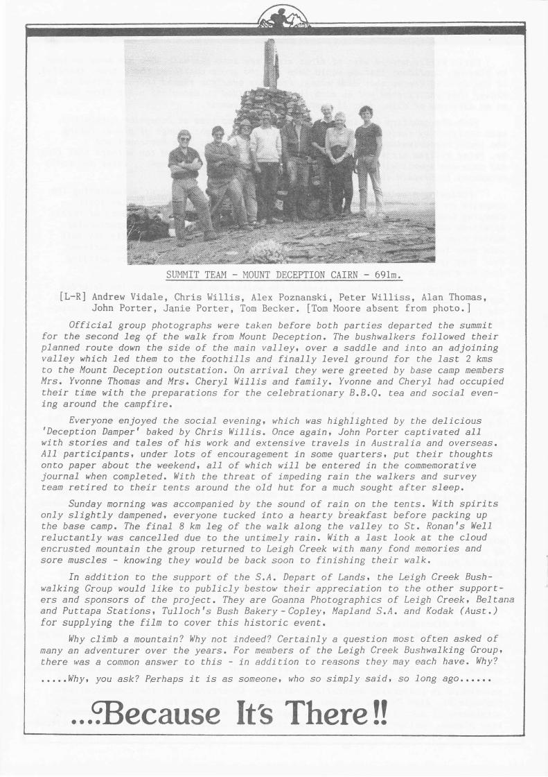
SUMMIT TEAM - MOUNT DECEPTION CAIRN - 691m.
[L-R] Andrew Vidale, Chris Willis, Alex Poznanski, Peter Williss, Alan Thomas, John Porter, J&nie Porter, Tom Becker. [Tom Moore absent from photo.]
Official group photographs were taken before both parties departed the summit for the second leg 9f the walk from Mount Deception. The bushwalkers followed their planned route down the side of the main valley, over a saddle and into an adjoining valley which led them to the foothills and finally level ground for the last 2 kms to the Mount Deception outstation. On arrival they were greeted by base camp members Mrs. Yvonne Thomas and Mrs. Cheryl Willis and family. Yvonne and Cheryl had occupied their time with the preparations for the celebrationary B.B.Q. tea and social evening around the campfire.
I
Everyone enjoyed the social evening, which was highlighted by the delicious 'Deception Damper' baked by Chris Willis. Once again, John Porter captivated all with stories and tales of his work and extensive travels in Australia and overseas. All participants, under lots of encouragement in some quarters, put their thoughts onto paper about the weekend, all of which will be entered in the commemorative journal when completed. With the threat of impeding rain the walkers and survey team retired to their tents around the old hut for a much sought after sleep.
Sunday morning was accompanied by the sound of rain on the tents. With spirits only slightly dampened, everyone tucked into a hearty breakfast before packing up the base camp. The final 8 km leg of the walk along the valley to St. Ronan's Well reluctantly was cancelled due to the untimely rain. With a last look at the cloud encrusted mountain the group returned to Leigh Creek with many fond memories and sore muscles - knowing they would be back soon to finishing their walk.
In addition to the support of the S.A. Depart of Lands, the Leigh Creek Bushwalking Group would like to publicly bestow their appreciation to the other supporters and sponsors of the project. They are Goanna Photographics of Leigh Creek, Beltana and Puttapa Stations, Tulloch's Bush Bakery-Copley, Mapland S.A. and Kodak (Aust.) for supplying the film to cover this historic event.
Why climb a mountain? Why not indeed? Certainly a question most often asked of many an adventurer over the years. For members of the Leigh Creek Bushwalking Group, there was a common answer to this - in addition to reasons they may each have. Why?
••••• Why, you ask? Perhaps it is as someone, who so simply said, so long ago ••••••
. . . ~ecause Its There !!