release guide - hexagon ab
TRANSCRIPT
Release Guide
Release Guide ERDAS IMAGINE 2020 Update 3
Version 16.6.3
March 2021
ERDAS IMAGINE 2020 Update 3
2
Contents About This Release ................................................................................................................... 4
ERDAS IMAGINE Product Tiers................................................................................................ 4
New Platforms ........................................................................................................................... 5
Full Installers ........................................................................................................................... 5
ArcGIS 10.7.x and ArcGIS 10.8.x............................................................................................ 5
PostgreSQL & PostGIS ........................................................................................................... 5
Licensing................................................................................................................................. 5
New Technology ........................................................................................................................ 6
New Photogrammetry Workflows in Spatial Modeler ............................................................... 6
Create Semi-Global Matching (SGM) Point Cloud ............................................................... 6
Define Image Parameters for Orbital Pushbroom Model...................................................... 7
Define Block Parameters for Orbital Pushbroom Model ....................................................... 7
Read Image Parameters for Orbital Pushbroom Model ....................................................... 8
Define Image Parameters for Rational Function Model........................................................ 8
Define Block Parameters for Rational Function Model ......................................................... 8
Add Orthos to Block ............................................................................................................. 9
Read Image Parameters for Rational Function Model ......................................................... 9
New Artificial Intelligence Semantic Segmentation Operators for Spatial Modeler .................. 9
Initialize Image Segmenter .................................................................................................. 9
Segment Image Using Deep Learning ................................................................................10
Updated Operators ................................................................................................................11
Mosaic Images ...................................................................................................................11
Point Input ..........................................................................................................................11
Spatial Model Editor Interface Improvements .........................................................................12
Format Support ......................................................................................................................12
ICEYE SLC .........................................................................................................................12
RADARSAT Constellation Mission (RCM) ..........................................................................12
Maxar / DigitalGlobe WorldView Legion..............................................................................12
PRISMA L2D ......................................................................................................................12
Defense Gridded Elevation Data (DGED) ...........................................................................12
DiMAP v2 NoData ..............................................................................................................13
ERDAS IMAGINE 2020 Update 3
3
Pleiades Neo DiMAP Geometric Models ............................................................................13
General ERDAS IMAGINE .....................................................................................................13
Multi-band Thematic display ...............................................................................................13
Escape Key ........................................................................................................................13
Lagrange Resampling ........................................................................................................13
SIPS v2.4.15 ......................................................................................................................14
IMAGINE Digital Surface Model (DSM) Extractor...................................................................14
IMAGINE SAR Feature ..........................................................................................................14
Artificial Intelligence Convolutional Neural Network (CNN) Despeckle ...............................14
Anisotropic and SuperPixel .................................................................................................14
System Requirements ............................................................................................................. 15
ERDAS IMAGINE ..................................................................................................................15
ERDAS IMAGINE System Requirements Notes ....................................................................16
Issues Resolved – ERDAS IMAGINE 2020 Update 3 ............................................................. 18
IMAGINE Essentials ..............................................................................................................18
IMAGINE Advantage ..............................................................................................................20
IMAGINE Objective ................................................................................................................21
IMAGINE Photogrammetry ....................................................................................................22
IMAGINE Professional ...........................................................................................................23
Spatial Modeler ......................................................................................................................24
Contact Us ............................................................................................................................... 26
About Hexagon ........................................................................................................................ 26
ERDAS IMAGINE 2020 Update 3
4
About This Release This document describes enhancements in ERDAS IMAGINE 2020 Update 3 (v16.6.3), including IMAGINE Photogrammetry (formerly LPS Core) and ERDAS ER Mapper. Although the information in this document is current as of the product release, see the Hexagon Geospatial Support website for the most current version.
Update 3 includes both enhancements and fixes. For information on fixes that were made to ERDAS IMAGINE, see the Issues Resolved section.
This document is only an overview and does not provide all the details about the product's capabilities. See the online help and other documents provided with ERDAS IMAGINE for more information.
Development of ERDAS IMAGINE 2020 ensures all aspects of ERDAS IMAGINE run in 64-bit. Consequently, the installer has been split into three separate installers: ERDAS IMAGINE 2020 64-bit; ERDAS IMAGINE 2020 32-bit; and ERDAS ER Mapper 2020. The same split is available for Update 3 installers.
ERDAS IMAGINE Product Tiers ERDAS IMAGINE performs advanced remote sensing analysis and spatial modelling to create added information. You can also visualize results in 2D, 3D, or video and on cartographic-quality map compositions. The core of the ERDAS IMAGINE product suite is scalable to your geospatial data. Optional modules (add-ons) provide specialized functions to enhance productivity.
IMAGINE Essentials is the entry-level image processing product for map creation and simple feature collection tools. IMAGINE Essentials enables serial batch processing.
IMAGINE Advantage enables advanced spectral processing; image registration; mosaicking and image analysis; and change detection capabilities. IMAGINE Advantage allows you to process parallel batches for faster output.
IMAGINE Professional includes a production toolset for spatial modeling and advanced spectral, hyperspectral, and radar processing. This tier includes ERDAS ER Mapper at no additional cost.
IMAGINE Photogrammetry maximizes productivity with state-of-the-art photogrammetric satellite and aerial image processing algorithms.

ERDAS IMAGINE 2020 Update 3
5
New Platforms
Full Installers
Starting with ERDAS IMAGINE 2020 Update 1, update installers became full installers, allowing you to either install the update as a standalone (e.g., install ERDAS IMAGINE 2020 Update 3 without first installing ERDAS IMAGINE 2020) or as an update to an existing install (e.g., installing ERDAS IMAGINE 2020 Update 3 without first installing ERDAS IMAGINE 2020 Update 1). With full installers, you can no longer roll back an update to the previous version (e.g., If ERDAS IMAGINE 2020 is updated with ERDAS IMAGINE 2020 Update 3, uninstalling it removes ERDAS IMAGINE 2020 entirely). Consequently, “rolling back” now involves uninstalling ERDAS IMAGINE and re-installing the desired previous version.
ArcGIS 10.7.x and ArcGIS 10.8.x
ERDAS IMAGINE 2020 Update 3 (32-bit) has been tested and is supported when using an installed and licensed version of ArcGIS 10.6, 10.6.1, 10.7, 10.7.1, 10.8, or 10.8.1 to provide geodatabase support libraries.
Alternatively, the IMAGINE Geodatabase Support component (based on ArcGIS Engine 10.7) can be installed to provide geodatabase support.
PostgreSQL & PostGIS
The PostGIS Features Proxy reader now supports PostgreSQL 13.2 with PostGIS 3.1.1.
Licensing
ERDAS IMAGINE 2020 installers no longer attempt to automatically install geospatial licensing tools as part of the installer. If customers wish to use geospatial licensing tools, for example, to set up a floating/concurrent license server, you must download Geospatial Licensing 2020 separately.
We strongly recommend upgrading to the newest version of Geospatial Licensing 2020. If you are unsure of
your current version, refer to the Microsoft® Windows Add or Remove Programs utility.
You can find the appropriate download in the Downloads section of the Hexagon Geospatial website.
ERDAS IMAGINE 2020 Update 3
6
New Technology
New Photogrammetry Workflows in Spatial Modeler
Over the past several years, the amount of data from image acquisition systems have grown exponentially due, in part, to the growth of lower-cost UAV platforms and constellations of satellites. This effect is seen not only in the imagery’s spatial resolution but also in the frequency of acquisition, with daily revisit rates becoming the norm. This trend increases the need to process data automatically and quickly.
Photogrammetry workflows (e.g., adjustment, ortho rectification, color balancing, mosaicing) are usually the initial steps of data processing. To handle this large volume of imagery, you need photogrammetric solutions that can detect new acquisitions automatically; instantly process data; scale up computing resources as needed; and feed output to downstream geospatial processes.
Spatial Modeler is designed to solve these challenges by offering hundreds of operators that easily chain together into models to solve complex geospatial problems.
With the ERDAS IMAGINE 2020 Update 2 release, we expanded Spatial Modeler’s capabilities by adding a new suite of photogrammetry operators that perform project setup, automatic point measurement, triangulation and mosaicing for scanned frame, and digital frame cameras.
In ERDAS IMAGINE 2020 Update 3, we continue this process by expanding the operators into the satellite sensors via RPC and rigorous orbital pushbroom model support.
Note that many of these new operators require additional licensing in order to run as part of a spatial model execution. This is generally noted in the Help for each operator.
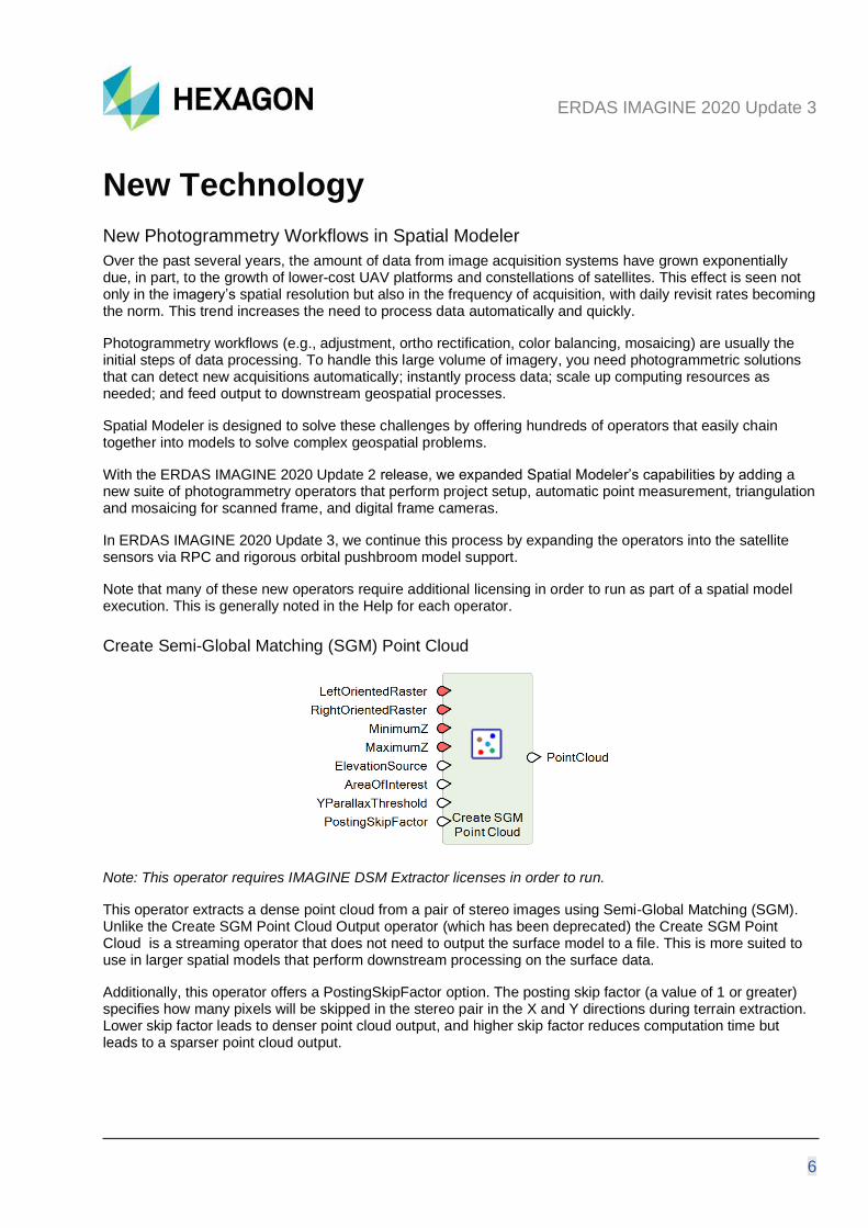
Create Semi-Global Matching (SGM) Point Cloud
Note: This operator requires IMAGINE DSM Extractor licenses in order to run.
This operator extracts a dense point cloud from a pair of stereo images using Semi-Global Matching (SGM). Unlike the Create SGM Point Cloud Output operator (which has been deprecated) the Create SGM Point Cloud is a streaming operator that does not need to output the surface model to a file. This is more suited to use in larger spatial models that perform downstream processing on the surface data.
Additionally, this operator offers a PostingSkipFactor option. The posting skip factor (a value of 1 or greater) specifies how many pixels will be skipped in the stereo pair in the X and Y directions during terrain extraction. Lower skip factor leads to denser point cloud output, and higher skip factor reduces computation time but leads to a sparser point cloud output.
ERDAS IMAGINE 2020 Update 3
7
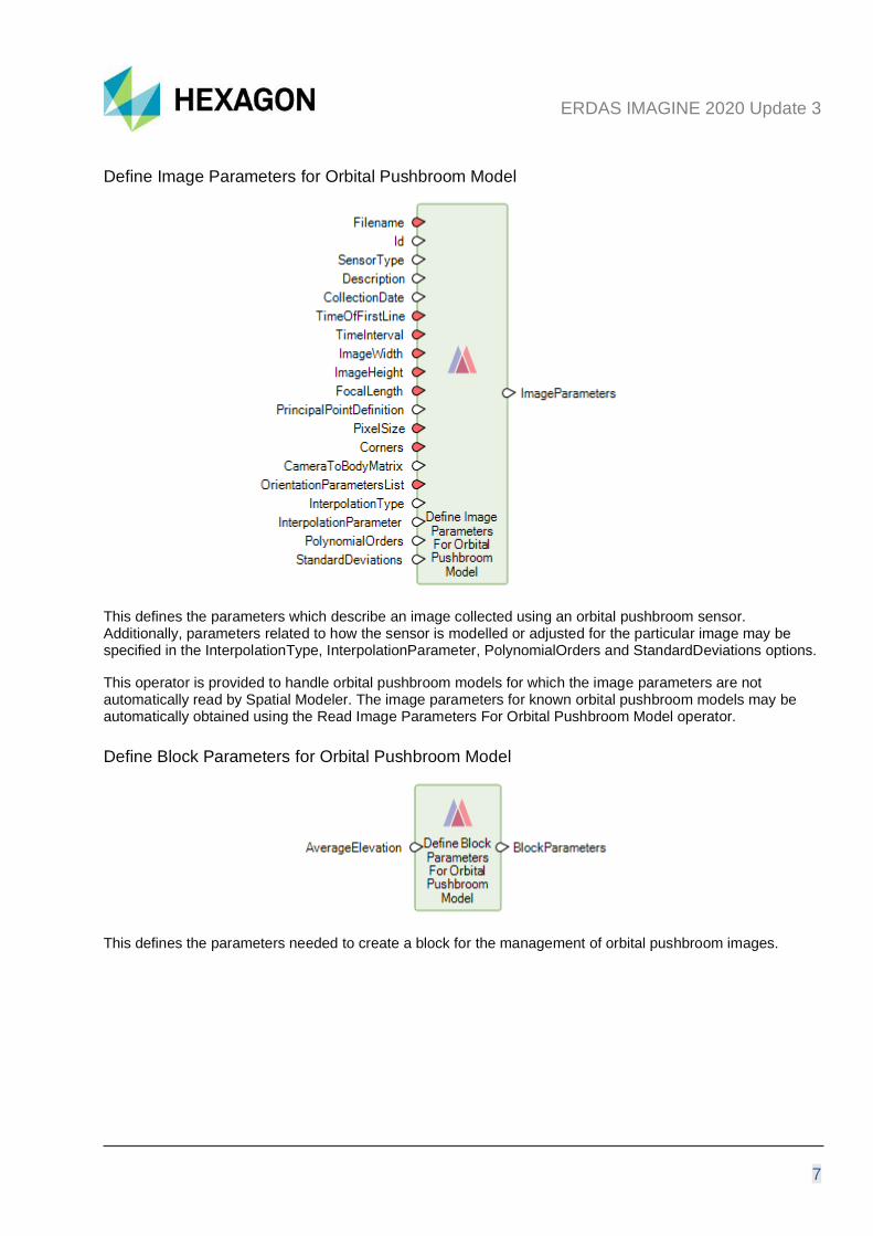
Define Image Parameters for Orbital Pushbroom Model
This defines the parameters which describe an image collected using an orbital pushbroom sensor. Additionally, parameters related to how the sensor is modelled or adjusted for the particular image may be specified in the InterpolationType, InterpolationParameter, PolynomialOrders and StandardDeviations options.
This operator is provided to handle orbital pushbroom models for which the image parameters are not automatically read by Spatial Modeler. The image parameters for known orbital pushbroom models may be automatically obtained using the Read Image Parameters For Orbital Pushbroom Model operator.
Define Block Parameters for Orbital Pushbroom Model
This defines the parameters needed to create a block for the management of orbital pushbroom images.
ERDAS IMAGINE 2020 Update 3
8
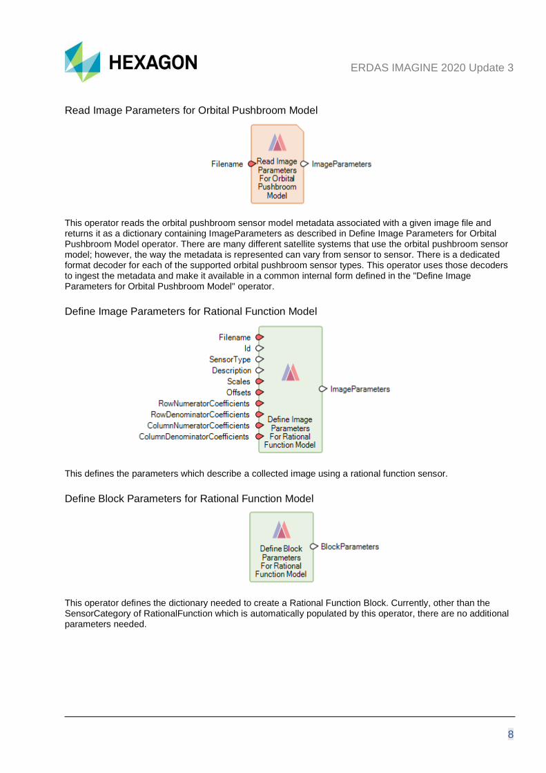
Read Image Parameters for Orbital Pushbroom Model
This operator reads the orbital pushbroom sensor model metadata associated with a given image file and returns it as a dictionary containing ImageParameters as described in Define Image Parameters for Orbital Pushbroom Model operator. There are many different satellite systems that use the orbital pushbroom sensor model; however, the way the metadata is represented can vary from sensor to sensor. There is a dedicated format decoder for each of the supported orbital pushbroom sensor types. This operator uses those decoders to ingest the metadata and make it available in a common internal form defined in the "Define Image Parameters for Orbital Pushbroom Model" operator.
Define Image Parameters for Rational Function Model
This defines the parameters which describe a collected image using a rational function sensor.
Define Block Parameters for Rational Function Model
This operator defines the dictionary needed to create a Rational Function Block. Currently, other than the SensorCategory of RationalFunction which is automatically populated by this operator, there are no additional parameters needed.
ERDAS IMAGINE 2020 Update 3
9
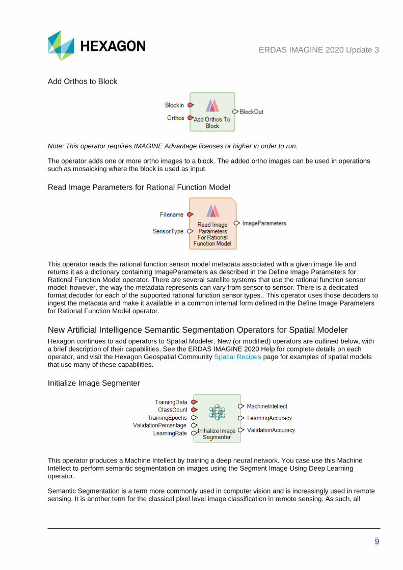
Add Orthos to Block
Note: This operator requires IMAGINE Advantage licenses or higher in order to run.
The operator adds one or more ortho images to a block. The added ortho images can be used in operations such as mosaicking where the block is used as input.
Read Image Parameters for Rational Function Model
This operator reads the rational function sensor model metadata associated with a given image file and returns it as a dictionary containing ImageParameters as described in the Define Image Parameters for Rational Function Model operator. There are several satellite systems that use the rational function sensor model; however, the way the metadata represents can vary from sensor to sensor. There is a dedicated format decoder for each of the supported rational function sensor types.. This operator uses those decoders to ingest the metadata and make it available in a common internal form defined in the Define Image Parameters for Rational Function Model operator.
New Artificial Intelligence Semantic Segmentation Operators for Spatial Modeler
Hexagon continues to add operators to Spatial Modeler. New (or modified) operators are outlined below, with a brief description of their capabilities. See the ERDAS IMAGINE 2020 Help for complete details on each operator, and visit the Hexagon Geospatial Community Spatial Recipes page for examples of spatial models that use many of these capabilities.
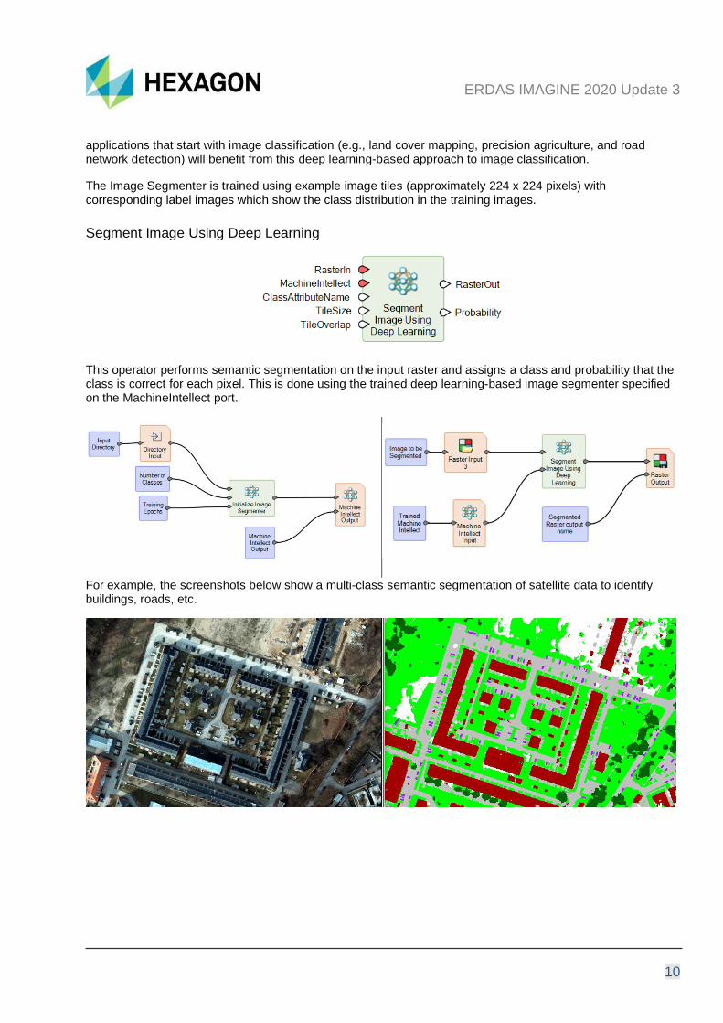
Initialize Image Segmenter
This operator produces a Machine Intellect by training a deep neural network. You case use this Machine Intellect to perform semantic segmentation on images using the Segment Image Using Deep Learning operator.
Semantic Segmentation is a term more commonly used in computer vision and is increasingly used in remote sensing. It is another term for the classical pixel level image classification in remote sensing. As such, all
ERDAS IMAGINE 2020 Update 3
10
applications that start with image classification (e.g., land cover mapping, precision agriculture, and road network detection) will benefit from this deep learning-based approach to image classification.
The Image Segmenter is trained using example image tiles (approximately 224 x 224 pixels) with corresponding label images which show the class distribution in the training images.
Segment Image Using Deep Learning
This operator performs semantic segmentation on the input raster and assigns a class and probability that the class is correct for each pixel. This is done using the trained deep learning-based image segmenter specified on the MachineIntellect port.
For example, the screenshots below show a multi-class semantic segmentation of satellite data to identify buildings, roads, etc.
ERDAS IMAGINE 2020 Update 3
11
Updated Operators
Mosaic Images
Note: This operator requires IMAGINE Advantage licenses or higher in order to run.
The Mosaic Images operator now accepts a list of input filenames rather than requiring a block as input. This enables you to mosaic existing ortho images.
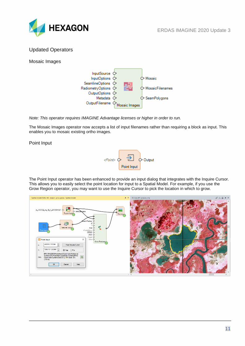
Point Input
The Point Input operator has been enhanced to provide an input dialog that integrates with the Inquire Cursor. This allows you to easily select the point location for input to a Spatial Model. For example, if you use the Grow Region operator, you may want to use the Inquire Cursor to pick the location in which to grow.
ERDAS IMAGINE 2020 Update 3
12
Spatial Model Editor Interface Improvements
The process of starting a new Spatial Model Editor panel has been difficult to navigate in the past. To make this process easier and more consistent with starting other types of View, Update 3 includes a shortcut located at Home tab > Window group > Add Views pulldown > Create New Spatial Model Editor.
We have also enhanced the Spatial Model Editor to persist the last state of the gridlines. Whichever state the Show Gridlines checkbox is set will determine how it is set when a new Spatial Model Editor is started.
Format Support
ICEYE SLC
ICEYE’s small satellite SAR imaging constellation is customized for the high revisit rate and frequent delivery of high-resolution imagery.
Interferometric processing has now been tested using the limited set of available sample SLC (single look complex) datasets. Further optimizations will occur as additional samples are delivered.
RADARSAT Constellation Mission (RCM)
The RADARSAT Constellation Mission (RCM) is Canada's new generation of Earth observation satellites. Launched on June 12, 2019, the three identical satellites provide daily images of Canada's vast territory and maritime approaches, as well as images of the Arctic, up to four times a day. It also has daily access to 90 percent of the world's surface.
Maxar / DigitalGlobe WorldView Legion
Synthesized examples indicate the upcoming WorldView Legion sensor is supported via RPC and Orbital Pushbroom geometric models for orthorectification and other photogrammetric processing.
PRISMA L2D
PRISMA L2D hyperspectral data delivered in HDF5 format (.he5) now geolocates correctly.
Defense Gridded Elevation Data (DGED)
The Defense Gridded Elevation Data (DGED) reader now recognizes more vertical coordinate reference systems that can be defined in the data and correctly interprets the data as elevation rather than simply an image.
ERDAS IMAGINE 2020 Update 3
13
DiMAP v2 NoData
DiMAP v2 data (e.g., SPOT, Pleiades, Pleiades Neo, etc.) XML headers often define a NoData value. This value is now automatically used as the NoData value in ERDAS IMAGINE.
Pleiades Neo DiMAP Geometric Models
Pleiades Neo imagery is supported in both rigorous Orbital Pushbroom and RPC geometric models.
General ERDAS IMAGINE
Multi-band Thematic display
In previous updates, a multi-band thematic dataset,such as what is produced by ERDAS IMAGINE’s supervised fuzzy classification tools, would default to open as a True Color display type. This default could be visually confusing. We have updated this display to ensure that despite the number of bands present in an image, if the first band is marked as thematic, the data will default to opening as Pseudo Color (band 1).
Escape Key
You can now dismiss dialogs using the industry-standard method of pressing the Esc key.
Lagrange Resampling
The Lagrange resampling method is now supported in IMAGINE Autosync (a part of the IMAGINE Expansion Pack product) and MosaicPro.
ERDAS IMAGINE 2020 Update 3
14
SIPS v2.4.15
We have updated the installer to use the Unclassified SIPS v2.4.15 XML file to control default Image Chain display parameters.
You can acquire extended versions of SIPS via the IMAGINE Defence Productivity Module (DPM).
IMAGINE Digital Surface Model (DSM) Extractor
You can now define a spatial subset to limit the area in which the Digital Surface Model (DSM) is extracted.
We have introduced a posting skip factor which specifies how many pixels will be skipped in the stereo pair in the X and Y directions during terrain extraction. Lower skip factor leads to denser point cloud output, and higher skip factor reduces computation time but leads to a sparser point cloud output.
IMAGINE SAR Feature
We have implemented two new classes of speckle suppression algorithms, including:
Artificial Intelligence Convolutional Neural Network (CNN) Despeckle
This function will process the radar image through a convolutional neural, network-based algorithm specifically trained to minimize speckle noise. This algorithm is fully automated and requires no user input.
Anisotropic and SuperPixel
This dialog enables the application of two sequential algorithms for a radar image. The first option, Despeckle, offers two forms of Anisotropic radiometric reconstruction – the Mixed-Norm algorithm and the Feature Preserving algorithm. Optionally, this step can be omitted by selecting “none”.
The intermediate image from the Despeckle step is followed by the second Segmentation step. The Superpixel algorithm evaluates the pixel values (greyscale) and modifies them to produce coherent regions (i.e., sub-features). The Cluster version of the algorithm also reduces pixel size. Again, selecting "none" eliminates this step from the processing.
ERDAS IMAGINE 2020 Update 3
15
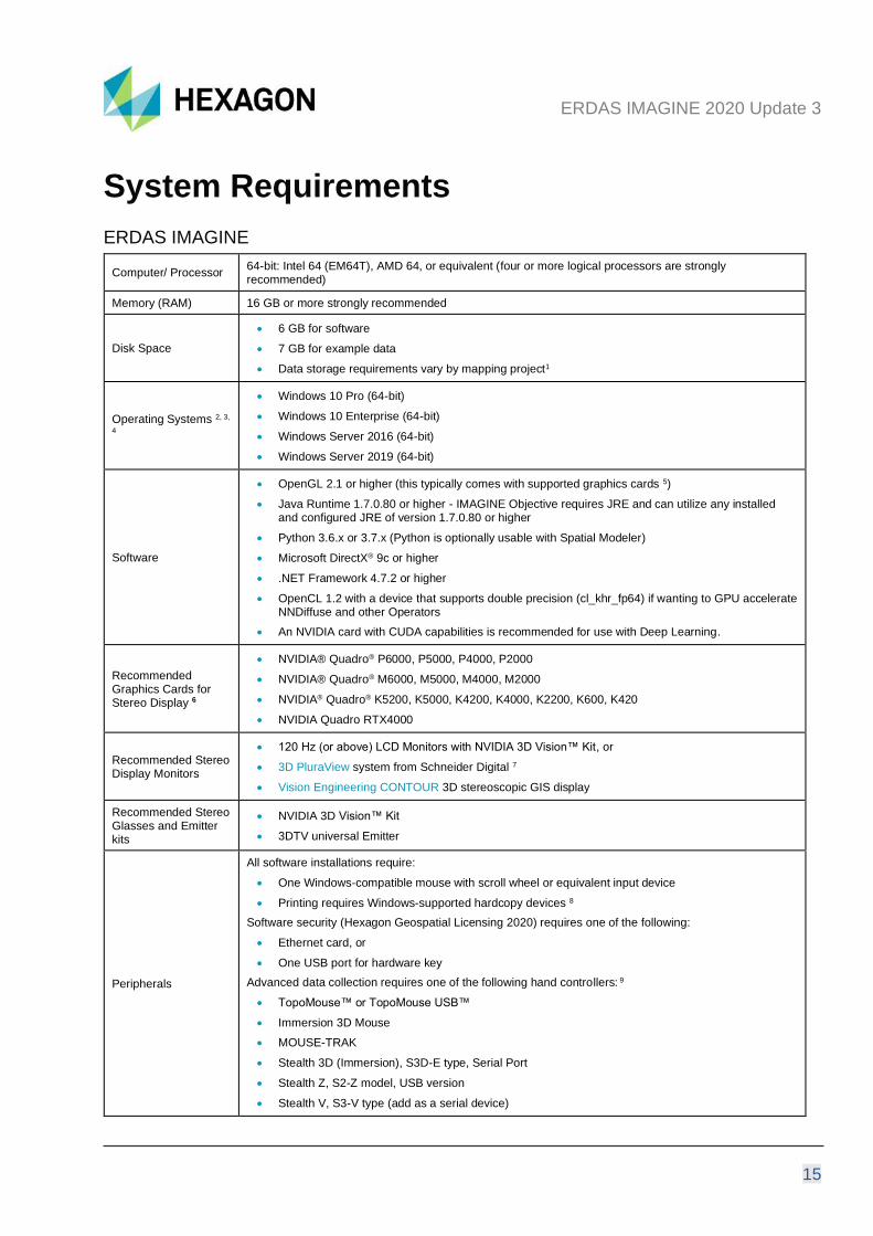
System Requirements
ERDAS IMAGINE
Computer/ Processor 64-bit: Intel 64 (EM64T), AMD 64, or equivalent (four or more logical processors are strongly recommended)
Memory (RAM) 16 GB or more strongly recommended
Disk Space
• 6 GB for software
• 7 GB for example data
• Data storage requirements vary by mapping project1
Operating Systems 2, 3,
4
• Windows 10 Pro (64-bit)
• Windows 10 Enterprise (64-bit)
• Windows Server 2016 (64-bit)
• Windows Server 2019 (64-bit)
Software
• OpenGL 2.1 or higher (this typically comes with supported graphics cards 5)
• Java Runtime 1.7.0.80 or higher - IMAGINE Objective requires JRE and can utilize any installed and configured JRE of version 1.7.0.80 or higher
• Python 3.6.x or 3.7.x (Python is optionally usable with Spatial Modeler)
• Microsoft DirectX® 9c or higher
• .NET Framework 4.7.2 or higher
• OpenCL 1.2 with a device that supports double precision (cl_khr_fp64) if wanting to GPU accelerate NNDiffuse and other Operators
• An NVIDIA card with CUDA capabilities is recommended for use with Deep Learning.
Recommended Graphics Cards for Stereo Display 6
• NVIDIA® Quadro® P6000, P5000, P4000, P2000
• NVIDIA® Quadro® M6000, M5000, M4000, M2000
• NVIDIA® Quadro® K5200, K5000, K4200, K4000, K2200, K600, K420
• NVIDIA Quadro RTX4000
Recommended Stereo Display Monitors
• 120 Hz (or above) LCD Monitors with NVIDIA 3D Vision™ Kit, or
• 3D PluraView system from Schneider Digital 7
• Vision Engineering CONTOUR 3D stereoscopic GIS display
Recommended Stereo Glasses and Emitter kits
• NVIDIA 3D Vision™ Kit
• 3DTV universal Emitter
Peripherals
All software installations require:
• One Windows-compatible mouse with scroll wheel or equivalent input device
• Printing requires Windows-supported hardcopy devices 8
Software security (Hexagon Geospatial Licensing 2020) requires one of the following:
• Ethernet card, or
• One USB port for hardware key
Advanced data collection requires one of the following hand controllers: 9
• TopoMouse™ or TopoMouse USB™
• Immersion 3D Mouse
• MOUSE-TRAK
• Stealth 3D (Immersion), S3D-E type, Serial Port
• Stealth Z, S2-Z model, USB version
• Stealth V, S3-V type (add as a serial device)
ERDAS IMAGINE 2020 Update 3
16
• 3Dconnexion SpaceMouse Pro 10
• 3Dconnexion SpaceExplorer mouse 10
• EK2000 Hand Wheels
• EMSEN Hand Wheels
• Z/I Mouse
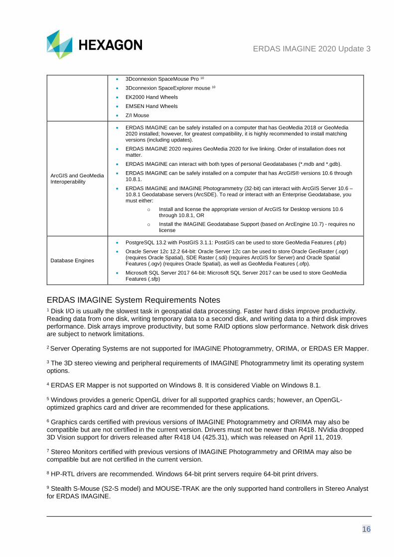
ArcGIS and GeoMedia Interoperability
• ERDAS IMAGINE can be safely installed on a computer that has GeoMedia 2018 or GeoMedia 2020 installed; however, for greatest compatibility, it is highly recommended to install matching versions (including updates).
• ERDAS IMAGINE 2020 requires GeoMedia 2020 for live linking. Order of installation does not matter.
• ERDAS IMAGINE can interact with both types of personal Geodatabases (*.mdb and *.gdb).
• ERDAS IMAGINE can be safely installed on a computer that has ArcGIS® versions 10.6 through 10.8.1.
• ERDAS IMAGINE and IMAGINE Photogrammetry (32-bit) can interact with ArcGIS Server 10.6 – 10.8.1 Geodatabase servers (ArcSDE). To read or interact with an Enterprise Geodatabase, you must either:
o Install and license the appropriate version of ArcGIS for Desktop versions 10.6 through 10.8.1, OR
o Install the IMAGINE Geodatabase Support (based on ArcEngine 10.7) - requires no license
Database Engines
• PostgreSQL 13.2 with PostGIS 3.1.1: PostGIS can be used to store GeoMedia Features (.pfp)
• Oracle Server 12c 12.2 64-bit: Oracle Server 12c can be used to store Oracle GeoRaster (.ogr) (requires Oracle Spatial), SDE Raster (.sdi) (requires ArcGIS for Server) and Oracle Spatial Features (.ogv) (requires Oracle Spatial), as well as GeoMedia Features (.ofp).
• Microsoft SQL Server 2017 64-bit: Microsoft SQL Server 2017 can be used to store GeoMedia Features (.sfp)
ERDAS IMAGINE System Requirements Notes 1 Disk I/O is usually the slowest task in geospatial data processing. Faster hard disks improve productivity. Reading data from one disk, writing temporary data to a second disk, and writing data to a third disk improves performance. Disk arrays improve productivity, but some RAID options slow performance. Network disk drives are subject to network limitations.
2 Server Operating Systems are not supported for IMAGINE Photogrammetry, ORIMA, or ERDAS ER Mapper.
3 The 3D stereo viewing and peripheral requirements of IMAGINE Photogrammetry limit its operating system options.
4 ERDAS ER Mapper is not supported on Windows 8. It is considered Viable on Windows 8.1.
5 Windows provides a generic OpenGL driver for all supported graphics cards; however, an OpenGL-optimized graphics card and driver are recommended for these applications.
6 Graphics cards certified with previous versions of IMAGINE Photogrammetry and ORIMA may also be compatible but are not certified in the current version. Drivers must not be newer than R418. NVidia dropped 3D Vision support for drivers released after R418 U4 (425.31), which was released on April 11, 2019.
7 Stereo Monitors certified with previous versions of IMAGINE Photogrammetry and ORIMA may also be compatible but are not certified in the current version.
8 HP-RTL drivers are recommended. Windows 64-bit print servers require 64-bit print drivers.
9 Stealth S-Mouse (S2-S model) and MOUSE-TRAK are the only supported hand controllers in Stereo Analyst for ERDAS IMAGINE.

ERDAS IMAGINE 2020 Update 3
17
10 3Dconnexion mice are supported in IMAGINE Photogrammetry.
ERDAS IMAGINE 2020 Update 3
18
Issues Resolved – ERDAS IMAGINE 2020 Update 3
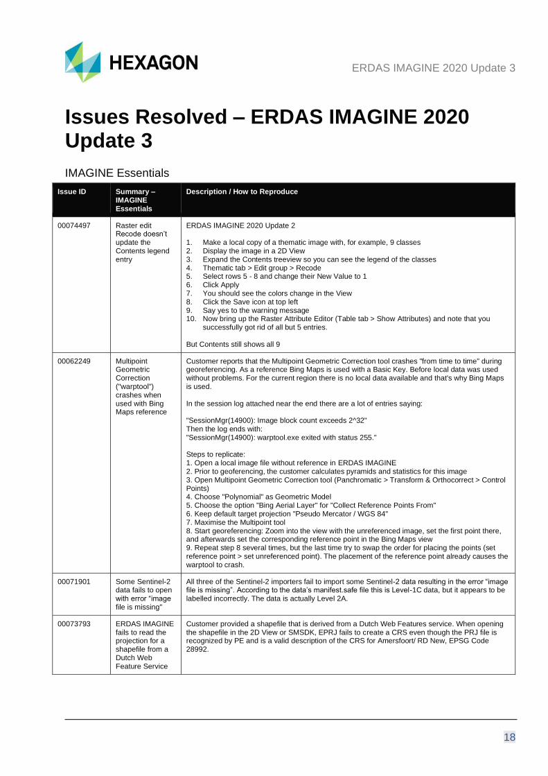
IMAGINE Essentials
Issue ID Summary – IMAGINE Essentials
Description / How to Reproduce
00074497 Raster edit Recode doesn’t update the Contents legend entry
ERDAS IMAGINE 2020 Update 2 1. Make a local copy of a thematic image with, for example, 9 classes 2. Display the image in a 2D View 3. Expand the Contents treeview so you can see the legend of the classes 4. Thematic tab > Edit group > Recode 5. Select rows 5 - 8 and change their New Value to 1 6. Click Apply 7. You should see the colors change in the View 8. Click the Save icon at top left 9. Say yes to the warning message 10. Now bring up the Raster Attribute Editor (Table tab > Show Attributes) and note that you
successfully got rid of all but 5 entries. But Contents still shows all 9
00062249 Multipoint Geometric Correction ("warptool") crashes when used with Bing Maps reference
Customer reports that the Multipoint Geometric Correction tool crashes "from time to time" during georeferencing. As a reference Bing Maps is used with a Basic Key. Before local data was used without problems. For the current region there is no local data available and that's why Bing Maps is used. In the session log attached near the end there are a lot of entries saying: "SessionMgr(14900): Image block count exceeds 2^32" Then the log ends with: "SessionMgr(14900): warptool.exe exited with status 255." Steps to replicate: 1. Open a local image file without reference in ERDAS IMAGINE 2. Prior to geoferencing, the customer calculates pyramids and statistics for this image 3. Open Multipoint Geometric Correction tool (Panchromatic > Transform & Orthocorrect > Control Points) 4. Choose "Polynomial" as Geometric Model 5. Choose the option "Bing Aerial Layer" for "Collect Reference Points From" 6. Keep default target projection "Pseudo Mercator / WGS 84" 7. Maximise the Multipoint tool 8. Start georeferencing: Zoom into the view with the unreferenced image, set the first point there, and afterwards set the corresponding reference point in the Bing Maps view 9. Repeat step 8 several times, but the last time try to swap the order for placing the points (set reference point > set unreferenced point). The placement of the reference point already causes the warptool to crash.
00071901 Some Sentinel-2 data fails to open with error “image file is missing"
All three of the Sentinel-2 importers fail to import some Sentinel-2 data resulting in the error “image file is missing”. According to the data’s manifest.safe file this is Level-1C data, but it appears to be labelled incorrectly. The data is actually Level 2A.
00073793 ERDAS IMAGINE fails to read the projection for a shapefile from a Dutch Web Feature Service
Customer provided a shapefile that is derived from a Dutch Web Features service. When opening the shapefile in the 2D View or SMSDK, EPRJ fails to create a CRS even though the PRJ file is recognized by PE and is a valid description of the CRS for Amersfoort/ RD New, EPSG Code 28992.

ERDAS IMAGINE 2020 Update 3
19
00071834 ERDAS IMAGINE doesn't display all attributes from HPC format (exported from LAS)
To reproduce:
1. Run Manage Data > Export Data 2. Pick Hexagon Point Cloud (HPC) as Format, define a .las file as Input File and provide
output filename. Click Ok. 3. In the opened dialog window activate Include Attributes option and click OK. 4. Load the resulting .hpc file to the 2D View and open attribute table (Table tab > Show
Attributes). Intensity, Return and Class will have all 0s This is an ERDAS IMAGINE display issue, attributes are being written correctly: the attributes are being written but ERDAS IMAGINE isn’t reading them when displaying the attribute table. ERDAS IMAGINE also only renders HPC point clouds by RGB for performance reasons. I.e. the HPC files are attributed correctly but some work was required to expose them to 2D View users.
ERDAS IMAGINE 2020 Update 3
20
IMAGINE Advantage
Issue ID Summary – IMAGINE Advantage
Description / How to Reproduce
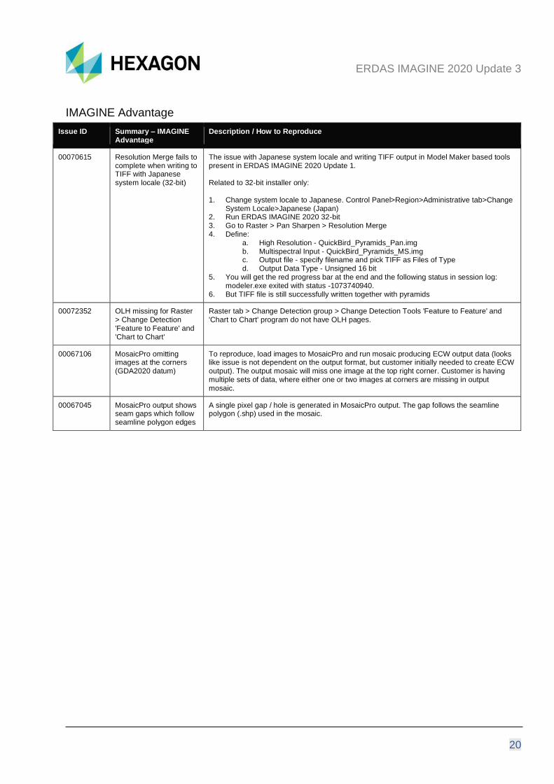
00070615 Resolution Merge fails to complete when writing to TIFF with Japanese system locale (32-bit)
The issue with Japanese system locale and writing TIFF output in Model Maker based tools present in ERDAS IMAGINE 2020 Update 1. Related to 32-bit installer only: 1. Change system locale to Japanese. Control Panel>Region>Administrative tab>Change
System Locale>Japanese (Japan) 2. Run ERDAS IMAGINE 2020 32-bit 3. Go to Raster > Pan Sharpen > Resolution Merge 4. Define:
a. High Resolution - QuickBird_Pyramids_Pan.img b. Multispectral Input - QuickBird_Pyramids_MS.img c. Output file - specify filename and pick TIFF as Files of Type d. Output Data Type - Unsigned 16 bit
5. You will get the red progress bar at the end and the following status in session log: modeler.exe exited with status -1073740940.
6. But TIFF file is still successfully written together with pyramids
00072352 OLH missing for Raster > Change Detection 'Feature to Feature' and 'Chart to Chart'
Raster tab > Change Detection group > Change Detection Tools 'Feature to Feature' and 'Chart to Chart' program do not have OLH pages.
00067106 MosaicPro omitting images at the corners (GDA2020 datum)
To reproduce, load images to MosaicPro and run mosaic producing ECW output data (looks like issue is not dependent on the output format, but customer initially needed to create ECW output). The output mosaic will miss one image at the top right corner. Customer is having multiple sets of data, where either one or two images at corners are missing in output mosaic.
00067045 MosaicPro output shows seam gaps which follow seamline polygon edges
A single pixel gap / hole is generated in MosaicPro output. The gap follows the seamline polygon (.shp) used in the mosaic.
ERDAS IMAGINE 2020 Update 3
21
IMAGINE Objective
Issue ID Summary – IMAGINE Objective
Description / How to Reproduce
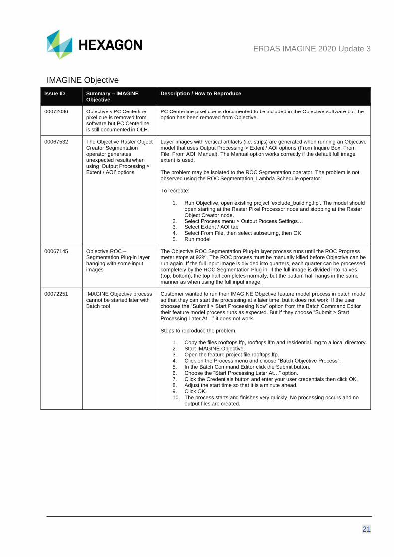
00072036 Objective's PC Centerline pixel cue is removed from software but PC Centerline is still documented in OLH.
PC Centerline pixel cue is documented to be included in the Objective software but the option has been removed from Objective.
00067532 The Objective Raster Object Creator Segmentation operator generates unexpected results when using ‘Output Processing > Extent / AOI’ options
Layer images with vertical artifacts (i.e. strips) are generated when running an Objective model that uses Output Processing > Extent / AOI options (From Inquire Box, From File, From AOI, Manual). The Manual option works correctly if the default full image extent is used. The problem may be isolated to the ROC Segmentation operator. The problem is not observed using the ROC Segmentation_Lambda Schedule operator. To recreate:
1. Run Objective, open existing project ‘exclude_building.lfp’. The model should open starting at the Raster Pixel Processor node and stopping at the Raster Object Creator node.
2. Select Process menu > Output Process Settings… 3. Select Extent / AOI tab 4. Select From File, then select subset.img, then OK 5. Run model
00067145 Objective ROC – Segmentation Plug-in layer hanging with some input images
The Objective ROC Segmentation Plug-in layer process runs until the ROC Progress meter stops at 92%. The ROC process must be manually killed before Objective can be run again. If the full input image is divided into quarters, each quarter can be processed completely by the ROC Segmentation Plug-in. If the full image is divided into halves (top, bottom), the top half completes normally, but the bottom half hangs in the same manner as when using the full input image.
00072251 IMAGINE Objective process cannot be started later with Batch tool
Customer wanted to run their IMAGINE Objective feature model process in batch mode so that they can start the processing at a later time, but it does not work. If the user chooses the “Submit > Start Processing Now” option from the Batch Command Editor their feature model process runs as expected. But if they choose “Submit > Start Processing Later At…” it does not work. Steps to reproduce the problem.
1. Copy the files rooftops.lfp, rooftops.lfm and residential.img to a local directory. 2. Start IMAGINE Objective. 3. Open the feature project file rooftops.lfp. 4. Click on the Process menu and choose “Batch Objective Process”. 5. In the Batch Command Editor click the Submit button. 6. Choose the “Start Processing Later At…” option. 7. Click the Credentials button and enter your user credentials then click OK. 8. Adjust the start time so that it is a minute ahead. 9. Click OK. 10. The process starts and finishes very quickly. No processing occurs and no
output files are created.

ERDAS IMAGINE 2020 Update 3
22
IMAGINE Photogrammetry
Issue ID Summary – IMAGINE Photogrammetry
Description / How to Reproduce
00071724 Very dense vertex interpolation during breakline editing
While moving a breakline over another existing breakline new vertices are immediately (on the fly) interpolated on the moved and on the overlapping breakline. The vertices of both breaklines get an extreme density of interpolated vertices while moving and not only at the end of the move (when releasing the Create/Edit button).
00071726 Breakline measurement cause problems near other breaklines
An accidental editing of a breakline vertices happens when a new breakline is digitized near an existing breakline which is within the “selection radius”. The adjacent breakline point(s) will be shifted then. An “Undo” sometimes result in unexpected effects. These are for example: the adjacent breakline disappears (Redo could fix this problem) or the adjacent breakline appers twice (old and new position).
00074735 IMAGINE DSM Extractor interface image pair threshold issue
Have a block file with 7 images with 80% overlap. When opening in the DSM Extractor interface it calculates/shows the rows with pairs based on 50% overlap or more. That is all normal. When I select 80% overlap or more it still shows the same amount of rows however now with many empty ones. Yet when I lower the percentage to 40% it still shows the same amount of rows in the preview even though there are more pairs now (15). So it still shows 11 rows, 4 pairs are missing which will not be considered. When pressing Run Now it will only take those selected out of these 11 options, the other 4 will automatically not be used. When pressing Submit all 15 pairs do appear.
00071725 Points and Breaklines are sometimes duplicated after editing in Terrain Editor
When zooming in and out after having moved/edited a point or a breakline the edited element sometimes is displayed twice (old and new position). When executing “Save” afterwards the elements in the LTFX file are really existing twice (old and new). Try to move some height points (4 to 5) with the Point Tool from one position to another (move in xyz). Then zoom in and out a couple of times. Try to do the same with breakline vertices using the Breakline Tool.
00071725 Terrain Editor: Points and Breaklines are sometimes duplicated after editing
When zooming in and out after having moved/edited a point or a breakline the edited element sometimes is displayed twice (old and new position). When executing “Save” afterwards the elements in the LTFX file are really existing twice (old and new).
00028810 WorldView image processing issues in SGM Tridicon
Customer is generating point clouds in Tridicon SGM using WorldView imagery. There are a lot of bad matches in Tridicon SGM outputs. It looks like accurate surface points are in there, but they are surrounded by several high and low anomalous points. Customer has created several iterations of blockfiles using various in-track stereo WV3 imagery, multiple formats (NTF and GeoTIFF), varying #’s of GCPs and tiepoints, and have ran SGM using the different pyramid and disparity levels, but still getting similar results. Triangulation results are good.
00046100 Import tool imports INPHO project with wrong flying height.
When importing Inpho project to block file; at project import default unit is meters, and when you enter units as US Survey Feet importer makes a conversion from meters to US Survey feet which it shouldn’t because project is triangulated in US Survey feet. Defining the INPHO projection units should not result in unit conversion.
ERDAS IMAGINE 2020 Update 3
23
IMAGINE Professional
Issue ID Summary – IMAGINE Professional
Description / How to Reproduce
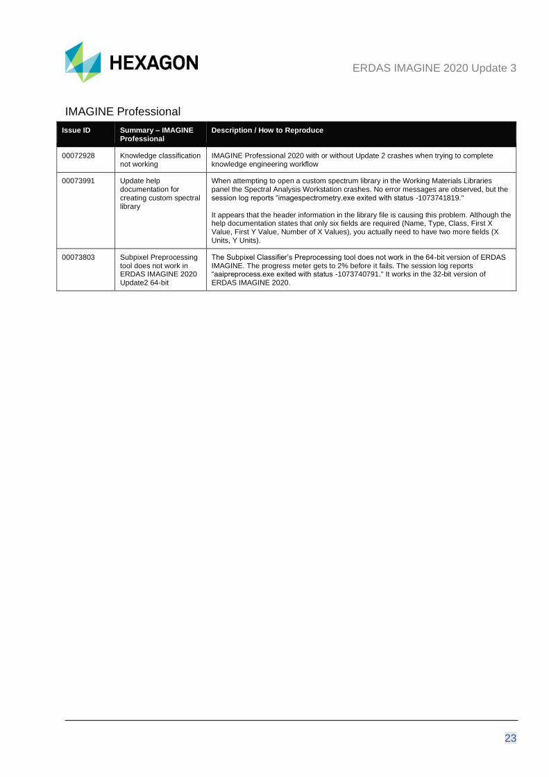
00072928 Knowledge classification not working
IMAGINE Professional 2020 with or without Update 2 crashes when trying to complete knowledge engineering workflow
00073991 Update help documentation for creating custom spectral library
When attempting to open a custom spectrum library in the Working Materials Libraries panel the Spectral Analysis Workstation crashes. No error messages are observed, but the session log reports “imagespectrometry.exe exited with status -1073741819." It appears that the header information in the library file is causing this problem. Although the help documentation states that only six fields are required (Name, Type, Class, First X Value, First Y Value, Number of X Values), you actually need to have two more fields (X Units, Y Units).
00073803 Subpixel Preprocessing tool does not work in ERDAS IMAGINE 2020 Update2 64-bit
The Subpixel Classifier’s Preprocessing tool does not work in the 64-bit version of ERDAS IMAGINE. The progress meter gets to 2% before it fails. The session log reports “aaipreprocess.exe exited with status -1073740791." It works in the 32-bit version of ERDAS IMAGINE 2020.
ERDAS IMAGINE 2020 Update 3
24
Spatial Modeler
Issue ID Summary – Spatial Modeler
Description / How to Reproduce
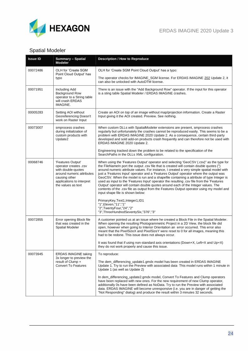
00072486 OLH for ‘Create SGM Point Cloud Output’ has typo
OLH for ‘Create SGM Point Cloud Output’ has a typo: The operator checks for IMAGINE_SGM license. For ERDAS IMAGINE 202 Update 2, it can also be unlocked with AutoDTM license.
00071951 Including Add Background Row operator to a String table will crash ERDAS IMAGINE.
There is an issue with the "Add Background Row" operator. If the input for this operator is a sting table Spatial Modeler / ERDAS IMAGINE crashes.
00005283 Setting AOI without Georeferencing Doesn't work on Raster Input
Create an AOI on top of an image without map/projection information. Create a Raster Input giving it the AOI created. Preview. See nothing.
00073007 smprocess crashes during initialization of custom products with Update2
When custom DLLs with SpatialModeler extensions are present, smprocess crashes regularly but unfortunately the crashes cannot be reproduced easily. This seems to be a problem with ERDAS IMAGINE 2020 Update 2. As a consequence, certain third-party developed and sold add-on products crash frequently and can therefore not be used with ERDAS IMAGINE 2020 Update 2. Engineering tracked down the problem to be related to the specification of the SearchPaths in the DLLs XML configuration.
00068746 'Features Output' operator creates .csv with double-quotes around numeric attributes causing other applications to interpret the values as text
When using the 'Features Output' operator and selecting 'GeoCSV (.csv)" as the type for the FileNameIn port the output .csv file that is created will contain double quotes (") around numeric attribute values. For instance, I created a very simple spatial model with just a 'Features Input' operator and a 'Features Output' operator where the output was GeoCSV. When the model is run and a shapefile containing a attribute of type Integer is used as input to the 'Features Input' operator the resulting .csv file from the 'Features Output' operator will contain double quotes around each of the Integer values. The contents of the .csv file as output from the Features Output operator using my model and input shape file is shown below: PrimaryKey,Text1,Integer1,ID1 "1",Eleven,"11","1" "2",TwentyFour,"24","2" "3",ThreeHundredSeventySix,"376","3"
00072855 Error opening Block file that was created in the Spatial Modeler
A customer pointed us at an issue where he created a Block File in the Spatial Modeler. When opening the resulting Photogrammetric Project in a 2D View, the block file did open, however when going to Interior Orientation an error occurred. This error also meant that the PixelSizeX and PixelSizeY were reset to 0 for all images, meaning this had to be redone. This issue does not always occur. It was found that if using non-standard axis orientations (Down+X, Left+X and Up+X) they do not work properly and cause this issue.
00073945 ERDAS IMAGINE taking 3x longer to preview the result of Clump + Convert To Features
To reproduce: The dem_differencing_update1.gmdx model has been created in ERDAS IMAGINE Update 1. Try to run the Preview with associated data This model runs within 1 minute in Update 1 (as well as Update 2) In dem_differencing_update2.gmdx model, Convert To Features and Clump operators have been replaced with new ones. For the new requirement of new Clump operator, additionally 0s have been defined as NoData. Try to run the Preview with associated data. ERDAS IMAGINE will become unresponsive (i.e. you are in danger of getting the "Not Responding" dialog) and produce the result within 3 minutes 32 seconds.

ERDAS IMAGINE 2020 Update 3
25
00072977 Features Input operator fails to read data if filename/path includes "&"
To reproduce:
1. The data should be located in folder named "data & model" or create any other folder that will include the “&” symbol.
2. Run data_prep_extract_rooftops.gmdx with associated files. It will read raster file successfully but Features Input will fail with "Cannot open specified Vector source" error.
Full Message is Cannot open specified Vector source (erdas::sb_CGP::FeaturesInput::OnExecute failed)
00077250 Issue with orthorectification of ALOS PRISM data in Spatial Modeler
Orthorectify without GCP tool is producing the expected output with ALOS PRISM data, while trying to replicate the same workflow in Spatial Modeler gives wrong result (either left or right part of image getting clipped out) This issue is addressed in Update 3 by using the new satellite photogrammetry operators.
ERDAS IMAGINE 2020 Update 3
26
Contact Us
https://go.hexagongeospatial.com/contact-us-today
About Hexagon Hexagon is a global leader in sensor, software, and autonomous solutions. We are putting data to work to boost efficiency, productivity, and quality across industrial, manufacturing, infrastructure, safety, and mobility applications.
Our technologies are shaping urban and production ecosystems to become increasingly connected and autonomous — ensuring a scalable, sustainable future.
Hexagon’s Geospatial division creates solutions that deliver a 5D smart digital reality with insight into what was, what is, what could be, what should be, and ultimately, what will be.
Hexagon (Nasdaq Stockholm: HEXA B) has approximately 21,000 employees in 50 countries and net sales of approximately 4.4bn USD. Learn more at hexagon.com and follow us @HexagonAB.
ERDAS IMAGINE 2020 Update 3
27
Copyright © 2021 Hexagon AB and/or its subsidiaries and affiliates. All rights reserved. Hexagon has registered trademarks in many countries throughout the world. Visit the Trademarks Page http://www.hexagongeospatial.com/legal/trademarks for information about the countries in which the trademarks are registered. See Product Page and Acknowledgments for more information.
Product Documentation Terms of Use PLEASE READ THESE TERMS CAREFULLY BEFORE USING HEXAGON GEOSPATIAL’S DOCUMENTATION ("DOCUMENT"). USE OF THIS DOCUMENT INDICATES ACCEPTANCE OF THIS AGREEMENT WITHOUT MODIFICATION. IF YOU DO NOT AGREE TO THE TERMS HEREOF ("TERMS"), DO NOT USE THIS DOCUMENT.
Use Of This Document All materials in this Document are copyrighted and any unauthorized use may violate worldwide copyright, trademark, and other laws. Subject to the terms of this Agreement, Hexagon Geospatial (a Division of Intergraph Corporation) and Intergraph’s subsidiaries ("Intergraph") hereby authorize you to reproduce this Document solely for your personal, non-commercial use. In consideration of this authorization, you agree to retain all copyright and other proprietary notices contained therein. You may not modify the Materials in any way or reproduce or publicly display, perform, or distribute or otherwise use them for any public or commercial purpose, except as specifically authorized in a separate agreement with Hexagon Geospatial.
The foregoing authorization specifically excludes content or material bearing a copyright notice or attribution of rights of a third party. Except as expressly provided above, nothing contained herein shall be construed as conferring by implication, estoppel or otherwise any license or right under any copyright, patent, or trademark of Hexagon Geospatial or Intergraph or any third party.
If you breach any of these Terms, your authorization to use this Document automatically terminates. Upon termination, you will immediately destroy any downloaded or printed Materials in your possession or control.
Disclaimers ALL MATERIALS SUPPLIED HEREUNDER ARE PROVIDED "AS IS", WITHOUT WARRANTY OF ANY KIND, EITHER EXPRESSED OR IMPLIED, INCLUDING, BUT NOT LIMITED TO, ANY IMPLIED WARRANTIES OF MERCHANTABILITY, FITNESS FOR A PARTICULAR PURPOSE, OR NON-INFRINGEMENT. Hexagon Geospatial does not warrant that the content of this Document will be error-free, that defects will be corrected, or that any Hexagon Geospatial Website or the services that make Materials available are free of viruses or other harmful components.
Hexagon Geospatial does not warrant the accuracy and completeness of this Document. Hexagon Geospatial may make changes to this Document at any time without notice.
Limitation Of Liability IN NO EVENT SHALL HEXAGON GEOSPATIAL BE LIABLE FOR ANY DIRECT, INDIRECT, INCIDENTAL, SPECIAL OR CONSEQUENTIAL DAMAGES, OR DAMAGES FOR LOSS OF PROFITS, REVENUE, DATA OR USE, INCURRED BY YOU OR ANY THIRD PARTY, WHETHER IN AN ACTION IN CONTRACT OR TORT, ARISING FROM YOUR ACCESS TO, OR USE OF, THIS DOCUMENT.
Indemnification You agree to defend, indemnify, and hold harmless Hexagon Geospatial, its officers, directors, employees, and agents from and against any and all claims, liabilities, damages, losses or expense, including reasonable attorneys' fees and costs, arising out of or in any way connected with your access to or use of this Document.
Use Of Software Use of software described in this Document is subject to the terms of the end user license agreement that accompanies the software, if any. You may not download or install any software that is accompanied by or

ERDAS IMAGINE 2020 Update 3
28
includes an end user license agreement unless you have read and accepted the terms of such license agreement. Any such software is the copyrighted work of Hexagon Geospatial, Intergraph or its licensors. Portions of the user interface copyright 2012- Telerik AD.
Links To Third Party Websites This Document may provide links to third party websites for your convenience and information. Third party websites will be governed by their own terms and conditions. Hexagon Geospatial does not endorse companies or products to which it links.
Third party websites are owned and operated by independent parties over which Hexagon Geospatial has no control. Hexagon Geospatial shall not have any liability resulting from your use of the third-party website. Any link you make to or from the third party website will be at your own risk and any information you share with the third party website will be subject to the terms of the third party website, including those relating to confidentiality, data privacy, and security.
Trademarks The trademarks, logos, and service marks ("Marks") displayed in this Document are the property of Hexagon Geospatial, Intergraph or other third parties. Users are not permitted to use Marks without the prior written consent of Hexagon Geospatial, Intergraph or the third party that owns the Mark. "Intergraph" is a registered trademark of Intergraph Corporation in the United States and in other countries. Other brands and product names are trademarks of their respective owners.
Find additional trademark information https://www.hexagongeospatial.com/legal/trademarks.
Procedure For Making Claims Of Copyright Infringement Notifications of claimed copyright infringement should be sent to Hexagon Geospatial by mail at the following address: Intergraph Corporation, Attn: Intergraph Legal Department, P.O. Box 240000, Huntsville, Alabama 35824.
US Government Restricted Right Materials are provided with "RESTRICTED RIGHTS." Use, duplication, or disclosure of Materials by the U.S. Government is subject to restrictions as set forth in FAR 52.227-14 and DFARS 252.227-7013 et seq. or successor provisions thereto. Use of Materials by the Government constitutes acknowledgment of Hexagon Geospatial or Intergraph’s proprietary rights therein.
International Use You may not use or export Materials in violation of U.S. export laws and regulations. Hexagon Geospatial makes no representation that Materials are appropriate or available for use in every country, and access to them from territories where their content is illegal is prohibited.
Hexagon Geospatial provides access to Hexagon Geospatial international data and, therefore, may contain references or cross references to Hexagon Geospatial products, programs and services that are not announced in your country. These references do not imply that Hexagon Geospatial intends to announce such products, programs, or services in your country.
The Materials are subject to U.S. export control and economic sanctions laws and regulations and you agree to comply strictly with all such laws and regulations. In addition, you represent and warrant that you are not a national of, or otherwise located within, a country subject to U.S. economic sanctions (including without limitation Iran, Syria, Sudan, Cuba, and North Korea) and that you are not otherwise prohibited from receiving or accessing the Materials under U.S. export control and economic sanctions laws and regulations. Hexagon Geospatial makes no representation that the Materials are appropriate or available for use in every country, and access to them from territories where their content is illegal is prohibited. All rights to use the Materials are granted on condition that such rights are forfeited if you fail to comply with the terms of this agreement.

ERDAS IMAGINE 2020 Update 3
29
Revisions Hexagon Geospatial reserves the right to revise these Terms at any time. You are responsible for regularly reviewing these Terms. Your continued use of this Document after the effective date of such changes constitutes your acceptance of and agreement to such changes.
Applicable Law This Document is created and controlled by Hexagon Geospatial in the State of Alabama. As such, the laws of the State of Alabama will govern these Terms, without giving effect to any principles of conflicts of law. You hereby irrevocably and unconditionally consent to submit to the exclusive jurisdiction of the United States District Court for the Northern District of Alabama, Northeastern Division, or the Circuit Court for Madison County, Alabama for any litigation arising out of or relating to use of this Document (and agree not to commence any litigation relating thereto except in such courts), waive any objection to the laying of venue of any such litigation in such Courts and agree not to plead or claim in any such Courts that such litigation brought therein has been brought in an inconvenient forum. Some jurisdictions do not allow the exclusions or limitations set forth in these Terms. Such exclusions or limitations shall apply in all jurisdictions to the maximum extent allowed by applicable law.
Questions Contact us with any questions regarding these Terms.