release notes for inpho 7.1.3 (patch) and 8.0 incl...
TRANSCRIPT
www.trimble.com http://uas.trimble.com/inpho-uasmaster http://www.trimble.com/Imaging/aerial-software.aspx
© 2016, Trimble Navigation Limited. All rights reserved. Trimble and the Globe & Triangle logo are trademarks of Trimble Navigation Limited registered in the United States and in other countries. All other trademarks are the property of their respective owners.
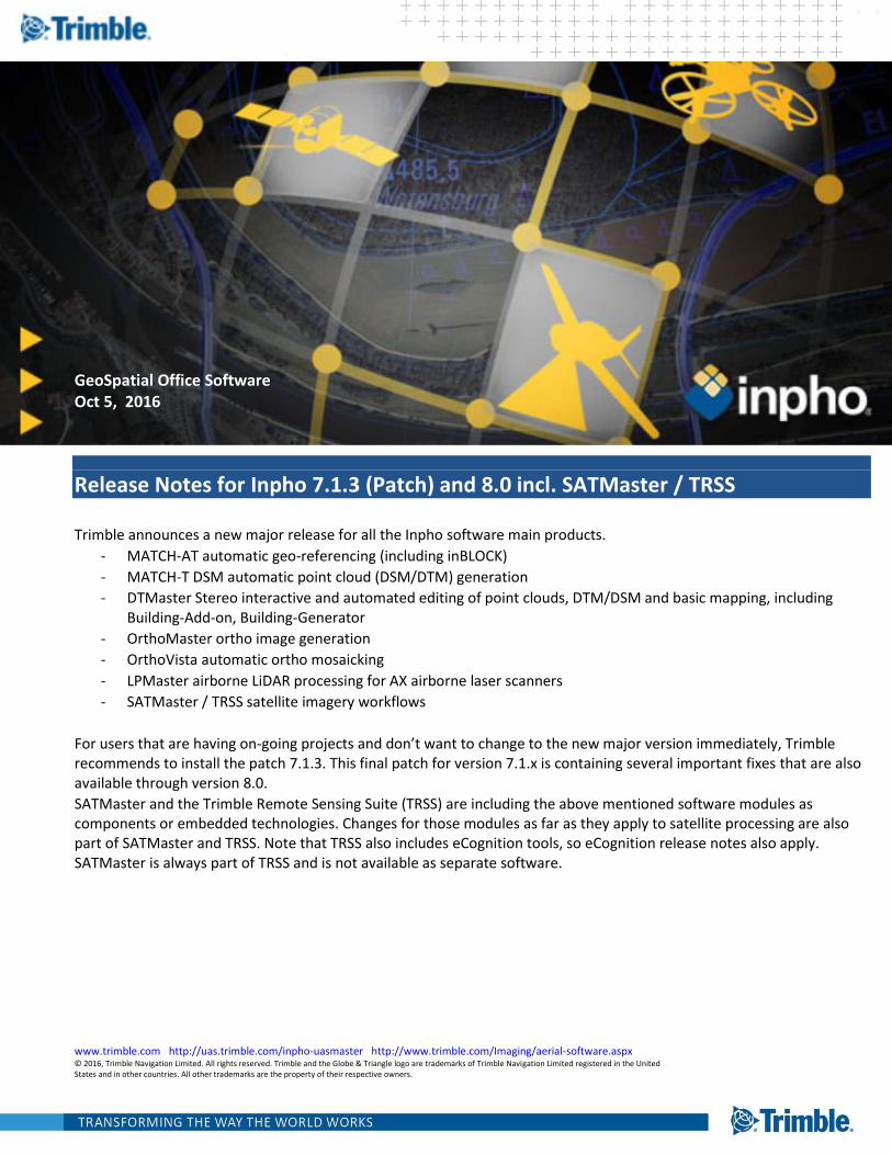
GeoSpatial Office Software Oct 5, 2016
Release Notes for Inpho 7.1.3 (Patch) and 8.0 incl. SATMaster / TRSS
Trimble announces a new major release for all the Inpho software main products.
- MATCH-AT automatic geo-referencing (including inBLOCK)
- MATCH-T DSM automatic point cloud (DSM/DTM) generation
- DTMaster Stereo interactive and automated editing of point clouds, DTM/DSM and basic mapping, including Building-Add-on, Building-Generator
- OrthoMaster ortho image generation
- OrthoVista automatic ortho mosaicking
- LPMaster airborne LiDAR processing for AX airborne laser scanners
- SATMaster / TRSS satellite imagery workflows
For users that are having on-going projects and don’t want to change to the new major version immediately, Trimble recommends to install the patch 7.1.3. This final patch for version 7.1.x is containing several important fixes that are also available through version 8.0.
SATMaster and the Trimble Remote Sensing Suite (TRSS) are including the above mentioned software modules as components or embedded technologies. Changes for those modules as far as they apply to satellite processing are also part of SATMaster and TRSS. Note that TRSS also includes eCognition tools, so eCognition release notes also apply. SATMaster is always part of TRSS and is not available as separate software.
www.trimble.com http://uas.trimble.com/inpho-uasmaster http://www.trimble.com/Imaging/aerial-software.aspx Page 2
Table of Contents GeoSpatial Office Software ..................................................................................................................................................... 1
Oct 5, 2016 .............................................................................................................................................................................. 1
What is INPHO .......................................................................................................................................................................... 4
What’s new in INPHO 8.0 ......................................................................................................................................................... 4
The perfect reference for GIS/CAD data collection: Ortho-mosaics directly from point clouds ......................................... 5
Radiometric balancing of raw aerial images ........................................................................................................................ 7
Improved geo-referencing – better tie point matching, better camera modelling ............................................................. 8
New Satellites & Multi-Satellite Geo-referencing ................................................................................................................ 9
ApplicationsMaster 7.1.3 / 8.0 ................................................................................................................................................. 9
New Feature 8.0: .................................................................................................................................................................. 9
Fix 7.1.3: e-mail notification ................................................................................................................................................. 9
Fix 7.1.3: correct distortion definition when upgrading project files ................................................................................... 9
Fix 7.1.3: correct image coordinates from ZI projects ........................................................................................................ 10
Fix 7.1.3: general stability improvements .......................................................................................................................... 10
Fix 7.1.3: correct selection of camera for image import .................................................................................................... 10
Change 7.1.3: default settings for principal point definition ............................................................................................. 10
Update 7.1.3: more data validation checks ........................................................................................................................ 10
Update 7.1.3: merged project files ..................................................................................................................................... 10
Update 7.1.3: revised documentation ................................................................................................................................ 10
Information 7.1.3: export of ft-us projects to Summit Evolution ....................................................................................... 10
MATCH-AT (inBLOCK) / Satellite Geo-referencing 7.1.3 / 8.0 ................................................................................................ 10
New Feature 8.0: ................................................................................................................................................................ 10
Fix 7.1.3: Worldview 3 ........................................................................................................................................................ 10
Fix 7.1.3: too many unknowns ............................................................................................................................................ 10
Update 7.1.3: multiple satellites in one project ................................................................................................................. 11
Update 7.1.3: considering image bounds ........................................................................................................................... 11
Update 7.1.3: move-to ....................................................................................................................................................... 11
Update 7.1.3: satellite triangulation without GCP ............................................................................................................. 11
Update 7.1.3: tie point distribution .................................................................................................................................... 11
MATCH-T DSM 7.1.3 / 8.0 ....................................................................................................................................................... 11
New Feature 8.0: ................................................................................................................................................................ 11
DTMaster Stereo 7.1.3 / 8.0 .................................................................................................................................................. 11
New Feature 8.0: ................................................................................................................................................................ 11
Update 7.1.3: shortcuts in un-docked windows ................................................................................................................. 11
Update 7.1.3: move-to ....................................................................................................................................................... 11
www.trimble.com http://uas.trimble.com/inpho-uasmaster http://www.trimble.com/Imaging/aerial-software.aspx Page 3
OrthoMaster 7.1.3 / 8.0 ......................................................................................................................................................... 12
New Feature 8.0: ................................................................................................................................................................ 12
Fix 7.1.3: OrthoVista Post processing ................................................................................................................................. 12
OrthoVista 7.1.3 / 8.0 ............................................................................................................................................................ 12
New Feature 8.0: ................................................................................................................................................................ 12
Fix 7.1.3: OrthoVista Post processing ................................................................................................................................. 12
Fix 7.1.3: parallel processing .............................................................................................................................................. 12
LPMaster 7.1.3 / 8.0 .............................................................................................................................................................. 12
New feature 8.0: reporting ................................................................................................................................................. 12
New feature 8.0: quick-DSM .............................................................................................................................................. 12
New feature 8.0: options for raster creation ..................................................................................................................... 12
Fix 8.0: internal 4GB limit for raster processing ................................................................................................................. 12
Fix 8.0: start/stop time ....................................................................................................................................................... 12
Fix 7.1.3: create batch file .................................................................................................................................................. 13
Fix 7.1.3: DSM/DTM dialog ................................................................................................................................................. 13
Fix 7.1.3: raster images ....................................................................................................................................................... 13
Fix 7.1.3: internal coordinates for TIFF ............................................................................................................................... 13
Fix 7.1.3: overlap flag for LAS files ...................................................................................................................................... 13
Fix 7.1.3: “Start” DSM/DTM ................................................................................................................................................ 13
Fix 7.1.3: automatically remove old data ........................................................................................................................... 13
Fix 7.1.3: spacing preferences ............................................................................................................................................ 13
Fix 7.1.3: raw LiDAR importer ............................................................................................................................................. 13
Fix 7.1.3: calibration ........................................................................................................................................................... 13
update 7.1.3: coverage visualization .................................................................................................................................. 13
For more information ......................................................................................................................................................... 14
www.trimble.com http://uas.trimble.com/inpho-uasmaster http://www.trimble.com/Imaging/aerial-software.aspx Page 4
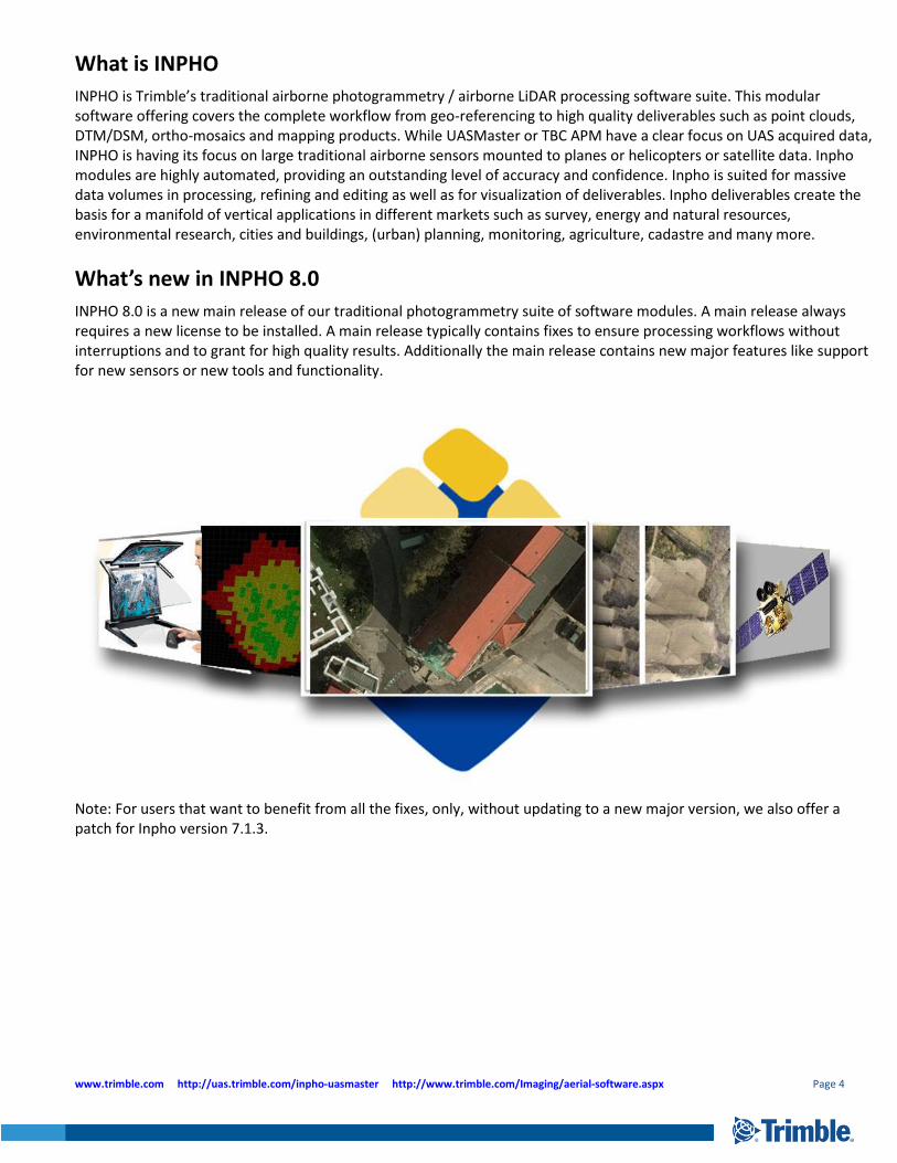
What is INPHO
INPHO is Trimble’s traditional airborne photogrammetry / airborne LiDAR processing software suite. This modular software offering covers the complete workflow from geo-referencing to high quality deliverables such as point clouds, DTM/DSM, ortho-mosaics and mapping products. While UASMaster or TBC APM have a clear focus on UAS acquired data, INPHO is having its focus on large traditional airborne sensors mounted to planes or helicopters or satellite data. Inpho modules are highly automated, providing an outstanding level of accuracy and confidence. Inpho is suited for massive data volumes in processing, refining and editing as well as for visualization of deliverables. Inpho deliverables create the basis for a manifold of vertical applications in different markets such as survey, energy and natural resources, environmental research, cities and buildings, (urban) planning, monitoring, agriculture, cadastre and many more.
What’s new in INPHO 8.0
INPHO 8.0 is a new main release of our traditional photogrammetry suite of software modules. A main release always requires a new license to be installed. A main release typically contains fixes to ensure processing workflows without interruptions and to grant for high quality results. Additionally the main release contains new major features like support for new sensors or new tools and functionality.
Note: For users that want to benefit from all the fixes, only, without updating to a new major version, we also offer a patch for Inpho version 7.1.3.
www.trimble.com http://uas.trimble.com/inpho-uasmaster http://www.trimble.com/Imaging/aerial-software.aspx Page 5
The perfect reference for GIS/CAD data collection: Ortho-mosaics directly from point clouds
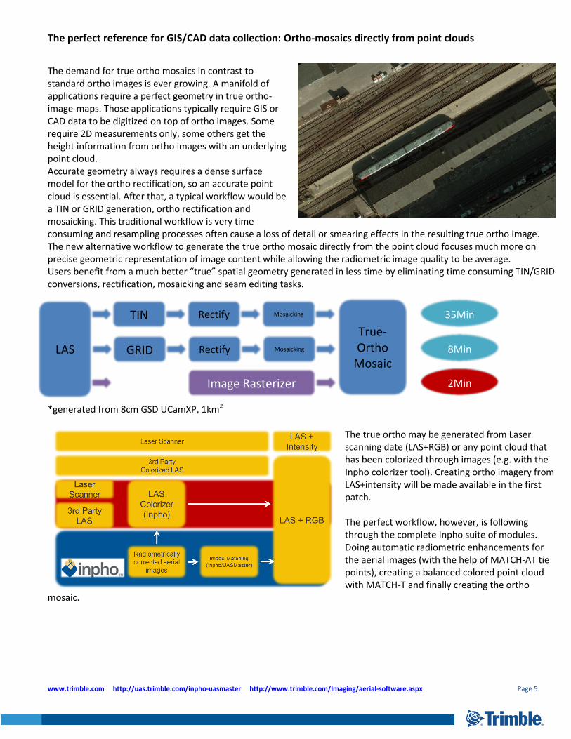
The demand for true ortho mosaics in contrast to standard ortho images is ever growing. A manifold of applications require a perfect geometry in true ortho-image-maps. Those applications typically require GIS or CAD data to be digitized on top of ortho images. Some require 2D measurements only, some others get the height information from ortho images with an underlying point cloud. Accurate geometry always requires a dense surface model for the ortho rectification, so an accurate point cloud is essential. After that, a typical workflow would be a TIN or GRID generation, ortho rectification and mosaicking. This traditional workflow is very time consuming and resampling processes often cause a loss of detail or smearing effects in the resulting true ortho image. The new alternative workflow to generate the true ortho mosaic directly from the point cloud focuses much more on precise geometric representation of image content while allowing the radiometric image quality to be average. Users benefit from a much better “true” spatial geometry generated in less time by eliminating time consuming TIN/GRID conversions, rectification, mosaicking and seam editing tasks. *generated from 8cm GSD UCamXP, 1km2
The true ortho may be generated from Laser scanning date (LAS+RGB) or any point cloud that has been colorized through images (e.g. with the Inpho colorizer tool). Creating ortho imagery from LAS+intensity will be made available in the first patch. The perfect workflow, however, is following through the complete Inpho suite of modules. Doing automatic radiometric enhancements for the aerial images (with the help of MATCH-AT tie points), creating a balanced colored point cloud with MATCH-T and finally creating the ortho
mosaic.
LAS
TIN
True-Ortho
Mosaic
Rectify Mosaicking
GRID Rectify Mosaicking
Image Rasterizer
35Min
8Min
2Min
www.trimble.com http://uas.trimble.com/inpho-uasmaster http://www.trimble.com/Imaging/aerial-software.aspx Page 6
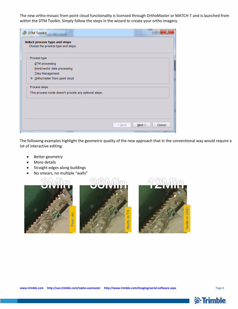
The new ortho-mosaic from point cloud functionality is licensed through OrthoMaster or MATCH-T and is launched from within the DTM Toolkit. Simply follow the steps in the wizard to create your ortho imagery.
The following examples highlight the geometric quality of the new approach that in the conventional way would require a lot of interactive editing:
Better geometry
More details
Straight edges along buildings
No smears, no multiple “walls”
www.trimble.com http://uas.trimble.com/inpho-uasmaster http://www.trimble.com/Imaging/aerial-software.aspx Page 7
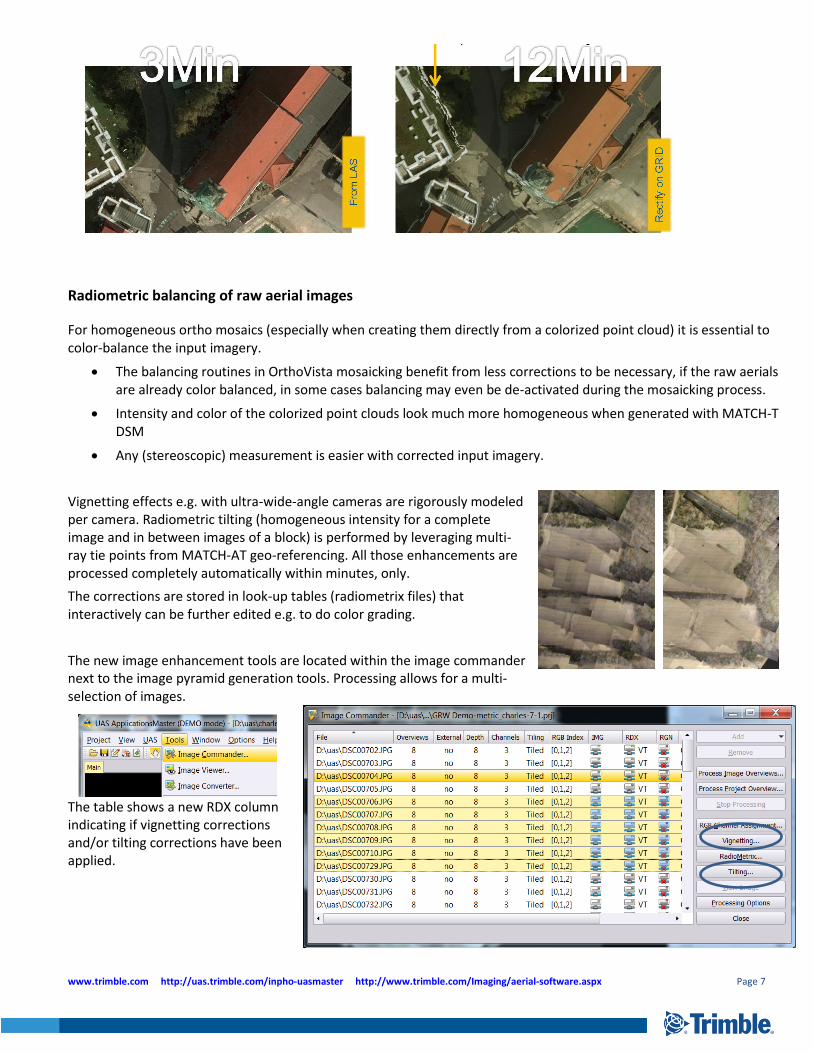
Radiometric balancing of raw aerial images
For homogeneous ortho mosaics (especially when creating them directly from a colorized point cloud) it is essential to color-balance the input imagery.
The balancing routines in OrthoVista mosaicking benefit from less corrections to be necessary, if the raw aerials are already color balanced, in some cases balancing may even be de-activated during the mosaicking process.
Intensity and color of the colorized point clouds look much more homogeneous when generated with MATCH-T DSM
Any (stereoscopic) measurement is easier with corrected input imagery.
Vignetting effects e.g. with ultra-wide-angle cameras are rigorously modeled per camera. Radiometric tilting (homogeneous intensity for a complete image and in between images of a block) is performed by leveraging multi-ray tie points from MATCH-AT geo-referencing. All those enhancements are processed completely automatically within minutes, only.
The corrections are stored in look-up tables (radiometrix files) that interactively can be further edited e.g. to do color grading.
The new image enhancement tools are located within the image commander next to the image pyramid generation tools. Processing allows for a multi-selection of images.
The table shows a new RDX column indicating if vignetting corrections and/or tilting corrections have been applied.
www.trimble.com http://uas.trimble.com/inpho-uasmaster http://www.trimble.com/Imaging/aerial-software.aspx Page 8
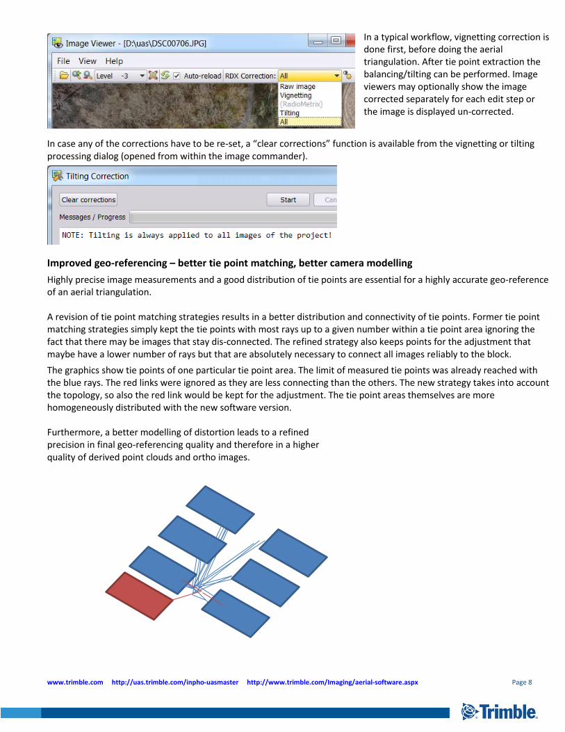
In a typical workflow, vignetting correction is done first, before doing the aerial triangulation. After tie point extraction the balancing/tilting can be performed. Image viewers may optionally show the image corrected separately for each edit step or the image is displayed un-corrected.
In case any of the corrections have to be re-set, a “clear corrections” function is available from the vignetting or tilting processing dialog (opened from within the image commander).
Improved geo-referencing – better tie point matching, better camera modelling
Highly precise image measurements and a good distribution of tie points are essential for a highly accurate geo-reference of an aerial triangulation. A revision of tie point matching strategies results in a better distribution and connectivity of tie points. Former tie point matching strategies simply kept the tie points with most rays up to a given number within a tie point area ignoring the fact that there may be images that stay dis-connected. The refined strategy also keeps points for the adjustment that maybe have a lower number of rays but that are absolutely necessary to connect all images reliably to the block.
The graphics show tie points of one particular tie point area. The limit of measured tie points was already reached with the blue rays. The red links were ignored as they are less connecting than the others. The new strategy takes into account the topology, so also the red link would be kept for the adjustment. The tie point areas themselves are more homogeneously distributed with the new software version. Furthermore, a better modelling of distortion leads to a refined precision in final geo-referencing quality and therefore in a higher quality of derived point clouds and ortho images.
www.trimble.com http://uas.trimble.com/inpho-uasmaster http://www.trimble.com/Imaging/aerial-software.aspx Page 9
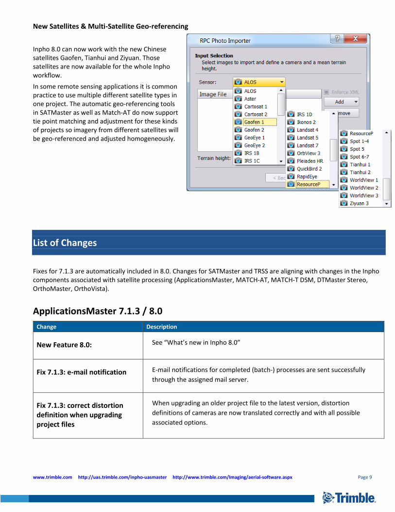
New Satellites & Multi-Satellite Geo-referencing
Inpho 8.0 can now work with the new Chinese satellites Gaofen, Tianhui and Ziyuan. Those satellites are now available for the whole Inpho workflow.
In some remote sensing applications it is common practice to use multiple different satellite types in one project. The automatic geo-referencing tools in SATMaster as well as Match-AT do now support tie point matching and adjustment for these kinds of projects so imagery from different satellites will be geo-referenced and adjusted homogeneously.
List of Changes
Fixes for 7.1.3 are automatically included in 8.0. Changes for SATMaster and TRSS are aligning with changes in the Inpho components associated with satellite processing (ApplicationsMaster, MATCH-AT, MATCH-T DSM, DTMaster Stereo, OrthoMaster, OrthoVista).
ApplicationsMaster 7.1.3 / 8.0
Change Description
New Feature 8.0: See “What’s new in Inpho 8.0”
Fix 7.1.3: e-mail notification
E-mail notifications for completed (batch-) processes are sent successfully
through the assigned mail server.
Fix 7.1.3: correct distortion definition when upgrading project files
When upgrading an older project file to the latest version, distortion
definitions of cameras are now translated correctly and with all possible
associated options.
www.trimble.com http://uas.trimble.com/inpho-uasmaster http://www.trimble.com/Imaging/aerial-software.aspx Page 10
Fix 7.1.3: correct image coordinates from ZI projects
Images measurement coordinates were showing offsets when converted from
ZI project files. This offset is corrected.
Fix 7.1.3: general stability improvements
The patch contains a number of fixes for situations that lead to an unstable
behavior.
Fix 7.1.3: correct selection of camera for image import
When importing imagery into a project with multiple cameras, the selection
for the associated camera is now correctly assigned.
Change 7.1.3: default settings for principal point definition
The default for the principal point coordinate definition in the camera editor is
now set to “with respect to image coordinate system”
Update 7.1.3: more data validation checks
A number of additional checks are carried out to ensure that projects are
completely and consistently set-up.
Update 7.1.3: merged project files
When merging project files, additional camera entries are generated if an
already existing camera name is detected with different parameter settings.
Update 7.1.3: revised documentation
Documentation for a number of modules is updated.
Information 7.1.3: export of ft-us projects to Summit Evolution
When exporting us-ft projects to Summit Evolution, it is essential to de-
activate the “Dynamic Heights” setting in summit to avoid shifted data.
MATCH-AT (inBLOCK) / Satellite Geo-referencing 7.1.3 / 8.0
Change Description
New Feature 8.0: See “What’s new in Inpho 8.0”
Fix 7.1.3: Worldview 3
The patch enables successful tie point extraction also on Worldview 3 data.
Fix 7.1.3: too many unknowns
The patch fixes stability problems when inBLOCK adjustment needed to solve equations with too many (>32766) unknowns.
www.trimble.com http://uas.trimble.com/inpho-uasmaster http://www.trimble.com/Imaging/aerial-software.aspx Page 11
Update 7.1.3: multiple satellites in one project
The patch enables to do geo-referencing (tie point extraction and adjustment) for projects that combine different scenes from different satellite providers.
Update 7.1.3: considering image bounds
All measurements outside of the image boundary (accidentally created) are ignored.
Update 7.1.3: move-to
The move-to function in the photo measurement tool now allows for more digits to be keyed in.
Update 7.1.3: satellite triangulation without GCP
A free adjustment without ground control points is now also possible for satellite triangulations.
Update 7.1.3: tie point distribution
Several changes have been made to optimize the tie point distribution and therefore to get a more stable geo-referencing solution.
MATCH-T DSM 7.1.3 / 8.0
Change Description
New Feature 8.0: See “What’s new in Inpho 8.0”
DTMaster Stereo 7.1.3 / 8.0
Change Description
New Feature 8.0: See “What’s new in Inpho 8.0”
Update 7.1.3: shortcuts in un-docked windows
Programmable keyboard short-cuts are now also working in un-docked windows.
Update 7.1.3: move-to
The move-to function in the DTMaster viewers now allows for more digits to be keyed in.
www.trimble.com http://uas.trimble.com/inpho-uasmaster http://www.trimble.com/Imaging/aerial-software.aspx Page 12
OrthoMaster 7.1.3 / 8.0
Change Description
New Feature 8.0: See “What’s new in Inpho 8.0”
Fix 7.1.3: OrthoVista Post processing
OrthoVista post-processing is not started successfully from OrthoMaster for
IPD as well as OVP template files.
OrthoVista 7.1.3 / 8.0
Change Description
New Feature 8.0: See “What’s new in Inpho 8.0”
Fix 7.1.3: OrthoVista Post processing
OrthoVista post processing is now started successfully from OrthoMaster for IPD as well as OVP template files.
Fix 7.1.3: parallel processing The patch improves the processing stability when working in a parallel processing mode.
LPMaster 7.1.3 / 8.0
Change Description
New feature 8.0: reporting LPMaster now also features an automated project report creation
New feature 8.0: quick-DSM
Version 8.0 now supports for a quick DSM processing option
New feature 8.0: options for raster creation
The new version allows for a definition of polygon shapes in all raster dialogs. Also new is the echo selection option.
Fix 8.0: internal 4GB limit for raster processing
The version fixes problems with the 4GB limit for imagery
Fix 8.0: start/stop time
Fixed start/stop time selection of strips processing
www.trimble.com http://uas.trimble.com/inpho-uasmaster http://www.trimble.com/Imaging/aerial-software.aspx Page 13
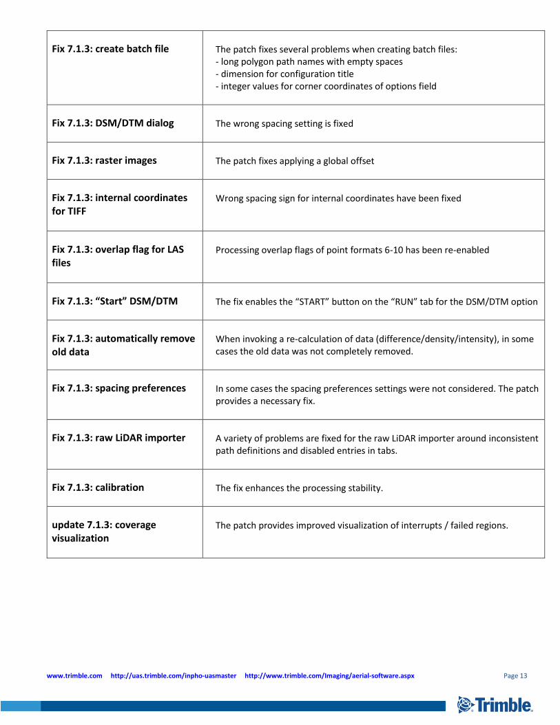
Fix 7.1.3: create batch file The patch fixes several problems when creating batch files: - long polygon path names with empty spaces - dimension for configuration title - integer values for corner coordinates of options field
Fix 7.1.3: DSM/DTM dialog The wrong spacing setting is fixed
Fix 7.1.3: raster images The patch fixes applying a global offset
Fix 7.1.3: internal coordinates for TIFF
Wrong spacing sign for internal coordinates have been fixed
Fix 7.1.3: overlap flag for LAS files
Processing overlap flags of point formats 6-10 has been re-enabled
Fix 7.1.3: “Start” DSM/DTM The fix enables the “START” button on the “RUN” tab for the DSM/DTM option
Fix 7.1.3: automatically remove old data
When invoking a re-calculation of data (difference/density/intensity), in some cases the old data was not completely removed.
Fix 7.1.3: spacing preferences
In some cases the spacing preferences settings were not considered. The patch provides a necessary fix.
Fix 7.1.3: raw LiDAR importer
A variety of problems are fixed for the raw LiDAR importer around inconsistent path definitions and disabled entries in tabs.
Fix 7.1.3: calibration The fix enhances the processing stability.
update 7.1.3: coverage visualization
The patch provides improved visualization of interrupts / failed regions.
www.trimble.com http://uas.trimble.com/inpho-uasmaster http://www.trimble.com/Imaging/aerial-software.aspx Page 14
For more information
For more information contact your Trimble Inpho Support Team at [email protected] and register at https://community.trimble.com in order to track all news on Inpho.
Note: the 8.0 release requires a new license to be installed. Users with a maintenance contract as of Oct. 2016 are entitled to download and use the new release. Dongle update files are automatically issued – if you did not get a notification, please contact us on [email protected]. Also note that inpho’s WiBU licensing system also is updating their libraries constantly. To guarantee for stable license access, Trimble strongly recommends updating the WiBU libraries (available for download on above mentioned site)
Please ask us for special educational / research packages. For individual trainings as well as group trainings contact our support team.
Also available from Trimble:
New Stereoscopic Monitor: 3D PluraView
no flickering, no ghosting (optimized glasses & mirror glass)
perfectly synced left and right image, no lags
optimized for perfect radiometry also in dark areas
mirror-card, main power-switch, connectors integrated in stand
27” 1920x1080
(4k version announced)
www.3d-pluraview.com