released science inquiry task ocean currents 2012 … science inquiry task ocean currents 2012 ......
TRANSCRIPT

Released Science Inquiry Task
Ocean Currents
2012
Grade 8
Date: _____________________________________________________
Your Name: _______________________________________________
Name(s) of Partner(s): _______________________________________

1NECAP 2012 G8 Science Released Inquiry Task_V1
Directions:
In this task, you will be analyzing data from an investigation described in a short story called “Ocean Currents.” You will use the data to make conclusions about the relationship among surface ocean currents, air temperatures, and ocean temperatures and use what you learn to answer a set of questions. Thoroughly explain all of your answers.
This Word Bank defi nes terms you will need to understand throughout this investigation. You may refer back to this page throughout this session.
Word Bank
Latitude an imaginary line that circles Earth and is parallel to the equator
Mean (average) a typical number for a data set; a value that is found by dividing the sum of a set of terms by the number of terms
Example: The average of 4, 5, and 9 is (4 + 5 + 9)
3 = 6.
Ocean current the steady fl ow of surface ocean water mostly in one direction
Solar radiation energy that is given off by the Sun in the form of rays or waves and is measured using Solar Radiation Units (kWh/m2/day)
Weather buoy a fl oating device that measures air temperature, ocean temperature, and wind speed and direction, and reports these data via satellite for use in forecasting weather and studying the climate
Wet suit a close-fi tting suit that divers and swimmers wear to retain body heat in cold water
Science
2
NECAP 2012 G8 Science Released Inquiry Task_V1
Ocean Currents
A student lives near the coastal town of Woods Hole, Massachusetts. Every August, she swims in a bay of the Atlantic Ocean near Woods Hole. In August, the temperature of the water in the bay averages 72°F.
Last August, the student visited Crescent City, a coastal city in northern California. The fi rst day she went swimming in the Pacifi c Ocean, she was surprised how cold the ocean water was. She noticed that other people were putting on wet suits before going in the water.
When she returned home, the student looked up information about Crescent City. She learned that the average water temperature off the coast of Crescent City is 55°F in August. She also learned that Crescent City and Woods Hole are located at approximately the same latitude. She wondered why the water was so much warmer near Woods Hole than near Crescent City.
For a class research project assigned in September, the student decided to investigate the factors that affect the ocean temperatures near both cities. She decided to fi nd data about each city’s ocean temperatures, surface ocean currents, and air temperatures. She then decided to investigate the following research question:
During August, why are ocean temperatures near the East Coast of the United States warmer than those near the West Coast in locations at approximately the same latitude?
The student started to investigate where the heat of the East Coast’s air and water came from. She found the newspaper article below.
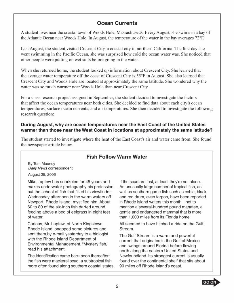
Fish Follow Warm WaterBy Tom MooneyDaily News correspondent
August 25, 2006
Mike Laptew has snorkeled for 45 years and makes underwater photography his profession, but the school of fi sh that fi lled his viewfi nder Wednesday afternoon in the warm waters off Newport, Rhode Island, mystifi ed him. About 60 to 80 of the six-inch fi sh darted around, feeding above a bed of eelgrass in eight feet of water.
Curious, Mr. Laptew, of North Kingstown, Rhode Island, snapped some pictures and sent them by e-mail yesterday to a biologist with the Rhode Island Department of Environmental Management. “Mystery fi sh,” read his attachment.
The identifi cation came back soon thereafter: the fi sh were mackerel scud, a subtropical fi sh more often found along southern coastal states.
If the scud are lost, at least they’re not alone. An unusually large number of tropical fi sh, as well as southern game fi sh such as cobia, black and red drum, even tarpon, have been reported in Rhode Island waters this month—not to mention a several-hundred pound manatee, a gentle and endangered mammal that is more than 1,000 miles from its Florida home.
All seemed to have hitched a ride on the Gulf Stream.
The Gulf Stream is a warm and powerful current that originates in the Gulf of Mexico and swings around Florida before fl owing north along the eastern United States and Newfoundland. Its strongest current is usually found over the continental shelf that sits about 90 miles off Rhode Island’s coast.

3NECAP 2012 G8 Science Released Inquiry Task_V1
Making a Prediction
Answer question 1 on page 1 in your Student Answer Booklet. 240747.001 Common, CMN
q Write a possible explanation about why ocean temperatures along the East Coast of the United States are warmer than ocean temperatures along the West Coast in locations at approximately the same latitude. Include one piece of information from the article and/or what you know about ocean currents in your explanation.
The student wondered whether the East and West Coasts receive different amounts of solar radiation and how that might affect ocean temperatures. She found the map in Figure 1 on the Internet. The map shows the average amounts of daily solar radiation received in the United States each year.
Key
5 to 6 3 to 4 2 to 34 to 5
WoodsHole
CrescentCity
Figure 1: United States Annual Average Daily Solar Radiation(kWh/m2/day)
Answer question 2 on page 1 in your Student Answer Booklet. 228334.002 Common, CMN
w Based on Figure 1, predict how the air temperatures in Crescent City and Woods Hole compare. Explain your prediction.
4
NECAP 2012 G8 Science Released Inquiry Task_V1
Analyzing and Presenting Data
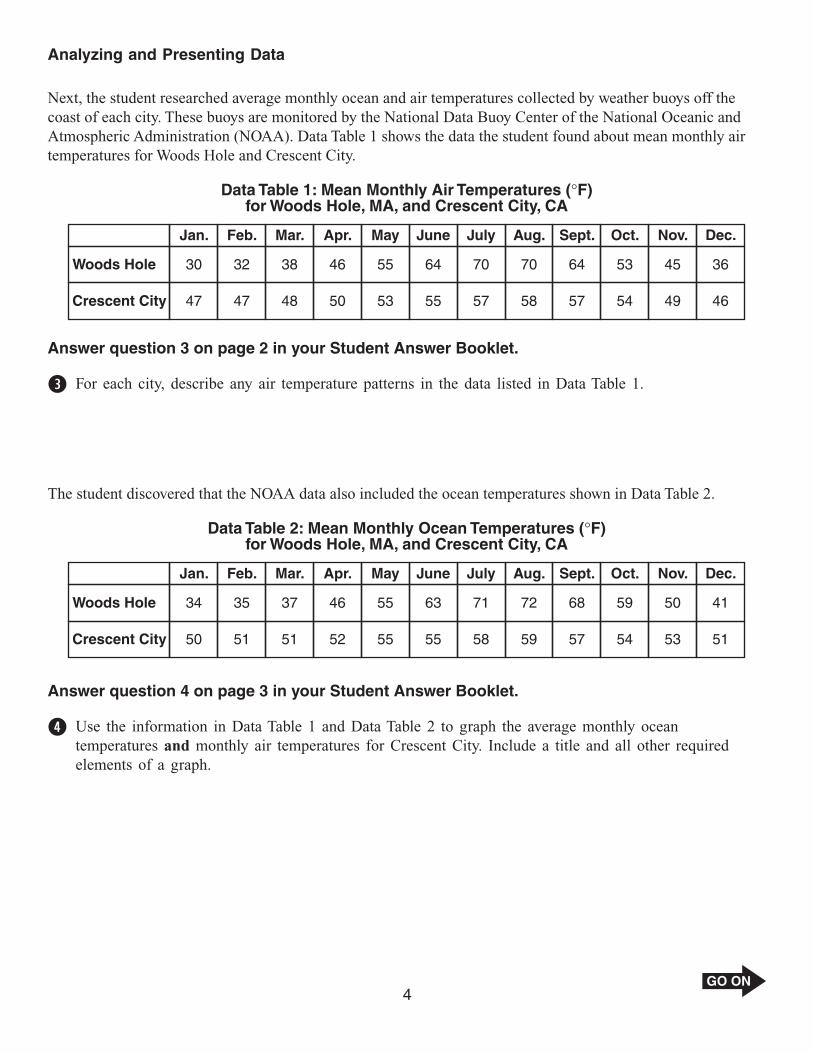
Next, the student researched average monthly ocean and air temperatures collected by weather buoys off the coast of each city. These buoys are monitored by the National Data Buoy Center of the National Oceanic and Atmospheric Administration (NOAA). Data Table 1 shows the data the student found about mean monthly air temperatures for Woods Hole and Crescent City.
Data Table 1: Mean Monthly Air Temperatures (°F)for Woods Hole, MA, and Crescent City, CA
Jan. Feb. Mar. Apr. May June July Aug. Sept. Oct. Nov. Dec.
30 32 38 46 55 64 70 70 64 53 45 36Woods Hole
Crescent City 47 47 48 50 53 55 57 58 57 54 49 46
Answer question 3 on page 2 in your Student Answer Booklet.228341.002 Common, CMN
e For each city, describe any air temperature patterns in the data listed in Data Table 1.
The student discovered that the NOAA data also included the ocean temperatures shown in Data Table 2.
Woods Hole 34 35 37 46 55 63 71 72 68 59 50 41
Data Table 2: Mean Monthly Ocean Temperatures (°F)for Woods Hole, MA, and Crescent City, CA
Jan. Feb. Mar. Apr. May June July Aug. Sept. Oct. Nov. Dec.
Crescent City 50 51 51 52 55 55 58 59 57 54 53 51
Answer question 4 on page 3 in your Student Answer Booklet. 240749.001 Common, CMN
r Use the information in Data Table 1 and Data Table 2 to graph the average monthly ocean temperatures and monthly air temperatures for Crescent City. Include a title and all other required elements of a graph.

5NECAP 2012 G8 Science Released Inquiry Task_V1
Answer questions 5 and 6 on page 4 in your Student Answer Booklet.235101.002 Common, CMN
t Describe any patterns in the ocean temperature data shown in your graph.
228337.002 Common, CMN
y Refer to the air temperature information in Data Table 1 and the ocean temperature information in Data Table 2. Describe any relationships between the ocean temperatures and air temperatures in Woods Hole.

6
NECAP 2012 G8 Science Released Inquiry Task_V1
The student located the map of surface ocean currents in the North Pacifi c and North Atlantic Oceans shown in Figure 2.
Alaska
N. Pacific
Kuroshio
N. Equatorial
Equatorial Counter
S. Equatorial
California
Labrador
Gulf Stre
amN. Atlantic
N. Equatorial
Warm-water current
Cold-water current
Key
Crescent City, CA
Woods Hole, MA
Figure 2: North Pacific and North Atlantic Surface Ocean Currents
N
Answer question 7 on page 5 in your Student Answer Booklet. 228344.001 Common, CMN
u Look at the ocean currents near Crescent City and Woods Hole on the map in Figure 2. Describe the type of ocean current near each location.

7NECAP 2012 G8 Science Released Inquiry Task_V1
Evaluating the Research
The student reviewed the information she had gathered:
• mean daily amounts of solar radiation received by Crescent City and Woods Hole• mean monthly air temperatures of both cities• mean monthly ocean temperatures near both cities• map of surface ocean currents near both cities
Answer question 8 on page 5 in your Student Answer Booklet.235099.001 Common, CMN
i Read the explanation you wrote for question 1. Identify whether the student’s data support or reject your explanation. Use evidence from the student’s research in your answer.

8
NECAP 2012 G8 Science Released Inquiry Task_V1
Acknowledgments
The New Hampshire, Vermont, Rhode Island, and Maine Departments of Education wish to acknowledge and credit the following author and publisher for use of their work in the New England Common Assessment Program—2012.
“Fish Follow Warm Water” (p. 2) by Tom Mooney, Journal Staff Writer, August 25, 2006, as it appeared on the Web site www.projo.com. Copyright © 2011 by The Providence Journal. Reprinted by permission of The Providence Journal.