remote sensing on the nez perce reservation nez perce tribe -land services laurie ames remote...
TRANSCRIPT

Remote Sensing on the Nez Perce Reservation
Nez Perce Tribe -Land ServicesLaurie Ames
Remote Sensing Analyst
By asking for the impossible we obtain the best possible. ~Italian Proverb
GIS on Fire!Coeur d’Alene, Idaho
May 9 – 13, 2005

Laurie Ames, Remote Sensing Analyst - - Land cover/use detection through Remote Sensing (NASA Grant)
Jennifer Jensen, University of Idaho -Predicating Forest Biophysical Properties with LiDAR
Nez Perce Tribe
Atoms for peace. Man is still the greatest miracle and the greatest problem on this earth. ~David Sarnoff

PartnersTribal DepartmentsUniversity of IdahoSpencer B. Gross, Inc (LiDAR)NASA – Stennis Space CenterAscent GIS (SPOT, IRS)USDA/USFS Fire Sciences LabUniversity of Montana (MODIS)SPOT Image CorporationBattelle/PNNLHyVista Corporation (Hyperspectral)
The beginning is the most important part of the work. ~Plato

Task Objectives• 1. Landcover & Landuse Classification
– Crop Map
• 2. Road Delineation– WEPP
• 3. Vegetation greenness, stress & drought
• 4. Forest Characterization
• 5. Hazard Rating of Invasive Weeds
First, have a definite, clear practical ideal; a goal, an objective. Second, have the necessary means to achieve your ends; wisdom, money, materials, and methods. Third, adjust all your means to that end. ~Aristotle
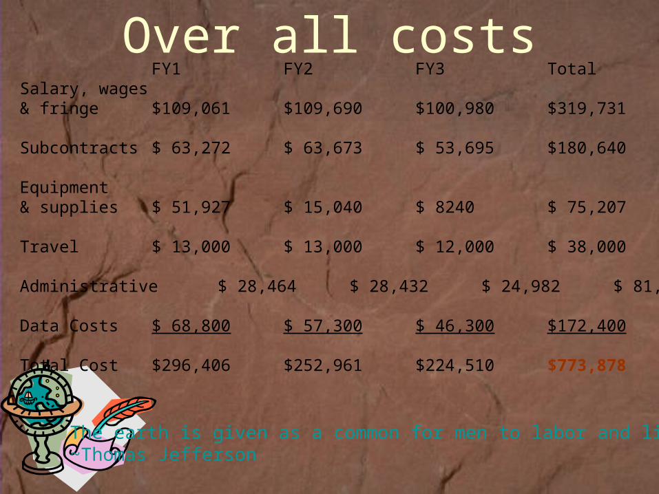
Over all costs
The earth is given as a common for men to labor and live in. ~Thomas Jefferson
FY1 FY2 FY3 TotalSalary, wages & fringe $109,061 $109,690 $100,980 $319,731
Subcontracts $ 63,272 $ 63,673 $ 53,695 $180,640
Equipment & supplies $ 51,927 $ 15,040 $ 8240 $ 75,207
Travel $ 13,000 $ 13,000 $ 12,000 $ 38,000
Administrative $ 28,464 $ 28,432 $ 24,982 $ 81,878
Data Costs $ 68,800 $ 57,300 $ 46,300 $172,400
Total Cost $296,406 $252,961 $224,510 $773,878

1. Land-cover/Land-use/Crop Maps
Landsat satellite multispectral imagery.7 bands of information. 30 meter resolution.
Multi-temporal3 scenes each year. Spring, End of Summer, Late
Fall (leaf off).7 classes
Urban, crop, grass, brush, mixed forest, coniferous forest, water.
Land use & Crop MapsRange, crops and forest monitoring.

Landcover Maps
Landsat 7 ImageFeature Analyst PreliminaryLandcover Classification
Landcover Classes
CLASS_ID
Coniferous Forest
Grass
Crop
Brush
Water
Mixed Woodland
Urban
NN

Supervised Classification ERDAS Imagine

Costs of Landsat Data
Landsat 5 $425Landsat 7 $608
Cost per acreless than $0.01

2. Road Delineation
Indian Remote Sensing (IRS) Panchromatic Images2 scenes to cover majority of 1863
boundary.
Different AlgorithmsEdge DetectionBattelle/PNNL MatrixFeature Analyst Extraction

Feature Analyst

Costs of Indian Remote Sensing Data
IRS Panchromatic$5,800For 3 archived scenesFor special requested $6,800
Cost per acreless than $0.45

3. MODIS Products MODIS
Vegetation Indices (MOD13)EVI & NDVI
LAI (MOD15)FPAR (MOD15)GPP (MOD17)NPP (MOD17)
Large Scale250m, 1km in size.
Shows plant health, moisture, snow melt.

MODIS
Leaf Area Index -Amount of leaf area that covers a given unit of ground.Helps to estimate active growing vegetation.
Pixel size: 1 km Composite every 8 days

4. Monitoring & Characterization of Forest Lands• Forest Characterization
– Species composition– Stand stress– Insect infestation– Fuel load estimation
• Imagery Used:– LiDAR -Active system (current work)– Landsat & SPOT– Hyperspectral– Ikonos 1m

Intensity
Intensity & Contour
Contour & Surface
Hillshade
N
N
N
N

Costs of LiDAR Data
Cost $65,505Total Acres 29,000
Cost per acre $1.87

WIAP1 satellite image matrix
IKONOS Multispectral
IRS2 Panchromatic
L73 Panchromatic L73 Multispectral SPOT Multispectral
Cost ($) high moderate low low moderate
Data source (see contact info below)
Space Imaging Corporation
Space Imaging Corporation
USGS Eros Data Center
USGS Eros Data Center
SPOT Image Corporation
Spatial Resolution (m) 4 5 15 30 20
Spectral Resolution visible, near infrared visible visible
visible, near & middle infrared
visible, near & middle infrared
# of data channels 4 1 1 6 3 or 4
Radiometric Resolution 8 or 11 bit quantization 8 bit quantization 8 bit quantization 8 bit quantization 8 bit quantization
Temporal Resolution (days) acquired as tasked 48-50 16 16 acquired as tasked
Footprint (km) minimum of 5 70 185 185 60
Defined as cloud free <20% NA listed in 10% increments
listed in 10% increments NA
Delivery time variable approximately 2 weeks
generally <1 week generally <1 week variable
Data format GEOTiff4 BSQ5 GEOTiff4 GEOTiff4 BIL6
Data storage requirements high high moderate low low
Appropriate project scale local local regional regional regional
Appropriate for visual interpretation yes yes yes yes yes
Appropriate for computer interpretation yes no no yes yes
Appropriate for wetland mapping yes limited limited yes yes
Cost Per Acre Comparison

5. Hazard Rating & Monitoring of Invasive
WeedsSPOT 10 & 20m multispectral dataSub-ecosystem mapAreas of susceptibility
MODIS Vegetation products

Costs of SPOT Data
SPOT 20 m $5,600Total Acres 17297Cost per acre $0.15
SPOT 10m $10,800Total Acres 5683Cost per acre $0.45

Thank You
Contact: Laurie Ames ext. [email protected]
Nothing in the world can take the place of persistence. Talent will not; nothing is more common than unsuccessful men with talent. Genius will not; unrewarded genius is almost a proverb. Education will not the world is full of educated derelicts. Persistence and determination alone are omnipotent. The slogan, 'Press on,' has solved and always will solve the problems of the human race. ~Calvin Coolidge