removal of the last fish barrier on the lower rogue river · removal of the last fish barrier on...
TRANSCRIPT

Shane K. Cline, PE
Removal of the Last Fish Barrier on the Lower
Rogue RiverShane K. Cline, PE
HDR Inc, Portland, OR

Gold Ray Dam, Gold Ray Dam,
Jackson Co., OR
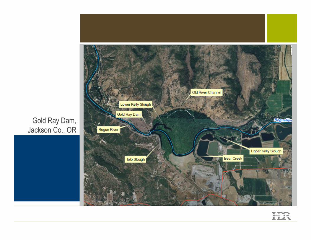
Gold Ray Dam, Gold Ray Dam,
Jackson Co., OR


Project History
• Located in Jackson
County on the Rogue
River
• Log crib dam built in
1903
• Concrete dam built in
1941
• During construction
found a third unknown
concrete dam

Project History
• Donated to Jackson
County by Pacific
Power in 1972
• County planned
recreational use at the
site but it never site but it never
occurred
• ODFW operates fish
ladders and counting
station

Optional Message Placement

Project Goal
• Improve inadequate fish passage
… Rogue River contains
ESA listed Coho salmon
… Dam obstructs fish
passage
… 5th highest priority on
ODFW fish passage list
Purpose and need for action
1
2
3
ODFW fish passage list
… Fish ladders do not
meet design standards
• Remove safety risks and maintenance costs
• Improve structural stability

Why Remove the Dam?
• The powerhouse and
dam structure were
deteriorating
• Vandalism and security
concerns
Gold Ray Dam
concerns
• Fish ladder didn’t meet
NMFS standards
• Drift removal and log
jams

Steps to Removal
• In fall 2009, County received $5M grant from
NMFS (must be obligated spent by October 31,
2010)
• County must complete NEPA and permitting to
release funds
• County hired a design build firm – Slayden
Construction. The team included River Design Construction. The team included River Design
Group and HDR
• HDR’s role
– NEPA Environmental Assessment
– Federal, state, and local permits
– Sediment transport analysis
– Floodplain analysis
Gold Ray Dam

Condensed Project Schedule
• Eight months to– Complete all analysis
– Complete NEPA
– Obtain all permits:
• Clean Water Act Section 404/401
• ESA Section 7 Consultation
• NHPA Section 106 MOA
• NPDES Construction Stormwater Permit
• State Removal-Fill Permit• State Removal-Fill Permit
• Jackson County Floodplain Permit
– In-water work window of June 15-Sept 1
– Translated: All analysis and draft documents completed in 3 months
• Monthly meetings with Interagency Review Team met monthly• USACE
• ODFW
• ODEQ
• ODSL
• NMFS
• Jackson County
Gold Ray Dam

Key Issues for Jackson County
During NEPA process, Jackson County wanted to:
• Explore dam rehabilitation
• Assess sediment and floodplains downstream impacts
• Condensed project schedule
Gold Ray Dam

Explore Dam Rehabilitation
• Rehabilitation options
– Dam rehabilitation
(structural upgrades only)
– Dam rehabilitation with
hydroelectric power
• No water rights to
generate power
Gold Ray Dam
generate power
• Cost Summary
– Dam Removal - $5.6M
– Dam Rehabilitation - $15.9M
– Dam Rehabilitation with
hydroelectric power -
$69.7M
Optional Message Placement

Hydraulic and Sediment Modeling
• Sediment sampling behind dam indicated no contaminants of concern
present
• Investigated several alternatives for sediment management per BOR
– No Action Alternative
– River Erosion Alternative
– Mechanical Removal Alternative
– Sediment Stabilization Alternative
• Due to clean sediment and cost constraints, River Erosion was selected
for sediment management
Gold Ray Dam

Hydraulic and Sediment Modeling
• Hydraulic and Sediment
Analysis HEC-RAS
modeling
• Hydraulic Analysis Results
– Water level behind the dam
estimated to drop up to 22
Gold Ray Dam
estimated to drop up to 22
feet
– Sediments behind the dam
would be transported
downstream
– Minor long-term deposition
downstream
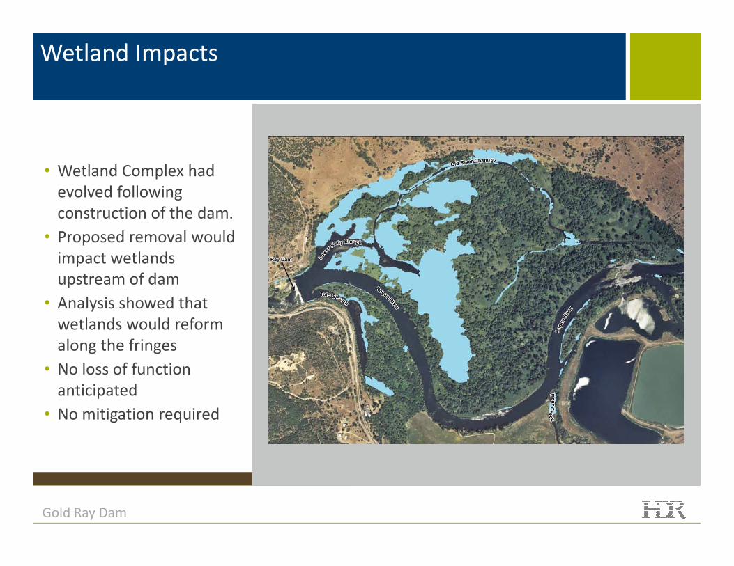
Wetland Impacts
• Wetland Complex had
evolved following
construction of the dam.
• Proposed removal would
impact wetlands
upstream of dam
Gold Ray Dam
upstream of dam
• Analysis showed that
wetlands would reform
along the fringes
• No loss of function
anticipated
• No mitigation required

Fish Passage
• Dam identified by ODFW
as one of the worst
impediments in Oregon
• Contained the last fish
counting station on the
Rogue River
Gold Ray Dam
Rogue River
• Removal of the dam
would create 157 miles of
habitat
• Fish passage retained
during construction

Ecosystem Restoration
• Lowering of water level
could increase potential
for head cuts
• Bear Creek confluence
anticipated 5 to 7 foot
Gold Ray Dam
anticipated 5 to 7 foot
drop
• Included several riffle
structures and large
woody debris to prevent
headcut migration

Optional Message Placement
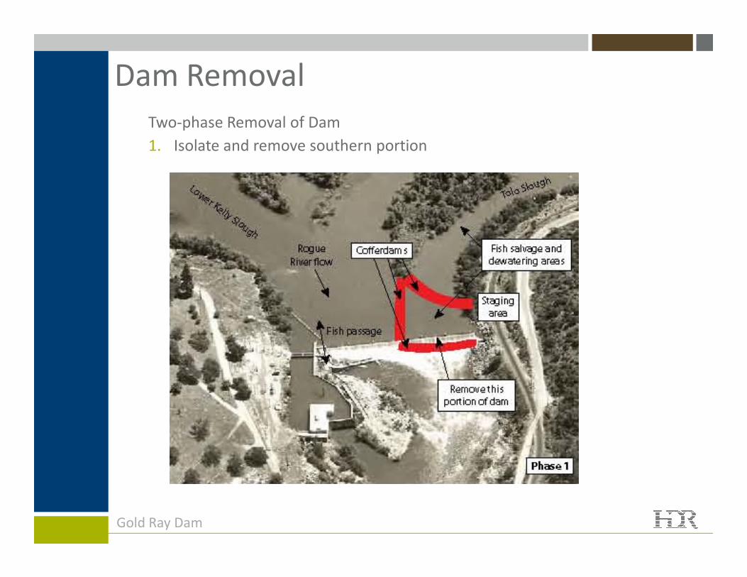
Dam Removal
Two-phase Removal of Dam
1. Isolate and remove southern portion
Gold Ray Dam

Dam Removal
Two-phase Removal of Dam
2. Isolate and remove northern portion and other components (powerhouse,
etc.)
Gold Ray Dam

Construction
• Started June 15, 2010
– Two appeals that stopped
work
Gold Ray Dam

Construction
• Resumed construction in
mid July 2010
Gold Ray Dam

Construction
• Removal completed
September 16, 2010
Gold Ray Dam

Project Summary
• Improved fish passage by removing fish barrier
• Addressed • Addressed environmental concerns through collaboration
• Met aggressive project schedule
Optional Message Placement

Project Acknowledgments
• Client – Jackson County Oregon
– Project Manager John Vial
• Project Delivery Team
– Slayden Construction – Darren Funk, PE
– River Design Group – Scott Wright, PE– River Design Group – Scott Wright, PE
– HDR – Permitting, Sediment and Hydraulic Analysis
• James Gregory – Project Manager
• Leandra Cleveland – NEPA/Permitting Lead
• Brian Doeing – Hydraulics/Sediment Management Lead
Optional Message Placement

Questions
Gold Ray Dam
http://www.rvcog.org/mn.asp?pg=NR_Gold_Ray_Dam
http://www.earthcam.com/clients/noaa/rogueriver/