report a-042/2007 data summary - accueil - bea
TRANSCRIPT
REPORT A-042/2007
DATA SUMMARY
LOCATION
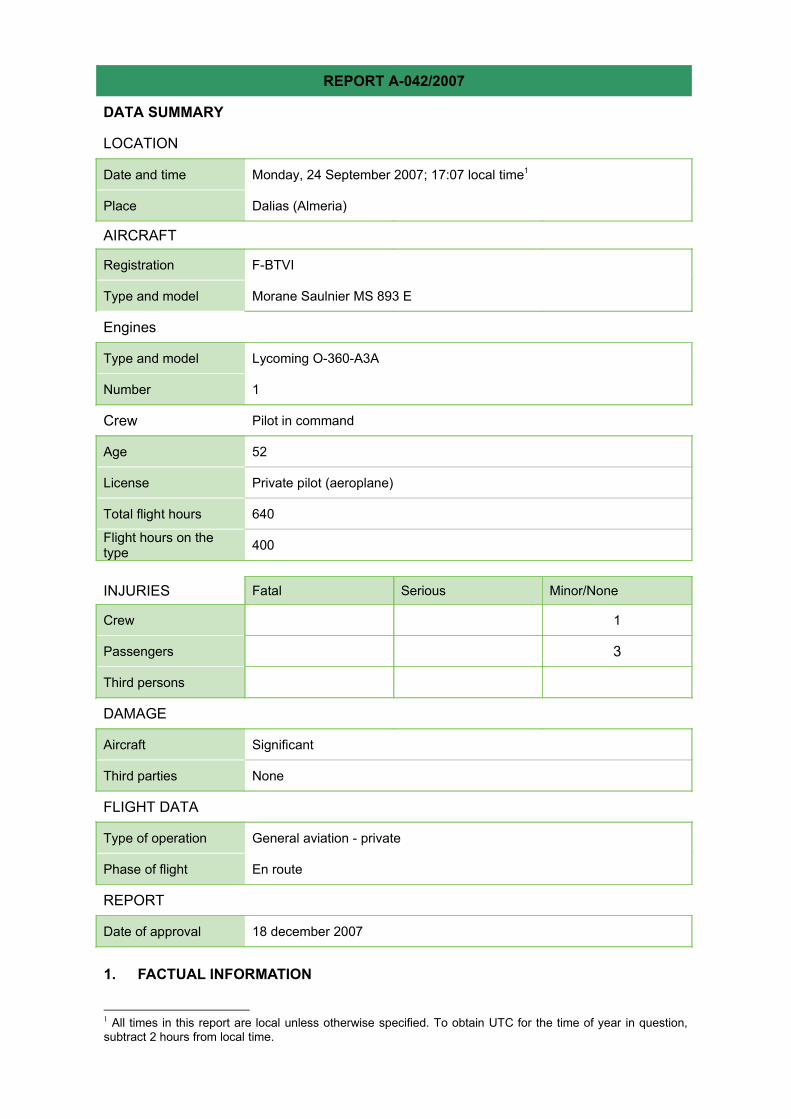
Date and time Monday, 24 September 2007; 17:07 local time1
Place Dalias (Almeria)
AIRCRAFT
Registration F-BTVI
Type and model Morane Saulnier MS 893 E
Engines
Type and model Lycoming O-360-A3A
Number 1
Crew Pilot in command
Age 52
License Private pilot (aeroplane)
Total flight hours 640
Flight hours on thetype 400
INJURIES Fatal Serious Minor/None
Crew 1
Passengers 3
Third persons
DAMAGE
Aircraft Significant
Third parties None
FLIGHT DATA
Type of operation General aviation - private
Phase of flight En route
REPORT
Date of approval 18 december 2007
1. FACTUAL INFORMATION
1 All times in this report are local unless otherwise specified. To obtain UTC for the time of year in question,subtract 2 hours from local time.

1.1.History of the flight
On Monday, 24 September 2007, an aircraft under French registry, F-BTVI, took off on aprivate flight from Ibiza Airport with a pilot and three passengers (the pilot’s wife and twofriends) onboard under visual flight conditions. Its destination was the La AxarquiaAerodrome in Malaga.
The pilot had planned the route using GPS and had filed an ATS flight plan at Ibiza Airportat 13:23, with an estimated departure time of 14:15 and a flying time of 3:15 hours. Theaircraft eventually took off at 14:37:44 and proceeded without incident during the first 2:05hours. At 16:42:45, the aircraft entered a mountainous region in which there wereextensive cloud formations, according to the pilot’s statement. The aircraft climbed from4000 to 7388 feet to clear a mountain range which forced the pilot to deviate from coursefor a few minutes.
As the pilot himself stated, the cloud cover was so extensive and dense that he decided todescend and continue with the flight below the cloud layer, hoping to find less irregularterrain and clearer skies. He descended from 7388 back to 4000 feet. He finished thedescent at 17:02:43, by which time the aircraft was in the vicinity of Padules, in the GadorMountains. Upon noticing the increasingly elevated terrain, the pilot started gainingaltitude in an attempt to clear the surrounding mountains. The impact took place at17:07:11, with the aircraft in a climbing attitude and with full flaps so as to minimize theimpact speed. The pilot notified ACC Seville of the accident 42 seconds later, relaying hisexact position in subsequent communications.
Except for the most seriously injured passenger, who had suffered a broken nose and wasevacuated by a private vehicle 56 minutes after the accident, the remaining passengers,though slightly injured, were rescued by an INFOCA (forest fire emergency response)helicopter 1 hour and 16 minutes after the accident
Figure 1. Condition of the aircraft after the accident
1.2.Wreckage and impact information
The aircraft was found in a southwesterly orientation, resting on its lower fuselage andperpendicular to a slightly inclined hill, with the front end pointing uphill. It appeared intactsave for damage to the underside, the engine, the landing gear, which had bentbackwards, the wing roots and the propeller.
Photographs taken of the cockpit after the accident indicated the following settings: richmixture, maximum throttle, right fuel tank selected, horizontal stabilizer trim tab in neutral,altimeter at 5450 feet. The magnetos, carburetor heat, battery, alternator and fuel pumpwere disconnected.
There were no signs of any fluid leaks in the aircraft. The amount of fuel left in the tanks,as indicated by the gauges, was ¼ in the left tank and ½ in the right.
1.3.Personnel information
The pilot, a Swiss national, was 52 years old at the time of the accident and had been alicensed private aircraft pilot for 18 years. He had a valid class 2 medical certificate.According to his statement, he had 640 total flying hours, 400 of them on aircraft F-BTVI,which he had been flying since 1997.
The pilot’s log showed no record of any previous flights duplicating the accident route. Hisonly flight in the south of Spain had taken place a year before, between Cordoba andCastellon de la Plana, which is to the north of the impact site.
The pilot had made the following flights in the 5 days prior to the accident:
• 19/09/2007: from Annecy to Ampuria Brava and from there to Castellon.• 20/09/2007: from Castellon to Ibiza.• 24/09/2007: accident flight from Ibiza to Axarquia.
1.4.Aircraft information
The aircraft, registered in France, was based at the French aerodrome of Annecy-Meythetand had all the necessary certificates and permits. As recorded in the log, at the time ofthe accident the aircraft had accumulated a total of 4213 flying hours and had been flownby the same pilot since 1997.
The aircraft’s loading condition was as follows:
• Aircraft dry weight (05/09/2006): 618.16 kg and 0.854 m moment arm.• Weight of pilot and copilot: 57 and 62 kg.• Weight of passengers in rear: 76 and 55 kg.• Weight of luggage: 25 kg in the baggage hold and 8 kg more in the rear seats.• Fuel: the aircraft had been fully refueled before taking off from Ibiza. At the time of the
accident, the fuel gauges indicated ¼ for the left tank and ½ for the right.

These values yield weights of 1011 kg at takeoff and 951 kg at the time of the accident.The center of gravity in both cases was located at its aftermost limit.
Figure 2. Position of CG during takeoff and accident
1.5.ATC information
1.1.1ATC communications
Recordings of the ATC communications held between the Central sector of FIR Sevilleand the aircraft, Madrid Search and Rescue and emergency dispatchers were used toreconstruct the sequence of events. At 17:07:53, aircraft F-BTVI issued a distress call onthe sector frequency informing of an accident: “Mayday, mayday, mayday. I just have anaccident now.” Updates on their exact position were provided during three subsequentcalls made by the pilot, until he finally provided his GPS coordinates at 17:30:04.
Five minutes after the accident, the supervisor at ACC Seville notified RCC Madrid, who inturn initiated a series of calls to the Civil Guard and to RCC Palma. Thirteen minutes afterthe accident, the supervisor of ACC Seville notified emergency dispatchers of theaccident.
At 17:52:21, a private individual arrived at the accident site with his car. This person usedthe Central sector frequency to inform the controller that the nearest town with medicalfacilities was Laujar.
Ten minutes later a call was placed to the emergency dispatcher, informing of two injuredpersons in need of help and asking about the type of assistance on the way. Thedispatcher reported that INFOCA (forest fire emergency response) aerial units had beendeployed.
At 18:03:47, the pilot informed the controller that the person who had found them wasgoing to take the most seriously injured person in his car to the hospital. Twenty minuteslater, at 18:23:50, the pilot informed the controller that a helicopter (the INFOCA unit) hadarrived.
1.1.2Radar trace and GPS
ACCIDENTTAKE OFF
The GPS time references were validated by comparing the radar trace with the onboardGPS. The last radar contact with the aircraft, whose transponder code was 7000, was at17:05:40 local time, two minutes before the accident took place.
The pilot had a Garmin GPS receiver onboard which was undamaged by the accident,and which allowed for data from the accident flight to be downloaded. Among these datawere the planned route from Ibiza to La Axarquia made the day prior to the flight. The dataincluded waypoints along the route, but not altitudes, save for those associated with thedeparture and destination airports. As shown in Figure 3, the flight followed the plannedroute at an average speed of 200 k/hr. After taking off from Ibiza at 14:37:44, the aircraftclimbed to 6500-7500 feet to enter the mainland over Denia (point 2). Once past themountainous area, it descended to an altitude of 4000 feet (point 4), which wasmaintained for one hour. At 16:42:45 (point 5), the aircraft initiated a climb and later a 10-minute detour so as to clear a mountainous area with elevations of 6500 feet. Themaximum altitude reached was 7388 feet (point 7). After flying over this peak, the aircraftresumed the planned track and initiated a descent to 4074 feet, reaching that altitude 7minutes before the accident. At that moment (point 8), the aircraft was in the vicinity ofPadules at an altitude of 4074 feet and an airspeed of 203 k/hr (110 kt). The final 5minutes of the flight (points 8 and 9) took place in the increasingly mountainous region ofthe Gador Mountains, with elevations going from 700-800 meters up to 1730 meters. Theaircraft climbed from 4074 feet to the 1717 meters at which the accident took place as itdecelerated from 110 kt to 50 kt. The final course was 226º and the altitude indicated onthe GPS was 1717 meters, matching the actual elevation of the terrain.
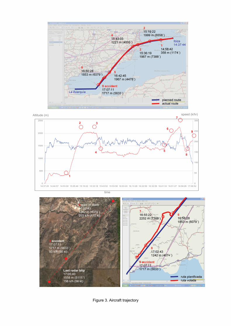
Figure 3. Aircraft trajectory
speed (k/hr)Altitude (m)
0
500
1000
1500
2000
2500
14:37:25 14:44:57 14:53:00 15:05:46 15:19:22 15:33:18 15:43:52 15:53:58 16:03:20 16:13:28 16:22:59 16:32:59 16:41:33 16:51:27 16:58:26 17:06:520
50
100
150
200
250
300
time
1
2 3
4 5
6
7
8
9
8 start of climb17:02:431242 m (4074´)203 k/h (110 kt)
Last radar blip17:05:401558 m (5111´)156 k/h (56 kt)
9 accident17:07:111717 m (5633´)93 k/h (50 kt)

1.6.Meteorological information
The weather forecast for the province of Almeria on 24 September 2007 called for partlycloudy or clear skies, except for the coastal region. The winds were to be light andvariable, with breezes along the coast.
Satellite and radar information for the Gador Mountains showed that between 17:00 and18:00 on 24 September 2007, the weather at an altitude of 5450 feet would most likelyhave started out as mostly cloudy, with cumulus and stratocumulus clouds giving way tomostly clear skies by 18:00 with stratocumulus clouds. Winds were weak and thetemperature would have been between 11 and 12º C.
1.7.Tests and research
1.1.3Pilot’s statement
The pilot stated that the flight from Ibiza proceeded normally until the first mountainsappeared, 30 NM to the northwest of Almeria, and with them the first cloud formations,which covered the mountainous areas and reached an altitude of 4500 feet. He cleared a6500-foot high mountain before descending to 4000 feet to go under the clouds, notabove them, since he was unsure of finding opening through which to descend later. Ashe descended, he became aware of the increasing elevation and proximity of the terrain,so he decided to head for a valley. Once inside the valley, he noticed mountains allaround without sufficient space in which to turn around, so he tried climbing as fast aspossible to clear the mountains over their lowest point. The aircraft’s rate of climb was toolow, however, and faced with the certainty of crashing into the mountain, the pilot decidedto lower the flaps one notch, followed by full flaps 30 seconds later so as to minimize theimpact speed. He crashed into the mountain at an altitude of some 5500 feet with full flapsand with a climb attitude.
After impact, smoke started issuing from the engine, which prompted him to turn off all thesystems. Later, after verifying there was no fire, he energized the electronics so he coulduse the radio to inform ACC Seville of the accident and of his location.
At the time of impact, all occupants were wearing their seat belts and visibility was good.
The flight had been planned using GPS and later transferred to a chart.
1.1.4SAR helicopter pilot’s statement
As the SAR helicopter approached the accident site, the pilot noted the presence ofclouds at 5000 feet which prevented them from finding a clearing through which to accessthe site.
1.1.5 INFOCA helicopter technician’s statement
The INFOCA technician aboard the helicopter which transported the passengers notedthe presence of fog at the accident site, but no wind. Despite the fog moving upward
toward the summit, they were still able to land. He likewise stated that the site was easy tofind thanks to the precise coordinates they had been given.
1.8.Survival aspects
The impact took place at the minimum airspeed the aircraft could sustain with full flaps,which resulted in minimum damage. The safety belts maintained their integrity and thewindow opened easily, allowing all onboard the aircraft to exit under their own power. Thecrash locator beacon was activated after the accident.
As a consequence of the accident, the passenger seated in the right rear seat suffered abroken nose. The other passengers received slight injuries to their foreheads, knees andelbows. The passenger with the broken nose was taken to Laujar de Andarax 56 minutesafter the accident in the private car of the person who found them. Since the remainingthree occupants only had bruises, they were able to be evacuated in the INFOCAhelicopter to Alhama de Andarax. All received medical treatment and were released within9 hours.
The INFOCA helicopter, which was requested by the emergency dispatcher and whichwas deployed from the Alhama de Almeria Forest Fire Center, 20 km away from theaccident site, was the first to arrive at the site, 1 hour and 16 minutes after the accident.
2. ANALYSIS
2.1.Flight analysis
On Monday, 24 September 2007, after flying for two and a half hours, aircraft F-BTVIimpacted a mountain in the Gador Mountains in Almeria. The flight had proceedednormally for the first 2 hours and 5 minutes, but encountered problems upon reaching themountainous region northeast of Almeria and finding cloud formations there.
The pilot, sufficiently experienced and knowledgeable on the aircraft, had rested for 4days in Ibiza and was on a pleasure flight with his wife and two friends. Neither fatigue norstress, therefore, is thought to have affected the pilot’s abilities. Along these same lines,the flight had been planned the day before and the actual takeoff time was only slightlybehind schedule (22 minutes). Likewise, the departure time, along with the season of theyear, provided ample time to make the flight under daylight conditions, which allownervousness or haste during the flight to be ruled out.
The aircraft’s condition at takeoff was in compliance insofar as weight and center ofgravity requirements. Neither the wreckage nor the pilot’s statement suggest the existenceof a technical problem affecting the operation or handling of the aircraft.
Based on the pilot’s statement and the GPS data, it seems the pilot planned the coursewithout taking into account the elevation. This could explain the events of the final 25minutes of the flight, during which he had to deviate from his route to clear a mountainbefore deciding to descend to 4000 feet while crossing over irregular terrain. After the
detour, he returned to his planned route; in other words, five minutes before the accident,when he decided to descend to 4000 feet, the pilot was over an area which he hadplanned to cross. Had the pilot been aware of the contour of the terrain over which he wasflying, he probably would have decided against losing so much altitude. The low altitude atwhich they were flying 5 minutes before the accident, along with the upward-slopingterrain in the area, made it impossible for the aircraft to clear the surrounding mountains.The pilot had no knowledge of the area of the accident since he had never flown therebefore, his normal area of operations being outside Spain and he being a resident ofSwitzerland.
The weather forecast indicated the possibility of clouds, particularly over mountainousareas, where they tend to form more easily. The pilot’s description of the cloud cover wasconsistent with the radar and satellite images for the Gador Mountains, which showed thepresence of cumulus and stratocumulus clouds. The pilot’s decision to continue flyingbelow the cloud cover to preclude the possibility of not finding an opening later throughwhich to descend suggests that he did not think the clouds would dissipate. It may havebeen more prudent, then, to have backtracked and searched for an alternate route. The pilot’s control of the emergency situation is considered adequate insofar as hisdecision to minimize the impact speed. Though fully extending the flaps would havelowered his climb angle, it also allowed him to impact the mountain at 50 knots, resultingin minimum harm to the occupants and the aircraft. After the impact, the magnetos andelectrical switches were turned off to avoid the risk of fire in the aircraft. The mixture andfuel switches, however, were not cut off, as they should have been. In this sense, andcontrary to the proper positioning of the flaps, the position of the throttle lever at full powerand the rich mixture were inconsistent with preparing the aircraft for an impact duringwhich they should have been in the opposite positions.
3. CONCLUSIONS
3.1.Findings
• The pilot and aircraft met all necessary requirements for carrying out in the flight inquestion.
• There were no technical problems associated with the aircraft. • The pilot, 52, had flown 400 hours aboard the accident aircraft. • It was the pilot’s first flight in the area. • The pilot had rested for 4 days prior to the flight. • The actual departure time differed only slightly from that planned by the pilot. • The departure time ensured daylight conditions throughout the flight. • The pilot had planned the waypoints the day before. The planning had not taken into
account terrain elevations at said waypoints. • The weather forecast for the area of the accident indicated the possibility of clouds. • The aircraft impacted at 17:07:11 against a mountain in the Gador Mountains while in a
climb attitude with full flaps and at 50 knots. • Search and rescue and emergency services were informed of the accident and the
location within 5 minutes.

• A passer-by who happened upon the wreckage 56 minutes after the accident used hisprivate car to evacuate the most seriously injured occupant.
• The remaining three occupants were rescued 1 hour and 16 minutes after the accidentby an INFOCA helicopter dispatched by emergency services.
3.2.Causes
The controlled impact of aircraft F-BTVI with a mountain in Almeria’s Gador Mountainsresulted from flying at an excessively low altitude within a mountainous region. A lack ofknowledge of the elevations in the region, along with the decision to continue flying underunfavorable meteorological conditions, are considered to have contributed to the accident.
4. SAFETY RECOMMENDATIONS
None.