report - broadway planning program and associated … · broadway planning program and associated...
TRANSCRIPT
POLICY REPORT
Report Date: June 6, 2018 Contact: Kevin McNaney
Contact No.: 604.871.6851 RTS No.: 12538 VanRIMS No.: 08-2000-20 Meeting Date: June 20, 2018
TO: Standing Committee on Policy and Strategic Priorities
FROM: General Manager of Planning, Urban Design and Sustainability
SUBJECT: Broadway Planning Program and Associated Interim Policies
RECOMMENDATION
A. THAT Council approve the Broadway Planning Program Terms of Reference generally as attached in Appendix A.
B. THAT Council approve the Interim Rezoning Policy, generally as attached in Appendix B to establish the conditions under which new rezonings and heritage revitalization agreements will be considered while the Broadway Planning Program is underway.
C. That Council approve the Development Contribution Expectations in Areas
Undergoing Community Planning policy to curb land value speculation in areas undergoing planning, generally as attached in Appendix C.
REPORT SUMMARY
This report presents a major planning initiative to develop a comprehensive land use policy plan for the Broadway area, generally between Clark Drive and Vine Street. The plan will focus on opportunities to integrate development with the future transit along and around the Millennium Line Broadway Extension (Broadway Extension) to support the City’s goals of creating housing affordability, job space, social and cultural amenities, environmental sustainability and livability. Council is asked to adopt an interim rezoning policy that will apply while the planning program is underway. This report to Council also includes a recommendation that Council adopt a new policy to curb land speculation in areas undergoing planning. Land speculation can contribute to rising land costs, impact housing and job space affordability, and hurt the City’s ability to deliver affordable rental housing and provide community amenities to serve the needs of our growing population.
Broadway Planning Program and Associated Interim Policies – RTS 12538 2
Staff will report back in December 2020 with a new plan and associated policies for Broadway.
COUNCIL AUTHORITY/PREVIOUS DECISIONS
Planning for Broadway allows the City to implement goals embodied in the following citywide and regional initiatives:
2008: Cultural Facilities Priorities Plan 2009: Metro Core Jobs and Economy Land Use Plan: Issues and Directions 2009/10: Regional Context Statement and Regional Growth Strategy 2011: Greenest City Action Plan 2012: Mayor’s Task Force on Housing Affordability 2012: Transportation 2040 Plan 2012: Climate Change Adaptation Strategy 2012: Neighbourhood Energy Strategy 2013: Heritage Amenity Bank and Transfer of Density 2013: Vancouver’s Culture Plan: Strategic Directions 2014: Healthy City Strategy 2014: The Mayor’s Engaged City Task Force 2017: Housing Vancouver 2018: Millennium Line Broadway Extension of SkyTrain – Municipal
Requirements
A number of other planning policies apply more specifically to various precincts within the study area. These include:
1974: Fairview Neighbourhood Plan 1976: Central Broadway C-3A Urban Design Guidelines 1977: Kitsilano Neighbourhood Plan 1974: False Creek Development and Area Plan 1988: Cambie Street (East Side) C-3A Guidelines 1989: View Protection Guidelines 1997: General Policy for Higher Buildings 1999: Central Area Plan 2000: Vancouver General Hospital Precinct Policy Statement 2002: Vancouver General Hospital (VGH) Precinct CD-1 Guidelines 2007: Metro Core Jobs & Economy Plan 2007: Rental Housing Stock ODP 2007: Rate of Change Guidelines for Certain RM, FM and CD-1 Zoning
Districts 2010: Mount Pleasant Community Plan 2016: Grandview Woodland Community Plan 2017: False Creek Flats Plan
CITY MANAGER'S/GENERAL MANAGER'S COMMENTS
The City Manager recommends approval of the foregoing.
Broadway Planning Program and Associated Interim Policies – RTS 12538 3
REPORT
This report seeks Council’s approval of the Terms of Reference for a Broadway Planning Program, an interim rezoning policy, and measures to curb land speculation while the planning program is underway.
Background/Context
Rapid transit for Broadway has been prioritized in City and regional plans for over twenty years. In 2014, the Mayors’ Council on Regional Transportation approved “Transportation Investments: A Vision for Metro Vancouver” which prioritized rapid transit to UBC to be delivered in two stages. The first stage is the Millennium Line Broadway Extension (Broadway Extension) – a SkyTrain extension under Broadway from VCC-Clark to Arbutus Street - to be delivered within the next ten years. This first stage of rapid transit to UBC was recently unanimously endorsed by Council on May 16, 2018. Stage 1 of the long-anticipated Broadway Extension is expected to receive funding approval in June 2018 and projected to be completed in 2025. It is an approximately six kilometre extension of the SkyTrain system that will link Vancouver with eastern growth centres (Burnaby, Coquitlam, and Surrey) and potentially with the University of British Columbia (UBC) in Stage 2. The line will also connect with existing rapid transit lines providing improved connections to downtown Vancouver and the Vancouver International airport and central Richmond. It is a large-scale infrastructure project that is anticipated and expected to be a catalyst for development and change in the areas that it services. Broadway is a regionally important area that connects the largest university (UBC) and the largest hospital (Vancouver General Hospital) in Western Canada. In 2011, there were 125,000 people living within the corridor (including UBC)1 with a further 70,000 expected by 20452. With more than 105,000 jobs along the corridor (including UBC) in 20113, Broadway is the second largest job centre in the Province, and a key source of employment for residents throughout Metro Vancouver. The proposed planning program outlined in the Terms of Reference (Appendix A) and Interim Rezoning Policy (Appendix B), follows up on a report to Council October 17, 2017, that provided an overview of City Core 2050 and Related Planning Programs. The report noted that staff would undertake further scoping for Broadway planning and report back to Council with a workplan and an interim rezoning policy by mid-2018. This report also responds to Council’s direction through the Housing Vancouver Action Plan to bring forward a policy to stabilize land values in emerging plan areas. The geographical scope of the study is centered on Broadway, generally from Clark Drive in the east to Vine Street (two blocks west Arbutus Street) in the west. The comprehensive context and scale of the proposed planning work will allow for the coordinated review of land use, connections, amenities, services and infrastructure throughout the Broadway planning area.
1 (Source: Statistics Canada (2011), UBC (2011) 2 (Source: City of Vancouver (2016), UBC (2016) 3 (Source: Statistics Canada (2011), UBC (2011)
Broadway Planning Program and Associated Interim Policies – RTS 12538 4
Strategic Analysis A. Program Description
Recommendation A is to adopt the Terms of Reference (attached as Appendix A) that sets out a planning program which will result in the following key deliverables:
Policy Plan - The Broadway Plan will incorporate land use and built form policies to expand housing options and job space, and will identify new or improved parks and public spaces, and other public amenities. This will include policies to increase social and rental housing, while retaining existing rental and increasing protection to tenants. By integrating with broader transportation and utility planning, the plan will also identify street network/connections (including active transportation modes) and necessary utility upgrades.
Public Benefits Strategy - The strategy will consider all public amenity and infrastructure needs, including affordable and rental housing, childcare, community facilities, civic facilities, parks and open spaces, transportation, and utilities. A long-term funding strategy will also be developed encompassing property taxes and user fees, development contributions and partner contributions.
The program is phased to provide key deliverables at distinct milestones in the process. The outcomes and timing of each phase are briefly summarized below. Background Phase (expected completion - December 2018):
comprehensive range of studies, including an area demographic profile, archaeological assessment, baseline utility capacity review, rate of change impact assessment, statement of significance/heritage assessment, transportation modelling, parking data collection and review, Broadway Extension project planning as well as other studies to inform the planning program work (see: Appendix A: Figure 7 for comprehensive list).
Phase 1 Guiding Principles (expected completion – June 2019):
planning principles (coordinated with and informed by broader City Core 2050 guiding principles).
Phase 2 Emerging Directions (expected completion – December 2019): growth scenarios and patterns for change in land uses, housing, jobs, parks
and public spaces, transportation connections and amenities (coordinated with and informed by broader City Core 2050/Economy Lands Studies, and Broadway Extension project design).
Phase 3 Refining Directions (expected completion - June 2020):
draft policy plan for land use, density, layout, built form, and design. This will integrate policies to increase social and rental housing, while retaining existing rental and increasing protection for tenants.
draft public amenity strategy addressing housing, community amenities, transportation connections, infrastructure, parks, public space, public realm improvements, and social and cultural amenities.

Broadway Planning Program and Associated Interim Policies – RTS 12538 5
Phase 4 Finalizing the Plan (expected completion - December 2020): final policy plan, including enhanced renter protection policy in the Rental
Housing Stock ODP areas included in the study area. final public amenity strategy.
Phase 5 Implementation (to be determined):
rescinding Interim Rezoning Policy referral of by-law amendments and subsequent policy amendments (e.g. to
Community Plans) The Terms of Reference provide a description of all aspects of the study (see: Appendix A).
B. Study Area
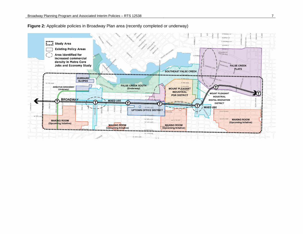
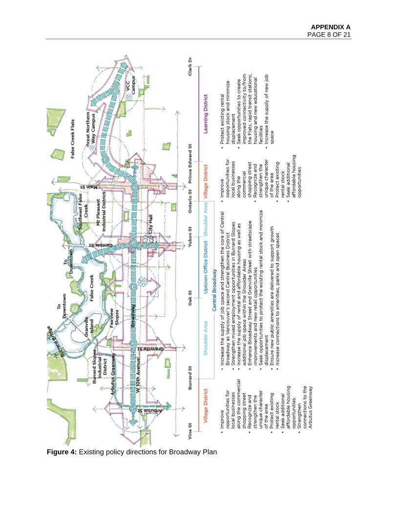
The overall Broadway Plan study area, shown in an outline on Figure 1, includes lands from Clark Drive in the east to Vine Street (two blocks west of Arbutus Street) in the west. The north and south boundaries (16th Avenue) boundaries of the overall study area were determined by considering areas up to 800 metres from existing and future stations. 800 metres is approximately a ten minute walk, which is commonly accepted as a reasonable walking distance to fast, frequent and reliable transit services such as SkyTrain. Existing policy areas, which have been recently considered by Council and areas that will be a focus of up-coming planning initiatives are shown on Figure 2. Key policy directions based on existing policy are described in summary on Figure 3. The parameters of the planning program in relation to existing policy and how these influence what’s on (or off) the table are discussed in Section D “Considerations Relative to Existing Policy and Community Plans” below. Within the overall study area there is a focus area to be reviewed for potential land use change as shown on Figure 4, shaded in purple. Generally, this includes the C-3A, C-2, RM-3/4, FM zoned areas, and parts of the Burrard Slopes mixed employment area within proximity to the station areas, as well as VGH and City Hall Campus. It excludes RS and RT zones, the False Creek South and the Southeast False Creek ODP areas, the majority of the Mount Pleasant industrial zones and False Creek Flats industrial and mixed employment zones. The RS and RT zones will be addressed through the ‘Making Room: Adding Housing Choice in Neighbourhoods Across Vancouver’ Planning Program, a key action item coming from the Housing Vancouver Strategy. The study area and focus area within is subject to change based on further analysis and stakeholder feedback in initial phases (see: Section 3, TOR Appendix A) of the planning process.

Broadway Planning Program and Associated Interim Policies – RTS 12538 6
Figure 1: Broadway Plan study area and Millennium Line Broadway Extension
Broadway Planning Program and Associated Interim Policies – RTS 12538 7
Figure 2: Applicable policies in Broadway Plan area (recently completed or underway)

Broadway Planning Program and Associated Interim Policies – RTS 12538 8
Figure 3: Existing policy directions for Broadway Plan

Broadway Planning Program and Associated Interim Policies – RTS 12538 9
Figure 4: Overall area of focus for the Broadway Plan
Broadway Planning Program and Associated Interim Policies – RTS 12538 10
C. Approach The existing Canada Line and future Broadway Extension will greatly improve sustainable transportation access to the area and present an opportunity to examine the future role and vision for Broadway. In creating a comprehensive plan for Broadway and its surround, policy would aim to: Expand affordable housing opportunities (social housing, market and below-market
rental) close to transit and jobs to accommodate the growing demand for rental housing in the city’s core while preserving and reinvesting in the existing older affordable market rental housing and minimizing displacement of existing residents.
Increase the amount of job space within Central Broadway to meet long term City,
regional and provincial economic development objectives. Enhance commercial shopping streets and local business opportunities. Improve the transportation network, connectivity, public realm and gathering
opportunities that can increase mobility and establish Broadway as a unique and inspiring series of places.
Secure additional public benefits and amenity to support new growth and improve
livability.
Deliver an integrated and resilient servicing plan for drinking water, rainwater and wastewater that acknowledges the pressures from growth and a changing climate.
Achieve ambitious sustainable mode share targets and reduce GHG emissions. The plan will also emphasize walking and cycling trips, especially those integrated with transit. The plan approach will be in keeping with the Transportation 2040 plan’s priorities to ensure most trips are made by foot, bike, and transit. Accordingly, the planning and design work will consider walkability and cycling as essential influences. The study area scope includes rental districts generally within 800 metres (10 minute walk) to the planned transit stations. These have been included to review options for rental stock within certain areas covered by the Rental Housing Stock ODP, which requires one-for-one replacement of existing rental units for developments of three units or more. Together, the rental districts within the study area make up one of the City’s core rental areas, containing 17,680 units of existing non-market and market rental housing - including 27% of the City’s total purpose-built rental units in areas covered by the Rental Housing Stock ODP. Planning work will explore potential future options for these sites, noting that rental replacement and enhanced tenant protection and relocation will be prioritized. A more focused approach (up to 400 metres from future stations) will be taken for the Arbutus and Main Street station “village district” sub-areas.
Broadway Planning Program and Associated Interim Policies – RTS 12538 11
D. Considerations Relative to Existing Policy and Community Plans The following section highlights the key policy issues that will be considered as part of the planning process. Rental Housing Stock Official Development Plan
The Housing Vancouver 10-year strategy identifies retention and renewal of existing rental housing as a core approach to ensuring the ‘Right Supply’ of housing in the city. The Rental Housing Stock ODP is a key tool to protect existing rental housing, requiring redevelopment projects proposing three or more units in certain areas to include one-for-one replacement of existing rental units. Located in some of the city’s most transit-accessible and amenity-rich neighborhoods, existing rental is more affordable than other forms of market housing like ownership or new market rental. Because of this, existing rental is critical for supporting income diversity required for sustaining local business and a healthy economy. However, this stock is aging, with the majority of buildings now over 40 years old – strategies to both renew and retain this existing stock will be considered as part of the Broadway planning work.
In the context of the current housing crisis in Vancouver, a broad-spectrum approach is needed to protect existing renters and housing affordability, while also significantly expanding the supply of new rental housing to meet the needs of a diverse and growing population. Housing Vancouver sets a 10 year target of 12,000 social, supportive and co-op housing units. As well, there is a target of 20,000 new purpose-built market rental units, quadrupling the previous target set in the Housing and Homelessness Strategy (2012-2021). The City will seek to shift 20 per cent of these new units to be developer-owned rental with deeper levels of affordability (targeted to annual incomes between $30,000- $80,000) secured for the long-term.
Opportunities to redevelop and increase the supply of new rental housing in areas covered by the Rental Housing Stock ODP will be considered. This will include consideration of strategies to preserve current affordability levels, ways to manage the pace of change, and partnerships with senior levels of government and industry to deepen levels of affordability and mitigate impact to tenants facing redevelopment. In addition, sites at and near transit hubs and amenity-rich areas will be prioritized for new secured rental and social housing.
On April 24, the province introduced legislation that would amend the Vancouver Charter and Local Government Act to enable municipalities to limit the form of residential tenure permitted in a zoning bylaw. This legislation responded to requests from the City following the Housing Vancouver Strategy adoption in late 2017, as well as from the Union of BC Municipalities in early 2018. Once the legislation is adopted by the province, expected imminently, the City will have the authority to zone for rental tenure under the Vancouver Charter. Staff will consider the impacts and implications of utilizing this new zoning tool in areas covered by the Rental Housing Stock ODP through both a city-wide review and as part of the Broadway planning work. This work is anticipated to begin in mid-2018, with a report back on issues and options in early 2019.
Jobs and Economy Policies Metro Core Jobs and Economy Plan (2007) policies for the job areas of the City Core are supported by the Livable and Regional Strategic Plan, Cityplan, and guiding principles for economic development in the City of Vancouver, which affirm the desire to maintain the City Core as Greater Vancouver’s cultural and job centre. The plan’s intent

Broadway Planning Program and Associated Interim Policies – RTS 12538 12
is to ensure that there is enough development and transportation capacity to accommodate future job growth and economic activity in the Metro Core. It will be updated by the Employment Lands and Economy Review Study in 2019. The review, which is currently scheduled to kick off publicly this fall, will examine Vancouver’s employment lands and identify policy actions and directions to ensure an appropriate supply of job lands to support the growth of the economy in the future. Informed by the Employment Lands and Economy Review Study and proceeding with a view that Central Broadway will need to continue to provide job space to meet the needs of local and regional growth, Broadway Planning will consider land use policies for this sub-area. This will include consideration of the Uptown Office District4, support services, and overall how to increase commercial space capacity to support transit investment. Situations where other City objectives like affordable and secured market rental housing, heritage revitalization, and cultural amenity should be achieved will be considered. The C-3A urban design guidelines will be reviewed. Existing industrial lands in the City’s current Regional Context Statement are largely excluded from the Broadway Plan scope, with very narrow exceptions. This includes the False Creek Flats area, and Mount Pleasant Industrial area. This is intentional, and intended to confirm the roles of industrially zoned areas in the City Core and because Council has recently adopted plan and zoning amendments in these areas (e.g. False Creek Flats Plan, 2017). These areas will be considered in the Employment Lands and Economy Review. While protecting the industrial land base is principally important, there is an unusual condition from Cambie to Main on the north side in that half block is zoned C3-A while the remainder half block is zoned I-1 (to 8th avenue). This limits potential redevelopment fronting on Broadway significantly, potentially reducing the level of amenity that redevelopment could provide. Accordingly, it is recommended that the study area extend to 8th avenue to allow consideration of non-industrial uses and a higher intensity of development. Heights, Views and Other Considerations The attractiveness of Broadway as a diverse jobs and residential area could strengthen with the introduction of rapid transit along Broadway. However, existing zoning height and density restrictions will limit employment and housing capacity over the long term. Employers and residents may choose to locate elsewhere in the city or region, including in places which are dispersed and difficult to serve by transit. Within this context, the planning program will undertake a review of the following policies that restrict height through the Broadway Corridor:
Queen Elizabeth View Corridor #3 Vancouver General Hospital Flight Path Central Broadway C3-A Urban Design Guidelines
4 The Metro Core Jobs and Economy Plan confirmed the uptown office district along Broadway between Oak and Yukon Streets as a priority area for job growth. Residential use is not permitted in the uptown office district.
Broadway Planning Program and Associated Interim Policies – RTS 12538 13
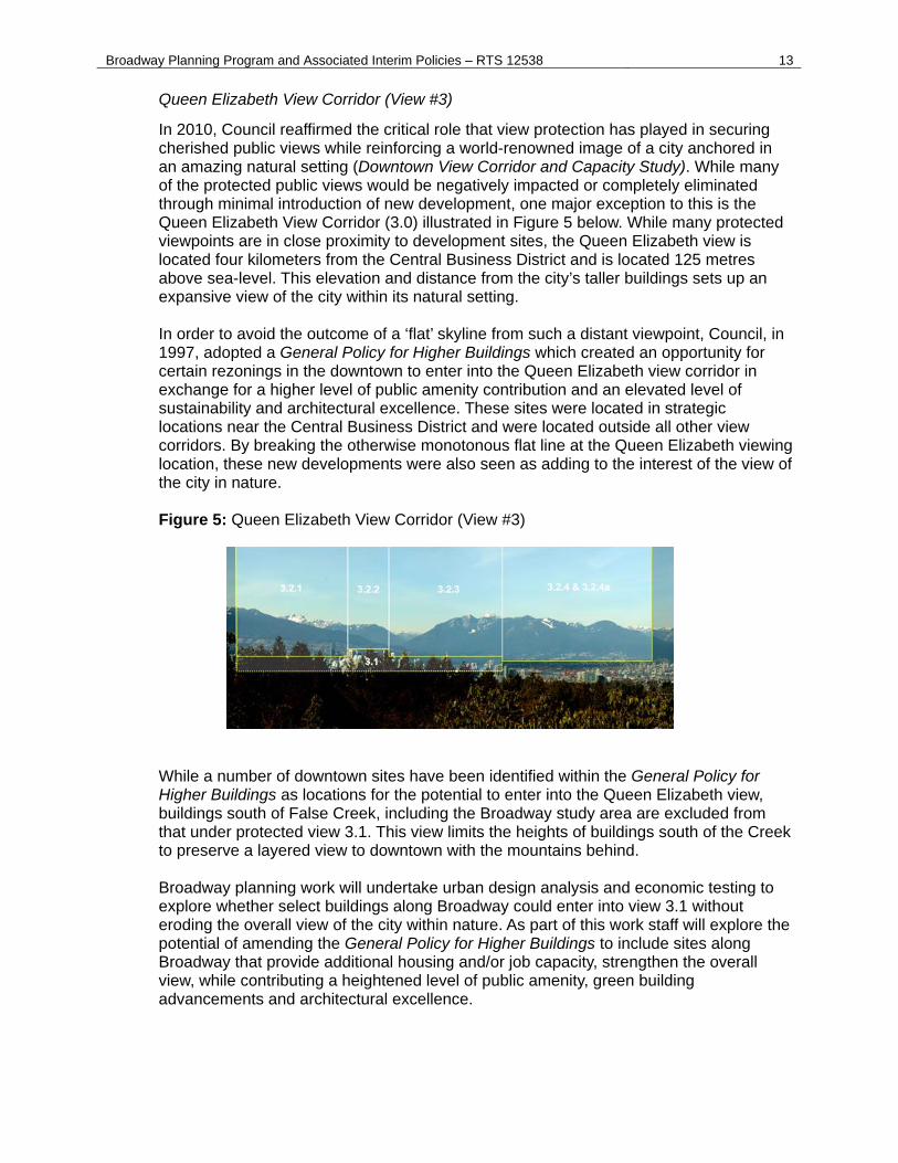
Queen Elizabeth View Corridor (View #3)
In 2010, Council reaffirmed the critical role that view protection has played in securing cherished public views while reinforcing a world-renowned image of a city anchored in an amazing natural setting (Downtown View Corridor and Capacity Study). While many of the protected public views would be negatively impacted or completely eliminated through minimal introduction of new development, one major exception to this is the Queen Elizabeth View Corridor (3.0) illustrated in Figure 5 below. While many protected viewpoints are in close proximity to development sites, the Queen Elizabeth view is located four kilometers from the Central Business District and is located 125 metres above sea-level. This elevation and distance from the city’s taller buildings sets up an expansive view of the city within its natural setting.
In order to avoid the outcome of a ‘flat’ skyline from such a distant viewpoint, Council, in 1997, adopted a General Policy for Higher Buildings which created an opportunity for certain rezonings in the downtown to enter into the Queen Elizabeth view corridor in exchange for a higher level of public amenity contribution and an elevated level of sustainability and architectural excellence. These sites were located in strategic locations near the Central Business District and were located outside all other view corridors. By breaking the otherwise monotonous flat line at the Queen Elizabeth viewing location, these new developments were also seen as adding to the interest of the view of the city in nature.
Figure 5: Queen Elizabeth View Corridor (View #3)
While a number of downtown sites have been identified within the General Policy for Higher Buildings as locations for the potential to enter into the Queen Elizabeth view, buildings south of False Creek, including the Broadway study area are excluded from that under protected view 3.1. This view limits the heights of buildings south of the Creek to preserve a layered view to downtown with the mountains behind. Broadway planning work will undertake urban design analysis and economic testing to explore whether select buildings along Broadway could enter into view 3.1 without eroding the overall view of the city within nature. As part of this work staff will explore the potential of amending the General Policy for Higher Buildings to include sites along Broadway that provide additional housing and/or job capacity, strengthen the overall view, while contributing a heightened level of public amenity, green building advancements and architectural excellence.
Broadway Planning Program and Associated Interim Policies – RTS 12538 14
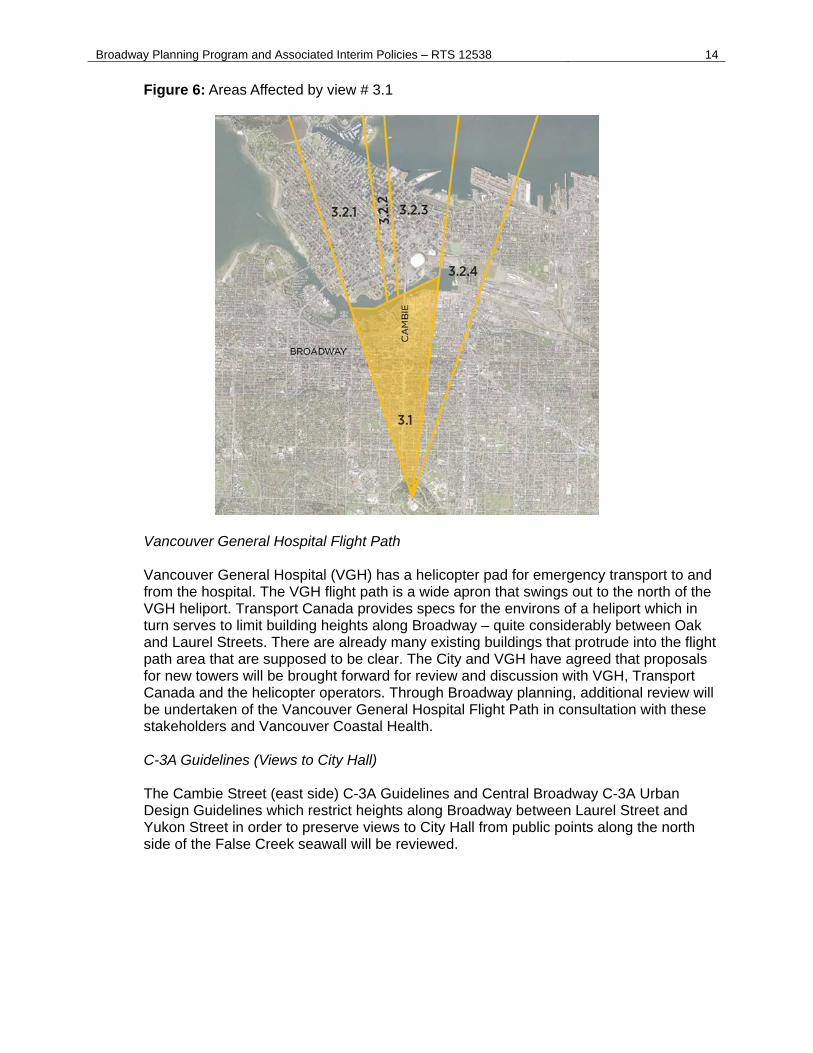
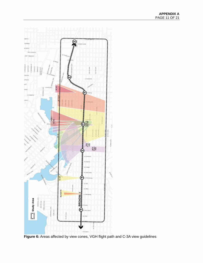
Figure 6: Areas Affected by view # 3.1
Vancouver General Hospital Flight Path Vancouver General Hospital (VGH) has a helicopter pad for emergency transport to and from the hospital. The VGH flight path is a wide apron that swings out to the north of the VGH heliport. Transport Canada provides specs for the environs of a heliport which in turn serves to limit building heights along Broadway – quite considerably between Oak and Laurel Streets. There are already many existing buildings that protrude into the flight path area that are supposed to be clear. The City and VGH have agreed that proposals for new towers will be brought forward for review and discussion with VGH, Transport Canada and the helicopter operators. Through Broadway planning, additional review will be undertaken of the Vancouver General Hospital Flight Path in consultation with these stakeholders and Vancouver Coastal Health. C-3A Guidelines (Views to City Hall) The Cambie Street (east side) C-3A Guidelines and Central Broadway C-3A Urban Design Guidelines which restrict heights along Broadway between Laurel Street and Yukon Street in order to preserve views to City Hall from public points along the north side of the False Creek seawall will be reviewed.
Broadway Planning Program and Associated Interim Policies – RTS 12538 15
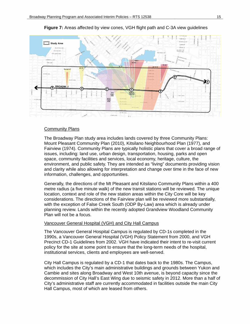
Figure 7: Areas affected by view cones, VGH flight path and C-3A view guidelines
Community Plans
The Broadway Plan study area includes lands covered by three Community Plans: Mount Pleasant Community Plan (2010), Kitsilano Neighbourhood Plan (1977), and Fairview (1974). Community Plans are typically holistic plans that cover a broad range of issues, including: land use, urban design, transportation, housing, parks and open space, community facilities and services, local economy, heritage, culture, the environment, and public safety. They are intended as “living” documents providing vision and clarity while also allowing for interpretation and change over time in the face of new information, challenges, and opportunities.
Generally, the directions of the Mt Pleasant and Kitsilano Community Plans within a 400 metre radius (a five minute walk) of the new transit stations will be reviewed. The unique location, context and role of the new station areas within the City Core will be key considerations. The directions of the Fairview plan will be reviewed more substantially, with the exception of False Creek South (ODP By-Law) area which is already under planning review. Lands within the recently adopted Grandview Woodland Community Plan will not be a focus.
Vancouver General Hospital (VGH) and City Hall Campus
The Vancouver General Hospital Campus is regulated by CD-1s completed in the 1990s, a Vancouver General Hospital (VGH) Policy Statement from 2000, and VGH Precinct CD-1 Guidelines from 2002. VGH have indicated their intent to re-visit current policy for the site at some point to ensure that the long-term needs of the hospital, institutional services, clients and employees are well-served. City Hall Campus is regulated by a CD-1 that dates back to the 1980s. The Campus, which includes the City’s main administrative buildings and grounds between Yukon and Cambie and sites along Broadway and West 10th avenue, is beyond capacity since the decommission of City Hall’s East Wing due to seismic safety in 2012. More than a half of City’s administrative staff are currently accommodated in facilities outside the main City Hall Campus, most of which are leased from others.

Broadway Planning Program and Associated Interim Policies – RTS 12538 16
Two of the new Broadway Extension stations will provide direct access to both City Hall and VGH. As both City Hall and VGH will be undertaking master planning initiatives to plan for their future in the near term, the larger context of these two major employment campuses and the area’s role as an important gateway to the City Core will be considered through Broadway planning.
Approach to Outreach and Engagement The outreach and engagement process will be inclusive and involve a broad range of interested parties: local businesses, local residents, and citizens from across the City, property owners, tenants, workers, business owners, transit and mobility stakeholders (including TransLink and Metro Vancouver interests) real estate development interests, academics, and other stakeholder groups. It will also provide for an array of engagement opportunities, from active involvement to providing information. The background phase of work will involve scoping an engagement plan and communication approach. A comprehensive list of interested organizations, public agencies, firms, institutions and individuals will be kept informed and will be asked to share their perspectives at key points. Working in consultation with the Communication Department, the program will utilize a variety of media to update the public on background information and products of the study in each phase. Open houses, innovative on-line tools, workshops, “walkshops”, focus groups, and staff presentations at meetings of key organizations are all formats that will be considered.
The Broadway planning program will embrace an approach that both considers the role of Broadway in the larger context of the City Core and region (allowing for broad participation in the planning process) but also allows for local neighbourhood-level engagement that acknowledges the diversity of the neighbourhoods and interests through the Broadway corridor. This will allow for meaningful dialogue that addresses the unique context of new station areas. In addition to broad outreach and neighbourhood level engagement, specific attention will be given to ensure local businesses have an opportunity to provide input by designing an outreach program to accommodate business hours and availability. There is already a City-led Advisory Group and Mayor’s Forum formed for the Broadway Extension project5 that will be consulted through the planning process. Since it is anticipated that initial phases of Broadway planning will run in coordination with the City Core 2050, city-wide perspectives engaged for City Core 2050 may be another touchstone for the Broadway planning process. Relevant Council appointed Advisory Committees will be consulted at key points. Opportunities to coordinate engagement and outreach with both City Core 2050 and the Broadway Extension project engagement will be explored. In addition, TransLink will be commencing its update to the Regional Transportation Strategy (RTS) in the fall of 2018, for up to two years. Opportunities to engage TransLink and other key regional partners should be explored as part of the RTS process. An inter-departmental Broadway planning team will work closely with other Planning, Urban Design and Sustainability staff and other City Departments including Engineering, Parks, Arts and Culture and Community Services, Finance, Real Estate and Facilities
5 City’s Rapid Transit Office is working with TransLink to advance the design and construction of the Broadway Extension.
Broadway Planning Program and Associated Interim Policies – RTS 12538 17
Management, and Communications. An integrated project approach will ensure information sharing and collaboration throughout the study and facilitate a comprehensively considered product.
E. Interim Rezoning Policy During Broadway Planning Process
The City’s established practice is to limit the types of new rezoning applications which will be considered during a significant planning process so as not to pre-empt or divert the planning program with rezonings which seek to set new directions or preclude options in a neighbourhood. Staff recommend that this practice be continued.
Appendix B contains proposed policy setting out the circumstances under which new rezonings and heritage revitalization agreements would be considered during the Broadway Planning process. These circumstances may include projects involving public or non-profit institutional, cultural, or recreational uses, non-market housing, or heritage retention, as well as minor housekeeping amendments. It should also be noted that applications that have already been submitted and enquiries that have received a written response up to three years prior to the adoption of the interim rezoning policy will continue to be considered or processed.
F. New Policy Measure to Curb Speculation
Land speculation can contribute to rising land costs, impact housing and job space affordability, and hurt the City’s ability to deliver affordable rental housing and provide community amenities to serve the needs of our growing population. In recognition of these challenges, Council directed staff through the Housing Vancouver Action Plan to bring forward a policy to stabilize land values in emerging plan areas. This policy, Development Contribution Expectations in Areas Undergoing Community Planning, is attached as Appendix C. The proposed new policy measure, called a Development Contribution Expectation (DCE), is intended to limit land value speculation by ensuring that owners, realtors and developers are made aware of the City’s intention to preserve and grow affordable rental housing, job space and public benefits along the corridor. By articulating the City’s priorities and expectations at the outset of the planning process, sellers and buyers of land in the Broadway study area will be able to make better decisions with respect to land transactions.
Approach to Developing the DCE Policy Broadway planning work has not yet begun. In the absence of growth projections and amenity needs analysis for the Broadway Planning area, the approach for identifying DCEs in advance of planning has been based on two key inputs:
(1) Existing Council policy and priorities for the area: job space and affordable rental housing; and
(2) The projected economic viability of alternative development scenarios. The Prioritization of Additional Job Space The Metro Core Jobs and Economy Plan confirmed the uptown office district along Broadway between Oak and Yukon Streets as a priority area for job growth. Residential
Broadway Planning Program and Associated Interim Policies – RTS 12538 18
use is not permitted in the uptown office district. In addition, Council policy allows for consideration of rezoning applications for projects that deliver additional job space in employment areas across the study area such as the Burrard Slopes light industrial district. In November 2017, Council approved the implementation of interim commercial linkage targets on net additional floor area for commercial-only rezoning applications in the Metro Core. This measure removed the requirement for negotiated CACs on commercial-only non-strata rezonings, simplifying the development process and encouraging the development of job space. The Prioritization of Affordable Rental Housing The City’s Rental Housing Stock ODP requires one for one replacement of existing rental housing in the apartment areas on and adjacent to the Broadway Corridor. This policy applies across the majority of RM and FM zoning districts in the City and serves to protect existing renters and the existing rental housing stock. The rent in newly constructed projects is typically double what is charged in existing, older, rental housing. Preservation of this affordability is a key consideration in planning processes that involve policy changes in existing apartment areas. The need for below market rate rental housing was recently reaffirmed by Council with the approval of the Housing Vancouver Strategy. The Strategy, approved by Council in November 2017, included the launch of the Moderate Income Rental Housing Pilot program. The pilot program allows for Council consideration of rezoning applications in a variety of areas across the city if the development is 100% rental housing and at least 20% of the dwelling units are rented at rates that are affordable to households earning between $30,000 and $80,000 per year. There has been significant developer interest in the pilot program and staff are working with industry to bring forward proposals for consideration by Council. It is expected that staff will be providing regular updates over the course of the pilot to highlight key learnings and evaluate the potential for a permanent program. Economic Viability of Alternative Development Scenarios Staff retained the services of an independent consultant to evaluate the economic viability of hypothetical development scenarios that might be considered along the Corridor. The consultant estimated the land value that would be created if additional strata residential development rights are granted in different locations and in different existing zoning districts along the Corridor. The strata land value estimates were based on detailed proforma analysis for hypothetical redevelopment projects as well as recent development site sales values in nearby neighbourhoods. These indicators were used to generate estimates of the additional land value (on a per square foot basis) that would be created by increased strata development rights in different parts of the Corridor.
Recommended Approach
The overarching objective of the DCE policy is to curb land value speculation in the market. This objective is best achieved by providing buyers and sellers with clear and consistent information about the City’s priorities and objectives for the Broadway Planning program. With the information, buyers and sellers will be able to properly account for the City’s expectations when identifying a fair price for land on the Corridor. Key priorities and approach for consideration of additional density is set out in Appendix C and summarized in Figure 8.
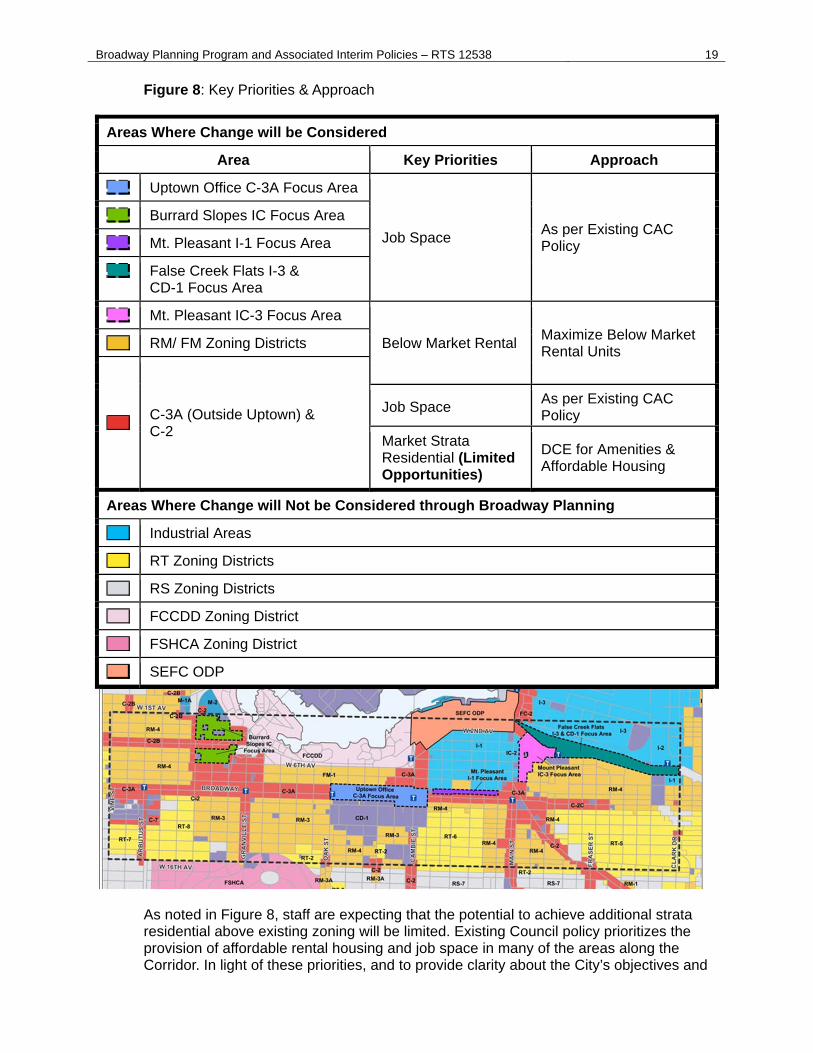
Broadway Planning Program and Associated Interim Policies – RTS 12538 19
Figure 8: Key Priorities & Approach
Areas Where Change will be Considered
Area Key Priorities Approach
Uptown Office C-3A Focus Area
Job Space As per Existing CAC Policy
Burrard Slopes IC Focus Area
Mt. Pleasant I-1 Focus Area
False Creek Flats I-3 & CD-1 Focus Area
Mt. Pleasant IC-3 Focus Area
Below Market Rental Maximize Below Market Rental Units RM/ FM Zoning Districts
C-3A (Outside Uptown) & C-2
Job Space As per Existing CAC Policy
Market Strata Residential (Limited Opportunities)
DCE for Amenities & Affordable Housing
Areas Where Change will Not be Considered through Broadway Planning
Industrial Areas
RT Zoning Districts
RS Zoning Districts
FCCDD Zoning District
FSHCA Zoning District
SEFC ODP
As noted in Figure 8, staff are expecting that the potential to achieve additional strata residential above existing zoning will be limited. Existing Council policy prioritizes the provision of affordable rental housing and job space in many of the areas along the Corridor. In light of these priorities, and to provide clarity about the City’s objectives and
Broadway Planning Program and Associated Interim Policies – RTS 12538 20
limit speculation, staff are recommending that, as part of the policy to curb land speculation presented in Appendix C, Council adopt a policy to confirm that the Broadway Planning program will not consider additional density for strata residential in RM and FM Zoning Districts and that additional density in industrial and employment areas is limited to job space. In the areas where strata residential will be considered as part of the planning program, staff are recommending that Council adopt a policy to clarify the DCE that will be anticipated to fund amenities and affordable housing to serve growth. It is recommended that the DCE on additional market strata residential density reflect the value of the additional density. The value of additional strata residential density above existing zoning is provided in Figure 9 below. Figure 9: Value of Additional Strata Residential (per sq. ft. above existing zoning): Proposed DCE for Amenities and Affordable Housing
C-2 C-3A East of Main St. C-3A West of Main St.
$330 $330 $425
Source: Coriolis Consulting 2018
The values in Figure 9 above may be adjusted throughout the Broadway planning process to reflect market changes and implementation approach.
Consultation, Outreach and Public Awareness
The direction to bring forward a policy to curb speculation in emerging plan areas was a key priority in the Housing Vancouver Action Plan. Housing Vancouver resulted from over a year of intensive stakeholder and public engagement. Activities included:
hosting an international conference on housing affordability an intensive and comprehensive creative advisory panels process multiple surveys generating over 10,000 responses In depth partner review of the draft strategy
Key stakeholder groups have been notified about the City’s recent work to develop the policy to curb speculation. Key activities in the spring 2018, included:
Letters and/or presentation to stakeholder groups o Urban Development Institute (UDI) o National Association for Industrial and Office Parks (NAIOP) o Real Estate Board of Greater Vancouver (REBGV) o British Columbia Real Estate Association (BCREA) o Board of Trade (BOT) o Building Owners and Managers Association (BOMA) o Realtors
Project website updates with email list sign up Notification emails to stakeholders at key points Stakeholder workshop event Media release
Broadway Planning Program and Associated Interim Policies – RTS 12538 21
Implications/Related Issues/Risk
Financial
The staff team dedicated to the Broadway Planning program will be primarily made up of staff funded from existing operating budgets wherever the reallocation of workloads and priorities is possible. For 2018, and the initial phase of work, all staff will be made up of existing staff yet some new staffing needs from departments such as Engineering will need to be funded in both 2019 and 2020. Consultancy costs have been identified for all departments (Planning, Urban Design and Sustainability, Engineering, Arts, Culture and Community Services, Park Board and Communications) and are anticipated to collectively range between $2.5M to $3.0M for the duration of the entire planning program. Planning, Urban Design and Sustainability and other departments integrating with the planning program will be funding their respective background phases of work for the remainder of 2018, while the balance of consultancy needs will be spread over 2019 and 2020. A more refined determination of the necessary staff and consultancy budget needs will commence in parallel with the background phase of work to be completed by the fall of 2018. Capital and operating budget needs will be included respectively as part of the annual budgeting framework for the Broadway program recognizing that this work is of key strategic importance for the long term planning for the City.
Environmental
Sustainable and progressive planning around rapid transit stations and along the Broadway study area represents an exceptional opportunity for Vancouver to advance on its longer term aspirations to be the “greenest” city in the world.
Social implications
Planning around rapid transit stations and along the Broadway provides an opportunity to address priorities for housing affordability, strong, safe, and inclusive communities, cultural and social amenities, as well as opportunities to provide important job space to foster creative capital and a growing economy.
Communications Plan
The Planning and Communications Department will work collaboratively to develop appropriate communications and engagement strategies as part of the consultation program at key points of the program. Opportunities to coordinate engagement and outreach with City Core 2050 and the Broadway Extension project engagement will be explored.
Broadway Planning Program and Associated Interim Policies – RTS 12538 22
CONCLUSION
The Broadway Planning Program will produce a long term comprehensive land use policy plan for the areas in close proximity to the future Broadway Extension rapid transit project within the City Core. The program will focus on opportunities to integrate development with the (MLBE) to meet the City’s goals of creating housing affordability, job space, social and cultural amenities, environmental sustainability and livability. An interim rezoning policy will apply while the planning program is underway as well as new “Developer Contribution Expectation” policy to curb land value speculation in advance of planning.
* * * * *
APPENDIX A PAGE 1 OF 21
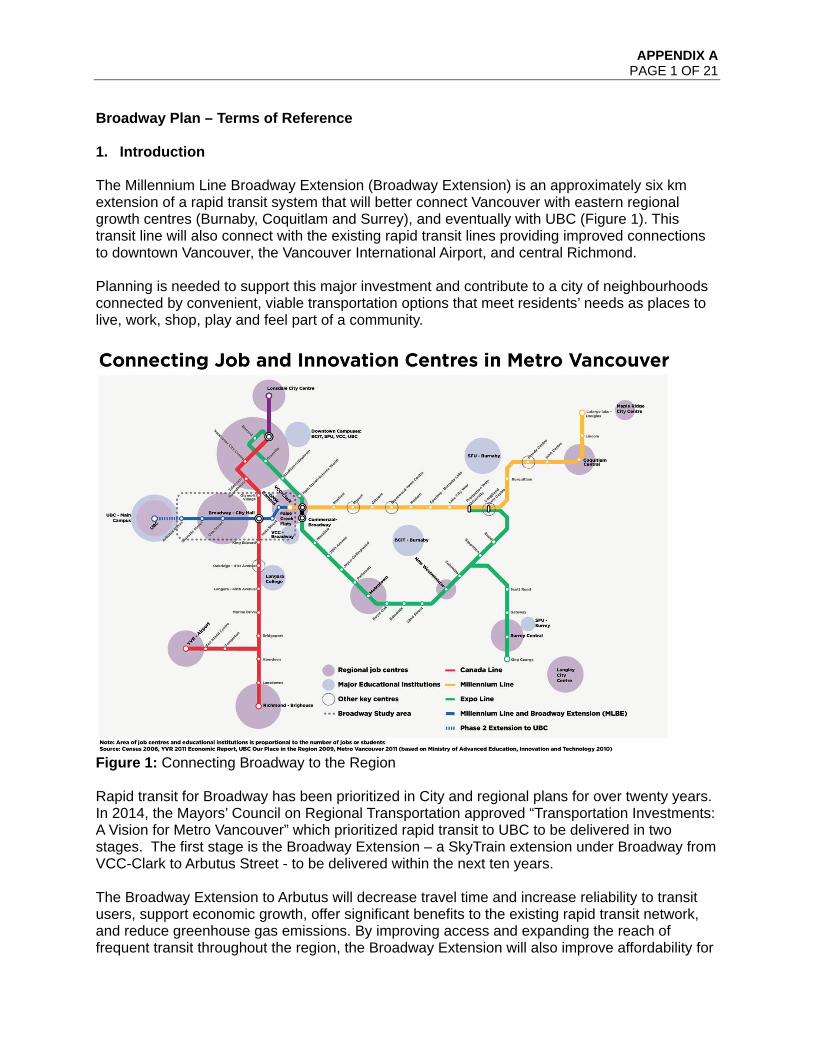
Broadway Plan – Terms of Reference 1. Introduction The Millennium Line Broadway Extension (Broadway Extension) is an approximately six km extension of a rapid transit system that will better connect Vancouver with eastern regional growth centres (Burnaby, Coquitlam and Surrey), and eventually with UBC (Figure 1). This transit line will also connect with the existing rapid transit lines providing improved connections to downtown Vancouver, the Vancouver International Airport, and central Richmond. Planning is needed to support this major investment and contribute to a city of neighbourhoods connected by convenient, viable transportation options that meet residents’ needs as places to live, work, shop, play and feel part of a community.
Figure 1: Connecting Broadway to the Region Rapid transit for Broadway has been prioritized in City and regional plans for over twenty years. In 2014, the Mayors’ Council on Regional Transportation approved “Transportation Investments: A Vision for Metro Vancouver” which prioritized rapid transit to UBC to be delivered in two stages. The first stage is the Broadway Extension – a SkyTrain extension under Broadway from VCC-Clark to Arbutus Street - to be delivered within the next ten years. The Broadway Extension to Arbutus will decrease travel time and increase reliability to transit users, support economic growth, offer significant benefits to the existing rapid transit network, and reduce greenhouse gas emissions. By improving access and expanding the reach of frequent transit throughout the region, the Broadway Extension will also improve affordability for
APPENDIX A PAGE 2 OF 21
residents in Metro Vancouver, as shown by previous research demonstrating that proximity to frequent transit networks across the region is related to lower overall household housing and transit costs.6 The Broadway Extension to Arbutus is key to the City achieving its affordability, liveability, transportation and environmental objectives. The City is looking to leverage this opportunity by coordinating comprehensive planning for the Broadway area with the timing of delivery of the rapid transit project. Key city goals for comprehensive planning (drawn from several sources, Housing Vancouver, Metro Core Jobs and Economy Land Use Plan, Transportation 2040 Plan, Greenest City Action Plan etc.) include the following:
Expand affordable housing opportunities (social housing, market and below-market rental) close to transit and jobs to accommodate the growing demand for rental housing in the city’s core while preserving and reinvesting in the existing older affordable market rental housing and minimizing displacement of existing residents.
Increase the amount of job space within Central Broadway to meet long term city,
regional and provincial economic development objectives. Enhance commercial shopping streets and local business opportunities. Improve the transportation network, connectivity, public realm and gathering
opportunities that can increase mobility and establish Broadway as a unique and inspiring place.
Secure additional public benefits and amenity to support new growth and improve
livability. Achieve ambitious sustainable mode share targets and reduce GHG emissions.
Other goals will emerge from the policy review/consultation with stakeholders in the early phases of the planning process (outlined in section 3). 2. Broadway Planning Context Statement 2.1 Overview The Broadway Extension and development around it can contribute to a city of neighbourhoods connected by convenient, viable transportation options that meet residents’ needs as places to live, work, shop, play and feel part of a community. Recognizing that rapid transit can be a catalyst for significant growth and change in the city and region, planning policy work must be timely and managed in order to effectively integrate land use, urban design and transportation planning. The plan approach outlined in this Terms of Reference will provide for a coordinated review of land use, amenities, services, transportation and infrastructure throughout the Broadway Plan area.
6 Metro Vancouver Housing and Transportation Cost Burden Study, 2015

APPENDIX A PAGE 3 OF 21
Broadway can be, in part, characterized as a place:
Of Regional Significance With more than 69,000 jobs in 2016, the Broadway Plan study area is the second largest job centre in the Province, and a key source of employment for residents throughout Metro Vancouver.7 It is also home to the province’s largest hospital, Vancouver General Hospital (VGH), and a robust health and life sciences sector which includes many of the province’s leading medical research centres.
That Drives our Local Economy and is the City’s Civic Centre
From Class A office building districts, to industrial uses, from retail to special employment zones, the Broadway Plan area contains a complete array of Vancouver’s employment spectrum. The City Hall campus forms the centre of local government, with about 1,700 employees working in the Broadway vicinity. Together with the nearby VGH health precinct, this area forms a focus of public-sector employment and public activity.
Comprised of Distinct Neighbourhoods and Diverse Character
In 2016, there were 71,500 people living within the Broadway Plan study area8 with 12,500 expected by 2041.
Broadway is framed by established city neighbourhoods, with unique shopping areas in South Main, Fairview, South Granville and Kitsilano, as well as a significant percentage of Vancouver’s heritage buildings. Several cultural precincts (e.g. the Granville Street and Main Street creative precincts) are also present along with venues for cultural production, display and performance, and live-work spaces. The attractiveness of Broadway as a diverse mixed-employment and residential area could be strengthened with the introduction of rapid transit along Broadway. However, there are challenges, which include:
Existing zoning height and density restrictions could limit employment and housing capacity over the long term. Employers and residents may choose to locate elsewhere in the city or region, including in places which are dispersed and difficult to serve by transit.
Rising housing costs and extremely low rental vacancy, which are putting pressure on existing rental housing in the areas surrounding Broadway. Existing renters – including families, young people, seniors, and vulnerable residents – face the difficult choice of paying higher rents or leaving the community to find more affordable options.
The existing rental housing stock provides an important source of housing to low and moderate incomes housing in the city, yet the vast majority of the existing rental housing stock within the study area is now over 40 years old and is in need of reinvestment.
The Broadway Plan area lacks a network-wide transportation plan that responds to the construction of the Broadway Extension and future changes in land use. A vision for
7 Clark to Vine Street study area (excluding UBC). Source: 2016 Census 8 Clark to Vine Street study area (excluding UBC). Source: 2016 Census

APPENDIX A PAGE 4 OF 21
Broadway should emphasize access to new stations and sustainable mobility throughout the area.
As a street, Broadway lacks a unified and legible public realm. The somewhat
haphazard development patterns along the length of the street result in a lack of definition in many places. The significant width of the street, lack of tree canopy, and in some places very narrow sidewalks represent an opportunity to develop Complete Streets in order to improve the pedestrian public realm and public gathering spaces.
The existing Canada Line and Broadway Extension will greatly improve sustainable transportation access to the area and present an opportunity to examine the future role and vision for Broadway in alignment with the city goals, noted above in Section 1. The Plan will also emphasize walking and cycling trips, especially those integrated with transit. The approach will be in keeping with the Transportation 2040 plan’s priorities to ensure most trips are made by people walking, cycling and taking. Further, the plan will consider the unique location, context, and role of the station areas in the broader study area, allowing for planning solutions that reflect the distinct qualities of their surround. 2.2 Associated Policy Studies There are a number of related planning initiatives that will be undertaken in a similar timeframe as the Broadway planning program. The scope of these initiatives and how they relate to the Broadway plan are noted below:
City Core 2050 (upcoming initiative) As reported to Council in October 2017, City Core 2050 is an umbrella initiative with related planning programs, including Broadway Planning Program. It includes the Broadway Plan study area, as well as the downtown.
City Core will be a big picture, public conversation about the future, exploring ideas about how the city could change and what the city wants to become over the next thirty years, which may in turn inform future city-wide planning efforts. Work relevant to Broadway Planning includes:
o Defining and key attributes and roles, as well as challenges and opportunities of
unique neighbourhoods o Establishing core principles to guideline the evolution of the area o Articulating a broad vision for the future of Vancouver’s core
The City Core 2050 and Broadway planning teams will coordinate their public engagement and analysis in the initial phases (as outlined in Section 3).
Vancouver Employment Lands and Economy Review (underway)
The Employment Lands and Economy review is also associated with City Core 2050 with implications for Broadway Planning. The study is examining Vancouver’s employment lands and will identify policy actions and directions to ensure an appropriate supply of job lands to support the growth of the economy in the future.
APPENDIX A PAGE 5 OF 21
The work will examine all Vancouver’s employment sectors (office, commercial, retail and industrial etc.) on a city -wide basis. The review will build on Vancouver’s strengths (CBD office, port lands, high-tech industry etc.) and work to protect the City’s industrial and mixed employment lands. It will also help inform the next generation of the City’s Regional Context Statement (RCS) (scheduled for 2020) and examine issues, including the intensification and densification of industrial employment lands.
The employment lands and economy review will bring new economic and demographic forecasts for Vancouver to bear and project long term projections for future job space by Spring 2019, which will be reflected in both the City Core 2050 and Broadway Planning growth scenarios.
False Creek South Neighbourhood Plan (underway)
The False Creek South Neighbourhood planning program was launched in June 2017 and is expected to result in a comprehensive plan that will update the False Creek Official and Area Development Plan. Council has recently (May 2018) adopted a provisional vision statement and guiding planning principles for the waterfront land north of 6th avenue, between Burrard and Cambie Bridge. Detailed planning is currently awaiting further resolution of lease negotiations on city-owned land in the area, at which time the planning program is expected to resume.
Making Room: Adding Housing Choice in Neighbourhoods Across Vancouver
(upcoming initiative) A key action item coming from the Housing Vancouver Strategy (2017) was to create a neighbourhood-based housing program which will focus on identifying ground-oriented, infill and low-rise options in RS and RT zoned neighbourhoods. The lower-density residential areas within or near the study area will be addressed through this planning program.
Other Initiatives (underway)
In addition, the Broadway Plan will consider emerging outcomes from studies already underway, including the Social Infrastructure Plan, Creative City Strategy, Making Space for Arts and Culture: Cultural Infrastructure Plan, City Hall Master Planning, Arbutus Greenway master plan, Mount Pleasant Industrial Area Transportation and Parking Strategies, and Vanplay (Parks and Recreation) Master Plan.
APPENDIX A PAGE 6 OF 21
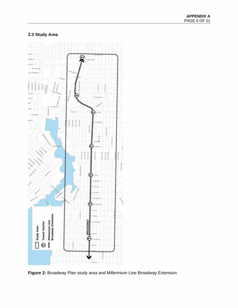
2.3 Study Area
Figure 2: Broadway Plan study area and Millennium Line Broadway Extension

APPENDIX A PAGE 7 OF 21
Figure 3: Applicable policies in Broadway Plan area (recently completed, underway, or upcoming)
APPENDIX A PAGE 8 OF 21
Figure 4: Existing policy directions for Broadway Plan

APPENDIX A PAGE 9 OF 21
Figure 5: Overall area of focus for the Broadway plan

APPENDIX A PAGE 10 OF 21
Key policy considerations and directions based on existing policy are described in summary on Figure 4. Additional detail on the general parameters of the planning program, specifically in relation to existing policy and how these influence what’s on (or off) the table are provided in the Council Report “Broadway Planning Program and Associated Interim Policies” RTS 12538. The overall Broadway Plan study area, shown in a dashed outline on Figure 2, includes lands from Clark Drive in the east to Vine Street (two blocks west of Arbutus Street) in the west. The north and south boundaries (16th Avenue) of the general study area were determined by considering areas up to 800 metres from existing and future stations. 800 metres is approximately a ten minute walk, which is commonly accepted as a reasonable walking distance to high-quality transit. This approach allows for the inclusion of rental districts protected by the Rental Housing Stock ODP and provides the opportunity for a coordinated review of land use, amenities, services, and infrastructure. A more focused approach (up to 400 metres from future stations) will be taken for the Arbutus and Main Street station “village district” areas. The overall study area will guide consideration of high level policy applicable to the overall area, such as public benefits allocations, transportation, infrastructure and public realm planning. Within the overall study area there are focus areas to be reviewed for potential land use change as shown on Figure 5, shaded in purple. Generally, this includes the following districts within proximity of the existing and planned stations:
C-3A and C-2 zones and guidelines Burrard Slopes IC zones RM and FM zones VGH and City Hall Campus CD-1s Limited portions of Mt Pleasant Industrial I-1 and False Creek Flats IC and I-3 zones
Industrial and mixed employment areas will be considered in a manner consistent with the Regional Growth Strategy. Existing heights and densities will be reviewed. This will necessitate a review of, notably, the Queen Elizabeth View Corridor View #3, Vancouver General Hospital Flight Path, C-3A Guidelines preserving views to City Hall, and other View Corridors impacting Broadway as noted in Figure 6.
APPENDIX A PAGE 11 OF 21
Figure 6: Areas affected by view cones, VGH flight path and C-3A view guidelines
APPENDIX A PAGE 12 OF 21
Generally the following areas are excluded either because parallel planning studies are or will soon be underway, or because these areas have recently been considered by Council (see: Figure 3).
RT and RS-1 zones (to be considered by “Making Room” up-coming housing program) False Creek South ODP area (planning underway) Southeast False Creek Official Development Plan (ODP) area (2005, and close to build-
out) Most portions of Mt Pleasant I-1 and False Creek Flats IC, I-3 zones (recently
considered by Council) The overall study area and focus area within is subject to change if additional analysis and community feedback in Phase 1 (see: Section 3) of the planning process warrants it. 2.4 Rental Housing Districts As noted, the RM-3 RM-4 and FM zoned rental districts generally within 800 m (a ten minute walk) to the existing and planned transit stations have been included to review options for rental stock within certain areas covered by the Rental Housing Stock ODP, which requires redevelopment of existing rental housing to include one-for-one replacement of rental units. Together, the RM-3, RM-4, and FM districts within the study area make up one of the City’s core rental areas, containing 17,680 units of existing nonmarket and market rental housing - including 27% of the City’s total purpose-built rental units in areas covered by the Rental Housing Stock ODP. Over 95% of the existing rental stock in the study area is over 40 years old, with the vast majority built between1950 to 1970. This is notable as many of the major original components of these buildings may be near or beyond their projected services lives, and will require capital upgrades and reinvestment over the coming years. The role of redevelopment and the pace of change will need to be carefully considered in these rental areas, as existing rental housing is generally more affordable than other forms of market housing in the city, making it possible for low and moderate income households to live in Vancouver. Renters in older rental buildings are often paying lower rents than current market rates. Because of this, when renters are displaced due to renovations or redevelopment of their building, it can very difficult for them to find a new rental home with similar affordability in their community, particularly in light of City’s tight rental market. This is a particularly serious challenge for vulnerable low-income renters, including families, seniors, and people with disabilities, who may have few if any alternative options in Vancouver. The planning program will align, and explore opportunities to enhance the City’s current policies and approaches to tenant protection and relocation, including potential partnerships with senior levels of government. The Province recently introduced legislation to enable municipalities to zone for residential tenure, which could allow the City to secure existing and new rental via rental-only zones. To alleviate pressure on rental stock in areas covered by the Rental Housing Stock ODP, Staff will continue to monitor the status of these provincial changes and explore the applicability of this tool as a method to prioritize rental housing, secure long-term affordability, and to reduce speculative activity in these important rental areas.
APPENDIX A PAGE 13 OF 21
Phases and Products 3.1 Overview The Broadway Planning program will deliver a comprehensive plan that includes policies related to land use, housing, jobs, parks and public spaces, street network/connections and public amenities. Given the size of the planning area, the broad scope of the work, and anticipated timing of umbrella policy initiatives like City Core 2050, the program is broken into distinct phases to provide key deliverables at appropriate milestones. At the end of the plan, these deliverables will include:
Policy Plan - The Broadway Plan will incorporate land use and built form policies to expand housing options and job space, and will identify new or improved parks and public spaces, and other public amenities. This will include policies to increase social and rental housing, while retaining existing rental and increasing protection to tenants. By integrating with broader transportation and utility planning, the plan will also identify street network/connections (including active transportation modes) and necessary utility upgrades.
Public Benefits Strategy - The strategy will consider all public amenity and
infrastructure needs, including affordable and rental housing, childcare, community facilities, civic facilities, parks and open spaces, transportation, and long-term utility upgrades required for water and sewers. A long-term funding strategy will also be developed encompassing property taxes and user fees, development contributions and partner contributions.
The phases of the program are as follows:
Background Phase: Background research, team/office set-up Phase 1: Guiding Principles Phase 2: Emerging Directions Phase 3: Refining Directions Phase 4: Finalizing the Plan Phase 5: Implementation (to be determined)
The phases of the program including the program elements, outcomes, timing, and expected points of engagement are summarized in Figure 7. Specific details of each phase follow.
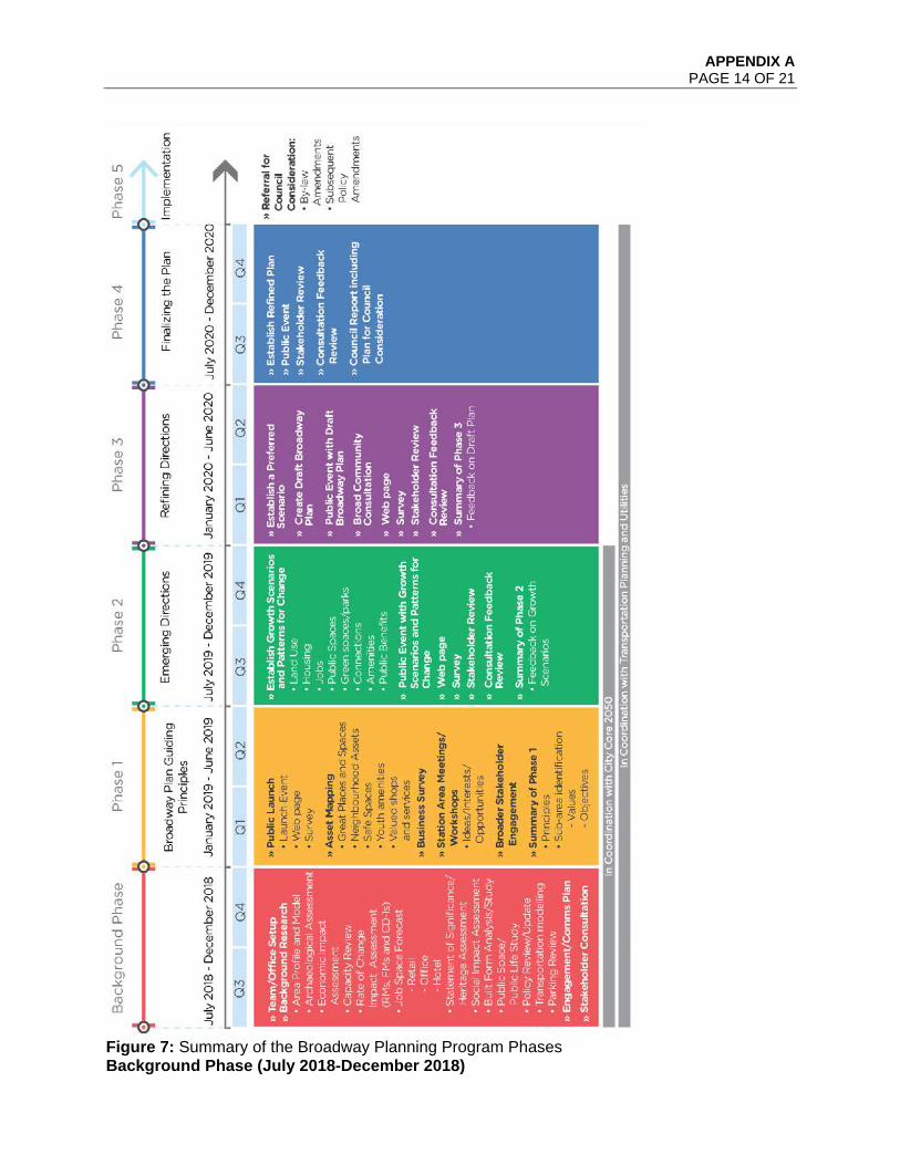
APPENDIX A PAGE 14 OF 21
Figure 7: Summary of the Broadway Planning Program Phases Background Phase (July 2018-December 2018)

APPENDIX A PAGE 15 OF 21
The background phase of work will allow for the considerable research and studies that need to be undertaken to prepare for a comprehensive planning process in the Broadway area. For example, a baseline review of all sewer and water infrastructure in the area will be carried out to inform what infrastructure expansion may be needed to support growth scenarios (see Figure 7 for a list of studies required). This phase will also produce an engagement and communications plan for the project. Phase 1: Guiding Principles (January 2019-June 2019) In this phase, staff will host a series of launch events, workshops, and open houses with the broader city and Broadway area to review, discuss, and ultimately refine the planning principles that will guide scenario building. The City Core project team and Broadway Planning team will launch jointly in January 2019. The teams expect to coordinate closely through the Background Phase and in Phase 1 where the public will be engaged in conversations about principles, values, and objectives. The Broadway planning process will include additional engagement at a subarea and station area geographic level. Broadway Planning will provide technical work, detailed analysis, and focused engagement on key topics to inform both the high level vision for the City Core and more detailed future planning for Broadway. Once City Core 2050 has been considered by Council, the Principles will carry through the next phases of the Broadway planning work. The principles will also provide a framework to allow key sites (such as City Hall Campus planning) to advance to a more detailed level of planning, in advance of completion of the overall plan. Phase 2: Emerging Directions (July 2019 – December 2019) Guided by existing city policy, emerging City Core and Broadway Plan guiding principles, staff will establish growth scenarios and patterns for change in land uses, housing, jobs, parks and public spaces, connections and amenities. Staff will host a series of public events with the city and businesses and neighbourhoods within the study area, to discuss and obtain input on a preferred scenario. Phase 3: Refining Directions (January 2020-June 2020) In this phase staff will produce a draft Broadway Plan that includes:
Policy for land use, density, layout, built form, and design. Draft policies to increase social and rental housing, while retaining existing rental and
increased protection to tenants. Draft public amenity strategy that addresses affordable housing, community amenities,
transportation connections, infrastructure, parks, public space and public realm improvement and options for financing.
Phase 4: Finalizing the Plan (July 2020- December 2020) In both phases 3 and 4 there will be opportunities for the public to provide input into the draft policy plan, which will include enhanced renter protection policy in the Rental Housing Stock ODP areas, and public amenity strategy prior to the City staff report to Council. Phase 5: Implementation (TBD – January 2021 onward) This phase is to be determined, subject to Council approval of a Broadway Plan, and will include rescinding the Interim Rezoning Policy, referral of by-law amendments, and subsequent policy amendments (e.g. to community plans). Should the plan be approved, it is expected that new
APPENDIX A PAGE 16 OF 21
district zoning schedules and associated guidelines will be prepared to support plan implementation.
3.2 Integrated Project Office The staff team dedicated to the Broadway Planning program will be primarily made up of staff funded from existing operating budgets wherever the reallocation of workloads and priorities is possible. For 2018 and the initial phase of work, all staff will be made up of existing staff yet some new staffing needs from departments such as Engineering will need to be funded in both 2019 and 2020. Consultancy costs have been identified for all departments (Planning, Urban Design and Sustainability, Engineering, Arts, Culture and Community Services, Park Board and Communications) and are anticipated to collectively range between $2.5M to $3.0M for the duration of the entire planning program. PDS and other departments integrating with the planning program will be funding their respective background phases of work for the remainder of 2018 while the balance of consultancy needs will be spread over 2019 and 2020. A more refined determination of the necessary staff and consultancy budget needs will commence in parallel with the background phase of work to be completed by the fall of 2018. Capital and operating budget needs will be included respectively as part of the annual budgeting framework for the Broadway program recognizing that this work is of key strategic importance for the long term planning for the City.

APPENDIX A PAGE 17 OF 21
4. Approach to Outreach and Engagement
4.1 Overview The outreach and engagement process will be inclusive to include and involve a broad range of interested parties: local businesses, local residents, and citizens from across the City, property owners, tenants, workers, business owners, transit and mobility stakeholders (including Translink and Metro Vancouver interests) real estate development interests, academic institutions, and other stakeholder groups. The background phase of work will involve scoping an engagement plan and communication approach. A comprehensive list of interested organizations, public agencies, firms, institutions and individuals will be kept informed and will be asked to share their perspectives at key points. Working in consultation with the Communication Department, the program will utilize a variety of media to update the public on background information and products of the study in each phase. Open houses, on-line tools, workshops, “walkshops”, focus groups, and staff presentations at meetings of key organizations are all formats that will be considered.
The Broadway planning program will embrace an approach that both considers the role of Broadway in the larger context of the City Core and region (allowing for broad participation in the planning process) but also allows for local neighbourhood-level engagement that acknowledges the diversity of the neighbourhoods and interests through the Broadway Plan area. This will allow for meaningful dialogue that addresses the unique context of new station areas. In addition to broad outreach and neighbourhood level engagement, specific attention will be given to ensure local businesses have an opportunity to provide input by designing an outreach program to accommodate business hours and availability. 4.2 Planning Process Principles As a starting point, the Broadway Plan process will be guided by the following outreach and engagement principles:
Be Inclusive – An accessible, inclusive process will be used to engage the broadest
possible range of people, including those with varying cultural backgrounds, ages, incomes, and tenures. The planning process will also ensure early in the process that the broader business and resident community is aware of the planning program and that their participation is important in shaping the plan.
Be strategic – the areas considered for change will be limited to strategic areas only and adjusted through consultation with businesses and the community.
Take time needed – accommodating growth and exploring change in an established urban context with distinct surrounding neighbourhoods is a complex endeavour and warrants sufficient time to work through the assets, issues and opportunities with the community.
Be visual – enhancing communication through high quality visual tools and materials (e.g., renderings, illustrations, photos, drawings, models, etc.) will help articulate complex issues increasing the local businesses and residents understand the scale of change being explored, allowing for informed and empowered decision-making.
Be Clear and Transparent - All stages of the planning process will be open and transparent and all decisions made should have a clear rationale that is available to all
APPENDIX A PAGE 18 OF 21
members of the community. The planning process and final products will be developed with user-friendly language and graphics. The scope of the plan, the key decision-points, and the role of all participants will be clearly identified. When a final product is ready for consideration by City Council, Staff will ensure that Council, before making decisions, is made aware of the range of community opinion, technical documentation, and any other necessary information.
Have a small group focus – while use of a variety of consultation tools is important for reaching the diversity of businesses and residents in the area, smaller group sessions that arrive out of sub-area identification are especially conducive to meaningful dialogue, and are particularly constructive when working through any core issues that may arise through the planning program.
Be flexible, adaptive, and responsive – the consultation program will adapt and respond, as necessary, to address community priorities including any core issues that arise throughout the program.
Action While Planning - Where possible the Planning Program will blend process and action - undertaking planning work at the same time as facilitating timely action on pressing issues and other ‘action’ opportunities which may emerge. These issues may include matters associated with transportation, local business, place-making, sustainability, housing and homelessness, public safety, health, food security, “greenest city” goals, etc.
4.3 Advisory Groups There is already a City-led Advisory Group and Mayor’s Forum formed for Broadway Extension Project that will be asked for their input at key points. City-wide perspectives and academics engaged for City Core 2050 may be another touchstone for the Broadway planning process. In addition, relevant Council appointed Advisory Committees will be consulted at key points. 4.4 Decision-Making Authority and Powers of Influence 4.4.1 Who Creates the Plan? Creation of the area plan for Broadway will be a collaborative process involving stakeholders residing in and beyond the study area, people from resource groups such as City advisory bodies, non-profit organizations and agencies or government agencies, and City staff from several departments. No single group creates the plan; rather, different constituents each play an important part. 4.4.2 Roles and Responsibilities The Community: Residents including tenants, landlords and homeowners, other property owners, business owners, employees of local businesses and service agencies, representatives of neighbourhood associations and voluntary organizations active in the study area. Collaborating with City staff, the community will help identify city-wide and neighbourhood issues, opportunities and actions, select preferred policy options, and help encourage and facilitate community outreach.
APPENDIX A PAGE 19 OF 21
Business and Community Advisory Group: Composed of a mix of businesses, business interests, residents and resident groups likely to be impacted by the Broadway Extension subway project. The group will participate in focused discussions and workshops to assist in the creation of principles, policies and strategies related to the Broadway Plan. The purpose of the Business and Community Advisory Group is to channel the experiences of Broadway area businesses and residents to help to generate ways to maximize benefits resulting from Broadway area planning, design and engineering changes. The Group has five objectives:
1. Broad representation: To represent a broad range of business and community interests in the Broadway area.
2. Share information: To provide Group members with project updates. 3. Gather input: To seek feedback on construction mitigation strategies. 4. Encourage dialogue and learning: To create a group where all parties can listen and
learn from each other, in order to better understand the complex needs of residents, businesses and organizations in Vancouver.
5. Develop strategies: To contribute towards the development of strategies to mitigate negative impacts of the Broadway Extension project as well as leverage positive impacts.
Developers: Developers who are (or expect to become) active in the Broadway Plan Study Area will be encouraged to participate in the planning process and afforded the same opportunities as other stakeholders. Developers will also be invited to learn from community members about issues affecting their area and development site, and to provide perspective to the community on the nature of land development and the issues and programming associated with their project(s). As with input from any stakeholders, input from developers into the plan process will be vetted by the community as a whole. City/Regional Stakeholders: Stakeholder groups located outside the geographical boundary of the Broadway Plan Study Area but have an interest in the planning initiative such as the Province of B.C., TransLink, Metro Vancouver, Vancouver Coastal Health, Vancouver School Board, and other city-wide and regional agencies. These groups will help City staff with outreach, identifying issues, opportunities and actions, and the review of policy options. Area Plan Staff Team: Staff will manage the planning process and collaborate with the community to identify clear neighbourhood issues, opportunities and actions informed by city-wide and regional policy. Staff will draft the plan and convey it to Council for consideration. Ongoing support will be provided by representatives from a number of City departments, boards and external government agencies. City Council: City Council allocates resources for the planning process and has the final decision of the plan. Council members, Park Board Commissioners and School Board Trustees will be invited to be "active observers" during the planning processes.

APPENDIX A PAGE 20 OF 21
Figure 8: Broadway Plan – General Roles and Actors Responsibilities
NOTE: This table outlines general roles associated with different actors; however, the work will likely overlap. For example, members of the community will participate on the Business and Community Advisory Group. 4.4.3 Additional Information on Roles Manage the Process: Organize the program, manage staff, budgets and schedule. Process Check-in and Advice: Ensure the community input is respected and provide advice on opportunities for broad outreach and meaningful community engagement. Outreach: Help tailor and facilitate engagement opportunities and communication approaches to meet the broad and diverse people in the Broadway planning area. Issues, Opportunities & Actions: Help identify key issues and opportunities, key planning areas and community action initiatives for the Broadway planning area. Drafting Policy Options: Coordinate, analyze and assess input against city-wide and regional policies, and create area-wide and sub-area policy options that will be tested and refined. Policy Testing: Comment and provide advice on how well different options respond to city-wide and regional policies and choose preferred options and/or identify components which require modification.

APPENDIX A PAGE 21 OF 21
Drafting the Plan: Prepare a draft plan that compiles area-wide and sub-area plans and policies and share it with the community at large, refining it as needed. Plan Approval: Formally approve the area plan as a basis for City policies and future actions, and approve action plans and allocation of City resources to implement the plan.
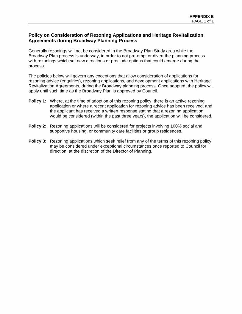
APPENDIX B PAGE 1 of 1
Policy on Consideration of Rezoning Applications and Heritage Revitalization Agreements during Broadway Planning Process Generally rezonings will not be considered in the Broadway Plan Study area while the Broadway Plan process is underway, in order to not pre-empt or divert the planning process with rezonings which set new directions or preclude options that could emerge during the process. The policies below will govern any exceptions that allow consideration of applications for rezoning advice (enquiries), rezoning applications, and development applications with Heritage Revitalization Agreements, during the Broadway planning process. Once adopted, the policy will apply until such time as the Broadway Plan is approved by Council. Policy 1: Where, at the time of adoption of this rezoning policy, there is an active rezoning
application or where a recent application for rezoning advice has been received, and the applicant has received a written response stating that a rezoning application would be considered (within the past three years), the application will be considered.
Policy 2: Rezoning applications will be considered for projects involving 100% social and
supportive housing, or community care facilities or group residences. Policy 3: Rezoning applications which seek relief from any of the terms of this rezoning policy
may be considered under exceptional circumstances once reported to Council for direction, at the discretion of the Director of Planning.

APPENDIX C PAGE 1 OF 6
Development Contribution Expectations in Areas Undergoing Community Planning June 2018
Development Contribution Expectations in Areas Undergoing Community Planning Adopted by City Council on
APPENDIX C PAGE 2 OF 6
Development Contribution Expectations in Areas Undergoing Community Planning June 2018
Contents 1 Application and Intent ............................................................................................. 3
1.1 Relationship to Community Amenity Contributions (CACs) ................................ 3
2 Area-Specific DCE Policies ..................................................................................... 3

APPENDIX C PAGE 3 OF 6
Development Contribution Expectations in Areas Undergoing Community Planning June 2018
1 Application and Intent
Development Contribution Expectations (DCE) policies are intended to limit land value speculation in areas undergoing community planning. The policies provide buyers and sellers of land in community planning areas with clarity regarding the City’s priorities for community planning areas and expectations for contributions towards amenities and affordable housing as a result of community planning.
1.1 Relationship to Community Amenity Contributions (CACs)
Area specific CACs are calculated at the end of a planning process based on the projected growth in population and jobs that will result from the plan, the amenities needed to serve that growth and the projected costs and funding sources available for the amenities. DCEs are identified at the beginning of a community planning program based on City policy priorities for each area and the projected economic viability of alternative development scenarios. Following the completion of a community planning program, DCEs are revisited to reflect the densities, mix of uses and amenity needs in the planning area. The DCEs are then updated and incorporated into the CAC policy for the planning area. For more information about the City’s CAC policy visit: http://vancouver.ca/files/cov/community-amenity-contributions-through-rezonings.pdf
2 Area-Specific DCE Policies
Area-specific development contribution expectations are shown in Tables 1 and 2.
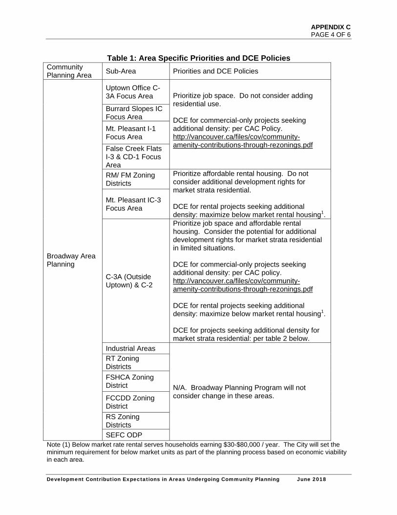
APPENDIX C PAGE 4 OF 6
Development Contribution Expectations in Areas Undergoing Community Planning June 2018
Table 1: Area Specific Priorities and DCE Policies Community Planning Area
Sub-Area Priorities and DCE Policies
Broadway Area Planning
Uptown Office C-3A Focus Area Prioritize job space. Do not consider adding
residential use. DCE for commercial-only projects seeking additional density: per CAC Policy. http://vancouver.ca/files/cov/community-amenity-contributions-through-rezonings.pdf
Burrard Slopes IC Focus Area
Mt. Pleasant I-1 Focus Area
False Creek Flats I-3 & CD-1 Focus Area
RM/ FM Zoning Districts
Prioritize affordable rental housing. Do not consider additional development rights for market strata residential. DCE for rental projects seeking additional density: maximize below market rental housing1.
Mt. Pleasant IC-3 Focus Area
C-3A (Outside Uptown) & C-2
Prioritize job space and affordable rental housing. Consider the potential for additional development rights for market strata residential in limited situations. DCE for commercial-only projects seeking additional density: per CAC policy. http://vancouver.ca/files/cov/community-amenity-contributions-through-rezonings.pdf DCE for rental projects seeking additional density: maximize below market rental housing1. DCE for projects seeking additional density for market strata residential: per table 2 below.
Industrial Areas
N/A. Broadway Planning Program will not consider change in these areas.
RT Zoning Districts
FSHCA Zoning District
FCCDD Zoning District
RS Zoning Districts
SEFC ODP Note (1) Below market rate rental serves households earning $30-$80,000 / year. The City will set the minimum requirement for below market units as part of the planning process based on economic viability in each area.

APPENDIX C PAGE 5 OF 6
Development Contribution Expectations in Areas Undergoing Community Planning June 2018
Table 2: Area Specific DCE Targets Community Planning Area DCE Target Area DCE Targets1
Broadway Area Planning
C-2 (Market Strata Residential)
$3,552.09/m2 ($330/sf)
C-3A East of Main St. (Market Strata Residential)
$3,552.09/m2 ($330/sf)
C-3A West of Main St. (Market Strata Residential)
$4,574.66/m2 ($425/sf)
Note (1) Rate information listed in Table 2 are applicable to the incremental density (above existing zoning).
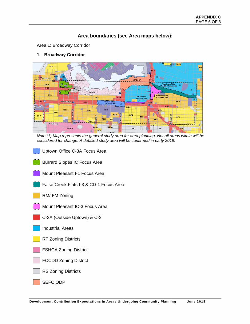
APPENDIX C PAGE 6 OF 6
Development Contribution Expectations in Areas Undergoing Community Planning June 2018
Area boundaries (see Area maps below):
Area 1: Broadway Corridor
1. Broadway Corridor
Note (1) Map represents the general study area for area planning. Not all areas within will be considered for change. A detailed study area will be confirmed in early 2019.
Uptown Office C-3A Focus Area Burrard Slopes IC Focus Area Mount Pleasant I-1 Focus Area False Creek Flats I-3 & CD-1 Focus Area RM/ FM Zoning Mount Pleasant IC-3 Focus Area C-3A (Outside Uptown) & C-2 Industrial Areas RT Zoning Districts FSHCA Zoning District FCCDD Zoning District RS Zoning Districts SEFC ODP