report - nasa · 2013-08-30 · this final report summarizes activities conducted by the principal...
TRANSCRIPT

NASA-CR-196478 . ~^c£
Report
To The
NATIONAL AERONAUTICS AND SPACE ADMINISTRATION
-AMES RESEARCH CENTER -
FINAL REPORT
for
GRANT NAG 2-700
SEARCH FOR EXTRATERRESTRIAL INTELLIGENCE/
HIGH RESOLUTION MICROWAVE SURVEY
TEAM MEMBER
Paul G. Steffes, Principal Investigator
Report Period: March 1,1991 through August 31,1994
Submitted by
Professor Paul G. SteffesSchool of Electrical and Computer Engineering
Georgia Institute of TechnologyAtlanta, Georgia 30332-0250
telephone: (404) 894-3128e-mail: [email protected]
(NASA-CR-196478) SEARCH FOREXTRATERRESTRIAL INTELLIGENT/HIGH "95-13026RESOLUTION MICROWAVE SURVEY TEAMMEMBER Final Report, l Mar. 1991 - ,, ,
T3icSr?- ir; <Geor9ia inst- °f
G3/55 0019818
https://ntrs.nasa.gov/search.jsp?R=19950006613 2018-07-13T00:52:58+00:00Z

TABLE OF CONTENTS
I. INTRODUCTION AND SUMMARY 1
II. DEVELOPMENT OF A DATA BASE OF SPACEBORNE TRANSMITTERS 4
III. INVOLVEMENT IN PLANNING AND CONDUCT OF OBSERVATIONS 5
IV. CONCLUSION 6
V. REFERENCES 6
VI. APPENDIX 7

I. INTRODUCTION AND SUMMARY
This Final Report summarizes activities conducted by the Principal Investigator and his students
during the three years of the NASA High Resolution Microwave Survey (HRMS). As a (HRMS)
Team Member with primary interest in the Sky Survey activity, this investigator attended nine
Investigator Working Group (IWG) meetings and traveled independently to conduct experiments
or present results at other meetings (See Table 1). As a member of the IWG, the investigator'smajor activity involved evaluating the effects of spaceborne radio frequency interference (RFT) on
both the SETI Sky Survey and Targeted Search. A key accomplishment has been development of
a database of all unclassified earth or biting and deep space transmitters, and development of
accompanying search software, which provides to the observer information about potential sources
of interference and gives complete information regarding the frequencies, positions and levels of
interference generated by these spacecraft A complete description of this search system (called
MRS, or HRMS RFI Search) is given in Section n of this report. Other key accomplishments
have included development of a 32,000 channel Fast-Fourier-Transform Spectrum analyzer for use
in studies of interference from satellites (Tatem and Steffes, 1993) and in a 1.4 mm SET!
observational study (Steffes and DeBoer, 1994). The last revision of HRS has now been
distributed to the extended radio astronomy and SETI community. Its usefulness has beendemonstrated by the large number of users (see Appendix A).
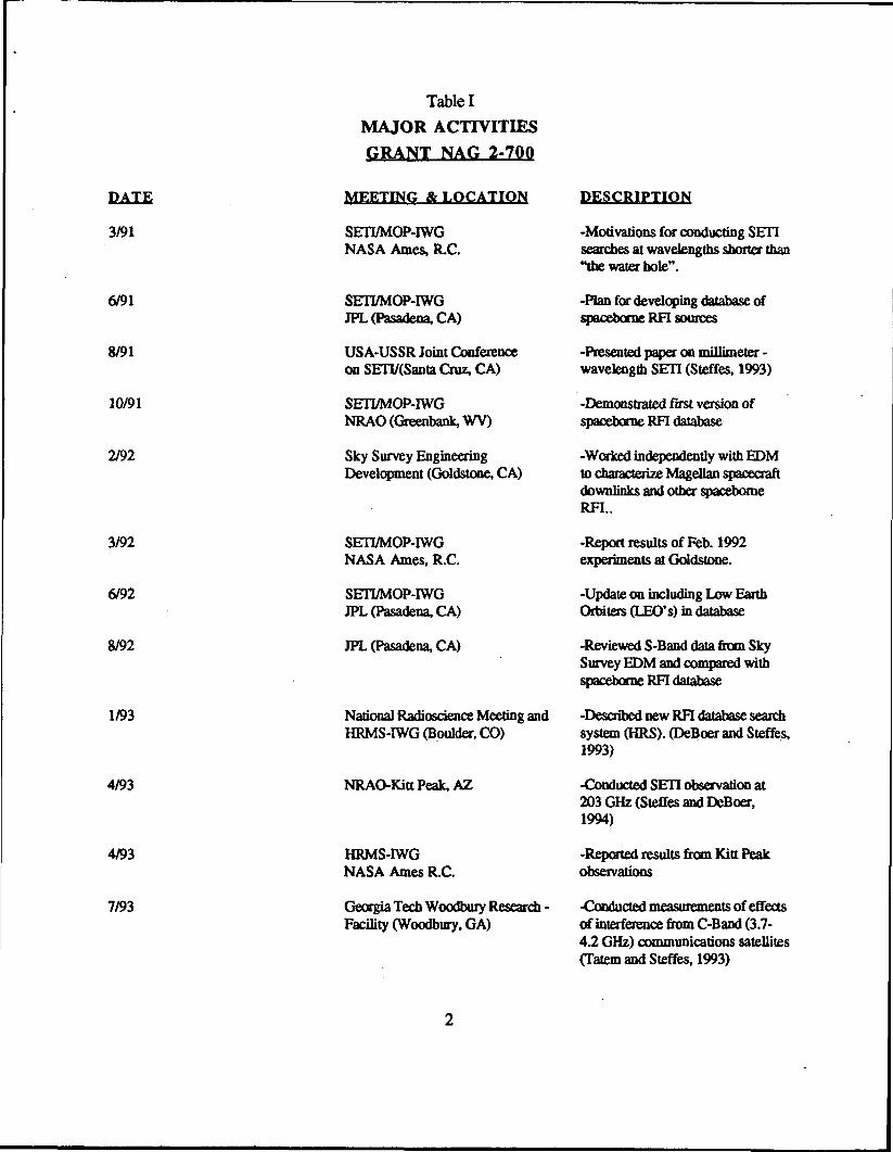
Table I
MAJOR ACTIVITIES
GRANT NAG 2-700
DATE
3/91
6/91
8/91
10/91
2/92
3/92
6/92
8/92
1/93
4/93
4/93
7/93
MEETING & LOCATION
SETI/MOP-IWGNASA Ames, R.C.
SETI/MOP-IWGJPL (Pasadena, CA)
USA-USSR Joint Conferenceon SETI/(Santa Cruz, CA)
SETI/MOP-IWGNRAO (Greenbank, WV)
Sky Survey EngineeringDevelopment (Goldstooe, CA)
SETI/MOP-IWGNASA Ames, R.C.
SETI/MOP-IWGJPL (Pasadena, CA)
JPL (Pasadena, CA)
National Radioscience Meeting andHRMS-IWG (Boulder. CO)
NRAO-KittPeak,AZ
HRMS-IWGNASA Ames R.C.
Georgia Tech Woodbury Research -Facility (Woodbury, GA)
DESCRIPTION
-Motivations for conducting SET!searches at wavelengths shorter than"the water hole".
-Plan for developing database ofspaceborne RFI sources
-Presented paper on millimeter -wavelength SETI (Steffes, 1993)
-Demonstrated first version ofspaceborne RFI database
-Worked independently with EDMto characterize Magellan spacecraftdownlinks and other spaceborneRFI..
-Report results of Feb. 1992experiments at Goldstone.
-Update on including Low EarthOrbilers (LEO's) in database
-Reviewed S-Band data from SkySurvey EDM and compared withspaceborne RFI database
-Described new RFI database searchsystem (HRS). (DeBoer and Steffes,1993)
-Conducted SETI observation at203 GHz (Steffes and DeBoer,1994)
-Reported results from Kitt Peakobservations
•Conducted measurements of effectsof interference from C-Band (3.7-42 GHz) communications satellites(Tatem and Steffes, 1993)
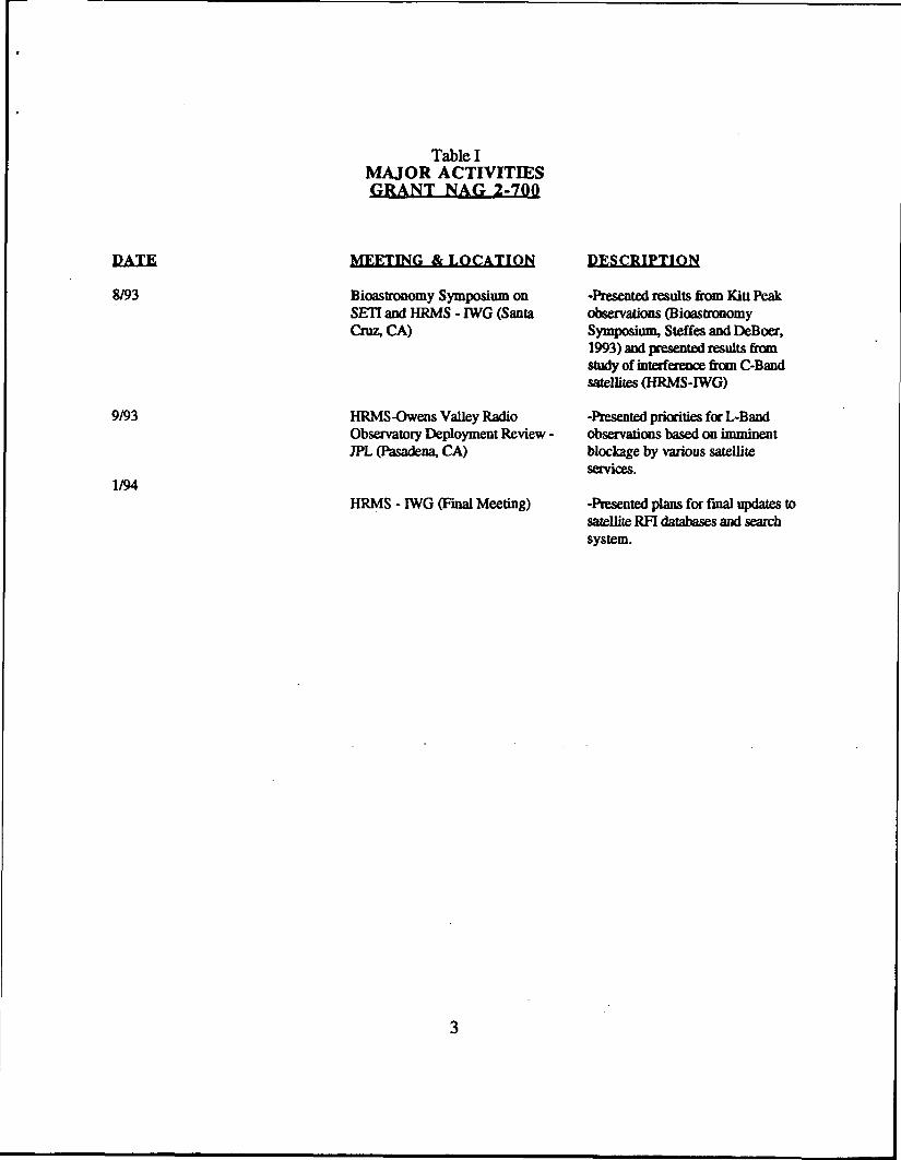
Table IMAJOR ACTIVITIESGRANT NAG 2-700
DATE MEETING & LOCATION DESCRIPTION
8/93 Bioastrooomy Symposium on -Presented results from Kitt PeakSET! and HRMS - IWG (Santa observations (BioastronomyCruz, CA) Symposium, Steffes and DeBoer,
1993) and presented results fromstudy of interference from C-Bandsatellites (HRMS-IWG)
9/93 HRMS-Owens Valley Radio -Presented priorities for L-BandObservatory Deployment Review - observations based on imminentJPL (Pasadena, CA) blockage by various satellite
services.1/94
HRMS - IWG (Final Meeting) -Presented plans for final updates tosatellite RFI databases and searchsystem.
II. DEVELOPMENT OF DATABASE OF SPACEBORNE TRANSMITTERS
Over the 3 year life of the NAS A-HRMS Investigator Working Group (IWG), the Georgia Tech
group developed a database of all non-classified satellites, giving frequencies and orbitalparameters on each. The data was derived and is maintained from eight sources:
1) "World Satellite Annual", and the quarterly "World Satellite Transponder Loading
Reports" (published by Mark Long Enterprises, Inc.). This includes allgeostationary, and many low-earth orbiting (LEO) commercial satellites.
2) "The Satellite Situation Report" (published by Project Operations Branch,
NASA/GSFC). This document includes all earth orbiting spacecraft, but has only
limited information on transmitting frequencies.
3) "The Space Frequency Coordination Group (SFCG) Database." Maintained by Dr.
Luis Vadillo (INTA/Spain), this includes both earth orbiting and deep-space
spacecraft which are governmentally owned.
4) The "Communications Center" (Clarksburg, MD) database. This includes all
governmental and non-governmental geostationary spacecraft
5) "AFTT Satellite Data Base", maintained by T.S. Kelso, Air Force Institute of
Technology. Contains orbital elements for all spacecraft, available electronically via
internet
6) "Space 2000" Database, produced by Space Analysis and Research, Inc., Colorado
Springs, CO.
7) "The NRAO Database", maintained by Dr. Wesley Sizemore, NRAO-Green Bank,
WV.
8) Published updates in journals such as "Satellite Communications" and "Via
Satellite."
All of the above information (except for #3) has been integrated into a single database known as

GEOSAT. GEOSAT currently contains 551 satellites, including 241 geostationary and 310 low
earth orbiting satellites. Since the orbital parameters for the low-earth orbiting satellite do change,
we have updated all of the "two-line orbital elements" using the NASA-Goddard database.
A second database, known as SSDB is derived from the Space Frequency Coordination Group
(SFCG) database (#3, above). It contains 219 government-owned spacecraft Searches of bothGEOSAT and SSDB are conducted with a top-level search system called HRMS RFI Search
(HRS). HRS search parameters consist of a sky window in right ascension/declination or
azimuth/elevation, and a frequency range. The observer's location, as well as the date and time
(UT) of the observation, are likewise entered. The spacecraft found to lie within the search space
are written to an ASCII output file, along with the search parameters and the spacecraft
characteristics. The latest edition of HRS (together with the databases) was sent to the user group
(approximately 25 users, see Appendix A) in June 1994. Its revisions are significant, especially
with the increasing number of L-Band mobile satellite systems, which will pose a definite obstacle
to future radio astronomical and SET! observations.
III. INVOLVEMENT IN PLANNING AND CONDUCT OF OBSERVATIONS
During the September 1993 exercise of planning for the HRMS Sky Survey/Summer 1994 OVRO
campaign (L-Band), it became clear how important knowledge of the developing spaccborne RFI
problem would be in scheduling observations. While the Sky Survey has now been cancelled,
many of the lessons learned about approaches to scheduling will be important for Project Phoenix,
the private-sector continuation of the Targeted Search. For example, the Optus B1 satellite has
now been launched and provides an L-Band transponder with total downlink flux levels reaching
3.7 x 10⁻¹² watts per square meter in the 1545-1559 MHz band, over the entire continent of
Australia. This can be 60 dB to 120 dB above the detection threshold of the Targeted Search,
depending on how much spectral spreading is used. Since studies conducted under this grant by
Tatem and Steffes (1993) have shown that such transmissions are detectable when the receiving
antenna is pointed over 150 beam widths away from the satellite, the risk of complete spectral
blockage is significant. Usage of the Optus B1 L-Band system is currently quite low, but is
expected to grow quickly. It will be necessary to evaluate the usage levels, and decide whether this
spectral range can be observed BEFORE the usage level becomes excessive, and the ability to
observe is lost forever. Likewise, if the usage level is excessive, this should be determined before
scheduling of future observations, since the number of detections would probably overwhelm a
system and waste valuable telescope time. Such studies have been a major part of this
investigation.
In addition, a SETT search of 40 solar-type stars was conducted at the 203 GHz positronium,
hyperfine resonance using the NRAO-Kitt Peach, AZ 12-meter radio telescope (Steffes and
DeBoer, 1994). Many of the techniques used in studying the problem of spaceborne RFI wereused in this observation.
IV. CONCLUSION
Despite the premature cancellation of the NASA-HRMS Program, the techniques and databases
developed by this investigation will serve to make future SETT observations, and other radio
astronomical observations, more effective by predicting potential sources of spaceborne radio
frequency interference (RFI). Its future use in radio astronomy and SET! will be a lasting legacy
of the HRMS Program. Similarly, the one journal paper and four conference publications will
serve to document both the observational work and RFI studies conducted to date, and will be very
useful to future programs.
V. REFERENCES
DeBoer, D.R. and P.O. Steffes 1993. The Georgia Tech Spaceborne Transmitter Database and itsuses in SETT and Radio Astronomy. International Union of Radio Science Programs andAbstracts: 1993 National Radio Science Meeting, pg. 224. (Presented January 8,1993; Boulder,CO)
Steffes, P.O. 1993. The Potential for Millimeter-Wave SETT. Third Decennial USA-USSRConference on SETT - A.S.P. Conference Series vol. 47. pp. 367-371. (Presented August 9,1991; Santa Cruz, CA)
Steffes, P.G. and D.R. DeBoer 1993. A SETT Search of Nearby Solar-type Starts at the 203-GHzPositronium Hyperfine Resonance. Program of the Bioastronomy Symposium: Progress in theSearch for Extraterrestrial Life, pg. 30. (Presented August 17,1993; Santa Cruz, CA)
Steffes, P.G. and D.R. DeBoer 1994. A SETT Search of Nearby Solar-Type Starts at the 203-GHZ Positronium Hyperfine Resonance. fcarus!07. pp. 215-218.
Tatem, R.B. and P.G. Steffes 1993. Impact of Satellite Radio Frequency Interference (RFI) onthe High Resolution Microwave Survey (HRMS) Sky Survey at C-Band Frequencies. Appendixto Semiannual Status Report #5 for Grant NAG2-700 to the NASA Ames Research Center.Appendix C.

APPENDIX A
*** DISTRIBUTION LIST ***
HRHS RFI SEARCH DATABASE
till Brundage•'requency CoordinatorIRAQ'.0. Box 0;ocorro, NM, 87801
vmail: nbrundagapotaris.cv.nrso.edutotes: Version 2.2 on 9/9/1993
lichard Lacasse)igital Engineer4RAO'.0. Box 23reen Bank, WVA 24944-0002;304) 456-2109
totes: Version 2.2 on 9/9/1993
Suillermo Lemarchand'hysicistJniversity of Buenos Aires
:.c. 8 - Sue. 25,1425-Bs. As., Argentina
j-mail: Iemar3dcfcen.edu.ar54-1-774-066754-1-786-8114
totes: Version 2.2 on 9/9/1993
Dan Uerthimer\ssoc. Development EngineerAstronomy Dept. end Space Sciences Lab.Jniversity of California at Berkeley3erkeley, CA 94720(415) 642-9222(415) 642-6997(415) 848-2179
Motes: Version 2.2 on 9/9/1993
Wayne L. Bowman, Jr.Project Engineer660 Engineering Drive, Technology Park/AtlantaP.O. Box 7700Morcross, GA 30091-7700(404) 263-9200 Ext. 4315
Motes: Version 2.2 on 9/9/1993
Wesley A. SizemoreNRAOP.O. Box 2Green Bank, W VA 24944-0002(304) 456-2107
e-mail: usizemoreapolaris.cv.nrao.eduNotes: Version 2.2 on 9/9/1993
Larry Van HornGrove EnterprisesP.O. Box 98Brasstown, NC 28902(704) 837-9200
Notes: Version 2.2 on 9/15/1993
Jim CordesAstronomy DepartmentSpace Science BuildingCornell UniversityIthaca, NY 14853-6801(607) 255-0608
e-mail: cordesaastrosun.tn.cornell.eduNotes: Version 2.2 on 9/16/1993
Mike DavisDirector, Arecibo ObservatoryP.O. Box 995Arecibo, PR 00613(809) 878-2612
e-mail: mikeaaosun.naic.edue-mail: mdavis3naic.bitnetNotes: Version 2.2 on 9/16/1993
Dayton JonesNail Code 238-700Jet Propulsion Laboratory4800 Oak Grove DrivePasadena, CA 91109(818) 354-7774
e-mail: dj3bllac.jpl.nasa.gov
Jill C. TarterSETI Project ScientistNASA Ames Research CenterHail Stop 244-1Moffett Field, CA 94035-5830(415) 604-5727
e-mail: tarter3bkyast.berkeley.eduNotes: Version 2.2 on 9/16/1993
Dick Thompson
e-mail: athompsoapotaris.cv.nrao.eduNotes:
Tom Gergely
e-mail: tgergely3note.nfs.govNotes:
William Baan
e-mail: willem3naic.eduNotes:
Dewey Ross
e-mail: dross3polaris.cv.nrao.eduNotes:
R.S. Roger
e-mail: rsr3drao.nrc.caNotes:
Vivek Dhawan
e-mail: vdhawan3polaris.cv.nrao.eduNotes:
Ted Seling
e-mail: tvs3deimos.caltech.eduNotes:
OFPAGE ft
-APPENDIX B-
School of Electrical Engineering
Georgia Institute of TechnologyAtlanta, Georgia 30332-0250USAFax 404«853'9171
Tel: (404)894-3128
June 8, 1994
Dear Colleague:
Enclosed is a diskette and an updated instruction manual for the Georgia Techdatabase of spaceborne transmitters known as MRS (tlRMS BFI Search). Thedatabase has been substantially updated since last year's revision, and the searchsoftware itself has been made more easy to use. Contained in the database are over750 spacecraft, with updated orbital elements for those not in geostationary orbits.While the diskette has been set up in a DOS format, the software can be run in almostany environment (UNIX, etc.). Installation can be accomplished by simply typing"install".
Development of this database has been made possible by the NASA - Search forExtraterrestrial Intelligence/High Resolution Microwave Survey Program under GrantNAG2-700 from NASA Ames Research Center. Since NASA's SETI activity has nowterminated, this will be the last update for a while. However, we expect the usefulnessof this software for planning both radio astronomical and SETI observations to remainstrong for at least a year or more. In the future, we hope to obtain support to continuethe maintenance and upgrades of this database, from other sources.
Questions regarding MRS can be directed to myself, or students, Dave DeBoer andLewis Roberts, who have worked very diligently on its development.
Sincerely,
Paul G. SteffesProfessor
PGS: sr
Enclosures
An Equal Education and Employment Opportunity Institution A Unit of the University System of Georgia

HRMS RFI Search (HRS)
David R. DeBoer, Lewis Roberts
June 1, 1994
Contents
1 Introduction 1
2 Installation and Operation 1
3 More on OTHER and HELP 6
4 Incorporating New Data Into HRS 8
5 COMl And COM2 Orbital Specifications 85.1 Keywords and Format 8
5.1.1 GEOSAT 85.1.2 SSDB 10
5.2 Low Earth Orbit Parameters 10
1 Introduction
This document contains the manual for HRMS RFI Search (HRS). HRS is adatabase search program that utilizes data (primarily commercial geostation-ary) compiled at the Georgia Institute of Technology (hereafter referred to asGEOSAT) and a database of government owned satellites compiled by the SpaceFrequency Coordination Group (hereafter referred to as SSDB).
2 Installation and Operation
To install HRS and the associated databases (SSDB and GEOSAT) onto yourhard drive insert the diskette labeled 'COMPLETE INSTALLATION' into yourdisk drive and simply type 'install' at the drive prompt (A:\ or B:\). Thiswill invoke an installation utility routine which will allow the user to place acopy of HRS in a chosen directory. The default directory is C:\HRMS. Thiswill place a copy of HRS in the directory C:\HRMS\HRS, a copy of SSDB in
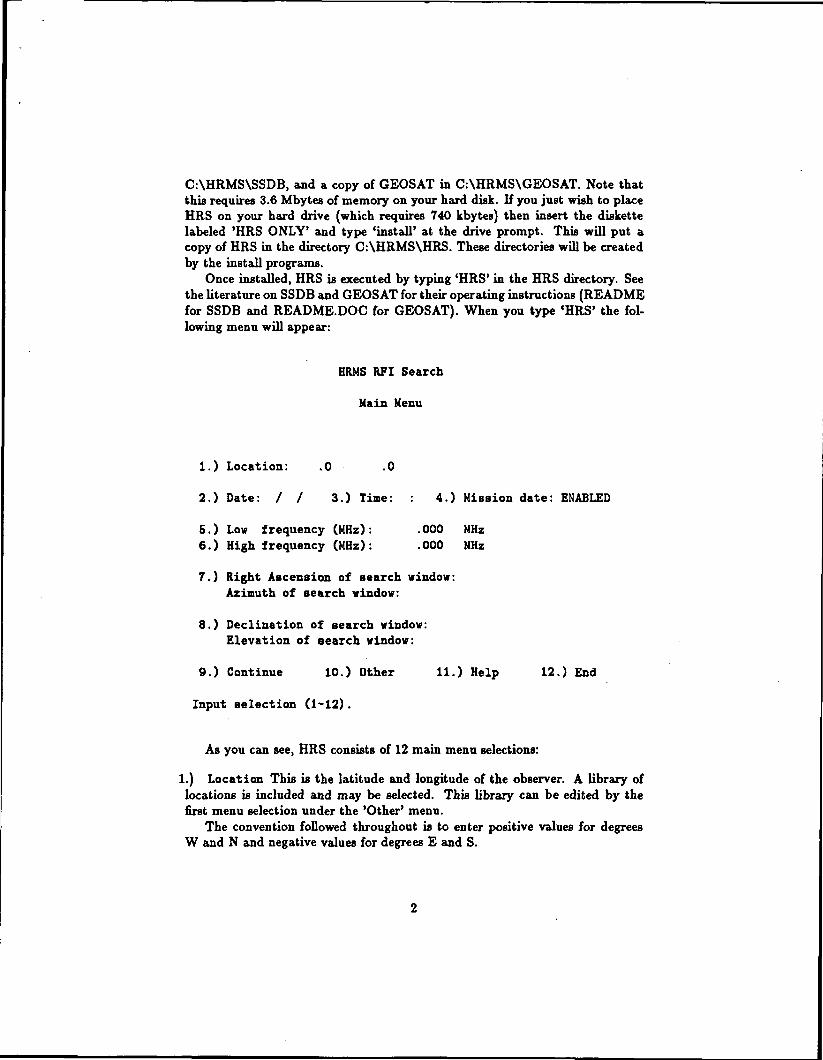
C:\HRMS\SSDB, and a copy of GEOSAT in C:\HRMS\GEOSAT. Note thatthis requires 3.6 Mbytes of memory on your hard disk. If you just wish to placeHRS on your hard drive (which requires 740 kbytes) then insert the diskettelabeled 'HRS ONLY' and type 'install' at the drive prompt. This will put acopy of HRS in the directory C:\HRMS\HRS. These directories will be createdby the install programs.
Once installed, HRS is executed by typing 'HRS' in the HRS directory. Seethe literature on SSDB and GEOSAT for their operating instructions (READMEfor SSDB and README.DOC for GEOSAT). When you type 'HRS' the fol-lowing menu will appear:
HUMS RFI Search
Main Menu
1.) Location: .0 .0
2.) Date: / / 3.) Time: : 4.) Mission date: ENABLED
5.) Low frequency (MHz): .000 MHz6.) High frequency (MHz): .000 MHz
7.) Right Ascension of search window:Azimuth of search window:
8.) Declination of search window:Elevation of search window:
9.) Continue 10.) Other 11.) Help 12.) End
Input selection (1-12).
As you can see, HRS consists of 12 main menu selections:
1.) Location This is the latitude and longitude of the observer. A library oflocations is included and may be selected. This library can be edited by thefirst menu selection under the 'Other' menu.
The convention followed throughout is to enter positive values for degreesW and N and negative values for degrees E and S.

2.) Date The date of observation is input in the format MMDDYYYY, e.g.01031992 for January 3, 1992. You will be asked if you wish to use today's dateand if so this will be read from the DOS utility.
3.) Time The time (Universal Time) of the observation is input in the formatHHMM, e.g. 2030 for 8:30 p.m.. You will be asked if you wish to use the currenttime and if so this will be read from the DOS utility. The number of hours toget UT from local time will automatically be added. This function will statewhat the conversion to UT is and ask if that is correct-if not you may changeit.
4.) Mission date The mission date option has two settings: ENABLED andDISABLED. If enabled it will read the SOM (Start Of Mission) and EOM(End Of Mission) from the database and only include the satellites currentlyoperational (or at least those that the database thinks are currently operational).For DISABLED it obviously does not. Note for GEOSAT there is only an SOMentry so EOM is assumed eternity. Also, this function checks the year only.
5.) Low frequency (MHz) The lower limit of the frequency search window isentered at this choke, in MHz. Each database entry has a lower and upperfrequency value for each transponder (a center and bandwidth for SSDB) andif any portion of this range falls within the search window it is passed to thenext criterion of position.
6.) High frequency (MHz) The upper limit of the frequency search window isentered at this choice.
7.) Right Ascension of search window/Azimuth of search window Whenthis selection is chosen you will be prompted to select either a window in R A/Decor Az/El. The appropriate parameters for minimum and maximum values arethen entered in HHMMSS for RA min/max or decimal degrees for Az min/max.If no orbital parameters exist within the database (or no subsatellite points forgeostationary satellites) then frequency is the only criterion.
8.) Declination of search window/Elevation of search window The Dec-lination or Elevation minimum and maximum values are entered upon this choicein decimal degrees. If a window in R A/Dec or Az/El has not yet been chosenyou will be prompted to choose at this time. Note that for declination, degreessouth are entered as a negative number and degrees north as a positive number.
9.) Continue This option will begin the database search with the given param-eters. The output will be written to an ASCII file named as the search time withthe tag OUT, e.g. the output file for a search at 8:30 pm would be 2030.OUT.There is a header with the search parameters followed by a list of the satellitesfound to match the criteria. As a match is found the satellite name is writtento the screen.
10.) Other Other contains various helpful astrometric routines and the locationlibrary editing facility. See Section 3 for more information.

11.) Help HRS maintains an on-line help with this option. The user may addto it by editing the HRS.HLP file with an ASCII editor. See Section 3 for moreinformation.
12.) End This option leaves the HRS system and returns the user to DOS.
The first eight menu selections constitute your search parameters. Aftermaking those selections, and for a window in RA/Dec, the main menu will looksomething like this:
HUMS RFI Search
Main Menu
1.) Location: 84.4 V 33.8 N
2.) Date: 10/13/1992 3.) Time: 13:42 4.) Mission date: DISABLED
5.) Low frequency (MHz): 1000.000 MHz6.) High frequency (MHz): 2500.000 MHz
7.) Right Ascension of search window: Olh 00m OOs - 22h 00m OOs
8.) Declination of search window: 15.00 S - 15.00 N
9.) Continue 10.) Other 11.) Help 12.) End
Input selection (1-12).
A typical output file will look something like this:
HRMS RFI Search
Date of search: 12-16-92 Time of search: 14:16:32
Date: 12/16/1992 UT: 18:15 LST: 18h 18m 53sLocation: 84.4 V 33.8 N Mission Date: ENABLEDLow frequency: 1000.000 MHzHigh frequency: 1500.000 MHzAzimuth Search Window: .00 - 360.00Elevation Search Window: 15.00 - 65.00

Frequency entry
Spacecraft: Inmarsat II Fl
Downlink 1:1500.000 - 1550.000 MHz
Downlink 2:3600.000 - 3621.000 MHz
Downlink 3:4180.000 - 4200.000 MHz
Downlink 4:.000 - .000 MHz
Launch Date: 10 /1991
EIRP: 39 dBw
EIRP: 24 dBw
EIRP: 24 dBw
EIRP: dBw
Antenna Coverage: Global beam
Comments: Orbit to be determined
Polariztion: RH
Polariztion: LH
Polariztion: LH
Polariztion:
Geostationary
Spacecraft: Gstar 3Subsatellite point: 93.0 tf
Launch Date: 9 /1988
Azimuth: 195.2 Elevation: 49.6Right Ascension: 17h 39m 35s Declination: 5.5 S
Downlink 1:11700.000 - 12200.000 MHzDownlink 2:1500.000 - 1650 000 MHz
Downlink 3:.000 - .000 MHz
Downlink 4:.000 - .000 MHz
EIRP: 38.5-50 dBw Polariztion: H/V
EIRP: 17 dBw Polariztion:
EIRP: dBw Polariztion:
EIRP: dBw Polariztion:
Antenna Coverage: CONUS, Alaska, Hawaii, Caribbean, and CentralAmerica
Comments: Currently in an inclined orbit.
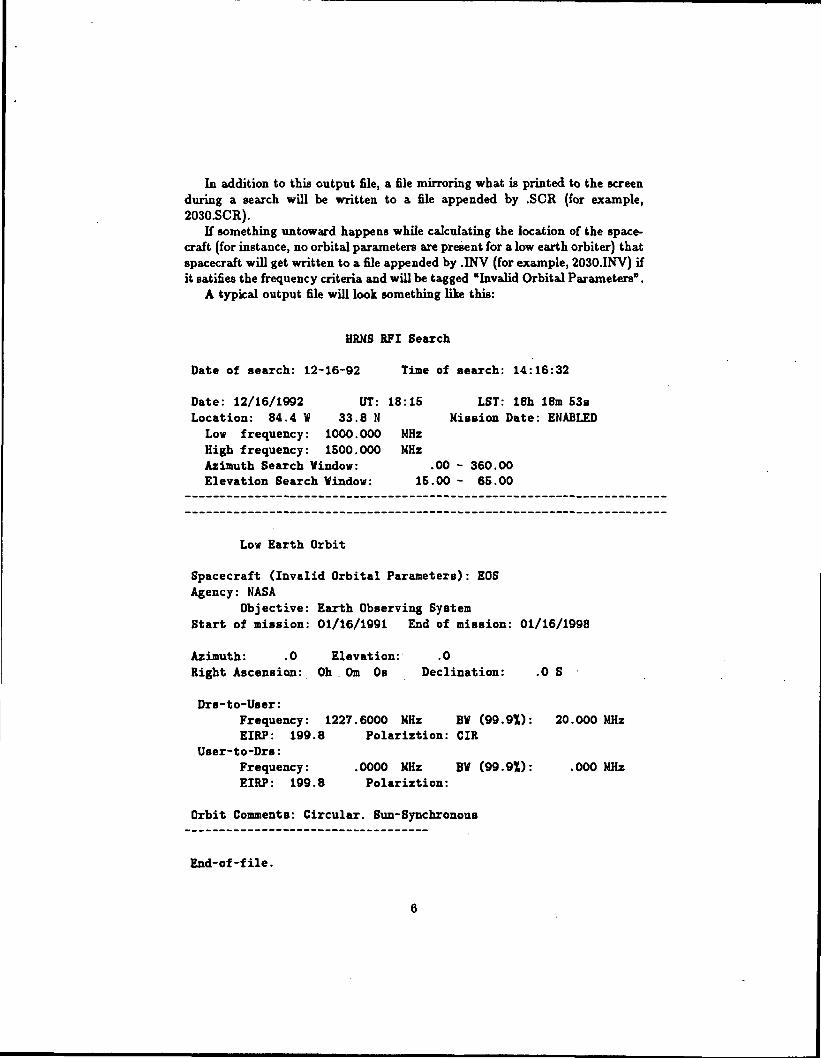
In addition to this output file, a file mirroring what is printed to the screenduring a search will be written to a file appended by .SCR (for example,2030.SCR).
If something untoward happens while calculating the location of the space-craft (for instance, no orbital parameters are present for a low earth orbiter) thatspacecraft will get written to a file appended by .INV (for example, 2030.INV) ifit satifies the frequency criteria and will be tagged "Invalid Orbital Parameters".
A typical output file will look something like this:
HUMS RFI Search
Date of search: 12-16-92 Time of search: 14:16:32
Date: 12/16/1992 UT: 18:15 LST: 18h 18m 53sLocation: 84.4 V 33.8 N Mission Date: ENABLED
Low frequency: 1000.000 MHzHigh frequency: 1500.000 MHzAzimuth Search Window: .00 - 360.00Elevation Search Window: 15.00 - 65.00
Low Earth Orbit
Spacecraft (Invalid Orbital Parameters): EOSAgency: NASA
Objective: Earth Observing SystemStart of mission: 01/16/1991 End of mission: 01/16/1998
Azimuth: .0 Elevation: .0Right Ascension: Oh . Om Os Declination: .0 S
Drs-to-User:Frequency: 1227.6000 MHz BV (99.9%): 20.000 MHzEIRP: 199.8 Polariztion: CIR
User-to-Drs:Frequency: .0000 MHz BV (99.9%): .000 MHzEIRP: 199.8 Polariztion:
Orbit Comment8: Circular. Sun-Synchronous
End-of-file.

In general, the philosophy haa been to be overly inclusive, if anything, andlet the operator discriminate the data.
3 More on OTHER and HELPOTHER contains several helpful (hopefully) routines to assist you in your RFIsearch. The OTHER menu looks like:
OTHER menu
1.) Edit location list2.) Calculate Local Sidereal Time from UT3.) Calculate UT from Local Sidereal Time4.) Calculate RA/Dec from Az/El6.) Calculate Az/El from RA/Dec6.) Calculate Az/El-RA/Dec from subsatellite point7.) Calculate Az/El-RA/Dec from orbital parameters8.) Calculate postion of the sun9.) Calculate positions of the planets10.) Process RA and Dec to new epoch11.) Return to Main Menu
Input selection (1-11).
These are all pretty much self-explanatory and you are prompted for inputs,so using it shouldn't be a problem. Most of the routines were adapted fromPeter Duffett-Smith's "Astronomy With Your Personal Computer" (CambridgeUniversity Press, 1985). OTHER is fairly well insulated from the MAIN menufunctions with the exception of option 7, which will change the value of latitudeand longitude of the observer in the MAIN menu.
The on-line help was included for completeness since HRS is pretty simpleand straight-forward to use. However, there are a few helpful tips in there. Forinstance, an Ac search window cannot straddle 360 degrees. Also, if you wishto view something ASCII while running HRS you could include it in the ASCIIHRS.HLP file.
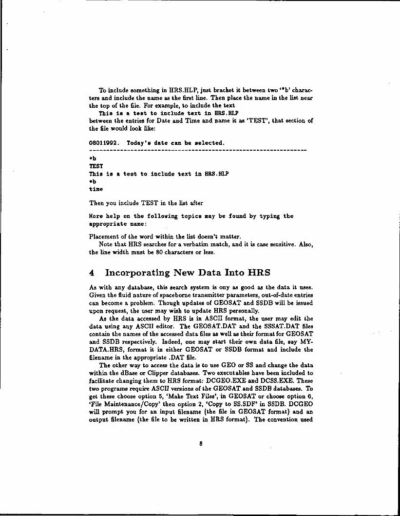
To include something in HRS.HLP, just bracket it between two '*b' charac-ters and include the name as the first line. Then place the name in the list nearthe top of the file. For example, to include the text
This is a test to include text in HRS.HLPbetween the entries for Date and Time and name it as 'TEST', that section ofthe file would look like:
08011992. Today's date can be selected.
*bTESTThis is a test to include text in HRS.HLP*btime
Then you include TEST in the list after
More help on the following topics may be found by typing theappropriate name:
Placement of the word within the list doesn't matter.Note that HRS searches for a verbatim match, and it is case sensitive. Also,
the line width must be 80 characters or less.
4 Incorporating New Data Into HRS
As with any database, this search system is ony as good as the data it uses.Given the fluid nature of spaceborne transmitter parameters, out-of-date entriescan become a problem. Though updates of GEOSAT and SSDB will be issuedupon request, the user may wish to update HRS personally.
As the data accessed by HRS is in ASCII format, the user may edit thedata using any ASCII editor. The GEOSAT.DAT and the SSSAT.DAT filescontain the names of the accessed data files as well as their format for GEOSATand SSDB respectively. Indeed, one may start their own data file, say MY-DATA.HRS, format it in either GEOSAT or SSDB format and include thefilename in the appropriate .DAT file.
The other way to access the data is to use GEO or SS and change the datawithin the dBase or Clipper databases. Two executables have been included tofacilitate changing them to HRS format: DCGEO.EXE and DCSS.EXE. Thesetwo programs require ASCII versions of the GEOSAT and SSDB databases. Toget these choose option 5, 'Make Text Files', in GEOSAT or choose option 6,'File Maintenance/Copy' then option 2, 'Copy to SS.SDF' in SSDB. DCGEOwill prompt you for an input filename (the file in GEOSAT format) and anoutput filename (the file to be written in HRS format). The convention used

is to change the tag to .HRS from .TXT. DCSS assumes an input filename ofSS.SDF and writes the output to SS.HRS.
Note that SSDB does not have a way to edit the orbital parameters as neededfor HRS. This must be done with an ASCII editor and, again, the format maybe found in the SSSAT.DAT file. GEOSAT includes orbital parameters in thecomment sections. For any orbital parameter editing see section 5.
5 COM1 And COM2 Orbital Specifications
5.1 Keywords and Format5.1.1 GEOSATGEOSAT was primarily designed to include geostationary spacecraft and there-fore all that was needed was the one subsatellite point to completely characterizethe location of the spacecraft. In order to incorporate other types of spacecraftsuch as low earth orbiters or deep space probes however we need further spec-ifications. The fields in the database which will contain this information arethe two COMMENT lines (referred to as COMl and COM2, respectively). TheCOM lines are formatted to hold only 50 characters so if you have to lose anynumbers make sure that they are the least significant digits. These fields willhave several reserved keywords and/or symbols as specified below.
1.) If the first character of COMl is the '&' character this will mean the space-craft is a low earth orbiter. Following Q in COMl should be the orbital param-eters of:
• Epoch in format YYDDD.dddddddd
• First derivative of mean motion / 2
• Second derivative of mean motion / 6
• Ballistic coefficient
• Inclination in degrees
and COM2 should contain the rest of the needed orbital parameters:
• Right ascension of ascending node in degrees
• Eccentricity
• Argument of perigee in degrees
• Mean anomaly
• Mean motion

(See section 5.2 for the meanings of these parameters.) They should be delimitedby a comma and proceeded by a colon. For example,
Q92045.70925411,-6.0E-8,4.5E-5,.10672E-4,99.1388:110.7968)9.485E-5,158.7714,201.3836,13.83679338:
2.) If the first ten characters of COM2 are 'Deep Space' then this is a deep spaceprobe. HRS then only checks the frequency but states in the output that it isa deep space probe.
S.) If the first four characters of COM2 are 'Freq' then this is only a frequencyentry and HRS only checks the frequency and states this in the output. If theCOM2 entry is none of the above but the direction entry is the '*' characterinstead of 'E' or ' W then this is also only a frequency check and will be statedas such in the output.
4.) If none of these cases apply then the satellite is a geostationary satellite.
5.1.2 SSDB
SSDB has an orbit specification symbol (ORBIT) whereG = GeostationaryA = Low Earth OrbitB = Deep SpaceF = Frequency entry
which determines what sort of orbit the spacecraft is in. The 'G', 'A* and 'B'designations are internal to SSDB but 'F' is unique to HRS and would haveto be included by using an ASCII editor in the SS.HRS datafile (SSDB willnot allow it). If the spacecraft is a low earth orbiter (A) then the parametersare included in two COM statements identical to the two COM statements inGEOSAT, which should be appended to the end of the data line in the SS.HRSfile. Note that these are also formatted to be 50 characters apiece and thatthe format is the same as the low earth orbit format for GEOSAT. You shouldignore the orbital parameter entries in the SS program itself.
5.2 Low Earth Orbit ParametersThese numbers follow the NORAD/NASA 2-Line model. These numbers aregenerated by the SGP4/SDP4 model. The two line format is:
EPOCH XNDT20 1 2 BSTAR 3/ \ /- \ /- \A /- V\
1 11080U 78098 A 9221S.70925411 -.00000006 00000-0 10672-4 0 98412 11080 99.1388 110.7968 0009485 158.7714 201.3836 13.83679338695555
\ / \ / \ / \ / \ / \ /XINCL XNODEO EO OMEGAO XMO XNO
10

1 - XNDD60 (significand) 2 « IEXP (XNDD60 exponent)3 - IBEXP (BSTAR exponent)
For quantities in scientific notation, an implied decimal pointis located just before the aignificand. In the example above,BSTAR - .10672E-4.
EPOCH - YYDDD.dddddddd. where 92001.00000000 - 1992 Jan 1 Oh UTCXNDT20 - (1st derivative of mean motion) / 2XNDD60 " (2nd derivative of mean motion) / 6BSTAR - ballistic coefficient (mass/cross section)XINCL - inclinationXNODEO = right ascension of ascending nodeEO - eccentricityOMEGAO " argument of perigeeXMO m mean anomalyXNO m mean motion
Note that in the 2-line format the decimal is assumed for BSTAR, XNDD60and for the eccentricity (EO) and that the exponents for BSTAR and XNDD60are separate. This is not the case for the COM1/COM2 specifications-they are"real" numbers. That is:XNDD6O = [XNDD6O] x io\^XP\-5BSTAR = (BSTAR] x \Q\IBEXP\-IEO = [EO] x 1(T7
where the square brackets refer to NORAD/NASA variables. The rest of thenumbers can be entered as typed in the 2-line format.
11