report of investigation 15 - michigan.gov · information on the subsurface geology of barry county....
TRANSCRIPT

Report of Investigation 15 – Page 1 of 18
Geological Survey
Report of Investigation 15
SUBSURFACE GEOLOGY OF BARRY COUNTY, MICHIGAN
by
Richard T. Lilienthal
Illustrations by Author
Lansing
1974
Contents FOREWORD......................................................................2 ABSTRACT .......................................................................2 INTRODUCTION ...............................................................3 GEOLOGIC SETTING.......................................................3 MINERAL RESOURCES...................................................3
Surface Minerals ............................................................3 Subsurface minerals. .....................................................4
STRATIGRAPHIC SEQUENCE........................................4 Pennsylvanian System...................................................5 Mississippian System.....................................................5
Bayport Limestone......................................................5 Michigan Formation. ...................................................5 Marshall Sandstone....................................................6 Coldwater Shale .........................................................6 Sunbury Shale ............................................................6 Berea-Bedford formations ..........................................6
Devonian System ...........................................................6 Ellsworth Shale...........................................................6 Antrim Shale ...............................................................7 Traverse Group ..........................................................7 Rogers City-Dundee Limestone .................................7 Detroit River Group.....................................................7 Bois Blanc Formation .................................................8
Silurian System ..............................................................8 Bass Islands Group ....................................................8 Salina Group...............................................................8 Niagara Group ..........................................................10 Cataract Group .........................................................10
Ordovician System .......................................................10 Cincinnatian Series...................................................10 Trenton Group ..........................................................10 Black River Group ....................................................10 St. Peter Sandstone .................................................11 Prairie du Chien Group.............................................11
Cambrian System.........................................................11 Trempealeau Formation ...........................................11 Munising Formation ..................................................12
STRUCTURAL GEOLOGY .............................................12 POROUS INTERVALS....................................................12 REFERENCES AND FURTHER READING ...................16
Illustrations
Figures Index map ...................................................................................2
Figure 1A. Bedrock Geology - Barry County, Michigan..............4
Figure 1. Stratigraphic Correlation – Barry County, Michigan. Quaternary-Pennsylvanian and Mississippian Systems ......7
Figure 2. Stratigraphic Correlation – Barry County, Michigan. Devonian & Upper Silurian Systems ...................................9
Figure 3. Stratigraphic Correlation – Barry County, Michigan. Silurian System ...................................................................9
Figure 4. Stratigraphic Correlation – Barry County, Michigan. Upper and Middle Ordovician Correlation and Lower Ordovician and Cambrian Stratigraphic Section................11
Figure 5. Structure Contours on the Top of the Traverse Limestone..........................................................................14
Figure 6. Structure Contours on the Top of the Dundee Limestone..........................................................................14
Figure 7. Structure Contours on the Top of the A-2 Carbonate14
Figure 8. Structure Contours on the Top of the A-1 Carbonate15
Figure 9. Structure Contours on the Top of the A-1 Carbonate15
Figure 10. Structure Contours on the Top of the Trenton Group..........................................................................................16
Figure 11. Structural Cross Section – Barry County, Michigan. Odessa Twp. – Ionia County to Martin Twp. – Allegan County...............................................................................16
Figure 12. Structural Cross Section – Barry County, Michigan. Yankee Springs Twp. – Barry County to Maple Grove Twp. – Barry County ..................................................................16
Figure 13. Significant Porosity Zones. Traverse Limestone ....16
Charts Chart 1. Stratigraphic Succession in Michigan, Chart 1, 1964 ...5

FOREWORD The Geological Survey Division collects, interprets, and disseminates basic information on the geology and mineral resources of Michigan. Oil and gas have been important Michigan resources for nearly 50 years. Through 1973 more than 628 million barrels of oil an*d nearly 800 billion cubic feet of natural gas have been produced from several hundred fields scattered throughout counties of the Southern Peninsula. Annual production is again on the increase because of new oil and gas discoveries in older formations heretofore sparsely explored in many parts of the Peninsula.
One of the numerous activities of the Petroleum Geology Unit, Oil and Gas Section, is the preparation of reports useful in the search for new accumulations of oil and gas. In planning a new series of county reports, Barry County was chosen as a convenient starting point; not because it has greater or lesser oil and gas possibilities than other relatively unexplored counties of the State. This report, the first of the series, presents basic and practical information on the subsurface geology of Barry County. The intent is to provide a geologic framework that others may adapt or adjust to their own needs, and that will be helpful in the development of such projects as oil and gas exploration, subsurface disposal of liquid wastes, location of salt-cavern storage areas, and in providing background information useful in forming land use policies. Arthur E. Slaughter State Geologist Geological Survey Division Department of Natural Resources Lansing, 1974
Index map showing location of Barry County within the Michigan Basin. The basin, mainly centered in the Lower Peninsula of Michigan, includes parts of eastern Wisconsin, northeastern Illinois, northern Indiana, northern Ohio, part of Ontario, Canada, and part of Michigan's Upper Peninsula. Map adapted from the Michigan Basin Geological Society Guidebook "Studies of the
Precambrian of the Michigan Basin," 1969.
SUBSURFACE GEOLOGY OF BARRY COUNTY, MICHIGAN
ABSTRACT In Barry County the sequence of strata ranges in age from the Pennsylvanian to the Cambrian. The entire succession of Paleozoic rock is roughly 300 million to 570 million years old. This stratigraphic sequence may be as much as 8000 feet thick in northern Barry and 7000 feet thick in the southern portion of the county. A thin veneer of glacial drift covers the bedrock and ranges in thickness up to about 400 feet. The bedrock is predominantly composed of the Michigan and Marshall formations with minor amounts of Saginaw Formation in the northeastern portion of the county and some Coldwater Shale in the southwestern part.
Mississippian strata are found throughout the subsurface of the county and the thickness varies from about 900 feet in the southwest to about 1500 feet in the northeast. Devonian rocks are encountered next, ranging in thickness from about 1350 feet in the northeast to about 1000 feet in the southwest. The Silurian system contains strata which range in thickness from about 1500 feet in the northeast to about 800 feet in the southwest. Ordovician rocks were penetrated entirely by only one well, showing a thickness of 1500 feet in the southern portion of the county. The Cambrian stratigraphic sequence was not entirely penetrated in this well, therefore it can only be surmised that about 2000 feet of strata may be present.
Concerning the structure of the strata in the county, the strike of the beds is in a northwest-southeast direction with a dip in a northeasterly direction toward the center of the basin. The strata, in most cases, thicken toward the northeast but one notable exception is the Niagara Group which thins in that direction. There are several zones where synclinal or sink-hole type depressions occur and they may be related to the leaching of salt followed by slumping of the overlying strata.
Several porosity zones occur in the rocks underlying the county. The most significant zones are found in the Traverse Limestone, Dundee-Detroit River interval, Niagara Group and the Cambrian sandstones. These zones, especially those in the Dundee-Detroit River strata and the Mt. Simon sandstones, are important as possible liquid waste disposal reservoirs which may become increasingly important in the future. These porosity zones also delineate where lost circulation may occur in rotary drilling.
Finally, in the development of a comprehensive land use policy for a single county or group of counties, it should be noted that all aspects of surface and subsurface geology should be taken into account.
Report of Investigation 15 – Page 2 of 18

Report of Investigation 15 – Page 3 of 18
INTRODUCTION Barry County, located in the southwestern quadrant of the Southern Peninsula, covers an area of 571 square miles or about 365,440 acres. Geologically, the county has not been studied in great detail. Knowledge of the subsurface geology as well as the surface geology is important in determining best land use in respect to development of the county's land and mineral resources on the surface and in the subsurface.
Numerous lakes, particularly in the southern half of the county, along with stream drainage systems are scattered among the glacial features of the land surface. Knowledge of the type and thickness of the glacial drift which blankets the entire county is useful in determining where ground-water resources may be located, where sand and gravel deposits may occur, or where sanitary landfills might best be located in respect to protection of surface and ground water resources or other surface values.
Knowledge of the subsurface geology can help determine the possibilities of oil and gas entrapment and in what areas and strata they are most likely to occur. It is also important to have an understanding of the subsurface geology (e.g. the bedrock and all deeper strata) so that subsurface strata can be properly evaluated for use as storage reservoirs for various liquid waste products and storage of natural gas or liquid hydrocarbons.
The dominant industry of Barry County is agriculture. According to the Michigan Statistical Abstract (Verway, 1974) there were 1301 farms which, in the aggregate, occupied nearly 56 percent of the land area in 1969. In 1967 there were also 39 manufacturing establishments, 27 of which employed from 1 to 19 people, 8 employing from 20 to 99 people, 1 in the 100-249 employee range, and 3 which employed over 250 workers. Mineral resources currently being extracted are sands and gravels, marl, and petroleum. In terms of mineral resource value, Barry County ranked 58th among Michigan counties in 1972 (Segall, 1973). The possibilities of further mineral development are good.
In 1972 the county's population was 39,900. By 1980 the population is projected to be 44,063 and by 1990 it is projected to be 50,271. Hastings, the largest city, had a population of 6,501 as of 1970 (Verway, 1974) and, on the basis of county population projections, it should also increase. Along with continued population growth, economic expansion will no doubt increase as will the need for additional recreational areas.
This report, mainly a subsurface investigation of rock strata underlying Barry County, provides basic and general geologic data. The intent is to provide useful mechanical log correlation sections, structure maps and other data helpful in oil and gas development or the evaluation of strata for liquid waste disposal, natural gas or other hydrocarbon storage which may have an effect on land use. In accomplishing the investigation, all available mechanical logs and driller's logs were studied along with
some well-sample sets obtained from oil and gas tests drilled in the county.
GEOLOGIC SETTING The area of this study is located in the southwestern part of the Michigan Basin. The Michigan Basin, a relatively shallow intracratonic structure, includes all of the Southern Peninsula and part of the Northern Peninsula and parts of Wisconsin, Illinois, Indiana, Ohio, and Ontario. It is bounded on the north by the Canadian Shield; on the east and southeast by the Algonquin and Findlay Arches; on the southwest by the Kankakee Arch; and on the west and northwest by the Wisconsin Arch and the Wisconsin Dome.
Barry County is everywhere covered with Pleistocene glacial drift which varies from 150-400 feet in thickness. Beneath this veneer of drift the bedrock is predominantly of Mississippian age (Fig. 1A, Shah, 1974). Some isolated areas of Pennsylvanian rock, however, are found in the northeastern portion of the county. The strike of the subsurface strata is basically northwest-southeast with the dip in a northeasterly direction and a thickening of most rock units toward the center of the basin.
Mississippian strata underlying most of the glacial drift is about 900 to 1500 feet thick. This is followed by 1000 to 1300 feet of Devonian age rocks. Silurian strata, the next sequence encountered, range in thickness from about 800 feet in the south to about 1500 feet in the north. The entire Ordovician sequence of strata was penetrated by only one well, located in the southern portion of the county, in which a thickness of 1500 feet was found. It is estimated from some of the wells in northern Barry County which penetrated the Glenwood Shale that the Ordovician sequence has a thickness of approximately 2000 feet in that area. The Cambrian sequence, although not penetrated entirely by any well in this or any nearby county, appears to have a thickness of at least 2000 feet above the Precambrian basement.
MINERAL RESOURCES
Surface MineralsIn this report surface minerals are the sands, gravels, clays and marls associated with the unconsolidated Pleistocene glacial drift, and the limestones, shales and gypsum which might be found as bedrock immediately below the glacial drift.
At the present time there are no quarry operations for limestone, shale or gypsum. Some gypsum is reported in records of wells which penetrated the Michigan Formation. But development of this or other bedrock resources has not been attempted and is hampered by thick, glacial drift overburden which makes development uneconomical at this time. Several sand and gravel and some marl deposits have been developed commercially and are in operation.

Surface minerals will become increasingly important resources in the future development of many areas of the State. In formulation of land use policies, consideration should be given to the development potential of these materials. Barry County is covered with a thick blanket of glacial drift mainly in the form of moraines, ground moraine and outwash plains. Sands and gravels are associated with the drift and marls with lake sediments. The glacial drift is also a source of fresh water supply as are the many lakes which dot the surface, mainly in the southern part of the county. Landfill sites for solid waste disposal should be delineated and chosen for least detrimental effect on ground and surface water supplies, and on other surface values.
Figure 1A. Bedrock map of Barry County, Michigan
Interpretation of bedrock geology of Barry County by Balkumar P. Shah, 1974. Sources of information include: 1) Oil and gas well logs and samples: Michigan Geological Survey; 2) Water well logs: Michigan Geological Survey; 3) Martin, H. M., 1936, The Centennial Geological Map of the Southern Peninsula of Michigan: Michigan Geological Survey.
Subsurface minerals. The subsurface mineral resources of Barry County are natural brines, rock salt (NaCl), and oil and gas contained in various rock layers underlying the region.
Natural brines which may have future economic value are found in several porous rock intervals, perhaps the most important are those in the Detroit River Group. The units that contain the salt for possible solution mining are the B Unit, A-2 Evaporite and the A-l Evaporite of the Salina Group. The thickest expanse of salt sections is in the central and northeastern portions of the county. Here they are encountered at a depth ranging from approximately 3000 feet in the central part to about 4000 feet in the
northeast. At the present time, however, there are no brines produced nor are there solution mining activities in the area.
Oil has been produced in Barry County since 1939. There have been four fields discovered. They are Hope, Johnstown, Thornapple, Sec. 4 and Freeport, all of which have produced from the Traverse Limestone Formation. At the present time Hope and Johnstown are the only fields still producing. Through 1973 Hope had produced a total of 641,976 barrels of oil and Johnstown, 33,253 barrels. Thornapple section 4 was abandoned in 1961 after producing a total of 2,716 barrels of oil. Freeport, after producing 19,229 barrels of oil, was abandoned in 1951 (Ells et al, 1974). With respect to oil or gas exploration Barry County has not been highly explored and other fields are apt to be found in the future. The Detroit River Group, the Salina-Niagaran and the Trenton-Black River rocks, as well as the Traverse Limestone, have oil and gas possibilities.
Thick Salina salt beds may be used for hydrocarbon storage in man-made caverns. There is one such cavern in the A-2 Evaporite currently being used for natural dry-gas storage. There are possibilities for gas storage other than in the A-2 Evaporite, i.e. the A-l Evaporite or the B Unit, or an oil or gas trap in any other rock strata which could be converted to storage.
Another use for certain subsurface strata is for brine or liquid waste disposal. The two zones which may best serve this purpose are porous intervals in the Detroit River Group and the Cambrian sandstones. One Cambrian sandstone brine disposal well has been drilled in connection with the development of an A-2 salt cavern for the Lacey Station gas storage project, Section 14, T.1N., R.8W. In the future these subsurface porous layers may be used for other disposal projects.
STRATIGRAPHIC SEQUENCE The sequence of Paleozoic strata present beneath Pleistocene glacial drift in Barry County includes rocks of Pennsylvanian, Mississippian, Devonian, Silurian, Ordovician and Cambrian age. Because of pre-Pleistocene erosion, most Pennsylvanian rocks and part of the Mississippian formations have been truncated. Pennsylvanian rocks are found immediately beneath the glacial drift in the northeast part of the county but are absent elsewhere. Mississippian rocks form the bedrock over the remaining part. The general distribution of bedrock formations is shown in Figure 1A. As inferred from other areas of Michigan having denser well control and thus more data, the bedrock surface is no doubt highly dissected by pre-glacial valleys, so outliers of Pennsylvanian and uppermost Mississippian rocks may be more common than shown on the bedrock map. Because of the irregular bedrock surface and glacial topography such as moraines, the glacial drift thickness may in some areas be more or less than the 150 to 400 feet recorded from well records used in this report.
Report of Investigation 15 – Page 4 of 18

The sequence of strata penetrated by wells is shown in Figures 1 through 4. The figures are essentially mechanical log correlation sections showing characteristic gamma ray curves associated with lithologies of the various formations. The basic lithology for the various strata is shown for two wells used in the sections. It should be mentioned that the lithologies of some strata will change to some extent from place to place in the county. Significant changes are reflected in the gamma ray curves. The correlation sections in each figure have been related to a convenient reference plane rather than a sea-level datum so as to avoid distortion. The terminology and formation "tops" used are essentially the same as used by subsurface geologists engaged in oil and gas exploration in Michigan. The official stratigraphic nomenclature and informal terms used in oil and gas exploration are shown in Chart 1. In this report the stratigraphic sequence is briefly discussed, beginning with the youngest rocks encountered beneath the glacial drift.
Pennsylvanian System Pennsylvanian rocks are generally divided into two divisions, the Grand River formation and underlying Saginaw formations. The Saginaw formation is the only Pennsylvanian strata represented in Barry County. It is found in the extreme northeastern quarter of the county and is of limited extent. The thickness of the Saginaw formation is approximately 50 feet in that area and consists predominantly of sandstone with some interbeds of shaly sand, sandy shale and shale. Because of pre-glacial truncation, the Grand River beds and most of the Saginaw is absent from the county.
Mississippian System Mississippian formations, in descending order, consists of the Bayport Limestone, Michigan Formation, Marshall Sandstone, Coldwater Shale, Sunbury Shale and a small amount of rock equivalent to the Berea and Bedford formations of eastern Michigan. The entire sequence of strata ranges in thickness from approximately 1500 feet in the northeastern part of the county to about 900 feet in the southwestern and western areas.
Barry County occupies a part of the Michigan Basin where a transition occurs between the Berea and Bedford, predominantly Mississippian age on the east side of the State, and the upper part of the Ellsworth basically of Devonian age. Whether this transition is a facies change as suggested by several geologists, or two separate basins or source areas of sedimentation as suggested by others has not yet been definitely resolved. Determining the exact boundaries between the formations both laterally and vertically is a problem not easily resolved, and this paper by no means solves it. An interpretation based on lithologic and mechanical log data, of the boundary between the formations in the Barry County area, is presented.
Bayport Limestone. The Bayport, the first Mississippian
formation encountered in Barry County, is generally a fairly thin formation with a thickness of 50 feet or less. This formation, named by Lane in 1899, consists of predominantly limestone with some beds of dolomite and sandy limestone. Toward the south, southwest, and west the Bayport thins and pinches out by erosional truncation. It also composes the bedrock in some northeastern areas of the county, but due to glacial erosion and modification these areas are isolated pockets and outliers rather than a continuous band across the county. The Bayport Limestone is limited to the central part of the Michigan Basin where it is unconformably overlain by Pennsylvanian rocks. In some areas it was completely removed by erosion prior to deposition of Pennsylvanian sediments. Post-Pennsylvanian erosion has further truncated the Bayport. Its thickness and distribution is most likely to be highly variable. The base of the Bayport appears to be conformable with the underlying Michigan formation.
Chart 1. Stratigraphic Succession in Michigan, Chart 1, 1964
Michigan Formation. The next rocks encountered are those of the Michigan Formation. Generally no more than 150-200 feet thick, this formation forms the bedrock in much of eastern and northern Barry County. Named by Winchell in 1861, the formation consists of interbedded shale, limestone, dolomite and gypsum. The formation expands in thickness basinward where it contains important natural gas reservoirs in sandstone beds. The basal part forms a gradational contact with the underlying
Report of Investigation 15 – Page 5 of 18

Report of Investigation 15 – Page 6 of 18
Marshall Sandstone.
Marshall Sandstone. The Marshall, named by Winchell in 1861, is generally not more than 350-400 feet thick in Barry County. Because of erosional truncation, it pinches out in a southwesterly direction (Figure 1). The Marshall is found below the drift over much of the central, southern, northwestern, and western parts of the county. Along with the Michigan Formation, it is the predominant bedrock of the county. The lithology of the Marshall is sandstone with some thin interbeds of sandy shale and shale. The contact between the Marshall and the underlying Coldwater is conformable and gradational, and is characterized by an interbedding of sandstone and shale.
Coldwater Shale. Named by Lane in 1895, the Coldwater Shale is the oldest bedrock formation in Barry County. It occurs mainly in the southwest quarter of the county and has a limited distribution. It is a thick formation, generally ranging from about 900-1000 feet throughout the entire area. A few isolated areas, however, show thicknesses slightly more or less than these values. The lithology of the Coldwater, a fairly uniform sequence, is a slightly calcareous gray shale with some beds of highly calcareous shale, silty shale and thin sandstones. Throughout Barry County the Coldwater contains a bed of calcareous shale readily distinguished on gamma ray-neutron logs. This bed, designated C-1 on Figure 1, is a useful marker-bed in gamma ray log correlations. The base of the Coldwater, throughout most of the basin, is characterized by a bed of calcareous red shale about 10 feet thick. Called the "Coldwater Red Rock", it is a widely used marker-bed in oil and gas exploration.
Sunbury Shale. The Sunbury is a black, highly radioactive shale found beneath the "Coldwater Red Rock". In most of Barry and adjacent counties it is about 10 feet thick but in the extreme western part of Barry County it thins and appears to pinch out. Where present, because of its color and radioactive characteristic (Figures 1 and 2) it serves as a good stratigraphic marker throughout much of the state. Where the Sunbury is regionally absent because of depositional pinch-out, the Mississippian Coldwater Shale rests upon shales of the Ellsworth formation, primarily of Devonian age.
Berea-Bedford formations. The Berea and Bedford formations are the final Mississippian formations encountered in Barry County. These strata, identified by Rominger in 1876, achieve maximum thickness in the eastern part of the basin. The Berea and Bedford formations do not crop out in Michigan but subcrop beneath glacial drift in the eastern part of the state. These strata have been correlated with similar rocks which outcrop at the surface in Ohio and Pennsylvania. Based on paleontological data, the time-line between the Devonian and Mississippian systems appears to be in the lowermost few feet of the Bedford Shale (DeWitt, 1970). On this basis, most of the Bedford Shale occurring in the Michigan Basin is assigned to the Mississippian system. The Berea Sandstone and underlying Bedford Shale both
thin in a westward direction and appear to merge laterally into the uppermost part of the Ellsworth Shale, predominantly of Devonian age. The relationship of the Berea and Bedford to the upper part of the Ellsworth Shale is demonstrated by gamma ray log correlations in Figure 2. In a westerly direction, and in Barry County in particular, the strata thin so that they are difficult to separate from each other. The thickness of the Berea and Bedford interval in this area is generally no more than 50 feet in the eastern part of the county. It thins westward and interfingers or grades into the top part of the Ellsworth. The lithology of the Berea-Bedford unit where best developed is essentially an interbedding of sand, shale, sandy shale, and argillaceous sandstone.
The Berea Sandstone produces oil and gas in eastern Michigan. In western Michigan, oil and gas are produced from sandy carbonates in the upper part of the Ellsworth Shale. The reservoir interval of the Ellsworth Shale has long been called "Berea" by the petroleum industry. No production has been established from the "Berea" part of the Ellsworth in Barry County.
The question of age, interfingering, gradation or facies aspects of the Berea, Bedford, Ellsworth, and Antrim formations remains controversial in some respects. As previously mentioned, the Devonian-Mississippian time line is believed to be in the base of the Bedford Shale in Michigan. In tracing the Bedford and Berea westward into Barry County, the time line appears to be in the upper Ellsworth as these formations pinch out or grade into it. As a practical matter and for purposes of this report, the top of the Devonian in Figure 2 is placed at the top of the Ellsworth Shale.
Devonian System In descending order, the sequence of Devonian strata underlying Barry County includes the Ellsworth Shale, Antrim Shale, Traverse Group, Rogers City-Dundee Limestone, Detroit River Group, possibly the Sylvania Sandstone, and the Bois Blanc Formation. The thickness of the entire sequence of Devonian strata ranges from about 1350 feet in northeastern Barry County to approximately 1000-1100 feet in the southwestern and southern parts (Figure 2). In extreme western Barry County, the Devonian thickens to about 1500 feet due to the deposition of the Ellsworth Shale in a separate basin, or more deposition at that time in that area (Bishop, 1940). The vertical and lateral extent of the formations in the Detroit River Group are especially difficult to determine because of the long and fairly continuous sequence of dolomite and limestone. Therefore, in this paper they are not discussed individually. An erosional unconformity occurs at the contact between Silurian and Devonian strata in Barry County and southwestern Michigan in general. Other unconformities have been postulated within the Devonian sequence (Landes, 1945, 1951; Ells, 1958, 1963).
Ellsworth Shale. The Ellsworth, defined and named by Newcombe in 1932, is found most prominently throughout

western Michigan, and it occurs in the western portion of Barry County. In this area it is about 400 feet thick and consists of greenish gray to gray shale with some silty or dolomitic beds interspersed in the formation, especially in the upper strata. It is underlain by the black shales of the Antrim formation.
The Ellsworth Shale, as defined, has a lateral facies relationship with the Berea Sandstone, Bedford Shale and Antrim Shale as these formations are found elsewhere in the basin. How these rock units relate to the Ellsworth Shale is best shown by gamma ray log correlations in Figure 2. As previously mentioned, the time-line separating Mississippian and Devonian strata is placed in the basal part of the Bedford Shale. The Bedford Shale and overlying Berea Sandstone can be traced westward into the uppermost part of the Ellsworth Shale. The upper part of the Ellsworth is considered to be Mississippian in age but for purposes of this report is shown as Devonian in Figure 2.
In a westerly direction, then, the Berea Sandstone and Bedford Shale which from about mid-state westward cannot be readily separated into individual units, and most of the underlying Antrim Shale (Figure 2) grades into or interfingers with the Ellsworth Shale. The basal part of the Ellsworth becomes darker in color and grades downward into characteristic Antrim Shale. The transitional interval is commonly called "light Antrim" by drillers. On gamma ray logs the "light Antrim" is shown by an increase in radioactivity downward into the black, Antrim Shale.
Antrim Shale. The Antrim Shale, the next formation encountered beneath the Ellsworth Shale in western Barry County, is predominantly a black to brown shale with some interspersed limestone and siltstone beds near the base. Pyrite is common to several zones in the black shale. In the western part of the county the Antrim is about 100 feet thick and has a high radioactive response on the gamma ray curve (Figure 2). The gradual change in gamma ray curve characteristics of the Ellsworth-Antrim interval from west to east is well demonstrated by the cross section in Figure 2. The greenish-gray color of the Ellsworth darkens to characteristic Antrim in an eastward direction. In the eastern part of the county the entire Ellsworth-Antrim interval, about 300 feet thick, is called Antrim Shale.
Traverse Group. The next Devonian strata are the Traverse Group formations. In outcrop the Traverse Group is divided into several formations (Chart 1). In the subsurface, however, outcrop terminology is seldom applied and the Traverse is commonly divided into three divisions: Traverse Formation, the Traverse Limestone and the Bell Shale which is basal Traverse. However, in southern Michigan including Barry County, the Bell Shale is essentially absent with possibly only a remnant of the shale present. The three subsurface divisions of the Traverse Group are those commonly in use in oil and gas exploration.
The Traverse Formation, approximately 60 feet thick
throughout Barry County, consists of an interbedding of gray calcareous shale and argillaceous limestone. The Traverse Limestone, on the other hand, consists predominantly of varying shades of brown or gray, finely crystalline limestone. There are also some dolomitic limestone and argillaceous limestone scattered throughout this interval. One of these argillaceous interbeds can be easily distinguished on gamma ray logs. This bed, designated TL-1 on Figure 2, is a useful Traverse Group marker-bed for gamma ray log correlations. The Traverse Limestone, unlike the Traverse Formation, varies in thickness from about 250 feet in the north and northeast parts of the county to about 200 feet in the south and southwest.
Figure 1. Stratigraphic Correlation – Barry County, Michigan. Quaternary-Pennsylvanian and Mississippian Systems
Rogers City-Dundee Limestone. The Rogers City-Dundee Limestones are the next formations encountered beneath the Traverse Group in Barry County. The Rogers City is seldom identified; more commonly the interval is simply called Dundee. The Dundee Limestone, named by Lane in 1895, remains rather constant throughout the county in both thickness and lithology. It is basically a brown, finely to medium crystalline limestone with some interbedded dolomitic limestone. The thickness of the Dundee (including the Rogers City Limestone) throughout Barry County is generally between 25 and 35 feet with some isolated areas differing from this general thickness. An unconformity has been postulated at the top of the so-called Rogers City interval (Cohee and Underwood, 1945).
Detroit River Group. The sequence of formations in the Detroit River Group as determined from outcrop and subsurface studies is, from youngest to oldest: the Anderdon, Lucas, Amherstburg and Sylvania Sandstone. The group reaches its greatest thickness in the central and northern part of the basin (Landes, 1951). From this region it thins toward the basin rim. In the northeastern corner of Barry County the group aggregates about 500 feet in thickness and thins to about 300 to 350 feet in the southern and southwestern portions.
The Anderdon Formation, a limestone best identified by its fossil content, is rarely identified in subsurface studies.
Report of Investigation 15 – Page 7 of 18

Report of Investigation 15 – Page 8 of 18
The underlying Lucas Formation, a thick sequence of carbonate rock, rock salt and anhydrite beds in the central and northern part of the basin, contains only a few thin anhydrite beds in southern Michigan. In this region, including Barry County, the carbonate rock of the Lucas is mainly dolomite. The Amherstburg Formation, commonly called the "black lime" in the central basin, thins toward the basin rim. Unlike the Lucas, the Amherstburg does not contain anhydrite and salt beds. But, except by the absence of anhydrite beds, in the southern part of the basin it is not easily distinguished from the overlying Lucas Formation. The Sylvania Sandstone appears to be absent in Barry County but it may be represented by very thin, discontinuous intervals not readily detected in sample studies or on mechanical logs.
In Barry County the lithology of the Detroit River Group strata, excluding the Sylvania Sandstone, is essentially gray to brown, finely crystalline dolomite with some beds of anhydrite and dolomitic limestone interspersed in the Lucas interval. Gamma ray logs show a thin argillaceous (?) bed within the Lucas Formation which is useful in regional mechanical log correlations. This marker is designated DR-1 in Figure 2. According to Landes (1951), erosional unconformities are present at the top of the Lucas and the Amherstburg Formation.
Bois Blanc Formation. The oldest Devonian formation recognized in Barry County is the Bois Blanc. The basic lithology is a brown, finely crystalline dolomite with some chert and argillaceous dolomite. Lithologically, this formation is difficult to distinguish on electric logs from the Detroit River Group above and the Silurian-Bass Islands rocks below because the lithology is a dolomite similar to the other strata above and below. According to Landes (1951) an erosional unconformity exists both above and below the Bois Blanc in southwestern Michigan. The truncation of Bois Blanc rocks adds to the difficulty in determining their vertical and lateral extent. Sample studies, however, suggest that the Bois Blanc may be present in northeastern Barry. It appears to thin in a southerly, southwesterly, and westerly direction and may pinch out in the southwestern and southern part of the county.
Silurian System The sequence of Silurian rocks in the subsurface is, from youngest to oldest, the Bass Islands Group, the Salina Group, the Niagara Group and the Cataract Group. The general thickness of the entire Silurian system ranges from about 1500 feet in the northeast part of Barry County to about 800 feet in the south and southwest parts. An erosional unconformity separates Silurian and Devonian strata over much of the southwestern part of the state, including Barry County. Because of the regional truncation of certain Silurian strata by post-Devonian erosion, the general thinning of some formations and the loss of Salina salt units, the Silurian thins in a southerly and southwesterly direction (Figure 3).
Bass Islands Group. In outcrop, Bass Islands rocks are commonly divided into two formations: Raisin River Dolomite and an underlying Put-in-Bay Dolomite. In the subsurface the group is seldom divided but is most commonly treated as a single formation called Bass Islands. The rocks are predominantly brown to tan, finely crystalline, nonporous dolomites. The thickness of the section ranges from about 100 feet in the northeast part of Barry County to about 20-25 feet in the southwest part. The marked thinning is related to the erosional unconformity previously mentioned.
Salina Group. Rocks of this group conformably underly those of the Bass Islands Group and consist of dolomites, limestones, shales, halite (rock salt) and anhydrite. In the central part of the basin where this group is thickest, possibly as much as 3000 feet in the deepest part, it is divided into units having formation status. The subsurface terminology (Landes, 1945; Evans, 1950; Ells, 1967) applied to Salina Group rocks from top to bottom, is: G Unit, F Unit, E Unit, D Evaporite, C Unit, B Evaporite, A-2 Carbonate, A-2 Evaporite, A-l Carbonate and A-l Evaporite. Thick salt beds are present in the Salina Group in the central basin but these thin and pinch out toward the edge of the basin. The F Unit salts and the D Evaporite salt do not extend into Barry County. Lower evaporite units also thin or are absent in parts of the county so that the entire group has a thickness much less than is present in the deeper part of the basin. In Barry County the group ranges from about 1300 feet thick in the northeast part to about 600-700 feet in the southwest part. The nature of the thinning is shown in Figure 3.
The G and F Units, since they are not readily identified because of the absence of salt in this part of the basin, are not delineated as separate units or formations in Figure 3. Together, the two units thin from about 150 feet in the northeast part of the county to about 100 feet in thickness in the south and southwest parts. The lithology of the strata is an interbedding of brown to gray, finely crystalline dolomite and argillaceous dolomite.
The E Unit, readily recognized on gamma ray-neutron logs, is about 100 feet thick. It remains fairly constant in thickness in Barry County and over most of the basin. It consists of interbedded shale, argillaceous dolomite and brown, finely crystalline dolomite. A porous interval called "Kintigh Zone" or "E Zone" is present within the unit over most of the southwest part of the state, except where these rocks have been removed by post-Devonian erosion (Ells, 1967).
The D Evaporite, about 40 feet thick in the central part of the basin and consisting of an upper and lower salt bed separated by a thin dolomite bed, is absent in Barry and other counties near the edge of the basin. Where the D Evaporite is absent, the E Unit lies in contact with the C Unit.
The next 50-60 feet of strata below the E Unit is assigned to the C Unit. Sometimes called the C Shale, this formation can be traced throughout the Michigan Basin,

except where removed by erosion, and as far east as New York (Ulteig, 1963). The unit remains fairly constant in thickness, and is essentially a shale or dolomitic shale with a bed of dolomite in the center of the formation. The unit and the characteristic dolomite parting is readily recognized on gamma ray logs throughout the county and elsewhere.
The B Evaporite, the next formation below the C Unit, is essentially a salt section. The upper half contains thin dolomite beds while the lower half is essentially all salt. In the central basin the unit is over 475 feet thick but thins considerably toward the edge of the basin. It varies in thickness from 250 feet in the northeastern part of Barry County to about 100 feet in the southern and southwestern parts. In the northeastern part of the county, as in the central basin, the upper half is an interbedding of brown, finely crystalline dolomite, argillaceous dolomite, salt and anhydrite. The lower part is salt with some beds of anhydrite. The thinning of the unit is a combination of the structure of the basin and the loss of evaporite rocks toward the southern edge of the basin. In the southern and southwestern part of the county the evaporite rocks have all but disappeared and only the dolomite and argillaceous dolomite remain.
Except where removed by erosion, the A-2 Carbonate is present throughout most of the basin. Over most of the basin it is overlain by the B Evaporite and underlain by the A-2 Evaporite thus it is readily recognized. But on the edges of the basin where the confining evaporites are not present, it is in contact with similar carbonate rocks and not easily identified. In Barry County the lithology of the upper portion consists of interbedded tan to brown, finely crystalline dolomite and dark brown, dense limestone. The bottom part of the formation, regionally, is a predominantly dark brown to gray, finely crystalline limestone with some interbeds of dolomite or argillaceous limestone. The lower part is sometimes called A-2 limestone, especially in Allegan and adjacent counties. In Barry County the thickness of the A-2 Carbonate is fairly uniform, ranging from about 175 to 200 feet. In adjacent Calhoun County where Niagaran pinnacle reefs have been found, the A-2 Carbonate thins over higher parts of the reef. Should Niagaran pinnacle reefs occur in Barry County, the A-2 Carbonate would probably be considerably thinner over the reefs.
The A-2 Evaporite is the next Salina formation encountered beneath the A-2 Carbonate in the Barry County area. In the deeper part of the basin the evaporite section is as much as 475 feet thick and is composed predominantly of salt. In Barry County the formation ranges in thickness from about 300 feet in the northeastern part to approximately 10-25 feet in the southwestern part. The lithology also changes in a southerly and southwesterly direction from predominantly salt to anhydrite with minor stringers of dolomite. The thinning of the unit is illustrated in Figure 3. In areas of pinnacle reef development, the A-2 Evaporite also thins over the higher parts of individual reefs and is primarily anhydrite in these cases.
The A-l Carbonate, like the A-2 Carbonate, is readily identified when confined between the A-2 Evaporite and the underlying A-1 Evaporite. On the edges of the basin where these evaporites are absent, it is bounded by similar rock types. In Barry County and adjacent areas it is predominantly interbedded dark brown, finely crystalline dolomite and limestone. It maintains a thickness of about 50-60 feet throughout the county. In association with pinnacle reefs, the unit may thin or be entirely absent over the higher part of the reef. In such cases, the underlying A-1 Evaporite is absent and the A-1 Carbonate lies directly in contact with the reef.
The A-1 Evaporite is the basal formation of the Salina Group. In the center of the basin it can reach thicknesses as high as 450-500 feet and is composed chiefly of salt. In Barry County the A-1 Evaporite ranges in thickness from 175 feet in the northeast part to about 10 feet in the southwest. The lithology is essentially salt in the northeast part of the county but grades to anhydrite in the southern and southwestern parts. Over pinnacle reefs the A-1 Evaporite is generally missing, but may be present as an anhydrite bed on the flanks of the reef. The change in thickness and lithology is shown in Figure 3.
Figure 2. Stratigraphic Correlation – Barry County, Michigan. Devonian & Upper Silurian Systems
Figure 3. Stratigraphic Correlation – Barry County, Michigan. Silurian System
Report of Investigation 15 – Page 9 of 18
Report of Investigation 15 – Page 10 of 18
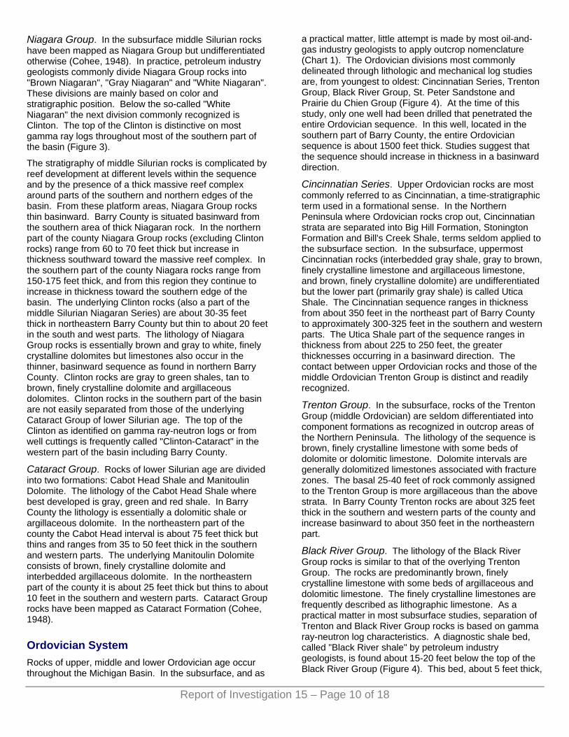
Niagara Group. In the subsurface middle Silurian rocks have been mapped as Niagara Group but undifferentiated otherwise (Cohee, 1948). In practice, petroleum industry geologists commonly divide Niagara Group rocks into "Brown Niagaran", "Gray Niagaran" and "White Niagaran". These divisions are mainly based on color and stratigraphic position. Below the so-called "White Niagaran" the next division commonly recognized is Clinton. The top of the Clinton is distinctive on most gamma ray logs throughout most of the southern part of the basin (Figure 3).
The stratigraphy of middle Silurian rocks is complicated by reef development at different levels within the sequence and by the presence of a thick massive reef complex around parts of the southern and northern edges of the basin. From these platform areas, Niagara Group rocks thin basinward. Barry County is situated basinward from the southern area of thick Niagaran rock. In the northern part of the county Niagara Group rocks (excluding Clinton rocks) range from 60 to 70 feet thick but increase in thickness southward toward the massive reef complex. In the southern part of the county Niagara rocks range from 150-175 feet thick, and from this region they continue to increase in thickness toward the southern edge of the basin. The underlying Clinton rocks (also a part of the middle Silurian Niagaran Series) are about 30-35 feet thick in northeastern Barry County but thin to about 20 feet in the south and west parts. The lithology of Niagara Group rocks is essentially brown and gray to white, finely crystalline dolomites but limestones also occur in the thinner, basinward sequence as found in northern Barry County. Clinton rocks are gray to green shales, tan to brown, finely crystalline dolomite and argillaceous dolomites. Clinton rocks in the southern part of the basin are not easily separated from those of the underlying Cataract Group of lower Silurian age. The top of the Clinton as identified on gamma ray-neutron logs or from well cuttings is frequently called "Clinton-Cataract" in the western part of the basin including Barry County.
Cataract Group. Rocks of lower Silurian age are divided into two formations: Cabot Head Shale and Manitoulin Dolomite. The lithology of the Cabot Head Shale where best developed is gray, green and red shale. In Barry County the lithology is essentially a dolomitic shale or argillaceous dolomite. In the northeastern part of the county the Cabot Head interval is about 75 feet thick but thins and ranges from 35 to 50 feet thick in the southern and western parts. The underlying Manitoulin Dolomite consists of brown, finely crystalline dolomite and interbedded argillaceous dolomite. In the northeastern part of the county it is about 25 feet thick but thins to about 10 feet in the southern and western parts. Cataract Group rocks have been mapped as Cataract Formation (Cohee, 1948).
Ordovician System Rocks of upper, middle and lower Ordovician age occur throughout the Michigan Basin. In the subsurface, and as
a practical matter, little attempt is made by most oil-and-gas industry geologists to apply outcrop nomenclature (Chart 1). The Ordovician divisions most commonly delineated through lithologic and mechanical log studies are, from youngest to oldest: Cincinnatian Series, Trenton Group, Black River Group, St. Peter Sandstone and Prairie du Chien Group (Figure 4). At the time of this study, only one well had been drilled that penetrated the entire Ordovician sequence. In this well, located in the southern part of Barry County, the entire Ordovician sequence is about 1500 feet thick. Studies suggest that the sequence should increase in thickness in a basinward direction.
Cincinnatian Series. Upper Ordovician rocks are most commonly referred to as Cincinnatian, a time-stratigraphic term used in a formational sense. In the Northern Peninsula where Ordovician rocks crop out, Cincinnatian strata are separated into Big Hill Formation, Stonington Formation and Bill's Creek Shale, terms seldom applied to the subsurface section. In the subsurface, uppermost Cincinnatian rocks (interbedded gray shale, gray to brown, finely crystalline limestone and argillaceous limestone, and brown, finely crystalline dolomite) are undifferentiated but the lower part (primarily gray shale) is called Utica Shale. The Cincinnatian sequence ranges in thickness from about 350 feet in the northeast part of Barry County to approximately 300-325 feet in the southern and western parts. The Utica Shale part of the sequence ranges in thickness from about 225 to 250 feet, the greater thicknesses occurring in a basinward direction. The contact between upper Ordovician rocks and those of the middle Ordovician Trenton Group is distinct and readily recognized.
Trenton Group. In the subsurface, rocks of the Trenton Group (middle Ordovician) are seldom differentiated into component formations as recognized in outcrop areas of the Northern Peninsula. The lithology of the sequence is brown, finely crystalline limestone with some beds of dolomite or dolomitic limestone. Dolomite intervals are generally dolomitized limestones associated with fracture zones. The basal 25-40 feet of rock commonly assigned to the Trenton Group is more argillaceous than the above strata. In Barry County Trenton rocks are about 325 feet thick in the southern and western parts of the county and increase basinward to about 350 feet in the northeastern part.
Black River Group. The lithology of the Black River Group rocks is similar to that of the overlying Trenton Group. The rocks are predominantly brown, finely crystalline limestone with some beds of argillaceous and dolomitic limestone. The finely crystalline limestones are frequently described as lithographic limestone. As a practical matter in most subsurface studies, separation of Trenton and Black River Group rocks is based on gamma ray-neutron log characteristics. A diagnostic shale bed, called "Black River shale" by petroleum industry geologists, is found about 15-20 feet below the top of the Black River Group (Figure 4). This bed, about 5 feet thick,
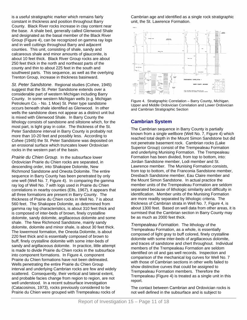
is a useful stratigraphic marker which remains fairly constant in thickness and position throughout Barry County. Black River rocks increase in clay content near the base. A shale bed, generally called Glenwood Shale and designated as the basal member of the Black River Group (Figure 4), can be recognized on gamma ray logs and in well cuttings throughout Barry and adjacent counties. This unit, consisting of shale, sandy and calcareous shale and minor amounts of glauconite, is about 10 feet thick. Black River Group rocks are about 250 feet thick in the north and northeast parts of the county and thin to about 225 feet in the south and southwest parts. This sequence, as well as the overlying Trenton Group, increase in thickness basinward.
St. Peter Sandstone. Regional studies (Cohee, 1945) suggest that the St. Peter Sandstone extends over a considerable part of western Michigan including Barry County. In some western Michigan wells (e.g. Michigan Petroleum Co. - No. 1 Moe) St. Peter type sandstone occurs beneath shale identified as Glenwood. In other wells the sandstone does not appear as a distinct unit but is mixed with Glenwood Shale. In Barry County the lithology consists of sandstone and siltstone which, for the most part, is light gray in color. The thickness of the St. Peter Sandstone interval in Barry County is probably not more than 10-20 feet and possibly less. According to Cohee (1945) the St. Peter Sandstone was deposited on an erosional surface which truncates lower Ordovician rocks in the western part of the basin.
Prairie du Chien Group. In the subsurface lower Ordovician Prairie du Chien rocks are separated, in descending order, into Shakopee Dolomite, New Richmond Sandstone and Oneota Dolomite. The entire sequence in Barry County has been penetrated by only one well (Well No. 7, Figure 4). In comparing the gamma ray log of Well No. 7 with logs used in Prairie du Chien correlations in nearby counties (Ells, 1967), it appears that all three formations are present in Barry County. The thickness of Prairie du Chien rocks in Well No. 7 is about 560 feet. The Shakopee Dolomite, as determined from gamma ray log characteristics, is about 310 feet thick and is composed of inter-beds of brown, finely crystalline dolomite, sandy dolomite, argillaceous dolomite and some shale. The New Richmond Sandstone, mainly sandy dolomite, dolomite and minor shale, is about 30 feet thick. The lowermost formation, the Oneota Dolomite, is about 220 feet thick and is essentially composed of brown to buff, finely crystalline dolomite with some inter-beds of sandy and argillaceous dolomite. In practice, little attempt is made to divide Prairie du Chien rocks in the subsurface into component formations. In Figure 4, component Prairie du Chien formations have not been delineated. Wells penetrating the entire Prairie du Chien Group interval and underlying Cambrian rocks are few and widely scattered. Consequently, their vertical and lateral extent, and probable facies change from region to region, are not well understood. In a recent subsurface investigation (Catacosinos, 1973), rocks previously considered to be Prairie du Chien were grouped with Trempealeau rocks of
Cambrian age and identified as a single rock stratigraphic unit, the St. Lawrence Formation.
Figure 4. Stratigraphic Correlation – Barry County, Michigan. Upper and Middle Ordovician Correlation and Lower Ordovician and Cambrian Stratigraphic Section
Cambrian System The Cambrian sequence in Barry County is partially known from a single wellbore (Well No. 7, Figure 4) which reached total depth in the Mount Simon Sandstone but did not penetrate basement rock. Cambrian rocks (Lake Superior Group) consist of the Trempealeau Formation and underlying Munising Formation. The Trempealeau Formation has been divided, from top to bottom, into: Jordan Sandstone member, Lodi member and St. Lawrence member. The Munising Formation consists, from top to bottom, of the Franconia Sandstone member, Dresbach Sandstone member, Eau Claire member and the Mount Simon Sandstone. In actual practice the member units of the Trempealeau Formation are seldom separated because of lithologic similarity and difficulty in identification. Member units of the Munising Formation are more readily separated by lithologic criteria. The thickness of Cambrian strata in Well No. 7, Figure 4, is about 1300 feet. Based on well data from other areas, it is surmised that the Cambrian section in Barry County may be as much as 2000 feet thick.
Trempealeau Formation. The lithology of the Trempealeau Formation, as a whole, is essentially composed of light gray to buff colored, finely crystalline dolomite with some inter-beds of argillaceous dolomite, and traces of sandstone and chert throughout. Individual members of the Trempealeau Formation are seldom identified on oil and gas well records. Inspection and comparison of the mechanical log curves for Well No. 7 with those of Cambrian sections in other wells failed to show distinctive curves that could be assigned to Trempealeau Formation members. Therefore the Trempealeau (Figure 4) is treated as a single unit in this report.
The contact between Cambrian and Ordovician rocks is not well defined in the subsurface and is subject to
Report of Investigation 15 – Page 11 of 18

Report of Investigation 15 – Page 12 of 18
debate. Thus the thickness of the Trempealeau hinges on where the top of the formation is placed. The thickness of this unit, approximately 275 feet, was determined by comparing the log curve of Well No. 7 with log sections shown in previously published studies (Ells, 1967).
Munising Formation. The term Munising Formation is seldom applied to Cambrian rocks in the subsurface. More commonly, oil-and-gas industry geologists identify rocks below the Trempealeau Formation, from top to bottom, as: Franconia Sandstone, Dresbach Sandstone, Eau Claire Formation, and Mount Simon Sandstone. The members of the Munising Formation are more readily identified by lithologic criteria than the divisions of the overlying Trempealeau Formation. Also, the member divisions of the Munising Formation have been related to gamma ray log curves which show considerable consistency and are traceable from well to well over a sizeable area of southwestern Michigan (Ells, 1967). However, there is not complete agreement as to where tops of the lower members should be placed, how they should be ranked, and what the facies relationship is from region to region within the basin (Catacosinos, 1973).
The upper member of the Munising Formation, the Franconia Sandstone, is from 150 to 175 feet thick and consists of interbedded sandstone, shale, gray to tan, finely crystalline dolomite, and sandy and shaly dolomite. Glauconite is scattered throughout the unit.
The next member, the Dresbach Sandstone, is predominantly sandstone with some interbeds of argillaceous and buff colored, sandy dolomite. The Dresbach, about 125 feet thick in the Barry County area, appears to remain fairly constant in thickness and lithology over other areas of southwestern Michigan.
The Eau Claire member underlying the Dresbach Sandstone is about 350 feet thick in Well No. 7, Figure 4. According to the lithologic record supplied by the Battle Creek Gas Company, the upper 150 to 200 feet is predominantly gray to green shale with some dolomite and dolomitic shale interbeds. The remaining portion is an interbedding of gray to green shale, sandstone, and argillaceous and sandy, buff colored, finely crystalline dolomite.
The Mount Simon Sandstone is the basal member of the Munising Formation. The entire section of this member was not penetrated by Well No. 7, Figure 4, so the exact thickness in Barry County is not known. Judging from other studies it is probably over 1000 feet thick but may be as much as 1500 feet. There is some disagreement as to where the top of the Mount Simon should be picked in sample studies and on mechanical logs. According to a regional correlation study (Ells, 1967) the top of the Mount Simon was picked below the thick, predominantly shale sequence of the Eau Claire Formation which appears to be defined on gamma ray logs from wells in southwest Michigan. In another study (Catacosinos, 1973), the top of the Mount Simon was picked at the first appearance of a clean sandstone. The interbedded shale, siltstone and sandstone in the upper part of the Mount Simon was
assigned to the basal part of the Eau Claire Formation. In this study, the relatively thin interbeds of light brown to gray colored, finely crystalline dolomite, shale, and dolomitic or argillaceous sandstones are retained in the upper part of the Mount Simon. The lithology of the Mount Simon Sandstone, as described in the Battle Creek Gas Company sample description for Well No. 7, is predominantly light gray, translucent, fine grained sandstone with some interbeds of light brown to gray, finely crystalline dolomite, and shale and argillaceous sandstone.
STRUCTURAL GEOLOGY Contour maps on the tops of several important formations, Figures 5 through 10, show the regional and minor structural aspects of Barry County. The strike of all formations contoured is essentially in a northwest-southeast direction across the county and is primarily a reflection of the nearly circular shape of the Michigan Basin. Well control is not evenly distributed throughout the county and the number of wells that were drilled to rocks older than the Devonian Dundee Limestone is relatively few. Well control is most abundant in and around the small oil fields located primarily in the south-central part of the county. Although all well control was used the amount of structural detail varies, particularly for the stratigraphically older formations.
Structure cross sections, drawn on mean sea level, complement the several structure contour maps. These cross sections, Figures 11 and 12, show the general nature of the erosional truncation of Paleozoic rock units beneath unconsolidated Pleistocene glacial deposits. They also show the variation in thickness of certain formations or groups and the pinchout of others. The Sunbury Shale, for example, is absent over a part of Barry County, probably as a result of depositional thinning and subsequent pinchout. On the other hand, the pinchout of the Bois Blanc formation is attributed to removal by erosion prior to deposition of Detroit River Group rocks. Bass Islands Group rocks have also been truncated in a southward direction. Of particular interest is the thinning of the A-1 and A-2 Evaporite Units. The thinning is believed to be mainly depositional but solution-subsidence mechanisms are probably involved in some areas. The interval from the top of the Niagaran to the Clinton-Cataract tends to thicken toward the southern rim of the basin. The thickening culminates in a massive reef bank.
POROUS INTERVALS There are several porous intervals or zones in the subsurface strata underlying Barry County. The porous intervals are found in rocks ranging in age from Pennsylvanian to Cambrian. These rocks, which may be as thick as 8000 feet in the northeastern part of the county, are of different lithologies and have varying degrees of porosity and permeability. The principle tools

Report of Investigation 15 – Page 13 of 18
used in interpreting the porosity and possible permeability of strata studied were laterolog and neutron logs. The information derived from these logs and used in conjunction with gamma ray curves and lithologic data provides a better estimation of porosity and possible permeability. Shale sequences such as the Coldwater Shale (Mississippian), Antrim Shale (Devonian), Utica Shale (Ordovician) and other shale intervals show very good porosity on neutron logs but permeability is lacking. Salt sections, such as those of the Salina Group, sometimes show good porosity on neutron logs, but such indications are caused by "washout" of salt while drilling is taking place. Solution of salt beds by undersaturated drilling fluids are readily detected by caliper surveys which show an increase in hole diameter adjacent to the salt beds. Salt and anhydrite are considered non-porous and impermeable.
Of interest to this study are the more significant porous and permeable intervals which may be related to oil and gas reservoir rocks, brine production, underground disposal or storage of waste fluids or the loss of drilling muds and fluids (lost circulation zones) in drilling operations. In reference to these porous intervals, four stratigraphic units have been selected because they are of interest in dealing with oil and gas exploration and because they show better porosity as well as possible permeability than most of the other strata in the Barry County area. These stratigraphic units, shown in Figure 13, characterize the porous zones present and the gamma ray-neutron-laterolog response and criteria used in interpreting the porosity of particular strata underlying the county and adjacent areas. Discussion of other stratigraphic intervals, though not figured, is included.
The only Pennsylvanian age rocks encountered in Barry County are those of the Saginaw Formation. This unit, as previously mentioned, is predominantly sandstone or argillaceous sandstone. Parts of the formation are porous but because of the argillaceous content of some intervals (Figure 1) and the fact that Pennsylvanian rocks are not widespread in the county it is not considered an important porous and permeable unit.
The Mississippian system includes several formations which contain porous and permeable intervals. The Michigan Formation produces gas and minor amounts of oil from porous and permeable basal sandstones in the more basin-ward counties such as Montcalm, Mecosta, Clare, and others. These rocks are of minor importance over most of Barry County. The Marshall Sandstone is porous and permeable and is a source of fresh water in many areas where it immediately underlies the glacial drift. The Coldwater Shale contains numerous thin beds of sandstone, siltstone and limestone, some of which may be porous and permeable.
Important porous and permeable zones are present in several divisions of the Devonian system. The Traverse Limestone (part of the Traverse Group) is predominantly limestone with some beds of argillaceous limestone interspersed throughout. The porosity zones of the
Traverse Limestone are labeled A, B and C on Figure 13. Porosity is mainly vugular with some pinpoint and intercrystalline porosity also present. Permeabilities vary considerably as evidenced by lost circulation zones or gas readings encountered in the zones. The Rogers City-Dundee Limestones and Detroit River Group porosities, unlike those of the Traverse Limestone, are mainly found in dolomitic beds. The several porous and permeable zones found in these rocks are designated D, E, F, G, H and I on Figure 13. Some of these zones, like those of the Traverse Limestone, are potential oil and gas reservoir rocks under proper trapping conditions. Devonian rocks with suitable porosities and permeabilities may also serve as sources of brines or reservoirs for disposal of certain liquid waste materials.
The main porosity zones within the Silurian sequence are found in the Salina and Niagara groups. The uppermost of these zones is found within the Salina E Unit and is designated as J on Figure 13. This porous interval, called "E Zone" or "Kintigh Zone" by many geologists, is composed predominantly of crystalline dolomite having good intercrystalline and pinpoint porosity. The E Unit is readily identified throughout most of the basin but the porous interval is less widespread and is essentially confined to the southwestern quadrant of the basin. The zone contains saltwater and is a reservoir rock for low-gravity (25.5° API) oil in the Diamond Springs field, Allegan County. The A-1 Carbonate may have effective porosity and permeability. This unit, essentially composed of brown, finely crystalline dolomite, shows porosity zones denoted as K and L on Figure 13. The A-1 Carbonate is an important oil and gas reservoir rock in many parts of the basin. The A-2 Carbonate Unit, stratigraphically higher than the A-1 Carbonate Unit and not illustrated on Figure 13, is also a reservoir rock in many parts of the basin. Niagaran rocks show good porosity and permeability, particularly the reef-bearing facies. Reefs have not yet been discovered in Barry County so the porosity characteristics cannot be figured. Porosity zones in non-reef Niagara Group rocks are designated as M and N on Figure 13.
Porous zones within Ordovician and Cambrian rocks have not been figured. As a rule Trenton and Black River Group rocks (Middle Ordovician) are limestones which exhibit very little porosity. Basin-wide porosity zones such as occur in parts of the Devonian sequence have not been observed. Yet Trenton-Black River rocks are potential oil and gas reservoirs where these rocks have been fractured and dolomitized. The Albion-Scipio trend, Michigan's largest oil field, has produced over 100 million barrels of oil from a narrow and linear dolomitized reservoir extending northwest-southeast through parts of Hillsdale, Jackson and Calhoun counties. The possibility of similar reservoirs existing in Barry County cannot be discounted. Prairie du Chien Group rocks (Lower Ordovician) are primarily dolomites, sandy dolomites and sandstones which are porous and permeable in many parts of the basin. Saltwater is generally encountered in the upper part of the group and shows of oil have been reported.

But the extent of these zones, not illustrated on Figure 13, are not well known in Barry County and must wait further drilling.
The Cambrian rocks have been penetrated by only one well (Well No. 7, Figure 4). The most likely porous intervals are probably associated with the sandstones, especially the Mt. Simon. Oil and gas possibilities of the Cambrian sequence are unknown, but porous intervals may be suitable for subsurface liquid waste disposal.
Figure 5. Structure Contours on the Top of the Traverse Limestone
Traverse Limestone is an oil field term widely applied to the first non-shaly limestones in the upper part of the Traverse Group in western Michigan. The stratigraphic position and gamma ray log characteristics of this unit are shown on Figure 2. Because of more abundant Traverse Limestone well control, structural elements appear more prominent in the southeast, southwest and northwest parts of the county. The structural depression in the northwest part of the county may be related to the solution and removal of Salina Group (Silurian) salt beds and the subsequent slumping or subsidence of upper strata. Oil and minor amounts of gas are produced from Traverse Limestone reservoir rocks associated with small structural closures frequently aligned along the crests of larger anticlinal features. The Hope and Johnstown fields (T.1N. and T.2N., R.9W., and T.1N., R.8W., respectively) are examples of this nature. Smaller contour intervals would delineate the independent closures associated with these fields. The Freeport and Thornapple fields (T.4N., R.8W. and T.4N., R.10W., respectively) in the northern part of the county show less prominent closures. The probability of finding other oil pools in Traverse Limestone and deeper reservoir rocks in Barry County is favorable.
The Rogers City-Dundee Limestone formations are most frequently treated as a single formation - the Dundee Limestone. The structures associated with the Dundee are similar to those shown for the top of the Traverse
Limestone. The southern part of the county is dominated by anticlinal and synclinal flexures similar to those of the Traverse Limestone. Prominent structural depressions in the northwestern part of the county persist. Some of the Dundee structures have shifted or changed slightly, possibly because of changes in depositional environment as well as the individual make up of the strata. The Rogers City-Dundee Limestones are prominent oil and gas reservoir rocks in the central basin counties. Although no commercial oil or gas deposits have been found in these rocks in Barry County, they are not well explored. Future exploratory drilling may result in the discovery of Dundee Limestone oil and gas reservoirs.
Figure 6. Structure Contours on the Top of the Dundee Limestone
Figure 7. Structure Contours on the Top of the A-2 Carbonate
Structural features associated with the A-2 Carbonate
Report of Investigation 15 – Page 14 of 18

appear less pronounced than those of the Devonian Traverse Limestone and Rogers City-Dundee Limestone because of fewer data and a larger contour interval. Structure on the top of the A-2 Carbonate can be influenced by the underlying A-2 Evaporite Unit (See Figure 3). The A-2 Evaporite is primarily a salt bed in the deeper part of the basin but thins and grades to an anhydrite bed toward the edge of the basin. Barry County is situated near the depositional edge of the A-2 Evaporite Unit where salt solution-subsidence phenomena has most likely occurred. The solution of salt and subsidence of overlying strata can influence the structure of the overlying A-2 Carbonate as well as other overlying rock units. The thickness of the underlying A-2 Evaporite is shown adjacent to the well location. Note the decrease in thickness values in the southern and western parts of the county. Where trapping and reservoir conditions are favorable, the A-2 Carbonate is a potential gas-producing formation. The underlying A-2 Evaporite salt bed is a potential source of salt or brine by solution-extraction methods and it also has potential for the development of storage caverns for natural gas or liquid hydrocarbons (LPG's). One such gas storage cavern Lacey Station, is located in Section 14, T.1N., R.8W.
Figure 8. Structure Contours on the Top of the A-1 Carbonate
The structure on the A-l Carbonate appears to be composed of gentle anticlinal and synclinal flexures throughout the county. Increased drilling, however, may encounter more substantial structures than have been found to date. The underlying A-l Evaporite thicknesses and trends in thinning have also been delineated on this map and there is a difference between these thicknesses and trends and those of the A-2 Evaporite. While the A-2 Evaporite thickness in the northern part of the county ranges from about 300-325 feet for the most part, the A-l Evaporite is generally less than half this thickness. There also appears to be a more abrupt thinning of the A-l Evaporite in the southern half of the county than occurs in the A-2 Evaporite. The A-l Evaporite, like the A-2
Evaporite is primarily a thick salt bed in the deeper part of the basin and, like the A-2 Evaporite, it thins and grades to an anhydrite bed toward the edge of the basin. Both evaporite units eventually pinchout south of Barry County. Oil and gas are produced from A-l Carbonate rocks in various parts of the basin but no production has been established from those underlying Barry County. Future Niagaran reef exploration may lead to oil or gas discoveries in these rocks.
Figure 9. Structure Contours on the Top of the A-1 Carbonate
Wells drilled into or through Niagara Group rocks are few in number and widely scattered throughout the county. Where data is more abundant, as in the southeastern part of the county, minor flexures occur. In general, the contours indicate the regional dip to the northeast. The Silurian age Niagara Group rocks underlying Barry and adjacent counties are on the basinward margin of the thick Niagaran reef complex underlying most of the counties to the south. Niagaran age pinnacle reefs which stand as topographic features on the Niagaran surface appear to be concentrated in a belt within this inner margin. Exploration for pinnacle reef oil-and-gas traps in Barry County has been sparse and none has been found. Numerous pinnacle reef oil-and-gas traps have been found, however, in Calhoun County to the south and in Eaton and Ingham counties to the east. Increased drilling in Barry County may result in reef discoveries, particularly in the southern half of the county.
Report of Investigation 15 – Page 15 of 18

Figure 10. Structure Contours on the Top of the Trenton Group
Wells drilled into or through Ordovician age Trenton-Black River Group rocks in Barry County are few and widely scattered. Contours on the top of the Trenton Group reflect the regional dip to the northeast and coincide with the regional dip found in overlying strata. The most prominent structural feature is in the southeastern quarter of the county and reflects the more abundant well control. Shows of oil and gas have been found in sub-Black River Group rocks in Rutland Township, T.3N., R.9W., but no production has been established. Michigan's largest and most prolific oil and gas field, the Albion-Scipio Trend, is located southeast of Barry County in Calhoun, Jackson and Hillsdale counties. Production is from dolomitized limestones of the Trenton and Black River Groups. The trap is associated with a linear and narrow fracture zone extending northwest-southeast for about 35 miles. If Trenton-Black River oil-and-gas traps are found in Barry County, they are likely to be of a similar nature and not associated with significant anticlinal features.
Figure 11. Structural Cross Section – Barry County, Michigan. Odessa Twp. – Ionia County to Martin Twp. – Allegan County
Figure 12. Structural Cross Section – Barry County, Michigan. Yankee Springs Twp. – Barry County to Maple Grove Twp. – Barry County
Figure 13. Significant Porosity Zones. Traverse Limestone
REFERENCES AND FURTHER READING Ailing, Harold L. and Briggs, Louis I. (1961), Stratigraphy of Upper
Silurian Cayugan Evaporites: Bull. Amer. Assoc. Petrol. Geol., Vol. 45, No. 4 (April, 1961) pp. 515-547, 12 Figs., 2 Tables.
Bishop, Margaret Stearns (1940), Isopachous Studies of Ellsworth to Traverse Limestone Section of Southwestern Michigan: Bull. Amer. Assoc. Petrol. Geol., Vol. 24, No. 12 (December, 1940) pp. 2150-2162, 8 Figs.
Catacosinos, Paul A. (1973), Cambrian Lithostratigraphy of the Michigan Basin: Bull. Amer. Assoc. Petrol. Geol., Vol. 57, No. 12 (December, 1973) pp. 2404-2418, 13 Figs.
Cohee, George V. (1945), Sections and Maps of Lower Ordovician and Cambrian Rocks in the Michigan Basin, Michigan and Adjoining Areas. U.S. Geological Survey, Oil and Gas Inv., Prelim. Chart No. 9, index and isopach maps.
Cohee, George V. (1945), Geology and Oil and Gas Possibilities of Trenton and Black River Limestones of the Michigan Basin, Michigan and Adjacent Areas. U.S. Geol. Survey, Oil and Gas Inv., Prelim. Chart No. 11, index and isopach maps.
Report of Investigation 15 – Page 16 of 18
Report of Investigation 15 – Page 17 of 18
Cohee, George V. (1947), Lithology and Thickness of the Traverse Group in the Michigan Basin. U.S. Geol. Survey, Oil and Gas Inv., Prelim. Chart No. 28, index geol., isopach and thickness maps, charts and sections.
Cohee, George V. (1948), Thickness and Lithology of Upper Ordovician, and Lower and Middle Silurian Rocks in the Michigan Basin. U.S. Geol. Survey Oil and Gas Inv., Prelim. Chart No. 33, 2 sheets, correlation chart, tables, index and isopach maps, and sections.
Cohee, George V. (1951), Thickness and Lithology of Upper Devonian and Carboniferous Rocks in Michigan. U.S. Geol. Survey, Oil and Gas Inv., Chart 0c 41, 5 sheets, 26 Figs., incl. sections, index, isopach and thickness maps.
Cohee, George V. and Underwood Lloyd B. (1944), Maps and Sections of the Berea Sandstone of Eastern Michigan. U.S. Geol. Survey, Oil and Gas Inv., Prelim. Map. No. 17, index, geol. and topog. maps, and correlation charts.
Cohee, George V. and Underwood Lloyd B. (1945), Lithology and Thickness of the Dundee Formation and the Rogers City Limestone in the Michigan Basin. U.S. Geol. Survey, Oil and Gas Inv., Prelim. Map No. 38, isopach maps.
Correlation Problems of the Cambrian and Ordovician Outcrop Areas, Northern Peninsula of Michigan (1967), Mich. Geol. Soc. Ann. Field Excurs. 82 pp., 25 Figs., contains the following papers:
1. Ells, Garland D., Correlation of Cambro-Ordovician Rocks in Michigan. 2. Guldenzopf, Charles E., Conodonts from the Prairie du Chien of Northern Michigan - Preliminary Report. 3. Hite, David M., Re-examination of the Jacobsville. 4. Kowalski, John J., Cambro-Ordovician Exposures in the Eastern Upper Peninsula of Michigan. 5. Ostrom, Meredith E., Geologic Cross Section, Alger County, Michigan -Walworth County, Wisconsin. 6. Terwilliger, F. Wells, Pleistocene Geology of the Munising Area.
DeWitt, Wallace Jr. (1970), Age of the Bedford Shale, Berea Sandstone, and Sunbury Shale in the Appalachian and Michigan Basins, Pennsylvania, Ohio, and Michigan. Geological Survey Bull. 1294-G, 11 pp.
Ells, Garland D. (1958), Notes on the Devonian-Silurian in the Subsurface of Southwest Michigan. Progress Report No. 18, 55 pp.
Ells, Garland D. (1963), Information on Silurian Oil and Gas Pools. Michigan Geological Survey Publication.
Ells, Garland D. (1967), Michigan's Silurian Oil and Gas Pools. Michigan Geological Survey Publication. Report of Investigation 2, 46 pp.
Ells, Garland D. (1974), Michigan’s Oil and Gas Fields, 1973, Annual Statistical Summary 20, 52 pp.
Evans, C. S., (1950), Underground Hunting in the Silurian of Southwestern Ontario, Geol. Assoc. Canada Proc., Vol. 3, pp. 55-85.
Hale, Lucille, (1941), Study of Sedimentation and Stratigraphy of Lower Mississippian in Western Michigan. Bull. Amer. Assoc. Petrol. Geol., Vol. 25, No. 4 (April, 1941), pp. 713-723, 5 Figs.
Kilgour, W. J. (1963), Lower Clinton (Silurian) Relationships in Western New York and Ontario, The Geological Society of America Bull., Vol. 74, No. 9, pp. 1127-1142.
Landes, Kenneth K. (1945), The Salina and Bass Islands Rocks in the Michigan Basin, U.S. Geol. Survey Prelim. Map No. 40, Oil and Gas Inv. Ser.
Landes, Kenneth K. (1945), Geology and Oil and Gas Possibilities of Sylvania and Bois Blanc Formations of Michigan. U.S. Geol. Survey, Oil and Gas Inv., Prelim. Map No. 28.
Landes, Kenneth K. (1951), Detroit River Group in the Michigan Basin. Geological Survey Circular 133, 23 pp.
Melhorn, Wilton N. (1958), Stratigraphic Analysis of Silurian Rocks in the Michigan Basin, Bull. Amer. Assoc. Petrol. Geol., Vol. 42, No. 4, pp. 816-838.
Monnett, V. Brown (1948), Mississippian Marshall Formation of Michigan, Bull. Amer. Assoc. Petrol. Geol., Vol. 32, No. 4 (April 1948), pp. 629-688, Figs. 1-15.
Newcombe, R. B. (1933), Oil and Gas Fields of Michigan, Michigan Geological Survey Div., Pub. 38, Geol. Ser. 32, Michigan Department of Conservation, 293 pp.
Rawlins, E. L. and Schellhardt, M. A. (1936), Extent and Availability of Natural Gas Reserves in Michigan "Stray" Sandstone Horizon of Central Michigan. U.S. Bur., Mines Rpt. Inv. 3313, 16 pls., 133 pp.
Segall, R. Thomas (1973), Michigan Mineral Producers 1973, Annual Directory 7, 55 pp.
Shelden, Frances D. (1963), Transgressive Marginal Lithotopes in Niagaran (Silurian) Northern Michigan Basin, Bull. Amer. Assoc. Petrol. Geol., Vol. 47, No. 1 (January, 1963) pp. 129-149, 15 Figs.
Silurian Rocks of the Michigan Basin (1962), Mich. Geol. Soc. Ann. Field Excurs., 96 pp., 36 Figs., contains the following papers: 1. Alguire, S. L., Some Geologic and Economic Aspects of Niagaran Reefs in Eastern Michigan. 2. Briggs, L. I., Niagaran-Cayugan Sedimentation in the Michigan Basin. 3. Carozzi, A. V., Petrography of Wabash Reef, Wabash, Indiana. 4. Ehlers, G. M., and Kesling, R. V., Silurian Rocks of Michigan and Their Correlation. 5. Ells, Garland D., Silurian Rocks in the Subsurface of Southern Michigan. 6. Geyer, R. A., Uses and Abuses of Gravity Surveys in Reef Exploration. 7. Shaver, R. H., Silurian Rocks at the Southern Edge of the Michigan Basin in Indiana. 8. Willman, H. B., The Silurian Strata of Northeastern Illinois.
Stratigraphy of Silurian Rocks in Western Ohio (1963), Mich. Geol. Soc. Ann. Field Excurs., 71 pp., 13 Figs., contains the following papers: 1. Forsyth, Jane L., A brief Summary of Ohio's Pleistocene Glacial Story. 2. Hoover, Karl V., Brassfield Limestone. 3. Summerson, C. H., A resume1 of the Silurian Stratigraphy of Ohio. 4. Ulteig, J. R., Upper Niagaran and Cayugan Stratigraphy in the Subsurface of Northeastern Ohio.
Verway, David I. (1974), Michigan Statistical Abstract, Tenth Edition, 705 pp.

Report of Investigation 15 – Page 18 of 18
STATE OF MICHIGAN William G. Milliken, Governor
DEPARTMENT OF NATURAL RESOURCES
A. Gene Gazlay, Director
GEOLOGICAL SURVEY DIVISION Arthur E. Slaughter
State Geologist and Assistant Supervisor of Wells
NATURAL RESOURCES COMMISSION Hilary F. Snell, Chairman, Grand Rapids
Carl T. Johnson, Cadillac (Mrs.) Joan L. Wolfe, Belmont
E. M. Laitala, Hancock Harry H. Whiteley, Rogers City Dean Pridgeon, Montgomery
Charles G. Younglove, Allen Park Charles J. Guenther, Executive Assistant
OIL AND GAS ADVISORY BOARD
Vance W. Orr, Chairman, McClure Oil Co. K. P. Wood, Vice Chairman, Independent Producer
G. D. Simon, Patrick Petroleum Co. J. A. Vary, Michigan Consolidated Gas Co.
C. John Miller, Miller Brothers Claude J. Osbourne, Shell Oil Co. William J. H. Wilde, General Public
(Mrs.) Mary Anne Williams, General Public William G. Smiley, Department of Natural Resources, Secretary
Published by Authority of State of Michigan CL '48 s.321.6
Any part of this publication may be quoted or reprinted with appropriate credit
Available from Publications Room, Department of Natural Resources, Lansing, Michigan 48926