report on geological evaluation . of
TRANSCRIPT
REPORT ON GEOLOGICAL EVALUATION
OF . MINERAL PROPERTY AT U M I T I CREEK
Claims: N B H I L L 1 (#4871), 2 (#4873),
3 (#4872), 4 (#4874), 5 and 6

m RElMCHEN URLICH GEOLOGICAL ENGINEERING L J
4381 GALLANT AVENUE, NORTH VANCOUVER, 6 C V7G 1L1 CANADA
PHONE (604) 929 2377 TELEX 04 352858
r_ J
June 5, 1984
F i l e 35-05
M i n i s t r y o f Energy, Mines and Pet ro leum Resources
M i n i ng Recorder P rov i nce o f 3 r i t i s h Columbia V i c t o r i a , B.C.
A t t e n t i o n : M r . Ta l i s Ka ln ins
Dear S i r :
P lease f i n d enclosed two copies o f t he assessment r e p o r t on t h e
NOHILL Claims i n t h e Cariboo M in i ng D i v i s i o n . A lso f i n d enc losed
a cheque f o r $185.
I f t h e r e a re any ques t ions concern ing t h i s r e p o r t , o r i f a d d i t i o n a l
i n f o r m a t i o n i s requ i red , lease c o n t a c t us. //
1 dg
Encl .
"Consultants in Resource Development and Geotechnical Engineering"
EDMONTON VANCOUVER

1.1 Property Locat ion
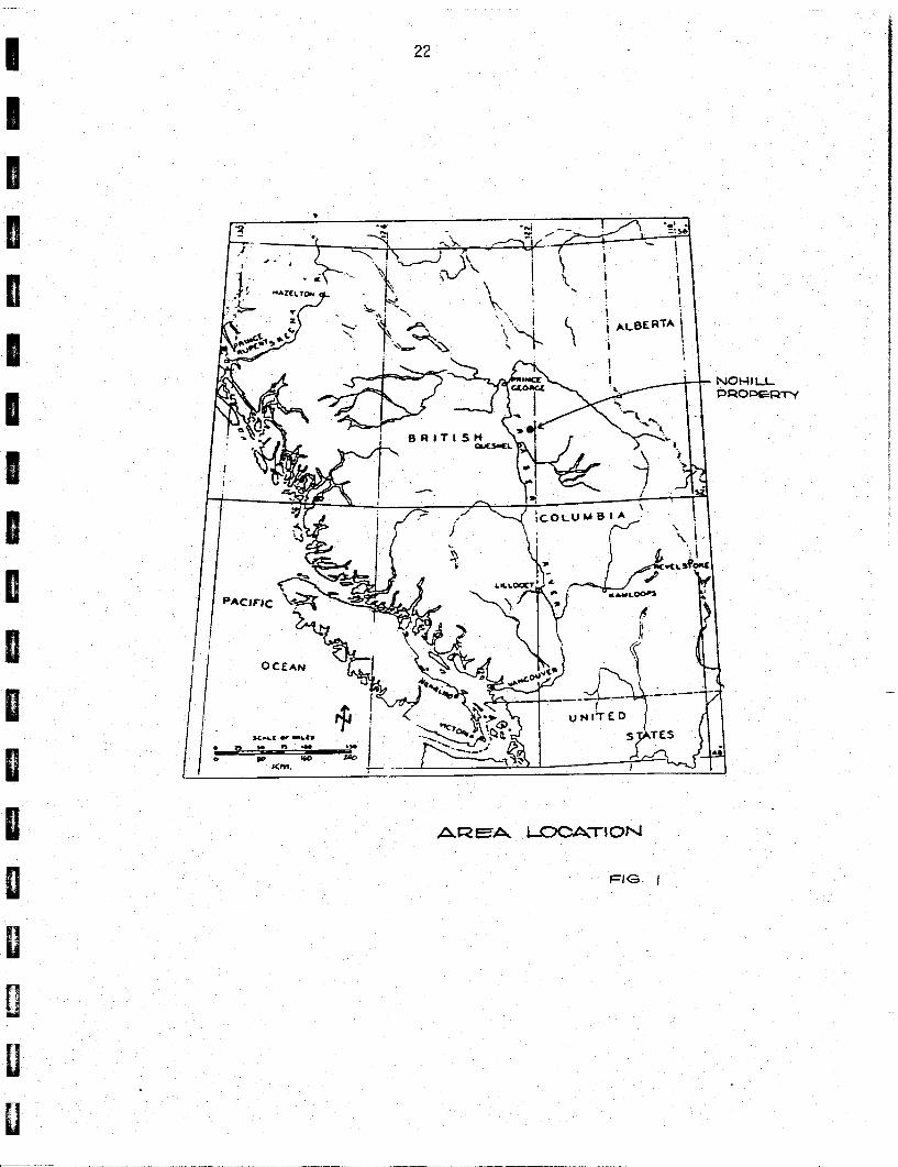
The NOHILL claims are loca ted 35 km nor theast o f Quesnel, B r i t i s h
Columbia (Figure 1 ) . They are access ib le by a gravel road which, a t
Cottonwood Hogse, 26 km east o f Quesnel, t u rns n o r t h o f f t he paved
p r o v i n c i a l Highway #26. The southern boundary o f t he proper ty i s
l oca ted 12 km down the gravel road. Logging roads c r i ssc ross the
proper ty .
The claims a re s i t ua ted near the boundary between the Fraser Basin
and Fraser Plateau, j u s t west o f the Quesnel Highland. The proper ty
i s dra ined by Umi t i Creek (F igure 2) .
1.2 Property D e f i n i t i o n
1.2.1 H i s t o r y
Areas p resen t l y covered by the NWILL c la ims were o r i g i n a l l y staked as
"BL 3, 4, 5, 6 and 8 Umi ti" by M r . B. Grauman (General Manager o f
Two-Way Resources Ltd. o f Vancouver). M r . T. Reimchen, P.Eng., (P res i -
dent of Reimchen S u r f i c i a l Geology Ltd. and pa r tne r o f CGEI, Geological % >*
Engineers Incorporated, the predec o r o f Reimchen U r l i c h Geological
Engineering, o f Vancouver) was subsequently approached by Hr. Grauman
t o do exp lo ra to ry work on the Umi t i claims. I n 1981, a s tudy o f t he
s u r f i c i a l geology and a s o i l sampling program was c a r r i e d ou t by
M r . T. Reimchen, fo l lowed by a study o f the bedrock geology and poss ib le
m i n e r a l i z a t i o n by M r . E. Bakker. The work was summarized i n a r e p o r t
by CGEI t o Two-Way Resources.
Because o f f i n a n c i a l problems by Two-Way Resources, Reimchen S u r f i c i a l
Geology and C G E I d i d no t get aid f o r t he work done, and no assessment
r e p o r t was w r i t t e n by them. The c la ims were f o r f e i t e d i n January 1983.
In April 1983, a small area of the original Grauman claims was staked by
a Mr. D. Coffey of Quesnel. His claims "Umiti 2, 3 and 4" covered I exactly the area i n the CGEI r e ~ o r t mentioned as the most i n t e r e s t i ng
par t of the Grauman claims. A l a rger area surrounding Coffey's claims
was then staked i n May 1983 a s NOIIILL 1, 2, 3 and 4 by Mr. E. Bakker
of Vancouver.
During the recent study, i t appeared tha t limited trenching was done on Mr. Coffey's claims on exposures mentioned in the CGEI repor t . How-
ever, as f a r i s known, the claims were allowed t o lapse. Subsequently
a par t of Coffey's claims was staked by Mr. E . Bakker as NOHILL 5 and 6.
The MCI-IILL claims a re presently owned by Mr. E . Bakker and operated by
Reimchen Urlich Geological Engineering.
1.2.2 Economic Assessment
The NOHILL claims a re s i tuated in an area famous fo r i t s placer gold
deposits . Placer mining has been carried out in creeks draining t h i s
area. Some rocks exposed in the NOHILL claims a re favourable as
source f o r placer gold; similar rocks, belonging t o the same geologic
formation, have been mined f o r gold near Wells. Anomalous gold,
copper, lead and zinc concentrations in quartz veins have been found.
Rocks associated with ul t rabasic intrusions show malachite encrusta t ions
and contain su l f ide minerals . The claims s t radd le a f a u l t . A
magnetic anomaly, u l t rabasic bodies and a g r an i t i c body a r e present
along t h i s f au l t .
1.3 Summary of Work
A deta i led survey was carried out in areas which, during the 1981 f i e l d - work, were deemed favourable fo r fur ther invest igat ion. These areas
a r e the quar tz i t e and sch i s t s w i t h abundant quartz veins i n NOHILL 1
and exposures along the f au l t in NOHILL 2, 3 and 4 (and i n NOHILL 5 and 6 ) .

Between May 17 and 30, 1984, an a r ea of 1 km2 was i n v e s t i g a t e d i n d e t a i l ,
and exposures were marked on a e r i a l photographs i n s c a l e 1:20,740. The
informat ion from the a e r i a l photographs has been t r a n s f e r r e d t o a map i n
t h e same s c a l e (F igure 3 ) . This map has been supplemented wi th updated
in format ion from. t h e 1981 f ie ldwork. '
Several samples were c o l l e c t e d during t h e survey, o f which s i x have
been submitted f o r assay.
A l l t h e information c o l l e c t e d during t h e r e c e n t f ie ldwork has been inte-
g ra t ed w i t h t h e r e l e v a n t p a r t o f the 1981 f ie ldwork and i s presen ted i n
t h i s r e p o r t .
1 .4 List of Claims
I n May 1984, work was performed on t h e fol lowing c la ims .
Name Units Record No. Mapping and Sampl r - .3
NOHILL 1 1 487 1 May 28 . NOHILL 2 3
NOHILL 3 6 :::: 1 May 17 , 26, 28, 29
NOHILL 4 6 4874
NOHILL 5 1 - Hay29 I
HILLTOP
NOHILL 6 1 - -

2.0 DETAILED TECHNICAL DATA A N D INTERPRETATION
2 . 1 Introduction
An extensive area near Umiti Creek was reconnaissance mapped in 1981. During the 1984 fieldwork, many outcrops in the NOHILL claims were re-
vis i ted and sometimes re-interpreted. Some new outcrops were found; malachite was found to be present a t a few places.
A bedrock study in the NOHILL property i s hampered by the lack of good
outcrop. Bedrock exposures are generally small and weathered. Most
outcrops occur in road surfaces and roadsides in the logged areas.
There are surprisingly few outcrops i n steep valley slopes and in creeks. I
2.2 Landscape and Geologic Setting
2 The NOHILL property occuoies 4 km of a gently sloping h i l l w i t h elevations
ranging from 925 m to 1200 m. About 90 percent of the claims has been logged in recent years. The remaining humid fores t , w i t h dense under-
brush, contrasts with the dry logged areas.
Parts of the property are cut by narrow, windino and intersecting valleys,
up t o several metres in depth. In NOHILL 1, a creek and a small lake
are present in such a valley; a l l others are dry or swampy. There i s no
obvious relation between the orientation ,of these vall eys and bedrock
s t ructures . The valleys are l a t e glacial meltwater channels.
Bedrock i s generally obscured by an overburden of variable thickness of
s i l t and sand, with larger rocks t o cobble s ize. Boulders are rare. The
oberburden comprises glacial t i l l w i t h locally reworked stream gravels
and occasionally broken bedrock. Erosion of th i s material i s f a s t , as
i s indicated by the presence of u p to 2 m deep gul l ies i n skid roads.
From the set t ing of outcrops in logged valleys, i t seems that the bedrock
surface i s more irregular than the present ground surface. This indicates the possible presence of hidden old stream valleys.
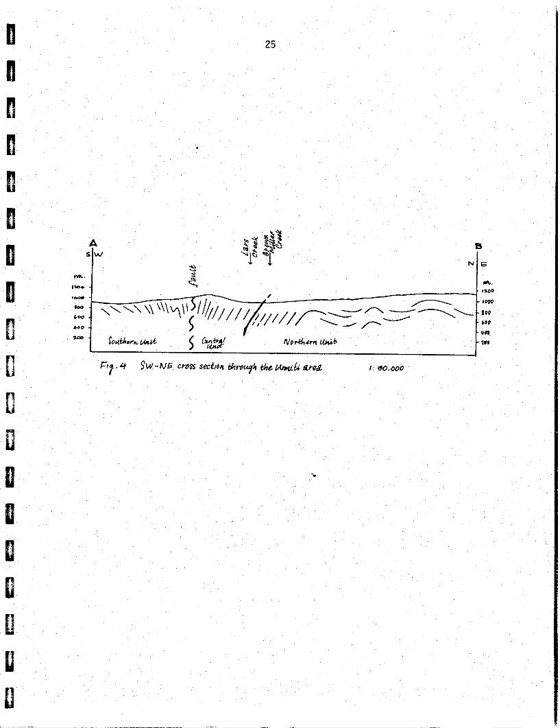
The NOHILL property straddles a major f a u l t which separates the Omineca
Crystall ine Belt in the northeast (Northern and Central Units with Pre-
cambrian strongly deformed and metamorphosed sediments) from the Inter- montane Be1 t in the southwest (Southern Unit with less deformed and
non-metamorphic Triassic sediments and volcanics). Along the f au l t , Triassic or Cretaceous ultrabasics and a Tertiary acid intrusive occur.
2 . 3 Geology
2 . 3 . 1 Lithologic Units
General. According to composition, deformation and metamorphism, the
rocks can be grouped into three units. Within each uni t , rocks of
different types appear. Due to lack of good outcrop, strong folding and
gradations between rock types, i t i s impossible to extend a par t icular
rock type over large distances. The main rock types w i t h i n each u n i t are:
Northern Unit: quartzites and schis ts
Central Unit: ser ic i t e schis ts
Southern Unit: s la tes
Along the boundary between the Central and Southern Units, intrusive rocks
occur. Quartz veins and lenses occur in a l l units. -
Northern U n i t : Quartzites. Light coloured massive quar tz i t ic rocks a re
common. They are f ine to medium-grained and contain always some feldspar
and mica (b io t i t e and muscovite). Occasional medium to coarse quartz and
feldspar grains are se t i n a f iner matrix ( g r i t ) . A fol iation i s J
defined by lent icular quartz grains w i t h mica oriented parallel t o i t .
The amount of mica i s variable, due to which the rock can become gneissic
and locally schistose. Garnet can occur as medium to coarse grains,
ranging in col our from fresh pink to completely a1 tered. Chlorite

111 rims are common. An occasional weak laverina in the auartzi te suaaests
cross bedding.
Northern Unit: Schists. The schis ts consist of l igh t to dark grey mica schis ts and phyllonitic schis ts ; locally they grade into qua r t z i t i c schis ts . In the mica schis ts , muscovite ( rather f ine) i s the most common mica. The amount of b io t i te (somewhat coarser) i s variable and i s often not or hardly present. Both are normally parallel t o the fo l ia t ion , but
b io t i t e has incidentally been observed as growing across the schis tosi ty .
Phyllonitic schists occur locally as small horizons or patches within
and gradational with the mica schis ts . Garnet i s common in a l l schis ts .
The colour i s darker and the al terat ion stronger than the garnet i n the
quartzite. Commonly, garnet i s only present as completely altered knots.
Weathered out rectangular holes i n the schis ts indicate the original
presence of pyrite. The schists commonly show rusty colours along
joints and often along cleavage planes.
Thin mica schis t layers often occur w i t h i n the thicker quartzi te layers.
Locally they are t igh t ly folded w i t h the schis tosi ty as axial plane
fol ia t ion. Thin quartzite layers are nearly always present i n the
schis ts . Schists predominate in the Northern Unit.
Central U n i t : Ser ici te Schists. Light colored, greenish schis ts a re the
most common rock type in th i s u n i t . Mica i s commonly present as s e r i c i t e , rarely as muscovite. Biotite has not c lear ly been observed, b u t could
be present i n darker rocks. Grey phyllonitic schis ts a re locally present
as thin layers. In Lars Creek, near the Umiti Creek junction, l i gh t
grey s e r i c i t e schists are underlain by a thick layer of dark grey
phyl l i t ic rock which contains s e r i c i t e and folded quartz bands. Occas-
ionally the rock grades into a quar tz i t ic gneiss, b u t quartzi te i s not
present. The schists locally contain bands with angular fragments,
suggesting a partly volcanic origin ( t u f f ) . Small , partly weathered,
pyrite crystals occur local ly.

I Intrusive Rocks between Central and Southern Units
Granitic Rock: A very 1 ight coloured and fine-grained quartz-feldspar rock i s exposed as a large body in NOHILL 3 (Figure 3) . Chlorite occurs as scattered f ine grains. The homogeneity and s t ructureless character of the body indicates a l a t e intrusive origin. Within the body, a one-metre band of very fine-grained chlorite-rich rock i s present. Ultrabasic Rock: Complete retrograde ultrabasic serpent ini te bodies -------- are present a t several loca l i t ies (Figure 3 ) . All o r part of them might
belong to a larger elongated NW-SE body. The southeasterly exposure i s mostly l i gh t coloured, w i t h some dark green "soapy" rock. The Body consists of serpentinite and chlori te with t a l c in more weathered
parts. A carbonate (magnesite) i s present in the l ighter rock as t h i n
veinsland in the darker one as coarse grains. Coarse and weathered
brownish crystals in the l ighter rock are probably al tered bronzite.
A schis tosi ty i s well developed with a secondary cleavage present i n
the darker rock. The northwesterly body consists mainly of serpent ini te
and t a l c , w i t h altered pyroxene r e l i c s .
Jus t west of the southeasterly ultrabasic body and southeast of the north-
westerly body, ul trabasic or ul trabasic-related rocks (anorthosi te?)
a re exposed containing malachite.
Southern Unit: Slates. The most common rock i s a dark grey, very f ine-
grained rock w i t h i n general a good planar cleavage. I t i s sometimes fissi-4e and locally rather massive. In the northern part , the rock
often has other cleavage directions as well (axial plane cleavage and
jo in ts ) . A l inear texture i s locally prominent. A t h i n layering of
l igh ter and s l ight ly coarser materials i s sometimes present. This
layering (bedding) i s mainly para1 le l , but i n fold hinges discordant t o
the s la ty cleavage. Argi l l i te is present as layers in s l a t e . Some rocks
contain coarse angular grains of different rock types and medium
grains of quartz (vol cani c breccia and greywacke) . The s l a t e occasional l y
shows rusty colours along joints.

I 2.3.2 Boundaries between U n i t s
Northern-Central Un i t . Although s i m i l a r s c h i s t s occur i n bo th u n i t s , a
d i s c o n t i n u i t y between these two u n i t s i s assumed. The presence o f
garnet and b i o t i t e i n the rocks o f t h e Northern U n i t and absence o f
these minera ls i n the Central Un i t , i n d i c a t e an o r i g i n a l h igher
grade o f metamorphism i n the Northern Un i t . Due t o re t rograde e f f e c t s ,
the rocks l o c a l l y become s i m i l a r . Furthermore, q u a r t z i t e s a r e common
i n t h e Northern U n i t b u t a r e absent i n t h e Centra l Un i t . The deformat ion
h i s t o r y seems t o be equal i n both u n i t s , as i s t he presence of smal l
boudinaged and folded quar tz bands. The contac t i t s e l f i s n o t exposed.
It probably runs through the v a l l e y o f Lars Creek. The contac t i s n o t
necessa r i l y a f a u l t o r unconformity. The d i f f e r e n c e between the two
u n i t s might r e f l e c t an o r i g i n a l sedimentary one, together w i t h a l a t e r
h igher grade metamorphism deeper i n t h e sequence.
Central-Southern Un i t . Higher grade metamorphism and a more complex
deformat ion h i s t o r y i n the Centra l U n i t than i n t he Southern U n i t
i n d i c a t e t h e presence o f a major f a u l t between the u n i t s . I n t r u s i v e
rocks occur along t h i s f a u l t . The aeromagnetic map (1963, Sheet 93 G / 1 )
shows a r e l a t i v e h igh i n the area where the f a u l t i n t e r s e c t s the main road.
Honeycomb quartz veins are concentrated i n rocks along the f a u l t .
2.3.3 Deformation
Folding. I n the Northern and Centra l Un i ts , a t i g h t t o i s o c l i n a l
f o ld ing i s present (Dl), which i s b e s t seen i n fo lded quar tz bands.
S c h i s t bands i n q u a r t z i t e are l o c a l l y i s o c l i n a l fo lded, b u t t he
s c h i s t o s i t y i n these f o l d s i s an a x i a l plane f o l i a t i o n (S l ) . Because
o f t he t i gh tness o f t he fo lds , t he main f o l i a t i o n i n these u n i t s i s
Ss (bedding) + S1. The l a r g e sca le i n f l u e n c e o f t h i s f o l d i n g i s hard
t o est imate because i n d i v i d u a l l a y e r s cannot be fo l lowed over l a r g e r
d is tances. I n the Southern Un i t , t h i s deformation phase i s absent.
I n most o f the rocks,small c renu la t i ons a re common. Local ly ,c lose t o
open fo lds of the f o l i a t i o n can be observed w i t h a f o l d a x i s g e n t l y
p lung ing t o the northwest and p a r a l l e l t o t he c renu la t i on l i n e a t i o n (D2).
A x i a l planes d i p moderately t o steep t o the southwest and l o c a l l y t o t h e
nor theast . An a x i a l plane f o l i a t i o n i s r a r e l y developed i n the s c h i s t s ,
b u t i s more common i n the s la tes . This deformat ion had much i n f l u e n c e
on t h e d i s t r i b u t i o n of rock types i n t he Northern Un i t . I n a d d i t i o n
t o t h e l a r g e s t ruc tu res shown on the map (F igure 3), smal ler a n t i - and
syn forms are present, the whole r e s u l t i n g i n an an t i c l i no r i um. V
Although i t i s n o t so ev ident from t h e map, an ana lys is o f measurements
made,shows t h a t there i s a p e r s i s t e n t f o l d i n g o f the l i n e a t i o n . When
comparing measurements i n narrow zones p a r a l l e l t o the t r e n d o f D2 s t r u c -
tures, a f o l d i n g phase (D3) emerges w i t h axes g e n t l y p lunging t o t h e
nor th-nor theast . A weak c renu la t i on l i n e a t i o n w i t h t h i s same d i r e c t i o n
has been observed i n a few places.
J o i n t i n g . I n the Northern and Centra l Uni ts , j o i n t s a re f a i r l y common,
and spacings o f several tens o f cent imetres a re normal. The bes t d e f i n e d
j o i n t s a re main ly moderate t o steep d ipp ing t o t h e southeast and l o c a l l y
d ipp ing t o the southwest. Less we1 1 -def ined j o i n t d i r e c t i o n s do occur .
I n t he Southern Un i t , the j o i n t s a re hard t o separate from the s l a t y
and a x i a l plane cleavage. Analys is o f a few conjugate se ts show t h a t t he
b e s t de f ined j o i n t s can be t i e d t o a f o l d i n g w i t h a northwest t o southeast
a x i s ( i .e., t he D2 f o l d i n g ) . The v a r i a t i o n i n o r i e n t a t i o n o f these . j o i n t s i n small areas ind ica tes a f o l d i n g w i t h nor theast and southwest plu.rain%.
a xcs , which imp l ies t h a t these conjugate se ts developed du r ing
D2 deforma ti on.
Boudinage. Thin quar tz bands a re commonly boudinaged. Quar tz i n t h i c k e r
bodies genera l l y have lenso id shapes, and l o c a l l y they can be seen as
p a r t o f a boudinaged layer . Quar tz veins l o c a l l y show a boudinaged
character . Because some quartz ve ins occupy D2 j o i n t s , and D2 was t h e

l a s t major deformation event, a t l e a s t some of t he boudinage must be
a t t r i b u t e d t o the D2 event. This i s a l s o shown by t h e boudinage o f
veins and the more competent bands i n t h e s la tes , where D l i s absent.
Fau l t ing . I n the Central and i n the Southern Un i t , t he f o l i a t i o n
changes t o a near l y v e r t i c a l o r i e n t a t i o n c lose t o the f a u l t which
separates these Uni ts . Because D2 f o l d i n g i s responsib le f o r t h i s
change i n o r ien ta t i on , i t i s ev ident t h a t the f a u l t i n g i s synchronous
w i t h D2 deformation. Because the o r i e n t a t i o n o f t he f a u l t i s p a r a l l e l
t o the t rend o f D2 s t ruc tures and n o t t o one o f t he j o i n t systems,
the f a u l t might have o r ig ina ted by shearing the l i m b o f a major f o l d
(Figure 4). Asymmetry o f p a r a s i t i c f o l d s o n l y p a r t l y agrees w i t h
such a s t ruc tu re . The s t ra t i g raphy being upside down i n the Southern
U n i t (Doug1 as, 1979) cornpl i ca tes the s t r u c t u r e more.
The i n t r u s i o n of ac id and u l t r a b a s i c rocks occured t y p i c a l l y a long a
zone o f weakness, as do occur the most i n t e r e s t i n g quar tz veins. Between
the i n t r u s i v e bodies, however, i s a d i f fe rence. The presence o f a sch is -
t o c i t y i n t h e u l t r a b a s i c rocks i nd i ca tes t h a t they a re probably contem-
poraneous w i t h the fau l t i ng . The l a c k o f any f o l i a t i o n i n t h e apl i t e
i nd i ca tes t h a t t h i s body has in t ruded a f t e r t he 02 deformation.
2.3.4 Quar tz Veins and Lenses
Northern Un i t . A t l e a s t two generations o f quar tz veins and lenses
(boudinaged veins) can be i d e n t i f i e d . Small D l fo lded i n t r a f o l i a l
lenses belong t o an o lde r generation. Veins occupying j o i n t s developed
dur ing D2 deformation belong t o a younger generat ion. Veins and lenses
which do no t e x h i b i t these c r i t e r i a a re d i f f i c u l t t o date. Quar tz
veins w i t h d i f f e r e n t o r i en ta t i ons belonging t o a D2 conjugate s e t have
been observed.
In the thin lenses and veins (mainly the older generation), the quartz
i s generally clear and consists of recrystall ized subgrains. In the thicker zones (mainly the younger generation), the quartz is mostly white
and contains many irregular and closely spaced cracks. Around some of
the cracks in the thicker veins and lenses, the quartz i s stained yellow
and brown. This colouring probably represents a very thin coating of iron
hydroxide. Red colours occur and appear t o be restr ic ted t o cracks and
weathering surfaces. This colouring probably resul ts from a l a t e r
oxidation. Rarely small cavi t ies are f i l l e d with iron hydroxides,
consisting of yellow to brown so f t material with a rim of dark grey t o
black hard material.
The most important quartz vein i n the Northern Unit occurs in NOHILL 1.
This area i s drained by a creek, where some placer mining has been done. 2 An area of 100 m above a c l i f f , with some outcrops of phyllonitic
schis t s overlying and interlayered with gneissose schis t , has scattered -
much quartz, probably mainly belonging t o an east-west subvertical 1 m wide vein. The white quartz i s extensively yellow-brown and partly red
(sampl e NH84-1) coloured. Another % m wide east-west subverticat
quartz vein cuts a feldspathic, garnet- and biotite-bearing, quartzite
layer. The quartz i s only locally s l ight ly coloured. A few cavi t ies
a re partly f i l l ed with chlor i te or with iron hydroxides. A regular sub- - vertical north-east-southwest joint system and an irregular one parallel
t o the vein i s present in the country rock. C i
Cen t t i
*a1 Unit. Thin quartz lenses are common in the schis ts in the same
way as in the Northern Unit. Larger ones a re rare. I
I I
The most important veins occur along a small road north of the grani t ic
body i n a 3 m wide zone with phyllonitic bands in s e r i c i t e schis t . T h i n
quartz lenses are isoclinal folded. A 10 cm wide westnorthwest to
eastsoutheast striking quartz vein i s mainly parallel t o the nearly
vertical fo l ia tes . The vein i s local ly discordant and faulted. The
white quartz i s clean but r ich i n i r regu la r ly shaped and par t ly tubular I cavi t i e s (honeycombed), par t ly f i 11 ed with iron hydroxides. Another i r regu la r , up t o t, m wide, vein i s more massive and cons i s t s of quar tz
w i t h pale yellow al tered feldspar. Extensive colouring and coatings and
t h i n veinle ts occur along cracks. The weathering i s strong along both
veins, the so i l and weathered rock is par t ly intensely coloured
(NH 84-7 from the f i r s t vetn).
Southern U n i t . Locally thin and often rus ty veins occur,such as one
east-to-west s t r ik ing subvert ical . In one area, however, considerable I amounts of quartz e x i s t in the s l a t e s discontinuous exposed over 500 m along the upper contact of the u n i t . In the southeastern par t (south of
sample NH 84-8 locat ion) , the honeycombed quartz contains c a l c i t e . In
the northwestern par t (sample NH 84-9), the honeycombed quartz (up t o
30% cav i t i e s ) contains much iron hydroxides. Here a zone of 5 m cons i s t s
of up t o % m thick boudinaged ver t i ca l eastsoutheast-westnorthwest
quartz veins paral le l t o the fo l i a t i on of the dark grey s l a t e s .
2.3.5 Mineralization
The honeycombed quartz veins encountered a t several locat ions ( N H 84-1,
7 and 9 ) w i t h anomalous values fo r gold, lead and zinc (as par t ly
shown i n ~ r e v i o u s assays), miaht be indicat ive of major sulphide
mineralizations i n rocks with a r e l e s s weathered than those encountered
i n owtcrops. Similar veins a re proven to be the source of placer t
gold i n other areas.
The malachite occurrences associated w i t h the u l t rabas ic bodies
( N H 84-2 and 8 ) a re indicative of the presence of copper. Some grains
of an unindentified sulphide ore have been observed i n these rocks.
Cobalt, nickel and chromium occur i n small, but anomalous amounts.
Because of poor outcrop, honeycombed quartz veins and copper-bearing
rocks a re probably more widesyead than observed i n outcrops.

2.4 Cor re la t ions
The Parsnip River Map (Douglas, 1979) shows fo r t h i s area th ree un i t s ,
from nor theast t o southwest:
- Proterozoic ~ a z a - ~ r o u ~ : sandstone, conglomerate, g r i t , p h y l l i te,
sch is t , amphibol i te, marble ard gneiss i n the Omineca Crysta l1 i n e Be1 t;
- Upper T r i a s s i c : b lack p h y l l i t e , s i l t s t o n e , l imestone and q u a r t z i t e
i n the Intermontane Be l t ;
- Upper Trassic t o Lower Jurassic Takla Group: andesite, basa l t , t u f f ,
breccia, conglomerate greywacke, shal e and 1 imestone i n the Intermontane
Be1 t.
The contacts between these u n i t s are drawn as f a u l t s . Along the f a u l t
between t h e Kaza Group rocks and t h e T r a i s s i c rocks, Permian t o Middle
T r i a s s i c u l t r a b a s i c bodies are shown southeast o f t h e Umi t i area.
T ipper (1960) and Campbell e t a1. (1973) do n o t separate the rocks i n
the Intermontane Be l t . O f the Pro terozo ic rocks, they discuss meta-
morphosed fe ldspa th i c sandstone and granule conglomerate, l o c a l l y micageous
and schistose; a r g i l l i te, p h y l l i t e and sch is t , minor conglomerate,
l imestone and marble, separated by an unconformity from the l o c a l l y f o s s i l -
i f e r o u s Upper T r iass i c rocks (dark p h y l l i t e , shale, a r g i l l i t e , s i l t s t o n e
and, r a r e l y , dark l imestone). The rocks a re fo lded i n the northwest
p lunging L igh tn ing Creek An t i c l i ne , o f which the cent re runs nor theast
of the study area. The Umit i area then i s s i t u a t e d i n the southwest l imb. . The Barkerv i l le -Wel ls area i s a l s o near t h e upper contac t of the Kaza Group
b u t i n the northeastern l imb o f t he a n t i c l i n e .
Campbell e t a1 . (1973) discuss t h e Pro terozo ic Isaac Formation which
o v e r l i e s the Kaza Group i n the nor theast l imb ( p h y l l i t e , a r g i l l i t e ,
s c h i s t and shale, minor s i l ts tone, f e l dspath ic sandstone and conglomerate,
I Doug1 as (1976) discusses the early Tertiary volcanism, coeval with
emplacement of small, high-level, g rani t ic plutons i n the Intermontane
Be1 t , and gives a general deformation history of the area.
Comparing our observations with these references, i t i s evident tha t the Northern finit correlates with the Proterozoic Kaza Group.
The Central U n i t may correlate w i t h the Isaac Formation, or perhaps a l so
with the Kaza Group. These rocks have been affected by the Devonian-
Mississippian Caribooan and perhaps by the older East Kootenay orogeny
(Dl structures and metamorphism). The Southern Unit correlates with
the Upper Triassic black phylli tes. I t i s not c lear i f the Triassic
Tahltanian Orogency i s responsible fo r the D2 deformation or i f the
Cretaceous Columbian orogeny i s responsible for D2 and D3 deformati-on, For the ultrabasic intrusions, an event contemporaneous with D2 i s favoured, which i s l a t e r than Douglas' Permian-Middle Triassic age.
The grani t ic intrusion 1 i kely correlates with Tertiary volcanism.
Johnston and Uglow (1926) describe the origin of placer gold i n the
Barkervil l e area. They conclude tha t the placer gold i s derived from
a be l t of auriferous quartz veins. The auriferous constituents of
unoxidized parts of the vein are arsenopyrite and pyrite. The gold
was liberated from these sulfides during deep decomposition i n l a t e
Cretacous-early Tertiary time and concentrated i n valleys during
u p l i f t i n l a t e Tertiary time. Many of these Tertiary deposits were
destroyed by glaciers during Pleistocene time.
Similar effects have l ikely also occurred in the Umiti area. Quartz
veins with cavities (representing leached sulphides) appear to be
the most interesting. Such veins a re exposed in several parts of the
property.
In the Cariboo Gold Quartz mine (Douglas, 1976), four types of veins a re
recognized. They occupy con jugate se t s of diagonal and (mainly)
northerly Joints and some transverse joints . These three types are
r e l a t e d t o fo ld ing . The f o u r t h type, a s t r i k e vein, i s unre la ted t o t h e
s t r u c t u r a l pa t te rn . The t ransverse veins produced most of t h e ore.
The s t r i k e veins were normal ly barren, b u t one d i d con ta in mineable
ore. An attempt t o c o r r e l a t e these veins w i t h those i n t h e Umi t i a rea
had no success because o f a l l t h e f o l d i n g and an apparent r o t a t i o n o f . o r i e n t a t i o n s .
From t h e aeromagnetic map (1963, Sheet 93 G / 1 ) , a r e l a t i v e l y h igh read ing
of about 4300 gamma was measured i n an area near t he main road (F igu re 3).
A weak t a i l emanated from t h i s p o i n t and extended t o t h e southeast a long
a l i n e p a r a l l e l t o the contact between the Southern and Centra l Un i t s .
Readings o f l ess than 4000 gamma were recorded over the remainder of
t h e area.
2.5 Conclusions and Recommendations
The most promising area o f minera l p o t e n t i a l i s a zone southeast o f
t h e main road a t both sides o f t he f a u l t between the Centra l and Southern
U n i t (F igure 3) . Pegmati t ic honeycomb quar tz ve ins a r e f a i r l y abundant
and con ta in i r o n hydroxides a probable res idue o f leached s u l f i d e s .
G r a n i t i c and u l t r a b a s i c i n t r u s i o n s occur. Malachi te i s nresent i n
u l t r a b a s i c - r e l a t e d rocks and these rocks a re anomalous i n coba l t ,
n i c k e l and chromium. Gold, lead and z i n c occur i n smal l amounts i n the honeycomb quartz ve ins b u t i n s i g n i f i c a n t l y h igher concen-
t r a t i o n s than elsewhere i n t he area (as i nd i ca ted by prev ious assays*). . I n view o f the leaching o f t he s u l f i d e s and the presence o f up t o
30 percent o f i r o n hydroxide, f reshe r rock may be encountered a t
deeper 1 eve1 s.
The ex ten t o f t h i s zone i s d i f f i c u l t t o est imate because o f l ack o f
outcrop. A ground geophysical survey might de f i ne anomalies
a long t h i s zone. Because o f t he r e l i e f o f the area, t h e VLF and s e l f -
p o t e n t i a l methods appear t o be t h e most promising. These methods a r e
f a s t and l ess expensive than o ther methods.

Because the major quar tz veins are mainly exposed i n steep slopes, and
as weathering and leaching may be extensive, trenching i n general would
be d i f f i cu l t and i s n o t recommended. Trenching i n the area with malachite-
bearing rocks (near the southeasterly ul trabasic exposure) i s advisable.
Because of the steepness of the foliation and the essential parallel veins,
angled diamond drilling from selected locali t ies could be performed a t a
1 a ter stage of the exploration. The irregular and boudinaged character
of the veins, and the rugged re1 ief , may present some problems. I'
The only other area in which further exploration and investigation are
recommended i s in NOHILL 1 near MH 84-1. A1 though
samples from this area did not show any significant mineralization, large
amounts of coloured qua r t z were encountered. In addition, gold dredging
was once carried out a t the end of the creek which drains this area.
.
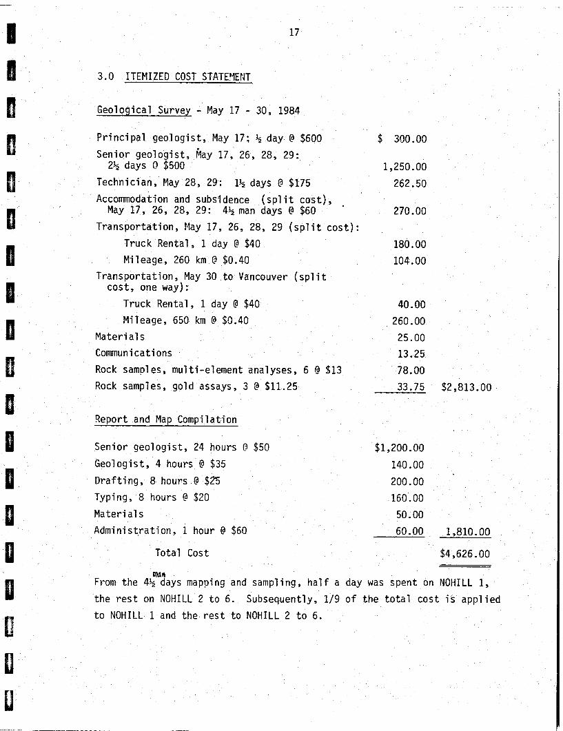
3.0 ITEMIZED COST STATEVENT
Geological Survey - May 17 - 30, 1984
Principal geologist, May 17; % day 4 $600 $ 300.00
Senior geologist, hay 17, 26, 28, 29: 2% days Q $500 1,250.00
Technician, May 28, 29: 1% days O $175 262.50
Accommodation and subsldence (split cost), May 17, 26, 28, 29: 4% man days @ $60 270.00
Transportation, May 17, 26, 28, 29 (split cost):
Truck Rental , 1 day @ $40 180.00
Mileage, 260 km O $0.40 104.00 Transportation, May 30 to Vancouver (spl it cost, one way) :
Truck Rental, 1 day 4 $40 40.00
Mileage, 650 km 4 $0.40 260.00
Materi a1 s 25.00
Communications 13.25
Rock samples, mu1 ti-element analyses, 6 @ $13 78.00
Rock samples, gold assays, 3 @ $11.25 33.75 $2,813.00
Report and Map Compilation
Senior geologist, 24 hours O $50 $1,200.00
Geologist, 4 hours @ $35 140.00
Drafting, 8 hours 4 $25 200.00
Typing, 8 hours !3 $20 160.00
Materials 50.00
Administration, 1 hour 4 $60 60.00 1,810.00
Total Cost $4,626.00
mafi From the 4% days mapping and sampling, half a day was spent on NOHILL 1,
the rest on NOHILL 2 to 6. Subsequently, 1/9 of the total cost is applied
to NOHILL 1 and the rest to NOHILL 2 to 6.
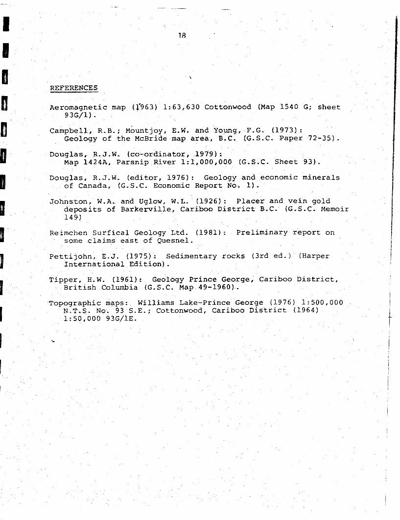
REFERENCES
A e r o m a g n e t i c map (1963) 1:63,630 Cot tonwood (Map 1540 G: s h e e t 93G/1) .
C a m p b e l l , R.B.; ~ b u n t j o ~ , E.W. and Young, F.G. ( 1 9 7 3 ) : Geology o f t h e McBride map area, B.C. (G.S.C. P a p e r 72 -35 ) .
D o u g l a s , R. J . W . ( c o - o r d i n a t o r , 1979 ) : Map 1424A. P a r s n i p R i v e r 1 :1 ,000 ,000 (G.S.C. S h e e t 9 3 ) .
D o u g l a s , R . J .W. ( e d i t o r , 1 9 7 6 ) : Geology a n d economic m i n e r a l s o f Canada , (G.S.C. Economic R e p o r t N o . 1).
J o h n s t o n . W.A. and Uglow, W.L. (1926) : P l a c e r and v e i n g o l d d e p o s i t s o f B a r k e r v i l l e , C a r i b o o D i s t r i c t B.C. (G.S.C. M e m o i r 1 4 9 )
Reimchen S u r f i c a l Geology L td . (1981) : P r e l i m i n a r y report o n some claims e a s t o f Quesne l .
P e t t i j o h n . E . J . ( 1 9 7 5 ) : S e d i m e n t a r y r o c k s ( 3 r d e d . ) ( H a r p e r I n t e r n a t i o n a l E d i t i o n ) .
T i p p e r , H. W. (1961) : Geology P r i n c e George , C a r i b o o D i s t r i c t , B r i t i s h Columbia (G.S.C. Map 49-1960) .
T o p o g r a p h i c maps: W i l l i a m s Lake -P r ince George (1976 ) 1 :500 ,000 I
N.T.S. N o . 93 S . E . ; Cot tonwood, C a r i b o o D i s t r i c t ( 1964 ) 1 :50 ,000 93G/lE. -
-
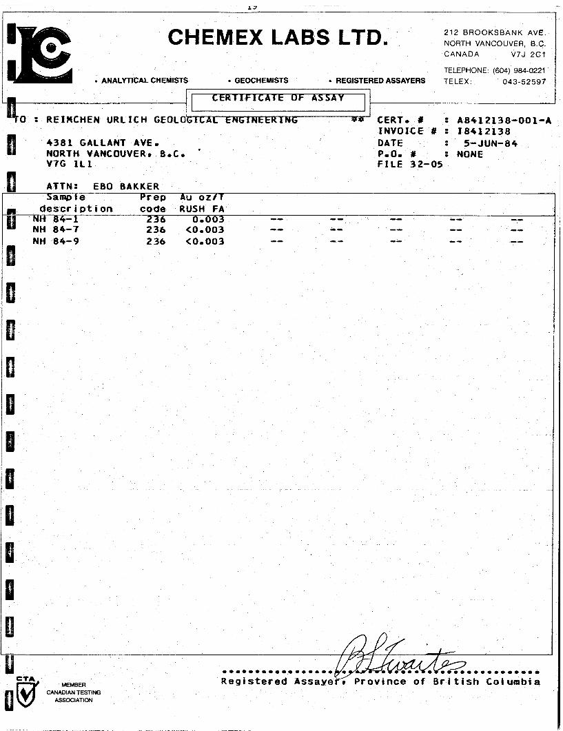
CHEMEX LABS LTD. 212 B R O O K S B A N K AVE.
NORTH VANCOUVER. B.C.
TELEPHONE. (604) 984-0221 ANALYTICAL CHEMIST EDASSAYERS TELEX.
0 : RElMCHEN U R L I C H GEOLO CERTo # : A 8 4 1 2 1 3 8 - 0 0 1 - A I N V O I C E # : 1 8 4 1 2 1 3 8
4381 GALLANT AVEo I DATE : 5-JUN-84
NORTH VANCOUVER. B r C o ' Po00 # : NONE V7G It1 F I L E 32-05
236 <Oo003
0 * * 0 * * ~ * 0 * * 0 * 0 * * 0 0 0 * 0 * 0 * * 0 * 0
Registered Assaye titish Columbia CANADIAN TESTING
ASSOCIATION

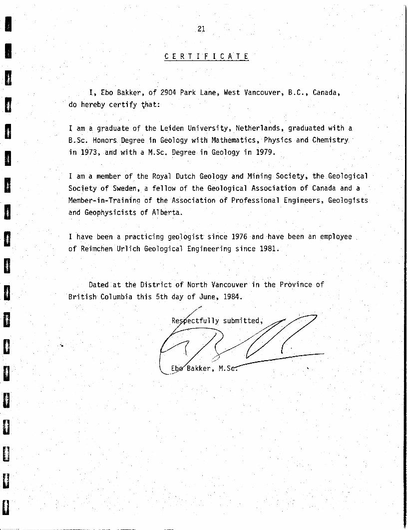
I, Ebo Bakker, of 2904 Park Lane, West Vancouver, B.C., Canada,
do hereby c e r t i f y t ha t :
I am a graduate of the Leiden Un ive rs i t y , Netherlands, graduated w i t h a
B.Sc. Honors Degree i n Geology w i t h Mathematics, Physics and Chemistry
i n 1973, and w i t h a M.Sc. Degree i n Geology i n 1979.
I am a member o f the Royal Dutch Geology and Mining Society, t h e Geological
Soc ie ty o f Sweden, a f e l l o w of t he Geological Assoc ia t ion o f Canada and a
Member-in-Trainina of the Associat ion o f Professional Engineers, Geologists
and Geophysicists of A1 berta.
I have been a p r a c t i c i n g geo log is t s ince 1976 and have been an employee
of Reimchen U r l i c h Geological Engineering s ince 1981.
Dated a t the D i s t r i c t o f North Vancouver i n the Province of
B r i t i s h Columbia t h i s 5 th day o f June, 1984.
*