report on preliminary site investigation€¦ · mr stephen mcmahon rev 0 . 1 . 0 . macarthur...
TRANSCRIPT

Appendix C
Report on Preliminary Site Investigation

Report on Preliminary Site Investigation
Land Capability Study Lowes Creek Maryland Precinct, Bringelly, NSW
Prepared for Department of Planning & Environment and
Camden Council c/- Macarthur Developments
Project 76742.00 September 2018
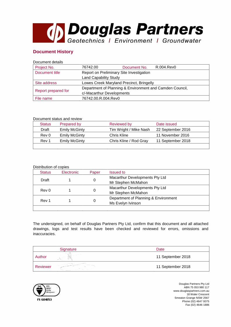
Document History
Document details Project No. 76742.00 Document No. R.004.Rev0 Document title Report on Preliminary Site Investigation
Land Capability Study Site address Lowes Creek Maryland Precinct, Bringelly
Report prepared for Department of Planning & Environment and Camden Council, c/-Macarthur Developments
File name 76742.00.R.004.Rev0 Document status and review
Status Prepared by Reviewed by Date issued Draft Emily McGinty Tim Wright / Mike Nash 22 September 2016
Rev 0 Emily McGinty Chris Kline 11 November 2016 Rev 1 Emily McGinty Chris Kline / Rod Gray 11 September 2018
Distribution of copies
Status Electronic Paper Issued to
Draft 1 0 Macarthur Developments Pty Ltd Mr Stephen McMahon
Rev 0 1 0 Macarthur Developments Pty Ltd Mr Stephen McMahon
Rev 1 1 0 Department of Planning & Environment Ms Evelyn Ivinson
The undersigned, on behalf of Douglas Partners Pty Ltd, confirm that this document and all attached drawings, logs and test results have been checked and reviewed for errors, omissions and inaccuracies.
Signature Date
Author 11 September 2018
Reviewer 11 September 2018
Douglas Partners Pty Ltd ABN 75 053 980 117
www.douglaspartners.com.au 18 Waler Crescent
Smeaton Grange NSW 2567 Phone (02) 4647 0075
Fax (02) 4646 1886

Preliminary Site Investigation, Proposed Rezoning Project 76742.00.R.004.Rev1 Lowes Creek and Maryland Precincts, Bringelly, NSW September 2018
Table of Contents Page
1. Introduction..................................................................................................................................... 1
1.1 Purpose ................................................................................................................................ 1
2. Scope of Works .............................................................................................................................. 1 3. Site Description .............................................................................................................................. 2
3.1 Separate Ownership Lots .................................................................................................... 3
4. Site Background ............................................................................................................................. 3
4.1 Site Topography ................................................................................................................... 3
4.2 Regional Geology and Soil Landscapes .............................................................................. 3
4.3 Regional Hydrology and Hydrogeology ............................................................................... 4 4.4 Review of Previous Reports ................................................................................................ 5
4.5 Statutory Notices and Licenses ........................................................................................... 8
4.6 Historical Council Records ................................................................................................... 9
4.7 Review of Historical Aerial Photographs.............................................................................. 9
4.8 Birling Carcass Burial Pits .................................................................................................20 5. Site Walkover ............................................................................................................................... 21
5.1 Part Lot 101 .......................................................................................................................21
5.2 Lots 3, 4 (North) and 4 (East) ............................................................................................21
5.3 Lot 29 .................................................................................................................................22
5.4 Lot 1 (north) .......................................................................................................................24
5.5 Lots 21 to 23 ......................................................................................................................24 5.6 Lots 1 south and 8 .............................................................................................................25
5.7 Lots 10 and 15 ...................................................................................................................25
5.8 Lot 102 ...............................................................................................................................26
6. Potential Areas of Environmental Concern .................................................................................. 27
7. Areas of Environmental Concern ................................................................................................. 30
8. Conclusions and Recommendations ........................................................................................... 36 8.1 Unexpected Finds ..............................................................................................................37
9. Limitations .................................................................................................................................... 37 Appendix A: About This Report and Drawings C1 to C5 Appendix B: Historical Reports Appendix C: Response from Local Land Services Appendix D: Section 149 Certificates Appendix E: Historical Aerial Photographs Appendix F: Report from Dr. Reynolds, University of Sydney Appendix G: Site Photographs C1 to C32 Appendix H: Laboratory Analytical Reports Appendix I: PAEC Forms

Page 1 of 38
Preliminary Site Investigation, Proposed Rezoning Project 76742.00.R.004.Rev1 Lowes Creek and Maryland Precincts, Bringelly, NSW September 2018
Report on Preliminary Site Investigation Proposed Rezoning Lowes Creek Maryland Precinct 1. Introduction
Douglas Partners Pty Ltd (DP) was commissioned by Mr Stephen McMahon of Macarthur Developments Pty Ltd (MD) on behalf of Department of Planning & Environment and Camden Council to complete a Preliminary Site Investigation (PSI) for a parcel of land located within Lowes Creek Maryland Precinct (‘the site’). The site has been previously been identified by the Growth Centres Commission for potential rezoning and urban development under the State Environmental Planning Policy (Sydney Regional Growth Centres) 2006. The site is currently zoned RU1 (primary production) and is proposed to be rezoned for various purposes, including (and predominantly) residential land use. This PSI forms part of a Land Capability Assessment for the site (DP (2018a) Report on Land Capability Study, Lowes Creek Maryland Precinct, Bringelly. Project No. 76742.00.R.001.Rev0); the geotechnical and salinity investigation findings are reported separately in the following reports:
• DP, 2018b. Report on Geotechnical Investigation, Lowes Creek Maryland Precinct, Bringelly. Project No. 76742.00.R.002; and
• DP, 2018c. Report on Salinity Assessment and Salinity Management Plan, Lowes Creek Maryland Precinct, Bringelly. Project No. 76742.00.R.003.
This PSI has been completed with reference to with the requirements for a PSI as provided in State Environmental Planning Policy 55 (SEPP 55) Remediation of Land and NSW Environment Protection Authority (EPA) guidelines made and endorsed under the Contaminated Land Management Act 1997. 1.1 Purpose
The purpose of this PSI is to assess the potential for soil and groundwater impact at the site and identify if the site is suitable for the proposed rezoning. 2. Scope of Works
The scope of works completed for the PSI is presented below:
• Site walkover by an environmental engineer;
• Search through the NSW EPA Land Information records to identify current statutory notices current on any parts of the site issued under the Contaminated Land Management Act, 1997;
• Review of available historical reports and aerial photographs to identify previous land uses on the site;
• Interviews with local residents and land owners (where possible) to obtain anecdotal information regarding the potential nature and extent of site filling;

Page 2 of 38
Preliminary Site Investigation, Proposed Rezoning Project 76742.00.R.004.Rev1 Lowes Creek and Maryland Precincts, Bringelly, NSW September 2018
• Compilation of a list of Potential Areas of Environmental Concern (PAEC) for the site based on the findings of the PSI, with each PAEC assessed individually to determine likely presence of and risk from contamination. Certain PAEC have been determined to be Areas of Environmental Concern (AEC) that will require further investigation and / or management; and
• Preparation of this PSI report. 3. Site Description
The site is located on The Northern Road, approximately 9 kilometres (km) north west of Narellan Town Centre and approximately 7 km west of Leppington town centre. The site is approximately 517 hectares (ha) in size and is expected to contain approximately 7,000 dwellings. The site is located within the Camden Council local government area (LGA) and is currently used for a combination of rural residential and agricultural (predominantly pastoral) purposes. The site comprises the following lots as shown on Drawing C1 (Appendix A):
• Part Lot 101 Deposited Plan (D.P) 1203966 (Lot 101);
• Lot 20 D.P. 1227094 (Lot 20)
• Lots 4 D.P. 1218798 (Lot 4);
• Lot 13 D.P. 1218155 (Lot 13);
• Lot 1 D.P. 218779 (Lot 1 north);
• Lots 9 and 10 D.P. 1216926 (Lots 9 and 10 north);
• Lot 23 D.P. 836540 (Lot 23);
• Lot 1 D.P. 1216380 (Lot 1 south);
• Lot 10 D.P. 1218155 (Lot 10); and
• Lot 11 D.P. 1218155. The site is irregular in shape and is bordered by The Northern Road along the eastern boundary and mixed rural residential and agricultural land to the north, west and south. Lowes Creek (watercourse) runs west to east through the centre of the site. The site is accessed via The Northern Road and is currently being used for mixed rural residential, agricultural and grazing purposes. Maryland Homestead is located on Lot 1 north, near to the centre of the site. Lots 20 and 4 were until recently occupied by Birling Avian Laboratories where testing of veterinary treatments and chemicals occurred. DP understands that Lot 1 (south) is to be retained and continue occupancy by the current occupants as part of the development works. Heritage buildings located in Lot 1 (north) and Lot 13, near to Lot 1 will also be retained.
Page 3 of 38
Preliminary Site Investigation, Proposed Rezoning Project 76742.00.R.004.Rev1 Lowes Creek and Maryland Precincts, Bringelly, NSW September 2018
3.1 Separate Ownership Lots
Lots 9, 10, 23 and 11 (separate ownership lots) are proposed to be included as part of the rezoning, however, transfer of ownership is currently being negotiated. These lots are currently used for rural residential and commercial purposes, and Lot 11 is currently occupied by ‘Hi - Quality Group’ a resource recovery and recycling facility. Therefore, works completed on these separate ownership lots under as part of this PSI have been restricted to a desk based study only. 4. Site Background
4.1 Site Topography
The site may be divided into three main topographic units (as presented in DP, 2018b):
1. Sloping ridgeline extending centrally from the southern edge of the site towards the north-east falling both eastward and westward to the course of Lowes Creek and its associated gullies. Lower ground slopes are typically less than 78 but increase towards the crest to approximately 22. The ridgeline comprises three crests and two saddles with the highest elevation along the ridgeline being RL 126 (relative to Australian Height Datum [AHD]).
The lower portions of the slopes and saddles have been cleared for grazing, whilst the crests range from open wooded areas to densely wooded areas.
2. The western edge of the site in which the dendritic drainage system of Lowes Creek (an initially easterly flowing tributary) has entrenched the bedrock forming side slopes mostly of about 10° to 12°, but locally steeper towards the crests of ridgelines and along eroded gully or stream beds. The gullies have been dammed in some locations for watering of stock. The highest elevation along within this portion is RL 132.
3. The remainder of the site comprises alluvium infilled valley floors of the eastward flowing Lowes Creek and gentler sloping hillsides feeding the creek. Surface levels range from approximately RL 100 along the western side of the site to RL 68 at the intersection of Lowes Creek with The Northern Road. While most of the unit has been cleared for use as grazing land, there is a discontinuous zone of remnant vegetation along the central section of the creek line.
4.2 Regional Geology and Soil Landscapes
Reference to the Penrith 1:100 000 Geological Series Sheet indicates that the site is underlain by Bringelly Shale of the Wianamatta Group of Triassic age. This formation typically comprises shale, carbonaceous claystone, laminite, fine to medium grained lithic sandstone and some minor coal bands. The bedrock is locally mantled by Quaternary aged alluvium (fine sand, silt and clay), particularly associated with Lowes Creek and minor creeks and gullies.

Page 4 of 38
Preliminary Site Investigation, Proposed Rezoning Project 76742.00.R.004.Rev1 Lowes Creek and Maryland Precincts, Bringelly, NSW September 2018
Reference to the Soil Landscapes of the Penrith 1:100 000 Sheet indicates that the site includes three soil landscapes: Blacktown Soil Landscape (bt) – which is mapped over most of the central and eastern sections of the site and is characterised by topography of "gently undulating rises on Wianamatta Group Shale, with local relief to 30 m and slopes usually less than 5 %". This is a residual landscape which the mapping indicates comprises up to four soil horizons that range from shallow red-brown hard-setting sandy clay soils on crests and upper slopes to deep brown to yellow sand and clay soils overlying grey plastic mottled clay on mid to lower slopes. These soils are typically of low fertility, are moderately reactive and have a generally low wet-bearing strength. Luddenham Soil Landscape (lu) – which is mapped in the western section of the site and is characterised by "undulating to rolling low hills on Wianamatta Group Shales, often associated with Minchinbury Sandstone with local relief 50 – 80 m, and slopes 5 % – 20 %.” The mapping indicates that it is an erosional unit with shallow (<1.0 m) Brown podsolic soils and massive earthy clays on crests and ridges and moderately deep (0.7 m to 1.5 m) Red podsolic soils on upper slopes. South Creek Soil Landscape (sc) – which is mapped along Lowes Creek and associated minor creeks extending south through the easternmost dam on Lot 13 and is characterised by “Floodplains, valley flats and drainage depressions of the channels on the Cumberland Plain. Usually flat with incised channels; mainly cleared.” Mapping indicates soils associated with this landscape comprise very deep layered sediments over bedrock or relict soils. Red and yellow podsolic soils occur. 4.3 Regional Hydrology and Hydrogeology
There are currently two large dams located in the southern half of the site (Lot 13), and several smaller dams across the site. Lowes Creek crosses the centre of the site in an east to west direction (see Drawings C2 and C3). Lowes Creek is a distributary of South Creek, which is located approximately 1.4 km to the east of the site. Approximately 6.5 km east/south east of the site is the Nepean River. Smaller creeks that are largely associated with the two large dams dissect the site in several locations. The site is located within the South Creek catchment area, and according to Camden Council NSW Office of Environment and Heritage Upper South Creek Flood Study for Camden Council, Final Report 2011, Rev 1, (NSW OEH 2011) flood prone land exists associated with and immediately adjacent to Lowes Creek, the two large dams located on the southern half of the site and three smaller dams located north of Lowes Creek (Lot 20). Based on site topography, surface water drainage preferentially flows toward Lowes Creek and toward the two large dams. Based on regional topography, groundwater is anticipated to predominantly flow toward the east. A review of data available on the Bureau of Meteorology (BOM) online Australian Groundwater Explorer1 was completed and the review indicates 24 registered bores are located on the site and within 1 km radius of the boundary of the site. The majority of these bores are used for ‘water supply’ purposes, three are used for monitoring, two for irrigation and one bore is used for exploration purposes. Bore installation details were not available. The shale terrain of much of Western Sydney is known for saline groundwater, resulting either from the release of connate salt in shales of marine origin or from the accumulation of windblown sea salt.
1 http://www.bom.gov.au/water/groundwater/explorer/. Accessed 7 June 2016.

Page 5 of 38
Preliminary Site Investigation, Proposed Rezoning Project 76742.00.R.004.Rev1 Lowes Creek and Maryland Precincts, Bringelly, NSW September 2018
Seasonal groundwater level changes of 1 – 2 m can occur in a shallow regolith aquifer or a deeper shale aquifer due to natural influences. Groundwater investigations undertaken by DP in the Camden area and previous studies of areas underlain by the Wianamatta Group and Quaternary alluvium indicate that:
• The shales have a very low intrinsic permeability, hence groundwater flow is likely to be dominated by fracture flow with resultant low yields (typically <1 L / s) in bores; and
• The groundwater in the Wianamatta Group is typically brackish to saline with total dissolved solids (TDS) in the range 4000 – 5000 mg / L (but with cases of TDS up to 31750 mg / L being reported). The dominant ions are typically sodium and chloride and the water being generally unsuitable for livestock or irrigation.
4.4 Review of Previous Reports
The site has been subject to the following previous investigations of relevance to the PSI: Lots 20 and 4
• The following extracts of reports and full reports of relevance to Birling Avian Laboratory were provided by MD to DP for this PSI:
o “Birling – Environmental Audit Action Plan 1990 – 1991” (EAAP, 1991: no author or date provided);
o Imcera, 7 March 990 (Imcera, 1990). Environmental Assessment – Birling Research Station;
o Pitman-Moore, 4 January 1991 (PM, 1991a). Environmental Action Plan – Birling Research Station, NSW;
o Pitman-Moore, 30 October 1991 (PM, 1991b). Facsimile Titled “RE: Effluent Ex-Birling”;
o File note dated 15 March 1991 (no stated author, 1991);
o Coopers, 22 November 1991 (Coopers, 1991). File note titled “Site Inspection by Waste Management authority 22 Nov”;
o PM 9 March 1992 (PM, 1992). Facsimile Reference Number 02 335 4067;
o Hand written notes dated 24 March 1992 (no stated author, 1992);
o ICI, 3 August 1992 (ICI, 1992). Internal Memorandum – Pitman-Moore Soil Sampling;
o Imcera, 26 May 1993 (Imcera, 1993). Interoffice Correspondence – Environmental Costs and Reserves; and
o PM, 25 May 1993 (PM, 1993). Environmental Protection – ANZ Sub Region.
• Camp Scott Furphy, November 1993 (CSF, 1993). Soil Contamination Assessment for “Birling” Farm Research Station;
• CSF, 20 May 1994 (CSF, 1994a). Excavation of PCB and Pyrethroid Contaminated Soil at “Birling” Research Farm – Summary Report. Prepared for Pitman – Moore; and
• CSF, August 1994 (CSF, 1994b). Remediation Report on Birling Research Farm for Mallinckrodt Veterinary Ltd (formerly Pitman-Moore Australia Ltd).

Page 6 of 38
Preliminary Site Investigation, Proposed Rezoning Project 76742.00.R.004.Rev1 Lowes Creek and Maryland Precincts, Bringelly, NSW September 2018
Copies of the above reports are provided in Appendix B, attached. Based on available site history (provided in CSF, 1994b) Birling avian laboratory was operated by Mallinckrodt (formerly Pitman-Moore) around 1994. Prior to this, the site has been used for testing of a range of veterinary formulations on livestock. The farm area has also been used as a horse stud between 1981 and 1985. Birling has not operated as a veterinary testing facility since December 1993. Historically, an incinerator used for the incineration of animal carcasses was located at the site. Burial of diseased carcasses as well as ash from the incinerator has been placed at the site. The locations of the former incinerator and where burial of animal (sheep and cattle) carcasses occurred are shown in Drawing C2 (Appendix A). An area of the site historically referred to as “the sheep palace” (sheep dip spraying yard) was located in “Paddock #20” (refer to Drawing C2; Appendix A) which was partially constructed with transite (containing asbestos) and has previously been subject to a contamination investigation (CSF, 1993) for pesticides and polychlorinated biphenyls (PCB) – none were recorded. No mention of the decommissioning and removal of transite materials was made in the documentation that has been reviewed by DP. Two fuel tanks have been historically located at the site, including (i)an underground petrol tank (refer to Drawing C2; Appendix A) near to the office buildings which in recent years was filled with water and is known to have historically leaked; and (ii) an above ground diesel tank (Drawing C2; A) which was later bunded (EAAP, 1991) and is still located at the site (refer to Section 4.8). Chemical wastes in “chicken shed number 1” (Drawing C2; Appendix A) were stored in large volumes which were subsequently removed (EAAP, 1991) and appropriately tidied up and disposed of (PM, 1991a). The exact type of chemicals that were stored is not stated in any of the documents provided to DP. Surface (top 0.25 m) soil samples were collected from laboratory leach drains (location not known) and analysed for major ions and total dissolved solids (TDS), and results were interpreted to be “minimal, if not non-existent” (PM, 1992). The Birling site was inspected by the Waste Management Authority (WMA) in 1991 (Coopers, 1991) who communicated to Coopers that they were basically satisfied with the waste management processes at that time, however, the on-site incinerator would require some form of improvement. A fenced enclosure located at the Birling site (may also be referred to as “Paddock #20”) and shown on Drawing C2 has historically received untreated waste from the laboratory Drawing C2; Appendix A) which has subsequently run into a leach drain, and potentially a dam located further downgradient. Soils within the enclosure were tested for organochlorine and organophosphorus pesticides and analytical results recorded deltamethrin (up to 26 mg/kg), chlorpyrifos (up to 0.3 mg/kg), chlorfenvinphos (up to 0.03 mg/kg), chlordane (up to 0.15 mg/kg), cyhalothrin (up to 30 mg/kg), cypermethrin (up to 0.01 mg/kg), deltamethrin (up to 4 mg/kg), DDE (up to 0.04 mg/kg), dieldrin (up to 0.13 mg/kg), DDD (up to 0.02 mg/kg), ethion (up to 0.2 mg/kg), malathion (up to 0.09 mg/kg) and PCBs (up to 3 mg/kg per congener). PCB were recorded in soils at concentrations up to 16 mg/kg, close to the point of effluent discharge (CSF, 1993). Approximately 15.5 tonnes of impacted soils were subsequently remediated and validated from near the discharge point located at Paddock #20 (CSF, 1994a). The current exact location of the discharge point is not known.

Page 7 of 38
Preliminary Site Investigation, Proposed Rezoning Project 76742.00.R.004.Rev1 Lowes Creek and Maryland Precincts, Bringelly, NSW September 2018
CSF completed a targeted investigation of key areas of the Birling site, including the laboratory waste disposal area in Paddock #20 (after removal of impacted soils), laboratory drain, sheep shearing shed, carcass disposal area, metal waste area and “dumping ground” (CSF, 1994). Soils in the carcass disposal area contained animal carcasses buried with a “white chemical” (likely cypermethrin) and occasional plastics. Animal carcasses as well as building and laboratory waste were observed in the “dumping ground” located next to Lowes Creek (CSF, 1994). The CSFs investigation report (CSF, 1994) indicates that disposal practices here were largely uncontrolled. No buried material was encountered in the metal waste area. Soil and sediments (dam and drain, where relevant) were sampled and analysed for metals, pesticides and PCBs (CSF, 1994). In general, analytical results did not indicate impact, with the exception of the following:
• Cypermethrin in the carcass disposal area (2.8 mg/kg);
• Metals, hexachlorobenzene (0.02 mg/kg) and phenols (up to 1.5 mg/kg) in the dumping grounds next to Lowes Creek;
• Dichloromethane (0.6 mg/kg) and zinc (310 mg/kg) in the metal waste area; and
• Dichloromethane (0.6 mg/kg) in the tank bund area north of the laboratory. Based on laboratory correspondence included with CSFs investigation report (CSF, 1994), observed that concentrations of dichloromethane may be sourced from laboratory sample extraction techniques. Used oils, including crankcase, gearbox and vacuum pump oils may have historically been disposed of at the site, however, the exact location of disposal is not known (Imcera, 1990). Lot 1 North (Maryland Homestead) The following reports of relevance to Maryland Homestead were provided by MD to DP for this PSI:
• NSW EPA (2012). Clean-Up Notice issued to J.P. Haines Plumbing Pty. Ltd. Dated 27 April 2012. Notice number 1504687. File number FIL 12 / 1969;
• P. Clifton & Associates Ptd Ltd (2012) RE; Visual Inspection Following Removal of Asbestos Contaminated Soil. Maryland, 877 The Northern Road, Bringelly, NSW. RE: Visual Asbestos Removal Clearance Certification.(P. Clifton, 2012);
• NSW EPA (2013). ‘Maryland’ 877 The Northern Road, Bringelly – Ground Technologies Report GTE206 Compliance with Clean-Up Notice No 1504687;
• Tropman and Tropman Architects, November 2014 (T and T, 2014). Maryland Estate, Also formerly Known as Nonnorrah, Lot 1, DP218779 & Lot 29, DP 872135, 773 The Northern Road, Bringelly. Preliminary European Heritage Assessment for Curtilage. Prepared for Macarthur Developments Pty Ltd to accompany the Maryland Estate Curtilage Proposal. For submission to Department of Planning NSW;
• Rosemary Broomham, Consultant Historian / Archaeologist, February 2015 (RB, 2015). Maryland Homestead 773 The Northern Road, Bringelly, NSW. Historical Context; and
• Casey and Lowe Pty Ltd, May 2016 (CL, 2016). 1, Historical Archaeological Assessment, Maryland, Bringelly. Prepared for T and T, on behalf of Macarthur Developments.
Copies of the above reports are provided in Appendix B, attached.

Page 8 of 38
Preliminary Site Investigation, Proposed Rezoning Project 76742.00.R.004.Rev1 Lowes Creek and Maryland Precincts, Bringelly, NSW September 2018
The Maryland Homestead area has historically encompassed both Lot 1 north and Lot 13. The first land grants and subsequent settlement occurred in the 1810s. The establishment of a farm here appeared to have occurred in and around 1816 (CL, 2016) and subsequently wheat, maize, barley and potatoes were grown. A 2 acre garden/orchard was also established around this time. Cattle and sheep grazing also occurred. A vineyard was established at the site on slopes to the north of the homestead in the 1860’s until the late 1890’s when a fire destroyed the cellar, assumed by DP to be located at the homestead (Drawing C3; Appendix A). The area was established as a dairy farm in the 1950’s and was continued to be used for dairy farming until 2012 (CL, 2016). Ad hoc rubbish pits and cesspits may be present near buildings across the homestead area (CL, 2016). A feature suspected by CL to be a cattle dip (Drawing C3; Appendix A) was observed on recent aerial photographs (CL, 2016). A clean up notice was issued by NSW EPA with respect to ACM impact observed on land between the north of the westernmost dam and south of the access road here (refer to Drawing C2). A total of 111.04 tonnes of ACM impacted material was subsequently removed and a visual inspection completed (P. Clifton, 2012) which concluded that the surface was free of visible ACM. Subsequent correspondence provided by NSW EPA (2012) confirmed they were satisfied that the clean-up carried out complied with the clean-up notice. Boral (Part Lot 101) The following reports have been provided to DP of relevance to the Boral site, which includes part Lot 101, located in the north western corner of the site:
• DP, 4 June 2015 (DP, 2015). Site Clean-up Status Report, Lot 101 Greendale Road, Bringelly, NSW. Letter report prepared for Macarthur Developments; and
• Transpacific, 20 August 2015 (Transpacific, 2015). Boral Bringelly Greendale Road, Bringelly, NSW ( 101 DP 1203966) Surplus Site Clean-up Validation Report. Prepared for Boral.
Part Lot 101 was subject to a site clean-up to remove bricks and other anthropogenic material, including a car body, general domestic fly tipping and ACM along a creek located here. Remediation validation results were below relevant criteria and the laboratory limit of reporting (LOR), with the exception of PCB, dieldrin and zinc in sediments along the creek. Fill material in the creek was remediated to remove observed ACM. Buried bricks in ‘Area 5’ of the creek (refer to Drawing C2) were retained owing to the dense population of juvenile eucalyptus trees in this area, however no visible ACM was observed by Transpacific. 4.5 Statutory Notices and Licenses
A search on the NSW EPA Land Information records2 confirmed that there are no current statutory notices under the Contaminated Land Management Act (1997) for any parts of the site (and the clean - up Notice as referenced above appears to have discharged to the satisfaction of EPA). The NSW Local Land Services (LLS) for Greater Sydney were contacted as part of this PSI to enquire whether there were any records of notifiable diseases under the Stock Diseases Act (1923). The LLS confirmed that no such reports have been made for the site (refer to Appendix C).
2 Completed on 3 August 2016.

Page 9 of 38
Preliminary Site Investigation, Proposed Rezoning Project 76742.00.R.004.Rev1 Lowes Creek and Maryland Precincts, Bringelly, NSW September 2018
Lot 11 is currently licensed to the Hi-Quality Group under the Protection of the Environment Operations Act (1997) to carry out composting, recovery of general wastes and storage of ‘other types of waste’. No further information was provided regarding the type of wastes located on Lot 11. 4.6 Historical Council Records
A request was made to Camden Council for records pertaining to previous site use, any information relating to known areas of flood prone land, or site contamination under Section 149 (2 and 5) of the Environmental Planning and Assessment Act 1979. Based on DPs review of the certificates, there are no known issues with regard to land contamination associated with these lots. Copies of the Section 149 (2 and 5) planning certificates are provided in Appendix D. The site area in general is identified in these records as being within a flood related development control area, however, further specific information is not provided. The general region is also noted to be subject to coal seam gas exploration. Lots 1 and 13 have been identified as containing features of environmental heritage which DP understands is associated with Maryland Homestead (on Lot 1) and a nearby cottage (on Lot 13). 4.7 Review of Historical Aerial Photographs
Historical aerial photographs available for the years 1961, 1970, 1982, 1994, 2005 and 2015 are provided in Appendix E and key observations are presented below:
• 1961 (does not cover part of Lots 1 south, and Lot 11 in the southern part of the site):
o The site (as covered by the aerial photograph) comprises open fields, which appear to be partially cultivated in Lots 20, 9, 10 and 23;
o Buildings that appear to be associated with a farm are present in Lot 1 north;
o A total of nine dams are present at the site, including a large dam in the easternmost part of Lot 13 (currently present), and several across part Lot 101 and Lot 20 and Lot 13. A small dam is located in the north western part of Lot 13, which is presently the site of a large dam (refer to Drawing C3);
o Buildings are present in the Maryland Homestead area, however the present dairy sheds do not appear to be present;
o A suspected racetrack (oval profile) is located in the south eastern corner of Lot 20;
o A house and nearby smaller structure is present on Lot 20, where the Birling Laboratory buildings are currently located. Smaller structures, including a possible house are located approximately 270 m toward the south west of the house; and
o Four areas of possible ground disturbance are observed across the site; two in Lot 20 and two in Lot 13.
• 1970 (does not cover the westernmost part of part Lot 101):
o A large dam is now present in the western part of Lot 13;
o Additional buildings, likely part of the current Birling Avian Laboratory are now present in the northern part of Lot 20;

Page 10 of 38
Preliminary Site Investigation, Proposed Rezoning Project 76742.00.R.004.Rev1 Lowes Creek and Maryland Precincts, Bringelly, NSW September 2018
o The racetrack observed in the south eastern corner of Lot 20 in the preceding aerial is no longer evident. Two additional dams and three recently cultivated fields are located on Lot 20;
o The dairy sheds which form part of the Maryland homestead are now present; and
o Lot 23 appears to have been cleared and a field cultivated.
• 1982 (does not cover a small part of the westernmost area of part Lot 101):
o Stables are now present in the north western part of Lot 4;
o Two small dams are located to the south of the laboratory buildings in Lot 20; and
o Small structures, including a house have been constructed on Lot 1 (south).
• 1994:
o Land clearance and stockpiling has occurred on Lot 11 since the previous aerial;
o Possible ground disturbance or stockpiling is evident south of the access road to Lot 1 (north);
o Localised possible ground disturbance is evident north east of the large dam located in the western part of Lot 13; and
o Additional structures appear to have been constructed on Lot 4 to the south of the main laboratory buildings, since the previous aerial.
• 2005:
o Lots 9 and 23 appear to have undergone significant change since the previous aerial photograph, including the construction of houses and other buildings, the construction of dams and an artificial channel, and suspected ground disturbance and debris located on Lot 23, near to Lowes creek; and
o Localised clearance of vegetation is evident on Lot 13, to the north east of the farmstead buildings. Elongate suspected stockpiles are evident on Lot 13 to the north of the farmstead buildings.
• 2015:
o Stockpiles are present near to the north eastern corner of the large dam located in the eastern part of Lot 13, and near to the farmstead buildings. Stockpiles of suspected pipes are observed near to the creek draining to the south of the large dam on the eastern part of Lot 13; and
o Possible debris, stockpiling or fly tipping is evident in the westernmost part of Lot 13, adjacent to the large dam in this area.
• 2010 to current (online review of NearMap aerial photographs):
o To establish recent land changes that may have occurred, DP conducted a review of historical aerials that are currently available on NearMap3. Key observed features are presented in Figures C1 to C16 below and their localities are presented on Drawings C2 and C3 (Appendix A).
3 http://maps.au.nearmap.com/. Last accessed 8 September 2016.

Page 11 of 38
Preliminary Site Investigation, Proposed Rezoning Project 76742.00.R.004.Rev1 Lowes Creek and Maryland Precincts, Bringelly, NSW September 2018
Figure C1: Lot 13 south of easternmost dam – Several elongate features (including possible
fence lines) and stockpiles (September 2010)
Figure C2: Lot 13 south side of access road to Lot 1 (July 2010) – Linear trench in the ground
and based on later aerial photographs and observations made during the Walkover this feature appears to have been filled in based on later aerial photographs

Page 12 of 38
Preliminary Site Investigation, Proposed Rezoning Project 76742.00.R.004.Rev1 Lowes Creek and Maryland Precincts, Bringelly, NSW September 2018
Figure C3: Lot 13 west side of westernmost dam – Stockpiles (September 2010)

Page 13 of 38
Preliminary Site Investigation, Proposed Rezoning Project 76742.00.R.004.Rev1 Lowes Creek and Maryland Precincts, Bringelly, NSW September 2018
Figure C4: Lot 13 – Land clearance and material storage associated with film set
(confirmed by MD to be located at the site during this time) is present at the site (November 2016)

Page 14 of 38
Preliminary Site Investigation, Proposed Rezoning Project 76742.00.R.004.Rev1 Lowes Creek and Maryland Precincts, Bringelly, NSW September 2018
Figure C5: Lot 13 – Film set has been cleared, however stockpiles remain north of the
westernmost dam and some land scarring is evident (January 2016)

Page 15 of 38
Preliminary Site Investigation, Proposed Rezoning Project 76742.00.R.004.Rev1 Lowes Creek and Maryland Precincts, Bringelly, NSW September 2018
Figure C6: Lot 13 – Land clearing and stockpiling north of westernmost dam (May 2012)
Figure C7: Lot 13 – Current stockpiling area located north of westernmost dam and north of
laydown yard appears to have been utilised as a laydown yard and parking of large vehicles (possibly trucks) or shipping containers (2012)

Page 16 of 38
Preliminary Site Investigation, Proposed Rezoning Project 76742.00.R.004.Rev1 Lowes Creek and Maryland Precincts, Bringelly, NSW September 2018
Figure C8: Lot 13 – Land scarring and stockpiling in the north eastern part of the lot (2012)
Figure C9: Lot 13 – Stockpiling and possible filling in the north eastern part of the lot (2012)

Page 17 of 38
Preliminary Site Investigation, Proposed Rezoning Project 76742.00.R.004.Rev1 Lowes Creek and Maryland Precincts, Bringelly, NSW September 2018
Figure C10: Lot 13 – Stockpiles and material laydown areas north of the farmstead area
(present in aerials until 2012)
Figure C11: Small dam east of Lot 1 north, Lot 13 – Two structures (no longer present) located
near the current dilapidated timber / metal shed (present until mid – late 2013)

Page 18 of 38
Preliminary Site Investigation, Proposed Rezoning Project 76742.00.R.004.Rev1 Lowes Creek and Maryland Precincts, Bringelly, NSW September 2018
Figure C12: Access road through Lot 13 to Lot 1 north structure near former residential
cottage – (present until 2010)
Figure C13: Lot 10 – Land scarring and small structure (now under dam water) located in dam
next to creek in ploughed field (February 2011)

Page 19 of 38
Preliminary Site Investigation, Proposed Rezoning Project 76742.00.R.004.Rev1 Lowes Creek and Maryland Precincts, Bringelly, NSW September 2018
Figure C14: Lot 10 – Unknown features (#2, 4, 5 and 7), stockpiles (#3, 6 and 8) and land
scarring (#1) surrounding large shed (October 2011)
Figure C15: Lot 10 eastern part – Land scarring, stockpiles and general fill (all aerials)

Page 20 of 38
Preliminary Site Investigation, Proposed Rezoning Project 76742.00.R.004.Rev1 Lowes Creek and Maryland Precincts, Bringelly, NSW September 2018
Figure C16: Lot 10 – Suspected washout / erosion of soils from near Lot 102 (February 2011) 4.8 Birling Carcass Burial Pits
The PSI has identified three pits at the site where the burial of sheep and cattle carcasses has historically occurred at the site (refer to Section 4.4). The burial pits are located on Lot 20 which forms part of the former Birling avian laboratory. In a general sense, bacillus anthracis spores (anthrax) may potentially be associated with buried or disposed animal carcasses that are infected with the associated spores. This risk of infection is greater in a region of NSW which is known as the “anthrax belt” which runs through the centre of NSW and into Victoria. In NSW, should symptoms of anthrax infection be observed in livestock, the LLS are required to be notified under the Stock Diseases Act (1923). The NSW LLS for Greater Sydney were contacted by DP as part of this PSI to confirm whether there were any records of notifiable diseases under the Stock Diseases Act (1923). The LLS confirmed that no such reports have been made for the site (refer to Section 4.5).

Page 21 of 38
Preliminary Site Investigation, Proposed Rezoning Project 76742.00.R.004.Rev1 Lowes Creek and Maryland Precincts, Bringelly, NSW September 2018
Further advice regarding the risk of anthrax spores at the site was sought from livestock Veterinary specialist Dr Michael Reynolds from the Faculty of Veterinary Science, University of Sydney, NSW. Dr Reynolds was provided with the site location, site history information, results from geotechnical mapping showing the location of waterlogged soil and the burial pits (DP, 2018b) and soil pH data obtained from the salinity investigation (DP, 2018c). Dr Reynolds’ report is presented in Appendix F and concludes the following: “In conclusion, whilst the risk of Anthrax can never be completely removed from any property which has been grazed by livestock, or in which livestock have been buried, in my professional opinion, no further investigations and/or soil testing specific to anthrax, or restrictions on development, are deemed necessary prior to the proposed residential redevelopment of the Bringelly site. I do not believe the proposed development site in Bringelly to be at a greater Anthrax risk than any other property outside of the Anthrax belt.” 5. Site Walkover
A site walkover was completed by a DP environmental scientist in four stages, on 22 and 24 July, 10 August and 15 September 2016. Key findings of the site walkover are presented in Drawings C2 and C3 (Appendix A) and discussed below. Photographs referenced throughout are presented in Appendix G. 5.1 Part Lot 101
Part Lot 101 were located in the north western extent of the site. The western / north western extent of here comprised bushland cover, and the remaining extent grass cover. The topography of this area was generally more variable than the remaining extent of the site. Several dams were located across this area; based on field observations the construction of the dam walls appeared to comprise natural soils only. Several patches of scorched grass cover were observed (burn sites – Photograph C1), likely associated with controlled burning of stockpiles of vegetation. Two separate stockpiles of old barbed wire were also present. A metal water tank was located adjacent to the eastern boundary. Part Lot 101 is separated by Lot 20 (to the east) by a metal electric fence. 5.2 Lots 20 and 4
Lots 20 and 4 were occupied by Birling Avian Laboratory and surrounding farmland were used for dairy pastoral purposes. DP inspected the grounds with ‘Joe’, the laboratory groundskeeper who has worked at the site for approximately 20 years and provided information regarding the layout and history of the grounds associated with the laboratory, which has been incorporated in the findings of the walkover and as presented below.

Page 22 of 38
Preliminary Site Investigation, Proposed Rezoning Project 76742.00.R.004.Rev1 Lowes Creek and Maryland Precincts, Bringelly, NSW September 2018
The main laboratory buildings comprised an office building, former office building, chicken sheds (Photographs C2 and C3) and a former sheep shearing shed (Photograph C4). A house was also located in the main building area, and a second house was located further south. The chicken sheds (not currently in use) comprised steel and plastic with corrugated ACM present in panels located below the windows. The roof of the sheep shearing shed was constructed with ACM. None of the buildings are connected to a mains water supply; toilets are served by a septic tank (location not known) and dam water was pumped to a tank located near to the main buildings (Photograph C5) where it is treated with chlorine and aluminium sulfate and subsequently used for toilets etc. Drinking water is brought onto site from a commercial supplier. No irrigation has been conducted within the grounds of the laboratory for the last 20 years. With the exception of Roundup (spot weed killer), no chemicals were been added to the grounds in the last 20 years. A former petrol tank (Drawing C2; Appendix A) has recently been removed from near the office buildings, and the underlying soils removed and validated (Photograph C6). DP understands that a report documenting the findings of this validation works been prepared at the time of reporting (consultant not known). A bunded diesel tank (Drawing C2; Appendix A) was located at the site (Photograph C7). Historically, an incinerator has been used at the site (Drawing C2; Appendix A); however the incinerator has since been removed. No fill material has been placed on or below the ground surface in the last 20 years, and all dams located at the site were constructed more than 20 years ago. A total of sixteen dams of varying size were located across the grounds. Four of the dams may contain some introduced fill material in the surrounding walls. Lowes Creek is immediately adjacent to the southern boundary of Lot 20. 5.3 Lot 13
Lot 13 largely comprised pastoral land, much of which was occupied by cattle at the time of the walkover. A metal electric wire fence separates individual grazing paddocks across much of the Lot. Two large dams are also located on Lot 13; one in the eastern half and the other in the western half of the lot. Three smaller dams are also located on the Lot; one near to the western boundary, one slightly east of the western dam and the remaining dam is located south of Lot 1 north. No man-made fill material associated with the dams was visible at the time of the walkover. A small creek drains through Lot 10 northwards, toward the easternmost large dam. Occasional disused structures (cottage and sheds) are located adjacent to the access road and are generally made of timber and sheet metal. A residential cottage (now abandoned) was located south of Lot 1 north; a small bank that forms part of the garden area to the south of the house may comprise fill, however grass cover inhibited close inspection. Dairy sheds (Photograph C8) associated with the historical Maryland Farm area are located on Lot 13 and were occupied by a large number of ducklings (contained within the sheds) at the time of the walkover.

Page 23 of 38
Preliminary Site Investigation, Proposed Rezoning Project 76742.00.R.004.Rev1 Lowes Creek and Maryland Precincts, Bringelly, NSW September 2018
A farmstead, including work sheds and a house were located near to the centre of Lot 13 which was occupied at the time of the walkover. To the south west of the farmstead were three small stockpiles of topsoil, organic material, an old barbed wire fence and metal poles, corrugated steel and an older timber power pole (Photograph C9). A power line located nearby appears to have recently been replaced with metal poles. Based on information provided by the groundskeeper for Birling Avian Laboratory (Lot 4), below ground ACM pipes may have recently been removed from Lot 13. The current manager of the farm located on Lot 13 confirmed that ACM pipes associated with the easternmost large dam were previously removed. A pump house constructed with sheet metal was located near to the north eastern corner of the western part of the lot (Photograph C10), and a small dam is also located to the east of this structure. No fill material was observed associated with this dam; however grass and tree cover inhibited close inspection of the area. A laydown/storage yard was located near to the north eastern corner of the large dam in the western part of the site (Photograph C11). The laydown yard appeared to be used for the storage of wood chippings As well as old machinery, shipping containers and a cherry picker. A large (presumably soil) stockpile (Photograph C12) was present immediately north of the laydown yard which was covered with dense grass, therefore preventing verification of stockpile contents. Several smaller stockpiles were also located in the same area of Lot 13, some of which contained construction and demolition materials (Photograph C13). An access road running from the stockpiles and toward the west, and north of the western dam was covered with unconsolidated fill containing construction and demolition material, and occasional fragments of suspected Hardifence. A fragment was collected during the walkover and analysed for asbestos, and none was detected by the laboratory (refer to laboratory report in Appendix H). Stockpiles of shale and limestone materials are located near the north western corner of the western dam in Lot 13 (Photograph C14) that may be remaining from a film set that was recently located near here (refer to Section 4.7; Figure C4). No construction and demolition type materials or suspected ACM were visible on the surfaces of the stockpiles. The road continued around the western dam and toward the southern part of the lot, where construction and demolition type materials were visible in parts of the road. A stockpile of organic material was observed near to the southern extent of the western dam. Immediately north east of the dairy sheds were several stockpiles of topsoil and gravel (Photograph C15). The dairy shed appeared to be constructed of sheet metal and corrugated ACM (Photograph C16). Several metal and stone structures, a liquid petroleum gas (LPG) tank, a shipping container and old machinery were located near to the dairy sheds. All three dairy sheds were occupied by a large number of ducklings. A slight urea / ammonia odour was evident in the general area; algae was visible in stagnant puddles of water present on the general ground surface (Photograph C17). Brick and stone structures with corrugated steel roofs were located near to the dairy sheds (Photograph C18). In the far north eastern corner of Lot 13 were two houses; one house (no longer occupied) surrounded by gardens was in a dilapidated condition located at the base of a hill and was constructed with stone and metal. A second brick house (currently occupied) was located at the top of the hill. A power line, comprising timber power poles runs east to west and onto the site here.
Page 24 of 38
Preliminary Site Investigation, Proposed Rezoning Project 76742.00.R.004.Rev1 Lowes Creek and Maryland Precincts, Bringelly, NSW September 2018
5.4 Lot 1 (north)
Lot 1 was accessed along the main access road running through Lot 13. At the northern end of the access track was a small residential structure (currently occupied), followed by structures associated with the historical Maryland homestead. Toward the north and east of the homestead (on a slope – historical vineyard area based on historical reports; see Section 4.4) was generally covered with trees and grass. 5.5 Lots 9, 10 and 23
Access to Lots 9,10 and 23 was not possible as these are separate ownership lots. The scope of the ‘walkover’ for this portion of the site therefore comprised an ‘over-the-fence’ study, as well as a study of recent aerials available on NearMap4. Lot 23 appeared to be in use for a horticultural type commercial operation, based on the appearance of lines of plants, some of which are under plastic covers. Three round structures (likely water tanks) were located in the south eastern corner of the site. A laydown area was located immediately adjacent to the eastern site boundary. A house was also located on the eastern part of the Lot, three round features (possible water tanks or septic tanks) were located immediately adjacent to the house. To the rear was a large dam surrounded by grassland and bush cover. A well appeared to be located adjacent to the dam, indicating groundwater may be abstracted for irrigation purposes. Lot 10 was occupied by a large brick house in the south eastern corner. The bulk of the remaining southern half of the lot appeared to be in use for horticultural purposes, whilst the northern half in general appeared to comprise open fields (probably used for grazing). Two dams were located near to the middle of the lot, and a small structure that may be a pump house was located immediately adjacent to the dams. Lot 9 was located immediately adjacent to Lowes Creek. A brick house and surrounding grassland was located in the south eastern corner of the lot, which is bordered from the remaining extent of Lot 9 by trees. The remaining extent of the lot was covered with grass, occasional tree cover and two dams. Frequent tyre marks can be observed in the grass, indicating the Lot was accessed on a regular basis and therefore frequent stockpiling or potentially fly tipping activities are possible. Toward the centre of the lot were numerous stockpiles of unknown materials, small structures (possibly shipping containers and skips) and boats. Based on the above observations, there currently exists the potential for a junk yard or similar to be located at this Lot. A square shaped building was located near to the centre of the lot, and is surrounded by dense tree cover.
4 http://maps.au.nearmap.com/. Last accessed on 11 August 2016, using the latest available aerial (dated 6 June 2016)

Page 25 of 38
Preliminary Site Investigation, Proposed Rezoning Project 76742.00.R.004.Rev1 Lowes Creek and Maryland Precincts, Bringelly, NSW September 2018
5.6 Lot 1 south
Lot 1 south was occupied by a large brick house and surrounding gardens at the time of the walkover. The house was occupied at the time of the walkover. A paved access road runs from The Northern Road to the eastern side of the house. A second access road comprising road base/loose bitumen cover was located on the northern part of the lot, running from The Northern Road toward the west, i.e. toward Lot 10 south. Power lines ran parallel to the eastern site boundary, i.e. outside of the site area. The house was surrounded by brick pillar and timber fence, and the wider lot area was surrounded by chain link fencing and then tree cover. With the exception of the access road and pavement area surrounding the house, both lots were generally grass covered. Based on discussions with Dominic Vitocco (occupant), the current occupants have resided here for approximately 20 years and manage pastoral land on Lot 10 south, to the north and west. Mulch and manure from cow pasture are sold to fertilizer companies. A septic tank was in use (exact location not known), which treats grey water for irrigation purposes. The current occupants had not installed any below ground infrastructure in their 20 year occupancy and were not aware of any ACM pipes or historical fence lines located on Lot 1 south and 10 south. 5.7 Lot 10 south
Lots 10 south was located to the north and west of Lot 1 south. To the north of Lot 1 south is a fenced area occupied by a brick house which was occupied at the time of the walkover. A number of trees were located near to the house. Two metal sheds were located to the rear of the property. Two unlabelled intermediate bulk containers (IBCs) were located adjacent to the northern side of the house (Photograph C19), and an unlabelled IBC was located on the northern side of the house. Based on information provided by the occupant of Lot 1 (south), a septic tank was connected to the house. A number of drivable lawnmowers were present next to the eastern boundary. A gravel access road ran from The Northern Road to the eastern side of the house. The lot was surrounded by fencing comprising wood and metal pillars, and metal chain link fencing. With the exception of the access road and pavement area surrounding the house, the lot was generally covered with grass. Further north of the fenced part lot area, and toward the west was the remaining extent of the lot. Lot 10 south was generally covered with grass and oats in season and was partially occupied by cattle. A small creek with steep banks in some sections runs north to south through the centre of Lot 10 south. Fill material is present in some sections of the creek bank (Photograph C20), indicating some artificial creek stabilisation works may have been undertaken. An access road crossed the creek, allowing access to the western part of Lot 10 south. A strong urea / ammonia-like odour was evident in the general area, and algae is visible on the surface of stagnant water, particularly on the ground surface near the creek. A PVC type drainage pipe appeared to have recently been placed near to the access road crossing the creek, which has been overlain with crushed limestone and road base materials. Small stockpiles were evident near to the southern part of the creek (Photograph C21), however, owing to dense grass cover, it was not possible to inspect the stockpiles or verify the contents during the walkover.

Page 26 of 38
Preliminary Site Investigation, Proposed Rezoning Project 76742.00.R.004.Rev1 Lowes Creek and Maryland Precincts, Bringelly, NSW September 2018
The remainder of the lot was covered with a combination of grass cover and oat crops at the time of the walkover. Some bare areas near the north eastern side of the lot (next to the western boundary of Lot 11) expose gravelly clay soils containing some construction and demolition type materials (Photograph C22). The source of this material may potentially be via (i) washout from the south (after recent rainfall), (ii) placed fill, or possibly (iii) historical overtoppling of soils from stockpiles located on the adjacent Lot 11 (Photograph C23), however the actual source could not be identified at the time of the walkover. Two dams were located on Lot 10 south at the time of the walkover; one larger dam is located toward the south east of the creek, and another smaller one to the north east of the house. The large dam was enclosed by walls along the northern (access road) and western sides. The western wall appeared to have been built using natural red / brown clays. The northern wall appeared to comprise light to medium brown clays, similar to surrounding soils. The smaller dam appeared to be walled with red / brown gravelly clays to the north and west which do not appear to contain foreign materials. Near to the dam (toward the south east) was a small stockpile covered with grass, therefore the contents of the stockpile could not be inspected at the time of the walkover (Photograph C24). There appeared to be small pockets of “cut” in the proximity of the stockpile, indicating that the stockpile may be sourced from local surface soil. A large shed is located in the south eastern part of the lot, adjacent to the access road running from Lot 1 south. To the north of the shed was a stockpiling area with various stockpiles; several stockpiles contained mulch whilst others contained road base, brick and other demolition materials as well as suspected bonded asbestos containing materials – ACM (Photograph C25). Two shipping containers, a cool room and an old port-a-loo were stored immediately west of the large shed (Photograph C26). Immediately outside the shed were drums, old chemical containers (appearing to generally contain engine oil and similar), an old fuel tank, a stockpile of old timber power poles, sections of suspected ACM pipe (in good condition), a large tank (contents not known) that appears to be internally bunded and several small stockpiles of metal and construction materials (Photographs C27 to C29). The shed floor comprised concrete that appeared to be in good condition. A number of tools and machinery were stored inside the shed, as well as drums (suspected to contain fuel) on a palette, two containers of bromicide (herbicide), an empty unlabelled black drum and 10 kilogram bags of lime, some of which were open (Photographs C30 to C32). 5.8 Lot 11
A walkover of Lot 11 was not possible as this is a separate ownership lot. The scope of the ‘walkover’ for Lot 11 therefore comprised an ‘over-the-fence’ study, as well as a study of recent aerials available on NearMap5. Lot 11 was occupied by numerous stockpiles at the time of the walkover, including a large stockpile of light grey fill material in the north western corner of the lot. A dam and two structures (likely sheds / office) were also present. Three mechanical screeners appeared to be in use and truck deliveries of soil were observed throughout the inspection (likely as part of its current license conditions; refer to Section 4.5). The lot is surrounded by a grass covered soil bund and tree cover, with a concrete hoarding and outer chain link fencing along the eastern boundary.
5 http://maps.au.nearmap.com/. Last accessed on 11 August 2016, using the latest available aerial (dated 28 July 2016)

Page 27 of 38
Preliminary Site Investigation, Proposed Rezoning Project 76742.00.R.004.Rev1 Lowes Creek and Maryland Precincts, Bringelly, NSW September 2018
6. Potential Areas of Environmental Concern
Sixty seven areas were identified in the course of the PSI as Potential Areas of Environmental Concern (PAEC). Each PAEC was logged on a PAEC Identification & Inspection Log (Appendix I). Table C1 below lists the identified PAEC which following consideration of risk includes an “outcome” or determination, as not all nominated PAEC necessarily become an AEC. Table C1: AEC
Lot PAEC # Description Identified From Inspection Type Outcome
1 (north) 1 former vineyard until 1890s Aerial photography Walkover AEC
1 (north) and 13 2 Dairy farm Aerial photography Walkover AEC
1 (north) and 13 3
Possible rubbish pits and cesspits present Historical reports Walkover AEC
1 (north) and 13 4 Possible cattle dip
Aerial photography and Historical
reports Walkover AEC
20 5 Two areas of possible ground
disturbance Aerial photography Walkover Not AEC
20 and 4 6 several small dams Aerial photography Walkover
Five dams require
investigation for fill soils -
AEC 20 and 4 7 Former incinerator Historical reports Walkover AEC
20 and 4 8 Animal carcass burial area Historical reports Walkover AEC
20 and 4 9 the sheep palace/sheep dip
spraying yard - Transite pipes Historical reports Not applicable AEC
20 and 4 10 the sheep palace / sheep dip
spraying yard Historical reports
Review of investigation
reports Not AEC
20 and 4 11 UST (petrol) Historical reports Walkover AEC
20 and 4 12 AST (diesel) Historical reports
and interview Walkover AEC
20 and 4 13 Chemical wastes in "chicken shed
number 1" Historical reports Walkover AEC
20 and 4 14
Paddock #20 - drainage of laboratory wastes via leach drain
here Historical reports
Review of remediation
reports Not AEC
20 and 4 15 Dumping ground next to Lowes
Creek Historical reports
Review of investigation
reports AEC
20 and 4 16 Metal waste area Historical reports
Review of investigation
reports AEC

Page 28 of 38
Preliminary Site Investigation, Proposed Rezoning Project 76742.00.R.004.Rev1 Lowes Creek and Maryland Precincts, Bringelly, NSW September 2018
Lot PAEC # Description Identified From Inspection Type Outcome
20 and 4 17
Disposal of used oils, including crankcase, gearbox and vacuum pump oils (location not known) Historical reports Walkover AEC
20 and 4 18 Racetrack
Aerial photography and
interview Walkover Not AEC
20 and 4 19 Historical structures located near
the current buildings Aerial photography Walkover Not AEC 20 and 4 20 ACM in several structures Walkover Walkover AEC 20 and 4 21 Use of on the spot Roundup Interview Not applicable Not AEC
10 south 22 Two dams Aerial photography Walkover AEC 10 south 23 Land scarring east of western dam Aerial photography Walkover Not AEC
10 south 24 Possible former structure next to
western dam Aerial photography Walkover Not AEC
10 south 25 Stockpiles next to large shed Aerial photography Walkover Not AEC
10 south 26 Unknown features and land scarring next to large shed Aerial photography Walkover Not AEC
10 south 27 Stockpiles in eastern part of lot Aerial photography Walkover AEC 10 south 28 Possible wash out of fill soils Aerial photography Walkover AEC 10 south 29 Fill soil in creek banks Walkover Walkover AEC 10 south 30 Urea / ammonia odour Walkover Not applicable AEC 10 south 31 Small stockpiles next to creek Walkover Not applicable AEC
10 south 32
Materials including drums, chemical containers and ACM pipes stored
next to large shed Walkover Walkover AEC
10 south 33
Machinery and materials including containers of bromicide, drums and lime stored inside the large shed -
floor is concrete and in good condition. Material storage is reasonably well maintained Walkover Walkover Not AEC
9 34 Dams Aerial photography Not applicable AEC 9 35 Stockpiles Aerial photography Not applicable AEC
9 36 Current structure (unknown usage
or construction materials) Aerial photography Not applicable AEC 10 37 Dam Aerial photography Not applicable AEC 10 38 Suspected horticultural land use Aerial photography Not applicable AEC 23 39 Dam Aerial photography Not applicable AEC 23 40 Suspected horticultural land use Aerial photography Not applicable AEC 13 41 Large dam (eastern side of lot) Aerial photography Walkover AEC 13 42 Large dam (western side of lot) Aerial photography Walkover AEC 13 43 smaller dams located throughout lot Aerial photography Walkover AEC

Page 29 of 38
Preliminary Site Investigation, Proposed Rezoning Project 76742.00.R.004.Rev1 Lowes Creek and Maryland Precincts, Bringelly, NSW September 2018
Lot PAEC # Description Identified From Inspection Type Outcome
13 44
Historical ACM impact on land parcel north of westernmost dam
and current stockpile Historical reports
Historical reports and Walkover
AEC (stockpile)
13 45 Stockpiles north of laydown area Aerial photography Walkover AEC
13 46 Three areas of possible ground
disturbance Aerial photography Walkover Not AEC
13 47
Ground disturbance, laydown areas and stockpiles north of the
farmstead Aerial photography Walkover AEC
13 48 Stockpiles of soils and suspected
pipes Aerial photography Walkover Not AEC 13 49 Possible debris or fly tipping Aerial photography Walkover Not AEC 13 50 Fence lines and stockpiles Aerial photography Walkover Not AEC
13 51 Stockpiles west of westernmost
dam Walkover Walkover Not AEC
13 52 Land clearance and stockpiles likely
associated with film set Aerial photography Walkover Not AEC
13 53 Former laydown area north of
current laydown yard Aerial photography Walkover Not AEC
13 54 Land scarring and stockpiling in
north eastern part of the lot Aerial photography Walkover AEC
13 55 Possible filling - north east part of
lot Aerial photography Walkover AEC
13 56
Former structures adjacent to dilapidated shed and associated
filling Aerial photography Walkover AEC
13 57 Suspected filling north of
easternmost dam Walkover Not applicable AEC 13 58 Current stockpiles Aerial photography Walkover Not AEC
13 59 historical timber power lines are
located throughout site Walkover Not applicable AEC
13 60 possible historical below ground
ACM pipes Interview Interview Not AEC
13 61 Possible filling in field located south
east of westernmost dam Walkover Not applicable AEC
Part 101 62 several small dams Aerials and site
inspection Walkover Not AEC
Part 101 63 Possible buried brick fill in creek Aerial photography Walkover AEC
Part 101 64 Several burn sites Walkover Walkover Not AEC Part 101 65 Barb wire stockpiles Walkover Not applicable AEC
11 66 Stockpiles Aerial photography Not applicable AEC 11 67 Dam Aerial photography Not applicable AEC
Page 30 of 38
Preliminary Site Investigation, Proposed Rezoning Project 76742.00.R.004.Rev1 Lowes Creek and Maryland Precincts, Bringelly, NSW September 2018
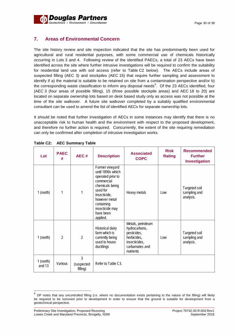
7. Areas of Environmental Concern
The site history review and site inspection indicated that the site has predominantly been used for agricultural and rural residential purposes, with some commercial use of chemicals historically occurring in Lots 3 and 4. Following review of the identified PAECs, a total of 23 AECs have been identified across the site where further intrusive investigations will be required to confirm the suitability for residential land use with soil access (refer to Table C2 below). The AECs include areas of suspected filling (AEC 3) and stockpiles (AEC 15) that require further sampling and assessment to identify if a) the material is suitable to be retained on site from a contamination perspective and/or b) the corresponding waste classification to inform any disposal needs6. Of the 23 AECs identified, four (AEC 3 (four areas of possible filling), 15 (three possible stockpile areas) and AEC 18 to 20) are located on separate ownership lots based on desk based study only as access was not possible at the time of the site walkover. A future site walkover completed by a suitably qualified environmental consultant can be used to amend the list of identified AECs for separate ownership lots. It should be noted that further investigation of AECs in some instances may identify that there is no unacceptable risk to human health and the environment with respect to the proposed development, and therefore no further action is required. Concurrently, the extent of the site requiring remediation can only be confirmed after completion of intrusive investigation works. Table C2: AEC Summary Table
Lot PAEC # AEC # Description Associated
COPC
Risk Rating
Recommended Further
Investigation
1 (north) 1 1
Former vineyard until 1890s which operated prior to commercial chemicals being used for insecticide, however metal containing insecticide may have been applied.
Heavy metals Low Targeted soil sampling and analysis.
1 (north) 2 2
Historical dairy farm which is currently being used to house ducklings
Metals, petroleum hydrocarbons, pesticides, herbicides, insecticides, carbamates and nutrients
Low Targeted soil sampling and analysis.
1 (north) and 13 Various
3 (suspected
filling) Refer to Table C3.
6 DP notes that any uncontrolled filling (i.e. where no documentation exists pertaining to the nature of the filling) will likely be required to be removed prior to development in order to ensure that the ground is suitable for development from a geotechnical perspective.

Page 31 of 38
Preliminary Site Investigation, Proposed Rezoning Project 76742.00.R.004.Rev1 Lowes Creek and Maryland Precincts, Bringelly, NSW September 2018
Lot PAEC # AEC # Description Associated
COPC
Risk Rating
Recommended Further
Investigation
1 (north) and 13 4 4 Possible cattle dip
and filling Metals, TRH, BTEX,
pesticides, insecticides
Cattle dip – Medium
Filling – Low
Targeted soil sampling and
analysis.
20 and 4 7 5
Former incinerator footprint area.
Incinerator was in poor condition
whilst in operation.
TRH, BTEX, heavy metals, nutrients,
insecticides Medium
Targeted soil sampling and
analysis.
20 and 4 8 6 Animal carcass burial area and
associated contaminants
Heavy metals, pesticides, faecal
coliforms Low
Targeted soil sampling and
analysis.
20 and 4 9 7 Transite pipes
present in sheep palace / sheep dip
spraying yard Asbestos Medium
Complete trenches to visually inspect / remove / validate
pipes.
20 and 4 11 8 Historical UST Metals, TRH, BTEX, PAHs, phenols and
MTBE Low
Review Validation Report for UST
removal.
20 and 4 12 9
AST (diesel) – currently bunded
however was historically without
a bund.
Metals, TRH, BTEX, PAHs and phenols Medium
Targeted soil sampling and
analysis.
20 and 4 13 10
Chemical wastes in "chicken shed
number 1". Historical reports demonstrate a
likely high quantity of chemical wastes were
stored here. The content of the
chemical wastes is not known.
Although the base of the shed is
made of concrete, frequent cracks
are evident
Metals, petroleum hydrocarbons,
pesticides, herbicides,
insecticides and carbamates
Medium Targeted soil sampling and
analysis.
20 and 4 15 11
Dumping ground next to Lowes
Creek – possible uncontrolled filling
and leaching of liquid wastes
Metals, TRH, BTEX, PAHs, phenols,
pesticides, herbicides,
insecticides and carbamates.
Medium Targeted soil sampling and
analysis.

Page 32 of 38
Preliminary Site Investigation, Proposed Rezoning Project 76742.00.R.004.Rev1 Lowes Creek and Maryland Precincts, Bringelly, NSW September 2018
Lot PAEC # AEC # Description Associated
COPC
Risk Rating
Recommended Further
Investigation
20 and 4 16 12
Metal waste area – possible
uncontrolled filling and leaching of liquid wastes
Metals, TRH, BTEX, PAHs, phenols,
pesticides, herbicides,
insecticides and carbamates.
Medium Targeted soil sampling and
analysis.
20 and 4 17 13
Disposal of used oils, including
crankcase, gearbox and
vacuum pump oils (location not
known)
Metals, TRH, BTEX, PAHs and phenols. Low
Screen soils using a Photo Ionization Detector (PID)
during Detailed Site Investigation (DSI).
Adopt an Unexpected Finds Protocol (UXF) for
earthworks.
20 and 4 20 14
ACM in several structures in poor
condition and fragments of ACM
have potentially impacted the surrounding
ground surface
Asbestos Medium Targeted asbestos investigation.
10 25 15
(stockpiles)
Refer to Table C4.
10 (south) 30 16 Urea / ammonia odour
Nutrients, pesticides, metals Low
Targeted soil and surface water sampling and
analysis.
10 (south) 32 17
Materials including drums,
chemical containers and
ACM pipes stored next to large shed
Metals, petroleum hydrocarbons,
pesticides, PAHs, phenols and
asbestos
Medium Targeted soil sampling and
analysis.
9 (separate ownership
lot)
36 18 Current structure (unknown usage or construction
materials) Not applicable Low
Site walkover.
10 (north) (separate ownership
lot)
38 19 Suspected
horticultural land use
To be confirmed after site inspection Medium
Site walkover. Targeted soil sampling and
analysis, if required.
23 (separate ownership
lot)
40 20 Suspected
horticultural land use
To be confirmed after site inspection Medium
Site walkover. Targeted soil sampling and
analysis, if required.

Page 33 of 38
Preliminary Site Investigation, Proposed Rezoning Project 76742.00.R.004.Rev1 Lowes Creek and Maryland Precincts, Bringelly, NSW September 2018
Lot PAEC # AEC # Description Associated
COPC
Risk Rating
Recommended Further
Investigation
13 47 21
Ground disturbance,
laydown areas and stockpiles
north of the farmstead
Metals, petroleum hydrocarbons,
pesticides, PAHs, phenols and
asbestos
Medium Targeted soil sampling and
analysis.
13 59 22 historical timber power lines are
located throughout site
Metals, pesticides, petroleum
hydrocarbons, PAHs, creosote and
ammonia
Low Targeted soil sampling and
analysis.
Part 101 65 23 Barb wire stockpiles Heavy metals Low
Targeted soil sampling and
analysis. NOTES: Heavy metals= As, Cd, Cr, Cu, Pb, Hg, Ni, Zn TRH= Total Recoverable Hydrocarbons
BTEX= Benzene, Toluene, Ethylbenzene, Xylenes PAH= Polycyclic Aromatic Hydrocarbons MTBE= Methyl Tert Butyl Ether
Table C3: AEC 3 – Areas of Suspected Filling
Lot PAEC # AEC # Description Associated
COPC
Risk Rating Recommended Further
Investigation
1 (north) and 13 3 3A Possible rubbish pits
and cesspits present
Metals, petroleum hydrocarbons,
pesticides, PAHs, phenols and asbestos
Low
Targeted soil sampling and
analysis, if required (depending on
extent of development)
20 and 4 6 3B
several small dams - raised walls
surrounding dams may potentially
contain uncontrolled filling
Metals, petroleum hydrocarbons,
pesticides, PAHs, phenols and asbestos
Low Targeted soil sampling and
analysis.
10 (south) 22 3C
Two dams with raised edges that may contain filling
Metals, petroleum hydrocarbons,
pesticides, PAHs, phenols and asbestos
Low Targeted soil sampling and
analysis.
10 (south) 28 3D Possible wash out of
fill soils
Metals, petroleum hydrocarbons,
pesticides, PAHs, phenols and asbestos
Low Targeted soil sampling and
analysis.
10 (south) 29 3E Fill soil in creek banks
Metals, petroleum hydrocarbons,
pesticides, PAHs, phenols and asbestos
Low Targeted soil sampling and
analysis.

Page 34 of 38
Preliminary Site Investigation, Proposed Rezoning Project 76742.00.R.004.Rev1 Lowes Creek and Maryland Precincts, Bringelly, NSW September 2018
Lot PAEC # AEC # Description Associated
COPC
Risk Rating Recommended Further
Investigation
13 41 3F Large dam (eastern side of lot)
To be confirmed after site inspection Low
Site inspection and possible targeted soil sampling and
analysis
13 42 3G Large dam (western side of lot)
To be confirmed after site inspection Low
Site inspection and possible targeted soil sampling and
analysis
13 43 3H smaller dams located throughout lot
To be confirmed after site inspection Low
Site inspection and possible targeted soil sampling and
analysis
13 55 3I Possible filling - north east part of lot
Metals, petroleum hydrocarbons,
pesticides, PAHs, phenols and asbestos
Medium Targeted soil sampling and
analysis.
13 56 3J Former structures
adjacent to dilapidated shed and
associated filling
Metals, petroleum hydrocarbons,
pesticides, PAHs, phenols and asbestos
Medium Targeted soil sampling and
analysis.
13 57 3K Suspected filling north of easternmost dam
Metals, petroleum hydrocarbons,
pesticides, PAHs, phenols and asbestos
Low Targeted soil sampling and
analysis.
13 61 3L Possible filling in field located south east of
westernmost dam
Metals, petroleum hydrocarbons,
pesticides, PAHs, phenols and asbestos
Medium Targeted soil sampling and
analysis.
Part 101 63 3M Possible buried brick fill in creek
Metals, petroleum hydrocarbons,
pesticides, PAHs, phenols and asbestos
Low Targeted soil sampling and
analysis.

Page 35 of 38
Preliminary Site Investigation, Proposed Rezoning Project 76742.00.R.004.Rev1 Lowes Creek and Maryland Precincts, Bringelly, NSW September 2018
Lot PAEC #
AEC # Description Associated
COPC
Risk Rating Recommended Further
Investigation
9 (separate ownership
lot)
34 3N Dams
Metals, petroleum hydrocarbons,
pesticides, PAHs, phenols and asbestos
Low
Site walkover. Targeted soil sampling and
analysis, if required.
10 (north) (separate ownership
lot)
37 3O Dam To be confirmed after site inspection Low
Site walkover. Targeted soil sampling and
analysis, if required.
23 (separate ownership
lot)
39 3P Dam To be confirmed after site inspection Low
Site walkover. Targeted soil sampling and
analysis, if required.
11 (separate ownership
lots)
67 3Q Dam Metals, petroleum
hydrocarbons, pesticides, PAHs,
phenols and asbestos Low
Site walkover. Targeted soil sampling and
analysis, if required. Table C4: AEC 15 - Stockpiles
Lot PAEC #
AEC # Description Associated
COPC
Risk Rating Recommended Further
Investigation
10 (south) 25 15A Construction and
demolition material stockpiles, including
suspected ACM
Metals, petroleum hydrocarbons,
pesticides, PAHs, phenols and asbestos
Medium Targeted soil sampling and
analysis across pad area.
10 (south) 27 15B Stockpiles in eastern part of lot
Metals, petroleum hydrocarbons,
pesticides, PAHs, phenols and asbestos
Low Stockpile soil sampling and
analysis.
10 (south 31 15C Small stockpiles next to creek
Metals, petroleum hydrocarbons,
pesticides, PAHs, phenols and asbestos
Low Stockpile soil sampling and
analysis.
13 44 15D
Historical ACM impact on land parcel north of
westernmost dam - current stockpile
Metals, petroleum hydrocarbons,
pesticides, PAHs, phenols and asbestos
Low Stockpile soil sampling and
analysis.
13 45 15E Stockpiles north of laydown area
Metals, petroleum hydrocarbons,
pesticides, PAHs, phenols and asbestos
Low Stockpile soil sampling and
analysis.

Page 36 of 38
Preliminary Site Investigation, Proposed Rezoning Project 76742.00.R.004.Rev1 Lowes Creek and Maryland Precincts, Bringelly, NSW September 2018
Lot PAEC #
AEC # Description Associated
COPC
Risk Rating Recommended Further
Investigation
13 54 15F Land scarring and stockpiling in north eastern part of the
lot
Metals, petroleum hydrocarbons,
pesticides, PAHs, phenols and asbestos
Medium Targeted soil sampling and
analysis.
9 (separate ownership
lots)
35 15G Stockpiles Metals, petroleum
hydrocarbons, pesticides, PAHs,
phenols and asbestos Low
Site walkover. Targeted soil sampling and
analysis, if required.
11 (separate ownership
lots)
66 15H Stockpiles Metals, petroleum
hydrocarbons, pesticides, PAHs,
phenols and asbestos Low
Stockpile soil sampling and
analysis.
8. Conclusions and Recommendations
A total of 23 AECs were identified across the site, including areas of suspected filling (AEC 3) and stockpiles (AEC 15). The AECs are generally associated with the historical use of the site, including agricultural and rural residential land use. Of the 23 AECs identified, five are located on separate ownership lots that were not accessible at the time of the site walkover (being AEC 3 (four areas of possible filling), AEC 15 (three possible stockpile areas) and AEC 18 to 20). A future site walkover completed by a suitably qualified environmental consultant can be used to amend the list of identified AECs for separate ownership lots (i.e. some areas may be deemed to be no longer an AEC once inspected). Further intrusive investigation works in the form of a Detailed Site Investigation (DSI) in accordance with SEPP 55 and NSW EPA guidelines will be necessary. Groundwater in shales beneath the site is unlikely to be suitable for irrigation purposes owing to its generally low yield and reasonably high levels of salinity. The permeability of the shales is generally very low (typically <1 L / s), therefore significantly inhibiting the potential for contamination to migrate from the site. Based on the findings of the PSI, a groundwater investigation is not required for the areas outside of the AECs. The scope for groundwater investigation of the AECs will be determined on a case by case basis during the DSI. Buried sheep and cattle carcasses have been identified in Lot 20 in the northern part of the site which have been further considered with regard to the potential for anthrax spores associated with the carcasses. The NSW LLS for Greater Sydney were contacted by DP as part of this PSI to confirm whether there were any records of notifiable diseases under the Stock Diseases Act (1923). The LLS confirmed that no such reports have been made for the site. Furthermore, professional advice from Dr Michael Reynolds concludes that the risk of anthrax associated with burial pits at the site is no higher than any other property located outside of the “anthrax belt” of NSW. As per Dr Reynolds’ advice, no further investigation and/or soil testing of the burial pits specific to anthrax is required. Based on observations made during the site walkover, there is the potential for ACM to be present in current structures in several areas at the site. It is therefore recommended that a hazardous building materials survey is completed prior to any demolition of structures.
Page 37 of 38
Preliminary Site Investigation, Proposed Rezoning Project 76742.00.R.004.Rev1 Lowes Creek and Maryland Precincts, Bringelly, NSW September 2018
DP concludes that the potential for contamination constraints to the proposed development for the site excluding the AECs is considered by DP to be low. The potential for contamination in areas of environmental concern is considered to be low to medium. Targeted sampling and / or a site walkover (for the separate ownership lots) is required in each of the 23 AECs together with a lower density sampling regime in the remainder of the site area. Further assessment of the AEC areas will determine appropriate remediation requirements, if any, to render the site suitable for the proposed development. 8.1 Unexpected Finds
There is the potential that hidden, below ground structures (such as USTs, septic tanks, ACM pipes and ACM fence footings) may be present at the site and this should be considered accordingly during the DSI and subsequently during bulk earthworks for the proposed development. Based on DP’s experience on similar sites, below ground ACM features (ACM pipes in particular) are commonly encountered during earthworks and subsequent remediation works can delay site formation and general construction. DP therefore recommends that the proposed DSI should include an inspection of soils around the perimeter of the current building footprints to identify any buried ACM pipes. An Unexpected Finds Protocol will therefore need to be established for use during earthworks during redevelopment, in order to ensure that due process is carried out in the event of a possible contaminated find. 9. Limitations
Douglas Partners Pty Ltd (DP) has prepared this report (or services) for this project at Lowes Creek Maryland Precinct, Bringelly in accordance with DP’s proposal dated 22 April 2016 and email acceptance received from Stephen McMahon dated 4 May 2016. The work was carried out under DP’s Conditions of Engagement. This report is provided for the exclusive use of the Department of Planning & Environment, Camden Council and Macarthur Developments for this project only and for the purposes as described in the report. It should not be used by or relied upon for other projects or purposes on the same or other site or by a third party. Any party so relying upon this report beyond its exclusive use and purpose as stated above, and without the express written consent of DP, does so entirely at its own risk and without recourse to DP for any loss or damage. In preparing this report DP has necessarily relied upon information provided by the client and/or their agents. The results provided in the report are indicative of the sub-surface conditions on the site only at the specific sampling and/or testing locations, and then only to the depths investigated and at the time the work was carried out. Sub-surface conditions can change abruptly due to variable geological processes and also as a result of human influences. Such changes may occur after DP’s field testing has been completed. DP’s advice is based upon the conditions encountered during this investigation. The accuracy of the advice provided by DP in this report may be affected by undetected variations in ground conditions across the site between and beyond the sampling and/or testing locations. The advice may also be limited by budget constraints imposed by others or by site accessibility.
Page 38 of 38
Preliminary Site Investigation, Proposed Rezoning Project 76742.00.R.004.Rev1 Lowes Creek and Maryland Precincts, Bringelly, NSW September 2018
This report must be read in conjunction with all of the attached and should be kept in its entirety without separation of individual pages or sections. DP cannot be held responsible for interpretations or conclusions made by others unless they are supported by an expressed statement, interpretation, outcome or conclusion stated in this report. This report, or sections from this report, should not be used as part of a specification for a project, without review and agreement by DP. This is because this report has been written as advice and opinion rather than instructions for construction. The contents of this report do not constitute formal design components such as are required, by the Health and Safety Legislation and Regulations, to be included in a Safety Report specifying the hazards likely to be encountered during construction and the controls required to mitigate risk. This design process requires risk assessment to be undertaken, with such assessment being dependent upon factors relating to likelihood of occurrence and consequences of damage to property and to life. This, in turn, requires project data and analysis presently beyond the knowledge and project role respectively of DP. DP may be able, however, to assist the client in carrying out a risk assessment of potential hazards contained in the Comments section of this report, as an extension to the current scope of works, if so requested, and provided that suitable additional information is made available to DP. Any such risk assessment would, however, be necessarily restricted to the geotechnical environmental components set out in this report and to their application by the project designers to project design, construction, maintenance and demolition. Asbestos has not been detected by observation or by laboratory analysis, either on the surface of the site, or in filling materials at the test locations sampled and analysed. Building demolition materials, such as concrete, brick and glass, were, however, located in previous below-ground filling and above-ground stockpiles, and these are considered as indicative of the possible presence of hazardous building materials (HBM), including asbestos. Although the sampling plan adopted for this investigation is considered appropriate to achieve the stated project objectives, there are necessarily parts of the site that have not been sampled and analysed. This is either due to undetected variations in ground conditions or to budget constraints (as discussed above), or to parts of the site being inaccessible and not available for inspection/sampling, or to vegetation preventing visual inspection and reasonable access. It is therefore considered possible that HBM, including asbestos, may be present in unobserved or untested parts of the site, between and beyond sampling locations, and hence no warranty can be given that asbestos is not present.
Douglas Partners Pty Ltd