report on transnational tool development for … 1 report on transnational tool development for...
TRANSCRIPT

page 1
Report on Transnational Tool Development for Tracking and Tracing of Dangerous Goods Summary – data collection of all project partners from Austria, Czech Republic, Germany, Italy, Hungary, Poland, Slovakia, Slovenia
September 2013

Analysis and Development of Tracking and Tracing Tools
page 2
Table of content
Table of content ...................................................................................................... 2
Executive summary ................................................................................................ 3
National results ....................................................................................................... 7
Austria ................................................................................................................ 7
Czech Republic ................................................................................................ 17
Germany .......................................................................................................... 35
Hungary ........................................................................................................... 45
Italy .................................................................................................................. 58
Poland .............................................................................................................. 73
Slovakia ........................................................................................................... 84
Slovenia ........................................................................................................... 93
Conclusion .......................................................................................................... 108
Tables and Figures ............................................................................................. 116
This project is implemented through the CENTRAL EUROPE Programme co-financed by
the ERDF. Any liability for the content of this publication lies with the authors. The
European Commission is not responsible for any use that may be made of the information
contained herein.
www.central2013.eu

Analysis and Development of Tracking and Tracing Tools
page 3
Executive summary
The tool development is divided into the hardware and the data (software and system)
part. The systemic part of the tracking and tracing tool should allow an open approach for
integration of different kind of technical solutions. Also the interaction with existing IT
platforms should be considered. From the hardware side, the project follows an open
approach in order to give flexibility to the project partners in the choice and adaptation of
specific technologies. As the tracking and tracing tool is directly linked to the later practical
testing in the pilot projects, the involved partners from the particular pilot projects also
discuss about concrete technical options for the transnational tracking and tracing tool.
The analysed hardware is characterized by the energy supply, configuration/maintenance
effort, possibility to provide explosion proof and its connection/fixation to the container.
Configuration and maintenance effort for the devices is clarified in good detail. It is
important that the solution offers the possibility to configure the device to the requirements
of the customer. GPS is the technology which was mentioned most. Another important
point deals with one of the main criterion of the industry of being safe and secure.
Therefore accidents and their consequences are of big interest for stakeholder. Event
management describes the measuring of defined values (e.g. temperature, shock, etc.) by
using specific sensors. Based on determined alarm thresholds data are collected and
submitted to institutions or persons in charge in case of irregularities.
A very important point, when analysing different T&T solutions, deals with the costs of the
hardware as well with the running costs as for data transmission. This point needs to be
specified in detail before starting with the pilot projects as this is a key criterion for
practical testing well as for the final implementation on the market.
Finally, the ChemLog T&T working group “Central Orchestration Framework” defines
strategies how to ensure a common attempt within the systemic part. It is also important to
match these new guidelines from the working group on telematics (initial proposal from
the European Commission).

Analysis and Development of Tracking and Tracing Tools
page 4
Introduction – ChemLog T&T and the Analysis and
Development of Tracking and Tracing Tools
The promotion of intelligent use of ICT for the improvement of intermodal transport of
dangerous goods in CEE to strengthen regional development and competitiveness of
chemical industry is a central goal of the ChemLog T&T project. Also to facilitate modal
shift from road to rail and reduce greenhouse emissions by improving competitiveness of
intermodal transport as well as the improvement of safety, security, reliability and
efficiency of intermodal transport of dangerous goods are essential when talking about
long term visions of the project. Within this work package there is a great focus on
developing recommendations for open and joint standards for tracking and tracing as
result of practical testing and facilitating the implementation of T&T technologies in CEE.
The vulnerability of dangerous goods transports clearly stresses the needs for chemical
companies and public authorities to ensure safe transport and functioning crisis
management procedures. Today there are no commonly used T&T solutions in Europe,
which fully answer the needs of the chemical industry. Several single initiatives exist,
which are isolated and not compatible. Furthermore there are also interface problems at
the boarders for transnational transports and problems of communication and cooperation
with public authorities. Therefore it is necessary to develop an efficient information
platform for tracking and tracing, which provides reliable information about the actual
location of transported goods and its status for the entire transport chain. The partnership
consists of different entities from DE, AT, PL, CZ, SK, SI, HU, IT, which fulfil a specific
function in the project.
The partners mentioned will jointly develop transnational ICT tools for tracking and tracing.
The discussion within the partnership is extended to further relevant stakeholders from
industry, logistics service providers and responsible public entities in the framework of the
Regional Stakeholder Forum. The results of this analysis are used for the transnational
exchange of experience and mutual learning in order to transfer innovative technological
solutions for logistics.

Analysis and Development of Tracking and Tracing Tools
page 5
Methodology to gather information
On the basis of joint research and in cooperation with stakeholders from the chemical
industry, logistics service providers as well as authorities, all project partners select T&T
solutions and adopt them to their needs of transnational transport of dangerous goods.
For this purpose a close partnership with the relevant partners described, especially with
tracking and tracing providers are established in order to have a very practical set up on
tool development. The tool development take into account experiences of existing
solutions and choose technical options according to a detailed evaluation of pros and
cons for the specific needs of intermodal transport of dangerous goods. The tool
development is divided into the hardware and the data (software/system) part. The
systemic part of the tracking and tracing tool should allow an open approach for
integration of different kind of technical solutions. Also the interaction with existing IT
platforms should be considered.
From the hardware side, the project follows an open approach in order to give flexibility to
the project partners in the choice and adaptation of specific technologies according to
their needs. As the tracking and tracing tool is directly linked to the later practical testing in
the pilot projects, involved partners discuss about concrete technical options for the
transnational tracking and tracing tool. Also a mixture of different solutions can be
possible. In any case the close cooperation with logistic service providers should ensure
practical orientation and the possibility of later usage in the pilot projects.
To ensure that all project partners use the same template and criterions, a joint approach
was developed. As mentioned two big core topics were defined, namely hardware and
systemic part of the analysed T&T solutions. Based on these two points several questions
were asked in order to integrate more (technical) aspects to the evaluation of already
established solutions but also products under development.
1. What should be tracked?
2. What are the requirements for T&T onboard units?
3. What are the requirements for data transmission?
4. What are the requirements for the T&T system for the processing of information?

Analysis and Development of Tracking and Tracing Tools
page 6
By looking at the raised points many facts and figures came up during the regional
stakeholder as well as during the working group meetings. Therefore, a common template
with the defined requirements is used to analyse different T&T solutions within all eight
partner countries of the project. Each partner should identify at least two to three possible
solutions particularly suitable for the practical testing within the pilot phase.
This summary report states all national reports by using the defined template. In order to
come to a conclusion and guarantee a better overview of all these analyses made, a final
evaluation of the single points is done. Criteria under development are evaluated
according their chance to get implemented in a more practical way.

Analysis and Development of Tracking and Tracing Tools
page 7
National results
Austria
Table 1: Description TINO® series (AT)
Name of T&T Tool: TINO® series
Name Technology Provider: CEplus GmbH
Address: Atterseestraße 56 A-4850 Timelkam
Contact Details:
Contact Person:
Email:
Phone:
Christian Meschnig [email protected] Mobile: +43 664 250 2436 Fax: +43 7672 94 429 13
Website: www.ceplus.com
Summary
Short Summary of T&T Solution
CEplus is a specialized provider of GPS-System solutions for professional usage. These solutions work without intervention. The focus is in the line of business for services, construction, industry/heavy industry and agricultural services (etc.). The provider offers a self-developed WEB-Portal which provides all relevant data. For projects the portal will be adapted to customer specific needs. Generally stated TINO® provides information about the actual position of a certain container at a fixed time (customer’s choice), duration of presence of the container at customer site, change of position (e.g. to a position outside customer size) and container management.
Description of hardware
Independent energy supply How is the unit supplied with energy? E.g. battery or energy harvesting (PV, etc.)
Energy supply is guaranteed with several batteries which enable different possibilities according their status updates. Energy harvesting was already tested but not yet used in a practical way.
Robust system Is the unit robust and protected against human and environmental impact?
The system is robust and save/secure. As example, a protective cap is in use in order to camouflage the tracking device on the transport unit. All the hardware was tested and can be stated as robust.
Maintenance What kind of maintenance and in which time intervals is necessary?
Maintenance will be done automatically. The solution is characterized by a maintenance-free hardware. If the battery has low level there will be an automatic signalling / alert for the user.
Connection to the container How is the unit connected to the
The device is bolted with the container and can be changed between several transport units. Additionally
Analysis and Development of Tracking and Tracing Tools
page 8
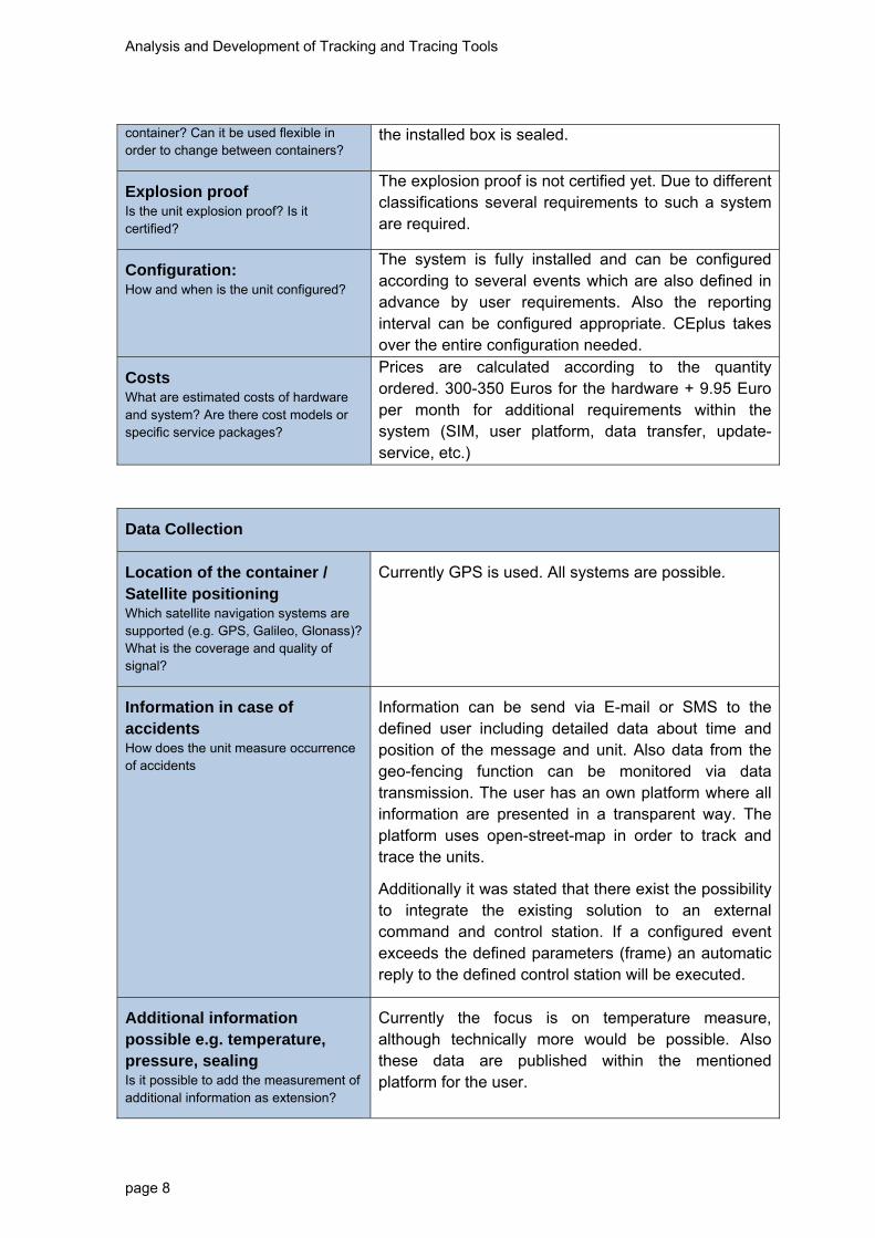
container? Can it be used flexible in order to change between containers?
the installed box is sealed.
Explosion proof Is the unit explosion proof? Is it certified?
The explosion proof is not certified yet. Due to different classifications several requirements to such a system are required.
Configuration: How and when is the unit configured?
The system is fully installed and can be configured according to several events which are also defined in advance by user requirements. Also the reporting interval can be configured appropriate. CEplus takes over the entire configuration needed.
Costs What are estimated costs of hardware and system? Are there cost models or specific service packages?
Prices are calculated according to the quantity ordered. 300-350 Euros for the hardware + 9.95 Euro per month for additional requirements within the system (SIM, user platform, data transfer, update-service, etc.)
Data Collection
Location of the container / Satellite positioning Which satellite navigation systems are supported (e.g. GPS, Galileo, Glonass)? What is the coverage and quality of signal?
Currently GPS is used. All systems are possible.
Information in case of accidents How does the unit measure occurrence of accidents
Information can be send via E-mail or SMS to the defined user including detailed data about time and position of the message and unit. Also data from the geo-fencing function can be monitored via data transmission. The user has an own platform where all information are presented in a transparent way. The platform uses open-street-map in order to track and trace the units.
Additionally it was stated that there exist the possibility to integrate the existing solution to an external command and control station. If a configured event exceeds the defined parameters (frame) an automatic reply to the defined control station will be executed.
Additional information possible e.g. temperature, pressure, sealing Is it possible to add the measurement of additional information as extension?
Currently the focus is on temperature measure, although technically more would be possible. Also these data are published within the mentioned platform for the user.

Analysis and Development of Tracking and Tracing Tools
page 9
Transmission of data
Transmission of information from Unit to Database How is the transmission of data functioning e.g. via GPRS?
GPRS transmission
Frequency of transmission What is the range of frequency of transmission of real time data?
The frequency of data transmission can be configured individually to the expectations of the customer. According to short reporting intervals, battery life time is reduced.
In case of event (Accident) immediate information
Is it possible to provide information in case of accidents e.g. shock sensors
Event management and information via E-Mail and SMS (CEplus alarm-management).
On demand transmission Can the customer define on-demand transmission?
Data transmission takes place in case of an event (e.g. caused by motion) or at a defined time of day. The system keeps the device “awake”. A request can be sent to the device which responses with an status update
Costs for transmission What are costs of data transmission, especially respecting international transport?
See above – 1 MB is enough for the system.
Data security How is data security ensured?
An own data processing centre is used which guarantees high data security (including modern encryption).
Geofencing Is it possible to define geofencing application?
Yes is possible, fine control over calendar (weekday, time of day, etc.)
Low manual interference – automatisation How much automatisation and manual interference is necessary?
There is no human manual interference needed. The truck driver has nothing to do with the system.
System for the processing of information
Integration into the supply It is possible to integrate the system to other logistic

Analysis and Development of Tracking and Tracing Tools
page 10
chain management of chemical companies How is the T&T application integrated in the company IT?
interfaces. As example: SAP interface: a big customer already uses the system within their own company
There exist CSV/XML interfaces.
Integration in Emergency Response Systems (e.g. TUIS, fire brigades) How is the T&T Tool integrated in ERS?
Command and control stations have already access to the presented solution. It is possible to configure additional interfaces to defined emergency response systems. Also the willingness of the provider is given.
Authorisation – Access of private and public entities How is the access of private and public authorities to the data managed?
The authorization can be configured individually.
Storage and operation of data: Where and how are the data stored and operated (central – decentral)?
Data are stored in the data processing centre (12 months up to 7 years)
Reference to Disaster Management (Prevention, Preparedness, Response) Can
Data be used for disaster Management?
Monitoring and analyses of the transports are possible. Currently the system works autarkic and is not aligned to refer to disaster management processes.
Monitoring and Planning Transports / Statistics Can data be used for monitoring and planning of transports or other statistical purposes?
Single reporting points get tracked and can be monitored according to the information available. There does not happen an exact routing on the given routes (points are connected directly – linear distance) – real positions, no interpolation.
Analysis and Development of Tracking and Tracing Tools
page 11
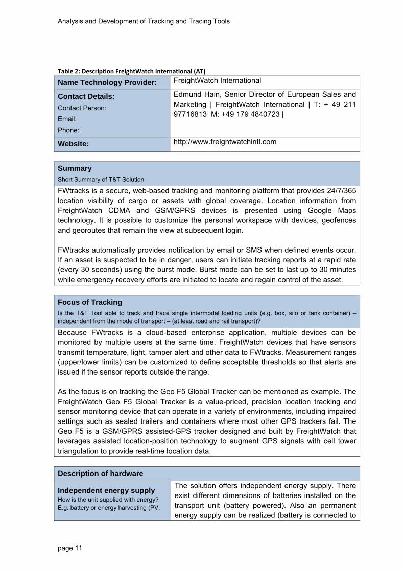
Table 2: Description FreightWatch International (AT)
Name Technology Provider: FreightWatch International
Contact Details:
Contact Person:
Email:
Phone:
Edmund Hain, Senior Director of European Sales and Marketing | FreightWatch International | T: + 49 211 97716813 M: +49 179 4840723 |
Website: http://www.freightwatchintl.com
Summary
Short Summary of T&T Solution
FWtracks is a secure, web-based tracking and monitoring platform that provides 24/7/365 location visibility of cargo or assets with global coverage. Location information from FreightWatch CDMA and GSM/GPRS devices is presented using Google Maps technology. It is possible to customize the personal workspace with devices, geofences and georoutes that remain the view at subsequent login. FWtracks automatically provides notification by email or SMS when defined events occur. If an asset is suspected to be in danger, users can initiate tracking reports at a rapid rate (every 30 seconds) using the burst mode. Burst mode can be set to last up to 30 minutes while emergency recovery efforts are initiated to locate and regain control of the asset.
Focus of Tracking
Is the T&T Tool able to track and trace single intermodal loading units (e.g. box, silo or tank container) – independent from the mode of transport – (at least road and rail transport)?
Because FWtracks is a cloud-based enterprise application, multiple devices can be monitored by multiple users at the same time. FreightWatch devices that have sensors transmit temperature, light, tamper alert and other data to FWtracks. Measurement ranges (upper/lower limits) can be customized to define acceptable thresholds so that alerts are issued if the sensor reports outside the range. As the focus is on tracking the Geo F5 Global Tracker can be mentioned as example. The FreightWatch Geo F5 Global Tracker is a value-priced, precision location tracking and sensor monitoring device that can operate in a variety of environments, including impaired settings such as sealed trailers and containers where most other GPS trackers fail. The Geo F5 is a GSM/GPRS assisted-GPS tracker designed and built by FreightWatch that leverages assisted location-position technology to augment GPS signals with cell tower triangulation to provide real-time location data.
Description of hardware
Independent energy supply How is the unit supplied with energy? E.g. battery or energy harvesting (PV,
The solution offers independent energy supply. There exist different dimensions of batteries installed on the transport unit (battery powered). Also an permanent energy supply can be realized (battery is connected to

Analysis and Development of Tracking and Tracing Tools
page 12
etc.) the lorry battery)
Robust system Is the unit robust and protected against human and environmental impact?
A so called “Pelican Case” (hard plastic, closed and transparent/opaque cover – also light sensors work with this solution) protects the hardware. Other sensors can be installed (temperature, etc.). The whole system is referred as robust (which was also tested).
Maintenance/Configuration What kind of maintenance and in which time intervals is necessary? How and when is the unit configured?
Through an online platform all status can be observed. The device gets a number and the customer/client can monitor the transport unit (container). Here, a flexible organisation is possible by asking for the location, the temperature and so on. The device transfers all required data. The platform also shows available updates as well as battery life time. The platform is connected with a “Command and Control Centre” which cooperates with all relevant persons for a secure transport all over the world. Customer has the possibility to track and manage one special and defined transport with the solution. This is called “Active Monitoring” and performed by the people of the Command and Control Centre.
Connection to the container How is the unit connected to the container? Can it be used flexible in order to change between containers?
Cases are customized with magnets that attach to any metal surface. The magnet is anchored to a standard tracking case with machine screws and lock nuts for industrial strength use, ensuring the case stays in place for vehicle tracking across rough terrain. The external case surface is painted to blend with the under carriage of any vehicle [https://www.freightsecurity.net/products/cases-covert-gps-trackers].
Explosion proof Is the unit explosion proof? Is it certified?
Under development
Costs What are estimated costs of hardware and system? Are there cost models or specific service packages?
It is possible to rent the mentioned device. Depending on the single battery dimensions there are estimated costs of 60 to 70 Euros (including communication and further services). An external sensor was mentioned with 50 Euros. Devices cost 300 to 350 Euros (approximately) without renting them. Additionally, the solutions charges 33 Euros for communication per month.

Analysis and Development of Tracking and Tracing Tools
page 13
Data Collection
Location of the container / Satellite positioning Which satellite navigation systems are supported (e.g. GPS, Galileo, Glonass)? What is the coverage and quality of signal?
As mentioned, the device is directly connected to the platform. Also an APP can be used in order to provide information to the driver of the vehicle.
The solution uses GPS and cell-tower signals as navigation system.
Logistic service provider (operation manager) has the possibility to watch the whole transport chain. The information, e.g. temperature alerts, can be sent via email or SMS to external persons who can be defined in advance.
Signal coverage was not mentioned as problem, as several reporting intervals (depending on battery lifetime – weeks to months are no problem) can be configured – if there is no coverage, the position of the last point tracked will be transmitted when new signals are available.
Information in case of accidents How does the unit measure occurrence of accidents
Here the Command and Control Centre takes over the whole action plans required. The level of service has to be defined per customer resp. project.
Additional information possible e.g. temperature, pressure, sealing, light sensor Is it possible to add the measurement of additional information as extension?
Generally, many features are technically possible. Single events can be configured manually (crossing this value, give me an alert). This event management occurs in real time.
Transmission of data
Transmission of information from Unit to Database How is the transmission of data functioning e.g. via GPRS ?
GSM/GPRS worldwide cellular radio communication and location tracking
Frequency of transmission What is the range of frequency of transmission of real time data?
The frequency of transmission can be configured individually. This can happen once per day, every 4, 6 hours, every 15, 5 minutes but also every minute or second (burst mode). The shorter the reporting interval the shorter the battery life time.
Analysis and Development of Tracking and Tracing Tools
page 14
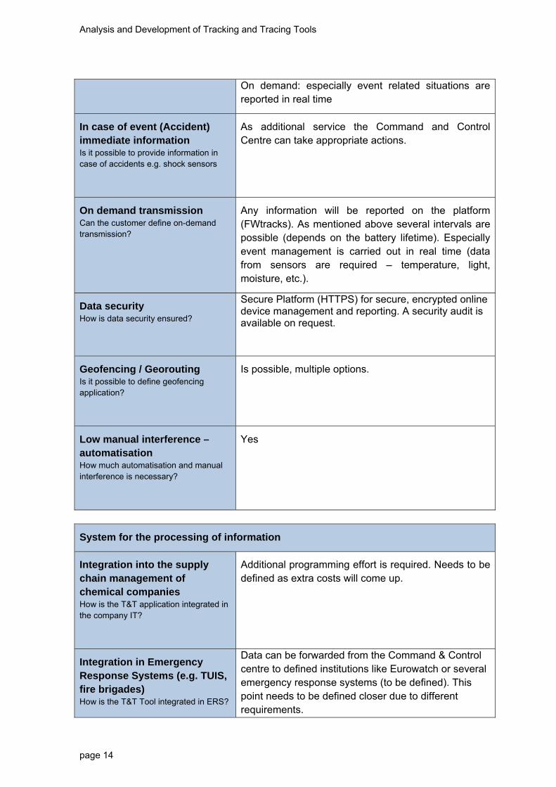
On demand: especially event related situations are reported in real time
In case of event (Accident) immediate information
Is it possible to provide information in case of accidents e.g. shock sensors
As additional service the Command and Control Centre can take appropriate actions.
On demand transmission Can the customer define on-demand transmission?
Any information will be reported on the platform (FWtracks). As mentioned above several intervals are possible (depends on the battery lifetime). Especially event management is carried out in real time (data from sensors are required – temperature, light, moisture, etc.).
Data security How is data security ensured?
Secure Platform (HTTPS) for secure, encrypted online device management and reporting. A security audit is available on request.
Geofencing / Georouting Is it possible to define geofencing application?
Is possible, multiple options.
Low manual interference – automatisation How much automatisation and manual interference is necessary?
Yes
System for the processing of information
Integration into the supply chain management of chemical companies How is the T&T application integrated in the company IT?
Additional programming effort is required. Needs to be defined as extra costs will come up.
Integration in Emergency Response Systems (e.g. TUIS, fire brigades) How is the T&T Tool integrated in ERS?
Data can be forwarded from the Command & Control centre to defined institutions like Eurowatch or several emergency response systems (to be defined). This point needs to be defined closer due to different requirements.

Analysis and Development of Tracking and Tracing Tools
page 15
Authorisation – Access of private and public entities How is the access of private and public authorities to the data managed?
Needs to be specified
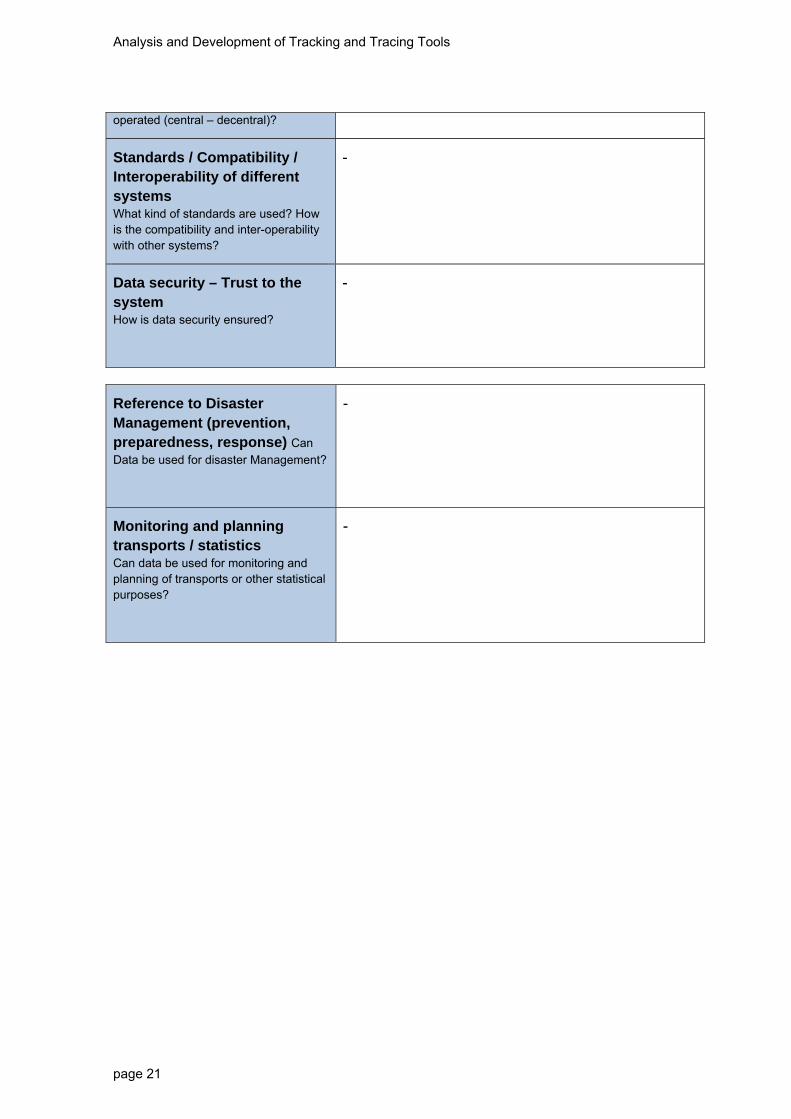
Storage and operation of data: Where and how are the data stored and operated (central – decentral)?
For 6 months at FWtracks (download possible), Active Monitoring reports through Command & Control Centre
Standards / Compatibility / Interoperability of different systems What kind of standards are used, How is the compatibility and inter-operability with other systems?
The mentioned solution provides a company own platform which is not suitable to any other system.
Reference to Disaster Management (Prevention, Preparedness, Response) Can
Data be used for disaster Management?
The data can be downloaded from FWtracks and used e.g. for statistics. The data can be used to optimize e.g. logistics processes.
Monitoring and Planning Transports / Statistics Can data be used for monitoring and planning of transports or other statistical purposes?

Analysis and Development of Tracking and Tracing Tools
page 16
Conclusions Austria
Which T&T Tool suits the defined requirements best and why?
Which one have you selected for practical testing in the pilot projects and what are the next steps?
What are the special challenges to be further developed and tested in the pilot projects?
For the practical testing it is important to position the device on a container. All solutions
stated offer the possibility to switch the device between several transport units.
Additionally robustness can be guaranteed for each solution. The analysed systems are
already in practical use which brings the advantage of being established and tested on the
market. All three companies combine hardware components with company-owned
systems (in case of events, etc.). This approach has the advantage of being tested and
used within daily transports. Although, almost every solution requires several coordination
steps according to meet the requirements of practical testing.
For the Austrian pilot project the T&T solutions CEplus and Freight watch will be chosen.
Representatives from both companies show great interest in adjusting their systems in
order to meet the requirements defined for the pilot project. Especially for data collection,
company owned databases can generate valuable data which in turn can be analysed
during the testing phase over the next month. Additionally, common solutions regarding a
centralized data collection for public emergency organisations (e.g. fire brigade, police,
etc.) can be discussed and tested within the cooperation setting mentioned.

Analysis and Development of Tracking and Tracing Tools
page 17
Czech Republic
Table 3: Description Carloc aktiv SOS (CZ)
Name of T&T Tool: Carloc aktiv SOS
Name Technology Provider: Carloc, s.r.o.
Address: Pobrezni 66/27 Prague 8 - Karlin, 186 00
Contact Details: Contact Person: Email: Phone:
Mrs Jurikova [email protected] Dispatching: +420 731 70 80 20
Website: http://www.carloc.cz/carloc_sos.php
Summary
Short Summary of T&T Solution
Carloc aktiv SOS is a product of Carloc. It is a reliable protection during a traffic accident, in case of life endangerment. The vehicle is connected to a non-stop 24-hour dispatching, where operators are ready to react in case of a traffic accident or car theft. It will secure assistance, car towing, spare vehicle. In case the client suffers an injury or shock during the accident, the dispatchers will send not only towing and assistance, but especially rescue units. The monitoring units are equipped with a shock sensor and a high performance GPS/GSM module, which can secure immediate communication with the dispatching workplace. In case of an accident (or car theft), the unit will send the exact position (GPS coordinates) and time of the accident to the non-stop dispatching. The dispatchers will immediately connect with the client and if he is communicating, the will find out the scope of damage and offer the needed HELP IN AN EMERGENCY. In case the client is not picking up the phone, the dispatchers will evaluate the severity of the accident according to the speed of the impact and send the needed rescue units (ambulance, fire brigade, intervention vehicle).
Focus of Tracking
Is the T&T Tool able to track and trace single intermodal loading units (e.g., box, silo or tank container) – independent from the mode of transport – (at least road and rail transport)?
The system is suitable only for road transport – it can be installed into all types of road cars. It cannot be used for ship and railway transport for reason of power. The unit must be permanently connected into the socket of the vehicle, therefore installation into railway cars or ships is not expected. Connection directly to the container also is not possible, the unit must be placed in the vehicle’s cabin due to power.
Description of hardware
Independent energy supply Power 12 – 15 V, internal accumulator 3.6 V, 1,600 mAh (upon disconnecting, the backup source works

Analysis and Development of Tracking and Tracing Tools
page 18
How is the unit supplied with energy? E.g., battery or energy harvesting (PV, etc.)
max. for 48 hours)
Robust system Is the unit robust and protected against human and environmental impact?
Minimum protection (It is expected that the unit will not be exposed to extreme conditions, because it must be placed inside the vehicle.)
Maintenance What kind of maintenance and in which time intervals is necessary?
There are two options: 1. Maintenance-free variant (use example: car rental) – the driver does not have to even know the unit is installed in the vehicle, but the dispatching has an overview of the unit’s movement. 2. The driver must be identified - identification takes place using a small card, which the driver has affixed on the vehicle keys (the reason is the fear of theft or unauthorised handling of the vehicle) According to the customer’s requirements, the first or second option is chosen.
Connection to the container How is the unit connected to the container? Can it be used flexible in order to change between containers?
The unit must be placed in the vehicle, near the dashboard, so that permanent powering of the unit is secured (location directly in or on the container is impossible)
Explosion proof Is the unit explosion proof? Is it certified?
No
Configuration How and when is the unit configured?
Costs What are estimated costs of hardware and system? Are there cost models or specific service packages?
Equipment price CZK 17,900 + monitoring fees CZK 3,000 per year
Data collection
Location of the container / Satellite positioning Which satellite navigation systems are supported (e.g., GPS, Galileo, Glonass)? What is the coverage and quality of signal?
GPS
Information in case of accidents How does the unit measure occurrence
A sensor is placed on the vehicle, on the front bumper, which sends information upon an impact about the location and time of the accident to the unit and this

Analysis and Development of Tracking and Tracing Tools
page 19
of accidents? information appears on the computer at the dispatching. The dispatchers will then immediately connect with the client and if he is communicating, they will find out the scope of damage and offer him the needed help. The customer may also request a service, where the dispatchers will immediately send intervention units. The SOS service is currently inactive, but there is no problem to request and activate this service.
The disadvantage of this unit lies in the fact that the sensor is only activated during a frontal impact, a rear or side impact is not considered. Upon a query, whether more sensors could be installed (e.g. from all four sides), the dispatcher replied that there is a theoretical possibility, but the unit practically does not have enough inputs for these sensors.
Additional information possible e.g., temperature, pressure, sealing Is it possible to add the measurement of additional information as extension?
No
Transmission of data
Transmission of information from Unit to Database How is the transmission of data functioning e.g., via GPRS?
GSM signal
Frequency of transmission What is the range of frequency of transmission of real time data?
The position data is collected in the travel book, into which the data is transferred as data collection packages, which are gradually stored into the memory and on the server. The customer can then view this data in the browser with a delay of 10-15 minutes.
However, the dispatcher sees all data in real time. In case of an accident, the dispatcher immediately reacts, because he sees the position and time of the vehicle online.
In case of event (Accident) immediate information
Is it possible to provide information in case of accidents e.g., shock sensors
Yes (described above) – upon a frontal impact, the shock sensor is activated and sends information about the position and time of the accident.
On demand transmission The customer sees the course of the travel in the

Analysis and Development of Tracking and Tracing Tools
page 20
Can the customer define on-demand transmission?
travel book.
Costs for transmission What are costs of data transmission, especially respecting international transport?
-
Cluster data for transmission How can alarm thresholds be set to cluster data and minimise transmission volumes?
-
Data security How is data security ensured?
The data from the server is available to the customer after entering the right code via the internet.
Geofencing Is it possible to define geofencing application?
Maps available for the entire Europe
Low manual interference – automatisation How much automatisation and manual interference is necessary?
Described above. Possible to choose a maintenance-free mode.
System for the processing of information
Integration into the supply chain management of chemical companies/ Logistics Service Provider How is the T&T application integrated in the company IT?
-
Integration in Emergency Response Systems (e.g., TUIS, fire brigades) How is the T&T Tool integrated in ERS?
Yes, the customer may order a service, which includes calling of intervention units if needed.
Authorisation – Access of private and public entities How is the access of private and public authorities to the data managed?
-
Storage and operation of data Where and how are the data stored and
-
Analysis and Development of Tracking and Tracing Tools
page 21
operated (central – decentral)?
Standards / Compatibility / Interoperability of different systems What kind of standards are used? How is the compatibility and inter-operability with other systems?
-
Data security – Trust to the system How is data security ensured?
-
Reference to Disaster Management (prevention, preparedness, response) Can
Data be used for disaster Management?
-
Monitoring and planning transports / statistics Can data be used for monitoring and planning of transports or other statistical purposes?
-

Analysis and Development of Tracking and Tracing Tools
page 22
Table 4: Description GPS Dozor Cargo (CZ)
Name of T&T Tool: GPS Dozor Cargo
Name Technology Provider: TLV s.r.o.
Address: Bubenská 1447 / 1 170 00, Praha 7
Contact Details:
Contact Person:
Email:
Phone:
Oldřich Škranc [email protected]
734 762 998
Website: http://www.gpsdozor.cz/sledovaci-lokator-gps-dozor-cargo/
Focus of Tracking
Is the T&T Tool able to track and trace single intermodal loading units (e.g., box, silo or tank container) – independent from the mode of transport – (at least road and rail transport)?
The unit is suitable for multimodal transport (road – railway and water transport).
Description of hardware
Independent energy supply How is the unit supplied with energy? E.g., battery or energy harvesting (PV, etc.)
The battery will last for 6 months but its life span depends on the number of samplings (with continuous sampling it lasts max. 1-2 days)
Robust system Is the unit robust and protected against human and environmental impact?
Weatherproof
Maintenance What kind of maintenance and in which time intervals is necessary?
Maintenance free (max. replacement of battery when it is discharged)
Connection to the container How is the unit connected to the container? Can it be used flexible in order to change between containers?
Connection outside of the container with four screws
Explosion proof Is the unit explosion proof? Is it certified?
Explosion-proof design cannot be guaranteed
Configuration How and when is the unit configured?
-

Analysis and Development of Tracking and Tracing Tools
page 23
Costs What are estimated costs of hardware and system? Are there cost models or specific service packages?
Price ca. 7-8 thousand CZK + purchase of batteries (there are two non-rechargeable lithium batteries, a new set of batteries must be purchased when they are discharged – 2 pcs cost ca. 600 CZK)
Data collection
Location of the container / Satellite positioning Which satellite navigation systems are supported (e.g., GPS, Galileo, Glonass)? What is the coverage and quality of signal?
GPS
Information in case of accidents How does the unit measure occurrence of accidents?
cannot be measured
Additional information possible e.g., temperature, pressure, sealing Is it possible to add the measurement of additional information as extension?
no
Transmission of data
Transmission of information from Unit to Database How is the transmission of data functioning e.g., via GPRS?
GPRS
Frequency of transmission What is the range of frequency of transmission of real time data?
according to customer requirements – e.g. it is possible to set position detection once every eight hours (transmission delay 2-30 s – can be set individually)
In case of event (Accident) immediate information
Is it possible to provide information in case of accidents e.g., shock sensors
shock sensor is not fitted in
On demand transmission Can the customer define on-demand
yes

Analysis and Development of Tracking and Tracing Tools
page 24
transmission?
Costs for transmission What are costs of data transmission, especially respecting international transport?
-
Cluster data for transmission How can alarm thresholds be set to cluster data and minimise transmission volumes?
-
Data security How is data security ensured?
not specified
Geofencing Is it possible to define geofencing application?
in case of sampling once in eight hours, geofencing is of no use
Low manual interference – automatisation How much automatisation and manual interference is necessary?
only replacement of batteries
System for the processing of information
Integration into the supply chain management of chemical companies/ Logistics Service Provider How is the T&T application integrated in the company IT?
No
Integration in Emergency Response Systems (e.g., TUIS, fire brigades) How is the T&T Tool integrated in ERS?
no
Authorisation – Access of private and public entities How is the access of private and public authorities to the data managed?
no
Storage and operation of data Where and how are the data stored and operated (central – decentral)?
Data are stored on the company server, processed and transmitted to the customer in the form of a map

Analysis and Development of Tracking and Tracing Tools
page 25
Standards / Compatibility / Interoperability of different systems What kind of standards are used? How is the compatibility and inter-operability with other systems?
no
Data security – Trust to the system How is data security ensured?
not specified
Reference to Disaster Management (prevention, preparedness, response) Can
Data be used for disaster Management?
no
Monitoring and planning transports / statistics Can data be used for monitoring and planning of transports or other statistical purposes?
yes
Table 5: Description SHERLOG Trace 801V4 (CZ)
Name of T&T Tool: SHERLOG Trace 801V4
Name Technology Provider: SHERLOG TRACE, a.s.
Address: Londýnská 674/55, 120 00 Praha 2
Contact Details:
Contact Person:
Email:
Phone:
Ms Erbenová
602 180 428, 221 513 263
Website: http://www.sherlogtrace.cz/cs/jednotky/sherlogtrace-801.html
Summary
Short Summary of T&T Solution
The unit is battery powered. According to the settings, it periodically sends its location. Suitable also for multimodal transport. Shock sensor cannot be connected to the unit. Range of operating temperatures from -20 °C to +70 °C, dimensions 130 x 88 x 58 mm, weight 1 kg.
Focus of Tracking
Is the T&T Tool able to track and trace single intermodal loading units (e.g., box, silo or tank container) –

Analysis and Development of Tracking and Tracing Tools
page 26
independent from the mode of transport – (at least road and rail transport)?
The unit is suitable for combined transport road – railway – water.
Description of hardware
Independent energy supply How is the unit supplied with energy? E.g., battery or energy harvesting (PV, etc.)
Battery – its life span depends on the settings of periodical sending of position 4 months – 7 years (e.g.: waking up every 2 hours – at least 4 months, 3x per 1 day (after 8 hours) – at least 2 years, 1x per day – at least 3 years, 1x per 10 days – at least 7 years)
Robust system Is the unit robust and protected against human and environmental impact?
Yes – water-proof, dust-proof (the unit is supplied in plastic packaging)
Maintenance What kind of maintenance and in which time intervals is necessary?
Maintenance-free
Connection to the container How is the unit connected to the container? Can it be used flexible in order to change between containers?
Any position outside of the container in a protective grille, the upper part of the unit must have a direct view of the sky
Explosion proof Is the unit explosion proof? Is it certified?
No
Configuration How and when is the unit configured?
At set intervals the unit sends info about the position, and it is in sleep mode in the remaining time. The interval for sending position can be configured remotely 2 hours – 10 days, the configuration takes place the moment the unit wakes up. It is not possible to establish communication with the unit in sleep mode, each individual wake up of the unit is presented as driving at one point
Costs What are estimated costs of hardware and system? Are there cost models or specific service packages?
7 475,- CZK exclusive of VAT + monthly fees
Data collection
Location of the container / Satellite positioning Which satellite navigation systems are
GPS

Analysis and Development of Tracking and Tracing Tools
page 27
supported (e.g., GPS, Galileo, Glonass)? What is the coverage and quality of signal?
Information in case of accidents How does the unit measure occurrence of accidents?
not possible (there is no shock sensor)
Additional information possible e.g., temperature, pressure, sealing Is it possible to add the measurement of additional information as extension?
No
Transmission of data
Transmission of information from Unit to Database How is the transmission of data functioning e.g., via GPRS?
Communication between the unit and the server is ensured by a SIM card (roaming must be purchased). The information is further forwarded from the server to an internet portal for customers.
Frequency of transmission What is the range of frequency of transmission of real time data?
According to the settings, it periodically sends its position, e.g. 1x per 8 hours (i.e. 3 positions per day), 1x per 2 hours (i.e. 12 positions per day), etc.
In case of event (Accident) immediate information
Is it possible to provide information in case of accidents e.g., shock sensors
No shock sensor
On demand transmission Can the customer define on-demand transmission?
No
Costs for transmission What are costs of data transmission, especially respecting international transport?
It can be also used for international transport, roaming must be purchased
Cluster data for transmission How can alarm thresholds be set to cluster data and minimise transmission volumes?
not specified
Analysis and Development of Tracking and Tracing Tools
page 28
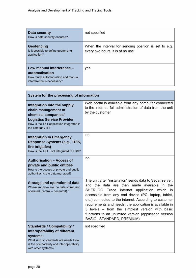
Data security How is data security ensured?
not specified
Geofencing Is it possible to define geofencing application?
When the interval for sending position is set to e.g. every two hours, it is of no use
Low manual interference – automatisation How much automatisation and manual interference is necessary?
yes
System for the processing of information
Integration into the supply chain management of chemical companies/ Logistics Service Provider How is the T&T application integrated in the company IT?
Web portal is available from any computer connected to the internet, full administration of data from the unit by the customer
Integration in Emergency Response Systems (e.g., TUIS, fire brigades) How is the T&T Tool integrated in ERS?
no
Authorisation – Access of private and public entities How is the access of private and public authorities to the data managed?
no
Storage and operation of data Where and how are the data stored and operated (central – decentral)?
The unit after “installation” sends data to Secar server, and the data are then made available in the SHERLOG Trace internet application which is accessible from any end device (PC, laptop, tablet, etc.) connected to the internet. According to customer requirements and needs, the application is available in 3 levels – from the simplest version with basic functions to an unlimited version (application version BASIC , STANDARD, PREMIUM)
Standards / Compatibility / Interoperability of different systems What kind of standards are used? How is the compatibility and inter-operability with other systems?
not specified
Analysis and Development of Tracking and Tracing Tools
page 29
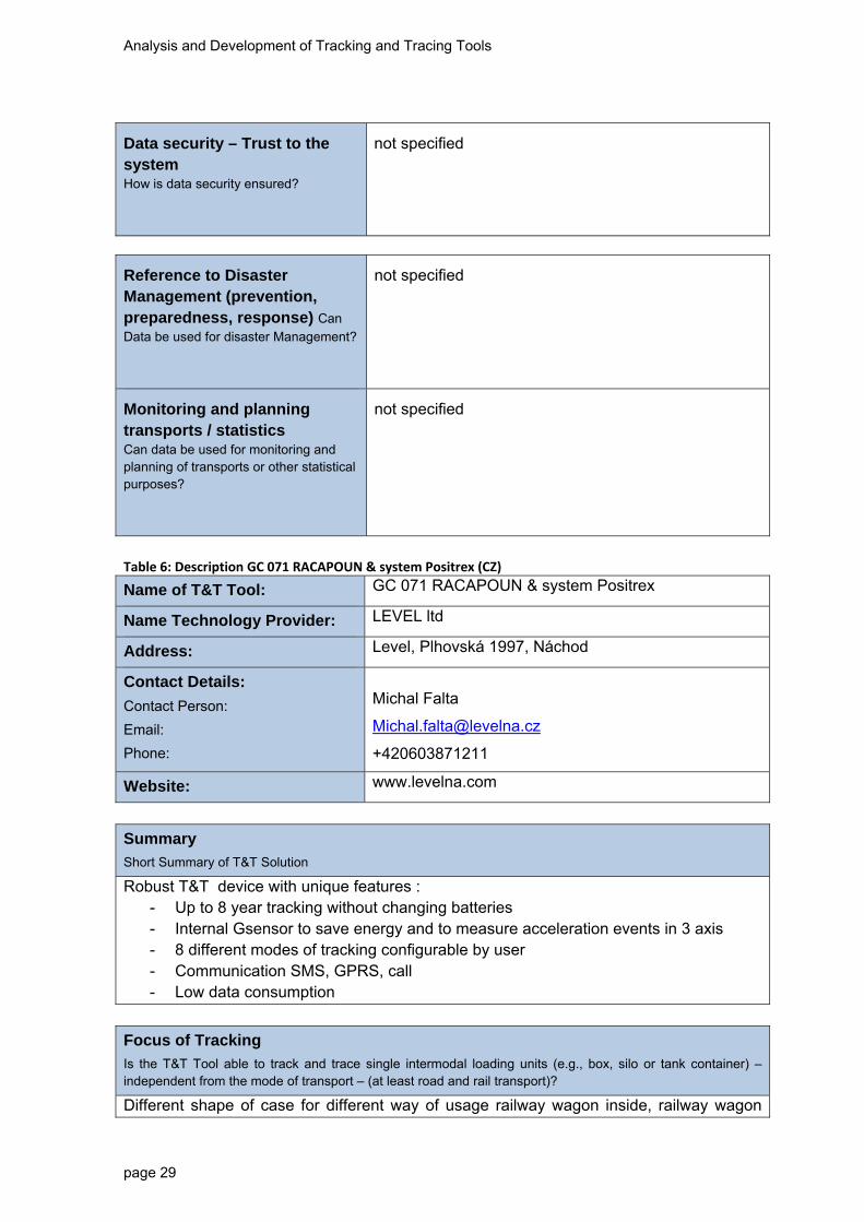
Data security – Trust to the system How is data security ensured?
not specified
Reference to Disaster Management (prevention, preparedness, response) Can
Data be used for disaster Management?
not specified
Monitoring and planning transports / statistics Can data be used for monitoring and planning of transports or other statistical purposes?
not specified
Table 6: Description GC 071 RACAPOUN & system Positrex (CZ)
Name of T&T Tool: GC 071 RACAPOUN & system Positrex
Name Technology Provider: LEVEL ltd
Address: Level, Plhovská 1997, Náchod
Contact Details:
Contact Person:
Email:
Phone:
Michal Falta
+420603871211
Website: www.levelna.com
Summary
Short Summary of T&T Solution
Robust T&T device with unique features : - Up to 8 year tracking without changing batteries - Internal Gsensor to save energy and to measure acceleration events in 3 axis - 8 different modes of tracking configurable by user - Communication SMS, GPRS, call - Low data consumption
Focus of Tracking
Is the T&T Tool able to track and trace single intermodal loading units (e.g., box, silo or tank container) – independent from the mode of transport – (at least road and rail transport)?
Different shape of case for different way of usage railway wagon inside, railway wagon
Analysis and Development of Tracking and Tracing Tools
page 30
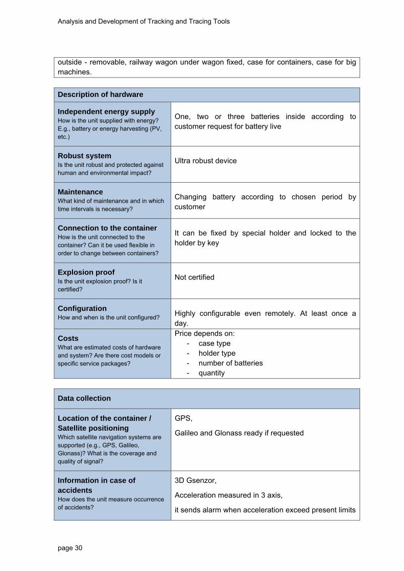
outside - removable, railway wagon under wagon fixed, case for containers, case for big machines.
Description of hardware
Independent energy supply How is the unit supplied with energy? E.g., battery or energy harvesting (PV, etc.)
One, two or three batteries inside according to customer request for battery live
Robust system Is the unit robust and protected against human and environmental impact?
Ultra robust device
Maintenance What kind of maintenance and in which time intervals is necessary?
Changing battery according to chosen period by customer
Connection to the container How is the unit connected to the container? Can it be used flexible in order to change between containers?
It can be fixed by special holder and locked to the holder by key
Explosion proof Is the unit explosion proof? Is it certified?
Not certified
Configuration How and when is the unit configured?
Highly configurable even remotely. At least once a day.
Costs What are estimated costs of hardware and system? Are there cost models or specific service packages?
Price depends on: - case type - holder type - number of batteries - quantity
Data collection
Location of the container / Satellite positioning Which satellite navigation systems are supported (e.g., GPS, Galileo, Glonass)? What is the coverage and quality of signal?
GPS,
Galileo and Glonass ready if requested
Information in case of accidents How does the unit measure occurrence of accidents?
3D Gsenzor,
Acceleration measured in 3 axis,
it sends alarm when acceleration exceed present limits

Analysis and Development of Tracking and Tracing Tools
page 31
Additional information possible e.g., temperature, pressure, sealing Is it possible to add the measurement of additional information as extension?
Temperature, pressure, any analog or binary output
Transmission of data
Transmission of information from Unit to Database How is the transmission of data functioning e.g., via GPRS?
GPRS, SMS
Frequency of transmission What is the range of frequency of transmission of real time data?
From real time to once a day
In case of event (Accident) immediate information
Is it possible to provide information in case of accidents e.g., shock sensors
3D G sensor included
On demand transmission Can the customer define on-demand transmission?
Preselected intervals by user when the unit is ready to receive commands
Costs for transmission What are costs of data transmission, especially respecting international transport?
extremely low data consumption, very reasonable international cost
Cluster data for transmission How can alarm thresholds be set to cluster data and minimise transmission volumes?
Alarms wake up the unit from deep sleep and unit send data immediately
Data security How is data security ensured?
Cypher key 128bits by LEVEL
Geofencing Is it possible to define geofencing application?
Yes, but it usually increase energy consumption dramatically. GPS receiver has to be almost always on.
Low manual interference – automatisation How much automatisation and manual
Easy to maintain

Analysis and Development of Tracking and Tracing Tools
page 32
interference is necessary?
System for the processing of information
Integration into the supply chain management of chemical companies/ Logistics Service Provider How is the T&T application integrated in the company IT?
WEB based system Positrex – manual or automatic exports of data to the server of company
Integration in Emergency Response Systems (e.g., TUIS, fire brigades) How is the T&T Tool integrated in ERS?
System Positrex has his own security dispatcher centre 24 h/day. In case of emergency they call authorities.
Authorisation – Access of private and public entities How is the access of private and public authorities to the data managed?
Highly configurable in the system Positrex
Storage and operation of data Where and how are the data stored and operated (central – decentral)?
Cloud server in hosting centre.
Standards / Compatibility / Interoperability of different systems What kind of standards are used? How is the compatibility and inter-operability with other systems?
Positrex and units are compatible with other systems:
Logiscare, CCS, Czech Police, Eurosat, Altea,..
Data security – Trust to the system How is data security ensured?
Secure disk fields, Server mirroring, fire wall
Reference to Disaster Management (prevention, preparedness, response) Can
Data be used for disaster Management?
yes
Monitoring and planning transports / statistics Can data be used for monitoring and planning of transports or other statistical purposes?
yes

Analysis and Development of Tracking and Tracing Tools
page 33
Conclusions (Carloc aktiv SOS)
Which T&T Tool suits the defined requirements best and why?
Which one have you selected for practical testing in the pilot projects and what are the next steps?
What are the special challenges to be further developed and tested in the pilot projects?
The provider Carloc aktiv SOS is the only one in the Czech market, concerning an internal desktop research that is capable of finding the vehicle position in a certain time and also the information about whether an accident or theft occurred with a direct reference to the departure of rescue units. The unit is not primarily designed for monitoring goods with hazardous cargo, but customers purchase it for fears of vehicle theft because it is capable of generating the travel book. The disadvantage is the unit powering and the impossibility of using it for railway and ship transport. The advantage of the unit is the direct connection to the rescue units and the already functioning dispatching service.
Conclusions (GPS Dozor Cargo)
Which T&T Tool suits the defined requirements best and why?
Which one have you selected for practical testing in the pilot projects and what are the next steps?
What are the special challenges to be further developed and tested in the pilot projects?
The solution GPS Dozor Cargo is suitable for road, railway and water transport. Depending on the number of position detections, the unit can last up to 6 months without battery replacement. In case of continuous monitoring, the battery lasts 1-2 days. The disadvantage is - the unit is not fitted with any inputs for connection of the shock sensor.
Conclusions (SHERLOG Trace 801V4)
Which T&T Tool suits the defined requirements best and why?
Which one have you selected for practical testing in the pilot projects and what are the next steps?
What are the special challenges to be further developed and tested in the pilot projects?
The unit SHERLOG Trace 801V4 is battery powered. Battery life span depends on the settings of periodical sending of position. According to the settings, it periodically sends its location. Suitable also for multimodal transport. Shock sensor cannot be connected to the unit. Localisation is implemented on the principle of GPS/GSM. Communication between the unit and the server is ensured by a SIM card (roaming must be purchased). The information is further forwarded from the server to an internet portal for customers. Conclusions (GC 071 RACAPOUN & system Positrex)
Which T&T Tool suits the defined requirements best and why?
Which one have you selected for practical testing in the pilot projects and what are the next steps?
What are the special challenges to be further developed and tested in the pilot projects?
Robust T&T device with unique features:
Suitable also for multimodal transport Up to 8 year tracking without changing batteries (One, two or three batteries inside

Analysis and Development of Tracking and Tracing Tools
page 34
according to customer request for battery live) Internal Gsensor to save energie and to measure acceleration events in 3 axis (it
sends alarm when acceleration exceed present limits) 8 different modes of tracking configurable by user Ultra robust device
Localisation is implemented on the principle of GPS/GSM. Galileo and Glonass can be used if requested. Geofencing is possible, but it usually increases energy consumption dramatically. Conclusion: For pilot project this OBU unit will be used.

Analysis and Development of Tracking and Tracing Tools
page 35
Germany
Table 7: Description Fraunhofer IFF Telematics (DE)
Name of T&T Tool: Fraunhofer IFF Telematics
Name Technology Provider: Fraunhofer IFF
Address: Sandtorstr. 22
Contact Details:
Contact Person:
Email:
Phone:
Tobias Kutzler [email protected] +49 391 40 90 415
Website: www.iff.fraunhofer.de
Summary
Short Summary of T&T Solution
The Fraunhofer IFF Telematics system is based on a modular set-up of hardware and software components using modern technologies like GPS, RFID, sensors and mobile communications offering services and functions for tracking and tracing of different types of logistics objects. The system can be separated in three parts:
- acquisition - storage - analysis
The acquisition part mainly consists of mobile devices containing localization, sensor and communication technologies like GPS, shock sensors and mobile communications as well as optionally rechargeable batteries for independent power supply. These devices are being placed in or at the objects to be traced. Once installed these devices operate based on a configured behaviour (e.g. wake up on movement or ignition state) and start collecting localization data which is being sent to the central storage component for permanent storage or analysis. The analysis process can be divided into two steps. As data arrives at the system some primary analysis is being done directly on the transmitted data. This allows the implementation of alarm functions which can check the breach of defined rules and create an alarm message. The second step of analysis can be done with all collected data or parts of it (depends on what should analysed and filtering by the user).
Focus of Tracking
Is the T&T Tool able to track and trace single intermodal loading units (e.g., box, silo or tank container) – independent from the mode of transport – (at least road and rail transport)?
The T&T tool can be used to track and trace single intermodal loading units. This can be realised by using connector adaptors which can be attached to the object being tracked. Realized scenarios range from attaching the mobile device directly at screws of

Analysis and Development of Tracking and Tracing Tools
page 36
component parts (with adapter), their transport frame or on containers.
Description of hardware
Independent energy supply How is the unit supplied with energy? E.g., battery or energy harvesting (PV, etc.)
Two types of energy supply possible: - power supply by cable (often used in vehicles
or trucks), only small backup battery - power supply primary by rechargeable backup
battery, external power connector for charging (but can be used for permanent power supply, too)
Robust system Is the unit robust and protected against human and environmental impact?
The used hardware for the mobile components fulfils the Ingress Protection Rating (classifying and rating the degree of protection provided of intrusion of solid objects, dust, accidental contact and water). The used devices fulfil the IP-code 65 which means:
- No ingress of dust; complete protection against contact
- Water protected for a certain amount of time Explosion protection cannot be guaranteed at this time as the necessary certifications are not being done for these units (no use case until now).
Maintenance What kind of maintenance and in which time intervals is necessary?
Only maintenance activities are charging batteries. No other maintenance is necessary.
Connection to the container How is the unit connected to the container? Can it be used flexible in order to change between containers?
The mounting can be done by an adaptor which is attached or fixed by screws. To change between containers tools are required.
Explosion proof Is the unit explosion proof? Is it certified?
No certification for explosion proof.
Configuration How and when is the unit configured?
The unit can be configured first before being used. Later configuration can be done via communication layer to the server. If new configuration settings are being stored on server these configuration parameters are transmitted to the mobile devices updating the configuration.
Costs What are estimated costs of hardware and system? Are there cost models or specific service packages?
- Initial Costs for hardware (device): approximately 400,- €
- no pricing structure until now because no real product (lack of distribution partner)
Data collection
Analysis and Development of Tracking and Tracing Tools
page 37
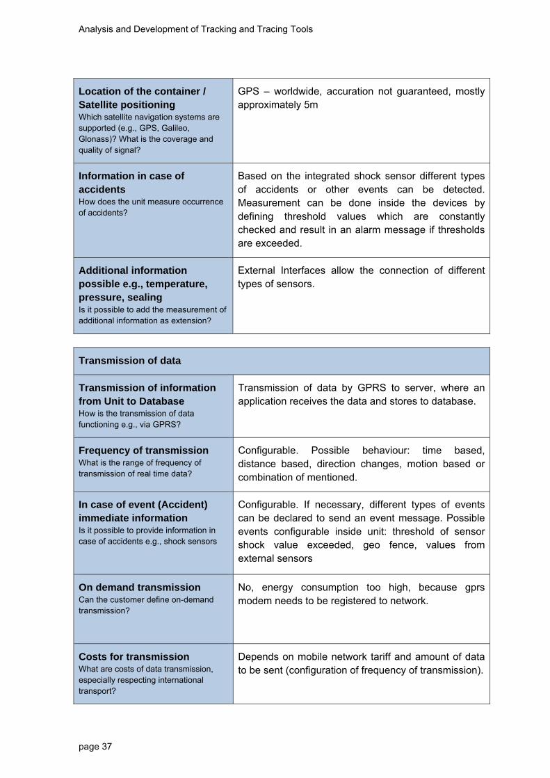
Location of the container / Satellite positioning Which satellite navigation systems are supported (e.g., GPS, Galileo, Glonass)? What is the coverage and quality of signal?
GPS – worldwide, accuration not guaranteed, mostly approximately 5m
Information in case of accidents How does the unit measure occurrence of accidents?
Based on the integrated shock sensor different types of accidents or other events can be detected. Measurement can be done inside the devices by defining threshold values which are constantly checked and result in an alarm message if thresholds are exceeded.
Additional information possible e.g., temperature, pressure, sealing Is it possible to add the measurement of additional information as extension?
External Interfaces allow the connection of different types of sensors.
Transmission of data
Transmission of information from Unit to Database How is the transmission of data functioning e.g., via GPRS?
Transmission of data by GPRS to server, where an application receives the data and stores to database.
Frequency of transmission What is the range of frequency of transmission of real time data?
Configurable. Possible behaviour: time based, distance based, direction changes, motion based or combination of mentioned.
In case of event (Accident) immediate information
Is it possible to provide information in case of accidents e.g., shock sensors
Configurable. If necessary, different types of events can be declared to send an event message. Possible events configurable inside unit: threshold of sensor shock value exceeded, geo fence, values from external sensors
On demand transmission Can the customer define on-demand transmission?
No, energy consumption too high, because gprs modem needs to be registered to network.
Costs for transmission What are costs of data transmission, especially respecting international transport?
Depends on mobile network tariff and amount of data to be sent (configuration of frequency of transmission).
Analysis and Development of Tracking and Tracing Tools
page 38
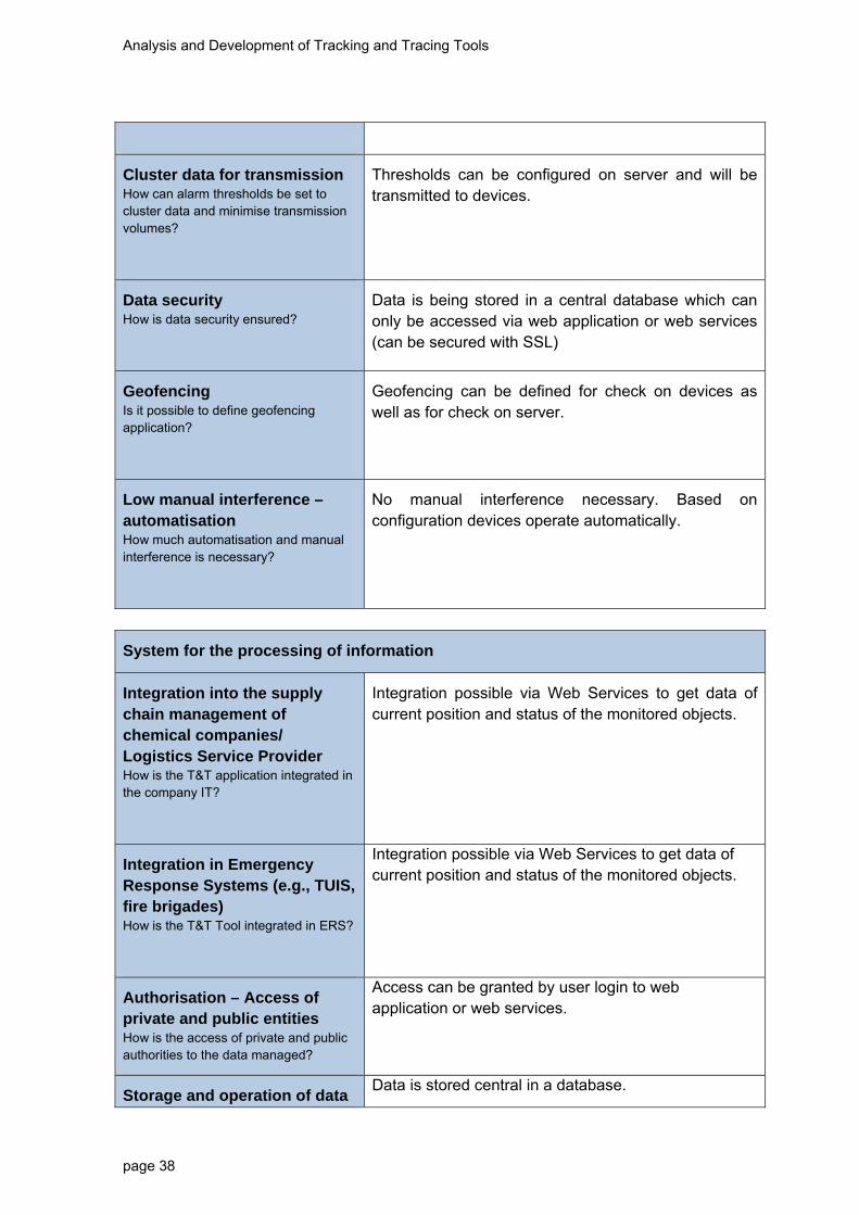
Cluster data for transmission How can alarm thresholds be set to cluster data and minimise transmission volumes?
Thresholds can be configured on server and will be transmitted to devices.
Data security How is data security ensured?
Data is being stored in a central database which can only be accessed via web application or web services (can be secured with SSL)
Geofencing Is it possible to define geofencing application?
Geofencing can be defined for check on devices as well as for check on server.
Low manual interference – automatisation How much automatisation and manual interference is necessary?
No manual interference necessary. Based on configuration devices operate automatically.
System for the processing of information
Integration into the supply chain management of chemical companies/ Logistics Service Provider How is the T&T application integrated in the company IT?
Integration possible via Web Services to get data of current position and status of the monitored objects.
Integration in Emergency Response Systems (e.g., TUIS, fire brigades) How is the T&T Tool integrated in ERS?
Integration possible via Web Services to get data of current position and status of the monitored objects.
Authorisation – Access of private and public entities How is the access of private and public authorities to the data managed?
Access can be granted by user login to web application or web services.
Storage and operation of data Data is stored central in a database.

Analysis and Development of Tracking and Tracing Tools
page 39
Where and how are the data stored and operated (central – decentral)?
Standards / Compatibility / Interoperability of different systems What kind of standards are used? How is the compatibility and inter-operability with other systems?
No standardized formats for data exchange implement because of lack of standards.
Data security – Trust to the system How is data security ensured?
Data is being stored in a central database which can only be accessed via web application or web services (can be secured with SSL)
Reference to Disaster Management (prevention, preparedness, response) Can
Data be used for disaster Management?
Integration possible via Web Services to get data of current position and status of the monitored objects. Based on event driven data exchange alarm messages can be generated and send to disaster management systems.
Monitoring and planning transports / statistics Can data be used for monitoring and planning of transports or other statistical purposes?
Application offers some analytic functions or charts, but data can be provided by export for further analytics.
Analysis and Development of Tracking and Tracing Tools
page 40
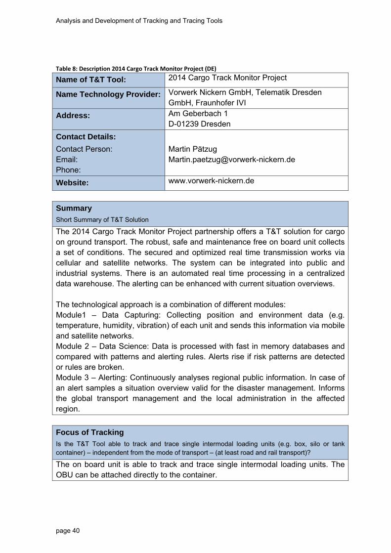
Table 8: Description 2014 Cargo Track Monitor Project (DE)
Name of T&T Tool: 2014 Cargo Track Monitor Project
Name Technology Provider: Vorwerk Nickern GmbH, Telematik Dresden GmbH, Fraunhofer IVI
Address: Am Geberbach 1 D-01239 Dresden
Contact Details:
Contact Person: Email: Phone:
Martin Pätzug [email protected]
Website: www.vorwerk-nickern.de
Summary
Short Summary of T&T Solution
The 2014 Cargo Track Monitor Project partnership offers a T&T solution for cargo on ground transport. The robust, safe and maintenance free on board unit collects a set of conditions. The secured and optimized real time transmission works via cellular and satellite networks. The system can be integrated into public and industrial systems. There is an automated real time processing in a centralized data warehouse. The alerting can be enhanced with current situation overviews. The technological approach is a combination of different modules: Module1 – Data Capturing: Collecting position and environment data (e.g. temperature, humidity, vibration) of each unit and sends this information via mobile and satellite networks. Module 2 – Data Science: Data is processed with fast in memory databases and compared with patterns and alerting rules. Alerts rise if risk patterns are detected or rules are broken. Module 3 – Alerting: Continuously analyses regional public information. In case of an alert samples a situation overview valid for the disaster management. Informs the global transport management and the local administration in the affected region.
Focus of Tracking
Is the T&T Tool able to track and trace single intermodal loading units (e.g. box, silo or tank container) – independent from the mode of transport – (at least road and rail transport)?
The on board unit is able to track and trace single intermodal loading units. The OBU can be attached directly to the container.

Analysis and Development of Tracking and Tracing Tools
page 41
Description of hardware
Independent energy supply How is the unit supplied with energy? E.g. battery or energy harvesting (PV, etc.)
The unit has an independent energy supply. The frequency of data acquisition and transmission determines the power consumption of the device. Battery powered devices have operation/run-times of weeks or months and have to be serviced from time to time or replaced to charge the battery. Energy Harvesting cannot replace batteries but the need to recharge them manually. Energy transducers use energy from the environment vibration in this case to generate electrical energy. Vibration harvester charge battery during operation. Unlimited operation and standby-times become possible. The OBU is then maintenance free.
Robust system Is the unit robust and protected against human and environmental impact?
The OBU is robust against different weather conditions. Special robust characteristics against human interventions must be further analysed.
Maintenance What kind of maintenance and in which time intervals is necessary?
The partners aim at a combination of battery and energy harvester to extend the lifetime of the OBU without maintenance.
Connection to the container How is the unit connected to the container? Can it be used flexible in order to change between containers?
The OBU is fixed to the container and can be removed to fix it to another container.
Explosion proof Is the unit explosion proof? Is it certified?
The OBU is not explosion proof certificated yet. If there is a need for that certification, there will be no problem to do that.
Configuration: How and when is the unit configured?
The configuration takes place at the beginning of the transport to connect OBU with specific load information. Several OBU can communicate with each other and exchange information.
Costs What are estimated costs of hardware and system? Are there cost models or specific service packages?
The direct costs of OBU cannot be estimated so far, as new hardware has to be developed. Few elements have been tested in other pilots, which can be used for the present work to reduce costs.

Analysis and Development of Tracking and Tracing Tools
page 42
Data Collection
Location of the container / Satellite positioning Which satellite navigation systems are supported (e.g. GPS, Galileo, Glonass)? What is the coverage and quality of signal?
OBU supports satellite systems for positions capturing (GPS). There is a sort range communication for low-power data transmission between single devices. Compatibility with GLONASS is under discussion.
Information in case of accidents How does the unit measure occurrence of accidents
The OBU integrates a shock sensor that gives information about movements which can be used to identify heavy shocks (Accidents) or unintended movements (in case of theft)
Additional information possible e.g. temperature, pressure, sealing Is it possible to add the measurement of additional information as extension?
Further information can be collected with additional hardware.
Transmission of data
Transmission of information from Unit to Database How is the transmission of data functioning e.g. via GPRS?
The OBU uses cellular or satellite system for data-transmission to server or infrastructure.
Frequency of transmission What is the range of frequency of transmission of real time data?
The OBU can be configured to use different ranges of frequencies for the transmission of information depending on the defined needs.
In case of event (Accident) immediate information Is it possible to provide information in case of accidents e.g. shock sensors
The shock sensor provides immediate information in case of accidents. The important question is to define the thresholds for alarm setting.
On demand transmission Can the customer define on-
The customer can predefine events, when the information is sent to the database. Furthermore the frequency of transmission can be fixed at the

Analysis and Development of Tracking and Tracing Tools
page 43
demand transmission? beginning of the transport.
Costs for transmission What are costs of data transmission, especially respecting international transport?
The transmission via cellular network (SMS) causes costs. Especially in foreign countries these costs can raise dramatically. Special flat rates should be used to minimise and plan the costs.
Cluster data for transmission How can alarm thresholds be set to cluster data and minimise transmission volumes?
A set of data can be collected in the memory of the OBU and the frequency of transmission of information can be chosen in relation to the defined needs of the customer and the intended relation of battery capacity and lifetime.
Geofencing Is it possible to define geofencing application?
The programming of geofencing is possible. Data Science includes import schedules and unit information from Transport Management Systems. Check location and velocity compared to the schedule. Update Units for active geofencing. Check Unit conditions according to the loaded materials.
Low manual interference – automatisation How much automatisation and manual interference is necessary?
The OBU must be configured at the beginning of the transport by connecting it to the load, which is transported. It can be configured during the transport as well, e.g. changing the interval of data transmission.
System for the processing of information
Integration into the supply chain management of chemical companies How is the T&T application integrated in the company IT?
The T&T database can be connected via interface to companies IT system such as SAP.
Integration in Emergency Response Systems (e.g. TUIS, fire brigades) How is the T&T Tool integrated in ERS?
A special interface is also open for the transmission of information to public entities such as fire brigades.
Authorisation – Access of Access of different entities can be defined via

Analysis and Development of Tracking and Tracing Tools
page 44
private and public entities How is the access of private and public authorities to the data managed?
interfaces.
Storage and operation of data Where and how are the data stored and operated (central – decentral)?
The data is stored in separate database, where the customer can access information.
Standards / Compatibility / Interoperability of different systems What kind of standards are used, How is the compatibility and inter-operability with other systems?
Compatibility with other systems is ensured with the interface.
Data security – Trust to the system How is data security ensured?
Data security is ensured via restricted access to data defined by customer to separated database.
Reference to Disaster Management (Prevention, Preparedness, Response) Can Data be used for disaster Management?
The system can integrate analysis of external effects. Based Web 2.0 application – participation in the web environment. Impacts of different events lead to delays or non-delivery (e.g. industrial action, embankment fire). Contains data regarding news feeds, social media monitoring, governmental web pages etc. The open data collection can include dynamic data from internet, social media monitoring and data from public authorities.
Monitoring and Planning Transports / Statistics Can data be used for monitoring and planning of transports or other statistical purposes?
The data can also be used for long term investigations.
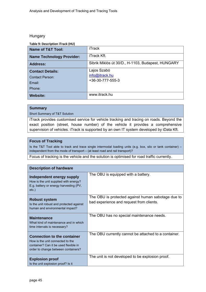
Analysis and Development of Tracking and Tracing Tools
page 45
Hungary
Table 9: Description iTrack (HU)
Name of T&T Tool: iTrack
Name Technology Provider: iTrack Kft.
Address: Sibrik Miklós út 30/D., H-1103, Budapest, HUNGARY
Contact Details:
Contact Person:
Email:
Phone:
Lajos Szabó [email protected] +36-30-777-555-3
Website: www.itrack.hu
Summary
Short Summary of T&T Solution
iTrack provides customised service for vehicle tracking and tracing on roads. Beyond the exact position (street, house number) of the vehicle it provides a comprehensive supervision of vehicles. iTrack is supported by an own IT system developed by iData Kft.
Focus of Tracking
Is the T&T Tool able to track and trace single intermodal loading units (e.g. box, silo or tank container) – independent from the mode of transport – (at least road and rail transport)?
Focus of tracking is the vehicle and the solution is optimised for road traffic currently.
Description of hardware
Independent energy supply How is the unit supplied with energy? E.g. battery or energy harvesting (PV, etc.)
The OBU is equipped with a battery.
Robust system Is the unit robust and protected against human and environmental impact?
The OBU is protected against human sabotage due to bad experience and request from clients.
Maintenance What kind of maintenance and in which time intervals is necessary?
The OBU has no special maintenance needs.
Connection to the container How is the unit connected to the container? Can it be used flexible in order to change between containers?
The OBU currently cannot be attached to a container.
Explosion proof Is the unit explosion proof? Is it
The unit is not developed to be explosion proof.

Analysis and Development of Tracking and Tracing Tools
page 46
certified?
Configuration: How and when is the unit configured?
The unit is configured before its use.
Costs What are estimated costs of hardware and system? Are there cost models or specific service packages?
Hardware costs depend on the number of OBUs. iTrack works out customised service packages according to the client’s needs.
Data Collection
Location of the container / Satellite positioning Which satellite navigation systems are supported (e.g. GPS, Galileo, Glonass)? What is the coverage and quality of signal?
The positioning is solved by GPS.
Information in case of accidents How does the unit measure occurrence of accidents
The solution monitors extraordinary events. If thresholds are exceeded then the alarm function gets activated. This is the iTrack Vizsla function.
For the monitored features thresholds can be set. If thresholds are exceeded automatic sms messages are sent.
Additional information possible e.g. temperature, pressure, sealing Is it possible to add the measurement of additional information as extension?
There is the possibility to apply various tools, such as certified, independent measure tools.
Depending on the client’s demand customised service can be provided to monitor various measurable parameters (temperature, pressure, humidity, door opening, fuel control, etc.).
Transmission of data
Transmission of information from Unit to Database How is the transmission of data functioning e.g. via GPRS ?
Data transmission via GPRS. Owing to developments data traffic is minimised to save costs.
Frequency of transmission What is the range of frequency of transmission of real time data?
The solution is able to provide real time tracking.
In case of event (Accident) immediate information
Yes it is. The iTrack Vizsla solution supports this function. If preset, threshold of any measured factor is

Analysis and Development of Tracking and Tracing Tools
page 47
Is it possible to provide information in case of accidents e.g. shock sensors
exceeded, an automatic message is going to be generated.
On demand transmission Can the customer define on-demand transmission?
It is possible. Various automatic lists can be defined. Any set of data can be transmitted.
Costs for transmission What are costs of data transmission, especially respecting international transport ?
Costs are according to GPRS fees of providers. Roaming can raise costs significantly.
Cluster data for transmission How can alarm thresholds be set to cluster data and minimise transmission volumes?
The OBU collects data continuously; transmission of data is set according to customer’s needs.
Data security How is data security ensured?
Access level are predetermined that define the kind of data the user can access.
Geofencing Is it possible to define geofencing application?
Yes, it is.
Low manual interference – automatisation How much automatisation and manual interference is necessary?
The system is configured according to the needs of the client. On behalf of the client no manual interference is needed. Demands from client can be communicated via email or phone.
System for the processing of information
Integration into the supply chain management of chemical companies How is the T&T application integrated in the company IT?
Tracking results can be exported to an electronic database. The solution can be linked with ERP or management information systems. iTrack has strategic cooperation with SAP. Interface to standard or unique systems will be programmed by the iTrack Kft.
The results and data can be directly fed e. g. in the finance module of a management information system to simplify billings.
Data can be retrieved database or can be visualised on maps or graphs.
All measured data can be exported to Excel.
Integration in Emergency Response Systems (e.g. TUIS, fire brigades)
See above.

Analysis and Development of Tracking and Tracing Tools
page 48
How is the T&T Tool integrated in ERS?
Authorisation – Access of private and public entities How is the access of private and public authorities to the data managed?
Access level are predetermined that define the kind of data the user can access.
Storage and operation of data: Where and how are the data stored and operated (central – decentral)?
Data are stored centrally on the server of iData Kft.
Standards / Compatibility / Interoperability of different systems What kind of standards are used, How is the compatibility and inter-operability with other systems?
Developers of iData Kft. are able to provide communication and interface solutions for any kind of systems.
Data security – Trust to the system How is data security ensured?
Access level are predetermined that define the kind of data the user can access.
Reference to Disaster Management (Prevention, Preparedness, Response) Can
Data be used for disaster Management?
Yes, it can be, see above.
Monitoring and Planning Transports / Statistics Can data be used for monitoring and planning of transports or other statistical purposes?
Yes it can. The user friendly application makes it possible to plan and organise traffic continuously.
Position of vehicles are visualised on maps of Hiszi-Map (Hungarian map provider, very detailed Hungarian map) and Teleatlas (map provider for Google maps). Due to developments the punctuality of maps are above the Hungarian average.

Analysis and Development of Tracking and Tracing Tools
page 49
Table 10: Description OSRM (HU)
Name of T&T Tool: OSRM
Name Technology Provider: Rendszertudományi Innovációs Központ Zrt.
Address: 8230 Balatonfüred, Fürdő utca 17/B., HUNGARY
Contact Details:
Contact Person:
Email:
Phone:
Mr. Gábor Ujhelyi [email protected] +36 87 799 300
Website: www.rikzrt.hu
Summary
Short Summary of T&T Solution
The multiobjective, modular satellite tracking, optimising, planning and supervising system is an application developed for different transport companies and for companies with their own vehicle fleet. The application contains various service modules coordinated by a framework system. Beyond fleet tracking the system is suitable for planning, analysis and optimisation tasks. In addition to that, it processes data of the vehicle, its driver, the route and the cargo in the data and statistics module of the system. These can be stored and printed in spread sheets or charts (e. g. speeding).
Focus of Tracking
Is the T&T Tool able to track and trace single intermodal loading units (e.g. box, silo or tank container) – independent from the mode of transport – (at least road and rail transport)?
Further development is needed for tracking single intermodal loading units. Currently the vehicle is the focus of tracking. From the point of view of the underlying system anything can be tracked and traced not only a vehicle. It is possible to collect and analyse data and it is possible to trigger actions based on results of the analysis. Tracking data can be made visible on Google maps.
Description of hardware
Independent energy supply How is the unit supplied with energy? E.g. battery or energy harvesting (PV, etc.)
The unit has a battery, its capacity is optimised for the vehicle.
Robust system Is the unit robust and protected against human and environmental impact?
The unit is designed to be place in the engine area or in the passenger area of the vehicle.
Maintenance What kind of maintenance and in which
There is no special maintenance need.

Analysis and Development of Tracking and Tracing Tools
page 50
time intervals is necessary?
Connection to the container How is the unit connected to the container? Can it be used flexible in order to change between containers?
At the current stage of development the unit cannot be connected to a container.
Explosion proof Is the unit explosion proof? Is it certified?
It is not explosion proof. The underlying system is able to predict disasters. It is considered more important that the unit does not explode, therefore detection of signals leading to an explosion is provided.
Configuration: How and when is the unit configured?
The unit is configured in advance or online and on-the-spot.
Costs What are estimated costs of hardware and system? Are there cost models or specific service packages?
This is a new development. Both hardware and system would need to be customised for proper use. Cost of customisation depends on the number of OBUs and configuration. No cost models or service packages have been introduced so far since the product has not been marketed yet.
Data Collection
Location of the container / Satellite positioning Which satellite navigation systems are supported (e.g. GPS, Galileo, Glonass)? What is the coverage and quality of signal?
At this stage, GPS is supported but it can be developed to support other systems.
Information in case of accidents How does the unit measure occurrence of accidents
Accidents can be detected using the sensors and so alarm action can be generated. For example the sensor can measure acceleration or pressure and can trigger alarm.
Additional information possible e.g. temperature, pressure, sealing Is it possible to add the measurement of additional information as extension?
Any kind of analog or digital sensor can be connected.
Transmission of data

Analysis and Development of Tracking and Tracing Tools
page 51
Transmission of information from Unit to Database How is the transmission of data functioning e.g. via GPRS ?
GPRS (TCP)
Frequency of transmission What is the range of frequency of transmission of real time data?
Maximum frequency is 1 second.
In case of event (Accident) immediate information
Is it possible to provide information in case of accidents e.g. shock sensors
Accidents can be detected using the sensors and so alarm action can be generated. For example the sensor can measure acceleration or pressure and can trigger alarm.
On demand transmission Can the customer define on-demand transmission?
Global data type and interval can be set.
Costs for transmission What are costs of data transmission, especially respecting international transport ?
5-50 Mbyte. Size depends on measurement intervals and the number of sensors;
Costs mainly depend on roaming charges, for example: in Hungary 50 MB data traffic service fee is EUR 2.5 + VAT. (domestic, Vodafone)
50 MB data traffic abroad: EUR 9 + VAT.
Cluster data for transmission How can alarm thresholds be set to cluster data and minimise transmission volumes?
Interval of measurements and data transmission can be different. The underlying system generates alarm based on the data sent by the unit.
As for events related to geofencing the unit itself is able to make alarm.
Data security How is data security ensured?
Data is transmitted through unique binary protocol that is not encrypted therefore it can partly be decrypted. Access to the data stored in a decentralised way is defined by different user and authority levels.
Geofencing Is it possible to define geofencing application?
Yes, both the system and unit is able to handle multiple fencings at the same time.
Low manual interference – automatisation
The system is able to send automatic sms messages.

Analysis and Development of Tracking and Tracing Tools
page 52
How much automatisation and manual interference is necessary?
A dispatcher can track the measured data and the identified events on a web-based platform.
System for the processing of information
Integration into the supply chain management of chemical companies How is the T&T application integrated in the company IT?
Communication of data can happen through any kind of interface.
Integration in Emergency Response Systems (e.g. TUIS, fire brigades) How is the T&T Tool integrated in ERS?
Communication of data can happen through any kind of interface.
Authorisation – Access of private and public entities How is the access of private and public authorities to the data managed?
Communication of data can happen through any kind of interface.
Storage and operation of data: Where and how are the data stored and operated (central – decentral)?
Data are stored in the server centre of RIK Zrt.
Standards / Compatibility / Interoperability of different systems What kind of standards are used, How is the compatibility and inter-operability with other systems?
XML, JSON, REST, WebService, J2EE, RPC, CORBA
Data security – Trust to the system How is data security ensured?
The system uses a cloud-based distributed data warehouse.
Reference to Disaster Management (Prevention, Preparedness, Response) Can
Data be used for disaster Management?
RIK Zrt. has developed the WebScada system, which makes possible preventing accidents using the collected historical data and analysing it with artificial intelligence. The system uses predictive log-analysis.

Analysis and Development of Tracking and Tracing Tools
page 53
Monitoring and Planning Transports / Statistics Can data be used for monitoring and planning of transports or other statistical purposes?
Any kind or reports can be generated or exported on an all-platform web surface.
Table 11: Description Reko Systems (HU)
Name of T&T Tool: Queclink GL505
Name Technology Provider: Reko Systems Kft.
Address: Paprika str 4. Szigetszentmiklós H-2310
Contact Details:
Contact Person:
Email:
Phone:
Konrad Nagy [email protected] +36-30-618-4254
Website: www.reko-systems.com
Summary
Short Summary of T&T Solution
Reko Systems Kft is basically an IT service provider. It includes communication technologies, include hardware and software. We maintain different communication technologies, include mobile and GPS technologies.
Focus of Tracking
Is the T&T Tool able to track and trace single intermodal loading units (e.g. box, silo or tank container) – independent from the mode of transport – (at least road and rail transport)?
Focus of tracking is the loading units. It independent from the mode of transport.
Description of hardware
Independent energy supply How is the unit supplied with energy? E.g. battery or energy harvesting (PV, etc.)
The OBU is equipped with a battery. (standard CR123A lithium batteries)
Robust system Is the unit robust and protected against human and environmental impact?
The OBU is protected against human sabotage due to bad experience and request from clients.
Maintenance What kind of maintenance and in which
The OBU has no special maintenance needs.

Analysis and Development of Tracking and Tracing Tools
page 54
time intervals is necessary?
Connection to the container How is the unit connected to the container? Can it be used flexible in order to change between containers?
The OBU can be attached to a container. (with screws or magnet)
Explosion proof Is the unit explosion proof? Is it certified?
The unit is not developed to be explosion proof.
Configuration: How and when is the unit configured?
The unit is configured before its use.
Costs What are estimated costs of hardware and system? Are there cost models or specific service packages?
Hardware costs depend on the number of OBUs. It is around 100 Euros. The systems (monitoring and so on) price depend on exact requirements.
Data Collection
Location of the container / Satellite positioning Which satellite navigation systems are supported (e.g. GPS, Galileo, Glonass)? What is the coverage and quality of signal?
The positioning is solved by GPS.
Information in case of accidents How does the unit measure occurrence of accidents
Equipment has G-Shock sensor, and inner temperature monitor. These systems can generate events.
Additional information possible e.g. temperature, pressure, sealing Is it possible to add the measurement of additional information as extension?
We have direct connection to the manufacturer. If there is an exact specification of requirement, and of course a large order, they can modify the device to connect outer measure equipment.
Transmission of data
Transmission of information from Unit to Database How is the transmission of data functioning e.g. via GPRS ?
Data transmission via GSM and GPRS. Owing to developments data traffic is minimised to save costs.

Analysis and Development of Tracking and Tracing Tools
page 55
Frequency of transmission What is the range of frequency of transmission of real time data?
The solution is able to provide real time tracking.
In case of event (Accident) immediate information
Is it possible to provide information in case of accidents e.g. shock sensors
Yes it is.
On demand transmission Can the customer define on-demand transmission?
It is possible. Various automatic lists can be defined. Any set of data can be transmitted.
Costs for transmission What are costs of data transmission, especially respecting international transport ?
Costs are according to GSM and GPRS fees of providers. Roaming can raise costs significantly.
Cluster data for transmission How can alarm thresholds be set to cluster data and minimise transmission volumes?
The OBU collects data continuously; transmission of data is set according to customer’s needs.
Data security How is data security ensured?
Access level are predetermined that define the kind of data the user can access.
Geofencing Is it possible to define geofencing application?
Yes, it is. (equipment can manage up to 5 geofence zones)
Low manual interference – automatisation How much automatisation and manual interference is necessary?
The system is configured according to the needs of the client. On behalf of the client no manual interference is needed. Demands from client can be communicated via email, web site or phone.
System for the processing of information
Integration into the supply chain management of chemical companies How is the T&T application integrated in the company IT?
Tracking results can be exported to an electronic database, or can be provide real time communication. The solution can be linked with ERP or management information systems. Interface to standard or unique systems will be programmed by the Reko Systems Kft.
The results and data can be directly fed e. g. in the finance module of a management information system to simplify billings.
Data can be retrieved database or can be visualised
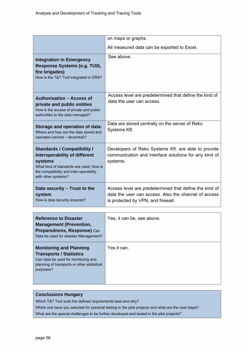
Analysis and Development of Tracking and Tracing Tools
page 56
on maps or graphs.
All measured data can be exported to Excel.
Integration in Emergency Response Systems (e.g. TUIS, fire brigades) How is the T&T Tool integrated in ERS?
See above.
Authorisation – Access of private and public entities How is the access of private and public authorities to the data managed?
Access level are predetermined that define the kind of data the user can access.
Storage and operation of data: Where and how are the data stored and operated (central – decentral)?
Data are stored centrally on the server of Reko Systems Kft.
Standards / Compatibility / Interoperability of different systems What kind of standards are used, How is the compatibility and inter-operability with other systems?
Developers of Reko Systems Kft. are able to provide communication and interface solutions for any kind of systems.
Data security – Trust to the system How is data security ensured?
Access level are predetermined that define the kind of data the user can access. Also the channel of access is protected by VPN, and firewall.
Reference to Disaster Management (Prevention, Preparedness, Response) Can
Data be used for disaster Management?
Yes, it can be, see above.
Monitoring and Planning Transports / Statistics Can data be used for monitoring and planning of transports or other statistical purposes?
Yes it can.
Conclusions Hungary
Which T&T Tool suits the defined requirements best and why?
Which one have you selected for practical testing in the pilot projects and what are the next steps?
What are the special challenges to be further developed and tested in the pilot projects?

Analysis and Development of Tracking and Tracing Tools
page 57
Three solutions have been mapped:
1. iTrack 2. OSRM-RIK 3. REKO Systems
iTrack and OSRM solutions have been primarily developed for road traffic and would need further development to be able to serve rail and/or intermodal traffic. The REKO Systems OBU unit is originally developed for marine traffic, which is closer in use to the rail traffic than the other two solutions. Relevant technical features of the solutions are similar for most mapped parameters. One advantage of iTrack is that it is a marketed product with operational experience whereas OSRM-RIK is a new development without relevant track-record. The OBU of REKO Systems is a marketed product, as well with relevant track record. Based on these HTEO chooses the REKO Systems solution for the pilot project testing.

Analysis and Development of Tracking and Tracing Tools
page 58
Italy
During RSF and in individual interviews the Italian partners have analysed different T&T systems and different T&T devices that can be integrated with each other. The following description is divided by T&T systems and devices.
T&T systems We have analysed several T&T systems, with focus on open source and “Software as a service” products in order to comply with the budget of the project.
Table 12: Description T&T systems Italy
Name of T&T System: OpenGTS
Name Technology Provider: Geo Telematic Solution Inc.
Address:
Contact Details:
Contact Person:
Email:
Phone:
Website: www.geotelematic.com
Summary
Short Summary of T&T Solution
OpenGTS™ ("Open GPS Tracking System") is an open source (Apache 2.0) project designed specifically to provide web-based GPS tracking services for a "fleet" of vehicles. (J2EE + MySql) The system has a direct interface with many devices already implemented via TCP socket/HTTP, or other.
Focus of Tracking
Is the T&T Tool able to track and trace single intermodal loading units (e.g., box, silo or tank container) – independent from the mode of transport – (at least road and rail transport)?
The focus of the system is to track fleet of vehicles. The satellite navigation system is GPS.
Name of T&T System: 3dTracking
Name Technology Provider: 3dTracking LLC
Address: 11311 NW 29th PL Suite 100 Sunrise, FL 33323 USA
Contact Details:
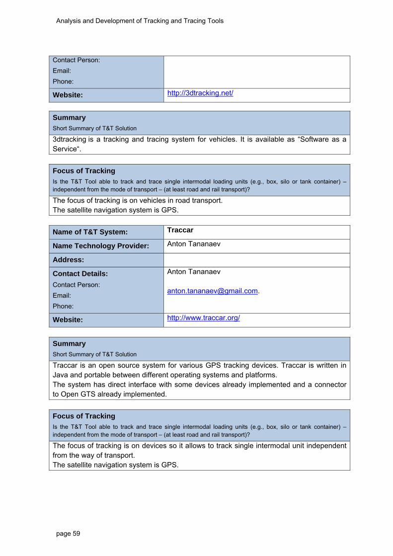
Analysis and Development of Tracking and Tracing Tools
page 59
Contact Person:
Email:
Phone:
Website: http://3dtracking.net/
Summary
Short Summary of T&T Solution
3dtracking is a tracking and tracing system for vehicles. It is available as “Software as a Service“.
Focus of Tracking
Is the T&T Tool able to track and trace single intermodal loading units (e.g., box, silo or tank container) – independent from the mode of transport – (at least road and rail transport)?
The focus of tracking is on vehicles in road transport. The satellite navigation system is GPS.
Name of T&T System: Traccar
Name Technology Provider: Anton Tananaev
Address:
Contact Details:
Contact Person:
Email:
Phone:
Anton Tananaev [email protected].
Website: http://www.traccar.org/
Summary
Short Summary of T&T Solution
Traccar is an open source system for various GPS tracking devices. Traccar is written in Java and portable between different operating systems and platforms. The system has direct interface with some devices already implemented and a connector to Open GTS already implemented.
Focus of Tracking
Is the T&T Tool able to track and trace single intermodal loading units (e.g., box, silo or tank container) – independent from the mode of transport – (at least road and rail transport)?
The focus of tracking is on devices so it allows to track single intermodal unit independent from the way of transport. The satellite navigation system is GPS.

Analysis and Development of Tracking and Tracing Tools
page 60
Name of T&T System: GpsGate Server
Name Technology Provider: GpsGate AB
Address: Luntmakargatan 66, 3tr Stockholm
Contact Details:
Contact Person:
Email:
Phone:
[email protected] +46 8 612 50 70
Website: http://gpsgate.com/
Summary
Short Summary of T&T Solution
GpsGate Server is a web based GPS tracking platform used by transportation companies, police and fire departments, utility companies, service organisations and other businesses with mobile workers around the world. In addition to real time tracking the GpsGate Server platform includes modules for Vehicle Maintenance, Dispatch, ECO Driving, Driver Journal, Alerts and Reporting. GpsGate Server is also available as a hosted service that you access with a web browser.
Focus of Tracking
Is the T&T Tool able to track and trace single intermodal loading units (e.g., box, silo or tank container) – independent from the mode of transport – (at least road and rail transport)?
The platform offers real time GPS tracking of multiple vehicles in a web browser. A live view of the entire vehicle fleet gives you control, the best vehicle can be dispatched for a job and specific vehicles can be followed when required. Alerts and notifications are instantly available in the application.
System for the processing of information – common to all the T&T systems .
Reference to Disaster Management (Prevention, Preparedness, Response) Can
Data be used for disaster Management?
The system DEWETRA can be used for disaster management into the entire disaster cycle:
1-prevention: it gives extensive and reliable statistical data on flows that are the base of risk assessment. Flows can be specified for the entire road network. It can be used for real time traffic management
2-Preparedness: allow the quasi-real time monitoring of dangerous good moving on the road network (GPS system). If the system is connected to Emergency services, it can be used for building real time risk scenario
3- response: it can aid the emergency response by

Analysis and Development of Tracking and Tracing Tools
page 61
transmitting the truck location and the material transported after accident
Monitoring and Planning Transports / Statistics Can data be used for monitoring and planning of transports or other statistical purposes?
The system DEWETRA produces an extensive database for the analysis of dangerous good flows. Data are not limited to a specific area but can potentially refer to the entire road network (GPS system)
Conclusions Italy
Which T&T Tool suits the defined requirements best and why?
Which one have you selected for practical testing in the pilot projects and what are the next steps?
What are the special challenges to be further developed and tested in the pilot projects?
The T&T systems analysed have several criticalities: difficulties in customisation; high costs; single developer; poor documentation about code;
In order to respect the budget and achieve the objective of the project, we have decided to develop internally the T&T Tool. The approach chosen follows a modular architecture, using an existing module, the Central Orchestration Module, in order to integrate the data of different actors, guarantee the interoperability and storage the data, and developing a T&T Map Representation Module and the related connectors. The Central Orchestration Module will be connected with the system for multi-hazard risk management DEWETRA. DEWETRA is a web platform used by the Italian Civil Protection for monitoring and forecast natural and man-made risks. DEWETRA is operationally used by the National Department of Civil protection, the Italian Regions and several other countries such as Albania, Caribbean, Lebanon and Bolivia. The system allows: 1- real-time monitoring of good location and content; 2- real time assessment of impact zones of chemical releases (module CHESRM), exchange information of hydro-meteorological warnings; build risk and emergency scenario; archive data for statistics and flows.

Analysis and Development of Tracking and Tracing Tools
page 62
T&T devices Table 13: Description SITmar (ITA)
Name of T&T Device: SITmar
Name Technology Provider: Advanced Microwave Engineering (AME)
Address: Via del Monastero 4, Firenze Italy
Contact Details:
Contact Person:
Email:
Phone:
Filippo Bonifacio [email protected] 0039-055-73921
Website: www.ameol.it
Summary
Short Summary of T&T Solution
AME’s solution includes a tracking and monitoring device for containers and trailers taking advantage of RFID active technology and optionally of GPS technology that allows to:
Identify a container passing through a gate; Monitor chemical and physical parameters; Survey significant events; Use wired / wireless sensors; Fit in to the context using different protocols.
Focus of Tracking
Is the T&T Tool able to track and trace single intermodal loading units (e.g., box, silo or tank container) – independent from the mode of transport – (at least road and rail transport)?
This device is able to track and trace intermodal single unit independent from the mode of transport.
Description of hardware
Independent energy supply How is the unit supplied with energy? E.g., battery or energy harvesting (PV, etc.)
The device is powered by battery (5 years of duration).
Robust system Is the unit robust and protected against human and environmental impact?
The device is protected against environmental and human impact.
Maintenance What kind of maintenance and in which time intervals is necessary?
The maintenance is related to the battery exchange.

Analysis and Development of Tracking and Tracing Tools
page 63
Connection to the container How is the unit connected to the container? Can it be used flexible in order to change between containers?
The device is hooked by bolt to the container door.
Explosion proof Is the unit explosion proof? Is it certified?
No.
Configuration How and when is the unit configured?
The device is configured when it is connected to the container/intermodal transport unit (UTI).
Costs What are estimated costs of hardware and system? Are there cost models or specific service packages?
More than 100 €.
Data collection
Location of the container / Satellite positioning Which satellite navigation systems are supported (e.g., GPS, Galileo, Glonass)? What is the coverage and quality of signal?
Optionally GPS satellite navigation systems
Information in case of accidents How does the unit measure occurrence of accidents?
The unit measure the occurrence of accidents only if there are added external sensors.
Additional information possible e.g., temperature, pressure, sealing Is it possible to add the measurement of additional information as extension?
It is possible to add a wireless sensor network in order to have more information.
Transmission of data
Transmission of information from Unit to Database How is the transmission of data functioning e.g., via GPRS?
The transmission of data are made by RFID readers (gate, handheld,..).
Frequency of transmission What is the range of frequency of transmission of real time data?
10-30 minutes.

Analysis and Development of Tracking and Tracing Tools
page 64
In case of event (Accident)immediate information
Is it possible to provide information in case of accidents e.g., shock sensors
Yes, with additional sensors.
On demand transmission Can the customer define on-demand transmission?
Using RFID gate or long range radio transmission (within 200 metres).
Costs for transmission What are costs of data transmission, especially respecting international transport?
Free.
Cluster data for transmission How can alarm thresholds be set to cluster data and minimise transmission volumes?
The device has an internal storage system that allow to memorize the data and send it periodic to the T&T system.
Data security How is data security ensured?
-
Low manual interference – automatisation How much automatisation and manual interference is necessary?
The manual interference is necessary during the affixing to the container.
Table 14: Description NEPTUNE SEAL RFID UHF (ITA)
Name of T&T Device: NEPTUNE SEAL RFID UHF
Name Technology Provider: Leghorn
Address: Via Degli Arrotini 34, Livorno TuscanyItaly
Contact Details:
Contact Person:
Email:
Phone:
Alessandro Paternostro [email protected]
Website: http://www.leghornseals.com/
Summary
Short Summary of T&T Solution
Leghorn’s solution includes a tracking and monitoring device for containers and trailers using RFID passive technology that allow to:
- Identify a container passing through a gate;

Analysis and Development of Tracking and Tracing Tools
page 65
- Monitor the status of the container in the event of tampering.
Focus of Tracking
Is the T&T Tool able to track and trace single intermodal loading units (e.g., box, silo or tank container) – independent from the mode of transport – (at least road and rail transport)?
This device is able to track and trace intermodal single unit independent to the mode of transport.
Description of hardware
Independent energy supply How is the unit supplied with energy? E.g., battery or energy harvesting (PV, etc.)
This device is not supplied with energy because it uses passive RFID technology,
Robust system Is the unit robust and protected against human and environmental impact?
The device is protected against environmental and human impact.
Maintenance What kind of maintenance and in which time intervals is necessary?
The device doesn’t need maintenance.
Connection to the container How is the unit connected to the container? Can it be used flexible in order to change between containers?
The device is hooked to the container door.
Explosion proof Is the unit explosion proof? Is it certified?
No.
Configuration How and when is the unit configured?
The device is configured when it is connected to the container/intermodal transport unit (UTI).
Costs What are estimated costs of hardware and system? Are there cost models or specific service packages?
Less than 1€.
Data collection
Location of the container / Satellite positioning Which satellite navigation systems are supported (e.g., GPS, Galileo, Glonass)? What is the coverage and quality of signal?
RFID using gate readers located in strategic points the devices are able to transmit the crossing.

Analysis and Development of Tracking and Tracing Tools
page 66
Information in case of accidents How does the unit measure occurrence of accidents?
The unit does not measure the occurrence of accident.
Additional information possible e.g., temperature, pressure, sealing Is it possible to add the measurement of additional information as extension?
No.
Transmission of data
Transmission of information from Unit to Database How is the transmission of data functioning e.g., via GPRS?
RFID gate.
Frequency of transmission What is the range of frequency of transmission of real time data?
Passing through a RFID gate.
In case of event (Accident)immediate information
Is it possible to provide information in case of accidents e.g., shock sensors
No.
On demand transmission Can the customer define on-demand transmission?
Using RFID handheld.
Costs for transmission What are costs of data transmission, especially respecting international transport?
Using passive RFID technology the transmission is free.
Cluster data for transmission How can alarm thresholds be set to cluster data and minimise transmission volumes?
The data is filtered by the RFID reader.
Data security How is data security ensured?
There is no data security.
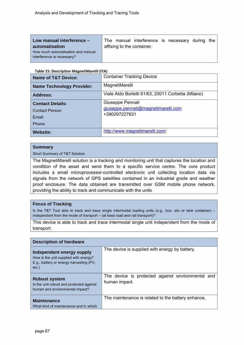
Analysis and Development of Tracking and Tracing Tools
page 67
Low manual interference – automatisation How much automatisation and manual interference is necessary?
The manual interference is necessary during the affixing to the container.
Table 15: Description MagnetiMarelli (ITA)
Name of T&T Device: Container Tracking Device
Name Technology Provider: MagnetiMarelli
Address: Viale Aldo Borletti 61/63, 20011 Corbetta (Milano)
Contact Details:
Contact Person:
Email:
Phone:
Giuseppe Pennati [email protected] +390297227631
Website: http://www.magnetimarelli.com/
Summary
Short Summary of T&T Solution
The MagnetiMarelli solution is a tracking and monitoring unit that captures the location and condition of the asset and send them to a specific service centre. The core product includes a small microprocessor-controlled electronic unit collecting location data via signals from the network of GPS satellites contained in an industrial grade and weather proof enclosure. The data obtained are transmitted over GSM mobile phone network, providing the ability to track and communicate with the units
Focus of Tracking
Is the T&T Tool able to track and trace single intermodal loading units (e.g., box, silo or tank container) – independent from the mode of transport – (at least road and rail transport)?
This device is able to track and trace intermodal single unit independent from the mode of transport.
Description of hardware
Independent energy supply How is the unit supplied with energy? E.g., battery or energy harvesting (PV, etc.)
The device is supplied with energy by battery.
Robust system Is the unit robust and protected against human and environmental impact?
The device is protected against environmental and human impact.
Maintenance What kind of maintenance and in which
The maintenance is related to the battery enhance.

Analysis and Development of Tracking and Tracing Tools
page 68
time intervals is necessary?
Connection to the container How is the unit connected to the container? Can it be used flexible in order to change between containers?
The device is fixed inside the container using magnets.
Explosion proof Is the unit explosion proof? Is it certified?
No
Configuration How and when is the unit configured?
The device is configured when it is connected to the container/intermodal transport unit (UTI) CTD’s mission configuration can be fit according to customer needs either on activation or on going.
Costs What are estimated costs of hardware and system? Are there cost models or specific service packages?
More than 100€.
Data collection
Location of the container / Satellite positioning Which satellite navigation systems are supported (e.g., GPS, Galileo, Glonass)? What is the coverage and quality of signal?
GPS satellite navigation system.
Information in case of accidents How does the unit measure occurrence of accidents?
The unit measure only the temperature and tampering status.
Additional information possible e.g., temperature, pressure, sealing Is it possible to add the measurement of additional information as extension?
It is possible to add sensor to measure temperature.
Transmission of data
Transmission of information from Unit to Database How is the transmission of data functioning e.g., via GPRS?
The data are transmitted over GSM mobile phone network.

Analysis and Development of Tracking and Tracing Tools
page 69
Frequency of transmission What is the range of frequency of transmission of real time data?
The frequency of messages that the user wants to receive.
In case of event (Accident)immediate information
Is it possible to provide information in case of accidents e.g., shock sensors
The shock sensor is not provided.
On demand transmission Can the customer define on-demand transmission?
No.
Costs for transmission What are costs of data transmission, especially respecting international transport?
The cost of one SMS.
Cluster data for transmission How can alarm thresholds be set to cluster data and minimise transmission volumes?
The alarm threshold can be set using temperature.
Data security How is data security ensured?
No.
Geofencing Is it possible to define geofencing application?
Yes (Removal of container from a given position over a set limit)
Low manual interference – automatisation How much automatisation and manual interference is necessary?
The manual interference is necessary during the affixing to the container.
Table 16: Description ULYS Ex2 (ITA)
Name of T&T Device: ULYS Ex2
Name Technology Provider: Saphymo
Address: Parc des Alogorithmes, Batiment ESOPE, 91190 Saint-Aubin, France Heerstrasse 149, 60488 Frankfurt, Germany
Contact Details:
Contact Person:
Email:
Phone:
Olivier Magne [email protected] +33(0)169537309

Analysis and Development of Tracking and Tracing Tools
page 70
Website: www.saphyme.com
Summary
Short Summary of T&T Solution
The Saphymo’s solution is a standalone, all-in-one, onboard tracking that ensures the function of location to track the transportation of sensitive cargo.
Focus of Tracking
Is the T&T Tool able to track and trace single intermodal loading units (e.g., box, silo or tank container) – independent from the mode of transport – (at least road and rail transport)?
This device is able to track and trace intermodal transport unit (UTI), especially rail tank cars and tank containers, independent to the mode of transport.
Description of hardware
Independent energy supply How is the unit supplied with energy? E.g., battery or energy harvesting (PV, etc.)
The device is powered by battery (5 years of duration).
Robust system Is the unit robust and protected against human and environmental impact?
The device is protected against environmental and human impact.
Maintenance What kind of maintenance and in which time intervals is necessary?
The maintenance is related to the battery exchange.
Connection to the container How is the unit connected to the container? Can it be used flexible in order to change between containers?
The device is hooked by bolt inside the container.
Explosion proof Is the unit explosion proof? Is it certified?
No
Configuration How and when is the unit configured?
The device is configured when it is connected to the container/intermodal transport unit (UTI)
Costs What are estimated costs of hardware and system? Are there cost models or specific service packages?
More than 100 €.
Data collection
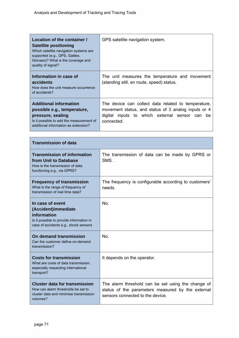
Analysis and Development of Tracking and Tracing Tools
page 71
Location of the container / Satellite positioning Which satellite navigation systems are supported (e.g., GPS, Galileo, Glonass)? What is the coverage and quality of signal?
GPS satellite navigation system.
Information in case of accidents How does the unit measure occurrence of accidents?
The unit measures the temperature and movement (standing still, en route, speed) status.
Additional information possible e.g., temperature, pressure, sealing Is it possible to add the measurement of additional information as extension?
The device can collect data related to temperature, movement status, and status of 3 analog inputs or 4 digital inputs to which external sensor can be connected.
Transmission of data
Transmission of information from Unit to Database How is the transmission of data functioning e.g., via GPRS?
The transmission of data can be made by GPRS or SMS .
Frequency of transmission What is the range of frequency of transmission of real time data?
The frequency is configurable according to customers’ needs.
In case of event (Accident)immediate information
Is it possible to provide information in case of accidents e.g., shock sensors
No.
On demand transmission Can the customer define on-demand transmission?
No.
Costs for transmission What are costs of data transmission, especially respecting international transport?
It depends on the operator.
Cluster data for transmission How can alarm thresholds be set to cluster data and minimise transmission volumes?
The alarm threshold can be set using the change of status of the parameters measured by the external sensors connected to the device.
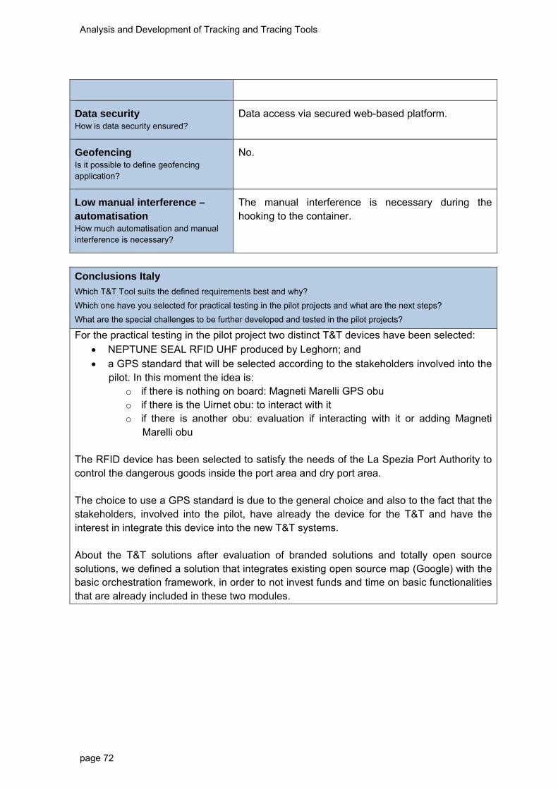
Analysis and Development of Tracking and Tracing Tools
page 72
Data security How is data security ensured?
Data access via secured web-based platform.
Geofencing Is it possible to define geofencing application?
No.
Low manual interference – automatisation How much automatisation and manual interference is necessary?
The manual interference is necessary during the hooking to the container.
Conclusions Italy
Which T&T Tool suits the defined requirements best and why?
Which one have you selected for practical testing in the pilot projects and what are the next steps?
What are the special challenges to be further developed and tested in the pilot projects?
For the practical testing in the pilot project two distinct T&T devices have been selected: NEPTUNE SEAL RFID UHF produced by Leghorn; and a GPS standard that will be selected according to the stakeholders involved into the
pilot. In this moment the idea is: o if there is nothing on board: Magneti Marelli GPS obu o if there is the Uirnet obu: to interact with it o if there is another obu: evaluation if interacting with it or adding Magneti
Marelli obu The RFID device has been selected to satisfy the needs of the La Spezia Port Authority to control the dangerous goods inside the port area and dry port area. The choice to use a GPS standard is due to the general choice and also to the fact that the stakeholders, involved into the pilot, have already the device for the T&T and have the interest in integrate this device into the new T&T systems. About the T&T solutions after evaluation of branded solutions and totally open source solutions, we defined a solution that integrates existing open source map (Google) with the basic orchestration framework, in order to not invest funds and time on basic functionalities that are already included in these two modules.

Analysis and Development of Tracking and Tracing Tools
page 73
Poland
Table 17: Description Qguar OTM‐Object Tracking&Monitoring (PL)
Name of T&T Tool: Qguar OTM-Object Tracking&Monitoring
Name Technology Provider: Quantum Software S.A.
Address: Ul. Walerego Sławka 3A, 30-633 Kraków
Contact Details:
Contact Person:
Email:
Phone:
Marek Jędra [email protected] (+48) 602 650 410
Website: www.quantum-software.com
Summary
Short Summary of T&T Solution
An intelligent and efficient combination of gear and software for object tracking and monitoring. Based on information system (provided by Quantum Software) and satellite location device Kormoran (tool produced by Radionika S.A., directly for this system). Using technologies GPS, GPRS, APN, IPCES channel Qguar OTM gives full-functionality tracking and tracing service of different types of logistic objects, dedicated especially for rail transport of chemical loads (a system and tool was prepared for special order of one of the biggest polish petrochemical producer). All data about a loading unit from Kormoran are generated on a communication server and distributed to monitoring office (personal computers, mobile). A Kormoran has its own independent power source (battery, lifetime to two years – it depend on real activity of tool). An information system collecting data from Kormoran - data on current location, movement and stopover of vehicles and presents it as a map with load transport route (on a real time). A data generated on communication server are analysed by system. I t can be done directly on the transmitted data - this allows the implementation of alarm functions which can check the breach of defined rules and create an alarm message. Another analysis can be done with all collected data or parts of it (for configured period of a time) – data are presented as a thematic charts, tables etc.
Focus of Tracking
Is the T&T Tool able to track and trace single intermodal loading units (e.g., box, silo or tank container) – independent from the mode of transport – (at least road and rail transport)?
The T&T tool can be used to track and trace single intermodal loading units. This can be realised by using connector adaptors which can be attached to the object being tracked. Realized scenarios range from attaching the mobile device directly at screws of component parts (with adapter), their transport frame or on containers.
Description of hardware

Analysis and Development of Tracking and Tracing Tools
page 74
Independent energy supply How is the unit supplied with energy? E.g., battery or energy harvesting (PV, etc.)
Power supply primary by rechargeable backup battery (12-36 month on one charge; optimization of energy consumption function - „Kick start”, Assist Online”), external power connector for charging (but can be used for permanent power supply, too). Information about the battery (power level) is collected on a system with all location data.
Robust system Is the unit robust and protected against human and environmental impact?
Technical specification of a Kormoran location unit: - IP Code: IP 67 / EN 60529 - IK Code: IK 9 / EN 0208 - working temperature scope: - 40° C … + 80° C Main features of a unit: - high quality, durable plastic casing - airtight, weather-proof construction - dedicated mount preventing unauthorized dismantling - motion detector - unique vehicle signature system
Maintenance What kind of maintenance and in which time intervals is necessary?
Only maintenance activities are charging batteries. No other maintenance is necessary.
Connection to the container How is the unit connected to the container? Can it be used flexible in order to change between containers?
A unit can be mountable on any type of vehicle/load unit – using steel mount system, can be attached or fixed by screws. It can be mounted on a tank wagon, on a platform, on or inside of a container unit etc.
Explosion proof Is the unit explosion proof? Is it certified?
A Kormoran unit is certificated for explosion proof.
Configuration How and when is the unit configured?
First configured of unit is done before using, on a system connection (on a server; all units has its dedicated unique vehicle signature system). Then it will be done when a unit is mounted on a load unit – by w/RFID identification system in steel mount. All later configurations can be done via communication layer to the server.
Costs What are estimated costs of hardware and system? Are there cost models or specific service packages?
No pricing structure until now because no real product (lack of distribution partner) – cost for test route using of unit and system won’t be higher than 2500EUR. Real cost of system tool work depends of real time work of battery, prices of mobile communication.
Data collection
Location of the container / - GPS receiver

Analysis and Development of Tracking and Tracing Tools
page 75
Satellite positioning Which satellite navigation systems are supported (e.g., GPS, Galileo, Glonass)? What is the coverage and quality of signal?
- bidirectional GSM communication module
- GSM Galileo compatible
Location Device Antenna Unit (high-sensitivity antenna) inside a unit.
Information in case of accidents How does the unit measure occurrence of accidents?
Based on the integrated motion detector of a unit.
Additional information possible e.g., temperature, pressure, sealing Is it possible to add the measurement of additional information as extension?
Temperature sensor - outside of a unit
For this moment there are no more other sensors.
Transmission of data
Transmission of information from Unit to Database How is the transmission of data functioning e.g., via GPRS?
server communication: SMS, GPRS
Frequency of transmission What is the range of frequency of transmission of real time data?
Configurable. Possible behaviour: time based, distance based, direction changes, motion based or combination of mentioned.
In case of event (Accident) immediate information
Is it possible to provide information in case of accidents e.g., shock sensors
Configurable. If necessary, different types of events can be declared to send an event message. Possible events configurable on a server system – base on a data from location unit.
On demand transmission Can the customer define on-demand transmission?
Yes but it generated high energy consumption (gprs modem needs to be registered to network).
Costs for transmission What are costs of data transmission, especially respecting international transport?
Depends on mobile network tariff and amount of data to be sent (configuration of frequency of transmission).

Analysis and Development of Tracking and Tracing Tools
page 76
Cluster data for transmission How can alarm thresholds be set to cluster data and minimise transmission volumes?
Thresholds can be configured on server and will be transmitted to devices.
Data security How is data security ensured?
Data is being stored in a central database which can only be accessed via web application or web services
Geofencing Is it possible to define geofencing application?
No information about for now
Low manual interference – automatisation How much automatisation and manual interference is necessary?
No manual interference necessary. Based on configuration devices operate automatically.
System for the processing of information
Integration into the supply chain management of chemical companies/ Logistics Service Provider How is the T&T application integrated in the company IT?
Main features of a system:
- access via web browser
- intuitive user interface
- installation on a customer server or as Quantum SaaS
Integration in Emergency Response Systems (e.g., TUIS, fire brigades) How is the T&T Tool integrated in ERS?
Integration possible via Web Services to get data of current position and status of the monitored objects.
Authorisation – Access of private and public entities How is the access of private and public authorities to the data managed?
Access can be granted by user login to web application or web services.
Storage and operation of data Where and how are the data stored and
Data is stored central in a database/server system.

Analysis and Development of Tracking and Tracing Tools
page 77
operated (central – decentral)?
Standards / Compatibility / Interoperability of different systems What kind of standards are used? How is the compatibility and inter-operability with other systems?
System guaranteed an easy integration with external systems (e.g. SAP)
Data security – Trust to the system How is data security ensured?
Data is being stored in a central database which can only be accessed via web application or web services
Reference to Disaster Management (prevention, preparedness, response) Can
Data be used for disaster Management?
Integration possible via Web Services to get data of current position and status of the monitored objects. Based on event driven data exchange alarm messages can be generated and send to disaster management systems.
Monitoring and planning transports / statistics Can data be used for monitoring and planning of transports or other statistical purposes?
Application offers some analytic functions or charts, but data can be provided by export for further analytics.
Standard monitoring overview list:
� Monitored objects data
� Location of objects on a map
� Objects workflow
� Objects workflow overview
� Objects in the area
� Stopovers analysis
� Immobile objects in the area
� Stopovers network in the area

Analysis and Development of Tracking and Tracing Tools
page 78
Table 18: Description Telenor Traxion (PL)
Name of T&T Tool: Telenor Traxion
Name Technology Provider: TELENOR TRAXION
Address: Registered Office: Telenor Traxion AB, Campus Gräsvik 12, SE-371 80 Karlskrona, Sweden
Contact Details:
Contact Person:
Email:
Phone:
Michal Szlendak Sales Manager - Poland, Czech Republic, Slovakia Phone: +48 668 565 487 E-mail: [email protected]
Website: www.telenortraxion.com
Summary
Short Summary of T&T Solution
Telenor Traxion gives a total solution for modern assets monitoring. Based on an information system (with lot of possible analyse, dedicated/specific thematic information etc.) and independent tool/unit with satellite location device and system of different sensors. It guaranteed professional track&trace service:
- a full overview of moving load, - define instant alarms and reports (for demand, define period of a time), - standing still detection, monitoring of load temperature
The Telenor Traxion hardware is compliant with railway directives (e.g. regarding electromagnetic compatibility). Hardware is approved for use in potentially explosive atmosphere. A hardware allow the implementation of alarm functions which can check the breach of defined rules and create an alarm message A data from location unit are generated and transformed on server - software system. And there are analysed by system – number and kind of analytics presentations depend of a customer needs. Analysis can be done with all collected data or parts of it (for configured period of a time) – data are presented as a thematic charts, tables etc.
Focus of Tracking
Is the T&T Tool able to track and trace single intermodal loading units (e.g., box, silo or tank container) – independent from the mode of transport – (at least road and rail transport)?
The T&T tool can be used to track and trace single intermodal loading units. This can be realised by using connector adaptors which can be attached to the object being tracked. Realized scenarios range from attaching the mobile device directly at screws of component parts (with adapter), their transport frame or on containers.
Description of hardware
Independent energy supply How is the unit supplied with energy?
Telenor Traxion takes care of monitoring the status of the DCTU (GPS-device) and platform, when to change
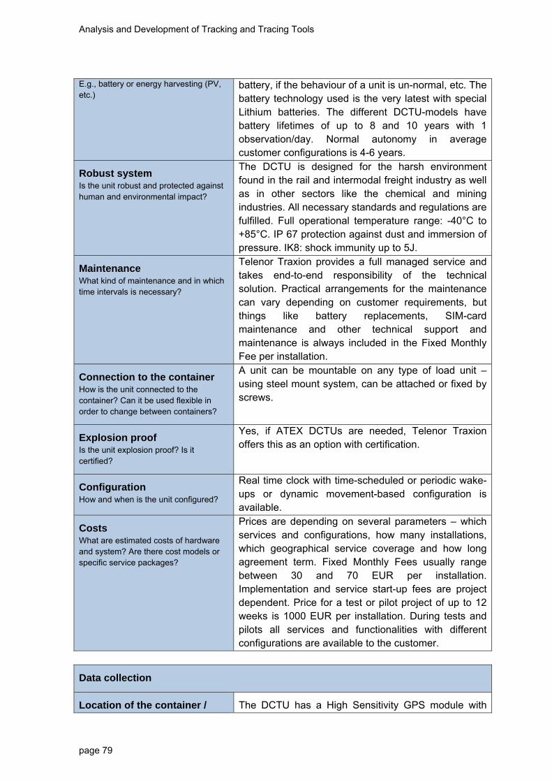
Analysis and Development of Tracking and Tracing Tools
page 79
E.g., battery or energy harvesting (PV, etc.)
battery, if the behaviour of a unit is un-normal, etc. The battery technology used is the very latest with special Lithium batteries. The different DCTU-models have battery lifetimes of up to 8 and 10 years with 1 observation/day. Normal autonomy in average customer configurations is 4-6 years.
Robust system Is the unit robust and protected against human and environmental impact?
The DCTU is designed for the harsh environment found in the rail and intermodal freight industry as well as in other sectors like the chemical and mining industries. All necessary standards and regulations are fulfilled. Full operational temperature range: -40°C to +85°C. IP 67 protection against dust and immersion of pressure. IK8: shock immunity up to 5J.
Maintenance What kind of maintenance and in which time intervals is necessary?
Telenor Traxion provides a full managed service and takes end-to-end responsibility of the technical solution. Practical arrangements for the maintenance can vary depending on customer requirements, but things like battery replacements, SIM-card maintenance and other technical support and maintenance is always included in the Fixed Monthly Fee per installation.
Connection to the container How is the unit connected to the container? Can it be used flexible in order to change between containers?
A unit can be mountable on any type of load unit – using steel mount system, can be attached or fixed by screws.
Explosion proof Is the unit explosion proof? Is it certified?
Yes, if ATEX DCTUs are needed, Telenor Traxion offers this as an option with certification.
Configuration How and when is the unit configured?
Real time clock with time-scheduled or periodic wake-ups or dynamic movement-based configuration is available.
Costs What are estimated costs of hardware and system? Are there cost models or specific service packages?
Prices are depending on several parameters – which services and configurations, how many installations, which geographical service coverage and how long agreement term. Fixed Monthly Fees usually range between 30 and 70 EUR per installation. Implementation and service start-up fees are project dependent. Price for a test or pilot project of up to 12 weeks is 1000 EUR per installation. During tests and pilots all services and functionalities with different configurations are available to the customer.
Data collection
Location of the container / The DCTU has a High Sensitivity GPS module with

Analysis and Development of Tracking and Tracing Tools
page 80
Satellite positioning Which satellite navigation systems are supported (e.g., GPS, Galileo, Glonass)? What is the coverage and quality of signal?
integrated antenna. For best performance, the DCTU should be mounted on a horizontal or vertical surface (requires at least 180° of sky view for optimal GPS performance.) The accuracy is +/- 5 meters. No compatibility with Galileo and Glonass. Our aim is to provide the best functionality with the best quality and therefore we view Galileo and Glonass very limited for the moment.
Information in case of accidents How does the unit measure occurrence of accidents?
Based on the integrated motion detector of a unit.
Additional information possible e.g., temperature, pressure, sealing Is it possible to add the measurement of additional information as extension?
Temperature sensor and other different sensors are possible – on customer demand.
Transmission of data
Transmission of information from Unit to Database How is the transmission of data functioning e.g., via GPRS?
server communication: SMS, GPRS
Frequency of transmission What is the range of frequency of transmission of real time data?
System provider suggests movement detection for optimal monitoring. Then the customer gets a dynamic, real-time tracking and monitoring of his assets. Combined with features for alarms and alerts this gives maximum visibility. We don´t offer transmissions on demand because of the power consumption when having the DCTU online 24/7/.
In case of event (Accident) immediate information
Is it possible to provide information in case of accidents e.g., shock sensors
Configurable. If necessary, different types of events can be declared to send an event message. Possible events configurable on a server system – base on a data from location unit.
On demand transmission Can the customer define on-demand transmission?
Yes but it generated high energy consumption (gprs modem needs to be registered to network).
Costs for transmission What are costs of data transmission, especially respecting international
Depends on mobile network tariff and amount of data to be sent (configuration of frequency of transmission).

Analysis and Development of Tracking and Tracing Tools
page 81
transport?
Cluster data for transmission How can alarm thresholds be set to cluster data and minimise transmission volumes?
Thresholds can be configured on server and will be transmitted to devices.
Data security How is data security ensured?
Data is being stored in a central database which can only be accessed via web application or web services
Geofencing Is it possible to define geofencing application?
No information about for now
Low manual interference – automatisation How much automatisation and manual interference is necessary?
No manual interference necessary. Based on configuration devices operate automatically.
System for the processing of information
Integration into the supply chain management of chemical companies/ Logistics Service Provider How is the T&T application integrated in the company IT?
Yes it is possible to export information from our platform into SAP or similar systems via our SOAP API. The customer decides what data to import and with which frequency
Integration in Emergency Response Systems (e.g., TUIS, fire brigades) How is the T&T Tool integrated in ERS?
Not possible.
Authorisation – Access of private and public entities How is the access of private and public authorities to the data managed?
Access can be granted by user login to web application or web services.
Storage and operation of data Where and how are the data stored and operated (central – decentral)?
Data is stored central in a database/server system. All XML response messages are encoded in UTF-8. Standard set-up is that Telenor Traxion stores the information for 1 year. More or less capacity and storing time can of course be agreed. The entire service platform is hosted in a cloud-based environment with full redundancy and security. Back up of data is done continuously.
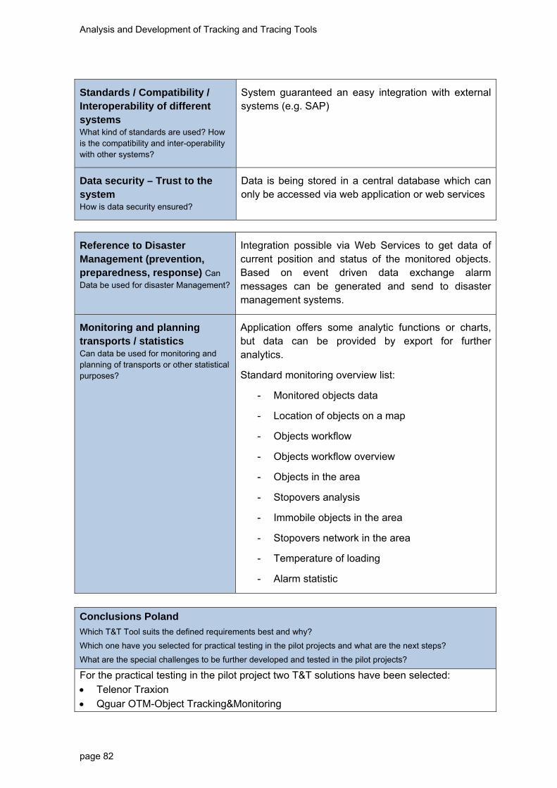
Analysis and Development of Tracking and Tracing Tools
page 82
Standards / Compatibility / Interoperability of different systems What kind of standards are used? How is the compatibility and inter-operability with other systems?
System guaranteed an easy integration with external systems (e.g. SAP)
Data security – Trust to the system How is data security ensured?
Data is being stored in a central database which can only be accessed via web application or web services
Reference to Disaster Management (prevention, preparedness, response) Can
Data be used for disaster Management?
Integration possible via Web Services to get data of current position and status of the monitored objects. Based on event driven data exchange alarm messages can be generated and send to disaster management systems.
Monitoring and planning transports / statistics Can data be used for monitoring and planning of transports or other statistical purposes?
Application offers some analytic functions or charts, but data can be provided by export for further analytics.
Standard monitoring overview list:
- Monitored objects data
- Location of objects on a map
- Objects workflow
- Objects workflow overview
- Objects in the area
- Stopovers analysis
- Immobile objects in the area
- Stopovers network in the area
- Temperature of loading
- Alarm statistic
Conclusions Poland
Which T&T Tool suits the defined requirements best and why?
Which one have you selected for practical testing in the pilot projects and what are the next steps?
What are the special challenges to be further developed and tested in the pilot projects?
For the practical testing in the pilot project two T&T solutions have been selected: Telenor Traxion Qguar OTM-Object Tracking&Monitoring

Analysis and Development of Tracking and Tracing Tools
page 83
Selected solution answers/has high compliance for the requirements in ChemLog T&T Project. System providers have a good qualifications and experience in T&T systems for chemical sector. In the pilot project we want to see selected T&T system’s in practical action primarily focusing on the following functional elements: Tool’s strength and durability (external factors) time – test of delay (compliance with defined times for each section and operations -
the response of the tool in case of non-compliance) alert system - correct information passed to the right users availability of transport information (product, unit, route, brake points on route,
transport provider, product owner etc.) in system data flow in system between each entities/stakeholders summary reports quality system energy consumption (combined transport rail&road) total costs of using quality / suitability / value reporting and analysis of transport compliance / compatibility with ERP systems (if possible) – the ability to
export/import data and information between systems
Next steps: final determination of the cooperation agreements with selected T&T System suppliers signing a preliminary agreements on cooperation with selected T&T System providers start pilot project transport – NL-DE-PL-RU roundtrip route (detailed organizational /
time frame for implementation in consultation and cooperation with German partner)
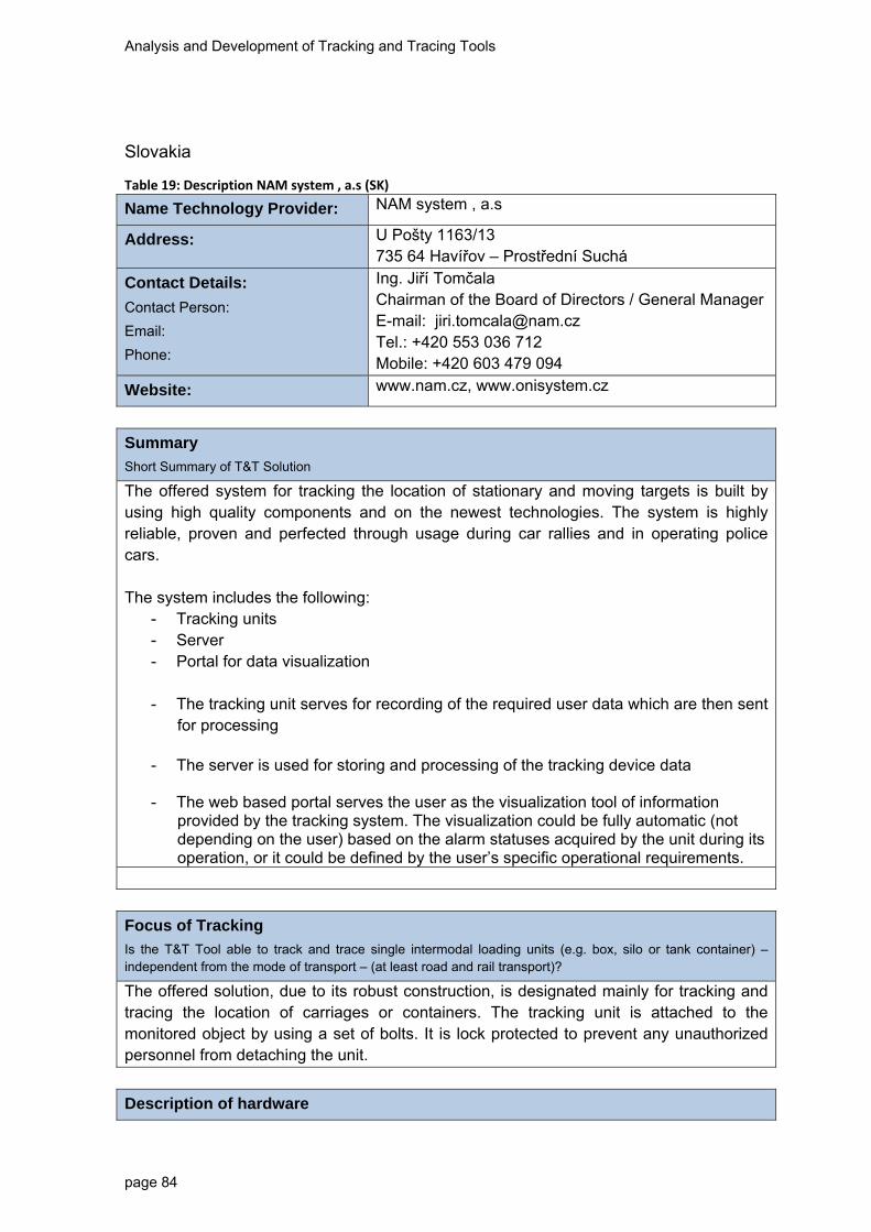
Analysis and Development of Tracking and Tracing Tools
page 84
Slovakia
Table 19: Description NAM system , a.s (SK)
Name Technology Provider: NAM system , a.s
Address: U Pošty 1163/13 735 64 Havířov – Prostřední Suchá
Contact Details:
Contact Person:
Email:
Phone:
Ing. Jiří Tomčala Chairman of the Board of Directors / General ManagerE-mail: [email protected] Tel.: +420 553 036 712 Mobile: +420 603 479 094
Website: www.nam.cz, www.onisystem.cz
Summary
Short Summary of T&T Solution
The offered system for tracking the location of stationary and moving targets is built by using high quality components and on the newest technologies. The system is highly reliable, proven and perfected through usage during car rallies and in operating police cars. The system includes the following:
- Tracking units - Server - Portal for data visualization
- The tracking unit serves for recording of the required user data which are then sent
for processing
- The server is used for storing and processing of the tracking device data
- The web based portal serves the user as the visualization tool of information provided by the tracking system. The visualization could be fully automatic (not depending on the user) based on the alarm statuses acquired by the unit during its operation, or it could be defined by the user’s specific operational requirements.
Focus of Tracking
Is the T&T Tool able to track and trace single intermodal loading units (e.g. box, silo or tank container) – independent from the mode of transport – (at least road and rail transport)?
The offered solution, due to its robust construction, is designated mainly for tracking and tracing the location of carriages or containers. The tracking unit is attached to the monitored object by using a set of bolts. It is lock protected to prevent any unauthorized personnel from detaching the unit.
Description of hardware
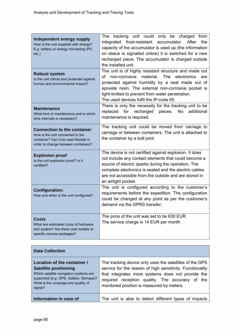
Analysis and Development of Tracking and Tracing Tools
page 85
Independent energy supply How is the unit supplied with energy? E.g. battery or energy harvesting (PV, etc.)
The tracking unit could only be charged from integrated frost-resistant accumulator. After the capacity of the accumulator is used up (the information on status is signalled online) it is switched for a new recharged piece. The accumulator is charged outside the installed unit.
Robust system Is the unit robust and protected against human and environmental impact?
The unit is of highly resistant structure and made out of non-corrosive material. The electronics are protected against humidity by a seal made out of epoxide resin. The external non-corrosive pocket is tight-knitted to prevent from water penetration. The used devices fulfil the IP-code 65.
Maintenance What kind of maintenance and in which time intervals is necessary?
There is only the necessity for the tracking unit to be replaced for recharged pieces. No additional maintenance is required.
Connection to the container How is the unit connected to the container? Can it be used flexible in order to change between containers?
The tracking unit could be moved from carriage to carriage or between containers. The unit is attached to the container by a bolt joint.
Explosion proof Is the unit explosion proof? Is it certified?
The device is not certified against explosion. It does not include any contact elements that could become a source of electric sparks during the operation. The complete electronics is sealed and the electric cables are not accessible from the outside and are stored in an airtight pocket.
Configuration: How and when is the unit configured?
The unit is configured according to the customer’s requirements before the expedition. The configuration could be changed at any point as per the customer’s demand via the GPRS transfer.
Costs What are estimated costs of hardware and system? Are there cost models or specific service packages?
The price of the unit was set to be 630 EUR The service charge is 14 EUR per month
Data Collection
Location of the container / Satellite positioning Which satellite navigation systems are supported (e.g. GPS, Galileo, Glonass)? What is the coverage and quality of signal?
The tracking device only uses the satellites of the GPS service for the reason of high sensitivity. Functionality that integrates more systems does not provide the required reception quality. The accuracy of the monitored position is measured by meters.
Information in case of The unit is able to detect different types of impacts

Analysis and Development of Tracking and Tracing Tools
page 86
accidents How does the unit measure occurrence of accidents
(collisions) due to a 3-axle integrated acceleration sensor. This information could be sent via different channels to a stipulated place (SMS, e-mail, web portal, etc.).
Additional information possible e.g. temperature, pressure, sealing Is it possible to add the measurement of additional information as extension?
The unit without the additional sensors only registers its own internal temperature.
Transmission of data
Transmission of information from Unit to Database How is the transmission of data functioning e.g. via GPRS ?
The data transfer from the tracking device is online and via GPRS. The data are transferred into the data centre.
Frequency of transmission What is the range of frequency of transmission of real time data?
The item could be configured and set to show the range from tens of seconds to tens of hours.
In case of event (Accident) immediate information
Is it possible to provide information in case of accidents e.g. shock sensors
The accident information could be recorded and sent based on the details provided by the integrated acceleration sensor.
On demand transmission Can the customer define on-demand transmission?
Based on individual requirement, the customer can have his/her real-time location sent by the tracking device.
Costs for transmission What are costs of data transmission, especially respecting international transport?
The message transfer expenses are in compliance with other EU countries standards and are in level with the required fees for the services.
Cluster data for transmission How can alarm thresholds be set to cluster data and minimise transmission volumes?
The threshold values could be set on the side of the server.
Data security How is data security ensured?
The data are secured on the web application level. The access is secured by either IP address, 4-level password system or by combination of both.
Geofencing Is it possible to define geofencing application?
“geoplot” functionality could be used for location tracking. Geoplot provides 16 positions – stationary as

Analysis and Development of Tracking and Tracing Tools
page 87
well as dynamic.
Low manual interference – automatisation How much automatisation and manual interference is necessary?
According to the used configuration it is possible to use a fully automatic regime without the necessity of the user’s involvement.
System for the processing of information
Integration into the supply chain management of chemical companies How is the T&T application integrated in the company IT?
An integration with the supply chain management is possible via the data bridge from the application (location, alarm status, etc.).
Integration in Emergency Response Systems (e.g. TUIS, fire brigades) How is the T&T Tool integrated in ERS?
An integration with the Emergency Response System is possible via the data bridge from the application (location, alarm statuses, etc.).
Authorisation – Access of private and public entities How is the access of private and public authorities to the data managed?
User can access the application after entering the valid login details. The users could be assigned by different rights. The login could be linked to a static IP address.
Storage and operation of data: Where and how are the data stored and operated (central – decentral)?
The data are stored in the technological centre of our partner company, K2.
Standards / Compatibility / Interoperability of different systems What kind of standards are used, How is the compatibility and inter-operability with other systems?
No standard dative transfer formats are used for the security reasons.
Data security – Trust to the system How is data security ensured?
Data are stored in a data centre with a multiple back-up system. Only an authorized person (administrator) is allowed access to the data centre.
Analysis and Development of Tracking and Tracing Tools
page 88
Reference to Disaster Management (Prevention, Preparedness, Response) Can
Data be used for disaster Management?
Data from the web application could be sent to the crisis management centres.
Monitoring and Planning Transports / Statistics Can data be used for monitoring and planning of transports or other statistical purposes?
The web application allows for monitoring of basic parameters (map foundation, location, speed, covered distances, itinerary, logbook), or data export for further processing.

Analysis and Development of Tracking and Tracing Tools
page 89
Table 20: Description On‐line tracking and tracing tools (SK)
Name of T&T Tool: On-line tracking and tracing tools
Name Technology Provider: QADRA plus s.r.o.
Address: Agátova 66, 92701 Šaľa, Slovakia
Contact Details:
Contact Person:
Email:
Phone:
Milan Gombík [email protected] +421 911 966 669
Website: http://www.qadra.sk/
Summary
Short Summary of T&T Solution
The proposed devices (M7 and TT1) are available on market for few years so the hardware and firmware are stable and tested enough. Well known high quality ARM based hardware is proposed to accomplish the special requests coming out from trailer tracking needs. Long term relationship with devices manufacturer assurer the fine tuning of firmware and implementing of the special requests related to the 3D g-sensor functionality. Eventually the necessary hardware changes could be realised including the 4~20MB of internal flash memory, used GSM module and GPS/GLONASS combined receivers and 2.4GHz RF interface.
Focus of Tracking
Is the T&T Tool able to track and trace single intermodal loading units (e.g., box, silo or tank container) – independent from the mode of transport – (at least road and rail transport)?
The on board unit is able to track and trace single intermodal loading units. The OBU can be attached directly to the container.
Description of hardware
Independent energy supply How is the unit supplied with energy? E.g., battery or energy harvesting (PV, etc.)
The unit has an independent energy supply. The frequency of data acquisition and transmission determines the power consumption of the device. Battery powered devices have operation/run-times of weeks or months and have to be serviced from time to time or replaced to charge the battery.
Robust system Is the unit robust and protected against human and environmental impact?
The OBU is robust against climatic loadings. Robust characteristics against human interventions must be further analysed.
Maintenance What kind of maintenance and in which time intervals is necessary?
Average li-ion battery lifetime is 2 ~ 4 years. Battery must be replaced when the capacity is decreased.

Analysis and Development of Tracking and Tracing Tools
page 90
Connection to the container How is the unit connected to the container? Can it be used flexible in order to change between containers?
The OBU is fixed to the container and can be removed to fix it to another container. The OBU is fixed using 2 strong neodymium magnets, eventually double fixed with binders or custom seals.
Explosion proof Is the unit explosion proof? Is it certified?
Explosion proof has not been analysed. Electronic fuses and IP67 rated enclosure is explosion proof and water proof.
Configuration How and when is the unit configured?
The unit is configured on place where it is installed or on-line during use. Unit could be configured via GPRS and SMS remotely via USB locally.
Costs What are estimated costs of hardware and system? Are there cost models or specific service packages?
From 230,00 EUR / piece excluding VAT
Data collection
Location of the container / Satellite positioning Which satellite navigation systems are supported (e.g., GPS, Galileo, Glonass)? What is the coverage and quality of signal?
OBU supports satellite systems for positions capturing (GPS, GLONASS). In case of GPS/GLONASS not available, OBU unit is able to share details about GSM network and Cell ID.
Information in case of accidents How does the unit measure occurrence of accidents?
The OBU has a 3D shock sensor that gives information each second about movements which can be used to identify inclinations or unintended movements (in case of theft). Internally the g-sensor values are updated at least in 10Hz resolution.
Additional information possible e.g., temperature, pressure, sealing Is it possible to add the measurement of additional information as extension?
No further information possible for M7 Also data information are not included at present time because it requires data interface or input of the cargo data. TT1 variant also includes the RS232 serial port for additional customised accessories. 2.4GHz RF interface available on demand.
Transmission of data
Transmission of information from Unit to Database How is the transmission of data functioning e.g., via GPRS?
The OBU uses Cellular system for data-transmission to server or infrastructure. Both Internet and VPN could be used for data transfer.

Analysis and Development of Tracking and Tracing Tools
page 91
Frequency of transmission What is the range of frequency of transmission of real time data?
The OBU can be configured to use different ranges of frequencies for the transmission of information depending on the defined needs as time, distance, heading criteria.
In case of event (Accident) immediate information
Is it possible to provide information in case of accidents e.g., shock sensors
The OBU has a shock sensor that gives information each second about movements which can be used to identify inclinations or unintended movements (in case of theft).
On demand transmission Can the customer define on-demand transmission?
The customer can requires events, when the information is sent to database and predefined telephone numbers as low battery alert, signal level alert. Currently not defined for shock sensors.
Costs for transmission What are costs of data transmission, especially respecting international transport?
Costs for cellular network transmissions via SMS service and GPRS data transmission. Blocking in roaming service is possible.
Cluster data for transmission How can alarm thresholds be set to cluster data and minimise transmission volumes?
Data set defined by customer in term of battery capacity can be stored in the memory of the device but the memory itself limits long time storage of data in case of high frequency of data.
Data security How is data security ensured?
Data in OBUs flash STORAGE are password protected and saved in binary format. Data on server side is possible to encrypt if necessary. GPRS transfer could be protected using encrypted VPN.
Geofencing Is it possible to define geofencing application?
YES, within circles defined by positions and radiuses.
Low manual interference – automatisation How much automatisation and manual interference is necessary?
At first installation OBU is configured at place than it is possible to reconfigure it on-line if necessary.
System for the processing of information
Integration into the supply chain management of chemical companies/ Logistics Service Provider How is the T&T application integrated in
The database can be connected via interface to IT systems of companies. XML services and directed database access could be assured.

Analysis and Development of Tracking and Tracing Tools
page 92
the company IT?
Integration in Emergency Response Systems (e.g., TUIS, fire brigades) How is the T&T Tool integrated in ERS?
Possible to define interface but not currently used because ERS don’t have the data structure defined in Slovakia to accept such data.
Authorisation – Access of private and public entities How is the access of private and public authorities to the data managed?
Access defined via interface or web-application. XML outputs could be generated under the specification for interfacing with 3rd party software.
Storage and operation of data Where and how are the data stored and operated (central – decentral)?
In central database of the provider of the service or on own customer servers. Optimized and fine-tuned MySQL engine is used as data storage.
Standards / Compatibility / Interoperability of different systems What kind of standards are used? How is the compatibility and inter-operability with other systems?
Ensured with the interface or by own servers.
Data security – Trust to the system How is data security ensured?
Password restricted access to database. Password restricted settings of OBU.
Reference to Disaster Management (prevention, preparedness, response) Can
Data be used for disaster Management?
NO
Monitoring and planning transports / statistics Can data be used for monitoring and planning of transports or other statistical purposes?
Long-term monitoring possible.
Conclusions Slovakia
Which T&T Tool suits the defined requirements best and why?
Which one have you selected for practical testing in the pilot projects and what are the next steps?
What are the special challenges to be further developed and tested in the pilot projects?
TT1 and M7 fits the requests the best. 4700mAh for M7 and 10000mAh for TT1 are available. Both devices available with IP67 enclosure. Various power saving modes are available together with 3D g-sensor and 4MB built in flash memory for data logging. Firmware is customizable under the customer requests.

Analysis and Development of Tracking and Tracing Tools
page 93
Slovenia
In Slovenia there are currently several different T&T services (GPS/GSM) on the market: Telargo, Frotcom, Easytracker, Track, Sledat, Gps-sledenje, Blackblox, Sledenje, etc. In May 2013, company Sledenje.d.o.o responded to invitation to the RSF held on 20. 5. 2013 and presented their service. Following the RSF an internal meeting was held between Institute of Traffic and Transport Ljubljana (external expert) and representatives of aforementioned company in order to assess the T&T service according to the pre-identified requirements and proposed pilot project.
Table 21: Description Sledenje.com (SI)
Name of T&T Tool: Sledenje.com
Name Technology Provider: SLEDENJE d.o.o.
Address: Letališka cesta 33d, SI - 1000 Ljubljana
Contact Details:
Contact Person:
Email:
Phone:
JURE URGL, Sales Manager [email protected] +386 1 5466 772, +386 51 464 646
Website: http://www.sledenje.com/ENG/o_podjetju.php
Summary
Short Summary of T&T Solution
T&T system is based on common capability of GPS/GSM tracking service providers. It actually bases on the service of Sledenje.com company. The multimodal T&T solution should be deemed a proposal since it hasn’t been agreed among the partners nor it has been actually implemented by the technology provider.
Automatic T&T information system for tracking of hazardous goods is based on GPS/GSM technology for detection of location (GPS) and data transmission (GSM-GPRS). This is done via on-board unit that is mounted on a vehicle or transport unit. Main parts of the on-board unit (OBU) are:
- GPS module – location and time capture,
- GSM-GPRS – data transmission to the data centre,
- Sensor interface (digital or analog) input – connection to the sensors’ installation,
- processing unit (microcomputer) – data processing: geo-fencing, data capture.
Data from OBU are periodically (real-time or delayed) transmitted to the database in the data centre of the registered1 T&T service provider. The data in the data centre are further processed and transmitted to the respective end users based on their roles and functions (commercial users – subscribers, location and UN number to motorway operator, alarms to emergency units etc.). Type of users, data contents and data scenarios (e.g. emergency cases) should be detailed.
1 Each OBU should be registered at T&T service provider – analogy with SIM card of mobile telephone operator.
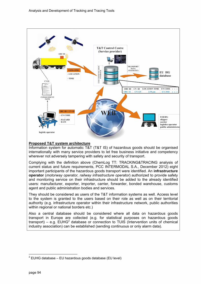
Analysis and Development of Tracking and Tracing Tools
page 94
Proposed T&T system architecture Information system for automatic T&T (T&T IS) of hazardous goods should be organised internationally with many service providers to let free business initiative and competency wherever not adversely tampering with safety and security of transport.
Complying with the definition above (ChemLog TT: TRACKING&TRACING analysis of current status and future requirements, PCC INTERMODAL S.A., December 2012) eight important participants of the hazardous goods transport were identified. An infrastructure operator (motorway operator, railway infrastructure operator) authorized to provide safety and monitoring service on their infrastructure should be added to the already identified users: manufacturer, exporter, importer, carrier, forwarder, bonded warehouse, customs agent and public administration bodies and services.
They should be considered as users of the T&T information systems as well. Access level to the system is granted to the users based on their role as well as on their territorial authority (e.g. infrastructure operator within their infrastructure network, public authorities within regional or national borders etc.)
Also a central database should be considered where all data on hazardous goods transport in Europe are collected (e.g. for statistical purposes on hazardous goods transport) – e.g. EUHG2 database or connection to TUIS (Intervention units of chemical industry association) can be established (sending continuous or only alarm data).
2 EUHG database – EU hazardous goods database (EU level)

Analysis and Development of Tracking and Tracing Tools
page 95
Focus of Tracking
Is the T&T Tool able to track and trace single intermodal loading units (e.g., box, silo or tank container) – independent from the mode of transport – (at least road and rail transport)?
GPS/GSM OBU can be used to track any vehicle or transport unit (truck, container, locomotive wagon). In intermodal transport any on the 3 types of ITU can be located: Type A: full truck of dangerous goods (FTL) – OBU on a truck.
Type B: silo (FCL) – OBU on a silo/swap body
Type C: full container carrying hazardous goods (FCL) – one container, one consignment note – OBU on a container
The tracked unit determines the power supply. If OBU is mounted in a vehicle (truck or locomotive) a vehicle-produced energy will be used as applied in type A of intermodal goods transport. For types B and C and independent energy supply should be provided – a battery inside the tracking device. In this case battery life span is of crucial importance. It is important to note that OBU can also contain RFID reader used in identification of a loading unit if RFID tagged. We propose to pilot test at least Type C of intermodal transport, i.e. transport of FCL – a container containing hazardous goods transported intermodal: by truck (first and last leg) and by rail (in-between).
Description of hardware
Independent energy supply How is the unit supplied with energy? E.g., battery or energy harvesting (PV, etc.)
Independent energy supply can be provided by the battery that is sealed within the housing together with the tracking unit. With normal use the battery can be used for at least 6 months – depends on amount of data transmission (frequency). Longer lasting batteries (4 -7 years) are very big and expensive and are not in regular use. Also alternative battery charging has been tested by using solar cells but such solutions are not very robust and affordable. The battery use can be monitored. Amount of charge (remaining capacity) can be sent to the control centre upon request or at predefined alarm thresholds.
Robust system Is the unit robust and protected against human and environmental impact?
Most GPS tracking units and additional hardware are made in compliance with applicable standards regarding robustness of the system. The devices used commercially observe strict military standards (humidity, temperature: -25°C to +55°C). Protection class that is used in regular housing (tracking device + battery) complies with IP65 standard. To suspend vibrations and humidity impact a special silicon shell can be applied.
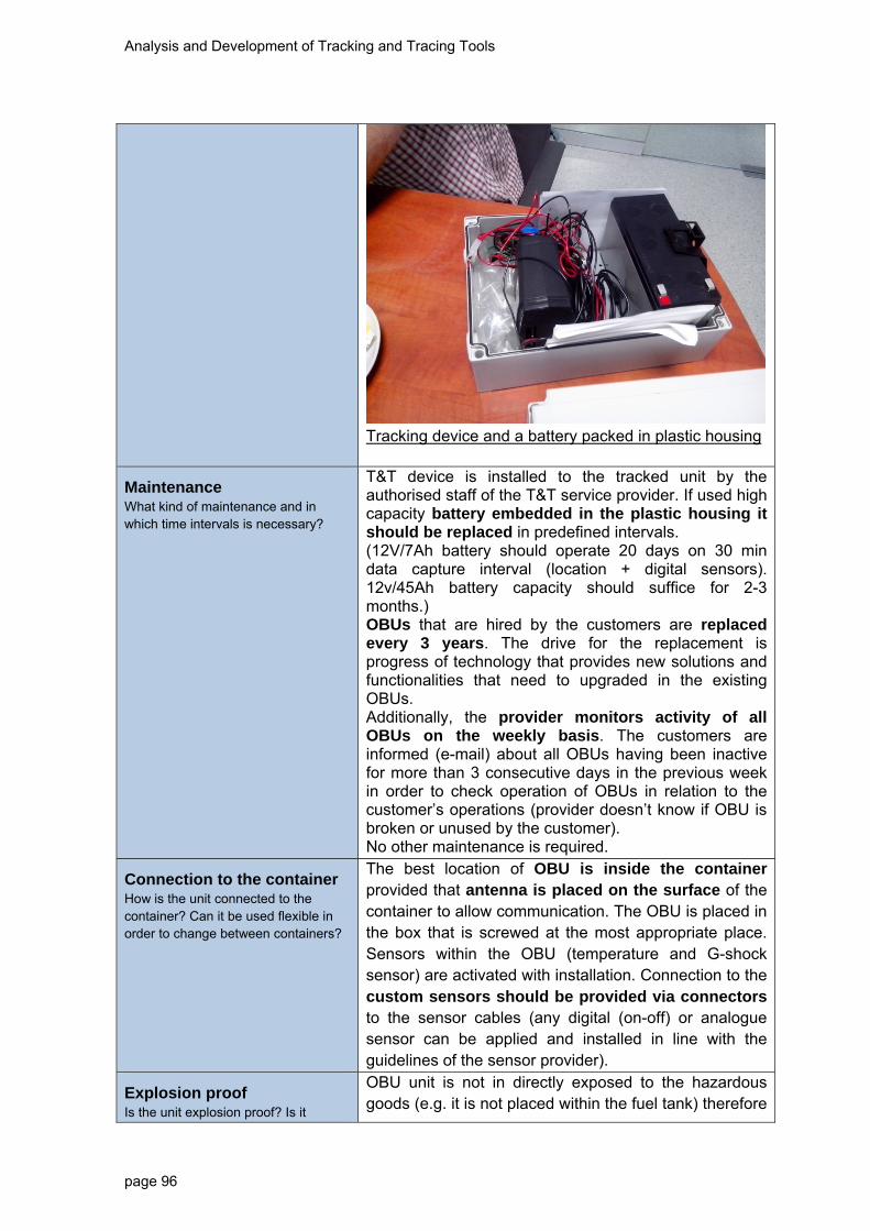
Analysis and Development of Tracking and Tracing Tools
page 96
Tracking device and a battery packed in plastic housing
Maintenance What kind of maintenance and in which time intervals is necessary?
T&T device is installed to the tracked unit by the authorised staff of the T&T service provider. If used high capacity battery embedded in the plastic housing it should be replaced in predefined intervals. (12V/7Ah battery should operate 20 days on 30 min data capture interval (location + digital sensors). 12v/45Ah battery capacity should suffice for 2-3 months.) OBUs that are hired by the customers are replaced every 3 years. The drive for the replacement is progress of technology that provides new solutions and functionalities that need to upgraded in the existing OBUs. Additionally, the provider monitors activity of all OBUs on the weekly basis. The customers are informed (e-mail) about all OBUs having been inactive for more than 3 consecutive days in the previous week in order to check operation of OBUs in relation to the customer’s operations (provider doesn’t know if OBU is broken or unused by the customer). No other maintenance is required.
Connection to the container How is the unit connected to the container? Can it be used flexible in order to change between containers?
The best location of OBU is inside the container provided that antenna is placed on the surface of the container to allow communication. The OBU is placed in the box that is screwed at the most appropriate place. Sensors within the OBU (temperature and G-shock sensor) are activated with installation. Connection to the custom sensors should be provided via connectors to the sensor cables (any digital (on-off) or analogue sensor can be applied and installed in line with the guidelines of the sensor provider).
Explosion proof Is the unit explosion proof? Is it
OBU unit is not in directly exposed to the hazardous goods (e.g. it is not placed within the fuel tank) therefore

Analysis and Development of Tracking and Tracing Tools
page 97
certified? it only complies with the general commercial standards. The connectors to the sensors within the tank (e.g. temperature sensor) are certified as explosion proof.
Configuration How and when is the unit configured?
T&T device is installed to the tracked unit and configured by the authorised staff of the T&T service provider. Installation time and configuration, as well as maintenance and replacement is stipulated in the service contract. Installation and configuration takes place before the first use of the device. Configuration depends on the terms of use: if hired or bought – only a T&T device or also T&T software and other services.
Costs What are estimated costs of hardware and system? Are there cost models or specific service packages?
T&T system can be used: - hire OBUs and use T&T web application
- purchase OBUs and hire T&T web application
- purchase both OBUs and T&T web application solution – very unlikely. Use of the system is offered in various price ranges depending on the service a customer has contracted: - single OBU in a truck
- OBU sealed in the plastic housing in the container,
- OBU hosed and mounted on the tank
- additional sensors (+ communication interface – e.g. RS232 interface)
- international roaming
- etc. The monthly cost of 51€/month for the T&T service package provides: - GPRS transfer of data EUROPE wide
- up to 15 GPSWin application licenses
- use of web application for monitoring
- use of map of Slovenia and Europe
- use of vector database
- elaboration of reports for selected periods
- monitoring and provision of uninterrupted operation
- maintenance of HW and SW
- user support
- alarms
- optional connection of Garmin navigation device. Additional options are available:

Analysis and Development of Tracking and Tracing Tools
page 98
Housing for T&T device with independent power supply
58 €/piece
Battery 12V/7Ah (independent power supply)
70 €/piece
Connection to the existing digital sensors
35 €/piece
Connection to the existing analog sensors
defined after examination
Data collection
Location of the container / Satellite positioning Which satellite navigation systems are supported (e.g., GPS, Galileo, Glonass)? What is the coverage and quality of signal?
Location data are basic information and can be collected on the basis of different parameters (time, distance, angle change, alarms and at geo-points). GPS coordinates are available (Longitude, Latitude, time...).
OBU can receive signals from GPS as well as GLONASS navigation satellite system. Coverage of both signals is OK depending on micro location conditions (terrain configuration, tree leafs, high buildings etc.). Capability of reception of both GNSS signals provides better accuracy. The accuracy of GPS only localisation is raised from 3m to 1.5m in case both GNSS are used.
Information in case of accidents How does the unit measure occurrence of accidents?
The unit doesn’t detect the accident it should be custom designed (shocks in railways – e.g. shunting – and road differ extensively!).
Shock sensor is already installed in OBU. It can be used for detection of movement start and stop – dedicated algorithms are developed for that. Use of shock sensors should be used in shunting yards for not triggering false alarms due to wagon movements. The integrated G-shock sensor cannot be used for accident detection as sophisticated and very reliable algorithms need to be developed and verified beforehand (at least 99.9% reliability and repeatability is mandatory!). G-shock sensor can trigger an alarm if threshold exceeded. Use of only G-sensor without special algorithms and use of other parameters to detect an accident is NOT ADVISABLE!!
It is possible to install a “PANIC BUTTON” in the

Analysis and Development of Tracking and Tracing Tools
page 99
vehicle that can be applied by the driver to immediately alarm an operator in the data centre and related emergency units.
Additional information possible e.g., temperature, pressure, sealing Is it possible to add the measurement of additional information as extension?
Temperature:
A temperature sensor is already integrated in the OBU but it measures internal device temperature. External temperature sensor can be applied via communication interface (e.g. RS232). Manufacturer should provide a “sensor transfer function” for proper calibration and interpretation of the sensor’s data (this can be very time consuming task). A sensor can trigger an alarm or the temperature can just be sent to the data centre regularly.
Pressure:
Measurement of spatial pressure in the container can be applied via communication interface (e.g. RS232) to the sensor in the container. Manufacturer should provide a “sensor transfer function” for proper calibration and interpretation of the sensor’s data (this can be very time consuming task). A sensor can trigger an alarm or the pressure can just be sent to the data centre regularly.
Sealing alarm:
A sensor can detect if the door or a latch of the ITU (container, silo etc.) is closed or open. Connection to the sensor can be applied via communication interface (e.g. RS232). This sensor is not complicated as it only provides on/off states (two states). A calibration is needed according to the manufacturer’s guidelines. A sensor can trigger a sealing alarm or the pressure can just be sent to the data centre regularly.
Customs information:
Customs information can be stored in the database and transmitted from the central database upon a request or automatic condition. Customs data require customisation of the web application form according to the needs and rules. Generally in T&T application only work order and travel order are available.
Additional information
Any business logic can on the available data be implemented in server and made available via web application and web services. Additional information

Analysis and Development of Tracking and Tracing Tools
page 100
should be defined and integrated in T&T solution.
Transmission of data
Transmission of information from Unit to Database How is the transmission of data functioning e.g., via GPRS?
The system uses GPRS data transmission.
GPRS data transmission depends on the signal coverage. Many grey areas still exist along the corridor transport routes, especially in the narrow valleys (e.g. railway corridor in Sava river valley in Slovenia) and in the tunnels.
OBUs continually store the data captured from GPS and transmit them delayed in packages after the GPRS signal has been restored.
Alarms triggered in grey area zones cannot be instantly communicated to the data centre!
Frequency of transmission What is the range of frequency of transmission of real time data?
Data from OBU can be transmitted in real time on the basis of:
- time - frequency (e.g. 5 sec interval – power consuming and recommended only with continuous power supply – e.g. truck accumulator);
- distance (e.g. every 500 m);
- angle change (fast angle changes – angle change vs. time – allows detection of truck deviations
- alarms (e.g. temperature threshold, start the vehicle, stop the vehicle etc.)
- at geo-points (using geo-fencing provided by the selected list of geo-points and pertaining perimeters - e.g. tunnels start and end, viaducts, junctions, borders etc.).
In case of event (Accident) immediate information
Is it possible to provide information in case of accidents e.g., shock sensors
In case a predefined alarm has been triggered (e.g. temperature threshold, start the vehicle, stop the vehicle etc.) it is immediately sent to the control centre database. If GPRS signal is not available the data are stored in the local memory and transmitted later after the signal has been restored.
Integrated G-sensor can provide data on sudden velocity changes but very sophisticated algorithms need to be developed, tested and applied with 99.9%

Analysis and Development of Tracking and Tracing Tools
page 101
reliability to detect accidents in order not to bring about false alarms. Use of only G-sensor without special algorithms and use of other parameters is NOT ADVISABLE!!
It is possible to install a “PANIC BUTTON” in the vehicle that can be applied by the driver to immediately alarm an operator in the data centre and related emergency units.
On demand transmission Can the customer define on-demand transmission?
Data transmission on demand is technically feasible but is not applicable if data transmission and alarm thresholds are carefully planned. In case needed (e.g. maintenance or security reasons of the operator) a web application can be featured with additional button <On Demand OBU Interrogation> sending an SMS to a GPRS modem in OBU. The SMS wakes the OBU from the “idle mode” and replies to the centre a “Session ID” to be used in communication with a particular device (OBU). This action takes time.
Costs for transmission What are costs of data transmission, especially respecting international transport?
Cost of transmission depends on the package (contract) bought from the service provider. Costs of data transmission in EU zone (including roaming) without other service costs are approximately 10 €/month (flat rate). Other costs included in the package need to be taken into consideration – monthly subscription of one device, premium web application and including data transmission (international) costs 51 €/month (plus VAT).
Cluster data for transmission How can alarm thresholds be set to cluster data and minimise transmission volumes?
Alarm thresholds can be preset in OBU device (sensors, geo-fencing). Many different conditions impact frequency of transmission – see above.
The data are clustered for a delayed transmission if GPRS signal is not available. The data are stored in the local memory and transmitted later after the signal has been restored.
Data security How is data security ensured?
Data transmission is partly encrypted and partly not: - OBU >> GPRS base station – could be encrypted (128 GEA/4 encryption) – it is not encrypted as it would significantly reduce transmission speed.
- GPRS base station >> data centre transmission uses tunnelling encryption protocol SSH (Secure Shell Tunnelling)
- data centre >> end user via web application uses HTTPS (Hyper Text Transfer Protocol Secure)

Analysis and Development of Tracking and Tracing Tools
page 102
protocol for secure communication over a computer network/internet.
Data transmission via GPRS is not security critical as it is difficult to capture (source: Sledenje.com, service provider).
Geofencing Is it possible to define geofencing application?
Geo-fencing can be implemented as:
- static in the OBU – immediate response of the OBU - only points are considered;
- dynamic in the back-office server – data are processed in the data centre and response of OBU is requested by the server; apart from points geo-fencing can be applied also as polygons.
Geo-fencing can be used to limit data access (users of web-application to monitor data) or data delivery (transfer data to the customer database via web service) to the authorised users (e.g. if OBU in Slovenia, the Slovenian emergency units should be informed about the accident if happened) or to trigger the location related alarms (e.g. avoidance of specified route – motorways).
Low manual interference – automatisation How much automatisation and manual interference is necessary?
Data transmission is fully automatic – data are captured and transmitted automatically in accordance with the specified transmission frequency parameters (time, distance, angle change, alarms and at geo-points). OBU can be interrogated manually if this feature has been contracted with the service provider in advance.
System for the processing of information
Integration into the supply chain management of chemical companies/ Logistics Service Provider How is the T&T application integrated in the company IT?
If an alarm has been triggered it can be sent to the predefined users (supply chain management of chemical companies) via e-mail (accessible also on smart phones) or via SMS.
Integration into supply management depends on the requirements of the customer.
T&T data are available to all stakeholders in the supply management chain upon their user access rights. The data can be monitored via web application user interface. Additionally, the data can be communicated

Analysis and Development of Tracking and Tracing Tools
page 103
to other databases by using web services. The data can be manually exported or sent automatically using database procedures.
The (HTTP) server provides report on OBU activity to the end-user on a daily basis.
Integration in Emergency Response Systems (e.g., TUIS, fire brigades) How is the T&T Tool integrated in ERS?
Application and communication technology provides capability to transfer data, especially alarms to the Emergency response Systems in the way described above – database can connect on the web service technology. It has to be noted that each user can get information that is shaped according to their needs – the important information in order not to lose focus. E-mail or SMS can be sent if alarm has been triggered. Alarms defined in the OBU (static – rarely change) are sent immediately – faster response.
Authorisation – Access of private and public entities How is the access of private and public authorities to the data managed?
Data can be monitored (web application), exported or transferred to the end-user database based on the end-user rights. Each user can use their data according to the granted login and password.
User rights can be diversified according to:
- the current status of the location (location in the geo-fencing area),
- an alarm that has been triggered (Emergency response units only get alarm data),
- authorisation to particular data use (some data can be confidential)
- etc.
The User Access Rights need to be specified and implemented in the application.
Storage and operation of data Where and how are the data stored and operated (central – decentral)?
All data from OBU and data entered via web application formed are collected in the central data base at the T&T operator. According to the rules they can be transferred to the central database (hazardous goods database - HG DB on the EU level) or other databases (based on events or regularly).
Many T&T service providers can operate in the system but all should report to the same central database (HG DB) if so decided and stipulated.
Standards / Compatibility / Although the OBU devices are generally standardised
Analysis and Development of Tracking and Tracing Tools
page 104
Interoperability of different systems What kind of standards are used? How is the compatibility and inter-operability with other systems?
and compatible, on the level of data capture no standardisation is needed. The OBUs are hired by the end user at the service T&T providers and are returned back if the contract has expired. The devices can operate wherever GPS/GLONASS/GPRS signal is available and roaming is established. This is the case for all Europe and wider. The service providers compete with the price and service quality as is the case with today’s mobile operators.
Standardisation is mandatory on the level of data contents (web service model) – which data should be monitored and transferred among the databases of the users (UN code, hazard rate, customs data etc.).
Interoperability of the system is achieved on the level of application. Location data capture is independent of transport mode or operator as long as all stakeholders share data with the T&T service providers.
Data security – Trust to the system How is data security ensured?
Data transfer from central database of T&T service provider via web application uses HTTPS (Hyper Text Transfer Protocol Secure) protocol for secure communication over a computer network/internet.
Reference to Disaster Management (prevention, preparedness, response) Can
Data be used for disaster Management?
Application and communication technology provides capability to transfer data, especially alarms to the Disaster Management unit in the way described in the point - Integration in Emergency Response Systems. It has to be noted that each user can get information set that is shaped according to their needs – the important information in order not to lose focus.
Monitoring and planning of transports / statistics Can data be used for monitoring and planning of transports or other statistical purposes?
Monitoring is assured on a moving electronic map (e.g. Google Map or custom designed map). Planning is possible if the authorised transport operator actively updates the states of the working orders – if working order is based on location it can be updated automatically – but application needs to be customized. Cargo data needs to be updated in the data base regularly, too.
Reports are provided on the daily basis. Export of data and further processing for statistics purposes is available.
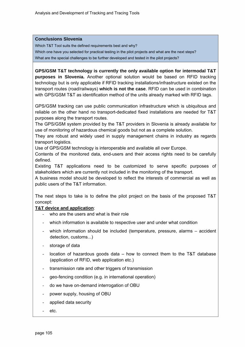
Analysis and Development of Tracking and Tracing Tools
page 105
Conclusions Slovenia
Which T&T Tool suits the defined requirements best and why?
Which one have you selected for practical testing in the pilot projects and what are the next steps?
What are the special challenges to be further developed and tested in the pilot projects?
GPS/GSM T&T technology is currently the only available option for intermodal T&T purposes in Slovenia. Another optional solution would be based on RFID tracking technology but is only applicable if RFID tracking installations/infrastructure existed on the transport routes (road/railways) which is not the case. RFID can be used in combination with GPS/GSM T&T as identification method of the units already marked with RFID tags. GPS/GSM tracking can use public communication infrastructure which is ubiquitous and reliable on the other hand no transport-dedicated fixed installations are needed for T&T purposes along the transport routes. The GPS/GSM system provided by the T&T providers in Slovenia is already available for use of monitoring of hazardous chemical goods but not as a complete solution. They are robust and widely used in supply management chains in industry as regards transport logistics. Use of GPS/GSM technology is interoperable and available all over Europe. Contents of the monitored data, end-users and their access rights need to be carefully defined. Existing T&T applications need to be customized to serve specific purposes of stakeholders which are currently not included in the monitoring of the transport. A business model should be developed to reflect the interests of commercial as well as public users of the T&T information. The next steps to take is to define the pilot project on the basis of the proposed T&T concept: T&T device and application:
- who are the users and what is their role
- which information is available to respective user and under what condition
- which information should be included (temperature, pressure, alarms – accident detection, customs...)
- storage of data
- location of hazardous goods data – how to connect them to the T&T database (application of RFID, web application etc.)
- transmission rate and other triggers of transmission
- geo-fencing condition (e.g. in international operation)
- do we have on-demand interrogation of OBU
- power supply, housing of OBU
- applied data security
- etc.

Analysis and Development of Tracking and Tracing Tools
page 106
System architecture and specification of application:
Pilot test goal: Pilot project should investigate and on-field test an automatic T&T IS used in intermodal transport focussed on dataflow among the users in terms of:
- time – test of delay and
- content - correct information passed to the right users (e.g. availability of consignment note data)
- data flow between entities/stakeholders
- energy consumption (combined transport: type A and type B).
Implementation:
- Selection of a transport unit - 3 transport units are monitored:
o Type A: full truck of dangerous goods (FTL) – OBU on a truck.
o Type B: silo (FCL) – OBU on a silo/swap body
o Type C: full container carrying hazardous goods (FCL) – one container, one consignment note – OBU on a container
- Selection of a transport route – intermodal route: 3 transport routes should be defined where first and last leg involve road transport, the rest is rail transport.
- Selection of a T&T service provider – at least two GPS/GSM T&T service providers should be involved from different countries. They should work in international environment – covering the testing corridor (in order to test roaming).
- Selection of end users – users are defined in terms of the database (one database represents one user). If a respective user should receive data they should be available in the database. Pilot should involve users/databases in all participating countries. Pilot databases:
o T&T service provider DB (2 or more)
o EUHG database (1)
o infrastructure operator database (motorway operator, railway infrastructure operator)
o commercial user database – manufacturer (exporter) =shipper (importer), recipient, carrier, forwarder (3 – on in each country?)
o alarm users – public administrator, emergency centre (3 one in each country?)
o customs – what information and when s needed for customs?
- Selection of performance indicators – test scenarios should provide key performance indicators (KPI) that need to be observed and methodology to capture and evaluate data required for the KPIs:
o international level: data should be collected in different countries along the
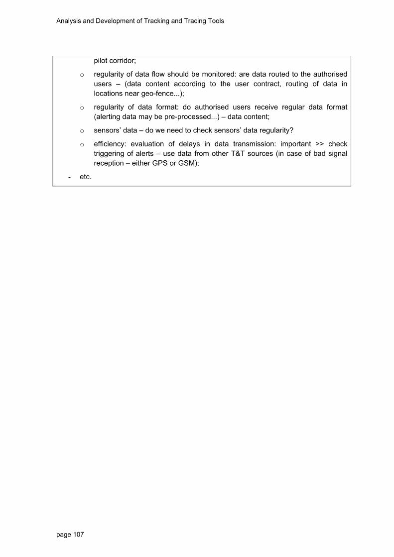
Analysis and Development of Tracking and Tracing Tools
page 107
pilot corridor;
o regularity of data flow should be monitored: are data routed to the authorised users – (data content according to the user contract, routing of data in locations near geo-fence...);
o regularity of data format: do authorised users receive regular data format (alerting data may be pre-processed...) – data content;
o sensors’ data – do we need to check sensors’ data regularity?
o efficiency: evaluation of delays in data transmission: important >> check triggering of alerts – use data from other T&T sources (in case of bad signal reception – either GPS or GSM);
- etc.

Analysis and Development of Tracking and Tracing Tools
page 108
Conclusion
After presenting national based analyses of potential Tracking and Tracing solutions a
final conclusion can be drawn. In total 20 approaches have been evaluated within eight
partner countries of the ChemLog T&T project. Existing T&T solutions, which combine
hardware components with company-owned systems, have the advantage of being tested
and used within daily transports. However, almost every solution requires several adaptive
steps according to the requirements defined within the transnational report “Tracking &
Tracing - Analysis of Current Status and Future Requirements”. Especially systems for
processing information need to be investigated further. Additionally, some solutions focus
on the development of new applications by specialized third parties. Partners have
analysed several T&T systems that focus on open source and “software as a service”
products. This approach assembles several modules and parts into one new solution
which should fulfil as many requirements as possible.
In order to get a final overview of all technologies and approaches, the following table tries
to consolidate the big amount of data indicated in the national surveys. By means of this
analyses also the status quo of given solutions concerning their potential for
implementation/testing within the pilot project was evaluated with the following scaling.
Analysis and Development of Tracking and Tracing Tools
page 109
Positive development (green-coloured): the evaluation of the defined criterion is
described in a way that can contribute to a practical implementation of the pilot
project. In the long run a standardised approach should provide established
solutions which are already implemented on the market (well-developed).
Neutral development (violet-coloured): the evaluation of the defined criterion is
described in a way that cannot be fully applied to a practical execution of the pilot
project yet. Here, several further steps need to be specified in order to get practical
solutions which can be tested by different stakeholders. In the long run these fields
should be transferred to standardized and/or establish solutions. One way to do so
is within the pilot phase of the project, as criterions can be tested and analysed as
well as consequently adapted to the needs of stakeholders involved.
Need for development (red-coloured): the evaluation of the defined criterion is
described in a way that is not applicable for the execution of the pilot project yet. It
is not possible to apply the described criterion to a practical testing or
implementation in the long run for the analysed solution. It is required to look for
alternative approaches, whereby a good process of coordination within the pilot
phase can help to define other solutions and new ideas respectively.

Analysis and Development of Tracking and Tracing Tools
page 110
Energy supplyConnection to
container
Explosion
proofConfiguration
Navigation
systemAccidents Additional data Transmission Frequency Geofencing
TINO® series battery
bolted with
the container
+ flexible
not certifieddone by
providerGPS
E‐Mail, SMS, event‐
managementtemperature GPRS
different
intervallspossible
Fwtracks battery
magnetic
connection +
flexible
under
development
via online
platform
GPS and cell‐
tower signals
Command and Control
Center (incl. event mgmt.)
temperature +
other data
possible (n.s.)
GSM/GPRSdifferent
intervallspossible
Carloc aktiv
SOS
battery
(independent
supply 48 hours)
location
directly at the
container is
impossible
no ‐ GPSsensor sends information
upon an impact no GSM
collected in a
"travel book"possible
GPS Dozor
Cargobattery
outside the
container with
four screws
can not be
guaranteed‐ GPS can not be measured no GPRS
different
intervallsno use
SHERLOG
Trace 801V4battery
at any position
of the
container
no
possible
(configuration
of intervalls)
GPS not possible no
communication
is ensured by a
SIM card
different
intervallsno use
GC 071
RACAPOUN &
system
Positrex
battery
special holder ‐
locked to the
holder by key
not certifiedHighly
configurable GPS
Acceleration measured in 3
axis (event mgmt.)
temperature,
pressureGPRS, SMS
different
intervallspossible
Fraunhofer
IFF Telematicscable/battery
adaptor which
is attached by
screws
not certified
can be
configured
anytime
GPSby threshold values (event‐
management)
possible with
external
interfaces
GPRSdifferent
intervallspossible
2014 Cargo
Track Monitor
Project
battery/energy
harvesting
fixed to
container and
flexible
not been
answered yet
at the
beginning of
transport
GPS
by threshold values (event‐
management) based on e.g.
unintented movements
information
can be
collected with
additional
hardware
cellular or
satellite system ‐
not specified
different
intervallspossible
iTrack battery
can not be
attached to
container
noconfigured
before its useGPS
by threshold values (event‐
management), SMS are sent
temperature,
pressure,
humidity, etc.
GPRSdifferent
intervallspossible
OSRM battery
can not be
attached to
container
no
configured in
advance or
online
GPSby threshold values (event‐
management)
any sonsors can
be connectedGPRS
different
intervallspossible
Queclink
GL505battery
fixed with
screws or
magnet
noconfigured
before its useGPS
G‐shock sensor, temperature
measure
any sonsors can
be connectedGSM/GPRS
different
intervallspossible
SITmar battery
hooked by
bolt to
container
door
no
when it is
connected to
the container
optionally GPSonly with addes external
sensors
add a wireless
sonsor networkRFID reader 10‐30 minutes not possible
NEPTUNE
SEAL RFID
UHF
passive RFID
technology
hooked to the
container
door
no
when it is
connected to
the container
gate readers no measure of an accident no RFID gatepassing a RFID
gatenot possible
Container
Tracking
Device
battery
insight the
container
(magnets)
no
when it is
connected to
the container
GPS no measure of an accident temperature SMSdifferent
intervallspossible
ULYS Ex2 batteryinsight the
container no
when it is
connected to
the container
GPS no measure of an accident
temperature +
analog and
digital inputs
GPRS or SMSdifferent
intervallsnot possible
Qguar OTM‐
Object
Tracking&Mo
nitoring
battery
nountable on
any type of
load unit ‐
fixed by
screws
certified
clear
configuration
plan
GPS
based on the integrated
motion detector (event
managment)
temperature SMS and GPRSdifferent
intervalls
no
information
about for now
Telenor
Traxionbattery
attached or
fixed by
screws on any
type of
loading
as option with
certification
different
configuration
types are
possible
GPS
integrated motion detector
of a unit (event‐
management)
temperature +
other sensors
possible
SMS and GPRSdifferent
intervalls
no
information
about for now
NAM system ,
a.sbattery
attached to
container by a
bolt joint ‐
flexible
not certified
configuration
can be changed
at any point
GPS
provided by the integrated
acceleration sensor based on
impacts = collision
temperature GPRSdifferent
intervallspossible
QADRA plus
s.r.o.battery
fixed using 2
strong
neodymium
magnets ‐
flexible
not yet
analysed
on place where
it is installed or
on‐line during
use
GPS/GLONASS
shock sensor provide
information about
movements
no cellular systemdifferent
intervallspossible
SI Sledenje.com battery
inside the
container and
with antenna
on the surface
no
configured by
the authorised
staff of the
T&T service
provider
GPS/GLONASS
alarm threshold is
immediately sent to the
control centre database
temperature,
pressure,
sealing alarm,
customs
information
GPRSdifferent
intervallspossible
PL
SK
DE
HU
ITA
Data transmission
CZ
AT
CountryName of T&T
tool/provider
Hardware Data collection
Figure 1: Final evaluation of all T&T solutions (hardware, data collection and transmission) ‐ status quo
Figure 1 focuses on the hardware (on-board unit - OBU) as well on the data collection and
transmission of the analysed solutions. The hardware is characterized by their energy
supply, configuration/maintenance effort, possibility to provide explosion proof and its

Analysis and Development of Tracking and Tracing Tools
page 111
fixation to the container. Partners also raised questions concerning the robustness of the
devices. Many solutions use a protection class that is used in regular housing (tracking
device + battery) which complies with IP65 standard. This is why the OBUs also refer to
robustness regarding different weather conditions.
For the practical testing it is important to position the device on a container. Some
solutions also describe the possibility to switch the device between several transport units,
often with special equipment which has to be specified according their practical use. If the
device can only be attached insight the container further specifications of installation
should be discussed (signal strength, combination with antenna on the surface, etc.).
Almost every solution indicates that the explosion proof is not certified yet.
Configuration and maintenance efforts for devices are clarified in good detail. It is
important that the solution offers a possibility to configure devices to the requirements of
the customer. Also the point of configuration was specified and descriptions show that
there exist different frames and channels (e.g. online by user, in advance by the provider,
etc.). Maintenance is required when it comes to the changing of the battery. After the final
configuration and maintenance plan, low manual interference can be mentioned.
Demands from client can be communicated via other media.
As all partners asked for the satellite navigation systems supported, a clear trend can be
observed. The Geographic Positioning System (GPS) is the technology which was
mentioned most and therefore a good solution for the practical execution. Further
specifications need to be done for RFID-based solutions as gate readers are required for
collecting data.
Another important point deals with one of the main criterion of the industry of being safe
and secure. Therefore accidents and their consequences are of big interest for
stakeholder, also mentioned within the analysis of current status and future requirements
of T&T tools. Is it possible to provide information (not yet specified which information) in
case of an accident and how an accident is measured from the technical perspective?
These are questions which were answered very different within the national surveys.
Event management imply the measuring of defined values (e.g. temperature, shock, etc.)
by using sensors. Based on predefined alarm thresholds, data are collected and
potentially submitted to institutions or persons in charge in case of irregularities. Many
solutions focus on impact measurement which can be seen as critical as e.g. explosion
proof is mentioned as very uncertain for the practical execution. Consequently, pursuing
Analysis and Development of Tracking and Tracing Tools
page 112
considerations are required to enhance the level of operation. The possibility to add
various additional data is one way to do so, as more information generates a reliable base
of revealing accidents.
Within the field of data transmission it is important that mobile communications standards
are used (e.g. General Packet Radio Service - GPRS). This point can be adopted
according the needs and wishes of the defined pilots and their involved stakeholders.
A question asked during the evaluation process deals with the issue of “on demand
information defined by the customer”. Data transmission on demand is technically feasible
but is barely applicable if data transmission and alarm thresholds are carefully planned.
Almost every solution offers the possibility to get different reporting intervals which in turn
defines the battery life time (with alternative energy supply longer life times can be
realized, e.g. energy harvesting, solar cells). The shorter the reporting interval the shorter
is the battery life time. Clear requirements and useful intervals have to be implemented in
cooperation with the logistic service provider during the pilot projects. Intervals can be
configured based on time, distance, direction changes, motion or a combination of all
mentioned. Geofencing should be considered in this context too as lot of T&T solutions
already offer this service.
A very important point, when it comes to analysing different T&T solutions, deals with the
costs of the hardware as well with operating costs for data transmission. During the
evaluation, a wide range of costs are collected. This makes a comparison very difficult.
Nevertheless, the final investigation of all solutions comes up with the conclusion that
especially renting possibilities are a good chance to test the described tools in an
economic way. There are offers from several representatives of T&T providers which
accounts for around 70 Euros for hardware per month. This point needs to be specified in
detail before starting with the pilot projects as this is a key criterion for a practical testing in
the first run as well as for the final implementation on the market in the long run.
After analysing the hardware as well as the data collection and transmission of the related
solutions the next step looks at the integration of the generated data into one standardized
system. Figure 2 indicates different attempts mentioned during the final assessments.

Analysis and Development of Tracking and Tracing Tools
page 113
Access of data CompatibilityDisaster
Management
Planning
(statistics)
TINO® seriesindividually
configurable ‐ not aligned yet
reporting points
can be tracked
Fwtracksneeds to be
defined
platform is not
suitable to
other systems
Carloc aktiv SOS ‐ ‐ ‐ ‐
GPS Dozor Cargo no no no possible
SHERLOG Trace
801V4no ‐ ‐ ‐
GC 071
RACAPOUN &
system Positrex
highly
configurable
compatible
with other
systems
possible possible
Fraunhofer IFF
Telematicsby user login
no standardized
formats
possible via WEB
SERVICE
analytic
functions +
export of data
2014 Cargo
Track Monitor
Project
via interfaces ensured via
interfaces
dynamic data
can be included
and analysed
possible
iTrackaccess level is
predetermined
possible to
provide
interfaces
possible (see
integration to
other systems)
possible ‐
visualised with
maps
OSRM
trough any
kind of
interface
XML, JSON,
REST, J2EE,
RPC, COBRA,
using data and
analysing it with
artificial
possible via an
all‐platform
web surface
Queclink GL505
defined data
the user can
access
able to provide
communication
and interface
solutions
possible possible
Qguar OTM‐
Object
Tracking&Monit
oring
Access can be
granted by
user login
integration
with external
systems (e.g
SAP)
alarm can be
generated and
send +
integration via
Web Service
data can be
provided by
export
Telenor Traxion
Access can be
granted by
user login
integration
with external
systems (e.g
SAP)
alarm can be
generated and
send +
integration via
Web Service
data can be
provided by
export
NAM system ,
a.s
entering valid
login details ‐
users could be
assigned by
different rights
no standard
transfer
formats are
used
via web
application to
crisis
management
centres
web application
allows for
monitoring +
export of data
QADRA plus
s.r.o.
via interface
or web‐
application
(XML)
Ensured with
the interface or
by own servers
no
long‐term
monitorin
possible
SI Sledenje.com
monitored
(web
application),
exported or
transferred to
the end‐user
Standardisation
is mandatory
on the level of
data contents
(web service
model) ‐ tbd
capability to
transfer data,
especially alarms
to the Disaster
Management
unit
Export of data
and further
processing for
statistics
purposes is
available.
can be exported to an
electronic database, or can be
provided via real time
communication
can be exported to an
electronic database, or can be
provided via real time
communication
possible but needs to be
defined
can be downloaded and used for
statistics and disaster
management
‐
no
Web portal is available from
any computer connected to
the internet
no
no
Integration into Emergency
Response
internal command and control
station + additional interfaces
possible
possible but needs to be
defined
customer may oder a service
alarm can be sent to the
predefined users via email or
SMS + monitoring via web
application + data can be
exported
each user can get information
that is shaped according to
their needs (via E‐Mail or SMS)
‐ database connect on web
service technology
Italy has analysed several T&T systems, with focus on open source and “Software as a service” products (OpenGTS, 3dTracking, Traccar, GpsGate Server;). To
sum up the system DEWETRA can be used/integtrated for disaster management and produces database for analysis
via web browser, user
interface or installation on a
customer server or as
Quantum SaaS
Integration possible via Web
Services to get required data
customer decides what data
to import ‐ platform to system
via SOAP API
not possible
HU
PL
SK
possible via the data bridge
from the application (location,
alarm status, etc.).
possible via the data bridge
from the application (location,
alarm status, etc.).
connected via interface to IT
systems of companies (XML
service)
interface possible but not
currently used, ERS don’t have
the data structure in Slovakia
to accept data
possible ‐ can be exported to
an electronic database
possible ‐ can be exported to
an electronic database
can be realized trough any
kind of interface
can be realized trough any
kind of interface
data management
possible via WEB Services possible via WEB Services
possible via interfaces to
companies IT (e.g. SAP)
DE special interface is open for
transmission of information to
public entities (e.g. fire
brigades)
own security dispatcher
center 24 h/day ‐ call
authorities
exports of data to the server
of company possible
to other systems (SAP) +
CSV/XML interfaces
CountryName of T&T
tool/provider
system for the processing of information
Integration into SCM
AT
CZ
Figure 2: Final evaluation of all T&T solutions (system and data management) ‐ status quo

Analysis and Development of Tracking and Tracing Tools
page 114
The ChemLog T&T working group “Central Orchestration Framework” defines strategies how to ensure a common attempt within the mentioned topics. It is also important to match new guidelines from the working group on telematics (initial proposal from the European Commission). The following picture as well as the underlying description is directly taken from the official report of the 11th session of the working group on telematics (Tegernsee, 3 and 4 June 2013, page 2).3
Figure 3: Basic application scenario with federated services
The transport undertakings input all the data necessary for the transport of dangerous
goods into their own database or into a database belonging to a service provider of their
choice. These databases, for which existing systems can be used, are considered to be
Trusted Party 2 (TP2). In transport checks or intervention by the emergency services,
externally recognisable characteristics, such as vehicle markings and wagon numbers,
are transmitted by the inspection personnel or emergency services to their respective
control centres, which then use an internet-based interface (central management service,
Trusted Party 1) to retrieve data from Trusted Party 2. In so doing, Trusted Party 1
ensures that access to the data input by the carriers can only be obtained via authorised
entities. It also checks the authorisation of the TP2 parties. The same procedure is also
used for automated signals sent directly from the vehicle to the control centre (e.g. eCall).
As the systems shown on the left and right-hand sides of the diagram are already
available, only the central management service has to be set up, which deals with the
3 At the invitation of Germany, the 11th session of the working group on telematics was held in Tegernsee on 3 and 4 June 2013. The meeting was chaired by Mr Helmut Rein (Germany).
Analysis and Development of Tracking and Tracing Tools
page 115
retrieval of and access to the data. This should preferably be set up at European
Commission level as the single central body.
The analyses indicate that there exist many approaches in the context of Tracking and
Tracing. For the special requirements of the project ChemLog T&T, where dangerous
goods should be transported intermodal and transnational, this report is seen as basis for
choosing and adapting established or new solutions for the upcoming testing phase.

Analysis and Development of Tracking and Tracing Tools
page 116
Tables and Figures
Table 1: Description TINO® series (AT) ................................................................. 7
Table 2: Description FreightWatch International (AT) ........................................... 11
Table 3: Description Carloc aktiv SOS (CZ) ......................................................... 17
Table 4: Description GPS Dozor Cargo (CZ) ........................................................ 22
Table 5: Description SHERLOG Trace 801V4 (CZ) ............................................. 25
Table 6: Description GC 071 RACAPOUN & system Positrex (CZ) ..................... 29
Table 7: Description Fraunhofer IFF Telematics (DE) .......................................... 35
Table 8: Description 2014 Cargo Track Monitor Project (DE) .............................. 40
Table 9: Description iTrack (HU) .......................................................................... 45
Table 10: Description OSRM (HU) ....................................................................... 49
Table 11: Description Reko Systems (HU) ........................................................... 53
Table 12: Description T&T systems Italy .............................................................. 58
Table 13: Description SITmar (ITA) ...................................................................... 62
Table 14: Description NEPTUNE SEAL RFID UHF (ITA) ..................................... 64
Table 15: Description MagnetiMarelli (ITA) .......................................................... 67
Table 16: Description ULYS Ex2 (ITA) ................................................................. 69
Table 17: Description Qguar OTM-Object Tracking&Monitoring (PL) ................... 73
Table 18: Description Telenor Traxion (PL) .......................................................... 78
Table 19: Description NAM system , a.s (SK) ...................................................... 84
Table 20: Description On-line tracking and tracing tools (SK) .............................. 89
Table 21: Description Sledenje.com (SI) .............................................................. 93
Proposed T&T system architecture ...................................................................... 94
Figure 1: Final evaluation of all T&T solutions (hardware, data collection and transmission) - status quo .................................................................................. 110
Figure 2: Final evaluation of all T&T solutions (system and data management) - status quo ........................................................................................................... 113
Figure 3: Basic application scenario with federated services ............................. 114