report on user requirements of mobile topographic...
TRANSCRIPT
User requirements for mobile topographic maps
Project number: IST-2000-30090
Project title: GiMoDig
Deliverable number: D2.1.1
Deliverable type: PU
Deliverable nature: Re
Contributing WP: WP 2
Contractual date of delivery: October 31, 2002
Actual date of delivery: December 31, 2002
Author: National Land Survey of Finland/ Antti Jakobsson
Keywords: user requirements, application and user scenarios, topographic data sets, mobile devices, location based services
Abstract: In this report we identify the most common user groups for mobile applications utilizing large-scale topographic data in the near future and categorize use cases. By investigating information available on user requirements and describing existing needs, we describe the GiMoDig usage areas, application scenarios and user scenarios. Finally we select some user scenarios for further examination.
GiMoDig User requirements for mobile topographic maps IST-2000-30090 D2.1.1
Contents
CONTENTS ............................................................................................................................................2
EXECUTIVE SUMMARY ........................................................................................................................4
PREFACE ...............................................................................................................................................6
User requirements for mobile topographic maps .............................................................................6 1 Introduction.......................................................................................................................................6
1.1 General ......................................................................................................................................6 1.2 Project objectives.......................................................................................................................6
2 Method..............................................................................................................................................7 2.1 User requirements .....................................................................................................................7 2.2 Usability ...................................................................................................................................10
PART I...................................................................................................................................................11
Desk study on user requirements .....................................................................................................11 1 Technology and application requirements......................................................................................11 2 Services and business requirements .............................................................................................12
2.1 Accuracy demands in determination of location in LBSs.........................................................15 3 Data sets and user requirements ...................................................................................................16
3.1 Data content.............................................................................................................................18 4 Mobile users and requirements ......................................................................................................19
4.1 Mobile user groups ..................................................................................................................21 4.2 Available information on user requirements in mobile services ..............................................22
5 Conclusions ....................................................................................................................................24
PART II..................................................................................................................................................26
How to use topographic data.............................................................................................................26 1 Needs for GiMoDig type of mobile services ...................................................................................26
1.1 Emergency services.................................................................................................................26 1.2 Public transportation ................................................................................................................27 1.3 Safety.......................................................................................................................................28 1.4 Tourism ....................................................................................................................................30 1.5 Protection of environment........................................................................................................31
2 Existing use scenarios....................................................................................................................31 2.1 Unexpected holiday .................................................................................................................31 2.2 'Maria' -Road warrior................................................................................................................32
3 Conclusions ....................................................................................................................................34
PART III.................................................................................................................................................35
User context and requirements .........................................................................................................35 1 GiMoDig user requirements ...........................................................................................................35
1.1 Classification of usage - GiMoDig usage areas.......................................................................36 1.2 Application scenarios...............................................................................................................36 1.3 User scenarios .........................................................................................................................39
2
GiMoDig User requirements for mobile topographic maps IST-2000-30090 D2.1.1
1.4 Selecting user scenarios for the prototype and user validation...............................................40 2 Summary and conclusions .............................................................................................................43
BIBLIOGRAPHY AND REFERENCES................................................................................................46
APPENDIX A ........................................................................................................................................50 1 General mobile applications ...........................................................................................................50
1.1 General characteristics ............................................................................................................50 2 Specific applications .......................................................................................................................51
2.1 Logistics ...................................................................................................................................51 2.2 Restrictions of use or movement .............................................................................................51 2.3 Military applications..................................................................................................................51
APPENDIX B ........................................................................................................................................52 1 Locating a taxi driver having an emergency...................................................................................52 2 A forest owner and a timer hauler ..................................................................................................55 3 A worker fixing power lines after a major storm .............................................................................57 4 A fisherman in the Tornio/Haaparanta area ...................................................................................59 5 Hiking in Nuuksio National Park .....................................................................................................62 6 An official inspecting the use of EU subsidies................................................................................66 7 Family with children on a camping trip ...........................................................................................68 8 Emergency services in cross-border operations ............................................................................71 9 Guidance in aviation hobbies .........................................................................................................74 10 Guidance for a user in a city area ................................................................................................76 11 Sport audience at a rally...............................................................................................................79 12 Searching for property to build a summer cottage .......................................................................81
APPENDIX C ........................................................................................................................................84 1 Workforce management, fleet management, security....................................................................84 2 Public services................................................................................................................................85 3 Services related to hobbies ............................................................................................................86 4 Navigation and finding....................................................................................................................88
APPENDIX D ........................................................................................................................................90 1 Mobile voice, SMS and MMS services ...........................................................................................90 2 Mobile map services.......................................................................................................................91
3
GiMoDig User requirements for mobile topographic maps IST-2000-30090 D2.1.1
Executive Summary GiMoDig (Geospatial info-mobility service by real-time data integration and generalisation project) services will be targeted to location-based services (LBSs). From the user point of view the GiMoDig vision is to provide harmonized, European, large-scale topographic data sets to mobile users using real-time integration and real-time generalisation. These types of services offer a new market for National Mapping Agencies (NMAs) and bring new users to topographic data sets. We have identified the most common user groups for this types of services. In general, there are 2 different user groups: professional users and consumers. Professional users are more familiar with topographic maps and are likely to use these in mobile environments. In general the public requires more sophisticated user interfaces and probably would benefit most from the GiMoDig type of environment. Professionals are currently the main user group for topographic data sets. Traditionally the military has been the dominant user and data sets have been designed for this usage. The NMAs in Europe have recognized the importance of meeting customer needs. EuroGeographics, representing most European NMAs, has been active in producing Pan-European data sets (e.g. 1:1 000 000 data set) and now is investigating the feasibility of defining specifications even to the most detailed level (1:5 000-1:10 000). Several NMAs have already begun to change their database technology to meet modern requirements (i.e. object-orientation). GiMoDig types of applications will be come a reality when the NMAs have changed their database technology and use common specifications to model the real world.
LBSs that might be interesting from the GiMoDig viewpoint include those that have a high usage of maps or otherwise use map data, and require generalisation and integration of data from other services. Users predicted behaviour is an important factor that must be considered using for example adaptive map technology. Users’ acceptance criteria is dependent on content (map and other information), user interfaces, technology and speed of the service.
Users have different needs depending of their profession, hobbies, interests, mode of travel, activities and daily errands, age, way of life, education, language skills, gender, marital status and socio-economic status. User needs vary somewhat in different European countries. In central Europe some services may be more important than in northern Europe. User groups also vary from country to country. Younger generation educated with ‘virtual’ reality (games) will certainly develop, supported by the technology, into adults expecting sophisticated services more and more virtual reality-like, services making a high demand in high resolution, up-to-date, 3D and 4D geographic (and other) information. These services and this information might, sooner than we may imagine, diffuse into nearly all sectors of application.
Currently, information on user requirements is concentrated in LBSs, using either city maps or road navigation data. The reason for this is obvious: most people live in cities and drive cars. Today, some services utilize topographic maps but these are mostly commercial and, therefore, information on user requirements in not available to the GiMoDig project. However we found that there is a clear need for using topographic data sets in mobile applications. Situations in which users would need topographic information include safety or emergencies and, on the other hand, hiking in the wilderness and other hobbies related to nature. Current LBSs utilizing city maps or road data would benefit if topographic data sets were used. Data content in some of the services is quite poor and topographic information could enrich the services. For example, 3D visualisation needs information about elevation. Almost all scenarios in LBSs include situations in which
4
GiMoDig User requirements for mobile topographic maps IST-2000-30090 D2.1.1
topographic data would be useful. Information on user requirements using road and city maps can be employed when designing the user scenarios for topographic data. Still further research is required for identifying user requirements for topographic data. Evidently mobile use of topographic data will begin with professionals, but with greater improvements in technology and redesign of data sets there will also be a new market segment for topographic data sets.
We identified the usage areas for GiMoDig service to include information services, safety, emergency, restrictions for usage or movement, guidance or navigation, logistics and military. The application scenarios we described are general mobile applications and specific applications in logistics, restrictions for usage or movement and military applications. We identified 12 user scenarios and 2 existing user scenarios, which we utilize for prototype selection and user validation.
Acknowledgements
The following people have contributed to and commented on this user requirement study:
The GiMoDig project:
Prof. Tapani Sarjakoski, the Finnish Geodetic Institute Dr. Tiina Sarjakoski, the Finnish Geodetic Institute Ms. Annu-Maaria Nivala, the Finnish Geodetic Institute Dr. Andreas Illert, the Federal Agency for Cartography and Geodesy Dr. Lars Brodersen, the National Survey and Cadastre - Denmark Mr. Flemming Nissen, the National Survey and Cadastre - Denmark Prof. Bengt Rysted, the National Land Survey of Sweden Mr. Reino Ruotsalainen, the National Land Survey of Finland Dr. Lars Harrie, the National Land Survey of Sweden Mr. Ismo Kemppainen, the National Land Survey of Finland
The author is also grateful to Dr. James Thompson and John Gage for language check.
Special thanks go to Tiina Sarjakoski, who made valuable comments on the structure of the document and helped with the layout. I am also grateful to Annu-Maaria Nivala who worked out many of the user scenarios. Andreas Illert wrote two user scenarios. Lars Brodersen, Flemming Nissen and Bengt Rystedt contributed to some of the scenarios. Ismo Kemppainen assisted in writing the Appendix D. Mr. Pasi Pekkinen from Navinova Ltd. also commented on the results.
This report was peer-reviewed by Mr. Claude Luzet and I would like to thank him for making valuable comments.
5
GiMoDig User requirements for mobile topographic maps IST-2000-30090 D2.1.1
Preface
User requirements for mobile topographic maps
1 Introduction
1.1 General
This report comprises the first deliverable of Work Package 2 (WP 2) in the Geospatial info-Mobility service by real-time Data integration and Generalisation project (GiMoDig) (gimodig.fgi.fi). The second deliverable comprises a market analysis of mobile maps.
This report consist of 3 parts:
Part 1: A desk study of available information on user requirements
Part 2: How to use topographic data. Some existing needs and user scenarios with potential use for topographic data sets
Part 3: Context of use and user requirements in GiMoDig application domains.
1.2 Project objectives
The main objective will be to identify the most common user groups for mobile applications utilizing large-scale topographic data in the near future and to categorize use cases. Testing of the application will be carried out in the Work Package 9, Validation.
The GiMoDig project will begin with a thorough analysis of predicted use cases. Work on user requirements will yield a set of use cases, e.g. detailing the most common applications in which a mobile user would need large-scale topographic geodata. The consortium will then decide which use cases will be targeted as primary use cases in the project. This decision will affect the setting of priorities in WP 5, Global Schema, because the user applications essentially affect the selection of feature types that will be harmonized. Based on the use cases selected, the various usability criteria will be set up. VNET5 project personnel will be contacted for advice on defining the usability criteria.
The main practical outcome of the GiMoDig project will be a prototype spatial data service providing access, through a common interface, into the primary national geodatabases. The provision of a standards-compliant service will promote the creation of third-party, value-added mobile information services needed in position-dependent applications such as traffic guidance, rescue operation management and personal navigation. Based on the use case analysis, a representative set of user groups will be set up to provide the
6
GiMoDig User requirements for mobile topographic maps IST-2000-30090 D2.1.1
essential end user feedback to the project. During the GiMoDig project potential users, customers and value-added service providers will be called on to test the implementation prototype and consider exploitation of the common access interface in the national topographic geodatabases involved. The actual evaluation will be carried out inside WP 9, Validation. The results of the validation will then be assessed in WP 9 for necessary updating of user requirement analysis. Once the initial use case analysis results become available, work on data model synthesis can be initiated. Work in WP 7, Real-time generalisation, will also start with a requirement analysis of generalisation cases, which will obtain an essential input from the results of the use case study to be carried out in this WP.
To avoid unnecessary duplication of work, all relevant external public information sources were searched in order to determine the extent of information available on user requirements in mobile map applications.
2 Method
2.1 User requirements
This user requirement study consists of 3 parts in which various methods have been applied, the first of which is the desk study of available information on user requirements for mobile services utilizing topographic data sets. This part is mainly a literature review; however, there were few studies regarding user requirements for topographic data sets, so some of our conclusions were derived using the expertise available in WP 2. These will be verified in WP 9. In the second part we will describe some existing needs and scenarios in which we believe topographic data sets could be used. In the third part we define the context of use and specify user requirements in the GiMoDig.
We have adopted a human-centred design approach for describing the use cases of mobile applications, utilizing large-scale topographic databases. The approach is used in the ISO 13407 standard Human-centred Design Processes for Interactive Systems and in the technical report ISO TR 18529. According to ISO TR 18529 a human-centred design consist of 5 types of activity:
1) planning the human-centred process,
2) specifying the context of use,
3) specifying user and organizational requirements,
4) producing design solutions and
5) evaluating designs against user requirements.
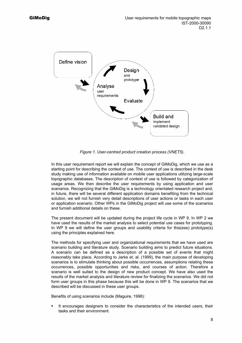
This approach was developed by the INUSE (Information Engineering Usability Support Centres) project as part of the Telematics Applications Programme of the European Union (EU) (Daly-Jones et al., 1997), and an improved version is now published as ISO TR 18529. These activities are iterative, as described by the VNET5 project (2002) in Figure 1.
7
GiMoDig User requirements for mobile topographic maps IST-2000-30090 D2.1.1
Figure 1. User-centred product creation process (VNET5).
In this user requirement report we will explain the concept of GiMoDig, which we use as a starting point for describing the context of use. The context of use is described in the desk study making use of information available on mobile user applications utilizing large-scale topographic databases. The description of context of use is followed by categorization of usage areas. We then describe the user requirements by using application and user scenarios. Recognizing that the GiMoDig is a technology orientated research project and, in future, there will be several different application domains benefiting from the technical solution, we will not furnish very detail descriptions of user actions or tasks in each user or application scenario. Other WPs in the GiMoDig project will use some of the scenarios and furnish additional details on these.
The present document will be updated during the project life cycle in WP 9. In WP 2 we have used the results of the market analysis to select potential use cases for prototyping. In WP 9 we will define the user groups and usability criteria for this(ese) prototype(s) using the principles explained here.
The methods for specifying user and organizational requirements that we have used are scenario building and literature study. Scenario building aims to predict future situations. A scenario can be defined as a description of a possible set of events that might reasonably take place. According to Jarke et. al. (1999), the main purpose of developing scenarios is to stimulate thinking about possible occurrences, assumptions relating these occurrences, possible opportunities and risks, and courses of action. Therefore a scenario is well suited to the design of new product concept. We have also used the results of the market analysis and literature review for finalizing the scenarios. We did not form user groups in this phase because this will be done in WP 9. The scenarios that we described will be discussed in these user groups.
Benefits of using scenarios include (Maguire, 1998):
It encourages designers to consider the characteristics of the intended users, their tasks and their environment.
8
GiMoDig User requirements for mobile topographic maps IST-2000-30090 D2.1.1
Usability issues can be explored at a very early stage in the design process (before a commitment to code has been made).
Scenarios can help identify usability targets and likely task completion times.
The method promotes developer buy-in and encourages a user-centred design approach.
Scenarios can also be used to generate contexts for evaluation studies.
Only minimal resources are required to generate scenarios.
The technique can be used by developers with little or no human factor expertise.
The techniques used to illustrate the design are several, e.g. use cases, scenarios and storyboarding. Use cases were originally defined as a part of object-oriented software engineering. Cockburn (2001) gives an example of how a use case for requirements could be described:
Scope: (GiMoDig)
Level: <Summary, user goal, subfunction>
Context: < a longer statement of the context of use>
Technical requirements from GiMoDig point of view:
Primary Actor: <a role name or a description for the primary actor>
Stakeholders and interests: <stakeholder name> <interest>
Preconditions: <what we expect to be ready, the state of the world>
Triggers: <the action upon the system that starts the use case>
Main success scenario:
Frequency of occurrence:
Open issues:
We decided not to use this technique in this early specification phase, opting instead to use scenarios and storyboarding for illustrating the usage situation. The method is not proprietary and is described in Clarke (1991) and Nielson (1991). The difference between use cases and scenarios is that a scenario is not a narrowly focused task description but illustrates how some particular tasks are performed. On the other hand a scenario does not include all usage situations, but only describes an individual user in a certain usage situation. Carrol (1995) suggests that the concreteness in scenarios enables designers and users to deal with complicated and conflicting situations and behaviours in meaningful terms, and to better understand the implications of particular design solutions in performing realistic tasks. For some user scenarios we also made storyboards, which are sequences of images demonstrating the relationship between individual screens and actions within a system.
9
GiMoDig User requirements for mobile topographic maps IST-2000-30090 D2.1.1 2.2 Usability
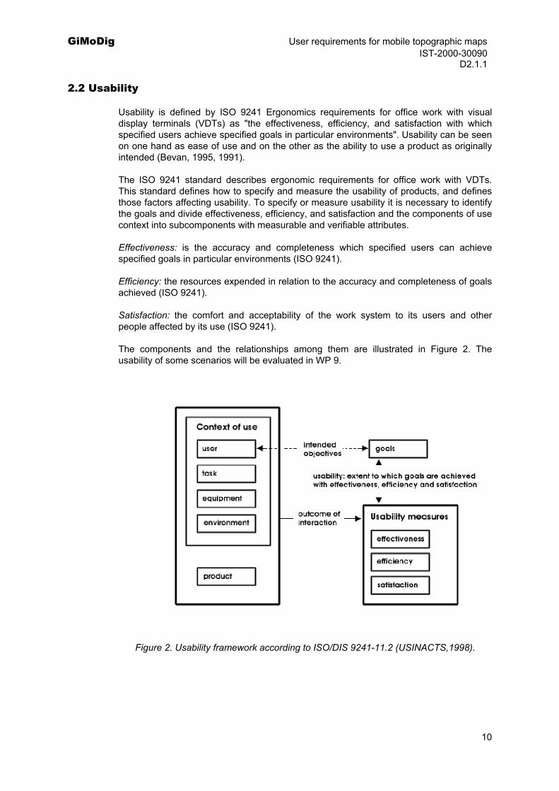
Usability is defined by ISO 9241 Ergonomics requirements for office work with visual display terminals (VDTs) as "the effectiveness, efficiency, and satisfaction with which specified users achieve specified goals in particular environments". Usability can be seen on one hand as ease of use and on the other as the ability to use a product as originally intended (Bevan, 1995, 1991).
The ISO 9241 standard describes ergonomic requirements for office work with VDTs. This standard defines how to specify and measure the usability of products, and defines those factors affecting usability. To specify or measure usability it is necessary to identify the goals and divide effectiveness, efficiency, and satisfaction and the components of use context into subcomponents with measurable and verifiable attributes.
Effectiveness: is the accuracy and completeness which specified users can achieve specified goals in particular environments (ISO 9241).
Efficiency: the resources expended in relation to the accuracy and completeness of goals achieved (ISO 9241).
Satisfaction: the comfort and acceptability of the work system to its users and other people affected by its use (ISO 9241).
The components and the relationships among them are illustrated in Figure 2. The usability of some scenarios will be evaluated in WP 9.
Figure 2. Usability framework according to ISO/DIS 9241-11.2 (USINACTS,1998).
10
GiMoDig User requirements for mobile topographic maps IST-2000-30090 D2.1.1
Part I
Desk study on user requirements The following Part I consists of a desk study of available information on user requirements.
1 Technology and application requirements
In this chapter we will discuss how technology and applications affect user requirements. There are some general principles that should be considered. The Navikärki (Petäkoski-Hult, 2000) project in Finland has examined the requirements related to technology in personal navigation including:
overall reliability,
accuracy, speed and functionality of location information,
speed and reliability of the telecommunications connection,
data security and data privacy (as recognition and encryption completeness),
resolution and contrast of the display,
power consumption; duration of battery vs. weight of the device.
Factors related to the user interface may include (Petäkoski-Hult et al., 2000):
efficiency,
effectiveness,
satisfaction,
learnability and comprehensibility of the information,
multimodality,
scaling, adaptation and personalization,
functionality in emergency situations.
In market analysis (Deliverable D2.2.1) we describe mobile information and communication technologies, positioning technologies and mobile LBSs. In general, the conclusion is that the infrastructure is available for mobile services utilizing topographic maps.
11
GiMoDig User requirements for mobile topographic maps IST-2000-30090 D2.1.1
In GiMoDig service there is always a map present. This means that in general all usability issues related to digital maps can be used when designing the requirements of each application. The usability of digital maps will not be addressed here. The WP 3 will include an analysis of user requirements regarding location-based services, including performance issues from the point of view of map visualization. The WP 4 will include an analysis of the existing technological situation, therefore we will not address this here. The WP 7 will cover analysis of usage situations and their requirements for adapted generalization.
There are some interesting related research initiatives from the technology viewpoint. In the 6th Framework Programme of the EU one of the focus areas is ambient intelligence systems offering universal access to the information society, regardless of age and situation, as well as interactive and intelligent systems for health, mobility, security, leisure, preservation of cultural heritage and environmental monitoring. We have analysed one of these existing user scenarios in Part II, Chapter 2.2.
The CReation of User-friendly Mobile services Personalised for Tourism (CRUMPET) project (funded by the EU IST programme), aiming to create user-friendly mobile services personalized for tourism, has developed a proactive Spatial Context Agent concept that g obtains information on users’ current interests (User Model Agent), objects in a region near the actual user’s location (Spatial Agent) and taxonomic information on the object identified. The agent can thus draw the user's attention to objects of interest that are nearby. The project has discovered user needs for map content to be dependent on user interests, knowledge of the area and cognitive capabilities (e.g. visually impaired people need large symbols and less detail). Children need understandable symbols, perspective or 3D displays, no abstract information and less information detail. The project has presented a model for adaptive map with step-by-step implementation. Examples of map adaptation needs include: culture-specific colouring, map generalisation, user-orientation dependent maps and focus maps (Posland, 2001; Zipf, 2002).
An important aspect in mobile environment is the user's movement. Conventionally, LBSs are focused on the user's location but also the user's planned or predicted path must be considered when designing user interfaces and map displays. When a user deviates from the planned route the application must calculate a new route from the present origin. Information request can be targeted along the path and ahead of the user.
2 Services and business requirements
Services that would benefit from the GiMoDig application include LBSs. Here we use the term LBSs when we mean services that could utilize information of location.
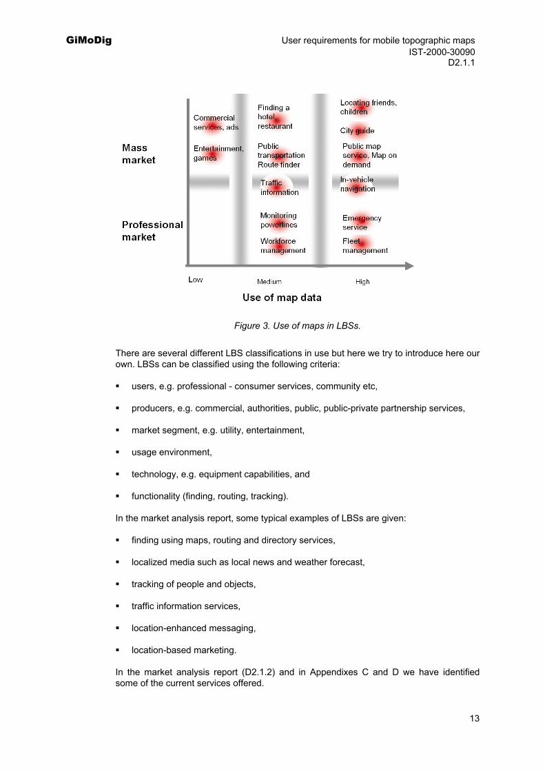
We examined some LBSs and service ideas to ascertain the feasibilities of using topographic data in mobile service. Here we assume that topographic data could also be utilized in forms other than a map. Figure 3 depicts the results. Services were divided into professional and mass market. The classification of map use was done empirically. High use of map data means that it is essential for the service: service could not have been implemented without maps. Medium means that it is useful to have maps in some of the functions but a service may be implemented without it or it is very important only under special circumstances. Low means that it may be useful for some functions but a service could be implemented without it. The classification is based on the present situation. In future, those that are classified in the medium category probably will move to the high-use category.
12
GiMoDig User requirements for mobile topographic maps IST-2000-30090 D2.1.1
Figure 3. Use of maps in LBSs.
There are several different LBS classifications in use but here we try to introduce here our own. LBSs can be classified using the following criteria:
users, e.g. professional - consumer services, community etc,
producers, e.g. commercial, authorities, public, public-private partnership services,
market segment, e.g. utility, entertainment,
usage environment,
technology, e.g. equipment capabilities, and
functionality (finding, routing, tracking).
In the market analysis report, some typical examples of LBSs are given:
finding using maps, routing and directory services,
localized media such as local news and weather forecast,
tracking of people and objects,
traffic information services,
location-enhanced messaging,
location-based marketing.
In the market analysis report (D2.1.2) and in Appendixes C and D we have identified some of the current services offered.
13
GiMoDig User requirements for mobile topographic maps IST-2000-30090 D2.1.1
User goals in LBSs can be anticipated when designing the applications. In general, there are several characteristics that can be considered:
Locating your position, and being located (Where am I?),
Locating other people (relatives, friends etc.),
Locating objects (points of interest, shops, restaurants),
Obtaining guidance,
Obtaining information,
Obtaining help.
We will use this classification as a starting point in the GiMoDig user and application scenarios. These can be implemented by 4 basic tasks (Reichenbacher, 2001):
1) locators,
2) proximity,
3) navigation,
4) events.
The differences between user goals and tasks were already discussed.
When designing the service it is important to model the users’ predicted behaviour. These can modelled according to Reichenbacher (2001):
prediction of next location: this allows for prefetching information of this location, recentring the map display, adjusting visualization to the context of this location, checking for events occuring at this location and finding suitable representation forms (i,e. symbols) for them,
prediction of next information requests: pre-fetching, compilation of information choices,
structuring the information content,
prediction of next information visualization method and style: prerendering of map data, buffering,
taking into account the user's cognition of space: delivering and presenting spatial information in a mode easily perceivable for the user.
According to Geake (2000), acceptance of a LBS will be dependent on the following criteria:
speed of delivery,
completeness of delivered information,
compactness or clarity of delivered information,
14
GiMoDig User requirements for mobile topographic maps IST-2000-30090 D2.1.1
currency of delivered information,
relevance of delivered information,
simplicity of use.
Currently we can recognize several problems with the present LBS systems (Reichenbacher, 2001):
They are mostly commercial and therefore mainly operate with precompiled and edited contents.
They may serve marketing and advertisement purposes not necessarily desired by the user.
They are often not compatible with other services and solutions due to proprietary formats and technology.
Although location is an important context parameter, it is not the only context element. For effective mobile cartography, other context elements should be derived from the location and must be included.
They do not necessarily take account of different users in the same location.
They need to handle the variable dispersion of location data.
Predicting the next location of a user is quite difficult.
They not focus on graphical quality and clarity (anything-goes approach).
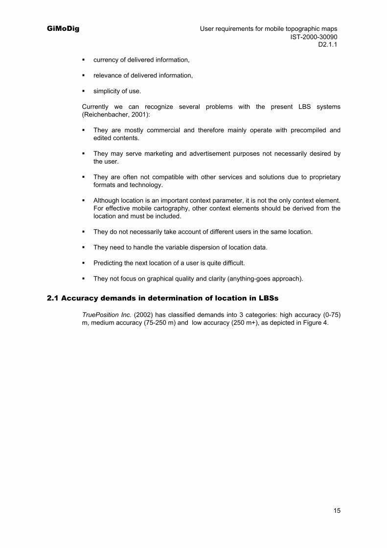
2.1 Accuracy demands in determination of location in LBSs
TruePosition Inc. (2002) has classified demands into 3 categories: high accuracy (0-75) m, medium accuracy (75-250 m) and low accuracy (250 m+), as depicted in Figure 4.
15
GiMoDig User requirements for mobile topographic maps IST-2000-30090 D2.1.1
Figure 4. Accuracy demands and revenue potential according to Trueposition (2002).
3 Data sets and user requirements
In this chapter we discuss user requirements regarding topographic data sets. The national mapping agencies (NMAs) in Europe investigated user requirements regarding topographic data sets. Co-operation among the agencies begun over 20 years ago with CERCO (Comité Européen des Responsables de la Cartographie Officielle). In 1993 CERCO established its ‘daughter’ organization MEGRIN (Multi-purpose European Ground Related Information Network) to manage pan-European projects. These have included the creation of harmonized geographic databases and the development of web-based metadata services. In 2000 the NMAs decided to merge these two organizations to EuroGeographics (Jan 1 2001).
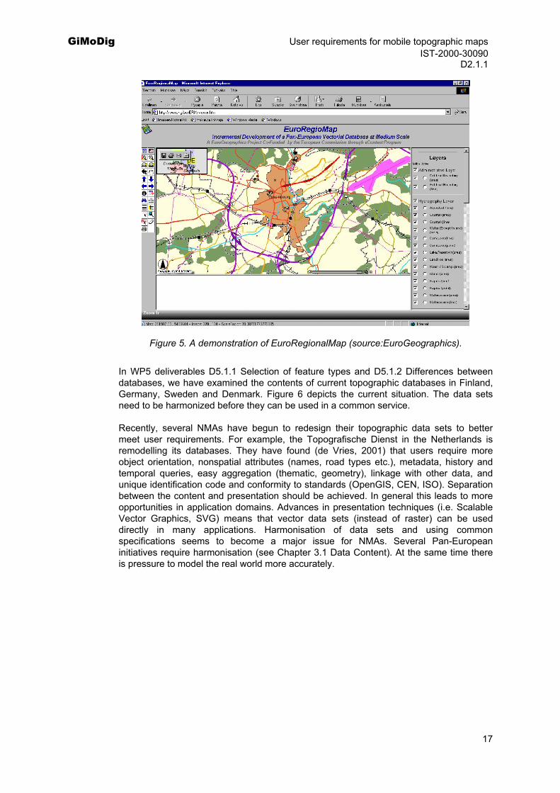
One of the projects in MEGRIN was the Pathfinder towards the European Topographic information Template (PETIT), that demonstrated international topographic data sets covering parts of the following 4 countries: Belgium, Germany, Luxembourg and the Netherlands. One of the key issues was a study of user requirements for pan-European topographic data. The first stage of the user-testing programme involved telephone interviews in which the aim was to complete 100 successful interviews. The second stage involved signing test user agreements and sending out prototype data, followed by in-depth meetings with a number of key companies, providing the opportunity to explore in detail some of the more complex issues surrounding the definition of the PETIT product. The aim was to complete in-depth interviews with 15-20 companies. Based on the results the EuroGeographics has decided to continue with the EuroRegionalMap project, which is partly funded by the EU. The aim of the project is to build up 1:250 000 topographic database of Europe incrementally starting with France, Germany, Belgium, Luxemburg, Denmark, Ireland and Northern Ireland. Other EuroGeographics projects include: EuroGlobalMap, which is producing 1:1000 000 topographic data set covering Europe and SABE, which has the administrative boundaries of Europe.
16
GiMoDig User requirements for mobile topographic maps IST-2000-30090 D2.1.1
Figure 5. A demonstration of EuroRegionalMap (source:EuroGeographics).
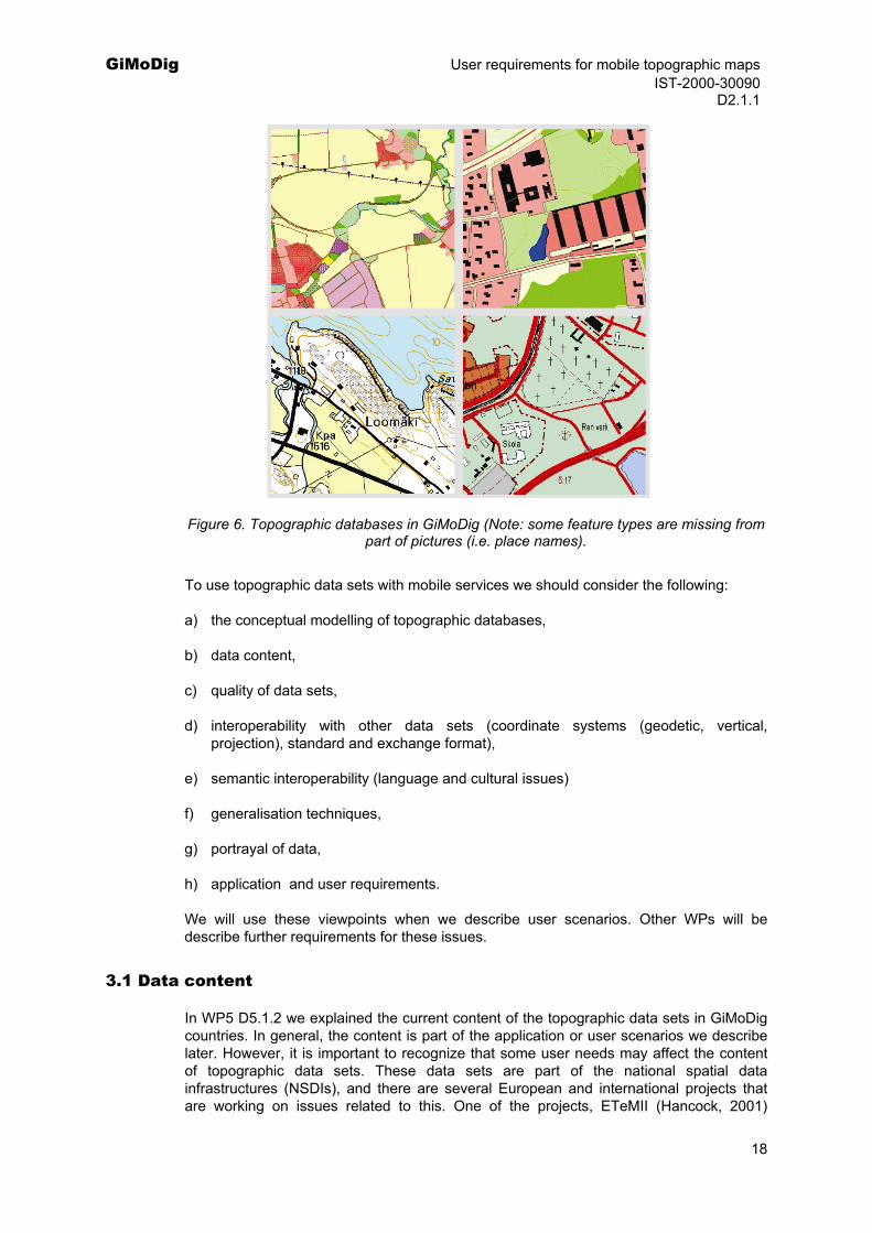
In WP5 deliverables D5.1.1 Selection of feature types and D5.1.2 Differences between databases, we have examined the contents of current topographic databases in Finland, Germany, Sweden and Denmark. Figure 6 depicts the current situation. The data sets need to be harmonized before they can be used in a common service.
Recently, several NMAs have begun to redesign their topographic data sets to better meet user requirements. For example, the Topografische Dienst in the Netherlands is remodelling its databases. They have found (de Vries, 2001) that users require more object orientation, nonspatial attributes (names, road types etc.), metadata, history and temporal queries, easy aggregation (thematic, geometry), linkage with other data, and unique identification code and conformity to standards (OpenGIS, CEN, ISO). Separation between the content and presentation should be achieved. In general this leads to more opportunities in application domains. Advances in presentation techniques (i.e. Scalable Vector Graphics, SVG) means that vector data sets (instead of raster) can be used directly in many applications. Harmonisation of data sets and using common specifications seems to become a major issue for NMAs. Several Pan-European initiatives require harmonisation (see Chapter 3.1 Data Content). At the same time there is pressure to model the real world more accurately.
17
GiMoDig User requirements for mobile topographic maps IST-2000-30090 D2.1.1
Figure 6. Topographic databases in GiMoDig (Note: some feature types are missing from part of pictures (i.e. place names).
To use topographic data sets with mobile services we should consider the following:
a) the conceptual modelling of topographic databases,
b) data content,
c) quality of data sets,
d) interoperability with other data sets (coordinate systems (geodetic, vertical, projection), standard and exchange format),
e) semantic interoperability (language and cultural issues)
f) generalisation techniques,
g) portrayal of data,
h) application and user requirements.
We will use these viewpoints when we describe user scenarios. Other WPs will be describe further requirements for these issues.
3.1 Data content
In WP5 D5.1.2 we explained the current content of the topographic data sets in GiMoDig countries. In general, the content is part of the application or user scenarios we describe later. However, it is important to recognize that some user needs may affect the content of topographic data sets. These data sets are part of the national spatial data infrastructures (NSDIs), and there are several European and international projects that are working on issues related to this. One of the projects, ETeMII (Hancock, 2001)
18
GiMoDig User requirements for mobile topographic maps IST-2000-30090 D2.1.1
defined the geographic reference data. They concluded that in the past, the various components were combined in the form of multipurpose products (such as topographic maps). In the digital era, we are now seeking to separate these different components to increase the flexibility of their use. The reference data components they defined were:
1) geodetic reference system (i.e., a coordinate system) for both horizontal and vertical measurements,
2) units of administration,
3) units of land rights, i.e. cadastral parcels,
4) addresses,
5) selected topographic themes, notably elevation, transport networks and hydrography and
6) orthoimagery.
To make these suggestions concrete they investigated existing user requirement studies initiated by the EU. The conclusion was that conducting further user requirement studies across the wide range of types of users in geographic information is not productive until or unless the entire exercise is conducted within an agreed analytical framework.
After the ETeMII the EU initiated INSPIRE (Infrastructure for Spatial Information in Europe) project aiming at making available relevant, harmonized and quality geographic information for the purpose of formulation, implementation, monitoring and evaluation of EU policy-making. One of the working groups has produced a position paper (Rase et al., 2002) on reference data components including:
1) geodetic reference system,
2) units of administration,
3) units of property rights (parcels, buildings),
4) addresses,
5) selected topographic themes (hydrography, transport, height),
6) orthoimagery,
7) geographical names.
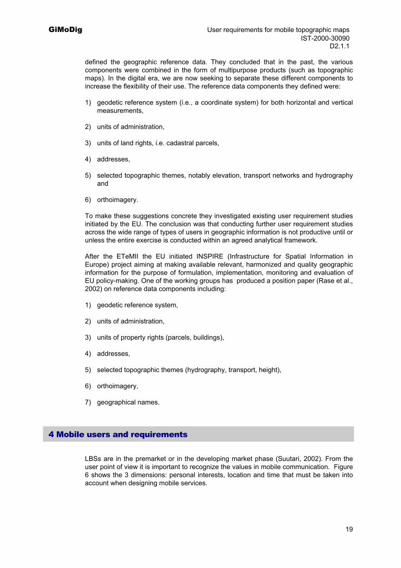
4 Mobile users and requirements
LBSs are in the premarket or in the developing market phase (Suutari, 2002). From the user point of view it is important to recognize the values in mobile communication. Figure 6 shows the 3 dimensions: personal interests, location and time that must be taken into account when designing mobile services.
19
GiMoDig User requirements for mobile topographic maps IST-2000-30090 D2.1.1
Figure 7. Values in mobile communication, as modified from Suutari (2002).
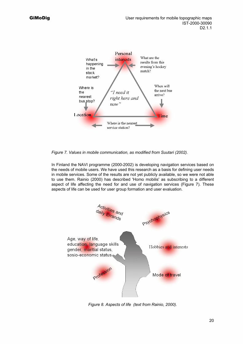
In Finland the NAVI programme (2000-2002) is developing navigation services based on the needs of mobile users. We have used this research as a basis for defining user needs in mobile services. Some of the results are not yet publicly available, so we were not able to use them. Rainio (2000) has described 'Homo mobilis' as subscribing to a different aspect of life affecting the need for and use of navigation services (Figure 7). These aspects of life can be used for user group formation and user evaluation.
Figure 8. Aspects of life (text from Rainio, 2000).
20
GiMoDig User requirements for mobile topographic maps IST-2000-30090 D2.1.1 4.1 Mobile user groups
User groups can be formed using several criteria. Using aspects of life we can identify user groups by profession, hobbies and interests, mode of travel activities and daily errands, age, way of life, education, language skills, gender, marital status and socioeconocomic status. Users in different countries may also have different needs. Users’ psychophysical status will also affect user requirements. Currently mobile services are mainly targeted at professional users or consumers. We use this approach as a starting point for GiMoDig user groups.
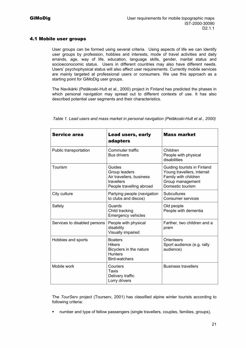
The Navikärki (Petäkoski-Hult et al., 2000) project in Finland has predicted the phases in which personal navigation may spread out to different contexts of use. It has also described potential user segments and their characteristics.
Table 1. Lead users and mass market in personal navigation (Petäkoski-Hult et al., 2000)
Service area Lead users, early adapters
Mass market
Public transportation Commuter traffic Bus drivers
Children People with physical disabilities
Tourism Guides Group leaders Air travellers, business travellers People travelling abroad
Guiding tourists in Finland Young travellers, interrail Family with children Group management Domestic tourism
City culture Partying people (navigation to clubs and discos)
Subcultures Consumer services
Safety Guards Child tracking Emergency vehicles
Old people People with dementia
Services to disabled persons People with physical disability Visually impaired
Farther, two children and a pram
Hobbies and sports Boaters Hikers Bicyclers in the nature Hunters Bird-watchers
Orienteers Sport audience (e.g. rally audience)
Mobile work Couriers Taxis Delivery traffic Lorry drivers
Business travellers
The TourServ project (Tourserv, 2001) has classified alpine winter tourists according to following criteria:
number and type of fellow passengers (single travellers, couples, families, groups),
21
GiMoDig User requirements for mobile topographic maps IST-2000-30090 D2.1.1
age levels (children, teens, adults, seniors),
kind of winter sport practiced (alpine skiing, fun skiing, snow boarding, tour skiing, cross-country skiing, non-skiers),
duration of stay (one day, weekends end few extra days, one week or more),
level of expertise (beginners, experienced, experts),
origin.
This kind of classification can be utilized when analysing user need further in WP 9. In the user scenarios we identified several more focused user groups that will be used for evaluation purposes in WP 9.
4.2 Available information on user requirements in mobile services
The Key Usability and Ethical Issues (KEN project) is one of the horizontal support projects in the NAVI programme of the Ministry of Transport and Communications in Finland. The aim of the KEN project is to ensure that usability and ethical issues are accounted for in projects of the NAVI programme. In studies of user needs for personal navigation services (PNSs) (Anttila et al., 2001), the authors investigated overall user needs for PNSs in Finland, Germany and Italy, exploring the most promising market segments for personal navigation. The results from the study in Finland are publicly available. The authors used a stratified random sample of 2000 Finnish persons over 15 years of age chosen from the population register; the response rate in Finland was 59%. The most important services were related to daily travel either by car or public transport. The most important information concerned automatic emergency calls (in the car).
The Finnish study also analysed information interest among different user groups. In general LBS was rated as most important for young people. Public transportation was most important for female respondents between 26 and 35 years of age and driving information for males 36-45 years of age. Automatic emergency calls, observing relatives' movements, navigation guidance in large buildings and saving (and sending) locations were all indicated to be almost as important by the older age-groups as by the younger age-groups (Anttila et al., 2001).
The willingness to pay for driving-related information was relatively high. When considering the willingness to pay for all listed information services, the percentage of respondents willing to pay for information was highest for LBSs not related to any mode of transport. For example, over 70% of the respondents were willing to pay for guidance in unfamiliar cities.
Respondents in Finland were likely willing to pay for services that presented obvious time- or money-saving opportunities such as optimizing the route, avoiding congestion or obtaining guidance in unfamiliar environments. On the other hand, information related to other services (events or purchases while travelling) were considered important, but costs for these information services were probably more often seen as a responsibility of the service provider (Anttila et al., 2001).
Ikonen and Sotamaa (2001) investigated 13 different scenarios with potential user groups. Of these scenarios nearly all had functions related to outdoor navigation and route guidance, which are interesting from the GiMoDig viewpoint, including:
1) Tarzan going to the city with Terk (a monkey) to meet Jane at the zoo.
22

GiMoDig User requirements for mobile topographic maps IST-2000-30090 D2.1.1
A fictional story of Tarzan using a navigator in a city.
2) Visiting Helsinki with the twins - A woman with children visits an unfamiliar city.
Car navigation, finding a parking space, finding a restaurant, route planning, traffic information.
3) A family vacationing at the Levi ski resort.
Locating family members in a ski resort, and finding routes while skiing in a mountain area and locating another log cabin after finding the one that you went to was occupied. Locating friends nearby.
4) Junk mail
Mobile marketing, choosing location-aware advertisements, locating an employee.
5) Rita and boys
Locating the children.
6) Pub Lighthouse
Locating friends nearby and abroad.
7) House party
A boy is going to a house party by bus, looking there for friends and new faces, returning home by taxi.
8) Billiards
Two boys are looking for their friends and entertainment for the evening. Includes a task finding friends locations using a city map.
9) To afternoon dance and back
Elderly men keeping track of each other’s location, choosing transportation, using public transportation, sending a location to a taxi service, finding routes.
10) Emma 2035
Story of a lady who has Alzheimer disease and uses PNSs. Keeping track of her location and sending help if needed.
11) Abroad
A family is going to Estonia by boat when suddenly one of the group has a heart attack. Using a navigator when having an unexpected illness (guidance of emergency services).
12) Ride-sharing
A man is looking for his friend in the morning to pick him up. Includes locating a friend, route guidance in an urban area.
23
GiMoDig User requirements for mobile topographic maps IST-2000-30090 D2.1.1
Analysing the group discussion, the authors determined that route guidance in unfamiliar places was generally seen to be extremely practical. Wilderness, hobbies related to nature, and cities were mentioned in all the user groups as places where the PNSs could be usable.
The LoVEUS project (Location aware Visually Enhanced Ubiquitous Services, funded by EU IST programme; 2002) has examined user requirements for future location services. The aim of the project is to provide European citizens with ubiquitous services for personalized, tourism-oriented, multimedia information related to location and orientation within cultural sites or urban settings, occasionally enriched with relevant advertisements. Project developed an on-line questionnaire for end-users, comprised of people 25-34 years of age with occupation in information technology, financial or media industries or who were studying, and of whom over 95% used PCs and mobile phones and over 80% had graduate or postgraduate education. They found that people more often use maps more often abroad and wanted to know their current location on the map and the way to a specific point of interest. The most unrequired functions were locating friends, zooming in and out and saving the map view (Zacharopoulos , 2002).
Raikkolainen et al. (2000) studied a 3D City Information system for mobile users in the city of Tampere, Finland. They built a working mobile laptop version of the 3D City Info with an integrated GPS receiver. They evaluated the prototype in the field using a mock-up field-test version of the system. They found out that the test persons would prefer to use a 3D model combined with a map than to use only the map or the model alone. The test users recognised their current position and the landmarks from the photorealistic model more easily than from the map. The authors found out that the visual similarity with the reality helped the users to find the places in real life. We can conclude that a 3D visualisation in some applications seems to be very important.
5 Conclusions
LBSs that might be interesting from the GiMoDig viewpoint include those that have a high usage of maps or otherwise use map data, and require generalisation and integration of data from other services. Both the user goals and user task must be identified in the GiMoDig service using the techniques described earlier (i.e. scenario building and use case modelling). Users predicted behaviour is an important factor that must be considered using for example adaptive map technology. Users’ acceptance criteria are dependent on content (map and other information), user interfaces, technology and speed of the service. A GiMoDig service requires high or medium positioning accuracy. The accuracy demand for a location service is under 75 m and ideally would be around 10-20 m.
User needs vary somewhat in different European countries. In central Europe some services may be more important than in northern Europe. User groups also vary from country to country.
There are 2 different user groups: professional users and consumers. Professional users are more familiar with topographic maps and are willing to use them in mobile environments. The public requires more sophisticated user interfaces and probably would benefit most from the GiMoDig type or environment. LBSs in general would also be the right target area when using real-time integration and generalisation. This type of service offers a new market for the NMAs and new users for topographic data sets. Currently, the main use for topographic data is in professional and military applications. A GiMoDig type of application will become a reality when NMAs change their database technology to object orientation and use common specifications.
24
GiMoDig User requirements for mobile topographic maps IST-2000-30090 D2.1.1
The present knowledge of user requirements is focused on LBSs, using either city maps or road navigation data. We found no results on services using topographic maps or data sets. However, we determined that there is a clear need for using topographic data sets with mobile applications. Situations in which users would need topographic information include safety or emergencies and, on the other hand, hiking in the wilderness and other hobbies related to nature. Current LBSs utilizing city maps or road data would benefit if topographic data sets were used. Data content in some of the services is quite poor and topographic information could enrich the services. For example, 3D visualisation needs information about elevation. Almost all LBS scenarios include situations in which topographic data sets would be useful. Knowledge on user requirement using road and city maps can be used when designing user scenarios utilizing topographic data. More research is required for identifying user requirements for topographic data. Evidently, mobile use of topographic data will begin with professionals but with the increase in improvements in technology and modelling of data sets there will also be a new market segment for topographic data sets.
25
GiMoDig User requirements for mobile topographic maps IST-2000-30090 D2.1.1
Part II
How to use topographic data In the following Part II of the report some existing needs and user scenarios with potential use for topographic data sets are described.
1 Needs for GiMoDig type of mobile services
The first section of this part describes existing needs for mobile services, which are potential for GiMoDig type of application.
1.1 Emergency services
E112
It is estimated that over 100 million trips are taken to other EU countries every year in Europe and about 185 million emergency calls made annually. A study in Germany estimates that socioeconomic benefits may be in excess of 4 billion euros if 10% of the 41 000 road fatalities could be reduced and intervention could be halved to 10 minutes during the 'golden hour'. The eEurope initiative sets the goal that "All citizens on the move throughout Europe should have full access everywhere to call localization, multilingual support and full provision of emergency services through the 112 number.” The percentage of mobile calls to 112-service varies from 12% to 97% (in 5 EU countries) (Jääskeläinen, 2002).
In May 2000, the Commission established a public forum CGALIES (Coordination Group on Access to Location Information by Emergency Services) with the mission to find a consensus in implementing an enhanced 112 service in Europe and to identify the requirements for enhanced 112 calls. The participants in this forum are operators, emergency authorities, regulatory authorities and manufacturers.
According to the final report of the CGALIES:
Emergency services unable to send a response for about 6% of mobile calls due to lack of information (number of calls 1-2,4 million). The same figure with fixed line is 1- 5%.
Location information is inaccurate in about 9% of cases, leading to loss of time.
The benefits of location information are:
route the calls to the right emergency call centre,
dispatch the most appropriate emergency response team(s),
26
GiMoDig User requirements for mobile topographic maps IST-2000-30090 D2.1.1
locate the caller and the incident site,
determine if there are multiple accidents at the same location,
sense of security and thus comfort it gives to users.
There is a requirement for a GIS to be installed to establish the location service. Currently, GIS systems are not compatible or interoperable and the emergency centres are aware of ongoing standardization of geographic information.
According to the report, the requirements for GIS and map material are:
usability varies if a map is a scanned versus a true digital map (this means vector data sets),
coordinate systems should be managed,
accuracy should be 10 m.
The CGALIES report also discusses the data transfer standards and mentions the Geographic Data File (GDF), which is a European standard implemented in the navigation industry. It also mentions Magic and LIF (Location information format) as potential uses for this type of service.
1.2 Public transportation
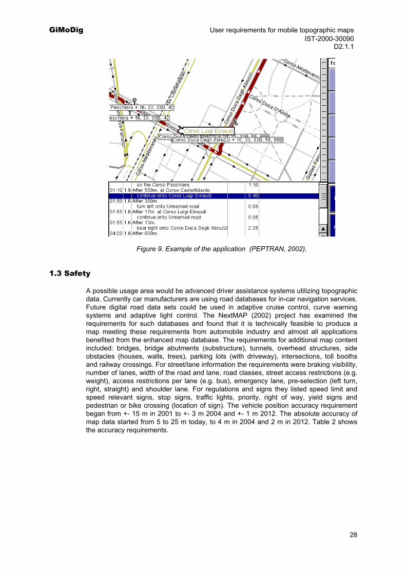
There are several existing applications for public transportation. Frank (1999) presented a scenario for public transportation. He found that existing information sources do not meet the user requirements of a typical business traveller, because the information is not in a useful format. He suggests that the data should be integrated from several sources using a single interface with minimal input needs from a traveller.
PEPTRAN (Pedestrian and Public Transport Navigator; 2002) is a project aiming to develop software to give a pedestrian or park-and-ride motorist a route from point to point in a city or semiurban area, then walking and using public transportation more efficiently. They will offer a pedestrian multimodal routing advice covering all phases of the journey, including detailed street directions while walking. The work of routing will be split between a central server dealing with routing through the public transportation network and routing through the streets, which will be accomplished on the local device. It tries to provide data required by the mobile user in a manner optimized for mobile use. The route presented will be complete, from the user's current location to the user's destination, not just from one station to another. If the route needs several modes of transport, this will be dealt with transparently — the user does not need to know how to integrate the different timetables. No user requirement documentation has yet been found.
27
GiMoDig User requirements for mobile topographic maps IST-2000-30090 D2.1.1
Figure 9. Example of the application (PEPTRAN, 2002).
1.3 Safety
A possible usage area would be advanced driver assistance systems utilizing topographic data. Currently car manufacturers are using road databases for in-car navigation services. Future digital road data sets could be used in adaptive cruise control, curve warning systems and adaptive light control. The NextMAP (2002) project has examined the requirements for such databases and found that it is technically feasible to produce a map meeting these requirements from automobile industry and almost all applications benefited from the enhanced map database. The requirements for additional map content included: bridges, bridge abutments (substructure), tunnels, overhead structures, side obstacles (houses, walls, trees), parking lots (with driveway), intersections, toll booths and railway crossings. For street/lane information the requirements were braking visibility, number of lanes, width of the road and lane, road classes, street access restrictions (e.g. weight), access restrictions per lane (e.g. bus), emergency lane, pre-selection (left turn, right, straight) and shoulder lane. For regulations and signs they listed speed limit and speed relevant signs, stop signs, traffic lights, priority, right of way, yield signs and pedestrian or bike crossing (location of sign). The vehicle position accuracy requirement began from +- 15 m in 2001 to +- 3 m 2004 and +- 1 m 2012. The absolute accuracy of map data started from 5 to 25 m today, to 4 m in 2004 and 2 m in 2012. Table 2 shows the accuracy requirements.
28

GiMoDig User requirements for mobile topographic maps IST-2000-30090 D2.1.1
Table 2. Database requirements for future road data sets (Pandazis, 2002)
They also stated that the coverage of the database should increase gradually, depending on area and feature type, from 10% in 2004 to full coverage in 2012. Some of the applications were found to be dependent on the content, which is shown in Table 3.
Table 3. Application areas and road data sets (Pandazis, 2002)
29
GiMoDig User requirements for mobile topographic maps IST-2000-30090 D2.1.1 1.4 Tourism
Tourism is one the most promising fields in which different maps are needed to guide people in a foreign environment. The NMAs data sets combined with the most detailed city maps offer a powerful combination to LBSs in tourism. We already discussed the CRUMPET project (funded by EU IST) aiming to create a user-friendly mobile services personalised for tourism. Also we mentioned the LoVEUS project (Location aware Visually Enhanced Ubiquitous Services, funded by EC IST programme, 2002) and their finding that people use maps more often abroad, and would like to know their current location on the map and the way to a specific point of interest. (Zacharopoulos, 2002). Raikkolainen (2001) has studied a city information system using 3D graphics and found that search and visualisation of location-based information of a city becomes more intuitive with life-like 3D. The users preferred 3D views over maps, although both might be needed.
The m-ToGuide project (funded by the EU IST) is developing mobile LBS systems for tourists. The vision of the project is that m-ToGuide is to become an automated mobile replacement to a human tourist guide. The HyperGeo (2002) project has studied user requirements in tourism information service. In the user requirements report they have listed several information needs including maps. The ODIN (2002) project aiming to provide citizen/tourist/SMEs (Small Medium Enterprises) in rural areas with easy mobile access to geo-spatial Web applications has found out that: "Like any digital service cannot survive without information content, so mobile digital service can take the lead only if data are somehow linked to the position on a map. Within this respect, the service providers are well aware of that but, nevertheless, many differences exist between the regions as far as the availability of geomapped data is concerned" (Odin, 2002). Numerous other project across Europe are targeted to mobile services for tourists including:
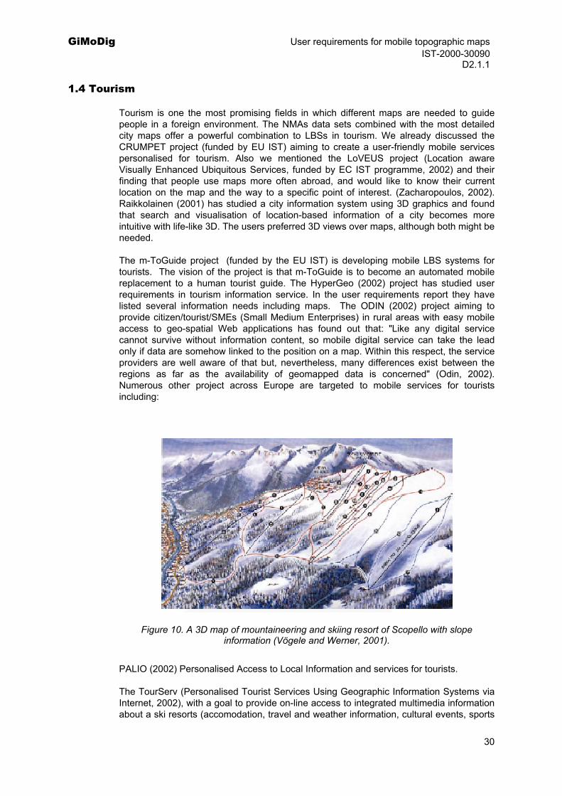
Figure 10. A 3D map of mountaineering and skiing resort of Scopello with slope information (Vögele and Werner, 2001).
PALIO (2002) Personalised Access to Local Information and services for tourists.
The TourServ (Personalised Tourist Services Using Geographic Information Systems via Internet, 2002), with a goal to provide on-line access to integrated multimedia information about a ski resorts (accomodation, travel and weather information, cultural events, sports
30
GiMoDig User requirements for mobile topographic maps IST-2000-30090 D2.1.1
rental) together with value added services (booking, tour guidance, geographic information), visualize information via a GIS-based user interface, make information accessible through regular PCs and mobile devices (PDAs) and support all phases of a vacation.
1.5 Protection of environment
Although of no direct commercial interest, environmental issues will be one of reason of utilizing topographic information in mobile applications. An accurate 3D model of a road would not only increase safety, but would allow the optimisation of the fuel consumption by predicting the route characteristics, and therefore adjusting the most economic engine regime. Impact on environment includes also the possibility to reduce harmful exhaust gases by monitoring the traffic, limiting traffic jams etc.
2 Existing use scenarios
In the following subsections we describe some examples of existing user scenarios where GiMoDig application could be useful.
2.1 Unexpected holiday
This user scenario was prepared by the preAnvil project (Anvil, 2000) (funded by the Joint Research Centre of the EU) and is explained in detail in (preAnvil, 2000). In this scenario a business traveller named Susan is in a foreign country and realizes that she has 4 free days until the next meeting. She then begins to organize a short holiday. The scenario also includes services that are not applicable to a GiMoDig type of application, but we believe it is a useful example showing that in a typical user scenario a GiMoDig service is either part of an integrated service or a separate service used for some user tasks.
Here the user has several information requirements:
Which areas offer the best weather conditions for the next 4 days?
Which these areas can I reach within 5 hours considering the expected traffic?
Which these areas offer rock climbing?
How can I get there?
Is it better to drive or use public transportation?
Where can I find accommodation there for 4 days?
Where can I hire climbing equipment?
Can I meet friends of mine in this region?
I need information on the climbing area
Using this scenario we have made a GiMoDig solution to this problem. Several information and service providers are required for solving the user requirement.
31
GiMoDig User requirements for mobile topographic maps IST-2000-30090 D2.1.1
Integrating all information requirements into one service is a possibility as Frank (1999) suggested, but not very likely from the business point of view. Therefore we suggest a decentralized solution using GiMoDig technology.
The preAnvil project analysed the benefits of the suggested solution:
Synergies of the scenario are in data integration, making them publicly available. If these could be archived then one-stop shops offering this type of service could emerge. The problem is that the service is a high-volume, 'small-GI' business. As explained by preAnvil "Users are willing to pay for the service if they can benefit from the information, and if the price corresponds to their benefits. The scenario shows some benefits for users: timesaving in travel planning, feeling safe by being well prepared (reservations etc.), exclusion of unpleasant factors (weather forecast) etc. Some of the benefits include material gain ('finding a cheaper alternative'), some are immaterial; however the value of the information is relatively small and thus the price for each service must be low. Business models will account for large numbers of users paying pennies for answers on simple queries."
From the technological point of view GiMoDig offers some more functionalities in the scenario:
Susan can search several European countries to find suitable areas and then decide if the weather is favourable enough for her to go,
public transportation services could be linked between countries, using the same topographic data for presenting information,
finding the fastest way between countries could be used,
topographic data could be the same in different services using the same type of visualization if required.
From the business point of view GiMoDig offers:
real-time integration of several data sources providing new opportunities for using public sector information (e.g. topographic data) in various commercial and public services,
new pricing models for data sets.
Classification of use case (see Appendix A):
GiMoDig usage area: information services, guidance and navigation
GiMoDig application scenarios: general mobile applications
User groups: business travellers, private persons
2.2 'Maria' -Road warrior
This scenario was prepared for the IST Advisory Group (ISTAG, 2002) by the IPTS (part of the EU’s Joint Research Centre) in collaboration with the DG Information Society and with the active involvement of 35 experts from across Europe. The aim was to describe what living with 'Ambient Intelligence' might be like for ordinary people in 2010. The concept of Ambient Intelligence (AmI) provides a vision of the Information Society in
32
GiMoDig User requirements for mobile topographic maps IST-2000-30090 D2.1.1
which the emphasis is on greater user-friendliness, more efficient service support, user-empowerment and support for human interactions. In all, they described 4 scenarios. We selected Maria for this analysis, although we could also have included Carmen: traffic, sustainability and commerce. For our purposes this scenario will illustrate the usefulness of GiMoDig.
The scenario basically extrapolates the mobile business market case. Business travellers require a multitude of related services, such as hotel reservations and car hire. Business travellers are also likely to be a lead market in that the social groups involved have highly disposable incomes and/or have the market pull of the companies that they work for behind them.
We took some parts of the story and analysed where a GiMoDig type of service would be helpful. The full story can be downloaded at (ISTAG, 2002).
The story in brief:
After a tiring long-haul flight, Maria passes through the arrivals hall of an airport in a Far Eastern country. She is travelling light, with hand baggage only. Her computing system for this trip is reduced to one highly personalized communications device, her 'P-Com' that she wears on her wrist. A particular feature of this trip is that the country Maria is visiting has since the previous year embarked on an ambitious AmI infrastructure programme. She is using a rented car where she can be guided by a traffic guidance system. She arrives at a hotel and uses her P-COM for several functions such as opening doors etc. She makes a presentation and relaxes afterwards in her hotel room.
The story could be extended from the GiMoDig point of view:
She could plan an unexpected holiday, as explained in Chapter 2.1
She could use her P-COM for GiMoDig services such as finding information about the property ownership together with topographic information. She could plan to buy property for a summer cottage.
From the technological point of view GiMoDig offers:
GiMoDig type of application integrated with the traffic guidance system, offering Maria information on the landscape,
P-COM using GiMoDig services (planning an unexpected holiday etc.),
Topographic data objects as one type of augmented object linked with other objects.
From the business point of view GiMoDig offers:
GiMoDig service providers as one of the multiservice vendors, linking topographic information to other information sources and
New business models for data providers.
Classfication of use case (see Appendix A):
GiMoDig usage area: information services, guidance and navigation
GiMoDig application scenarios: general mobile applications
33
GiMoDig User requirements for mobile topographic maps IST-2000-30090 D2.1.1
User group: business travellers, private persons
3 Conclusions
We examined 5 important service areas, in which GiMoDig type of services could be utilized. In Appendix C we demonstrate some current existing user or application scenarios using topographic maps or some topographic data themes. Situations in which users would need topographic information include safety or emergencies and, on the other hand, hiking in the wilderness as well as other hobbies related to nature. Security issues and crisis management have a major need for up-to-date topographic information. Recent examples in Europe (floods in Czech, Germany 2002) and Homeland Security policy in the USA demonstrates that current topographic information is needed even in remote areas. Giving people a fast access to the information is essential in crisis situatuations. Tourists and business travellers are important user groups of LBSs. Topographic data can be utilized in some of the activities related to tourist and business traveller needs. However, topographic information has value only when linked to other information relevant to the service. The presented user scenarios show the relevance of GiMoDig service from the business and technological viewpoint. Service providers can easily build value-added services based on the topographic data sets if real-time integration and real-time generalisation functionalities are available.
34
GiMoDig User requirements for mobile topographic maps IST-2000-30090 D2.1.1
Part III
User context and requirements In the Part III we focus on specifying GiMoDig user context and requirements.
1 GiMoDig user requirements
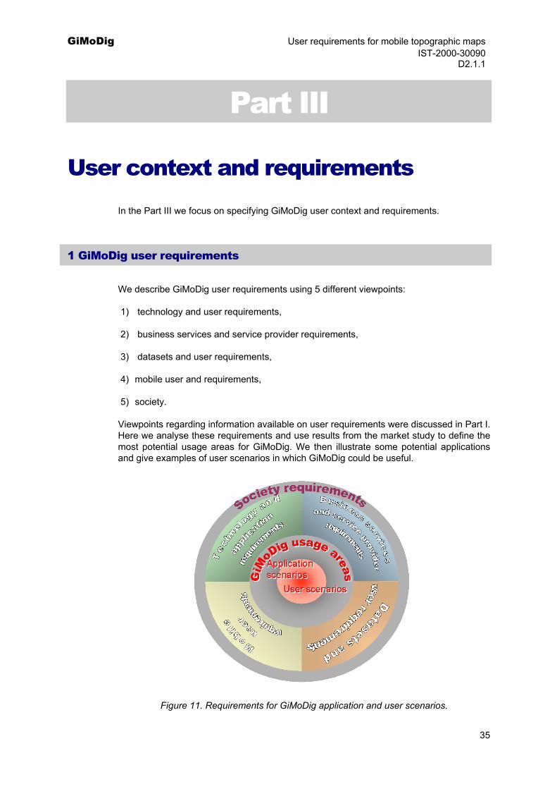
We describe GiMoDig user requirements using 5 different viewpoints:
1) technology and user requirements,
2) business services and service provider requirements,
3) datasets and user requirements,
4) mobile user and requirements,
5) society.
Viewpoints regarding information available on user requirements were discussed in Part I. Here we analyse these requirements and use results from the market study to define the most potential usage areas for GiMoDig. We then illustrate some potential applications and give examples of user scenarios in which GiMoDig could be useful.
Figure 11. Requirements for GiMoDig application and user scenarios.
35
GiMoDig User requirements for mobile topographic maps IST-2000-30090 D2.1.1 1.1 Classification of usage - GiMoDig usage areas
We found in Part I that the services that may be interesting from the GiMoDig viewpoint include those LBSs that have a high usage of maps or otherwise use map data, and require generalisation and integration of data. Typically, these services require high or medium accuracy from the service point of view.
The usage areas in which we identified potential for GiMoDig are:
Information services
Services that citizens require from government, business information etc,
Safety, emergency
Services that require some authorities to give assistance to people,
Restrictions of use or movement
Services that identify no-go zones, protective areas, hazardous areas, military areas,
Guidance or navigation
Services in which a guidance is required for navigation to a particular place,
Logistics
Services, in which management of goods and vehicles is required,
Military
Military services.
These usage areas overlap each other, and typical applications or user scenarios would cover many usage areas.
1.2 Application scenarios
We describe 2 application domains in which GiMoDig services could be implemented. We divide the market, using 4 different viewpoints (Figure 12):
user groups: professionals – consumers,
motivation for services: commercial – noncommercial,
focus environment: National – international,
motivation for usage.
36
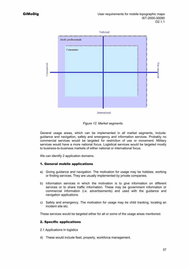
GiMoDig User requirements for mobile topographic maps IST-2000-30090 D2.1.1
Figure 12. Market segments.
General usage areas, which can be implemented in all market segments, include: guidance and navigation, safety and emergency and information services. Probably no commercial services would be targeted for restriction of use or movement. Military services would have a more national focus. Logistical services would be targeted mostly to business-to-business markets of either national or international focus.
We can identify 2 application domains:
1. General mobile applications
a) Giving guidance and navigation. The motivation for usage may be hobbies, working or finding services. They are usually implemented by private companies.
b) Information services in which the motivation is to give information on different services or to share traffic information. These may be government information or commercial information (i.e. advertisements) and used with the guidance and navigation applications.
c) Safety and emergency. The motivation for usage may be child tracking, locating an incident site etc.
These services would be targeted either for all or some of the usage areas mentioned.
2. Specific applications
2.1 Applications in logistics
d) These would include fleet, property, workforce management.
37
GiMoDig User requirements for mobile topographic maps IST-2000-30090 D2.1.1
e) Emergency services, E911, E112
2.2 Restrictions of use or movement
Motivation for these services arises from society, and may include tracking prisoners, transportation of goods or no-go zones.
2.3 Military applications
Military applications are not described here.
2.4 Other specific areas
Other application areas not specified here.
We describe application scenarios using the following criteria:
scenario name,
general characteristics,
description,
list of applicable GiMoDig usage areas,
service providers,
service provider goals,
end-user goals,
user groups,
usage environment,
required data,
dataset requirements,
examples of related user scenarios.
Application scenarios are described in Appendix A. Figure 13 depicts the relationship between application scenarios and market segments. Current applications are most related to general application domain. Examples of current applications are described in Appendix D.
38
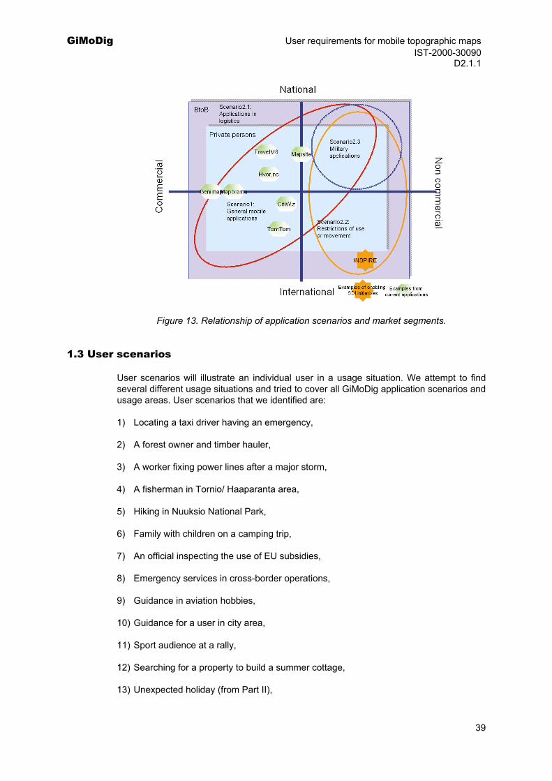
GiMoDig User requirements for mobile topographic maps IST-2000-30090 D2.1.1
Figure 13. Relationship of application scenarios and market segments.
1.3 User scenarios
User scenarios will illustrate an individual user in a usage situation. We attempt to find several different usage situations and tried to cover all GiMoDig application scenarios and usage areas. User scenarios that we identified are:
1) Locating a taxi driver having an emergency,
2) A forest owner and timber hauler,
3) A worker fixing power lines after a major storm,
4) A fisherman in Tornio/ Haaparanta area,
5) Hiking in Nuuksio National Park,
6) Family with children on a camping trip,
7) An official inspecting the use of EU subsidies,
8) Emergency services in cross-border operations,
9) Guidance in aviation hobbies,
10) Guidance for a user in city area,
11) Sport audience at a rally,
12) Searching for a property to build a summer cottage,
13) Unexpected holiday (from Part II),
39
GiMoDig User requirements for mobile topographic maps IST-2000-30090 D2.1.1
14) Maria the road warrior (from Part II).
1.4 Selecting user scenarios for the prototype and user validation
The selection criteria for the prototype and user validation were:
Benefit to the users (scale 1 - 5)
1: not very useful,
2: some use,
3: useful but the user goals could also be achieved traditionally,
4. very useful, the user goals could not be reached without the service,
5: critical, the user goals could not be reached without the service.
Commercial Market demand (scale 1 - 5)
1: very small market and low revenue,
2: very small market but high revenue,
3: moderate market, low revenue,
4: mass market, low revenue,
5: mass market with high revenue.
Use of topographic data sets (scale 1 - 5)
1: very little,
2: some use,
3: moderate use,
4: high use,
5: very high use.
Need for real-time access
1: low need for real-time access and the response time is not critical
2: some need for real time access and response time in minutes
3: moderate need for real-time access and response time in a minute
4: high need for real-time access and response time in 10-30 seconds
5: real-time access is critical and the response time below 10 seconds
Use of generalization (scale 1:very little use to 5: very high use)
40

GiMoDig User requirements for mobile topographic maps IST-2000-30090 D2.1.1
Mobility (scale 1: very little to 5: very high)
Use of integration (scale 1:very little use to 5: very high use)
The evaluation was done by WP 2 participants. The candidate user scenarios are shown in bold. Evaluation is quite subjective; therefore we will update the results when user groups can be involved with the evaluation. We will select several test areas, in which we will demonstrate some of these scenarios.
41
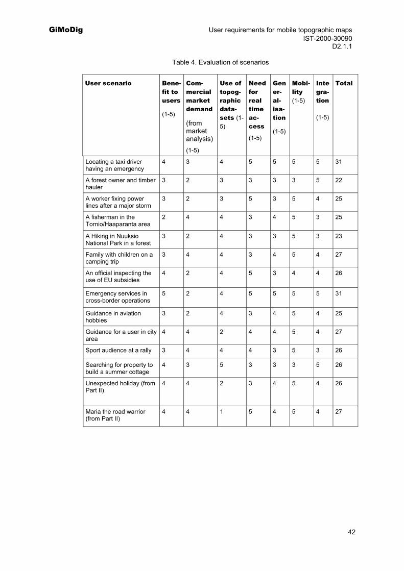
GiMoDig User requirements for mobile topographic maps IST-2000-30090 D2.1.1
Table 4. Evaluation of scenarios
User scenario Bene-fit to users
(1-5)
Com-mercial market demand
(from market analysis) (1-5)
Use of topog-raphic data-sets (1-5)
Need for real time ac-cess
(1-5)
Gener-al-isa-tion
(1-5)
Mobi-lity (1-5)
Integra-tion
(1-5)
Total
Locating a taxi driver having an emergency
4 3 4 5 5 5 5 31
A forest owner and timber hauler
3 2 3 3 3 3 5 22
A worker fixing power lines after a major storm
3 2 3 5 3 5 4 25
A fisherman in the Tornio/Haaparanta area
2 4 4 3 4 5 3 25
A Hiking in Nuuksio National Park in a forest
3 2 4 3 3 5 3 23
Family with children on a camping trip
3 4 4 3 4 5 4 27
An official inspecting the use of EU subsidies
4 2 4 5 3 4 4 26
Emergency services in cross-border operations
5 2 4 5 5 5 5 31
Guidance in aviation hobbies
3 2 4 3 4 5 4 25
Guidance for a user in city area
4 4 2 4 4 5 4 27
Sport audience at a rally 3 4 4 4 3 5 3 26
Searching for property to build a summer cottage
4 3 5 3 3 3 5 26
Unexpected holiday (from Part II)
4 4 2 3 4 5 4 26
Maria the road warrior (from Part II)
4 4 1 5 4 5 4 27
42
GiMoDig User requirements for mobile topographic maps IST-2000-30090 D2.1.1
2 Summary and conclusions
The main objective of this study was to identify the most common user groups for mobile applications utilizing large-scale topographic data in the near future and to categorize use cases. The user groups that we have now identified are (from Appendix B):
Professional users:
Employers, employees Taxi companies, taxi drivers Forestry companies, timer haulers, forestry workers Surveyors Electrical companies, electricians Pilots
Authorities Emergency centres Police, Fire brigade and Ambulance drivers Agricultural administration Board guard authorities European Union
Business users Farmers Business travellers Real estate agents
Private users, Consumers
General public in the role of citizens
Property owners (i.e. forest owners, purchasers of property)
People with hobbies related to nature (i.e. fishermen, hunters, berry and mushroom pickers, hikers, bird watchers)
Parents, children
Tourists in a foreign city, in countryside
Sport audience
Drivers, bikers
People finding friends, relatives
People locating businesses
People in an emergency
Utilizing the criteria in Part I Chapter 4.1, we can categorize these user groups as lead users and mass market users. Lead users would be business travellers, people travelling
43
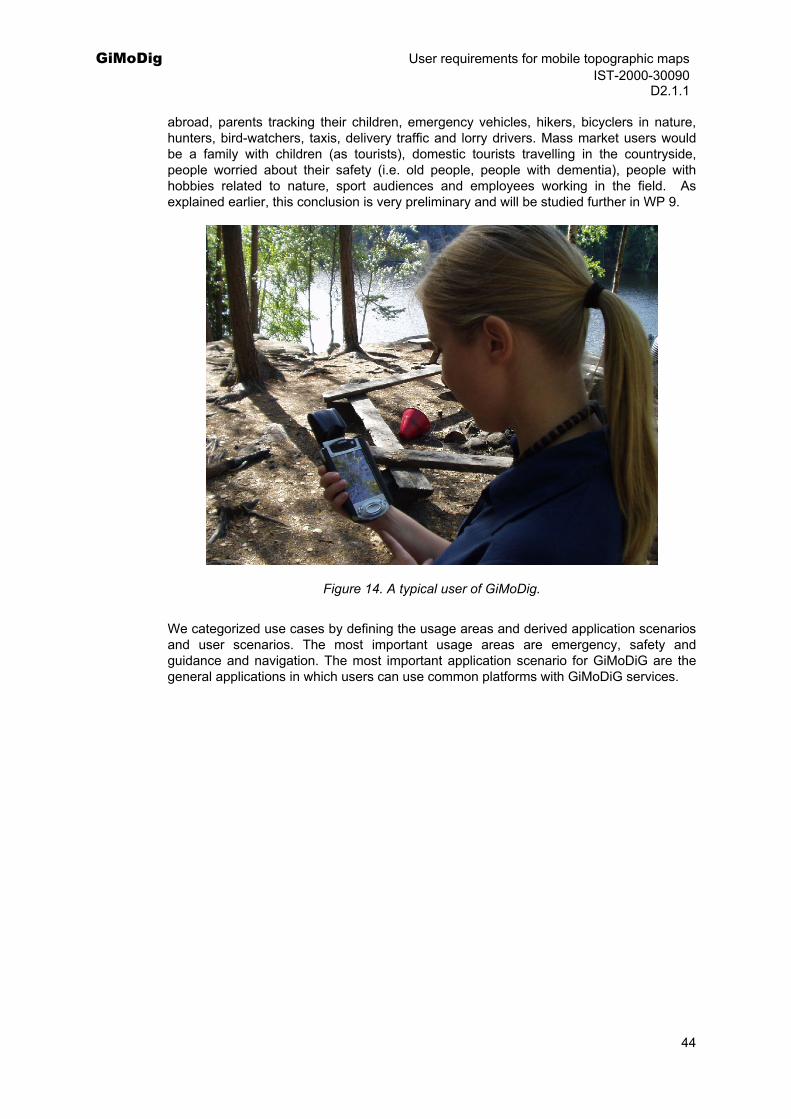
GiMoDig User requirements for mobile topographic maps IST-2000-30090 D2.1.1
abroad, parents tracking their children, emergency vehicles, hikers, bicyclers in nature, hunters, bird-watchers, taxis, delivery traffic and lorry drivers. Mass market users would be a family with children (as tourists), domestic tourists travelling in the countryside, people worried about their safety (i.e. old people, people with dementia), people with hobbies related to nature, sport audiences and employees working in the field. As explained earlier, this conclusion is very preliminary and will be studied further in WP 9.
Figure 14. A typical user of GiMoDig.
We categorized use cases by defining the usage areas and derived application scenarios and user scenarios. The most important usage areas are emergency, safety and guidance and navigation. The most important application scenario for GiMoDiG are the general applications in which users can use common platforms with GiMoDiG services.
44
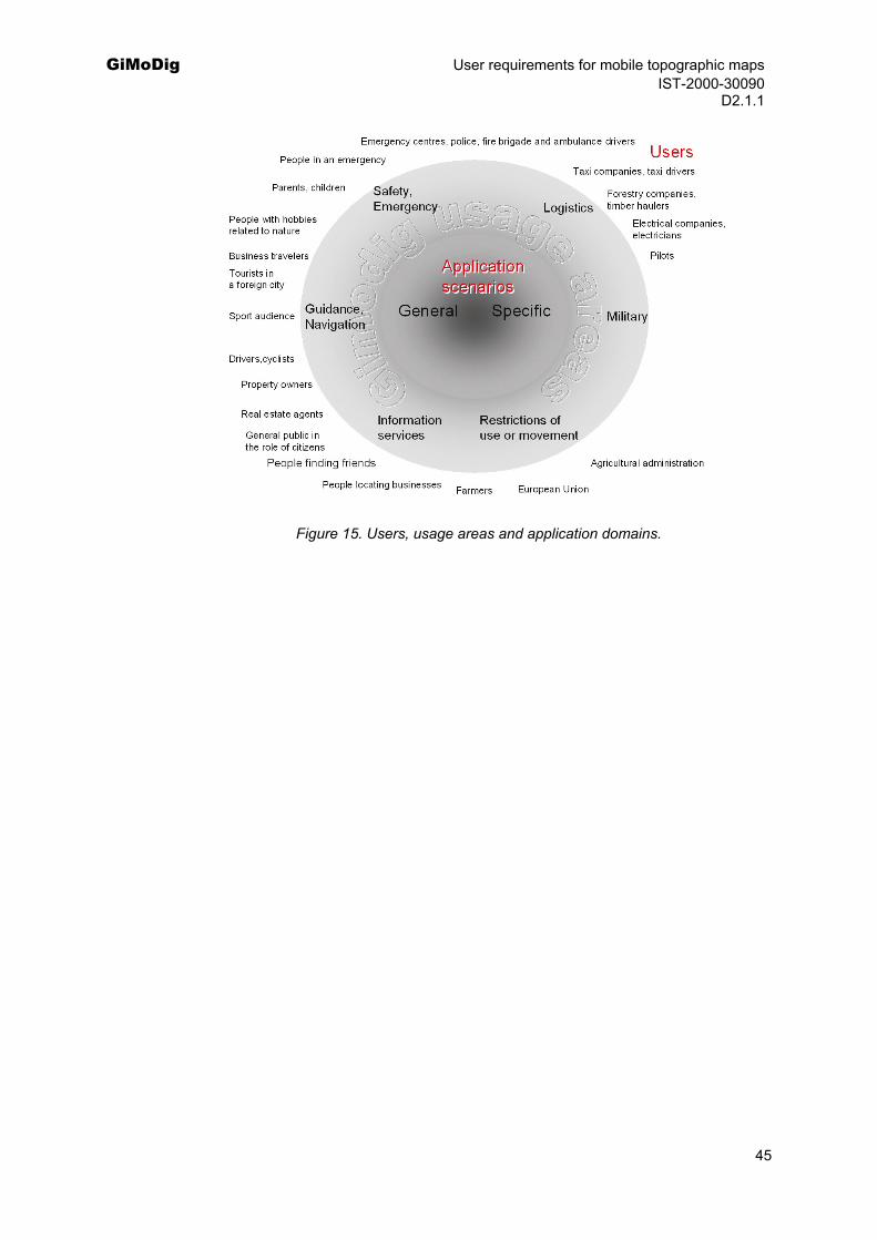
GiMoDig User requirements for mobile topographic maps IST-2000-30090 D2.1.1
Figure 15. Users, usage areas and application domains.
45
GiMoDig User requirements for mobile topographic maps IST-2000-30090 D2.1.1
Bibliography and references Anttila, V., Penttinen M., Luoma J., Nurmela J. and H. Hyppönen, 2001. User needs for personal
navigation services -phone interviews conducted in Finland. Deliverable 1, Version 1.2, NAVItarve Consortium 2001, (accessed August, 2002).
Anvil, 2000. Anvil – A Networked Virtual Interoperability Laboratory. At http://www.anvil.eu.com, (accessed October 24, 2002).
Benefon, 2002. Bird observation service. At http://benefon.com/products/esc/bird_observation_service/index.htm (accessed in October 28, 2002)
Bevan, N., 1995. Measuring usability as quality of use. Software Quality Journal, 4, pp. 115-150, at http://www.usability.serco.com/papers/qusab95.pdf (accessed October, 2002).
Bevan, N., Kirakowski, J. and J. Maissel, 1991. What is usability. Proceedings of the 4th International Conference on HCI, Stuttgart, September 1991, at http://www.usability.serco.com/papers/whatis92.pdf (accessed August, 2002).
Buttenfield, B. P., 1999. Sharing Vector Geospatial Data on the Internet. Proceedings of the 18th Conference of. the International Cartographic Association, August 1999, Ottawa, Canada, at http://greenwich.colorado.edu/babs/Bfield_Ottawa.htm (accessed August, 2002).
Bösser, T., and E.-M. Melchior, 2002. User-Centred Product Creation, Best Practice in Interactive Electonic Publisihing. Acit -Advance Concepts for interactive technology GmbH, at www.vnet5.org (accessed August, 2002).
Carrol, J.M., (ed.), 1995. Scenario-Based Design. London, John Wiley & Sons. 416 p.
CGALIES, 2002, Final report on implementation issues related to access to location information by emergency services (E112) in the European Union. At http://www.telematica.de/cgalies/ 28 January 2002, (accessed August, 2002).
Clark, L.,1991. The use of scenarios by user interface designers. In: Daiper, D. and N. Hammond, (Eds.), HCI'91 conference proceedings, pp.103-115.
Cockburn, A., 2001. Writing Effective Use Cases. Addison-Wesley, 270 p.
Daly-Jones, O., Thomas, C. and N. Bevan, 1997. Handbook of user centred design. EC Telematics Applications Programme, Project IE 2016 INUSE, NPL Usability Services, National Physical Laboratory, Queens Road, Teddington, Middlesex, TW11 0LW, at http://www.ejeisa.com/nectar/inuse/6.2/3-3.htm, (accessed August, 2002).
De Vries, M., 2001. Top10vector GML prototype: Part 1- interoperability. OEEPE workshop, November 19-20, 2001, Marne-la-Valleé, at http://www.eurogeographics.org/News/Events/oeepe_xml_workshop/powerpoint/Top10vector(devries+quak).ppt, (accessed August, 2002).
Digiroad, 2002. Digiroad material. At http://www.tiehallinto.fi/digiroad/esittelyaineistot.htm, (accessed October 24, 2002).
46
GiMoDig User requirements for mobile topographic maps IST-2000-30090 D2.1.1 EuroGeographics, 2002. EuroGeographics- Europe’s National Mapping Agencies Working for the
European Geographic Information Infrastructure. At http://www.eurogeographics.org, (accessed October 24, 2002).
Frank, A.U., 1999. Improve Public Transportation with Geographic Information: Door-to-Door Public Transportation Guidance. Presentation held at IST '99, November 24, 1999, Helsinki, Finland, at http://www.geoinfo.tuwien.ac.at/publications/frank/3196_ZumHotel_Sacher_IST99/index.htm, (accessed August, 2002).
Geake, V., 2000. Web mapping. Get mobile, it's the place to be. GIS Europe, 09/2000, at http://www.geoplace.com/ge/2000/0900/0900mob.asp, (accessed August, 2002).
GiMoDig, 2002. Geospatial info-mobility service by real-time data-integration and generalisation. IST-project No. IST-2000-30090, at http://gimodig.fgi.fi/ (accessed October 24, 2002).
Harrie, L., Sarjakoski, L. T. and L. Lehto, 2002. A variable-scale map for small-display cartography. Proceedings of the Joint International Symposium on "GeoSpatial Theory, Processing and Applications" (ISPRS/Commission IV, SDH2002), Ottawa, Canada, July 8–12, 2002, 6 p, CD-rom.
Hypergeo, 2002. Hypergeo – Easy and friendly access to geographic information for mobile users. At http://www.hypergeo.org, (accessed October 24, 2002).
Ikonen, V. and O. Sotamaa, 2002. Evaluating the Nonexistent - Picturing the Future Personal Navigation Products and Services for the Potential Users by means of Scenarios,
ISTAG, 2002. ISTAG- Scenarios for Ambient Intelligence in 2010. At ftp://ftp.cordis.lu/pub/ist/docs/istagscenarios2010.pdf, (accessed October 24, 2002).
Jarke M., Tung Bui X. and J.M. Carroll, 1999. Scenario Management: An Interdisciplinary Approach. Requirements Engineering Journal, 1999, At http://phillips.rmc.ca/archive/eee583/2000/papers/jarke-scenario-management.pdf. (accessed in July, 2002).
Jääskeläinen, J., 2002. Location technologies and Location based services from the European Commission perspective. Mobile Expo, April 16, 2002, Helsinki, presentation slides.
LoVEUS, 2002. LoVEUS project - Location aware Visually Enhanced Ubiquitous Services. At http://loveus.intranet.gr/overview.htm, (accessed October 24, 2002).
Maguire, M.,C., 1998. User-Centred Requirements Handbook. Version 3.2, June 29, 1998, at http://www.ejeisa.com/nectar/respect/5.3/index.htm, (accessed October 24, 2002).
Maporama, 2002 At http://pda.maporama.com/share/ (accessed in October 28, 2002).
Mcity, 2002, Piloting services for the inhabitants in Stockholm. At http://www.stockholm.se/templates/template_121.asp?mainframe=template_120.asp?number=28425&category=621 (accessed October 28, 2002)
NextMAP, 2002. NextMAP for transport telematics applications. At http://www.ertico.com/activiti/projects/nextmap/home.htm, (accessed October 24, 2002).
Nielsen, J., 1991. Paper versus computer implementations as mock up scenarios for heuristic evaluation. In: Daiper et al., eds., HCI-Interact '90 Conference Proceedings, pp. 315-320.
Nielsen, J. 1993. Usability Engineering. Academic Press, Boston, Table of context available at http://www.useit.com/jakob/useengbook.html, (accessed October, 2002).
47
GiMoDig User requirements for mobile topographic maps IST-2000-30090 D2.1.1 ODIN, 2002. User requirements and market trends. ODIN D 1.1, at http://www.odinproject.org/
(accessed October 24, 2002).
PALIO, 2002. PALIO- Personalised Access to Local Information and services for tourists. At http://www.palio.dii.unisi.it/, (accessed October 24, 2002).
Palmtop, 2002. A demonstration of the capabilities of TomTom, At http://www.palmtop.nl/ce/demo/ttnav_uk.html (accessed October 28, 2002)
Pandazis, J-C., 2002. Final report of the NextMap. June 21, 2002, at http://www.ertico.com/activiti/projects/nextmap/public_d.htm, (accessed August, 2002).
Paramount, 2002. Paramount project. At http://www.paramount-tours.com, (accessed October 27, 2002).
PEPTRAN, 2002. PEPTRAN - PEdestrian and Public TRAnsport Navigator. At http://www.crfproject-eu.org/sites/peptranfolder/top.htm , (accessed August, 2002).
Petäkoski-Hult, T., Kulju, M., Manninen, T., Penttinen, M., Pilke, E., Pyörre, S., Vuori,M. and J. Kivistö-Rahnasto, 2000. Navigointipalvelujen käytettävyyden varmistaminen ja käyttäjäkeskeinen tuotekehitys. In English: Assuring the usability of navigation services and human centred product design. Navikärki project internal report (available for NAVI-verkosto). March 6, 2000, in Finnish.
Pointer, 2002. Pointer – Positioning solutions. At http://www.pointersolutions.com/eng/hunting_dog_gps_view.htm), (accessed October 27, 2002).
Pointer, 2002b. Pointer – Positioning solutions. At (http://www.pointersolutions.com/eng/hunting_dog_gps_samp.htm) (accessed October 27,2002)
Poslad, S., Laamanen, H., Malaka, R., Nick, A., Buckle, P. and A. Zipf, 2001. CRUMPET:Creation of User-friendly Mobile services Personalised for Tourism. 3G 2001, Second International Conference on 3G Mobile Communication Technologies, March 2001, LondonUK.
preAnvil, 2000. Horizontal Services Scenario: An unexpected Holiday. At http://www.anvil.eu.com/showcase/holiday/holidaymain.htm, (accessed October 24, 2002).
Rakkolainen, I., Timmerheid, J. and T. Vainio, 2000. A 3D City Info for Mobile Users. Proceedings of the 3rd International Workshop on Intelligent Interactive Assistance and Mobile Multimedia Computing (IMC2000), November 9-10, 2000, Rostock, Germany, pp. 115-121.
Rakkolainen I and T. Vainio, 2001. A 3D City Info for Mobile Users. Computers & Graphics, Special Issue on Multimedia Appliances, Vol. 25, No. 4, Elsevier, pp. 619-625.
Rainio, A., 2000. Personal Navigation. NAVI programme 2000-2002, Espoo 2000, Technical Reseach Centre of Finland, VTT Research Notes 2038, 47 p. + app. 1, at http://www.inf.vtt.fi/pdf/tiedotteet/2000/T2038.pdf, (accessed August, 2002).
Rase, D., Björnsson A., Probert, M. and M.-F. Haupt, eds., 2002. Reference Data and Metadata Position Paper. Eurostat, at http://www.ec-gis.org/inspire/reports/DPP/RDM_Position_Paper_v3-0_en.doc, (accessed August, 2002).
Reichenbacher, T., 2001. The World In Your Pocket - Towards a Mobile Cartography. Proceedings of 20th International Cartographic Conference, August 6–10, 2001, Beijing, China, at http://129.187.92.218/publications/reichenbacher/ICC2001_Paper.pdf, (accessed August, 2002).
Sarjakoski, T., Sarjakoski, L. T., Lehto, L., Sester, M., Illert, A., Nissen, F., Rystedt, R. and R. Sarjakoski, T., Sarjakoski, L. T., Lehto, L., Sester, M., Illert, A., Nissen, F., Rystedt, R. and R. Ruotsalainen , 2002. Geospatial Info-mobility Services — A Challenge for National Mapping
48
GiMoDig User requirements for mobile topographic maps IST-2000-30090 D2.1.1
Agencies. Proceedings of the Joint International Symposium on "GeoSpatial Theory, Processing and Applications" (ISPRS/Commission IV, SDH2002), Ottawa, Canada, July 8–12, 2002, 5 p, CD-rom.
Sarjakoski, T., Sarjakoski, L. T., Lehto, L., Sester, M., Illert, A., Nissen, F., Rystedt, R. and R. Ruotsalainen , 2002. Geospatial Info-mobility Services — A Challenge for Interoperability and National Mapping Agencies. Proceedings of the 5th AGILE Conference on Geographic Information Science, Palma (Mallorca), Spain, April 25–27, 2002, pp. 585–589.
Sester, M., 2002. Application Dependent Generalisation - the Case of Pedestrian Navigation. Proceedings of the Joint International Symposium on "GeoSpatial Theory, Processing and Applications" (ISPRS/Commission IV, SDH2002), Ottawa, Canada, July 8–12, 2002, 6 p, CD-rom.
Sutcliffe, A.G., 1998. Supporting Scenario-Based Requirements Engineering. IEEE Transactions on Software Engineering, Vol. 24, No. 12, pp. 1072-1088.
Talentum, 2002, The most valued web web brands in Finland, at http://markkinointimainonta.talentum.com/pdf/brandit.pdf (accessed in October 28, 2002)
TopoQuads, 2002, At http://www.hunting-trail.com/Hunting_Trail_Approved/DELORME_-_3D_TopoQuads/delorme_-_3d_topoquads.html (Accessed in October 28,2002)
TourServ, 2002. TourServ - Personalised Tourist Services Using Geographic Information Systems via Internet. At http://www.tourserv.com/, (accessed in October 24, 2002).
Tourserv, 2001. TourServ User Requirements, System architecture, and System Requirements Definition. At http://www.tourserv.com, (accessed in October 2002).
TruePosition 2002. TruePosition – Enabling location based services, At http://www.trueposition.com/images/TP_HighValueApps.pdf, (accessed October, 2002).
USINACTS, 1998. At http://atwww.hhi.de/USINACTS/usinacts.html, (accessed in August 30, 2002).
VISPA, 2002. Mobile TourGuide User Interface, at http://www.paramount-tours.com/English/PARAMOUNT%20Vispa.htm (accessed in October 28, 2002)
Vivatech, 2002. Vivatech – visual services. At http://www.vivatech.de, (accessed October 27, 2002).
VNET5, 2002. VNet5 - User-Centred Product Creation in Interactive Electronic Publishing. At http://www.vnet5.org, (accessed August 30, 2002).
Vögele, T. and A. Werner, 2001. Personalized Tourist Services Using Geographic Information Systems via Internet. Presented at ENTER2001, International Congress on Tourism and Communication Technologies in Tourism, April 24-27, 2001, Montreal, Canada, abstract available at http://www.tourserv.com/, (accessed in October 2002).
Yeoman, 2002. TravelM8. At http://www.yeomannavigation.com/ (accessed in October 28, 2002)
Zacharopoulos, I. and D. Xenakis, 2002. User perspective for the future Location Services. Presented at Mobile Venue 02, Athens, May 30-31, 2002, at http://www.telecom.ece.ntua.gr/mobilevenue02/presentations/mlw_4_zacharopoulos.pdf, (accessed October, 2002).
Zipf, A., 2002. User-Adaptive Maps for Location-Based Services (LBS) for Tourism. In: K. Woeber, A. Frew and M. Hitz, eds., Proceedings of the 9th International Conference for Information and Communication Technologies in Tourism, ENTER 2002, Innsbruck, Austria, Springer Computer Science, Heidelberg, Berlin. At http://www.eml.villa-bosch.de/english/homes/zipf/ENTER2002.pdf, ( accessed October 28, 2002).
49
GiMoDig User requirements for mobile topographic maps IST-2000-30090 D2.1.1
Appendix A
GiMoDig application scenarios
1 General mobile applications
1.1 General characteristics
Giving guidance and navigation. The motivation for usage may be hobbies, working or finding services. They are usually implemented by private companies.
Information services in which the motivation is to give information on different services or traffic information. These may be government information or commercial information (i.e. advertisements) and may be used with the guidance and navigation applications.
Safety and emergency. The motivation for usage may be e.g. child tracking or locating an incident site.
These services would be targeted either for all or some of the usage areas mentioned.
Related user scenarios:
Locating a taxi driver,
A forest owner and timber hauler,
A fisherman in the Tornio/Haaparanta area,
Hiking in Nuuksio National Park,
Family with children on a camping trip,
Guidance in aviation hobbies,
Guidance for a user in a city area,
Related existing user scenarios:
An Unexpected holiday
Maria the road warrior
50
GiMoDig User requirements for mobile topographic maps IST-2000-30090 D2.1.1
2 Specific applications
2.1 Logistics
f) These could include fleet, property and workforce management,
g) Emergency services, E911, E112.
Related user scenarios:
Locating a taxi driver,
A forest owner and timber hauler,
An electrician fixing power lines after a major storm,
Emergency services in cross-border operations,
Related existing user scenarios:
FleetASAP,
Follow the fleet.
2.2 Restrictions of use or movement
Motivation for these services arises from society, and may include tracking prisoners, transportation of goods or no-go zones.
Related user scenarios:
Locating a taxi driver,
A forest owner and timber hauler,
A fisherman in the Tornio/Haaparanta area,
An official inspecting the use of EU subsidies.
2.3 Military applications
We will not describe military applications.
51
GiMoDig User requirements for mobile topographic maps IST-2000-30090 D2.1.1
Appendix B
GiMoDig user scenarios
1 Locating a taxi driver having an emergency
Descripition: A taxi driver picks up a customer on a street in Helsinki, Finland. He is going to an address, Kuutamokuja 2, in Lahti. The driver does not know the Lahti area very well so he uses his mobile service to locate the address. He finds out the route (road navigation service is offered by the Finnish Digiroad service; Digiroad, 2002) and starts the journey. They drive to the Mäntsälä area when the customer says that he wants to stop near the next bus stop. They are not in the urban area and the driver stops. Suddenly the customer attacks the driver and tries to stab him. Luckily, the driver avoids him and presses the emergency button on his mobile device. The siren starts and the attacker is scared away and runs to the forest. The emergency centre and the taxi driver’s company receives the alert and locate the driver (this is a GiMoDig service). They note that the driver is located near the Mäntsälä area and alert the police. A police patrol car arrives in 10 minutes and the taxi driver shows which way the attacker went. The police patrol is using a GiMoDig service with topographic maps to study the region and they see that there are some houses nearby. They call back to the emergency centre and ask to warn people not to go outside. The local public emergency centre uses the public emergency service to mark the zone as unsafe and issue a warning. Most of the people have a GiMoDig application where they can be alerted when this type of incidents occurs. A jogger in the forest is alerted by her GiMoDig application that this area is unsafe and she immediately leaves the area. Finally, the police with auxiliaries locate and apprehend the attacker and the incident is over.
Special considerations:
GiMoDig usage areas: safety, emergency restriction of use or movement
End-user goals:
A taxi driver: locate him/herself get route guidance get help in an emergency
Emergency centre: locate the taxi driver get a topographic map of the area
warn people (geofencing)
Police patrol: get a topographic map get topographic features (houses)
A jogger: locate herself
52
GiMoDig User requirements for mobile topographic maps IST-2000-30090 D2.1.1
get a warning about unsafe areas get guidance get a topographic map
User groups: taxi companies emergency centres, Police, Ambulance taxi drivers public
Usage environment: in a vehicle, outside, inside
Dataset requirements (Context modelling):
A) The conceptual modelling of topographic databases
For this example there are no special requirements for conceptual modelling of topographic databases. The present modelling of features is sufficient if the incident has no cross-border aspect. However, the incident could also happen across several countries in which case the topographic data set should be harmonised.
B) Data content
1:250 000 Topographic data set 1:100 000 Topographic data set 1:50 000 Topographic data set 1:10 000/20 000 Topographic data set Topographic features (Buildings, forests, roads, administrative areas, contour lines, built-up areas, fields and open areas) Road data (with address information and other navigation information) City maps
C) Quality of data sets
The accuracy demand would be 10-20 m.
D) Interoperability with other data sets (coordinate system, data quality, exchange format)
The datasets should be compatible with each other. Cross-border aspects: In this example there are no cross-border aspects. However, this incident could very well be applied to a border area as well, in which case the emergency centres and the police patrol would require topographic maps from both countries.
Technical requirements:
Portrayal of data: A 3D view would be useful for the police patrol in order to assess the terrain.
53

GiMoDig User requirements for mobile topographic maps IST-2000-30090 D2.1.1
Real-time integration: The integration of several services is required: The Digiroad service should be interoperable with the GiMoDig application. The public emergency system should be connected to the application.
Real-time generalisation: From the jogger’s point of view, she needs to know only how she is able to leave the area. Thus the service could pinpoint the paths and tracks that she could use (the shortest or the fastest track). On the other hand the jogger probably knows the area very well so she may only need the generalised picture of the area.
Figure 16. Integration of GiMoDig with other services.
54
GiMoDig User requirements for mobile topographic maps IST-2000-30090 D2.1.1
2 A forest owner and a timer hauler
Description: Mr. Mattila is a retired man who manages his forests by himself. He has been cutting pine trees in an area where there are several property owners. He has located his property borders using the GiMoDig service offered by the National Land Survey of Finland. He has bought a mobile device with Global Positioning System locator, and the GiMoDig service currently also offers a locating service for property borders. He marks the property lines to ensure that he does not cut down the trees of neighbouring Ms. Pampula, who is quite strict about her property. Mattila thinks that these modern mobile services are quite good, and appreciates that the service can locate someone in an emergency. His wife can also locate his whereabouts by using the service. After 2 days of working he finishes the job and sends the location of the wood piles to a forestry company. He has arranged that the company will come and pick up the wood when the job is completed. The company gets the message and a driver is giver an work order to haul Mr. Mattila's wood. He uses the company's route service to find the best possible route to the log piles. He also notes that the road to the property may not be quite fit for his vehicle because the road classification indicates the possibility of poor carrying capacity during this season. He phones the owner and confirms that the road is fit for the purpose. He gets to the property and notes that there are several log piles in the vicinity. Ms. Pampula has also contacted the company and asked that some of her trees to be cut down. Since he is not certain which wood piles are to picked up the driver contacts the GiMoDig service and checks to see the owners of properties in this area. When assured that he is in the right place he loads up the logs.
Special considerations:
GiMoDig usage areas: logistics, guidance and navigation, restriction of usage, emergency
End user goals:
Mr. Mattila: locate himself locate property borders get help in an emergency send location information of logs to the forestry company
Wife: locate other people (Mr. Mattila)
Forestry company: locate trucks
Log driver: get route guidance locate property get a topographic map get topographic features (road class) to determine the
carrying capacity of the road
User groups: forest owners forestry companies
Usage environment: inside, in a forest, in a vehicle
55
GiMoDig User requirements for mobile topographic maps IST-2000-30090 D2.1.1
Dataset requirements (Context modelling):
A) The conceptual modelling of topographic databases
For this example there are no special requirements for conceptual modelling of topographic databases. The present modelling of features is sufficient.
B) Data content
1:250 000 Topographic data set 1:100 000 Topographic data set 1:50 000 Topographic data set 1:10 000/20 000 Topographic data set Topographic features (forests, roads, administrative areas, contour lines, built-up areas, fields and open areas) Road data (with address information and other navigation information) Cadastral information (borders)
C) Quality of datasets
The accuracy demand would be 10 - 20 m.
D) Interoperability with other datasets (coordinate system, data quality, exchange format)
The datasets should be compatible with each other. Cross-border aspects: In this example there are no cross-border aspects.
Technical requirements:
Portrayal of data:
Real-time integration: integration with cadastral boundaries is required
Real-time generalisation: selection of features
56
GiMoDig User requirements for mobile topographic maps IST-2000-30090 D2.1.1
3 A worker fixing power lines after a major storm
Descripition: A heavy storm and wet snow have brought down several hundred trees over the power lines. 22 000 households in the district of Sweden have lost electricity and the electric company is getting alarms. There are several power lines to be checked so the rescue workers are alerted. Customers complaining of power cuts are identified by using their address, so that the company can locate the approximate location of the problem.
The supervisor gives each worker a segment to clear from fallen trees. The segment is depicted on a map. The workers are guided and the supervisor follows the work from the service car. The personal security module is activated. The worker calls for assistance, if help is required. The worker marks the position for trees that should be cut later. The worker reports, when the segment is cleared and waits for new instructions. The supervisor directs him to another segment.
Special considerations:
GiMoDig usage areas: safety and emergency logistics information
End user goals:
A worker: locate himself get route guidance get help in a emergency
Emergency centre: locate the worker get a topographic map of the area
The company: to give information on the progress of the clearance record data for future maintenance
A supervisor: locate the workers direct the workers plan the further work get a warning about unsafe areas get guidance get direct reports
Customers: get a service (electricity)
User groups: power and telephone companies emergency centres, Ambulance customers to the companies employees of these companies
Usage environment: in a vehicle, outside and inside office outdoor in rough climate
57
GiMoDig User requirements for mobile topographic maps IST-2000-30090 D2.1.1
Dataset requirements (Context modelling):
A) The conceptual modelling of topographic databases
For this example there are no special requirement for conceptual modelling of topographic databases. The present modelling of features is sufficient.
B) Data content
1:250 000 Topographic data set 1:100 000 Topographic data set 1:50 000 Topographic data set 1:10 000/20 000 Topographic data set Topographic features (Buildings, forests, roads, administrative areas, contour lines, built-up areas, fields and open areas) Road data (with address information and other navigation information) Maps of power and telephone lines
C) Quality of datasets
The accuracy demand would be 10 - 20 m.
D) Interoperability with other datasets (co-ordinate system, data quality, exchange format)
The datasets should be compatible with each other. Cross-border aspects: In this example there are no cross-border aspects. However, this incident could very well be applied to a border area as well, in which case the emergency centres and they would require topographic maps from both countries.
Technical requirements:
Portrayal of data: A 2d viewer. Some features highlighted. Colour.
Real-time integration: There is a requirement to integrate several services: First of all the application must be included in the maintenance system of the company. The public emergency system should be connected to the application.
Real-time generalisation: All user group mentioned must have possibilities to zoom in and out
58
GiMoDig User requirements for mobile topographic maps IST-2000-30090 D2.1.1
4 A fisherman in the Tornio/Haaparanta area
Description: Mr. Kauppila is a middle-aged man who is taking a fishing and boating trip in the area of the Tornio River valley in Finland. The area is near the Swedish border and his fishing licence only covers areas inside Finland. Mr. Kauppila has hired a GiMoDig service for his mobile device to get guidance during his trip.
At the beginning of his trip he takes a look at the overview map of the area from his mobile device. He asks the service to show “all the good spots for fishing salmon”. The service gives him a map “adapted specially for him” indicating all the good fishing spots. Mr. Kauppila chooses one of the places by pointing out it on the screen and he obtains more information on the place itself and also services nearby. With all this information it is easy for him to make a decision about where to go and stay for the first few days.
On the 3rd day of his staying, Mr. Kauppila is so exited about the good fishing fortune he had, that he is not paying a lot of attention to his location. He is just following his instincts where to get even bigger salmons, and at the same time his boat is drifting closer and closer to the border of the fishing licence (which in this case happens to be the national border of Finland and Sweden). Luckily, Mr. Kauppila’s mobile device is aware of the location of its user and when Mr. Kauppila gets too close to the national border the device gives an alarm signal. From the screen Mr. Kauppila can see his location on the map and the border he is approaching, emphasized on the map. The map also shows topographic information (waterways, contour lines etc.) from both sides of the border. It is also suggested on the map to which direction Mr. Kauppila should go. He turns his boat and goes further from the border, and after a couple of hours, he gets the biggest salmon ever!
Special considerations:
GiMoDig usage area: restrictions for use or movement guidance
End user goals: locate himself get a topographic map of the area get a special map (with waterways, with the area covered by the fishing licence, etc.) get a warning when going too close to the border get more information about the restricted area
User groups: people moving near the border area on their leisure time (fishermen, hunters, berry and mushroom pickers, hikers)
people moving near the border area because of their occupation (border guard authorities, forestry workers, surveyors etc)
Usage environment: outdoors
59
GiMoDig User requirements for mobile topographic maps IST-2000-30090 D2.1.1
places where there are some restricted areas for people (fishing licence areas, national parks, military areas, archipelago nature protection areas, national borders)
in all weather conditions
Dataset requirements (context modelling):
A) The conceptual modelling of topographic database: For this example there are no special requirements for conceptual modelling of topographic databases. The present modelling of features is sufficient. B) Data content 1:250 000 Topographic data set 1:100 000 Topographic data set 1:50 000 Topographic data set 1:10 000/20 000 Topographic data set Topographic features (names, waterways, forests, roads, buildings, administrative areas, contour lines, fields, bedrocks). Coverage of the fishing license areas. Different cabins in the area provided by the Finnish Forest and Park Service. Tourist maps with additional information on the points of interests in the area. C) Quality of datasets The accuracy demand would be at least 10 - 20 m. D) Integration with other datasets (coordinate system, data quality, exchange format) Topographic data must be integrated with the Forest and Park Service data, with tourist map data and with fishing licence information. Cross-border aspects: The system should be able to integrate maps from the border area of the 2 countries. Choice of the language for the map names should be optional in the cross-border areas.
Technical requirements:
Portrayal of data: No specific needs for 3D images. Real-time integration: Real-time integration among the topographic data, tourist
maps data and fishing licence area information should work seamlessly.
Real-time generalisation: Needed for making adaptive maps: maps with different
degrees of information, maps with enhanced country borders, overview maps of the area, maps with detailed information on the fishing licence area and maps with route guidance to be able remain inside the area covered by the fishing licence.
Others: The user must not be expected to have both hands free
for using a mobile device. Therefore the user should be
60
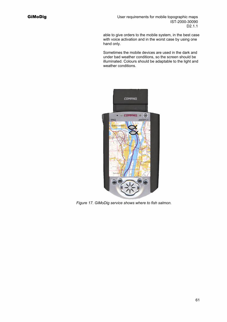
GiMoDig User requirements for mobile topographic maps IST-2000-30090 D2.1.1
able to give orders to the mobile system, in the best case with voice activation and in the worst case by using one hand only.
Sometimes the mobile devices are used in the dark and under bad weather conditions, so the screen should be illuminated. Colours should be adaptable to the light and weather conditions.
Figure 17. GiMoDig service shows where to fish salmon.
61
GiMoDig User requirements for mobile topographic maps IST-2000-30090 D2.1.1
5 Hiking in Nuuksio National Park
Description: Family Virtanen, mother (Maija) and father (Esko), in their fifties, with two teenagers (Matti and Liisa), are going to hike over the weekend in Nuuksio National Park. They use GiMoDig service and their mobile devices to get route guidance during the hiking in Nuuksio.
They start the trip from Helsinki, Vuorela, and first they want to get route guidance to Nuuksio from Vuorela. The service gives them an overview roadmap, where the route from Vuorela to Nuuksio is highlighted and their location on the map. When the father is driving towards Nuuksio, the mother gives advices according to the route guidance in mobile device.
It is the end of the summer and it has not been raining for a long time. Therefore the hikers are not allowed to build up any open fires since it may cause a forest fire. This meteorological information is delivered to family Virtanen’s mobile phones by the system when they arrive at the National Park area. Maija wants to know also other information about what people are allowed to do in national parks and what is forbidden. By selecting the area from the screen she obtains more detailed information on the area: People are not allowed to pick flowers, cut trees and disturb animals.
At the beginning the family wants to see the map of the whole Nuuksio area and also zoom into certain places. All the maps they use are delivered to their mobile devices by the GiMoDig service. Depending on the scale there are different symbols shown on the map, which they can point and select to get more detailed information on the POIs. They can also scroll the screen view outside the National Park area.
First the family Virtanen wants to find a camping place they can sleep in a tent during the coming night. They ask the service to show all the campsites nearby. Since they are not bringing much water with them, the group chooses a campsite near Haukkalampi that has a tap water connection. When choosing this campsite, they receive the distance from their present location, measured along a suitable hiking route.
Maija and Esko are more adventuresome and want to hike off-trail. There is an option in the mobile device where they can ask for guidance for the straightest route to Haukkalampi. They get a topographic map showing waterways, hills and swamps, as well as the shortest route to the camping place. The map is oriented along the direction the user is walking giving also instructions if the hikers stray from the route. But in some cases they choose to ignore this guidance, since they have to avoid some natural obstacles in the route (i.e. blocks and swamps). Afterwards they get guidance back to the route by the device.
During their second day of hiking it starts raining heavily (like cats and dogs). All the equipment is soaking wet and the family decides to go to an unoccupied cottage. By asking ‘Show me the nearest unoccupied cottages’ the mobile device answers that there are no free cottages in the area, to which you can go without making a reservation and paying beforehand. They decide to ask where a ‘lean-to’ may be found. This turns out to be near by Holma-Saarijärvi. Guidance leads them to the right place.
After arriving at Holma-Saarijärvi, Liisa ja Matti, who don’t like the rain at all, decide to go home right away by bus. They ask help from the mobile device: “Where is the nearest public transportation going and at which time?”. The GiMoDig service communicates with
62
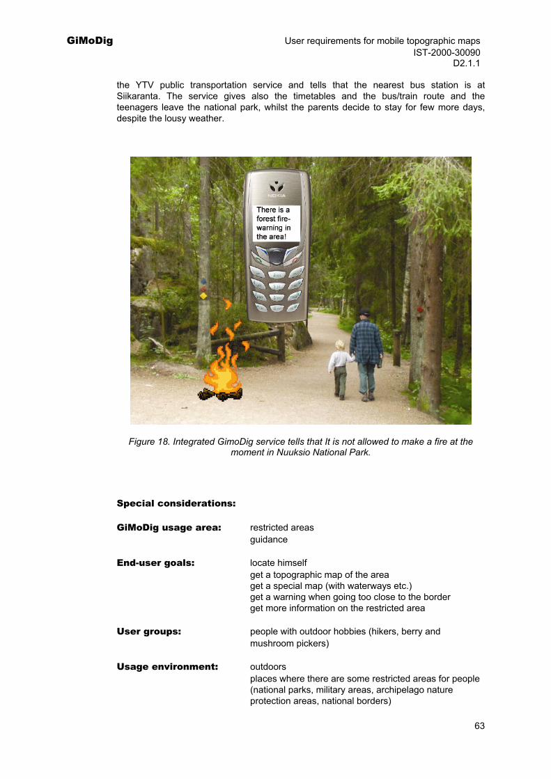
GiMoDig User requirements for mobile topographic maps IST-2000-30090 D2.1.1
the YTV public transportation service and tells that the nearest bus station is at Siikaranta. The service gives also the timetables and the bus/train route and the teenagers leave the national park, whilst the parents decide to stay for few more days, despite the lousy weather.
Figure 18. Integrated GimoDig service tells that It is not allowed to make a fire at the moment in Nuuksio National Park.
Special considerations:
GiMoDig usage area: restricted areas guidance End-user goals: locate himself get a topographic map of the area get a special map (with waterways etc.) get a warning when going too close to the border get more information on the restricted area
User groups: people with outdoor hobbies (hikers, berry and mushroom pickers)
Usage environment: outdoors places where there are some restricted areas for people (national parks, military areas, archipelago nature protection areas, national borders)
63
GiMoDig User requirements for mobile topographic maps IST-2000-30090 D2.1.1
Under all weather conditions
Dataset requirements and context modelling:
A) The conceptual modelling of topographic database:
For this example there are no special requirements for conceptual modelling of topographic databases. The present modelling of features is sufficient.
B) Data content
1:250 000 Topographic data set 1:100 000 Topographic data set 1:50 000 Topographic data set 1:10 000/20 000 Topographic data set Topographic features (names, waterways, swamps, rivers, forests, roads, buildings, administrative areas, contour lines, fields, bedrocks). Various cabins and campsites in the area provided by Finnish Forest and Park Service. Tourist maps with additional information on the POIs in the area. Meteorological data with forest fire warning area information.
C) Quality of data sets
The accuracy demand would be at least 10 - 20 m.
D) Interoperability with other datasets (coordinate system, data quality, exchange format)
Topographic data must be integrated with Forest and Park Service, tourist maps, meteorological data and public transportation service.
Cross-border aspects: The system should be able to integrate maps from the border area of the 2 countries. The choice of language for the map names should be optional in the cross-border areas.
Technical requirements:
Portrayal of data: Terrain in 3D would give valuable information.
Real-time integration: Real time integration with topographic data, tourist map data, meteorological data and public transportation data should work seamlessly.
Real-time generalisation: The user should be able to zoom the map and watch the route at different scales. Real-time generalisation is needed to make user-specific adaptive maps: maps with waterways, basic roads and route guidance to find POIs etc.
Others: After deciding the route the user should get guidance about the route he plans to walk. If the user strays from the route, he is notified and guided back to the route. He
64

GiMoDig User requirements for mobile topographic maps IST-2000-30090 D2.1.1
can ignore the route guidance in some situations, for example when the planned route is too difficult to walk.
It is often foreigners who visit national parks. They should be able to choose the language before starting to use the service (e.g. Finnish, Swedish, English).
Hikers also want to know the total distance walked during hiking.
A digital compass may also be needed in some situations, e.g. with advanced users who are familiar with orienteering.
65
GiMoDig User requirements for mobile topographic maps IST-2000-30090 D2.1.1
6 An official inspecting the use of EU subsidies
Description: Inspector Svensson working for Swedish agricultural administration is visiting family Johansson’s farm in southern Sweden. Mr. Svensson has a duty to measure fields and crops to be compared with the farmer’s application. He has a mobile device connected to the main database and service hired from GiMoDig.
At first the inspector is guided to the farm by his mobile device. He downloads the data for the farm. Using a GPS connected to the laptop he records the corners of each field and the crop. He sends the data to the national land parcel database. Farmer Johansson has also access to the national land parcel database. Using his GiMoDig application he can verify the results and record changes to the database directly. Special considerations:
GiMoDig usage area: restrictions for use or movement information
End user goals: The data collector: locate himself
get route guidance get help in emergency receiving attribute information on land parcels
The farmer get information on parcel locations
User groups: field surveys professionals EU
farmers agricultural administration in EU countries
Usage environment: in a vehicle, on foot, outdoors, indoors.
Dataset requirements (Context modelling):
A) The conceptual modelling of topographic database: Harmonisation of topographic data with the land parcel data e.g. boundaries of the agricultural land. B) Data content 1:250 000 Topographic data set 1:100 000 Topographic data set 1:50 000 Topographic data set 1:10 000/20 000 Topographic data set Topographic features (Buildings, forests, roads, administrative areas, contour lines, built-up-areas, fields and open areas) Road data (with address information and other navigation information)
66
GiMoDig User requirements for mobile topographic maps IST-2000-30090 D2.1.1
City maps Land parcel database C) Quality of datasets Built-in GPS: The accuracy demand would be 0.5 m. D) Integration with other datasets (coordinate system, data quality, exchange format) The datasets should be compatible with each other Cross-border aspects: Not relevant for this service from the end-user point of view. The national reference is adequate for users. From the service providers’ point of view the international border lines should be edge-matched. A harmonized data model should be available with feature types related to cultivation needs, roads, water framework.
Technical requirements:
Portrayal of data: No specific needs for 3D images. Real-time integration: Real time integration of parcel datasets and the
topographic data. The integration is based on unified coordinate system.
Real-time generalisation: Real time generalisation is related to finding a parcel
location and presenting parcel attributes.
Figure 19. How large are my parcels?
67
GiMoDig User requirements for mobile topographic maps IST-2000-30090 D2.1.1
7 Family with children on a camping trip
Description: Family Rasmussen: father Niels, mother Hanne and their two children, Anker and Svend, are going for a combined bicycle and camping trip for the summer. Before going to the trip they plan a suitable route for each day and locate convenient camping sites by using the different topographic and camping maps delivered to their mobile devices by the GiMoDig-service. Because they are planning to travel by bicycle, they want to avoid major roads and find a “route with a view” with nice places to go. Specially Anker and Svend are interested in visiting all the amusement parks along the route so this must be considered too when planning the trip. When they find places that they are interested in, they can save the addresses of these points of interests (POIs) in their mobile devices. After deciding the route they are planning to cycle, the places they are going to visit and the hotels and camping places they are going to stay over night, they ask the service to show also all the other hotels and camping places along the route, just in case they want to change their plans during their trip.
Before going to the trip family Rasmussen also makes a deal with some of their relatives so that they will be able to track family’s location during their cycling trip according to Tvede’s mobile devices location. The farther is an enthusiastic bird watcher, so he also joins a service that allows him to use a bird watcher alarm, so that he is notified when interesting appearances occur and where they occur.
Finally the family is cycling at the Læsø island. Suddenly there is a broken bottle on the road and Hanne’s bicycle wheel is broken. They need to find the nearest bicycle repairer. Hanne switches on the device, which initialises and locates itself automatically. After that she is confronted with a question: ‘Where do you want to go?’ followed by a list of themes (like: address, camping site, points of interest, health, safety, bicycle repairer, shopping etc.) and the choice of ‘point out destination on map’. From this list Hanne selects the intended object, which will be displayed on the background of a map to give the user the opportunity to check if it is the right object. In case of ‘okay – continue’ is chosen, the device calculates the route from present position to the selected object. The route will be presented on a map and the distance along the route is displayed. As long as the user moves along the desired route the device automatically recalculates the route regarding remaining distance and estimated time arrival (according to actual speed). If the user misses the route the device automatically recalculates the route and gives the warning ‘original route has been left – new route is being calculated’.
Special considerations:
GiMoDig usage area: guidance information services
safety and emergency
End user goals: locate himself locate other people get specific maps with the information needed for planning a bicycle and camping trip get route guidance
User groups: tourists people planning holiday trips
people on holidays parents
68
GiMoDig User requirements for mobile topographic maps IST-2000-30090 D2.1.1
children bird watchers bikers
Usage environment: outdoors indoors on foot
Dataset requirements (Context modelling):
A) The conceptual modelling of topographic databases: For this example there are no special requirements for conceptual modelling of topographic databases.The present modelling of features is sufficient B) Data content Maps of scale 1:100 000 and 1:200 000, which are the traditional scales for bicyclists, will be the inspiration for these maps. This ‘scale’ or resolution will also reduce the need for precise location, i.e. cell-based location should be satisfactory.
Topographic features (Buildings, forests, roads, administrative areas, contour lines, built-up-areas, fields and open areas) Road data (with address information and other navigation information)
Camping maps City maps Information of weather conditions, birds, repair shops Tourist information (campsites, hotels, POIs)
C) Quality of datasets The accuracy demand would be at least 10 - 20 m.
D) Integration with other datasets (coordinate system, data quality, exchange format) The datasets should be compatible with each other Cross border aspects: Topographic data must be integrated with tourist maps, meteorological data and city maps. The system should be able to integrate maps from the border area of the 2 countries. The choice of language for the map names should be optional in the cross-border areas.
Technical requirements:
Portrayal of data: Terrain in 3D would give valuable information Directions as arrows to the right, the left, straight forward
etc. Moving map (up, down, right, left) with the actual position in the middle
Maps presented in bird's-eye view and oriented towards the destination.
Audiovisual guidance when cycling
69
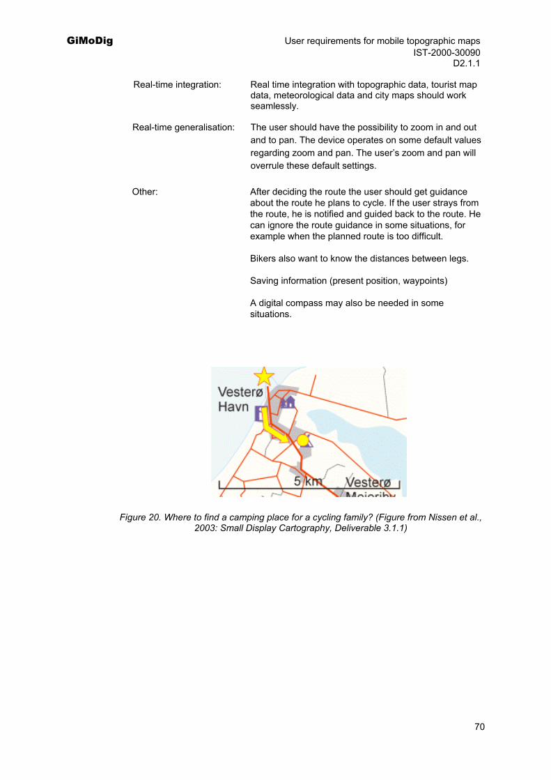
GiMoDig User requirements for mobile topographic maps IST-2000-30090 D2.1.1
Real-time integration: Real time integration with topographic data, tourist map data, meteorological data and city maps should work seamlessly.
Real-time generalisation: The user should have the possibility to zoom in and out
and to pan. The device operates on some default values regarding zoom and pan. The user’s zoom and pan will overrule these default settings.
Other: After deciding the route the user should get guidance
about the route he plans to cycle. If the user strays from the route, he is notified and guided back to the route. He can ignore the route guidance in some situations, for example when the planned route is too difficult.
Bikers also want to know the distances between legs.
Saving information (present position, waypoints)
A digital compass may also be needed in some situations.
Figure 20. Where to find a camping place for a cycling family? (Figure from Nissen et al., 2003: Small Display Cartography, Deliverable 3.1.1)
70
GiMoDig User requirements for mobile topographic maps IST-2000-30090 D2.1.1
8 Emergency services in cross-border operations
Description: During a hot summer with a long period of no rain, a forest fire breaks out just north of the Danish-German border. The fire spreads fast and threatens settlements on both sides of the border. Most of the fire is in the Danish area, but parts of the site are better accessed from the German side. All available fire brigades in the area get involved. The operations are coordinated from a Danish headquarters. Special equipment including SAR airborne rescue services are provided from the nearby German city of Flensburg.
The headquarters tracks the situation on a digital map. The topographic base data are acquired and harmonized on-line from the national databases of Denmark and Germany. Information on critical sites such as petrol stations, petrol tanks or pipelines is added from national security databases. The position of fire fighters and fire engines is transferred from the GPS units of the mobile devices to the headquarters and marked on the plan. The mobile devices from both countries rely on the standardized GiMoDig interface, so communication is no problem. The fire fighters report the status of the fire using the topographic maps on their mobile display. Furthermore, the scene is relayed from digital cameras onboard helicopters. The headquarters incorporates all information in the thematic map. The fire fighters can download this map to their mobile devices.
The headquarters detects the nearest watercourses from the topographic map and identifies the hydrants from the databases of the local water supply. They outline an infrastructure of access roads that must be kept clear of parked fire engines and other vehicles. On some of the narrow roads they specify a temporary one-way system or coordinate the movement of individual vehicles so that they do no get into each other’s way. Spread of the fire is predicted from the actual situation, weather forecast and data on land use from the topographic database. Address data are collected for the threatened areas to be prepared for evacuation and closure of roads or other infrastructures.
The fire continues into the night. Suddenly the direction of the wind changes and several fire fighters have to escape immediately. The headquarters marks suitable escape paths on the plan and transmits it to the local mobile displays. With the help of the GPS and the map on their mobile devices the fire fighters find their vehicles and drive away in time during the darkness although visibility is limited to a few metres.
In the morning the fire is under control. However some peat material continues to burn under the surface. With a special camera a thermal image is taken from a helicopter. The hot spots are marked on the topographic map and loaded into the mobile device. By means of the GPS the fire fighters are guided to the critical spots. They examine the scene and extinguish the fire if necessary.
Special considerations:
GiMoDig usage area: safety and emergency
End user goals:
Fire fighter locate himself locate other people
be located by other people get a topographic map of the area get a thematic map of the area
71
GiMoDig User requirements for mobile topographic maps IST-2000-30090 D2.1.1
get route guidance locate a georeferenced feature (area, point, line)
report a feature including its georeference
Emergency centre locate other people get a topographic map of the area distribute a thematic map of the area locate a georeferenced feature (area, point, line)
User groups: police ambulance fire brigade, fire fighters emergency centre
Usage environment: indoors outdoors in a vehicle on foot
Dataset requirements (Context modelling):
A) The conceptual modelling of topographic databases
The application requires a detailed road network that includes any road and path suitable for vehicles.
B) Data Content
Topographic data set 1: 10.000 Topographic data set 1: 50.000 for overview. List of dangerous sites (petrol stations, pipelines, chemical plants, etc.) with georeference Spatial information on water supply: watercourses, lakes, hydrants Thematic information on the status of the fire, compiled from reports and interpretation of aerial images.
C) Quality of the datasets
The accuracy demand would be 3 - 10 m.
D) Interoperability with other datasets
The data must be suitable for GPS navigation.
The thematic data have no need for consistent geometry with the topographic data, but overlay should be precise within the accuracy demands.
Cross-border aspects: The cross-border situation requires a seamless topographic dataset.
Technical requirements:
Portrayal of data: Topographic map used as background, fire fighter logistics and fire situation to be displayed on top of the topographic map.
72

GiMoDig User requirements for mobile topographic maps IST-2000-30090 D2.1.1
Real-time integration: Integration of individual point features (vehicles, people) by coordinates, Integration of information on dangerous sites by coordinates or by addresses.
Real-time generalisation: Real-time generalisation is required to adapt the map area to extension of the emergency scene and/or area operation.
73
GiMoDig User requirements for mobile topographic maps IST-2000-30090 D2.1.1
9 Guidance in aviation hobbies
Description: Herbert Graf von Hoya's passion is flying his hot-air balloon. On a Saturday in May he has invited 4 of his best friends to accompany him on a trip from the island of Sylt. The weather is fine with no clouds and a fresh wind from the sea. Two hours before sunset the party ascends from a meadow near Kampen. They carry the necessities including their GiMoDig device and a case of excellent French wines. The balloon crosses the tidal flat areas and continues over land along the German-Danish border. Butler Johann follows the balloon with the pursuit car. Herbert Graf von Hoya has activated the GiMoDig service that tracks the balloon on a topographic map, calculates height over ground from GPS and Digital Terrain Model, and checks in permanent mode the direction of flight for registered height obstacles and restricted areas. The balloon travels without trouble, and half an hour before sunset the pilot searches the topographic database for a suitable landing place. The ideal place has to be clear of buildings and trees, in some distance from dangerous installations such as high-voltage lines, and be accessible from roads nearby. Herbert Graf von Hoya finds a place and performs a smooth landing. Butler Johann locates the landing place on his GiMoDig device and obtains directions from the routing system. He meets the party in time to pick up the balloon and passengers before night fall.
Special considerations:
GiMoDig usage area: guidance restrictions for use or movement
End-user goals: locate himself get route guidance find and use services nearby locate a georeferenced feature (area, point, line)
User groups: pilots
Usage environment: small aircraft, helicopter, balloon
Dataset requirements (Context modelling):
A) The conceptual modelling of topographic databases
The database should provide landmark features for orientation and information on height of terrain and prominent artificial features.
B) Data content
Topographic dataset 1: 10.000 Topographic datasets 1: 50.000 and 1: 250.000 for overview. List of flight obstacles Information on radio frequencies Digital terrain model
C) Quality of the datasets
74
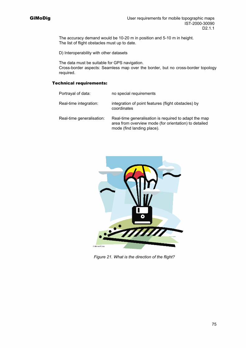
GiMoDig User requirements for mobile topographic maps IST-2000-30090 D2.1.1
The accuracy demand would be 10-20 m in position and 5-10 m in height. The list of flight obstacles must up to date.
D) Interoperability with other datasets
The data must be suitable for GPS navigation. Cross-border aspects: Seamless map over the border, but no cross-border topology required.
Technical requirements:
Portrayal of data: no special requirements
Real-time integration: integration of point features (flight obstacles) by coordinates
Real-time generalisation: Real-time generalisation is required to adapt the map area from overview mode (for orientation) to detailed mode (find landing place).
Figure 21. What is the direction of the flight?
75
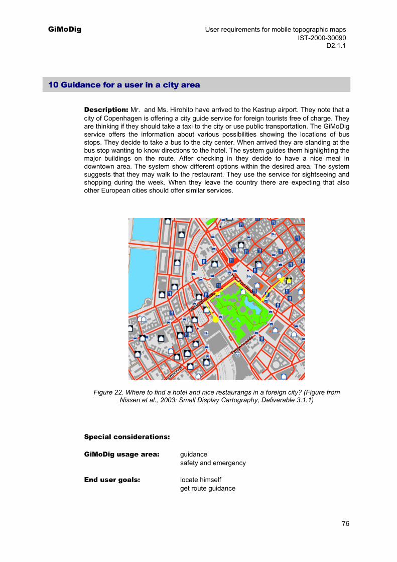
GiMoDig User requirements for mobile topographic maps IST-2000-30090 D2.1.1
10 Guidance for a user in a city area
Description: Mr. and Ms. Hirohito have arrived to the Kastrup airport. They note that a city of Copenhagen is offering a city guide service for foreign tourists free of charge. They are thinking if they should take a taxi to the city or use public transportation. The GiMoDig service offers the information about various possibilities showing the locations of bus stops. They decide to take a bus to the city center. When arrived they are standing at the bus stop wanting to know directions to the hotel. The system guides them highlighting the major buildings on the route. After checking in they decide to have a nice meal in downtown area. The system show different options within the desired area. The system suggests that they may walk to the restaurant. They use the service for sightseeing and shopping during the week. When they leave the country there are expecting that also other European cities should offer similar services.
Figure 22. Where to find a hotel and nice restaurangs in a foreign city? (Figure from Nissen et al., 2003: Small Display Cartography, Deliverable 3.1.1)
Special considerations:
GiMoDig usage area: guidance safety and emergency
End user goals: locate himself get route guidance
76
GiMoDig User requirements for mobile topographic maps IST-2000-30090 D2.1.1
User groups: tourists
Usage environment: The user should have the option to choose between different means of transportation (bicycle, pram, by foot, public transportation or snow scooter etc.). On that background the device should calculate choice of route, time, distance etc.
Restrictions: The device is not to be used in known areas (areas where the user knows where 'everything' is and how to find it).
Database requirements and Context modelling:
A) The conceptual modelling of topographic databases
In this example there are no special requirements for conceptual modelling of topographic databases. The present modelling of features is sufficient.
B) Data content
City maps Some topographic maps for getting a general picture of the area 1:250 000 Topographic data set 1:100 000 Topographic data set 1:50 000 Topographic data set 1:10 000/20 000 Topographic data set Tourist information (POIs)
C) Quality of datasets
The accuracy demand would be 10 - 20 m.
D) Interoperability with other datasets (coordinate system, data quality, exchange format)
The datasets should be compatible with each other. Cross-border aspects: In this example there are no cross-border aspects.
Technical requirements:
Portrayal of data: presentation of the thematic information in connection with topographic information.
moving map (up, down, right, left) with the actual position in the middle. directions as arrows to the right, the left, straight forward etc. maps presented in bird's-eye view and oriented towards the destination
audiovisual guidance
Real-time integration: integration between the thematic information and the topographic information.
77

GiMoDig User requirements for mobile topographic maps IST-2000-30090 D2.1.1
Real-time generalisation: Generalisation of the features that are not important.
Other: After deciding the route the user should get guidance about the route he plans to walk If the user strays from the route, he is notified and guided back to the route. He can ignore the route guidance in some situations, for example when the planned route is too difficult.
Saving information (present position, waypoints)
A digital compass may also be needed in some situations.
78
GiMoDig User requirements for mobile topographic maps IST-2000-30090 D2.1.1
11 Sport audience at a rally
Description: It is time for the annual Finnish rally championships in Jyväskylä. This year the organizers are offering a guidance service through the Internet. People can have topographic maps using a GiMoDig service and see the different legs of the race. Using a national road navigation system they will be able to be guided to the sites and then they can search the right places to watch. The organizers have marked the areas that are private or dangerous to go to.
Special considerations:
GiMoDig usage areas: safety and emergency restriction for use or moving guidance
End-user goals :
An organizer: give guidance to the audience mark the private and dangerous areas give other information
A spectator: get guidance get a topographic map of the area locate himself get a warning about unsafe areas get guidance
User groups: organizers of the sport event audience
Usage environment: in a vehicle on foot outside
Dataset requirements (Context modelling):
A) The conceptual modelling of topographic databases
In this example there are no special requirements for conceptual modelling of topographic databases. The present modelling of features is sufficient.
B) Data content
1:250 000 Topographic data set 1:100 000 Topographic data set 1:50 000 Topographic data set 1:10 000/20 000 Topographic data set Topographic features (Buildings, forests, roads, administrative areas, contour lines, built-up areas, fields and open areas) Road data (with address information and other navigation information) Thematic information related to the event
79
GiMoDig User requirements for mobile topographic maps IST-2000-30090 D2.1.1
C) Quality of datasets
The accuracy demand would be 10 - 20 m.
D) Interoperability with other datasets (coordinate system, data quality, exchange format)
The datasets should be compatible with each other. Cross-border aspects: In this example there are no cross-border aspects.
Technical requirements:
Portrayal of data: presentation of the thematic information in connection with topographic information, unsafe zones, private areas.
location of the cars could be presented
Real-time integration: integration between the thematic information and the topographic information
Real-time generalisation: generalisation of the features that are not important along the legs
80

GiMoDig User requirements for mobile topographic maps IST-2000-30090 D2.1.1
12 Searching for property to build a summer cottage
Description: A family has decided that they want to buy a property on which to build a holiday cottage. They note that the real estate agency has a suitable property on sale on the Internet. The real estate agency's service uses maps from the public map site in Finland (Mapsite).
The service is also linked with a new cadastral and detail-planning database offered by the NLS. Recently MapSite has announced the opportunity to offer 3D realistic views. The family finds an interesting property in the municipality of Valkeala. They decide to drive to the location and have a look. Using national road data service (Digiroad) they can plan the route. The GiMoDig application connects all these different data sources in real time. Having arrived in Valkeala they locate the property (they can choose either the traditional map display or a 3D display). After the visit they decide to check the ownership information and contact the real estate agent in order to conclude a deal.
Figure 23. Location of the property (in red).
81
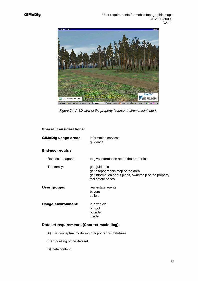
GiMoDig User requirements for mobile topographic maps IST-2000-30090 D2.1.1
Figure 24. A 3D view of the property (source: Instrumentointi Ltd.).
Special considerations:
GiMoDig usage areas: information services guidance
End-user goals :
Real estate agent: to give information about the properties
The family: get guidance get a topographic map of the area get information about plans, ownership of the property, real estate prices
User groups: real estate agents buyers
sellers
Usage environment: in a vehicle on foot outside inside
Dataset requirements (Context modelling):
A) The conceptual modelling of topographic database
3D modelling of the dataset.
B) Data content
82
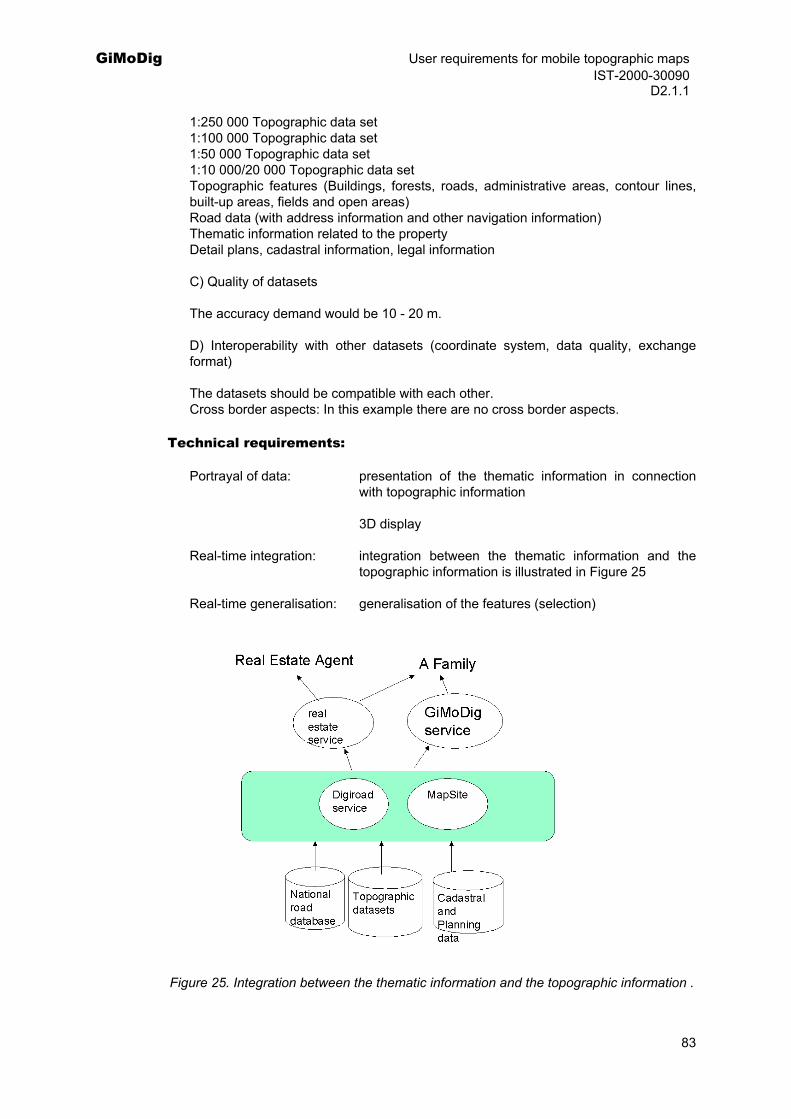
GiMoDig User requirements for mobile topographic maps IST-2000-30090 D2.1.1
1:250 000 Topographic data set 1:100 000 Topographic data set 1:50 000 Topographic data set 1:10 000/20 000 Topographic data set Topographic features (Buildings, forests, roads, administrative areas, contour lines, built-up areas, fields and open areas) Road data (with address information and other navigation information) Thematic information related to the property Detail plans, cadastral information, legal information
C) Quality of datasets
The accuracy demand would be 10 - 20 m.
D) Interoperability with other datasets (coordinate system, data quality, exchange format)
The datasets should be compatible with each other. Cross border aspects: In this example there are no cross border aspects.
Technical requirements:
Portrayal of data: presentation of the thematic information in connection with topographic information
3D display
Real-time integration: integration between the thematic information and the topographic information is illustrated in Figure 25
Real-time generalisation: generalisation of the features (selection)
Figure 25. Integration between the thematic information and the topographic information .
83
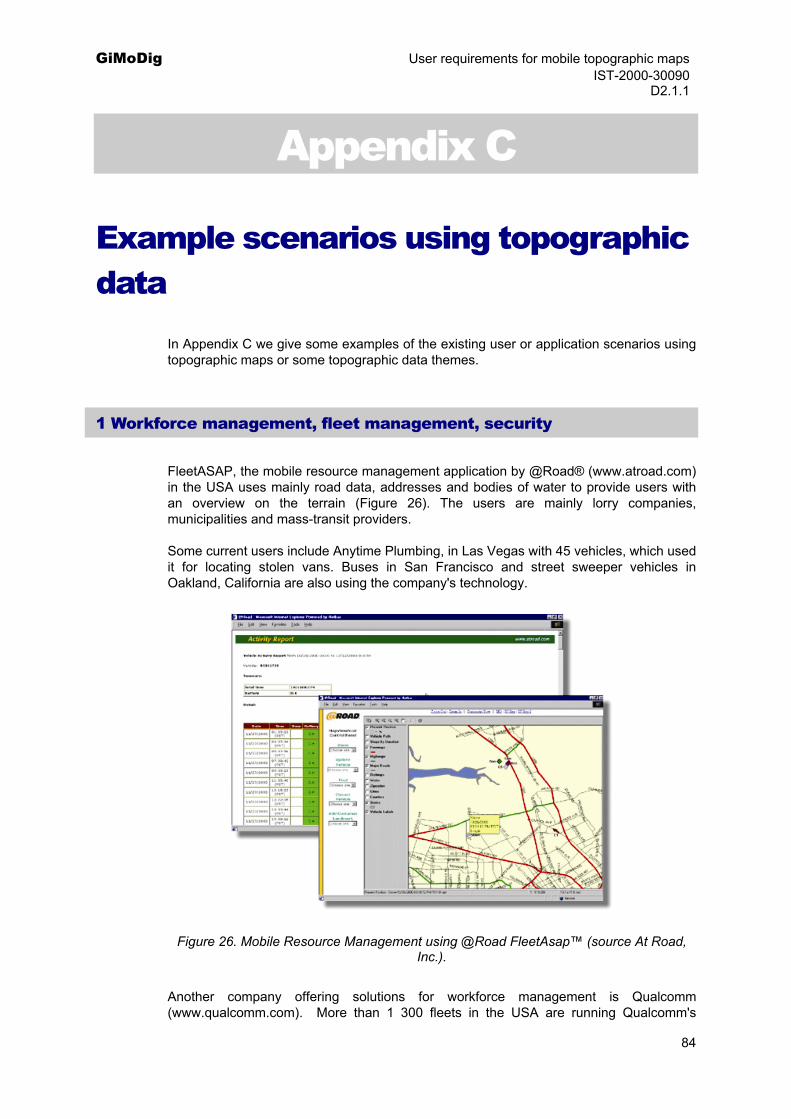
GiMoDig User requirements for mobile topographic maps IST-2000-30090 D2.1.1
Appendix C
Example scenarios using topographic data
In Appendix C we give some examples of the existing user or application scenarios using topographic maps or some topographic data themes.
1 Workforce management, fleet management, security
FleetASAP, the mobile resource management application by @Road® (www.atroad.com) in the USA uses mainly road data, addresses and bodies of water to provide users with an overview on the terrain (Figure 26). The users are mainly lorry companies, municipalities and mass-transit providers.
Some current users include Anytime Plumbing, in Las Vegas with 45 vehicles, which used it for locating stolen vans. Buses in San Francisco and street sweeper vehicles in Oakland, California are also using the company's technology.
Figure 26. Mobile Resource Management using @Road FleetAsap™ (source At Road, Inc.).
Another company offering solutions for workforce management is Qualcomm (www.qualcomm.com). More than 1 300 fleets in the USA are running Qualcomm's
84

GiMoDig User requirements for mobile topographic maps IST-2000-30090 D2.1.1
system. Customers include J.B. Hunt, Roadway Express, and Schneider National. The U.S. Army and United Nations use Qualcomm's wireless technology to help military convoys travel safely through Bosnia and Kosovo.
Other companies offering similar solutions include Darby Coroporate Solutions (DCS, www.dcs.com), and Summary Systems (www.summarysystems.com).
In Finland Arbonaut Ltd. and Telekoski have announced Arbonaut Secure – a product, by which a client can monitor vehicles on the Internet.
The Finnish forestry company Metsäliitto is updating it's log transport vehicles with in-car devices using map displays and GPS receivers. These will be supplied by Sunit Mobile (www.sunit.fi). The same technology has also been used in forest-harvesting machines.
2 Public services
Citizens MapSite (Karttapaikka) (http://www.kartta.nls.fi/karttapaikka/eng/home.html) is a free service for all Finnish citizens. It requires advance registration and provides access to browsable and seamless maps at various scales from all over Finland. More than 2 million addresses provided by the Population Register Centre are integrated with the system. Thus the system allows loading of maps up to 1:40 000 scale (using 1:20 000 topographic map) and enables searching via addresses, place names or coordinates. There are more than 245 000 registered users for this service. Every week the system ushers in over 5000 different users. Recently a survey in Finland (Talentum, 2002) rated MapSite (Karttapaikka in Finnish) as the 14th most valued web brands in Finland (the Google was the most highly valued).
Professional's MapSite provides the same services as the Citizen's MapSite and in addition offers the opportunity to browse maps up to a scale of 1:8 000 (using 1:20 000 topographic map). These larger-scale maps are invoiced per view. Ordering Service uses the MapSite as the geographic search mechanism enabling the user to order data defined by area and given attributes. There are more than 1000 paying customers using this service on a regular basis.
Both the Service Centre and the Ordering Services provide access to the following data sets:
topographic map 1:4 500 000
topographic map 1:1 000 000
topographic map 1:500 000
topographic map 1:250 000
topographic map 1:20 000
Real Estate Market Price Register
Cadastral Register
addresses from Finnish Population Register
85
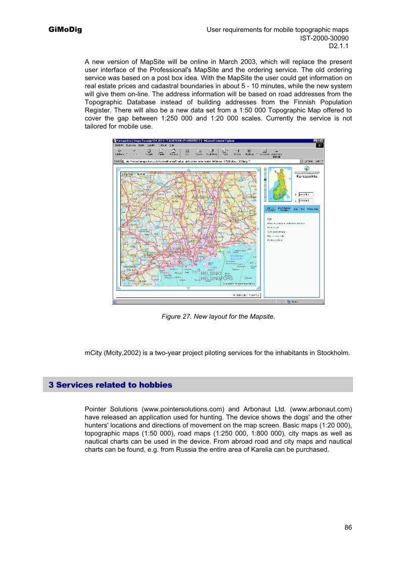
GiMoDig User requirements for mobile topographic maps IST-2000-30090 D2.1.1
A new version of MapSite will be online in March 2003, which will replace the present user interface of the Professional's MapSite and the ordering service. The old ordering service was based on a post box idea. With the MapSite the user could get information on real estate prices and cadastral boundaries in about 5 - 10 minutes, while the new system will give them on-line. The address information will be based on road addresses from the Topographic Database instead of building addresses from the Finnish Population Register. There will also be a new data set from a 1:50 000 Topographic Map offered to cover the gap between 1:250 000 and 1:20 000 scales. Currently the service is not tailored for mobile use.
Figure 27. New layout for the Mapsite.
mCity (Mcity,2002) is a two-year project piloting services for the inhabitants in Stockholm.
3 Services related to hobbies
Pointer Solutions (www.pointersolutions.com) and Arbonaut Ltd. (www.arbonaut.com) have released an application used for hunting. The device shows the dogs' and the other hunters' locations and directions of movement on the map screen. Basic maps (1:20 000), topographic maps (1:50 000), road maps (1:250 000, 1:800 000), city maps as well as nautical charts can be used in the device. From abroad road and city maps and nautical charts can be found, e.g. from Russia the entire area of Karelia can be purchased.
86
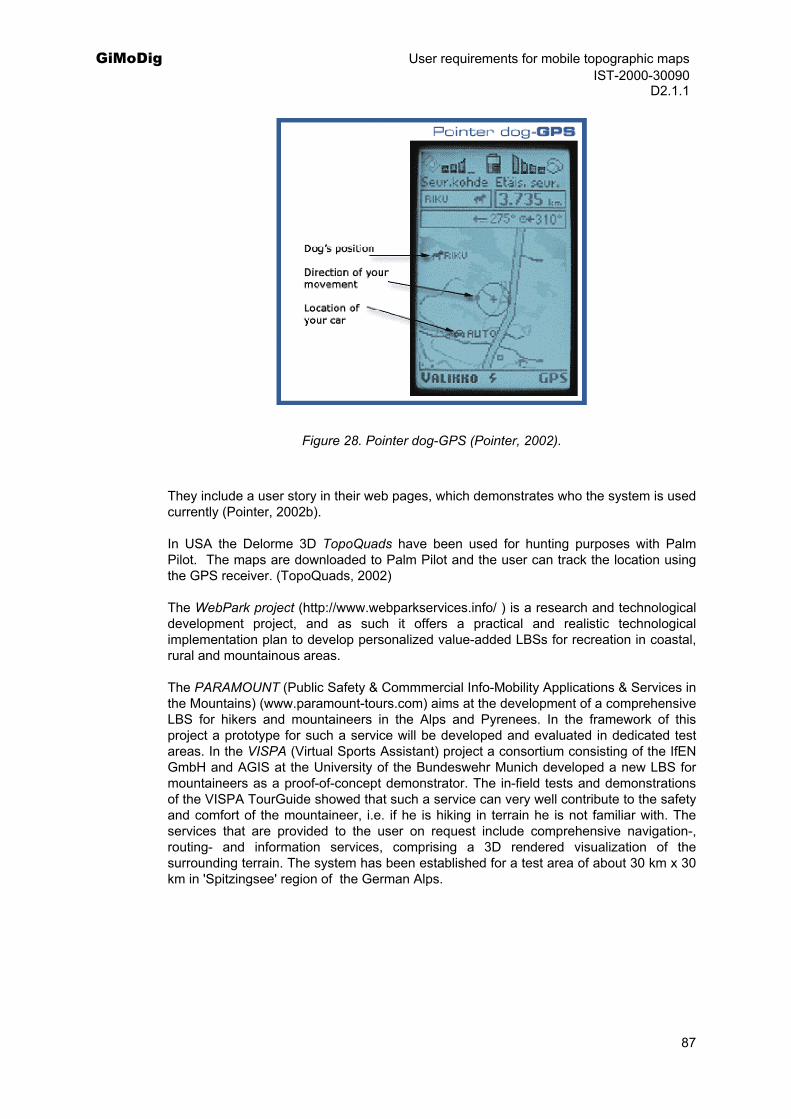
GiMoDig User requirements for mobile topographic maps IST-2000-30090 D2.1.1
Figure 28. Pointer dog-GPS (Pointer, 2002).
They include a user story in their web pages, which demonstrates who the system is used currently (Pointer, 2002b).
In USA the Delorme 3D TopoQuads have been used for hunting purposes with Palm Pilot. The maps are downloaded to Palm Pilot and the user can track the location using the GPS receiver. (TopoQuads, 2002)
The WebPark project (http://www.webparkservices.info/ ) is a research and technological development project, and as such it offers a practical and realistic technological implementation plan to develop personalized value-added LBSs for recreation in coastal, rural and mountainous areas.
The PARAMOUNT (Public Safety & Commmercial Info-Mobility Applications & Services in the Mountains) (www.paramount-tours.com) aims at the development of a comprehensive LBS for hikers and mountaineers in the Alps and Pyrenees. In the framework of this project a prototype for such a service will be developed and evaluated in dedicated test areas. In the VISPA (Virtual Sports Assistant) project a consortium consisting of the IfEN GmbH and AGIS at the University of the Bundeswehr Munich developed a new LBS for mountaineers as a proof-of-concept demonstrator. The in-field tests and demonstrations of the VISPA TourGuide showed that such a service can very well contribute to the safety and comfort of the mountaineer, i.e. if he is hiking in terrain he is not familiar with. The services that are provided to the user on request include comprehensive navigation-, routing- and information services, comprising a 3D rendered visualization of the surrounding terrain. The system has been established for a test area of about 30 km x 30 km in 'Spitzingsee' region of the German Alps.
87

GiMoDig User requirements for mobile topographic maps IST-2000-30090 D2.1.1
Figure 29. Mobile TourGuide User Interface (VISPA, 2002).
The Bird Observation Service (www.lintupalvelu.com) in Finland provides a solution for sharing bird observations and receiving information on the bird species of interest. The bird observation information is delivered as an SMS message to the user’s mobile phone. If the user has a Benefon Esc! GSM+GPS personal navigation instrument, the message contains the exact location (coordinates) of the observation, and this is shown on a map screen. All bird observations that have been delivered to the system are at the user's disposal via the Internet. The Bird Observation Service collects, stores, handles and delivers information on bird observations. The observation messages that are sent to the service by a bird observer can easily and quickly be delivered to other registered observers through the Bird Observation Service. The plan is to develop the Bird Observation Service into a national centralised archive of bird observation, which will be accessible by Birdlife and its member organizations. In Pyhä-Luosto National Park Finland, a day tourist can have a mobile guide system from the hotel and get guidance when hiking in the national park. The service is part of the testing lab programme of Aurora Borealis Technology Centre. The pilot is using Benefon Esc! Platform (Benefon, 2002)
4 Navigation and finding
Using Pocket Navigator by Mactech Ltd. (www.maptech.com) on the PDA and USGS topographic maps delivered on the CD-ROM the user can view the topographic maps, and if connected with the GPS receiver can locate his position. Another application is National Geographic's TOPO! Sync USA (www.nationalgeographic.com). A similar solution is offered by Fugawi GPS mapping software (www.fugawi.com). The software supports a variety of maps and coordinate systems. In Europe they offer 46 different maps in scale of 1:500 000. In Sweden the user can download maps from the National Land Survey of Sweden in 1:50 000 and smaller scales and in Germany in 1:200 000 scale and also 1:50 000 in Bavaria and Nordrhein-Westfallen.
88
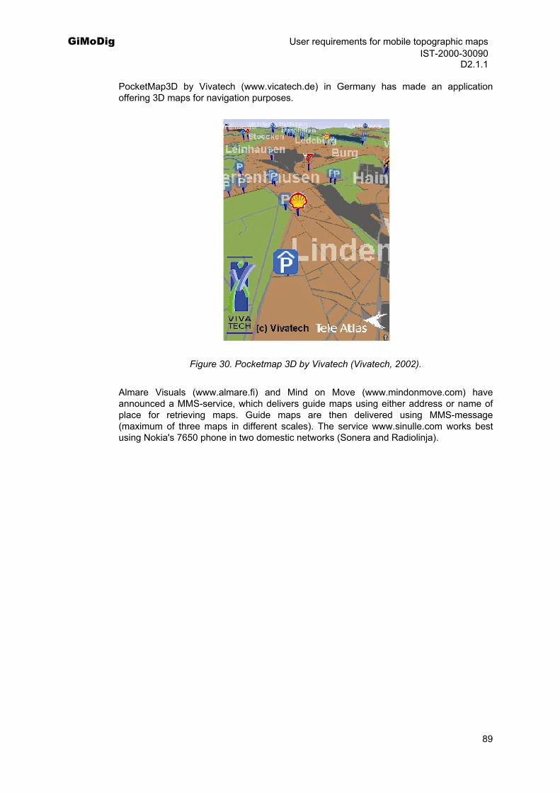
GiMoDig User requirements for mobile topographic maps IST-2000-30090 D2.1.1
PocketMap3D by Vivatech (www.vicatech.de) in Germany has made an application offering 3D maps for navigation purposes.
Figure 30. Pocketmap 3D by Vivatech (Vivatech, 2002).
Almare Visuals (www.almare.fi) and Mind on Move (www.mindonmove.com) have announced a MMS-service, which delivers guide maps using either address or name of place for retrieving maps. Guide maps are then delivered using MMS-message (maximum of three maps in different scales). The service www.sinulle.com works best using Nokia's 7650 phone in two domestic networks (Sonera and Radiolinja).
89
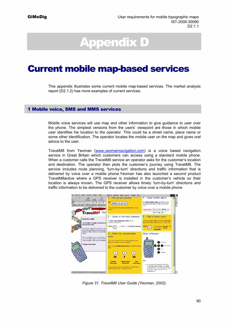
GiMoDig User requirements for mobile topographic maps IST-2000-30090 D2.1.1
Appendix D
Current mobile map-based services This appendix illustrates some current mobile map-based services. The market analysis report (D2.1.2) has more examples of current services.
1 Mobile voice, SMS and MMS services
Mobile voice services will use map and other information to give guidance to user over the phone. The simplest versions from the users’ viewpoint are those in which mobile user identifies his location to the operator. This could be a street name, place name or some other identification. The operator locates the mobile user on the map and gives oral advice to the user.
TravelM8 from Yeoman (www.yeomannavigation.com) is a voice based navigation service in Great Britain which customers can access using a standard mobile phone. When a customer calls the TravelM8 service an operator asks for the customer’s location and destination. The operator then plots the customer’s journey using TravelM8. The service includes route planning, 'turn-by-turn' directions and traffic information that is delivered by voice over a mobile phone.Yeoman has also launched a second product TravelM8active where a GPS receiver is installed in the customer’s vehicle so their location is always known. The GPS receiver allows timely 'turn-by-turn' directions and traffic information to be delivered to the customer by voice over a mobile phone
Figure 31. TravelM8 User Guide (Yeoman, 2002).
90
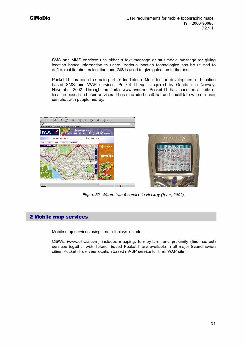
GiMoDig User requirements for mobile topographic maps IST-2000-30090 D2.1.1
SMS and MMS services use either a text message or multimedia message for giving location based information to users. Various location technologies can be utilized to define mobile phones location, and GIS is used to give guidance to the user.
Pocket IT has been the main partner for Telenor Mobil for the development of Location based SMS and WAP services. Pocket IT was acquired by Geodata in Norway, November 2002. Through the portal www.hvor.no, Pocket IT has launched a suite of location based end user services. These include LocalChat and LocalDate where a user can chat with people nearby.
Figure 32. Where (am I) service in Norway (Hvor, 2002).
2 Mobile map services
Mobile map services using small displays include:
CitiWiz (www.citiwiz.com) includes mapping, turn-by-turn, and proximity (find nearest) services together with Telenor based PocketIT are available in all major Scandinavian cities. Pocket IT delivers location based mASP service for their WAP site.
91
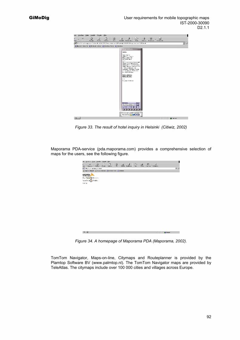
GiMoDig User requirements for mobile topographic maps IST-2000-30090 D2.1.1
Figure 33. The result of hotel inquiry in Helsinki (Citiwiz, 2002)
Maporama PDA-service (pda.maporama.com) provides a comprehensive selection of maps for the users, see the following figure.
Figure 34. A homepage of Maporama PDA (Maporama, 2002).
TomTom Navigator, Maps-on-line, Citymaps and Routeplanner is provided by the Plamtop Software BV (www.palmtop.nl). The TomTom Navigator maps are provided by TeleAtlas. The citymaps include over 100 000 cities and villages across Europe.
92
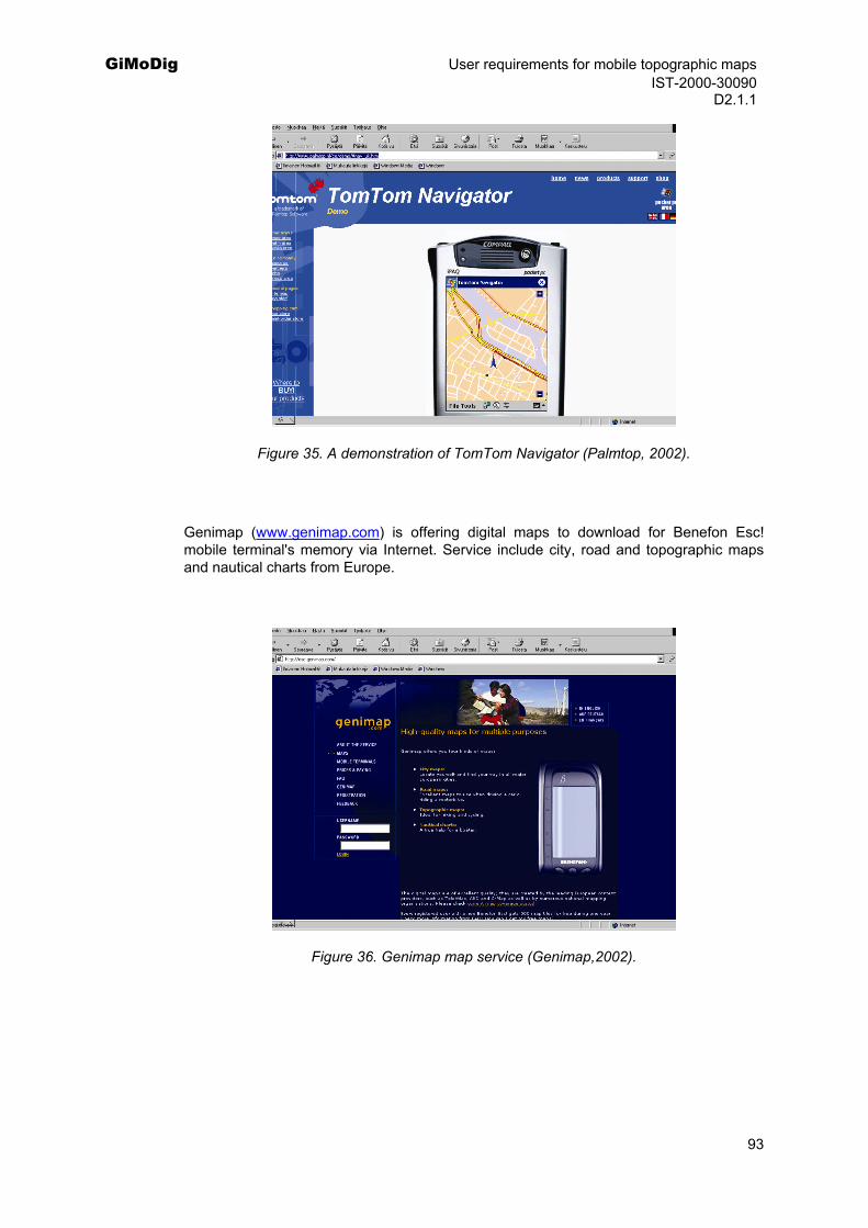
GiMoDig User requirements for mobile topographic maps IST-2000-30090 D2.1.1
Figure 35. A demonstration of TomTom Navigator (Palmtop, 2002).
Genimap (www.genimap.com) is offering digital maps to download for Benefon Esc! mobile terminal's memory via Internet. Service include city, road and topographic maps and nautical charts from Europe.
Figure 36. Genimap map service (Genimap,2002).
93