report - rr 4 - appendix c - vancouvercouncil.vancouver.ca/20170516/documents/rr4appendixc.pdf · 4...
TRANSCRIPT
APPENDIX C Page 1 of 39

APPENDIX C Page 2 of 39
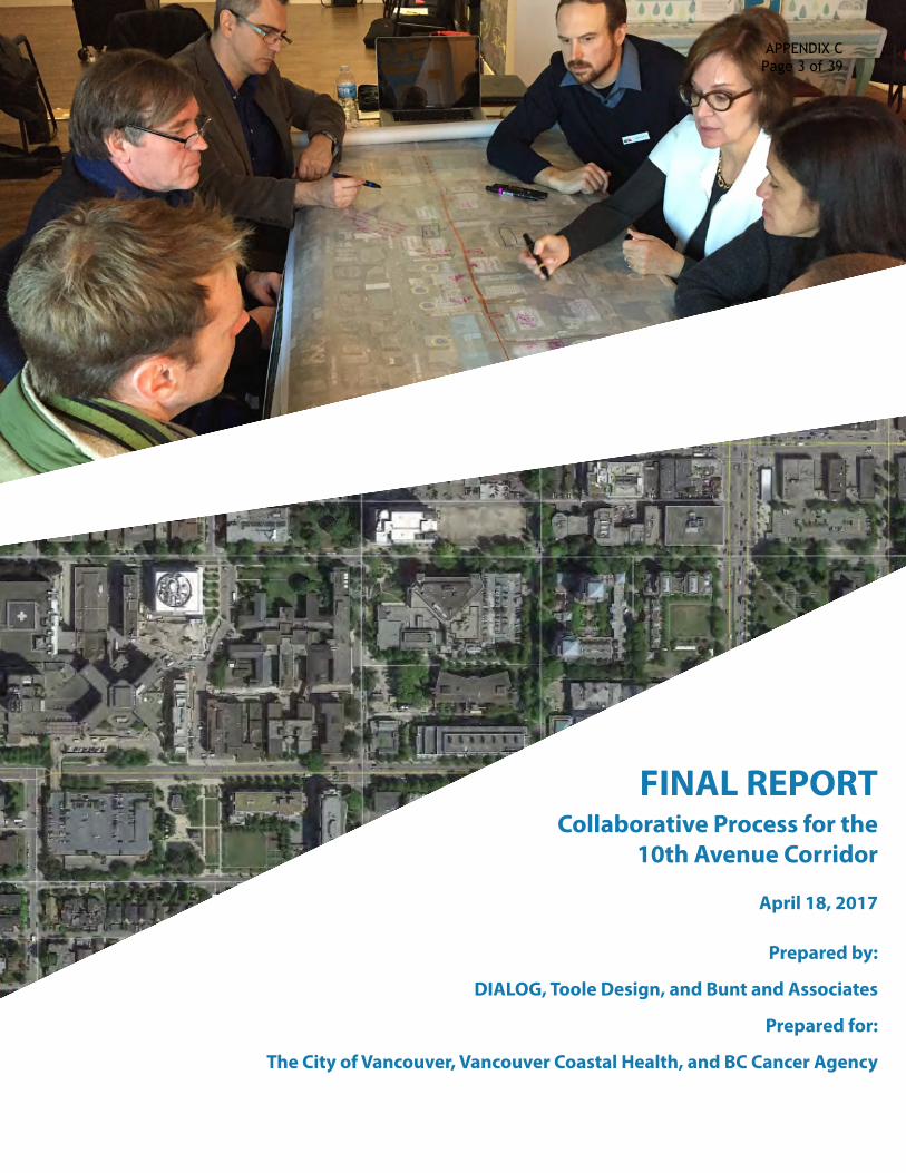
FINAL REPORTCollaborative Process for the
10th Avenue Corridor
April 18, 2017
Prepared by:
DIALOG, Toole Design, and Bunt and Associates
Prepared for:
The City of Vancouver, Vancouver Coastal Health, and BC Cancer Agency
APPENDIX C Page 3 of 39

APPENDIX C Page 4 of 39

CONTENTS
A INTRODUCTION
1 INTRODUCTION ................................................. ................................................................1
2 WORK PLAN ......................................................... ................................................................2
3 STAKEHOLDER ENGAGEMENT PLAN ..........................................................................4
B STAKEHOLDER WORKSHOPS
1 WORKSHOP 1: SHARED UNDERSTANDING ...............................................................6
2 WORKSHOP 2: DESIGN OPTION DEVELOPMENT ...................................................8
3 WORKSHOP 3: DESIGN OPTION EVALUATION ......................................................11
C LEADERSHIP TEAM MEETINGS
1 MEETING 1: REVIEW OF THREE OPTIONS ...............................................................15
2 MEETING 2: REVIEW OF THE PREFERRED OPTION .............................................17
D PREFERRED DESIGN CONCEPT
1 DESIGN OBJECTIVES ......................................... .............................................................19
2 SUPPORTING TRAVEL AND PARKING ANALYSIS .................................................20
3 OTHER DESIGNS CONSIDERED ..................... .............................................................27
4 OVERVIEW OF THE PREFERRED DESIGN CONCEPT ............................................28
APPENDIX C Page 5 of 39

PART A
PROJECT BACKGROUND
APPENDIX C Page 6 of 39
| 110th Avenue Collaborative Process – Final Report
1 INTRODUCTION
To build on the planning and engagement work undertaken by the City of Vancouver in the upgrading of the 10th Avenue Corridor, the City, Vancouver Coastal Health (VCH), and BC Cancer Agency (BCCA) agreed to enter into a collaborative process to develop a shared resolution for the 10th Avenue right-of-way within the Health Precinct, between Oak and Cambie Streets. The outcome of this process is a preferred design option supported by Health Precinct Partners, and that addresses VCH and BCCA concerns about patient safety, access for patient drop-off, and parking availability for patients and visitors.
To arrive at a preferred concept, the partners engaged stakeholders within the organizations in three workshops, hosted two leadership team meetings, and held a number of smaller working team meetings. This report provides overview of: the work plan and stakeholder engagement plan; the stakeholder workshops and leadership team meetings; and the preferred design option.
ENGAGEMENT SNAPSHOT: A TIMELINE OF ACTIVITIESBetween December 2016 and March 2017, a number of meetings and workshop took place:
WORK PLANNING
November 2016
STAKEHOLDER WORKSHOPS (3)
December 2016 - January 2017
LEADERSHIP MEETINGS (2)
February 2017
PREFERRED DESIGN OPTION REFINEMENT
March 2017
Outcomes:• Exchanged
information;• Hierarchy of
needs;• Design ideas and
early options; and• Preliminary
evaluations of design options.
Outcomes:• Refined design
options; and• Draft preferred
design option.
Outcome:• Final preferred
design option.
Outcome:• Process work
plan; and • Stakeholder
engagement plan.
Consultants were engaged in the following roles to assist in undertaking the work:
• DIALOG (Integrated Design and Engagement Specialists) – Facilitation;• Toole Design (Transportation Engineering/Planning) – Development of design concepts; and• Bunt and Associates (Transportation Engineering/Planning) – Analysis of site accessibility, travel demand,
traffic operations, and parking management.
APPENDIX C Page 7 of 39

2 |
2 WORK PLAN
What follows is the work plan for the collaborative process, developed by the partners at the project outset.
WORKPLAN -‐ VCH + BCCA + CoV COLLABORATIVE PROCESS for 10th AVENUE CORRIDOR
1 Workplan – Collaborative Process – 10th Avenue Corridor Final Version November 24, 2016
Objective: Develop Shared Resolution to 10th Ave Congestion and Safety Issues. Description of process: As a follow up to the three series of Open Houses held by the City and based on the feedback received to date: 1. City and VCH have agreed to enter into a collaborative process to review all options for the
proposed redesign of the 10th Avenue corridor. 2. VCH and CoV will be continuing their dialogue to ensure safe, effective and timely access to the VGH
site for patients, while ensuring that the corridor is safe for everyone using the street, with a focus on vulnerable patients and their families first and foremost.
3. This process will be co-‐led by VCH/BCCA and the City with the assistance of external transportation design consulting team. The consulting team will:
o Review all potential strategies to ensure the 10th Avenue corridor redesign best serves the complex needs of the patients and their families while respecting the constraints of the urban location of the site. This will involve drawing from existing related solutions that have proven to be successful in similar contexts.
o Review the latest CoV 10th Ave Health Precinct design proposal, in light of the considerations listed below.
o Review the feasibility of re-‐routing the 10th Ave Bike Route around VGH, looking at comparable examples from other cities.
o Review other potential bike network changes in the vicinity of the 10th Ave Health Precinct with a view to improve conditions on the 10th Avenue corridor, in light of the considerations listed below.
o Review parking management strategies to better serve VGH clients/visitors o Review access strategies for HandyDART, disability parking, pick-‐up/drop-‐off, and hospital
transfers at key buildings adjacent to 10th Avenue, especially the Blusson building. 4. Leads from both VCH/BCCA and CoV must be copied on all communication with the external
consultant team, and a least one representative from both VCH/BCCA and CoV must be present for every meeting/phone call/or other communication.
VCH/BCCA and City will consider options in view of:
A. The Vancouver General Hospital, BC Cancer Centre and surrounding campus is a health precinct;
VCH/VGH/BCCA core business is the delivery of health care services to patients (and their supporting families).
B. Access to the Vancouver General Hospital and BC Cancer Agency (BCCA) sites is critically important for the access and safety of patients, especially efficient and intuitive access to the Emergency Department for both ambulance drivers and the general public.
C. Improving the safety, comfort, and accessibility for people on foot, especially patients and vulnerable pedestrians.
APPENDIX C Page 8 of 39

| 310th Avenue Collaborative Process – Final Report
WORKPLAN -‐ VCH + BCCA + CoV COLLABORATIVE PROCESS for 10th AVENUE CORRIDOR
2 Workplan – Collaborative Process – 10th Avenue Corridor Final Version November 24, 2016
D. The need to accommodate patient/client access needs of adjacent medical services, businesses, and other institutions, taking into account concern over the proposed removal of on-‐street parking and patient pick-‐up/drop-‐off needs at health services adjacent to 10th Avenue at which patients are often mobility and/or visually impaired: Eye Care Centre, Mary Pack Arthritis Centre and Blusson I-‐CORD Centre .
E. Various loading requirements along 10th Avenue, such as semi truck traffic to the main loading dock on campus, food service deliveries from an off-‐site kitchen that occur twice daily every day of the week to Jim Pattison Pavilion and Banfield, and BCCA loading.
F. A strong public interest in and City policy for preserving as much of the street’s healthy and mature tree canopy as possible and associated with this, ensuring an attractive and comfortable pedestrian/public realm.
G. Concerns in regard to the proposed half-‐block car-‐free zone on Heather Street north of 10th Ave. H. VCH/BCCA and CoV support the health and wellness of staff and the general public, and, as such,
support and encourage active modes of transportation such as walking and cycling. I. Ensuring adjacent residents can continue to park within a reasonable walking distance of home. J. Ensuring the recommended design and alignment for the 10th Avenue bike route, whether re-‐
routed or not, would be safe and comfortable for people of all ages and abilities to cycle. Proposed Activities and Timelines Two (or 3) Charrettes with City and VCH/BCCA teams – Facilitated brainstorming exercises to review options for 10th Avenue Corridor Design. Internal workshops will take place to develop strategies and options internally. Event name Date Activity Workplan November 17, 2016 Develop Draft Workplan for VCH/CoV Approval Open House Board Input November 17, 2016 Develop Key Messages and send to City Procure consultants Bunt /Toole Design Facilitator – To be selected
November 22, 2016 Develop Direct Award Share costs between major stakeholders
Regular Meetings November 18, 2016 Set up regular update meeting for VCH/VGH/BCCA/CoV executives and team
Communication strategy November 18, 2016 Identify stakeholders and keep informed Internal workshop November 29, 2016 LMFM/VCH prepare for Charrette #1 Charrette #1 City + VCH +Consultants
December 8, 2016 City and VCH meet to brainstorm and develop options
Workshop with consultants to refine options
TBD Work through options and refine
Charrette # 2 City + VCH +Consultants
TBD City and VCH meet to review detailed options -‐ Agreement on collaborative option
Develop Final report Mid-‐January 2017
APPENDIX C Page 9 of 39

4 |
3 STAKEHOLDER ENGAGEMENT PLAN
To guide the design and execution of stakeholder workshops, an engagement plan was developed to confirm engagement objectives and desired tangible outcomes.
OBJECTIVES
The objectives of this process were to:
• Create a positive tone and strong working relationship that will endure beyond the life of this process;
• Prioritize fairness, in which both health and City partners have equal input and say;
• Establish a high degree of inclusivity in which all participants feel heard;
• Reinforce the importance of a two-way dialogue in which active listening and mutual learning play a vital role;
• Convey the complexity of the project and recognize that a significant amount of analysis, engagement, and design work has been done to date, while being open to a broad and diverse range of possibilities/options;
• Ensure the “right people” are at the table, which includes individuals or representatives who are accountable for making final decisions;
• Demonstrate that the merits of each option have been explored, so that there is clear rationale driving the selection of the final option; and
• Instill a sense of creativity and inspiration in the process.
TANGIBLE OUTCOMES / DELIVERABLES
The tangible outcomes of this process were:
• Workshop 1 – A set of clear evaluation criteria with which to eventually weigh the merits of various design options;
• Workshop 2 – A set of design options; and
• Workshop 3 – A set of clearly defined and evaluated design options, including the merits and trade-offs associated with each, and recommendations on how to move forward with the shared preferred option(s).
APPENDIX C Page 10 of 39

| 510th Avenue Collaborative Process – Final Report
PART B
STAKEHOLDER WORKSHOPS
APPENDIX C Page 11 of 39

6 |
1 WORKSHOP 1: SHARED UNDERSTANDING AND EVALUATION CRITERIA
The first of three stakeholder workshops took place on December 8th, 2016 and provided the opportunity to:
• sharehopesandconcerns about the process;
• exchangeinformation and analysis already undertaken through presentations by the City of Vancouver, Vancouver Coastal Health, and Bunt and Associates; and
• begintoco-createevaluationcriteria for use later in the process to develop and assess the merits of design options.
HOPES AND FEARS
Participants provided input on their concerns, frustrations, and fears, and their hopes and aspirations about the process and its outcomes.
Emergent themes for “fears” included:
• inability to reach consensus;
• lack of flexibility;
• increased conflicts between modes in the corridor; and
• increased safety issues for cyclists and pedestrians, namely vulnerable patients.
APPENDIX C Page 12 of 39
| 710th Avenue Collaborative Process – Final Report
Emergent themes for “hopes” included:
• a focus on looking forward and moving beyond past differences;
• identification of common goals, such as safe streets for all users; and
• arriving at solution in which partners can stand before Council with a shared recommendation.
EVALUATION CRITERIA
Participants provided individual responses to the question: “Which criteria should we use to develop the design options, evaluate their merits, and weigh trade-offs?”. The group collectively developed the following category headings to group individual responses:
• Minimize walking travel distance to services
• Respond to general parking needs
• Efficient access to ER
• Efficient emergency access to other facilities on 10th Avenue
• Road safety (e.g. fewer collisions)
• Perceived safer, more comfortable, more delightful experience
• Mode hierarchy (e.g. vulnerable pedestrians, other pedestrians; cyclists; good movement; cars)
• User priority (e.g. ambulance and fire; patients/families; goods; visitors; staff; through travelers)
• Future thinking (e.g. flexibiliity, adaptability)
• Overarching principles and plans
The outcomes of this brainstorming exercise were adapted to a “Hierarchy of Needs” exercise in Workshop #2.
APPENDIX C Page 13 of 39

8 |
2 WORKSHOP 2: DESIGN OPTIONS
The second of three stakeholder workshops took place on December 14th and provided the opportunity to:
• considerandorganizeneedswithinahierarchy to help the design team consider trade-offs;
• learnaboutdesignissuesandexamplesofbestpractices through a presentation from Toole Design; and
• co-createdesignoptions to be further evolved/developed by the consulting design team.
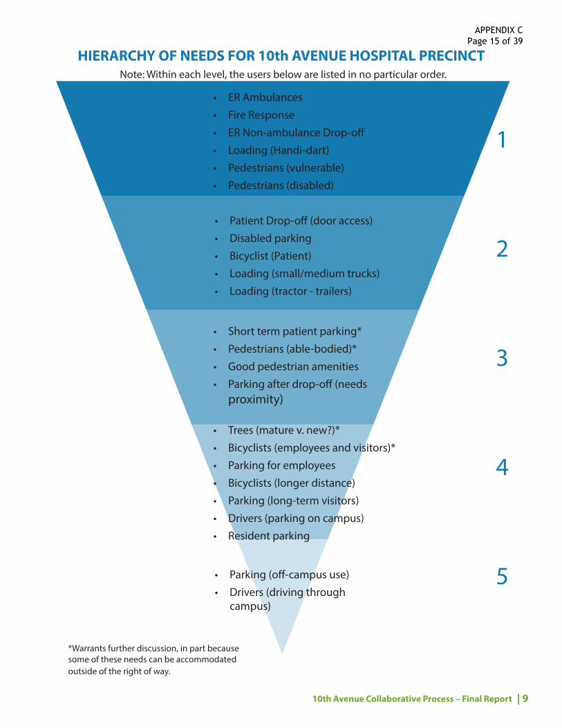
HIERARCHY OF NEEDS
Building on the previous brainstorming exercise for evaluation criteria, participants established a Hierarchy of Needs for the different user groups of 10th Avenue in the hospital precinct. The hierarchy was to be used as a tool to inform design and evaluate options.
Results of this exercise (page 9) show where each user group falls within the five level hierarchy. Within each level, the users are listed in no particular order. Some elements were noted as warranting further discussion, in part because some needs could be accommodated outside of the right of way.
APPENDIX C Page 14 of 39
| 910th Avenue Collaborative Process – Final Report
HIERARCHY OF NEEDS FOR 10th AVENUE HOSPITAL PRECINCT
• Short term patient parking*
• Pedestrians (able-bodied)*
• Good pedestrian amenities
• Parking after drop-off (needs proximity)
• Parking (off-campus use)
• Drivers (driving through campus)
• Trees (mature v. new?)*
• Bicyclists (employees and visitors)*
• Parking for employees
• Bicyclists (longer distance)
• Parking (long-term visitors)
• Drivers (parking on campus)
• Resident parking
• Patient Drop-off (door access)
• Disabled parking
• Bicyclist (Patient)
• Loading (small/medium trucks)
• Loading (tractor - trailers)
• ER Ambulances
• Fire Response
• ER Non-ambulance Drop-off
• Loading (Handi-dart)
• Pedestrians (vulnerable)
• Pedestrians (disabled)
1
3
2
4
5
*Warrants further discussion, in part because some of these needs can be accommodated outside of the right of way.
Note: Within each level, the users below are listed in no particular order.
APPENDIX C Page 15 of 39
10 |
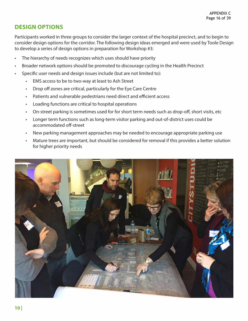
DESIGN OPTIONS
Participants worked in three groups to consider the larger context of the hospital precinct, and to begin to consider design options for the corridor. The following design ideas emerged and were used by Toole Design to develop a series of design options in preparation for Workshop #3:
• The hierarchy of needs recognizes which uses should have priority
• Broader network options should be promoted to discourage cycling in the Health Precinct
• Specific user needs and design issues include (but are not limited to):
• EMS access to be to two-way at least to Ash Street
• Drop off zones are critical, particularly for the Eye Care Centre
• Patients and vulnerable pedestrians need direct and efficient access
• Loading functions are critical to hospital operations
• On-street parking is sometimes used for for short term needs such as drop-off, short visits, etc
• Longer term functions such as long-term visitor parking and out-of-district uses could be accommodated off-street
• New parking management approaches may be needed to encourage appropriate parking use
• Mature trees are important, but should be considered for removal if this provides a better solution for higher priority needs
APPENDIX C Page 16 of 39
| 1110th Avenue Collaborative Process – Final Report
3 WORKSHOP 3: EVALUATING DESIGN OPTIONS
The third of three stakeholder workshops took place on January 19th, 2017 and provided the opportunity to:
• evaluatethedesignoptionsdeveloped by Toole Design; and
• revisethedesignoptions.
DESIGN OPTION EVALUATION
Based on the outcomes of the previous workshops, Toole Design developed four options:
1. MinimalIntervention,TrafficCalming – This included: maintaining two-way flow throughout; utilizing traffic calming to reduce traffic and bike speeds; prioritizing pedestrians at intersections and crossings; and minimizing disruption to parking.
2. SharedStreets,TrafficCalming – This included: reducing traffic and bike speeds; reducing traffic volumes by introducing one-block, one-way shared street segment (with maintained two-way flow for EMS between Laurel and Willow Streets); prioritizing pedestrians; and minimizing disruptions to parking.
3. Westbound-onlyProtectedBikeLane – This included: maintaining two-way traffic flow; separating bikes from cars in one direction; maintaining drop-offs; trading other on-street parking for bikeway; and allowing more width on the segment between Oak and Willow Streets.
4. ProtectedBikeLanesinBothDirections – This included: creating one-way flow westbound from Cambie to Willow Streets (in which EMS can mount bikeway to go in opposite direction); maintaining two-way flow from Oak to Willow Streets; maintaining drop-offs; and trading other on-street parking for bikeway.
Toole Design also explored other options, but did not bring them forward to participants at the workshop as they were seen as unfeasible. They included: bi-directional bikeways; elevated and subterranean bikeways; and street closures / new streets.
For the evaluation exercise, participants used the following colour scheme to determine how each of the four options addressed specific needs – as identified in the pre-established Hierarchy of Needs – and compared to current conditions:
• Green – This design responds well to this need.
• Yellow – This design responds the same as does current conditions to this need.
• Pink – This design does not respond well to this need.
The results are organized by option on the following page. In some instances, participants used multiple colours to evaluate individual needs. Some groups did not complete the evaluation for all options.
APPENDIX C Page 17 of 39

12 |
OPTI
ON EV
ALUA
TION
OPTION 1
MINIMAL INTERVENTION, TRAFFIC CALMING
GROUP 1
GROUP 2
GROUP 3
OPTION 2
SHARED ST. SECTION, TRAFFIC CALMING
OPTION 3
SEPARATED BIKEWAY WESTBOUND
OPTION 3
SEPARATED BIKEWAYS BOTH DIRECTIONS
ER AMBULANCES ER NON-AMBULANCE DROP-OFF VULNERABLE PEDESTRIANS
DISABLED PEDESTRIANS
LOADING (LARGE)LOADING (SMALL)DIABLED PARKINGPATIENT DROP-OFF
FIRE RESPONSE LOADING (HANDIDART)
BICYCLIST (PATIENT)
SHORT TERM PATIENT PARKING GOOD PEDESTRIAN AMENITIES
PEDESTRIAN (ABLE-BODIED) PARKING AFTER DROP-OFF
MATURE TREES
CYCLISTS (LONG DISTANCE) PARKING ON CAMPUS
EMPLOYEE PARKING
CYCLISTS (EMPLOYEE / VISITOR)
PARKING (OFF CAMPUS USE)
DRIVE THROUGH
NEW TREES
RESIDENT PARKING
LONG TERM VISITOR PARKING
4APPENDIX C
Page 18 of 39

| 1310th Avenue Collaborative Process – Final Report
THEMES FROM DISCUSSION ON OPTION EVALUATION AND REVISIONS
Participants were encouraged to explore hybrid options and/or to suggest changes to the options. Among the ideas that were discussed – as well as from comments shared during the evaluation process – the following themes emerged and were used by Toole Design to develop a series of refined design options in preparation for leadership team meetings:
• Given much of the traffic on 10th Avenue is related to local health services, minimal intervention through the use of traffic calming alone would not reduce traffic volumes to a level comfortable for an AAA bikeway and reinforces the need for bikeway separation.
• Some of the traffic calming elements have benefits to reducing motor vehicles speeds, improving the interaction between modes, and most importantly improving the pedestrian environment.
• Some see two-way traffic flow between Oak and Ash Streets as critical to hospital operations including for emergency access, loading functions, and patient access and circulation.
• There was general agreement that one-way traffic flow westbound for the block between Cambie and Ash Streets is not critical to the operation of the Health Precinct and could be supported by VCH and BCCA if supported by other local stakeholders.
• There was concern about the operation of a shared street environment and, in particular, the possibility it would encourage people biking to encroach on pedestrian space and the ability for visually impaired and blind pedestrians to navigate the space safely.
• A mixed solution with separated bikeway in only one direction does not address the City’s desire for an all-ages-and-abilities bikeway.
• The passenger loading zones are an important amenity for clinics and services in the Health Precinct. There is also a desire to maintain some short-term on-street parking and increase the number of accessible on-street parking spaces.
• The existing curb-to-curb width is not sufficient to accommodate two-way traffic flow, on-street parking, and protected bike lanes. Space outside the curbs are recommended and should consider potential loss of trees.
APPENDIX C Page 19 of 39

14 |
PART C
LEADERSHIP TEAM MEETINGS
APPENDIX C Page 20 of 39
| 1510th Avenue Collaborative Process – Final Report
1 MEETING 1: REVIEW OF THREE OPTIONS
The first of two leadership team meetings – which included participation from a smaller group of senior managers, project leads, and members of the consulting teams – took place on February 3rd, 2017. The purpose of the meeting was to review and refine three design options, to determine which were acceptable to Health Precinct partners, before refining further to create a preferred option.
The three options included:
1. Traffic Calming and Pedestrian Improvements: this included traffic calming features, pedestrian improvements, a section of curbless street, and an option for how a drop-off could be created in front of Blusson. This option retained as much parking and as many trees as possible, but does not include separated bikeways.
2. Protected Bike Lanes in both Directions: this included unidirectional bikeways on either side of the street, retention of most of the on-street parking, but required removal of most of the trees from the corridor.
3. Protected Bike Lane, Westbound: this included a unidirectional bikeway on the north side of the street with bicyclists sharing the roadway with motor vehicle traffic in the eastbound (downhill) direction. It retains most of the on-street parking, but requires removal of most of the trees on the north side of the street.
DESIGN OPTION REVISIONS
None of the options presented provided a solution that met all the needs of the stakeholders. For example, Option 1 retained on-street parking and all the trees along the corridor, but provided no separation for bicyclists. With only a very limited reduction in traffic volumes expected from traffic calming, this is not considered an AAA bikeway solution.
Option 2 retained on-street parking, but created separated bikeways at the expense of removing nearly all the trees from the street, which would not be an acceptable outcome. Similarly, Option 3 looked at whether removing trees from just the north side of the street would achieve an acceptable design outcome, but it only provides separation for bicyclists in one direction and is not considered an AAA bikeway solution.
These designs were useful as they showed that to achieve the stakeholders’ goals for the project, space would need to be created through block-by-block trade-offs that balance tree removal, on-street parking conversion, relaxation of design standards, and opportunities to use private property through statutory rights-of-way. The leadership group went through these trade-offs for each half block and include the following ideas:
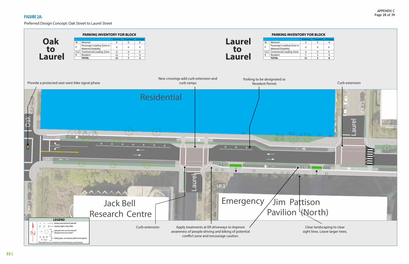
• Oak – Laurel: Trees on the south side are set-back from the curb and provide space to create a protected bike lane eastbound. On the north side, trees could be removed and some of the resident parking spaces repurposed to create a protected bike lane westbound.
• Laurel – Laurel: Landscaping should be cleared out of the area in front of emergency on the south side of the street to improve sight distance at the emergency room driveways. Strategic tree removal and conversion of some of the resident parking spaces will create additional space on the north side of the street.
APPENDIX C Page 21 of 39

16 |
• Laurel – Willow: Younger trees could be relocated on the south side of the street and some metered parking could be repurposed on the north side of the street. Some tree removal would likely be required on the north side of the street as well.
• Willow – Heather: There is an opportunity to create a statutory rights-of-way to use some property in front of the Heather Pavilion and in front of the future PHIX building and the existing Eye Care Centre. However, tree removal will likely also be necessary on the north side of the block. Parking in this block is the most utilized in the study area and as much as possible will be retained.
• Heather – Ash: There is an opportunity to create a statutory right-of-way to use some of the property in front of the vacant lot owned by PHSA. Much of the metered parking in this block could also be converted and some isolated tree removal may also be necessary.
• Ash – Cambie: Two-way traffic flow in this block is not critical to the operation of the Health Precinct and could be reduced to one travel lane. Metered parking could also be converted to additional space for separated bikeways.
APPENDIX C Page 22 of 39
| 1710th Avenue Collaborative Process – Final Report
TABLE 1: KEY BLOCK BY BLOCK DESIGN IMPROVEMENTS TO EXISTING CONDITIONS
2 MEETING 2: REVIEW OF THE PREFERRED OPTIONThe second of two leadership team meetings took place on February 23rd. The purpose of the meeting was to review and refine the preferred design option, which was generally characterized by:
• Retaining two-way traffic flow between Oak and Ash Streets;
• One-way traffic flow (westbound) between Cambie and Ash Streets;
• Retaining two-way traffic flow on all side streets;
• Encroachment into privately owned properties to minimize tree removal;
• Retention of critical parking needs including expansion of the existing passenger loading zones (PLZ) and creation of additional accessible parking; and
• Pedestrian improvements and traffic calming elements such as curb extensions, raised intersections, and raised crosswalks.
PREFERRED DESIGN OPTION REVISIONS
The leadership group offered comments on the design. Key comments are listed in Table 1 below and were incorporated into the Recommended/Preferred Design Option presented in Part D.
APPENDIX C Page 23 of 39

PART D
PREFERREDDESIGN CONCEPT
APPENDIX C Page 24 of 39
19 |
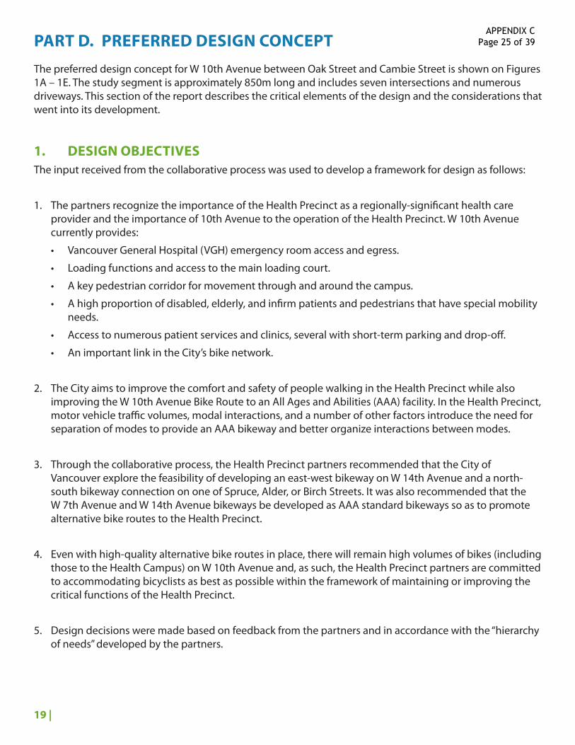
PART D. PREFERRED DESIGN CONCEPT
The preferred design concept for W 10th Avenue between Oak Street and Cambie Street is shown on Figures 1A – 1E. The study segment is approximately 850m long and includes seven intersections and numerous driveways. This section of the report describes the critical elements of the design and the considerations that went into its development.
1. DESIGN OBJECTIVESThe input received from the collaborative process was used to develop a framework for design as follows:
1. The partners recognize the importance of the Health Precinct as a regionally-significant health care provider and the importance of 10th Avenue to the operation of the Health Precinct. W 10th Avenue currently provides:
• Vancouver General Hospital (VGH) emergency room access and egress.
• Loading functions and access to the main loading court.
• A key pedestrian corridor for movement through and around the campus.
• A high proportion of disabled, elderly, and infirm patients and pedestrians that have special mobility needs.
• Access to numerous patient services and clinics, several with short-term parking and drop-off.
• An important link in the City’s bike network.
2. The City aims to improve the comfort and safety of people walking in the Health Precinct while also improving the W 10th Avenue Bike Route to an All Ages and Abilities (AAA) facility. In the Health Precinct, motor vehicle traffic volumes, modal interactions, and a number of other factors introduce the need for separation of modes to provide an AAA bikeway and better organize interactions between modes.
3. Through the collaborative process, the Health Precinct partners recommended that the City of Vancouver explore the feasibility of developing an east-west bikeway on W 14th Avenue and a north-south bikeway connection on one of Spruce, Alder, or Birch Streets. It was also recommended that the W 7th Avenue and W 14th Avenue bikeways be developed as AAA standard bikeways so as to promote alternative bike routes to the Health Precinct.
4. Even with high-quality alternative bike routes in place, there will remain high volumes of bikes (including those to the Health Campus) on W 10th Avenue and, as such, the Health Precinct partners are committed to accommodating bicyclists as best as possible within the framework of maintaining or improving the critical functions of the Health Precinct.
5. Design decisions were made based on feedback from the partners and in accordance with the “hierarchy of needs” developed by the partners.
APPENDIX C Page 25 of 39

20 |
2. SUPPORTING TRAVEL & PARKING ANALYSIS
Bunt & Associates conducted a number of travel and parking surveys in the Health Precinct that were used to inform the design process and the preferred design concept.
TRAVEL DEMAND CHARACTERISTICS
Daily Person Trips and Mode Split
A significant portion of the travel demand on W 10th Avenue is accommodated via non-auto modes, although auto mode share was observed to be highest during an October weekday observation period. Between the hours of 6AM to 6PM on October 6, 2016, there were approximately 10,300 people travelling east-west along the W 10th Avenue Corridor just west of Heather St, between the hours of 6am and 6pm. Of these, 57% of them travelled in vehicles, 33% were walking and 11% were cycling. During the peak summer cycling months, cycling activity on the corridor is known to increase by 70% to 130%, which would increase the number of total person trips but also the percentage of people cycling.
Vehicle Demand and Routing Patterns
• W 10th Avenue serves an important vehicle access function for the Health Precinct. There are currently 10 driveway accesses that serve the Health Precinct on the W 10th Avenue corridor, 1 on the north side and 9 on the south side of the Street.
• During the peak mid-day hospital peak person trips hour (Noon to 1pm), approximately 10 vehicles enter and exit these driveways on the north side of the corridor, and 260 vehicles enter and exit the driveways on the south side of the corridor.
• 10th Avenue also provides a key travel route to the underground parking located at the Gordon and Leslie Diamond Health Care Centre (368 Stalls), due to left turn restrictions from 12th Ave onto Laurel Street.
• License plate surveys were conducted along W 10th Avenue and Heather Street in order to understand the driver routing patterns on the section of W 10th Avenue between Oak Street and Heather Street as well as the section of Heather Street between Broadway and W 12th Avenue.
• Approximately 86% of the vehicles travelling eastbound and 68% travelling westbound on W 10th Avenue were associated with the Health Precinct;
• Approximately 65% of the vehicles travelling northbound and 58% travelling southbound on Heather Street were associated with the Health Precinct.
Loading Activity
Loading demand observations were conducted in early May 2016 to document the loading activities at various buildings within the Health Precinct. There are two major loading facilities in the Health Precinct that are accessed directly via W 10th Avenue: the VGH Centralized Loading Facility at Jim Pattison Pavilion and the BC Cancer Agency (BCCA) loading facility. The Jim Pattison Pavilion Loading Facility has a daily loading demand of approximately 90 vehicles, which are split approximately 50%/50% to the west and east on W 10th Avenue. The BCCA loading facility has a daily loading demand of approximately 30 vehicles, most of which arrive from the west and leave to the east. The loading facility at BCCA is currently configured to accommodate trucks entering from the eastbound direction.
APPENDIX C Page 26 of 39
21 |
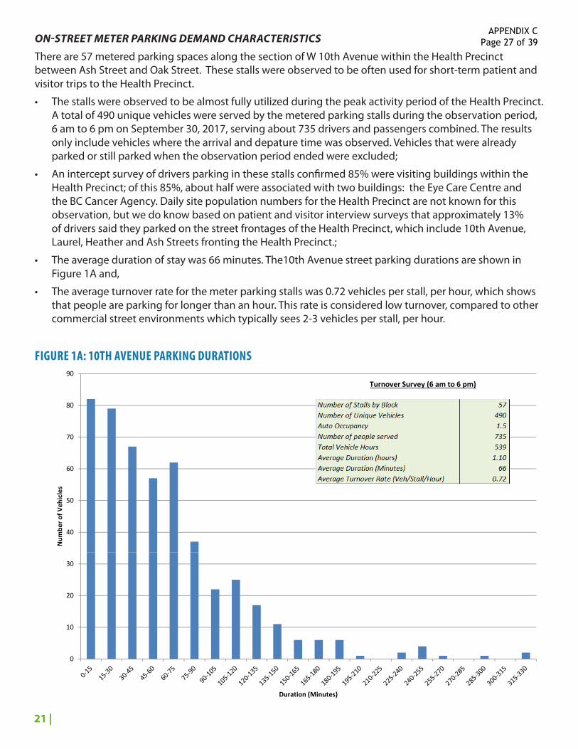
ON-STREET METER PARKING DEMAND CHARACTERISTICS
There are 57 metered parking spaces along the section of W 10th Avenue within the Health Precinct between Ash Street and Oak Street. These stalls were observed to be often used for short-term patient and visitor trips to the Health Precinct.
• The stalls were observed to be almost fully utilized during the peak activity period of the Health Precinct. A total of 490 unique vehicles were served by the metered parking stalls during the observation period, 6 am to 6 pm on September 30, 2017, serving about 735 drivers and passengers combined. The results only include vehicles where the arrival and depature time was observed. Vehicles that were already parked or still parked when the observation period ended were excluded;
• An intercept survey of drivers parking in these stalls confirmed 85% were visiting buildings within the Health Precinct; of this 85%, about half were associated with two buildings: the Eye Care Centre and the BC Cancer Agency. Daily site population numbers for the Health Precinct are not known for this observation, but we do know based on patient and visitor interview surveys that approximately 13% of drivers said they parked on the street frontages of the Health Precinct, which include 10th Avenue, Laurel, Heather and Ash Streets fronting the Health Precinct.;
• The average duration of stay was 66 minutes. The10th Avenue street parking durations are shown in Figure 1A and,
• The average turnover rate for the meter parking stalls was 0.72 vehicles per stall, per hour, which shows that people are parking for longer than an hour. This rate is considered low turnover, compared to other commercial street environments which typically sees 2-3 vehicles per stall, per hour.
40
50
60
70
80
90
Num
ber o
f Veh
icles
10th Avenue Street Parking Durations, September 30, 2016, Bunt & Associates
Turnover Survey (6 am to 6 pm)
0
10
20
30
Duration (Minutes)
FIGURE 1A: 10TH AVENUE PARKING DURATIONS
APPENDIX C Page 27 of 39
22 |
FIGURE 2A:Preferred Design Concept: Oak Street to Laurel Street
Residential Residential
Skin CareCentre
Eye CareCentre
BC Cancer Research Centre
COV/ Vancity
855 Canadian
Cancer Society / J.C.B. Lodge
Arthritis Society 86
5
545
525
535
Emergency
Heather Pavilion
Jim Pattison Pavilion (North)
VGH Cycling CentreJack Bell
Research CentreBC Cancer Agency
UBCMedical Faculty Residential
ICORD Blusson Spinal Cord Centre
Research Pavilion
SLOW
BIKES
SLOW
BIKES
R R R R R R R R R R
P P P P P P P P
PPPP P P P P P P PP
P
M M
CLZ
P
Oak
Laur
el
Will
ow
Hea
ther
Ash
Cam
bie
Laur
el
Residential Residential
Skin CareCentre
Eye CareCentre
BC Cancer Research Centre
COV/ Vancity
855 Canadian
Cancer Society / J.C.B. Lodge
Arthritis Society 86
5
545
525
535
Emergency
Heather Pavilion
Jim Pattison Pavilion (North)
VGH Cycling CentreJack Bell
Research CentreBC Cancer Agency
UBCMedical Faculty Residential
ICORD Blusson Spinal Cord Centre
Research Pavilion
Provide a protected east-west bike signal phaseNew crossings add curb extension and
curb rampsParking to be designated as
Resident Permit Curb extension
Curb extension Apply treatments at ER driveways to improve awareness of people driving and biking of potential
conflict zone and encourage caution.
Clear landscaping to clear sight lines. Leave larger trees.
Oak to
Laurel
Laurelto
Laurel
R M ST
LEGENDExisting curb and back of sidewalkStatutory Right of Way (SRW)
Parking types: see inventory tables for descriptions
Dark green trees are to remainLight green trees are to be removed
P CLZ
**
*Only mature trees are included in the preferred design concept drawing
Existing Proposed Change M Metered 0 0 0
P Passenger Loading Zone or
0 0 0 Metered Disability CLZ Commercial Loading Zone 0 0 0 R Resident 12 7 -5 TOTAL 12 7 -5
PARKING INVENTORY FOR BLOCK PARKING INVENTORY FOR BLOCK Existing Proposed Change M Metered 4 0 -4
P Passenger Loading Zone or
0 0 0 Metered Disability CLZ Commercial Loading Zone 0 0 0 R Resident 7 3 -4 TOTAL 11 3 -8
APPENDIX C Page 28 of 39

23 |
FIGURE 2B:Preferred Design Concept: Laurel Street to Willow Street
Residential Residential
Skin CareCentre
Eye CareCentre
BC Cancer Research Centre
COV/ Vancity
855 Canadian
Cancer Society / J.C.B. Lodge
Arthritis Society 86
5
545
525
535
Emergency
Heather Pavilion
Jim Pattison Pavilion (North)
VGH Cycling CentreJack Bell
Research CentreBC Cancer Agency
UBCMedical Faculty Residential
ICORD Blusson Spinal Cord Centre
Research Pavilion
SLOW
BIKES
SLOW
BIKES
R R R R R R R R R R
P P P P P P P P
PPPP P P P P P P PP
P
M M
CLZ
P
Oak
Laur
el
Will
ow
Hea
ther
Ash
Cam
bie
Laur
el
Residential Residential
Skin CareCentre
Eye CareCentre
BC Cancer Research Centre
COV/ Vancity
855 Canadian
Cancer Society / J.C.B. Lodge
Arthritis Society 86
5
545
525
535
Emergency
Heather Pavilion
Jim Pattison Pavilion (North)
VGH Cycling CentreJack Bell
Research CentreBC Cancer Agency
UBCMedical Faculty Residential
ICORD Blusson Spinal Cord Centre
Research Pavilion
Narrow the bike lane through
the passenger loading zone. Raised crosswalk
Designed for semi-trailer access and egress
Construct curb extention
Raised intersection at sidewalk level
Laurel to Willow
R M ST
LEGENDExisting curb and back of sidewalkStatutory Right of Way (SRW)
Parking types: see inventory tables for descriptions
Dark green trees are to remainLight green trees are to be removed
P CLZ
**
*Only mature trees are included in the preferred design concept drawing
PARKING INVENTORY FOR BLOCK Existing Proposed Change M Metered 17 0 -17
P Passenger Loading Zone or
2 8 +6 Metered Disability CLZ Commercial Loading Zone 0 0 0 R Resident 0 0 0 TOTAL 19 8 -11
APPENDIX C Page 29 of 39
24 |
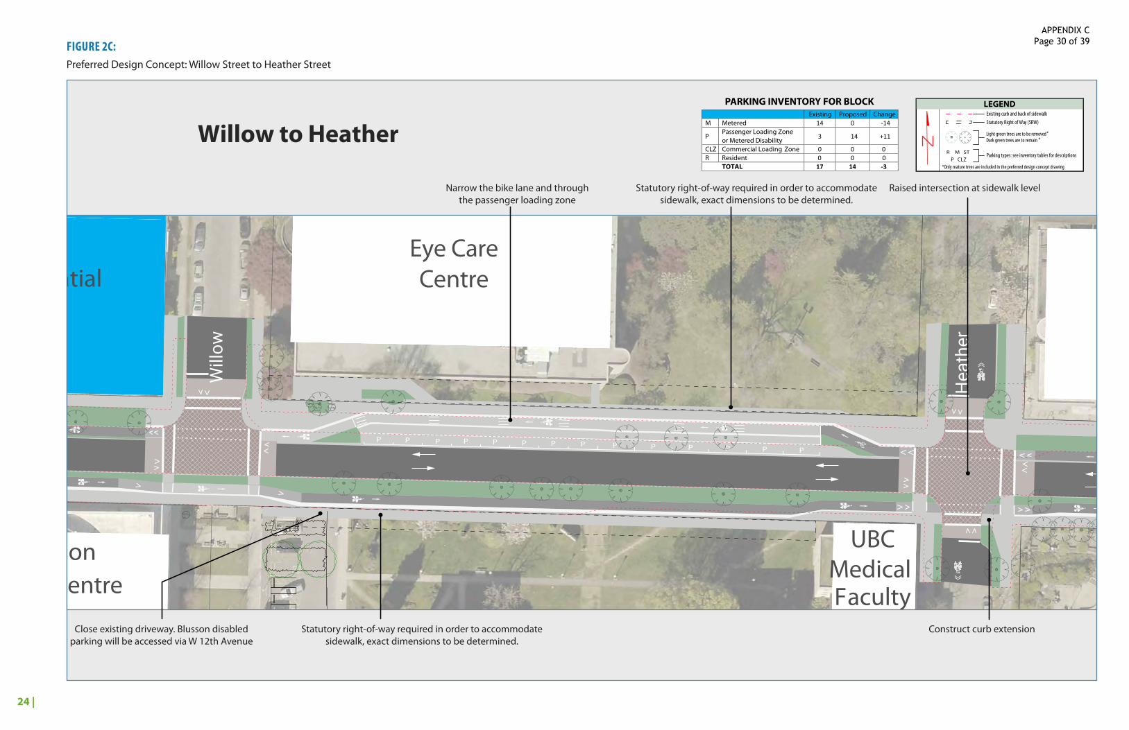
FIGURE 2C:Preferred Design Concept: Willow Street to Heather Street
Residential Residential
Skin CareCentre
Eye CareCentre
BC Cancer Research Centre
COV/ Vancity
855 Canadian
Cancer Society / J.C.B. Lodge
Arthritis Society 86
5
545
525
535
Emergency
Heather Pavilion
Jim Pattison Pavilion (North)
VGH Cycling CentreJack Bell
Research CentreBC Cancer Agency
UBCMedical Faculty Residential
ICORD Blusson Spinal Cord Centre
Research Pavilion
SLOW
BIKES
SLOW
BIKES
R R R R R R R R R R
P P P P P P P P
PPPP P P P P P P PP
P
M M
CLZ
P
Oak
Laur
el
Will
ow
Hea
ther
Ash
Cam
bie
Laur
el
Residential Residential
Skin CareCentre
Eye CareCentre
BC Cancer Research Centre
COV/ Vancity
855 Canadian
Cancer Society / J.C.B. Lodge
Arthritis Society 86
5
545
525
535
Emergency
Heather Pavilion
Jim Pattison Pavilion (North)
VGH Cycling CentreJack Bell
Research CentreBC Cancer Agency
UBCMedical Faculty Residential
ICORD Blusson Spinal Cord Centre
Research Pavilion
Narrow the bike lane and through the passenger loading zone
Raised intersection at sidewalk level
Close existing driveway. Blusson disabled parking will be accessed via W 12th Avenue
Construct curb extensionStatutory right-of-way required in order to accommodate sidewalk, exact dimensions to be determined.
Willow to Heather
R M ST
LEGENDExisting curb and back of sidewalkStatutory Right of Way (SRW)
Parking types: see inventory tables for descriptions
Dark green trees are to remainLight green trees are to be removed
P CLZ
**
*Only mature trees are included in the preferred design concept drawing
Statutory right-of-way required in order to accommodate sidewalk, exact dimensions to be determined.
PARKING INVENTORY FOR BLOCK Existing Proposed Change M Metered 14 0 -14
P Passenger Loading Zone
3 14 +11or Metered Disability CLZ Commercial Loading Zone 0 0 0 R Resident 0 0 0 TOTAL 17 14 -3
APPENDIX C Page 30 of 39
25 |
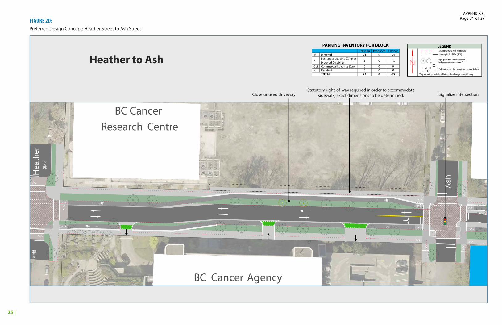
FIGURE 2D:Preferred Design Concept: Heather Street to Ash Street
Residential Residential
Skin CareCentre
Eye CareCentre
BC Cancer Research Centre
COV/ Vancity
855 Canadian
Cancer Society / J.C.B. Lodge
Arthritis Society 86
5
545
525
535
Emergency
Heather Pavilion
Jim Pattison Pavilion (North)
VGH Cycling CentreJack Bell
Research CentreBC Cancer Agency
UBCMedical Faculty Residential
ICORD Blusson Spinal Cord Centre
Research Pavilion
SLOW
BIKES
SLOW
BIKES
R R R R R R R R R R
P P P P P P P P
PPPP P P P P P P PP
P
M M
CLZ
P
Oak
Laur
el
Will
ow
Hea
ther
Ash
Cam
bie
Laur
el
Residential Residential
Skin CareCentre
Eye CareCentre
BC Cancer Research Centre
COV/ Vancity
855 Canadian
Cancer Society / J.C.B. Lodge
Arthritis Society 86
5
545
525
535
Emergency
Heather Pavilion
Jim Pattison Pavilion (North)
VGH Cycling CentreJack Bell
Research CentreBC Cancer Agency
UBCMedical Faculty Residential
ICORD Blusson Spinal Cord Centre
Research Pavilion
Signalize intersectionStatutory right-of-way required in order to accommodate
sidewalk, exact dimensions to be determined. Close unused driveway
Heather to AshR M ST
LEGENDExisting curb and back of sidewalkStatutory Right of Way (SRW)
Parking types: see inventory tables for descriptions
Dark green trees are to remainLight green trees are to be removed
P CLZ
**
*Only mature trees are included in the preferred design concept drawing
PARKING INVENTORY FOR BLOCK Existing Proposed Change M Metered 21 0 -21
P Passenger Loading Zone or
1 0 -1 Metered Disability CLZ Commercial Loading Zone 0 0 0 R Resident 0 0 0 TOTAL 22 0 -22
APPENDIX C Page 31 of 39
26 |
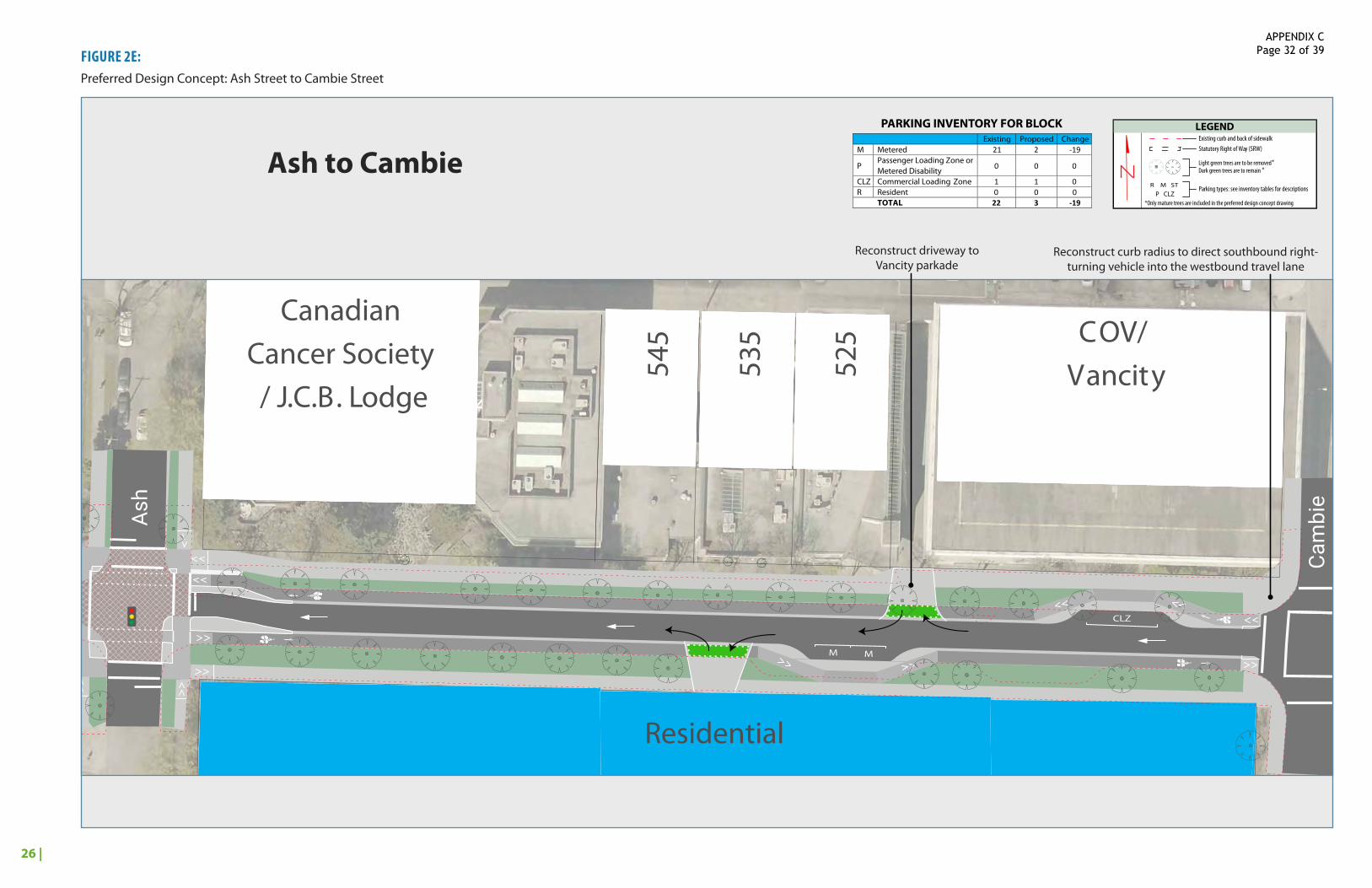
FIGURE 2E:Preferred Design Concept: Ash Street to Cambie Street
Residential Residential
Skin CareCentre
Eye CareCentre
BC Cancer Research Centre
COV/ Vancity
855 Canadian
Cancer Society / J.C.B. Lodge
Arthritis Society 86
5
545
525
535
Emergency
Heather Pavilion
Jim Pattison Pavilion (North)
VGH Cycling CentreJack Bell
Research CentreBC Cancer Agency
UBCMedical Faculty Residential
ICORD Blusson Spinal Cord Centre
Research Pavilion
SLOW
BIKES
SLOW
BIKES
R R R R R R R R R R
P P P P P P P P
PPPP P P P P P P PP
P
M M
CLZ
P
Oak
Laur
el
Will
ow
Hea
ther
Ash
Cam
bie
Laur
el
Residential Residential
Skin CareCentre
Eye CareCentre
BC Cancer Research Centre
COV/ Vancity
855 Canadian
Cancer Society / J.C.B. Lodge
Arthritis Society 86
5
545
525
535
Emergency
Heather Pavilion
Jim Pattison Pavilion (North)
VGH Cycling CentreJack Bell
Research CentreBC Cancer Agency
UBCMedical Faculty Residential
ICORD Blusson Spinal Cord Centre
Research Pavilion
Reconstruct driveway to Vancity parkade
Reconstruct curb radius to direct southbound right-turning vehicle into the westbound travel lane
Ash to CambieR M ST
LEGENDExisting curb and back of sidewalkStatutory Right of Way (SRW)
Parking types: see inventory tables for descriptions
Dark green trees are to remainLight green trees are to be removed
P CLZ
**
*Only mature trees are included in the preferred design concept drawing
PARKING INVENTORY FOR BLOCK Existing Proposed Change M Metered 21 2 -19
P Passenger Loading Zone or
0 0 0 Metered Disability CLZ Commercial Loading Zone 1 1 0 R Resident 0 0 0 TOTAL 22 3 -19
APPENDIX C Page 32 of 39
27 |
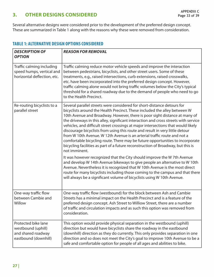
3. OTHER DESIGNS CONSIDERED
Several alternative designs were considered prior to the development of the preferred design concept. These are summarized in Table 1 along with the reasons why these were removed from consideration.
TABLE 1: ALTERNATIVE DESIGN OPTIONS CONSIDERED
DESCRIPTION OF OPTION
REASON FOR REMOVAL
Traffic calming including speed humps, vertical and horizontal deflection, etc.
Traffic calming reduce motor vehicle speeds and improve the interaction between pedestrians, bicyclists, and other street users. Some of these treatments, e.g., raised intersections, curb extensions, raised crosswalks, etc. have been incorporated into the preferred design concept. However, traffic calming alone would not bring traffic volumes below the City’s typical threshold for a shared roadway due to the demand of people who need to go to the Health Precinct.
Re-routing bicyclists to a parallel street
Several parallel streets were considered for short-distance detours for bicyclists around the Health Precinct. These included the alley between W 10th Avenue and Broadway. However, there is poor sight distance at many of the driveways in this alley, significant interaction and cross streets with service vehicles, and difficult street crossings at major intersections that would likely discourage bicyclists from using this route and result in very little detour from W 10th Avenue. W 12th Avenue is an arterial traffic route and not a comfortable bicycling route. There may be future opportunities to incorporate bicycling facilities as part of a future reconstruction of Broadway, but this is not imminent.
It was however recognized that the City should improve the W 7th Avenue and develop W 14th Avenue bikeways to give people an alternative to W 10th Avenue. Nevertheless it is recognized that W 10th Avenue is the most direct route for many bicyclists including those coming to the campus and that there will always be a significant volume of bicyclists using W 10th Avenue.
One-way traffic flow between Cambie and Willow
One-way traffic flow (westbound) for the block between Ash and Cambie Streets has a minimal impact on the Health Precinct and is a feature of the preferred design concept. Ash Street to Williow Street, there are a number of traffic and circulation impacts and as such this option was removed from consideration.
Protected bike lane westbound (uphill) and shared roadway eastbound (downhill)
This option would provide physical separation in the westbound (uphill) direction but would have bicyclists share the roadway in the eastbound (downhill) direction as they do currently. This only provides separation in one direction and so does not meet the City’s goal to improve 10th Avenue to be a safe and comfortable option for people of all ages and abilities to bike.
APPENDIX C Page 33 of 39
28 |
Bi-directional bikeway on north or south side of W 10th Avenue
Options for a bi-directional bikeway on either the north or south sides of the street were investigated. The primary concerns with bi-directional bikeways on one side of the street is that other road users, e.g., pedestrians, turning motorists, etc., often do not expect bicyclists coming from both directions. As a result, these types of bike facilities work best where there are few driveways, pedestrian crossings, etc. and it would be difficult to transition the facility from one side of the street to the other to minimize interactions with the emergency room driveways on the south side of the street and the passenger loading zones on the north side of the street.
Shared Street The idea of a shared street environment was considered, but there were concerns that motor vehicle traffic volumes are too high on this corridor and that the design would not provide sufficient delineation between modes of travel. In particular, there are significant design challenges in making the distinction between pedestrian and motor vehicle space for sight-impaired and blind pedestrians. There was also a concern that bicyclists may ride in the pedestrian space given the street’s high vehicle volumes.
Elevated Bikeway This was considered at a high level and removed due to concerns about steep grades to achieve the necessary clearance over intersection streets, usability, high costs, connectivity to the surrounding land uses as well as intersection bike routes, impacts on the streetscape and tree canopy, and convenience. If it isn’t easy to access and egress by bike, people would likely choose to continue using the street.
4. OVERVIEW OF THE PREFERRED DESIGN CONCEPT
The key elements of the preferred design concept include:
• Maintaining two-way traffic flow between Oak Street and Ash Street.
• Converting the block between Cambie Street and Ash Street to one-way westbound.
• Improvements to the pedestrian realm: raised intersections, raised crossings, bulges, etc.
• Creating unidirectional protected bike lanes on either side of the street.
• Maintaining critical hospital functions including ambulance service routes, access to the emergency room, and loading functions.
• Retaining critical access to the services and clinics along W 10th Avenue, including increasing the number of passenger pick-up and drop-off spaces and as much priority and accessible parking as possible.
• Minimizing the loss of mature and significant trees.
• Maintaining 2-way traffic on all side streets.
APPENDIX C Page 34 of 39

29 |
Each block is unique along the corridor and as such different trade-offs were considered in every block to determine how space would be used to accommodate the design needs. These are summarized in Table 2.
TABLE 2: CONSIDERATION OF TRADE-OFFS
ELEMENT CONSIDERATIONS
Bicycling Infrastructure Are there places where the desirable bike lane width can be narrowed?
Motor Vehicle Circulation
The Cambie to Ash Street block was converted to one-way westbound to be able to accommodate protected bike lanes without significant loss of trees
On-Street Parking Which parking user is most critical and where do they need space? Where can less critical parking be relocated or removed to create space for high-priority street uses?
Tree Removal Where can trees be removed to create space for high-priority street uses? Are there locations where this is the only trade-off that can be made?
Statutory Right-of-Way Are there strategic locations where it makes sense to encroach the sidewalk into private property to accommodate a better design for everyone?
4.1 PEDESTRIAN REALM
Intersections:
• Raised intersections were included at the Willow Street and Heather Street intersections to bring all road users to the same grade as the sidewalk. This has a number of benefits including minimizing grade changes for vulnerable pedestrians. Raising the intersection also slows drivers entering intersection.
• A raised crosswalk is included on the east leg of the Laurel Street (east) intersection. A raised intersection is not possible at this intersection because the primary ambulance response routes between Oak Street and Laurel Street (east) need to be maintained clear of bumps and delay.
• Curb bulges were used at intersections where vehicle turning paths allowed this design. These treatments shorten crossing distances and improve visibility of pedestrians at intersection crossings.
Accessibility:
• Curb ramps and/or refuge spaces should be used at all pedestrian crossings that are not at sidewalk grade, and where possible, intersection corners should be designed to include curb ramps at 90-degrees to the street to align with the crosswalks and define the safest path across the intersection.
4.2 HEALTH PRECINCT OPERATIONS
Emergency Room and Ambulance Movements:
• The primary access and egress routes for ambulances on W 10th Avenue are to and from Oak Street, Laurel Street (west), and Laurel Street (east). Treatments that could slow response time, such as raised traffic calming elements were not applied west of the Laurel Street (east) intersection.
• The emergency room driveways are subject to the same rules of the road as any other driveways, however, it is recognized that these locations are unique locations and so managing modal
APPENDIX C Page 35 of 39

30 |
interactions is of the highest priority. A number of striping, signage, and design elements are proposed to increase awareness between modes and to manage vehicle and bicycle speeds at these driveways. The access driveway is particularly important as drivers are turning across the bikeway and may be more panicked and rushing to bring patients to the emergency room. Their entry speeds need to be managed to provide safe use of the street for others, including pedestrians, bicyclists, and people using the emergency room drop-off. Potential design treatments for these driveways are highlighted on Figure 3. Vancouver has an existing example of a bike lane crossing an ER driveway at St. Paul’s Hospital on Burrard Street.
Service Vehicles:
• W 10th Avenue is critical to the day-to-day function of the hospital and includes deliveries and loading to numerous buildings and access to the primary loading court. Driveways and intersections were designed for the appropriate design vehicles servicing the precinct.
FIGURE 3: EMERGENCY ROOM DRIVEWAY TREATMENTS.
Traffic Flow:
• As described earlier, maintaining two-way traffic flow between Oak Street and Ash Street was important for the Health Precinct partners. However, one-way traffic flow in the westbound direction between Cambie Street and Ash Street has limited impact on Health Precinct operations. Providing one-way traffic flow in this block allows protected bike lanes to be developed within the existing curbs and minimal impact to mature and significant trees.
• It is recommended that the W 10th Avenue / Ash Street intersection would be signalized. This would help with traffic operations at this intersection and would improve the interactions between different road users.
• The City recommends introducing a dedicated east-west bicycle/walk phase at the Oak Street intersection.
APPENDIX C Page 36 of 39

31 |
4.3 BICYCLING INFRASTRUCTURE
• The recommended design features uni-directional protected bike lanes on either side of the street throughout the Health Precinct. It is expected that protected bike lanes would not only better organize roadway space, but would improve interactions between different modes. There would be clear expectations for where bicyclists will be on the street and clear identification of right-of-way. These features are summarized on Figure 4.
• The majority of the preferred design concept includes a physical buffer between the bike lane and the travel lane (as shown in the example shown on Figure 3). This provides a physical separation for bicyclists and prevents vehicles from using the bike lane to drop-off passengers.
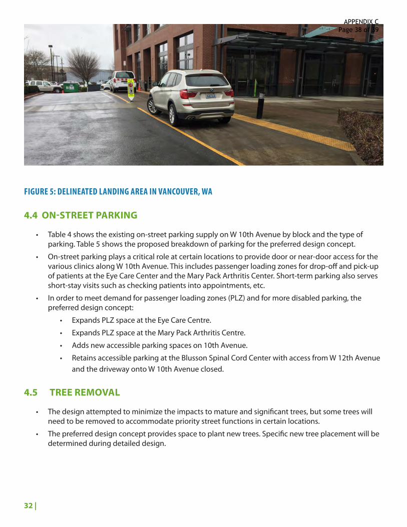
• The bikeway will be “wrapped” behind passenger loading zones and accessible parking spaces to eliminate conflicts between people driving in/out of these spaces and people biking along 10th Ave.. These areas are recommended to be built at sidewalk level and require a “landing area” between the parking space and the bikeway to give people a comfortable space to get in and out of their vehicles. Figure 5 shows an example from Vancouver, WA of how this space could be delineated (although without the bike lane).
FIGURE 4: ELEMENTS OF A PROTECTED BIKE LANE
APPENDIX C Page 37 of 39
32 |
FIGURE 5: DELINEATED LANDING AREA IN VANCOUVER, WA
4.4 ON-STREET PARKING
• Table 4 shows the existing on-street parking supply on W 10th Avenue by block and the type of parking. Table 5 shows the proposed breakdown of parking for the preferred design concept.
• On-street parking plays a critical role at certain locations to provide door or near-door access for the various clinics along W 10th Avenue. This includes passenger loading zones for drop-off and pick-up of patients at the Eye Care Center and the Mary Pack Arthritis Center. Short-term parking also serves short-stay visits such as checking patients into appointments, etc.
• In order to meet demand for passenger loading zones (PLZ) and for more disabled parking, the preferred design concept:
• Expands PLZ space at the Eye Care Centre.
• Expands PLZ space at the Mary Pack Arthritis Centre.
• Adds new accessible parking spaces on 10th Avenue.
• Retains accessible parking at the Blusson Spinal Cord Center with access from W 12th Avenue and the driveway onto W 10th Avenue closed.
4.5 TREE REMOVAL
• The design attempted to minimize the impacts to mature and significant trees, but some trees will need to be removed to accommodate priority street functions in certain locations.
• The preferred design concept provides space to plant new trees. Specific new tree placement will be determined during detailed design.
APPENDIX C Page 38 of 39

33 |
TABLE 4: EXISTING ON-STREET PARKING INVENTORY BY BLOCK AND PARKING TYPE
OAK TO LAUREL
LAUREL TO LAUREL
LAUREL TO WILLOW
WILLOW TO HEATHER
HEATHER TO ASH
ASH TO CAMBIE
TOTAL
Metered 0 4 17 14 21 21 77
Passenger Loading and Disability Parking Spaces
0 0 2 3 1 0 6
Commercial Loading Zone
0 0 0 0 0 1 1
Resident Permit 12 7 0 0 0 0 19
TOTAL 12 11 19 17 22 22 103
TABLE 5: PROPOSED ON-STREET PARKING INVENTORY BY BLOCK AND PARKING TYPE
OAK TO LAUREL
LAUREL TO LAUREL
LAUREL TO WILLOW
WILLOW TO HEATHER
HEATHER TO ASH
ASH TO CAMBIE
TOTAL
Metered 0 0 0 0 0 2 2
Passenger Loading Zone and Disability Parking Spaces
0 0 8 14 0 0 22
Commercial Loading Zone
0 0 0 0 0 1 1
Resident Permit 7 3 0 0 0 0 10
TOTAL 7 3 8 14 0 3 35
Note: There will also be some changes to parking on side streets not shown in these tables.
4.6 STATUTORY RIGHTS-OF-WAY
Statutory rights-of-way (SRWs) are recommended at three locations:
• On the north side of W 10th Avenue, in the eastern half of the Heather-Ash block. This will extend the sidewalk into the vacant lot currently owned by PHSA. This SRW would allow retention of most trees in this block.
• On the south side of W 10th Avenue, for most of the block between Willow Street and Heather Street. This will extend the sidewalk into the lawn in front of the Heather Pavilion and allow a bikeway to be developed behind the trees and retention of on-street parking and two-way traffic flow.
• On the north side of W 10th Avenue, between Willow and Heather to accommodate disability parking spaces, bikeway, and sidewalk.
APPENDIX C Page 39 of 39