report to leeds city council
TRANSCRIPT

Report to Leeds City Council
by Claire Sherratt DipURP MRTPI and Louise Gibbons BA (Hons) MRTPI
Inspectors appointed by the Secretary of State Date: 7 June 2019
Planning and Compulsory Purchase Act 2004 (as amended)
Section 20
Report on the Examination of the Leeds City Council Site Allocations Plan
The Plan was submitted for examination on 5 May 2017
The examination hearings were held between 24 October 2017 and 3 August 2018
File Ref: PINS/N4720/429/14

2
Abbreviations used in this report AA Appropriate Assessment
AVLAAP CS CSSR DtC
Aire Valley Leeds Area Action Plan Core Strategy Core Strategy Selective Review Plan Duty to Co-operate
ELR FE GATE GTAA HMCA
Employment Land Review Forms of Entry Leeds Gypsy and Traveller Exchange Leeds Gypsy and Traveller Accommodation Assessment Housing Market Characteristic Area
HRA Habitats Regulations Assessment HS2 IDP LDS
High Speed Rail Phase 2 Infrastructure Delivery Plan Local Development Scheme
LP Local Plan MHCLG Ministry of Housing, Communities and Local Government MM MUA
Main Modification Main Urban Area
NPPF NRWLP
National Planning Policy Framework Natural Resources and Waste Local Plan
PAS PPA PPG
Protected Areas of Search Primary Planning Areas Planning Practice Guidance
PPTS Planning Policy for Traveller Sites SA Sustainability Appraisal SAC SAP SCI SEA
Special Area of Conservation Site Allocations Plan Statement of Community Involvement Strategic Environmental Assessment
SHLAA Strategic Housing Land Availability Assessment SP SPD SPA
Spatial Policy Supplementary Planning Document Special Protection Area
UDP WMS
Unitary Development Plan Review Written Ministerial Statement

Leeds City Council Site Allocations Plan, Inspector’s Report June 2019
3
Non-Technical Summary This report concludes that the Leeds City Council Site Allocations Plan (SAP) provides an appropriate basis for the planning of the City, provided that a number of main modifications [MMs] are made to it. Leeds City Council has specifically requested that we recommend any MMs necessary to enable the Plan to be adopted. The MMs all concern matters that were discussed at the examination hearings. Following the hearings, the Council prepared schedules of the proposed main modifications and carried out sustainability appraisal of them. The MMs were subject to public consultation over a six-week period. In relation to MM19 we have amended the detailed wording. We have recommended their inclusion in the Plan after considering all the representations made in response to consultation on them. The Main Modifications can be summarised as follows:
• Set out the housing requirement for years 1 – 11 of the plan period; • Delete sites that would need to be released from the Green Belt but are not
necessary to meet the housing requirement for years 1 to 11 of the Leeds Core Strategy plan period;
• Commitment to review of housing element of SAP immediately after adoption of the Core Strategy Selective Review Plan;
• Delete all references to phasing of sites; • Commitment to monitor the delivery of negotiated stopping places and
private pitch provision through planning permissions and if necessary, undertake a review of allocation of gypsy and traveller pitches post 2024;
• Clarify that site allocation HG7-1 ‘West Wood, Dewsbury Road, Tingley’ is to be removed from the Green Belt;
• Delete safeguarded land allocations no longer necessary to meet 10% of lower housing requirement to year 11;
• Delete designation of additional land in Outer North East Housing Market Characteristic Area (HMCA) as ‘new’ Green Belt (currently designated as Rural Land in adopted Unitary Development Plan);
• Amend allocation EG3 ‘Leeds Bradford International Airport’ Employment Hub’ to EG2-24 to be consistent with other employment land;
• Delete identified and allocated sites that are no longer available or deliverable;
• Revise policies relating to identified sites to be clear what this category includes; list the sites relevant at the time of the examination in an Annex; ensure clear monitoring of identified sites to check on-going availability and deliverability;
• Various modifications to generic and individual site requirements to ensure they are effective;
• Update capacity of sites to reflect most up-to-date information.

Leeds City Council Site Allocations Plan, Inspector’s Report June 2019
4
Introduction 1. This report contains our assessment of the SAP in terms of Section 20(5) of
the Planning & Compulsory Purchase Act 2004 (as amended). It considers first whether the Plan’s preparation has complied with the duty to co-operate. It then considers whether the Plan is sound and whether it is compliant with the legal requirements. The National Planning Policy Framework (NPPF) 2012 (paragraph 182) makes it clear that in order to be sound, a Local Plan should be positively prepared, justified, effective and consistent with national policy.
2. The revised NPPF was published in July 2018 and further revised in February 2019. It includes a transitional arrangement in paragraph 214 which indicates that, for the purpose of examining this Plan, the policies in the 2012 NPPF will apply. Similarly, where the Planning Practice Guidance (PPG) has been updated to reflect the revised NPPF, the previous versions of the PPG apply for the purposes of this examination under the transitional arrangement. Therefore, unless stated otherwise, references in this report are to the 2012 NPPF and the versions of the PPG which were extant prior to the publication of the 2018 NPPF.
3. The SAP is a Development Plan Document which sits within a wider group of documents comprising the Leeds Local Plan. The Local Plan currently comprises the Core Strategy (2014) (CS), the Natural Resources and Waste Local Plan (2015) (NRWLP) and the Aire Valley Leeds Area Action Plan (2017) (AVLAAP). A number of policies within the Unitary Development Plan Review (2006) (UDP) also remain extant.
4. The starting point for the examination is the assumption that the local planning authority has submitted what it considers to be a sound plan. The SAP Submission Draft submitted in May 2017, which incorporates pre-submission changes, is the basis for our examination. There were two sets of pre-submission changes as set out below.
5. The Publication Draft SAP was agreed by the Council’s Executive Board on 15 May 2015 and an 8-week period of statutory consultation was undertaken from 22 September to 16 November 2015. However, at the time of publication, the landowner of a proposed new settlement in the Outer North East HMCA, site MX33-Headley Hall, withdrew the site. As a result of this, the Council reconsulted on the revised proposals for the Outer North East HMCA only. The Council’s Executive Board agreed the Revised Publication Draft Plan for Outer North East HMCA on 21 September 2016 and there was a statutory period of public consultation for this area only from 26 September to 7 November 2016.
6. Following the statutory public consultation on the Publication Draft SAP (Regulation 20) referred to above, officers analysed the representations received and identified key issues which could affect the ‘soundness’ of the Plan. Changes, recommended to make the Plan sound, were considered and endorsed by the Development Plan Panel and Executive Board of the Council. Subsequently, these pre-submission changes were advertised for comment between 13 February and 27 March 2017. This included updated planning application approvals (up to 1st April 2016), which has resulted in some proposed new allocations becoming identified sites. New sites were also

Leeds City Council Site Allocations Plan, Inspector’s Report June 2019
5
submitted for consideration either during the earlier consultation process or as part of the Strategic Housing Land Availability Assessment (SHLAA) (which is updated annually).
7. To meet the CS housing requirement between 2012 – 2028 (‘the plan period’) significant releases of land from the Green Belt are necessary, a position accepted in the CS. Exceptional circumstances were therefore found to exist to support the release of Green Belt land as a matter of principle. The Council’s emerging work on housing need, as part of the evidence to support the Core Strategy Selective Review (CSSR), identified a lower housing requirement figure than that contained in the adopted CS. The CSSR was submitted for examination in August 2018 and is still being examined. Nevertheless, any consideration of whether the housing requirement figure contained in the adopted CS remains appropriate or what any new requirement should be is beyond the purpose of the SAP and the remit of this examination. A lower requirement may however mean less Green Belt release would be necessary.
8. The Council considered its position during the examination process and suggested revisions to the housing element of the SAP which it presented as a ‘Revised Submission Draft SAP’ (‘the revised plan’). The revised plan included revised policies relating to housing allocations, broad locations, safeguarded land, phasing and associated explanatory text, all of which were subject to consultation between 15 January 2018 and 26 February 2018. These matters were discussed at the hearing sessions that commenced in July 2018.
9. Having regard in particular to the Planning and Compulsory Purchase Act 2004 (s20 7B & 7C), the 2012 Local Planning Regulations (various) and the PPG on local plans (Paragraph: 004 Reference ID: 1200420160519), it is clear that, once submitted for examination, the substance of a submitted plan can only be changed in one way, through a process of MMs. MMs can only be recommended by the Inspector but only where they are necessary to achieve a sound plan.
10. It follows from this that that the Act and Regulations do not allow a Council to withdraw a plan which has been submitted for examination, prepare an alternative plan and then re-submit it during the examination. Consequently, the plan which we are obliged to examine is the Submission Draft SAP submitted in May 2017. However, through the examination we have considered whether the changes advanced in the Council’s ‘revised plan’ were necessary to achieve a sound plan and if, therefore, they should be recommended by us as MMs in some form
11. The ‘revised plan’ contained site allocations and Broad Locations to meet the housing requirement for the plan period. The Broad Locations were those sites that the Council identified in the Green Belt as necessary to meet the housing requirement in the latter 5 years of the plan period. However, these sites were to remain in the Green Belt with no mechanism for their release at a later stage through this SAP. Rather, the Council intended that these sites would form the basis of sites to be considered through a review of the SAP once the CSSR established a revised housing requirement. However, this approach would not be effective in meeting the adopted CS housing requirement to 2028 as the Broad Location sites would remain in the Green

Leeds City Council Site Allocations Plan, Inspector’s Report June 2019
6
Belt for the purposes of the SAP. This approach was not considered to be sound. Furthermore, it would pre-empt and thus potentially limit the pool of sites to be considered through any SAP review.
12. We have also considered the further work which was subsequently carried out by the Council after the ‘revised plan’ was prepared. This led to some of the recommended MMs which are considered in detail later on in our report.
Main Modifications
13. In accordance with section 20(7C) of the 2004 Act the Council requested that we should recommend any MMs necessary to rectify matters that make the Plan unsound and thus incapable of being adopted. Our report explains why the recommended MMs, all of which relate to matters that were discussed at the examination hearings or were contained in our Post Hearing Procedural Notes to the Council are necessary. The MMs are referenced in bold in the report in the form MM1, MM2 etc, and are set out in full in the Appendix.
14. Following the examination hearings, the Council prepared a schedule of proposed MMs and carried out Sustainability Appraisal (SA) of them. The MM schedule was subject to public consultation for six weeks. We have taken account of the consultation responses in coming to our conclusions in this report. We have made amendments to the detailed wording of MM19, MM20, MM22 and MM126, necessary for clarification or to correct typographical errors. In addition, a further MM (MM152) is required to ensure a consistent approach to site requirements concerning non-designated heritage assets throughout the SAP and to reflect other MMs made. These amendments do not significantly alter the content of the MMs as published for consultation or undermine the participatory process and SA that has been undertaken.
Policies Map
15. The Council must maintain an adopted policies map which illustrates geographically the application of the policies in the adopted development plan. When submitting a local plan for examination, the Council is required to provide a submission policies map showing the changes to the adopted policies map that would result from the proposals in the submitted local plan. In this case, the submission policies map comprises the Leeds Policies Map. In addition, and separate to the Leeds Policies Map, a set of plans relating to each HMCA is included in the SAP document itself (‘the SAP Maps’).
16. The policies map is not defined in statute as a development plan document and so we do not have the power to recommend MMs to it. However, a number of the published MMs to the Plan’s policies require further corresponding changes to be made to the policies map and / or SAP Maps. In addition, there are some instances where the geographic illustration of policies on the submission policies map is not justified and changes to the policies map or SAP Maps are needed to ensure that the relevant policies are effective.
17. These further changes to the policies map were published for consultation alongside the MMs.
18. When the SAP is adopted, in order to comply with the legislation and give effect to the Plan’s policies, the Council will need to update the adopted

Leeds City Council Site Allocations Plan, Inspector’s Report June 2019
7
policies map and SAP maps in line with the submission map but subject to all the changes proposed in Appendix 2 of the Consultation Version of the Schedule of Proposed Modifications and the further changes published alongside the MMs.
Assessment of Duty to Co-operate
19. Section 20(5)(c) of the 2004 Act requires that we consider whether the Council complied with any duty imposed on it by section 33A in respect of the Plan’s preparation. Consideration of whether the Council has complied with this duty is to be assessed in the context of this being a site allocation plan only. The duty to cooperate in this context therefore relates primarily to the location of sites.
20. The Council has been proactive in this respect. From 2011 the Council have been engaged across the Leeds city region on strategic cross boundary matters. Meetings were held between different authorities to discuss these matters both at officer level through the Strategic Planning Duty to Co-operate Group, and through Member groups.
21. Mechanisms developed as part of the work on the Leeds CS have provided a framework for a consistent approach towards the SAP. There is a structured approach to cross boundary issues including agreement between the authorities on how to assess the impact of housing and employment allocations in the SAP on the adjoining authorities in respect of traffic and transport, schools including planning school places, local healthcare facilities, the impact of gypsy and traveller and Travelling Showpeople sites on traffic and transport movements, and the effect of development at Leeds Bradford Airport. In respect of the Green Belt and Rural Land, there has been engagement and liaison with the relevant adjoining authorities, including Bradford and Harrogate.
22. The evidence demonstrates co-operation on a range of matters and with several organisations. The Strategic Planning Duty to Co-operate group includes representatives from Highways England, the Homes and Communities Agency and Environment Agency. There has also been effective and on-going involvement in the SAP from Historic England and Highways England. Natural England have also been actively engaged in assessing the impacts of the SAP.
23. There are no unresolved strategic matters, and we are satisfied that where necessary the Council has engaged constructively, actively and on an on-going basis in the preparation of the SAP and that the duty to co-operate has therefore been met.
Assessment of Soundness
Background
24. The purpose of the SAP, as set out in paragraph 1.6, is to provide site allocations and requirements that will help to deliver the CS policies, ensuring that sufficient land is available in appropriate locations to meet the targets set out in the CS, adopted in November 2014, and achieve the Council’s ambitions. The CS plan period is 2012-2028. The SAP covers Housing, Employment, Retail and Green Space allocations for the whole of Leeds district except for the area within the AVLAAP.
Leeds City Council Site Allocations Plan, Inspector’s Report June 2019
8
Main Issues
25. Taking account of all the representations, the written evidence and the discussions that took place at the examination hearings, we have identified 7 main issues upon which the legal compliance and soundness of this plan depends. This report deals with these main issues. It does not respond to every point or issue raised by representors. Nor does it refer to every policy, policy criterion or allocation in the SAP.
Issue 1 – Whether the SAP meets the legal process and requirements?
26. The overall legal process and requirements are summarised later in the report.
Statement of Community Involvement
27. Some concern was expressed that the Statement of Community Involvement document was now rather dated. However, it nevertheless meets the relevant statutory requirements. Whilst some Neighbourhood groups and forums felt a greater level of engagement should have occurred, the engagement with and involvement of Neighbourhood Plan groups as part of the consultation on the SAP and on the MMs was carried out in compliance with the principles set out in the Council’s Statement of Community Involvement.
Sustainability Assessment
28. A SA of sites was undertaken alongside the production of the SAP. It has been subject to the public consultation process. Furthermore, the SAP aims to deliver the requirements of the CS, which has itself been subject to SA. The policies in the CS determine how sites should be considered for inclusion in the SAP.
29. The SA has considered the overall effects of proposed allocations coming forward as a whole, i.e. the cumulative effects and the identification of mitigation measures where negative effects are identified for individual sites or sites as a whole. The SA provides a guide to compare the performance of individual sites against a range of environmental, social and economic considerations allowing all reasonable alternatives to be assessed on the same basis and thus meeting the Strategic Environmental Assessment (SEA) requirements.
30. The SAP’s preparation has been based on an adequate process of SA. Whilst it does not itself provide a definitive answer on which sites to allocate, it is an important part of the supporting evidence.
Habitats Regulations Assessment
31. As part of the Habitats Regulations Assessment Screening Assessment the Council assessed Special Protection Areas (SPA) and Special Areas of Conservation (SAC) within 10 km of the Leeds City Council MD boundary and also the Humber Estuary, alone and in combination with other known plans or projects, including the Bradford area. This identifies elements of the Plan that have the potential to cause an adverse effect on areas designated for their special habitats.

Leeds City Council Site Allocations Plan, Inspector’s Report June 2019
9
32. Pursuant to the European Court of Justice Judgment in, People over Wind, Peter Sweetman v Coillte Teoranta1[Case C323/17] (“the Judgment”), the Council revisited the Screening Assessment, and have undertaken a Habitat Regulations Assessment (HRA) (Appendix 1 SAP-HRA-Response to Inspectors’ Questions Final) in relation to the South Pennine Moor SPA (Phase 2).
33. This follows the stages of HRA with evidence gathering, assessing likely significant effects for the SPAs and SACs, having regard to the conservation objectives of each protected site. Mitigation for adverse effects is considered, in particular the measures based on existing projects in Chevin Forest Park and North West Leeds Country Park, both of which require maintenance and enhancement to reduce any recreational impacts on the SPA to an acceptable level.
34. MMs are necessary for clarity to set out the conclusions of the HRA in the SAP in respect of the HMCAs of Aireborough, Outer North West and Outer West as they relate to the South Pennine Moor SPA (Phase 2). Monitoring of the measures will be necessary and this is to be undertaken through the Council’s Monitoring Framework and the Annual Monitoring Report (AMR) which will quantify spending and improvements to green spaces in the relevant HMCAs [MM38, MM84 and MM148].
35. To conclude subject to the MMs, the requirements of the Habitats Directive and in particular, Article 6(3) have been addressed and the conclusions are in accordance with the Judgment. Appropriate Assessment has been carried out on the relevant SPA, and Natural England supports the findings of both the Screening Assessment, the HRA and mitigation. The Screening Assessment and HRA adequately addresses the full range of potential impacts on the Plan.
Issue 2 – Whether the SAP gives effect to and is consistent with the CS.
Housing
36. CS Spatial Policy 6 (SP6) sets out a requirement for the provision of 70,000 (net) new dwellings between 2012 and 2028 with a target that at least 3,660 per year should be delivered from 2012/13 to the end of 2016/17. It states that guided by the settlement hierarchy the Council will identify 66,000 dwellings gross (62,000 net). New allocations are not needed to accommodate all of the 66,000 target. Part of this is to be met through existing supply (‘Identified Sites’). Taking account of consequential MM updates, Table 1 of the SAP calculates the existing supply to be 35,950 dwellings leaving a residual target of 30,050 to be met through allocations.
37. To achieve sufficient allocations to meet the residual housing requirement a number of significant site allocations are proposed on land that would need to be released from the Green Belt. Although the SAP is intended to provide the supply of housing sought by the adopted CS between 2012 to 2028, as stated previously, the Council’s emerging work on housing need, as part of the evidence to support the CSSR, identifies a lower figure. The CSSR submitted for examination states that the Council will identify 46,352 dwellings (gross) between 2017 and 2033; substantially less that the equivalent figure of 66,000 dwellings (gross) set out in the adopted CS. Until such time as the CSSR examination is concluded, there is uncertainty about what the need

Leeds City Council Site Allocations Plan, Inspector’s Report June 2019
10
figure (and requirement) should be and whether the adopted CS need figure is up to date. In these circumstances, given that national policy attaches great importance to the Green Belt and only envisages altering boundaries in exceptional circumstances, significant releases of land from the Green Belt would not be justified at this stage.
38. Paragraph 47 of the NPPF stipulates that to boost significantly the supply of
housing, local planning authorities should identify and update annually a supply of specific deliverable sites sufficient to provide five years’ worth of housing against their housing requirement with an additional buffer and identify a supply of specific, developable sites or broad locations for growth for years 6 - 10 and where possible, for years 11 – 15. For the reasons already set out, it is not possible to identify sites in the latter five years of the plan period that would not necessitate significant releases of land from the Green Belt. To make the SAP sound, only those Green Belt sites necessary to make housing provision for years 1 to 11 of the plan period (i.e. to 2023) should be released from the Green Belt at this stage [MM1, MM2, MM3, MM17]. Those housing sites or parts of allocated housing / mixed use sites in the Green Belt and not required to achieve this should be deleted [MM5]. Some non-Green Belt provision will continue beyond 2023.
39. Based on the adopted CS figure, the housing requirement for years 1-11 (2012-2023) only is calculated as 43,750. This is reflecting the lower CS Policy SP6 target of 3,660 per year to be delivered from 2012/13 to the end of 2016/17 and the stepped up SP6 target of 4,700 per year from 2017/18. A MM is necessary to ensure that both the housing requirement to 2023 is clear and that Table 1 includes expected delivery to 2023 having regard to non-Green Belt and Green Belt sites [MM6].
40. In addition, the SAP should be amended, by way of a MM, to commit to a review of it, to commence as soon as the housing requirement is established through the CSSR with a view towards completion of the examination and adoption no later than 31 March 2023, to bring the supply into alignment with any CSSR figure [MM3, MM4].
41. In the meantime, the SAP would only identify sufficient housing land that
would need to be released from the Green Belt to meet the housing requirement for at least years 1 to 11 of the plan period i.e. up to 2023. Accordingly, no phasing policies would be justified and so references to phasing will need to be deleted from the SAP [MM1 and MM10].
42. Paragraph 4.6.12 of the CS explains that the housing requirement will
comprise of current, undelivered allocations, extant planning permissions and other sites which are deemed to be appropriate for housing delivery, as per the guidelines contained in CS SP6 (Figures as at March 2011). The CS is therefore clear that the role of the SAP is to identify, in addition to current undelivered allocations and extant planning permissions, those “other sites which are deemed to be appropriate for housing delivery”.
43. Policy HG1 of the SAP refers not only to site allocations but other ‘identified sites’. All identified sites are included on the Policies Map. Identified sites are

Leeds City Council Site Allocations Plan, Inspector’s Report June 2019
11
described as those with existing planning permission (extant planning permissions), sites previously allocated for housing in the UDP (undelivered allocations) and sites where planning permission has recently expired. This latter category is not specifically referred to in the CS and so must fall within the category “other sites which are deemed to be appropriate for housing delivery” notwithstanding that they are not put forward as, or given the status of, site allocations.
44. Identified sites are regarded by the Council to be appropriate for housing
delivery. Examination Document EX38 details that as at 1 April 2018 there are 550 identified (Policy HG1) sites in total with a total capacity of 36,333 units. 223 of these sites have been completed since 1st April 2012, having a total capacity of 6,023. A further 120 of these 550 sites are presently under construction and will provide a further 11,033 units. This gives rise to a residual total of 207 sites. These comprise UDP allocations without permission (19 sites / 6299 dwellings); sites with detailed permission (88 sites / 7749 dwellings); sites with outline permission (10 sites / 1878 dwellings) and those with expired permission (90 sites / 3351 dwellings). All 207 sites have been subject to SA. The most up-to-date position on supply, having regard to changes reflected through MMs, is 35,950.
45. It is not correct to refer to sites where planning permission has ‘recently’
expired. Many have expired some years ago and in some cases the date of the planning permission pre-dates the issue of the NPPF. A MM is required to delete any references to ‘recently’ expired planning permissions [MM6, MM8].
46. Most of the Identified Sites either have planning permission or remain
allocated in the UDP. The remaining sites, where planning permission has expired, would generally be in locations that broadly accord with the settlement hierarchy, as per the guidelines in CS Policy SP6 and remain available. Accordingly, there is a reasonable prospect that planning permission may once again be forthcoming. However, unlike allocated sites, the number and overall capacity of sites that fall within this category at any given point will change over time. Consequently, they can only give a broad quantitative indication of the likely level of supply that may be forthcoming from this category and for guiding the calculations of residual shortfall to be met by allocations.
47. In addition, to reflect the status of these Identified Sites as non-allocations,
they should not be individually referenced under Policy HG1 but simply included in an annex of sites contributing to supply (at the date of the submission of the SAP) [MM5, MM8]. Consequently, they should be deleted from the Policies Map and SAP Maps as they will not necessarily exist for the duration of the SAP.
48. The same approach will be required for sites with planning permission which
will also be subject to change as permissions expire and should therefore only be included as an annex and deleted from the Policies Map [MM7].
49. Sites in the Green Belt where planning permission has expired should not be
regarded as contributing towards the supply of housing since any planning application for new housing is likely to constitute inappropriate development in the Green Belt and it will therefore be necessary to demonstrate that very

Leeds City Council Site Allocations Plan, Inspector’s Report June 2019
12
special circumstances exist if planning permission is to be forthcoming. The SA also highlighted some sites that should not be regarded as Identified Sites contributing to the supply as they were no longer available.
50. The following HG1 and MX1 sites are therefore to be deleted:
HG1-36 [MM72] HG1-155 [MM133] HG1-157 [MM134] HG1-163 [MM135] HG1-68 [MM58] HG1-99 [MM59] HG1-119 [MM60] HG1-327 [MM109] HG1-344 [MM110] HG1-259 [MM54] HG1-404 [MM85] HG1-317 [MM100] MX1-9 [MM39]
51. Not all policies in the UDP were superseded upon adoption of the CS and some
are superseded by the SAP. Some sites therefore remain allocated in the UDP and are therefore included in the overall balance of the housing and employment land requirements set out in the CS. It is not within the remit of this examination to consider the soundness of those UDP allocations. Whilst it is correct to depict those maps on the Leeds Policies Map as UDP allocations, those sites included within the UDP should not be included on the SAP Maps since they remain allocated sites in the UDP only. A MM ensuring adequate sign posting to relevant policies relating to these sites in the UDP will nevertheless be required to ensure Policy HG1, as modified, is effective. MM7 clarifies the on-going relevance of the UDP site requirements to the unimplemented UDP sites. MM150 updates the schedule of saved UDP policies and these are both recommended [MM7, MM150].
52. The following sites are identified as Safeguarded Land but have since received planning permission and are thus to be regarded as HG1 commitments instead:
HG3-8 (now HG1-59) [MM78] HG3-10 (now HG1-520) [MM78] HG3-17 (now HG1-523) [MM146] HG3-19 (now HG1-521) [MM106] HG3-24 (now HG1-522) [MM125]
Whilst it is understood that planning permission may have since been secured on other areas of Safeguarded Land the soundness of the SAP has been assessed at the date of submission incorporating any known changes up to 1 April 2018.
53. The CS states, at paragraph 4.8.7, that new Protected Areas of Search (PAS)
should account for at least 10% of the total land identified for housing. This is to provide contingency for growth, if the supply of housing and employment allocations proves to be insufficient in the latter stages of the plan period. The SAP refers to and identifies PAS as Safeguarded Land. Due to the reduced

Leeds City Council Site Allocations Plan, Inspector’s Report June 2019
13
plan period relating to housing and the consequential reduction in the housing requirement over this period, it is necessary to reduce proportionately the amount of Safeguarded Land to be identified to reflect the lower housing requirement and ensure the Safeguarded Land allocations are justified. Safeguarded land, with a total indicative housing capacity of 4,666 dwellings, will be retained. Any shortfall between this and CS Policy SP10 will be addressed through the SAP Review [MM4, MM17].
54. It is considered that the assumed build–out rates contained in the
SHLAA (Evidence Base Document EB8/4 (Appendix 1)) are realistic and robust. Accordingly, the capacity of the allocated housing sites is justified. In some cases, the capacity of certain sites has been reduced or increased between publication draft and the submission SAP. These reductions take account of the most up to date information available to the Council on likely site constraints and are therefore justified and should be reflected in the SAP. These are referenced separately under Issue 7.
55. To conclude, having regard to the above MMs, the SAP allocates sufficient sites
to provide the balance of housing required to meet the CS housing requirement for years 1 to 11 and therefore gives effect to and is consistent with the CS for this time period. Some allocated non-Green Belt sites will continue to deliver beyond this period. Given the shortened timeframe relating to housing provision and the reasons for adopting this approach, together with the Council’s commitment to a review of the SAP immediately following the adoption of the CSSR, the SAP provides sufficient flexibility to ensure it is effective in this regard.
Accommodation for gypsies and travellers and Travelling showpeople
56. CS Policy H7 ‘Accommodation for gypsies, travellers, and travelling showpeople’ states that the City Council will identify suitable sites in the SAP to accommodate 62 pitches for gypsies and travellers (of no more than 15 pitches per site) and 15 plots for travelling showpeople between 2012 and 2028. Existing public sites are to be safeguarded through Policy HG6.
Gypsies and travellers
57. In line with the findings of the Leeds Gypsy and Traveller Accommodation Assessment (August 2014) (GTAA) and recorded in the CS supporting text, the need is split into provision for 25 pitches on Council managed sites, 28 pitches on privately managed sites and 9 pitches on negotiated stopping sites.
58. Council-run provision is provided at Cottingley Springs, Gildersome (HG6-1). The site is however overcrowded. Scope for an additional 2 pitches has been identified on this site which will assist and contribute to the supply of pitches. Since the base date of the GTAA, temporary planning permission has been secured at an existing site at Kidacre Street (HG6-2) for 8 pitches on the edge of the City Centre. Further feasibility work in relation to this Council managed site concludes that an additional 5 (rather than 3) pitches can be accommodated to address some of the need. A MM is required to record this within both Policy HG6 and the site-specific policy [MM18 & MM48]. This will address much of the immediate public need in the area throughout most, if not all, of the plan period and is in a sustainable location. However, its future availability is likely to be compromised by the High-Speed Rail Phase 2 (HS2)

Leeds City Council Site Allocations Plan, Inspector’s Report June 2019
14
route. The Council has identified a replacement site in the immediate area that could be made available to address some of the potential displacement of the 13 public pitches due to HS2 (HG6-3 – Former Moorend Training Centre, Tulip Street, Hunslet) (8 pitches) , if necessary. This does not form part of the supply to meet the CS requirement.
59. Two further sites are proposed to be allocated to meet the need for public provision: West Wood, Dewsbury Road, Tingley (5 pitches) (HG7-1) and Land on the Corner of Tong Road and Lakeside Road, Wortley (5 pitches) (HG7-2). The SAP therefore identifies 25 public pitches together with a replacement site should the Kidacre Street site become unavailable during the plan period.
60. In terms of private provision, some 14 pitches are identified that would contribute towards the identified requirement for 28 privately managed pitches between 2012 and 2028. These comprise pitches on 10 small scale (1-4 pitches) long term tolerated sites that are to be safeguarded to ensure they remain available for occupation by gypsy and travellers and thus contribute to the overall supply of sites. Planning permission has been granted for a single pitch at Hollinhurst, Allerton Bywater since the relevant Hearing session.
61. The suitability of the proposed sites is considered under Issue 6 below. Existing sites in the Green Belt that are generally longstanding are to be safeguarded to ensure they remain available for occupation by gypsy and travellers and thus contribute to the overall supply of sites. Given they have become lawful over time, it is not necessary to release them from the Green Belt to ensure their continued use. New allocations within the Green Belt will need to be inset so that future applications are not considered to be inappropriate development in the Green Belt.
62. The Council has deliberately chosen not to identify any specific site(s) to accommodate 9 stopping places due to concerns that they are likely to become, by default, sites for permanent accommodation. Rather, the Council intends that the Environment and Neighbourhoods service will work alongside other Council services, as part of ongoing operational management, to identify an appropriate pool of short-term sites where gypsy and travellers passing through Leeds can be directed. This approach has the support of Leeds Gypsy and Traveller Exchange (GATE), the local gypsy and traveller advocacy group. This is a pragmatic approach allowing the Council to exercise flexibility in the sites it uses although it will not strictly fulfil the requirement to identify in the SAP where stopping places will be. The Council will need to monitor closely whether it can deliver and manage a constantly changing pool of available stopping places (9 pitches) and if not, consider reviewing the SAP [MM19].
63. A shortfall of 13 permanent private residential pitches would remain over the plan period. The Council suggests in the Housing Background Paper that some of the identified need can be met through future planning permissions, using the criteria set out in the second part of Policy H7. Appendix 3 of EX37 demonstrates that in the past five years planning permission has been granted for only 1 permanent pitch, as referred to above. That permission was granted on appeal following the refusal of planning permission by the Council against Officer recommendation (planning application No. 16/06911/FU). The evidence of historical permissions does not support the Council’s view that
Leeds City Council Site Allocations Plan, Inspector’s Report June 2019
15
planning permissions are likely to make up the existing deficit, of 13 (private) pitches.
64. Policy H7 is clear that the whole identified need is to be met by the identification of sites in the SAP, whether permanent or transient stopping places. Overall, the SAP does not identify sufficient sites to accommodate all 62 pitches for gypsies and travellers. Setting aside the provision of stopping places, the SAP would identify sufficient pitches for years 1-12 only (to 2024)1. Planning Policy for Traveller Sites (PPTS) requires local planning authorities to (a) identify and update annually, a supply of specific deliverable sites sufficient to provide five years’ worth of sites against their locally set targets and (b) identify a supply of specific, developable sites or broad locations for growth, for years six to ten and, where possible, for years 11-15.
65. Whilst the SAP does not identify the number of pitches set out in CS Policy H7, it nevertheless identifies sufficient permanent residential pitches overall for up to year 12 of the plan period, albeit on predominantly public sites. Accordingly, the SAP identifies permanent pitches for years 1 – 12 which is consistent with national policy. No other suitable sites came forward as part of the call for sites to enable developable sites or broad locations for growth to be identified beyond 2024.
66. To justify the Council’s approach, careful monitoring will be required together with a commitment to undertake an early review of the SAP in this regard should the Council’s monitoring determine that the deficit in identified permanent pitches is not being fully addressed through the grant of planning permissions or the stopping places are not being provided as intended by the Council [MM19]. The wording of the MM has been revised as the calculation within it includes the CS total requirement of 62 pitches which includes temporary stopping pitches in addition to permanent residential pitches. The change is not of any consequence as both calculations result in provision for years 1 to 12 of the plan period. Travelling Showpersons
67. The CS requirement for 15 plots for Travelling Showpeople is met through the
allocation of two longstanding sites which accommodate 9 plots and a new site
1 62 pitches minus 9 negotiated stopping places = 53. 53 pitches divided by 16 years ‘the plan period’ = 3.3 pitches per annum. 25 public pitches + 14 private pitches + 1 pitch with planning permission = 40 pitches divided by 3.3 pitches per annum = approx. 12 years of provision
Leeds City Council Site Allocations Plan, Inspector’s Report June 2019
16
on Land off Phoenix Avenue, Micklefield (HG8-3) that can accommodate the remaining 6 plots. Accordingly, the SAP allocates sufficient plots to meet the CS identified need for accommodation for Travelling Showpeople.
Employment 68. CS Spatial Policy 9 (SP9) specifies the amount of land required to support
potential growth over the plan period to 2028. This requires a minimum of 706,250 sqm office (B1a class) floorspace. Notwithstanding that some 840,000 sqm of floorspace already exists in planning permissions, the CS requires that a minimum of 160,000 sqm is to be identified in or on the edge of the City Centre and Town Centres to provide flexibility when determining any renewals on existing out of centre permissions. A minimum of 493 ha of general employment land for uses such as research and development, industrial and distribution / warehousing uses (B1b, B1c, B2 and B8 classes) is required.
69. The CS requirements for office and employment land include contributions from ‘identified sites’ in addition to proposed. Like housing policy HG1, identified sites for office use (Policy EO1) and identified sites for General Employment use (Policy EG1) erroneously refer to recently expired planning permissions. Similarly, only those sites that are still considered to be appropriate for office or employment use and like to come forward for development should be included. A MM is therefore required for effectiveness [MM20, MM22].
70. In addition, to reflect the status of these sites, they should not be individually referenced under Policy EO1 or EG1, but simply included in an annex of sites contributing to supply (at the date of the submission of the SAP) [MM20, MM22]. Consequently, they should be deleted from the Leeds Policies Map and SAP maps as they will not necessarily exist for the duration of the SAP.
71. The following EG1 site is also to be deleted as its inclusion is not justified as it is below the threshold for including sites:
EG1-55 [MM128]
72. Some sites remain allocated in the UDP and are therefore included in the
overall balance of the employment land requirements set out in the CS. As stated previously, it is not within the remit of this examination to consider the soundness of those UDP allocations. Those sites included within the UDP, whilst shown on the Leeds Policies Map, should not be included on the SAP Maps since they remain allocated sites in the UDP only. A Main Modification ensuring adequate sign posting to relevant policies relating to these sites in the UDP will nevertheless be required to ensure Policy EO1 and Policy EG1, as modified, are effective. MM20 and MM22 clarify the on-going relevance of the UDP site requirements to the unimplemented UDP sites. MM150 updates the list of UDP policies which have not been superseded by the CS or this plan [MM20, MM22, MM150].
73. The SAP sets out the contribution to the CS requirements made from the AVLAAP, identified sites and the proposed allocations. A surplus of some 58,028 sqm of office space would be provided, taking account of consequential MM updates.

Leeds City Council Site Allocations Plan, Inspector’s Report June 2019
17
74. Only a small surplus of general employment land is secured through the SAP; some 0.12ha. This will be reduced further due to some of the MMs required to make the SAP sound and in particular the deletion of mixed-use site MX2-39 (Parlington Estate), that would have provided some 5ha of employment land. The release of GB land in this location away from a settlement for employment development alone would not be justified. A very modest deficit in general employment land could therefore arise. However, there remains an opportunity for the allocation of mixed-use sites as part of the SAP review to make up the modest deficit. It is not considered that the deficit is significant and would not warrant the SAP unsound.
Issue 3 – Is the Council’s approach to the Green Belt Review robust and consistent with the CS.
75. In accordance with the NPPF, strategic policies in the CS establish the need for changes to the Green Belt boundaries in order to meet the housing and employment growth requirements set out in the CS. Exceptional circumstances, as required in the NPPF, were therefore found to exist as a matter of principle as part of the CS examination.
76. Even to meet the identified needs to year 11 (to 2023) only, some Green Belt release remains necessary. Issue 6 below considers the overall site selection process, including Green Belt assessments. This section of the report is focused on the soundness of the overall review that the Council has carried out and the inclusion of a large area of land, currently designated as Rural Land in the UDP, as Green Belt.
77. CS Policy SP10 requires no more than a review of Green Belt land to identify sites. It is acknowledged that a reference to a ‘selective’ review was specifically deleted from the policy by way of a MM to the CS. Given the purpose of the SAP is to identify individual sites, it is appropriate that the review carried out focused on the pool of Green Belt sites that were put forward as available. However, the areas within which sites would be considered was not restricted in any way and so all options were considered by the Council thus avoiding pressure to release land in a specific ‘review’ area when there may have been more suitable land elsewhere. This reflects the reasoning for the MM set out in the Inspector’s report on the CS.
78. The Council’s approach to the review of the Green Belt in order to identify sites to accommodate the scale of housing and employment growth necessary is wholly in accordance with CS Policy SP10 and sound.
Rural Land
79. The SAP includes a large area of land, currently designated as Rural Land in the UDP, as Green Belt. Paragraph 135 of the NPPF confirms that new Green Belts should only be established in exceptional circumstances, for example when planning for larger scale development such as new settlements or major urban extensions. Any proposals for new Green Belts should be set out in strategic policies which should satisfy several criteria. Whilst the CS established the need to release land it does not expressly refer to the provision of ‘new’ or compensatory Green Belt land in the SAP. The appropriate place to do so is in a strategic plan.

Leeds City Council Site Allocations Plan, Inspector’s Report June 2019
18
80. In any event, the Council has not satisfactorily demonstrated how the criteria set out in paragraphs 82 and 83 of the 2012 NPPF have been met. The new Green Belt land was proposed following an assessment of Rural Land within the Outer North East HMCA. The Council argued that the change in circumstances required by the NPPF was that land was being allocated for 66,000 homes and 493ha of land. However, this was already known when the CS was being produced. This does not constitute a major change in circumstance since the time of the preparation of the CS when the need for a Green Belt review was being considered. In addition, the SAP will now only allocate housing land for years 1-11, thus reducing the particular pressures on Outer North East HMCA due to the resulting lower housing supply requirement. It has also not been demonstrated that the Rural Land planning policies would not be adequate, particularly in the context of the purpose of the SAP in meeting the requirements of the CS.
81. The inclusion of additional land within the Green Belt is not consistent with CS Policy SP10 or national policy contained in NPPF. Exceptional circumstances to justify the establishment of a new area of land in the Green Belt have not been demonstrated. [MM12] is therefore necessary to delete the designation. It would therefore remain as Rural Land in the UDP.
Issue 4 - Whether the Council’s approach to Green Space protection and designation is sound?
82. The methodology used to assess the quality, quantity and accessibility of Green Space, as set out in the Green Space Background Paper (CD1/32), provides appropriate justification for designations whilst supporting the aims of the CS and it is robust.
83. The SAP seeks to protect several sites in accordance with Policy G6 of the CS. However, for the approach towards the protection of existing Green Spaces to be consistent with the CS and effective, a MM is necessary to indicate how a decision maker should have regard to alternative uses on ancillary non-green land related to a mainly green space site [MM25]. Additional guidance is also required in relation to opportunities to provide new green space in compliance with CS Policies G4 and G5. This is to ensure that deficiencies are identified in an area either through Council evidence or Neighbourhood Plans and the accompanying evidence base [MM26].
84. In order to ensure that the SAP makes adequate provision of Green Space to ensure existing and new populations have adequate access to good quality open space in accordance with the CS, a MM is needed to add an additional Green Space site as this will ensure there is sufficient provision within the North HMCA [MM71].
85. The Green Space Background Paper confirms that several sites are proposed to have their green space designation removed because the sites are now subject to planning permissions for alternative uses or development. For the SAP to be effective, these sites should therefore be deleted as follows:
G1076 [MM56] G1696 [MM57] G1111 [MM70] G870 [MM99]
Leeds City Council Site Allocations Plan, Inspector’s Report June 2019
19
G655 [MM131] G1430 [MM149]
86. Subject to the MMs the Council’s approach to Green Space to ensuring that sites are protected and the manner in which sites have been designated is sound.
Issue 5 - Whether the necessary infrastructure will be in place to support the planned development?
87. The Infrastructure Background Paper (CD1/35) sets out comprehensively the requirements for critical infrastructure including roads, water and waste infrastructure and also education provision. It incorporates information on planned delivery of projects.
88. The Infrastructure Background Paper sets out the requirements for school places and associated facilities, and new schools as a result of the site allocations. The pupil yields through the site allocations have been calculated, and in some instances sites for schools have been identified. There is a gap in provision in the City Centre HMCA and to some extent in the Inner HMCA. However, sensitivity testing based on recent city centre developments suggests that the area may generate a lower yield than in other areas. Solutions to manage this will come through expansions of existing schools and potentially the government’s free school programme. This approach is justified.
89. Analysis by Primary Planning Areas (PPA) indicates that in some areas, the housing allocations generate additional demand for school places, However, this would be accommodated through the approach of a combination of new schools and permanent or temporary expansions of existing schools. In addition, the Council have taken a cautious approach and have included a comprehensive assessment of pupil yield. The methodology and evidence used in assessing school places as a result of the allocations in the SAP is justified and robust.
90. The Infrastructure Background Paper also addresses current traffic conditions,
key transport projects relating to significant improvements particularly in public transport, and it forecasts the impacts on the proposed site allocations on the transport and road network in Leeds. Transport modelling forecasts highway conditions up to 2028 and tests the effect on both housing and employment sites in the SAP. This has been used to identify improvements to local roads, junctions and pedestrian access as set out in the site requirements of allocations where necessary. It is a justified approach and should ensure adequate steps are taken to accommodate future traffic and mitigate any adverse impacts.
91. The SAP sets out the Council’s approach towards infrastructure through ‘Site Requirements’ and indicates that infrastructure should be provided using planning obligations or via the Community Infrastructure Levy. It is consistent with Policy ID1 of the CS. The Infrastructure Delivery Plan (IDP) which is a ‘live’ document provides up-to-date details of strategic infrastructure requirements, this sets out the details of infrastructure projects required within the area, including funding sources such as contributions, Community
Leeds City Council Site Allocations Plan, Inspector’s Report June 2019
20
Infrastructure Levy and budgets including those relating to transport and education.
92. To be effective, the SAP should refer to the IDP, and although the SAP contains site specific local infrastructure requirements for each site allocation where relevant, it is also necessary to indicate that applicants should have regard to the IDP when preparing planning applications [MM16, MM151]. It is also necessary to ensure that all applications on EO1 and EG1 sites also have regard to the IDP [MM21, MM23].
93. To conclude, the process of identifying the infrastructure requirements arising from the proposed allocations set out in the SAP is sound and will ensure that the necessary infrastructure will be in place to support the planned delivery of development.
Issue 6 – Are the site allocations justified by a robust process of site selection within the context of the CS?
94. HS2 will deliver a route from Crewe to Manchester, West Midlands to Leeds
and beyond to the North East. The area safeguarded by the Safeguarding Direction associated with HS2 has been taken into account when selecting sites.
Housing and Safeguarded Land
95. CS Spatial Policy 1 (SP1) sets out the principles to be followed in relation to the distribution and scale of development to ensure the spatial development strategy is achieved. This is based on the settlement hierarchy and the concentration of the majority of development within and adjacent to urban areas, using an appropriate balance of brownfield and greenfield land. It sets out the preferred locational choices for new housing.
96. Tables 2 and 3 of CS SP7 set out the scale and distribution of dwellings expected by settlement hierarchy (Table 2), distinguishing between infill and extensions and by HMCA (Table 3). The supporting text clarifies that these are intended to be indicative. The distribution by HMCA and the other characteristics set out in CS SP7 provided the starting point for the provision of allocations. The Council acknowledges that in some instances these considerations have made it difficult to translate strategic policy into specific sites, whilst in the City Centre and Inner area it has been possible to identify more land than originally envisaged to meet the scale of distribution contained in CS Policy SP7. There is no ceiling contained in any HMCA and over-provision in a HMCA does not make the SAP unsound.
97. The indicative numerical amounts and percentages within these tables are to be achieved over a longer period to 2028. There is therefore scope in the future SAP review to consider any notable shortfalls arising in specific geographical areas when allocating sites. Accordingly, notwithstanding CS SP7, given this plan is now only looking at a very short period to 2023 and will be subject to a review, it is not considered necessary in this examination to consider whether the distributions set out in SP7 are broadly met on a pro-rata basis for years 1 to 11.

Leeds City Council Site Allocations Plan, Inspector’s Report June 2019
21
98. Core Strategy Policy H1 includes previously developed land and buildings within the MUA or settlement as a priority for identifying land for development. Insufficient brownfield land exists to accommodate all the housing needs of the City. It is nevertheless a factor taken into account as part of the site selection process. The overall split between brownfield and greenfield requires modification following the various deletions of site allocations made in order to be accurate [MM11].
99. SHLAA sites, not immediately sieved out at the initial stage, were subject to an initial individual site assessment which includes consideration of Green Belt issues where applicable. The site assessments considered whether a site can be developed physically, including consideration of comments from infrastructure providers, as well as the relationship of the site to the settlement hierarchy, whether brownfield or greenfield and the more preferable sites to release in Green Belt review terms, those being sites having the least effect on the five Green Belt purposes.
100. The Development Plan Panel reports and minutes assist in providing evidence to clarify occasions where the panel’s views impact on choices. There may be specific local circumstances that justify choosing a particular option that does not perform as well as others, when appraised against the SA framework. This could arise, for instance, because of the CS targets for individual HMCAs rather than a district wide target.
101. In addition, certain sites may be affected by other considerations including the HRA, or comments made by neighbouring authorities or other statutory consultees in the Duty to Cooperate process. It is a combination of all these factors that led to the final suite of new housing allocations. On this basis, sites have either been allocated for housing or not.
102. As previously explained, the examination of the CS established that it would be necessary to release Green Belt land in order to meet the housing and employment growth requirement to 2028 and thus exceptional circumstances were found to exist. The role of the SAP is to determine how much land it is necessary to release and where, following consideration of all reasonable options. The Green Belt Review Background Paper provides details of the Green Belt assessment carried out by the Council. CS Policy SP10 specifies that the review should generally consider Green Belt release around (i) the MUA, (ii) Major Settlements and (iii) Smaller Settlements. Sites are to be assessed against the purposes of including land in the Green Belt. Exceptionally, sites unrelated to these areas may be considered.
103. PAS sites within the UDP were assessed and designated in 2001. Since that time, planning policy has changed significantly. It would not therefore be appropriate to simply allocate these sites in preference to Green Belt sites in the context of the CS. All PAS sites were also assessed against the new criteria to determine their suitability for allocation, with sites within Green Belt incorporating a Green Belt assessment. Having carried out the site assessments, some Green Belt sites were preferred to existing PAS sites for example, because they were considered to be in a more sustainable location. The Council’s approach to the assessment of the continued suitability of these sites for housing or as safeguarded land as reasonable alternatives is justified

Leeds City Council Site Allocations Plan, Inspector’s Report June 2019
22
104. For soundness reasons previously rehearsed it is necessary to delete some of the allocated sites that would require land to be released from the Green Belt that are not necessary to meet the housing requirement up to year 11 (2023). The sites to be deleted are those that would require the release of land from the Green Belt, would have the greatest impact on the purposes of including land in the Green Belt and that would not deliver all, or a substantial amount of, the anticipated housing capacity of the site by year 11. On this basis, it is necessary to delete the following site allocations:
HG2-3 [MM28] HG2-5 [MM29] HG2-10 [MM31] HG2-12 [MM32] HG2-41 [MM64] HG2-49 [MM67] HG2-24 [MM73] HG2-25 [MM74] MX2-39 [MM77] and consequential change to EG2 [MM79] HG2-181 [MM90] HG2-184 [MM92] HG2-185 [MM93] HG2-124 [MM101] HG2-127 [MM102] HG2-128 [MM103] HG2-131 [MM104] HG2-132 [MM105] HG2-144 [MM111] HG2-145 [MM112] HG2-147 [MM113] HG2-148 [MM114] HG2-170 [MM123] HG2-54 [MM136] HG2-55 [MM137] HG2-56 [MM138] HG2-59 [MM139] HG2-76 [MM141] HG2-80 [MM142] HG2-15 [MM80] HG2-16 [MM81] HG2-173 [MM86] HG2-179 [MM88]
105. Whilst this would leave some HMCAs short of the individual target for those
areas, as stated previously, the Council could consider how it wishes to address any shortfalls in individual HMCAs to 2028 through the CSSR and / or SAP review process, having regard to any revised requirement.
106. Following deletion of the above sites, the allocation of some 38 Green Belt sites remain, 37 of which would require the release of land from the Green Belt. These range in capacity from around 11 to 340 units, providing an overall contribution of about 4,070 units. Sites were immediately sieved out at issues and options stage that were outside of the settlement hierarchy with the exception of Headley Hall (MX2-33) and subsequently Parlington Estate
Leeds City Council Site Allocations Plan, Inspector’s Report June 2019
23
(MX2-39). These were advanced by the Council as falling within the ‘exceptionally’ paragraph of Policy SP10. However, as Headley Hall was withdrawn and Parlington Estate is the subject of a MM requiring its deletion, all the remaining sites accord with the settlement hierarchy. The selected sites therefore accord with the review approach set out in CS Policy SP10 and the overall spatial strategy of the CS.
107. To reflect the lower housing requirement that this SAP is to meet, the amount of safeguarded land should equally be proportionately reduced. The following sites allocated as Safeguarded Land are therefore to be deleted or reduced in area:
HG3-1 [MM33] HG3-2 [MM33] HG3-3 [MM33] HG3-4 [MM33] HG3-27 [MM96] HG3-28 [MM96] HG3-21 [MM125] HG3-16 [MM146] HG3-29 [MM146] HG3-5 to be reduced in scale to reduce capacity from 280 to
260 [MM83]
108. The Green Belt Review Background Paper helpfully provides maps of each HMCA showing the position of sites sieved out, allocated and not allocated. Some of those shown as allocated have been deleted through the various MMs to take account of the reduced timeframe for housing now being addressed. Nevertheless, these maps clearly depict how the chosen sites relate well to the MUA or settlements in each HMCA, respecting the existing pattern of development, ensuring limited sprawl and encroachment into the countryside or merging of neighbouring towns and are preferable to other discounted sites in this regard. The individual Green Belt site assessments and reasons for allocating or not allocating sites address the impact of sites on the setting and special character of historic towns. The selection of the remaining allocated sites within each HMCA that require land to be released from the Green Belt have been appropriately assessed against the purposes of including land in the Green Belt to ensure those selected will have the least impact on those purposes, whilst also reflecting the needs and characteristics of each HMCA. Unlike the housing allocations, whilst the final distribution of safeguarded land takes into consideration the CS guiding principles and Green Belt functions, there is no requirement in the CS to ensure an even distribution across HMCAs. The overall site selection assessment does not reveal any clear reasonable alternative sites that would provide preferable sustainable options to those sites selected for Green Belt release. The exceptional circumstances required have therefore been demonstrated.
109. Whilst there are a number of documents all feeding in to overall site selection,
the Housing Background Paper is effective at pulling all the threads together. The site selection process, including Green Belt releases, is clear and based on a sound process of SA and the testing of reasonable alternatives. Driven by the CS guiding principles, the key factors were identified. An appropriate selection of potential sites was assessed. The reasons for selecting the preferred sites and rejecting others is summarised in the Housing Background

Leeds City Council Site Allocations Plan, Inspector’s Report June 2019
24
paper and sufficiently clear. The overall process represents a sound approach to identifying those sites considered to represent the best and most sustainable choice for development in each HMCA to contribute to the target requirement.
Employment and Retail
110. The SAP sets out the sites and locations that are safeguarded for continued employment and economic development purposes (EG1 and EO1) and the selection of sites identified for new general employment and economic development uses (EG2 and EO2). The Employment Land Review (ELR) provided the main evidence base to underpin the CS. A review of the ELR, that focused exclusively on supply, takes the form of the Employment Land Assessment 2017 (ELA). It continues to have a base date of March 2016.
111. In addition to general thematic policies, the CS also includes detailed policies which set out the principles on how general employment and office land will be selected. Policy EC1 sets out criteria on how land or sites for general employment purposes (all the B class use except B1) will be assessed and allocated in the SAP and AVLAAP process. CS Policy EC2 sets out the appropriate locations for existing and proposed office development (B1 use) based on a ‘centres first’ policy.
112. These guiding policies on employment land and office space allocation, direct development to accessible locations within the MUA, Major Settlements and Smaller Settlements, including sites with good access to the motorway, rail and waterways networks, within regeneration areas, within established industrial areas or within urban extensions linked to a new housing proposal. The focus for most office development is within and / or the edge of the City Centre and designated Town and Local Centres. No specified distribution amongst HMCAs is required. These form the basis of the selection criteria that have been applied. The existing UDP allocations and other commitments that remain suitable, available and deliverable are carried forward as identified sites.
113. In preparing the Issues and Options document, sites from the ELR 2010 were included along with new permissions and new submissions received as part of the “Call-for-Sites” process.
114. The Employment Background Paper provides a list of mixed use, office or employment sites, identified, allocated and not allocated together with a brief summary of the reason for the outcome in each case. The decision not to allocate sites stems from a variety of reasons, including sites already being in office or employment use, sites no longer being available due to the implementation of permissions for other uses or a preference to allocate for other uses in the SAP. In many cases, subsequent planning permissions had been granted for residential development.
115. Where relevant a Green Belt review assessment was also carried out and reasons clearly set out in the Employment Background Paper to explain why exceptional circumstances exist to justify the release of land for employment purposes. Four employment sites (and a mixed-use site) are to be released

Leeds City Council Site Allocations Plan, Inspector’s Report June 2019
25
from the Green Belt. These sites generally relate well to existing employment uses and have good road network access.
116. Of particular significance is Leeds Bradford Airport Employment hub, currently situated within the Green Belt, which would provide some 36.23 ha of land to the north of the airport as an employment hub for general employment land including a business park and logistics and freight. Outside of the Aire Valley, this is the largest employment allocation.
117. CS Spatial Policy 12 (SP12) which gives support to the expansion of the airport does not refer to the provision of additional employment land. Throughout the SAP, the provision of general employment land in accordance with CS Policy SP9 is referenced under policy EG2, with the exception of this employment hub site which is prefixed under a separate policy reference EG3. No call for sites included a request for suitable ‘employment hubs’ under a separate category EG3. The Council has confirmed that it was not the intention to distinguish between an EG2 or EG3 allocated site nor is it intended that it should operate and function any differently from other general employment allocations.
118. The site allocation therefore forms part of the provision of general employment land allocated in the SAP. It was submitted as a site for employment use and thus appropriately assessed for employment uses against the same criteria as other employment sites, having regard to other reasonable alternatives that were also put forward for and assessed for employment purposes. It is not therefore necessary to identify the site any differently from other ‘EG2’ employment sites. A MM is therefore proposed to delete Site reference EG3 and instead identify the site as reference EG2-24 ‘Land at Carlton Moor, Leeds Bradford Airport’ [MM24, MM36].
119. The Employment Background Paper explains that this site brings a significant employment development opportunity to an area of shortfall, where there has been a steady loss of existing premises to residential development. The impact on the Green Belt is minimised because of clearly defined boundaries and sunken topography which means the site is not highly visible. Whilst not immediately adjacent to the MUA, a Major or Smaller settlement, it is adjacent to the operational boundary of the airport and other identified employment sites. It can also be developed in parallel with the ambitions to grow the airport. These factors constitute the exceptional circumstances necessary to justify the release of the site from the Green Belt.
120. The SAP designates boundaries for the retail centres identified within the CS, including Primary Shopping Areas, and where appropriate Primary and Secondary Shopping Frontages. Policy RTC2 covers protected shopping frontages including The Merrion Centre and St Johns. The wording of the Policy is consistent with Policy CC1 of the CS and is justified and the methodology to assess and allocate protected shopping centres is robust and justified in respect of the identified shopping frontages.
121. To conclude the site selection process is sound ensuring that the allocated employment and office sites are the most reasonable having regard to the alternatives assessed.

Leeds City Council Site Allocations Plan, Inspector’s Report June 2019
26
Gypsy and traveller accommodation and Travelling Showpersons
122. CS Policy H7 sets out the criteria against which sites for gypsies and travellers are to be considered. Two other criteria were important in guiding the site selection process; firstly, CS Policy H7 notes an aspiration for no more than 15 pitches per site. This reflects the preference by the gypsy and travelling community for large number of small sites rather than a smaller number of large sites as recorded in the Leeds GTAA. Secondly, PPTS requires authorities to ensure that their policies promote peaceful and integrated co-existence. GATE confirmed their reluctance to see such small sites delivered within existing settled housing estates. However, this must be balanced against a desire to ensure sites are near to local services and facilities and provide opportunities for peaceful integration.
123. It is often difficult to engage the gypsy and traveller community in Local Plan preparation. However, in addition to the assistance provided by GATE, Leeds City Council held a consultation event at the Latter Lee Gap Horse Fair with maps of potential new Council managed gypsy and traveller sites. Officers also facilitated a drop-in session at Leeds GATE offices as part of the Publication Draft consultation, where members of the Leeds Gypsy and Traveller community could come along and discuss any site specific issues. Furthermore, Officers also guided Leeds GATE and a local Gypsy and Traveller representative around the preferred Gypsy and Traveller site allocations as well as some of the discounted sites to obtain their opinions. The Council’s efforts to engage the gypsy and traveller community in the process provide an exemplary example.
124. In accordance with the CS, the potential of each submitted and existing site was assessed against the site selection criteria in Policy H7. At the same time, each site was assessed for its deliverability. Many of the sites considered initially at ‘Phase 1’ were simply not available as they had not been submitted by willing landowners. A potential pool of 13 sites were carried forward, including existing sites without planning permission and a privately submitted site. The potential capacity of these sites would not meet the identified need in Policy H7. Stage 2 included potential Council owned sites and produced a further 27 possible sites.
125. Although Policy H7 of the CS states that sites in the Green Belt will not be permitted unless other locations have been considered and only then in exceptional circumstances, the identified unmet need for sites and the lack of no alternative deliverable sites elsewhere, is considered to constitute exceptional circumstances. Green Belt assessments were carried out for potential sites in the Green Belt.
126. Site selection has resulted in some brownfield sites and land within the MUA of Leeds, but it has not been possible to identify gypsy and traveller site allocations wholly on brownfield land. Where greenfield and Green Belt sites have been chosen these are small in scale and considered to form self-contained and well-defined boundaries with minimal impact to the Green Belt. The allocation of the site at West Wood (HG7-1) for 5 pitches, situated within the Green Belt, would only have a minor impact on the Green Belt with little potential to create precedents of sprawl or encroachment. Whilst it does not round off a settlement boundary it is nevertheless small scale and its impact is minimal. This site shall be inset within the Green Belt [MM126].

Leeds City Council Site Allocations Plan, Inspector’s Report June 2019
27
127. Whilst the addition of 2 further pitches at Cottingley Springs will result in a site of 43 pitches, far in excess of a preference for sites no greater than 15 pitches, this is an existing site and the additional pitches are likely to address some of the over-crowding occurring due to the expansion of existing families on the site. This approach is therefore justified in this instance.
128. Only two private site suggestions were put forward during the SAP preparation. First, for land off Pawson Street, Robin Hood for 15 pitches in the Green Belt. This site was discounted as the site lies within a strategically important Green Belt buffer which defines the western edge of the smaller settlement of Robin Hood. Release of this site from the Green Belt, which is currently actively used for agricultural purposes, would lead to sprawl, encroachment and create a potential precedent for further release of sites to the north and south. This tract of Green Belt forms a strategic role in Leeds and proposals for settled housing to the north of the site have also been discounted because of the importance of this Green Belt buffer. The second was land at the Old Telephone exchange which was also discounted; this being for 1 pitch. This site is a small brownfield site. It was rejected because, on balance, it was considered that high potential for unrestricted sprawl exists. However, it is acknowledged that this impact would be mitigated to some extent by the small scale and brownfield nature of the site. A temporary permission for 3 years has since been granted. In addition, a site at land off Sandon Mount, Hunslet for 1 pitch was assessed as it was the subject of a S78 appeal against the refusal of planning permission. The site has been discounted on the basis that it is on green space in an area of deficit and amenity concerns relating to noise levels for the occupants. Notwithstanding the deficit of pitches allocated, the reasons for rejecting these sites are sound.
129. During the site assessment for sites to accommodate gypsies and travellers, land was also assessed for its potential for a Travelling Showperson’s site. This involved looking at the larger parcels of land. There is an unauthorised “tolerated” site at Whitehall Road, Drighlinton (HG8-1) where 8 families (plots) are reported by the Showmen’s Guild to currently reside. There is also a longstanding small site at Town Street, Yeadon (HG8-2) (1 plot). These sites satisfy the assessment criteria of CS Policy H7 and are therefore allocated which leaves a remaining need for 6 plots. These plots are required to meet the current needs of two family groups currently residing on land in Leeds for which there is no permission and where the landowner, whilst tolerant for a short period, does not wish them to remain permanently.
130. The Council identified a site on land off Phoenix Avenue, New Micklefield (HG8-3). This site is sustainable and deliverable, being part of a wider employment land allocation. Given the nature of the proposed use for Travelling Showpeople it is not considered that its suitability for employment is inconsistent with the proposed use for Travelling Showpeople as they will require the land to store large equipment and machinery alongside their caravans. A suitable residential environment can still be achieved.
131. To conclude, the approach to site selection for gypsies and travellers and Travelling Showpeople is sound and the sites identified are suitable.

Leeds City Council Site Allocations Plan, Inspector’s Report June 2019
28
Conclusion
132. To conclude overall on issue 6, the site selection process accords with the guiding locational principles and criteria for site selection set out in the CS alongside a process of SA. The site allocations are therefore justified by a robust process of site selection methodology and where necessary exceptional circumstances are demonstrated.
Issue 7 - Whether the generic policies and specific site requirements for allocated sites are sound?
133. There are a considerable number of sites allocated within the SAP. It is not necessary to refer to each and every one in this report. We have already found the overall site selection methodology and process, including Green Belt assessment, to be sound. This section of the report will therefore concentrate on those individual sites where MMs are considered necessary to make the SAP or an individual allocation sound. Reference will not be made to those sites previously referred to that are required to be deleted from the SAP.
134. Section 2 of the SAP provides a retail, housing, employment and green space overview, setting out policies that apply generally to each type of development.
135. In relation to generic housing policies, Policy HG1 has previously been
addressed. Policy HG2 is general in nature simply setting out what the SAP will do and explaining that any specific site requirements will be detailed under the allocation concerned. It also relates to phasing which is no longer applicable and is to be deleted. The various tables in this section under housing will require amendment to reflect the timescales of the plan and the consequential deletion of sites [MM9, MM11].
136. A number of technical considerations and infrastructure and generic site
requirements are listed within Section 2. In relation to flooding the need for applications to be accompanied by a site-specific flood risk assessment should relate to all sites rather than simply those over 1 hectare and be commensurate with the scale of the development to ensure the policy is effective. In addition, there should be clear referencing to relevant policies relating to flooding in the NRWLP to ensure consistency with other development plan policies [MM13].
137. In relation to heritage assets the generic site requirements should include
archaeology in the list of non-heritage assets to reflect national policy and to ensure the generic site requirements are effective [MM14].
138. The generic site requirement in relation to air quality requires an assessment
where a site is in close proximity to a major road (A road or motorway). A MM is required to ensure all applications for major development are required to include an air quality assessment in line with Policy AIR of the NRWLP. Similarly, a noise assessment to address noise pollution is only required where a site falls within 50m of an A road or rail line, or within 25m of a B road and for any site within the City Centre. Again, for consistency with the NRWLP the precise wording of the generic site requirements requires some modification to

Leeds City Council Site Allocations Plan, Inspector’s Report June 2019
29
require a noise assessment where a site is in ‘close’ proximity to a road [MM15].
139. Subject to the MMs referred to above, the general policies and site
requirements relating to all sites are positively prepared, justified and will be effective, being clearly expressed so they can be applied in day to day decision-making, and are consistent with national policy.
140. The deliverability of individual sites and effectiveness of individual site
requirements is addressed below for each HMCA. The characteristics of each HMCA is briefly described in the context of the overarching settlement hierarchy and how it relates to each HMCA.
Aireborough
141. Guiseley is one of the major settlements in the Aireborough area and so site
allocations within or adjacent to it accord with the settlement hierarchy principles set out in the CS.
HG2-2 (Wills Gill, Guiseley).
142. Wills Gill is a site proposed for release from the Green Belt to assist in meeting housing need to year 11. It has a capacity of 133 units of which a high proportion (some 93 units) are expected to be delivered by 2023.
143. The site is largely bounded by existing residential development and although a
greenfield site, would cause limited encroachment into the countryside as it is situated in a gap between roads to the north and south and the rear garden boundaries of the existing housing along these roads. The western boundary is formed by a stone wall, beyond which is a paddock then further housing. Only the short eastern boundary is adjacent to open fields. It is therefore well contained in the context of the surrounding housing which would also ensure harm to openness is minimised. Clear boundaries are defined around most of the site, provided by roads, rear garden boundaries, a stone wall or field boundaries defined by post and rail fencing. These are mainly physical boundaries that are clearly recognisable and can endure beyond the plan period.
144. A requirement to make provision for a vehicular and pedestrian link to the
adjacent site reference HG2-3 is no longer justified given that this site is not required and is to be deleted. In addition, it should be recognised within the site requirements that the development of the site would affect the setting of Guiseley Conservation Area which should be preserved or enhanced. Furthermore, preservation or enhancement of the adjacent surviving medieval field system and views of St Oswald’s Church should be achieved through a requirement for a significant buffer on the western part of the site. It is not accepted that this requirement would preclude access to the site. A MM is required to give effect to these requirements to ensure the site requirements are consistent with national policy and effective [MM27].
Leeds City Council Site Allocations Plan, Inspector’s Report June 2019
30
HG2-6 (Silverdale Avenue (land at), Guiseley)
145. There is a requirement to lay out half this site for allotments and / or an alternative type of green space dependent on local needs required. Whilst only a small proportion of the allotments remain in use, the requirement to retain half of the site as green space would strike an appropriate balance between the provision of housing in a sustainable location and the retention of a good proportion of the site as green space. It is considered the requirement is justified.
HG2-9 (Land at Victoria Avenue, Leeds)
146. It would be necessary to release this land from the Green Belt. It is expected
that all housing on the site, some 102 units, would be delivered pre-year 11 thus making a significant contribution to the housing requirement by 2023. It is well related to existing built development being adjacent to existing housing and adjacent to the Main urban Area. Its release from the Green Belt to contribute towards the housing requirement to 2023, is thus considered to be justified.
147. The development of the site would however bring housing development closer to the Leeds Bradford Airport runway. A MM is required to ensure aircraft noise mitigation will be provided rather than simply requiring a developer to ‘give consideration’ to such matters which would not be effective. Any housing development in such close proximity would clearly have potential to result in unacceptable noise impacts for future occupiers if satisfactory mitigation is not provided to protect their living conditions [MM30].
EG1-1 (Coney Park, Harrogate Road, Yeadon)
148. The site area and related capacity of identified employment site EG1-1
requires amendment to reflect the most up-to-date evidence, increasing it from 14.73 ha to 16.5ha [MM34].
EG3 (Land at Carlton Moor / Leeds Bradford Airport)
149. Sub-section 2 of Policy EG3 referred to a Supplementary Planning Document (SPD) to cover the airport operational land boundary, the employment hub, existing employment allocations, industrial properties and other associated land, subject to a number of criteria. The NPPF confirms that any additional development plan documents should only be used where clearly justified. SPDs should be used where they can help applicants make successful applications or aid infrastructure delivery and should not be used to add unnecessarily to the financial burdens on development. CS SP12 states that the continued development of Leeds Bradford Airport will be supported to enable it to fulfil its role as an important regional airport. However, there appears to be no requirement within SP12 for a document relating to a wider area. As the geographical area of the SPD referred to in the policy requirement includes a larger area of land the requirement for an SPD goes beyond the scope of the allocation and is not justified. A MM to remove any requirement to provide a SPD is required [MM35].

Leeds City Council Site Allocations Plan, Inspector’s Report June 2019
31
150. However, to provide an appropriate framework to assess planning applications, it is necessary for the plan to set out key development management criteria. A series of site requirements are proposed in relation to EG2-24. These site requirements, which include the need for a development brief for the overall site, will ensure the site will be effective in delivering general employment land to contribute to the CS employment requirement [MM37].
City Centre
151. The allocation of sites within the City Centre HMCA accords with the sequentially preferred location for development contained in the CS.
HG2-208 (Globe Quay)
152. There are listed buildings within the vicinity and for the site allocation to be effective and clearly expressed in respect of the historic environment, the site requirements should refer to this. The site is also located within Flood Zone 3, flood mitigation measures and a site-specific flood risk assessment will be required in order for the site allocation to be consistent with national policy [MM40].
HG2-209 (The Faversham, Springfield Mount)
153. The site requirements include reference to a listed building being within the site. However, this is adjacent to the site not within it, and in order to be justified the requirement in relation to the listed building is amended to reflect this. [MM41].
MX2-15 (LGI, Great George Street)
154. This brownfield site would contribute 372 units and 12,000 sq. metres of offices. There are several buildings within the site which contribute to the historic environment of the area, including a listed building. The site is also within a conservation area. These are listed within the site requirements. However, for the site allocation to be justified and effective a MM is necessary to reflect requirements in relation to the conservation area, and the non-designated heritage assets within the northern part of the site [MM42].
MX2-19 (Westgate – Leeds International Swimming Pool)
155. This mixed-use site would contribute 209 units as well as over 13,000 sq. metres of offices. Development of the site would have an impact on the M621 junction 2, and for the site allocation to be justified it is necessary to amend the Local Highway Network site requirement to have regard to the M621 junction and the potential for improvements schemes [MM43].
MX2-20 (Westgate – Brotherton House)
156. This site would contribute 63 units and 5,000 sq. metres of office space. The building on the site is a non-designated heritage asset, accordingly for the site allocation to be effective and consistent with national policy a MM is needed to reflect this [MM44].

Leeds City Council Site Allocations Plan, Inspector’s Report June 2019
32
MX2-30 (Water Lane Railway Triangle)
157. This site was expected to contribute 171 units and 5,000 sq. metres of offices. However, access to the site has now been compromised by a Flood Alleviation Scheme. It will no longer be possible to deliver the housing and office space on the site and the inclusion of the site is not justified. It is necessary to delete it [MM45, MM49].
MX2-32 (Water Lane – Westbank)
158. This site would have an impact on the M621 junction 3. For the site allocation and requirements to be effective, the Local Highway Network site requirement should to refer to this and the potential for contributions to be required towards any necessary improvement scheme [MM46].
MX2-35 (Temple Works Mixed Use Site)
159. This site would contribute 1,000 residential units as well as 3.1 hectares of land. The site includes a number of Listed Buildings and there are others in close proximity. The site also includes part of a Conservation Area and this was not referred to in the site requirements as drafted. For the site allocation to be effective in respect of the historic environment, a MM is necessary to refer to the listed buildings and the Conservation Area [MM47].
East Leeds
160. The East HMCA consists of an area which covers the eastern extent of the MUA of Leeds. Accordingly, the allocation of sites within or on the edge of the MUA accords with the sequentially preferred location for development contained in the CS.
HG2-119 (Red Hall Offices and Playing Fields)
161. Red Hall Offices and Playing Fields is a greenfield site that has a capacity of 50 units contributing to the housing requirement. The site is situated to the north of existing residential development. There are some existing buildings within the site and development to the west. To the north of the site are some scattered properties, together with a petrol filling station and ribbon of residential development to the north east. The site was allocated for employment in the UDP. However, the principle of the development of the site is consistent with that of the wider area.
162. The site requirements provide clear guidance in relation to the Grade II listed building of Red Hall and the allocation will be effective in that respect. The site will be subject to a detailed planning brief. However, for the allocation and site requirements to be effective in this respect, it is necessary to indicate what matters the planning brief will cover – these are design, landscaping, heritage and green space. The site also contains a Safeguarded Municipal Waste site in the NRWLP. A MM is necessary to clarify the matters to be covered by the planning brief and that the waste site is being re-provided elsewhere and will not have an effect on the development of the site for housing [MM50].

Leeds City Council Site Allocations Plan, Inspector’s Report June 2019
33
HG2-120 (Manston Lane – former Vickers Tank Factory Site) 163. This is a brownfield site that has a capacity of 450 units. To ensure
consistency with the approach to other sites in the area and to be effective, the site requirements explain that the site should not be brought forward until the Manston Lane Link Road has been completed. The requirements acknowledge the effect of the site on the Link Road and also Junction 46 of the M1 and that mitigation is required and may include the need for contributions towards future works [MM51].
HG2-123 (Colton Road East) 164. The site capacity is expected to be some 17 units (increased from 14 units in
the submission plan. As drafted, it is considered that the site requirements do not ensure sufficient protection for biodiversity within the site. For the allocation to be effective the requirements should indicate that an Ecological Assessment will be required and that where appropriate, mitigation measures should be implemented [MM52].
MX2-38 (Barrowby Lane) 165. This is a mixed-use site to be released from the Green Belt that has the
capacity of 150 dwellings and 10 hectares of employment land. The site is close to a former World War I National Filling Factory which has recently been identified as a scheduled Ancient Monument. In order to be effective, the site requirements should refer to this and the need to safeguard elements which contribute to the significance of the area. [MM53].
Inner
166. The Inner area HMCA comprises of a ring of inner-city neighbourhoods around the city centre. The AVLAAP area runs from the City Centre south eastwards through the Inner areas HMCA. A large proportion of sites are allocated within this HMCA in accordance with the CS.
HG2-201 (York Road (land south of), East of Pontefract Lane
167. This site was expected to contribute 121 units. However, the site is no longer available for residential development, and the inclusion of the site is not therefore justified. It should be deleted. Part of the site was to have been retained for education provision, this is now affected by the deletion of the site and it is also necessary to amend the wording in relation to Sites Reserved for School use to delete the reference to HG2-201 [MM55].
North Leeds
168. The North area covers the northern wedge of the MUA of Leeds. Site allocations accord with the principles set out in the CS.
HG2-36 (Alwoodley Lane, Alwoodley)
169. This is a Green Belt site to be retained to contribute to the housing requirement up to 2023 (year 11). The site capacity is expected to be some 302 units (increased from 285 units in the submission plan) [MM62], with
Leeds City Council Site Allocations Plan, Inspector’s Report June 2019
34
anticipated delivery of 275 units by 2023. It is broadly rectangular in shape, bounded on two sides by existing housing, a wooded area to the north and field boundary to the west. Part of the site is to be retained for the provision of a school. Overall the site relates well to the urban edge of North Leeds.
170. Nevertheless, as drafted, it is considered that the site requirements do not ensure the protection of Eccup Reservoir SSSI situated to the north of the site. Rather than require any mitigation measures found to be necessary following an ecological assessment to simply ensure consideration of the SSSI, they should clearly ensure its protection to be effective [MM62].
HG2-37 (Brownberie Lane) 171. Due to the proximity to the airport, aircraft noise mitigation measures will be
required. As drafted, only consideration of noise mitigation is needed to comply with the site requirements. This is not effective. Furthermore, the requirements should be explicit about whether the group of Victorian Villas are non-designated heritage assets rather than simply ‘viewed’ as such which raises uncertainty about their status and whether the generic requirements concerning heritage assets apply. [MM63]
HG2-43 (Horsforth Campus)
172. This Green Belt site has an estimated capacity of 134 units, all of which are expected to be delivered by year 11. Given its close proximity to the urban area of Horsforth it is not out of step with the site selection assessment methodology.
173. It wraps around identified site HG1-515 and will have the effect of infilling the gap between existing housing to the north-east and this identified site. A MM encouraging the development of both sites together is appropriate in the interests of good design and to ensure appropriate highway infrastructure is put in place. Horsforth roundabout will require alteration to accommodate the additional traffic. A MM to ensure appropriate mitigation is put in place and encourage the comprehensive development of the site is necessary to ensure the site allocation is effective [MM65].
HG2-46 (Horsforth (former Waste water treatment works)
174. An ecological assessment is required on this site to ensure impacts on wildlife corridor functions are appropriately addressed in a scheme. As drafted the wording assumes that any mitigation would include a biodiversity buffer along the west, south and east boundary. However, until an up-to-date ecological assessment has been carried out, any necessary and most appropriate mitigation measures are not yet known. Accordingly, the specified mitigation is not justified. Whilst an ecological assessment is clearly required, a MM is necessary to delete the requirement that mitigation measures must include a biodiversity buffer and simply suggest it ‘may’ include a buffer [MM66].
HG2-234 (Land at Kirkstall Forge, Kirkstall Road, Leeds]
175. This allocation is intended to provide additional land, over and above an
identified mixed-use site (MX1-3) to offer a greater degree of flexibility in the

Leeds City Council Site Allocations Plan, Inspector’s Report June 2019
35
delivery of housing, a primary school and open space. The submission plan requires the comprehensive development of both sites. To achieve that, both sites would need to be expressly allocated. However, as an identified site, MX1-3 does no more than contribute to the overall housing requirement at this time. Any provision of a school, open space etc would therefore need to be secured through other mechanisms such as a unilateral undertaking. The allocated site is justified in its own right and as such, a requirement that the development of this site in isolation and without an access from MX1-3, would not be permitted, is not justified. A MM is required [MM68].
HG2-236 (West Park Centre) 176. The site is situated in Flood Zone 1. A requirement to submit a Flood Risk
Assessment is not therefore justified and should be deleted [MM69]
HG1-500 (Corn Mill Fold, Low Lane, Horsforth)
177. The footnote to the Table of Identified Housing Sites should include this site as one where the flood risk exception test would not be needed, provided the development is carried out in accordance with the planning permission which has already addressed flood risk. This will ensure a consistent approach and that the SAP is effective [MM61].
Outer North East
178. The Outer North East HMCA is characterised by a collection of freestanding mainly small towns and villages within a rural setting. Wetherby is the largest settlement within the area. It is bounded by the MUA of Leeds to the south-west. Site allocations accord with the principles set out in the CS.
HG2-26 (Wetherby Road, Scarcroft Lodge, Scarcroft)
179. This is a major developed site situated within the Green Belt. It would remain as such. The NPPF confirms that the limited infilling or the partial or complete redevelopment of previously developed sites (brownfield land) whether redundant or in continuing use, which would not have a greater impact on the openness of the Green Belt and the purposes of including land within it than the existing development, is not to be regarded as inappropriate development. That is the nature of development the Council wish to support on this site rather than releasing it from the Green Belt and increasing the potential capacity of the site. This approach respects the location of the site outside any main or Local Centre. To ensure this is achieved a MM is required specifying that any new development should have no greater impact on openness in addition to the purposes of including land in the Green Belt [MM75].
180. The site is expected to be capable of delivering about 100 units, all of which could be delivered by year 11 to contribute to the housing requirement to be addressed through this plan.
HG2-226 (Land to the east of Wetherby) 181. This is a large greenfield site that would accommodate 1100 units and thus
make the greatest contribution to the housing needs of the City, albeit that the

Leeds City Council Site Allocations Plan, Inspector’s Report June 2019
36
greater proportion (some 700 units) are unlikely to be deliver post 2023. However, it is not situated within the Green Belt and is adjacent to Wetherby, the largest settlement within the Outer-North East HMCA which provides a range of local services and facilities.
182. The western boundary of the site comprises the A1(M) which severs the site from the existing built form of Wetherby. The site wraps around the HM Young Offender Institution (YOI) and is bounded by roads on all sides. There is a separate footpath alongside the road that crosses over the motorway. There are existing buildings related to the YOI and the racecourse to the west of the A1(M). The land immediately surrounding the site therefore has a more formalised setting than the land further east that is clearly characteristic of open countryside.
183. The site is well contained by physical features and in terms of distance is very close to the urban edge of Wetherby. Site allocation HG2-19, situated to the west of the A1(M) also serves to consolidate any gap between the existing urban edge of Wetherby and the motorway.
184. Whilst requirements for a comprehensive design brief, access requirements and local highway improvements are necessary and justified, some modification is required to ensure the site requirements are expressed in a way that they will be effective. In particular, it is necessary to ensure a comprehensive design brief shows the retention of key landscape features within the site; the need for highway quality pedestrian and cycle links to York Road providing safe and practical all year-round links to Wetherby Town Centre and improvements to existing footpaths and a bridleway. In addition, links should be provided to the existing public right of way and A1(M) junction 46 to the north-west of the site along the northern flank of York Road between Racecourse Approach and Bridleway no. 7 to aid connectivity [MM76].
185. Overall, subject to these MMs, the selection of this large site on the edge of Wetherby is justified to make a substantial contribution to the housing requirement to 2023 and beyond, without the release of Green Belt land.
Outer North West
186. The area extends from the north western boundary of the main urban area of Leeds out towards Otley, the main settlement in the area. The majority of the area lies in the Green Belt and the open countryside is an important feature. Only a few sites are allocated in the HMCA in accordance with the principles set out in the CS.
HG2-18 (Church Lane, Adel)
187. To reflect the most up-to-date evidence on this site the capacity should be increased from 87 to 104 [MM82].
Outer South
188. The Outer South HMCA contains Rothwell (including Oulton and Woodlesford), categorised as a Major Settlement and several smaller settlements. Site allocations accord with the principles set out in the CS.

Leeds City Council Site Allocations Plan, Inspector’s Report June 2019
37
HG2-175 (Bullough Lane, Haigh Farm (land adjacent to) Rothwell)
189. This Green Belt site is expected to deliver 222 units contributing to the housing requirement up to 2023 (year 11). It is situated on the edge of the major settlement of Rothwell and thus accords with the main site selection principles in terms of settlement hierarchy. It does not encroach significantly into the Green Belt.
190. As drafted, it is considered that the site requirements relating to ecology mitigation measures would not have been sufficiently flexible. The wording assumes that any mitigation would include a biodiversity buffer adjacent to the northern boundary with Rothwell Country Park. However, until an up-to-date ecological assessment has been carried out, any necessary and most appropriate mitigation measures are not yet known. Accordingly, the specified mitigation is not justified at this stage. Whilst an ecological assessment is clearly required, a MM is necessary to delete the requirement that mitigation measures must include a biodiversity buffer and simply suggest it ‘may’ include it [MM87].
HG2-179 (Fleet Lane, Eshald lane, (land at), Oulton S26 8HT)
191. Updated information relating to the route of HS2 indicates that the deliverability of this will no longer be feasible. To ensure the SAP is justified, it will be deleted [MM88]
HG2-180 (Land between Fleet Lane & Methley Lane, Oulton)
192. Notwithstanding the concerns expressed by Oulton & Woodlesford Neighbourhood Forum in relation to the delivery of this site, HS2 Limited has confirmed that the development of the site can co-exist with the design for the Phase 2b scheme for HS2. Accordingly, we are satisfied that this remains sound based on the evidence available.
193. It is nevertheless necessary to up-date the capacity of the site from 322 to 339 to reflect the most recent information available [MM89].
HG2-182 (Main Street and Pitfield Road, Carlton, Wakefield)
194. A site requirement stating that the site should be combined with the adjacent identified site HG1-410 is not justified as any allocated site should be deliverable without reliance on another site. A MM is required to simply express a preference for both sites to be developed together [MM91].
HG2–186 (Main Street, Hunts Farm, Methley)
195. The requirements should be explicit about whether the historic buildings referred to are non-designated heritage assets rather than simply ‘viewed’ as such which raises uncertainty about their status and whether the generic requirements concerning heritage assets apply [MM94].

Leeds City Council Site Allocations Plan, Inspector’s Report June 2019
38
MX2-14 (Aberford Road, Oulton)
196. It is necessary to reduce the anticipated site capacity from 50 to 25 to reflect the mixed-use allocation of the site rather than an allocation solely for residential purposes. Consequential changes are required to include the employment area of 1.33 ha in Policy EG2 [MM95, MM98].
HG5-7 (Hope Farm, Wakefield Road, Robin Hood)
197. This site is allocated for a school use. Following the deletion of various sites from the Green Belt in the Outer South HMCA there is no longer sufficient justification for as many additional school places. Accordingly, the allocation is no longer justified and is to be deleted [MM97].
Outer South East
198. The Outer South East HMCA includes the major settlement of Garforth, together with the smaller settlements of Kippax, Swillington, Allerton Bywater, and Micklefield. Site allocations accord with the principles set out in the CS.
EG1-35 (Phase 2, Hawks Park North, Newhold, Aberford Road, Garforth) and EG1-36 (Phase 1 Warehouse Hawks Park North Newhold, Aberford Road, Garforth) Hawks Park, North Newhold)
199. The site areas of identified employment site EG1-35 and EG1-36 will be reduced to reflect the most up-to-date evidence regarding the impact on the deliverability of parts of the site due to HS2. The impact of the route will reduce the site capacity from 12.99 hectares to 8.43 in respect of EG1-25 [MM107] and, from 4.08 hectares to 1.52 on EG1-36 [MM108].
HG2-129 (Ash Tree Primary School, Kippax)
200. To ensure the policy is effective, it is necessary to change the title of the Conservation Area Site Requirement to Heritage and be clear that the former school is a non-designated heritage asset. The wording that it is ‘considered to be’ a non-designated heritage asset is vague and introduces uncertainty [MM152]. Whilst this was not included in the Consultation Version of the Schedule of Proposed Main Modifications, it is consistent with other MMs of the same purpose. Accordingly, the inclusion of this MM would not undermine the participatory process and SA that has been undertaken.
Outer South West 201. The Outer South West HMCA is characterised by the Major Settlement of
Morley and the settlements of West and East Ardsley, Gildersome and Drighlington and the communities of Middleton and Beeston.
HG2-145 (Bradford Road/ Wakefield Road)
202. This is a Green Belt site that it is not necessary to retain to meet the housing
requirement to year 11. Part of the site was to be retained to allow the extension of Birchfields Primary School. A need for additional school places

Leeds City Council Site Allocations Plan, Inspector’s Report June 2019
39
remains necessary and justified notwithstanding the loss of some Green Belt residential sites. It will therefore need to be referenced as a stand-alone school site (HG5-9) [MM112].
HG2-149 (Lane Side Farm Morley)
203. Site HG2-149 has recently received planning permission and this includes the provision of a 2 FE primary school. There are requirements for the school to be able to expand, and if implemented this site would achieve this. For the site allocation to be effective in delivering this, a MM is needed to include education provision [MM115].
HG2-150 (Churwell (Land to the East of)
204. There is also an education requirement associated with the development of this site. However, this would potentially duplicate any provision within HG2-149 should that site be developed with a 2 FE primary school, and a MM is necessary to ensure that capacity of HG2-150 can be adjusted in the event the school provision comes forward on site HG2-149. It is also noted that the site capacity can be increased from 205 units to 223 units in any event due to an error in a calculation of the capacity of the site [MM116].
HG2-153 (Albert Drive, Morley)
205. This site is to be released from the Green Belt and would be expected to deliver 121 units contributing to the housing requirement up to 2023 (year 11). It is a brownfield site on the edge of the Major Settlement of Morley and as such well located in terms of the settlement hierarchy set out in the CS. The Highway Access and Local Highway Network site requirements as drafted are vague in relation to traffic management and pedestrian linkages. For the site allocation to be effective a MM is necessary that refers to the specific streets where it is known that traffic management measures would be necessary and specifies which existing footpaths would need to be upgraded [MM117].
HG2-155 (Joseph Priestley College) and HG2-158 (Tingley Mills, Tingley Common, Morley).
206. In both cases, the site requirements for the above sites refer to historic buildings that are ‘viewed as’ non designated heritage assets. This is vague. The requirements should be explicit about whether the existing building is a non-designated heritage asset rather than simply ‘viewed’ as such which raises uncertainty about their status and whether the generic requirements concerning heritage assets apply [MM118, MM119]
HG2-167 (Old Thorpe Lane, Tingley)
207. The capacity of the available site is reduced from 619 units and 28 hectares to 207 units and 9.2 hectares to avoid unnecessary release of Green Belt Land to contribute towards the housing requirement to year 11. The reduced capacity no longer justifies a requirement to fund appropriate mitigation measures for a new link road or the provision of a new centre. Accordingly, a MM is required to delete these requirements to ensure the site is deliverable and therefore justified and effective [MM120].

Leeds City Council Site Allocations Plan, Inspector’s Report June 2019
40
HG2-168 (Haigh Wood, Ardsley) and HG2-169 (Haigh Wood, Ardsley)
208. The site requirement for these sites refers to the area which lies between the sites as being of significant ecological value. The Statement of Common Ground (STA12) refers to proposed mitigation and surveys which have been undertaken, although in accordance with the site requirements for the allocations an ecological assessment is still required for both sites. The site requirements as drafted would ensure appropriate mitigation is implemented and any proposed layout reflects the findings of an assessment. The site requirements would therefore be effective in this respect and they would also ensure that there is no detriment to this important area.
209. The site requirements in respect of highways are justified except in relation to addressing the impacts on the A653 where highway impacts may occur outside of the Leeds administrative area. Modifications are therefore necessary to ensure the requirements for both sites in relation to highway mitigation measures on traffic impacts on the A653 are clearly expressed [MM121, MM122]
HG2-171 (Westerton Road East Ardsley)
210. A MM is required to reflect the substantially reduced available capacity of this
site from 195 units and 8.68 hectares to 35 units and 1.3 hectares. In addition, due to the reduction in area and capacity, the site requirement for a contribution to appropriate mitigation measures in the form of junction capacity improvements and contributions resulting from cumulative impacts at M62 junction 28 is no longer necessary or justified. The site requirement should be deleted [MM124].
HG7-1 (West Wood, Dewsbury, Tingley)
211. The area of the site shall be reduced from 0.68 to 0.39 hectares to exclude areas of flood risk. The number of gypsy and traveller pitches that can be accommodated remains as 5 pitches. Additional wording is necessary to clarify that the allocated site is to be released from the Green Belt and identified as such on the Policies Map and SAP plans [MM126].
EG1-48 (Opposite Ravell Works, Geldered Road, Wortley)
212. The site capacity is to be reduced from 5.02 to 3.19 hectares to exclude land that is now proposed to be used to extend the neighbouring cemetery [MM127].
EG1-55 (Adjacent to Ravenheat Ltd, Chartists Way, Morley)
213. A MM is necessary to correct a factual error as the site is not a saved UDP site and is below the area threshold for allocation [MM128].
EG2-19 (Land off Topclife Lane, Morley And to the North of Capitol Park, Leeds)
214. No significant benefit would arise by opening or restoring the culvert or canalised watercourse that is very small and goes under Topcliffe Lane. There
Leeds City Council Site Allocations Plan, Inspector’s Report June 2019
41
is no justification for such a site requirement. In addition, some buildings at Topcliffe Farm at end of Topcliffe Lane are non-designated Heritage Assets. The loss through demolition would therefore require justification. These modifications are necessary to ensure the site allocation will be effective and consistent with national policy [MM129].
EG2-20 (Fall Lane, East Ardsley
215. This site is no longer available for employment use and thus not deliverable. A MM is necessary to delete it [MM130]
Outer West
216. The Outer West HMCA contains the communities of Pudsey, Farsley, Bramley, Stanningley, Armley and Wortley which all form part of the MUA of Leeds. Site allocations accord with the principles set out in the CS.
HG1-131 (Pollard Lane) 217. It is necessary to amend the site capacity from 179 to 120 to correct a factual
error [MM132] HG2-72 (Land off Tyersal Court, Tyersal)
218. It is necessary to amend the capacity of the site from 40 to 46 units to correct
an erroneous calculation of the capacity of the site when making an allowance for provision of a school [MM140].
HG2-204 (Wood Nook, North of the /B6155, Pudsey)
219. To ensure the policy is effective it is necessary to specify precisely where the
footpaths links should be provided to for a development to be considered satisfactory [MM143].
HG2-205 (Stonebridge Mills, Farnley)
220. For the site allocation to be effective it is necessary to amend the site requirement relating to Highway Access to the Site to refer to suitable alternative access to Stonebridge Lane. The site requirement currently omits any reference to flood risk although a small part of the site is within Flood Zone 3. For the approach to be consistent with other site allocations it is necessary to refer to the approach that needs to be taken towards flood risk [MM144].
HG2-206 (Heights Lane, Armley)
221. The Highways Access site requirement for this site is not specific about where
a footway should be provided, and it is necessary to refer to the Heights Lane site frontage to make the allocation effective. A reference to potential changes to the existing traffic calming measures that may be required to accommodate the site access is also needed. [MM145]

Leeds City Council Site Allocations Plan, Inspector’s Report June 2019
42
HG7-2 (Land on the corner of Tong Road and Lakeside Road, Worley
222. It is no longer necessary to include the highways site requirement that access should be taken from Lakeside Road if practicable as further feasibility work demonstrates that it is not justified [MM147].
Conclusion
223. To conclude on Issue 7, the generic and specific site requirements relating to individual sites are, subject to the MMs addressed above, justified and effective. They are clearly expressed so they can be applied in day to day decision-making and consistent with national policy. The evidence demonstrates that the deliverability and viability of the allocated sites is not prejudiced by the site requirements.
Assessment of Legal Compliance
224. Our examination of the legal compliance of the Plan is summarised below.
225. The SAP has been prepared in accordance with the Council’s Local Development Scheme.
226. Consultation was carried out in accordance with the Council’s Statement of Community Involvement.
227. The SA that has been carried out is adequate.
228. The Updated Habitat Regulations Assessment Screening Report and subsequent correspondence, as previously discussed, set out why an AA is necessary and has been undertaken in relation to South Pennine Moor SPA (Phase 2) and the mitigation necessary which is to be secured through the SAP.
229. The CS includes policies designed to secure that the development and use of land in the local planning authority’s area contribute to the mitigation of, and adaptation to, climate change. This is further supported through individual site requirements in the SAP such as those relating to flood risk, ecology, and public transport measures.
230. The SAP complies with all other relevant legal requirements, including in the 2004 Act (as amended) and the 2012 Regulations. The policies in the SAP are consistent with the development plan.
231. We have had due regard to the aims expressed in S149(1) of the Equality Act 2010. This has included our consideration of several matters during the examination including the provision of traveller sites to meet need and accessible and adaptable housing.

Leeds City Council Site Allocations Plan, Inspector’s Report June 2019
43
Overall Conclusion and Recommendation
232. The SAP has a number of deficiencies in respect of soundness for the reasons set out above, which mean that we recommend non-adoption of it as submitted, in accordance with Section 20(7A) of the 2004 Act. These deficiencies have been explored in the main issues set out above.
233. The Council has requested that we recommend MMs to make the Plan sound and capable of adoption. We conclude that with the recommended main modifications set out in the Appendix, the Leeds Site Allocations Plan satisfies the requirements of Section 20(5) of the 2004 Act and meets the criteria for soundness in the National Planning Policy Framework.
Claire Sherratt and Louise Gibbons
Inspectors
This report is accompanied by an Appendix containing the Main Modifications.

Appendix – Main Modifications The modifications below are expressed either in the conventional form of strikethrough for deletions and underlining for additions of text, or by specifying the modification in words in italics. The page numbers and paragraph numbering below refer to the submission local plan, and do not take account of the deletion or addition of text.
Ref Page Policy/
Paragraph Main Modification
MM1 CD1/1a Page 8
Section 1 Introduction ¶1.5
Amend ¶1.5 as follows: The evidence base of the Core Strategy is continually monitored and as subsequent demographic projections are released it will be important to evaluate whether they have an impact on the full objectively assessed needs of the City. Whilst tThe most recent post-Census projections suggest that Council’s emerging work on housing need, using up to date post census projections, identifies a lower housing requirement than that in the Adopted Core Strategy. This is being progressed in a Core Strategy Selective Review. may be needed in Leeds it is too early to tell whether these are structural and long term changes to the Leeds population or simply as a result of the recent recession. In these circumstances, given that national policy attaches great importance to the Green Belt and only envisages altering boundaries in exceptional circumstances, significant release of land from the Green Belt is not justified upon Adoption of the Plan. However, there remains a need for limited release of Green Belt up to year 11 of the plan period (to 2023). To that end, Tthe Site Allocations Plan aims to support the full Core Strategy housing requirement up to year 11 of the plan (to 2023), beyond which a review of the Plan will be undertaken to bring it into line with the housing requirement within the Core Strategy Selective Review. However, to ensure sufficient supply of land, achievement of plan targets and choice and competition it is not justified to have phasing policies in the SAP at this stage but contains policies such as those on phasing and the identification of Safeguarded Land to ensure that all sites are not immediately released for

Ref Page Policy/
Paragraph Main Modification
development and to enable flexibility for the Plan as a whole to respond to any potential changes to the overall housing requirement.
MM2 CD1/1a Section 1 ¶1.6 Continue ¶1.6 to add text at the end, as follows: “…(the Plan Period), as follows: • Housing (HG1, HG2, HG4, HG5, MX1, MX2) up to 31st March 2023 with a need to submit a SAP Review no later than 31st December 2021, following Adoption of Core Strategy Selective Review • Safeguarded Land (HG3) beyond 31st March 2028 (acknowledging a need for a Site Allocations Plan review, to be adopted before 31st March 2023, where there will be a need to consider any additional Green Belt land that may need to be released to reflect the implications of revised Core Strategy Selective Review housing requirements upon the quantum of safeguarded land required) • Gypsy and Traveller (HG6, HG7) up to 31st March 2024 (thereafter subject to a Site Allocations Plan review to address any disparity between allocated sites and requirements within Core Strategy Policy H7) • Travelling Showpeople (HG8) up to 31st March 2028 • Employment (EG1, EG2, EO1, EO2) up to 31st March 2028 • Retail (RTC1, RTC2, RTC3, RTC4) up to 31st March 2028 • Green Space (GS1) up to 31st March 2028
MM3 CD1/1a Page 16
Section 2 Housing Overview ¶2.27, ¶2.27a and ¶2.27b
Amend ¶2.27 as follows: “In allocating sites for Housing, the Site Allocations Plan needs to meet the Core Strategy housing target, deliver the an ambitious level of growth required as well as meeting the need for specialist accommodation (for independent living, Gypsies and Travellers and travelling show-people) and the focus on accommodating development within the identified settlement hierarchy. The scale of the housing target means that a Green Belt review has been necessary. The Background Paper – Green Belt Review explains this process. See also paragraph 2.33 below.

Ref Page Policy/
Paragraph Main Modification
The Site Allocations Plan needs to identify land to accommodate 66,000 dwellings Core Strategy Policy SP7 further breaks down the total housing target for Leeds as follows (columns 2 and 3 in Table 1): Insert ¶2.27a and ¶2.27b as follows: 2.27a The Site Allocations Plan does not meet all of the Core Strategy requirement between 2012 and 2028. To do so would require the release of significant amounts of Green Belt land. Only those sites necessary to make housing provision for years 1 to 11 (2012-2023) of the current plan period (2012-28) are released from the Green Belt. Non-Green Belt allocated and identified sites can make provision for housing for years 1 to 16. In doing this the Council ensures that annual Core Strategy housing requirements can readily be achieved up to 2023 and that there is choice and competition in the market for land throughout the City with a degree of flexibility. To that end, there are exceptional circumstances to justify the release of land from the Green Belt to meet housing needs up to 2023 only. 2.27b As part of this strategic approach to meeting housing needs whilst ensuring that only minimal releases of land be made from the Green Belt, the Council is committing to a review of the Plan, when the Core Strategy Selective Review is Adopted and a new housing requirement is established for the City. At that time, the Council shall consider whether there is a need for further housing allocations and whether there are exceptional circumstances for any further release of Green Belt land to meet the up to date housing requirements of the City. This will require the submission of a Site Allocations Plan Review no later than 31st December 2021 to the Secretary of State, in line with the Council’s Local Development Scheme. Policy ‘Housing Review 1’ (HGR1) sets out the Council’s commitment to this review.
MM4 CD1/1a Section 2 Housing Overview New Policy HGR1
Insert new policy after ¶2.27b as follows:

Ref Page Policy/
Paragraph Main Modification
HGR 1 THE SITE ALLOCATIONS PLAN WILL BE SUBJECT OF A REVIEW DURING THE PLAN PERIOD, AS FOLLOWS:
1. TO BE COMMENCED FOLLOWING ADOPTION OF THE CORE STRATEGY SELECTIVE REVIEW,
2. TO BE SUBMITTED NO LATER THAN 31 DECEMBER 2021, AND 3. TO ENSURE THAT SUFFICIENT LAND FOR HOUSING IS
ALLOCATED AND SAFEGUARDED LAND DESIGNATED SO AS TO COMPLY WITH CORE STRATEGY SELECTIVE REVIEW HOUSING REQUIREMENTS.
MM5 CD1/1a
Page 16
Section 2 Housing Overview ¶2.27d Table 1 ¶2.28
Insert text as follows to ¶2.27d 2.27c Table 1 breaks down the identified and allocated housing capacity by Housing Market Characteristic Area in line with the indicative targets for distribution of housing set out in Core Strategy Policy SP7. Delete Table 1 and replace with Table 1 set out at Appendix 1 to this schedule. Amend ¶2.28 by adding new text at the start of the paragraph as follows: “The +/- performance against indicative HMCA targets up to 2028 is shown in the last column. The greatest differences between Policy SP7 HMCA targets and allocated capacity are in those HMCAs, which rely on Green Belt releases. There is a clear need for new housing in the District and a significant requirement is established in the Core Strategy….”
MM6 CD1/1a Page 17
Section 2 Housing Overview ¶ 2.29
New allocations are not needed to accommodate all of the 66,000 target. The Council already has an existing supply of 35,374 35,950 dwellings (previous UDP housing allocations not developed, planning permissions with units still remaining to be built as at 1.4.16 and sites with an recently expired permission (this includes sites covered by the Aire Valley Area Action Plan) which can be deducted from the total, as shown in column 4, Existing Supply,

Ref Page Policy/
Paragraph Main Modification
in Table 1 above). This is not of course spread evenly across the housing market characteristic areas. These sites are listed in Section 3, Policy HG1 for each area and in Annex 1. This leaves a residual target for each area. The overall residual target is 30,626 30,050 (the overall target minus existing supply). New housing allocations are proposed to meet the residual target consistent with Core Strategy policy and in line with ¶2.27 above, where Green Belt release is necessary to meet targets up to 2023. … The distribution set out in Table 1 is considered to properly reflect the guidance set out in Policy SP7, and the wider ambitions of the Core Strategy and national policy, which attaches great importance to the Green Belt and only envisages altering boundaries in exceptional circumstances”.
MM7 CD1/1a Page 17
Section 2 Housing Overview ¶2.29
Continue ¶2.29 as follows “Policy HG1 applies to identified housing sites which have extant planning permission, have expired planning permission but are still deemed to be appropriate for housing delivery or are allocated in the UDP. For purpose of ease and reference UDP sites are this is repeated detailed for each HMCA in Section 3, with other identified sites listed in Annex 1. the relevant list of sites which form part of the policy. Any site requirements identified in the UDP under this reference are also retained, and planning applications should have regard to these. Planning applications should have regard to the Infrastructure Delivery Plan.”
MM8 CD1/1a Page 17
Section 2 Housing Overview ¶2.29 Policy HG1
Amend Policy HG1 as follows: THE SITE ALLOCATIONS PLAN IDENTIFIES THAT THE FOLLOWING CATEGORY OF SITES WHICH CONTRIBUTE TO OVERALL SUPPLY: 1) SITES THAT HAVE EXISTING PLANNING PERMISSION; AND 1) 2 OR RECENTLY EXPIRED PLANNING PERMISSIONS FOR HOUSING OR MIXED USE INCLUDING HOUSING THAT ARE STILL DEEMED TO BE APPROPRIATE FOR HOUSING DELIVERY, OR AND 3) WERE PREVIOUSLY ARE ALLOCATED FOR HOUSING IN THE

Ref Page Policy/
Paragraph Main Modification
UNITARY DEVELOPMENT PLAN. AS IDENTIFIED HOUSING SITES. 3) ALL IDENITIFIED HOUSE SITES ARE IN PHASE 1 FOR RELEASE IN ACCORDANCE WITH CORE STRATEGY POLICY H1. 4) THESE CATEGORIES OF IDENTIFIED HOUSING SITES CONTRIBUTE TO THE TARGETS FOR THE ELEVEN HOUSING MARKET CHARACTERISTIC AREAS SET OUT IN CORE STRATEGY POLICY SP7. THE UDP SITES ARE SHOWN ON THE POLICIES MAP AND DETAILED WITHIN SECTION 3 FOR EACH HOUSING MARKET CHARACTERISTIC AREA. A LIST OF SITES WITH PLANNING PERMISSION/EXPIRED PLANNING PERMISISON CURRENTLY INCLUDED IN THIS CATEGORY ARE LISTED IN ANNEX 1. Amend on this basis in Section 3 for each HMCA.
MM9 CD1/1a Page 18
Section 2 Housing Overview Table 2
Replace Table 2: Comparison of Housing Allocations against Core Strategy Policy SP7 as set out in Appendix 1 to this schedule.
MM10 CD1/1a Page 19
Section 2 Housing Overview ¶2.32
Delete all references throughout the SAP to phasing of housing land. This relates to the following paragraphs and policies:
• ¶2.32 • Policy HG1 • ¶2.36 to ¶2.39 (including Table 4 (sic) on page 20 and 21 – “Phasing
Approach”) • Policy HG2 • ¶2.50

Ref Page Policy/
Paragraph Main Modification
• Section 3: Policies HG1 and HG2 in each HMCA
MM11 CD1/1a Page 19
Section 2 Housing Overview Table 3
Amend Table 3: Greenfield / Brownfield split across HMCAs as shown in Appendix 1 to this schedule.
MM12 CD1/1a page 19 and 20
Section 2 Housing Overview Rural Land Para 2.34 and 2.35
Delete paragraphs 2.34 and 2.35
MM13 CD1/1a Page 24 CDR1/1a Page 24
Section 2 Housing Overview ¶2.51 Flooding Issues ¶2.51 Flooding Issues
Delete sentence: “All sites within flood zone 1 on sites larger than 1ha, have to submit a site specific flood risk assessment as part of the planning process. Replace with sentence: ‘It is expected that planning applications for sites in the Plan include a site specific flood risk assessment commensurate with the scale and impact of the proposed development.” Continue ¶2.51: …For drainage issues, particular regard should be had to Policy Water 6: Flood Risk Assessments and Policy Water 7: Surface Water Run–Off in the adopted Natural Resources and Waste Plan.
MM14 CD1/1a Page 25
Section 2 Housing Overview ¶2.54 Heritage Assets
Amend ¶2.54 as follows: • Heritage Assets: …Non-designated heritage assets are buildings, archaeology, monuments, sites, places, areas or landscapes that are not designated but have a degree of
Ref Page Policy/
Paragraph Main Modification
significance meriting consideration in planning decisions, because of their heritage interest…
MM15 CD1/1a Page 26
Section 2 Housing Overview ¶2.54 Air quality Noise pollution
Revise Air Quality wording to state: “All applications for major development are required to include an air quality assessment in line with Policy AIR 1 of the Natural Resources and Waste Local Plan”. Revise Noise Pollution wording. Replace existing with “Noise pollution: Where a site is in close proximity to a major road (A road or motorway), B road or rail line or for any site within the City Centre a noise assessment is required as part of a planning application.”
MM16 CD1/1a Page 26
Section 2 Housing Overview ¶2.55 Delivering the Infrastructure Required
Continue ¶2.55, as follows: “The Infrastructure Delivery Plan is up to date as at the date of Adoption and assists the implementation of the Local Plan. It will be kept regularly up to date in liaison with the Combined Authority and relevant infrastructure providers, on the Council’s website. Applicants should have regard to the Infrastructure Delivery Plan when preparing planning applications.”
MM17 CD1/1a Page 27 Page 28
Section 2 Housing Overview ¶2.60
Amend ¶2.60 as follows: “…This would equates to sites with a total housing capacity of 6,600 to meet the current Core Strategy requirement in full. However, due to the Council’s emerging work on housing need and the uncertainty about what a new housing requirement may be, it is not considered justified to identify further safeguarded land releases from Green Belt to meet this requirement in full at Adoption. Hence, in addition to the housing requirement, additional land is identified as safeguarded land the Site Allocations Plan designates safeguarded land with a total indicative housing capacity of 4,666 dwellings. Any shortfall between this and Core Strategy Policy SP10 will be addressed

Ref Page Policy/
Paragraph Main Modification
through the Site Allocations Plan Review as set out in Policy HGR1…” Replace “Table 4: The distribution of safeguarded land designations across Leeds” as set out in Appendix 1 to this schedule
18 CD1/1a Page 31
Section 2 Housing Overview ¶2.70 Policy HG6 1(i) ¶2.73
Amend ¶2.70 to read: ‘There is also potential to expand this site by a minimum of 3 5 pitches. Amend Policy HG6 as follows: HG6-2 KIDACRE STREET, CITY CENTRE (8 PITCHES AND 5 ADDITIONAL PITCHES) Amend ¶2.73 as follows: “…The Site Allocations Plan makes provision for 23 25 Council managed pitches….” …Council managed pitches: 23 25 pitches as against a requirement for 25 pitches…
MM19 CD1/1a Page 32
Section 2 Housing Overview ¶2.72 and new Policy HGR2
Amend ¶2.72 as follows: “There is a need to allocate further sites in order to help to provide for Gypsy and Traveller needs throughout the plan period; these are set out in Policy HG7. The process of identifying new sites is set out in the Housing Background Paper. Detailed planning applications for Gypsy and Traveller sites should have regard to the Core Strategy, PPTS and the NPPF. Other than extensions to existing sites, no submitted private sites were considered suitable, available and achievable for inclusion in the Site Allocations Plan. The process of assessing private site submissions is detailed in the Housing Background Paper. Using an equal annual distribution of the overall pitch requirement throughout the plan period (after deducting 9 negotiated stopping pitches), the

Ref Page Policy/
Paragraph Main Modification
SAP upon Adoption identifies sufficient pitches for years 1- 12 only. In the absence of allocated private sites, and in line with the provisions within PPTS, New private sites will be provided where they satisfy the criteria in Core Strategy Policy H7. The Council will monitor approval rates of currently unidentified Gypsy and Traveller sites in the AMR, alongside the implementation of its managed approach to negotiated stopping. The Council will undertake an early review of the SAP should the Council’s monitoring determine that the deficit in sites against the Core Strategy targets for private and public provision is not being addressed through the grant of planning permissions to meet the identified need of an additional 13 pitches beyond year 12 (2024). In such circumstances, and in line with the Local Development Scheme, a review will need to have commenced and new sites be identified, in advance of 31st March 2023 so as to ensure that there can be supply equal to 13 pitches for the period 2024-2028. Insert new Policy HGR2 as follows: HGR 2 THE SITE ALLOCATIONS PLAN WILL BE MONITORED AND SUBJECT TO A REVIEW DURING THE PLAN PERIOD, AS FOLLOWS: 1. MONITOR THE NUMBER OF PERMISSIONS FOR GYPSY AND TRAVELLER SITES GRANTED BY CORE STRATEGY POLICY H7 AND SAFEGUARDED THROUGH POLICY HG6(2), 2. ADOPT A PLAN REVIEW OF SITES FOR GYPSIES AND TRAVELLERS AGAINST CORE STRATEGY NEEDS IN POLICY H7 FOR PRIVATE AND PUBLIC PROVISION SHOULD THE QUANTUM OF SUCH SITES PROVIDED THROUGH PLANNING PERMISSIONS BE LESS THAN 13 AS AT 31st MARCH 2023
MM20 CD1/1a Page 34
Section 2 Employment Overview ¶2.85 Policy EO1
Continue ¶2.85 by inserting: “UDP allocations which have not yet been fully developed are to remain as identified allocations within the saved UDP. Policy EO1 lists saved UDP allocations. Sites with planning permission/expired permission are set out in Annex 2. Column 2 in the table of sites within the policy identifies the UDP

Ref Page Policy/
Paragraph Main Modification
reference retained, where applicable. Any site requirements identified in the UDP under this reference are also retained, and planning applications should have regard to these.” Amend Policy EO1 as follows: POLICY EO1 – IDENTIFED SITES FOR OFFICE USE THE SITE ALLOCATIONS PLAN IDENTIFIES THAT THE FOLLOWING CATEGORIES OF SITES CONTRIBUTE TO OVERALL SUPPLY SITES WHICH: 1) SITES THAT HAVE EXISTING OR RECENTLY EXPIRED PLANNING PERMISSION, AND 2) EXPIRED PLANNING PERMISISONS FOR OFFICE THAT ARE STILL DEEMED TO BE APPROPRIATE FOR OFFICE DELIVERY; AND 1) 3) OR WERE PREVIOUSLY ARE ALLOCATED FOR USES INCLUDING OFFICE IN THE UNITARY DEVELOPMENT PLAN, AS IDENTIFIED OFFICE SITES. 2) 4) THESE CATEGORIES OF IDENTIFIED OFFICE SITES CONTRIBUTE TO THE TARGET FOR OFFICE USE SET OUT IN CORE STRATEGY POLICY SP9. THE UDP SITES THESE ARE SHOWN ON THE POLICIES MAP (FOR MIXED USE OR OFFICE USE) AND DETAILED WITHIN SECTION 3 FOR EACH HOUSING MARKET CHARACTERISTIC AREA. A LIST OF SITES WITH PLANNING PERMISSION / EXPIRED PLANNING PERMISSION CURRENTLY INCLUDED IN THIS CATEGORY ARE LISTED IN ANNEX 2.
MM21 CD1/1a Page 34
Section 2 Employment Overview ¶2.85
Continue ¶2.85 after proposed modification 14 by inserting;

Ref Page Policy/
Paragraph Main Modification
‘Applications on EO1 sites should have regard to the Infrastructure Delivery Plan’.
MM22 CD1/1a Page 35
Section 2 Employment Overview ¶ 2.88 Policy EG1
Continue ¶2.88 by inserting; UDP allocations which have not yet been fully developed are to remain as identified allocations within the saved UDP. Policy EG1 lists saved UDP allocations. Sites with planning permission/expired permission are set out in Annex 3. Column 2 in the table of sites within the policy identifies the UDP reference retained, where applicable. Any site requirements identified in the UDP under this reference are also retained, and planning applications should have regard to these. Amend Policy EG1 as follows: POLICY EG1 – IDENTIFED SITES FOR GENERAL EMPLOYMENT USE THE SITE ALLOCATIONS PLAN IDENTIFIES THAT THE FOLLOWING CATEGORIES OF SITES CONTRIBUTE TO OVERALL SUPPLY SITES WHICH: 1) SITES THAT HAVE EXISTING OR RECENTLY EXPIRED PLANNING PERMISSION, AND 2) EXPIRED PLANNING PERMISISONS FOR USES INCLUDING GENERAL EMPLOYMENT THAT ARE STILL DEEMED TO BE APPROPRIATE FOR GENERAL EMPLOYMENT DELIVERY; AND 1) 3) OR WERE PREVIOUSLY ARE ALLOCATED FOR USES INCLUDING GENERAL EMPLOYMENT IN THE UNITARY DEVELOPMENT PLAN, AS IDENTIFIED GENERAL EMPLOYMENT SITES. 2) 4) THESE CATEGORIES OF IDENTIFIED GENERAL EMPLOYMENT SITES CONTRIBUTE TO THE TARGET FOR GENERAL EMPLOYMENT USE SET OUT IN CORE STRATEGY POLICY SP9.

Ref Page Policy/
Paragraph Main Modification
THE UDP SITES THESE ARE SHOWN ON THE POLICIES MAP (FOR MIXED USE OR OFFICE USE) AND DETAILED WITHIN SECTION 3 FOR EACH HOUSING MARKET CHARACTERISTIC AREA. A LIST OF SITES WITH PLANNING PERMISSION / EXPIRED PLANNING PERMISSION CURRENTLY INCLUDED IN THIS CATEGORY ARE LISTED IN ANNEX 3.
MM23 CD1/1a Page 35
Section 2 Employment Overview ¶2.88
Continue ¶2.88 after proposed modification 16 by inserting; Applicants for sites which are unimplemented allocations in the Leeds Unitary Development Plan (UDP) Applications on EG1 sites should have regard to the Infrastructure Delivery Plan.
MM24 CD1/1a Page 36
Section 2 Employment Overview ¶2.91 Policy EG3
Delete ¶2.91 and Policy EG3
MM25 CD1/1a Page 38 and 39
Section 2 Green Space Overview ¶2.98
Continue ¶2.98 by inserting: Green space sites may include ancillary non green space uses such as car parks, or school buildings where they are linked to the overall dominant green space designation and aid the function of the site as green space. Proposals for development on sites will be considered against the impact of the proposal on the integrity and function of the green space.
MM26 CD1/1a Page 39
¶2.100 Green Space Overview
Continue ¶ 2.100 by inserting: Where opportunities arise for the provision of new green space, priority should be given to addressing identified deficiencies in green space typologies in the area. Decision makers should also consider the provisions of any made

Ref Page Policy/
Paragraph Main Modification
Neighbourhood Plan covering the new green space site and be guided by the policies, projects and evidence of local needs and views contained in the made Neighbourhood Plan and accompanying evidence base.
MM27 CD1/1b Page 48
Section 3: Aireborough HG2-2 Wills Gill
Revise the “Highway Access to Site” site requirement to: The site should be accessed directly from Queensway. Provision of a vehicular and pedestrian link to site HG2-3 should be made to improve access options for both sites. Revise the Conservation Area site requirement to read: “This site affects the setting of the Guiseley Conservation Area. Any development should preserve or enhance the character or appearance of the Conservation Area. A significant buffer is required on the western part of the site to preserve or enhance the character of adjacent surviving medieval field systems and views of St Oswalds Church. This should be a natural form rather than an overtly domesticated or managed space. A landscaped buffer will also be required between the new housing development and this open space. Further guidance on these requirements is provided in the Heritage Background Paper.”
MM28 CD1/1b Pages 43, 49 and 50
Section 3: Aireborough HG2-3 Shaw Lane, Guiseley and Banksfield Mount, Yeadon
Delete the following site from Policy HG2 and the site schedule, plan and site requirements:
HG2-3 Shaw Lane, Guiseley and Banksfield Mount, Yeadon
MM29 CD1/1b Pages 43, 53 and 54 and 71
Section 3: Aireborough HG2-5 Land at Coach Road, Guiseley ¶3.1.11 and ¶3.1.12 Policy HG4
Delete the following site from Policy HG2 and the site schedule, plan and site requirements:
HG2-5 Land at Coach Road, Guiseley Amend Aireborough, paragraph 3.1.11, Policy HG4 as follows:

Ref Page Policy/
Paragraph Main Modification
“Six Five housing allocations have easy access to Local Centres in Aireborough…” and delete HG2-5 Coach Road/Park Road, Guiseley from Policy HG4 Amend paragraph 3.1.12 last sentence as follows: In Aireborough there is one are no sites where part of the site is to be retained for a school. This site is: HG2-5 Coach Road/Park Road, Guisley
MM30 CD1/1b Page 62
Section 3: Aireborough HG2-9 Victoria Avenue, Yeadon
HG2-9 Victoria Avenue, Yeadon: Amend the wording of the site requirement relating to noise mitigation to delete the words ‘Consideration should be given at the planning application stage’ and insert ‘Aircraft noise mitigation is required, (particularly in bedrooms), for example by means of enhanced glazing for habitable rooms, alternative means of ventilation, and an enhanced roof specification as appropriate, such that the internal noise standards of BS 8233 can be achieved.’
MM31 CD1/1b Pages 43, 63 and 64
Section 3: AireboroughHG2-10 Gill Lane, Yeadon
Delete the following site from Policy HG2 and the site schedule, plan and site requirements:
HG2-10 Gill Lane, Yeadon
MM32 CD1/1b Pages 43, 67 and 68
Section 3: Aireborough HG2-12 Woodlands Drive Rawdon
Delete the following site from Policy HG2 and the site schedule, plan and site requirements: HG2-12 Woodlands Drive, Rawdon
MM33 CD1/1b Page 71
Section 3: Aireborough ¶ 3.1.10 Policy HG3
Amend ¶3.1.10 as follows:

Ref Page Policy/
Paragraph Main Modification
Section 2, paragraph 2.60 explains the need to designate sites as safeguarded land – a reserve of potential sites for longer term development post 2028. There are no safeguarded land designations in Aireborough. Delete Aireborough Policy HG3:
POLICY HG3 – SAFEGUARDED LAND
THE SITE ALLOCATIONS PLAN DESIGNATES SITES TO BE SAFEGUARDED FROM DEVELOPMENT FOR THE PLAN PERIOD (TO 2028) TO PROVIDE A RESERVE OF POTENTIAL SITES FOR LONGER TERM DEVELOPMENT POST 2028 AND PROTECT THE GREEN BELT. THESE ARE SHOWN ON THE POLICIES MAP. IN AIREBOROUGH THE SITES DESIGNATED AS SAFEGUARDED LAND ARE:
Plan Ref Address Area ha Capacity
HG3-1 Ings Lane, Guiseley 4.3
114
HG3-2
Land to west of Knott Lane, Rawdon
3.1
81
HG3-3 Land at Rawdon, Leeds
1
35
HG3-4 Layton Wood Rawdon
4.7
130
Safeguarded land total: 360
MM34 CD1/1b Page 75
Section 3: Aireborough Policy EG1 EG1-1 Coney
Amend EG1-1 Coney Park, Harrogate Road, Yeadon site area and capacity from 14.73 to 16.5ha.

Ref Page Policy/
Paragraph Main Modification
Park, Harrogate Road, Yeadon
MM35 CD1/1b Page 75
Section 3: Aireborough ¶3.1.18
Amend ¶3.1.18 as follows: Leeds Bradford Airport (LBIA) – Employment Hub It should be noted that provision already exists for development of a variety of airport related facilities within the Airport Operational Land Boundary (AOLB), which is designated under Saved Policy T30A of the UDP. Policy T30A lists the uses which may be developed in principle within the AOLB, subject also to Core Strategy Spatial Policy 12. In reflecting the opportunity to contribute to local general employment land requirements and to recognise the strategic economic role of Leeds Bradford International Airport (LBIA) for Leeds and the City Region, 36.23ha of land at LBIA is allocated as EG2-24 an Employment Hub, subject to Spatial Policy 12 of the Core Strategy. and the following policy requirements. Detailed guidance on how airport growth is managed in the context of Policies T30A, SP12 and EG3, including the Employment Hub, will be set out in a LBIA Supplementary Planning Document which will cover the area of the Airport Operational Land Boundary, the Employment Hub, the UDP employment allocations, existing industrial properties and other associated land. This will be draw up with involvement of landowners and other key stakeholders.
MM36 CD1/1b Page 75
Section 3: Aireborough Policy EG2
Delete sentence There are no general employment allocations (Policy EG2) in Aireborough and insert Policy EG2: POLICY EG2 – GENERAL EMPLOYMENT ALLOCATIONS, OR MIXED USE ALLOCATIONS WHICH INCLUDE GENERAL EMPLOYMENT USE. 1) THE SITE ALLOCATIONS PLAN ALLOCATES SITES FOR GENERAL
EMPLOYMENT OR MIXED USE INCLUDING GENERAL EMPLOYMENT IN ACCORDANCE WITH CORE STRATEGY POLICY SP9.
2) ANY SPECIFIC SITE REQUIREMENTS ARE DETAILED UNDER THE ALLOCATION CONCERNED.

Ref Page Policy/
Paragraph Main Modification
THESE ALLOCATIONS ARE SHOWN ON THE POLICIES MAP. IN AIREBOROUGH THESE ALLOCATIONS ARE:
Plan Ref Address Capacity (Ha) EG2-24 Land at Carlton Moor, Leeds Bradford Airport 36.23
Allocated for employment total: 36.23 ha
MM37 CD1/1b Page 77
Section 3: Aireborough EG2-24 Land at Carlton Moor, Leeds Bradford Airport
Revise former EG3 site as general employment allocation under Policy EG2 (as EG2-24) alongside a site schedule, site plan and site requirements as follows: A development brief will be required for the comprehensive development of this site, which has regard to: the overall layout, overall design and landscaping, land uses and phasing, linked to the provision of necessary infrastructure, including land to accommodate the proposed A65-A658 link road. Development of the site should not prejudice the development of the wider area adjacent to the airport. Public Transport Access:
A surface access and car parking strategy will be required, incorporating major highways and public transport improvements, with identified funding and trigger points. The site layout must accommodate through routes for public transport and take account of wider strategic proposals including the Airport Link Road and Airport Parkway Station.
Local Highway Network:
The detailed transport assessment and surface access and car parking strategy will assess the impact of the proposal on the local highway network and identify any mitigation that may be required (including a potential contribution to the

Ref Page Policy/
Paragraph Main Modification
Airport Link Road). Measures may be required to limit the impact upon local minor roads and traffic impact on the major road network. Highway Access to Site:
Access can be taken from suitably designed junctions on Whitehouse Lane. The development brief and application must accommodate the potential for future access to the Airport Link Road. This will be subject to the outcome of a detailed transport assessment. Ecology: The comprehensive development brief for the site should be informed by the findings of appropriate ecology surveys and landscape appraisal. Subject to the findings of this work, and where appropriate, mitigation measures will be provided.
MM38 CD1/1b Page 78
Section 3: Aireborough ¶3.1.21
Add new ¶3.1.21 as follows: The Habitat’s Regulations Assessment has concluded that measures will be required regarding the provision and enhancement of green spaces within the HMCA so as to help avoid visitor pressure on the South Pennine Moors SPA/SAC. The Council will monitor these through monitoring indicator 24 of the Council’s Monitoring Framework which supports preparation of the Authority Monitoring Report. This will quantify the delivery of green space and green infrastructure delivered in the area along with the amount of commuted sums collected and spent on green space projects. Moreover, for the purposes of monitoring this measure the AMR will also report on specific improvements to green spaces in this HMCA, which arise as a result of the North West Leeds Green Gateways and Country Park project.
MM39 CD1/1c Page 85
Section 3: City Centre ¶3.2.6
Amend Policy HG1 to delete site MX1-9 - 30 Sovereign Street.

Ref Page Policy/
Paragraph Main Modification
Policy HG1 MX1-9 30 Sovereign Street
MM40
CD1/1c Page103
Section 3: City Centre HG2-208 Globe Quay, Globe Road, Holbeck
HG2-208 Globe Quay, Globe Road, Holbeck: Amend wording of the Listed Buildings Site Requirement to state: The site includes a Listed Building and there are several others in its vicinity. Any development should preserve the special architectural or historic interest of Listed Buildings and their setting. Add flood risk site requirement to state: Flood Risk: The site, or part of the site is located within Flood Zone 3. Flood risk mitigation measures are set out in the Council’s “Flood Risk Exception Test” document (available on the Council’s site allocations plan web-site) and site specific flood risk assessment should be applied.
MM41 CD1/1c Page105
Section 3: City Centre HG2-209 The Faversham, Springfield Mount
HG2-209 The Faversham, Springfield Mount: Amend wording of the Listed Buildings Site Requirement to state: The site includes a Listed Building. There is a Listed Building adjacent to this site. Any development should preserve the special architectural or historic interest of Listed Buildings and their setting”
MM42 CD1/1c Page107
Section 3: City Centre MX2-15 LGI, Great George Street
MX2-15 LGI, Great George Street: Remove last sentence from Conservation Area site requirement and move under the heading ‘Heritage’, so Heritage site requirement will read: The northern part of the site contains some non-designated heritage assets. Proposals should respect the setting of the Listed Building and Conservation Area.

Ref Page Policy/
Paragraph Main Modification
MM43 CD1/1c Page115
Section 3: City Centre MX2-19 Westgate – Leeds International Swimming Pool
MX2-19 Westgate – Leeds International Swimming Pool: Amend Local Highway Network site requirement to: The development will make a direct impact on the congested A65 / A58 / Wellington Street gyratory. It will also have a cumulative impact on Armley Gyratory and M621 junction 2. A contribution towards mitigation measures at these locations will be required including any necessary improvement scheme as agreed with Highways England.
MM44 CD1/1c Page117
Section 3: City Centre MX2-20 Westgate- Brotherton House
MX2-20 Westgate- Brotherton House: Change title of the Conservation Area Site Requirement to ‘Heritage’ Heritage Site Requirement to State: “The existing building is viewed as a non-designated heritage asset. As such any development should sustain and enhance the significance of the asset unless the harm can be justified.”
MM45 CD1/1c Pages 87, 128 and 129
Section 3 City Centre MX2-30 Water Lane Railway Triangle
Delete the following site from Policy HG2 and the site schedule, plan and site requirements:
MX2-30 Water Lane Railway Triangle
MM46 CD1/1c Page131
Section 3: City Centre MX2-32 Water Lane – Westbank
MX2-32 Water Lane – Westbank: Amend Local Highway Network site requirement last sentence to: Contributions will also be required towards the City Centre Package transport interventions for Meadow Lane, Victoria Road and Neville Street and to any necessary improvement scheme at M621 junction 3 as agreed with Highways England.
MM47 CD1/1c Page135
Section 3: City Centre MX2-35 Temple
MX2-35 Temple Works: Amend the wording of the Listed Buildings Site Requirement to state

Ref Page Policy/
Paragraph Main Modification
Works Mixed Use Site
“The site includes and is in the setting of a Listed Building a number of Listed Buildings associated with the Grade I Listed Marshall Mills and there are a number of others in close proximity. Any development should preserve the special architectural or historic interest of Listed Buildings and their setting.” Add to Site Requirements: Conservation Area: The site affects the setting of a Conservation Area. Any development should preserve or enhance the character or appearance of the Conservation Area.
MM48 CD1/1c Page140
Section 3: City Centre Sites for Gypsies and Travellers. HG6-2 Kidacre Street
Amend site schedule to amend number of pitches on Kidacre Street 13 pitches (8 Existing and 5 additional pitches)
MM49 CD1/1c Page143
Section 3 City Centre Employment MX2-30 Water Lane Railway Triangle
Amend Policy EO2 to delete site MX2-30 Water Lane Railway Triangle, capacity 5,000sq m
MM50 CD1/1d Page 160
Section 3 East HG2-119 Red Hall Offices & Playing Field LS17
HG2-119 Red Hall Offices & Playing Field: Revise introductory paragraph of site requirements to read: The Red Hall site will be the subject of a detailed planning brief (this includes HG1-284 the remainder of the Red Hall site) which shall provide further guidance on design, landscaping, heritage and green space. Development and development will be subject to the provision of the section of the East Leeds Orbital Route which will run through the northern part of the site. The site contains a Safeguarded Municipal Waste site in the Natural Resources and Waste DPD, but this is being re-provided as part of the relocation of the Council operation, so will not affect development on the site.

Ref Page Policy/
Paragraph Main Modification
Delete the Natural Resources and Waste DPD site requirement.
MM51 CD1/1d Page162
Section 3 East HG2-120 Manston Lane - former Vickers Tank Factory Site, Cross Gates
HG2-120 Manston Lane - former Vickers Tank Factory Site, Cross Gates – Revise Local Highway Network Site Requirement to read: “This site should not be brought forward The development shall not commence until the completion of Manston Lane Link Road (MLLR) is complete. The site will be expected to contribute to the improvement scheme at M1 junction 46, in line with plans from Highways England have a direct impact upon MLLR and M1 Jn 46 and mitigating measures will be required. This may take the form of a contribution towards to the cost of future works on MLLR, in line with the proposals for East Leeds Orbital Road, together with a contribution to works at Jn 46 in line with the requirements of Highways England.”
MM52 CD1/1d Page167
Section 3 East HG2-123 Colton Road East, Colton
HG2-123 Colton Road East, Colton Amend capacity from 14 to 17 - Re-insert ecology site requirement from Publication Draft to read: “Ecology: An Ecological Assessment of the site is required and where appropriate, mitigation measures will need to be provided, including a biodiversity buffer (not private garden space) to protect and link hedgerows and young woodland.”
MM53 CD1/1d Page173
Section 3 East MX2-38 Barrowby Lane, Manston
MX2-38 Barrowby Lane, Manston: Insert additional Site Requirement: “Scheduled Ancient Monuments (I & II): This area lies close to the site of the former World War I National Filling Factory at Barnbow. This is a Scheduled Monument. Any development should safeguard those elements which contribute to the significance of this area”

Ref Page Policy/
Paragraph Main Modification
MM54 CD1/1e Page186
Section 3: Inner ¶ 3.4.6 Policy HG1 HG1-259 - 236 Tong Road
Amend Policy HG1 table to delete site HG1-259 - 236 Tong Road, capacity 9
MM55 CD1/1e Pages 189, 235 and 236 CD1/1e Page 262
Section 3 Inner HG2-201 Sites Reserved for School Use ¶ 3.4.12
Delete the following site from Policy HG2 and the site schedule, plan and site requirements:
HG2-201 York Road (land south of), East of Pontefract Lane, Richmond Hill Amend sentence within ¶ 3.4.12 as follows: “In the Inner HMCA there is one are two sites where part of a housing site is to be retained for a school. This These sites is are: HG2-201 York Road (Land south of), East of Pontefract Lane, Richmond Hill MX2-9 Kirkstall Road, Kirkstall
MM56 CD1/1e Plans at page 281
Section 3 Inner HMCA plan for Inner. Green Space site G1076 Phil May Court
Delete green space site G1076 Phil May Court
MM57 CD1/1e Plans at page 281
Section 3 Inner HMCA plan for Inner. Green space site G1696 Grafton School
Delete green space site G1696 Grafton School
MM58 CD1/1f Page 285
Section 3: North ¶3.5.6 Policy HG1
Amend Policy HG1 table to delete site: HG1-68 Silk Mill Drive, capacity 20

Ref Page Policy/
Paragraph Main Modification
HG1-68 Silk Mill Drive
MM59 CD1/1f Page 286
Section 3: North ¶3.5.6 Policy HG1 HG1-99 Low Fold Garage
Amend Policy HG1 to delete site: HG1-99 Low Fold Garage, New Road Side, Horsforth, capacity 5
MM60 CD1/1f Page 287
Section 3: North ¶3.5.6 Policy HG1 HG1-119 Belmont House, Wood Lane
Amend Policy HG1 to delete site HG1-119 Belmont House, Wood Lane, capacity 6
MM61 CD1/1f Page 288
Section 3: North ¶3.5.6 HG1-500 Corn Mill Fold, Low Lane, Horsforth
Amend site HG1-500 Corn Mill Fold, Low Lane, Horsforth to add asterisk to the site reference so flood risk footnote listed applies.
MM62
CD1/1f Page 303
Section 3: North HG2-36 Alwoodley Lane, Alwoodley, LS17
HG2-36 Alwoodley Lane, Alwoodley: Amend capacity from 285 to 302 Amend wording of Ecology site requirement to delete ‘ensure consideration of’ and insert ‘protect’
MM63
CD1/1f Page 306
Section 3: North HG2-37 Brownberrie Lane
HG2-37 Brownberrie Lane: Amend wording of the Aircraft Noise Mitigation site requirement as follows: Noise Consideration should be given at the planning application stage to a Aircraft noise mitigation is required, (particularly in bedrooms), for example by means of enhanced glazing for habitable rooms, alternative means of

Ref Page Policy/
Paragraph Main Modification
ventilation, and an enhanced roof specification as appropriate, such that the internal noise standards of BS 8233 can be achieved. Change title of the Conservation Area Site Requirement to Heritage. Heritage Site Requirement to State: “The site affects the setting of a group of Victorian villas that are viewed as is a non-designated heritage assets. Consideration should be given to their setting in any future development.”
MM64 CD1/1f Pages 289, 311 and 312
Section 3: North HG2-41 South of A65 from Horsforth and Rawdon roundabout to crematorium
Delete the following site from Policy HG2 and the site schedule, plan and site requirements:
HG2-41 South of A65 from Horsforth and Rawdon roundabout to crematorium Amend ¶3.5.12 as follows: Section 2 ¶ 2.64 explains that where land is needed for provision of a school or schools, or extension to a school, these sites are identified on the plan at the end of the section. In North HMCA there are three two sites where part of a housing site is to be retained for a school. These sites are: MX1-3 Abbey Road - Kirkstall Forge HG2-36 Alwoodley Lane, Alwoodley HG2-41 South of A65 from Horsforth & Rawdon roundabout to crematorium.
MM65 CD1/1f Page 316
Section 3: North HG2-43 Horsforth Campus
HG2-43 Horsforth Campus: Add wording at start of site requirements: “This site is adjacent to identified site HG1-515 Horsforth Campus, therefore it is encouraged that both sites should be developed together and comprehensively.”

Ref Page Policy/
Paragraph Main Modification
Delete wording of the Highway Access Site Requirement and replace with: “Horsforth roundabout will require alteration to accommodate additional traffic as a result of housing growth. The development will be expected to contribute to the cost of the alterations.”
MM66 CD1/1f Page 322
Section 3: North HG2-46 Horsforth (former waste water treatment works)
HG2-46 Horsforth (former waste water treatment works): Amend the wording of Ecology Site Requirement to read: “An Ecological Assessment of the site is required and where appropriate, mitigation measures will need to be provided to ensure impacts on wildlife corridor function are addressed including which may include a biodiversity buffer (not private garden space) along the west, south and east boundary.”
MM67 CD1/1f Pages 290, 327 and 328
Section 3: North HG2-49 Off Weetwood Avenue, Headingley
Delete the following site from Policy HG2 and the site schedule, plan and site requirements: HG2-49 Off Weetwood Avenue, Headingley
MM68 CD1/1f Page 336
Section 3: North HG2-234 Land at Kirkstall Forge, Kirkstall Road, Leeds
HG2-234 Land at Kirkstall Forge, Kirkstall Road: Amend site requirements to state: “Additional land, through the allocation of HG2-234, has been identified to extend the boundary (not the capacity) of identified site MX1-3 the Kirkstall Forge development to allow flexibility in the delivery of housing, a primary school and open space. in a comprehensive manner. Development of HG2-234 in isolation will not be permitted. Highway Access to Site:
• Vehicular access should from Kirkstall Forge site”
MM69 CD1/1f Section 3: HG2-236 West Park Centre:

Ref Page Policy/
Paragraph Main Modification
Page 338
North HG2-236 West Park Centre
Delete flood risk site requirement
MM70 CD1/1f Page 345
Section 3: North HMCA plan for North Green Space site G1111 Cragg Hill Farm
Delete green space site G1111 Cragg Hill Farm
MM71 CD1/1f Page 345
Section 3: North Shire View Headingley, G1718
Designate land at Shire View Headingley as G1718 greenspace. Plan at Appendix 2.
MM72 CD1/1g Page 348
Section 3: Outer North East ¶3.6.6 HG1-36 Moor End, Boston Spa
Amend table within Policy HG1 as follows: delete site HG1-36 Moor End (7-14), Boston Spa, capacity 9
MM73 CD1/1g Pages 349 and 357
Section 3: Outer North East HG2-24 Keswick Lane, Bardsey
Delete the following site from Policy HG2 and the site schedule, plan and site requirements: HG2-24 Keswick Lane (Land to north of), Bardsey
MM74 CD1/1g Pages 349 and 358
Section 3: Outer North East HG2-25 Farfield House, Bramham
Delete the following site from Policy HG2 and the site schedule, plan and site requirements: HG2-25 Farfield House, Bramham
MM75 CD1/1g Page 360
Section 3: Outer North East HG2-26 Scarcroft Lodge
HG2-26 Scarcroft Lodge, Scarcroft – Amend site requirement as follows: Major developed site within the Green Belt: Development to have no greater impact on the purposes openness of the Green Belt than the existing development. No major increase in the developed proportion of the site.
Ref Page Policy/
Paragraph Main Modification
Requirement for the derelict listed buildings to be brought back into use and incorporated into the scheme. Development brief to be agreed prior to development.
MM76 CD1/1g Page 363
Section 3: Outer North East HG2-226 East of Wetherby
Amend site requirements for HG2-226 East of Wetherby, Wetherby as follows: A comprehensive design brief for the development needs to be agreed prior to the development of the site. A pedestrian link shall be provided to the south-west of the site, providing links to Wetherby town centre. A link to the public right of way to the north of the site should also be provided. The design brief should show the retention of key landscape features such as the avenue of trees and areas of woodland within the site as well as retain key positively address all of the individual site requirements listed below. • Highway Access to Site: Access points must be created onto York Road and Racecourse Approach B1224, possibly requiring widening for ghost island junctions. The access points will need to be linked within the site. Footway and cycletrack improvements will be required along both Highway quality pedestrian and cycle routes are to be provided within the site. A pedestrian and cycle link to York Road shall be provided to the south-west of the site, providing safe, practical all year round links to Wetherby town centre from the new housing. These links should involve improvements to Bridleway No.7 and Footpath No.8. In addition a link to the public right of way and A1(M) junction 46 to the north-west of the site should also be provided and along the northern flank of York Road between Racecourse Approach and Bridleway No.7. • Local Highway Network: This site will have a significant impact on the surrounding strategic and local road network. A comprehensive transport planning exercise will need to confirm the details of the road network and public transport enhancements

Ref Page Policy/
Paragraph Main Modification
required. Mitigation works should be carried out in accordance with the findings of the assessment work. In addition development of the site will direct and significant impact on the surrounding road network and will require substantial improvements to both the local and strategic highway networks. This is likely to include mitigating measures at A1(M) Jn 46 as agreed with Highways England. have a cumulative impact upon junctions within Wetherby and a contribution will be required towards mitigation works at the Linton Road and Crossley St junctions with the A661.
MM77 CD1/1g Pages 349 and 366 to 369
Section 3: Outer North East MX2-39 Parlington
Delete the following site from Policy HG2 and the site schedule, plan and site requirements: Delete MX2-39 Land at Parlington
MM78 CD1/1g Page 372
Section 3: Outer North East ¶ 3.6.10 Policy HG3
Amend Policy HG3 as follows: …THESE ARE SHOWN ON THE POLICIES MAP. IN OUTER NORTH EAST THE SITES DESIGNATED AS SAFEGUARDED LAND ARE:
Plan Ref
Address Area
Capacity
HG3-7
The Ridge, Linton
4.1
100
HG3-8 Leeds Road Collingham 6.5 100
HG3-9
West Park, Boston Spa
4.1
110
HG3-10 Grove Road, Boston Spa 3.9 103
HG3-11
Chapel Lane (land to the east of), Clifford LS23
1.6
36
Ref Page Policy/
Paragraph Main Modification
HG3-12
Wood Lane (land off), and east of the former railway, Scholes
1.9
60
HG3-13
Scholes (east of)
32.1
850
Safeguarded land total
1,3591,156
MM79 CD1/1g Page 375
Section 3: Outer North East MX2-39 Parlington
Delete Policy EG2 and MX2-39 Parlington Estate Add in new paragraph 3.6.17b to state: “There are no proposed allocations for general employment in Outer North East”.
MM80 CD1/1h Pages 381, 384 and 385
Section 3: Outer North West HG2-15 Green Acres and Equestrian Centre Moor Road, Bramhope
Delete the following site from Policy HG2 and the site schedule, plan and site requirements: HG2-15 Green Acres and Equestrian Centre Moor Road, Bramhope
MM81 CD1/1h Pages 381, 386 and 387
Section 3: Outer North West HG2-16 Creskeld Lane, Bramhope – land to rear of no.45
Delete the following site from Policy HG2 and the site schedule, plan and site requirements: HG2-16 Creskeld Lane, Bramhope – land to rear of no.45
MM82 CD1/1h Page 390
Section 3: Outer North West HG2-18 Church Lane Adel
HG2-18 Church Lane, Adel - Amend capacity from 87 to 104
MM83 CD1/1h Page 396
Section 3: Outer North West ¶3.7.10 Policy HG3
Amend ¶3.7.10, Policy HG3 as follows: HG3-5 Old Pool Bank (land at), Pool in Wharfedale, Otley 23.1 11.07 540 260

Ref Page Policy/
Paragraph Main Modification
Safeguarded land total: 540 260
MM84 CD1/1h Page 405
Section 3 Outer North West ¶3.7.20 1
Add new ¶3.7.20 21 as follows: “The Habitat’s Regulations Assessment has concluded that measures will be required regarding the provision and enhancement of green spaces within the HMCA so as to help avoid visitor pressure on the South Pennine Moors SPA/SAC. The Council will monitor these through monitoring indicator 24 of the Council’s Monitoring Framework which supports preparation of the Authority Monitoring Report. This will quantify the delivery of green space and green infrastructure delivered in the area along with the amount of commuted sums collected and spent on green space projects. Moreover, for the purposes of monitoring this measure the AMR will also report on specific improvements to green spaces in this HMCA, which arise as a result of the North West Leeds Green Gateways and Country Park project.”
MM85 CD1/1i Page 408
Section 3: Outer South ¶ 3.8.6 Policy HG1
Amend Policy HG1 to delete site HG1-404 Marsh Street, Rothwell, capacity 6
MM86 CD1/1i Pages 410, 412 and 413
Section 3: Outer South
HG2-173 Haighside, Rothwell
Delete the following site from Policy HG2 and the site schedule, plan and site requirements:
HG2-173 Haighside, Rothwell
MM87 CD1/1i Page 417
Section 3: Outer South HG2-175 Bullough Lane, Haigh Farm (land adjacent to) Rothwell
HG2-175 Bullough Lane, Haigh Farm (land adjacent to) Rothwell: Amend the wording of the Ecology Site requirement to read: “An Ecological Assessment of the site is required and, where appropriate, mitigation measures will need to be provided, which may include including provision of a biodiversity buffer (not private garden space) adjacent to the northern boundary with Rothwell Country Park.”
MM88 CD1/1i Section 3: Delete the following site from Policy HG2 and the site schedule, plan and site

Ref Page Policy/
Paragraph Main Modification
Pages 410, 424 and 425
Outer South HG2-179 Fleet Lane/Eshald Lane (Land at), Oulton
requirements:
HG2-179 Fleet Lane/Eshald Lane (Land at), Oulton
MM89 CD1/1i Page 426
Section 3: Outer South HG2-180 Fleet Lane and Methley Lane, Oulton
HG2-180 Fleet Lane and Methley Lane, Oulton - Amend capacity from 322 to 339
MM90 CD1/1i Pages 410, 428 and 429
Section 3: Outer South HG2-181 Land at Leadwell Lane, Robin Hood
Delete the following site from Policy HG2 and the site schedule, plan and site requirements: HG2-181 Land at Leadwell Lane, Robin Hood
MM91 CD1/1i Page 431
Section 3: Outer South HG2-182 Main Street and Pitfield Road, Carlton
HG2-182 Main Street and Pitfield Road, Carlton: Amend the wording of the highways site requirement to state: “Highways Access to Site: The site should preferably be combined with the adjacent site HG1-410 to provide a suitable access”
MM92 CD1/1i Pages 410 and 434
Section 3: Outer South HG2-184 Westgate Lane, Lofthouse
Delete the following site from Policy HG2 and the site schedule, plan and site requirements: HG2-184 Westgate Lane, Lofthouse
MM93 CD1/1i Pages 411, 435 and 436
Section 3: Outer South HG2-185 Church Farm, Lofthouse
Delete the following site from Policy HG2 and the site schedule, plan and site requirements:
HG2-185 Church Farm, Lofthouse
MM94 CD1/1i Section 3: HG2-186 Main Street, Hunts Farm, Methley: Change title of the Conservation Area Site Requirement to Heritage

Ref Page Policy/
Paragraph Main Modification
Page 438
Outer South HG2-186 Main Street, Hunts Farm, Methley
Heritage Site Requirement to State: “The site includes, and affects the setting of, historic buildings that are viewed as non-designated heritage assets, including the historic farmhouse. Any development should preserve or enhance the significance of the assets, including the contribution made by their setting. Strong justification would be required for the demolition, rather than conversion, of such assets.”
MM95 CD1/1i Page 439
Section 3: Outer South MX2-14 Aberford Road (77/79), Oulton
MX2-14 Aberford Road (77/79), Oulton: Amend capacity from 50 to 25
MM96 CD1/1i Page 441
Section 3: Outer South ¶ 3.8.10 Policy HG3
Amend ¶3.8.10, Policy HG3 as follows: ……IN OUTER SOUTH THE SITES DESIGNATED AS SAFEGUARDED LAND ARE:
Plan Ref Address Area Ha
Capacity
HG3-26 Main Street and Pitfield Road, Carlton
4.2
115
HG3-27 Church Lane (land south of), Mickletown 2.5 55 HG3-28 Pinfold Lane (land west of), Mickletown 2.2 50 Safeguarded Land total 220 115
MM97 CD1/1i Page 441
Section 3: Outer South ¶ 3.8.12 Policy HG5
Delete last part of ¶3.8.12 and Policy HG5 as follows: In addition some sites that are not allocated for housing also need to be reserved for future school use. Policy HG5 applies to these sites: POLICY HG5: THE SITE ALLOCATIONS PLAN ALLOCATES SITES FOR SCHOOL USE. THESE ARE SHOWN ON THE POLICIES MAP. IN THE OUTER SOUTH HMCA THIS SITE IS:

Ref Page Policy/
Paragraph Main Modification
HG5-7 Hope Farm, Wakefield Road, Robin Hood
MM98 CD1/1i Page 443
Section 3: Outer South Employment ¶ 3.8.18 Policy EG2
Delete sentence ‘There are no proposed allocations for general employment in Outer South (policy EG2)’ and insert POLICY EG2 – GENERAL EMPLOYMENT ALLOCATIONS, OR MIXED USE ALLOCATIONS WHICH INCLUDE GENERAL EMPLOYMENT USE. 1) THE SITE ALLOCATIONS PLAN ALLOCATES SITES FOR GENERAL
EMPLOYMENT OR MIXED USE INCLUDING GENERAL EMPLOYMENT IN ACCORDANCE
WITH CORE STRATEGY POLICY SP9. 2) ANY SPECIFIC SITE REQUIREMENTS ARE DETAILED UNDER THE
ALLOCATION CONCERNED IN SECTION 3. THESE ALLOCATIONS ARE SHOWN ON THE POLICIES MAP. IN OUTER
SOUTH THESE ALLOCATIONS ARE:
Plan Ref: MX2-14 Address: Aberford Road (77/79), Oulton Area: 1.33 ha Capacity: 1.33 (ha) Allocated for general employment total 1.33
MM99 CD1/1i Page 445
Section 3: Outer South HMCA plan for Outer South Green space site G870 Rothwell Pastures Part 2
Delete green space site G870 Rothwell Pastures Part 2
MM100 CD1/1j Page 448
Section 3 Outer South East Policy HG1 HG1-317 2 Brigshaw Lane, Allerton Bywater
Amend Policy HG1 to delete site: HG1-317 2 Brigshaw Lane, Allerton Bywater, capacity 8
MM101 CD1/1j Pages
Section 3 Outer South East
Delete the following site from Policy HG2 and the site schedule, plan and site requirements:

Ref Page Policy/
Paragraph Main Modification
449, 450 and 451
HG2-124 Stourton Grange Farm South, Selby Road, Ridge Road, Garforth
HG2-124 Stourton Grange Farm South, Garforth
MM102 CD1/1j Pages 449, 456 and 457
Section 3 Outer South East
HG2-127 Newtown Farm, Micklefield
Delete the following site from Policy HG2 and the site schedule, plan and site requirements: HG2-127 Newtown Farm, Micklefield
MM103 CD1/1j Pages 449, 458 and 459
Section 3 Outer South East HG2-128 Selby Road/Leeds Road, Kippax
Delete the following site from Policy HG2 and the site schedule, plan and site requirements: HG2-128 Selby Road/Leeds Road, Kippax
MM104 CD1/1j Pages 449 and 464
Section 3 Outer South East HG2-131 Whitehouse Lane, Great Preston
Delete the following site from Policy HG2 and the site schedule, plan and site requirements: HG2-131 Whitehouse Lane, Great Preston
MM105 CD1/1j Pages 449, 465 and 466
Section 3 Outer South East HG2-132 Brigshaw Lane (land to east of), Kippax ¶3.9.11, Policy HG4
Delete the following site from Policy HG2 and the site schedule, plan and site requirements:
HG2-132 Brigshaw Lane (land to east of), Kippax Amend ¶3.9.11 and Policy HG4 as follows: “Three Two housing allocations have easy access to Local Centres in Outer South East…” and Delete ‘HG2-132 Brigshaw Lane (land to east of), Kippax’ from Policy HG4.

Ref Page Policy/
Paragraph Main Modification
MM106 CD1/1j Page 475
Section 3: Outer South East ¶ 3.9.10 Policy HG3
Amend ¶3.9.10, table within Policy HG3, as follows:
Plan Ref
Address Area
Capacity
HG3-18
Selby Road, Garforth 18
500
HG3-19 Moorgate, Kippax 10.4 166
HG3-20
Park Lane /Doctor’s Lane (land off) Allerton Bywater
40.6
950
Safeguarded land total
1,616 1,450
MM107 CDR1/1j Page 481
Section 3: Outer South East EG1-35 Hawks Park, North Newhold, Aberford Road, Garforth
Policy EG1. Revise capacity of site EG1-35 Hawks Park, North Newhold, Aberford Road, Garforth from 12.99ha to 8.43ha.
MM108 CDR1/1j Page 481
Section 3: Outer South East EG1-36 Hawks Park, North Newhold, Aberford Road, Garforth
Policy EG1. Revise capacity of site EG1-36 Hawks Park, North Newhold, Aberford Road, Garforth from 4.08ha to 1.52ha.
MM109 CD1/1k Page 485
Section 3: Outer South West
Amend Policy HG1 to delete site HG1-327 Barkly Road, capacity 25

Ref Page Policy/
Paragraph Main Modification
¶ 3.10.6 Policy HG1 HG1-327 Barkly Road
MM110 CD1/1k Page 486
Section 3: Outer South West ¶ 3.10.6 Policy HG1 HG1-344 Albert Road, Morley
Amend Policy HG1 to delete site HG1-344 Albert Road, Morley, capacity 40
MM111 CD1/1k Pages 491, 506 and 507
Section 3: Outer South West
HG2-144 Westfield Farm, Drighlington
Delete the following site from Policy HG2 and the site schedule, plan and site requirements:
HG2-144 Westfield Farm, Drighlington
MM112 CD1/1k Pages 491, 508,509, 554, 555
Section 3: Outer South West
HG2-145 Bradford Road/Wakefield Road Gildersome ¶3.10.12 Policy HG5
Delete the following site from Policy HG2 and the site schedule, plan and site requirements.
HG2-145 Bradford Road/Wakefield Road Gildersome Amend ¶3.10.12 as follows: “Section 2 ¶ 2.64 explains that where land is needed for provision of a school or schools, or extension to a school, these sites are identified on the plan at the end of the section. In Outer South West there are two is one sites where part of a housing site is to be retained for a school. These This sites are is:
HG2-145 Bradford Road/Wakefield Road GildersomeHG2-150 Churwell (land to the east of) Amend Policy HG5 as follows. See plan at Appendix 2. POLICY HG5

Ref Page Policy/
Paragraph Main Modification
THE SITE ALLOCATIONS PLAN ALLOCATES SITES FOR SCHOOL USE. THESE ARE SHOWN ON THE POLICIES MAP. IN OUTER SOUTH WEST THIS THESE SITES IS ARE: HG5-8 BRADFORD ROAD, EAST ARDSLEY HG5-9 LAND NORTH WEST OF BIRCHFIELD PRIMARY SCHOOL
GILDERSOME
MM113 CD1/1k Pages 491, 512 and 513
Section 3: Outer South West
HG2-147 Highfield Drive/Harthill Lane (land off), Gildersome
Delete the following site from Policy HG2 and the site schedule, plan and site requirements:
HG2-147 Highfield Drive/Harthill Lane (land off), Gildersome
MM114 CD1/1k Pages 491, 514 and 515
Section 3: Outer South West HG2-148 Gelderd Road/M621, Gildersome
Delete the following site from Policy HG2 and the site schedule, plan and site requirements: HG2-148 Gelderd Road/M621, Gildersome
MM115 CD1/1k Page 517
Section 3 Outer South West HG2-149 Lane Side Farm Morley
HG2-149 Lane Side Farm Morley: Insert Education site requirement to state: ‘Education Provision: Part of the site should be retained for provision of a school, unless the school is already delivered on site HG2-150. ‘
MM116 CD1/1k Page 518 and 519
Section 3 Outer South West HG2-150 Churwell (Land to the east of)
HG2-150 Churwell (Land to the east of): Amend capacity from 205 to 223 Education site requirement to be amended so that it reads ‘Part of the site should be retained for provision of a school, unless the school is already delivered on site HG2-149. In the event that the school is already delivered, the capacity would be adjusted accordingly.’

Ref Page Policy/
Paragraph Main Modification
MM117 CD1/1k Page 521
Section 3 Outer South West HG2-153 Albert Drive, Morley
HG2-153 Albert Drive, Morley: Amend the Highways Access and Highway Local Network site requirements: Highways Access to Site: Traffic management measures will be required in the streets to the south and west for should be reviewed on Albert Road, Peel Street and Clough Street and further measures introduced as necessary to the benefit of road safety. Local Highway Network:
The proposed development is required to improve pedestrian linkages to Morley railway station upgrading existing definitive footpaths 62 and 128.
MM118 CD1/1k Page 523
Section 3 Outer South West HG2-155 Joseph Priestley College
HG2-155 Joseph Priestley College: Amend Conservation Area site requirement as follows: “The site is within, or affects the setting of a proposed Conservation Area. When adopted, a Any development should preserve or enhance the character or appearance of the Conservation Area, when adopted. The building is identified as a positive historic building in the draft appraisal and is currently viewed as a Non-Designated Heritage Asset. Any development of the site would need to retain the existing building and convert it for residential use in a sensitive way. The loss, rather than conversion of the building, would need strong justification.” Add new ‘Heritage’ site requirement to state: Heritage: The building is identified as a positive historic building in the draft Conservation Area appraisal and is a Non-Designated Heritage Asset. Any development of the site would need to retain the existing building and convert it for residential use in a sensitive way. The loss, rather than conversion of the building, would need robust justification.”
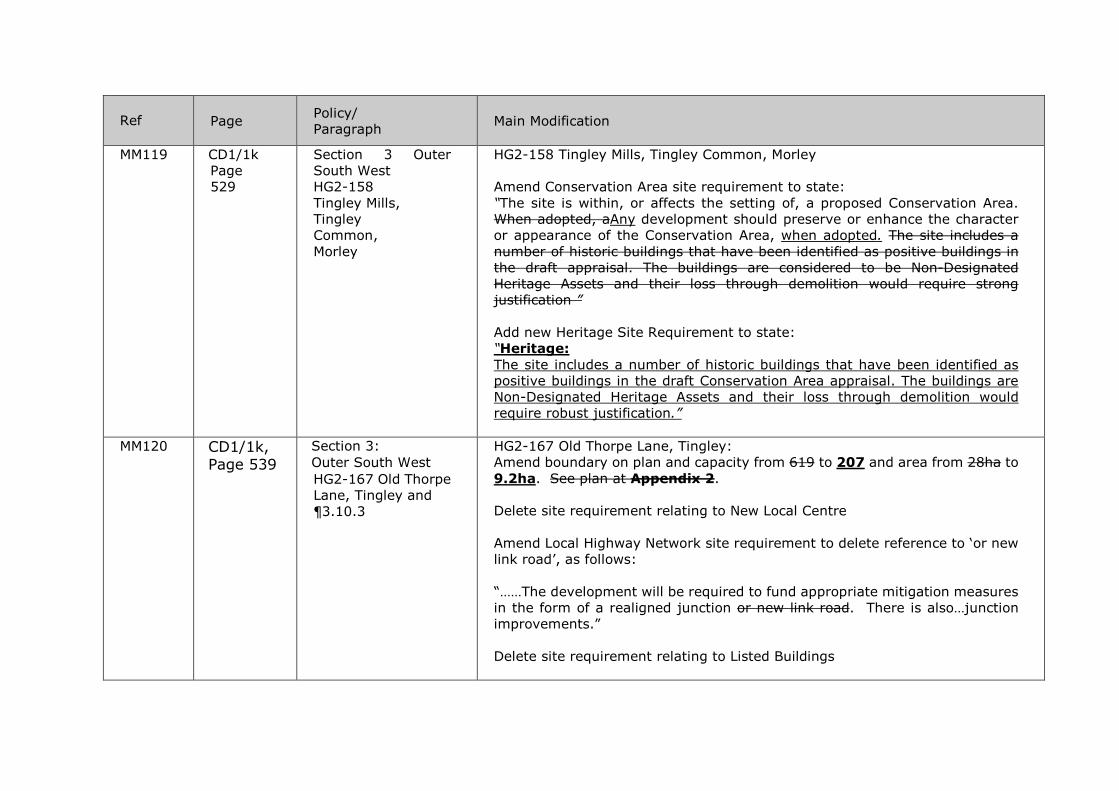
Ref Page Policy/
Paragraph Main Modification
MM119 CD1/1k Page 529
Section 3 Outer South West HG2-158 Tingley Mills, Tingley Common, Morley
HG2-158 Tingley Mills, Tingley Common, Morley Amend Conservation Area site requirement to state: “The site is within, or affects the setting of, a proposed Conservation Area. When adopted, aAny development should preserve or enhance the character or appearance of the Conservation Area, when adopted. The site includes a number of historic buildings that have been identified as positive buildings in the draft appraisal. The buildings are considered to be Non-Designated Heritage Assets and their loss through demolition would require strong justification ” Add new Heritage Site Requirement to state: “Heritage: The site includes a number of historic buildings that have been identified as positive buildings in the draft Conservation Area appraisal. The buildings are Non-Designated Heritage Assets and their loss through demolition would require robust justification.”
MM120 CD1/1k, Page 539
Section 3: Outer South West HG2-167 Old Thorpe Lane, Tingley and ¶3.10.3
HG2-167 Old Thorpe Lane, Tingley: Amend boundary on plan and capacity from 619 to 207 and area from 28ha to 9.2ha. See plan at Appendix 2. Delete site requirement relating to New Local Centre Amend Local Highway Network site requirement to delete reference to ‘or new link road’, as follows: “……The development will be required to fund appropriate mitigation measures in the form of a realigned junction or new link road. There is also…junction improvements.” Delete site requirement relating to Listed Buildings

Ref Page Policy/
Paragraph Main Modification
Delete last sentence of ¶3.10.3 as follows: For policies and guidance referring to centre boundaries, Primary Shopping Areas and proposals within protected shopping frontages, please refer to Section 2 of this document. These policies must also be read in conjunction with the Retail and Town Centres section of the Core Strategy. In addition to the designated centres outlined above, the site requirements for the housing site at Land at Old Thorpe Lane, Tingley (HG2-167) set out that a new centre should be delivered as part of this development.
MM121 CD1/1k, Page 542
Section 3: Outer South West HG2-168 Haigh Wood, Ardsley
HG2-168 Haigh Wood, Ardsley: Amend wording of Local Highway Network site requirement, as detailed: • Local Highway Network: The proposed development will cause a cumulative impact on the congested junction of the A650 with Common Lane. The development will be required to contribute to appropriate mitigation measures in the form of junction capacity improvements. There is also a cumulative impact upon Tingley roundabout. To mitigate this impact a contribution will be required towards any improvements as agreed with Highways England, taking into account the cumulative impact of other allocated sites in the area. The proposed development is also likely to impact on congested parts of the A653 including within the district of Kirklees. Kirklees Metropolitan Council will be consulted on the transport implications of any future planning applications on the site. The development will be required to assess impacts taking into account the cumulative impact of other allocated sites in the area and fund appropriate mitigation measures including road and junction improvements.
MM122 CDR1/1k, Page 544
Section 3: Outer South West HG2-169 Haigh Wood, Ardsley
HG2-169 Haigh Wood, Ardsley: Amend wording of Local Highway Network site requirement, as detailed: • Local Highway Network:

Ref Page Policy/
Paragraph Main Modification
The proposed development will have a direct impact on the congested junction of the A650 with Common Lane. The development will be required to contribute to appropriate mitigation measures in the form of junction capacity improvements. There is also a cumulative impact upon Tingley roundabout. To mitigate this impact a contribution will be required towards any improvements as agreed with Highways England, taking into account the cumulative impact of other allocated sites in the area. In addition, a cumulative impact is also likely at the A650 / Rein Rd junction and contributions towards mitigating measures will also be required here. The proposed development is also likely to impact on congested parts of the A653 including within the district of Kirklees. Kirklees Metropolitan Council will be consulted on the transport implications of any future planning applications on the site. The development will be required to assess impacts taking into account the cumulative impact of other allocated sites in the area and fund appropriate mitigation measures including road and junction improvements.
MM123 CD1/1k Pages 491, 545 and 546
Section 3: Outer South West HG2-170 Land off Haigh Moor Road
Delete the following site from Policy HG2 and the site schedule, plan and site requirements: HG2-170 Land off Haigh Moor Road
MM124 CD1/1k Page 547
Section 3: Outer South West HG2-171 - Westerton Road, East Ardsley
HG2-171 Westerton Road, East Ardsley - Amend site capacity from 195 to 35 and area from 8.68 to 1.3 hectares and amend boundary of site. Delete Local Highway Network site requirement.
MM125 CD1/1k Page 554
Section 3: Outer South West ¶ 3.10.10 Policy HG3
Amend ¶3.10.10, table within Policy HG3 as follows:
HG3-21 Gelderd Road (land to the north of), Wortley
11.6 315

Ref Page Policy/
Paragraph Main Modification
HG3-22 Manor House Farm, Churwell 2.9 80 HG3-23 Tingley Station 43.1 1050 HG3-24 Bradford Road (land off), East
Ardsley 9.7 218
HG3-25 New Lane, East Ardsley 3.8 90 Safeguarded Land total: 1753
1220
MM126 CD1/1k Page 563
Section 3: Outer South West HG7-1 – West Wood, Dewsbury Road, Tingley
HG7-1 – West Wood, Dewsbury Road, Tingley: Amend site boundary to exclude areas of flood risk. Amend site area from 0.68ha to 0.39ha Amend Green Belt boundary to inset the site from the Green Belt
MM127 CD1/1k Section 3: Outer South West Policy EG1 EG1-48 Opposite Ravell Works, Geldered Road, Wortley
EG1-48 Opposite Ravell Works, Geldered Road, Wortley
Revise capacity of EG1-48 from 5.02 to 3.19ha.
MM128 CD1/1k Page 567
Section 3: Outer South West Policy EG1 EG1-55 Adj Ravenheat Ltd, Chartists Way, Morley
Delete EG1-55 Adj Ravenheat Ltd, Chartists Way, Morley

Ref Page Policy/
Paragraph Main Modification
MM129
CD1/1k Page 573
Section 3: Outer South West EG2-19 Land off Topcliffe Lane, Morley and to the North of Capitol Park
EG2-19 Land off Topcliffe Lane, Morley and to the North of Capitol Park: Delete Culverts and Canalised Watercourses site requirement
Delete Conservation Area site requirement Add new Heritage Site Requirement to state: Heritage: Some buildings at Topcliffe Farm at end of Topcliffe Lane are Non-Designated Heritage Assets based upon the existing buildings’ age and local architectural and vernacular character, and their loss through demolition would require justification.
MM130 CD1/1k Pages 568 and 574
Section 3: Outer South West EG2-20 Fall Lane, East Ardsley
Delete the following site from Policy EG2 and the site schedule, plan and site requirements: EG2-20 Fall Lane, East Ardsley 0.59ha
MM131 CD1/1k Page 581
Section 3: Outer South West HMCA plan for Outer South West Green space site G655 Main Street (site of old pub)
Delete site G655 Main Street (site of old pub)
MM132 CD1/1l Page 584
Section 3: Outer West HG1-131 Pollard Lane
HG1-131 Pollard Lane: Amend capacity from 179 to 120
MM133 CD1/1l Page 585
Section 3: Outer West ¶ 3.11.6 Policy HG1
Amend Policy HG1 to delete site HG1-155 Elder Road/Swinnow Road, capacity 25

Ref Page Policy/
Paragraph Main Modification
HG1-155 Elder Road/Swinnow Road
MM134 CD1/1l Page 585
Section 3: Outer West ¶ 3.11.6 Policy HG1 HG1-157 Elder Road
Amend Policy HG1 to delete site HG1-157 Elder Road, capacity 22
MM135 CD1/1l Page 586
Section 3: Outer West ¶ 3.11.6 Policy HG1 HG1-163 Vernon Place
Amend Policy HG1 to delete site HG1-163 Vernon Place, capacity 8
MM136 CD1/1l Pages 590 and 594
Section 3: Outer West HG2-54 Upper Carr Lane (land off), Calverley
Delete the following site from Policy HG2 and the site schedule, plan and site requirements:
HG2-54 Upper Carr Lane (land off), Calverley
MM137 CD1/1l Pages 590, 595 and 596
Section 3: Outer West HG2-55 Calverley Lane, Calverley
Delete the following site from Policy HG2 and the site schedule, plan and site requirements: HG2-55 Calverley Lane, Calverley
MM138 CD1/1l Pages 590, 597 and 598
Section 3: Outer West HG2-56 Rodley Lane, Calverley Lane, Calverley
Delete the following site from Policy HG2 and the site schedule, plan and site requirements:
HG2-56 Rodley Lane (land at), Calverley Lane, Calverley
MM139 CD1/1l Pages 590, 601 and 602
Section 3: Outer West HG2-59 Land at Rodley Lane
Delete the following site from Policy HG2 and the site schedule, plan and site requirements: HG2-59 Land at Rodley Lane

Ref Page Policy/
Paragraph Main Modification
MM140 CD1/1l Page 621
Section 3: Outer West HG2-72 Land off Tyersal Court, Tyersal
HG2-72 Land off Tyersal Court, Tyersal - Amend capacity from 40 to 46
MM141 CD1/1l Pages 589, 629 and 630
Section 3: Outer West HG2-76 Hough Side Road, Pudsey
Delete the following site from Policy HG2 and the site schedule, plan and site requirements: HG2-76 Hough Side Road, Pudsey
MM142 CD1/1l Pages 589, 633 and 634
Section 3: Outer West HG2-80 Acres Hall Avenue, Pudsey
Delete the following site from Policy HG2 and the site schedule, plan and site requirements: HG2-80 Acres Hall Avenue, Pudsey
MM143 CDR1/1l, Page 644
Section 3: Outer West HG2-204 Wood Nook, Pudsey
Amend the Highways Access to Site requirement relating to the existing footpath network link at Site HG2-204 Wood Nook Pudsey as detailed: Highways Access to Site: The site would need to be linked to the existing footpath network to the northern boundary of the site from New Pudsey Station to the Owlcotes Shopping Centre and to the north-west corner of the site in order to reach local facilities and public transport.
MM144 CD1/1l Page 646
Section 3: Outer West HG2-205 Stonebridge Mills, Farnley
HG2-205 Stonebridge Mills, Farnley: Amend ‘Highway Access to Site’ site requirement to state: ‘Public transport improvements on Stonebridge Lane. Significant alteration to Ring Road roundabout to provide vehicular access to the site unless suitable alternative access to Stonebridge Lane can be gained.’ Insert Flood Risk site requirement:

Ref Page Policy/
Paragraph Main Modification
‘A small part of the site is affected by flood risk. A sequential approach should be taken to the layout of the site so that no housing or other more vulnerable development is located in the zone 3 high flood risk part of the site’.
MM145 CD1/1l, Page 648
Section 3: Outer West HG2-206 Heights Lane, Armley
HG2-206 Heights Lane, Armley: Amend the Highways Access to Site requirement on Site HG2-206 as detailed: Highways Access to Site: Nearside footway required – will affect trees. Review of TRO’s and Traffic Management measures. A footway should be provided along the Heights Lane site frontage. The existing traffic calming measure may need alteration to accommodate the site access.
MM146 CD1/1l Page 653
Section 3: Outer West ¶ 3.11.10 Policy HG3
Amend ¶3.11.10, table within Policy HG3 as follows: Plan Ref Address Area
Ha Capacity
HG3-14 Rodley (land at), Leeds LS13 1.6 50
HG3-15 Kirklees Knowl (land at), Bagley Lane, Bagley 17.8 415
HG3-16 Land off Gamble Lane 4.5 120 HG3-17 Low Moor Side, New Farnley 5.7 130 HG3-29 Land off Gamble Lane 7.6 200 Safeguarded Land total: 915 465
MM147 CD1/1l Page 659
Section 3: Outer West HG7-2 – Land on the Corner of Tong Road and Lakeside
HG7-2 – Land on the Corner of Tong Road and Lakeside Road, Wortley: Delete ‘Highways’ site requirement

Ref Page Policy/
Paragraph Main Modification
Road, Wortley
MM148 CD1/1l Page 669
Section 3: Outer West ¶3.11.20 1
Add new ¶3.11.20 1 as follows: “The Habitat’s Regulations Assessment has concluded that measures will be required regarding the provision and enhancement of green spaces within the HMCA so as to help avoid visitor pressure on the South Pennine Moors SPA/SAC. The Council will monitor these through monitoring indicator 24 of the Council’s Monitoring Framework which supports preparation of the Authority Monitoring Report. This will quantify the delivery of green space and green infrastructure delivered in the area along with the amount of commuted sums collected and spent on green space projects. Moreover, for the purposes of monitoring this measure the AMR will also report on specific improvements to green spaces in this HMCA, which arise as a result of the North West Leeds Green Gateways and Country Park project.”
MM149 CD1/1l Page 670
Section 3: Outer West HMCA plan for Outer West Green space site G1430 Chaucer Avenue (rear of)
Delete site G1430 Chaucer Avenue (rear of) from Outer West site allocations plan.
MM150
CD1/1l Page 676
Appendix 1 Schedule of the UDP Saved Policies
Appendix revised and updated.
MM151 CD1/1l Page 688
New Appendix 2 to the Plan
Add the Infrastructure Delivery Plan as Appendix 2 to the Plan.
MM152 CD1/1j Page 461
Section 3: Outer South East HG2-129 Ash Tree Primary School, Kippax
Change title of the “Conservation Area” Site Requirement to “Heritage”. Heritage Site Requirement to be amended as follows: “The boundary treatment relates to the former school and is considered to be a non-designated heritage assets…”

Appendix 1 – Consequential changes to tables as a result of Main Modifications in the schedule above MM5 Table 1: Housing Distribution by Housing Market Characteristic Area (HMCA)
Housing Market
Characteristic Area
Core Strategy Housing target up to 2028
Core Strategy Housing target up to 2023
Percentage (Core
Strategy SP7)
Delivery up to 2028 Delivery up to 2023 Residual Delivery 2023 to 2028
Existing supply
(‘Identified sites’)
Non Green Belt
Allocations Green Belt Allocations Total Performance
up to 2028 Non Green
Belt delivery to 2023
Green Belt delivery up
to 2023 Delivery
up to 2023 Performance
up to 2023
Non Green Belt
delivery 2023 to
2028
Green Belt delivery 2023 to
2028
Delivery 2023 to
2028
Aireborough 2,300 1,444 3 965 77 475 1,517 -783 1,042 425 1,467 23 0 50 50
City Centre 10,200 6,781 15.5 5,259 6,379 0 11,638 1,438 8,086 0 8,086 1,305 3,553 0 3,553
East Leeds 11,400 7,489 17 6,133 3,325 248 9,706 -1,694 7,590 248 7,838 349 1,869 0 1,869
Inner Area 10,000 6,569 15 8,961 3,951 0 12,912 2,912 6,875 0 6,875 306 6,037 0 6,037
North Leeds 6,000 3,941 9 4,095 484 575 5,154 -846 3,577 548 4,125 184 1,002 27 1,029
Outer North East 5,000 3,500 8 1,711 1,544 100 3,355 -1,645 3,355 100 3,255 -145 0 0 0
Outer North West 2,000 1,314 3 1,146 474 87 1,707 -293 1,288 87 1,375 61 332 0 332
Outer South 2,600 1,750 4 612 134 735 1,481 -1,119 746 599 1,345 -405 0 136 136
Outer South East 4,600 3,063 7 1,500 431 83 2,014 -2,586 1,931 83 2,014 -1,049 0 0 0
Outer South West 7,200 4,813 11 2,882 1,883 1,137 5,902 -1,298 3,846 1,104 4,950 137 919 33 952
Outer West 4,700 3,087 7 2,686 1,016 630 4,332 -368 2,647 584 3,231 144 1,055 46 1,101
Total 66,000 43,750 100 35,950 19,698 4,070 59,718 -6,282 40,882 3,778 44,660 910 14,766 292 15,058
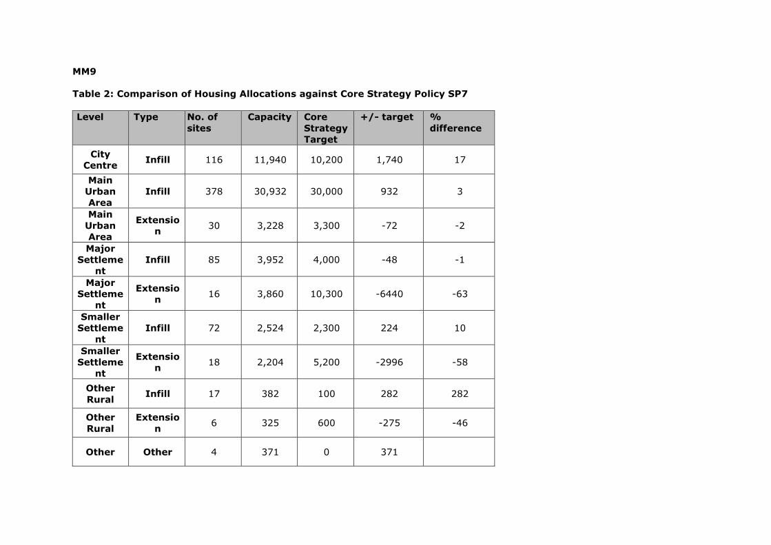
MM9 Table 2: Comparison of Housing Allocations against Core Strategy Policy SP7 Level Type No. of
sites Capacity Core
Strategy Target
+/- target % difference
City Centre Infill 116 11,940 10,200 1,740 17
Main Urban Area
Infill 378 30,932 30,000 932 3
Main Urban Area
Extension 30 3,228 3,300 -72 -2
Major Settleme
nt Infill 85 3,952 4,000 -48 -1
Major Settleme
nt
Extension 16 3,860 10,300 -6440 -63
Smaller Settleme
nt Infill 72 2,524 2,300 224 10
Smaller Settleme
nt
Extension 18 2,204 5,200 -2996 -58
Other Rural Infill 17 382 100 282 282
Other Rural
Extension 6 325 600 -275 -46
Other Other 4 371 0 371
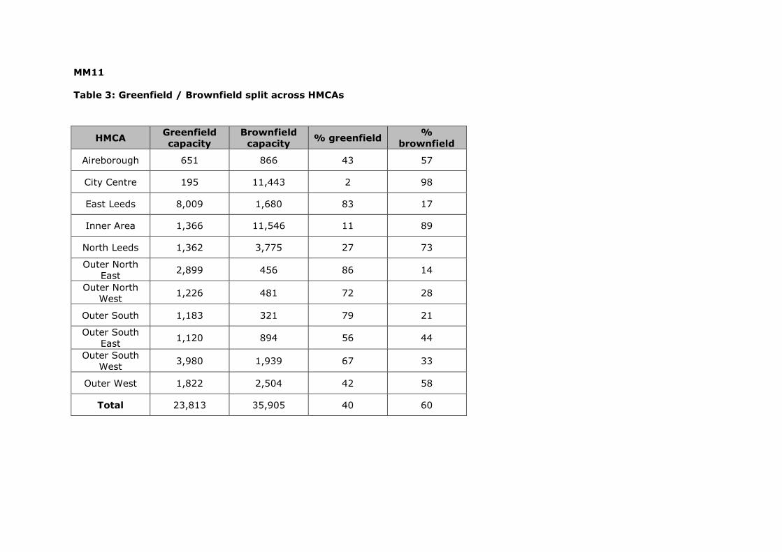
MM11 Table 3: Greenfield / Brownfield split across HMCAs
HMCA Greenfield
capacity Brownfield
capacity % greenfield % brownfield
Aireborough 651 866 43 57
City Centre 195 11,443 2 98
East Leeds 8,009 1,680 83 17
Inner Area 1,366 11,546 11 89
North Leeds 1,362 3,775 27 73
Outer North East 2,899 456 86 14
Outer North West 1,226 481 72 28
Outer South 1,183 321 79 21
Outer South East 1,120 894 56 44
Outer South West 3,980 1,939 67 33
Outer West 1,822 2,504 42 58
Total 23,813 35,905 40 60

MM17 Table 4: The distribution of safeguarded land designations across Leeds
HMCA
Total capacity of
Safeguarded Land sites
% of HMCA target as
Safeguarded Land
% of 6,600 total
Safeguarded Land target
Aireborough 360 0 16 5
City Centre 0 0 0
East Leeds 0 0 0
Inner Area 0 0 0
North Leeds 0 0 0 Outer North
East 1,359 1,156 0 21
Outer North West 540 260 27 8
Outer South 220 115 8 3 Outer South
East 1,6161,450 35 24
Outer South West 1,7531,220 24 27
Outer West 915465 19 14
Total 6,7634,666 - -