request for proposals protected instream flow studies and ... · souhegan river request for...
TRANSCRIPT

Request for Proposals Protected Instream Flow Studies
and Water Management Plan
for the Souhegan River Designated Reach
March 25, 2004
New Hampshire Department of Environmental Services
29 Hazen Drive Concord, New Hampshire 03301

Souhegan River Request for Proposal Page 2 of 40
Table of Contents Table of Contents..................................................................................................................................... 2 I. REQUIRED PROPOSAL SUBMISSIONS ........................................................................................ 3 II. PROJECT TEAM AND LEVEL OF PARTICIPATION................................................................ 3 III. PROJECT APPROACH/SCOPE OF WORK .................................................................................. 4 IV. PROJECT SCHEDULE.................................................................................................................... 4 V. SELECTION CRITERIA .................................................................................................................. 4 VI. CONFIDENTIALITY STATEMENT............................................................................................. 4 VII. CONFLICT OF INTEREST STATEMENT................................................................................... 5 ATTACHMENT I - AVAILABLE REFERENCE MATERIALS FOR SOUHEGAN RIVER PILOT PROGRAM.............................................................................................................................................. 6 ATTACHMENT II - SCOPE OF WORK GUIDANCE ......................................................................... 8 INTRODUCTION ................................................................................................................................... 8 BACKGROUND ..................................................................................................................................... 8 OVERALL PROJECT DESCRIPTION.................................................................................................. 9
I. Identification and Draft List of IPUOCR Entities ......................................................................... 10 II. Assessment of Well Withdrawal Impacts on Surface Water ....................................................... 10 III. On-stream Survey for IPUOCR Entities ..................................................................................... 11 IV. Report Describing IPUOCR Entities and Proposed PISF Methods ........................................... 11 PAY INCREMENT 1 ........................................................................................................................ 12 V. PISF assessments and Proposed PISF report ............................................................................... 12 VI. PISF Public Hearing ................................................................................................................... 13 VII. PISF Report for the Souhegan River......................................................................................... 13 PAY INCREMENT 2 ........................................................................................................................ 13 VIII. Assessment of water use with the established PISF ................................................................ 14 IX. Development of WMP sub-plans ................................................................................................ 14
Conservation Plan.......................................................................................................................... 14 Water Use Plan............................................................................................................................... 15 Dam Management Plan.................................................................................................................. 16
PAY INCREMENT 3 ........................................................................................................................ 17 X. Proposed WMP ............................................................................................................................ 17 XI. WMP Public Hearing.................................................................................................................. 17 XII. Water Management Plan for Souhegan River........................................................................... 18 PAY INCREMENT 4 ........................................................................................................................ 18 Preliminary Major milestones and estimated proportion of PISF contract effort.............................. 18 Preliminary Major milestones and estimated proportion of WMP contract effort ............................ 19
ATTACHMENT III - AFFECTED DAM OWNERS OF THE SOUHEGAN RIVER WMPA........... 20 ATTACHMENT IV - AFFECTED WATER USERS OF THE SOUHEGAN RIVER WMPA.......... 21 ATTACHMENT V – DEFINED FOR PISF STUDY – INSTREAM PUBLIC USES, OUTSTANDING CHARACTERISTICS, AND RESOURCES........................................................... 22 ATTACHMENT VI - PHOTO DOCUMENTATION PROCEDURE ................................................. 27 ATTACHMENT VII - INSTREAM FLOW ANALYSIS WITHIN THE CONTOOCOOK RIVER BASIN (DRAFT) ................................................................................................................................... 33

Souhegan River Request for Proposal Page 3 of 40
Request for Proposals for Protected Instream Flow Studies and Water Management Plan for the
Souhegan River Designated Reach March 25, 2004
I. REQUIRED PROPOSAL SUBMISSIONS Each consultant will submit a proposal package to the New Hampshire Department of Environmental Services (NHDES) that includes the following components as described in detail below:
• The project team, including a project team organization, team member qualifications and the anticipated level of involvement of key team members in each phase of the project as described in the project approach and scope of work.
• A technical proposal that describes the team’s project approach and scope of work. • A proposed project schedule. • A confidentiality statement. • A conflict of interest statement.
Complete and timely submittal of all required proposal documents plus attendance by at least one member of the project team at the mandatory question-and-answer meeting are required for the proposal to be considered. The mandatory question-and-answer meeting has been scheduled to answer questions about the Souhegan watershed and the proposal. The meeting will be held March 31, 2004 at 1:00 p.m. in Room 112 at NHDES, 29 Hazen Drive, Concord, NH. Questions will be recorded and a written, final response distributed to all attendees. Each consultant will submit six (6) copies of all documents by close of business on April 15, 2004 at 4:00 p.m. to:
New Hampshire Department of Environmental Services Water Division – Souhegan Instream Flow Proposal Package Attn: Paul M. Currier, Watershed Management Bureau Administrator 29 Hazen Drive Concord, New Hampshire 03301
Interviews will be scheduled for before the end of April, 2004. The consultants shall bring a sealed cost proposal to the interview. The sealed cost proposal will not be used in the selection process but will assist NHDES to expedite initial contract negotiations with the selected consultant. After the quality-based ranking is complete, the sealed cost proposal for only the first ranked consultant will be opened and NHDES will proceed with contract negotiations with that consultant. If these negotiations are not successful, NHDES will negotiate with the second ranked consultant, etc. until a contract has been successfully negotiated.
II. PROJECT TEAM AND LEVEL OF PARTICIPATION The proposal will identify the individuals responsible for managing the project and conducting specific project tasks. The proposal will also estimate the expected level of participation in the project tasks and in the overall project. An organization chart showing lines of communication and decision-making hierarchy will be included in the proposal.
Souhegan River Request for Proposal Page 4 of 40
III. PROJECT APPROACH/SCOPE OF WORK The technical proposal must contain the elements contained in Env-Ws 1900, Instream Flow Rules. Reference materials including web links and other references are listed in Attachment I to assist in project understanding. Attachment II contains additional Scope of Work Guidance to assist in the development of the project approach/scope of work. It must be clear on how all these elements will be addressed and also how public participation and interaction with the various advisory committees will occur.
IV. PROJECT SCHEDULE
The consultant will provide a schedule to conduct and complete the project. The schedule will include project tasks as identified in the Scope of Work. Project tasks will be laid out in a flow chart identifying the anticipated days to complete each task and the interrelationship of conducting and completing these tasks.
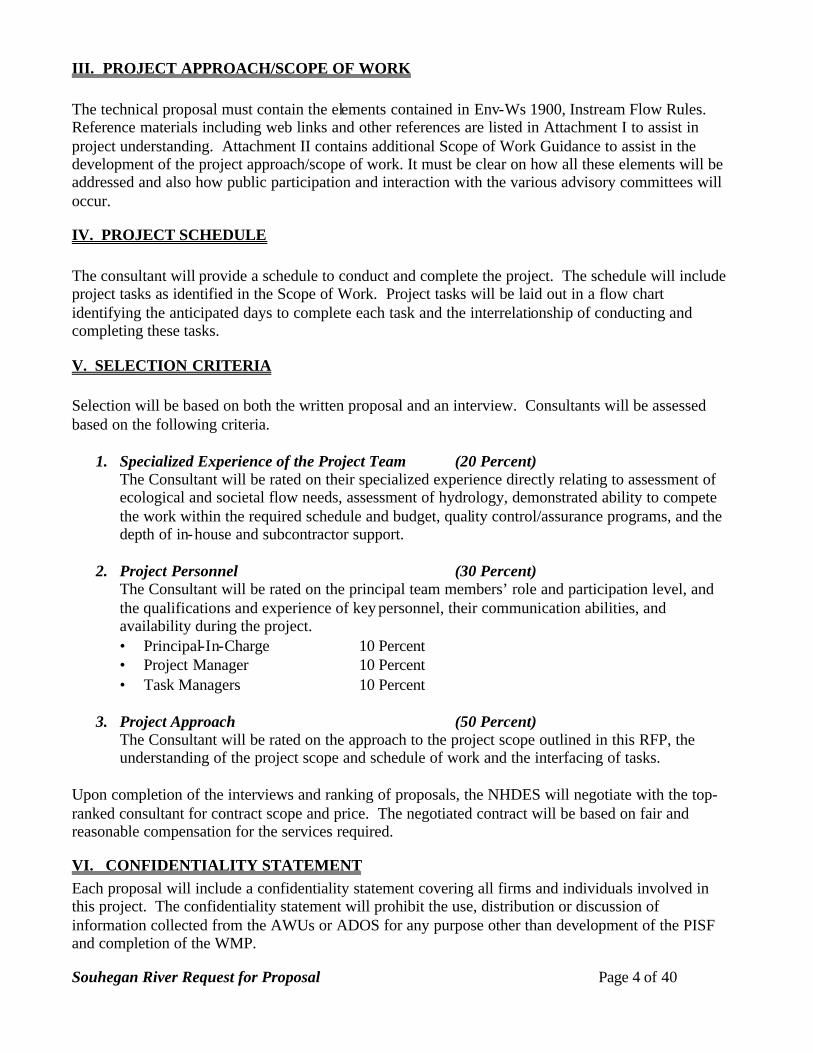
V. SELECTION CRITERIA Selection will be based on both the written proposal and an interview. Consultants will be assessed based on the following criteria.
1. Specialized Experience of the Project Team (20 Percent) The Consultant will be rated on their specialized experience directly relating to assessment of ecological and societal flow needs, assessment of hydrology, demonstrated ability to compete the work within the required schedule and budget, quality control/assurance programs, and the depth of in-house and subcontractor support.
2. Project Personnel (30 Percent) The Consultant will be rated on the principal team members’ role and participation level, and the qualifications and experience of key personnel, their communication abilities, and availability during the project. • Principal-In-Charge 10 Percent • Project Manager 10 Percent • Task Managers 10 Percent
3. Project Approach (50 Percent)
The Consultant will be rated on the approach to the project scope outlined in this RFP, the understanding of the project scope and schedule of work and the interfacing of tasks.
Upon completion of the interviews and ranking of proposals, the NHDES will negotiate with the top-ranked consultant for contract scope and price. The negotiated contract will be based on fair and reasonable compensation for the services required.
VI. CONFIDENTIALITY STATEMENT Each proposal will include a confidentiality statement covering all firms and individuals involved in this project. The confidentiality statement will prohibit the use, distribution or discussion of information collected from the AWUs or ADOS for any purpose other than development of the PISF and completion of the WMP.

Souhegan River Request for Proposal Page 5 of 40
VII. CONFLICT OF INTEREST STATEMENT Each candidate will submit a statement describing their past, existing, or anticipated business relationship with any of the Affected Water Users or Affected Dam Owners in the WMPA. The AWUs and ADOs known to the Department are listed in Attachments III and IV below.
VIII. DISCLAIMER This RFP does not commit the NHDES to award a contract or pay any costs incurred during the preparation of the proposal. The NHDES reserves the right to reject any or all of the proposals for completing this work. The NHDES also reserves the right to eliminate the need for the selected consultant to complete one or more tasks, pending he outcome of preceding related tasks or issues. Attachment I – REFERENCE MATERIALS Attachment II - SCOPE OF WORK GUIDANCE Attachment III – AFFECTED DAM OWNERS OF THE SOUHEGAN WMPA Attachment IV – AFFECTED WATER USERS OF THE SOUHEGAN WMPA Attachment V – DEFINED FOR PISF STUDY – INSTREAM PUBLIC USES, OUTSTANDING
CHARACTERISTICS, AND RESOURCES Attachment VI – PHOTO DOCUMENTATION PROCEDURE Attachment VII – INSTREAM FLOW ANALYSIS WITHIN THE CONTOOCOOK RIVER
BASIN (DRAFT)

Souhegan River Request for Proposal Page 6 of 40
ATTACHMENT I - AVAILABLE REFERENCE MATERIALS FOR SOUHEGAN RIVER PILOT PROGRAM
NHDES Souhegan Instream Flow site http://www.des.state.nh.us/rivers/instream/souhegan.htm NHDES Rivers Management and Protection Program http://www.des.state.nh.us/rivers/ http://www.des.state.nh.us/rivers/souhegan.htm Rules and Statutes RSA 483 – Rivers Management and Protection Act - http://www.des.state.nh.us/rivers/rsa483.htm Chapter 278, Laws of 2002 – http://www.des.state.nh.us/rivers/instream/ch278.pdf Env-Ws 1900 Instream Flow Rules – http://www.des.state.nh.us/rules/Env-Ws1900.pdf Env-Ws 1700 Surface Water Quality Regulations – http://www.des.state.nh.us/wmb/env-ws1700.pdf Watershed Reports Souhegan Designated River Nomination, May 1999, Souhegan Watershed Association and the Nashua Regional Planning Commission http://www.des.state.nh.us/rivers/souhegan/souhegan.htm - in sections without maps http://www.des.state.nh.us/rivers/instream/pdf/Nomination.pdf - as one document with maps The Souhegan River – A Report to the General Court, January 2000, NHDES http://www.des.state.nh.us/rivers/souhegan_report.htm Souhegan River Watershed Study, Prepared by the Nashua Regional Planning Commission - September 1995 http://www.des.state.nh.us/rivers/instream/pdf/WatershedStudy.pdf Souhegan River Corridor Study, June 1994, Nashua Regional Planning Commission http://www.des.state.nh.us/rivers/instream/pdf/CorridorStudy.pdf Souhegan USGS stream gage data resources USGS 01094000 SOUHEGAN RIVER AT MERRIMACK, NH http://waterdata.usgs.gov/nh/nwis/uv?01094000 USGS 01093800 STONY BROOK TRIBUTARY NEAR TEMPLE, NH http://waterdata.usgs.gov/nh/nwis/uv?01093800

Souhegan River Request for Proposal Page 7 of 40
USGS 01094006 MCQUADE BROOK @ N. AMHERST RD, NEAR BEDFORD, NH http://nwis.waterdata.usgs.gov/nh/nwis/peak/?site_no=01094006 Annual peak flows only – 1972-1979 Methods Evaluation of Streamflow Requirements for Habitat Protection by Comparison to Streamflow
Characteristics at Index Streamflow-Gaging Stations in Southern New England, David S. Armstrong, Gene W. Parker, and Todd A. Richards (Massachusetts Division of Fisheries and Wildlife) Water-Resources Investigations Report 03-4332
http://water.usgs.gov/pubs/wri/wri034332/ Environmental Flow Assessment for Aquatic Ecosystems: A Database of Methodologies, Rebecca
Tharme, 2002, based on Tharme, R.E. (2003). A global perspective on environmental flow assessment: emerging trends in the development and application of environmental flow methodologies for rivers. River Research and Applications. 19: 1-45. (In press), International Water Management Institute,
http://www.lk.iwmi.org/ehdb/EFM/visitors/ViewAllMethodology.asp Printed documents available for file review from the Department Souhegan River Watershed Report, Final Report, May 1997, prepared by NH Department of Environmental Services

Souhegan River Request for Proposal Page 8 of 40
ATTACHMENT II - SCOPE OF WORK GUIDANCE
Request for Proposals
Protected Instream Flow Studies and
Water Management Plan for the Souhegan River Designated Reach
INTRODUCTION The selected consultant will prepare Protected Instream Flows (PISFs) for the Souhegan River Designated Reach. The PISFs will protect and maintain protected entities listed in RSA 483, including designated uses under the Clean Water Act, and Instream Public Uses, Outstanding Characteristics, and Resources (IPUOCR). The consultant will then develop a Water Management Plan (WMP) that implements the PISF values. The WMP applies to the Souhegan River Designated Reach (DR) and its tributary drainage area, together known as the Water Management Planning Area (WMPA). Water Management Plans apply to water users who use more than 20,000 gallons of per day and to owners of dams with impoundments greater than ten acres. These water users are identified as Affected Water Users (AWUs) and the dam owners are identified as Affected Dam Owners (ADOs). The entire process will be conducted with public participation through two advisory committees and public hearings, as specified in Chapter 278, Laws of 2002.
BACKGROUND RSA 483:9-c (http://www.gencourt.state.nh.us/rsa/html/L/483/483-9-c.htm), enacted in 1988, requires the Department to adopt rules for protected instream flows on designated rivers. Since 1990, the Department has been working on concepts for instream flow protection. Chapter 278, Laws of 2002 (HB1449) created a pilot program for instream flow protection on the Lamprey and Souhegan Rivers (http://www.des.state.nh.us/rivers/instream/ch278.pdf). This program, enacted as a significant compromise among water-using interests and conservation interests, is based on the idea of first conducting studies to develop protected flows for the IPUOCR entities identified for the river segment, and then developing a management plan for the upstream watershed that will maintain the protected flows. The legislation also established two committees to advise the Department in the pilot process. A Technical Review Committee (TRC) to evaluate technical processes and results, and a Water Management Protection Area Advisory Committee representing local interests and knowledge.
The Department adopted rules in May 2003 to implement the legislation (http://www.des.state.nh.us/rules/Env-Ws1900.pdf). These rules define the process for the work to be conducted under this Scope of Work. Funding for this project and revised deadlines were promulgated by Chapter 319 (Parts 48-51), Laws of 2003 (also know as HB4) (http://www.des.state.nh.us/rivers/instream/HB4Sections.pdf). The primary purpose of this contract is to develop public policy and processes for instream flow protection. Many of the issues and methods for instream flow protection are expected to be identified and explored in the context of the contract studies and reports. The consultant will be expected to have the ability to work collaboratively with the Department, including frequent and

Souhegan River Request for Proposal Page 9 of 40
concise communication as the work progresses, and to show initiative and creativity in framing scientific knowledge and quantitative methods for instream flow protection for public discussion. Prospective consultant s should thoroughly familiarize themselves with the background and history above, and especially with Env-Ws 1900 Rules for the Protection of Instream Flows on Designated Rivers, RSA 483, Chapter 278, Laws of 2002, Env-Ws 1700 Surface Water Quality Regulations, and Env-Wr 700 Water Use Registration and Water Use Reporting or its successor rule.
The pilot program will be conducted with public participation. Chapter 278, Laws of 2002 specifies two advisory committees, a Technical Review Committee (TRC) and a Water Management Planning Area Advisory Committee (WMPAAC), for the Souhegan River. The consultant will present study results at specified milestones before one or both of the advisory committees in meetings that are open to the public. A public hearing will be held to present and hear comments on both the Proposed PISF Report and the Proposed WMP Report. The consultant will attend the hearings to present these reports and answer questions. The consultant will receive comments from the committees and from the public hearing through the Department. The Department will be responsible for the preparation and holding of the committee meetings and public hearings.
All deliverables for advisory committee meetings will be submitted to the Department as
thirty-eight (38) paper copies and three copies in electronic format on compact disks as Adobe .pdf and WORD document files. All deliverables for public hearings will be submitted to the Department as 66 hard copies and three copies in electronic format on compact disks as Adobe .pdf and WORD document files. All submittals for the public hearings will be provided forty days in advance of the public hearing dates. The consultant will provide an additional paper copy of the Proposed PISF and of the Proposed WMP to a municipal library centrally located in the WMPA at least thirty days before their respective public hearings. Consultants will be ranked based on qualifications, experience, proposals and interviews as described earlier. The highest ranked contractor will then negotiate price and detailed services with the Department. Cost will not be a factor in consultant selection. However, the legislature has funded the Department’s estimated consulting costs for this contract. The Department has presented the available funding publicly in the RFQ as $355,000. The Department expects to negotiate the contract with the successful candidate who will complete the work in the task descriptions below within this budget.
OVERALL PROJECT DESCRIPTION The consultant will determine PISFs for the Souhegan Designated Reach as specified in Env-
Ws 1905. The consultant will identify the IPUOCR entities for the Designated River segments and conduct an on-stream survey to document IPUOCR occurrences. The consultant will identify and apply appropriate assessment methods for determining PISFs that meet water quality standards and protect the IPUOCR entities. The consultant will make a preliminary assessment of water use versus stream flow, including an evaluation of groundwater-surface water interactions to assess the impact of the Proposed PISF. The consultant will present Proposed PISF values in a public hearing. Following final revisions in response to comments at the public hearing, the Proposed PISFs will be submitted to the Department. The Department will be responsible for establishing the PISFs.
The consultant will prepare a WMP for the Souhegan WMPA as described in Env-Ws 1906 ready for adoption by the Department. The consultant will reassess the water use versus stream flow using the established PISF to identify times, volumes and reaches not meeting the PISF. The

Souhegan River Request for Proposal Page 10 of 40
consultant will conduct interviews with AWUs and ADOs to document and evaluate AWU and ADO operations, and develop three sub-plans (conservation, dam management and water-use). Each sub-plan will list conservation, water use or dam management alternatives to meet the PISFs for each ADO and AWU. The consultant will prepare a draft Proposed WMP composed of the chosen alternatives for each AWU and ADO that together meet the PISFs. The consultant will present the Proposed WMP at a public hearing within the WMPA to receive comments. Following the public hearing the consultant will revise the Proposed WMP, in consultation with the Department, to create the final WMP ready for adoption by the Commissioner. PROTECTED INSTREAM FLOW STUDY (Note: The pay increments listed represent the Department’s concept of how consultant work products and incremental compensation might be structured. This is subject to negotiation with the successful candidate.)
I. Identification and Draft List of IPUOCR Entities The consultant will research and identify IPUOCR entities for the Designated Reach as
required in Env-Ws 1905.02(a) – (c). The Department has defined the Instream Protected Uses, Outstanding Characteristics, and Resources (IPUOCR) that must be evaluated for the Designated Reach in a discussion paper titled, Defined for PISF Study – Instream Public Uses, Outstanding Characteristics, and Resources (Attachment V). The Department has also compiled a preliminary list of IPUOCR entities for the Souhegan River DR available at http://www.des.state.nh.us/rivers/instream/souhegan.htm. The consultant will research applicable files, records and studies, and may need to conduct structured interviews with local watershed authorities to develop information about the specific IPUOCR entities, their river location, and their dependence on river flow conditions. To complete this Part I, the consultant will present an annotated list of the IPUOCR entities to both advisory committees for their review and comment. The list will identify and briefly describe the IPUOCR entities, and if known, their location within the DR. The consultant will document this information completely in a draft IPUOCR report required later under Part IV.
II. Assessment of Well Withdrawal Impacts on Surface Water The consultant will develop a method for assessing AWU groundwater withdrawal impacts on surface water flow in the Designated Reach. The Department, in consultation with stakeholders during rulemaking deliberations, developed the position that groundwater withdrawals, sufficiently separated from a stream by hydrologic barriers or distance, or both, may have reduced impacts on critical flows because of the timing or volume of the withdrawal. In previous rule drafts, the Department proposed methods of evaluating hydraulic connection between well withdrawals and surface water (See Instream Flow Rules – November 14, 2000, Working Draft Env-Ws 1903.04 Procedure for Determining No Hydraulic Connection - at http://www.des.state.nh.us/rivers/instream/Archive/11142kifr.pdf). This document may be used by the consultant as a starting point or the consultant may propose alternative methods.
The consultant will present the methods considered, and a recommended method in a report to the TRC for their review and comment. The recommended method will be capable of estimating effective surface water withdrawal due to wells by using available information, or information easily obtained by the Department. The consultant will then revise the report in consultation with the Department, and apply the selected method to the AWUs’ well withdrawals.

Souhegan River Request for Proposal Page 11 of 40
The Department has identified seven AWUs withdrawing from fourteen groundwater well sources (12 source IDs—two wells each for two sources). Well information is provided by way of Attachment IV - Available Reference Materials for Souhegan River Pilot Program or directly at the NHDES website http://www.des.state.nh.us/rivers/instream/souhegan.htm. The method developed from this task will be used in estimating water use by individual AWUs versus the proposed PISF under Part V and versus the established PISF under Part VIII.
III. On-stream Survey for IPUOCR Entities The consultant will conduct an on-stream survey of the DR as required in Env-Ws 1905.02(e)
to locate and verify the specific entities identified in the IPUOCR listing as revised by the TRC and WMPAAC. Prior to conducting the on-stream survey, the consultant will prepare a Standard Operating Procedure for conducting the survey and present it to the Department. The consultant will use the Department’s Photo Documentation Procedure (Attachment VI) to document IPUOCR entities and river conditions for future reference. The consultant will conduct the on-stream survey with DES staff oversight, and possibly with the presence of advisory committee representatives, during the summer season. The survey is not intended to be an exhaustive identification and cataloging of these entities, but rather a targeted verification of their existence and occurrence.
IV. Report Describing IPUOCR Entities and Proposed PISF Methods The consultant will produce a draft report describing the results of the IPUOCR entities
research and on-stream survey, and proposing PISF methods to be used to assess their flow needs. The report will include maps showing the presence of the IPUOCR entities and a short, referenced narrative for each. Locations of threatened or rare species, and archaeological sites should be generalized or omitted for their protection. The draft report will report temporal aspects of IPUOCR entities. The consultant will identify and catalogue all source documents and reports describing IPUOCR entities, as per Env-Ws 1905.02(d), as part of the report. The report will propose protection goals consistent with RSA 483, Env-Ws 1900 and surface water quality standards.
The consultant will collect and document relevant information in describing the IPUOCR
entities and PISF methods. The items listed in Env-Ws 1905.03(b) are considered relevant information. Some of these items concern IPUOCR entities, but some refer to watershed characteristics or other information. Where this information supports the identification and description of IPUOCR entities or the selection of PISF methods, it will be included in the draft report. Otherwise, this information will be included in the draft Proposed PISF report under Part V below.
The consultant will describe PISF methods that are appropriate for identifying protected flows
to conserve and protect the IPUOCR entities as required by Env-Ws 1905.02(f). At a minimum, the methods chosen must assess the hydrologic regime and the flow needs of the biologic ecosystem.
The draft report will describe in detail the proposed PISF methods with supporting rationale for
why and how they will be applied, including where they are to be used, and how the results will be rendered into PISFs. The consultant will explain how the proposed methods apply to the IPUOCR entities. The consultant will identify which method if any will be applied for the individual IPUOCR entities. The consultant must identify and provide justification for not applying methods to assess any IPUOCR.

Souhegan River Request for Proposal Page 12 of 40
The draft report will be submitted to the committees for review and comment. The draft report will then be revised in consultation with the Department into the final report on IPUOCR entities and PISF methods. This document will define the work to be conducted to make the PISF assessments.
PAY INCREMENT 1 The consultant will submit an itemized bill for not-to-exceed payment listing the activities and documents completed. First payment will be due on completion and written approval by the Department of the following activities and documents:
1) IPUOCR draft list 2) Report on method for quantifying well impacts on timing and volume of river flow 3) Two committee review meetings 4) On-stream survey SOP 5) On-stream survey 6) Draft IPUOCR and PISF assessment method report 7) Two committee review meetings 8) Final IPUOCR and PISF assessment method report
V. PISF assessments and Proposed PISF report The consultant will apply the selected PISF methods to determine scientifically-based,
quantitative PISF values to meet the protection goals described earlier for the IPUOCR entities and applicable water quality standards [Env-Ws 1905.01(a)(1)]. The Department will request the assistance of the Public Utilities Commission (PUC) in assessing the effect of the proposed PISF developed under this Part upon each of the hydroelectric power facilities in the WMPA as required in Env-Ws 1905.04(b)(4) and Env-Ws 1906.03(b)(3).
The consultant will compile the PISF assessment results in a draft Proposed PISF report. The
report will identify the IPUOCR entities, their locations, and the protection goals for these entities. The report will describe the PISF methods that were chosen for evaluating the flows needed to meet these goals, and the results using these methods. The consultant’s report will describe the Proposed PISF values and their scientific basis [See Env-Ws 1905.01(a)(1) and Env-Ws 1905.04(b)(2)].
The report will include a discussion describing how the Proposed PISF values meet the criteria
in RSA 483:1 and 483:2 supporting the Department’s decision making process under Env-Ws 1905.04(a). It will also include supporting documentation describing how the proposed PISF values meet applicable water quality standards [Env-Ws1905.04(b)(3)] and describing the results of the assessment required by Env-Ws 1905.04(b)(4), which cites RSA 483:9-c, III. The consultant will incorporate descriptions of the factors for reviewing the PISF found under Env-Ws 1905.03(b) and the results of PUC’s assessment.
The report will include a preliminary determination of DR reaches, and the timing, and quantity not meeting the draft proposed PISF. The consultant will determine aggregate water use versus stream flow on a daily basis using the draft Proposed PISF and following the model of the aggregate water use versus stream flow assessment under Env-Ws 1903.02. The consultant will base the determination on an assessment of daily conditions for the previous five years using appropriately selected or synthesized hydrologic data, and will incorporate the values determined earlier in Part II for the groundwater well withdrawal impacts on surface water. The report will describe the location, timing and net upstream withdrawal rates where the draft proposed PISF was not met. The methods in

Souhegan River Request for Proposal Page 13 of 40
the Department’s January 2002 Instream Flow Analysis Within the Contoocook River Basin (draft) (Attachment VII) should be used as a basis for developing this process.
The consultant will present the draft proposed PISF values before the advisory committees for review and comment. The draft Proposed PISF report will be revised in consultation with the Department to create the Proposed PISF report for submittal to the legislature as required by Laws of 2002, Chapter 278:3, III(a).
VI. PISF Public Hearing The Department will hold a public hearing jointly with the NH Senate’s Environment
Committee and the House’s Resources, Recreation & Development Committee within 60 days of submitting the Proposed PISF to the legislature as required by Chapter 278:3, III(a), Laws of 2002. The public hearing will be held to receive comments on the Proposed PISF as required by Chapter 278:3, III(a), Laws of 2002 and as described in Env-Ws 1905.03. The public hearing will be held in a community through or past which the DR flows in accordance with Env-Ws 1905.03(e).
The consultant will make the Proposed PISF with all documentation available to the public for at least 30 days prior to the hearing date. The consultant will ensure that the Proposed PISF is available in at least one major library in a community through or past which the DR flows at least 30 days prior to the hearing date. The consultant will participate in the public hearing by giving a presentation describing the Proposed PISF and its development, and by answering questions.
The Department will post the Proposed PISF on its website, and provide written notices for and
publicize the hearing in accordance with Env-Ws 1905.03(d) and (e). The Department will provide and prepare facilities for the hearing, and conduct the hearing. The comment period will remain open for a minimum of 30 days following the hearing. The Department will receive and record comments, and prepare records of the hearing.
VII. PISF Report for the Souhegan River Following the comment period, the consultant will revise the Proposed PISF report, in
consultation with the Department, based on the comments received. The consultant will prepare the PISF Report from the Proposed PISF report with the addition of a section describing how the comments affected the final PISF values [Env-Ws 1905.04 (b)(5-6)]. The consultant will submit the PISF Report within 40 days of the close of the comment period to allow time for the Department to issue a decision on the PISF within 60 days of the close of the comment period as required in Env-Ws 1905.04(a). The PISF study portion of the contract will be complete upon written notice from the Department of its acceptance of the PISF Report. It will be the Department’s responsibility to establish the PISF.
PAY INCREMENT 2 The consultant will submit an itemized bill for not-to-exceed payment listing the activities and
documents completed. Second payment will be due on completion and written approval by the Department of the following activities and documents:
1) PISF and Env-Ws 1905.04(b)(4) assessments 2) Draft Proposed PISF report 3) Two committee review meetings 4) Proposed PISF report 5) PISF Public Hearing

Souhegan River Request for Proposal Page 14 of 40
6) PISF Document accepted by Department SOUHEGAN WATER MANAGEMENT PLAN
VIII. Assessment of water use with the established PISF The consultant will estimate aggregate water use versus stream flow to identify times and stream reaches that do not meet the PISF and therefore require management under the WMP. The assessment will be reported on a daily basis over three one-year periods using the established PISFs and appropriately selected or synthesized hydrologic data. The three annual datasets selected will represent actual or simulated dry year, wet year, and mean streamflow and water use conditions. Probabilistic methods for assessing aggregate water use using flow duration or low-flow frequency characteristics of the river to identify percentages of time and frequency at which various stream reaches do not meet the PISF may also be used if this method can be applied to meet the need to determine times when the PISF is not met. The consultant will document the DR reaches not meeting the established PISF and use this information in guiding the development of the WMP. The process will be equivalent to the process described in Part V except for the hydrologic data set used and the use of the established PISF instead of the draft proposed PISF.
IX. Development of WMP sub-plans The consultant will develop three sub-plans – Conservation, Water Use, and Dam Management – as required under Env-Ws 1906.02 through 1906.04 for the WMP. Each of these sub-plans shall provide a range of alternatives for each AWU or ADO. The sub-plans will describe the potential for water conservation and water use changes by each AWU or for dam management by each ADO. The Department will make the notifications to each AWU and each ADO by certified mail as required by Env-Was1906.01(c)(1) through (3), such as that a WMP is being prepared and that the WMP is enforceable. The consultant will meet with each AWU and ADO and discuss the established PISF as required in Env-Ws 1906.01(c)(4) and in the rules describing each sub-plan. The consultant will interview each AWU and ADO to collect information about water use and management and discuss alternatives. From this information, the consultant will develop recommended alternatives for each AWU and ADO in the applicable sub-plans. The consultant shall prepare structured interview formats to collect necessary and useful information from the AWUs and ADOs for preparing these plans. The Department has identified known AWUs and ADOs from the Department’s water use and dam registrations. The consultant shall notify the Department if they encounter or are informed of any unregistered water users that meet the requirements for registration under the Department’s Water Use Registration and Reporting Rules. Previously unknown AWUs shall be incorporated into the sub-plans. Each sub-plan will be developed as described in the sections below.
Conservation Plan The consultant will prepare a Conservation Plan as described in Env-Ws 1906.02.
The Department has identified known AWUs from the Water Use database and has compiled water use and contact information and other data. See Attachment I - Available Reference Materials for Souhegan River Pilot Program. Other AWUs that may be discovered during the course of the project shall be incorporated into the plan. The consultant will identify generic conservation measures and best management practices for each AWU type (such as public water supplier, agricultural user, etc.) as required by Env-Ws 1906.02(b)(2).

Souhegan River Request for Proposal Page 15 of 40
The consultant will meet with each AWU to collect information on their water use patterns, needs, potential for conservation and past and present water conservation efforts as required by Env-Ws 1906.02(b)(3). The consultant will describe to each AWU during these meetings the established PISF and general instream flow requirements under the WMP as required by Env-Ws 1906.02(c)(4). The consultant will collect water use and operational information from the AWUs to the extent that they are willing to provide it. Information not provided by an AWU will be estimated by the consultant using reported historical water use, industry standards, or both. The consultant will document any changes in water use anticipated within the next five years. The consultant will document these findings separately for each AWU in the Conservation Plan.
The consultant will identify a range of specific conservation measures applicable to
each AWU, including a description of the water conservation best management practices and effective water-saving technologies applicable to the types of water-using processes of the AWU. The consultant will prepare an economic assessment of the estimated costs to implement the water conservation alternatives for each AWU as required by Env-Ws 1906.02(f). For AWUs, other than agricultural and public water suppliers, the estimated costs will be based on implementation within five years. For agricultural or public water supply AWUs, the consultant will determine the period for the cost of implementation to be paid back, if it is greater than five years, out to twenty years. The consultant will assess the feasibility of water conservation methods for each AWU using the water use and needs information collected from the AWU or using estimates of daily use.
The consultant will document in the Conservation Plan report, a detailed list of the
recommended water conservation measures that each AWU might implement including a quantitative estimate of the volume, location, and timing of water savings associated with these measures. The consultant will estimate the cost for each AWU to implement the recommended conservation measures and compare the cost to the water savings, and define the payback time. The consultant will prepare an implementation schedule for each AWU in order to meet Env-Ws 1906.02(c) through (f). The consultant will describe a process to monitor and evaluate the results of, and compliance with, the Water Conservation Plan, in order to meet Env-Ws 1906.02(b)(4)c.
Water Use Plan The consultant will prepare a Water Use Plan as described in Env-Ws 1906.03. The
consultant will identify and document generic water management alternatives for the AWU types in the WMPA. The consultant will meet with each AWU to collect information for the water use plan. Where information specific to the AWU is not available the consultant will use industry standards or generic water management alternatives for estimating methods, equipment, or costs. The consultant will identify and discuss with each water user the water management options specific to the AWU’s operation that will meet the established PISFs as required by Env-Ws 1906.03(c)(1).
The consultant will document in a Water Use Plan report each AWU’s potential for
water use modification or sharing as required by Env-Ws 1906.03(b)(2). The consultant will identify and document a recommended alternative available to each AWU for changing water use which, in combination with conservation measures and water use or release changes by other AWUs and ADOs, will meet the PISF as required by Env-Ws

Souhegan River Request for Proposal Page 16 of 40
1906.03(b)(4) and describe each alternative’s effectiveness in meeting the PISF. Appropriate changes in water use include, but are not limited to: changes in rate or timing of withdrawal; increases in volume of available storage; changes in location or type of withdrawal; and shared water uses. The Department will request the assessment by PUC of the effect of the PISF upon each hydroelectric power facility in the WMPA as required in Env-Ws 1906.03(b)(3)., for incorporation by the consultant into the plan.
For each AWU, the consultant will prepare an economic assessment of the estimated
costs to implement the water use change alternatives within five years. The consultant will prepare an implementation schedule for each AWU in order to meet Env-Ws 1906.03(b)(5).
Dam Management Plan The consultant will prepare a Dam Management Plan as described in Env-Ws
1906.04. The consultant will meet with each ADO to collect information on dam construction, and the operations and uses of their dams as required by Env-Ws 1906.04(b)(1). (Some data on dam construction, impoundment conditions and other particulars have been compiled and are available from the Department. See Attachment I – Available Reference Materials for Souhegan River Pilot Program.) The consultant will describe to each ADO during these meetings the established PISF requirements as required by Env-Ws 1906.04(c)(1).
The consultant will determine and report the potential flow available from dam
operation for instream flow management as described in Env-Ws 1906.04(b)(2)a. The consultant will identify and document, for each ADO impoundment as required by Env-Ws 1906.04(b)(2), ecological and other impacts to the impoundment and downstream river reaches resulting from storage or releases which might restrict the release of water for meeting the PISFs. The consultant will document the alternatives for offsetting water use by AWUs by dam management in order to meet the PISF. Dam management alternatives for providing instream flow will be described and ranked by effectiveness in meeting PISFs, and by positive and negative effects. The consultant will report the potential for dam management to meet PISF requirements as required by Env-Ws 1906.04(b)(2)c. For each ADO the consultant will prepare an economic assessment of the estimated costs to implement the dam management alternatives within five years. An implementation schedule for each ADO will be required in order to meet Env-Ws 1906.04(b)(4). The implementation schedule will be defined later after dam management measures are selected for the draft Proposed WMP from the range of alternatives. For agricultural or public water supply ADOs, the consultant will allow implementation over twenty years in order to spread the payback period where necessary.
The consultant will present the results of the water use assessment conducted in Part VIII and
the recommended alternatives compiled in the three sub-plans to the committees. The advisory committees will review and comment on the recommended alternatives in the sub-plans. The Department will document comments concerning the sub-plans from the committees. The consultant will use the comments, in consultation with the Department, to direct the development of the draft Proposed WMP.

Souhegan River Request for Proposal Page 17 of 40
PAY INCREMENT 3 The consultant will submit an itemized bill for not-to-exceed payment listing the activities and
documents completed. Third payment will be due on completion and written approval by the Department of the following activities and documents:
1) Daily water use versus established PISF assessment 2) Conservation sub-plan 3) Water Use sub-plan 4) Dam Management sub-plan 5) Two committee review meetings
X. Proposed WMP The Consultant will combine the Conservation, Water Use and Dam Management sub-plans
into a draft Proposed WMP, as described in Env-Ws 1906.05. The consultant will include the assessment in Part VIII of water use versus streamflow under the established PISF.
The draft Proposed WMP will contain a Conservation Plan and a Water Use Plan for each
AWU in the WMPA as required by Env-Ws 1906.02(b)(4) and Env-Ws 1906.03(b)(4). The draft Proposed WMP will contain a Dam Management Plan for each ADO in the WMPA as required by Env-Ws 1906.04(b)(3). The draft Proposed WMP will identify the recommended alternatives from each sub-plan developed under Part IX, which collectively will meet the protected instream flow requirements.
The consultant will discuss implementation schedules for selected water conservation
alternatives with AWUs per Env-Ws 1906.02(c). Conservation alternatives will be given highest priority. The consultant will negotiate with the ADOs and AWUs as per Env-Ws 1906.03(c)(1) and Env-Ws 1906.04(c)(2) to select from the alternatives identified in the Water Use and Dam Management sub-plans in Part IX. Alternatives will be chosen that most effectively improve flow conditions required under the established PISF. The consultant will negotiate a schedule for implementation for each of the alternatives selected from the Water Use and Dam Management sub-plans. The consultant will document in the draft proposed WMP any available sources of public funding identified by the Department, including grants, donations, and loans for AWUs engaged in agriculture or public water supply so as to meet the requirements of Env-Ws 1906.05(c). The implementation plans negotiated will comply with Env-Ws 1906.05(d) for agricultural and public water supply AWUs. The draft Proposed WMP will contain a section describing how the Proposed WMP meets the adoption criteria in 1906.07(b).
The consultant will present the draft Proposed WMP before the advisory committees for
review and comment. The consultant will revise the draft Proposed WMP, after consultation with the Department, in response to comments from the committees into a Proposed WMP. The Proposed WMP will be for submitted to the legislature as required by Chapter 278:3, III(a), Laws of 2002.
XI. WMP Public Hearing The Department will hold a public hearing jointly with the NH Senate’s Environment Committee and the House’s Resources, Recreation & Development Committee within 60 days of submitting the Proposed WMP to the legislature as required by Chapter 278:3, III(a), Laws of 2002. The public hearing will be held to receive comments on the Proposed WMP as required by Chapter 278:3, III(a), Laws of 2002 and as described in Env-Ws 1906.06. The public hearing will be held in a community through or past which the DR flows in accordance with Env-Ws 1906.06(c).
Souhegan River Request for Proposal Page 18 of 40
The consultant will make the Proposed WMP with all documentation available to the public for
at least 30 days prior to the hearing date. The consultant will ensure that the Proposed WMP is available in at least one municipal library in a community through or past which the DR flows at least 30 days prior to the hearing date. The consultant will participate in the public hearing by giving a presentation describing the Proposed WMP and its development, and by answering questions.
The Department will post the Proposed WMP on its website, and provide written notices for and publicize the hearing in accordance with Env-Ws 1906.06(d). The Department will provide and prepare facilities for the hearing, and conduct the hearing. The comment period will remain open for a minimum of 30 days following the hearing. The Department will receive and record comments, and prepare records of the hearing.
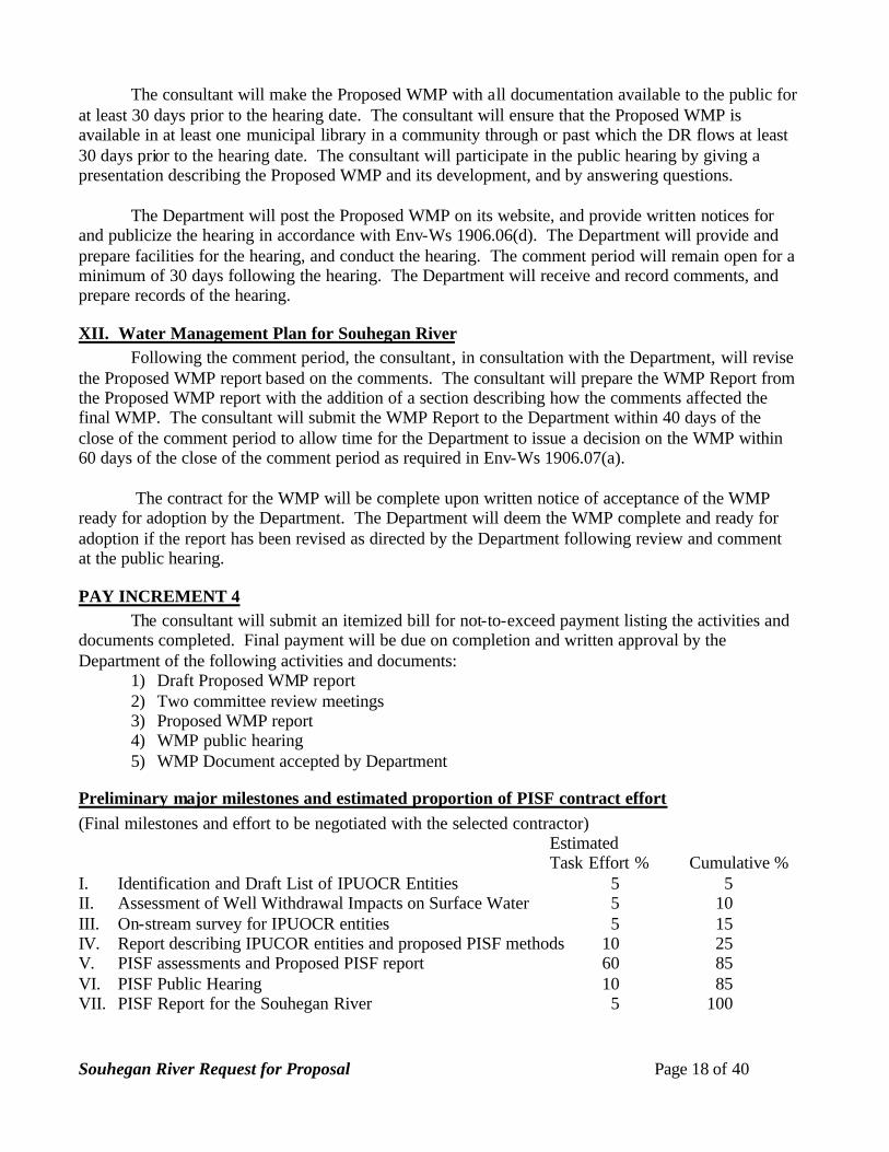
XII. Water Management Plan for Souhegan River Following the comment period, the consultant, in consultation with the Department, will revise
the Proposed WMP report based on the comments. The consultant will prepare the WMP Report from the Proposed WMP report with the addition of a section describing how the comments affected the final WMP. The consultant will submit the WMP Report to the Department within 40 days of the close of the comment period to allow time for the Department to issue a decision on the WMP within 60 days of the close of the comment period as required in Env-Ws 1906.07(a).
The contract for the WMP will be complete upon written notice of acceptance of the WMP
ready for adoption by the Department. The Department will deem the WMP complete and ready for adoption if the report has been revised as directed by the Department following review and comment at the public hearing.
PAY INCREMENT 4 The consultant will submit an itemized bill for not-to-exceed payment listing the activities and
documents completed. Final payment will be due on completion and written approval by the Department of the following activities and documents:
1) Draft Proposed WMP report 2) Two committee review meetings 3) Proposed WMP report 4) WMP public hearing 5) WMP Document accepted by Department
Preliminary major milestones and estimated proportion of PISF contract effort (Final milestones and effort to be negotiated with the selected contractor)
Estimated Task Effort % Cumulative %
I. Identification and Draft List of IPUOCR Entities 5 5 II. Assessment of Well Withdrawal Impacts on Surface Water 5 10 III. On-stream survey for IPUOCR entities 5 15 IV. Report describing IPUCOR entities and proposed PISF methods 10 25 V. PISF assessments and Proposed PISF report 60 85 VI. PISF Public Hearing 10 85 VII. PISF Report for the Souhegan River 5 100
Souhegan River Request for Proposal Page 19 of 40
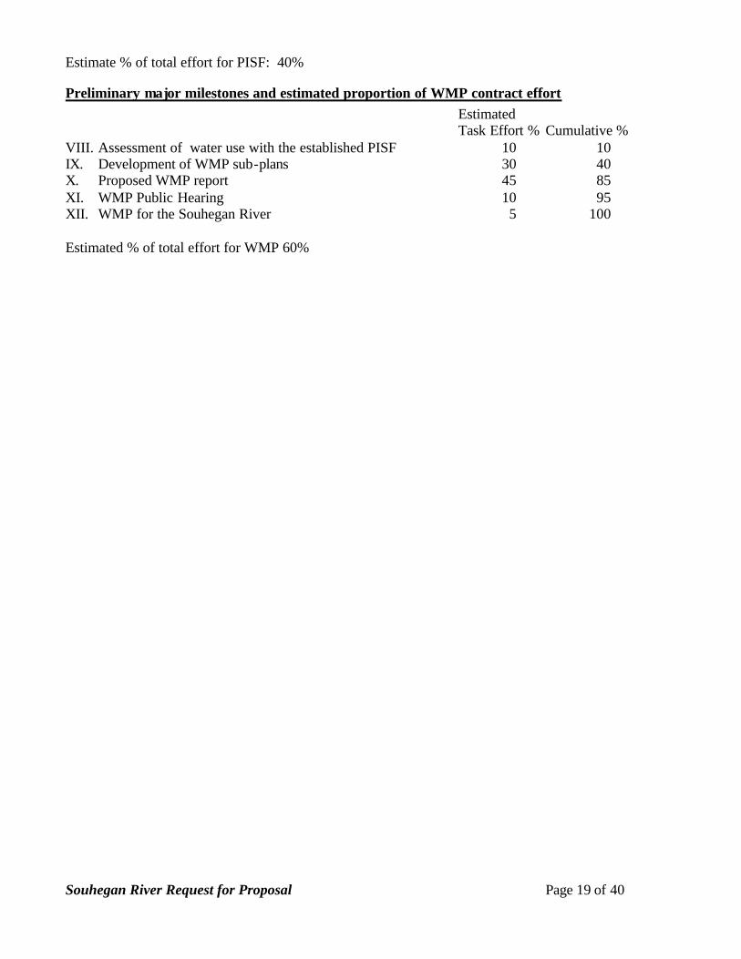
Estimate % of total effort for PISF: 40%
Preliminary major milestones and estimated proportion of WMP contract effort Estimated Task Effort % Cumulative %
VIII. Assessment of water use with the established PISF 10 10 IX. Development of WMP sub-plans 30 40 X. Proposed WMP report 45 85 XI. WMP Public Hearing 10 95 XII. WMP for the Souhegan River 5 100 Estimated % of total effort for WMP 60%
Souhegan River Request for Proposal Page 20 of 40
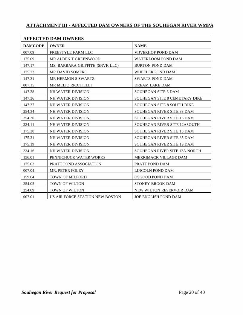
ATTACHMENT III - AFFECTED DAM OWNERS OF THE SOUHEGAN RIVER WMPA AFFECTED DAM OWNERS DAMCODE OWNER NAME
007.09 FREESTYLE FARM LLC VIJVERHOF POND DAM
175.09 MR ALDEN T GREENWOOD WATERLOOM POND DAM
147.17 MS. BARBARA GRIFFITH (SNVK LLC) BURTON POND DAM
175.23 MR DAVID SOMERO WHEELER POND DAM
147.31 MR HERMON S SWARTZ SWARTZ POND DAM
007.15 MR MELIO RICCITELLI DREAM LAKE DAM
147.28 NH WATER DIVISION SOUHEGAN SITE 8 DAM
147.36 NH WATER DIVISION SOUHEGAN SITE 8 CEMETARY DIKE
147.37 NH WATER DIVISION SOUHEGAN SITE 8 SOUTH DIKE
254.34 NH WATER DIVISION SOUHEGAN RIVER SITE 33 DAM
254.30 NH WATER DIVISION SOUHEGAN RIVER SITE 15 DAM
234.11 NH WATER DIVISION SOUHEGAN RIVER SITE 12ASOUTH
175.20 NH WATER DIVISION SOUHEGAN RIVER SITE 13 DAM
175.21 NH WATER DIVISION SOUHEGAN RIVER SITE 35 DAM
175.19 NH WATER DIVISION SOUHEGAN RIVER SITE 19 DAM
234.16 NH WATER DIVISION SOUHEGAN RIVER SITE 12A NORTH
156.01 PENNICHUCK WATER WORKS MERRIMACK VILLAGE DAM
175.03 PRATT POND ASSOCIATION PRATT POND DAM
007.04 MR. PETER FOLEY LINCOLN POND DAM
159.04 TOWN OF MILFORD OSGOOD POND DAM
254.05 TOWN OF WILTON STONEY BROOK DAM
254.09 TOWN OF WILTON NEW WILTON RESERVOIR DAM
007.01 US AIR FORCE STATION NEW BOSTON JOE ENGLISH POND DAM

Souhegan River Request for Proposal Page 21 of 40
ATTACHMENT IV - AFFECTED WATER USERS OF THE SOUHEGAN RIVER WMPA
AFFECTED WATER USERS SDID SDNAME FACILITY USERNAME 20190-S01 SOUHEGAN RIVER AMHERST COUNTRY CLUB AMHERST COUNTRY CLUB 20190-D01 IRRIGATION AMHERST COUNTRY CLUB AMHERST COUNTRY CLUB 20000-S01 WELL AMHERST VILLAGE DISTRICT PENNICHUCK WATER WORKS 20230-D01 SOUGHEGAN RIVER CHAMBERLAIN FALLS HYDRO GREENWOOD ALDEN T 20230-S01 SOUHEGAN RIVER CHAMBERLAIN FALLS HYDRO GREENWOOD ALDEN T 20047-S02 SOUHEGAN RIVER WELL GREENVILLE WATER WORKS GREENVILLE TOWN 20026-S01 NH WRD SITE 12-A GREENVILLE WATER WORKS GREENVILLE TOWN 20218-D01 PURGATORY BROOK MILFORD FISH HATCHERY NH FISH & GAME 20218-S02 WELL #1 MILFORD FISH HATCHERY NH FISH & GAME 20218-S01 WELL #4 MILFORD FISH HATCHERY NH FISH & GAME 20100-S02 KOKKO WELL MILFORD WATER WORKS MILFORD WATER WORKS 20100-S01 CURTIS WELLS #1 & #2 MILFORD WATER WORKS MILFORD WATER WORKS
20621-S02 INTERVALE RD SPRING WELL MONADNOCK MOUNTAIN WATER
MONADNOCK MOUNTAIN SPRING
20621-S01 MANSUR ROAD SPRING WELL MONADNOCK MOUNTAIN WATER
MONADNOCK MOUNTAIN SPRING
20229-D01 SOUHEGAN RIVER OTIS FALLS GREENWOOD ALDEN T 20229-S01 SOUHEGAN RIVER OTIS FALLS GREENWOOD ALDEN T 20383-S01 SOUHEGAN RIVER PETER DE BRUYN KOPS PETER DE BRUYN KOPS 20383-D01 IRRIGATION PETER DE BRUYN KOPS PETER DE BRUYN KOPS 20681-S02 SOUHEGAN RIVER WELL PILGRIM FOODS PILGRIM FOODS 20047-S01 TOWN OF GREENVILLE PILGRIM FOODS PILGRIM FOODS 20681-S03 ON SITE WELL PILGRIM FOODS PILGRIM FOODS 20681-S04 ON SITE WELL PILGRIM FOODS PILGRIM FOODS 20659-S01 GPW 1 & GPW 4 SOUHEGAN WOODS PENNICHUCK WATER WORKS 20523-S01 SOUHEGAN RIVER SOUHEGAN WOODS GOLF CLUB SOUHEGAN WOODS GOLF CLUB 20523-D01 GOLF COURSE SOUHEGAN WOODS GOLF CLUB SOUHEGAN WOODS GOLF CLUB 20092-D01 SOUHEGAN RIVER WASTE WATER TREAT PLANT MILFORD WWTF 20086-D01 SOUHEGAN RIVER WASTE WATER TREAT PLANT GREENVILLE WWTF 20228-D01 SOUHEGAN RIVER WATER LOOM FALLS HYDRO GREENWOOD ALDEN T 20228-S01 SOUHEGAN RIVER WATER LOOM FALLS HYDRO GREENWOOD ALDEN T 20281-D01 STONY BROOK WILTON QUARRY PIKE INDUSTRIES 20281-S01 STONY BROOK WILTON QUARRY PIKE INDUSTRIES 20065-S02 ABBOTT WELL ROUTE 31 WILTON WATER WORKS WILTON WATER WORKS
20065-S01 EVERETT WELL ROUTE 31 WILTON WATER WORKS WILTON WATER WORKS
Source: Revised 20040120 from wateruserdistances 20031110.xls

Souhegan River Request for Proposal Page 22 of 40
ATTACHMENT V – DEFINED FOR PISF STUDY – INSTREAM PUBLIC USES, OUTSTANDING CHARACTERISTICS, AND RESOURCES
The following table represents the Department’s understanding of the meaning of the Instream
Public Uses, Outstanding Characteristics, and Resources that are listed in RSA 483 that the NH legislature has identified as criteria for the Protected Instream Flow. These definitions shall be used by the Protected Instream Flow contractor to identify Instream Public Uses, Outstanding Characteristics, and Resources on the Designated River.
In the table below the Department has matched similar components of Instream Public Uses, Outstanding Characteristics, and Resources that are listed in various parts of RSA 483. Definitions of each entity have been given that describe the entities as they are relevant to instream flow protection. Wherever possible the definitions were drawn from descriptions in the rules for Designated River nomination criteria under Env-C 700 RIVERS MANAGEMENT AND PROTECTION PROGRAM.
Instream public uses
Outstanding characteristics
Resources Definition
Env-Ws 1905.02 Protected Instream Flow Study. The protected instream flow study shall: (c) For each segment, identify and catalog all instream public uses on the designated river listed under RSA 483:9-c.I, and designated uses under the federal Clean Water Act;
(b) For each segment, identify and catalog outstanding characteristics listed under RSA 483:1;
(d) For each segment, identify and catalog all resources for which the river or segment is designated pursuant to RSA 483:6 IV a.
include the state's interests in surface waters, including, but not limited to, navigation; recreation; fishing; storage; conservation; maintenance and enhancement of aquatic and fish life; fish and wildlife habitat; wildlife; the protection of water quality and public health; pollution abatement; aesthetic beauty; and hydroelectric energy production
including recreational, fisheries, wildlife, environmental, cultural, historical, archaeological, scientific, ecological, aesthetic, community significance, agricultural, and public water supply so that these valued characteristics shall endure as part of the river uses to be enjoyed by New Hampshire people
Whether the river, or segment or segments of such river, contain or represent either a significant statewide or local example of one or more of the following: (1) Scenic or recreational resource. (2) Open space or natural resource. (3) Fisheries, wildlife, vegetation, and rare species or habitat. (4) Cultural, historical, or archaeological

Souhegan River Request for Proposal Page 23 of 40
resource. (5) Hydrological or geological resource. (6) Water quality. (7) Scientific resource. (8) Community resource. (9) Current and projected withdrawals, discharges, or both, by public utilities and commercial or industrial users.
Navigation Navigation means use of the river for non-recreational, transportation purposes.
Recreational Recreational Recreational resource
Recreational use or resource means use of the river for swimming, boating or significant shoreland recreation, including, but not limited to, hiking, camping, picnicking, and bird watching.
Fishing Fisheries Fisheries Fishing and Fisheries means recreational and commercial uses of the river for fishing identified by the presence of fish that are caught for recreation or commercial use.
Open space resource
Open space means flow-dependent, characteristics of open space including, but not be limited to, national forest lands, state parks and forests, municipal parks, and conservation easements. There may be little or no flow-related issues concerning maintenance of open space.
Natural resource Natural resource means geologic, wildlife, endangered or threatened animals, wildlife habitat, wildlife travel corridor, vegetation/natural communities, fish resources, aquatic habitat for fish populations, a fishery that relies on natural reproduction or a stocking program, anadromous fish or a restoration effort, Class A waters or water quality equal to Class A or a Class B water or water quality equal to Class B, open space, natural flow characteristics. This category should only be invoked where the resource does not fit into another category.
Storage Storage means the natural or man-made attributes of a river for water storage. Only Community Rivers are subject to new dam construction.
Wildlife Wildlife Wildlife Wildlife for this purpose shall mean species that rely on flow and flow to regions, including, but are not limited to, waterfowl breeding or wintering areas, freshwater wetlands or riparian habitat, and saltwater wetlands associated with

Souhegan River Request for Proposal Page 24 of 40
estuarine systems Rare species or
habitat Rare species are identified by lists of plants and animals or fish available from NHI and by the nomination papers. Rare habitats are habitats that support rare species or are rare ecosystems.
Vegetation Vegetation means native, flow-dependent species Environmental Flow-dependent issues not included in other
categories are unlikely. Conservation Flow-dependent issues not included in other
categories are unlikely. Cultural Cultural
resource Cultural resources or characteristics mean on-going river corridor management planning effort or other local efforts to protect or manage the river, the existence of a riverside park or other public area, or community support for riverfront revitalization as demonstrated by acts such as the filing of a petition, establishment of a municipal committee or citizen group, or fundraising activities.
Historical resource
Flow-dependent issues are unlikely.
Archaeological Archaeological resource
Flow-dependent issues are unlikely.
Maintenance and enhancement of aquatic and fish life
Maintenance and enhancement of aquatic and fish life means the web of aquatic species that make up a balanced, integrated, and adaptive community of organisms having a species composition, diversity, and functional organization comparable to that of similar natural habitats of a region.
Hydrological resource
Hydrologic resource means natural flow characteristics meaning the river is free-flowing, such that the river is 100 percent free-flowing with no man-made dams, diversions, or other modifications which affect the river's natural flow or the river is largely free-flowing without characteristics of impoundment excluding low dams, diversion works and other minor modifications.
Geological resource
A geologic resource meaning a national, regional, state, or local geologic resource as determined by the state geologist or as listed in a national or state resource assessment. Flow-dependent issues are unlikely.
Fish habitat Fish habitat means regions which are important to the survival of fish populations. Such regions include, but are not limited to, aquatic life spawning beds and feeding areas, freshwater wetlands or riparian habitat, and saltwater wetlands associated with estuarine systems.
Wildlife habitat Wildlife habitat means habitat for game and non-game wildlife populations. Such regions include

Souhegan River Request for Proposal Page 25 of 40
waterfowl breeding or wintering areas, freshwater wetlands or riparian habitat, and saltwater wetlands associated with estuarine systems.
Historical Flow-dependent issues are unlikely. Scientific Scientific
resource It is not clear what is desired to be protected by this item.
Protection of water quality and public health
Water quality Water quality and public health are the flow-dependent characteristics that maintain water quality of the river including, but not limited to and the maintenance of chemical and physical water quality parameters that support designated and existing uses. Identify water quality as Class A or Class B.
Community significance
Community resource
Community river resource means a natural, managed, cultural, or recreational resource or use thereof associated with a river that is recognized by local residents or a municipal document accepted by the municipality, such as a master plan or a water resource management plan, as being important to a community adjacent to a river. "Recognized by local residents" for the purposes of this definition means that there are community projects, activities or events based on the river or its corridor such as river clean-ups, canoe races, or a riverfest. Community significance shall not include hydroelectric power generation.
Pollution abatement
Pollution abatement includes wastewater treatment facilities or industrial treatment facilities and aspects of flow affecting assumptions of flow for dilution and dispersal of waste in mixing zones and the rivers overall capacity to mitigate natural and non-point source contamination.
Ecological Ecology is a natural ecological community as determined by the NH natural heritage inventory.
Aesthetic beauty Aesthetic Scenic resource Scenic sites shall include, but not be limited to, designated viewing areas, scenic vistas, and overlooks.
Hydroelectric energy production
Hydroelectric energy production is an existing hydroelectric facility on any classification of designated river, or a former hydroelectric facility site that has been unused for fewer than six years on a Rural or Rural-Community river. The description of potential site of hydroelectric facilities on Community rivers is beyond the scope of this project and should be clearly stated as such in the PISF report.
Agricultural Agriculture as defined by RSA 21:34:a. http://gencourt.state.nh.us/rsa/html/i/21/21-34-a.htm
Public water A public water supply is an existing source of

Souhegan River Request for Proposal Page 26 of 40
supply public drinking water that meets the Department’s description of a public water system in http://www.des.state.nh.us/rules/envws300-309.pdf as stated in Env-Ws 302.02 Definitions. "Public water system" means a "public water system" as defined in RSA 485:I-a,XV, namely "a system for the provision to the public of piped water for human consumption, if such system has at least fifteen service connections or regularly serves an average of at least twenty-five individuals daily at least 60 days out of the year. The identification of all potential water supplies is beyond the scope of this project and should be clearly stated as such in the PISF report.
Clean Water Act designated uses
Use of the river shall not degrade the flow-dependent uses as instream public uses of the DR designated by the state under the CWA. The state’s designated uses and criteria defining support of these uses are in the following paragraphs taken from the CALM. Aquatic Life Waters that provide suitable chemical and physical conditions for supporting a balanced, integrated and adaptive community of aquatic organisms. Applicable to all surface waters. Fish Consumption Waters that support fish free from contamination at levels that pose a human health risk to consumers. Applicable to all surface waters. Shellfish Consumption Waters that support a population of shellfish free from toxicants and pathogens that could pose a human health risk to consumers. Applicable to all tidal surface waters. Drinking Water Supply Waters that with conventional treatment will be suitable for human intake and meet state/federal drinking water regulations. Applicable to all fresh surface waters. Primary Contact Recreation (i.e. swimming) Waters suitable for recreational uses that require or are likely to result in full body contact and/or incidental ingestion of water. Applicable to all surface waters. Secondary Contact Recreation Waters that support recreational uses that involve minor contact with the water. Applicable to all surface waters. Wildlife Waters that provide suitable physical and chemical conditions in the water and the riparian corridor to support wildlife as well as aquatic life. Applicable to all surface waters.
Sources: http://www.des.state.nh.us/rivers/rsa483.htm; http://www.des.state.nh.us/rivers/10-22-96.htm

Souhegan River Request for Proposal Page 27 of 40
ATTACHMENT VI - PHOTO DOCUMENTATION PROCEDURE
Photo Documentation Procedure for Measuring the Success of Restoration Projects and Best Management Practices Adapted from: Products of the 2000-2001 Technical Advisory Council on Citizen Monitoring, California Association of Resource Conservation Districts, working under 319(h) contract to the State Water Resources Control Board (contract No. 8-099-250-0) Adapted by: Stephen Landry Introduction: Photographs provide a qualitative, and potentially semi-quantitative, record of conditions in a watershed or on a water body. Photographs can be used to document general conditions on a reach of a stream during a stream walk, pollution events or other impacts, assess resource conditions over time, or can be used to document temporal progress for restoration efforts or other projects designed to benefit water quality. Photographic technology is available to anyone and it does not require a large degree of training or expensive equipment. Photos can be used in reports, presentations, or uploaded onto a computer website or GIS program. This approach is useful in providing a visual portrait of water resources to those who may never have the opportunity to actually visit a monitoring site. Equipment: Use the same camera to the extent possible for each photo throughout the duration of the project. Either 35 mm color or digital color cameras are recommended, accompanied by a telephoto lens. If you must change cameras during the program, replace the original camera with a similar one comparable in terms of media (digital vs. 35 mm) and other characteristics. A complete equipment list is suggested as follows: Required: • Camera • Folder with copies of previous photos (do not carry original photos in the field) • Topographic and/or road map • Compass • Timepiece • Extra film or digital disk capacity (whichever is applicable) • Extra batteries for camera (if applicable) • Photo-log data sheets or, alternatively, a bound notebook dedicated to the project • Dry-erase board, and markers (bring extra markers) Optional: • GPS unit • Ruler (for scale on close up views of streams and vegetation) • Wooden stakes and flags or re-bar and flags for dedicating fixed photo points in the absence of available
fixed landmarks

Souhegan River Request for Proposal Page 28 of 40
Roles and Duties of Team: The team should be comprised of two people, for restoration or other water quality improvement projects, as follows: 1. Primary Photographer responsible for selecting photo angles, targets and GPS operation. 2. One person responsible for taking field notes, recording photos and preparing dry erase board. Safety Concerns: Persons involved in photo monitoring should ALWAYS put safety first. For safety reasons, always have at least two volunteers for the survey. Make sure that the area(s) you are surveying either are accessible to the public or that you have obtained permission from the landowner prior to the survey. Some safety concerns that may be encountered during the survey include, but are not limited to: • Inclement weather • Flood conditions, fast flowing water, or very cold water • Poisonous plants (e.g.: poison ivy) • Dangerous insects and animals (e.g.: bees, ticks, livestock, etc.) • Harmful or hazardous trash (e.g.: broken glass, hypodermic needles, human feces) We recommend that the volunteer coordinator or restoration coordinator discuss the potential hazards with all volunteers prior to any fieldwork. General Instructions: From the inception of any photo documentation project until it is completed, always take each photo from the same position (photo point), and at the same bearing and vertical angle at that photo point. Photo point positions should be thoroughly documented, including photographs taken of the photo point. Refer to copies of previous photos when arriving at the photo point. Try to maintain a level (horizontal) camera view unless the terrain is sloped. When photo points are first being selected, consider the type of project (salt marsh, wetland, or stream restoration, ambient or event monitoring, etc.) and refer to the guidance listed on Suggestions for Photo Points. When taking photographs, try to include landscape features that are unlikely to change over several years (buildings, other structures, and landscape features such as peaks, rock outcrops, large trees, etc.) so that repeat photos will be easy to position. Lighting is, of course, a key ingredient so give consideration to the angle of light, cloud cover, background, shadows, and contrasts. Close view photographs taken from the north (i.e., facing south) will minimize shadows. Medium and long view photos are best shot with the sun at the photographer’s back. Some artistic expression is encouraged as some photos may be used on websites and in slide shows (early morning and late evening shots may be useful for this purpose). Seasonal changes can be used to advantage as foliage, stream flow, cloud cover, and site access fluctuate. It is often important to include a ruler, person, farm animal, or automobile in photos to convey the scale of the image. Of particular concern is the angle from which the photo is taken. Oftentimes an overhead or elevated shot from a bridge, peak, etc. will be instrumental in conveying the full dimensions of the project. Of most importance overall, however, is being aware of the goal(s) of the project and capturing images that clearly demonstrate progress towards achieving those goal(s). Again, reference to Suggestions for Photo Points, may be helpful. If possible, try to include a dry-erase board in the view, marked at a minimum with the location, subject, time and date of the photograph. Use large font and position the dry-erase board in the lower corner of each photograph. The dry erase board should be positioned at a distance from the photographer that does not obscure the subject matter of the photo point but allows for the text to be legible. If using a digital camera (recommended), experiment on the first photo point to determine the optimum combination of font size,
Souhegan River Request for Proposal Page 29 of 40
distance to photographer and position of dry erase board in the photo. Use of the flash is not recommended with the dry erase board as it tends to reflect off the surface obscuring the text. A blank photo sign form is included in this document. Copies of this sign form can be used in the photos if a dry-erase board is not available. Copying this form onto yellow sheets for field use provides the necessary contrast for the text to be visible in the photographs. Recording Information: Use a systematic method of recording information about each project, photo point, and photo. The following information should be entered on the photo-log forms (blank form included in this document) or in a dedicated notebook:
• Project or group name, and contract number (if applicable, e.g., for funded restoration projects) • General location (stream, beach, city, etc.), and short narrative description of project’s habitat type,
goals, etc. • Photographer and other team members • Photo number • Date • Time (for each photograph) • Photo point information, including:
o Name or other unique identifier (abbreviated name and/or ID number) o Narrative description of location including proximity to and direction from notable
landscape features like roads, fence lines, creeks, rock outcrops, large trees, buildings, previous photo points, etc. – sufficient for future photographers who have never visited the project to locate the photo point
o Latitude, longitude, and altitude from map or GPS unit • Magnetic compass bearing from the photo point to the subject • Specific information about the subject of the photo • Optional additional information: a true compass bearing (corrected for declination) from photo
point to subject, time of sunrise and sunset (check newspaper or almanac), and cloud cover. When monitoring the implementation of restoration, or Best Management Practices (BMP) projects, include or attach to the photo-log a narrative description of observable progress in achieving the goals of the project. Provide supplementary information along with the photo, such as noticeable changes in habitat, wildlife, and water quality and quantity. Archive all photos, along with the associated photo-log information, in a protected environment.

Souhegan River Request for Proposal Page 30 of 40
The Photo Point: Establishing Position of Photographer: 1. Bring a variety of methods for establishing position: maps, aerial photos, GPS, permanent markers and
landmarks, etc. If the primary method fails (e.g., an inoperative GPS or lost marker post) have an alternate method available.
2. Select an existing structure or landmark (mailbox, telephone pole, benchmark, large rock, etc.), identify its
latitude and longitude, and choose (and record for future use) the permanent position of the photographer relative to that landmark. If no such permanent landmark is convenient for establishing the photo point, the installation of grade stakes or rebar with flagging (with station ID on flagging) is recommended.
3. For restoration, and BMP projects, photograph the photo-points and carry copies of those photographs on
subsequent field visits. Determining the Compass Bearing: 1. Select and record the true compass bearing of the photo center view. Include a prominent landmark in a set
position within the view. If possible, have an assistant stand at a fixed distance from both the photographer and the center of the view, holding the dry-erase board for scale.
2. When performing ambient or event photo monitoring, and when a compass is not available, then refer to a
map and record the approximate bearing as north, south, east or west. Suggestions for Photo Points: 1. When first beginning a monitoring program take representative long and/or medium view photos of stream
reaches, segments of shoreline or other areas being monitored. Show the positions of these photos on a map or site sketch. Subjects to be photographed include a representative view of the stream or shore condition at the beginning and ending positions of the segment being monitored, storm drain outfalls, confluence of tributaries, structures (e.g., bridges, dams, culverts, etc.).
2. If possible , take a close view photograph of the substrate (streambed), algae, or submerged aquatic
vegetation. 3. Take long view and medium view of streambed changes (thalweg, gravel, meanders, etc.) 4. Time series: Take photos immediately before and after construction, planting, or vegetation removal. Take
medium and close views of structures, plantings, etc. Long term monitoring should allow for at least annual photography.
5. Event monitoring: this refers to any unusual or sporadic conditions encountered during a stream or shore
walk, such as trash dumps, turbidity events, oil spills, etc. Photograph and record information on your photo-log. Report pollution events to the NH Department of Environmental Services (603-271-3503).
6. Optional: Use a tape set perpendicular across the stream channel at fixed points and include this tape in
your photos. The tape will show the current depth of the stream relative to the tape.

Souhegan River Request for Proposal Page 31 of 40
PHOTO LOG FORM
Project: Photographer: Location: Team members: Date: Photo
#
Time
Photo Point
ID
Photo Point GPS Reading
Photo Pt. Description &
Location
Bearing to
Subject Subject Description
General Notes or Comments (weather, rainfall data, cloud cover, time of sunrise and sunset, other pertinent information):

Souhegan River Request for Proposal Page 32 of 40
PHOTO SIGN FORM: Print this form on yellow paper if a Dry-erase board is not available. Complete the following information in black marker for each photograph. Include in the photographic view so that it will be legible in the finished photo. Location: Subject Description: Date: Time:

Souhegan River Request for Proposal Page 33 of 40
ATTACHMENT VII - INSTREAM FLOW ANALYSIS WITHIN THE CONTOOCOOK RIVER BASIN (DRAFT)
Instream Flow Analysis within the
Contoocook River Basin
Prepared for the New Hampshire Department of Environmental Services Rivers Management & Protection Program.
DRAFT January, 2002
AUTHOR: Rod OwreSurface Water Hydrologist

Souhegan River Request for Proposal Page 34 of 40
Abstract. Water use with respect to stream flow was examined within the Contoocook River Basin of south central New Hampshire for the calendar year 1999. Daily stream flow and water use data were used to analyze compliance with the General Standard as proposed by the New Hampshire Department of Environmental Services (DES) in the June 2000 Draft Instream Flow Rules (“flow rules”). Withdrawal amounts and frequencies of thirty affected water users (AWUs) in the basin were assessed. Results show that water use was greatest when flow was lowest (July – September), and that the average water user in the basin exceeded the General Standard on 86 days in 1999. Water use was plotted for each individual user and on an aggregate basis throughout the basin to display frequency and extent of exceedence. The study was intended to address the need for instream flow protection and prioritization of water management for rivers designated under the New Hampshire Rivers Management and Protection Program.
INTRODUCTION AND BACKGROUND In 1990, the New Hampshire Department of Environmental Services (DES) was directed to establish Administrative Rules for the protection of instream flows (“flow rules”) for rivers designated into the New Hampshire Rivers Management and Protection Program (RMPP) under RSA 483. The purpose of the flow rules are to specify standards, criteria, and procedures by which a protected instream flows shall be established and enforced for each designated river or river segment in order to maintain sufficient water for instream public uses and to protect the resources for which the river or river segment is designated. Watershed Description The Contoocook River was designated into the RMPP on June 28, 1991. The river drains 766 square miles, travels 71 miles, and flows from southeast to northwest through Chesire, Hillsborough, and Merrimack counties before emptying into the Merrimack River in Concord (MAP XX). Primary tributaries to the Contoocook River include Nubanusit Brook, the North Branch River (designated under RSA 483), the Warner River, and the Blackwater River. In total, there are 79 dams located within the Contoocook River basin including 2 large (>350acres) recreational reservoirs (Contoocook Lake, Highland Lake), 1 large impoundment used for hydroelectric power generation (Franklin Pierce Lake; 486 acres), and 4 flood control reservoirs (MacDowell Reservoir, Hopkinton Flood Control Dam, Hopkinton Dike at Elm Brook Blackwater Dam). General Standard As proposed by DES a 4-tiered General Standard would be applied to each designated river watershed as a means for comparing water use to streamflow and prioritizing those rivers in need of protected flows. Under the flow rules a designated river is in compliance with the general standard if: (1) Average aggregate monthly water use does not exceed 5 percent of 7Q10 when average stream flow is less than or equal to 0.5 cubic feet / square mile (cfsm);
(2) Average aggregate water use does not exceed 0.02 cfsm when average stream flow is greater than 0.5 cfsm and less than or equal to 1.0 cfsm; (3) Average aggregate water use does not exceed 0.04 cfsm when average stream flow is greater than 1.0 cfsm and less than or equal to 4 cfsm; or (4) Average aggregate water use does not exceed 0.16 cfsm when average stream flow is greater than 4 cfsm. Under the proposed flow rules a priority list (Env-Ws-1908.03) is to be published annually by DES that analyzes water use with respect to stream flow for each designated river watershed. Specific objectives of this study were to: 1) apply the conditions of the General Standard by comparing individual and aggregate water use with respect to stream flow values on a daily and monthly basis within the Contoocook River watershed; and 2) gain an understanding of water use and stream flow patterns from a daily, monthly, and annual perspective. Study Design Daily stream flow values from six gaging stations (Map 1) and daily water use from 30 affected water users (AWUs; Map 2) in the watershed were compiled for calendar year 1999. Known stream flow values at the gaging stations were transposed to each water user location. The resultant estimated flow values were matched to individual and aggregate water use at a given AWU location. Pursuant to the General Standard, thresholds for aggregate water use were determined for each tier from the corresponding AWU-specific location stream flow estimate. Subsequently, compliance with or exceedance of the General Standard was tabulated for each day. Historical records of monthly mean water use, stream flow, and precipitation data were used to compare with 1999 figures.

Souhegan River Request for Proposal Page 35 of 40
-----------------------------------------------------------------------------------------------------------------------------------------------------------Definitions 7Q10 The lowest average flow rate for a period of 7 consecutive days with an expected recurrence interval of once in every 10 years, determined at a fixed location on a river or stream, and expressed in terms of volume per time period. Affected Water User A water user having a withdrawal or return in excess of 20,000 gallons per day and a location within 500 feet of a designated river or river or stream in its tributary drainage area. Aggregate Water Use The total water use by all affected water users at and upstream from any location on a designated river, being the difference between the sum of measured water withdrawals and the sum of measured water returns. De Minimus A De Minimus amount refers to an aggregate water use equal to 5 % of 7Q10 that shall always be available at any location. Stream Flow/Flow/Discharge/Q Terms used interchangeably to quantify a volume of water that passes a given point in a given period of time, and usually expressed in cubic feet per second (cfs). METHODS Water Use
All registered water users (defined as using >20,000 gallons / day on average) in the state of New Hampshire are required by law (Env-Wr 700) to provide the DES with monthly estimates of total water use. Referred to as “Monthly Operations Reports”, water use information is reported on a quarterly basis. Daily water use data is required for Waste Water Treatment Facilities (WWTF’s), and Municipal Water Supply Facilities (Water Works, or WW’s) who withdraw from surface-water sources.
Of the 30 AWUs identified within the Contoocook River, a
majority were categorized as “water suppliers”, with the next largest consumptive use category consisting “mining or industrial” operations (Table 1; Figure 1). Since a large proportion of the AWUs are public water suppliers (43%), daily water use records were commonly collected for these facilities to track their own operations. For those AWUs where actual daily water use records were not available, a various methods were used to track withrdrawal amounts. Some AWUs log meter readings on a weekly or bi-weekly basis. Other AWUs estimate their use by multiplying known pumping rates by the amount of time the pumps are run either on a daily basis, weekly, or monthly basis. Other AWUs calculate use by drawdown from holding tanks with theoretically known volumes. Thus, in many cases determining daily water use for required estimations.
For this study, daily data for 22 of the 32* water users was made available. Of the remaining 10 AWUs, daily withdrawal data from 6 AWUs was estimated by means suggested by the water user, and averaged for 4 AWUs by dividing the monthly totals by the number of days in each respective month. Table 2 provides a breakdown of the quality of water use data obtained.
Specific methods for estimating daily water for the 10 AWUs where actual daily use records were not available consisted of three approaches. The first approach applied to AWUs who suggested periods when they were likely to withdraw water. For examp le, for an AWU that reported their facility did not operate on weekends or holidays, an average daily withdrawal amount was estimated by dividing the monthly withdrawal amount, as report in the Monthly
Operations Report, by the number of weekdays minus holidays, yielding an average daily-use amount for those applicable days.
The second approach applied to AWUs categorized as
irrigators. Golf courses were the only such irrigators in this watershed. For these AWUs daily precipitation data from two National Weather Service stations (Jaffrey, NH, and Concord, NH) was used to estimate days when these facilities were likely to pump water. It was assumed that agricultural watering of “crops” demands 1 inch of water per week. Days when precipitation totals exceeded 0.13 inches (1 inch/ 7days) were eliminated as possible watering days. An average daily withdrawal amount was estimated for the remaining days by dividing the monthly withdrawal amount, as report in the Monthly Operations Report, by the number of days when watering was assumed to be necessary. This approach was used for three of the four golf courses represented as affected water users in the basin.
The third approach applied to AWUs who either did not
provide daily use figures or were uncertain about the figures previously reported on the Monthly Operations Report. Several facilities experienced technical problems with reporting in 1999, evidently due to their meters not working properly or their data tracking. In these instances, attempts were made to ascertain accurate amounts through direct communication with the AWU or using best professional judgment. The majority of these examples entailed a simple daily average computed from what the water user deemed the most accurate monthly totals. Stream Flow Steam flow data from six gaging stations used in this study was provided by the USGS, Water Resources Division of the New Hampshire & Vermont District. It was issued in raw (provisional) format, containing stage (gage height) and corresponding discharge (stream flow) recordings in 15-minute intervals. Daily mean stream flow values were computed at each station from these 15-minute values. Only one of the six gaging stations – Nubanusit Brook near Peterborough, NH, contained periods of missing record. Seven separate periods of missing record occurred here for a total of

Souhegan River Request for Proposal Page 36 of 40
Monthly Operations Report.
28%
38%
16%
13%
Table 2. Categorization of Water-Use Data Quality Obtained for Analysis.
Operations Report; no estimations involved.(1.) Accurate daily values; monthly sum of daily values matched those previously reported on Monthly
(5.) Daily values and/or monthly totals questionable; data set contained at least three months of estimations.6%
(2.) Reasonably accurate daily values; slight discrepancies between monthly sum of daily values and monthlytotals reported previously on Monthly Operations Report.
(3.) Daily values accurate from a monthly sum perspective; daily values estimated either by scientific methodor with means suggested by water user.(4.) Daily values accurate from a monthly sum perspective; daily values averaged from monthly totals on
------------------------------------------------------------------------------------------------------------------------------------------------------------- * There are a total of 30 Affected Water Users by definition; two water users (Peterborough WW and Monadnock Paper Mills) have
operations in distinctly different locations. Their different operations were assigned different drainage areas and consequently different stream flow values. There are 32 different SDID numbers – identification numbers associated with a particular source or destination. For this reason, the different operations of Peterborough WW and Monadnock Paper Mills are treated independently for much of the analysis contained in this report (See Table 1 for respective locations and drainage areas). 66 days (1/1 – 1/10; 4/29 – 5/1; 6/1 – 6/7; 6/9 – 7/2; 8/3 – 8/14; 9/4 – 9/6; 10/19 – 10/25). For the period 1/1 – 1/10, it is likely that ice formed inside the stilling well of the gage house inhibiting accurate gage readings. For this period, daily mean flow values of zero were entered. For the period 10/19 – 10/25, it is believed that the float within the stilling of the gage malfunctioned causing the gage height recording to fall 2.50 ft. between two consecutive 15-minute readings. Subsequently, on 10/25, the gage height recording rose 2.66 ft. between two consecutive 15-minute readings indicating that the recorder was serviced at this instant and the proper gage height recording was restored. Thus, a prorated gage height correction was applied between these two errant recording periods in order to generate estimated discharge values for this period.
For all other periods listed above, estimated discharge values were determined by extending the low end of a rating curve created for this station. From an ad hoc rating curve generated from the raw data, it was apparent that the USGS only maintained the rating to a gage height of 2.20 ft. (Figure 2). Whenever the recorder listed gage heights below this mark, an errant corresponding discharge value was listed beside it. Because this resulted in a substantial amount of lost stream flow record, an extension of the rating was created. This was accomplished by using the given gage height – discharge data relation, incorporating a known discharge measurement made by the USGS1 on 6/4/99 at a lower gage height, and estimating a gage height with a corresponding point of zero discharge. From these data, trendline was visually fit to the available data. The corresponding power function equation describing the trendline enabled discharge values to be assigned to all gage heights below 2.20 ft. Stream Flow Data Quality
Certain factors make stream flow records at a gaging station more reliable: 1) the number and frequency of discharge
measurements made; 2) the range of stages at which discharge measurements are made; 3) stability of the control; and 4) the frequency with which personnel service the gage and maintain the record. All six gaging stations used in this study were classified by the USGS as partial record sites in 1999. A partial record site is distinguished from a continuous record site in that the data was not adjusted for rating shifts (i.e modifications to the rating curve due to changes in the control conditions, gage height corrections, equipment failure, or periods of ice). Therefore, the continuous data record used in this report was provisional. The periods of missing record and lack of maintenance of the low end of the rating at the Nubanusit Brook site serve as good examples. Though the record at the other five stations was continuous throughout the year, no such corrections or adjustments referred to above were applied to the data. Transposed Flow Stream flow values were estimated for each AWU location for each day of the year in order to determine how often and by what extent the general standard was exceeded. Since none of the AWUs were located at establish gaging stations efforts were made to apply consistent methods for transposing known stream flow values from the gaging stations to estimated stream flow values at each AWU location. Stream flow transpositions were completed by using an AWU’s drainage area, in conjunction with drainage area(s) of the nearest adjacent gaging station(s), to generate estimated stream flow values.
The process of arriving at an estimated flow value for AWUs ranged in difficulty depending on their location in the watershed and nearness to gaging stations. An example of a simple case is depicted for the Town of Jaffrey’s wasterwater treatment facility (Figure 3, Example 1). For this AWU, daily stream flows were estimated by transposing measured flow values from the Peterborough gaging station (ID #) on the Contoocook River upstream to the determined flow location (DFL). The determined flow location (DFL) is the point on the
-5-

Souhegan River Request for Proposal Page 37 of 40
main stem of the Contoocook River where the where the AWU’s withdrawal or return point is theoretically located (for the Jaffery WWTF, the theoretic and actual geographic return
point are identical since WWTF discharges directly into the main stem of the Contoocook).
Figure 2. Extended Rating Curve (Low End)NUBANUSIT BROOK NEAR PETERBOROUGH, NH
0.60.8
11.21.41.61.8
22.22.4
0 1 2 3 4 5 6 7 8 9 10Discharge (cfs)
Gag
e H
eigh
t (ft
)
-------------------------------------------------------------------------------------------------------------------------------------
* The Power equation listed on the graph is not in proper sequence (mathematical syntax); to conform to standard, the gage height (independent variable) is plotted on the x-axis and the discharg e (dependent variable) is plotted on the y-axis.
For this example, daily stream flow transposition was accomplished by dividing daily streamflows at the gage by its drainage area (68.1mi2), yielding an area-based daily flow value (cubic feet per second per square mile; cfsm). Daily cfsm values were then multiplied by an AWU’s drainage area (36.3mi2) as determined from its DFL to arrive at an estimated daily stream flow. The mathematical expression for this type of transposition is as follows: AWUQ = (Qu/Au) * AAWU Where: AWUQ = Flow at water user (cfs) AAWU = Watershed area at the
water user’s DFL Qu = Flow at upstream gage Au = Watershed area at
upstream gage
The second example is more complex (Figure 3, Example 2). In this example, the actual geographic location of the Town of Hancock’s water supply withdrawal point is a pond that drains to the main stem of the Contoocook. In such a cases, the DFL was defined as the point where the drainage tributary (Nubanusit Brook) enters main stem of the Contoocook and was used to estimate the AWU’s drainage area (121.4 mi2). In addition, daily stream flow estimates for some AWUs utilized stream gaging stations on both the mainstem of the Contoocook River and a nearby tributary. For Hancock’s water wupply, estimated daily stream flows utilized stream flow gage records from the Peterborough (gage #) and Nubanusit Brook (gage #) gages. Next, for each gage, the amount of ungaged watershed area to a DFL was estimated and multiplied by the respective area-based daily stream flow. For Hancock’s Water Supply its DFL included a total of 9.3
mi2 of ungaged watershed area, 4.8 mi2 of which was applied to the Peterborough gage daily stream flow measurement and 4.5 mi2 applied to the Nubanusit gage daily stream flow measurement. The transposed flow was then added to the gage-specific daily flow estimates for the Peterborough and Nubanusit gages to arrive at an estimated daily stream flow at the Town of Hancock’s water supply. The mathematical expression for this transposition is as follows:
AWUQ = (Qu+Qt) + {[(Qu/Au)*AAWUu] + [(Qt/At)*AAWUt]} Where:
AWUQ = Flow at water user (cfs) Qu = Flow at upstream gage Qt = Flow at tributary gage Au = Watershed area at
upstream gage AAWUu = Watershed area of water
user applied to upstream gage
At = Watershed area at tributary gage
AAWUt = Watershed area of water user applied to tributary gage
In cases where an AWU was located as an intermediate
between two stream flow estimation points (i.e. stream gaging stations or major tributary confluences) weighted transpositions were completed to estimate AWU-specific daily stream flows. This method weighted each stream flow estimation point by its known watershed area and relative proximity to the AWU location. For instance, Antrim’s water supply (Antrim WW) stream flows were transposed for
LEGEND Pre-existing coordinates
USGS Measurement # 592
Values derived from equation
x = 0.0743y 5.4782 *

Souhegan River Request for Proposal Page 38 of 40
approximately 70.7 mi2 of ungaged watershed area by weighting the area-based flow estimates from the confluence point of Nubanusit Brook with the Contoocook River and the Henniker gaging point by 70% and 30% respectively. The weighted area-based streamflow estimate was then multiplied by the ungaged watershed area and added to known flow measurement points to arrived at a AWU-specific daily stream flow estimate. The mathematical expression for this transposition is as follows:
[ ] ( )( )
( )( )
−−
+
−
−−+=
d
d
ud
uAWU
u
u
ud
AWUdAWUuQ A
QAAAA
AQ
AAAA
AuAQAWU ***
Where
AWUQ = Flow at a water user (cfs) Qu = Flow at the upstream gage
or flow estimation point Qd = Flow at the downstream
gage or flow estimation point
AAWU = Watershed area at the water user
Au = Watershed area at the upstream gage or flow estimation point
Ad = Watershed area at the downstream gage or flow estimation point
The only exception to the transposition methods explained
above included Hillsborough’s water supply (Loon Pond). In this case, although its logical DFL would be on the North Branch of the Contoocook River, the lack of current stream flow data from this tributary necessitated that its DFL be placed on the main stem of the Contoocook River. In addition, the existence of a large upstream impoundment used for hydropower production (Franklin Pierce Lake) made any prediction stream flow from the North Branch of the Contoocook River difficult. Thus, for this AWU, only the watershed area of the Contoocook River to the confluence point with the North Branch (221.5 mi2) was used to estimate daily stream flows (Figure 4).
---------------------------------------------------------------------------------------------------------------------------------------------------------------
CONTOOCOOK RIVER BASIN
Figure 4. Determined Flow Location (DFL) for Hillsborough WW. The figure depicts where a logical DFL would be assigned if stream flow data were available within the North Branch basin. Area outlined in pink represents drainage area that was not taken into account when transposing flow for this water user.
Hillsborough WW
Contoocook River near Henniker
De Facto DFL
Logical DFL
North Branch Contoocook River
Main Stem Contoocook River

Souhegan River Request for Proposal Page 39 of 40
* HUC is an abbreviation for Hydrologic Unit Code. A hydrologic unit is a geographic area representing a surface drainage area or distinct hydrologic feature. HUCs are delineated on Hydrologic Unit Maps and are identified by an 8-digit number (HUC-8), 10-digit number (HUC-10), or a 12-digit number (HUC-12). The higher the number, the more defined the drainage basin becomes. HUC-12 drainage areas were used to determine all water user drainage areas, and are graphically represented in the WATER USE RESULTS section to show water use concentration in the Contoocook River Basin.
RESULTS Stream Flow Average monthly stream flow in 1999 was below historic averages for four of the six gaging stations (Table xx). From April through August all six of the gaging stations had below average stream flows. The greatest difference occurred during June when each gaging station recorded an average monthly streamflow in excess of 200% below its respective historic average monthly stream flow.
Water Use – Concentration of Use in the Basin
Total water use for the year was summed for each water user, tallied by HUC-12 watersheds, and then divided by the respective HUC-12 watershed areas (expressing a cfsm amount) to compare water use concentration in the basin. Tabular results are listed in Table 7, and graphical results are listed in Figure 13. These values serve as a good basis for comparing overall annual use, and highlight particular areas in the watershed where aggregate water supply may experience pressure. The HUC-10 concentration figures include only the HUC-12 watersheds where water users were located and do not factor the entire areas. For instance, HUC-10 watershed 01070003-01 has a total area of 221 mi2 but the cfsm concentration expresses only six of the eight HUC-12 watersheds comprising an area of 181 mi2. This omission of
“useless area” reflects a more concise value of water use per square mile. One HUC-12 stands out – 01070003-06-03. Concord WW is located within this watershed. It can be inferred that Concord’s operations have a large impact on stream flow. To gage the pressure exerted on the resource, it is useful to compare it’s individual and aggregate use as a percentage of total stream flow on a daily basis (Figure 14). Although the annual average individual use to stream flow was 1.42 percent, maximum individual use to flow for one day equaled 17 percent. The maximum percentage of aggregate water use to stream flow for one day was 38 percent. This statistic can be interpreted many ways. An interesting approach, and one that should be considered for instream flow analysis, would be to measure indiv idual and aggregate water use to available stream flow.
0%
10%
20%
30%
40%
50%
Jan Feb Mar Apr May Jun Jul Aug Sep Oct Nov Dec
Aggregate Use
Individual Use
Figure 13. Percentage of individual and aggregate water use to total stream flow at Concord WW, 1999.
-14-

CONCLUSION Future Considerations for Instream Flow Protection Accurate synthesis of water use and stream flow data is vital for assessing instream flow. Some of the methods outlined in this report such as estimating and averaging needed to be done in order to generate a complete data set for the year. Future monitoring will likely require daily water use reporting from all registered water users. Continuous stream flow record will have to be collected and maintained, and additional gage sites will need to be installed at key locations. It is a big expense that public and political figures must deem necessary in order to preserve this natural resource. The mission of the Department of Environmental Services is to protect, maintain and enhance environmental quality and public health in New Hampshire.