research compendium - friends of ecological reserves
TRANSCRIPT

!
1!
!
Research Compendium
A summary of research conducted in Gulf Islands National Park Reserve
2003 - 2009

!
2!
!
Research Compendium A summary of research conducted in Gulf Islands
National Park Reserve 2003 - 2009
Parks Canada
Gulf Islands National Parks Reserve
Sidney, BC
Prepared by
Amanda Taylor, Todd Golumbia March, 2010
Citation: Taylor, A. and T. Golumbia. 2010. Research Compendium: A summary of research conducted in Gulf Islands National Park Reserve - 2003 F 2009. Unpublished manuscript. Parks Canada, Gulf Islands National Park Reserve, Sidney, BC.
© 2010 Parks Canada.
No part of this publication may be reproduced, stored in a retrieval system, or transmitted, in any form or by any means, electronic, mechanical, photocopying, recording, or otherwise, without prior permission from Gulf Islands National Park Reserve, 2220 Harbour Road, Sidney BC V8L 2P6, Coastal BC Field Unit, Parks Canada, Tel: 250-654-4000, Toll-free: 1-866-944-1744, E-mail: [email protected]. !

3!
!
Table of Contents
Executive!Summary!.......................................................................................................................................!5!
Introduction!..................................................................................................................................................!6!
Methodology!.................................................................................................................................................!8!
Results/Discussion!........................................................................................................................................!8!
Recommendations!......................................................................................................................................!10!
Research!Templates!....................................................................................................................................!15!
2003!Studies!........................................................................................................................................!16!
2004!Studies!........................................................................................................................................!34!
2005!Studies!........................................................................................................................................!46!
2006!Studies!........................................................................................................................................!58!
2007!Studies!........................................................................................................................................!70!
2008!Studies!........................................................................................................................................!91!
2009!Studies!......................................................................................................................................!100!
Appendix!A!Researcher!Index!...................................................................................................................!117!
Appendix!B!Researcher!Contact!Information!...........................................................................................!120!
Appendix!C!Research!Priorities!(2005)!......................................................................................................!131!
!

4!
!
List of Figures !
Figure!1.!Gulf!Islands!National!Park!Reserve!lands!and!core!area!of!interest.!...........................................!11!Figure!2.!Research!effort!in!Gulf!Islands!National!Park!Reserve!from!2003!to!2009.!Results!are!classified!by!year(s)!permit!was!active.!......................................................................................................................!12!Figure!3.!Research!effort!in!Gulf!Islands!National!Park!Reserve!from!2003!to!2009.!Results!are!classified!by!year!permit!was!issued.!.........................................................................................................................!12!Figure!4.!Research!effort!in!Gulf!Islands!National!Park!Reserve!from!2003!to!2009.!Results!are!classified!by!research!discipline.!.................................................................................................................................!13!Figure!5.!Research!effort!in!Gulf!Islands!National!Park!Reserve!from!2003!to!2009.!Results!are!classified!by!major!sponsors.!......................................................................................................................................!13!Figure!6.!University!research!effort!in!Gulf!Islands!National!Park!Reserve!from!2003!to!2009.!Results!are!classified!by!number!of!permits!issued!to!university!sponsors.!.................................................................!14!Figure!7.!Internal!Parks!Canada!research!effort!in!Gulf!Islands!National!Park!Reserve!from!2003!to!2009.!Results!are!classified!as!GINPR!(Park);!SAR!(Species!at!Risk);!and,!VSC!(Vancouver!Service!Centre).!........!14!

5!
!
Executive Summary
This report is a review of research studies that have been conducted in Gulf Islands National Park Reserve (GINPR) from the time of park establishment in 2003 to the end of 2009. It provides context for researchers and Parks Canada to gain a deeper understanding of the Park on a multitude of levels. Due to the relatively recent establishment of the Gulf Islands National Park Reserve, the research program is in its infancy and administrative tools like a functional research database have not been created until now. T34>�=0;:=?�=0;=0>09?>�?30�",=6J>�14=>?�:;;:=?@94?D�?:�share research activities and findings. The primary goals of this report are to: 1) summarize each study by year of initiation and compile the information into one report accessible to Parks Canada staff, the research community, and the general public; 2) create local, regional, and international awareness regarding research conducted in the Park; and, 3) generate interest among potential researchers to conduct relevant research in the Park. This is the first report of its kind for a Gulf Islands National Park Reserve. There continues to be increasing interest from well established researchers in the region and those who may be new to the area and contemplating future involvement in our program. There is also a recognized need and increasing demand for public outreach and awareness regarding research in national heritage areas. We are hoping to increase awareness in these groups thereby leading to increased and focussed research efforts in GINPR based on identified management challenges that the park faces.
Over the past six years, the park has issued permits for 54 research projects in Natural Science, Archaeological/Historical Research and Social Science. The existing permits are predominantly natural science based as there is a more established and pre-existing permitting program in place. The other disciplines have only come under this permitting program since 2006 and awareness is still building around the need for permits. Research has been sponsored by internal researchers at the park and the Western Canada Service Centre as well as eight universities and several other agencies and NGOs.
Research priorities were established shortly after park establishment but these were interim and incomplete. Many of these priorities have been addressed by research initiatives over the past several years and a new set of research priorities will be generated as a result of this review, the Sate of the Park Report and the Park Management Planning Process that is currently underway.

6!
!
Introduction Gulf Islands National Park Reserve GINPR was established May 9, 2003 by agreement between the governments of British Columbia and Canada. The park reserve represents the Strait of Georgia Lowlands Natural Region F the smallest and most urbanized natural region in Canada and includes lands and waters extending over 15 islands. More than 5.8 million people live within a five-hour travel distance of the park, and the region also attracts hundreds of thousands of visitors annually for both marine and land-based recreation. The park is a meeting place for a myriad of contrasting, complementary, and competing forces. The unique ecosystem exists in the Gulf Islands because of the mix of ecological forces created by the Vancouver Island rain shadow, the influx of nutrient-rich marine waters from the Strait of Juan de Fuca, and the freshwater outflow of the Fraser River. The unique location and the Mediterranean-type climate allow delicate meadow flowers and sensitive mosses to grow on the rocky shores and coastal bluffs and provide the 94.30�900/0/�1:=��,==D�:,6�0.:>D>?08>��:90�:1��,9,/,J>�=,=0>?�,9/�8ost imperilled ecosystems. Although the ecosystems in the region may be far from pristine and contain introduced species, ?30�;,=6�;=:?0.?>�>:80�:1�?30�-0>?�0C,8;70>�:1��,9,/,J>�8:>?�?3=0,?090/�0.:>D>?08>�
Similarly, the park embodies a rich human history stretching from thousands of years ago to the present. Many First Nations lived on these islands and they believe they are entrusted with protecting the islands for future generations. This deep spiritual connection to the area and traditional uses continues today. Over the last two centuries, members of many other cultures, including Hawaiians, African-Americans, Japanese, Chinese, and Europeans have joined First Nations residents. Each culture has brought its own distinctive traditions and approach to the cultural landscape; they have been part of the ecosystem, adapting to and modifying the natural environment of the region over the years.
As is the case with GINPR, when outstanding First Nations interests exist in relation to national park lands, the term national park reserve is used. This natural park reserve status does not affect ?30�;,=6J>�;@=;:>0�:=�8,9,20809?���
Why conduct research in a National Park? National parks act as long-term ecological research sites, serving as ecological benchmarks, for the study of natural environments and their components in a relatively undisturbed state. Park based research is not only of value in assisting park management and interpretation, but contributes to the growing body of scientific knowledge concerning our natural world and human interaction with it. Scientific studies in parks are seen as increasingly important because they can help reveal changes occurring in ecosystems as a result of human intervention or nature.
Parks Canada Agency is responsible for protecting and presenting heritage areas for present and future generations. These responsibilities are discharged using various legislative and policy 49>?=@809?>��%30��209.DJ>�2:,7>�,=0�?:�8,49?,4n or restore ecological integrity, monitor and ensure the commemorative integrity of historic places, protect cultural and natural resources, and provide for appropriate visitor experiences. Achieving these goals requires a full understanding of the natural and cultural elements in Heritage Areas, their inter-relationships, the natural

7!
!
processes, and visitor interests and activities. Long term accumulation and analysis of information derived from scientific research and traditional knowledge are important tools to realize this goal. The Research and Collection Permit System enables the Parks Canada Agency ?:�0110.?4A07D�8,9,20�=0>0,=.3�49��,9,/,J>��0=4?,20��=0,>�?:�1@lfil its mandate.
Furthermore, Parks Canada is one of the principle cultural resource management organizations in Canada. It is responsible for a vast array of cultural resources in public settings at Heritage Areas, including cultural landscapes and landscape features, archaeological sites, structures, engineering works, artifacts, and associate/�=0.:=/>��#0>0,=.3�.:9?=4-@?0>�?:�",=6>��,9,/,J>�efforts to protect and present these cultural resources for public benefit, and represent part of the on-going efforts to protect, understand and appreciate our human heritage. Heritage Area managers increasingly recognize that timely and reliable information, to which research information is seen as integral, is essential for sound decisions and high quality visitor experiences. Parks Canada welcomes proposals for scientific studies that are consistent with its mandate. These responsibilities are discharged using various policy and legal instruments such as ",=6>��,9,/,J>��@4/492�"=49.4;70>�,9/�!;0=,?4:9,7�":74.40>��?30��,9,/,� ,?4:9,7�",=6>��.?��?30�Canada National Marine Conservation Areas Act, and the Species at Risk Act (SARA).
Research Priorities As a newly established park reserve, research priorities are evolving as we continue to focus on the collection and analysis of baseline inventory data. Listed below are some general research priorities that have been identified as necessary for park management in the shorter term (detailed list in Appendix C). This list was created in 2005 by GINPR staff. The majority of studies conducted so far have been primarily in the first 3-4 categories, consisting mostly of natural science studies as managers continue to develop an understanding of both terrestrial and marine ecosystems. This list is almost five years out-dated and needs to be revised to incorporate new findings. This report will serve as a reference point for GINPR staff to guide management decisions, influence future research, and assist in generating a revised list of research priorities.
Research activities within parks are not necessarily restricted to topics of direct relevance to park management; however, researchers are encouraged to familiarize themselves with park management issues which may be of interest and to contact the park once they have a specific research topic in mind to discuss their proposals. Research Categories:
1. Inventory and Status Surveys 2. Ecosystem and Habitat Studies 3. Studies on Ecology and Behavior of Species 4. Long-Monitoring Studies 5. Impact Assessment Studies 6. Geophysical Studies 7. Aboriginal and Traditional Knowledge 8. Social Science Studies 9. Archaeology/Human History

8!
!
!
Methodology The purpose of this report is to compile and summarize all research conducted in GINPR since establishment in 2003. This involved auditing research permits for the Park and inputting information into a database. Each research project was reviewed based on annual research reports and other information located in the research permit files. These data were compiled in a standardized database as well as digital and hard-copy files. For the purposes of reporting in this report, some basic summary statistics were generated to describe the research program to date. Recommends for future work to improve the administration of the research program and to improve on reporting out to interested parties are included. For the development of this report, data is further summarized and displayed in standard templates. As draft templates were generated for each research project, the principle researchers were contacted either to provide the missing documents and reports or to review the draft templates for accuracy. This was done through E-mail, in-person interviews, and phone interviews. A standardized letter was sent to each researcher outlining the goals of the report and a request for an update/revision of the templates, along with a request to send any remaining reports. Follow-up communications occurred in efforts to finalize templates with the most current information from research studies. Where researchers did not respond, the information has been presented in draft. Project Name: Highlighted in red indicates the template has not been reviewed by the researcher.
Records are based on information available in existing files and records. This initiative has provided an opportunity to identify missing documents or data. Efforts will be made to retrieve these missing elements so that they can be archived in the park offices and provided in future updates.
Results/Discussion Review of research permits for GINPR provides an indicator of research effort in the protected area. Research permits are categorized based on input to the National Research and Collection Permit System (http://www.pc.gc.ca/apps/RPS/page1_e.asp) which was established in 2006. Due to the developmental nature of this database, earlier years (2003-2006) rely on park-based records.
From 2003 to 2009, the number of active research permits has increased annually to a high of 24 permits in 2007, declining slightly to 21 permits in 2008, and increasing again to 23 permits in 2009 (Figure 2). The number of research permits issued in 2003 reflects the need to collect baseline data by means of inventories and surveys for the Strait of Georgia Lowlands natural region the park lies within. As little scientific data existed for ecosystems and their inhabitants prior to park establishment, 2003 became a critical year for researchers and parks staff to begin ecological monitoring programs (Figure 3). Six to ten new permits are issued per year in GINPR

9!
!
with an expected increase in future years, while approximately fifteen permits are renewed annually. So far, 64 permits have been applied for, while only 54 permits have been approved. Where permits have not been approved, it is generally for one of three reasons: 1) Funding issues may prevent researchers from carrying out their research; 2) Proposed studies may be 49,;;=:;=4,?0�1:=�?30�;,=6J>�=0>0,=.3�;=4:=4?40>�,9/�:=�;:?09?4,7�3,=8�?:�09A4=:9809?,7�components; 3) Researchers identify other areas outside of the park to undertake their research.
Natural science research is the dominant discipline facilitating research in the park, reflecting the number of academic research, inventory, and monitoring programs (Figure 4). Archaeology research reflects basic resource inventory efforts as well as some site-specific initiatives. Archaeological surveys undertaken for environmental assessment are not permitted individually but fall under the blanket annual permit issued to the Western Canada Service Centre. Similarly, a small number of natural resource inventory and monitoring programs are not covered under the permit process. Social science is under-represented because it has only recently come under the permitting policy and is not yet fully integrated. Parks Canada is increasing capacity in social science and social marketing. This new capacity is in demand and it is anticipated that there will be increased research effort in future years. Respecting archaeology and historical research effort, the basic resource inventory phase of park establishment is nearing completion, but the park anticipates continued effort at specific sites for inventory, academic research, and condition monitoring.
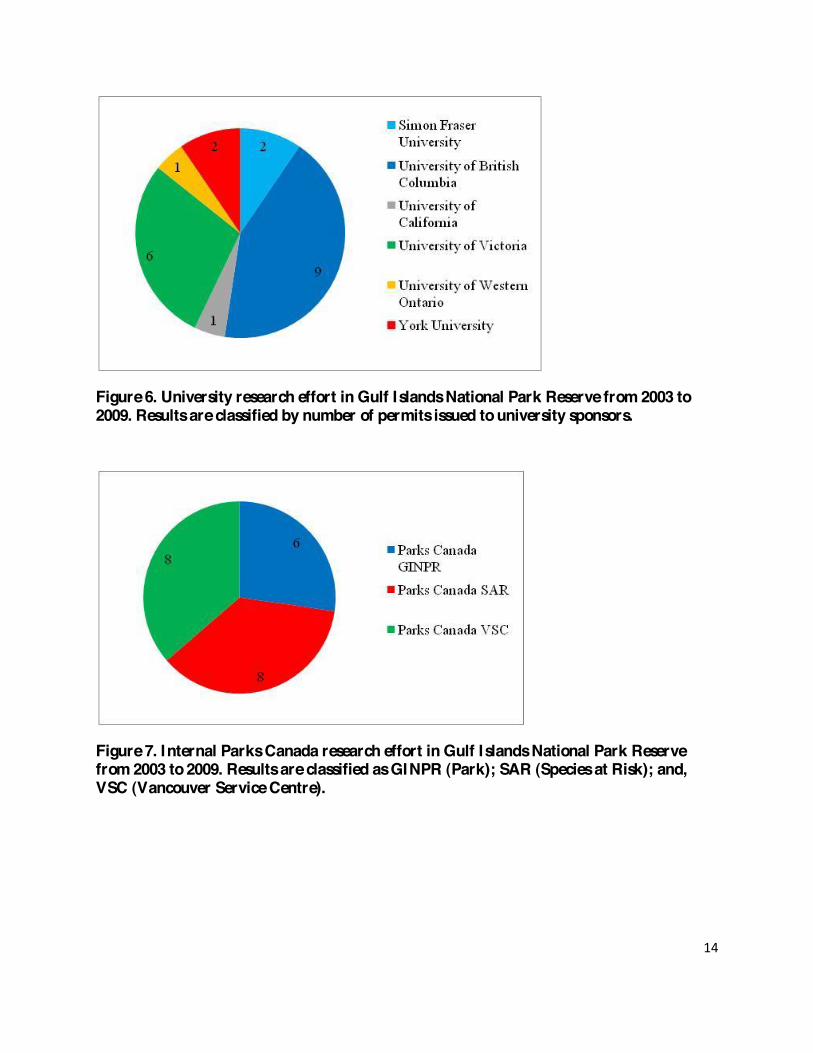
The two dominant sponsors facilitating research in the park so far have been Parks Canada with 23 studies and University sponsors with 21 studies. University-sponsored research is lead by the University of British Columbia with 9 studies so far, followed by the University of Victoria with 6 studies. Universities involved in research within the Park demonstrate the attraction of local protected areas for facilitating research. Permits issued to other governmental organizations and non-governmental organizations are fewer. This is often due to funding issues and lack of resources. There appear to be three-year trends seen for Parks Canada (2003-2005 and 2007-2009). These likely represent three-year permits issued specifically for social science and natural science studies (These permits must be renewed on a three year basis). It is important to note that permit holders operating under three-year permits are required to submit interim reports updating Park staff on research activities, as well as any new trajectories their studies may have taken. Where the research program shifts beyond the scope of a permit, a new application or amendment is required. Declines in research effort in a given year most likely reflect a reduction in park resources available to support research programs. For example, many university researchers prefer to work within the national park system and typically rely on Parks Canada for technical and logistical support. Without dedicated human resources, funds in place, and a mechanism to access these funds in a timely way, it is difficult to provide committed support to access researchers and, therefore, difficult to build long term relationships or long term programs.
!
10!
!
Recommendations Listed below are recommended strategies and general ideas for the future management of the Research Permit Registry Program and Research Compendium Report.
Develop and implement a management strategy
Have one staff member manage incoming permit proposals and renewals
Update database and report annually
2. Update research priorities for the Park
Managers and Park ecologist to review and revise existing priorities and to take into account future struggles (eg. Climate change)
3. Make template document mandatory for researchers to fill out when agreeing to terms of research permit
This will reduce internal Park tasks and increase efficiency and accuracy of information made available to the public

11!
!
Figure 1. Gulf Islands National Park Reserve lands and core area of interest.

12!
!
!
Figure 2. Research effort in Gulf Islands National Park Reserve from 2003 to 2009. Results are classified by year(s) permit was active.
!
!
Figure 3. Research effort in Gulf Islands National Park Reserve from 2003 to 2009. Results are classified by year permit was issued.
!
!

13!
!
!
!
!
Figure 4. Research effort in Gulf Islands National Park Reserve from 2003 to 2009. Results are classified by research discipline.
!
Figure 5. Research effort in Gulf Islands National Park Reserve from 2003 to 2009. Results are classified by major sponsors.
!
0123456789
10
2003 2004 2005 2006 2007 2008 2009
Perm
its Is
sued
Year
ArchaeologyNatural ScienceSocial Science
14!
!
!
Figure 6. University research effort in Gulf Islands National Park Reserve from 2003 to 2009. Results are classified by number of permits issued to university sponsors.
!
Figure 7. Internal Parks Canada research effort in Gulf Islands National Park Reserve from 2003 to 2009. Results are classified as GINPR (Park); SAR (Species at Risk); and, VSC (Vancouver Service Centre).
!
!
15!
!
Research Templates The following research templates are designed as summary reviews of each research project. Each project is presented in a consistent layout although, the level of detail is limited by the information at hand when this report was created. The templates are categorized by the year of project initiation. Some projects are multi-year and present several years of results while other projects may be a short term initiative. More recent projects are often not far enough along to present results so these templates are less detailed. To facilitate searches by principle researcher an alphabetical index is provided in the appendix with linkages to the templates through the project number. !
!
!
!
!
!
!
!
!
!
!
!
!
!
!
!
!
!
!
16!
!
!
2003 Studies !
Project Name: Herbivory and Native Plant Diversity in Coastal Bluff Garry Oak Ecosystems in the Gulf Islands
Project #: 2003-01
Discipline: Natural Science
Principle Investigator(s): Emily Gonzales (Ph.D. Candidate); Dr. Peter Arcese (Graduate Supervisor)
Sponsor: University of British Columbia
Duration: Multi-Year (2003-2005)
Location: Anniversary Islet, Brackman Island, Channel Island and nearby Islets, East Point, Isle-de-�4>��>7,9/���0:=20>:9��>7,9/���>,-077,��>70?>��#0,D��>7,9/��&99,80/��>70?�90,=��J�=.D�- G�494��J�=.DH���:.6��>70?>�,9/�?30��4??70��=:@;���%@8-:��>7,9/���,--,20��>7,9/��$,77as Rocks, �J�=.D��>7,9/��":=?7,9/��>7,9/��"077:B��>70?>���=-@?@>��>7,9/�,9/��8=40��>70? Permit #: 2003-00; 2004-01; 2005-01
Project Completed: Yes
Data Received: Yes
Final Report Received: Yes
Abstract/Overview:
We describe a system in which a group of invading plant species that has no native analogue achieves dominance by avoiding consumption by a native, generalist herbivore. To do so, we used multivariate models in an information theoretic context to compare the prevalence of plant groups and focal species to island size and isolation, human population density, the duration of European settlement, and soil depth estimated from 340 plots on 40 island sites with different densities of deer. Islands served as natural experimental units in a measurative study of abundance patterns in seven plant groups and 15 focal species along gradients of herbivory, biogeography, soil depth, and human activities. Increasing ungulate densities were related to declines in abundances of native forbs, and increasing abundances of non-native annual grasses. (Note: these regional patterns were upheld by two plot-based, 2x2 factorial experiments that contrasted the fitness of native species under manipulations of herbivory and competition for light. These experiments were conducted on Salt Spring Island, not in GINPR.)
Forage selectivity indices were then used to rank deer feeding preferences for different plant species and groups. Non-native annual grasses were avoided as forage by black-tailed deer. In

17!
!
contrast, native perennial forbs, the dominant native plant group, were selected as forage and declined in abundance with increased herbivory.
Key Findings/Conclusions:
Our results suggest that herbivory confers an advantage to non-native annual grasses relative to native perennial forbs. Non-native annual grasses lack phylogenetic equivalents in the native species pool, and thrive, which is consistent with the Limiting Similarity Theory of invasibility. Non-native perennial grasses have phylogenetic equivalents and are selectively browsed by herbivores; however, they tolerate defoliation, as their abundance was not related to herbivore density. We suggest that the conservation and restoration of endangered island Garry oak ecosystems should emphasize the reduction of herbivory and removal of non-native grasses.
Recommendations/Management Plan:
Our results suggest that restoring invaded Garry oak meadows may require reducing herbivore density to increase the growth, reproduction and survival of some native plant species. Many Garry oak meadows have been subject to high herbivory for at least 50 years (MacDougall 2008) and, compared to sites with low or no historic herbivory (e.g., Gonzales and Arcese 2008), it appears that many palatable native species have become rare or extirpated or adjusted to herbivory by foregoing sexual reproduction. Our related results further demonstrate that deer prefer to forage on native forbs over most annual and perennial grasses common in invaded oak meadows (Gonzales and Arcese 2008). Because the current dominance of non-native grasses in 8,9D�>4?0>�8,D�.:910=�,�IB0423?0/�7:??0=DJ�,/A,9?,20�A4,�;=:;,2@70�;=0>>@=0���,A:=07�,9/�Lebreton 1992), the removal of non-native species and augmentation of native species may also hasten overall restoration goals. Related Publications/Published Reports:
Gonzales, E. K. and P. Arcese 2008. Herbivory more limiting than competition on early and established native plants in an invaded meadow. Ecology 89(12), 3282)3289.
The dominance of non-native plants coupled with declines of native plants suggests competitive displacement drive extinctions, yet empirical examples are rare. Consumers may act on mature, reproductive life stages whereas some of the strongest competitive effects might occur at early life stages that are difficult to observe. For example, shading by non-native grasses could interfere with germination and establishment of native seeds. We contrasted the effects of ungulate herbivory and shading by neighbouring plants on the performance of native plants at early and established life stages in oak meadows. We transplanted four native species as established plants, six species from seed, and observed five extant lily species, all subject to 2x2 factorial experiments to manipulate herbivory and shading. Species-specific measures included germination, establishment, growth, reproduction and survival. Herbivory reduced the performance of nearly all focal native species at both early and established life stages, whereas shading had few measurable effects. Our results suggest that herbivory has a greater local influence on native plant species than shading and that reducing herbivore impacts will be

18!
!
required to successfully restore and conserve endangered oak meadows where ungulates are now abundant. Gonzales, E. K. and D. R. Clements. 2009. Plant community biomass shifts in response to mowing and fencing in invaded oak meadows with non-native grasses and abundant ungulates. Restoration Ecology.
Many herbaceous meadows are dominated by competitive non-native grasses and subject to ungulate herbivory, ecological processes that shift the proportional biomass of plant groups in the community. Predicting the outcome of restoration is complicated because herbivory and competition can interact. We examined the relationship between herbivory by native black-tailed deer and domestic sheep and dominance of non-native grasses in Garry oak meadows, one of :=?3��80=4.,J>�8:>?�09/,920=0/�3,-4?,?�?D;0>�����-year factorial experiment tested the effects of mowing and fencing on plant community biomass, categorized into eight groups by geographic origin (native/nonnative), growth form (annual/perennial), and plant type (forb/grass). To test if the rarity of native plant groups was related to herbivory, we estimated ungulate foraging preferences for each plant group. Mowing and fencing treatments interacted for annual and perennial non-native grasses. Dominance was shifted from non-native to native grasses only when both mowing and fencing were applied. Fencing increased the total biomass, whereas mowing had no overall effect; however, fencing alone did not affect any individual plant group. Mowing shifted dominance from grasses to forbs, although both native and non-native forbs benefited from the increased light availability. We also noted that herbivore fecal pellet densities were greatest in the spring, which coincided with the peak season of their preferred plant group, native perennial forbs. Overall, applying both mowing and fencing was the most effective restoration treatment to increase native plant groups and biomass. Gonzales, E.K. 2008. The effects of herbivory, competition, and disturbance on island meadows. PhD Thesis. University of British Columbia. It is an unresolved paradox that non-native species are successful in novel environments whereas native species, presumably adapted to that environment, decline. This knowledge gap has persisted because third party processes in invasion ecology have been overlooked. Ungulate densities are increasing due to the eradication of predators and landscape change and I asked how herbivory and invasion might interact to cause declines of native species. In Garry oak 80,/:B>���,9,/,J>�8:>?�09/,920=0/�0.:>D>?08��9,?4A0�1:=->�3,A0�/0.7490/�=07,?4A0�?:�9:9-native grasses and I tested the facilitatory role of herbivory in that degradation. My investigations, novel to the field, were conducted on islands spanning the Canada-US border. Islands served as natural experimental units in a mensurative study of abundance patterns in seven plant groups and 15 focal species along gradients of herbivory, biogeography, soil depth, and human activities. Increasing ungulate densities were related to declines in abundances of native forbs, and increasing abundances of non-native annual grasses. These regional patterns were upheld by two plot-based, 2x2 factorial experiments that contrasted the fitness of native species under manipulations of herbivory and competition for light. Specifically, I showed that ungulates limited the establishment, growth, survival and reproduction of seedlings and transplanted native forbs and shrubs and that competition from non-native species had little effect. I also calculated forage selectivity indices and tested the efficacy of fencing and cutting to reduce competition, for the restoration of native community biomass. Non-native annual grasses

19!
!
were rarely browsed and increased with increasing ungulate density. Non-native perennial grasses declined with herbivory, however, their regional abundances were unaffected by ungulate density despite being preferentially foraged. That non-native annual and perennial grasses differed in their responses to herbivory has consequences for restoration and illustrates the challenge of developing a comprehensive theory of invasion. Reducing ungulates, necessary for the recovery of native forbs, also benefits non-native perennial grasses and therefore their removal speed recovery of Garry oak meadows. Despite advances in invasion ecology, scientists and managers are disconnected and research is rarely implemented. I conclude by proposing seven solutions to facilitate the integration of science into management.

20!
!
Project Name: Impacts of Climate Change and Fire on the Ecological Integrity of Garry Oak Ecosystems: An Active Management Approach for Parks Canada
Permit #: 2003-02 Discipline: Natural Science
Principle Investigator(s): Marlow Pellatt
Sponsor: Parks Canada Vancouver Service Centre
Duration: Multi-Year
Location: Anniversary Islet, Georgeson Island, Brackman Island, Beaumont Marine Park, Mt. Maxwell Ecological Reserve, Brown Ridge, Tumbo Island and Cowichan Garry oak Preserve Permit #: 2003-01
Project Completed: Yes
Data Received: Yes
Final Report Received: Yes
Abstract/Overview:
Garry oak (Quercus garryana) ecosystems exist within a highly fragmented landscape where urban development, roads, agricultural practices, and other forms of habitat loss have occurred. Former disturbance mechanisms such as fire and tilling of the soil by aboriginal people have ceased to be active ecosystem processes and likely impaired ecosystem function and structure. The result of habitat degradation and agricultural practices (farming and grazing) has seen a decline in native species and increases in exotic species that can be significant competitors with "at-risk" flora and fauna. Previous work partially funded by the Interdepartmental Recovery Fund has shown the need for disturbance in maintaining Garry oak ecosystems as well as potential climate change impacts. The purpose of this project is to translate research into practice as we intend to reintroduce past disturbance mechanisms following detailed application prescriptions, as well as place exclosures at various sites to evaluate the impacts from grazing. In order to effectively restore Garry oak ecosystems we must understand the processes that allow them to exist and persist. Only by examining the efficacy of re-establishing both ecological and anthropogenic processes, though the process of ethnoecological restoration, can we work toward creating resilient ecosystems that can withstand present stressors as well as future impacts such as climate change. Key Findings/Conclusions:
The results present two contrasting insights into the dynamics of Garry oak ecosystems on Southern Vancouver Island. All of the sites are undergoing a transition from oak-dominated

21!
!
ecosystems to closed forest ecosystems; however, the role of fire and fire exclusion in driving this process seems complex and is likely modulated by local factors and site history.
Recommendations/Management Plan:
In order to manage the park (including active management) understanding of climate change, fire history, and baseline ecosystems are essential. All of the sites sampled in this analysis require active management if healthy Garry oak communities are to be maintained or restored. Mechanical removal of young conifers would probably be sufficient as an interim measure to protect existing overstory individuals. However, given that Garry oak recruitment is virtually non-existent at the sites, ultimately it will be necessary to restore some level of ecosystem processes if Garry oak is to survive at these locations. The process most likely to make a difference in this respect is fire, although if used carelessly it can also provide a vector for invasion by exotic weeds (Agee 1996).
Related Publications/Published Reports:
Gedalof, Z., Pellat, M. and Smith, D. J. 2006. From Prairie to Forest: Three Centuries of Environmental Change at Rocky Point, Vancouver Island, British Columbia. Northwest Science 80(1), 34-46.
Pellatt, M. G., Gedolof, Z., McCoy, M., Bodtker, K., Cannon, A., Smith, S., Beckwith, B., Mathewes, R., and Smith, D. Fire History and Ecology of Garry Oak and Associated Ecosystems in British Columbia: Final Report for the Interdepartmental Recovery Fund Project 733.

22!
!
Project Name: Amphibian and Reptile Surveys in Riparian and Wetland Habitats in the Gulf Islands National Park Reserve
Project #: 2003-03
Discipline: Natural Science
Principle Investigator(s): Kristiina Ovaska; Lennart Sopuck; Christian Engelstoft
Sponsor: Parks Canada Species At Risk
Duration: April and June 2004; Visual encounter surveys took place on 23 and 30/04/2004; trapping surveys took place on 8-9 and 15-16/06/2004
Location: Roe Lake (North Pender), Greenburn Lake (South Pender) and Lyall Creek/McLean Lake (Saturna)
Permit #: 2003-02; 2004-02
Project Completed: Yes
Data Received: Yes
Final Report Received: Yes
Abstract/Overview:
The Gulf Islands National Park Reserve contains riparian and wetland habitats suitable for several species of amphibians and reptiles but has never been surveyed specifically for these groups. Knowledge of their distributions and important habitats provides essential information for the management of these special areas and contributes to a database of biological resources of ?30�",=6��(0�.,==40/�:@?�=0.:99,4>>,9.0��;=0>09.0�G9:?�/0?0.?0/H��70A07�>@=A0D>�1:=�,8;34-4,9>�and reptiles at three larger riparian/wetland areas within the Park in the spring and early summer of 2004: Roe Lake on North Pender, Greenburn Lake on South Pender, and Lyall Creek/McLean Lake on Saturna. The surveys were designed to compliment other biodiversity surveys that are in progress within the Park (for the endangered Sharp-tailed Snake, Contia tenuis, and for rare species of terrestrial gastropods).
Key Findings/Conclusions:
During surveys of the wetland and riparian areas at the three sites in 2004, we located five species of amphibians (four native species and the introduced Bullfrog) and three species of snakes. Observations during gastropod surveys conducted concurrently (in spring 2004) in nearby terrestrial habitats produced no additional species. At Roe Lake, we detected three species of native amphibians, the Rough-skinned Newt, Red-legged Frog, and Pacific Treefrog, and the introduced Bullfrog. All three species of garter snakes present in British Columbia occur at this site, but only two were detected during the surveys. This property is of particular value for

23!
!
amphibians and reptiles because it consists of a relatively large, undisturbed area and encompasses both terrestrial forest habitat and a variety of aquatic habitats.
At Greenburn Lake, we detected two species of native amphibians, the Rough-skinned Newt and Red-legged Frog, and the introduced Bullfrog. We found all three species of garter snakes at this site. A rocky slope on the north shore of the lake provides excellent breeding and nursery habitat, and the lake and wet meadow provide foraging habitat. Potential habitat for the Sharp-tailed Snake is present on the rocky slope.
At McLean Lake, we found four species of amphibians, all native: the Rough-skinned Newt, Long-toed Salamander, Red-legged Frog, and Pacific Treefrog. This shallow lake with abundant emergent vegetation provides exceptional breeding habitat for amphibians and likely represents a source of recruits for a much wider area in the surrounding landscape.
Lyall Creek and its tributaries provide important foraging habitat and movement avenues, but we found no signs of breeding by amphibians in the creeks. The Red-legged Frog was particularly abundant in and along the main channel. Of reptiles, we detected only the Common Garter Snake, at Lyall Creek, but all three garter snakes may well be present.
The introduced Bullfrog was found at two sites: at Roe Lake and Greenburn Lake. These records represent the first documented records from Pender Islands.
Recommendations/Management Plan:
Recommended management measures for wetland habitats at the three sites consist of (1) prevention of the spread/control of Bullfrog populations, (2) maintaining natural hydrological patterns that facilitate the survival of native species of amphibians, and (3) enhancing/restoring habitat for native amphibians at the Greenburn Lake site.
Recommendations for habitat enhancement/restoration should focus on Greenburn Lake and its vicinity as this site is disturbed by human activities, and opportunities exist to substantially improve the habitat for native amphibians. At Roe Lake and McLean Lake efforts should focus on preserving existing, relatively unmodified habitats in their natural state. Both sites provide important breeding habitat for native amphibians and are among few such sites that are protected.
Related Publications/Published Reports:
Ovaska, K.; L. Sopuck and C Englestoft. 2004: Amphibian and Reptile Surveys in Riparian and Wetland Habitats in the Gulf Islands National Park Reserve. Unpublished manuscript submitted to Parks Canada, Gulf Islands National Park Reserve, Sidney BC.

24!
!
Project Name: Historic Structures Mapping
Project #: 2003-04
Discipline: Archaeology/History
Principle Investigator(s): Ian Sumpter
Sponsor: Parks Canada Vancouver Service Centre
Duration: Single-Year (29/09/2003 to 10/10/2003)
Location: Taylor Point and Williams property (Saturna Island), Hawaiian homestead (Russell �>7,9/����,B,44,9�3:80>?0,/��":=?7,9/��>7,9/���!??0=��,D�� :=?3�"09/0=��>7,9/����J�=.D��>7,9/��Sidney Spit, Sidney Island and Tumbo Island Permit #: 2003-03
Project Completed: Yes
Data Received:
Final Report Received:
Abstract/Overview:
Hypothesis: Early 20th century structures and surface features are threatened by natural decay and potential human disturbance. The survey and mapping of these historic sites will assist in mitigating the loss of structural, historic, and cultural information.
Key Findings/Conclusions:
Recommendations/Management Plan:
Related Publications/Published Reports:

25!
!
Project Name: Gulf Islands Structural Histories Project
Project #: 2003-05
Discipline: Archaeology/History
Principle Investigator(s): Richard Linzey; Lyle Dick
Sponsor: Parks Canada Vancouver Service Centre
Duration: Single-Year (16/10/2003 to 15/05/2003)
Location: #@>>077� �>7,9/��":=?7,9/��>7,9/���J�=.D� �>7,9/��$4/90D�$;4?��%,D7:=�":49?��(4774,8>�property (Saturna Island), Prevost Island and Roesland (Pender Island)
Permit #: 2003-04
Project Completed:
Data Received:
Final Report Received:
Abstract/Overview:
To record, photograph, document and interpret the above-ground structures of GINPR
Key Findings/Conclusions:
Recommendations/Management Plan:
Related Publications/Published Reports:

26!
!
Project Name: Survey of Terrestrial and Freshwater Arthropods in the Gulf Islands National Park Reserve
Project #: 2003-06
Discipline: Natural Science
Principle Investigator(s): Jennifer Heron
Sponsor: BC Ministry of Water, Land and Air Protection
Duration: 10-12/05/2004
Location: Saturna Island (Mt. Warburton Pike, Lyall Creek and Narvez Bay), Cabbage Island (West side) and Tumbo Island (Trailside, West point and East point)
Permit #: 2003-05; 2004-05
Project Completed: Yes
Data Received: Yes
Final Report Received: Yes
Abstract/Overview:
Terrestrial arthropod biodiversity surveys are almost non-existent and synoptic lists of arthropods are not complete for the Southern Gulf Islands of British Columbia. The goal of this project is to provide a synoptic list of arthropods within these islands. Over time (and other projects) additional arthropods will be added to this list. The objective of this survey is to sample a variety of habitat types on separate islands within the Gulf Islands National Park Reserve.
Various sampling methods were used to ensure target groups of arthropods were represented during this survey. A team of volunteer entomologists collected specimens/set up traps from May 10 F 12, 2004. Collection methods included dip netting, malaise traps, hand searching, Burlese funnel traps and pitfall traps. Further arthropod collections using pitfall traps were completed and trap contents were collected monthly from June through November, 2004. Pitfall trap collections were sorted, prepared and selectively identified. Specimens were sent to various taxonomic specialists for identification. The majority of specimens are deposited in the Royal British Columbia Museum. The aquatic specimens collected from May 10 F 12, 2004 are deposited at the University of British Columbia Spencer Entomological Museum. Owing to taxonomic uncertainty and lack of available experts, identification of all collected specimens was not possible. Key Findings/Conclusions:
In total, 118 pitfall traps were collected over a five-month period. Some of these traps were destroyed, either by adverse weather conditions, wildlife or human caused reasons. Over 12,149 specimens were sorted (some specimens, e.g. Isopods and Collembola, were not fully tallied in

27!
!
pitfall traps). From these specimens, 2621 were pinned and placed in the Royal British Columbia Museum. An average of 13 families per pitfall trap sample was recorded and 23 specimens pinned from each pitfall trap sample. Recommendations/Management Plan:
Ultimately, unique species assemblages may require additional management and this baseline information will aid in decisions pertaining to restoration and conservation initiatives within the Gulf Islands National Park Reserve. Species of interest will be identified, including rare and endangered species and alien species. Future Research:
Further studies within these ecosystems should focus on specific arthropod groups, with links to specific habitat features such as rock formations, water bodies, ponds, or ecosystem type. Studies that focus on these features allow for a greater insight into the relationships arthropods have with specific ecosystem types and the ability to protect these features is more effective than a species by species approach.
Invertebrate groups recommended for future study include: gastropods, earthworms, butterflies, grasshoppers, crickets, ladybird beetles, dragonflies, longhorn beetles, mosquitoes, blackflies, moths and carabids. The priority for these groups is driven by links to the general status work plan to place a conservation status rank on these species groups within the next five years. This plan is dynamic and changing and this does not lessen the value of additional arthropod groups and the importance to native ecosystems. Related Publications/Published Reports:
Heron, J. 2007. Survey of Terrestrial and Freshwater Arthopods in the Gulf Islands National Park Reserve: Saturna, Cabbage and Tumbo Islands. Final Report March 2007. BC Ministry of Environment, Wildlife Science Section, Ecosystems Branch.

28!
!
Project Name: Light-trapping for Sand-verbena Moth (Copablepharon fuscum) and other moth species on Sidney Spit
Permit #: 2003-07
Discipline: Natural Science
Principle Investigator(s): Nick Page
Sponsor: Parks Canada Species At Risk
Duration: Single-Year (2004) Location: Sidney Spit Permit #: 2003-06; 2004-06; 2006-N001 Project Completed: Yes
Data Received: Yes
Final Report Received: Yes
Abstract/Overview:
Hypothesis: Sand-verbena Moth appears to require large parches (>500 square metres) of yellow sand-verbena for population stability. Previous moth trapping at Sidney Spit has failed to capture Sand-verbena Moth which may be related to the limited amount or patchiness of yellow sand-verbena at the site.
Sand-A0=-09,��:?3�B,>�/0>429,?0/�,>�G�92,920=0/H�-D��!$�(���49� :A08-0=�����:97D�eight populations have been found globally, three of which are in Canada. Yellow sand-verbena is consid0=0/�=024:9,77D�=,=0�,9/�4>�/0>429,?0/�,>�$���G'@790=,-70H��-D�?30�����:9>0=A,?4:9�Data Centre. Populations of both species are believed to be declining in response to vegetation changes in sand dunes and spits in the last 100 years. It is unknown if Sand-verbena Moth has been extirpated from any sites in Canada. The purpose of the research project is to determine the presence or absence of Sand-verbena Moth on two spots on Sidney Island in GINPR. The study will assist recovery planning for Sand-verbena Moth as well as provide new information on the distribution of moths in GINPR. This will assist conservation planning and monitoring, and will also provide information for environmental education.
Moth sampling will be completed using one or two battery-operated modified Robsinson light traps. Sampling will be undertaken for one or two nights between May 15 and July 31, 2004. The trap will be placed within 5 m of a patch of yellow sand-verbena. The trap consists of a 5 gallon bucket with an upright baffle encircling a UV florescent tube. The trap is installed around dusk and retrieved the following morning. No permanent markers of site location will be used and no damage to vegetation will occur. Access to the sampling site will be by foot.

29!
!
The project tasks will assist in understanding the ecological linkages between the Sand-verbena �:?3��4?J>�3:>?�;7,9?��,9/�09A4=:9809?,7�.:9/4?4:9>�?3,?�>@;;:=?�-:?3�>;0.40>��"=074849,=D�,4=�photo assessment of vegetation change indicates the loss of open dune habitats is progressive and likely accelerating in the Georgia Basin. However, methods to reverse these trends have not been tested and it is unclear if sand dunes stabilized by grasses and nitrogen-fixing Scotch broom can be restored to their former condition.
Key Findings/Conclusions:
1. Sand-verbena Moth (Copablepharon fuscum) was not captured on Sidney Spit. This supports previous sampling results and I believe we can be confident that a population does not exist on Sidney Island. I observed less yellow sand-verbena (Abronia latifolia) on Sidney Spit in 2004 than in 2002 or 2003. The spit appears to have narrowed during the winter of 2003/2004 and reduced habitat for yellow sand-verbena.
2. The finding of Trichoclea edwardsii is interesting and of potential conservation significance. This species has only been recorded at three sites in coastal BC. I am currently assessing this species as part of COSEWIC status report. It is only found on sandy coastal beaches or dunes but its host plant is not known. Recommendations/Management Plan:
Related Publications/Published Reports:
Page, N. A. 2003. Status Report on Copablepharon fuscum (Noctuid moth). Draft report for Committee on the Status of Endangered Wildlife in Canada (COSEWIC), Invertebrate Task Group. Page, N. A. 2001. Ammophila breviligulata (Poaceae) New to British Columbia. Botanical Electronic News (BEN) No. 276 (November 15, 2001).

30!
!
Project Name: Monitoring Environmental Impacts of Recreational Boat Anchoring on Eelgrass (Zostera marina L.) and Benthic Invertebrates Project #: 2003-08
Discipline: Natural Science
Principle Investigator(s): Kate Leatherbarrow (M.Sc. candidate); Dr. Phil Dearden and Dr. Cliff Robinson (Graduate Supervisors)
Sponsor: University of Victoria, Marine Protected Areas Research Group (Department of Geography)
Duration: Multi-Year: Initial transects were recorded at each site in May 2004; saved GPS tracks were repeated in September 2004, with the intention of comparing the spatial data from before (May) and after (September) the main boating season.
Location: Sidney Spit and Tumbo Island
Permit #: 2003-09; 2004-09
Project Completed: Yes
Data Received: Yes
Final Report Received: Yes
Abstract/Overview:
The goal of this study was to characterize the ecology and recreational boating activity at two popular anchoring sites located in the waters of the Gulf Islands National Park Reserve of Canada (Sidney Spit and Tumbo Island). The three components of the study were to characterize the distribution of eelgrass (Zostera marina L.), build an inventory of anchoring/mooring activity, and characterize the benthic infauna at each site. These observations were used to evaluate the impact of anchoring on the eelgrass and invertebrate communities. No visible loss of eelgrass was documented, but the results at one of the two sites support the hypothesis that benthic communities in high anchoring intensity areas are in poorer health than those in low anchoring intensity or mooring areas, a characteristic of communities residing in disturbed and fragmented eelgrass beds. Recommendations for site management and long-term monitoring are proposed based on these results.
Key Findings/Conclusions:
The results of this study support the hypothesis that benthic communities in high anchoring intensity areas are in poorer health than those in low anchoring intensity or mooring areas at Tumbo Island but not at Sidney Spit. This likely stems from the differences in use at each site F although higher overall anchoring usage was observed at Sidney Spit, larger boats were observed
31!
!
at Tumbo Island. Therefore, the greater physical impact of larger anchors and stronger forces exerted by heavier boats on the benthos could account for the stronger correlation between anchoring intensity and community health at Tumbo Island.
Overall, Tumbo Island communities were generally healthier than Sidney Spit at all anchoring intensities, and Sidney Spit communities were most strongly correlated with environmental factors rather than anchoring intensity. The results of the Sidney Spit site are likely confounded by the high overall human usage in this area, in contrast to Tumbo Island, where the main human activity is boat anchoring.
Recommendations/Management Plans:
Although the results of this study were not conclusive, there is a growing body of literature supporting the negative impacts of recreational boat anchoring on seagrass meadows. If a precautionary approach were to be taken in GINPR, there are several management opportunities for the park to decrease the amount of anchoring in eelgrass beds. They include the following: 1) alleviate concerns regarding mooring buoy use by addressing mooring buoy safety and user fee issues; 2) encourage boaters not to set anchor if there are still available mooring buoys; 3) educate boaters on the ecological and safety hazards of anchorage inside eelgrass beds through shore signage; 4) inform boaters that if anchoring inside an eelgrass bed is necessary, traditional G ,ADH�G),.3?>8,9H�?D;0�,9.3:=>�,=0�70,>?�/,8,2492�?:�>0,2=,>>0>�� ��.70,=7D�4dentify the perimeter of eelgrass beds at each site with buoys and encourage boaters to anchor outside these margins, through signage on shore and on the buoys; and, 6) target anchorage sites frequented by larger boats since they cause greater disturbance. Related Publications/Published Reports:
Leatherbarrow, K. 2003. Monitoring Environmental Impacts of Recreational Boat Anchoring on Eelgrass (Zostera marina L.) and Benthic Invertebrates in the Gulf Islands National Park Reserve of Canada. A Thesis Submitted in Partial Fulfillment of the Requirements for the Degree of Master of Science, Department of Geography, University of Calgary. Leatherbarrow, K. Management of recreational boat anchoring in the Southern Strait of Georgia: Effects of physical disturbance on benthic infauna. Fisheries and Marine Ecosystems: Integrating Science and Management. Crescent Beach, British Columbia, Canada (April 30-May 2, 2004).

32!
!
Project Name: Sharp-Tailed Snake Surveys
Project #: 2003-09
Discipline: Natural Science
Principle Investigator(s): Christian Engelstoft
Sponsor: Parks Canada Species At Risk; Department of National Defence
Duration: Multi-Year (2003-2009)
Location: $,?@=9,�� :=?3� "09/0=�� $:@?3� "09/0=�� %@8-:�� ":=?7,9/�� #@>>077���,D90�� �J�=.D��Rum, and Sidney Islands, Mount Work Regional Park and Gowlland Todd Provincial Park
Permit #: 2003-12; 2004-12; 2005-06; 2008-1503
Project Completed: Yes
Data Received: Yes
Final Report Received: Yes
Abstract/Overview:
The endangered Sharp-tailed Snake (Contia tenuis) is known from only a few locations in Canada. Because of its cryptic behaviour, the Sharp-?,470/�$9,60J>�;=0>09.0�4>�/4114.@7?�?:�confirm and unknown populations are suspected to exist. Consequently, two of the Sharp-tailed $9,60�#0.:A0=D�%0,8J>�:-50.?4A0>�,=0�?:��1) identify potential habitat in an attempt to find new ;:;@7,?4:9>��,9/����49.=0,>0�?30�@9/0=>?,9/492�:1�?30�>;0.40>J�;:;@7,?4:9�0.:7:2D�,9/�3,-4?,?�requirements. To meet these two objectives, this project identifies new potential habitat while continuing to monitor existing artificial cover-objects (ACO) installed in 2003 and 2004 on Prevost Island, Saturna Island, Roe Island, Mt. Norman and Greenburn Lake. Activity at all sites will focus on detection of the Sharp-tailed Snake. If new parcels of land are added to the park, we will conduct Sharp-tailed Snake habitat assessments on these, and if appropriate install ACOs. The use of ACOs is the most effective and least destructive way to find the snakes. Only the vegetation directly beneath the boards is affected, and we ensure that these boards are not situated on rare or endangered plant species.
Key Findings/Conclusions:
This project builds on previous inventory work, initiated by Parks Canada in GINPR in 2002 (Englestoft et al. 2002; Englestoft 2004). The initial project consisted of habitat assessment and time-constrained surveys of natural cover at numerous sites, usually one brief survey per site, within GINPR. Artificial cover-objects were installed on Prevost Island, Saturna Island, Roe Island, Mt. Norman, Greenburn Lake and Roe Lake. Sharp-tailed Snakes were observed at Greenburn Lake in 2007, 2008 and 2009.

33!
!
Recommendations/Management Plans:
The following management measures are recommended for sites where the Sharp-tailed Snake occurs:
- Restrict public access to sensitive habitats occupied by the Sharp-tailed Snake by ensuring adequate signage and using barriers, where needed
- On Parks Canada properties, route new trails away from Sharp-tailed Snake habitat and restrict visitor activity in known Sharp-tailed Snake habitats
- Control spread of the introduced European Wall Lizard; eradication may be possible at newly invaded sites
- On properties with records of the Sharp-tailed Snake or with high-quality habitat, conduct surveys and assessments before initiating any developments or activities that may disturb the habitat
� ����������������-tailed Snake Inventory and Population Monitoring on Federal Lands on Southern Vancouver Island and Gulf Islands, April 2008-�����������������
Recommendations for Further Studies:
1) Continue monitoring sites with potential habitat but where the snakes have not yet been found. Sites that are in proximity to known sites are the first priority, including Mount Norman and Roe Lake on Pender Islands. Sites with high-quality habitat on islands with no previous records of the species on Saturna and Prevost should also be examined.
2) Prepare a detailed habitat map for the Greenburn Lake property delineating features important for snakes such as rock outcrops and accumulations of coarse woody debris.
3) Continue population monitoring at Greenburn Lake using the existing set-up of ACOs to collect information on population structure and trends; expand set-ups as needed to delineate area of occupancy.
� ����� ����� ������-tailed Snake Inventory and Population Monitoring on Federal Lands on Southern Vancouver Island and Gulf Islands, April 2008-����������������
Related Publications/Published Reports:
Englestoft, Christian. 2004. Sharp-tailed Snake Habitat Assessment and Survey on Coast Guard, DND and Parks Canada properties in the Capital Region, BC. Unpublished manuscript prepared for Parks Canada. Englestoft, Christian and K. Ovaska. 2009. Sharp-tailed Snake Inventory and Population Monitoring on Federal Lands on Southern Vancouver Island and Gulf Islands, April 2008-March 2009. Unpublished manuscript prepared for Department of National Defense Contract No. 23145082008005.
34!
!
2004 Studies !
Project Name: Botanical Surveys: Common and rare species
Project #: 2004-01
Discipline: Natural Science
Principle Investigator(s): Brian Reader
Sponsor: Parks Canada Species At Risk
Duration: Multi-Year (2004-2005)
Location: Throughout the islands with a focus on islets: Dock, Reay, Sidney lagoon, Blunden, %@8-:�$,77,>�,9/��J�=.D
Permit #: 2004-03; 2005-09
Project Completed: Yes
Data Received: Yes
Final Report Received: No
Abstract/Overview:
As evidenced in islets in Juan de Fuca Strait, islets within Gulf Islands National Park Reserve serve as refugia of high biodiversity and provide undisturbed habitat for some plant species at risk. The objective of the rare plant survey on islets within Gulf Islands National Park Reserve is to identify occurrences of plant species at risk on these important refugia and prepare plant species lists for these sites.
Key areas proposed for study include isolated islets that have had little or no development and no known search for species at risk. Similar locations in the Juan de Fuca Strait and Strait of Georgia have inordinately high numbers of plant species at risk. The research project will allow Parks Canada to assess the risks of habitat degradation on specific sites with detected plant species at risk.
Islets will be surveyed for plants and species lists prepared for these sites. This will cover key emergence ?480>�1:=�;7,9?>�,?�=4>6�49��,==D�:,6�0.:>D>?08>����J>�70,/492�=,=0�;7,9?�-:?,94>?>�will again be invited (on an honorarium basis) to participate in the survey and prepare species lists for the sites. In 2003 we had participation from Dr. Hans Roemer (retired Botanist, BC Parks), Dr. Adolf Ceska (retired ecologist, BC Conservation Data Centre), Oluna Ceska (Botanist), Harvey Janszen (Gulf Islands botanist and Saturna Island resident), Pam Janszen (amateur botanist, mycologist and Saturna Island resident), Matt Fairbarns (Rare Plant Specialist, BC Conservation Data Centre), Emily Gonzales (UBC PhD Student), and Dr. Peter Arcese (UBC

35!
!
Centre for Applied Conservation Research and Gulf Islands resident). Species at risk occurrences will be documented using the BC Conservation Data Centre Field Survey Form.
Key Findings/Conclusions:
Recommendations/Management Plan:
Related Publications/Published Reports:

36!
!
Project Name: Marine Video and Sonar Surveys Field School
Project #: 2004-02
Discipline: Natural Science
Principle Investigator(s): Brian Bjornhold
Sponsor: University of Victoria
Duration: Single-Year (05/05/2004 to 07/05/2004)
Location: Portland Island and surrounding islets
Permit #: 2003-04; 2004-04
Project Completed: Yes
Data Received: No
Final Report Received: No
Abstract/Overview:
Undertake marine surveys with University of Victoria Field School Students in the vicinity of Portland Island and surrounding islets for the purposes of: collecting video imagery using a Remotely Operated Vehicle (ROV) to determine the patchiness of the substrates and to identify biota associated with various substrates and setting; side scan sonar readings to map the sediment types (sand, cobbles, boulders) and substrates (eg. bedrock) in the area; grab sampling to determine the nature of surficial sediments and biota.
Key Findings/Conclusions:
Recommendations/Management Plan:
Related Publications/Published Reports:
37!
!
Project Name: Predator effects on terrestrial vertebrate prey: an integrated approach to responses at multiple scales
Project #: 2004-03
Discipline: Natural Science
Principle Investigator(s): Dr. Liana Zanette; Dr. Michael Clinchy
Sponsor: University of Western Ontario
Duration: Multi-Year (2003-2008)
Location: The Pellows, Russell Island, Brackman Island and Portland Island (Arbutus Point, Royal Cove, Shell Beach, Tortoise Bay, the old Racetrack and the small bay across from the Pellows)
Permit #: 2004-07; 2005-04; 2008-1504
Project Completed: Ongoing
Data Received: Yes
Final Report Received: Yes (Annual)
Abstract/Overview:
Our overall objectives are to, quantify the full impact of predators on terrestrial vertebrate (bird and mammal) prey, and so aid in effective conservation planning. Whereas population ecologists have historically focused on the demographic consequences of predators consuming their prey, 0C;0=4809?,7�0A4/09.0�1=:8�>?@/40>�:9�49A0=?0-=,?0�,9/�,<@,?4.�>;0.40>�>@220>?>�I49?484/,?4:9J�by predators may be as or more important to prey demography than the direct killing predators do. Revi0B>�:1�?30�74?0=,?@=0�=0;0,?0/7D�;:49?�?:�,�I?0==0>?=4,7J�2,;�49�:@=�69:B70/20�=02,=/492�the demographic significance of fear (intimidation) since there have been very few experimental studies addressing the impact of fear itself on the population dynamics of birds and mammals. At present, the best evidence for the central role fear likely plays in the population dynamics of birds and mammals comes from work on islands, since a lack of fear in prey on islands is coming to be accepted as the only commonality that can explain the devastating effect the introduction of mammalian predators has had on so many species of island prey all around the globe.
We are currently pursuing two research objectives. One objective is to experimentally test the effects of intimidation vs. consumption on terrestrial vertebrate prey at multiple integrated scales. To achieve this we are studying the demography, behaviour and physiology of birds nesting on islands (Brackman and Russell) without introduced and invasive predators as compared to birds nesting on adjacent islands where these predators remain. This allows us to contrast sites (Brackman and Russell Islands) with neither intimidation nor consumption vs. sites (on adjacent islands) with both intimidation and consumption. We are experimentally preventing consumption of nests at the latter sites to look solely at intimidation by erecting predator-proof netting just over the nest site. Thus, some birds (with predator-proof netting) suffer no nest

38!
!
predation while being >@==:@9/0/�-D�I1=423?09492J�;=0/,?:=>��:?30=>�,=0�0C;:>0/�?:�-:?3�90>?�predation and frightening predators, while birds on Brackman and Russell Islands suffer neither nest predation nor are ever frightened by the presence of predators.
Our second objective involves exploiting the variation in predator abundance among the Gulf Islands to assess whether and how fear, physiology, growth and longevity vary with the presence and abundance of predators on islands. We are in the process of surveying all the Gulf Islands to establish the present distribution of every species of mammal, and will then use historical records and genotypic data to determine which have been extirpated and which have been introduced in recent decades. Detailed behavioural, physiological and demographic studies are being conducted on deer mice, an archetypal mammalian prey, because the large size of mice on these islands has long been hypothesized to be due to the paucity of predators. There may now be more medium-sized mammalian predators, or I80>:;=0/,?:=>J��>@.3�,>�=,..::9>��"=:.D:9�7:?:=��and weasels (Mustela erminea), on these islands, than there were 50-100 years ago, in part because these mesopredators were introduced on many previously predator-free islands, and because the predators that preyed on them, such as wolves (Canis lupus), cougars (Puma concolor) and black bears (Ursus americanus), have been extirpated from most of the Gulf Islands. Another component of this project involves addressing: these changes in the abundance o1�80>:;=0/,?:=>��B30?30=�80>:;=0/,?:=>�3,A0�-02@9�?:�I1:=20?J�,-:@?�?304=�;=0/,?:=>��,9/�B3,?�effect this has had on their behaviour, physiology, growth and longevity.
Key Findings/Conclusions:
Recommendations/Management Plan:
The research we are conducting in the Gulf Islands National Park Reserve addresses several park research priorities: 1) The impacts of introduced and invasive predators on native birds and mammals in the Park; 2) potential methods of introduced and invasive predator control; and 3) the identification of the past and present ranges, and enumeration, of mammalian predators and ;=0D��?3=:@23:@?�?30�",=6���%30>0�:-50.?4A0>�,=0�/4=0.?7D�=070A,9?�?:�",=6>��,9,/,J>�#0>0,=.3�Priorities for the Park, which include: basic surveys of the distribution and abundance of native and invasive animals; studies on the ecology and behaviour of hyper-abundant wildlife; the role of large carnivores on the islands (historic and present predator-prey dynamics); and long-term monitoring.
Related Publications/Published Reports:
Zanette, L., E. MacDougall-Shakleton, M. Clinchy, & J.N.M. Smith. 2005. Brown-headed cowbirds skew host offspring sex ratios. Ecology 86:815-820. Zanette, L., Haydon, D., Smith, J.N.M., Taitt, M.J. & Clinchy, M. 2007. Re-assessing the cowbird threat. Auk 124:210-223. Zanette, L., Clinchy, M. & Smith, J.N.M. 2006. Food and predators affect egg production in song sparrows. Ecology 87:2459)2467
39!
!
Zanette, L., Clinchy, M. & Smith, J.N.M. 2006. Combined food and predator effects on songbird nest survival and annual reproductive success: results from a bi-factorial experiment. Oecologia 147:632-640. Duncan-Rastogi, A., Zanette, L., & Clinchy, M. 2006. Food affects diurnal nest predation and adult anti-predator behaviour in song sparrows. Animal Behaviour 72:933-940.Zanette, L., Pagnucco, K., Zanette, L., Clinchy, M., and Leonard, M. L. 2008. Sheep in wolf's clothing: host nestling vocalizations resemble their cowbird competitors. Proc. R. Soc. B, 275:1061-1065. Clinchy, M. & Sung, H.-C. 2009. Food-$&""���� %� ��"�#� %$�#��&��$�%���#�$! $*�$! ��repertoire size. Proc. R. Soc. B, 276: 2855-2860.
40!
!
Project Name: Exotic Geese Facilitate Invasion by Exotic Grasses in the GINPR Project #: 2004-04
Discipline: Natural Science
Principle Investigator(s): Rebecca Best (M.Sc. Candidate); Dr. Peter Arcese (Graduate Supervisor)
Sponsor: University of British Columbia
Duration: Multi-Year (2005-2009)
Location: Dock North, Dock South, Dock West, Isabella East, Isabella West, and Reay Islet
Permit #: 2004-08; 2005-02
Project Completed: Yes
Data Received: Yes
Final Report Received: Yes
Abstract/Overview:
In the Gulf Islands of southwest British Columbia, endangered islet ecosystems are being invaded by both exotic Canada geese (Branta canadensis) and exotic annual grasses. I studied this co-invasion by exotic herbivores and exotic grasses to estimate the synergistic effects of novel inter- and intra-trophic interactions on the invasion success of the grasses. Geese fed selectively on the exotic grasses, causing them to produce a higher number of short stems. This appeared to be an efficient reproductive and competitive strategy, allowing the grasses to form dense lawns with reduced occurrence of native forbs not adapted to compete under grazing or with grass. The demographic success of the exotic grasses was thus a product of both novel grazing interactions with geese and novel competitive interactions with the native plant community. In combination, these interactions produced an unexpected outcome. Current theory suggests the grasses should be limited by a selective enemy, but my work shows that co-evolved grazer and grass strategies benefited exotic species at both trophic levels. Selective herbivory by geese also facilitated their dispersal of exotic grass seed between heavily invaded feeding areas and small islands used for nesting. In sum, selective herbivory by geese resulted in the spread and proliferation of their preferred food source. This unexpected case of positive feedback between invaders suggests two avenues for strengthening current theoretical frameworks. Robust hypotheses for predicting invasion success must account for multiple novel interactions, and for the degree of shared evolutionary context between multiple invaders. In the Gulf Islands, preventing herbivory by exotic geese may prevent the spread of exotic grasses to new sites, but may not be enough to restore native communities in areas already dominated by grasses.
41!
!
Key Findings/Conclusions:
Areas with intense goose grazing and/or other disturbance have fewer native perennial flower species and are dominated by exotic annual grasses. Results of greenhouse germination trials also indicate that geese are capable of dispersing the seeds of these grasses through ingestion and feces deposition. Over the four years of this study, exotic annual grasses continued to increase in plots exposed to grazing and decrease in plots protected from grazing, but native species did not show a corresponding increase in the absence of grazing. Without grazing, exotic annual grass litter accumulates and appears to limit the growth of most species. Recommendations/Management Plan:
This suggests that restoration from exotic annual grasses to native plant communities may require a combination of goose exclosures, removal of litter, and possibly addition of native seeds.
Related Publications/Published Reports:
Best, R. J. 2008. Exotic grasses and feces deposition by an exotic herbivore combine to reduce the relative abundance of native forbs. Oecologia,(158), 319-327. DOI 10.1007/s00442-008-1137-4. Best, R. J. & Arcese, P. 2009. Exotic herbivores directly facilitate the exotic grasses they graze: mechanisms for an unexpected positive feedback between invaders. Oecologia (159), 139-150.DOI 10.1007/s00442-008-1172-1.

42!
!
Project Name: Settlement and Land Use History of Gulf Islands National Park Reserve of Canada
Project #: 2004-05
Discipline: History/Archaeology
Principle Investigator(s): Denise Cook
Sponsor: Parks Canada GINPR
Duration: Multi-Year (2003 to 2004)
Location: $4/90D�$;4?���J�=.D� �>7,9/��#@>>077� �>7,9/��#:0>7,9/��"09/0=� �>7,9/���%,D7:=�":49?�and Williams property (Saturna Island), Tumbo Island, Prevost Island and Portland Island
Permit #: 2003-10; 2004-10
Project Completed: Yes
Data Received: No
Final Report Received: No
Abstract/Overview:
Hypotheses:
1. Post contact settlement and land use history of the southern Gulf Islands.
2. Detailed historical land use histories of the Parks Canada properties acquired for GINPR.
Carry out historical research as per the attached proposal and research Application.
Key Findings/Conclusions:
Recommendations/Management Plan:
Related Publications/Published Reports:

43!
!
Project Name: Monitoring the health of eelgrass (Zostera marina) beds in National Parks of the Pacific Bioregion Project #: 2004-06 Discipline: Natural Science
Principle Investigator(s): Cliff Robinson
Sponsor: Parks Canada Vancouver Service Center
Duration: Multi-Year (field sampling of eelgrass was conducted during August of 2004, 2005 and 2006)
Location: Eelgrass meadows adjacent to Tumbo Island, Sidney Island, Portland Island, Saturna Island, Prevost Island, and Mayne Island
Permit #: 2004-11; 2005-05
Project Completed: Ongoing
Data Received: Yes
Final Report Received: Yes
Abstract/Overview: (summarize from SGI DRAFT or other report)
Key Findings/Conclusions:
Healthy eelgrass communities are widely considered a useful sentinel of the condition of coastal ecosystems (Biber et al. 2005) and eelgrass consistently ranks highest among Pacific Northwest coastal ecosystems in terms of fish diversity and abundance (e.g., Murphy et al. 2000; Johnson et al 2003).
The anthropogenic disturbance scores calculated for SGI eelgrass indicate that the meadows are located in regions of high human use and activity. Consequently, we might expect a priori that these meadows would be worse off relative to regions with less human use (e.g., Gwaii Haanas).
Regional and local environmental properties were shown to vary markedly among years. August of 2004 was perhaps unusual with low Fraser River runoff, and higher salinities at Active Pass, and it also experienced significantly higher precipitation than the 30 year median. These environmental conditions translated into higher nitrate concentrations, cooler waters and higher salinities at eelgrass meadows in August 2004. Conditions observed in August of 2005 and 2006 were near longer-term observations.
The vast majority of eelgrass meadows in the GINPRC were found to lack intertidal components. This condition indicates that eelgrass meadows at one time experienced severe environmental conditions (e.g., heat stress) above the low tide mark. It is not known if the eelgrass beds have always lacked an intertidal zone, but speculative evidence from the San Juan Islands indicates

44!
!
that the meadows may have lost their intertidal components in 2002 and 2003 due to unprecedented sediment loading from the Fraser River.
Subtidal video surveys revealed that the SGI meadows are 1) thin and patchy, 2) have a moderate to high epiphyte load, and 3) occur over a wide depth range (1.3-5.6 m). The first two conditions are indicative of poor health (Deegan et al. (2002); Duffy 2006). No incidences of wasting disease were recorded (possibly because of the high epiphyte loading obscures the blades)
There were clear interannual difference in environmental conditions in the SGI, but this was not reflected in components of the fish assemblage (similarity, dominance or relatedness). In addition, it appears that spatial differences are more important than temporal differences. At this time, it is not clear as to what seascape factors are responsible for these differences. We speculate that the mosaic of habitats adjacent to a seagrass meadow is fundamental to the structure of a given fish assemblage. Further research is required.
Recommendations/Management Plan:
Given their importance and the fact that only about 20% of the known eelgrass meadows have been sampled in GINPRC (cf. Table 1), it is recommended that the inventory of eelgrass meadows within and outside the GINPRC continue. The methods used by the WNSC can be implemented with minimal resources. In addition, the GINPRC should support, where possible, local community mapping initiatives to document distribution and change in eelgrass meadows in and around Park boundaries.
Regional environmental data should be analyzed annually to monitor the status of the nearshore Strait of Georgia ocean environment. This is very low cost and easy to do.
Available air photos shot at low tide or other sources of information pre-2000 should be examined for evidence of intertidal eelgrass in the SGI and San Juan Islands.
It is recommended that subtidal assessments using underwater video be continued. The method provides an objective record of the state of eelgrass meadows and of their characteristics, offers a permanent record of the eelgrass meadows for future assessments of ecological integrity (EI), and allows for ground-truthing of aerial surveys.
Subtidal video surveys reveal that some eelgrass beds also experience high macroalgal loading. It might be worth considering removing algal biomass as an attempt to allow eelgrass to obtain enough light to grow. This kind of gardening has occurred, with some success, in Puget Sound.
Boaters frequently anchor within eelgrass beds. It is recommended that the park work towards shifting this anchoring activity away from the eelgrass. An educational approach similar to the Jefferson County Marine Resources Committee should be adopted
The absence of young-of-the year rockfishes (coppers and black/yellowtail), kelp greenlings and lingcod is a concern. Recreational fishers target adults of these species. It is not known however, what factors are responsible for the absence of juveniles (e.g., environmental, habitat quality, lack of adults). Experiments with artificial seagrass habitats may shed light onto some of the contending issues.

45!
!
The WNSC should continue to analyze eelgrass-environmental-fish data collected in 2004-2006, and evaluate the application of a multi metric fish index to understand eelgrass health in the Pacific bioregion.
Related Publications/Published Reports:
46!
!
2005 Studies !
Project Name: Lyall Creek and Tributaries Inventory and Restoration Project #: 2005-01 Discipline: Natural Science
Principle Investigator(s): Leila Sumi
Sponsor: Parks Canada GINPR
Duration: Single-Year (2005)
Location: Lyall Creek (Saturna Island)
Permit #: 2005-03
Project Completed: Yes
Data Received: Yes
Final Report Received: Yes
Abstract/Overview:
Lyall Creek is located on Saturna Island within the Gulf Islands National Park Reserve. The creek supports populations of Coho (Oncorhynchus kisutch), Chum (Oncorhynchus keta) and sea-run Cutthroat Trout (Oncorhynchus clarki). It is the only protected salmon-bearing watershed in the Southern Gulf Islands. The surrounding riparian forest bears lush vegetation and supports a multitude of organisms.
$49.0�?30���J>�?30=0�3,>�-009�,9�:->?=@.?4:9�?:�14>3�;,>>,20�,?�?30�.=:>>492�:1��,>?�":49?�#:,/�due to the placement of a culvert of insufficient size. This also resulted in a restriction to peak flows causing mass upstream flooding and sediment deposition. In 1990, the Lyall Creek Enhancement Society began a chum fry stocking program in partnership with DFO and has successfully re-established a population in Lyall Creek. Prior to acquisition by the Gulf Islands National Park Reserve, very little scientific knowledge and written information existed for the Lyall Creek watershed. Most existing information was in the form of local knowledge, obtained through personal communications with residents. This project attempts to collate existing information as a baseline for future work.
Since Park establishment, Parks Canada has partnered with existing stakeholders to undertake habitat restoration in the creek. Implementation of inventory, restoration and monitoring projects will identify areas of concern, improve the overall health of these sites and allow us to examine changes over time. In 2003 an engineering design was produced for the restoration works. Simultaneous to this a number of surveys were initiated to provide some baseline data. Works on
47!
!
the creek involved re-grading of the creek bed to its original elevation and replacement of the culvert with a large pre-cast concrete box culvert. In 2005 a detailed habitat inventory and mapping program was implemented for the creek and riparian areas including low water juvenile salmonid surveys. Groundwater monitoring wells were installed and restoration works included installation of in-stream complexing, re-grading of stream banks and re-vegetation of riparian areas. The initial results from restoration efforts appear successful. The information obtained from these baseline surveys and ongoing monitoring programs will assist the Park in the successful management of this watercourse.
This work has been completed in the context of collaboration and involvement with local stewardship groups and other government agencies. With a good basis of scientific data, we hope that Lyall Creek B477�-0�.:9>4/0=0/�,�G-09.38,=6H�1:=�=0;=0>09?492�30,7?3D�1=0>3B,?0=�>D>?08>�in the Southern Gulf Islands. Key Findings/Conclusions:
Efforts in salmon enhancement, inventory and restoration of habitats has improved the ecological integrity of Lyall Creek. These initiatives serve as a baseline for long term ecological condition and management effectiveness monitoring. Detailed stream habitat inventory identifies sites that may require further restoration. Through this inventory we are better equipped to assess the health and productive capacity of the watershed and quantitatively identify habitat. Restoration priorities and long-term monitoring goals will be established using the baseline data collected in this survey.
The restoration of Lyall Creek successfully removed elevational barriers to fish passage and enhanced overall habitat quality. Upstream channel modifications improved bank stability and habitat quality with the addition of in-stream complexing. Follow-up riparian planting of native tree and shrub species is now underway. It is anticipated that this effort will augment the natural recovery of native grasses, sedges, shrubs and trees. The incubation infrastructure (including the dam) has been removed. The salmon enhancement program has shifted from instream incubation to the direct release of salmon fry.
Parks Canada will continue to liaise with the Lyall Creek Stewardship Group, neighbouring landowners and island residents. Discussions to date suggest that future plans will focus on monitoring activities. There is a continued need to facilitate communications around Lyall Creek and other research programs on the Outer Gulf Islands and facilitate a better understanding of the PCA mandate and our common interests and concerns. Recommendations/Management Plan:
The following recommendations should be considered in future program planning for the Lyall Creek watershed.
1. Non-native invasive flora have been located along the creek and require removal. This should be done in a timely fashion to prevent further infestation or expansion.
2. Old roads and landings identified in the upper watershed may be affecting local hydrological regimes and may serve as an impediment to aquatic and riparian species. Further assessment is required to determine the feasibility of deactivation of these headwater impediments.

48!
!
3. PCA should continue to work to promote the creation of side channel habitat and associated wetlands.
4. $����/,?,�>3:@7/�-0�G.=:>>-B,760/H�?:�?30�&$�"�;=:2=,8�1:=�?30�;@=;:>0>�:1�8:/077492�habitat supply and quality throughout the basin.
5. Annual low water sampling for juvenile salmonid should be continued. 6. Herpetiles and gastropods should be given consideration as indicators for ecosystem health as
part of a long-term monitoring program. 7. Standardized surveys for adult salmon escapement are valuable for establishing chum salmon
returns and documenting adult Coho and Cutthroat trout returns. These should be considered for future monitoring.
8. Future monitoring should include benthic invertebrate surveys, water flow and water chemistry.
9. Parks Canada should continue to liaise with the Lyall Creek Stewardship Group, neighbouring landowners and island residents.
Related Publications/Published Reports:
Sumi, L. and T. Golumbia, 2006. Lyall Creek and Tributaries Inventory and Restoration Completion Report. Gulf Islands National Park Reserve, Parks Canada, 2220 Harbour Road, Sidney, BC V8L 2P6. 53p. © 2006 Parks Canada.

49!
!
Project Name: Population Genetics and Demography of Song Sparrows and Sea Blush (Plectritis congesta) in the Georgia Basin, BC.
Project #: 2005-02
Discipline: Natural Science
Principle Investigator(s): Peter Arcese
Sponsor: University of British Columbia
Duration: Multi-Year (2005-2006)
Location: Throughout the islands
Permit #: 2005-07; 2005-08; 2006-684
Project Completed: Ongoing
Data Received: Yes
Final Report Received: Yes
Abstract/Overview:
Theory suggests that the persistence of metapopulations will be influenced by the degree of synchrony in the dynamics of their component populations. Various studies have shown that climate can promote synchrony in the size of adjacent populations linked by dispersal, but few have examined the effects of climate on underlying demographic rates. We studied annual variation in the timing of breeding and reproductive rate in song sparrow (Melospiza melodia) populations on islands linked by dispersal to determine if biotic factors acting at local scales or climatic factors acting at a regional scale were more influential of variation in demography. The onset of egg-laying varied markedly among years, but was roughly synchronous across islands within years. Despite this synchrony, island populations varied markedly in reproductive rate, due mainly to spatial variation in nest depredation and brood parasitism. In general, populations further from Vancouver Island and with few resident predators experienced less nest depredation and brood parasitism, and higher reproductive rates, than populations closer to Vancouver Island. Our results show that even when climate acts regionally to synchronize reproductive timing in adjacent populations, its effects on reproductive rate may be over-ridden by biotic factors that vary among populations.
Key Findings/Conclusions:
Recommendations/Management Plan:

50!
!
Related Publications/Published Reports:
��%���� �����*�! !#����(������##����%�#��#��$��� &��$��������#����%�#( ���������#(��and Michael W. Bruford. Extra-Pair Fertilization and Effective Population Size in the Song Sparrow (Melospiza melodia) RH: Extra-Pair Mating and Population Estimates.

51!
!
Project Name: Saturna Island Air Quality Study Project #: 2005-03 Discipline: Natural Science - Atmospheric Chemistry
Principle Investigator(s): Robert McLaren
Sponsor: Centre for Atmospheric Chemistry, York University
Duration: Single Year
Location: Saturna Island and Tumbo Island
Permit #: 2005-13
Project Completed: Yes
Data Received: No
Final Report Received: Yes
Abstract/Overview:
Measurements of NO2, NO3, N2O5, O3, SO2 and HONO were made by Differential Optical Absorption Spectroscopy (DOAS), both active and passive (a.k.a. Max-DOAS), in the Straight of Georgia during a three week field study in the summer of 2005. The primary purpose of the study was to measure chemistry products (NO3, N2O5) in the Strait at night, and to look at the link between what happens in the Straight at night and air quality in the populated Lower Fraser Valley the next day. Equipment was set up at East Point on Saturna Island with our light beam traversing the ocean to a retro-reflector located on Tumbo Island in Gulf Islands National Park Reserve. We report our first findings from the study in a paper in the online journal, Atmospheric Chemistry and Physics. We expect one or two additional papers to follow, reporting on SO2 and HONO measurements, and the use of Max-DOAS for measurement of vertical distributions of pollutants.
We acknowledge our gracious hosts, Roy and Marie Barrow, lighthouse keepers on Saturna Island, who tolerated our presence on their property and provided office space for students during the study.
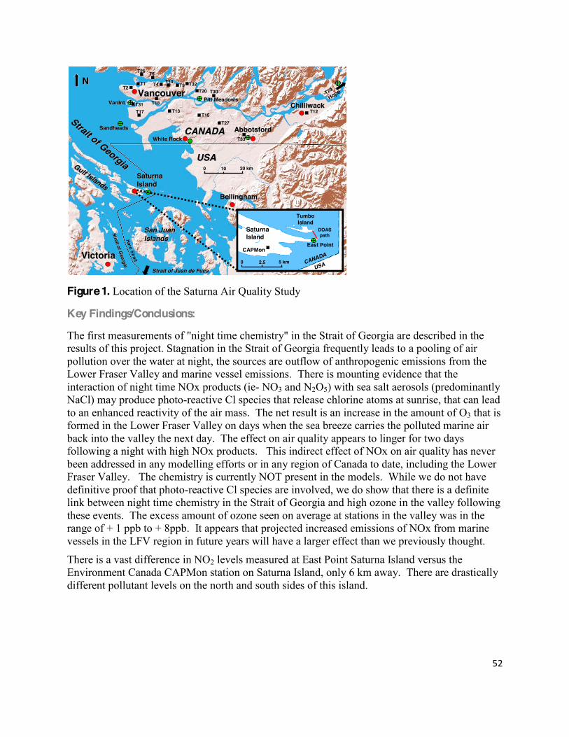
52!
!
Figure 1. Location of the Saturna Air Quality Study
Key Findings/Conclusions:
The first measurements of "night time chemistry" in the Strait of Georgia are described in the results of this project. Stagnation in the Strait of Georgia frequently leads to a pooling of air pollution over the water at night, the sources are outflow of anthropogenic emissions from the Lower Fraser Valley and marine vessel emissions. There is mounting evidence that the interaction of night time NOx products (ie- NO3 and N2O5) with sea salt aerosols (predominantly NaCl) may produce photo-reactive Cl species that release chlorine atoms at sunrise, that can lead to an enhanced reactivity of the air mass. The net result is an increase in the amount of O3 that is formed in the Lower Fraser Valley on days when the sea breeze carries the polluted marine air back into the valley the next day. The effect on air quality appears to linger for two days following a night with high NOx products. This indirect effect of NOx on air quality has never been addressed in any modelling efforts or in any region of Canada to date, including the Lower Fraser Valley. The chemistry is currently NOT present in the models. While we do not have definitive proof that photo-reactive Cl species are involved, we do show that there is a definite link between night time chemistry in the Strait of Georgia and high ozone in the valley following these events. The excess amount of ozone seen on average at stations in the valley was in the range of + 1 ppb to + 8ppb. It appears that projected increased emissions of NOx from marine vessels in the LFV region in future years will have a larger effect than we previously thought.
There is a vast difference in NO2 levels measured at East Point Saturna Island versus the Environment Canada CAPMon station on Saturna Island, only 6 km away. There are drastically different pollutant levels on the north and south sides of this island.
VancouverVancouver
VictoriaVictoria
CANADACANADA
USAUSA
SaturnaSaturnaIslandIsland
AbbotsfordAbbotsford
ChilliwackChilliwack
BellinghamBellingham
Strait of Georgia
Strait of Georgia
SaturnaIsland
TumboIsland
USACANADA
East PointCAPMon
DOASpath
T12
T33
T29
Hope
T17
T1 T9
T27
T13
NN
0 10 20 km
0 2.5 5 km
Gulf Islands
Gulf Islands
San Juan San Juan IslandsIslands
Strait of Juan de FucaStrait of Juan de Fuca
Strait of Georgia
Strait of Georgia
HaroHaro
StraitStrait
T31
T15
T32T14
T20 T30
T26 T6
T4T2
T18
White RockWhite Rock
SandheadsSandheads
VanIntVanInt Pitt MeadowsPitt Meadows

53!
!
Recommendations/Management Plan:
Future research is needed. First and foremost, we need measurements of the potential photo-reactive species in the area (Cl2 and ClNO2 ) and/or we need other evidence that Cl chemistry is indeed occurring in the valley (a detailed analysis of NMHC data sets may be able to achieve the latter). A larger survey of night time chemistry in and around the Strait of Georgia is needed, especially closer to the eastern side of the Strait, or in the middle of the Strait. We also need to look at the link between the nighttime chemistry and aerosols (PM2.5) in the valley. It is highly likely that if Cl chemistry is leading to higher ozone, it will be leading to higher PM2.5 levels as well. The question will be how much?
Related Publications/Published Reports:
Robert McLaren, Patryk Wojtal, Daniel Majonis, Joy McCourt, Jamie D. Halla, and Jeff Brook, NO3 radical measurements in a polluted marine environment: links to ozone formation, 2009 Atmos. Chem. Phys. Discuss., 9, 24531)24585, 2009
54!
!
Project Name: Intertidal Monitoring
Project #: 2005-04
Discipline: Natural Science
Principle Investigator(s): Patricia Haugh
Sponsor: Pender Islands Conservancy Association Duration: Multi -Year (2005 to Present)
Location: Roe Islet (Pender Island)
Permit #: 2005-14; 2008-1912
Project Completed: Ongoing
Data Received: Yes
Final Report Received: No
Abstract/Overview:
Key Findings/Conclusions:
Recommendations/Management Plan:
Related Publications/Published Reports: !

55!
!
Project Name: Archaeology Inventory: GINPR Archaeological Resource Management Program Project #: 2005-05 Discipline: Archaelogy/History
Principle Investigator(s): Daryl Fedje
Sponsor: Parks Canada Vancouver Service Center
Duration: Multi-Year (2005-2007)
Location: Pender Island, Portland Island, and Sidney Island
Permit #: 2005-14a; 2006-513; 2007-1090
Project Completed:
Data Received:
Final Report Received:
Abstract/Overview:
Key Findings/Conclusions:
Recommendations/Management Plan:
Related Publications/Published Reports:

56!
!
Project Name: 2005/2006 Patterns of Visitor Use, Survey of Users to the Gulf Islands National Park Reserve
Project #: 2005-06
Discipline: Social Science
Principle Investigator(s): Jennie Sparkes
Sponsor: Parks Canada - Western and Northern Canada Service Centre (Social Science Research Unit)
Duration: Multi-Year (2005-2006)
Location: Gulf Islands National Park Reserve
Permit #: 2006-00 (No permit issued)
Project Completed: Yes
Data Received: Yes
Final Report Received: Yes
Abstract/Overview:
The 2005 Patterns of Visitor Use survey of Gulf Islands visitors and residents was Phase I of a two-year study initiated by Parks Canada. The objective of the study was to establish baseline information for Gulf Islands National Park Reserve regarding the characteristics, expectations, levels of satisfaction and levels of knowledge of visitors to and residents of the Gulf Islands. Phase II of the study, conducted in 2006, focused specifically on how visitors use the national park reserve.
The 2005 study consisted of five separate questionnaires which surveyed people who influence (or are influenced by) the Gulf Islands within the vicinity of Gulf Islands National Park Reserve: 1) Terrestrial Visitors who travel to the southern Gulf Islands; 2) Marine Visitors who travel to the southern Gulf Islands; 3) Sidney Spit Visitors; 4) McDonald Campground Visitors; and, 5) Residents of Saturna, Mayne and North and South Pender Islands.
The 2006 study focused in on building understanding about the people who specifically visited the national park properties. Correlating the 2005 and 2006 data sets it is estimated that the park hosts approximately 23% (N=46,357 people) of the total visitors to Mayne, Saturna and the Pender Islands.
Key Findings/Conclusions:
As a subset of the larger population visiting the Gulf Islands it is not surprising that there are some similarities between Gulf Island visitors and GINPR visitors, such as:

57!
!
The average party size visiting GINPR properties was 2.9 people, compared to 2.9 (marine) to 3.6 (terrestrial) people visiting the Gulf Islands.
76% of respondents indicated they were repeat visitors to GINPR properties, compared to 70% (terrestrial) to 85% (marine) of parties being repeat visitors to the Gulf Islands.
The average number of consecutive days that respondents visited national park properties was 2.8 days, compared to 3 (marine) to 5.3 (terrestrial) days for Gulf Island visitors. 80% of GINPR visitors were Canadian, compared to 71% (marine) to 81% (terrestrial) of visitors to the Gulf Islands being Canadian.
Recommendations/Management Plan:
It is recommended that this research be repeated every 5 years to establish longitudinal trends in how visitors are using the park.
Related Publications/Published Reports:
Parks Canada. (2005). Gulf Islands National Park Reserve 2005 SUrvey of Visitors and Residents. Social Science Unit, Western and Northern Service Centre, Parks Canada, Sidney, BC. Parks Canada. (2006). Gulf Islands National Park Reserve 2006 Survey of Visitors. Social Science Unit, Western & Northern Service Centre, Parks Canada, Sidney, BC.

58!
!
2006 Studies !
Project Name: Parallel phylogeography of a lichenised fungus (Ramalina menzeisi) and its major carrier tree species Project #: 2006-01 Discipline: Natural Science
Principle Investigator(s): Silke Werth
Sponsor: University of California
Duration: Single-Year
Location: North Pender �>7,9/��#:0>7,9/�,9/��:=0??,J>�(::/���$:@?3�"09/0=��>7,9/���:@9?�Norman and Beaumont), Mayne Island (Bennet Bay), and Saturna Island (Narvaez Bay, Winter cove and Taylor Point)
Permit #: GWA-2006-573 (issued by Gwaii Haanas)
Project Completed: No
Data Received: No
Final Report Received: No
Abstract/Overview:
This study will also be the first research comparing the phylogeographic pattern of both a host plant and its epiphyte, which will demonstrate how closely their responses to glaciations events match. Another, important overall goal of this research is to identify areas of high genetic diversity for the lace lichen, areas that are also likely to have played a role as refugia in other species, and may thus be particularly relevant for the conservation of genetic diversity in lichens. Specifically, we will sample individuals of the lace lichen in propsed refugial sites that were not affected by the last glaciation and sites that were glaciated during the Pleistocene. We propose to sample a total of 60 sites along the Pacific west coast, three of them located in Pacific Rim National Park, in Gwaii Haanas National Park Reserve, and in the Gulf Islands National Park Reserve. In each of the sites, twenty individuals of the lace lichen will be collected. Analysis of polymorphic molecular markers will reveal the spatial distribution of haplotypes across the study region, and determine if the lace lichen shows a loss of genetic diversity in sites that were !

59!
!
affected by glaciations as compared to populations in areas not affected by Pleistocene glaciations events, and show how closely co-evolved this species is to a major host plant, California valley oak.
Key Findings/Conclusions:
Recommendations/Management Plan:
Related Publications/Published Reports:

60!
!
Project Name: Climate variability and change impacts monitoring of beach-dune systems on the Pacific Coast Project #: 2006-02
Discipline: Natural Science
Principle Investigator(s): Ian Walker
Sponsor: University of Victoria
Duration: Single-Year
Location:
Permit #: GWA-2006-640 (issued by Gwaii Haanas)
Project Completed: Yes
Data Received: Yes
Final Report Received: Yes
Abstract/Overview:
Key Findings/Conclusions:
Recommendations/Management Plan:
Related Publications/Published Reports:

61!
!
Project Name: Terrestrial Ecosystem Mapping
Project #: 2006-03
Discipline: Natural Science
Principle Investigator(s): Todd Golumbia
Sponsor: Parks Canada GINPR
Duration: Single-Year (01/04/2006 to 30/08/2006)
Location: GINPR and adjacent island ecosystems
Permit #: 2006-524
Project Completed: Yes
Data Received: Yes
Final Report Received: Yes
Abstract/Overview:
The principal objective of this project is to complete a detailed inventory of terrestrial 0.:>D>?08>�@>492�G093,9.0/H�%0==0>?=4,7��.:>D>?08��,;;492��%����?3,?�4>�/0>4290/�?:�>@;;:=?�planning and management of the Park Reserve. This baseline ecological data will be applied to a number of key management issues. This project provides baseline data for the entire southern Gulf Islands area so that management of the Park Reserve will take into consideration this broader context. This is particularly important given the dispersed distribution of Park Reserve lands throughout the southern Gulf Islands. This broader information base will also support future land acquisition strategies for the Park Reserve.
Key Findings/Conclusions:
The data generated from this study provides a detailed inventory of ecosystems of the Gulf Islands Park Reserve and the surrounding southern Gulf Islands. Mapping was undertaken at a 1:10,000 scale, and was supported with a thorough field sampling program that generated 1000 observations over the 12,000 ha study area. It employed innovative terrestrial ecosystem 8,;;492�80?3:/>�49�B34.3�9,?@=,7�G>?,-70H�10,?@=0>�=0;=0>09?492�>4?0�@94?>�,9/�?0==,49�;=:;0=?40>�were mapped and tracked separately from dynamic features such as structural stage, development, stand composition, etc. This resulted in a flexible ecological database which will have long term viability. Differentiating the stable from dynamic ecosystem components allows for efficient updating of changes that will occur over time. This differs from many traditional terrestrial ecosystem mapping databases where dynamic features are incorporated in the basic polygon delineations, essentially dating the inventory to the year of photography and precluding efficient data updating. In addition to ecosystem attributes, this inventory captured data on type of use for developed areas (a dynamic feature), as well as disturbance history. Since these

62!
!
features were tracked separately from the stable site properties, it allows for powerful database analyses of the types of uses and major disturbance types which have occurred on the range of sites found in the southern Gulf Islands. As these features were mapped irrespective of administrative or property boundaries, it provides a real picture of the pattern of disturbance and uses in relation to the natural distribution of ecosystems. Recommendations/Management Plan:
Related Publications/Published Reports:
Green, R.N. 2007. Terrestrial Ecosystem Mapping of the Southern Gulf Islands. Manuscript submitted by B.A. Blackwell and Associates to Gulf Islands National Park Reserve, Parks Canada, Sidney British Columbia. 122 pp.

63!
!
Project Name: Integrating advanced spectral and structural remotely sensed information to improve land classification and forest inventory
Project #: 2006-04
Discipline: Natural Science
Principle Investigator(s): Trevor Jones (Supervisor: Dr. Nicholas Coops; University of British Columbia)
Sponsor: Parks Canada Ecological Integrity Funds: Innovation and Leadership Fund, Fire Management Fund, and Patterns of Visitor Use Fund; University of British Columbia
Duration: July 2006-2009
Location:
Permit #: 2006-786
Project Completed: Ongoing
Data Received: Yes
Final Report Received: Yes
Abstract/Overview:
To reliably manage and protect terrestrial ecosystems, managers require accurate, detailed and up-to-date information on forest structure, species composition (i.e., species presence) and distribution (i.e., species location). At present, Park managers use information yielded from conventional Terrestrial Ecosystem Mapping (TEM) to provide required ecosystem attribute information. Despite the necessity for the baseline information, and its usefulness for numerous applications, these data are costly and require significant elucidation making them poorly suited for unaccompanied use in operational monitoring programs. As a necessary supplement, digital remotely sensed data can be used to provide park managers with crucial complimentary attribute information. New state-of-the-art methodologies augment currently utilized approaches and involve the integration of Light Detection and Ranging (LiDAR) and airborne hyperspectral data supplemented by ground-based spectroscopy information and field measurements.
Key Findings/Conclusions: Results of this project thus far indicate that: 1) Ground-based spectroscopy is capable of discriminating between 11 tree species of interest at
the leaf-level. Specifically, discriminant analyses are able to isolate spectral regions and specific wavelengths optimal for species discrimination. Deciphering leaf-level wavelength significance is a logical starting point for investigations employing airborne hyperspectral

64!
!
data sets. Targeted spectral information formed the basis for subsequent (and ongoing) work mapping the distribution of tree species in and around the GINPR using airborne hyperspectral AISA data fused with LiDAR derived structural metrics. Stemming from this first component of the work was a publication in the International Journal of Remote Sensing (Vol. 31, No. 4, 20 February 2010, 1121-����09?4?70/��G�8;7:D4ng ground-based spectroscopy for tree->;0.40>�/4110=09?4,?4:9�49�?30��@71��>7,9/>� ,?4:9,7�",=6�#0>0=A0�H��
2) LiDAR data provide valuable information on forest structure and as expected are highly correlated with stand measured attributes such as height. A LiDAR derived DEM was successfully generated from ground returns and subsequently provided reference information from which additional vegetative metrics could be derived (i.e., cover percentiles; canopy surface model (CSM); canopy volume profiles (CVPs); mean canopy height; maximum canopy height; standard deviation of canopy height; coefficient of variation (for canopy heights); overstory cover; midstory cover; understory cover). With a suite of LiDAR structural metrics derived, plot-based analyses attempted exploring the statistical relationship between metric values and TEM defined structural stages. It was determined that TEM defined structural stage could not be predicted using LiDAR metrics; however, this was not a reflection on the inability of the LiDAR data to represent structural characteristics, bur rather, the comparatively subjective nature of TEM defined structural stages coupled with known GPS positional error associated with TEM plots. Although the structural stage label serves TEM polygons very appropriately, for finer scale plots known to have significant positional GPS error, there is questionable confidence associated with the structural stage label. In other words, this represents a data mis-match scenario, where the most pertinent application of either data set involved is not reflected.
3) Employing the results of Jones et al. 2010 (International Journal of Remote Sensing) to
dictate selection of spectral variables, a methodology was developed and tested for a portion of the southern Gulf Islands (SGI), wherein targeted airborne hyperspectral bands were fused with LiDAR derived structural metrics to map tree species distribution with an emphasis on Quercus garryana (Garry oak). Classification identified the precise location and amount of Garry oak trees/tree clusters at a 2 m spatial resolution providing significant improvement as compared with 1:5000 scale TEM polygons mapped with a minimum unit of 0.04 ha (i.e., 20 x 20 m). Classification results provide contemporary reference information which can inform required restoration activities and be used to judge their effectiveness. Furthermore, classification results confirmed the usefulness of the methodology and warranted its application over a more widespread area. Details pertaining to this methodology and the results achieved can be found in the Journal of Restoration Ecology (in press) entitled, G�C;7:=492�?30�@?474?D�:1�3D;0=>;0.?=,7�,9/��4��#�/,?,�1:=�;=0/4.?492�Quercus garryana Ecosystem distribution and aiding in habitat restor,?4:9�H
4) The results presented in Jones et al. 2010 (Journal of Restoration Ecology), which built on
those presented in Jones et al. 2010 (International Journal of Remote Sensing) warranted the expansion of the methodology to the extent of the SGI as represented by extant hyperspectral and LiDAR transects. Work submitted to Remote Sensing of Environment (in review) 09?4?70/��G�>>0>>492�?30�@?474?D�:1�,4=-:=90�3D;0=>;0.?=,7�,9/��4��#�/,?,�1:=�>;0.40>�/4>?=4-@?4:9�8,;;492�49�?30�.:,>?,7�",.414.� :=?3B0>?H�;=esents the expansion of the

65!
!
methodology and the subsequent results. The methodology establishes a specific framework for employing advanced geo-technologies to map key species with more detail and accuracy then is possible using conventional approaches (i.e., aerial photograph interpretation) or either technology on its own. Species distributional maps facilitate a variety of critical managerial tasks.
5) A Landsat TM land-cover classification exhibits the ability to produce a significant (i.e.,
86%) broad-scale regional map of the SGI. Results indicate that non-forested vegetated classes and non-vegetated classes were generally mapped with greater accuracy than forested vegetated classes. However, the reason for the comparatively poorer performance of forested classes vs. non can most likely be attributed to the nature of the reference data (i.e., TEM polygons vs. orthoimagery). Furthermore, despite their high individual accuracies, shrub dominant and developed categories were overclassified and underclassified respectively, most likely owing to the wide spread spectral variability inherent to these classes.
6) Landsat imagery on its own is not capable of forming the basis for species and structural
mapping with the detail and accuracy achieved using airborne hyperspectral and LiDAR data; however, a Landsat scene provides coverage for the entire SGI. The segmentation of Landsat TM data can permit a representation of the landscape comparable to that offered by TEM polygons, both in terms of the total number of polygons and their mean size. Ongoing work is attempting to use eCognition software to perform image segmentation and subsequent extrapolation of fine detailed species and structural information to the extent of the SGI as represented by Landsat.
7) Species and structural information, as derived form hyperspectral and LiDAR data, can form
the basis for countless managerial applications and investigations. The final stage of ongoing work involves exploring the relationship between old-forest dependent bird species and LiDAR structural metrics in conjunction with hyperspectral information in an attempt to predict species richness and/or other habitat characteristics.
Related Publications/Published Reports:
Jones, T.G., Coops N.C., and Sharma, T. 2010. Employing ground-based spectroscopy for tree species differentiation in the Gulf Islands National Park Reserve. International Journal of Remote Sensing, 31: 1121-1127. Jones, T.G., Coops N.C., and Sharma, T. 2010. Exploring the utility of hyperspectral and LiDAR data for predicting Quercus garryana ecosystem distribution and aiding in habitat restoration. Restoration Ecology. In press. Jones, T.G., Coops, N.C., and Sharma, T. 2009. Predicting the distribution of tree species in the southern Gulf Islands, Canada, using hyperspectral and LiDAR data fusion. Proceedings of the 30th Canadian Symposium on Remote Sensing. 22-25 June 2009, Lethbridge, Alberta, Canada. Jones, T.G., Coops, N.C., and Sharma, T. 2009. Predicting Garry oak distribution in the southern Gulf Islands, Canada, using spectroradiometer, airborne hyperspectral and

66!
!
LiDAR data. Proceedings of 6th European Remote Sensing Laboratories (EARSeL) Special Interest Group (SIG) Imaging Spectroscopy (IS) workshop. 16-19 March 2009, Tel Aviv University, Israel. Jones, T. G. And Coops, N. C. 2010. Procedural report documenting a new methodology for the mapping of forest structure and species distribution in the southern Gulf Islands employing LiDAR and hyperspectral remotely sensed data in conjunction with field measurements, ground-based spectroscopy, and Landsat TM. Final report prepared for Dr. Tara Sharma.

67!
!
Project Name: Law and Landscape: An Indigenous Consideration in National Parks in Canada and Aotearoa/New Zealand Project #: 2006-05 Discipline: Social Science
Principle Investigator(s): Jacinta Ruru
Sponsor: University of Victoria
Duration: Multi-Year (15/08/2006 to 01/01/2008) Location:
Permit #: 2006-846
Project Completed: No
Data Received: No
Final Report Received: No
Abstract/Overview:
Project intended to explore the modern national park concept in Canada and Aotearoa/New Zealand, including the associated national identity symbolism attached to national parks; and, to consider the relationships between law and society in the context specific place of lands enclosed in national park boundaries. Propose to case-study up to 6 national parks in Canada, and up to 3 national parks in Aotearoa/New Zealand. Intend to conduct face-face-face interviews with Aboriginal Peoples whose traditional territories are now overlaid with a national park label, and Parks Canada employees to consider whether:
1) the national park concept, as embodied in legislation, continues to reflect a monocultural
(Western) perception of wilderness landscape? 2) recent legislative and policy initiatives aimed at better recognising and providing for
Indigenous Peoples participation in the management (and establishment) of national parks displaced the mono-cultural rationality for preserving national parks?
3) If not, is there st477�A,7@0�49�?30>0�I;0=4;30=DJ�7024>7,?4A0�=01:=8>�1:=��9/4209:@> Peoples? Or, 8@>?��9/4209:@>�"0:;70>J�7,B�-0.:80�49?02=,7�?:�?30�9,?4:9,7�;,=6�.:9.0;?�49 order to displace mono-cultural perceptions?
Key Findings/Conclusions:
Recommendations/Management Plan:
Related Publications/Published Reports:

68!
!
Project Name: Deer Abundance ) Sidney Island
Project #: 2006-06
Discipline: Natural Science
Principle Investigator(s): George Mercer
Sponsor: Parks Canada GINPR
Duration: Multi-Year (2006-Present)
Location: Sidney Island
Permit #: 2006-926
Project Completed: Ongoing
Data Received: Yes
Final Report Received: Yes
Abstract/Overview:
Introduced and native deer species are a significant component of Gulf Islands National Park Reserve and exert a major influence on terrestrial ecosystems within the park. Understanding the nature of the relationship between deer population size and effects on vegetation is important, especially on islands such as Sidney Island, where a lack of predators has resulted in hyper-abundant levels of deer, notably introduced Fallow deer. This has resulted in major vegetation changes and likely impacted songbirds and other species, reducing the extent and diversity of 9,?4A0�>;0.40>�,9/�@7?48,?07D�48;,.?492�?30�;,=6J>�0.:7:24.,7�49?0grity.
Monitoring vegetation change, songbird diversity and deer population size will be important ,>;0.?>�:1�?30�;,=6J>�0.:7:24.,7�49?02=4?D�8:94?:=492�;=:2=,8�,9/�B477�;=:A4/0�,�80,9>�:1�measuring ecological condition as well as assessing the effectiveness of future restoration actions. While vegetation and songbirds are easily sampled, dense forest cover and the cryptic nature of deer make their detection and the calculation of reliable population estimates difficult.
As a result of the difficulties in the census of deer, it was proposed to use methods to estimate relative as opposed to absolute deer abundance as the preferred approach to monitor deer in the ;,=6����;=48,=D�80?3:/�:1�0>?48,?492�=07,?4A0�,-@9/,9.0��14=>?�/0A07:;0/�49�?30���J>��4>�?:�conduct fecal pellet counts. These counts have been used extensively in North America and Europe to evaluate deer habitat use and develop population estimates.
�9�����@71��>7,9/J>�>?,11�-02,9�/00=�;0770?�.:@9?>�:9�$4/90D��>7,9/��@>492�,9�0>?,-74>30/�technique adopted for the British Columbia Biodiversity Inventory Methods to look at seasonal and year to year differences in deer use and deer numbers on Sidney Island in response to deer population reduction. The primary objective was to determine if existing fecal pellet count methodologies could be used to provide a reliable and defendable method for calculating relative

69!
!
deer abundance. If successful, this approach would also be used on other park properties to monitor deer numbers.
Key Findings/Conclusions:
Based on the analysis of three years of fecal pellet counts, this technique appears to be a useful method to detect major changes in deer abundance and shifts in habitat use but may not be useful for estimating the relative abundance of deer in the park. Additional work is required to calibrate pellet density with deer population size.
Results of pellet counts and comparisons with previous deer counts had suggested the total deer population on Sidney Island may be as high as 1500 animals however recent population reduction efforts suggest the population could be as high as 3000 animals, necessitating the development of other population assessment techniques.
Attempts to conduct a DNA based mark-recapture study using fecal pellets were abandoned due to the low genetic variability of deer on the island.
Recommendations/Management Plan:
Continued management of deer populations will be required in the future to restore ecosystem condition where it has shown to be negatively impacted. This will require establishing targets and thresholds for deer population size to guide restoration and other aspects of park management. Pellet counts (or some other method of measuring deer abundance) will likely be key elements of any future management program.
In addition to fecal pellet counts, other census techniques such as distance sampling should be explored to corroborate and refine population estimates. Vegetation monitoring to assess deer impacts is also a key element of long-term monitoring and management.
Related Publications/Published Reports:

70!
!
2007 Studies Project Name: Using Satellite, VHF Telemetry and leg banding to document inter-seasonal movements and habitat use by Black Oystercatcher in Alaska, British Columbia and Washington State Project #: 2007-01 Discipline: Natural Science
Principle Investigator(s): Todd Golumbia; Peter Clarkson
Sponsor: Parks Canada GINPR
Duration: Multi-Year (ongoing) Location: Gulf Islands National Park Reserve of Canada; Pacific Rim National Park Reserve of Canada
Permit #: 2007-?; PACRIM #
Project Completed: Yes
Data Received: Yes
Final Report Received: Yes
Abstract/Overview:
The migratory Black Oystercatcher (Haematopus bachmani) is a species of high conservation concern throughout its range and is a USFWS focal species for priority conservation action. Conservation of Black Oystercatchers is hindered by lack of information on inter-seasonal movements, their non-breeding distribution, and habitat connectivity. Using satellite and conventional VHF radio transmitters and coded leg bands, a large-scale collaborative research effort will assess habitat use and movements among breeding and wintering sites by Black Oystercatchers throughout their annual cycle in southern Alaska, coastal B.C. and Washington State. Work in Gulf Islands National Park Reserve has focussed on annual nesting surveys and leg banding.
Key Findings/Conclusions:
The Black Oystercatcher is broadly dispersed and historic data are scant to assess changes in abundance. Vermeer and others (1989) conducted a region-wide survey of nesting Black Oystercatchers in the Strait of Georgia in 1987 visiting 284 potential nesting islands. Their data provides the only available comparative measure to estimate change in the distribution, site occupancy, and size of the breeding population. Butler and Golumbia (2008) reported numbers for the Strait of Georgia comparing 1987 and 2005-2006 counts. Their results indicate that

71!
!
overall the 2005-06 oystercatcher population in the Strait of Georgia remained stable or possibly increased somewhat compared to 1987 from 64 nesting pairs in 1987 to 80 nesting pairs in 2005-06. Numbers detected were elevated in the northern strait while the Southern strait was slightly lower. Across the region, many nest sites used in 1987 were re-occupied in 2005-2008, but several additional sites were also detected.
The reasons for stable numbers or modest increases are unclear. Gulls and oystercatchers often nest in close association on small islands and oystercatcher nesting success is negatively correlated with the density of island-nesting gulls as a consequence of crowding and predation (Nysewander 1977, Vermeer et al. 1992). The nesting population of gulls in the Strait of Georgia has retracted since 1987 (Sullivan and others 2003) and oystercatchers may expand into gull-reduced habitats. Butler and Golumbia (2008) reported that most of the increased use by oystercatchers occurred on islands that were never used by nesting gulls but found that, of 4 islands vacated by nesting gulls after 1987, 1 island lost 4 oystercatcher pairs whereas 3 islands increased from no pairs in 1987 to17 nesting pairs in 2005-06.
Golumbia and others (2009) reviewed Black Oystercatcher nesting status for the larger region inclusive of American waters in north Puget Sound and the San Juan Islands for 2005 and 2006. Their results indicate that the 2005-06 population in the Salish Sea (North Puget Sound and the Strait of Georgia) consists of at least 420 breeding birds and 141 non-nesting individuals. The population appears to be stable although similar cautions are raised regarding the paucity of consistent survey effort across years. Collaboration in standardized surveys will provide better data for consideration in future years.
Banding efforts have been limited in Gulf Islands National Park Reserve. To date, 13 16 and 8 birds have been banded in 2007, 2008 and 2009 respectively. One band was recovered on Imrie Island in 2008 from a mortality. No other bands have been recovered to date.
Recommendations/Management Plan:
Although high levels of nesting failure are related to natural disturbances, oystercatchers are known to be sensitive to human disturbance (Morse et al. 2006, Tessler et al. 2007) and protection measures should result in improved nesting success. Golumbia and others (2009) looked at the management status of Black Oystercatcher nesting islands. The analysis indicates that, in 2005-2006, 63 percent of active nesting sites were considered to receive high levels of conservation protection. Islands in Oak Bay are almost all protected as provincial ecological reserves with restricted access. Gulf Islands National Park Reserve provides enhanced protection to all lands and has implemented public access closures on almost all nesting islets since 2006. Butler and Golumbia (2008) found that some areas known to have nesting birds historically are not presently supporting breeding pairs. This may be related to disturbance (unlimited access, development pressures etc) and continued stress related to human use (dogs, hikers etc.). Limited data from 2005 to 2009 indicates that this may be the case. A negative trend (albeit insignificant) is observed on those nesting islands that are not protected. Continued survey data should improve our ability to detect these trends. Further research effort is required to determine how these measures affect nesting success.

72!
!
While it is important to continue monitoring nesting activity in the national park reserve lands, these data are limited in value without further regional context. Annual surveys in the Southern Gulf Islands should be augmented with coordinated regional surveys and subsequent assessment in the larger Salish Sea region. Additional effort is required for banding and re-sighting to further understanding of recruitment and bird movement throughout the region.
Related Publications/Published Reports:
Butler, R. W. and Golumbia, T. E. 2008. Status of breeding black oystercatchers, Haemaptopus Bachmani, in the Strait of Georgia, British Columbia. Northwestern Naturalist, 89 (37-40). Golumbia, T. E., Nysewander, D., Butler, R. W., Milner, R., Cyra, T., and Evenson, J. 2009 (in press). Status of breeding Black Oystercatcher, Haematopus bachmani, in the Salish Sea. The Salish Sea Ecosystem: Status and Impacts of Changes on Marine Birds. Special Publication - Marine Ornithology.
73!
!
Project Name: Fire Risk Assessment
Project #: 2007-02
Discipline: Natural Science
Principle Investigator(s): Matthew Tutsch
Sponsor: Simon Fraser University
Duration: Single-Year (2007)
Location:
Permit #: 2007-000
Project Completed: Yes
Data Received: Yes
Final Report Received: Yes
Abstract/Overview:
People play an important role in both causing and mitigating risk in forest-urban intermix areas. We developed a wildfire risk assessment model that characterizes the nature and causes of wildfire risk and evaluates the effectiveness of risk mitigation strategies for a wildland-urban intermix area in the southern Gulf Islands, British Columbia, Canada. The risk maps produced highlight the significance of both human-.,@>0/�14=0�4294?4:9>�,9/�=0>4/09?4,7�/0A07:;809?>J�vulnerability to wildfire in producing wildfire risk. Wildfire managers should recognize that people, as much or more than biophysical factors such as fuel type or topography, drive wildfire risk in wildland-urban intermix areas such as those found in the Gulf Islands. As such, successful wildfire mitigation strategies should be designed to encourage changes in human behaviour as it relates to fire ignition and residential development. Furthermore, a successful risk assessment must involve stakeholders, building their capacity to undertake ongoing risk mitigation initiatives.
Key Findings/Conclusions:
Wildfire managers in the Southern Gulf Islands who wish to mitigate wildfire risk should consider allocating mitigation resources away from fuel treatments to strategies targeted at changing human behaviour such as public education campaigns, FireSmart residential development standards, building code amendments, and improved evacuation strategies. Recommendations/Management Plan:
Wildfire managers in intermix areas should encourage communities to take part in the risk assessment process. Perhaps the most important product of a risk assessment is informed stakeholders that understand that understand the impacts of their risk mitigation choices (Finney

74!
!
2005). Fire managers undertaking risk assessments should consider using methods such as those described in this paper to involve stakeholders in the risk assessment process. Accordingly, funding must be provided by government that allows for the time and staff resources it takes to meet and work with local stakeholders. Wildfire mangers in intermix areas should also consider allocating mitigation resources away from fuel treatments to strategies targeted at changing human behaviour such as public education campaigns, FireSmart residential development standards, building code amendments, and improved evacuation strategies.
Fire managers should recognize that the southern Gulf Islands are a somewhat unique example of a wildland-urban intermix area and be careful when applying the results of this study to other intermix areas. The island setting of this study area creates a distinct example of an intermix area in that it cannot receive large wildland fires. Many intermix areas are part of a wildland urban interface and are therefore subject to large fires from surrounding wildland forests. To account for the probability of fire arriving from the wildland, WUI risk assessments benefit from the addition of fire growth modelling (Finney 2005). It is likely that reducing human ignitions will become less effective at mitigating risk as the probability of ignition from large wildland fires increases. Reducing human ignitions will also be less effective as the incidence of lightning ignition, which is very rare in the Gulf Islands, increases. As well, sites with lower relative humidities during 90th percentile fire weather conditions will likely benefit to a greater extent than the Gulf Islands from fuel treatments.
Fire managers in intermix areas should also note that a risk-based management approach (in this case, targeting reductions in human ignitions) is only appropriate when fire management resources are insufficient to protect values at risk. If fire management resources are sufficient, mitigation should be focused on reducing the vulnerability of values at risk to wildfire. Given that a wildfire will eventually happen (Reinhardt et al. 2008), protecting values at risk is the only mitigation strategy that will eliminate wildfire consequences in the long term.
Related Publications/Published Reports:
Tutsch, M. 2009. People are the problem and the solution: Characterizing wildfire risk and risk mitigation in a wildland-urban intermix area in the Southern Gulf Islands. Unpublished manuscript submitted to Parks Canada, Sidney BC.

75!
!
Project Name: Garry Oak Ecosystem Restoration and Rare Butterfly Recovery in the Gulf Islands National Park Reserve
Project # : 2007-03
Discipline: Natural Science
Principle Investigator(s): Nicole Kroeker
Sponsor: Parks Canada Species At Risk; University of British Columbia; University of Notre Dame; University of Victoria; BC Ministry of Environment; Nature Conservancy of Canada; Garry Oak Ecosystem Recovery Team Duration: Multi-Year (2007-2009)
Location:
Butterfly surveys: Tumbo Island, East Point, Mt. Waburton Pike, Taylor Pt., Winter Cove, Narvaez Bay, Mt. Norman, Greenburn Lake, Roe Lake, James Bay, Portlock Pt. Sidney Spit, Bennett By, Portland �>7,9/���=,.68,9��>7,9/�,9/��J�=.D��>7,9/��
Ecosystem Restoration: Eagle Islet and Anniversary Islet.
Exotic plant surveys/removals: Dock Island, Imrie Island, Reay Island, Sallas Rocks, Pellow Islets, Hawkins Island, Bright Islet and Channel Islets.
Golden paintbrush transLocation: �494��J�=.D��>70?
Permit #: 2007-1050; 2009-3633
Project Completed: Ongoing
Data Received: Yes
Final Report Received: Yes
Abstract/Overview:
Key Findings/Conclusions:
Recommendations/Management Plan:
Related Publications/Published Reports:
Fenneman, J.D. 2008. Butterfly Inventory of Gulf Islands National Park Reserve. LGL Project EA1969. Unpublished report by LGL Limited environmental research associates for the BC Ministry of Environment, Vancouver, BC. ix + 40 pp. + Appendices.

76!
!
Guppy, C.S. 2008. Butterfly Inventory 2008 of Gulf Islands National Park Reserve. Unpublished report prepared for the B.C. Ministry of Environment and Parks Canada Agency. 65 pp. + attachments. Hockin, A., L. Colquhoun, and N. Hebda. 2007. Gulf Islands National Park Reserve Co-op Student Report for Summer 2007. Unpublished manuscript , Parks Canada, Western and Northern Service Centre. 58 pp. Lee, P., C. Webb, A. Hockin, N. Hebda, and L. Colquohoun. 2007. Estimation of % Cover for Non- Native Species on Anniversary and Eagle Islands with Recommendations for a Permanent Monitoring Program. Unpublished manuscript. Western and Northern Service Centre, Parks Canada Agency. Maslovat, Carrina. 2008. Translocation Plan for Golden Paintbrush (Castilleja levisecta) to �� ���*�#�(�$�� ���� "&���$������ &$�#�"%�"#�"�#����!#���#�$��� �������� �(����� Polster, D. 2007. Restoration Concepts: Eagle and Anniversary Islands Gulf Islands National. Unpublished manuscript prepared by Polster Environmental Services Ltd. for Parks Canada Agency, Sidney, B.C.
77!
!
Project Name: Foraging Patterns of Harbour Seals in the Belle Chain Rockfish Conservation Area Project #: 2007-04
Discipline: Natural Science
Principle Investigator(s): Peter Olesiuk
Sponsor: Department of Fisheries and Oceans; Washington State Fish and Wildlife (WSFW)
Duration: Single-Year
Location: Belle Chain Rockfish Conservation Area
Permit #: 2007-1054
Project Completed: Yes
Data Received: No
Final Report Received: No
Abstract/Overview:
A joint U.S.-Canadian study is being conducted to monitor the foraging patterns (locations and depths) of harbour seals to assess overlap with rockfish habitat in and adjacent to Rockfish Conservation Areas. The Canadian component of the study was conducted at the Belle Chain Islets, one of the largest seal haulouts in British Columbia. The study site is situated within the recently established Belle Chain Rockfish Conservation Area and lies within a proposed Marine Conservation Area. Seals were captured using nets and an instrument package containing a satellite transmitter and time-depth recorder was glued to the pelage. The satellite transmitter provides information on foraging locations, and the time-depth recorders, which will be recovered when the animals moult and shed them in the fall, provide detailed records of diving behaviour and foraging depths. Seal foraging locations and depths were mapped in relation to rockfish distribution and habitat to assess potential areas of seal predation. It is anticipated the study will assist in the evaluation of the effectiveness of RCAs for protecting rockfish stocks, and lead to a better understanding of this prominent apex predator in the MCA. Key Findings/Conclusions:
Recommendations/Management Plan:
Related Publications/Published Reports:
Reuland, Kenady. 2008. Seasonal Variation in the Foraging Behavior of Harbor Seals in the Georgia Basin: Implications for Marine Reserves. MSc Thesis. Western Washington University.
78!
!
Project Name: Recreational Boating in the Southern Gulf Islands: 2007 Survey of Motor and Sail Powered Vessels Project #: 2007-05 Discipline: Social Science
Principle Investigator(s): Darcy Gray (M.Sc. Candidate); Dr. Rosaline Canessa (Graduate Supervisor)
Sponsor: University of Victoria; GEOIDE (Geomatics for Informed Decisions); Social Science and Humanities Research Council of Canada
Duration: Single-Year (15/06/2007 to 15/09/2007)
Location: The questionnaire was delivered at six locations in the southern Gulf Islands (five of which are located in the Gulf Islands National Park Reserve): Sidney Spit (Sidney Island), Princess Bay/Royal Cove (Portland Island), James Bay/Selby Cove/Anette Inlet/Glenthorne Passage (Prevost Island), Montague Harbour (Galiano Island), Bedwell Harbour/Beaumont Marine Park (Pender Island), and Tumbo Island (Saturna Island)
Permit #: 2007-1089
Project Completed: Yes
Data Received: Yes
Final Report Received: Yes
Abstract/Overview:
In the summer of 2007, a survey was conducted with 543 recreational boaters (sail and motorboats) in the southern Gulf Islands. This survey was conducted as part of the requirements for a Master of Arts degree at the University of Victoria. Data were collected at five Gulf Islands National Park Reserve locations (Sidney Spit, Bedwell Harbour, Portland Island, Cabbage/Tumbo Island, and James Bay/Selby Cove) as well as three other locations (Montague Harbour, Annette Inlet, and Glenthorne Passage).
The focus of the study was on gaining an increased understanding of recreational boating in the region. Specifically, it examined: boater demographics, vessel and trip characteristics; recreational boater travel patterns within the southern Gulf Islands; typical boating activities in the southern Gulf Islands; the importance of various environmental, social, and facility elements to boaters, as well as the level of boater satisfaction with each; areas of perceived conflict between recreational boaters and other marine activities; and, the level of support amongst recreational boaters for marine zoning strategies.

79!
!
Key Findings/Conclusions:
Demographics and Vessel Information: - 72% of boaters visiting the GINPR were Canadian, 27% were American; - 88% of boaters were over the age of 45; - The average number of passengers per vessel was 2.84, down from 2.99 in 2005; - 51% of boaters visiting the GINPR belonged to a boating club or organization; - 52% of vessels were sailboats, 48% were powerboats. The mean vessel length was 34 feet; - 94% of boaters owned the vessel they were in at the time of intercept. Travel Patterns in the Southern Gulf Islands: - The median trip length of recreational boater was 9 days, during which an average of 1.7
GINPR locations were visited; - Of the five GINPR locations surveyed, day trips were most common at Sidney Spit and
Portland Island, and least common at Tumbo Island and Beaumont; - 34% of boating trips to GINPR locations originated from the Sidney area, 21% from
mainland USA, 16% from the Vancouver/Lower mainland region, and 7% from the greater Victoria area;
- By far the most common first GINPR site visited by boaters on multi-day cruises was Beaumont (40%), followed by Sidney Spit (24%). This is partially reflective of the popularity of Beaumont as a point of entry for US vessels; and,
- The most frequent boating destinations in the SGI overall were Montague Harbour and Ganges Harbour. The most frequent GINPR locations were Beaumont, Sidney Spit, Portland Island, and Winter Cove.
Activities, Importance, Satisfaction, and Facilities: - While very few recreational boaters utilize camping facilities (5%), other land-based
activities such as hiking (81%) and accessing beaches (79%) are popular with boaters; - 48% of GINPR boaters usually participate in crabbing, and 28% usually participate in
fishing; - Motorboat operators are more likely than sailboat operators to participate in extractive
activities, and also place a greater importance on them; - Environmental aspects of boating (e.g., natural scenery, clean water, marine wildlife) are
generally rated at the highest level of importance by recreational boaters (all important to ����:=�8:=0����0492�49�,�G;0,.01@7��<@40?�;7,.0H�B,>�,7>:�:1�A0=D�3423�48;:=?,9.0�?:�-:,?0=>�(highly important to 90%);
- Boaters overall appear to prefer being away from other boaters (highly important to 34%), rather than a social experience characterized by being around other boaters (highly important to 8%); however, there are some to whom a social experience is important and most boaters were in between these two extremes. Motorboat operators place a comparatively greater importance on social aspects of boating compared to sailboat operators;

80!
!
- Boating facilities, particularly dinghy docks (50% high importance), pumpout facilities (42% high importance), mooring buoys (36% high importance), and marinas (27% high importance), are important to most recreational boaters;
- Boaters are generally satisfied with most items in the SGI. By far the greatest source of dissatisfaction was with pumpout facilities (10% satisfied, 29% dissatisfied), followed by catching fish (8% satisfied, 16% dissatisfied), and dinghy docks (53% satisfied, 15% dissatisfied);
- By far the most common suggestions for additional facilities or services in the SGI were pumpout facilities (25%) and mooring buoys (20%).
Conflict with other activities: - An overwhelming majority of recreational boaters visiting the GINPR (85%) react negatively
to jet skis/PWC. Reasons provided include noise, dangerous behaviour, speed, and disrespect. Most negative interactions appear to occur in anchorages;
- Other activities that are viewed negatively by 25% or more of respondents include whale watching vessels, shellfish farms, powerboats, and float planes;
- Considering all activities that detract from recreational boating, the most common reason provided was noise;
- There are differences in conflict perception based on vessel type, with sailboat operators reacting more negatively to a variety of motorized activities.
Support for Zoning/Environmental Management Strategies:
- 56% of recreational boaters were supportive of marine zoning, 25% were opposed, and 19% were unsure;
- Specific strategies that received the highest level of support were seasonally closing certain sensitive areas (60%), limiting anchoring in some areas (57%), and limiting commercial fishing in some areas (56%);
- The lowest level of support was observed for limiting motorized access to some areas (46%), limiting all access to some areas (44%), and limiting recreational fishing in some areas (38%);
- Support for zoning was associated with recognition of benefits (particularly environmental benefits). In addition, sailboat operators and younger boaters tended to be more supportive of zoning; and,
- Opposition to zoning was associated with perceptions of over-regulation, mistrust of the federal government/Parks Canada, fears of losing access for boating, and perceived negative impacts on the boating experience. Motorboat operators and older boaters were more likely to be opposed to zoning.
Recommendations/Management Plan:
Although the findings of this study potentially have a large number of implications for managers of the Gulf Islands National Park Reserve, the main management recommendations to emerge from this report are as follows:

81!
!
1. Communicating with recreational boaters: A number of findings of this study have implications for managers looking to deliver communication messages to recreational boaters regarding the GINPR. First, given that 51% of boaters belong to a club or organization, managers should continue to utilize local boating clubs (e.g., Canadian Power and Sail Squadron, yacht clubs) as means of communicating with boaters. Second, this study highlights the importance on �0,@8:9?��,9/�?:�,�70>>0=�0C?09?�$4/90D�$;4?��,>�48;:=?,9?�G14=>?�.:9?,.?H�7:.,?4:9>�1:=�-:,?0=>�visiting the GINPR. Finally, given that the two most frequent destinations for boaters in the southern Gulf Islands were Montague Harbour and Ganges Harbour, managers may wish to investigate the potential for delivering communications messages about the GINPR to boaters at these locations (e.g. information pamphlets/booklets at the Montague Harbour nature house, Ganges docks, or Ganges Saturday Market).
2. Mitigating Conflict: Given the overwhelmingly negative reaction of recreational boaters to jet skis, managers should consider monitoring the use of jet skis, particularly at busy locations such as Sidney Spit and Beaumont, in order to determine whether some sort of mitigating action is required to preserve the visitor experience of boaters (e.g., zoning). Furthermore, given that the most common reason provided as to why any activity detracted from the experience of boaters B,>�9:4>0��,9/�.:@;70/�B4?3�?30�48;:=?,9.0�?3,?�-:,?0=>�;7,.0�:9�G-0492�49�,�;0,.01@7��<@40?�;7,.0H��8,9,20=>�8,D�B,9?�?:�49A0>?42,?0�?30�;:?09?4,7�:1�8:94?:ring or managing certain sites 1:=�9:4>0�70A07��49�:=/0=�?:�;=0>0=A0�?30�G;0,.01@7H��G<@40?H��,9/�G>:74?@/0H�0C;0=409.0>�?3,?�,=0�highly valued by recreational boaters. The fact that there was a slight disparity between the 9@8-0=�:1�-:,?0=>�B3:�=,?0/�G-0492�49�,�;0,.01@7��<@40?�;7,.0H�,>�34237D�48;:=?,9?�,9/�?3:>0�who expressed satisfaction with this item suggests that this may be an emerging issue for managers.
3. Managing for a range of settings: Boaters overall placed the greatest importance on environmental elements and being in a peaceful, quiet place. However, there is some variability in boater preferences, particularly when it comes to social aspects (e.g., being around other boaters) and facilities (e.g., mooring buoys, docks, marinas). Given this, managers should .:9?49@0�?:�;=0>0=A0�,�=,920�:1�>0??492>�1:=�-:,?0=>�49�?30��� "#��49.7@/492�G@9/0A07:;0/�,9.3:=,20>H��0�2���,80>��,D��":=?7,9/��>7,9/�� ,=A,0E��,D��?3=:@23�?:�8:=0�/0A07:;0/�,9.3:=,20>�?3,?�;=:A4/0�,�G>:.4,7H�0C;0=409.0��0�2��$4/90D�$;4?) in order to maximize opportunities for boater satisfaction.
4. Variability based on vessel type:One of the consistent findings of this study is that there are differences in attitudes, preferences, and activities of boaters based on vessel type. Motorboat operators were significantly different from sailboat operators in terms of typical activities, the importance placed on social/facility/extractive elements of boating, perceptions of conflict, and support for environmental management strategies. Managers must recognize these differences when communicating with boaters and when planning for boater satisfaction in the GINPR.
5. Pumpout facilities: Pumpout facilities were a dominant issue expressed by boaters throughout this study. While they were rated as being important to over 80% of boaters, only 10% are satisfied with the availability of such facilities in the SGI. They were by far the most dominant facility suggested by boaters for the region, and were again a dominant theme when boaters were asked if they had any additional thoughts about boating in the region. Although provision of an

82!
!
extensive system of pumpout facilities for boaters in the southern Gulf Islands is beyond the scope of the GINPR, managers concerned with increasing boater satisfaction may wish to investigate the possibility of providing some kind of mobile pumpout service F as is often used in San Juan Island marine parks F at particularly busy anchorages (e.g. Sidney Spit, Beaumont, Winter Cove) during the summer months.
6. Addressing the concerns of boaters when making management decisions:This study identified several key areas of opposition to environmental management strategies such as zoning. When implementing such strategies, managers must be able to recognize and respond to such concerns, including perceptions over-regulation, fears of losing access for boating, and mistrust of the federal government. Furthermore, because support for such strategies was so strongly tied to perceived environmental benefits, managers may benefit from clearly communicating the environmental benefits/rationale of management decisions to recreational boaters, as a means of gaining support.
7. Mooring buoys and dinghy docks:Consistent with the 2005 study, boaters in 2007 desired additional mooring buoys, and to a lesser extent dinghy docks, in the southern Gulf Islands. Given that this has remained consistent over several years (and in the case of mooring buoys, may have increased), managers may wish to investigate providing additional mooring buoys or dinghy docks, as well as monitoring the level of boater satisfaction with each if additional facilities are added.
8. Effects of extractive activities:Given the relatively large number of recreational boaters who usually participate in crabbing (48%) in the SGI, coupled with the thousands of boaters who visit the GINPR each year, managers may wish to monitor the ecological effects of this activity, particularly in and around the most heavily used anchorages. Related Publications/Published Reports:
Gray, D. L. Recreational Boating in the Southern Gulf Islands: 2007 Survey of Motor and Sail Powered Vessels. A report prepared for the Gulf Islands National Park Reserve of Canada. March 2009.
Gray, D. L. 2008. Incorporating stakeholder preferences, attitudes, and use patterns into marine protected area planning: a case study of recreational boating in the southern Gulf Islands, British Columbia. Thesis. University of Victoria.

83!
!
Project Name: Pacific Great Blue Heron Inventory and Monitoring
Project #: 2007-06
Discipline: Natural Science
Principle Investigator(s): Ross Vennesland
Sponsor: Parks Canada Species At Risk
Duration: Single-Year
Location: Gulf Islands National Park Reserve of Canada; Pacific Rim National Park Reserve of Canada
Permit #: 2007-1186
Project Completed: Yes
Data Received: No
Final Report Received: No
Abstract/Overview:
Key Findings/Conclusions:
Recommendations/Management Plan:
Related Publications/Published Reports:
84!
!
Project Name: BC Purple Martin Stewardship and Recovery Program
Project #: 2007-07
Discipline: Natural Science
Principle Investigator(s): Bruce Cousens
Sponsor: Georgia Basin Ecological Assessment and Restoration Society (GBEARS) Duration: Mutli-Year (2007-Present)
Location: Sidney Spit
Permit #: 2007-1225
Project Completed: Ongoing
Data Received: Yes
Final Report Received: Yes
Abstract/Overview:
As part of the BC Purple Martin Stewardship and Recovery Program, boxes were installed at Sidney Spit over 10 years ago on pilings near the transport dock (adjacent to remnants of the brick factory). No martin nesting activity was documented at this location until 2005, during a period of rapid population growth.
In 2006, discussions with Parks Canada personnel indicated that there were plans to remove the Transport Canada dock and associated pilings in the future and the nest boxes would need to be relocated. Therefore, arrangements were made to have new nest boxes built and installed at the main dock for the 2007 breeding season and to have the Purple Martin colony moved to this location over the next 2-3 years. Some of the old boxes were removed from the Transport Canada pilings in 2007 and 2008.
In 2009, the Parks Canada plans changed and the Transport Canada dock and pilings would now be retained and Purple Martins could continue to nest at this location. These nest boxes were old and falling apart and were replaced with new ones for the 2009 nesting season. Parks Canada personnel also installed new interpretive signs about the plight of Purple Martins and their recovery program. Increased awareness may have resulted in less human disturbance of the Purple Martins at the Transport Canada dock and pilings.
The Sidney Spit Purple Martin colony was monitored throughout the breeding season in 2009. As part of the overall stewardship and recovery program, Purple Martin arrival and activity were monitored and nest box checks were conducted to document active nests, number of eggs and the number and age of nestlings produced. All 10-day old and older nestlings were banded.

85!
!
Key Findings/Conclusions:
The number of Purple Martins nesting at Sidney Spit has been fairly consistent for the last 3 years ranging from 12-14 pairs which is not reflected in the overall population. The BC population has decreased from ~ 650 pairs in 2007 to 500 pairs in 2009 as a result of poor weather conditions and low reproductive success. The breeding population this year was composed mainly of 2-4 year old birds from the 2005-2007 year classes, with a noticeably much smaller component of second year recruits from the 2008 year class. This low recruitment is due to the adverse weather-related low fledging success in 2008.
The number of young produced at Sidney Spit increased in 2009 from 32 for both 2007 and 2008 to 53 in 2009, likely as a result of good weather conditions and a plentiful flying insect food supply. The number of young successfully fledged per pair at Sidney Spit was slightly higher this year than for the overall population. Both were well above the 2.5 young/nest needed to offset average post-breeding and winter mortality. An increase in the number of martin pairs is expected at Sidney Spit in 2010 and the BC population to is expected to increase to ~ 600 pairs.
Recommendations/Management Plan:
Related Publications/Published Reports:
Cousens, Bruce. 2010. Final Report for Parks Canada Agency Research and Collection Permit #GINP-2007-1225. Project Title: BC Purple Martin Stewardship and Recovery Program ) Sidney Spit. Unpublished manuscript submitted by Georgia Basin Ecological Assessment and Restoration Society to Parks Canada Agency, Sidney BC.

86!
!
Project Name: BC ShoreZone Field Verification Project
Project #: 2007-08
Discipline: Natural Science
Principle Investigator(s): John Harper
Sponsor: BC Integrated Land Management Branch
Duration: Single Year
Location: �J�=.D��>7,9/
Permit #: 2007-1279
Project Completed: Yes
Data Received: Yes
Final Report Received: Yes
Abstract/Overview:
The overall goal of the project is to establish a confidence level in the ShoreZone mapping my conducting a ground inventory of previously mapped shoreline and comparing ground surveys results to aerial survey interpretations. Specific survey objectives: 1) conduct a ground inventory of selected ShoreZone mapping attributes, using essentially the same methodology and definitions as the aerial interpretation techniques, to compare to shoreline units previously mapped from the aerial videography and photography; and, 2) collect information on attribute coverage or density (e.g., eelgrass density) that can be used to assess the threshold of detection from aerial imagery. That is, what is the minimum density of a resource that can be observed in the aerial videography or photography?
Key Findings/Conclusions:
�:;D� ,9/� ;,>?0� 1=:8� I��� $3:=0*:90� �407/� '0=414.,?4:9� "=:?:.:7�� A0=� �J� �B309� =0.04A0/� 49�digital)
Recommendations/Management Plan:
Related Publications/Published Reports:

87!
!
Project Name: Predicting impact of deer browsing on woody flora and bird assemblages of offshore islands
Project #: 2007-09
Discipline: Natural Science
Principle Investigator(s): Tara Martin
Sponsor: Centre for Applied Conservation Research (University of British Columbia), Gulf Islands National Park Reserve of Canada, Washington State Parks and Recreation Commission and The Nature Conservancy
Duration: Single-Year (Field season March F July 2007)
Location: $4/90D��>7,9/���J�=.D��>7,9/��,9/�#@>>077��>7,9/�;7@>� �4>7,9/>�:@?>4/0�:1�?30�GINPR within the Gulf and San Juan Islands.
Permit #: 2007-986
Project Completed: Yes
Data Received: Yes
Final Report Received: Yes
Abstract/Overview:
Unregulated deer populations are a major driver of contemporary forest dynamics throughout North America (e.g., Stockton et. al. 2005; Tremblay 2004; Veblen et. al. 1989). From direct effects on plant architecture and composition (Alverson et. al. 1988; Crête M. 1999; Russell et. al. 2001; Waller et. al. 1997) to indirect effects on bird (e.g. Allombert et. al. 2005) and invertebrate assemblages (e.g. Wardle et. al. 2001), deer play a key in forest ecosystems. Understanding the consequences of deer browsing on different forest ecosystems and their fauna will underpin sound forest conservation management decisions.
The Gulf islands (British Columbia, Canada) and San Juan islands (Washington, United States) are considered part of the Coastal Douglas Fir Bioclimatic zone (Meidinger & Pojar 1991). Black-tailed deer (Odocoileus hemionus columbianus) inhabit many of these islands. Several islands also contain Fallow deer (Cervus dama) introduced from the Mediterranean to the region 49�?30�7,?0��J>��$3,.670?:9��������%30=0�4>�[email protected]�>;0.@7,?4:9�,-:@?�?30�34>?:=4.,7�=:70�:1�/00=�within this island archipelago. On some islands it is likely that deer have formed part of the native fauna for centuries, whereas on others deer have been absent or have been introduced in recent times, however the degree and relative influence of browsing since glacial retreat is not known. Historically, deer populations on these islands were periodically extirpated by predators (cougars and wolves) and hunting by First Nations, giving the flora a reprieve from consistent browsing pressure (Ministry of Environment, Lands and Parks, 2000). By the

88!
!
�J>�>0??70=>�3,/�0C?4=;,?0/�.:@2,=>�,9/�B:7A0>�1=:8�?30�4>7,9/>���4770=���� ��$3ackleton, 1999; Tremblay, 2004). Over the last century hunting of deer has become increasingly infeasible due to rising human population density within the islands and hunting regulation (Ministry of Environment, Lands and Parks, 2000; Shackleton, 1999). As a result deer populations are expanding (Golumbia in press). Islands without deer and islands with varying densities of deer provide an opportunity to study the influence of deer on island ecosystems. This study provides a companion to the work conducted 49�9:=?30=9��=4?4>3��:7@8-4,J>���,4/,��B,44�4>7,9/�Archipelago (e.g., Allombert et al 2005ab, Stockton et al 2005) and investigates the relative influence of deer on southern BC island vegetation and bird fauna assemblages. Within the Gulf Islands National Park (GINP), deer inhabit or frequent most islands. Three islands within the �� "��$4/90D���J�=.D�,9/�#@>>077��1:=80/�;,=?�:1�?34>�7,=20=�>?@/D�� Key Findings/Conclusions:
Of the 19 islands surveyed within the Gulf Islands (Canada) and San Juan Islands (US), 0>?48,?0/�/00=�/09>4?40>�:9�$4/90D�,9/��J�=.D�B0=0�?30�34230>?�=0.:=/0/��-0492�:9�,A0=,20���times higher than other islands where deer were present. Deer exert a substantial effect on the understory vegetation architecture. This does not necessarily equate to a decline in total vegetation cover, but rather a shift in the total cover of particular strata. Browsing sensitive shrubs in the understorey vegetation decline, whereas grasses and more browsing tolerant shrubs such as Salal (Gaultheria shallon) coverage increase under the influence of browsing. While the comparison is not shown here as it relies on data collected outside of GINP, densities of several common ground and understory foraging bird species (e.g. Song Sparrow, Fox Sparrow, Winter Wren, Spotted Towhee, Rufous Hummingbird) were at significantly lower densities on Sidney ,9/��J�=.D�4>7,9/>�?3,9�:?30=�4>7,9/>�B4?3�7:B0=�/09>4?40>�:1�/00=�:=�B4?3�9:�/00=��%30�=08:A,7�of the understory vegetation through browsing is likely to be the explanation. A full analysis of the impact of deer on the bird assemblages and vegetation in the Gulf Islands and San Juan Island can be found in Martin et al in press; Martin et al in review) F see below. Recommendations/Management Plan:
Given humans have highly fragmented and reduced native vegetation communities, at what densities should deer be maintained? With respect to the 18 Gulf and San Juan islands we studied, islands without deer supported the most abundant and diverse bird assemblages and islands with high deer density were depauperate of iconic island bird such as resident song and fox sparrows and migrant rufous hummingbirds. Islands with moderate deer density (0.13-0.38 deer/ha) were more similar in diversity and species evenness to high deer density (1.05-1.14 deer/ha) islands than islands with no deer, suggesting that even these densities are too high for the maintenance of diverse bird communities. McCabe and McCabe (1997) estimate densities of white-tailed deer prior European colonization at between 0.031-0.042 deer/ha and in Haida Gwaii Martin and Baltzinger (2002) found that densities above 0.04 deer/ha were associated with negative effects of tree recruitment. Given these assessments and our own current results, we suggest that a management target of <0.04 deer/ha be adopted as one target within a wider, active adaptive management program to test the influence of different deer densities on ecosystem recovery (Martin et al in press).

89!
!
Related Publications/Published Reports:
Martin, T. G. Project: Predicting impact of deer browsing on woody flora and bird assemblages of offshore islands. Final Report for Gulf Islands National Park. March 2008. Martin T.G., Arcese P. & Scheerder N. (In press). Browsing down our natural heritage: Deer impacts vegetation structure and songbird assemblages across an island archipelago. Biological Conservation. Martin T.G., Arcese P., Kuhnert P.M., Gaston A.J. & Martin J.-L. (in review). Prior information improves predictions of the impact of deer on bird species.

90!
!
Project Name: Active Pass Lightstation, Archaeological Site 1786T (DfRt-3): Archaeological monitoring of fuel/electrical line removal
Project #: 2007-10
Discipline: Archaeology
Principle Investigator(s): Jim Stafford
Sponsor: Department of Oceans and Fisheries
Duration: Single-Year
Location: Active Pass Lighthouse Station (Georgina Point), Mayne Island
Permit #: 2007-990
Project Completed: Yes
Data Received: Yes
Final Report Received: Yes
Abstract/Overview:
Key Findings/Conclusions:
Recommendations/Management Plan:
Related Publications/Published Reports:
Stafford, J. 2007. Active pass lightstation, archaeological site 1786T (DFRT-3): Archaeological monitoring of fuel/electrical line removal. Unpublished manuscript submitted to Parks Canada, Sidney BC.

91!
!
2008 Studies !
Project Name: The Cerambycidae (Long-horned wood borers) of Canada and Alaska
Project #: 2008-01
Discipline: Natural Science
Principle Investigator(s): James Hammond
Sponsor: Natural Resources Canada: Canadian Forest Service; Agriculture and Agri-Food Canada
Duration: Multi-Year (2008 to Present)
Location:
Permit #: n/a
Project Completed: No
Data Received: No
Final Report Received: No
Abstract/Overview:
Key Findings/Conclusions:
Recommendations/Management Plan:
Related Publications/Published Reports:

92!
!
Project Name: Stellar Sea Lion Population and Brand Re-sight Surveys off Southwest Vancouver Island, British Columbia; Seasonal Abundance and Distribution of Stellar Sea Lions in British Columbia Coastal National Park Reserves
Project #: 2008-02
Discipline: Natural Science
Principle Investigator(s): Wendy Szaniszlo
Sponsor: National Marine Mammal Lab (NMML), NMFS; Clayoquot Sound Biosphere Trust; Parks Canada SAR
Duration: Multi-Year (2006-2008)
Location: Gulf Islands National Park Reserve: Belle Chain Group, East Point; Pacific Rim National Park Reserve; Gwaii Haanas National Park Reserve. Permit #: 2008-2010; PACRIM # Project Completed: Ongoing
Data Received:
Final Report Received:
Abstract/Overview:
Steller sea lions occupy six year-=:@9/�,9/�>0A09�>0,>:9,7�3,@7:@?>�B4?349�",=6>��,9,/,J>�?3=00�coastal protected areas F Pacific Rim, Gwaii Haanas, and Gulf Islands National Park Reserves. Steller sea lions were listed as a Species of Special Concern in 2003 by the Committee on the Status of Endangered Wildlife in Canada (COSEWIC), are considered an indicator species of coastal ecosystems, and are a
focus of the local marine wildlife viewing industry. One limitation to protecting sea lions is a lack of understanding of the type and level of haulout use by Steller sea lions in BC. Given the rates of declining Steller populations in the western portion of their range, a greater understanding of Steller sea lion haulout use is important. In 2007, the Steller Sea Lion Species-At-Risk Technical Working Group identified lack of knowledge of seasonal abundance and distribution of Steller sea lions as a priority data gap to address in BC. Haulout sites have recently been identified as areas which are important for breeding (Coombs 2005) and recent observations (Szaniszlo pers. obs.) have identified use of haulouts by pups and nursing females both Pacific Rim and Gwaii Haanas National Park Reserves. Based on haulout use by pups and juvenile Steller sea lions in Alaska, nearshore areas adjacent to haulouts appear to be critical habitat (Raum-Suryan et. al. 2004). This study will provide information to accurately .3,=,.?0=4E0�3,@7:@?�@>0�1:=�,;;74.,?4:9�?:�.:9>0=A,?4:9�494?4,?4A0>�49�",=6>��,9,/,J>�.:,>?,7�protected areas. Key Findings/Conclusions:

93!
!
Preliminary results indicate a significant change in the seasonal abundance of Steller sea lions at all haulouts in PRNPR and the GINPR, and at most park haulouts in GHNPR. A marked seasonal difference in the gender and age classes of hauled animals has also been observed. Summary of 2009 Steller sea lion brand re-sight effort:
Survey No. Steller sea lion brands sighted
22 July 2009 NMML to analyze
22 August 2009 1 plus a tagged animal
20 September 2008 25 plus 2 tagged animals
2 October 2008 13
12 October NMML to analyze
Total 39 ( 33 unique individuals)
Digital photographs and a database including survey effort, count data, brands sighted and photo log were forwarded to the NMML, NMFS in January 2010. Digital photographs of Steller sea lions taken as part of the abundance/distribution project have been retained for counts and analysis. These counts and analyses are planned for the spring-summer of 2010. A report providing project results will be submitted to DFO and Parks Canada upon project completion.
Recommendations/Management Plan:
Three years of seasonal surveys, as conducted in PRNPR, are recommended for the GINPR and GHNPR to identify if changes in abundance found during the one year of surveys are representative of seasonal changes over time.
Collaboration and data sharing with other agencies conducting sea lion censuses and/or marine surveys would support the on-going investigation of seasonal abundance and /4>?=4-@?4:9�:1�>0,�74:9>�49��,9,/,J>�.:,>?,7�9,?4:9,7�;,=6�=0>0rves.
Aerial surveys would prove to be more appropriate to collect sea lion data in GHNPR.
Related Publications/Published Reports:
Raum-Suryan, K.L., M.J. Rehberg, G.W. Pendleton, K.W. Pitcher and T. S. Gelatt. 2004. Development of dispersal, movement patterns, and haulout use by pup and juvenile Steller sea lions (Eumetopias jubatus) in Alaska. Marine Mammal Science 20(4): 823-850

94!
!
Project Name: Local versus regional determinants of community composition and emerging threats in Garry Oak Ecosystems
Project #: 2008-03
Discipline: Natural Science
Principle Investigator(s): Joseph Bennett
Sponsor: University of British Columbia; NSERC
Duration: Single-Year
Location: Reay, Rum, Dock, Isabella, Anniversary, Channel East and West, Bell, Pellow, Georgeson, Sallas Rocks, and Brackman Islands, and Lot 65
Permit #: 2008-1433
Project Completed: Yes
Data Received: No
Final Report Received: No
Abstract/Overview:
This study is a biogeographic comparison of plant community composition and emerging threats for meadow ecosystems on Vancouver Island and adjacent islands. Island Biogeography Theory (IBT) contains specific predictions regarding the number and characteristics of organisms inhabiting islands versus contiguous swaths of mainland habitat. IBT has also been used to develop predictions regarding communities inhabiting fragmented habitats on mainlands, treating patches as pseudoislands. However, due to a paucity of appropriate study areas, very few analyses have directly compared true islands with habitat patches of the same ecosystem type. A combination of geography and recent habitat fragmentation makes the meadow ecosystems of the study area ideal for such a biogeographic comparison. The theoretical component of this project therefore looks to test several hypotheses (outlined below) about the differences between islands and mainland patches in terms of floristic composition. As is well known among those working on islands and coastal meadow patches in the area, there are many general and patch-specific threats to this ecosystem type. Among these threats is herbivory by hyper-abundant ungulates in some areas, and historical or current human disturbance. Invasive species can also be a major threat to the integrity of these ecosystems, even in relatively undisturbed areas with small or no deer populations.
Through plot-based surveys of vascular plants on island meadow patches, this project is designed to achieve the following general goals: 1) ��-4:20:2=,;34.�.:8;,=4>:9�:1�4>7,9/�A0=>@>�I8,497,9/J�;,?.30>��49 order to test the
applicability of IBT in different matrices.
95!
!
2) A more clear and quantitative understanding of the drivers of species composition in meadow islands/patches, in terms of cover and identity of native versus introduced species.
3) Using 1), provide assistance in assessing threats of invasive species and guidance for
remedial action and stewardship efforts on degraded patches.
This project is needed to address specific and general threats to the broader ecosystem, through a better understanding of the processes driving plant communities. Parks Canada islands are a crucial part of this study, because they represent the most protected remnants of this ecosystem, and thus can serve as benchmarks for other sites.
Key Findings/Conclusions:
Recommendations/Management Plan:
Related Publications/Published Reports:

96!
!
Project Name: %*$� !%� ���� ������ � �� ���%��� � � �#����!�!������ � '�$%���%�! � !�� $!�����identity in colonial BC
Project #: 2008-04
Discipline: Archaeology
Principle Investigator(s): �J�99�!wens
Sponsor: University of Victoria Duration: Single-Year
Location: Portland Island, Prevost Island, and Russell Island Permit #: 2008-1586
Project Completed: No
Data Received: No
Final Report Received: No
Abstract/Overview:
This archaeological research program specifically intends to examine the role of material culture in the construction and negotiation of ethnic and racial identity among American Black homesteaders, and Coast Salish women and their British-Hawaiian husbands on Salt Spring, Russell, Prevost and Portland Islands. The colonial and geographic context of the study suggests the potential for these settlers to select from
a wide range of material goods through which they could recreate and reposition themselves vis-à-vis their ethnic and racial identities. Archaeological testing and analysis of anticipated remains provide the opportunity to examine the persistence, hybridization and transformation of social identity among these populations between the mid-1800s and the early 20th century.
Key Findings/Conclusions:
Recommendations/Management Plan:
Related Publications/Published Reports:

97!
!
Project Name: GINPR Archaeological Inventory and Management Programme 2008-09
Project #: 2008-05
Discipline: Archaeology
Principle Investigator(s): Rod Heitzmann
Sponsor: Parks Canada GINPR
Duration: Single-Year
Location:
Permit #: 2008-1732
Project Completed: Yes
Data Received: No
Final Report Received: No
Abstract/Overview:
Key Findings/Conclusions:
Recommendations/Management Plan:
Related Publications/Published Reports:
98!
!
Project Name: Habitat choice of endangered and threatened marine birds and mammals of the Salish Sea
Project #: 2008-06
Discipline: Natural Science
Principle Investigator(s): Rob Butler
Sponsor: Parks Canada Species At Risk
Duration: Single-Year
Location:
Permit #: 2008-2007
Project Completed: Yes
Data Received: Yes
Final Report Received: Yes
Abstract/Overview: The Gulf Islands National Park Reserve and surrounding areas of the Southern Gulf Islands are an important breeding and non-breeding area for a wide variety of marine birds and mammals, including 22 species that are either federally Endangered, Threatened, or Special Concern, or Red- or Blue-listed by the government of British Columbia. Historically, high concentrations of some species used the Southern Gulf Islands rocky shorelines, islets and sandy-bottomed tidal passages, leading to the designation of two globally Important Bird Areas, around Sidney Channel and Active Pass. A thriving whale watching industry centered in Victoria depends largely on the presence of Killer Whales that use the area deaily through the summer months. The Gulf Islands National Park Reserve encompasses several stretches of coastline in the southern Gulf Islands, and a National Marine Conservation Area is proposed for significant adjacent areas of marine water. Parks Canada agency has a legal responsibility to manage these species, particularly federal Species at Risk. A systematic survey of these waters had not been made. The purpose of this study was to conduct such a survey through the course of an annual cycle, with a particular focus on federal Species at Risk, and compare the results with existing information on the distribution, abundance and conservation of marine birds and mammals in the southern Gulf Islands and the wider surrounding region.
Key Findings/Conclusions:
Fourteen surveys were conducted between 22 October 2008 and 23 September 2009, tallying approximately 4,815 records (way-point-encounters) of 67,678 individuals of 63 marine bird and eight marine mammal species (summarized in Table 2). About 40% of all individuals were �:9,;,=?0J>�,9/��0B��@77>���7,@.:@>-winged Gull was the third most abundant bird, comprising about 10% of records, followed by Pigeon Guillemot and Pelagic Cormorant at <5%
99!
!
each. The Harbour Seal was by far the most numerous marine mammal, and fourth most numerous animal (compromising ~10% of all bird and mammal records).
Recommendations/Management Plan:
Monitoring Long-Term Species Trends:
A regional on-going survey would have immense value for planning and the annual budgetary commitment would be quite small. However, estimating trends of marine birds and mammals around the Gulf Islands National Park Reserve will require a commitment to surveying likely of a decade or more before trends can be estimated with confidence. There are several options for the design of such a monitoring protocol, all of which involve conducting boat-based transect surveys:
1) Continue monthly surveys based on this studDJ>�;=:?:.:7�,9/�=:@?0�
2) Expand the protocol and route described in this study to include Navy Channel
3) Conduct monthly or even bi-weekly surveys of Species at Risk hotspots, as identified by this study coupled with other information, to define the boundaries of species at Risk use and numbers
4) Focus on the areas used by SARA species with a periodic (quarterly) comprehensive survey.
Related Publications/Published Reports:
100!
!
2009 Studies !
Project Name: Verification of in situ genetic conservation status of indigenous B.C. Forest tree species
Project #: 2009-01
Discipline: Natural Science
Principle Investigator(s): Jodie Krakowski
Sponsor: BC Ministry of Forests and Range Research Branch
Duration: Single-Year
Location:
Permit #: 2009-?; PACRIM #
Project Completed: No
Data Received: No
Final Report Received: No
Abstract/Overview:
Key Findings/Conclusions:
Recommendations/Management Plan:
Related Publications/Published Reports:

101!
!
Project Name: COSEWIC status reports for the lichens butterfly vinyl (Leptogium platinum) and peacock vinyl (Leptogium polycarpum)
Project #: 2009-02
Discipline: Natural Science
Principle Investigator(s): Trevor Goward
Sponsor: COSEWIC
Duration: Single-Year
Location: Portland Island
Permit #: 2009
Project Completed: Yes
Data Received: Yes
Final Report Received: No
Abstract/Overview:
Potential habitats and any historic collection localities of Leptogium platynum and Leptogium polycarpum need to be visited to assess the habitats, current status, abundance, and threats to these two species. Most importantly, we need to know if any populations of these species are protected within parks, and to document any additional rare lichen species in the park boundaries. Key Findings/Conclusions:
Recommendations/Management Plan:
Related Publications/Published Reports:

102!
!
Project Name: Investigating changes in the plant communities of the Saanich peninsula over the past 40 years
Project #: 2009-03
Discipline: Natural Science
Principle Investigator(s): Jenny McCune
Sponsor: University of British Columbia; NSERC
Duration: Single-Year
Location: Garry oak and Douglas fir dominated vegetation types on Saanich Peninsula
Permit #: 2009-2112
Project Completed: Yes (August 2009)
Data Received: No
Final Report Received: No
Abstract/Overview:
The plant communities of Southeastern Vancouver Island, B.C., have undergone a period of turbulent change in the past forty to fifty years, and much of the natural vegetation has been lost to agriculture and urban development. However, there is a lack of detailed data on precisely how these changes have affected the remaining fragments. For example, how quickly or slowly do non-native species move in? Is there a time lag between disturbance and its effects? Can we document the disappearance of sensitive species? There is great interest in restoring what is left, but in order to restore plant communities we need better data on precisely how they have changed and what caused that change.
This project examined how the plant communities of the highly developed Saanich peninsula of Southeastern Vancouver Island have changed over the past 4 decades. This work was possible due to the work of Dr. Hans Roemer, who collected detailed vegetation data from over 400 20 x 20m vegetation plots throughout the peninsula in 1968 and 1969. His original dataset provided a baseline by which to measure exactly how plant community composition and structure has changed. During the months of May through August, 2009, I and my undergraduate field assistant were able to relocate and re-survey 184 of the original plots. Due to limited time, I decided to re-sample only those plots that were designated by Dr. Roemer as within Garry oak and Douglas fir dominated vegetation types. Since the six plots surveyed by Dr. Roemer in what is now McDonald Campground were all riparian plots dominated by maple, alder, or cottonwood, I did not resurvey these plots.
Key Findings/Conclusions:

103!
!
I am currently in the processing of analyzing the data collected from the 184 plots resurveyed on the Saanich peninsula in terms of changes in vegetation composition, and relating this change to changes in human disturbance levels nearby. Once completed, the results of this work will be made available to Parks Canada, even though the plots on GINPR property were not resurveyed.
Recommendations/Management Plan: none at this time.
Related Publications/Published Reports: none at this time.

104!
!
Project Name: Population structure and dispersal of garter snakes in the southern Gulf Islands, BC
Project #: 2009-04
Discipline: Natural Science
Principle Investigator(s): Peter Arcese; Stephanie Hazlitt
Sponsor: University of British Columbia
Duration: Single-Year
Location:
Permit #: 2009-2523
Project Completed: Yes
Data Received: Yes
Final Report Received: Yes
Abstract/Overview:
Garter snakes (Genus Thamnophus) provide an excellent system to monitor the ecological integrity of the southern Gulf Island archipelago system. Garter snakes are common throughout southern Vancouver Island and the Gulf Islands region (Matsuda et al. 2006). Previous research has demonstrated that garter snakes populations exhibit detectable levels of population genetic structure, with moderate to high levels of gene flow through pristine habitat (e.g. Manier & Arnold 2005; Prior et al. 1997). In addition, ecological genetic measures of dispersal are comparable to estimates from mark-recapture studies (Manier & Arnold 2005). In some regions, snake populations are known to exhibit functioning source->496�/D9,84.>�49�I4>7,9/J�7460�3,-4?,?>�(e.g. wetlands or terrestrial habitat fragments Manier & Arnold 2005; Paquin et al. 2006). Importantly, snake populations in the southern Gulf Islands are likely to be suitable indicators of habitat or ecosystem integrity. For example, habitat fragmentation significantly altered the population structure of black rat snakes (Elaphe obsolete), where increased urbanization resulted in a significant decrease in successful dispersal at a very small spatial scale (Prior et al. 1997). At extreme levels of habitat disruption, for example where habitats are seriously fragmented, snake populations can become too small and/or isolated and are susceptible to inbreeding depression (Madsen et al. 1996)and/or extinction (Ujvari et al. 2002).
Although garter snakes are common throughout the southern Gulf Islands (Matsuda et al. 2006), nothing is currently known about the structure of the populations within or among islands, such as levels of dispersal, population units or likelihood of recolonization by neighbouring island populations. While island dispersal patterns have not been investigated in the garter snake, many I?0==0>?=4,7J�>9,60�>;0.40>�,=0�69:B9�?:�1:=,20�49�.:7/�B,?0=�1:=�>3:=?�;0=4:/>�,9/�?:�>B48�1:=�short to medium distances (MacKinnon et al. 2006; Nelson & Gregory 2000), therefore it is likely that dispersal occurs among near-by islands. The two most common garter snake species,

105!
!
(Thamnophus ordinoides and T. sirtalis) show different affinities for cold water swimming (P. Gregory, pers. comm.), facilitating comparative predictions on dispersal and resulting population >?=@.?@=0�;,??0=9>��B3470�,7>:�;=:A4/492��I=0;74.,?0J�/,?,�>0?>�1:=�0C,849492�2090=,7�;,??0=9>�:1�population structure in garter snakes in the southern Gulf Islands archipelago. This study will use a combination of field sampling and ecological genetic techniques to investigate the population structure and dispersal patterns of common garter snake species in the southern Gulf Islands, BC. This research will improve our understanding of the ecology of garter snakes and will provide useful baseline data for informing optimal management and conservation actions for reptile and amphibian populations in this unique archipelago region.
Key Findings/Conclusions:
Recommendations/Management Plan:
Related Publications/Published Reports:

106!
!
Project Name: Rockfish as Ecosystem Engineers: The Effects of Rockfish Conservation Areas in the Strait of Georgia
Project #: 2009-05
Discipline: Natural Science
Principle Investigator(s): Ryan Cloutier
Sponsor: Simon Fraser University; NSERC; Parks Canada; Department of Fisheries and Oceans
Duration: Multi-Year (2009 to Present)
Location: Saturna Island, Bedwell Bay, Portland Island, Maple Bay, Bell Chain Islets and Sidney Island
Permit #: 2009-3474
Project Completed: Ongoing
Data Received: No
Final Report Received: Yes (Annual)
Abstract/Overview:
Fisheries management is undergoing a shift from an approach based on the population ecology of a single harvested species to one that incorporates community and ecosystem-level processes1,2. The change in emphasis has been motivated by the failure of single-species models to predict population trajectories that result from interactions among different species or life history stages3,4.
There has been a precipitous decline in rockfish abundance in British Columbia (BC), as 0A4/09.0/�-D�?30�>3,=;�/0.7490�49�.,?.3�=,?0>�>49.0�?30�0,=7D���J>��$?:.6�,>>0>>809?>�1:=�certain rockfish species have estimated declines as much as 98 percent since 19705. In an effort to curb the collapse of this economically valuable fishery in Canada ($21 million in 2007), the Department of Fisheries and Oceans (DFO) created rockfish conservation areas (RCAs). RCAs are a spatial management tool that have been implemented since 2002 to protect a portion of rockfish populations from harvest and to guard against scientific uncertainty8 in stock assessments. Currently, there are no monitoring programs in place to evaluate their effects on rockfish and other commercially important species.
The goals of my project are two-fold. First, I will quantify the extent of rockfish recovery inside RCAs. Second, I will determine the effects of RCAs on community structure and the abundance of other commercially important species.
To quantify the extent of rockfish recovery inside of RCAs I will perform underwater visual surveys. I will record all rockfish species as well as other commercially important species (lingcod, herring, greenling) inside and outside of various RCAs in three distinct areas (Howe Sound, Gulf Islands and Sechelt)9. I will compare the abundance, size structure and ultimately

107!
!
biomass between RCAs and their paired adjacent sites in order to assess the effect of RCAs on these metrics.
RCAs may also have an effect on other commercially important species that are not protected against fishing mortality within the reserve boundaries. As meso-predators, rockfish play an important role in determining benthic and pelagic community structure. It is therefore essential to understand the impacts of RCAs on community structure, mediated through rockfish abundance. To quantify these effects (Goal 2) I will count and measure other benthic fish species and select invertebrates. From these data I will be able to assess ecosystem integrity and determine the circumstances that lead to trophic cascades in a temperate reef ecosystem.
Nearshore rockfish commonly occur at depths that necessitate the use of ROVs for stock assessment surveys. To date no study has examined differences in rockfish detectability between ROV and diver transects. Rockfish are more detectable by divers, but we do not know to what degree. This may result in different estimates between deep water and shallow water transects. By pairing ROV and diver transects I will be able to produce a correction factor to alleviate this discrepancy (Goal 3). These results will improve accuracy of fish density estimates across all depths, regardless of sampling method.
%34>�>?@/D�B477�-0�?30�14=>?�?:�08;4=4.,77D�/:.@809?�?30�48;,.?�:1�#��>�:9���J>�.:,>?,7�ecosystem. This project will generate baseline data for rockfish populations in various RCAs in 3 distinct areas in the Strait of Georgia. This will be the start of an ongoing effort to track the effects of RCAs over time. Moreover, this project will generate the first empirical species-specific correction factors for the purpose of comparing transect data conducted by ROVs and divers. These data will inform future decisions about RCA placement and design, improve chances for success and reduce costs of management actions. This project could not have been possible without the support of Parks Canada and others.
(1) Browman HI, Sterigou KI (2004) Mar. Ecol. Progr. Ser. 274:269-303. (2) Pikitch EK et al. (2004) Science 305:346-347. (3) Roughgarden J, Smith F (1996) PNAS 93:5078-5083. (4). Walters C, Kitchell JF (2001) Can. J. Fish. Aquat. Sci. 58:39-50. (5) Love et al. (2002) University of California Press. (6) Lockhead JK, Yamanaka KL (2007) Can.Tech. Fish. Sci. 2690. (7) Martin JC et al. (2006) Can.Tech. Fish. Sci. 2663. (8). DFO. 2002. Towards an inshore rockfish conservation plan. (9) Masson D, Pena A (2009) Est. Coast. Shelf. Sci. 82:19-28.
Key Findings/Conclusions:
In this study we aim to answer two main questions: (1) Is there evidence for rockfish recovery? And (2) How do rockfish change community structure? We are using fish counts and size estimates (of all rockfish and several other dominant species) to address the first question. The second question is being addressed by correlating species abundances (namely rockfish or lingcod) against lower trophic levels to look for negative/positive correlations that span two or more links in the food chain, which could indicate a trophic cascade. At this point in time our analyses are ongoing. We are planning a second field season this coming summer (2010). Due to logistical issues goal 3 (the ROV-Diver comparison of rockfish abundances) has been removed our study.

108!
!
Recommendations/Management Plan:
This study has been designed as a paired study using ecologically equivalent unprotected sites to be compared with RCAs. One of the main assumptions in this design is that sites differ only by protection. At this time I have no way of quantifying the level of protection received by RCAs. Any information regarding the level of protection received by RCAs would be highly valuable to the outcome and conclusions of the study. A detailed account of any observed poaching activities would also be beneficial.
Related Publications/Published Reports:

109!
!
Project Name: GINPR Archaeological Resource Management Programme
Project #: 2009-06
Discipline: Archaeology
Principle Investigator: Daryl Fedje
Sponsor: Parks Canada, Vancouver Service Centre
Duration:
Location:
Permit #: 2009-3475
Project Completed: Yes
Data Received: No
Final Report Received: No
Abstract/Overview:
Key Findings/Conclusions:
Recommendations/Management Plan:
Related Publications/Published Reports:

110!
!
Project Name: Sandpiper Ecology: A comparison of body condition at local stopover sites in relation to food availability and predation danger trade-offs
Project #: 2007-09
Discipline: Natural Science
Principle Investigator(s): Rachel Gardiner
Sponsor: Simon Fraser University; NSERC
Duration: Single-Year
Location: Sidney Spit
Permit #: 2009-3533
Project Completed: No
Data Received: No
Final Report Received: No
Abstract/Overview: Several sandpiper species show a summer-long passage period through the Strait of Georgia en route from northern breeding grounds to southerly wintering areas. During a brief stopover period, individual birds rest and rebuild fat reserves for the next leg of the migration. Work by Professor R.C. Ydenberg and his colleague Dr R.W. Butler at the Canadian Wildlife Service has shown that western sandpipers stopping over on the Fraser Estuary are heavier by on average 2.71 grams than those captured at Sidney Spit, located 35 km SW. This phenomenon is best supported by the idea that, through Sidney Spit offers good feeding, it is also dangerous because its small enclosed mudflat gives cover to hunting predators, particularly falcons. The large open mudflats of the Fraser estuary reduce falcon hunting effectiveness, but feeding there is not as good. Consequently, birds with small fat reserves elect to use the good feeding at Sidney Spit because they are less vulnerable to falcons than more heavily laden conspecifics.
The least sandpiper, shows body mass differences between different stopover locations in the Fraser estuary (Butler and Kaiser, 1985). I propose to investigate (1) whether the mechanism hypothesized for western sandpipers might also explain these mass differences in the least sandpiper (2) whether mass differences have become greater over the past 40 years due to the increase in falcon abundance since the early ��J>�����41�/4110=09?�>?:;:A0=�>4?0>�;=:A4/0�?30�same benefits and costs to least and western sandpipers. The methods involve: (1) mistnet captures of migrating least sandpipers and measurements of site and bird characteristics, including (2) distance of feeding sandpipers to cover; (3) triglyceride levels in the plasma of feeding least and western sandpipers; (4) falcon occurrence; (5) habitat use by western sandpipers and least sandpipers.
111!
!
The predictions of the hypothesis are that sites at which least sandpipers show lower body mass ,=0�8:=0�/,920=:@>��100/492�.7:>0=�?:�.:A0=��34230=�1,7.:9�:..@==09.0J�8:=0�A4247,9.0�-D�feeding sandpipers) but offer higher feeding (higher triglyceride levels in blood plasma). Key Findings/Conclusions:
Recommendations/Management Plan:
Related Publications/Published Reports:

112!
!
Project Name: Sidney Island Shorebird Survey
Project #: 2009-08
Discipline: Natural Science
Principle Investigator(s): Moira Lemon
Sponsor: Environment Canada Canadian Wildlife Service
Duration: Multi-Year (2009 to Present)
Location: Sidney Island
Permit #: 2009-3633
Project Completed: Ongoing
Data Received:
Final Report Received:
Abstract/Overview:
Sidney Island lagoon is a known stopover site for migrating Western and Least Sandpipers. During the 1990's, the Canadian Wildlife Service operated a field station at the lagoon and conducted surveys during the southward migration of these birds. Since that time, we have conducted once a week counts during July and August which provide a trend in the shorebird use of the lagoon over the years. This serves as a comparison to the more detailed surveys of the 1990's.
Key Findings/Conclusions:
Recommendations/Management Plan:
Related Publications/Published Reports:
113!
!
Project Name: Mayne Island Conservation and Sustainability Plan: Pacific Sand Lance Spawning Habitat Conservation
Project #: 2009-09
Discipline: Natural Science
Principle Investigator(s): Leanna Boyer
Sponsor: n/a
Duration: Multi-Year (2009 to Present)
Location: Mayne Island; Bennett Bay
Permit #: 2009-4173
Project Completed: Yes
Data Received: Yes
Final Report Received: Yes
Abstract/Overview:
The Pacific sand lance (Ammodytes hexapterus) spawning surveys are a component of the Mayne Island Conservation and Sustainability Plan and fall under the citizen science and biodiversity/ecosystem diversity and function of the plan. Volunteers were recruited and trained to assist with field sampling and egg searching.
Surveys were conducted on 6 beaches from January 2009 to February 2010 (Table1). Miners Bay was initially included in the survey but was dropped to maintain a manageble number of sites. Piggott Bay was not surveyed in January or February due to unsuitability of substrate. Gallagher Bay was not surveyed in January due to unsuitability of substrate. Once eggs are found there is no need to continue surveying a beach, therefor Gallagher and Bennett are the only beaches that were surveyed in February 2010.
Key Findings/Conclusions:
To date no sand lance eggs have been found on Bennett Bay. The survey will be repeated for 2 more years in order to confirm or disconfirm spawning activity.
Eggs were found on Village Bay, Horton Bay and Campbell Bay (Figure 1). Next winter Piggott, Gallagher and Bennett Bay will continue to be surveyed. More beaches will be added to the survey as time and funding allow.
Recommendations/Management Plan:

114!
!
There are no recommendations at this time as no sand lance eggs have been found on Bennett Bay. Mayne Island Conservancy Society will explore the possibility of conducting surf smelt spawning habitat surveys on Bennett Bay during the remaining months of the year. As a precautionary management measure we recommend that any shoreline modification be discouraged.
Related Publications/Published Reports:

115!
!
Project Name: The Bees of Canada's National Parks Project #: 2009-10
Discipline: Natural Science
Principle Investigator: Laurence Packer
Sponsor: York University
Duration:
Location:
Permit #: n/a
Project Completed: No
Data Received: No
Final Report Received: No
Abstract/Overview:
There are ~800 species of bee found in Canada and they are excellent indicators of the health of terrestrial ecosystems because a) they have a higher extinction rate than other organisms (Zayed and Packer 2005), b) they are essential components of these systems as a result of their pollination activities, c) different taxonomic groups are indicators of different habitats (species that visit spring ephemeral flowers in forests for example) and d) they are more susceptible to global warming than even other insects (bees generally will not fly at temperatures below 12C). We plan to perform baseline inventories of the bee fauna of a subset of Canada's National Parks and to generate DNA barcode data for all species as a long term legacy for future comparative research. We propose to sample bees using 30 brightly coloured plastic cups, 4 modified asian ladybeetle traps and several sets of trap nest blocks at each park. Key Findings/Conclusions:
Recommendations/Management Plan:
Related Publications/Published Reports:

116!
!
Project Name: Assessing impacts of coastal structures on productive capacity
Project #: 2009-11
Discipline: Natural Science
Principle Investigator(s): Steve Tang and Steve McDonald
Sponsor: Department of Fisheries and Oceans
Duration:
Location: Russell Island, Royal Cove and Princess Bay (Portland Island), Roesland (North Pender Island), Winter Cove (Saturna Island), and Tumbo Island
Permit #: n/a Project Cancelled
Project Completed: No
Data Received: No
Final Report Received: No
Abstract/Overview:
The construction of coastal structures can create lasting impacts on fish habitat, potentially 48;,.?492� 4?>� ;=:/@.?4A0� .,;,.4?D�� ��!J>� ;:74.D� /4.?,?0>� ?3,?� 9:� ;=:50.?� >3:@7/� =0>@7?� 49� ?30�harmful alteration, disruption or destruction (HADD) of fish habitat. Projects that are responsible for HADD are required to incorporate measures (i.e. compensation and/or mitigation) to achieve no net loss (NNL) or net gain of fish productivity.
DFO Science Gulf Region was approached by their regional Small Craft Harbours (SCH) Branch in an effort to collaborate on answering questions relating to impacts associated with coastal structures on fish productivity in the Gulf Region. These issues also exist in the Pacific Region, and in an attempt develop this issue with a national perspective we approached the Pacific region SCH Branch with a similar list of questions. As part of the project development process we wish to engage stakeholders to discuss common concerns and a possible collaborative research approach.
Key Findings/Conclusions:
Recommendations/Management Plan:
Related Publications/Published Reports:

117!
!
Appendix A Researcher Index Research projects are sorted by researcher last name in alphabetical order. Where there are two researchers, the project is listed twice by each name. Each record can be cross-referenced with ?30�;=:50.?�?08;7,?0�-D�@>492�?30�G"=:50.?+�H�=010=09.0��%34>�=010=>�?:�?30�D0,=�:1�494?4,?4:9�,9/�the sequential template in this document. !Lastname Firstname Project_# Project_Name
Arcese Peter 2009-04 Population structure and dispersal of garter snakes in the southern Gulf Islands, BC
Arcese Peter 2003-01 Herbivory and Native Plant Diversity in Coastal Bluff Garry Oak Ecosystems in the Gulf Islands
Arcese Peter 2005-02 Demographics of Songbirds in SGI .. Demographic and genetic threats to the persistence of isolated vertebrate populations on islands
Best Rebecca 2004-04 Impacts of Canada Geese / Exotic geese facilitate invasion by exotic grasses in the GINPR
Bjornhold Brian 2004-02 Marine Video and Sonar Surveys Field School Boyer Leanna 2009-09 M.I. Conservation and Sustainability Plan: Pacific
Sand Lance Spawning Habitat Conservation Butler Robert 2008-06 Marine Species at Risk Surveys / Habitat choice of
endangered and threatened marine birds and mammals of the Salish Sea
Clarkson Peter 2007-01 BLOY Banding and Radio Taggin Clinchy Michael 2004-03 Predator effects on terrestrial vertebrate prey: an
integrated approach to responses at multiple scales / Songsparrow Predation
Cloutier Ryan 2009-05 Rockfish as Ecosystem Engineers: The Effects of Rockfish Conservation Areas in the Strait of Georgia
Cook Denise 2004-05 Settlement and Land Use History of GINPR Coops Nicholas 2006-04 Hyperspectral Remote Sensing LiDAR and Forest
Classification Cousens Bruce 2007-07 PUMA banding and monitoring Davidson Peter 2008-06 Marine Species at Risk Surveys / Habitat choice of
endangered and threatened marine birds and mammals of the Salish Sea
Dick Lyle 2003-05 Gulf Islands Structural Histories Project Engelstoft Christian 2003-09 Sharp-Tailed Snake Surveys Fedje Daryl 2005-05 Archaeology Inventory Fedje Daryl 2009-06 GINPR Archaeological Resource Management
Programme !

118!
!
Lastname Firstname Project_# Project_Name
Gardiner Rachel 2009-07 Sandpiper Banding - Sidney - Sandpiper Ecology: A comparison of body condition at four stopover sites in relation to food availability and predation danger trade-offs
Giroux Scott 2004-06 Eelgrass and Coastal Health Monitoirng Golumbia Todd 2007-01 BLOY Banding and Radio Taggin Golumbia Todd 2006-03 Terrestrial Ecosystem Mapping Gonzales Emily 2003-01 Herbivory and Native Plant Diversity in Coastal Bluff
Garry Oak Ecosystems in the Gulf Islands Goward Trevor 2009-02 COSEWIC status reports for the lichens Leptogium
platynum and Leptogium polycarpum Gray Darcy 2007-05 A Study of Recreational Boaters in the Southern Gulf
Islands, British Columbia Hammond James 2008-01 Cerambycidae collections Harper John 2007-08 Field verification of ShoreZone Haugh Patricia 2005-04 Intertidal monitoring surveys - Roesland Hazlitt Stephanie 2009-04 Population structure and dispersal of garter snakes in
the southern Gulf Islands, BC Heitzman Rod 2008-05 Field Unit Archaeology Heron Jennifer 2003-06 Survey of Terrestrial and Freshwater Arthopods in the
Gulf Islands National Park Reserve Joe Bennet 2008-03 Composition of GO meadows Jones Trevor 2006-04 Hyperspectral Remote Sensing LiDAR and Forest
Classification Krakowski Jodie 2009-01 Tree protection - Verification of in situ genetic
conservation status of indigenous B.C. Forest tree species
Kroeker Nicole 2007-03 PIFFSAR Program Leatherbarrow Kate 2003-08 Monitoring Environmental Impacts of Recreational
Boat Anchoring on Eelgrass (Zostera marina L.) and Benthic Invertebrates in GINPR
Lemon Moira 2009-08 Sandpiper Surveys Linzey Richard 2003-05 Gulf Islands Structural Histories Project Martin Tara 2007-09 Predicting impact of deer browsing on woody flora and
bird assemblages of offshore islands McCune Jenny 2009-03 Investigating changes in the plant communities of the
Saanich peninsula over the past 40 years McDonald Steve 2009-11 Dock impact assessment - Assessing impacts of coastal
structures on productive capacity McLaren Robert 2005-03 Air Quality Experimentation Mercer George 2006-06 Sidney Island Deer Population Monitoring F Pilot
Program Olesiuk Peter 2007-04 Harbour Seal Tracking

119!
!
Lastname Firstname Project_# Project_Name
Ovaska Kristiina 2003-03 Amphibian and Reptile Surveys in Riparian and Wetland Habitats in the Gulf Islands National Park Reserve
Owens D'Ann 2008-04 Kanaka Archaeology Packer Laurence 2009-10 The Bees of Canada's National Parks Page Nick 2003-07 Light-trapping for Sand-verbena Moth (Copablepharon
fuscum) and other moth species on Sidney Spit in GINPR
Pellatt Marlow 2003-02 Impacts of Climate Change and Fire on the Ecological Integrity of Garry Oak Ecosystems: An Active Management Approach for Parks Canada
Reader Brian 2004-01 Botanical Surveys: Common and rare species / Plant surveys on islets
Robinson Cliff 2004-06 Beach Seining etc... Ruru Jacinta 2006-05 Law and Landscape: An Indigenous Consideration in
National Parks in Canada and Aotearoa/New Zealand Sparkes Jennie 2005-06 2005 Patterns of Visitor Use, Survey of Users to the
Gulf Islands National Park Reserve Stafford Jim 2007-10 Active Pass Lightstation, Archaeological Site 1786T
(DfRt-3): Archaeological monitoring of fuel/electrical line removal
Sumi Leila 2005-01 Lyall Creek and Tributaries Inventory and Restoration Sumpter Ian 2003-04 Historic Structures Mapping Szaniszlo Wendy 2008-02 Sea Lion Surveys Tang Steve 2009-11 Dock impact assessment - Assessing impacts of coastal
structures on productive capacity Tutsch Matthew 2007-02 Fire Risk Assessment Vennesland Ross 2007-06 GBHE Surveys Walker Ian 2006-02 Climate variability and change of beach dune systems Werth Silke 2006-01 Parallel phylogeography of a lichenised fungus
(Ramalina menzeisi) and its major carrier tree species Zanette Lianna 2004-03 Predator effects on terrestrial vertebrate prey: an
integrated approach to responses at multiple scales / Songsparrow Predation
! !

120!
!
Appendix B Researcher Contact Information !
Lastname Firstname Contact Information Email Address Arcese Peter UBC, Faculty of Forestry
2424 Main Mall Vancouver, BC, V6T 1Z4 Tel:604-822-1886 Fax: 604-822-9102
Bellefleur Danielle 2040 Pacific Rim Highway Box 280 Ucluelet, BC, V0R 3A0 Tel: 250-726-7165 ext 229 Fax: 250-726-4991
Bennet Joe UBC, Faculty of Forestry 2424 Main Mall Vancouver, BC, V6T 1Z4 Tel: 604-822-1256 Fax: 604-822-9102
Best Rebecca University of British Columbia Centre for Applied Conservation Research 3004 Main Mall Vancouver, BC, V6T 1Z4 TeL 604-910-0524 Fax: 604-822-9102
Bjornhold Brian Coastal and Ocean Resources Inc. A - 759 Vanalman Avenue Victoria, BC, V8Z 3B8 Canada Phone: (250) 658-4050 Fax: (250) 658-1291 www.coastalandoceans.com
Boyer Leanna S27-C8 Skana Gate Road Mayne Island, BC, V0N 2J0 Tel: 250-539-5937 Fax: 250-539-2002
Bull Gary UBC, Department of Forest Resources Management 2424 Main Hall Vancouver, BC, V6T 1Z4 Tel : 604-822-3482 Fax : 604-822-9106

121!
!
Lastname Firstname Contact Information Email Address Butler Robert Bird Studies Canada
Pacific Wildlife Research Centre 5421 Robertson Road Delta, BC, V4K 3N2 Tel: 604-940-4672 Fax: NA
Byrne Laura Natural Resources Canada Canadian Forest Service 506 Burnside Road West Victoria, BC, V8Z 1M5 Tel: 250-363-0646 Fax: 250-363-0775
Campbell Elizabeth BC Ministry of Forests and Range Coast Region 2100 Labieux Road Nanaimo, BC, V9T 6E9 TEL : 250-751-7165 Fax : 250-751-7197
Clarkson Peter P.O. Box 280 Ucluelet, BC, V0R 3A0 Tel: 250-726-7165 Fax: 250-726-4691
Clinchy Michael Department of Biology University of Victoria Victoria, B.C., V8W 3N5 Ph: 250-658-3325 Fax: NA
Cloutier Ryan Simon Fraser University 8888 University Road Burnaby, BC, V5A 1S6 Tel: 778-782-3989 Fax: NA
Cook Denise 764 Donegal Place North Vancouver, BC, V7N 2X7 Tel: 604-985-5756 Fax: 604-985-5735
Coops Nicholas UBC, 2424 Main Hall Vancouver, BC, V6T 1Z4 Tel : 604-822-6452 Fax : 604-822-9106

122!
!
Lastname Firstname Contact Information Email Address Cousens Bruce Georgia Basin Ecological Assessment
and Restoration Society 5331 Hammond Road Nanaimo, BC, V9T 5M9 Tel: 250-758-2992 Fax: 250-758-299?
Davidson Peter British Columbia Program Manager Bird Studies Canada Pacific Wildlife Research Centre 5421 Robertson Road Delta BC V4K 3N2 Canada T 604-940-4696 | F 604-946-7022
Dick Lyle Historian, Western and Northern Canada Service Centre 300 - 300 West Georgia Street Vancouver, British Columbia, V6B 6B4 Tel: 604-666-7640 Fax: 604-666-7957
Engelstoft Christian 1967 Nicholas Road Saanichton, BC, V8M 1X8 Tel: 250-652-9770 Fax: NA
Fedje Daryl Park Canada Archaeologist Gulf Islands National Park Reserve 2220 Harbour Road Sidney, BC, V8L 2P6 Tel: 250-654-4064 Fax: 250-654-4014
Gardiner Rachel Rachel Gardiner M.Sc. Candidate Centre for Wildlife Ecology Department of Biological Sciences Simon Fraser University 8888 University Dr Burnaby BC V5A 1S6 Tel: (604) 727-8744
Giroux Scott Resource Management and Public Safety Gulf Islands National Park Reserve 2220 Harbour Road Sidney, BC, V8L 2P6 Tel: 250-539-3564 Fax: 250-539-3052
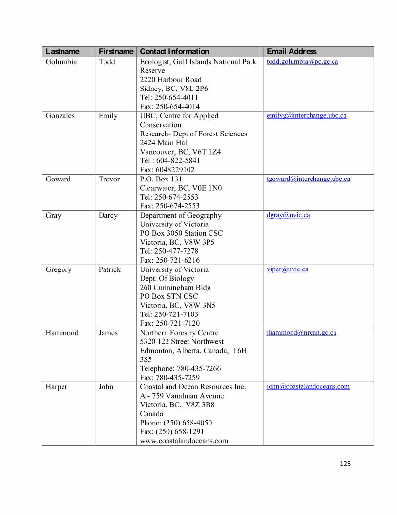
123!
!
Lastname Firstname Contact Information Email Address Golumbia Todd Ecologist, Gulf Islands National Park
Reserve 2220 Harbour Road Sidney, BC, V8L 2P6 Tel: 250-654-4011 Fax: 250-654-4014
Gonzales Emily UBC, Centre for Applied Conservation Research- Dept of Forest Sciences 2424 Main Hall Vancouver, BC, V6T 1Z4 Tel : 604-822-5841 Fax: 6048229102
Goward Trevor P.O. Box 131 Clearwater, BC, V0E 1N0 Tel: 250-674-2553 Fax: 250-674-2553
Gray Darcy Department of Geography University of Victoria PO Box 3050 Station CSC Victoria, BC, V8W 3P5 Tel: 250-477-7278 Fax: 250-721-6216
Gregory Patrick University of Victoria Dept. Of Biology 260 Cunningham Bldg PO Box STN CSC Victoria, BC, V8W 3N5 Tel: 250-721-7103 Fax: 250-721-7120
Hammond James Northern Forestry Centre 5320 122 Street Northwest Edmonton, Alberta, Canada, T6H 3S5 Telephone: 780-435-7266 Fax: 780-435-7259
Harper John Coastal and Ocean Resources Inc. A - 759 Vanalman Avenue Victoria, BC, V8Z 3B8 Canada Phone: (250) 658-4050 Fax: (250) 658-1291 www.coastalandoceans.com

124!
!
Lastname Firstname Contact Information Email Address Haugh Patricia 37189 Schooner way
Pender Island, BC, V0N 2M0 Tel: 250-629-9991 Fax: NA
Hazlitt Stephanie UBC, Dept of Forest Sciences #3041- 2424 Main Hall Vancouver, BC, V6T 1Z4 Tel : 604-827-5843 Fax : 604-822-9102
Heitzman Rod Parks Canada, Western and Northern Service Centre Calgary Office Phone: 403-292-4694 Fax: 403-292-6001
Heron Jennifer BC Ministry of Water, Land and Air Protection 2204 Main Mall Vancouver, BC, V6T 1Z4 Tel: 604-222-6759 Fax: 604-660-1849
Jones Trevor IRSS: Integrated Remote Sensing Studio Department of Forest Resources Management Forest Sciences Centre 2424 Main Mall University of British Columbia Vancouver , B.C., Canada V6T 1Z4 Tel: (604) 822 6452 Fax (604) 822-9106
Krakowski Jodie Cowichan Lake Research Station BC Ministry of Forests and range Box 335 , Mesachie Lake, BC, V0R 2N0 Tel: 250-749-6811 ext 43 Fax: 250-749-6020
Kroeker Nicole Species at Risk, Coastal BC Field Unit Fort Rodd Hill & Fisgard Lighthouse National Historic Sites 603 Fort Rodd Hill Road Victoria, BC, V9C 2W8 Tel: 250-478- 5118 Fax: 250-478-8415
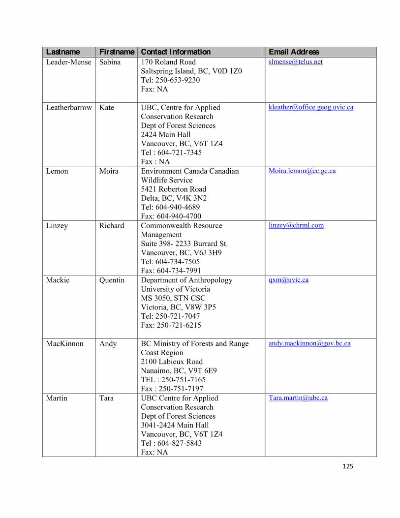
125!
!
Lastname Firstname Contact Information Email Address Leader-Mense Sabina 170 Roland Road
Saltspring Island, BC, V0D 1Z0 Tel: 250-653-9230 Fax: NA
Leatherbarrow Kate UBC, Centre for Applied Conservation Research Dept of Forest Sciences 2424 Main Hall Vancouver, BC, V6T 1Z4 Tel : 604-721-7345 Fax : NA
Lemon Moira Environment Canada Canadian Wildlife Service 5421 Roberton Road Delta, BC, V4K 3N2 Tel: 604-940-4689 Fax: 604-940-4700
Linzey Richard Commonwealth Resource Management Suite 398- 2233 Burrard St. Vancouver, BC, V6J 3H9 Tel: 604-734-7505 Fax: 604-734-7991
Mackie Quentin Department of Anthropology University of Victoria MS 3050, STN CSC Victoria, BC, V8W 3P5 Tel: 250-721-7047 Fax: 250-721-6215
MacKinnon Andy BC Ministry of Forests and Range Coast Region 2100 Labieux Road Nanaimo, BC, V9T 6E9 TEL : 250-751-7165 Fax : 250-751-7197
Martin Tara UBC Centre for Applied Conservation Research Dept of Forest Sciences 3041-2424 Main Hall Vancouver, BC, V6T 1Z4 Tel : 604-827-5843 Fax: NA

126!
!
Lastname Firstname Contact Information Email Address Marven Cindy University of Victoria
Department of Geography PO Box 3060 STN, CSC Victoria, BC, V8W 3R4 Tel: 250-472-4624 Fax: NA
McCune Jenny UBC Department of Botany 3529-6270 University Blvd. Vancouver, BC, V6T 1Z4 Tel: 604-827-3250 Fax: 604-822-6089
McDonald Steve DFO- Marine Ecosystems and Aquaculture Division 4160 Marine Drive Vancouver, BC, V7V 1N6 Tel: NA Fax: NA
McLaren Patrick University of Victoria, Dept of Geography P.O. box 3050, Station CSC, Victoria, BC V8W 3P5 Tel: 250-721-7347 Fax: 250-721-6216
McLaren Robert Petrie Science and Engineering Building Room 301-York University 4700 Keele Street Toronto, Ontario, M3J 1P3 Tel: 416-736-2100 ext. 30675 FAX: 416-736-5411
Mercer George EI Monitoring Specialist Gulf Islands National Park Reserve 2220 Harbour Road Sidney, BC, V8L 2P6 Tel: 250-654-4018 Fax: 250-654-4014
Murphy Sean Parks Canada Social Science Branch 1869 Upper Water Street Halifax, N.S., B3J 1S9 Tel: 902-426-5846 Fax: 902-426-2745

127!
!
Lastname Firstname Contact Information Email Address Olesiuk Peter Pacific Biological Station
3190 Hammond Bay Road Nanaimo, BC, V9T 6N7 Tel: 250-756-7254 Fax: 250-656-7053
Ovaska Kristiina Biolinx Environmental Research 4180 Clinton Place Victoria, BC, V8Z 6M1 Tel: 250-727-9708 Fax: 250-655-4697
[email protected] [email protected]
Owens D'Ann 2648 Asquith Street Victoria, BC, V8R 3Y3 Tel: 250-477-7761 Fax: NA
Packer Laurence Department of Biology York University 4700 Keele Toronto, ON, M3J 1P3 Tel: 416-736-2100 ext 66524 Fax: 416-736-5698
Page Nick 102-1661 West 2nd Avenue Vancouver, BC V6J 1H3 Tel: 604-742-9890 Fax: NA
Pellatt Marlow Dr. Marlow G. Pellatt Coastal Ecologist Parks Canada, Western and Northern Service Centre 300 - 300 West Georgia Street Vancouver, British Columbia, V6B 6B4 Phone: (604) 666-2556 Fax: (604) 666-7957
Poon Penny Social Science Specialist Western and Northern Canada Service Centre 300 - 300 West Georgia Street Vancouver, British Columbia, V6B 6B4 Tel: 604-666-2974 Fax: 604-666-7957

128!
!
Lastname Firstname Contact Information Email Address Reader Brian Species at Risk
Coastal BC Field Unit Fort Rodd Hill & Fisgard Lighthouse National Historic Sites 603 Fort Rodd Hill Road Victoria, BC, V9C 2W8 Tel: 250-478-5131 Fax: 250-478-8415
Robinson Cliff Marine Ecologist Western and Northern Service Centre 300 - 300 West Georgia Street Vancouver, British Columbia, V6B 6B4 Tel: 604-666-2374 Fax: 604-666-7957
Ruru Jacinta Faculty of Law University of Victoria P.O. box 3050, Station CSC Victoria, BC V8W 3P5 Tel: 250-721-8913 ( 250- 477-4685) Fax: 250-721-8146
Saunders Sari BC Ministry of Forests and Range Coast Region 2100 Labieux Road Nanaimo, BC, V9T 6E9 TEL : 250-751-7165 Fax : 250-751-7197
Simonsen Bjorn O. The Bastion Group Heritage Consultants 105- 1419 Stadacona Ave. Victoria, BC, V8S 5J3 Tel: 250-294-1150 Fax: NA
Sparkes Jennie Social Science Researcher Coastal BC Field Unit Fort Rodd Hill & Fisgard Lighthouse National Historic Sites 603 Fort Rodd Hill Road Victoria, BC, V9C 2W8 Tel: 250-478-5135 Fax: 250-478-8415

129!
!
Lastname Firstname Contact Information Email Address Stafford Jim 3206 Armadale Road
Pender Island, BC V0N 2M1 Tel: 250-629-3045 Fax: NA
Sumi Leila Parks Canada Yukon Field Unit 295-300 Main Street Whitehorse, YK, Y1A 2B3 Tel: 867-667-6701 Fax: 867-667-4157
Szaniszlo Wendy 332 Pacific Crescent Ucluelet, BC, V0R 3A0 Tel: 250-726-2775 Fax: 250-726-2775
Tang Steve DFO- Marine Ecosystems and Aquaculture Division 4160 Marine Drive Vancouver, BC, V7V 1N6 Tel: NA Fax: NA
Tutsch Matthew 403 1688 E4th Ave. Vancouver, BC, Canada, V5N 1J8 Tel: 778.833.1875 cell
Vennesland Ross Western and Northern Service Centre 300 - 300 West Georgia Street Vancouver, British Columbia, V6B 6B4 Tel: 604-666-4648 Fax: 604-666-7957
Walker Ian University of Victoria Dept of Geography P.O. box 3050, Station CSC Victoria, BC, V8W 3P5 Tel: 250-721-7347 Fax: 250-721-6216
Webb Conan Fort Rodd Hill & Fisgard Lighthouse National Historic Sites 603 Fort Rodd Hill Road Victoria, BC, V9C 2W8 Tel: 250-478-5153 Fax: 250-478-8415

130!
!
Lastname Firstname Contact Information Email Address Werth Silke University of Los Angeles
Warren Hall 900 Veteran Avenue Los Angeles, Califirnia, 90024 Tel: 310-794-1431 Fax: 310-794-1431
Zanette Lianna Department of Biology University of Western Ontario London, Ontario, N6A 5B7 Tel: 519-850-2549 (Ontario) Tel: 250-658-3325 ( Victoria) Fax: NA
!
! !

131!
!
Appendix C Research Priorities (2005) !
RESEARCH PRIORITIES Gulf Islands National Park Reserve was established in May, 2003. As we are a newly established park reserve, our research priorities are evolving as we continue to focus on the collection and analysis of baseline inventory data. Research priorities were established shortly after park establishment but these were interim and incomplete. Many of these priorities have been addressed by research initiatives over the past several years and a new set of research priorities will be generated as a result of this review, the Sate of the Park Report and the Park Management Planning Process that is currently underway.
Researchers are encouraged to familiarize themselves with park management issues which may be of interest. Research activities within parks are not necessarily restricted to topics of direct relevance to park management. Researchers are encouraged to contact the park, once they have a specific research topic in mind, if they would like to discuss their proposals. Subject areas listed below do not have attached funding. Researchers wanting to submit proposals should clearly indicate funding sources for their work.
1. INVENTORY AND STATUS SURVEYS
Flora and fauna Surveys Nearshore subtidal inventory, classification and mapping Intertidal community assessment Invasive plant and animal species distribution and abundance Terrestrial Invertebrate surveys Forest insect and disease surveys and collation of existing historical FIDS data Establish or continue existing inventory and monitoring programs for federally and provincially
listed species, plant communities, and ecosystems
2. ECOSYSTEM AND HABITAT STUDIES
Landscape change analysis (terrestrial land cover, marine shorelines) Regional landscape analysis Setting restoration goals and targets Gap analysis and representation of landscape elements in conservation planning �:9/@.?�,�2090=,7�,>>0>>809?�:1�7,9/>�B4?349�?30�9,?4:9,7�;,=6�=0>0=A0J>�.:=0�,=0,�:1�49?0=0>?�,9/�4/09?41D�?3:>0�?3,?�;=:A4/0�?30�-0>?�=0;=0>09?,?4:9�:1�?30�9,?@=,7�=024:9J>�.3,=,.?0=4>?4.>�
Fragmentation, connectivity and landscape complexity �,;�0C4>?492�9,?@=,7�0.:>D>?08>�,9/�,77�;=:?0.?0/�,=0,>�49�,9/�,=:@9/�?30�9,?4:9,7�;,=6�=0>0=A0J>�
core area of interest, identify existing and potential natural area corridors, and identify opportunities to reduce fragmentation.
3. STUDIES ON ECOLOGY AND BEHAVIOR OF SPECIES
Hyper-abundant wildlife (ungulate) populations
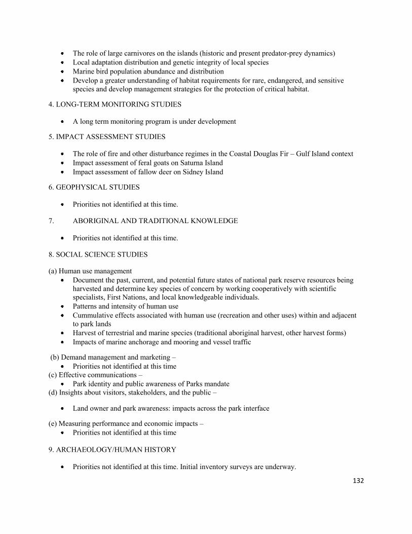
132!
!
The role of large carnivores on the islands (historic and present predator-prey dynamics) Local adaptation distribution and genetic integrity of local species Marine bird population abundance and distribution Develop a greater understanding of habitat requirements for rare, endangered, and sensitive
species and develop management strategies for the protection of critical habitat.
4. LONG-TERM MONITORING STUDIES
A long term monitoring program is under development
5. IMPACT ASSESSMENT STUDIES
The role of fire and other disturbance regimes in the Coastal Douglas Fir F Gulf Island context Impact assessment of feral goats on Saturna Island Impact assessment of fallow deer on Sidney Island
6. GEOPHYSICAL STUDIES
Priorities not identified at this time.
7. ABORIGINAL AND TRADITIONAL KNOWLEDGE
Priorities not identified at this time.
8. SOCIAL SCIENCE STUDIES
(a) Human use management Document the past, current, and potential future states of national park reserve resources being
harvested and determine key species of concern by working cooperatively with scientific specialists, First Nations, and local knowledgeable individuals.
Patterns and intensity of human use Cummulative effects associated with human use (recreation and other uses) within and adjacent
to park lands Harvest of terrestrial and marine species (traditional aboriginal harvest, other harvest forms) Impacts of marine anchorage and mooring and vessel traffic
(b) Demand management and marketing F Priorities not identified at this time
(c) Effective communications F Park identity and public awareness of Parks mandate
(d) Insights about visitors, stakeholders, and the public F
Land owner and park awareness: impacts across the park interface
(e) Measuring performance and economic impacts F Priorities not identified at this time
9. ARCHAEOLOGY/HUMAN HISTORY
Priorities not identified at this time. Initial inventory surveys are underway.