research of morphological processes into …landreclamationjournal.usamv.ro/pdf/2016/art4.pdf ·...
TRANSCRIPT

RESEARCH OF MORPHOLOGICAL PROCESSES INTO THE MOLDOVA
RIVERBED USING PERIODIC TOPOGRAPHIC MEASUREMENTS
Anca BALAN, Mihail LUCA, Daniel TOMA
"Gheorghe Asachi" Technical University of Iasi, 63 Dimitrie Mangeron Blvd., 700050, Iasi, Romania
Corresponding author email: [email protected]
Abstract The floods occurred on Moldova River, during 2004-2015 changed the minor bed in Soci area. In this area it is embedded the undergoing Timișești-Iași adduction pipe. The undergoing section morphological changes have influenced the vertical and horizontal minor bed stability. Morphological changes were monitored by topographical surveys. The leveling surveys of research area were updated after each flood. There were made cross section and longitudinal section of the riverbed in the research area. By processing the topographical series of surveys it result the riverbed changes under the action floods. The longitudinal and cross sections indicated the riverbed hydrodynamic erosion parameters. The data collected and processed allowed the design of the breastwork in the area where the headrace ducts under-cross the river. Key words: river, flood, morphological process, topographical surveys, hydrodynamic erosion. INTRODUCTION Floods are natural events being part of the natural course of normal events into a drainage area. Spatial distribution and floods amplitude are caused flash by natural and anthropogenic factors. Most high floods are caused by meteorological factors. Floods action is different depending on the environment where they take place. Triggering floods in the warm season is especially given by the downpour. Characteristic of these floods is the sudden increase in flow and level in the river bed in a very short time. The floods period from summer beginning has an annual frequency. But the beginning and magnitude of floods are varying widely during the year. Flood wave is moving through the riverbed and then through streambed. The flood wave can have one crest (monounda) or several crests, based on the sequence of occurrence of precipitation. Flash floods cause significant morphological changes in rivers with eroded riverbeds. The construction works located in erodible riverbeds are highly degraded by flood actions. The breastworks are partially or totally destroyed by disaster nature floods.
After such a flood is likely that the breastworks could lose the role for witch this was made. Morphological changes of the river bed can be studied by various methods. Topographic measurements at intervals allow analysis of the evolution of the riverbed in the longitudinal and cross sections. MATERIALS AND METHODS The research was performed on a section of Moldova River within the city of Soci, Iasi County (Fig. 1a). In this section are riverbed regularization and bank protection works. The work was carried out to protect the under-crossing construction of the three adduction ducts with 1000 mm diameter. Moldova River Basin has an area of 4299 km2. River water supply is achieved through collected on the western side of the Eastern Carpathians. The Moldova River basin presents a moderate continental hydroclimatic regime. The flow in the river is characterized by frequent discontinuities of temporal and spatial hydrological parameters. Rainfall in some periods of time presents a character strongly randomly
20
Scientific Papers. Series E. Land Reclamation, Earth Observation & Surveying, Environmental Engineering. Vol. V, 2016Print ISSN 2285-6064, CD-ROM ISSN 2285-6072, Online ISSN 2393-5138, ISSN-L 2285-6064

a
Ax conducta de aductiune 1 (veche)
Ax conducta de aductiune 2 (noua)
Ax conducta de aductiune 3 (noua)
CV 3
CV 4
CV 1
CV 2
Camin pe conducta de aductiune 1 (veche)
Rau
Mol
Rau
Mol
dova
Rau
Mold
ova
Lucrari de aparare de mal
Lucrari aparare de mal
Lucrari aparare de mal
Ax prof
il lon
gitud
inal R
. Mold
ova -
zona d
e subtr
avers
are
ducta de aductiune 1 (veche)
une
Formatiune aluvionara
Formatiuni aluvionare
Lestare cu piatra
Lucrari aparare de mal
b Figure 1. Map of studied area:
a – research area on the Moldova River; b – Land survey on investigated river section in 2005
Conditions of leakages into the Moldova River basin vary with in a large particularity in time and space, with an obvious torrential type. The high degree of torrential character is highlighted by extreme values multiannual leak. The ratio of maximum flow rate at low historically and is about 1.000 higher coeffi-cient values are present torrential average monthly debits (170 - 175) and even the annual (5 - 6).The extreme values of rainfall were recorded at different times of the year: 1969 July and August, 1972 May, June and July - 1991, September - 2001 April - 2005 July - 2008 etc.
a
b
Figure 2. Pictures of the Moldova River area: a – Google earth view (2012);
b – Downstream view of the studied area Moldova River presents in the studied area a ballast thalweg with thickness of 15 - 20 m. The ballast layer is extending in major riverbed in range of 100 200 m. Cohesionless material from riverbed allows formation of active hydrodynamic erosion processes. In the research area the Moldova River has two branches. The second branch was made in 1970 from technological reasons for under-crossing execution.
The research method has the following steps: � Processing the hydrological and
hydraulic data specific to the considerate research river section; � Topographical land survey in the
research riverbed area to obtain the base plan; � Surveying at timed intervals to assess
morphological changes of the riverbed; � Surveying for achieving the bed cross
sections profiles of specific research sections; � Surveying for achieving the riverbed
longitudinal profile; � Surveying the bank to determine the
hydrodynamic erosion parameters; � Acquisition of photographic images
and video; � Processing and interpretation of
measurements by highlighting qualitative and analytical morphological changes of the riverbed; Using topographic measurements are made the cross section and longitudinal profiles in specific sections through major and minor riverbed. Hydrodynamic erosion of the riverbed value is measured on the longitudinal and cross sections. The measured values are compared with those calculated. The deep of the riverbed caused by hydrodynamic erosion determines with equation (Mitoiu C., 1999):
(1) where: q is the specific flow; vav – is the water speed downstream; η = 1,5…2 – coefficient depending on the uniformity of the velocity distribution; w - falling speed; d - the diameter d90 of the material from the riverbed; γs - grain specific weight of riverbed. RESULTS AND DISCUSSIONS Moldova River in the studied area shows a strong degree of instability (where the adduction pipes undercross the river Figure 2). Following transit floods were was recorded constantly morphological changes in the spatial configuration of the river. The most significant changes were: � Changing geometry of the minor riverbed in plan and longitudinal and cross sections;
21
Scientific Papers. Series E. Land Reclamation, Earth Observation & Surveying, Environmental Engineering. Vol. V, 2016Print ISSN 2285-6064, CD-ROM ISSN 2285-6072, Online ISSN 2393-5138, ISSN-L 2285-6064
� 2D displacements to the riverbed upstream and downstream of the undercrossing; � Hydrodynamic erosion of the thawing, with its descent below the calculated design; � To follow the process of morphological change of the riverbed were made after floods topographic measurements at determined intervals. Topographical surveys have been executed in next periods; � In 1968 the design and construction of hydraulic structures undercrossing pipes and the regularization of the river Moldova; � In 2005 to check morphological changes of the riverbed after a period of operation of 30 years (total area plan and longitudinal and cross sections, Figure 1b); � In 2008 to check morphological changes of the riverbed after the passage of floods that produced changes (topographic survey of banks); � In 2010 to verify morphological changes of the riverbed after several floods that produced changes (topographical surveys of the banks); � In 2012 to verify morphological changes of the riverbed after several floods that produced changes (area general plan and longitudinal and cross section); � In 2015 to verify morphological changes of the riverbed that caused degradation of bank protection works and the undercrossing adduction pipes (local plans, cross sections and longitudinal sections).
Brat stang r. Moldova
Figure 3. Cross section profile in adduction ducts undercrossing area (year 2006)
From the theoretical analysis and research in the field there were obtained the following results on morphological changes of the riverbed in the undercrossing area:
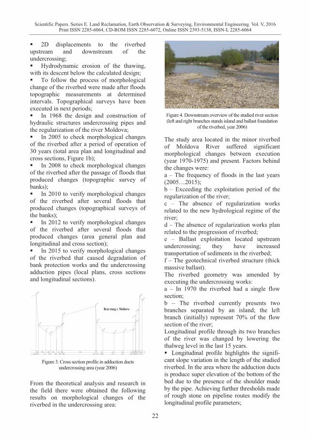
Figure 4. Downstream overview of the studied river section (left and right branches stands island and ballast foundation
of the riverbed, year 2006)
The study area located in the minor riverbed of Moldova River suffered significant morphological changes between execution (year 1970-1975) and present. Factors behind the changes were: a – The frequency of floods in the last years (2005…2015); b – Exceeding the exploitation period of the regularization of the river; c – The absence of regularization works related to the new hydrological regime of the river; d – The absence of regularization works plan related to the progression of riverbed; e – Ballast exploitation located upstream undercrossing; they have increased transportation of sediments in the riverbed; f – The geotechnical riverbed structure (thick massive ballast). The riverbed geometry was amended by executing the undercrossing works: a – In 1970 the riverbed had a single flow section; b – The riverbed currently presents two branches separated by an island; the left branch (initially) represent 70% of the flow section of the river; Longitudinal profile through its two branches of the river was changed by lowering the thalweg level in the last 15 years. � Longitudinal profile highlights the signifi-cant slope variation in the length of the studied riverbed. In the area where the adduction ducts is produce super elevation of the bottom of the bed due to the presence of the shoulder made by the pipe. Achieving further thresholds made of rough stone on pipeline routes modify the longitudinal profile parameters;
22
Scientific Papers. Series E. Land Reclamation, Earth Observation & Surveying, Environmental Engineering. Vol. V, 2016Print ISSN 2285-6064, CD-ROM ISSN 2285-6072, Online ISSN 2393-5138, ISSN-L 2285-6064

� Moldova minor riverbed near the site presents relative stability in the plan and the characteristics of an evolving riverbed, with the formation of bends, areas of erosion and deposition areas;
Figure 5. Longitudinal profile through Moldova riverbed in the research area
� In 1970-1972, the bed was calibrated and constrained in bank protection works and works provided with for directing currents. In 2005 ... 2015 has been a degradation of bank protection works. The area located in the right bank; � In the river shows a relative stability in the plan and is less affected by phenomena of collapse or erosion (Figure 7).
Figure 6. Degradation of left shore protection works of
Moldova River after floods in 2010
The comparative analysis made on the topo-graphical plans and photograph mapping highlighted morphological changes in the area where the three adduction pipes undercross the river. Alluvial processes have developed to the right side of the riverbed and especially around the island. Erosion processes were developed left bank. Left bank erosion intensified in 2005 and was manifested by washing alluvium, degradation and total destruction of bank protection etc. Excavating ballast upstream undercrossing influenced the intensification of hydrodynamic erosion. Calculation deepening minor bed after erosive action of the water showed values of
0.55...0.81 m on the section studied. Comparison of longitudinal profiles of the Moldova riverbed at different intervals confirmed calculations. The data were used to design the rehabilitation of existing constructions in the riverbed.
Figure 7. Downstream overview downstream of the left arm
of river in the study area (year 2015)
CONCLUSIONS The comparative analysis of initial and after floods topographical plans indicates a number of significant morphological changes in the riverbed, with particular impact on the dynamics of solid and liquid flows. The undercrossing area through minor riverbed the river has two branches generated by the presence of alluvial formations (an island) that modifies the configuration of solid and liquid flows and levels in flood value. Longitudinal sections have revealed the deepening of the riverbed as determined by hydrodynamic erosion. Values increased in the last 15 years and influenced the stability of the construction of transmission pipes undercrossing. Lack of flow control works in the riverbed led to the formation of currents that influence and generate hydrodynamic erosion, with significant effects on bank protection works. The floods from 2006 and 2008 intensified a series of morphological changes in the river channel, particularly in the left bank, a situation that resulted in partial and total degradation protection works. Transport capacity of the Moldova’s minor riverbed in the undercrossing area need to be restored by recalculating and updating the topographic geometrical parameters as planned.
23
Scientific Papers. Series E. Land Reclamation, Earth Observation & Surveying, Environmental Engineering. Vol. V, 2016Print ISSN 2285-6064, CD-ROM ISSN 2285-6072, Online ISSN 2393-5138, ISSN-L 2285-6064

REFERENCES Dapporto S., Rinaldi M., Casaglia N., Vannocci P., 2003,
Mechanisms of bank failure along the Arno River, central Italy, vol., Earth Surface Processes and Landforms, nr., 28, 1303-1323 pp.
Hâncu S., 1976, Regularizarea albiilor raurilor, Ed. Ceres, Bucuresti,.
Luca M., 2006, Expertiza tehnica privind starea de siguranta în exploatare a subtraversarii raului Moldova –zona Soci, jud. Iasi a conductelor din captarea Timisesti.
Luca M.,2012, Technical expertise on rehabilitation in the undercrossing the river Moldova to the adduction pipes water Timisesti, village Soci, county of Iasi. SC POLIAS-INSTAL Iasi.
Luca M., 2000, Hobjila V. Complemente privind proiectarea şi expertizarea unor tipuri de constructii hidrotehnice, Ed. CERMI, Iasi.
Manoliu I., 1973, A., Regularizari de rauri si cai de comunicatie pe apa, Ed. Ed. Did. si Pedag., Bucuresti.
Mitoiu C., 1999, Marin G., Regularizarea albiilor de rauri, Indrumar de proiectare, Edit. Bren., Bucuresti.
Ratiu M., Constantinescu C., 1989, Comportarea constructiilor si amenajarilor hidrotehnice. Editura Tehnica, Bucuresti.
SingV.P.,2003, On the theories o hydraulic geometry. International Journal of Sediment Research, Vol 18, No.3, 196-218 pp.
Thorne C., 1982, Bank erosion processes and mechanisms, Ed., John Wiley & Sons, Ltd., Chichester, 227-271 pp.UK.
24
Scientific Papers. Series E. Land Reclamation, Earth Observation & Surveying, Environmental Engineering. Vol. V, 2016Print ISSN 2285-6064, CD-ROM ISSN 2285-6072, Online ISSN 2393-5138, ISSN-L 2285-6064